Embed Size (px)
Citation preview

INVESTIGATIONS AT THE GRAVEL PIT SITE 44SX14
SUSSEX COUNTY, VIRGINIA
Keith T. Egloff
Technical Site Report #1
1989
Department of Conservation & Historic Resources
Division of Historic Landmarks 221 Governor Street
Richmond, Virginia 23219

List of Illustrations
Acknowledgements
Introduction
Environment
TABLE OF CONTENTS
Excavation Methodology
Stratigraphy and Features
Artifact Discussion Ceramics Diagnostic Projectile Points Bifaces Unifacial Scrapers and Flake Tools Hammerstones and Anvils Flakes and Fire-cracked Rock
V
vii
1
5
6
8
13
Summary of Joseph McAvoy's Investigations 1983-1987 35
Discussion 36
References Cited 41
iii

ILLUSTRATIONS
FIGURE Page
1. Location map ix
2. Plan map of Gravel Pit Site along Nottoway River 2
3. Plan of June 1984 excavations 7
4. Profiles of excavations 9
5. Northeast profile of Squares 3, 5, and McAvoy's excavation 10
6. Southeast profile of Squares 1 and 5 10
7. Rock hearths in Squares 1 and 5 12
8. Rock hearths in Squares 3 and in profile of Square 1 12
9. Table of ceramics 14
10. Artifact tabulation from Squares 1 and 3 17
11. Artifact tabulation from Square 5 18
12. Projectile points 19
13. Stage 2 bifaces 19
14. Type I bifaces, large and wide 23
15. Type II bifaces, long and narrow 23
16. Unifacial scrapers 25
17. Retouched flakes 25
18.
19.
20.
21.
22.
Flake analysis from Square
Flake analysis from Square
Flake analysis from Square
Fire-cracked rock analysis
Graph illustrating depth of
1
3
5
material
V
culture
30
31
32
34
40

ACKNOWLEDGEMENTS
The Division of Historic Landmarks of the Department of
Conservation and Historic Resources is especially indebted
to Joseph McAvoy of Sandston, Virginia, who, in the spring
of 1984, brought the Gravel Pit Site to our attention. He
not only obtained permission from the landowner, w. T.
Fannin, for the Division's investigations, but he also
cleared thick underbrush from the area of excavation. His
intimate knowledge of the wide range of lithic artifacts
found at this site has been invaluable to this study.
Gratitude is extended to McAvoy's family--his wife, Lynn,
and their two sons, Bryan and James--for their hard work and
continual support.
Appreciation is extended to the field crew from the
Division: Keith Egloff, Dennis Hartzell, Mary Ellen Hodges,
and J. Mark Wittkofski. Volunteers at the site included
Harold Conover and M. R. "Blue" Lilley. Special debt is
owed to Harold Conover for providing lodging for the crew.
Mary Ellen Hodges catalogued the artifacts recovered from
the site. This catalogue formed the basis for much of the
data presented in this report.
vii

PETERSBURG
---Figure 1: Location of Gravel Pit Site, 44SX14.
ix
INTRODUCTION
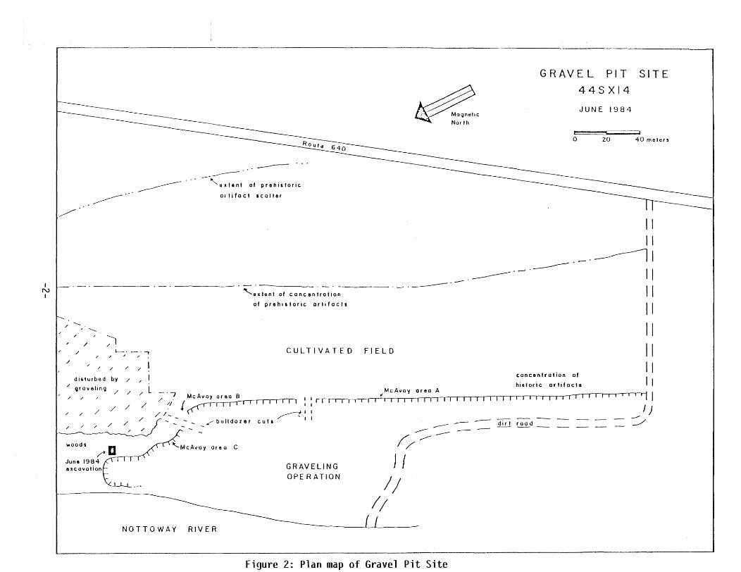
The Gravel Pit Site, 44SX14, is located on a sandy terrace
along the Nottoway River in the vicinity of the town of
Stony Creek, Sussex County, Virginia (Figure 1). Although
this site was first recorded in the state files in 1968,
people had heavily surface collected it for decades. An
observer is struck not only by the tremendous size of the
site, measuring approximately 800 meters (m) north-south
along the Nottoway River and 140 m east-west at the widest
point, but also by the extremely dense concentration of
quartzite and quartz debitage (Figure 2). The greatest
attention given by collectors to the site occurred in the
late 1960s when it was first used as a sand and gravel pit.
Apparently the north end of the site, a high sandy knoll,
was quarried for sand, revealing numerous projectile points.
Collectors found the bonanza so rich, especially the
unbroken Palmer and Kirk Corner-Notched points, that they
dug as well as surface-collected on the site. Today the
area of this knoll has been reclaimed as a cultivated field.
The soil here is clayey and less fertile than the remaining
southern portion of the field. The graveling has continued
along a strip of land near the Nottoway River, creating a
hole ca. 4 m deep by 340 m north-south and 80 m east-west.
Artifact collectors come infrequently to this site to
surface-collect since the number of whole projectile points
found per trip has dropped to only a fewe
1
---- .. •
--------- . . . -----
/
/ ., /
/
/ / /
di,turbed by / / I
/ gro11 eling
------- ... --- ...
'- c!)I. I e nt of . prohi,tori
artifact c ,caller
". ex lenl f . o concen . of preh lrotaan
11toric artifacts
CULTIVATED
/ /
/ / L. / , /
7 M,A, , / / / / ,, I ., ., •• "
/ ~·- - - ~ I I 11--rl --r1-rt -,-.....-.-. 0· 1111"
I I f
~ood• - - - _,-bulldo,or ~II . . '"''/.
/D June 1984 ,.,o,otioo o,,o C
NOTTOWAY RIVER
I I
GRAVELING OPERATION
~' North
GRAVEL PIT
44SXl4
JUNE 1984
SITE
11
--------------·-· ~:
11
11
11
----·-·
Fl EL o
A
..--- --f/ --- --
} I /j
I;
c _on c o n I r a t ion h of a,toric art"f 1 oct,
I I TT I
_.,.,
11
11
11
I 1
I 11
lj __/
Figure 2: Plan map of Gravel P1·t Site
In 1983 Joseph McAvoy and his family
site,
from
hoping
Sandston,
to find Virginia, became interested in the
evidence of Paleoindian and
testing showed that a small
stratified soil approximately
existed between the field and
Early Archaic material. His
section of undisturbed
75 centimeter (cm) deep
the gravel pit. After
receiving permission from the landowner, McAvoy cleared an
area of woods and opened a 3 by 3 m trench (Area D). The
cultural remains recovered dated from 8000 B.C. to A.D.
1000.
McAvoy commented on the original richness of this once
tremendous site before surface collecting and graveling.
According to him, the Gravel Pit Site is one of about six
sites along this portion of the Nottoway River that
originally contained close to one-half million bifaces and
projectile points. The Division of Historic Landmarks'
excavation at 44SX14 supported this astonishing figure.
Slightly over 150 bifaces and fragments, scrapers, and
projectile points were recovered from a 2 by 4 m square,
which will be elaborated upon in a later section of this
manuscript. If this artifact density held true for the
entire site, approximately 1,400,000 of these artifacts
would have been left at this site area by Native Americans.
The projectile points alone would have numbered 112,000.
The major lithic source is an adjacent stratum of quartzite
-3-

and quartz cobbles visible in the bank of the Nottoway River
during low water. Also, the river bed is covered with
cobbles that were readily accessible to Native Americans.
McAvoy invited the Division to excavate in a small area
adjacent to his trench. On June 5, 1984, the state
archaeologists started the excavation of a 2 by 4 m trench
(Squares 1 & 5). Later a balk (Square 3), 2.3 by 0.5 m, was
excavated between the initial trench and McAvoy's
excavation. The sandy soil was removed in 5 cm levels to a
depth of 1 m. The crew worked a total of 184 man hours at
the site until it was backfilled on June 10.
excavation found Early Archaic through
remains, confirming McAvoy's investigations.
from the 1984 Division's excavation are
The Division's
Late Woodland
The artifacts
curated at its
Research Center for Archaeology, 221 Governor
Richmond, Virginia.
Street,
-4-

ENVIRONMENT
The Gravel Pit Site is located on the Interior Coastal Plain
of Virginia along the east bank of the Nottoway River in the
vicinity of the town of Stony Creek, Sussex County (Figure
1). Native Americans who settled here not only had access
to an ample supply of lithic material but also to an
ecologically rich, varied environment of swamps and uplands
of the Interior Coastal Plain and the uplands of the
adjacent Fall Zone.
The site composed of strata of sands and gravels is
approximately 5 m higher than the Nottoway River. The rich
soil is loose, sandy, and well-drained. The top 1 m of
sandy soil has been deposited since the end of the
Pleistocene. This process of soil build-up may have been
caused by a combination of aoelian and sedimentary
deposition.
The Nottoway River, the major water course in the region,
flows north along a geological fault zone where it enters
the Interior Coastal Plain. This means that the river flows
parallel to the Fall Zone in the vicinity of Stony Creek for
a distance of approximately 14 miles. This stretch contains
one of the heaviest concentrations of Native American sites
in Virginia, forming two long avenues of almost continuous
sites along both banks of the river. A thick stratum of
-5-

quartzite and quartz river cobbles is exposed along the bank
of the river there, providing a supply of lithic material.
EXCAVATION METHODOLOGY
Squares 1 and 5 formed a 2-by-4-m trench positioned two
meters east of the edge of the gravel pit, allowing enough
room for the archaeologists to move around the squares
without falling four meters down into the pit (Figure 3).
All excavated soil was screened through 1/4 inch mesh
hardware cloth. The datum point, located at the northeast
corner of Square 5, was designated an arbitrary elevation of
10 mat the surface of the ground. After excavating the
trench, soil and water-screen samples were taken from the
balk separating Square 5 and McAvoy's excavation. The size
of the soil samples was 20 cm by 10 cm by 5 cm in depth.
Twenty samples (2Al -2A20) were removed from the surface of
the ground to a depth of 1 m. The water-screen samples (4Al
-4A20) were 20 cm by 20 cm by 5 cm in volume and likewise
were removed from the top of the ground to a depth of 1 m.
After the soil samples were removed the remaining portion of
the balk, Square 3, was excavated.
Each excavated level was assigned a letter of the alphabet
beginning with A, except for the first level which just
received the number designation of the square. Letters not
used include I, o, Q, U, and V because of their similar
-6-

/,. ---
Square 5
Square I
GRAVEL PIT SITE
44SXl4
Oat um
V /
I L
5 June 1984
----------. 1 m et e r
- - - - ______ ... ., Square 3
I McAvoy s
Excavation
I
- _J
edge of field
edge of gravel pit
Figure 3: Plan of June 1984 excavations.
-7-
)

appearance to other letters of the alphabet. Since the
squares were not excavated in conjunction with each other, a
particular letter designation for each square may represent
a different depth and therefore cultural horizon. Each
feature or artifact mapped in place within a particular
level was assigned a number which followed the letter. Thus
artifact 1D3 was the third artifact found in situ in the
fifth level of Square 1.
STRATIGRAPHY AND FEATURES
The stratigraphy at the site was rather simple. First a
dark brown sandy topsoil varying from 15 to 30 cm deep
covered the site. Below that existed a yellow-tan sand
stratum aproximately 1 to 1.2 m thick. A yellow sandy
stratum, devoid of artifacts, lay at the base of the site
(Figures 4, 5, and 6).
The surface of the site, and to a lesser extend the lower
strata, slopes slightly from east to west towards the river.
This slope was less pronounced in the area of McAvoy's
excavation, and more pronounced in the area of Squares 1, 3,
and 5.
The sloping of the strata up to the east may reflect the
high knoll that once existed directly east of the
excavation. Furthermore, the strata in the area of
excavation may represent the slow accumulation of colluvial
-8-

I U) I
Datum '
,
square
Key: .,,. /
c:,
square 5
A
"' "' _.,. - .,,. ,.
\ -,, B .,. 0 0
C
square
Datum
' 5
......
C
fire cracked rock
flake
cobble
GRAVEL PIT SITE 44SXl4
9 June 1984
East Profile 50 cm
I square I
-IOm. -
"' - .,.,
~ ........ - 0 I ....... ,,. .......... ,..,
_. 'IGI
{ -9m.
3 McAvoy's Excavation
-IOm. A
o;
B _.,.
North Profile C
-9m.
A dark brown sandy topsoil
B yellow ton sand
C yellow sand
Figure 4: Profiles of excavations.

Figure 5: From left to right, northeast profile of Squares 5 and 3 and McAvoy•s excavation. View to the northeasto
Figure 6: From left to right, southeast profile of Squares 5 and 1. View to the southeast.
-10-

soils from the knoll. While quarrying the sand and gravel
from the knoll for road construction, many Palmer and Kirk
Corner-Notched points were found by collectors. Today this
knoll area is marked by a cover-crop. The soil is too
infertile for regular crop cultivation.
The archaeologists identified three fire-cracked rock hearth
features during the excavation.
compack and probably were
shallow pits.
These rock clusters were
contained originally within
The first feature, lGl, was located adjacent to the eastern
profile of Square 1 (Figures 7 and 8) at an elevation of
9.59 9.43 m. The hearth was 65 cm north-south, by 40 cm
east-west, but did continue east into an unexcavated portion
of the site. No diagnostic artifacts were found associated
with the feature. However, a Stanly (6,000-5,300 B.C.)
projectile point was recovered from the square at an
elevation of 9.44 m. This hearth, like the other two
hearths found during the excavation, has been interpreted as
belonging to the Savannah River culture (3000-1000 B.C.).
The second hearth feature, 5Gl, was uncovered at a depth of
9.56 - 9.48 m (Figure 7). It was 50 cm in diameter. The
tip of a probable savannah River projectile point was
uncovered 20 cm southeast of the feature at an elevation of
-11-

Figure 7: Squares 1 and 5. Feature 561 in foreground and Feature 161 in background. View to the southwest.
Figure 8: Fire-cracked rock hearths, Feature 161 in profile and Feature 3Ll in Square 3. View to the southeast.
-12-

9.57 m.
period.
The feature probably dates to the Savannah River
The third fire-cracked rock hearth feature, 3Ll, was
excavated at an elevation of 9.56 - 9.48 m (Figure 8). This
feature, 45 cm in diameter, is 70 cm southeast of feature
5Gl and has exactly the same depth measurements. Although
no diagnostic points were found in the level, two Savannah
River points with contracting stems were recovered above the
feature. First, point 3Fl was encountered at an elevation
of 9.72 m, and next 3Gl was found at 9.69 m. Point 3Gl was
recovered 13 cm directly above feature 3Ll.
ARTIFACT DISCUSSION
Ceramics:
Although one may surface-collect the large field at the
Gravel Pit Site without finding any Native American pottery,
the excavations did recover 50 rather small sherds (Figure
9). One may only assume that cultivation pulverized the
sherds that once existed in the field.
The sherds were divided first into two classes, those with
sandy paste and those with clayey paste. The sandy-paste
sherds normally had no temper, while the clayey-paste sherds
normally had crushed quartz ca. 2 mm in diameter. The
-13-

Square
cord
1 lA lB lC 1 1D 1
3A 3D 3E 3H
5 2 SA SB SC SD SE SF SG
Total 4
GRAVEL PIT SITE
44SX14
Ceramics
Sandy
unid. cord
2 2 3
2
1 1
2 2 2 1
1
1 1 2 1 1
14 11
Clayey
Figure 9: Ceramic table.
-14-
Total
unid.
4 6 2 4 3 6 2 3 1 4
1 1
1 1 2 2
6 1 4 1 2 2 2 2 4
2 1 1
21 50

majority of the sandy-paste sherds occurred below the
clayey-paste sherds. The deepest sandy-paste sherd, 5G,
found at a depth of 9.60 - 9.50 m was tempered with clay.
Even though the sherds were very small, the surface
treatment on a few of the sherds could be identified. In
all cases the surface treatment appeared to be linear cord
markings, although with some of the clayey-paste sherds this
could have been simple stamping.
In summary, four ceramic wares may be represented at the
site. The lowest pottery is a sandy-paste ware with clay
inclusions, perhaps representing the Early Woodland, Croaker
Landing Ware dated from 1200 to 800 B.C. (Egloff 1988). The
next lowest pottery also exhibits a sandy paste with cord
marked surfaces. This may represent the first half of the
Middle Woodland (500 B.C. to A.O. 200). Later the ceramics
become slightly more clayey with some crushed quartz added
as temper. The surface treatment is still cord marked.
This could represent the last half of the Middle Woodland
and the first half of the Late Woodland (A.O. 200 to 1300).
The last pottery at the site also has clayey paste, and
although identified as cord-marked, some sherds may actually
be simple-stamped. This ceramic would represent the last
half of the Late Woodland (A.O. 1300 to 1600) and may be
called Gaston Ware (Coe 1964: 105-106).
-15-

Diagnostic Projectile Points:
The archaeologists uncovered
artifacts during the project
These will be described briefly
ten temporally diagnostic
(Figures 10, 11, and 12).
beginning with the most
recent artifact found near the surface.
A quartz triangular point, lB, was found while screening
soil from an elevation of 9.85 -9.80 min Square 1. The
point measures 31 millimeters (mm) in height by 25 mm in
width.
Below this point in Square 3 were found two Savannah River
points. The first, 3Fl, was uncovered at an elevation of
9e72 m. This contracting-stemmed quartzite point has a
broken shoulder and had been extensively resharpened. The
second, 3Gl, also has a contracting stem--although less
severe--creating a general pentagonal shape to the point.
The quartzite point was found at an elevation of 9.69 m. A
third possible Savannah River point, 5G2, was found at an
elevation of 9.57 min Square 5. Although the point is
represented only by a tip fragment, the large width of the
tip (54 mm) strongly suggests a Savannah River point.
At an elevation of 9.44 ma Stanly quartzite point (1G2) was
uncovered in Square 1. The point measures 42 mm in height
by 28 mm in width at the shoulder.
-16-

Square
1 lA lB lC 1D lE lF 1G-1G2 lH 1J-1J3 1K-1K3 lL-114 1M-1M4 1N-1N3 1P-1P2
Total
3 3A 3B 3C 3D 3E 3F-3F2 3G-3Gl 3H 3J-3Jl 3K 3L-3L3 3M 3N-3N2 3P-3Pl 3R 3S 3T 3W
Total
Biface Stage 2
1 2
1
4
1
1
2
-
Biface Frag.
2 1 7 6 2 8 4 2 1
34
1 2 2 1 2
9
GRAVEL PIT SITE
44SX14
Biface Tip
1 1 2 1
1
6
1
1
Modified Flake
3
1 3 1 1
3 2 5 1 2
22
1
1 1
3
Figure 10: Artifact tabulation
-17-
Unifacial Projectile Scraper Point
1 1
1
1 2
1 1
1 1
6 4
1 1
1
1 2
from Squares 1 and 3.

GRAVEL PIT SITE
44SX14
Square Biface Biface Biface Modified Unifacial Projectile Stage 2 Frag. Tip Flake Scraper Point
5 1 SA 1 1 SB SC SD SE 1 3 1 1 SF 1 1 SG-SG2 2 1 2 1 1 1 SH-SHl 1 1 1 2 1 SJ-SJ6 4 3 2 2 1 SK-SK3 s 2 1 SL-SLl 1 2 SM-SMl 1 1 3 1 SN-SN2 1 1 1 SP-SPl 1 1 SR SS 1 ST
Total 11 16 10 12 7 4
. Figure 11: Artifact tabulation from Square 5.
-18-

\ l~L
3 CM.
Figure 12: Projectile points. Top row, left to right: 18, 162, lJ, 5J2, 1K3, 5Hl. Bottom row: 361, 562, 3Fl, 5Kl.
I IN.
3 CM
Figure 13: Stage 2 bifaces. Left to right: 5Jl, 5N2.
-19-

Next, four projectile points, all Morrow Mountain II, were
found in Squares 1 and 5. The first (5Hl) was uncovered at
an elevation of 9.44 m in Square, 5. The quartz· point
measures 38 mm in length by 17 mm in width at the shoulders.
Just below that another Morrow Mountain II point (5J2) was
found at an elevation of 9.37 m. This quartz point,
measuring 37 mm in length by 23 mm in width at the shoulder,
has one unifacial side suggesting that it was manufactured
from a flake. In Square 1 a small quartzite point, lJ, with
a contracting stem was found at an elevation of 9.38 m.
This point was broken both at the tip and stem. Directly
below that point another quartzite Morrow Mountain II point
(1K3) was found at an elevation of ca. 9.35 -9.30 m. This
point, primarily unifacial, measures 50 mm in height by 20
mm in width at the shoulders.
The lowest diagnostic artifact recovered was a quartzite
preform (5Kl) probably for a Kirk Corner-Notched or a Big
Sandy Side-Notched point. The preform was recovered from an
elevation of 9.34 m.
Bifaces:
This discussion will not include
described in the previous section,
fragments that offer little information.
-20-
projectile points,
or biface tips and
Only a few bifaces

from various levels will be described to illustrate the
process of manufacturing tools from bifacial ·reduction
(Figures 10 and 11).
To distinguish the different stages of bifacial reduction
the following definitions were applied (Callahan 1976: 382);
Stage 1: Obtain the flake blank.
Stage 2: Initial edging circumferential 70 degrees in thinning.
to produce centered, edge angles of between 50 to order to permit primary
Stage 3: Primary thinning to drive flakes from edge to center of biface.
Stage 4: Secondary thinning to produce a flattened cross section by driving flakes beyond the center line of the biface.
Stage 5: Shaping the flattened biface by alignment of edges, and specification of distal and basal ends.
As was mentioned earlier, the Nottoway River offers a
convenient and an unusually massive supply of quartzite and
quartz cobbles from which to choose. Many of the cobbles in
the bed of the Nottoway River adjacent to the site have had
one or two flakes removed. Apparently the Native Americans
tested the quality of the cobbles before removing them from
the river. A few cobble cores of quartzite were uncovered
at the site, suggesting that once the right cobble was
identified it was brought to the camp for reduction.
Two good examples of Stage 2 reduction indicate that these
bifaces started as large flakes from cobble cores (Figure
13). The flakes were next roughly shaped into bifacial
-21-

ovals. One biface, 5Jl, is 82 mm in length, 55 mm in width,
and 19 mm in thickness. The biface may have been rejected
due to the poor quality of material and a step-hinge
fracture.
in width,
discarded
The second biface, 5N2, is 94 mm in length, 58 mm
and 24 mm in thickness. It may have been
due to its extreme thickness for its width. Both
Stage 2 bifaces have cortex remaining on one face.
Stage 4 bifaces illustrate the shape of the artifact prior
to its final edge shaping. Such bifaces, called preforms,
will be divided into two types: large and broad, and long
and narrow. All of the bifaces of both types were broken
across their width, probably during bifacial reduction.
Type I are large and wide, ranging from 34 mm to 56 mm in
width (Figure 14). They- were found higher in the strata,
from an elevation of 9.70 to 9.26 m. Five examples are: (1)
3L3, 56 mm in width found at 9.55 m; (2) 1 H, 43 mm in width
uncovered at 9.45 m; (3) 1J2, 34 mm in width found at 9.40
m; (4) 1J3, 46 mm in width recovered at 9.37 m; and (5) 1L3,
43 mm in width found at 9.26 m.
Type II are long and narrow, ranging in width from 27 mm to
32 mm (Figure 15). They were found lower in the strata,
from an elevation of 9.35 to 9.22 m. The four preforms are:
-22-

Figure 14: Type I bifaces, large and wide. Top row,left to right: lH, 1J3. Bottom row: 3L3, 1L3.
; !N.
3 CM.
Figure 15: Type II bifaces, long and narrow. Top row, left to right: 1J2, lKl. Bottom row: 1L4, 1M4, 1N3.
-23-

{l) lKl, 27 mm in width uncovered at 9.35 m; {2) 1L4, 30 mm
in width found at 9.28 m; {3) 1M4, 28 mm in width recovered
at 9.25 m; and {4) 1N3, 32 mm in width found at 9.22 m.
Unifacial Scrapers and Flake Tools:
A substantial number of unifacial scrapers and flake tools
were found at the site {Figures 10 and 11). Five scrapers
and four flake tools, the best preserved examples, will be
described in detail to illustrate these quite diverse forms.
The highest stratified unifacial scraper described, 3L2, is
a quartzite circular artifact found at 9.51 m {Figure 16).
It measures 49 mm in diameter and is rather thick, 15 mm.
It appears crude and has an irregular outline. The next
lowest scraper described, SJ, was uncovered at an elevation
of 9.40 m {Figure 17). The unifacial quartzite scraper is
65 mm in length, 39 mm in width, and 15 mm in thickness.
One edge is retouched and the opposing side is flat,
creating a scraper similar to a backed-knife.
The next scraper, 1N2, is a very large quartzite artifact
found at an elevation of 9.21 m {Figure 16). It measures
102 mm in length, 73 mm in width, and 28 mm in thickness.
The artifact, with cortex remaining on a number of faces,
-24-

i lN,
3 CM
Figure 16: Unifacial scrapers. Top row, left to right: IP, 5Pl. Bottom row: 3L2, 1N2.
Figure 17: Retouched flakes. Top row, left to right: ll2, lNl. Bottom row: SJ, 3L, 5Nl.
-25-

was made by splitting a cobble and retouching the edge along
the cortex into a unifacial scraper with an edge angle of
approximately 65 degrees.
The next unifacial scraper (5Pl), found at an elevation of
9.16 m, is more carefully shaped into an oval from a
quartzite flake. It measures 65 mm in length, 42 mm in
width, and 12 mm in thickness. The unifacial scraper still
retains the bulb of percussion. The lowest unifacial
scraper (lP), recovered at 9.14 m, is very well made from
white quartz. However, only the scraping end of what
appears to be a small thumbnail scraper was recovered. The
scraper probably dates from the Early Archaic period.
In summary, only unifacial rather than bifacial scrapers
were recovered and most of these came from the bottom half
of the excavation below the elevation of 9.55 m. In
general, the scrapers are large and irregular, except for
the bottom two, which are more carefully shaped. The lowest
one is probably an Early Archaic thumbnail scraper.
Although modified flakes occurred throughout the strata,
they appeared more commonly in the bottom two-thirds of the
excavation (Figures 10 and 11). Without exception, the
retouched flakes are primary decorticated flakes that are
large, thick, and straight. None of the flakes created by
-26-
bifacial reduction were retouched and used as a tool.
Although some of these reduction flakes are quite large,
they are always thin, curved, and fragile and are not suited
for producing tools.
The highest flake described, 3L, was found at an elevation
of ca. 9.53 m (Figure 17). This quartzite decorticated
flake exhibits evidence of small flakes removed as a result
of utilization. The opposing side is flat cortex, creating
an artifact similar to a backed-knife.
The next flake (1L2), made from Bolsters Store chert, was
found at an elevation of 9.28 m. The chert is white with
brown mottling and contains black speckles of iron pyrite
inclusions. The quarry for this chert is located along the
Fall Line near a small cross roads called Bolsters Store in
Dinwiddie County. The next flake (lNl), also made from
Bolsters Store chert, was uncovered at 9.21 m. Both chert
flakes were retouched along their longer edge.
The final flake, 5Nl, was uncovered at an elevation of
9.23 m. The quartzite decorticated flake has been shaped by
limited bifacial retouching into an asymmetric blade with a
rudimentary stem. The artifact measures 64 mm in length and
31 mm in width. The tool probably was used as a knife.
-27-
Hammerstones and Anvils:
A number of hammerstones with battered ends and anvil stones
(with pitted flat surfaces) were recovered from the site.
The first two anvil stones were found in levels 5D (9.75-
9.70 m) and lE (9.70-9.65 m). Feature lGlA had one
hammerstone and one anvil stone associated with the fire
cracked rock. Two pieces of fire-cracked rock from the
feature exhibited battered and crushed edges, suggesting
they were hammerstones. A combination anvil/hammerstone was
found in level 5H (9.50-9.45 m). One more hammerstone was
recovered from level lJ (9.50-9.40 m}. Besides making
anvils and hammerstones from quartzite cobbles, a few
exhausted quartzite cores were subsequently used as
hammerstones. This was the case for one example from level
3K (9.55-9.50 m) and two from lM (9.30-9.25 m).
In general, the anvils and hammerstones were recovered from
levels dating to the Middle and Late Archaic where the
greatest density of flakage occurred. This suggests that
they may have served their main function during the process
of bifacial reduction. However, it is difficult to
interpret these artifacts because the anvil stones,
sometimes called nutting stones, may also have functioned in
the cracking of hard-shell nuts. The processing of nuts,
-28-
like the reduction of bifaces, increased greatly during the
Middle Archaic and probably reached its peak during the Late
Archaic.
Flakes and Fire-Cracked Rock:
The flakes recovered from a site where extensive bifacial
reduction occurred always present a problem in analysis and
interpretation, in part due to their sheer number. At this
site the flakes were separated by lithic material, counted,
and weighed, and then the average flake weight was
calculated (Figures 18, 19, and 20). Almost all of the
flakage is represented by the lithic materials--quartzite
and quartz--found in cobble form in the nearby Nottoway
River. In general there were 10 times more quartzite flakes
then quartz. Chert, jasper, basalt, and North Carolina
argillite, all lithic materials foreign to the immediate
area, were represented by only a few small flakes, usually
weighing less than 0.5 grams.
The flake data may be used in two ways: 1) to compare levels
within a square, and 2) to correlate levels between squares.
The gross number of flakes may indicate when the majority of
bifacial reduction occurred. In general, the flakage
increased in quantity and in size in the middle levels of
the excavation. These levels represented the Middle and
-29-

GRAVEL PIT SITE
44SX14
Flakes Square
Level Quartzite Quartz
no. wt. av. no. wt.
1 401 35 439.1*
lA 372 36 456.2*
lB 349 29 392.7*
lC 363 28 598.3*
lD 564 45 943.7*
lE 663 2219.0 3.3 57 54.3
lF 539 830.5 1. 5 51 46.8
lG 559 1025.4 1. 8 56 155.7
lGl 85 93.7 1.1 16 18.0
lGlA 39 133.6 3.4 6 5.2
lH 775 2576.0 3.3 85 123.5
lJ 723 1757.9 2.4 119 285.4
lK 870 1791. 0 2.1 126 237.6
lL 731 974.9 1. 3 86 140.2
lM 395 582.9 1. 5 46 22.4
lN 345 337.2 1. 0 32 39 .. 0
lP 218 189.7 0.9 17 12.8
lR 229 145.9 0.6 18 10.7
*Quartzite and Quartz flakes combined
Weight in grams
Figure 18: Flake analysis from Square 1.
-30-
1
av.
1. O*
1.1*
1. O*
1. 5*
1.5*
1. 0
0.9
2.8
1.1
0.9
1.5
2.4
1.. 9
1. 6
0.5
1. 2
0.8
0.6
Chert Jasper Argillite
no. no. no.
1
1
2
1
1

GRAVEL PIT SITE
44SX14
Flakes Square 3
Level Quartzite Quartz Chert Jasper Argillite
no. wt. av. no. wt. av. no. no. no.
3 82 103.2 1. 6 8 4.2 0.5
3A 32 32.8 1. 0 3 1. 0 0.3
3B 97 97.7 1. 0 8 4.2 0.5 1
3C 115 124.5 1.1 9 3.8 0.4 1
3D 117 127.0 1.1 9 2.7 0.3 1
3E 149 192.7 1. 3 9 6.1 0.7
3F 227 349.8 1. 5 9 7.4 0.8 1
3G 302 716.1 2.4 23 72.5 3.2
3H 330 602.8 1. 8 22 64.5 2.9
3J 283 467.4 1. 7 28 27.5 1. 0 1
3K 285 628.7 2.2 23 41. 5 1. 8
3L 388 710.8 1. 8 46 94.2 2.0 1 1
3Ll 79 136.7 1. 7 6 4.5 0.8
3M 408 1134.3 2.8 53 143.5 2.7
3N 476 929.6 2.0 52 1
3P 303 386.5 1. 3 35 43.3 1. 2 1
3R 89 116.8 1. 3 12 11. 4 1. 0
3S 100 53.7 0.5 12 7.9 0.7
3T 51 52.5 1. 0 5 2.5 0.5 1
3W 33 42. 6 1. 3 4 5.9 1. 5
3X 26 7.6 0.3 6 1. 7 0.3
Weight in grams
Figure 19: Flake analysis from Square 3.
-31-

Level Quartzite
no. wt. av.
5 581 779.1 1. 3
5A 302 374.3 1. 2
5B 332 409.3 1.2
5C 368 508.5 1.4
50 564 982.8 1. 7
5E 1085 3236.8 3.0
5F 476 864.3 1. 8
5G 877 1535.0 1. 8
5Gl 108 146.5 1. 4
5G1A 32 72.2 2 .. 3
5H 512 920.9 1.. 8
5J 840 2252.7 2.7
5K 620 1015.2 1. 6
5L 373 558.7 1.5
5M 299 557.9 1. 9
5N 250 340.3 1. 4
5P 126 241. 3 1. 9
5R 115 98.9 0.9
5S 52 70 .. 5 1.4
5T 18 5.6 0.3
Weight in grams
Figure 20: Flake analysis
GRAVEL PIT SITE
44SX14
Flakes Square 5
Quartz
no. wt. av.
43 47.3 1.1
33 57.4 1. 7
14 17.8 1.3
34 33.7 1. 0
32 56.3 1.8
71 85.1 1. 2
41 32.2 0.8
104 168.5 1. 6
17 7.8 0.5
5 19.9 4.0
69 188.7 2.7
123 88.3 0.7
89 205.4 2.3
64 92.4 1.4
59 50.1 0.9
47 43.8 0.9
21 35.1 1. 7
17 39.3 2.3
7 3 .. 6 0.5
5 1.. 4 0.3
from Square 5.
-32-
Chert Basalt Argillite
no. no. no.
1
1
2
1
1
1
1 2
2
3 2
3
2
2
1 2

Late Archaic periods. With further analysis, the size range
and weight of the flakes may be found to reflect the type of
biface that was being manufactured.
Flakage may be used to correlate levels between squares. In
general the same depth in Squares 1 and 5 produced
approximately the same amount of quartzite and quartz
flakage. This suggests that the site's strata hold cultural
integrity and have experienced little soil mixing.
Two flakes of a very distinctive chert suggest that limited
artifact mixing may have occurred between levels. One
fragment (1M2) of this brittle white chert occurred at a
depth of 9.26 m, the other piece (1P2) at 9.12 m. The two
pieces, which came from the same rock, were separated
horizontally by 1.25 m and vertically by 14 cm.
A massive quantity of fire-cracked rock was recovered from
the Gravel Pit Site. In general, the fire-cracked rock
recovered from each level of excavation was counted,
weighed, and then discarded (Figure 21). Only the fire-
cracked rock from the hearth features was saved. Although
some fire-cracked rock occurred in all levels except the
very bottom ones, the heaviest concentration was encountered
in the middle levels of the excavation from a depth of 9.65
to 9.30 m. This depth represents the Middle and Late
Archaic periods.
-33-

Square 1
no. wt. av.
22 63.5 2.9
A 21 104.8 5.0
B 18 66.5 3.7
C 26 453.8 17.5
D 42 299.7 7.1
E 81 778.0 9.6
F 69 453.0 6.6
G 125 1558.5 12.5
H 117 1801. 3 15.4
J 40 399.0 10.0
K 31 475.5 15.3
L 9 282.0 31. 3
M 1 138.6 138.6
N 3 80.7 26.9
p 2 11. 8 5.9
R 3 4.6 1. 5
s
T
w
X
Weight in grams
Figure 21: Fire-cracked rock
GRAVEL PIT SITE
44SX14
Fire-Cracked Rock
Square 3
no. wt. av.
2 8.1 4.1
5 13.6 2.7
6 16.3 2.7
11 79.7 7.2
12 50.5 4.2
27 486.3 18.0
28 694.4 24.8
33 1066.7 32.3
11 259.8 23.6
23 662.8 28.8
4 180.6 45.2
2 1.9 1. 0
analysis.
-34-
Square 5
no. wt. no.
14 232.3 16.6
8 236.3 29.5
16 369.4 23.1
42 576.1 13.7
27 147.0 5.4
35 299.6 8.6
32 742.3 23.2
38 917.5 24.1
26 419.3 16.1
18 480.3 26.7
14 574.7 41.1
6 507.8 84.6
3 32.2 10.7
1 2.8 2.8
1 0.9 0.9

SUMMARY OF JOSEPH MCAVOY'S INVESTIGATIONS 1983-1987
Joseph McAvoy, his wife Lynn, and their sons, Bryan and
James, first surface collected the site in 1983. In 1984,
they began to test the site by excavating along the face of
the quarry. They eventually worked in six locations,
designated Areas A through F, and uncovered a total of 477
square feet, recovering Native American material to a depth
of ca. 75 cm (McAvoy: personal communication 1984-1987).
Areas A, B, and Care shown on Figure 1. Area Dis their
June 1984 excavation adjacent to the Division of Historic
Landmarks' excavation. Areas E and Fare not shown on the
map. While conducting this work they found the base of a
fluted point in the middle of a bulldozer cut at a depth of
ca. 75 cm. They believe the point may have been in situ at
approximately this depth before being uncovered by the
bulldozer. In addition, they found chert artifacts,
possibly Paleoindian, in their excavations and also while
surface-collecting the field.
The surface collecting and testing, as well as the fluted
point, convinced them to continue their investigations in a
small section of woods undisturbed by either the gravel
activities or cultivation. They cleared an area of
vegetation in June 1984, Area D, and invited the Division to
excavate a trench adjacent to their square.
-35-
Their work demonstrated that well preserved cultural strata
existed along the face of the gravel pit cut. These strata,
extending to a depth of ca 75 cm., contained cultural
remains dating from Palmer (8000 B.C.) through Middle
Woodland (A.O. 900) periods. Probable Paleoindian artifacts
were excavated from the site: two unfinished fluted points
and a few chert end scrapers. The site contained a very
heavy Palmer occupation with a substantial occurrence of
early Big Sandy. Fire-cracked rock hearths dating from Kirk
Stemmed (6000 B.C.) through Savannah River (1000 A.O.)
periods commonly occurred at the site. McAvoy is writing a
book, which include the information from this site, on the
Native American archaeology of the north bend region of the
Nottoway River.
DISCUSSION
The excavation by the Virginia Division of Historic
Landmarks at the Gravel Pit Site revealed relatively
undisturbed strata and features dating from at least 8000
B.C. to the Late Woodland period. The Middle and Late
Archaic were the main periods of occupation with the Morrow
Mountain II and Savannah River cultures well represented. A
small triangular point and ceramics, a preform for an early
corner or side-notched point, and the end from a small
thumbnail scraper indicated that occupation also occurred
during the Woodland and Early Archaic periods.
-36-

McAvoy's excavation in Areas A-F revealed many fire-cracked
rock hearths dating from Kirk Stemmed (6000 B.C.) through
Savannah River (1000 B.C.) periods. Furthermore, his
investigations uncovered substantial Early Archaic material
as indicated by the Palmer and Big Sandy occupations.
All periods of Native American occupation--Paleoindian to
Late Woodland--are represented at the Gravel Pit Site.
Archaeologists with their small test squares revealed only
glimpses of the entire panorama of cultural history
represented at this once tremendous site.
Although the archaeological evidence suggests that the site
is basically undisturbed, the loose sandy soil encourages
some displacement of artifacts through plant and animal
activities and soil formation processess. However, the
great age of the site precludes the existence of any visible
soil variation in color or texture--evidence for such
disturbances. Only the more recent disturbances within the
last 1000 to 500 years were visible during the excavation.
This fact is a primary reason why archaeologists are
cautious in their interpretation of the physical association
of artifacts in loose sandy soil.
In general, the three hearth features and the distribution
of diagnostic artifacts, flakes, and fire-cracked rock,
-37-

indicate that little vertical and horizontal mixing had
occurred within the excavated area. However, finding a
Stanly point at a higher elevation than most of the Morrow
Mountain II points is unusual but not unheard-of because
their periods of manufacture apparently overlap by a few
hundred years. Furthermore, the occurrence of a few pottery
sherds in a Late Archaic context and the vertical separation
of two flakes from the same rock of a very distinctive chert
do suggest that some mixing between levels has occurred.
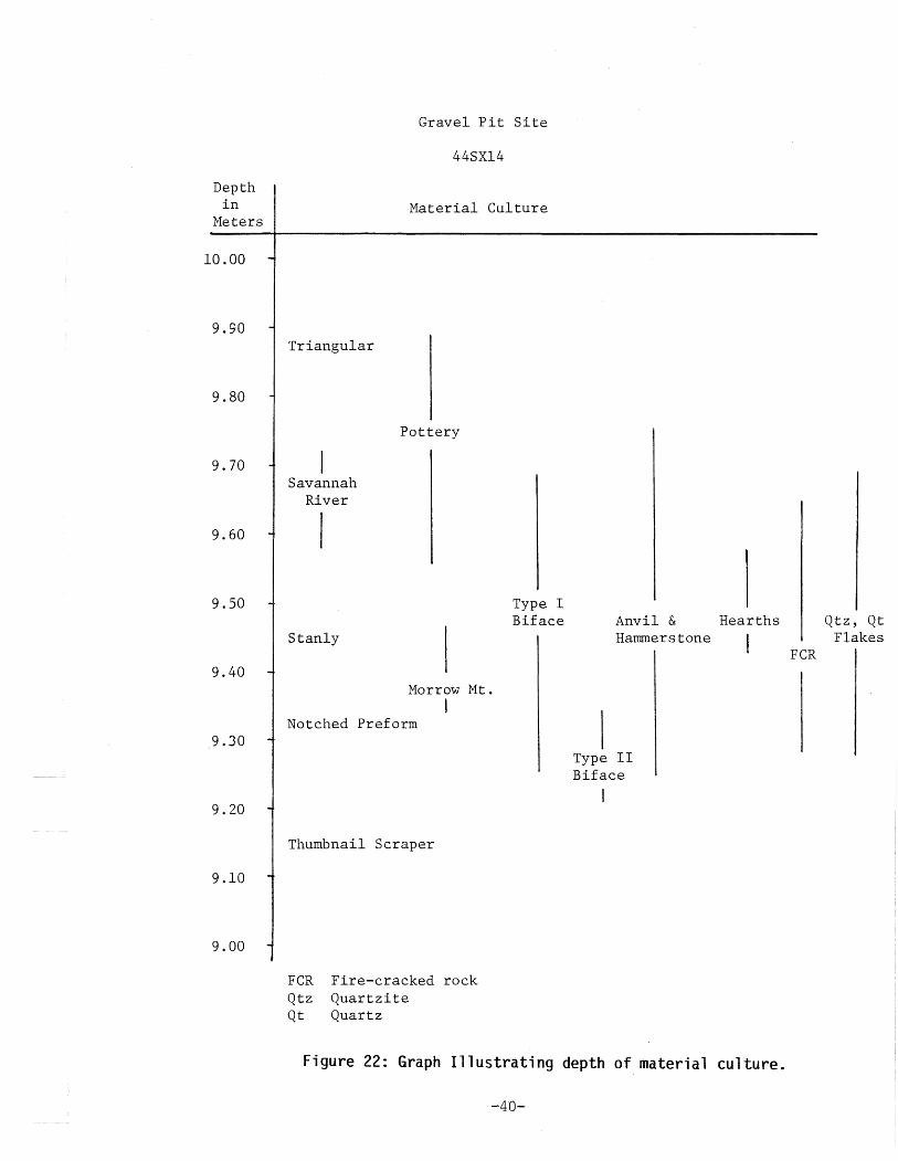
The vertical provenience of the major artifact classes is
illustrated in Figure 22. For quartzite and quartz flakage
and fire-cracked rock the depth of the heaviest
concentration is indicated. The artifact distribution
graphically shows that the end of the Early Archaic period
and the Middle and Late Archaic periods were the periods of
greatest cultural activity at this part of the site~
The Gravel Pit Site is an excellent example of a well
preserved stratified site along the Nottoway River in Sussex
County, Virginia. This site, along with others nearby,
holds significant knowledge of prehistoric Native American
culture. In fact, these stratified sites hold some of the
best data on Archaic period occupation in the Middle
Atlantic region. Additional investigations should be
conducted in this archaeologically-unique region before
-38-
continued cultivation, timbering, gravel-mining, and
artifact collecting either disturb the cultural context of
the sites or remove the remaining significant artifacts.
Unfortunately, the last large undisturbed section of the
Gravel Pit Site had been removed by gravel-mining by the
fall of 1985 (McAvoy 1985: personal communication).
·-39-
Depth in
Meters
10.00
9.90
9.80
9.70
9.60
9.50
9.40
9.30
9.20
9.10
9.00
Gravel Pit Site
44SX14
Material Culture
Triangular
Pottery
Savannah River
Stanly
Morrow Mt. I
Notched Preform
Thumbnail Scraper
FCR Fire-cracked rock Qtz Quartzite Qt Quartz
Type I Biface Anvil & Hearths
Hammerstone
Type II Biface
Figure 22: Graph Illustrating depth of material culture.
-40-
FCR
Qtz, Qt Flakes
REFERENCES CITED
Callahan, Errett
1976 The Pamunkey Project Phase I and II.
__ E=x...._p""""e....;r ...... 1 ___ · m=e~n __ t __ a __ l ___ ....;A __ r __ c-"-=h ___ a"""'e-'o'"""'l __ o;;...g.......,___i ___ c-=a=l------P--a=p~e-=r-=-s , No . 4 •
Department of Sociology and Anthropology,
Virginia Commonwealth University, Richmond.
Coe, Joffre Lanning
1964 The Formative Cultures of the Carolina Piedmont.
Transactions of the American Philosophical
Society, Volume 54, part 5.
Egloff, Keith T., et. al.
1987 Archaeological Investigations at Croaker Landing:
44JC70 and 44JC71. Research Report Series #4.
Division of Historic Landmarks, Richmond.
-41-


![Gravel Pit Management [Location] [Date] Weeds and Roads D. PolsterJ. Leekie](https://img.dokumen.tips/doc/110x75/551b37575503465c7e8b4cad/gravel-pit-management-location-date-weeds-and-roads-d-polsterj-leekie.jpg)


