Embed Size (px)
Citation preview

Introduction to Introduction to GIS In Pavement ManagementGIS In Pavement Management
Introduction to Introduction to GIS In Pavement ManagementGIS In Pavement Management
Alex Rocco and Barry WaiteAlex Rocco and Barry WaiteCity of Carson City of Carson Geographic Services DivisionGeographic Services Division

100 miles of street has a replacement value of approximately $42,000,000.
100 miles * 5280 ft/mile x 36ft ~ 19,000,000ft2
19,000,000ft2 * 1 yd2 / 9ft2 ~ 2,100,000 yd2
Average replacement value per yd2 ~ $20.00
$20.00 / yd2 * 2,000,000 yd2 = $42,000,000
Good planning and preventative maintenance saves $$$.
Is Is Pavement Management Important? Management Important?Is Is Pavement Management Important? Management Important?

Con
ditio
n
Time
40% Drop
75% Time40% Drop
12% Time
$1.00 spent herewill cost
$4.00 - $8.00here
Source: American Public Works Association
Pavement Deterioration CurvePavement Deterioration CurvePavement Deterioration CurvePavement Deterioration Curve

Pavement DeteriorationPavement DeteriorationPavement DeteriorationPavement Deterioration
Crop circles?

Tanks a lot!Tanks a lot!Tanks a lot!Tanks a lot!
M1A1 Abrams Tank

Pavement DeteriorationPavement DeteriorationPavement DeteriorationPavement Deterioration
Not a trash truck
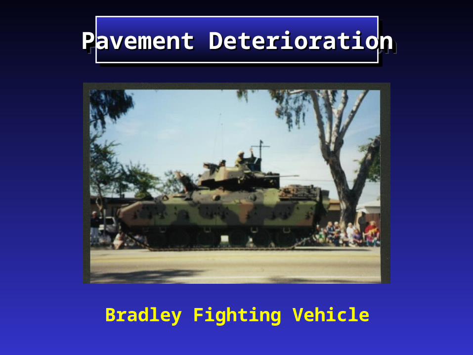
Pavement DeteriorationPavement DeteriorationPavement DeteriorationPavement Deterioration
Bradley Fighting Vehicle

Better visualization of current and expected conditionsBetter visualization of current and expected conditions Better analysisBetter analysis Aggregate with other geographic featuresAggregate with other geographic features Notify residents and businessesNotify residents and businesses Avoid shotgun approachAvoid shotgun approach Better CIP planning Better CIP planning Reduce duplication of dataReduce duplication of data
Traffic AccidentsTraffic Accidents
Traffic VolumeTraffic Volume
RoadsRoads
Structural DataStructural Data
Why integrateWhy integrateGIS and Pavement Management?GIS and Pavement Management?
Why integrateWhy integrateGIS and Pavement Management?GIS and Pavement Management?
TM
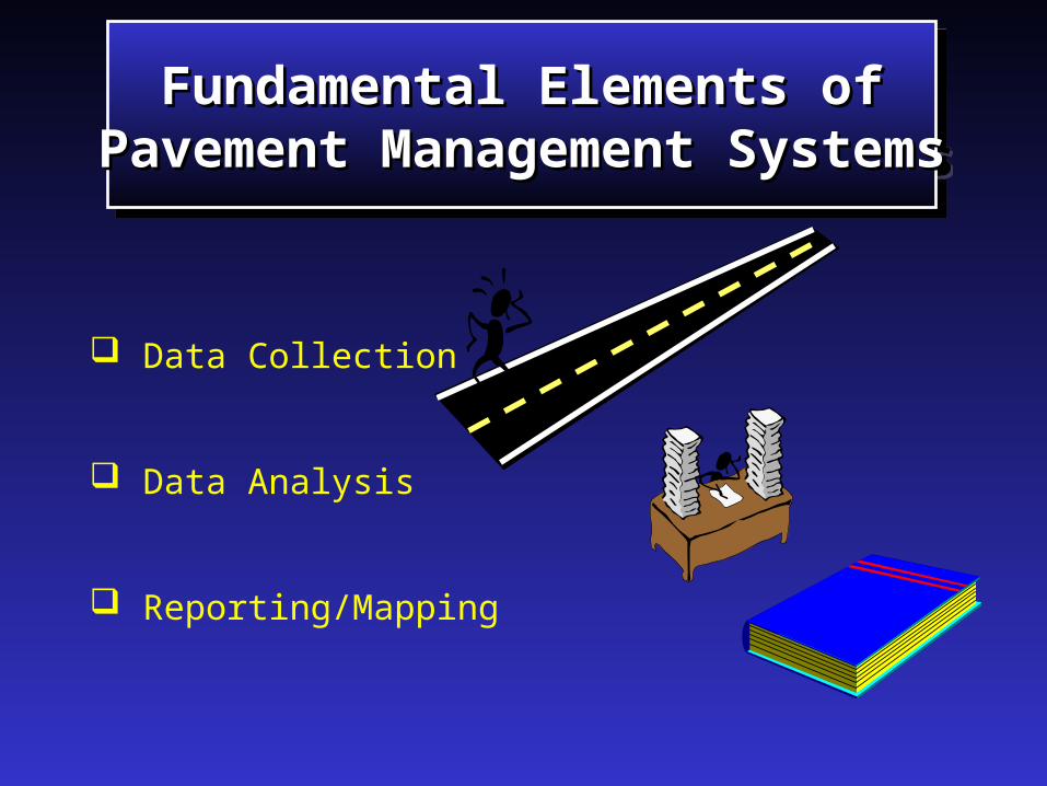
Data Collection
Data Analysis
Reporting/Mapping
Fundamental Elements ofFundamental Elements ofPavement Management SystemsPavement Management Systems
Fundamental Elements ofFundamental Elements ofPavement Management SystemsPavement Management Systems

Relate the data to any geographic feature Calculate pavement area for any geography Overlay projects with other activities
to avoid conflicts Cluster projects
AnalysisAnalysisAnalysisAnalysis
TM

Avoid maintaining a street in 1998 and then anadjoining street in 1999.
Resurface and repair whole subdivisions
Simplify and reduce the cost of notifications
Cluster ProjectsCluster ProjectsCluster ProjectsCluster Projects
Clustering
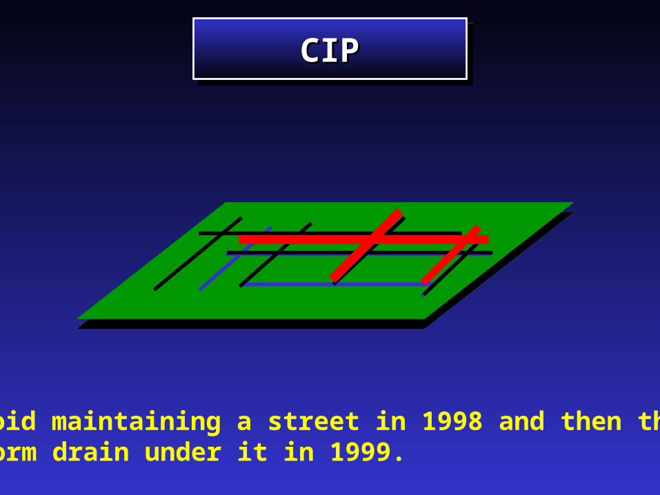
CIPCIPCIPCIP
Avoid maintaining a street in 1998 and then thestorm drain under it in 1999.
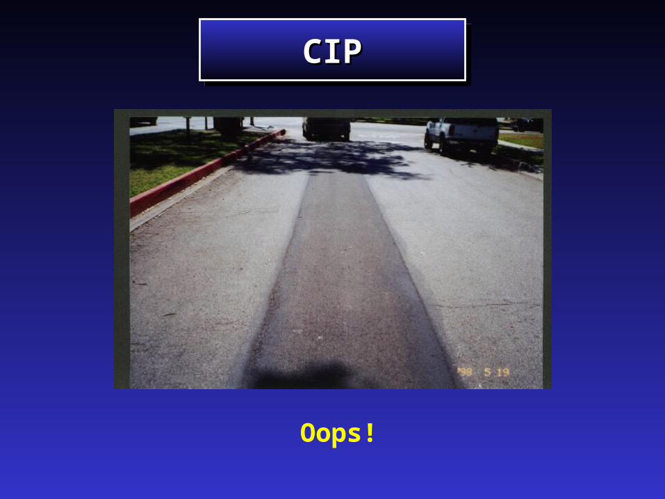
CIPCIPCIPCIP
Oops!

Functional Classification Yearly Improvement Plans Pavement Condition Future Condition Traffic Volumes
MapsMapsMapsMaps
TM

MapsMapsMapsMaps
Functional Classification
Arterials

Tabular DataTabular DataTabular DataTabular Data

MapsMapsMapsMaps

MapsMapsMapsMaps
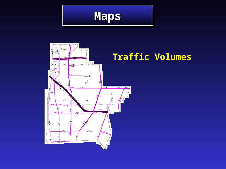
Traffic Volumes
MapsMapsMapsMaps

Priorities Current conditions Recommended corrective action Long range plan
ReportingReportingReportingReporting
TM

Traffic Engineer
TrafficVolumes
Utilities
SewerWaterStorm
Maintenance
Minor Repairs
Engineering
Major ImprovementsNew Streets
Materials Engineer
Soils
Avoid Redundant Data CollectionAvoid Redundant Data CollectionAvoid Redundant Data CollectionAvoid Redundant Data Collection

Arc-node TopologyLinking GIS Linking GIS
and Pavement Managementand Pavement ManagementLinking GIS Linking GIS
and Pavement Managementand Pavement Management
GIS From To1 A St B St2 B St C St
1 2
PM From To1 A St B St2 B St C St

Arc-node TopologyLinking GIS Linking GIS
and Pavement Managementand Pavement ManagementLinking GIS Linking GIS
and Pavement Managementand Pavement Management
GIS From To1 A St B St2 B St C St
PM From To1 A St 500ft2 500 ft B St3 B St C St
1 2

Arc-node TopologyLinking GIS Linking GIS
and Pavement Managementand Pavement ManagementLinking GIS Linking GIS
and Pavement Managementand Pavement Management
PM From To1 A St 500ft2 500 ft B St3 B St C St
1 2 3
GIS From To1 A St 500ft2 500 ft B St3 B St C St
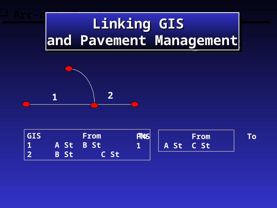
Arc-node TopologyLinking GIS Linking GIS
and Pavement Managementand Pavement ManagementLinking GIS Linking GIS
and Pavement Managementand Pavement Management
GIS From To1 A St B St2 B St C St
PMS From To1 A St C St
1 2

Roads Coverage
Concrete Asphalt Brick
Good Bad
2 lanes 4 lanes
The ProblemThe ProblemThe ProblemThe Problem

52
34
6
1
ARCS
A Solution is A Solution is Dynamic SegmentationDynamic Segmentation
A Solution is A Solution is Dynamic SegmentationDynamic Segmentation
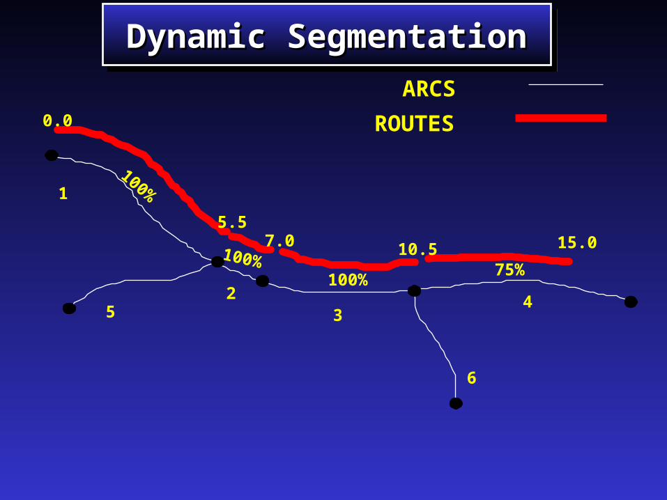
1
52
34
6
0.0
5.57.0 10.5 15.0
100%
100%100%
75%
ROUTES
ARCS
Dynamic SegmentationDynamic SegmentationDynamic SegmentationDynamic Segmentation
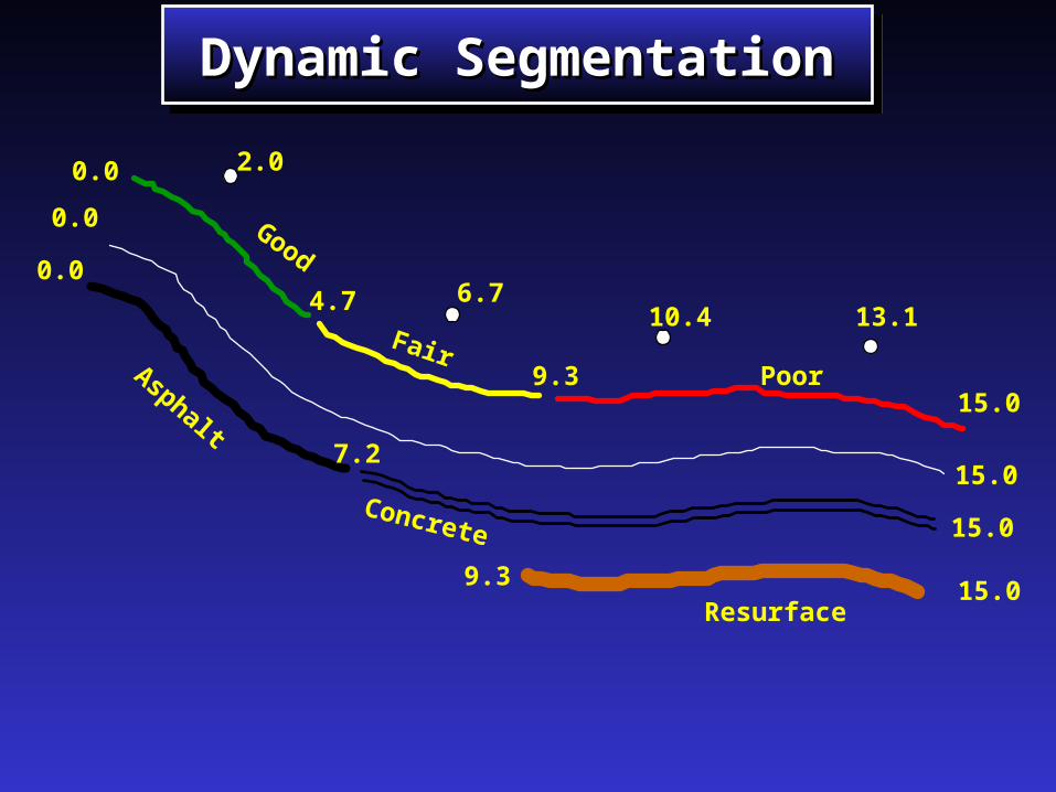
0.0
15.0
2.0
Good
FairPoor
0.0
4.7
9.315.0
7.2
6.710.4 13.1
0.0
15.0
9.315.0
Resurface
Asphalt
Concrete
Dynamic SegmentationDynamic SegmentationDynamic SegmentationDynamic Segmentation

Geography Geography is the is the
Missing Link!!!Missing Link!!!
Geography Geography is the is the
Missing Link!!!Missing Link!!!
Better visualization of current and expected conditionsBetter visualization of current and expected conditions Better analysisBetter analysis Aggregate with other geographic featuresAggregate with other geographic features Notify residents/businessesNotify residents/businesses Avoid shotgun approachAvoid shotgun approach Better CIP planning Better CIP planning Reduce duplication of dataReduce duplication of data
Sound familiar?

Do as we say, not as we doDo as we say, not as we doDo as we say, not as we doDo as we say, not as we do
Make sure you or your consultant has a plan for integrating Make sure you or your consultant has a plan for integrating GIS and pavement managementGIS and pavement management
Use a consultant who has GIS staff in-houseUse a consultant who has GIS staff in-house Collect other data while collecting street conditionsCollect other data while collecting street conditions
SignsSignsSignalsSignalsManholes (personnel access covers)Manholes (personnel access covers)Water valvesWater valvesCatch basinsCatch basins
Visit other agencies who have been through this processVisit other agencies who have been through this process Do not allow tanks on your streetsDo not allow tanks on your streets Eat your vegetablesEat your vegetables

Let’s Go!Let’s Go!Let’s Go!Let’s Go!