Embed Size (px)
Citation preview

Introduction
The present working plan is the first separate Working Plan for the Lidder Forest Division after the Working Plan prepared by the Mr.Shamim Mohmmad Khan in 1983-1992 for combined Kashmir Forest Division which included the present Lidder Forest Division. The Lidder Forest Division was created out in the year 1981 vide Government order No. 34/FST of 1981 dated: 20.02.1981. As a result of reorganization the Lidder drainage, which formed a part of erstwhile Kashmir Forest Division, a separate division was was carved out and named as Lidder Forest Division. In the later years Tral Range was included in this Division in 1982.
The Working Plan exercise was started in the financial year 2010-11. Active field work started in the month of May 2012. Several surveys were done in the field prior to taking up of the main exercise of Working Plan preparation. Random Point sampling methodology was used to assess and evaluate the growing stock. The GPS (Global Positioning System) was fully utilized for the first time during the field exercise. The Compartment boundaries were digitized for the first time by taking help from the Photo Interpretation Division Srinagar.
The Deodar-Kail Conversion Working circle which was previously managed under the shelterwood Compartment system is now to be managed under Indian Selection System due to excessive grazing pressure. It is feared that the gaps created under the Shelter wood system may not regenerate and may create permanent blanks in the prevailing situation. Moreover, Indian selection system will give flexibility in operation for the execution of work in a difficult terrain. The Indian Selection system shall continue for the management of Fir Forests. Few compartments have been shifted to Reboisement working circle so as to regenerate them and prevent their further degradation. The protection working circle of previous working circle is renamed as Ecological Conservation working circle. The Bio-Aesthetic working circle is extended in the present plan to the Beetab valley of Pahalgam Range. A comprehensive note on wildlife protection and management along with the assessment of growing stock is given under Wildlife Management working circle. The Lidder Forest Division is very rich in NTFP’s, particularly medicinal plants, so in order to achieve a sustainable yield of these resources, their conservation & to up lift the rural economy the NTFP working circle has been included. For the first time Willow Plantation working circle is created in which complete enumeration as well as yield calculation was done. The clear felling system followed by planting of Mawashas been proposed.
The field work took a lot of time due to shortage of working season i.e. May to October and inadequate trained staff.
My sincere thanks are due to worthy Principal Chief Conservator of Forests Mr. A.K. Singh, IFS and Ex-PCCF Mr. Abhav Kumar,IFS for all the expedient help ,as well as , for according the approval to the Prelimenary Working Plan Report. The writer is gratified to Mr. Nisar Ahmad Darzi ,IFS (Chief Conservator of Forests Kashmir) and Mr. R.S. Jasrotia,IFS (Chief Conservator of

Forests,Working Plan Circle )for their technical guidance and continued support during the preparation of this Working Plan document. My Special thanks are due to Mr. VasuYadav, IFS (Conservator of Forests Working Plan Circle) and Mr. Zahoor Ahmad Jan IFS (Conservator of Forests Kashmir, South Circle) for their able guidance and technical support especially during the analysis of data and the drafting of the final Working Plan document. Without their help it was not possible to present this document in the current format. The writer wishes to express his sincere thanks to the Ex- Divisional Forest Officer Mr. Ghulam Hassan Bhat for his valuable contribution in the preparation of this Plan. The admiringly wishes to thank Mr. Parvaiz A. Shagoo,(I/C Working Plan,Udhampur Forest Division) for his technical guidance at the final stages of preparation of this document .
The writer’s special thanks are due to Mr. Nawab Ahmad Magray and Mr. Sajad Ahmad Khan (Range Officers Grade-I) for executing the work in the field and helping me during the data analysis and other related works. My thanks are also due to Mr. Ghulam Mohi-u-din Dar, senior Forester and Mr. Ishtiyaq Ahmad Zarger, DDR Forester for completing the laborious field exercises and assisting me during the compilation of this Plan document. Finally the Writer’s thanks are due to Divisional Office staff especially Ms.Rifat Jan (Head Clerk) for the valuable assistance provided & also to Mr. Farooq Ahmad Dand (Helper) for organizing the field information in a systematic manner. Last but not the least special thanks are due to Mr. Ubaid Hussain Beig (Computer Operator) for computerizing the whole manuscript within the shortest possible time period.
Sd/-
Syed HumayunKabirQadri DFO, Working Plan Lidder Forest Division, Bijbehara.

Botanical Name Common Name
Elevation in mts. Habitat Uses Family
Abies pindrow Fir/Badlu 2300-3600 T WD Pinaceae
Acer caesium Kanzul 2000-2800 T WD & LE Aceraceae
Aconitum heterophyllum Atis/patress 2500-3200 H RS Ranunculaceae
Adiantum Leave Gewthere 1500-3000 H LE Pteridaceae
Aesculus indica Hanadun 2000-2800 T SE & FR Sapindaceae
Arisaema jacquemontii Hapat makai 2500-3400 H LE & RS Araceae
Artemisia absinthium Liun Tethwan2000-3000 H LE Asteraceae
Atropa acuminata Meitbrand 2000-3500 H Le & Rs Solanaceae
Berberis lycium Kaodacch 2000-3000 S RS/Fr Berberidaceae
Bergenia stracheyi Pashend 1800-4000 H Rh/Rs Saxifergaceae
Betula utilis D.Don Burza 2800-4000 T WD/Br Betulaceae
Canabis sativa Bhang 2000-2500 H Le Cannabaceae
Cedrus deodara Deodar 2000-2500 T WD Pinaceae
Celtis australis Brimji 500-2500 T LE & WD Ulmaceae
Corylus jacquemontii Virin 2800-3300 T Fr Corylaceae
Cotoneaster roseus Leun 2500-3300 S WD & Fr Rosaceae
Crataegus songarica Ringkul 2000-3000 T Fr Rosaceae
Cuscuta reflexa Kuklipoth 2000-2400 H LE Canvolvulaceae
Cynodon dactylon Dramun 1500-2000 H Le/RS Poecere
Dioscorea deltoidea Krees 1500-3000 S Rs Dioscoriaceae
Dutura stramonium Datur 2000-2200 S Le & Fr Solanaceae
Fragaria nubicola Ishtabur 2000-3500 H Rs & FR Rosaceae
Fraxinus hookeri Ash 2500-3000 T WD Oleaceae
Hedera nepalensis Agranth 2000-3000 S Fr Aesliaceae
Iris hookeriana Krishm 2400-3500 H RS Iridaceae
Juglans regia Dun 2000-3000 T Fr Juglandaceae
Juniperous macropoda Bethur 3100-3500 T WD Cupreisaceae
The flora of Lidder Forest Division with their common name, scientific name, family and uses is as below wit
Glossary of Botanical Terms
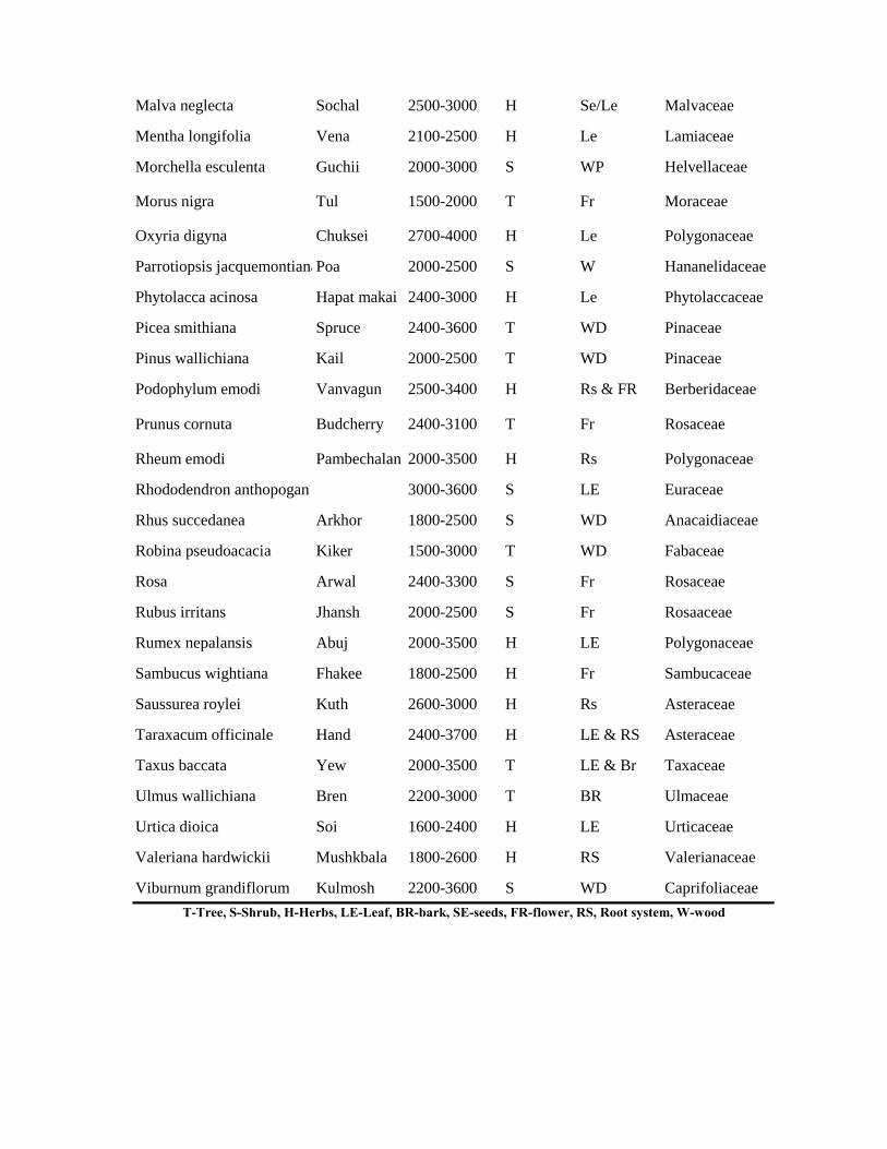
Malva neglecta Sochal 2500-3000 H Se/Le Malvaceae
Mentha longifolia Vena 2100-2500 H Le Lamiaceae
Morchella esculenta Guchii 2000-3000 S WP Helvellaceae
Morus nigra Tul 1500-2000 T Fr Moraceae
Oxyria digyna Chuksei 2700-4000 H Le Polygonaceae
Parrotiopsis jacquemontianaPoa 2000-2500 S W Hananelidaceae
Phytolacca acinosa Hapat makai 2400-3000 H Le Phytolaccaceae
Picea smithiana Spruce 2400-3600 T WD Pinaceae
Pinus wallichiana Kail 2000-2500 T WD Pinaceae
Podophylum emodi Vanvagun 2500-3400 H Rs & FR Berberidaceae
Prunus cornuta Budcherry 2400-3100 T Fr Rosaceae
Rheum emodi Pambechalan 2000-3500 H Rs Polygonaceae
Rhododendron anthopogan 3000-3600 S LE Euraceae
Rhus succedanea Arkhor 1800-2500 S WD Anacaidiaceae
Robina pseudoacacia Kiker 1500-3000 T WD Fabaceae
Rosa Arwal 2400-3300 S Fr Rosaceae
Rubus irritans Jhansh 2000-2500 S Fr Rosaaceae
Rumex nepalansis Abuj 2000-3500 H LE Polygonaceae
Sambucus wightiana Fhakee 1800-2500 H Fr Sambucaceae
Saussurea roylei Kuth 2600-3000 H Rs Asteraceae
Taraxacum officinale Hand 2400-3700 H LE & RS Asteraceae
Taxus baccata Yew 2000-3500 T LE & Br Taxaceae
Ulmus wallichiana Bren 2200-3000 T BR Ulmaceae
Urtica dioica Soi 1600-2400 H LE Urticaceae
Valeriana hardwickii Mushkbala 1800-2600 H RS Valerianaceae
Viburnum grandiflorum Kulmosh 2200-3600 S WD CaprifoliaceaeT-Tree, S-Shrub, H-Herbs, LE-Leaf, BR-bark, SE-seeds, FR-flower, RS, Root system, W-wood
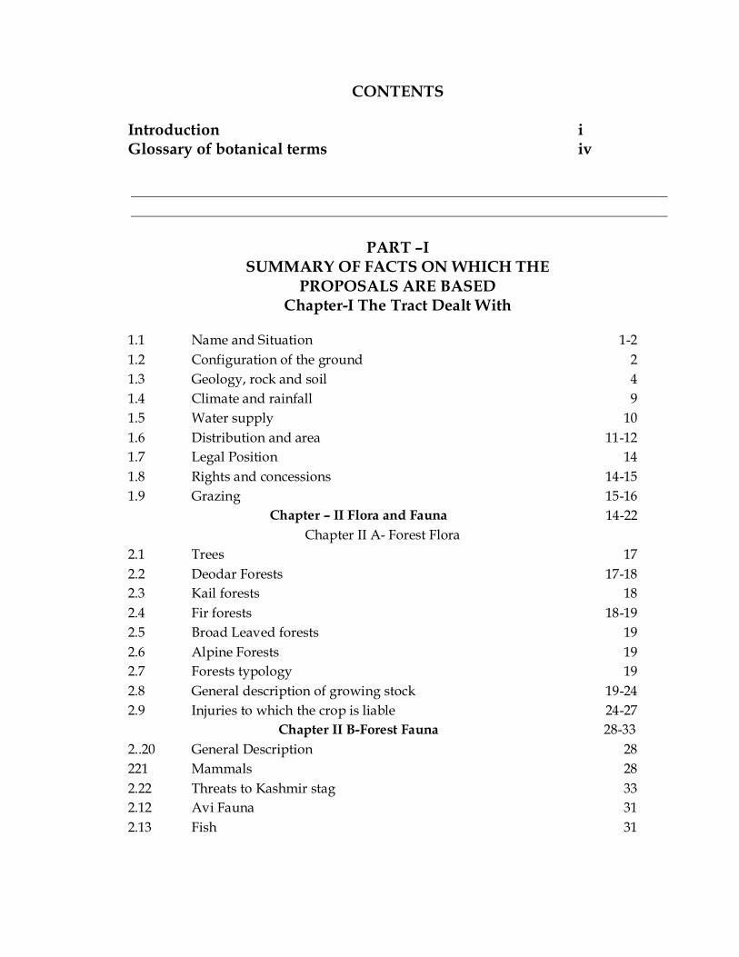
CONTENTS Introduction i Glossary of botanical terms iv
PART –I SUMMARY OF FACTS ON WHICH THE
PROPOSALS ARE BASED Chapter-I The Tract Dealt With
1.1 Name and Situation 1-2 1.2 Configuration of the ground 2 1.3 Geology, rock and soil 4 1.4 Climate and rainfall 9 1.5 Water supply 10 1.6 Distribution and area 11-12 1.7 Legal Position 14 1.8 Rights and concessions 14-15 1.9 Grazing 15-16
Chapter – II Flora and Fauna 14-22 Chapter II A- Forest Flora
2.1 Trees 17 2.2 Deodar Forests 17-18 2.3 Kail forests 18 2.4 Fir forests 18-19 2.5 Broad Leaved forests 19 2.6 Alpine Forests 19 2.7 Forests typology 19 2.8 General description of growing stock 19-24 2.9 Injuries to which the crop is liable 24-27
Chapter II B-Forest Fauna 28-33 2..20 General Description 28 221 Mammals 28 2.22 Threats to Kashmir stag 33 2.12 Avi Fauna 31 2.13 Fish
31

Chapter – III Utilisation of the produce 31-41 3.1 Agriculture customs and wants of the
population 31
3.2 Markets and marketable products 36 3.3 Demand and supply of forest produce on forests 36-40 3.4 Method of Harvesting and their costs 40 3.5 Lines of Export 40-41 3.6 Past and current prices 41
Chapter-IV Activities of State Forest Corporation 42-47 4.1 Jammu and Kashmir State Forest Corporation 42 4.2 Result of socio Economic Survey 45 4.3 Source of energy and fodder 46 4.4 Social customs 47
Chapter-V Five year plans 48-52 5.2 Management of Forests under Five year Plans 48 5.3 12th five year plan and its scope for J&K forest 49
Chapter-VI Staff and Labour Supply 53 Staff and Labour supply 53
Chapter VII Past system of Management 54-75 7.1 Past history of the forests 54 7.2 H.S. Pathania 1930-1940 (S. 1987-1997) 56 7.3 Khushoo’s Plan (1940-1955) 58 7.4 Fotidar’s Plan (1955-56 to 1969-70) 62-64 7.5 Quadir’s Plan (1970-71 to 1979-80) 64 7.6 Shahmim Mohd Khan Plan (1982-83 to 1991-92) 68 7.7 Special works of improvement undertaken 74 7.8 Fire conservancy 75
Chapter – VIII Statistics of Growth and Yield 76-80 8.1 Inventory method adopted 76 8.2 The results of statistical analysis performed 77 8.3 Age diameter correlation 79 8.4 Yield calculation 80 8.5 Assessment of Growing stock for willow
plantation 68
Part II FUTURE MANAGEMENT DISCUSSED AND PRESCRIBED
Chapter-IX Basis of Proposals 81-87 9.1 General objectives of Management 81 9.2 Method of treatment to be adopted 81-82 9.3 Constitution of working circles, their area and 82-83
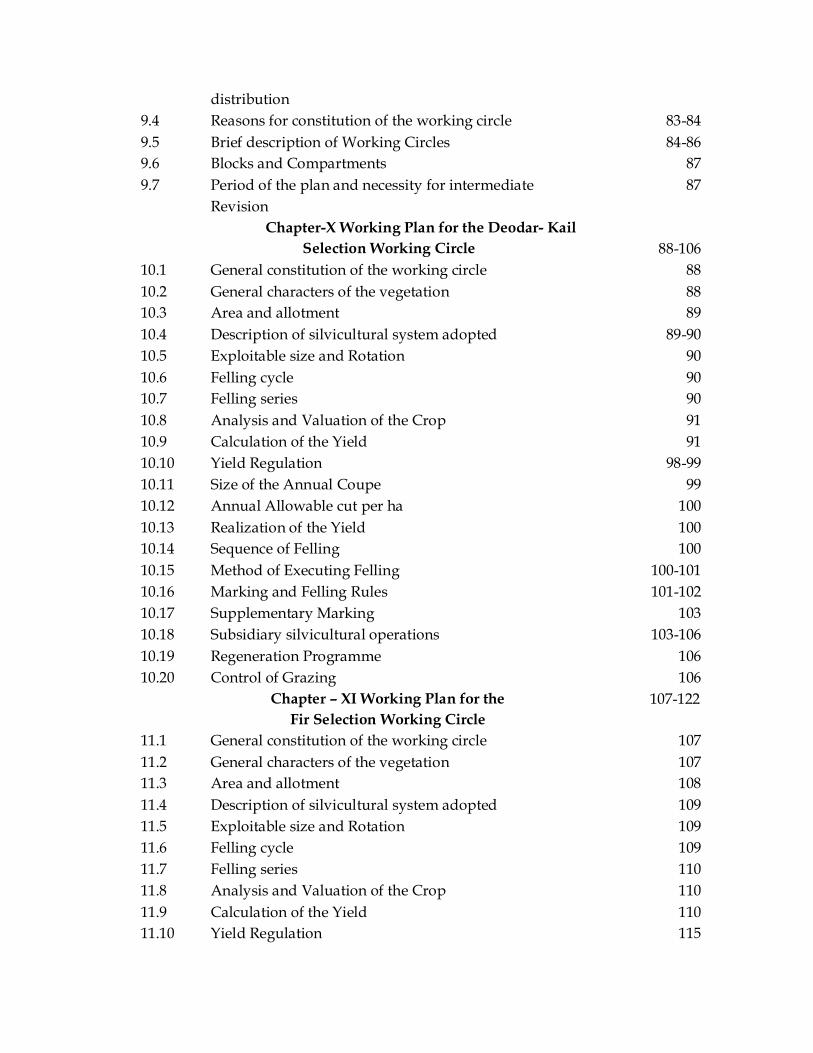
distribution 9.4 Reasons for constitution of the working circle 83-84 9.5 Brief description of Working Circles 84-86 9.6 Blocks and Compartments 87 9.7 Period of the plan and necessity for intermediate
Revision 87
Chapter-X Working Plan for the Deodar- Kail Selection Working Circle 88-106
10.1 General constitution of the working circle 88 10.2 General characters of the vegetation 88 10.3 Area and allotment 89 10.4 Description of silvicultural system adopted 89-90 10.5 Exploitable size and Rotation 90 10.6 Felling cycle 90 10.7 Felling series 90 10.8 Analysis and Valuation of the Crop 91 10.9 Calculation of the Yield 91 10.10 Yield Regulation 98-99 10.11 Size of the Annual Coupe 99 10.12 Annual Allowable cut per ha 100 10.13 Realization of the Yield 100 10.14 Sequence of Felling 100 10.15 Method of Executing Felling 100-101 10.16 Marking and Felling Rules 101-102 10.17 Supplementary Marking 103 10.18 Subsidiary silvicultural operations 103-106 10.19 Regeneration Programme 106 10.20 Control of Grazing 106
Chapter – XI Working Plan for the Fir Selection Working Circle
107-122
11.1 General constitution of the working circle 107 11.2 General characters of the vegetation 107 11.3 Area and allotment 108 11.4 Description of silvicultural system adopted 109 11.5 Exploitable size and Rotation 109 11.6 Felling cycle 109 11.7 Felling series 110 11.8 Analysis and Valuation of the Crop 110 11.9 Calculation of the Yield 110 11.10 Yield Regulation 115

11.11 Size of the Annual Coupe 115 11.12 Allowable Cut 116 11.13 Realization of the Yield 118 11.14 Sequence of Felling 118 11.15 Method of Executing Felling 118 11.16 Marking and Felling Rules 118-119 11.17 Supplementary Marking 119 11.18 Subsidiary silvicultural operations 119 11.19 Regeneration Programme 119-121 11.20 Nursery and Plantation technique 121 11.21 Control of Grazing 121
Chapter-XII Working Plan for the Ecological Conservation Working Circle
123-130
12.1 General constitution of the working circle 123 12.2 General character of vegetation 123 12.3 Area and allotment 123-124 12.4 Felling series and cutting sections 124 12.5 Special objectives of Management 125 12.6 Analysis and valuation of the crop 125 12.7 Silvicultural system adopted 125 12.8 Method of treatment prescribed 125 12.9 Realization of yield 126
Chapter-XIII Working Plan for the Reboisement Working Circle
131-140
13.1 General constitution of the working circle 131 13.2 General character of vegetation 131 13.3 Area and allotment 132 13.4 Special objectives of Management 133 13.5 Analysis and valuation of the crop 133 13.6 Exploitable Size 133 13.7 Method of treatment prescribed 134-135 13.8 Realization of yield 136 13.9 Nursery technology 136
Chapter-XIV Working Plan for the Bio-Aesthetic Working Circle
131-148
14.1 General description of the working circle and character of vegetation
141
14.2 Area and Allotment 142 14.3 Valuation and analysis of growing stock 142 14.4 Method of treatment prescribed 142-144

14.5 Realization of yield 144 Chapter-XV Working Plan for the NTFP
(Overlapping) Working Circle 149-153
15.1 General description of the working circle and character of vegetation
149
15.2 Objectives of Management 150 15.3 Management Prescriptions 150 15.4 Method of Harvesting 150-152 15.5 Walnut and Pohu twigs 153 Chapter-XVI Working Plan for the JFM
(Overlapping) Working Circle 154-166
16.1 Introduction 154-155 16.2 General constitution of the working circle and
general character of vegetation 155
16.3 Management objectives 155-156 16.4 The JFM Implementation in Lidder Division 156-164 16.5 Future Proposals 164-165 Chapter-XVII Working Plan for the Plantation
(Overlapping) Working Circle 167-170
17.1 General Description 167 17.2 Objectives of Management 167 17.3 Distribution of the Area 167-168 17.4 Method of treatment proposed 168 17.5 Maintenance/Establishment of new nursery 169 17.6 Nursery and Plantation technique 169-170 Chapter-XVIII Working Plan for the Forest
Protection (Overlapping) Working Circle 171-176
18.1 General constitution of the Working Circle 171 18.2 Major threats to the forests and management
prescriptions 171-172
18.3 Smuggling and illicit felling 173 18.4 Encroachment 173 18.5 Mining 173 18.6 Fire 174 18.7 Torch wood cutting 175 18.8 Grazing 175 18.9 Pests 176 18.10 Diseases 176 18.11 Parasites 176 18.12 Management measures 176

Chapter-XIX Working Plan for the Wildlife Management Working Circle
177-186
19.1 General constitution of the circle and character of vegetation
177
19.2 Area and Allotment 179 19.3 Analysis and valuation of crop 180 19.4 Description and present condition of wildlife 180 19.5 Special objectives of Management 180 19.6 Management and protection measures for
protected areas 180
19.7 Method of treatment 180-181 19.8 Training 181 19.9 Awareness Programme 181-182 19.10 Management of Man-Animal conflict 182 19.11 Wildlife Research 182 Chapter-XX Working Plan for the Willow
Plantation Working Circle
187-191 20.1. General constitution of the working circle 187 20.2 General characters of vegetation 187 20.3 Area and Allotment 187 20.4 Silviculture system adopted 188 20.5 Calculation of the Rotation 188 20.6 Calculation of the yield 188 20.7 Method of executing fellings 189 20.8 Regeneration of the areas after felling 189 20.9 Technique of planting 189 20.10 Subsidiary Silvicultural operations 189-190 20.11 Provision of drainage in water logged areas 190
Chapter-XXI Miscellaneous Regulations 192-197 21.1 Forest Roads 192 21.2 Bridges and culverts 192 21.3 Buildings 193 21.4 Forest Demarcation and consolidation 193 21.5 Alpine pastures and Grazing 194 21.6 Firewood supply 195 21.7 Beats and Blocks 196 21.8 MAPS 197 21.9 Compartment Description 197 21.10 Draft Plan 197
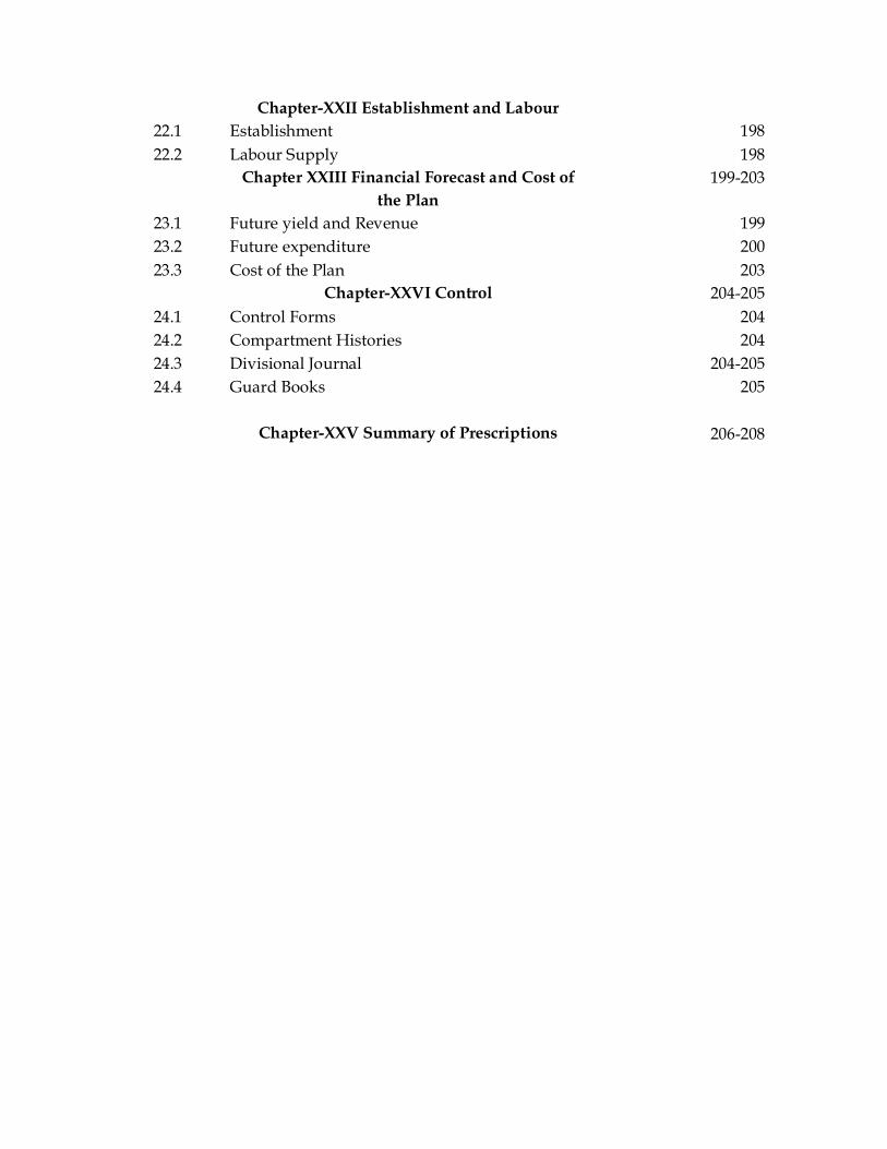
Chapter-XXII Establishment and Labour 22.1 Establishment 198 22.2 Labour Supply 198 Chapter XXIII Financial Forecast and Cost of
the Plan 199-203
23.1 Future yield and Revenue 199 23.2 Future expenditure 200 23.3 Cost of the Plan 203 Chapter-XXVI Control 204-205 24.1 Control Forms 204 24.2 Compartment Histories 204 24.3 Divisional Journal 204-205 24.4 Guard Books 205
Chapter-XXV Summary of Prescriptions
206-208
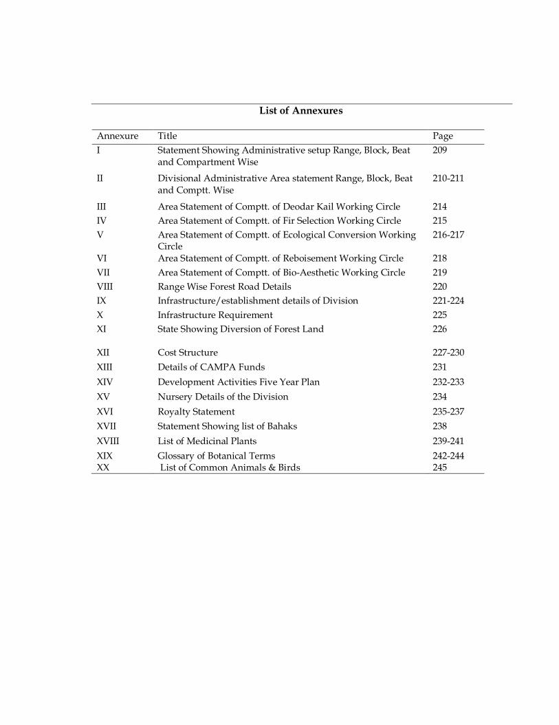
List of Annexures
Annexure Title Page I Statement Showing Administrative setup Range, Block, Beat
and Compartment Wise 209
II Divisional Administrative Area statement Range, Block, Beat and Comptt. Wise
210-211
III Area Statement of Comptt. of Deodar Kail Working Circle 214 IV Area Statement of Comptt. of Fir Selection Working Circle 215 V Area Statement of Comptt. of Ecological Conversion Working
Circle 216-217
VI Area Statement of Comptt. of Reboisement Working Circle 218 VII Area Statement of Comptt. of Bio-Aesthetic Working Circle 219 VIII Range Wise Forest Road Details 220 IX Infrastructure/establishment details of Division 221-224 X Infrastructure Requirement 225 XI
State Showing Diversion of Forest Land 226
XII Cost Structure 227-230 XIII Details of CAMPA Funds 231 XIV Development Activities Five Year Plan 232-233 XV Nursery Details of the Division 234 XVI Royalty Statement 235-237 XVII Statement Showing list of Bahaks 238 XVIII List of Medicinal Plants 239-241 XIX XX
Glossary of Botanical Terms List of Common Animals & Birds
242-244 245

1
CHAPTER – 1
THE TRACT DEALT WITH 1.1. NAME AND SITUATION
1.1.1. The working plan covers the entire Forests falling under the territorial
jurisdiction of Lidder Forest Division and is the maiden working plan for the Division, since its creation in 1981 as per Govt. order No. 34/FST of 1981 dated:- 20.02.1981. As a result of the reorganization, the Lidder drainage which formed a part of erstwhile Kashmir Forest Division was carved out, and named as Lidder Forest Division. Later on, the Tral Range has also been included in this Division in 1982. The Game areas of Tral Range were however seceded from it and kept under Wildlife department. The Division now comprises of three territorial Ranges and two overlapping Soil conservation Ranges. The Ranges of the Lidder Forest Division are:-
1. Mattan Range (with headquarter at Mattan) N330 45’ 33.8” E750 12’ 36.1” 2. Pahalgam Range (with headquarter at Pahalgam) N340 00’ 51.7” E750 19’ 11.3” 3. Tral Range (with headquarter at Tral) N330 56’ 40.2” E 750 07’ 56.0” 4. Pampore SC Range (with headquarter at Awantipora) N330 55’ 08.1” E750 00’ 41.1” 5. Bijbehara SC Range. (With headquarter at Bijbehara) N330 47’ 05.1” E750 06’ 20.4”
1.1.2 The Lidder Forest Division is situated between 34 ° 08´ 4.22´´ to 34 ° 02´ 43.41´´E Latitude and 75 ° 32´ 38.40´´ to 74 ° 51´ 37.57´´N Longitude and is represented by survey of India G.T sheet No’s 43J/16, 43N/4, 43N/8, 43N/12, 43K/13, 43O/1 and 43O/5. The net area remaining with the territorial Division is 655.665 Sq. Kms (65566.5 ha) excluding the area with Wildlife Department. Following are the wildlife protected areas which were part of erstwhile Lidder Forest Division:-
1. Owura – Aru Wildlife Sanctuary--- 425 Sq. Km 2. Khiram Conservation Reserve--- 5.70 Sq. Km. 3. Panner –Shikargah Conservation Reserve --- 6.80 Sq. Km 4. Khonmouh- Khrew Conservation Reserve --- 42.31 Sq. Km 5. Mini zoo Pahalgam --- 0 .09sq.Km
2
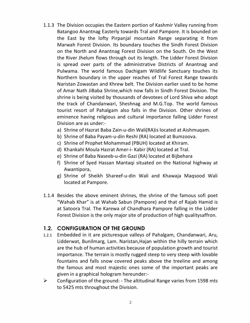
1.1.3 The Division occupies the Eastern portion of Kashmir Valley running from Batangoo Anantnag Easterly towards Tral and Pampore. It is bounded on the East by the lofty Pirpanjal mountain Range separating it from Marwah Forest Division. Its boundary touches the Sindh Forest Division on the North and Anantnag Forest Division on the South. On the West the River Jhelum flows through out its length. The Lidder Forest Division is spread over parts of the administrative Districts of Anantnag and Pulwama. The world famous Dachigam Wildlife Sanctuary touches its Northern boundary in the upper reaches of Tral Forest Range towards Naristan Zowastan and Khrew belt. The Division earlier used to be home of Amar Nath JiBaba Shrine,which now falls in Sindh Forest Division. The shrine is being visited by thousands of devotees of Lord Shiva who adopt the track of Chandanwari, Sheshnag and M.G.Top. The world famous tourist resort of Pahalgam also falls in the Division. Other shrines of eminence having religious and cultural importance falling Lidder Forest Division are as under:- a) Shrine of Hazrat Baba Zain-u-din Wali(RA)is located at Aishmuqam. b) Shrine of Baba Payam-u-din Reshi (RA) located at Bumzoova. c) Shrine of Prophet Mohammad (PBUH) located at Khiram. d) Khankahi Moula Hazrat Amer-i- Kabir (RA) located at Tral. e) Shrine of Baba Naseeb-u-din Gazi (RA) located at Bijbehara f) Shrine of Syed Hassan Mantaqi situated on the National highway at
Awantipora, g) Shrine of Sheikh Shareef-u-din Wali and Khawaja Maqsood Wali
located at Pampore.
1.1.4 Besides the above eminent shrines, the shrine of the famous sofi poet “Wahab Khar” is at Wahab Sabun (Pampore) and that of Rajab Hamid is at Satoora Tral. The Karewa of Chandhara Pampore falling in the Lidder Forest Division is the only major site of production of high qualitysaffron.
1.2. CONFIGURATION OF THE GROUND 1.2.1 Embedded in it are picturesque valleys of Pahalgam, Chandanwari, Aru,
Lidderwat, Bunilmarg, Lam. Naristan,Hajan within the hilly terrain which are the hub of human activities because of population growth and tourist importance. The terrain is mostly rugged steep to very steep with lovable fountains and falls snow covered peaks above the treeline and among the famous and most majestic ones some of the important peaks are given in a graphical hologram hereunder:-
Ø Configuration of the ground: - The altitudinal Range varies from 1598 mts to 5425 mts throughout the Division.

3
Point Altitude (mts) Dev Masjid 4439 mts Yamhar 4099 Sheikhvas Peak 4695 Gurpal Peak 4608 Gumber 3877 Doodsar Peak 4767 Chandsar Peak 4289 Sonasar Peak 4787 Kolahai Peak 5425 Katernag Peak 5116 Mosa Sahib Kabar 5110 Haksar Peak 4406 Watwangan 3664
1.3 DRAINAGE 1.3.1 The entire area of the Lidder valley is drained by Lidder stream while as
Tral catchment is drained by two perennial Nallahs of Aripal and Naristan. The major portion is drained by the Lidder catchment which comprises of 02 sub catchments, 08 water sheds and 98 MicroWater sheds. Aripal catchment comprises of 2 sub ctachments, 5 water sheds and 53 micro water sehds. These two catchments in total cover 151 micro water sheds out of total 1028 identified water sheds of Jehlum Basin comprising of total 24 catchments.
0
1000
2000
3000
4000
5000
6000

4
1.4 GEOLOGY, ROCK AND SOIL 1.4.1 Geologically the entire Kashmir valley has been formed during the entire
glaciations period followed by organic and tectonic movements, resulting in thearise of Pirpanjal system of mountains.
Table 1.1. The note of the geological survey of India for this area
S.No Formation Rock 01 02 03 04 05 06 07 08
Recent and post Pliocene Karewas (Pliocene) Upper trias Muschelkalk Lower Trias Zewan formation (Late Permion) Panjal trap Gondwana plant beds
Alluvium and gravel deposits like river beds. Alternating layers or beds of sand loam and conglomerates occur near Barsoo, Awantipora & Mattan etc. Massive blue gray lime stone of vast thickness with a little interbeded shales, are well exposed in North–East and West of Pahalgam, Chandanwari and Mattan. Dark shales and lime stones are partial exposed in Pahalgam, Mattan and Khrew belt. Pale, sandy and Schistose plates (Phyllites) Dark and black shales, lime stone and sand stone. The beds are exposed in the Lidder valley near Aru, Talwar gali and Zewan spur of Vihi valley. Vast thickness of basic and intermediate lava flows or sillo with ash bed found at North of Awantipora, Bijbehara. North and South of Pahalgam near Tersar, Liderwat, Aru, Chandanwari and Talwar Gali. exposed near Marhama and Aru
1.4.2 The soil composition is determined by the nature of the underlying
parent rock. The depth of the soil varies with slope and is comparatively shallow on Panjal formation. The composition, depth and porosity of soil exercises great influence over the distribution of coniferous vegetation thereupon.
1.5. Geology of South-East Kashmir
1.5.1 Summary: Kashmir Valley is characterized by a diverse geological record ranging in age from Pre-Cambrian to Recent (GSI 1977; Wadia 1975; Middlemiss 1910, 1911). The geology of Anantnag, not too complex as in other collision type organic belts, is dominated by the Upper Paleozoic and Triassic rocks. The Triassic rocks are surrounded by Palaeozoics and are overlain by Pleistocene and Recent sediments. Upper Palaeozoic rocks (Agglomeratic Slates and Panjal Traps) occur towards the marginal areas. The lithology of Upper Palaeozoics include andesitic/basaltic lavas, pyroclastics and arenites. The Paleozoic rocks are overlain by Triassic Limestone, which consists mostly of a thick series (~1000m) of compact

5
blue limestone, argillaceous limestone and dolomitic limestone (Middlemiss 1910) and occur in the form dissected ridges. The limestone is mostly thin bedded, with common shale and sandstone horizons. The fluvio-glacial and fluvio-lacustrine deposits of Pleistocene are locally known as Karewas, which consist of fine lacustrine sandstones, beds of loess, conglomerates, etc. Karewas at many places stand >100m above the alluvial plain and form plateau like features. Small valleys between Triassic Limestone ridges and Karewas are filled with Recent Alluvium, which consists of fine muddy and silty sediments. However, along the streams the boulders and gravels predominate.
1.6. Detailed Geology:
1.6.1 The detailed study of the geological, paleontological and petrologic observations and systematic mapping in Kashmir Valley was carried out in the years (1909, 1910, 1911). A detailed account of Stratigraphy of southern part of the valley (Anantnag) was given. The classification is still followed with some modification from time to time. The stratigraphic sequence was divided into two divisions, by making the Agglomeratic slate and Panjal volcanic as a convenient series for division. The two divisions are: Div A, below the Panjal volcanic and Div B, above the Panjal volcanic.
1.6.2 The other workers who modified the above classification either by giving some local names to some of the formation or by adding some more litho units include Gupta (1966-73), Pal (1977). Further Cambrian Silurian group of Anantnag were divided into 3 lithological units which are: Margan shale, Lihinwan sandstone and Chittergul mudstone (Shah 1972).
1.6.3 Chittergul mudstone: This formation represents the oldest unit in Anantnag district (Shah, 1972). It consists of a homogenous succession of fine grained pyrotiferous mud stone and slate of varying shades pale to dark blue. The silt content increases towards top and the formation grades into lihinwan sand stone. Good sections are also found in Naubug and near Khayar in Hapatnar valley.
1.6.4 Lihinwan sandstone: It consists of a heterogeneous succession of greywacke, banded sandstone and sandy phyllite, with varying sandstone and shale ratio. The typical section is seen around Lihinwan and near Naubug. The rocks show greater degree of metamorphism to North-West and comprise sandy Phyllite with copper mineralization.
1.6.5 Margan shale: It is exposed throughout the area and is the only formation containing determinable fossils. It comprises essentially shale, which is occasionally calcareous and sandy. The Margan shale is siliceous
6
towards the base and becomes sandy towards the top. Complete sections are seen below Margan pass.
1.6.6 Muth quartzite: The Silurian rocks on both the flanks of Lidder Anticline are overlain by a thick succession of snow white to greenish grey, pinkish Ortho-quartzite of Devonian age, known as Muth-quartzite. It forms a conspicuous topographical feature by making prominent cliffs and precipices. The formation consists of hard quartzite which is generally massive and of granular texture and at places with ferruginous spots. It also contains layers of siliceous limestone and argillaceous matters. The maximum thickness recorded is 317m. It shows wide development in Anantnag.
1.6.7 Aishmuqam formation: This formation is passage bed between Muthquartzite and Syringothyris Limestone and consists of quartzite with varying colour from white grey purple to blotchy. At places the formation is pebbly and gritty with shale and sandstone partings. Fragmentary plant impressions are found in the upper part. The maximum thickness is 150m near Wazur in the northern limb and 60m in the southern limb of Lidder valley anticline.
In the Lidder valley anticline Muth quartzite are overlain by a series of limestone strata called the Syringothyris Limestone. At Aishmuqam syringothyris limestone is underlain by Aishmuqam formation. The limestone is exposed at Kotsu, Ichnar. The formation yields fossils principally of Brachiopod class. Syringothyris cuspidate is a characteristic fossil of the strata from which the formation derived its name.
1.6.8 Passage beds: The Syringothyris Limestone is overlain by a considerable thickness of unfossilferous rocks. The rocks consist of quartz, sandstone and shale. Petrologically they might be linked with Fenestella shale above rather than limestone.
1.6.9 Fenestella shale: The passage beds of Middlemiss were included in Fenestella shale by a number of workers. The Syringothyris Limestone is conformably overlain by an enormous thickness (>609m) of quartzite with intervening layer of generally dark shales sometime slightly calcareous. It is in the lower part that these shales become principally developed and are fosssilferous whilst towards the middle, the shale becomes less conscious and without fossil. Towards the upper limit where the formation passes into Agglomeratic slate, occurs another fossil bearing horizon. Fossil Fenestella gave rise the name to this formation. The other fossils are Sprifer, Productus, Pecten etc. The Fossil Fenestella possesses its own characteristic being no relation to lower and

7
Upper Carboniferous. For this reason this formation is placed between lower and upper Carboniferous. Although the most characteristic sections are found in banks of Lidder Riverand at Lihindajan, the formation with fossils is also well marked in the valley head between the SW spurs of Liwapatur station,Barsoo and at the end of Khiram valley.
1.6.10Agglomeratic Slate: The Agglomeratic Slate are pyroclastic slates, conglomerates, and agglomeratic productus. They contain pieces of quartzite, slate, porphyry, granite etc irregularly dispersed in a fine grained greywacke like matrix. These are generally un-fossil ferrous but well preserved fossils have been obtained in Golabgarh pass. The presence of Fenestella and Protoretepora there conformable upward passage into the basal Gondwana conglomerate suggest upper carboniferous age to these rocks. These rocks are wide spread in most parts of South-East Kashmir Valley.
1.6.11Panjal Traps: Agglomerate slates are overlain by a thick series of bedded andesitic and basaltic traps. They are distinctly bedded and massive. Amygdaloidal and compact bands are both common. The lavas are non-porphyritic. The primary constituents are plagioclase and augite in a fine grained semi crystalline ground mass. The ferromagnesian minerals have been chloritized and/ or epitomized to give the traps a green colour. The inter trapping beds are also known within the Panjal Traps but fossils are rare. However some reported fossils from limestone intertrappean do not indicate any definite age. The estimated thickness is between 1800 and 2500 m. The Trap is extensively developed in Kashmir Valley. In SE Kashmir the typical sections are found in Liddarwath to Kolahoi, Zewan,, etc.
1.6.12Gangamopteris Beds (Lower Gondwana): In many parts of Kashmir, the Panjal Traps are directly overlain by a series of beds of cherts, siliceous and calcareous shales, thin bedded limestone, flaggy siliceous Beds of quartzite with a band of rock known as Novaculite. These beds contain fossil impressions of ferns like Gangamopteris and Glossopteris with skeletons of labyrinthodonts and fishes.Widia (1928, 1934) calls the plant beds as lower Gondwana with both Gangamopteris and Glossopteris flora. The localities where the horizons are found are NE slope of Pir Panjal at Banihal pass, at Golbargash pass, near Gulmarg, at Marhom, Vihiand Pastuna to Naristan. The age of Gangamopteris beds is Upper Carboniferous to lower Permian.
1.6.13Zewan formation: In Zewan, which is a type locality in Vihi district, the Gangamopteris beds are overlain by a series of marine fossiliferous

8
calcareous shale and crystalline limestone. The name Zewan formation has been applied to the entire succession from Gangamopteris beds to lower Triassic beds. The lower part of the Zewan formation is argillaceous but the upper part is calcareous. The lower part of the shale contains the abundance of fossil Protoretepora. Over the top of the series there lie thin bands of hard limestone and shales bearing Pseudomonades, Danu bites and other ammonites. Some outcrops are also seen in Lidder valley. This formation is also found in Guryul, Pastuna, Vihi, etc.
1.6.14Khonmouh formation: The Zewan Formation is succeeded by shale and limestone sequence of Khonmouh Formation. Khonmouh is the type locality of the Formation. The other localities are Guryul, Pastuna, Vihi, etc.
1.6.15Triassic: The Triassic of Kashmir consist mostly of a thick series of compact blue limestone, argillaceous limestone and dolomitic limestone and covers a large area of Kashmir. A superb development of limestone and dolomite of this system is exhibited in a series of picturesque escarpments and cliffs forming the best part of the scenery north of the river Jhelum. Numerous springs of fresh water issue from the cliffs and prominences of these limestones of the southern end of the valley and from the source of Jhelum.
1.6.16Lower Triassic: All the three zones of lower Triassics, the Otoceras, Ophiceras and Meekoceras are developed in Vihi district of Kashmir. These are well exposed in the Sind and Liddar valley. Good sections have been found near Pastuna and Lam (Tral).
1.6.17Middle Triassic (Muschalkhalk): The Middle Trias, also known as Muschalkhalk are visible at Pastuna, Khrew, Khunmu, above Pahalgam in the lidder valley and in some tributary valleys of upper Sind. The Muschalkhalk consist of buff coloured thin bedded limestone with thin intercalations of sandy limestone and shale with a 100 feet thick grey thin bedded limestone at the base containing lamellibranch fossils. These are overlain by pale nodular limestone and conspicuous horizons of red and grey slaby limestone rich in cephalopod fossils.
1.6.18Upper Triassic: The middle Triassic pass upward into more massive beds of the upper Triassic Limestone of a few 1000 m thick and cover much wider area than the lower and middle units. These comprise of pale grey limestone and dolomites with occasional quartzite layers which in some sections pass upwards into dark slate and thin limestone of

9
Jurassic age. The upper Triassic are well developed in Anantnag, Aripal, etc.
1.6.19Quatenary (Karewa group): During the Pleistocene period Kashmir had witnessed four major glaciations which were separated by the inter-glacial periods of humid and temperate climate. Of these interglacial periods, the First one synchronized with the appearance of a wide spread lake, which occupied every bit of the present day Kashmir valley. The non-deposition during glacial phase and active deposition during the interglacial phases in these deposits are preserved. The deposits thus formed nearly half of the area of present day Kashmir and presently range in altitude from 1600m in the Jhelum to over 3350m on the slopes of Pir Panjal and are known as Karewa deposits. Some sections of Karewas are found in lower altitudes of Anantnag and Tral.
1.6.20Recent Alluvium: The streams are generally covered with the Recent Alluvium.
1.7 CLIMATE AND RAINFALL The altitudinal variation and varying topographical features are two main factors responsible for the variation in micro climate. It is temperate in the lower elevations but arctic in the higher reaches with everlasting snow. Four seasons viz Spring, Summer, Autumn and Winter are distinct. The Spring is cool with light showers, Summer is hottest and mostly dry as the monsoons don’t cross the lofty mountains Range of Pirpanjal. Autumn is cold and dry while as Winter is very cold, frosty and experiences heavy snowfall. Table 1.2 Average rainfall in millimeters recorded at various stations in Station: Pahalgam (J & K) District: Anantnag
Year Jan Feb. Mar. Apr. May June July Aug. Sep. Oct. Nov. Dec.
2002 06.0 05.4 13.4 17.4 23.1 25.0 26.9 26.1 21.6 20.7 15.4 08.1
2003 08.2 07.1 10.0 17.5 19.4 25.7 26.2 25.4 22.9 19.3 12.1 06.7
2004 03.4 08.6 17.9 18.1 22.2 23.0 25.1 25.1 25.2 16.9 14.0 07.3
2005 04.0 03.1 10.1 16.7 18.9 25.3 24.4 26.3 25.5 20.0 13.3 08.0
2006 03.0 10.7 12.7 18.0 24.3 23.0 26.1 24.1 22.3 19.7 12.3 06.2
2007 07.4 08.6 11.6 22.2 22.0 25.1 25.2 25.2 23.7 21.4 15.9 07.7
2008 03.2 05.7 16.2 17.2 21.8 25.0 25.0 25.2 22.9 20.3 13.5 08.2
2009 06.5 09.1 13.9 17.5 21.6 22.7 25.6 26.5 24.5 19.9 11.2 07.9
2010 08.2 06.6 17.1 18.2 18.3 21.1 24.1 24.4 22.8 20.5 15.6 10.5
2011 04.7 06.2 13.4 16.2 23.8 25.3 25.1 25.3 23.8 19.6 14.0 08.2
2012 03.8 07.6 10.4 17.5 22.9 24.9 25.6 24.7 22.4 20.2 12.0 07.9
2013 06.7 10.3 12.6 16.4 24.2 25.8 27.2 25.9 23.6 21.4 12.8 09.2
10
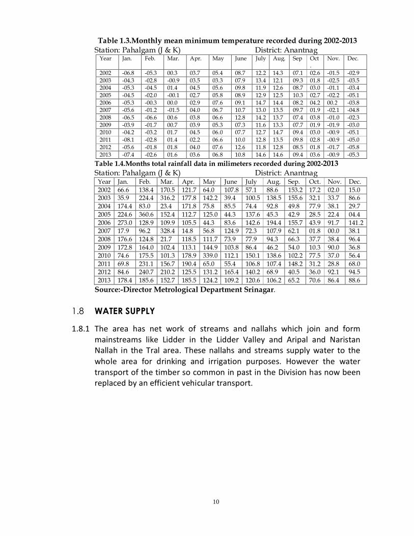
Table 1.3.Monthly mean minimum temperature recorded during 2002-2013 Station: Pahalgam (J & K) District: Anantnag
Year Jan. Feb. Mar. Apr. May June July Aug. Sep Oct.
Nov. Dec.
2002 -06.8 -05.3 00.3 03.7 05.4 08.7 12.2 14.3 07.1 02.6 -01.5 -02.9 2003 -04.3 -02.8 -00.9 03.5 03.3 07.9 13.4 12.1 09.3 01.8 -02.5 -03.5 2004 -05.3 -04.5 01.4 04.5 05.6 09.8 11.9 12.6 08.7 03.0 -01.1 -03.4 2005 -04.5 -02.0 -00.1 02.7 05.8 08.9 12.9 12.5 10.3 02.7 -02.2 -05.1 2006 -05.3 -00.3 00.0 02.9 07.6 09.1 14.7 14.4 08.2 04.2 00.2 -03.8 2007 -05.6 -01.2 -01.5 04.0 06.7 10.7 13.0 13.5 09.7 01.9 -02.1 -04.8 2008 -06.5 -06.6 00.6 03.8 06.6 12.8 14.2 13.7 07.4 03.8 -01.0 -02.3 2009 -03.9 -01.7 00.7 03.9 05.3 07.3 11.6 13.3 07.7 01.9 -01.9 -03.0 2010 -04.2 -03.2 01.7 04.5 06.0 07.7 12.7 14.7 09.4 03.0 -00.9 -05.1 2011 -08.1 -02.8 01.4 02.2 06.6 10.0 12.8 13.5 09.8 02.8 -00.9 -05.0 2012 -05.6 -01.8 01.8 04.0 07.6 12.6 11.8 12.8 08.5 01.8 -01.7 -05.8 2013 -07.4 -02.6 01.6 03.6 06.8 10.8 14.6 14.6 09.4 03.6 -00.9 -05.3
Table 1.4.Months total rainfall data in milimeters recorded during 2002-2013 Station: Pahalgam (J & K) District: Anantnag
Year Jan. Feb. Mar. Apr. May June July Aug. Sep. Oct. Nov. Dec. 2002 66.6 138.4 170.5 121.7 64.0 107.8 57.1 88.6 153.2 17.2 02.0 15.0 2003 35.9 224.4 316.2 177.8 142.2 39.4 100.5 138.5 155.6 32.1 33.7 86.6 2004 174.4 83.0 23.4 171.8 75.8 85.5 74.4 92.8 49.8 77.9 38.1 29.7 2005 224.6 360.6 152.4 112.7 125.0 44.3 137.6 45.3 42.9 28.5 22.4 04.4 2006 273.0 128.9 109.9 105.5 44.3 83.6 142.6 194.4 155.7 43.9 91.7 141.2 2007 17.9 96.2 328.4 14.8 56.8 124.9 72.3 107.9 62.1 01.8 00.0 38.1 2008 176.6 124.8 21.7 118.5 111.7 73.9 77.9 94.3 66.3 37.7 38.4 96.4 2009 172.8 164.0 102.4 113.1 144.9 103.8 86.4 46.2 54.0 10.3 90.0 36.8 2010 74.6 175.5 101.3 178.9 339.0 112.1 150.1 138.6 102.2 77.5 37.0 56.4 2011 69.8 231.1 156.7 190.4 65.0 55.4 106.8 107.4 148.2 31.2 28.8 68.0 2012 84.6 240.7 210.2 125.5 131.2 165.4 140.2 68.9 40.5 36.0 92.1 94.5 2013 178.4 185.6 152.7 185.5 124.2 109.2 120.6 106.2 65.2 70.6 86.4 88.6
Source:-Director Metrological Department Srinagar. 1.8 WATER SUPPLY
1.8.1 The area has net work of streams and nallahs which join and form mainstreams like Lidder in the Lidder Valley and Aripal and Naristan Nallah in the Tral area. These nallahs and streams supply water to the whole area for drinking and irrigation purposes. However the water transport of the timber so common in past in the Division has now been replaced by an efficient vehicular transport.

11
Table 1.5.Statement showing length and CCA and irrigated cropped area of lidder nallah in the jurisdiction of irrigation division anantnag
S. No.
Name of Scheme
Length of the canal in Kms.
CCA as per project in Acrs
Area Irrigated Rabi 2011 Kherief 2011 Total
(A)1 Martand Canal 35.00 7901 1272 7229 8501 2 Brah Canal 14.00 801 - 612 612 3 Wohal Canal
Left 5.50 1402 167 936 1103
4 Migund ladi 3.25 450 53 309 362 5 Dadi canal 25.63 4747 333 3898 4230 6 Awantipora
canal 20.00 2000 195 3981 4176
7 Mehind Canal 15.00 1947 82 1783 1865 8 Beora Canal 3.00 1474 30 819 849 9 Beora
Extension 0.50 - - 80 80
10 Wohan Right 15.5 1525 54 1004 1058 11 Wohan
Extension 5.00 - - 145 145
12 Darkhan khul 10.00 2470 102 1731 1833 13 Merchi Khul 14.00 2470 102 1731 1833 14 Waghama
Z/Khul 8.00 400 20 318 338
15 Gurhanji pora 7.00 120 35 156 191 16 Hapatnar Lift 0.00 7026 - 150 150 17 Vailnagbal 2.89 300 - 13 13 18 Kharim Lift 7.00 100 - 430 430 19 Durpora Lift 0.00 721 - 50 50 20 Bijbehara Lift 3.00 100 05 53 58 21 Wullarhama
lift 0.00 800 - 60 60
22 Yachnar Scheme
1.12 258 25 75 100
23 Punchpora Lift 0.00 260 - 10 10 24 Budroo Lift 0.00 304 - 37 37
Source: -Irrigation Division Anantnag
Table 1.6Statement showing canals/khuls of irrigation sub-division awantipora S.No. Name of
Canal/Khul Length of Canal/Khul
C.C.A Acrs Irrigated Area
1 Akber Khul Tral 14700 feets 307 170 Acrs 2 Ganie Khul 11500 feets 210 103 3 Kaw Khul 19600 330 284 4 Bud Khul 45000 1325 1188 5 Parganlar Khul 40000 2100 1945 6 Peth Khul Tral 10000 275 218 7 Bon Khul Tral 9500 225 200 8 Medura Canal
Tral 11000 625 299
9 Geeru Canal Tral 11000 500 338 10 Payneer Dam - 48 23
Source:-Irrigation Sub-Division Anantnag
1.9 DISTRIBUTION OF AREA
1.9.1 The Lidder Forest Division has been created out of the then Kashmir Forest Division in 1981. As a result of reorganization most area of the then Lidder Range were retained while as the Forest areas of Tral,

12
Shikargah and Khrew belt have been incorporated within this Division. The Wildlife areas of Overa-Aru Wildlife sanctuary, Shikargah, Panner, Khrew etc have later be seceded and brought under administrative control of Wildlife department.
The total area of the demarcated Forests of this Division is 655.665 Sq. Kms which includes Alpine scrubs and pasture lands. The Range wise distribution of the area is as under:-
Table 1.7 Range wise distribution of area S.No Range Total No. of
Comptts/ sub-Comptts.
Total forest area (ha)
1 Pahalgam 70 35254.50 2 Mattan 51 13207.00 3 Tral 32 17105.0
Total = 153 65566.5 ha (655.665 Sq. Kms)
Table 1.8: Distribution of Area and allotment of compartmensts during previous plan S. No. Working Circle Compartment Alloted Area(in hac.)
1 Deodar Kail Conversion WC
29a/AC,27/L,31c/L,17a/AC,23a/L,24b/L,25a/L,28a/L,48/L,26c/L,29c/L,31a/L,49/L,1a,1b,1c,4/K,5/K,6/P,16/L,25N,26/P,27/P,11b/L,5/L,8a/L,10a/L,14a/L,15b/L,16a/L,17b/L,17c/L,20a/L,6/L,7/L,9/L,12b/L,13a/L,18/L,50/L,51a/L,52b/L,53/L,54/L,55a/L,56a/L,57/L.
13553.25
2 Fir Selection 1a/AC,1b/AC,2a/AC,19/AC,25/AC,26/AC,27/AC,43/AC,46/AC,48/AC,49/AC,24c/L,25b/L,25c/L,26a/L,26b/L,30/L,31b/L,33a/L,33b/L,34a/L,37a/L,38c/L,13b/L,15a/L,19b/L,19c/L.
11289.75
3 Bio-Aesthetic 21/AC,34b/L,34c/L,35a/L,35b/L,36a/L,36b/L,36c/L,39/L,40/L,41/L,42/L,43b/L,44/L,45/L,46a/L,47a/L,47b/L.
5770.50
4 Reboisement 20/AC,28/AC,29b/AC,50/AC,23b/L,24a/L,24d/L,28b/L,29b/L,1d,2/K,7/P,8/L,18/L,19/L,24/N,28/P,29/P,1/L,2/L,3/L,4/L,8b/L,10b/L,11a/L,11c/L,12a/L,19a/L,20b/L,21/L,22/L,51b/L,52c/L,55b/L,56b/L,58/L.
12191.00
5 Protection 2b/AC,3/AC,4/AC5/AC,6/AC,7/AC,8/AC,9/AC,10/AC,11/AC,12/AC,13/AC,14/AC,15/AC,16/AC,17/AC,18/AC,22/AC,23/AC,24/AC,30/AC,31/AC,32/AC,33/AC,34/AC,35/AC,36/Ac,37/AC38/AC,39/Ac,40/AC,41/Ac,42/Ac,44/AC,45/AC,47/AC,28c/L,29a/L,32a/L,32b/L,33c/L,35c/L,37b/L,37c/L,38a/L,38b/L,43a/L,45b/L,46b/L,3/K,9/L,10/L,11/L,12/L,13/L,14/L,15/L,17/L,20/N,21/N,22/N,23/N,14b/L,16b/L,17a/L,51c/L,52a/L.
65447.40
6 Wildlife WC (tral) 30WL/SC,31WL/Sc,32WL/SC,33WL/SC,34WL/SC,35WL/SC,36WL/SC,37WL/SC,38WL/SC,39WL/SC,40WL/SC,41WL/Sc,42WL/SC,43W/SC,44WL/SC.
6967
Total= 115218.9

13
Table 1.9: Distribution of Area and allotment of compartments in Current Plan S. No. Working Circle Compartment Alloted Area
(in hac.) 1 Deodar Kail Selection WC 7/L,10a/L,11b/L12b/L,14b/L,15b/L,1
6a/L,17b/L,18/L,20a/L,50/L,51a/L,52b/L,53/L,54/L,55a/L,56a/L,57/L,24b/L,25a/L,26c/L,27/L,28a/L,9c/L,31a/L,31c/L,32c/L,17a/AC,1a/K,1b/K,5/K,6/P,16/Lam,25/N,27/P.
8947.75
2 Fir Selection 13a/L,13b/L,15a/L,19c/L,24c/L,25b/L,25c/L,26a/L,26b/L,28b/L,30/L,31b/L,33b/L,34a/L,37a/L,40/L,1a/AC,1b/AC,2a/AC,19/AC.
6560.75
3 Ecological Conservation WC 14a/L,16b/L,17a/L,28c/L,29a/L,32a/L,32b/L,33a/L,33c/L,35c/L,37b/L,38a/L,38b/L,51c/L,52a/L,2b/AC,3/AC,4/AC,5/Ac,6/AC,7/Ac,8/AC,9/AC,10/AC,11/AC,12/AC,13/AC,14/AC,15/AC,16/AC,17b/AC,18/AC,3/K,9/Lam,10/Lam,11/Lam,12/Lam,13/Lam,14/Lam,15/Lam,17/Lam,20/N,21/N,22/N,23/N,24/N.
37306.5
4 Reboisement 1/L,2/L,3/L,4/L,5/L,6/L,8a/L,8b/L,9/L,10b/L,11a/L,11c/L,12a/L,17c/L,19a/L,19b/L,20b/L,21/L,22/l,1b/L,51b/L,52c/L,55b/L,56b/L,58/L,20/AC,23a/L,23b/L,24a/L,24d/L,29b/L,1c/K,1d/K,2/K,4/K,7/P,8/Lam,18/Lam,19/N,26/P,28/P,29/P.
10676
5 Bio-Aesthetic WC 34b/L,34c/L,35a/L,35b/L,36a/L,36b/L,36c/L,38c/L,39/L,21/AC. 2075.5
6 Compartments handed over to wildlife department
22/AC,23/AC,24/AC,25/AC,26/AC,27/AC,28/AC29a/AC,29b/AC,30/AC,31/AC,32/AC,33/AC,34/AC,35/Ac,36/AC,37/AC,38/AC,39/AC,40/AC,41/AC,42/AC,43/AC,44/AC,45/Ac,46/AC,47/Ac,48/Ac,49/AC,50/AC,41/L,42/L,43a/L,43b/L,44/L,45a/L,45b/L,46a/L,46b/L,47a/L,47b/L,48/L,49/L,30WL/SC,33WL/Sc,34WL/SC,35WL/Sc,36WL/SC,37WL/SC,38WL/SC,39WL/SC,40WL/SC,41WL/SC,42WL/SC,43WL/SC,44WL/SC.
47990
Total= 113556.5
Note: - Out of the total area of 113556.5 ha. an area of 47990 ha is under the control of the wildlife protection department J&K. so the total area of the territorial division is 65566.5 ha.
1.10 Boundary consolidation
1.10.1 Timely updating of maps, survey and demarcation of boundaries are highly essential for protection and scientific management of forests. It is very important that the forest boundaries are properly demarcated and maintained for the effective protection of forests.The boundaries which are very vulnerableshould be demarcated as early as possible. This work should be given top priority and completed during the present plan period itself.

14
1.11 LEGAL POSITION
1.11.1 All the demarcated Forests come under the preview of J&K Forest Act Samavat 1987 (1930 A.D). All these Forests are owned by the J&K State and are managed by the J&K Forest Department under the administrative control of Principal Chief Conservator of Forests J&K. The following enactments and rules govern the preservation, regulation and control of Forests, a. The J&K Forest Act of Samvat 1987 (1930 AD) as amended to date. b. Kuth Act Samvat 1978 (1921 AD) as amended to date. c. CattleTrespass Act Samvat 1877 (1920 AD). d. The J& K soil Conservation and Land Improvement Scheme Act 1972 AD. e. The J&K Kahcharai Act Samvat 2011 (1954 AD). f. The J&K Game Preservation Act 1948 AD. g. The J&K Wildlife Protection Act 1978 AD. h. J&K public Premisis (Eviction of unauthorized occupant) Act 1959 AD. i. The J&K State Forest Corporation Act 1978 AD. j. The J&K specified Tree Act-1969 AD. k. J&K Forest Conservation Act 1990. l. J&K Forest Protection Act-1997.
1.12 RIGHTS AND CONCESSIONS
1.12.1 No rights, as such, are recognized by the state but the villagers putting up in near vicinities of the forests enjoy liberal concessions as embodied in Kashmir forest notice in lieu of some of their obligations towards improvement and protection of these forests. All villagers residing within 5 km of the boundary of the demarcated forests have been considered as concessionists provided that the forest is not detached from their village of residence by an unfordable stream at its lowest winter level. Some of the important concessions granted to such concessionist include grant of timber (Fir and Kail only) at 2.5% of the standard sale rates in vogue for the bonafide use of villagers (‘A’ class concessionists) residing within 3kms of a demarcated forests and at 25% of standard rates for zamindars (‘B’ class concessionists) residing within 5 to 8kms distance limit of such forests. The practice of granting trees at concession rates under “Kashmir Forest Notice” was stopped in 1980 later on it was re-opened due to heavy demands from the people. The other concessions provided for free grant of tree/timber to fire sufferers and calamity hit people for the reconstruction of their houses within “A” concession zone. The timber particularly from broad leaved species such as Aesculus indica, Prunus cornuta, Acer spp etc is granted free of charge to the
15
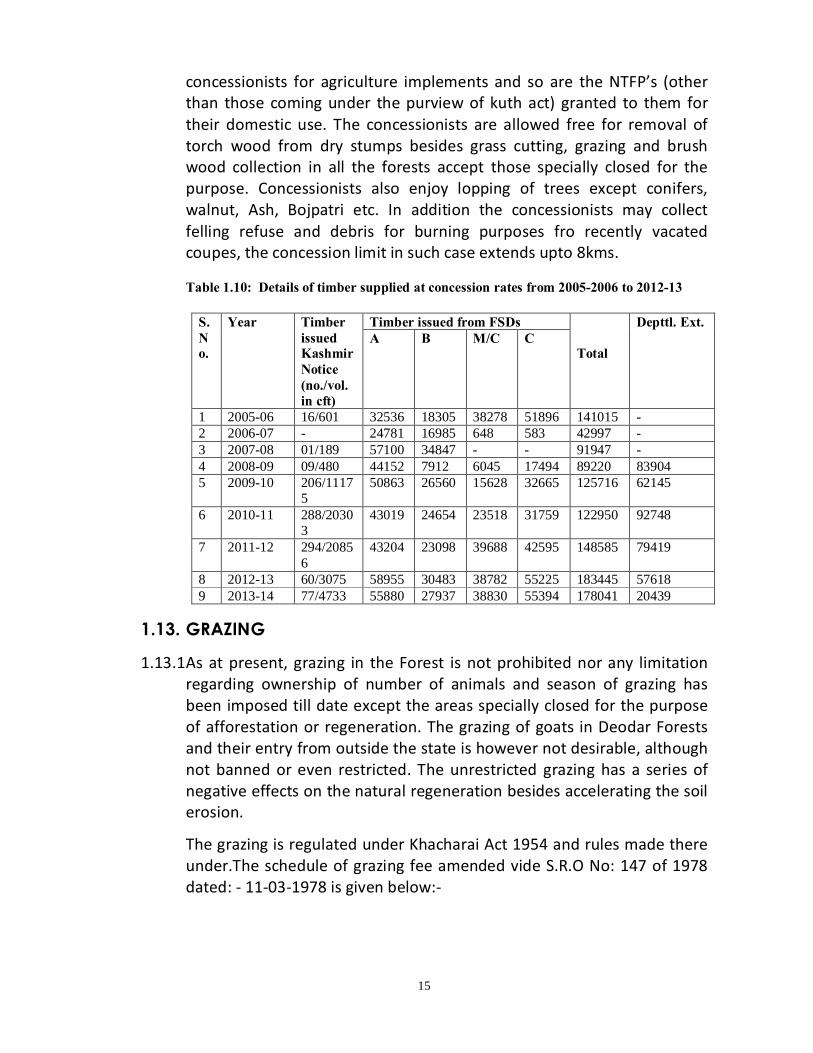
concessionists for agriculture implements and so are the NTFP’s (other than those coming under the purview of kuth act) granted to them for their domestic use. The concessionists are allowed free for removal of torch wood from dry stumps besides grass cutting, grazing and brush wood collection in all the forests accept those specially closed for the purpose. Concessionists also enjoy lopping of trees except conifers, walnut, Ash, Bojpatri etc. In addition the concessionists may collect felling refuse and debris for burning purposes fro recently vacated coupes, the concession limit in such case extends upto 8kms. Table 1.10: Details of timber supplied at concession rates from 2005-2006 to 2012-13
1.13. GRAZING
1.13.1 As at present, grazing in the Forest is not prohibited nor any limitation regarding ownership of number of animals and season of grazing has been imposed till date except the areas specially closed for the purpose of afforestation or regeneration. The grazing of goats in Deodar Forests and their entry from outside the state is however not desirable, although not banned or even restricted. The unrestricted grazing has a series of negative effects on the natural regeneration besides accelerating the soil erosion.
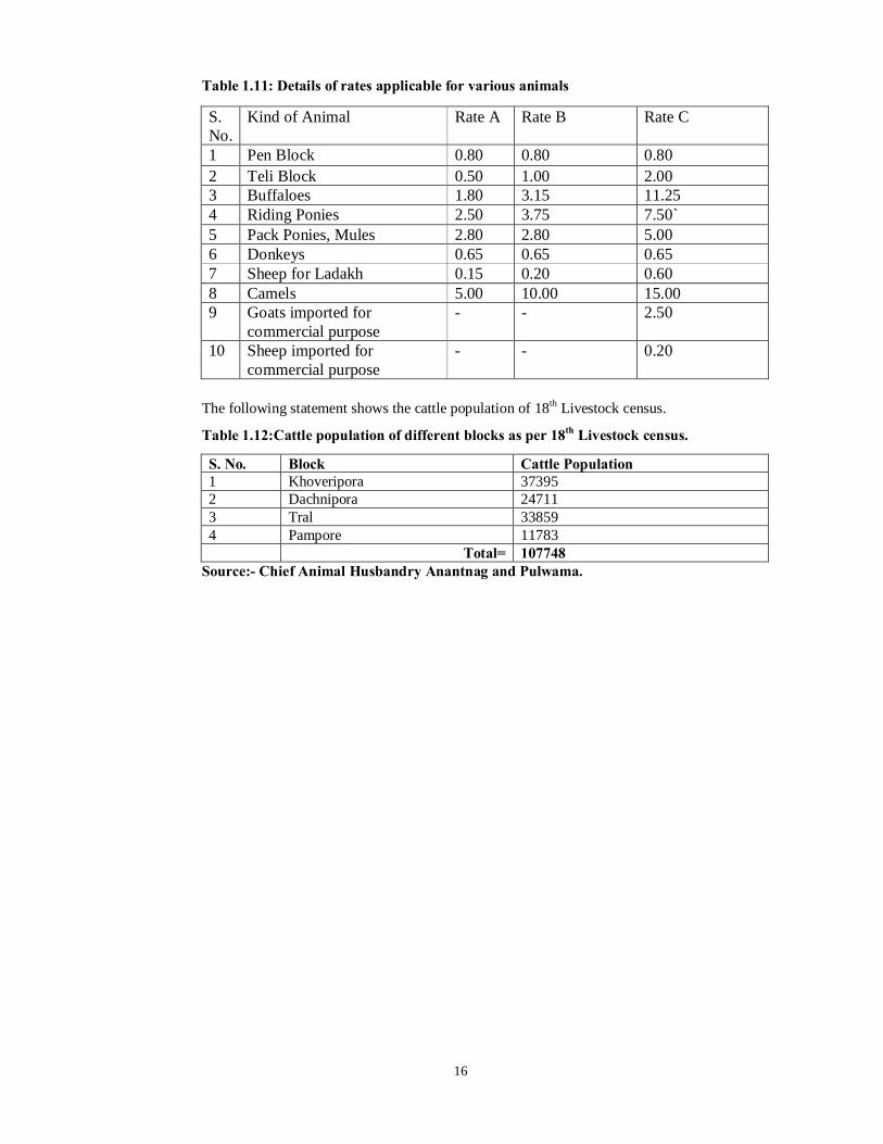
The grazing is regulated under Khacharai Act 1954 and rules made there under.The schedule of grazing fee amended vide S.R.O No: 147 of 1978 dated: - 11-03-1978 is given below:-
S. No.
Year Timber issued Kashmir Notice (no./vol. in cft)
Timber issued from FSDs Total
Depttl. Ext. A B M/C C
1 2005-06 16/601 32536 18305 38278 51896 141015 - 2 2006-07 - 24781 16985 648 583 42997 - 3 2007-08 01/189 57100 34847 - - 91947 - 4 2008-09 09/480 44152 7912 6045 17494 89220 83904 5 2009-10 206/1117
5 50863 26560 15628 32665 125716 62145
6 2010-11 288/20303
43019 24654 23518 31759 122950 92748
7 2011-12 294/20856
43204 23098 39688 42595 148585 79419
8 2012-13 60/3075 58955 30483 38782 55225 183445 57618 9 2013-14 77/4733 55880 27937 38830 55394 178041 20439
16
Table 1.11: Details of rates applicable for various animals S. No.
Kind of Animal Rate A Rate B Rate C
1 Pen Block 0.80 0.80 0.80 2 Teli Block 0.50 1.00 2.00 3 Buffaloes 1.80 3.15 11.25 4 Riding Ponies 2.50 3.75 7.50` 5 Pack Ponies, Mules 2.80 2.80 5.00 6 Donkeys 0.65 0.65 0.65 7 Sheep for Ladakh 0.15 0.20 0.60 8 Camels 5.00 10.00 15.00 9 Goats imported for
commercial purpose - - 2.50
10 Sheep imported for commercial purpose
- - 0.20
The following statement shows the cattle population of 18th Livestock census.
Table 1.12:Cattle population of different blocks as per 18th Livestock census.
S. No. Block Cattle Population 1 Khoveripora 37395 2 Dachnipora 24711 3 Tral 33859 4 Pampore 11783 Total= 107748
Source:- Chief Animal Husbandry Anantnag and Pulwama.
17
CH A P T E R – IIA
FOREST FLORA 2.1. Trees
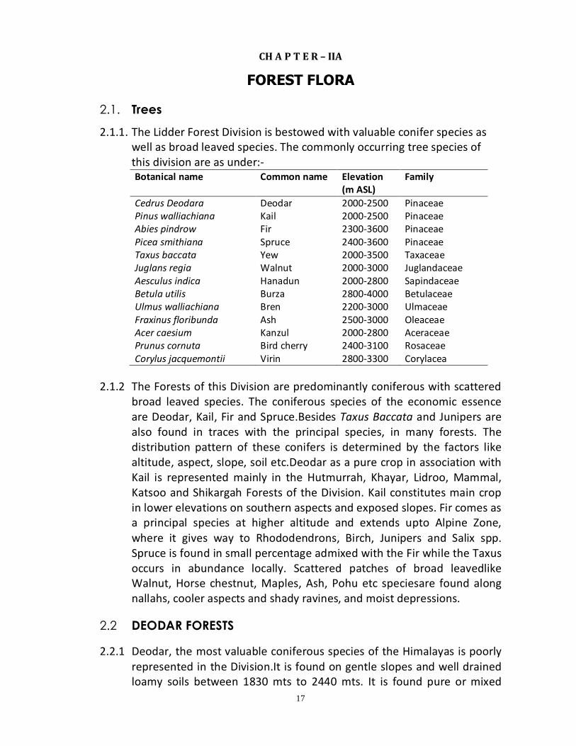
2.1.1. The Lidder Forest Division is bestowed with valuable conifer species as well as broad leaved species. The commonly occurring tree species of this division are as under:- Botanical name Common name Elevation
(m ASL) Family
Cedrus Deodara Deodar 2000-2500 Pinaceae Pinus walliachiana Kail 2000-2500 Pinaceae Abies pindrow Fir 2300-3600 Pinaceae Picea smithiana Spruce 2400-3600 Pinaceae Taxus baccata Yew 2000-3500 Taxaceae Juglans regia Walnut 2000-3000 Juglandaceae Aesculus indica Hanadun 2000-2800 Sapindaceae Betula utilis Burza 2800-4000 Betulaceae Ulmus walliachiana Bren 2200-3000 Ulmaceae Fraxinus floribunda Ash 2500-3000 Oleaceae Acer caesium Kanzul 2000-2800 Aceraceae Prunus cornuta Bird cherry 2400-3100 Rosaceae Corylus jacquemontii Virin 2800-3300 Corylacea
2.1.2 The Forests of this Division are predominantly coniferous with scattered
broad leaved species. The coniferous species of the economic essence are Deodar, Kail, Fir and Spruce.Besides Taxus Baccata and Junipers are also found in traces with the principal species, in many forests. The distribution pattern of these conifers is determined by the factors like altitude, aspect, slope, soil etc.Deodar as a pure crop in association with Kail is represented mainly in the Hutmurrah, Khayar, Lidroo, Mammal, Katsoo and Shikargah Forests of the Division. Kail constitutes main crop in lower elevations on southern aspects and exposed slopes. Fir comes as a principal species at higher altitude and extends upto Alpine Zone, where it gives way to Rhododendrons, Birch, Junipers and Salix spp. Spruce is found in small percentage admixed with the Fir while the Taxus occurs in abundance locally. Scattered patches of broad leavedlike Walnut, Horse chestnut, Maples, Ash, Pohu etc speciesare found along nallahs, cooler aspects and shady ravines, and moist depressions.
2.2 DEODAR FORESTS 2.2.1 Deodar, the most valuable coniferous species of the Himalayas is poorly
represented in the Division.It is found on gentle slopes and well drained loamy soils between 1830 mts to 2440 mts. It is found pure or mixed
18
with Kail near Mammal. Hutmurrah, Khayar, Ganishbal, Lidroo and Katsoo in Lidder valley and a small portion at Shikargah in Tral Range. The regeneration of Deodar is in a struggling mode due to intense biotic pressure. Well drained, porous soil, shady moist areas and protection from biotic interference are prerequisites for successful natural regeneration of Deodar.
2.2.2 The chief associates of Deodar is Kail in lower zone and Fir in its upper zone, while as Walnut, Horse chestnut, Maple, Ash and Bird Cherry are broad leaved associates. Shrub associates include Parrotia, Vibernum, Cotoneaster, Berberis, Rosa, Rubus and Indigofera species. The ground flora consists mostly of Viola, Wild Strawberry, Oryzopsis, Taraxacum officinalsetc other grasses.
2.3 KAIL FORESTS 2.3.1 Kail is the main coniferous species in the DeodarKail zone of the Division.
It occupies the lower zone and forms pure and homogenous crop but occasionally is found mixed with Deodar and Fir over higher and cooler aspects. It occurs gregariously an all aspects between 1700 mts to 2200 mts elevation, but extends upto 2400 mts in warmer southern aspects. The natural regeneration suffers due to heavy grazing and very severe biotic interference. The conifer and broad leaved associates of Kail are more or less same that of Deodar. Given Conducive edaphic and topographic conditions under complete protection from any biotic interference, the Kail regeneration has not any problem as it is a colonizing species. The young saplings and poles have established in the division at various places as Compt. 4/L, 1/L etc is nothing but a post conservancy crop. The regeneration however, suffers considerable from the odds of the grazing and illicit damage and these factors are responsible for its absence near habitation.
2.4. FIR FORESTS 2.4.1 The Fir Forest lies between 2400 mts to 3300 mts. At lower elevation it
overlaps with Kail and at higher reaches it gives its way to the Alpine scrub. It covers a significant area of the Lidder Division. Spruce forms a small percentage amongst the Fir crop. The principal Fir Forests of the Division are found in the Lidder valley Lam and Naristan areas of Tral Range. The common species occurring as under storey are Podophyllum, Vibernum species,Berberis, Viola, Anemone, Rumex, Fragaria, Polygonum species etc. The natural regeneration of Fir as a whole is deficient due to excessive unregulated grazing, illicit damage, thick cover of un-decomposed humus and litter and low soil moisture.

19
Taxus baccata occurs locally and singularly or in small patches over the moist and shady places.
2.5. BROAD LEAVED FORESTS
2.5.1 These occur along the cool shady and moist places along nallahs and in depressions and occupy 3778.50 ha(3.33%) of the area of the Division. Important species among the broad leaved species include, walnut, Ash, Maple, Horse Chest nut, Bird Cherry, Arkhor, Pohu and Celtis.
2.6 ALPINE FORESTS
2.6.1 Above the Fir Forests lies the Alpine zone upto permanent snowline and comprises of small dwarf trees, shrubs, grasses, medicinal and flowering herbaceous plants. Important Alpine scrub species include Junipers, Rhododendrons, Willows and Birch. The Alpine meadows which also called as “Margs”harbor some beautiful flowering plants like Potentilla, Primula, Corydalis, Caltha, Gentianas, Aconitum, Anemone, Agrotis, Dactylis etc. As a result of over exploitation and heavy grazing in the Alpine pastures, a number of medicinal plant species are now endangered and on the verge of extinction.
2.7. FORESTS TYPOLOGY
2.7.1 A pronounced differentiation in structure and floristic is discernible in the present day vegetation of Kashmir valley to that described by Champion and Seth in their revised classification of forest types of India. The slopes of Pirpanjal Mountain Range facing the valley overwhelmingly sustain a mesophytic type of temperate vegetation with conifer as its main component. The broad leaved clement is scattered throughout these forests in a light mixture particularly along moist depressions and sometimes in higher exposed elevations i.e Alpine ‘Margs’.
2.7.2 The vegetation of Kashmir Valley differs considerably from that of outer Himalayas, perhaps due to alterations in climate and soil which followed change in the topography under went in the glaciations era. The little rain the valley experiences in summer months is due to the precipitation of winds that escape in through the Jhelum Gorge.
2.8. General description of growing stock
2.8.1 The Kashmir forests are classified in the revised classification of forest types by Champion and Seth under the broad type groups 12, 13, 14 and 15 but do not strictly conFirmed to on account on the diversity in structure and composition. And attempt to has been made here under to identify the forest types of Kashmir Valley which special reference to

20
Lidder Forest Division, within the overall framework of the Champions classification. The broad groups are nomenclatured as follows: I. Himalayan Moist Temperate Forests. II. Sub Alpine Forests. III.Moist Alpine Srub Forests.
Group 12: Himalayan Moist Temperate Forests: The group corresponds to the type groups 12 & 13 of Champion & Seth’s classification and are predominantly coniferous forests with little diversity. Deciduous trees are found in depressions along the nallahs and stream banks. It extends within an altitudinal zone of 1500 mts to 2300 mts and further divided into:- Sub-group ‘I’ A (12 C1): Lower Western Himalayan Temperate Forests. Sub-group ‘I’ B:Montane high level Forests.
Sub-group IA (12 C1): Lower Western Himalayan TemperateForests
Low level and foot hill forests are spread over the lower belts of mountain ranges and Karewas where Deodar and Kail were predominant in the past. Being close to the habitations these forests have been damaged due to excessive grazing, lopping and other biotic interferences. The sub group is further divided into:- Sub type I A1(12/C1f):Low level blue pine Forests Sub type I A2 (13/C2b):DryDeodar Forests Sub type I A3 (12/Ce):Moist Temperate DecideousForests
I A 1 (12/C1f):Low level blue pine forests:
This sub-type is represented within an altitude of 1700-2300 mts on comparatively drier but easy slopes as well as on fresh alluvium, the karewa formation and the degenerated sites. Pure Kail crop dominates these forests and its colonization on recent and exposed sites is a common feature. The sub-type correspondence to the group 12/2 SI of champions revised classification of forest types.
These forests are seral in nature and are distributed over the gentle to moderately steep slopes on either side of the low lying perennial Lidder nallah of the division and generally a bound in post conservancy crop.
Floristic: I) Pinus walliachiana II) Juglans regia, Aesculus indica, Fraxinus excelsior. III) Parrotoipsis jacquemontiana, Viburnum foetens, Cotoneaster
roseus, Indigofera spp, Rubus spp, Berberis lycium,
21
IV) Fragaria spp, Plantingo spp, Taraxacum spp, Verbascum spp, Oryzopsis spp.
IA2 (13/C2b): DryDeodar forests:
The Deodar forests extend from 1600-2100 mts elevation, generally as pure crop, on the well drained karewa deposits with a boldery sub-soil. However, some Kail is mixed occasionally, particularly towards the upper limits and on ill drained sites. The trees attain aluxuriant growth with a straight clear bole. Parrotropsis spps comes up as a common shrub underneath. The sub-typecorresponds to group 13/c2b of Champions revised classification.
The forests regenerate adequately and constitute anedaphic climax. They are distributed in the division mainly over Khayar forests and near Mammal Pahalgam.
Floristics:
I) Cedrus Deodara II) Juglans regia, Aesculus indica, Ulmus dioica, Fraxinus hookeri. III) Parrotiopsis jacquemontiana, Viburnum cotinifolium, Indigofera
spp, Desmodium spp, Berberis lycium, Cotoneaster roseus. IV) Fragaria nubicola, Taraxacum officinale, Viola spp, Thymus
linearis, Oryzopsis spp.
IA3 (12/C1e): Moist Temperate DecideousForests:
Distributed within an altitudinal limit of 1880-2300mts, the sub-type occurs in damp depressions, nallahs and on slopes that have suffered severely on account of heavy biotic impact in the past. Excessive felling, lopping and grazing nearly cleared these sites of tree crop and the resultant heavy openings in the canopy paved way for a gregarious growth of shrubs. The sub-type confirms to a group of 12/C1e of champions revised classification.
These forests constitute a climax on moist soils and are found at Pahalgam in the division.
Floristic: I) Juglans regia, Prunus spp, Corylus jacquemontii, Aesculus indica,
Acer caesium and with scattered trees of Pinus walliachiana, Piceasmithiana and Abies pindrow
II) Crategus songarica, Euonymus spp III) Parrotiopsis jacquemontiana, Viburnum cotinifolium, Lonicera spp,
Sambucus wightiana.
22
1B: Montane high level Forests
The sub-group extends upto an altitude of 2600 mts and constitutes the main part of commercially important coniferous crop. The topography is comparatively steep and the conditions are mesophytic. The deciduous component is confined to a nallah banks are the moist hallows. The below enumerated sub-types are identifiable in the sub-group.
I B 1 (12/C1d): Western mixed coniferous forests. IB2 (13/C4): Western Himalayan High Level Dry Blue PineForests. IB3 (13/C3): West Himalayan Dry TemperateDecideous forests.
IB1(12/C1d): Western mixed coniferous Forests:
This sub-type is distributed with an elevation zone of 1800-2500 mts and is represented by a mixed crop of all the principal coniferous. The preponderance of an individual spp is dictated by the aspect, altitude and soil conditions. These forests correspond to group 12/cId of Champions classification.
The forests constitute the main bulk of the forests of the division. Kail is in seral stage yielding place to Fir and Deodar in upper and lower reaches respectively as conditions get moisture.
Floristics: I) CedrusDeodara, Pinus walliachiana, Abies pindrow, Picea
smithiana, Taxus baccata. II) Juglans regia, Aesculus indica, Acer caesium, Fraxinus hookeri,
Prunus cornuta. III) Viburnum cotinifolium, Sambuscus wightiana, Parrotoipsis
jacquemontiana, Skimmia spp, Podophyllum emodi. IV) Fragaria nubicola, Rumex nepalansis, Polygonium spp, Viola spp,
Anemone spp, Phytolacea acinosa.
I B2 (13/C4): Western Himalayan High Level Dry Blue PineForests
These forests of pure Kail are distributed in the form of a belt above mixed coniferous forests and extend upto the tree line, on a steep to precipitous topography. The crop is generally young, of open type and somewhat stunted in growth. Several trees are rotten and are infested with Armi (Arecuthobium minutissimum). The sub-type corresponds to groups 13C4 and 14/2s1 of Champions revised classifications.

23
The sub-type is serial in character (secondary succession) and is met within at Aru of the division.
Floristics: I) Pinus walliachiana II) Juglans regia, Aesculus indica, Acer caesium, Fraxinus hookeri. III) Viburnum cotinifolium, Desmodiumspp, Parrotiopsis
jacquemontiania. IV) Fragaria nubicola, Polygonium spp, Atropa acuminata, Aralia spp.
I B3 (13/C3): West Himalayan Dry Temperatedeciduous Forests:
The sub-type is distributed within an altitudinal zonation of 1800-2700mts and occurs in patches in the cool depressions and moist glens on northern aspects in the mixed coniferous forests. It corresponds to the group 13/C3 of Champions classification.
This sub-type is an edaphic post-climax to the coniferous forests on slopes and is found in the division at Aru. Floristics: I) Juglans regia, Prunus cornuta, Aesculus indica, Acer caesium,
Fraxinus hookeri, Salix flabellaris, Populus spp. II) Parrotiopsis jacquemontiania, Viburnum cotinifolium, Cotoneaster
roseus, Skimmia spp, Indigofera spp, Sambucus wightiana, Rosa spp.
III) Fragaria spp, Rumex spp, Polygonium spp, Voila spp, Thymus spp.
Group II (14/C1b):West Himalayan birch Forests: The group lies within altitudinal limits of 2200-3300 mts and comprises predominantly of Abies pindrow which gives way to Abies spectablis higher up. Kail is found in mixture on exposed slopes whereas the broad leaved trees of Betula occur along the upper reaches near tree line. The type corresponds to group 14/C1b of Champions classification and is distributed at Lidderwatt in the division. The ecological status of these forests is climatic climax.
Floristics: I) Abies pindrow, Abies spectablis, Pinus walliachiana, Picea
smithiana. II) Betula utlis, Prunus cornuta, Aesculus indica, Acer caesium.
24
III) Parrotoipsis jacquemontiana, Sambucus wightiana, Podophyllum emodi
IV) Atropa acminata, Phytolacea acinosa, Adiantum leave.
Group 15:Moist Alpine Scrub This type of group is distributed beyond the elevation of 3400 mts and mainly consists of vast treeless pastures having scattered scrub vegetation. The type corresponds to the group 15 of Champions classification. Two sub-types are identified in this group. IIIA (15/C1): Birch Alpine scrub Forest. IIIB (15/C3): Alpine pastures.
IIIA (15/C1): Birch Rhododendronscrub Forest:
The sub-type occurs close to the tree limit and comprise of scrub vegetation of the short statured Betula, Junipers and Rhododendrons. The sub-type corresponds to the champions group 15/C and is distributed in the division at Lidderwatt (Kolahai)
[
Floristics: I) Betula utilis, Juniperous recurva, Rhododendron andhropogan. II) Vibernum grandiflorum, Berberis lycium. III) Aconitum heterophylum, Mentha longifolia.
IIIB (15/C3): Alpine pastures:
These extensive pastures (Margs) bear a luxuriant growth of perennial herbs and other grasses. The sub-type is treeless albeit stray shrubs are met with occasionally. The sub-type corresponds to the champions group 15/3c.
The ecological status of these pasture-lands is not certain and may probably be a biotic climax. The sub-type is distributed over Aru, Chandanwari, Panchal Brangbal, Lichidalue, Chanipathrie, Wathnie, Brarangan, sariebun, etc. in the Lidder Forest Division.
Floristics: Myosotics spp, Cynoglossum spp, Primula spp, Fritillaria roylei, Androsac spp, Gentiana spp, Aster spp, Saussurea albescens.
2.9. INJURIES TO WHICH THE CROP IS LIABLE The forests crop is amenable to the damages by two main categories of agencies.
25
(a). Biotic (b). Abiotic These injuries are inflected by man, animals, insects and pests and caused in following ways.
a 1. Lopping
The incidence of lopping the trees to meet Firewood requirement is high in the forests near the habitation. The malpractice mutilates a plant, cuts down its photosynthetic surface, effects physiological vigour and leads to the formation of candlebras. Lopping is also injurious to the trees by exposing them to the attacks of fungi and parasites.
a 2. Torch wood extraction The practice of torchwood extraction is the main reason of great damage to the Kail and Deodar trees adjoining villages and bahaks.The villagers cunningly scoop over the tree trunk at the base, with the dual intension of extracting torch wood for burning and to lift the tree away once it falls down under the load of wind or snow.
a3. Illicit damage The people residing near the forests besides various other concessions are granted timber on concessional rates from sale depots. In spite of all these facilities damage to forest crop is caused by illicit fellings of trees for timber and Firewood purposes or to gain money. The forests are still considered no man’s property and every one spreads his tentacles over it. Besides illicit fellings most serious damage is done by extracting torchwood by scooping out the trees trunks at their base, such trees ultimately fall under wind or snow pressure. The debarking and griddling are other malpractices causing horrible damage to forest crop.
a4.Fire
The Fire is the most destructive of all destructive agencies. It causes huge damage to forest flora and fauna. Very rarely it is caused by natural agencies like lightening but is almost always due to human actions deliberate or accidental or due to carelessness and negligence. Fortunately such hazards are not very common in the division. The Fire breaks outs commonly in dry months of autumn as a consequence of carelessness. Sometimes in it is deliberately set on by villagers for better grass growth in the following season. The graziers during cold days collect dry lops and tops in heap and set them on Fire for warming up

26
themselves. They leave it un-extinguished which some time spreads. The charcoal manufacture is other common cause of forest Fire. The forest Fire besides causing large scale destruction of trees, young seedling, seed and wild life deteriorate the site as well. Table: 2.1 Details of Fire Incidence
Year No. of Fires
Range (Area burnt in Hect.) Total area burnt (Ha) Mattan Pahalgam Tral Pampore Bijbehara
2003-04 02 75 8 0 0 0
83
2004-05 0 0 0 0 0 0 0 2005-06 02 0 11 0 0.50 0 11.50 2006-07 01 0 4 0 0 0 4 2007-08 06 0 14 0 0 0 14 2008-09 03 35 03 0 1.00 0 39 2009-10 1 18 0 0 0 0 18 2010-11 0 0 0 0 0 0 0 2011-12 0 0 0 0 0 0 0 2012-13 1 0 0 1 0 0 1 2013-14 05 5.5 06 1.5 11 0 14
a5. Grazing The excessive and unrestricted grazing results in heavy damage to forests in various ways. The floor is tripped-off of its cover and sub-soil drainage gets impeded thus making it vulnerable to soil erosion. The over grazing is inimical to regeneration. The criss-cross by herds of cattle compacts surface soil. On such soil, germination of seed and their establishment becomes very difficult. The established seedlings are trampled over or browsed, so that even if they grow, they are stunted, branchy and malformed. The high grazing incidence is a common in the forests fringing habitations and villages.
a6. Encroachment
The villagers sometimes for land hunger resort to encroaching the forest land adjoining their own cultivations. The trees are mercilessly griddled and burning at the base and are made to dry and fell down. The boundary pillars are damaged or dislocated so as to extend and expand the limits of private cultivation within the forest bounds.

27
a7. Fungi
The most devastating fungus is the Fomes pini. It attacks Kail and Deodar trees generally when they are over mature, diseased, loppedand are hit by the lightening. The fungus attack is the source of Heart-rot in Kail and ring or coller-rot in Deodar. The attack is however not very common in the forests of the division. Barcalayella formansrenders damage to the trees of Fir and spruce occasionally while as Fomes formentorious infects the less vigrous and healthy trees of broad leaved species viz walnut, Ash.
a8. Parasites Parasites draw whole or part of their nourishment from host plant and thereby cause damage to it. The common parasites generally belong to family Loranthaceas; species of viscum, Loranthus and Arcenthobium minutissimun (Armi) are the example. The Armi attack is noticed on Kail generally in higher localities. The trees attacked by the parasite start drying and their branches get clustered to form what is properly known as ’’witches broom’’ such trees lose their vitality and vigour and often die. The Armi attack is of common occurrence in the forests of Pahalgam.
a9. Insect damage The insect damage is not significant in the forests of Division. The broad leaved spp viz Horse-chestnut and Mapples are defoliated in the early summer by caterpillars of Lepidopterousinsects. Longicorn beetles form galleries in the tree trunks of walnut. Certain scolytidea insects attack dead and diseased trees ofDeodar. While as Euzophora cedrella moth occasionally damage its cones which turn pale and do not develop further. The Cicadids damage Kail forests. Weak and debarked poles of Kailare also attacked by the insects of Tomicus spp.
a10. Animal damage: The black bears, flying squirrels and the monkeys cause damage to the trees. The black bear strips off the bark of Kail and Deodar poles so as to lick the sap in spring. The flying squirrels and woodpeckers damage the cones of conifers. The Monkeys damage cones of conifers, walnuts, Aesculus nuts and Hazal nuts etc
b 1. ABIOTIC AGENCIES
The atmospheric agencies like snow, wind, frost, lightening and land-slips cause sometime appreciable damage to forest trees. The sliding snow

28
causes erosion and uproots the forest trees on precipitous slopes. The sliding snowaccumulates on the crown of trees and by its weight bends, breaks and up-root them. The strong winds on higher reaches also break and up-root trees. The frost damages the young plantations by causing canker and cracks in stems and seedling by frost lifting. Similarly the land slips and lightening damage by way of up-rooting the plants and causing Fires respectively.
29
Chapter IIB Forest Fauna
2.10 General Description
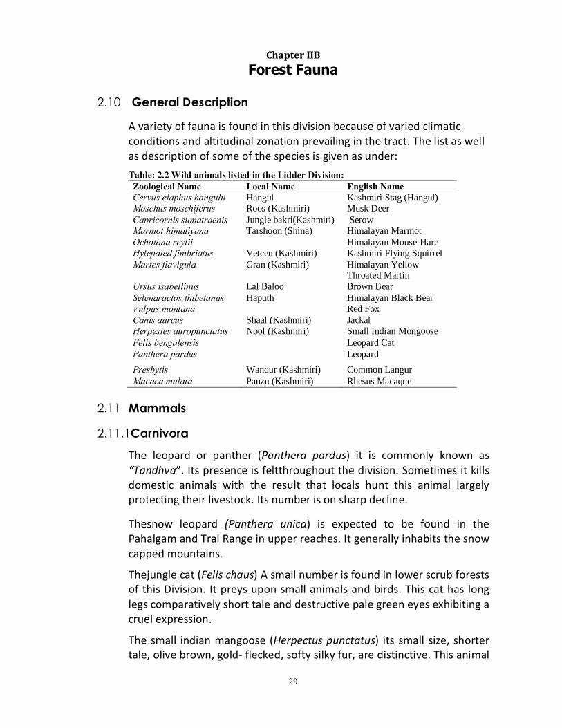
A variety of fauna is found in this division because of varied climatic conditions and altitudinal zonation prevailing in the tract. The list as well as description of some of the species is given as under:
Table: 2.2 Wild animals listed in the Lidder Division: Zoological Name Local Name English Name Cervus elaphus hangulu Hangul Kashmiri Stag (Hangul) Moschus moschiferus Roos (Kashmiri) Musk Deer Capricornis sumatraenis Jungle bakri(Kashmiri) Serow Marmot himaliyana Tarshoon (Shina) Himalayan Marmot Ochotona reylii Himalayan Mouse-Hare Hylepated fimbriatus Vetcen (Kashmiri) Kashmiri Flying Squirrel Martes flavigula Gran (Kashmiri) Himalayan Yellow
Throated Martin Ursus isabellinus Lal Baloo Brown Bear Selenaractos thibetanus Haputh Himalayan Black Bear Vulpus montana Red Fox Canis aurcus Shaal (Kashmiri) Jackal Herpestes auropunctatus Nool (Kashmiri) Small Indian Mongoose Felis bengalensis Leopard Cat Panthera pardus Leopard Presbytis Wandur (Kashmiri) Common Langur Macaca mulata Panzu (Kashmiri) Rhesus Macaque
2.11 Mammals 2.11.1Carnivora
The leopard or panther (Panthera pardus) it is commonly known as “Tandhva”. Its presence is feltthroughout the division. Sometimes it kills domestic animals with the result that locals hunt this animal largely protecting their livestock. Its number is on sharp decline.
Thesnow leopard (Panthera unica) is expected to be found in the Pahalgam and Tral Range in upper reaches. It generally inhabits the snow capped mountains.
Thejungle cat (Felis chaus) A small number is found in lower scrub forests of this Division. It preys upon small animals and birds. This cat has long legs comparatively short tale and destructive pale green eyes exhibiting a cruel expression.
The small indian mangoose (Herpectus punctatus) its small size, shorter tale, olive brown, gold- flecked, softy silky fur, are distinctive. This animal
30
lives in holes it burrows by itself. It is mostly found in low lying areas of this division and around cultivated fields. It feeds on rats, mice, snakes, scorpions, centipedes, wasps and insects.
The jackal (Cains aureus) this animal is commonly found in this division upto elevation of 1500 mts above mean sea level, mostly around towns, villages and cultivation areas, sheltering holes in the ground, dense grass and scrub. It is nocturnal inhabit. It sometimes attacks small domestic animals like goat, sheep and their young ones and birds. It is one of the most common scavengers in nature.
The red fox (Vulpus vulpus) it is mostly found in upper sub temperate and temperate zone of the tract. It is generally red in colour.
Indian wild dog (Cuon alpinus) it is similar to domestic dog in general appearance with deep red colour of the coat.This animal is rarely found in the forests of this division mostly surrounding the villages. It preys upon other wild animals.
The Himalayan black bear (Selenarctos thibetanus)It is black in colour with characteristics V shaped breast mark which may be white, yellow or buff. In summers it is found near the tree line 3000-3500 mts, whereas it descends to low lying areas during the autumn months. It lives on a variety of wild fruits, berries, honey, lizards, insects, termites andlarva. It raids maize fields as well as orchards and sometimes causes heavy damage. It is more carnivores in food habits than other bears and kills sheep, goats and even larger domestic animals. At times even human beings are killed by this animal. In the winter season it goes on complete hibernation.
The brown bear (Persus arctrus) it is commonly known as Lal Baloo because of reddish colour of its coat. It is heavier in built than black bear. It roams in open peaks high above the tree line. It is widely prevalent in the division. It is omnivorous andprefers grasses, ants, termites, honey, variety of fruits and flowers. Many times it attacks horses, sheep and goat when hungry.
The leopard cat (Felisbanjalnesis) the cat has a beautiful skin. The general colour is light tawny with black and broad lines on the back emerging into black spots. Leopard cats are carnivores feeding on variety of small prey including mammals, lizards, amphibians, birds and insects.
2.11.2Rodents
THE RED FLYING SQUIRREL (Pataurista Pataurista), inhabits the Deodar, Kail and Fir forests. It has a thick Fir covering and a tall longer than the
31
length of body. It feeds on fruits and nuts of various trees, bark, gums, resin and sometimes on small insects and their larva.
THE INDIAN PORCUPINE (Hystrix indica) the animal is commonly found in the division upto the elevation of 2100m above mean sea level, mostly around villages and cultivation areas. Its hairsare completely modified into spine like structures. The neck and the shoulders are crowned with a crust of bristles 15-30 cm long the quills on the back are very perfuse and the ornamental with deep brown are black and white rings. It peels off bark of conifers and damages nurseries and young plantation.
THE MIMALIYAN MARMOT (Marmot himalayana) it is also known as mountain mouse. It has dark chocolate brown coat with contrasting yellow patches on the face and chest. They live in small groups and have underground homes/burrows. They eat grasses and flowering plants. Marmots hibernate for about seven months from September to early May. They mate in spring and average of three pups. They are predated by the endangered snow leopard.
2.11.3Deer
THE MUSK DEER (Moschus moshiferus) it is a lacking antlers, not more than 50cm height at the shoulder. Its food consists of grasses, lichens, leaves and flowers. The male of this species has a musk gland under the skin on the abdomen in males. It has strong order and his largely used in perfumery. This deer has mercilessly been killed for its musk pod and is now threatened with extension. It therefore needs special protection.It is reportedly seen in Aru Pahalgam extending to Tral and Dachigam.
THE KASHMIR STAG (Cervus elaphus hangulu) commonly known as Hangul is critically endangered animal (IUCN 2004). The Kashmir Stag is a very handsome member of the red deer species. Kashmir Stag has a long head with a narrow muzzle. Its head and body length measures above 2m to 2.25m male deer weights about 200 to 300 kilograms female deer weight about 100 to 150 kilograms. Hangul can grow upto 1.2-1.4 mts in height. Sides and limbs are pale in colour. Belly in males are dark brown in colour. Tale is relatively short in sides. In males hears on the ridge of neck are long, thick and bushy and is brown in colour. It is then dwelling animal and having a browsing tendency. It feeds on flowers, leaves and tender suits of shrubs. They also feed on lichens, mosses, ferns and mushrooms. It is reported in the division from Overa Pahalgam, Khiram,Traland specially in Dachigam. The Hangul prefers to live in 1750-3650 mts at high valleys, also in the mountain areas. The breeding

32
season starts from September to October when antlers become harder. The gestation period is 7-8 months. Average life span is10-13 years.
2.12. Avi Fauna: The following are the list of birds sited in the Lidder Forest Division:
S. No. Common Name Scientific Name 1 The Black Eared kite Milvus migrans 2 The Himalayan Griffon Vulture Gyps himalayansis 3 The White Backed Vulture Psedopus bengalensis 4 The Monal Lephphorus impeyanus 5 The Himalayan Snow Cock Tetragallus
himalayansis 6 The Chucker Alectoris chakur 7 The Koklas Pucrsia macrolopha 8 The Blue Rock Pigeon Columba livia 9 The Himalayan Rufus Turtle dove Streptopelia orientalis 10 The Ring Dove S. decaota 11 The Red Turtle Dove S. tranqubarica 12 The Asiatic Cuckoo Cuculus canorus
telephones 13 The Alpine Swift Apus melba melba 14 The Kashmir Roller Crocias gasrullus
semenwi 15 The European Hoopoe Upopa epops epops 16 The Kashmiri Woodpecker Trybatus himalayansis 17 The Common Swallow Hirunda rustica 18 The Rufus Backed Shrike Lanius Schack 19 The Golden Oriole Oriolus. o. kunde 20 The Indian Myna Acridotheres tristis 21 The Himalayan Jungle Crow Corvus macrorhychos 22 The Large Spotted Nutcracker Nucifrage muhipunctata 23 The White Checked Bulbul Pycnonotus leucogenus 24 The Streaked Laughing Thrush Trocralopterum
linnactum 25 The Kashmir Wren Troglodyles t. neglectus 26 The Grey Tit Parus major
cahmiriensis 27 The Kashmir House Sparrow Passere domesticus
2.13 Fish There are many varieties of fishes found in the Lidder River which include: • Brown trout (sulmo trutta fario), • Rainbow trout (sulmo gairdnri), • shuddgurn (Local name), • Anyour (Local name).
2.14 Reptiles
The reptiles found in the division are • Viper (Viperidae), • Yellow monitor lizard (Varannus flavescenes)

33
2.15. Legal position:- 2.15.1 The wildlife (protection) act, 1972 is in force for protection and
conservation of wildlife in Jammu and KashmirUnder the above act, the forest offices have been duly empowered for implementation of the policies of protection and conservation of wildlife as the wildlife wardens. The junior officers are vested with the powers of detection of illegal wildlife crime. They are required to report to the Chief Wildlife wardens for taking necessary actions and drawing of wildlife offence reports.
2.16 Rights and concessions of wildlife.
No right and concession in respect of wildlife has been recognized.
2.17 Hunting and shooting:- 2.17.1 Hunting, shooting and capturing of wild animals and birds are not
allowed. However chief wildlife warden of the state is empowered under the act to permits shooting of any animal which has become dangerous for the human life.
2.18 General census:-
2.18.1 Census of wildlife animals such as Hangul isdone in Lidder Forest Division by the J&K Wildlife Protection Department.
2.19. Maintenance of wildlife Habitat:- 2.19.1 The maintenance of the habitat of wildlife is ensured by the J&K Wildlife
Protection Department in the Compartment which forms mostly the area on left side of Pahalgami’e.both sides of Aru. Separate Working Circle is proposed in this Division.
2.20. Protection measures for protected areas
• Deployment of watch and ward. • Involvement of local people/masses in protection of flora and fauna. • Awareness about protection and propagation of flora and fauna.
2.21. Injuries to which the fauna is liable and its protection:
a) Habitat Destruction: - The habitats of many wild animals are dwindling at an alarming rate.Proper habitat management practices are to be undertaken as an ameliorative step to save the remaining degraded habitats. The wildlife division is working with this mandate.

34
b) Fire protection: -Fire is potentially a deadly enemy of both forest and wildlife. Rapid running forest Fires, may be very destructive for wildlife in particular if it occurs in the nesting season of birds, breeding stock is destroyed. Therefore Fire protection measures should be taken on a big scale especially during the hot season.
c) Grazing: Grazing is rampant all over the forest areas and reduces forage availability for wildlife besides physically damaging their nests.
d) Poaching: Poaching is not common in Lidder Forest Division.
2.22. Threats to Kashmir Stag. 2.22.1Grazing: Grazing continues to be preventing Hangul from full
exploitation of its habitat. The alpine meadows during summer months are occupied by large herds of harbors. Because of these disturbances the deer no longer migrate to other areas. Fuel wood and timber extraction: Vast areas are razed down for fuel wood and timber extraction. This limits the available food for the Kashmir Stag during the harsh winter times.
2.22.2Grass cutting: The habitations living in fringes of forests cut down
much grass for their domestic animals at the cost of the food for Kashmir Stag.
2.22.3Predation: Four large predators could be considered as a major threat
for Hangul population i.e. Brown Beer, Snow Leopard, Leopard and Himalayan Black Bear. But Leopard has been the major predator which has caused maximum decline in its population.
THE HIMALIYAN YELLOW THROATED MARTIN (Martes flavigula) it is medium sized carnivores animal with creamy yellow coloured coat and dark brown coat and a black coloured bushy tale there about 2-5 kilograms and are fast moving mammals. They are reported from the division upto an altitude of 3500 mts. They hunt during the night hours and produce a noxious smell to escape from predator.
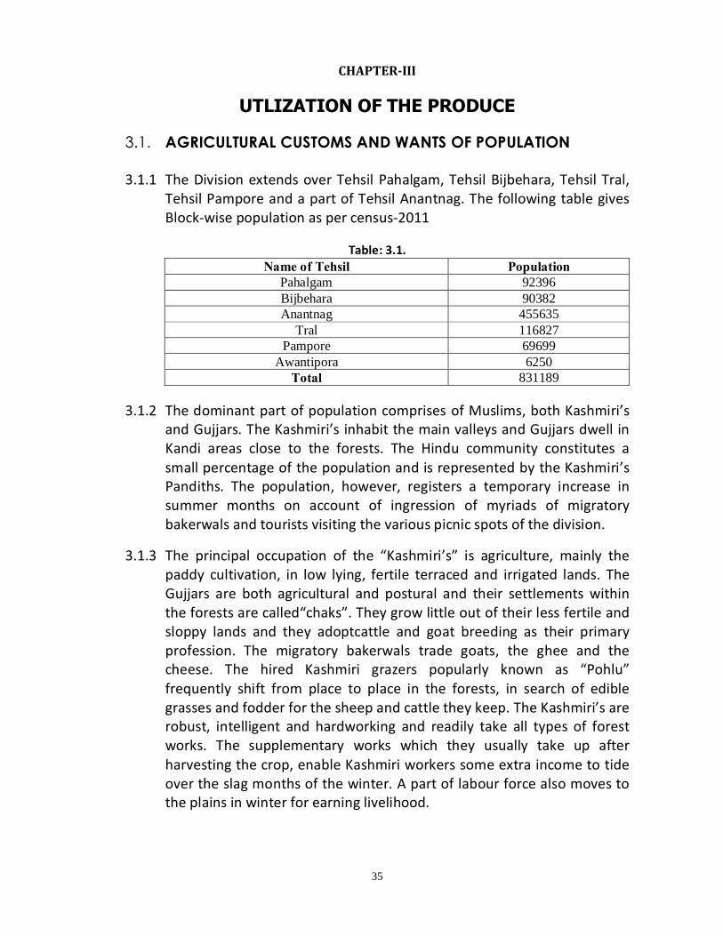
35
CHAPTER-III
UTLIZATION OF THE PRODUCE 3.1. AGRICULTURAL CUSTOMS AND WANTS OF POPULATION 3.1.1 The Division extends over Tehsil Pahalgam, Tehsil Bijbehara, Tehsil Tral,
Tehsil Pampore and a part of Tehsil Anantnag. The following table gives Block-wise population as per census-2011
Table: 3.1.
Name of Tehsil Population Pahalgam 92396 Bijbehara 90382 Anantnag 455635
Tral 116827 Pampore 69699
Awantipora 6250 Total 831189
3.1.2 The dominant part of population comprises of Muslims, both Kashmiri’s
and Gujjars. The Kashmiri’s inhabit the main valleys and Gujjars dwell in Kandi areas close to the forests. The Hindu community constitutes a small percentage of the population and is represented by the Kashmiri’s Pandiths. The population, however, registers a temporary increase in summer months on account of ingression of myriads of migratory bakerwals and tourists visiting the various picnic spots of the division.
3.1.3 The principal occupation of the “Kashmiri’s” is agriculture, mainly the paddy cultivation, in low lying, fertile terraced and irrigated lands. The Gujjars are both agricultural and postural and their settlements within the forests are called“chaks”. They grow little out of their less fertile and sloppy lands and they adoptcattle and goat breeding as their primary profession. The migratory bakerwals trade goats, the ghee and the cheese. The hired Kashmiri grazers popularly known as “Pohlu” frequently shift from place to place in the forests, in search of edible grasses and fodder for the sheep and cattle they keep. The Kashmiri’s are robust, intelligent and hardworking and readily take all types of forest works. The supplementary works which they usually take up after harvesting the crop, enable Kashmiri workers some extra income to tide over the slag months of the winter. A part of labour force also moves to the plains in winter for earning livelihood.

36
3.1.4 The Villagers are largely self supporting.The Kashmiri’s put up in “Laris” which are generally two storied, made up of sun-burnt bricks, mud and wood. The Gujjars usually live in single storied flat roofed and mud plastered Kothas. With the gradual up-liftmen of socio-economic condition of the people, the Kacha houses Kothas are giving way to Pucca houses. The schools, health and social welfare centers have been opened up throughout the length and breadth of the tract to facilitate the villagers. These developmental activities have revolutionized the rural life which in turn has exercised great influence on the forest working as well.
3.1.5 The forests play vital role in the lives of villagers who depend greatly upon them for their requirements. Besides the timber for constructional and agricultural purpose, the villagers obtain fodder, grass, Firewood, torchwood and MFP’s for their day to day domestic consumption from the forests. The endless demands and requirements of the ever-increasing local population pose tremendous pressure upon the forests, leading to their depletion and deterioration. The tendency needs to be properly checked and controlled immediately. The worst forest damage is caused by the Gujjars and the Kashmiri women; the myriads of latter enter the forests every day to hack, damage and pilfer the forest produce under the garb of collecting the Firewood, from dead and fallen material for their domestic use.
3.1.6 Agriculture is the main source of income for the people living the division. The availability of arable land is limited due to various ecological factors i.e. terrain, topography and climate. The land holdings are small to medium in nature. The agriculture fields are plain in nature in lower parts of the Division. The rainfall in the division varies from 44.3 to 183.6 mm which is moderate in nature for the irrigation. Some parts of the division are rain-fed in nature. The irrigation is being given to agriculture lands from the natural flowing perennial and annual flowing rivers and nallahs. During summer season people are cultivating food crops such as rice and maize. During winter mostly mustered is raised and in some places Potato and wheat are raised. Cultivation of apple and walnut is a most common practice and are cultivated in orchards. The people here are keeping livestock such as cow, sheep, goats and upper parts of the Division the buffaloes and horse/ponies are being domesticated. During summer the people are taking their livestock to the nearby pastures where as in winter the livestock are stall-fed. The people here are busy in harvesting the Kharif crop from September to October where as the horticulture crop is also being harvested in the same period.
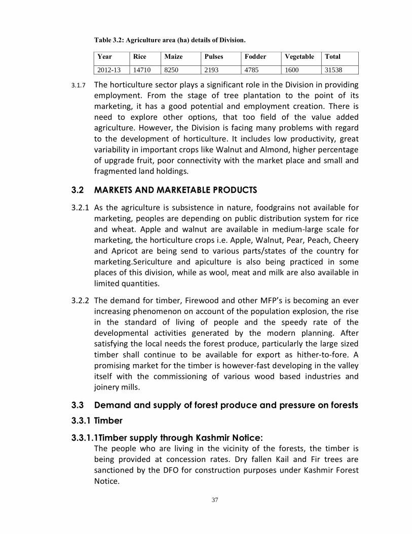
37
Table 3.2: Agriculture area (ha) details of Division. Year Rice Maize Pulses Fodder Vegetable Total
2012-13 14710 8250 2193 4785 1600 31538
3.1.7 The horticulture sector plays a significant role in the Division in providing employment. From the stage of tree plantation to the point of its marketing, it has a good potential and employment creation. There is need to explore other options, that too field of the value added agriculture. However, the Division is facing many problems with regard to the development of horticulture. It includes low productivity, great variability in important crops like Walnut and Almond, higher percentage of upgrade fruit, poor connectivity with the market place and small and fragmented land holdings.
3.2 MARKETS AND MARKETABLE PRODUCTS 3.2.1 As the agriculture is subsistence in nature, foodgrains not available for
marketing, peoples are depending on public distribution system for rice and wheat. Apple and walnut are available in medium-large scale for marketing, the horticulture crops i.e. Apple, Walnut, Pear, Peach, Cheery and Apricot are being send to various parts/states of the country for marketing.Sericulture and apiculture is also being practiced in some places of this division, while as wool, meat and milk are also available in limited quantities.
3.2.2 The demand for timber, Firewood and other MFP’s is becoming an ever increasing phenomenon on account of the population explosion, the rise in the standard of living of people and the speedy rate of the developmental activities generated by the modern planning. After satisfying the local needs the forest produce, particularly the large sized timber shall continue to be available for export as hither-to-fore. A promising market for the timber is however-fast developing in the valley itself with the commissioning of various wood based industries and joinery mills.
3.3 Demand and supply of forest produce and pressure on forests
3.3.1 Timber
3.3.1.1Timber supply through Kashmir Notice: The people who are living in the vicinity of the forests, the timber is being provided at concession rates. Dry fallen Kail and Fir trees are sanctioned by the DFO for construction purposes under Kashmir Forest Notice.

38
Table 3.3: Timber issued under Kashmir notice in Lidder Division
S. No.
Year Total No. of trees Persons benefited Standing volume (Cft)
1 2005-06 16 16 601 2 2006-07 - - - 3 2007-08 01 01 189 4 2008-09 09 06 480 5 2009-10 206 216 11175 6 2010-11 288 302 20303 7 2011-12 294 304 20856 8 2012-13 60 63 3075 9 2013-14 77 78 4733
Total= 935 970 60811
3.3.1.2: Timber supply through Forest Sale Depots:
The department has opened 89Forest Sale Depots to supply construction timber to people. These depots are spread over the entire division. These are classified as “A” zone “B” zone and “C” zone depots depending upon nearness to forests and the revenue status of the area viz, Municipal Committee/Township etc. the details of depots is given as under.
Table 3.4: Abstract of number of FSD’s in various ranges as per zonation.
M/C- Municipal Committee Areas
The details of quantity of timber issued to general public through various FSD’s and timber extracted departmentally is given as under:-
Table 3.5: Timber supplied to general public through various FSDs S.
No. Year Timber issued through FSDs (in cfts) Total Departmental
extraction(in cfts)
A B M/C C
1 2005-06 32536 18305 38278 51896 141015 - 2 2006-07 24781 16985 648 583 42997 - 3 2007-08 57100 34847 - - 91947 - 4 2008-09 44152 7912 6045 17494 89220 83904 5 2009-10 50863 26560 15628 32665 125716 62145 6 2010-11 43019 24654 23518 31759 122950 92748 7 2011-12 43204 23098 39688 42595 148585 79419 8 2012-13 58955 30483 38782 55225 183445 57618 9 2013-14 55880 27937 38830 55394 178041 20439
Range Wise abstract of FSD’s of Lidder Forest Division as on 2013-14 S.No. Range M/C C B A Total 1 Pahalgam - 1 - 9 10 2 Mattan 1 7 11 16 35 3 Bijbehara 1 13 - 1 15 4 Tral 1 1 5 8 15 5 Pampore 2 11 - 1 14 Total 5 33 16 35 89

39
The timber is provided at a concession rate to assamies. The price is much less compared to market price. The price of timber sold in various concession zones is as follows.
Table 3.6: Timber rates-past and current in various FSDs as per zonation (Rate/Cft) S. No. Zone Timber
Form Deodar Kail Fir
1 517 FST of 2002 dt: 31/1/2002
A Log 162 103 60 Sawn 204 122 82
B Log 246 160 120 Sawn 281 192 136
C Log 340 196 134 Sawn 411 266 150
2 501 FST of 2003 dt: 21/10/2003
A Log 146 93 54 Sawn 184 110 74
B Log 197 128 96 Sawn 225 154 109
C Log 272 157 108 Sawn 329 213 120
3 314 FST of 2005 dt: 1/8/2005
A Log 146 93 54 Sawn 184 110 74
B Log 197 128 96 Sawn 225 154 109
C Log 299 173 119 Sawn 362 231 132
M/C Log 391 226 156 Sawn 474 307 173
4 278 FST of 2006 dt: 19/5/2006
A Log 161 102 59 Sawn 202 121 81
B Log 246 160 120 Sawn 281 193 136
C Log 299 173 119 Sawn 362 231 132
M/C Log 391 226 156 Sawn 474 307 173
5 212 FST of 2010 dt: 13/5/2010
A Log 185 130 74 Sawn 215 160 104
B Log 345 245 138 Sawn 375 275 168
C Log 513 360 205 Sawn 543 390 235
The forest department was supplying timber to other government departments for construction purposes, but stopped now-a-days. Recently government directed the forest department to supply the timber for the construction of primary schools under Sarva Siksha Abhiyan (SSA).
3.3.1.3 Import of timber:
In order to ease the demand of timber for construction purposes, the governmenthas cleared import of timber and also reduced the restrictions. Presently within J&K only in two checkposts transit verification is made mandatory viz, Lakhanpur Checkpost of Kathua Division (entry point of imported timber into J&K state and Toll post
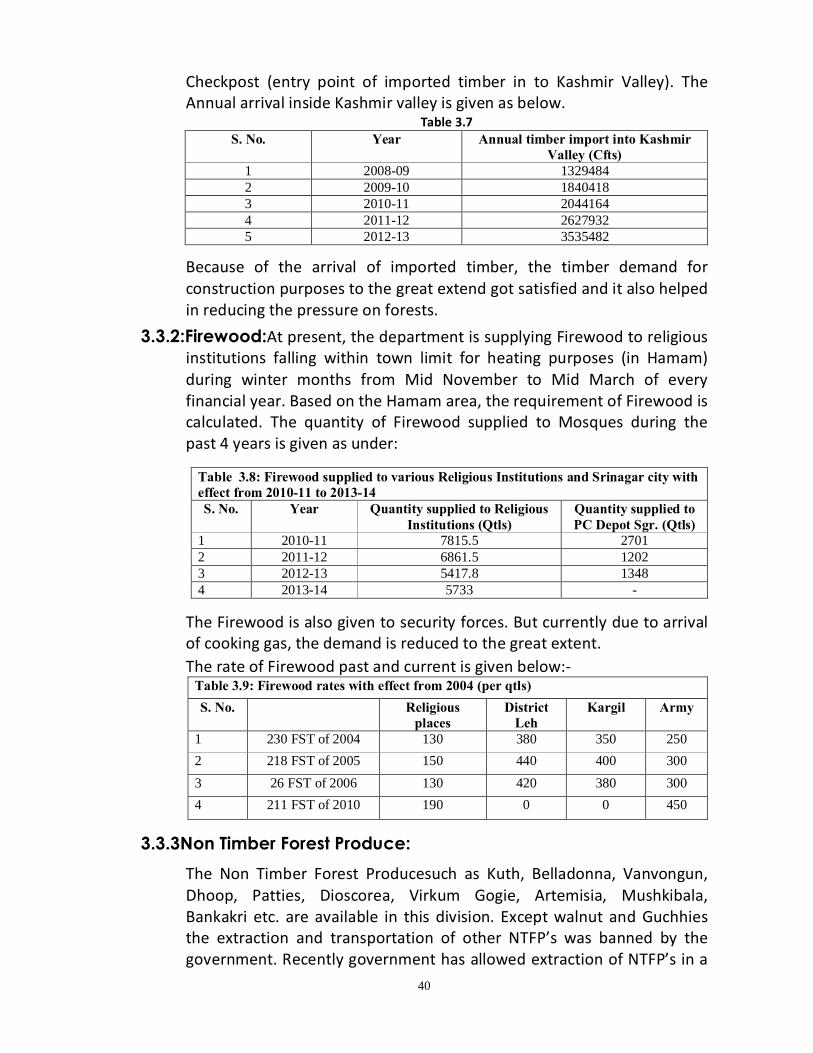
40
Checkpost (entry point of imported timber in to Kashmir Valley). The Annual arrival inside Kashmir valley is given as below.
Table 3.7 S. No. Year Annual timber import into Kashmir
Valley (Cfts) 1 2008-09 1329484 2 2009-10 1840418 3 2010-11 2044164 4 2011-12 2627932 5 2012-13 3535482
Because of the arrival of imported timber, the timber demand for construction purposes to the great extend got satisfied and it also helped in reducing the pressure on forests.
3.3.2:Firewood:At present, the department is supplying Firewood to religious institutions falling within town limit for heating purposes (in Hamam) during winter months from Mid November to Mid March of every financial year. Based on the Hamam area, the requirement of Firewood is calculated. The quantity of Firewood supplied to Mosques during the past 4 years is given as under:
Table 3.8: Firewood supplied to various Religious Institutions and Srinagar city with effect from 2010-11 to 2013-14 S. No. Year Quantity supplied to Religious
Institutions (Qtls) Quantity supplied to PC Depot Sgr. (Qtls)
1 2010-11 7815.5 2701 2 2011-12 6861.5 1202 3 2012-13 5417.8 1348 4 2013-14 5733 -
The Firewood is also given to security forces. But currently due to arrival of cooking gas, the demand is reduced to the great extent.
The rate of Firewood past and current is given below:- Table 3.9: Firewood rates with effect from 2004 (per qtls) S. No. Religious
places District
Leh Kargil Army
1 230 FST of 2004 130 380 350 250 2 218 FST of 2005 150 440 400 300 3 26 FST of 2006 130 420 380 300 4 211 FST of 2010 190 0 0 450
3.3.3Non Timber Forest Produce:
The Non Timber Forest Producesuch as Kuth, Belladonna, Vanvongun, Dhoop, Patties, Dioscorea, Virkum Gogie, Artemisia, Mushkibala, Bankakri etc. are available in this division. Except walnut and Guchhies the extraction and transportation of other NTFP’s was banned by the government. Recently government has allowed extraction of NTFP’s in a
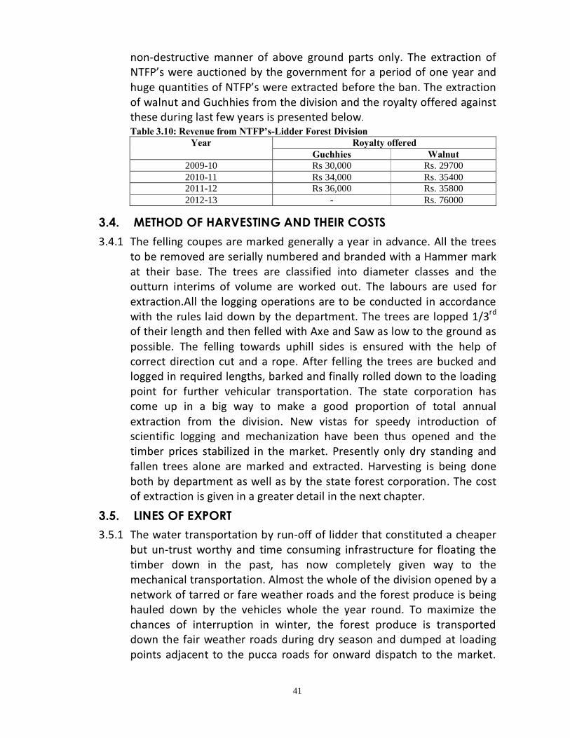
41
non-destructive manner of above ground parts only. The extraction of NTFP’s were auctioned by the government for a period of one year and huge quantities of NTFP’s were extracted before the ban. The extraction of walnut and Guchhies from the division and the royalty offered against these during last few years is presented below.
Table 3.10: Revenue from NTFP’s-Lidder Forest Division Year Royalty offered
Guchhies Walnut 2009-10 Rs 30,000 Rs. 29700 2010-11 Rs 34,000 Rs. 35400 2011-12 Rs 36,000 Rs. 35800 2012-13 - Rs. 76000
3.4. METHOD OF HARVESTING AND THEIR COSTS
3.4.1 The felling coupes are marked generally a year in advance. All the trees to be removed are serially numbered and branded with a Hammer mark at their base. The trees are classified into diameter classes and the outturn interims of volume are worked out. The labours are used for extraction.All the logging operations are to be conducted in accordance with the rules laid down by the department. The trees are lopped 1/3rd of their length and then felled with Axe and Saw as low to the ground as possible. The felling towards uphill sides is ensured with the help of correct direction cut and a rope. After felling the trees are bucked and logged in required lengths, barked and finally rolled down to the loading point for further vehicular transportation. The state corporation has come up in a big way to make a good proportion of total annual extraction from the division. New vistas for speedy introduction of scientific logging and mechanization have been thus opened and the timber prices stabilized in the market. Presently only dry standing and fallen trees alone are marked and extracted. Harvesting is being done both by department as well as by the state forest corporation. The cost of extraction is given in a greater detail in the next chapter.
3.5. LINES OF EXPORT
3.5.1 The water transportation by run-off of lidder that constituted a cheaper but un-trust worthy and time consuming infrastructure for floating the timber down in the past, has now completely given way to the mechanical transportation. Almost the whole of the division opened by a network of tarred or fare weather roads and the forest produce is being hauled down by the vehicles whole the year round. To maximize the chances of interruption in winter, the forest produce is transported down the fair weather roads during dry season and dumped at loading points adjacent to the pucca roads for onward dispatch to the market.
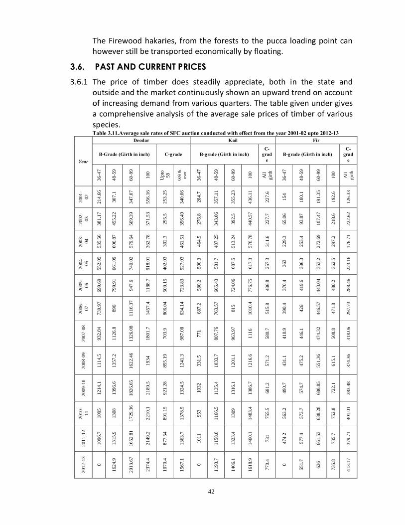
42
The Firewood hakaries, from the forests to the pucca loading point can however still be transported economically by floating.
3.6. PAST AND CURRENT PRICES
3.6.1 The price of timber does steadily appreciate, both in the state and outside and the market continuously shown an upward trend on account of increasing demand from various quarters. The table given under gives a comprehensive analysis of the average sale prices of timber of various species. Table 3.11.Average sale rates of SFC auction conducted with effect from the year 2001-02 upto 2012-13
Year
Deodar Kail Fir
B-Grade (Girth in inch) C-grade B-grade (Girth in inch) C-
grade
B-grade (Girth in inch) C-
grade
36-4
7
48-5
9
60-9
9
100
Upt
o 59
60”
&
over
36-4
7
48-5
9
60-9
9
100
All
girth
36-4
7
48-5
9
60-9
9
100
All
girth
2001
-02
214.
66
307.
1
347.
07
556.
16
253.
25
340.
06
284.
7
357.
11
355.
23
436.
11
227.
6
154
180.
1
191.
35
192.
6
126.
33
2002
-03
381.
17
455.
22
509.
39
571.
53
295.
5
356.
49
276.
8
343.
06
392.
5
440.
57
227.
7
65.0
6
93.8
7
107.
47
218.
6
222.
62
2003
-04
535.
56
606.
87
579.
64
362.
78
392.
3
461.
51
464.
5
487.
25
513.
24
576.
78
311.
6
229.
3
253.
4
272.
69
297.
2
176.
71
2004
-05
552.
05
661.
09
740.
02
918.
01
402.
03
527.
03
500.
3
581.
7
687.
5
617.
3
257.
3
363
336.
3
353.
2
362.
5
223.
16
2005
-06
699.
69
799.
91
947.
6
1188
.7
509.
15
723.
83
580.
2
665.
43
724.
06
776.
75
436.
8
370.
4
419.
6
443.
04
480.
2
288.
46
2006
-07
730.
97
896
1116
.37
1457
.4
806.
04
634.
14
687.
2
763.
57
815
1010
.4
515.
8
390.
4
426
446.
57
471.
8
297.
73
2007
-08
932.
84
1126
.8
1326
.08
1801
.7
703.
9
987.
08
771
807.
76
963.
97
1116
580.
7
410.
9
446.
1
474.
32
508.
8
318.
06
2008
-09
1114
.5
1357
.2
1622
.46
1934
855.
19
1241
.3
331.
5
1033
.7
1201
.1
1216
.6
571.
2
431.
1
475.
2
551.
36
615.
1
374.
36
2009
-10
1214
.1
1396
.6
1826
.65
2189
.5
921.
28
1324
.5
1032
1135
.4
1316
.1
1386
.7
681.
2
490.
7
574.
7
680.
85
722.
1
383.
48
2010
-11
1095
1308
1729
.36
2210
.1
891.
15
1378
.5
953
1166
.5
1309
1483
.4
755.
5
563.
2
573.
7
638.
28
752.
8
401.
01
2011
-12
1096
.7
1315
.9
1652
.81
2149
.2
877.
54
1363
.7
1011
1158
.8
1323
.4
1460
.1
731
474.
2
577.
4
661.
53
735.
7
379.
71
2012
-13
0
1624
.9
2013
.67
2374
.4
1070
.4
1567
.1
0
1193
.7
1406
.1
1618
.9
770.
4
0
551.
7
626
735.
8
413.
17
43
CHAPTER-IV
ACTIVITIES OF FOREST DEVELOPMENT CORPORATIONS IN HARVESTING AND MARKETING OF
FOREST PRODUCE 4.1. Jammu & Kashmir State Forest Corporation 4.1.1 The Jammu and Kashmir State Forest Corporation was created by the act
of legislationnamely, the Jammu and Kashmir State Forest Act and rules were framed in 1981. The forests were worked out by lease in the olden days and later the forest working was nationalized by the Jammu and Kashmir Nationalization of forest working Act 1987.
4.1.2 The main functions of the Corporation as per J&K SF Act are:-
v To undertake removal and disposal of trees and exploitation of forest resources entrusted to it by the Government.
v To undertake research programmes relating tto forest and forest products and render technical advise to Government on matters relating to forestry.
v To manage, maintain and develop such forests as are transferred and entrusted to it by the Government till these are handed back to the Government.
v To manage, maintain and develop such forests as are transferred and entrusted tom it by the Government till these are handed back to the Government.
4.1.3 The State Forest Corporation suggests the available volumes from
different Compartments if the Compartmentis fit to be worked out as per the conditions imposed by Q and Q norms and then only it is enumerated in terms of dry/fallen trees. The CF (working plan circle) issues the technical clearance. Based on technical clearance the trees in the Compartment are marked by the DDR trained officers. The marking list is sent to CF (working plan circle) for issue of technical sanction. The CCF (territorial) issues the administrative approval based on the technical sanction. Then the marking in the Comptt is handed over to the SFC for extraction.
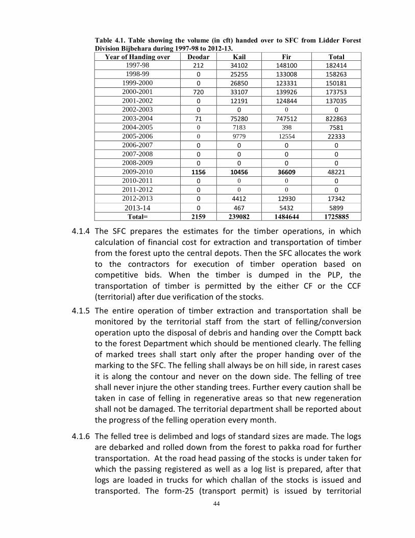
44
Table 4.1. Table showing the volume (in cft) handed over to SFC from Lidder Forest Division Bijbehara during 1997-98 to 2012-13.
Year of Handing over Deodar Kail Fir Total 1997-98 212 34102 148100 182414 1998-99 0 25255 133008 158263
1999-2000 0 26850 123331 150181 2000-2001 720 33107 139926 173753 2001-2002 0 12191 124844 137035 2002-2003 0 0 0 0 2003-2004 71 75280 747512 822863 2004-2005 0 7183 398 7581 2005-2006 0 9779 12554 22333 2006-2007 0 0 0 0 2007-2008 0 0 0 0 2008-2009 0 0 0 0 2009-2010 1156 10456 36609 48221 2010-2011 0 0 0 0 2011-2012 0 0 0 0 2012-2013 0 4412 12930 17342 2013-14 0 467 5432 5899 Total= 2159 239082 1484644 1725885
4.1.4 The SFC prepares the estimates for the timber operations, in which calculation of financial cost for extraction and transportation of timber from the forest upto the central depots. Then the SFC allocates the work to the contractors for execution of timber operation based on competitive bids. When the timber is dumped in the PLP, the transportation of timber is permitted by the either CF or the CCF (territorial) after due verification of the stocks.
4.1.5 The entire operation of timber extraction and transportation shall be monitored by the territorial staff from the start of felling/conversion operation upto the disposal of debris and handing over the Comptt back to the forest Department which should be mentioned clearly. The felling of marked trees shall start only after the proper handing over of the marking to the SFC. The felling shall always be on hill side, in rarest cases it is along the contour and never on the down side. The felling of tree shall never injure the other standing trees. Further every caution shall be taken in case of felling in regenerative areas so that new regeneration shall not be damaged. The territorial department shall be reported about the progress of the felling operation every month.
4.1.6 The felled tree is delimbed and logs of standard sizes are made. The logs are debarked and rolled down from the forest to pakka road for further transportation. At the road head passing of the stocks is under taken for which the passing registered as well as a log list is prepared, after that logs are loaded in trucks for which challan of the stocks is issued and transported. The form-25 (transport permit) is issued by territorial

45
division for monitoring the land transportation of forest produces.Mostly, the timber is sold in open auction by SFC.
Table 4.2 The rates in vogue in SFC for timber operations during 2013-14 is as follows. S.No Activity Category ( norm rate in Rupees) SAWN FORM D C B A (a) Extraction (on FMM) 1 Felling (per cft) 2.91 2.44 2.20 1.73 2 Hand Sawing – under/odd size ( per
cft) 38.53 35.21 32.60 29.66
b. Hand Sawing – standard size (per cft) 44.04 40.24 37.26 33.89 (b) Of f–road Transportation (on DMM) 3 Pathroo (per cft/Km of 33 chain) 6.44 6.26 6.11 5.94 4 Pacci nail (per Cft/Km of 33 chain) 2.41 2.17 2.17 2.08 5 Tarspan ( per span/cft) 5.44 5.16 5.16 5.16 6 S.N Mahan (per cft per km of 33
chain) 1.69 1.59 1.59 1.47
7 Main Nallah Mahan (cft/Km) 1.47 1.47 1.47 1.47 8 Head carriage (forests) (per cft/chain) 0.47 0.47 0.47 0.47 9 Crane (per cft/Km) 8.14 7.73 7.73 7.73 10 H/C after nikkasi ( per cft/chain) 0.50 0.50 0.50 0.50 (c) Minor Related Activity (on DMM) 11 Launching (S.N Mahaning) / Cft 0.36 12 Nikassi (per cft) 0.71 13 Stacking (per cft) 0.67 LOG FORM (d) A. EXTRACTION (A1 +A3) 6.53 A1 CONVERSION 4.35 14 A1.1 Debranching &Debarking /cft 0.89 15 A1.2 Sawing &log marking/cft 3.46 16 A3 Felling (per cft) 2.18 17 Loading logs (per cft) 3.92 18 Un- loading Logs (per cft) 0.05
(e) Log Rolling # Log rolling upto Kutcha Loading Point ( Per cft chain) Norms Rate in Rupees 1 Category A (0-20 degrees) 0.80 2 Category B (20-30 degrees) 0.59 3 Category C (30-40 degrees) 0.42 4 Category D (> 40 degrees) 0.19
(f) Kutcha Road Transportation ( Log Form) (Figures in Rupees) Volume Slab Cft Distance slab
0-50 km 6-10 km 11-20 km Above 21 km Upto 5000 2.97 2.28 1.78 1.39 5001-10000 2.92 2.11 1.49 1.03 10001-20000 2.78 2.05 1.46 1.00 20001-40000 2.64 1.95 1.38 0.95 40001-80000 2.50 1.81 1.27 0.85 Above 80001 2.36 1.70 1.18 0.79
(g) Pucca Road Transportation ( Log Form)(Figures in Rupees)

46
S.No Distance slab in Km Rate in Rs/ cft/Km
Rate with 15% Contractor’s profit (Rs/cft/km)
1 0-20 0.30 0.35 2 20-40 0.26 0.30 3 40-70 0.24 0.27 4 Above 70 0.21 0.25
(h) Pucca Road Transportation ( Sawn Form) – National Highways (Figures in Rupees) # Distance slab in Km Rate in
Rs/ cft/Km Rate with 15% Contractor’s profit (Rs/cft/km)
1 0-50 0.16 0.18 2 51-100 0.15 0.17 3 101-150 0.13 0.15 4 Above 151 0.12 0.14
(i) Road Transportation (Sawn form)
Other than National Highways = Rs. 0.19/ cft/ km (j) Loading charges (sawn timber) = Rs. 1.26/ cft (k) Extraction in log form on old NPC procedure
Activity Rate Extraction including felling , conversion rolling etc. (all operations) upto KLP
At the average rate of Rs. 191 per labour per day as per NPC procedure
4.2. Results of Socio Economic survey 4.2.1 The Bijbehara, Pahalgam, Awantipora, Tral, Pampore and part of
Anantnag are Tehsilsunder the jurisdictions of the Lidder Forest Division. The Population of Division is 831189 majority of the population is living in rural areas. The literacy rate of the division 64.66% with 62.18% in rural areas and 74.25% in urban areas.The Division experiences a heavy pressure from the grazing/browsinganimals. The division has a huge cattle population i.e. 107748.
4.2.2 In the rural areas very few people are working in the various
departments of the State Government. The remaining people practice agriculture and horticulture which at times is often supplemented by raring of animals for their subsistance. A very few peopleare also associated with other works such as labour, mining &quarrying, commerce and transport.
4.2.3 Agriculture, the predominant sector of the economy of the Division
supports majority of population. Rice is a cheap crop of this Division
47
followed by maize. The per capita income of the Division is around Rs. 50661.
4.3 Source of energy and Fodder:- 4.3.1 The Division like the other Division’s is energy starved despite the
tremendous potential for the generation of electricity, as the Division is famous for its water resources.Some of the villages are still without electricity.
4.3.2 Due to inadequate and erratic supply of electricity the villagers and
Gujjars living in the fringes of forests use solar lights for lighting. 4.3.3 The Firewood is the main source of energy in and around the villages of
forests for heating and cooking purposes. The cow dung after drying is also used by the villagers for cooking and heating purposes.
4.3.4 Migration of live stock on grazing pastures in summer and autumn
months, their confinement to basement animal sheds in severe winter, fodder scarcity during winter months and feeding paddy hay supplemented with tree leaves to livestock with occasional in-corporation of concentrates by progressive farmers to meet nutritional requirements have been unique features of animal husbandry practices. The common fodder used to sustain the livestock are as under:- Cultivated fodders
• Paddy hay • Oats • Maize • Berseem Fodder from leaves • Willow • Robinia • Ailanthus • Aesculus Paddy field herbage (Hypoxis hirsuta)
48
4.4 Social customs:-
4.4.1 The division has inhabitants of different religions and beliefs so, the customs followed and festivals celebrated are many. But the heartening thing about all festivals here is that they are celebrated by people of all faiths together with the same enthusiasm. The main festivals include Eid-ul-fitr, Shivrathri and Baisakhi etc.
4.4.2 Most people wear traditional clothes.For men kurta pajama in summers but in winter woolen clothes are worn. A kind of an overcoat called pheran is worn over kurta. It is quite loose but inside pheran, a warm pot called Kangri is kept to tackle the severity of winter. For women, ladies suit and Burqa (vell) and pheran are commonly used.

49
CHAPTER – V
FIVE YEAR PLANS
5.1. Five year plans form an important portion of the planning process in India. These are formulated, executed and monitored by the planning commission of India which is an institution in the Government of India headed by the prime minister.
5.1.2 The First five year plan formulated by the planning commission was
presented and launched in parliament of India by Jawaharlal Nehru on 1 April 1951. The eleventh plan completed its term in March 2012 (2007-12) and the twelfth plan (2012-17) is currently under way.
5.2 Management of forests under Five year plans: 5.2.1 Forest is a dynamic living entity that is to be managed with a view to
conserve the capital without depletion, while catering the present needs of the society. As such, the forest planning becomes a multi faceted, consistent and well integrated affair, where due weightage has to be given to soil and moisture conservation along with satisfaction of the presentand future demands of the society and that of the industries utilizing forest produce.
5.2.2 The planning commission of India, which is approving plans for the most
effective and balanced utilization of the country resources, for the development of the country, had given due importance to planning in forest sector 2. Accordingly, special attention was given in the five year plans to enhance the productive of forests by adopting sound schemes, such as rehabilitating the deputed forests and creating man-made forests to cater to the needs of the industrial sector. The successive five year plans have aimed at accelerating,the pace of forest development and expansion of the forestry activities in the country. Our forests have also benefited from these schemes.
5.2.3 In First five year plan a sum of Rs 8.5 crore was spend on forestry
programmes in which emphasis was laid on afforestation, forest transport and communication, forest administration and small scale plantation by state governments. In the subsequent plans also environmental protection and afforestation was given due importance. The past plans allocated funds for plantation, canal bank plantation, raising of plantations of industrial importance etc. In the recently expired
50
11th five year plan, and allocation of Rs. 10000 crore was made for environment and forest section. In the 12th year plan and allocation of Rs. 17, 874.00 crore is made.
5.2.4 The J&K Government has received funding from the centre of the
successive five year plans starting from 1951 till today. The J&K government utilizes the funds very efficiently. It has achieved tremendous success in social forestry and because of which pressure on forest was reduced to the great extent and the local economy also got a big boost. In Kashmir valley, massive plantation of poplar and willow outside the forest area in farmlands is an example. It has helped the horticulture industry by providing raw material for the preparation, of willow bats and packing cases.
5.3 12th five year plan and its scope for Jammu and Kashmir
forest development 5.3.1 During the 12th five year plan focus will be given towards strategic
directions for managing environment and forest in more professional manner: 1) Research and capacity building to arrest the degradation of
environment and protection of forest. 2) Greening of degraded land, afforestation and restoration of ecological
sensitive areas. 3) Technology based monitoring of forest cover, biodiversity and
growing stock besides establishment of open web-based national forestry and environmental information system for research and accessibility.
4) Establish forestry seed in forest circles and model nursery in potential areas.
5) Improve forest productivity, production and sustainable management of bio-diversity (equity in access to benefit sharing with local people).
6) Restoration and intensification of forest range land/grazing land management.
7) Revive seed orchards for various types as well as enlisted species under MFP/NTFP.
5.3.2 In the 12th five year plan one of the important component in national
mission for a green India also known as GIM-Greening India Mission.
The GIM is one of the important eight mission under the national action plan on climatic change (NAPCC). The GIM recognizes that climatic

51
change phenomena will seriously effect and alter the distribution, type and quality of natural resources of the country and the associated livehood of the people. GIM acknowledges the influences that the forest sector has on environmental emoloriation through climatic mitigation, food security, water security, biodiversity conservation and livelihood security of forest dependent communities. GIM puts the “Greening” in the context of climatic change adaptation and mitigation, meant to enhance ecosystem services like carbon, sequestration and storage (in forests and other ecosystems) hydrological services and biodiversity; alongwith provisioning services like fuel, fodder small timber and NTFP’s.
5.3.3 The Major objectives of GIM are
• Increased forest/tree cover on 5 million hectare of forest/non-forest lands and improved quality of forest cover on another 5 million hectare (a total of 10 million hectare).
• Improved ecosystem services including biodiversity, hydrological services and carbon sequestration as a result of treatment of 10 m ha.
• Increased forest-based livelihood income for 3 million forest dependent households.
• Enhanced annual carbon dioxide sequestration of 50-60 million tonnes by the year 2020.
Lidder Forest Division shall have to start preparing plans to increase forest cover as well as for improved quality of forest cover under GIM.

52
Table 5.1.Developmental activities carried under various Five Year Plans in the Division
Five
yea
r Pl
an.
Year
Name of the Scheme Comptt. No. Area
Covered (hacs)
Fencing (rfts) Plants Planted
Fin (in
lacs) 20
02-2
017
(10th
Pla
n)
2002
-03
District Sector Pulwama Sc Unit
Lethpora, Sc unit Buchoo
0 0 47000 1.9 District Sector Anantnag 51a/L, 54-55/L 40 0 11000 5
State Sector 18-19/Ac, 7/P, 0 0 121300 9.9
Total 40 0 179300 16.8
2003
-04
District Sector Pulwama Sc Unit Lethpora, 27/P 0 0 11574 1.3
District Sector Anantnag 22/L 35 0 35000 9.13
State Sector
Sc unit Lethpora,
8/lam, 39/L, 23/l, 34-36/L
140 15015 62451 10
Total 175 15015 109025 20.43
2004
-05
District Sector Pulwama 28/P, Shoganward 0 0 0 1.43
District Sector Anantnag 25/L, 34/L, 17/Ac, 1/L 42 0 51250 10.5
State Sector 24-25/N, 58/L, 56-57/l, 9/L 135 0 82000 22
Total 177 0 133250 33.93
2005
-06
District Sector Pulwama Sc unit ladhoo 15 3500 7046 1.54
District Sector Anantnag 3/L Seer 34 7650 22717 6.19
State Sector 29/L,21-22/L, 40/L, 33/hrew 135 1800 45047 9.9
Total 184 12950 74810 17.63
2006
-07 District Sector Pulwama Sc unit Buchoo 21 5250 28544 3.15
District Sector Anantnag 56B/L, 9/L 42 10500 26785 8.9
Total 63 15750 55329 12.05
2005
-06
District Sector Pulwama Sc unit ladhoo 15 3500 7046 1.54
District Sector Anantnag 3/L Seer 34 7650 22717 6.19
State Sector 29/L,21-22/L, 40/L, 33/hrew 135 1800 45047 9.9
Total 184 12950 74810 17.63
2007
-201
2 (1
1th P
lan)
2008
-09 District Sector Anantnag 28b/L, 37-38/L - - - 2.95
District Sector Pulwama 30/P, 5/K 34 10300 26000 6.69
Total 9.64

53
Five
yea
r Pl
an.
Year
Name of the Scheme Comptt. No. Area
Covered (hacs)
Fencing (rfts) Plants Planted
Fin (in
lacs)
2007
-201
2 (1
1th
Plan
)
2009
-10 State Sector Zawoora 27 8000 21917 5
District Sector Anantnag 21/L Ainoo 20 5500 13400 2.95
District Sector Pulwama 27/ Pustuna, Tral 20 5300 15300 3.1
Total 67 18800 50617 11.05
2010
-11
State Sector 7/L 20 6000 35500 6.32
District Sector Pulwama 4/K 22 4000 14500 3
Construction of Guard Hut at Doodmerg,co-5/K 3 District Sector Anantnag 19/L 25 6000 18000 3.95 Construction Guard Hut at Yechnar 3
Total 65 16000 68000 19.27
2011
-12
State Sector 7/P Panzvoa 20 7500 26000 6.2
District Sector Anantnag 9/L 25 6000 18000 4
Construction of Gurad Hut at 3/L 2.95
District Sector Pulwama 29P Gulshanpora 22 4500 12900 3
Construction of guard Hut at 1a Karmulla 3 Total 65 18000 56900 19.15
2012
-201
7 (1
2th P
lan)
2012
-13 State Sector 3/L,58/L,5/K 15+20+20=55
5000+6000+ 49574 12.31
6000=17000
Completion of Guard Hut at 9/L Cherward 2.95 District Sector Pulwama Completion of Guard Hut at Pustuna 3
Total 55 17000 49574 18.26
2013
-14 State Sector 17/lam, 34b/L 30 8000 18200 7
District Sector Anantnag 55a/L 12 3000 7000 5.21 Completion part of Forest Protection Hut at 9/L cherward 2.69 District Sector Pulwama 30/L 12 3000 8500 4.04
Completion part of forest protection Hut at Pustuna 1.5 Total 54 14000 33700 20.44

54
CHAPTER–VI
STAFF AND LABOUR SUPPLY
6.1. The staff strength sanctioned for the Division is given as follows:-
S. No
Designation Total No. of posts sanctioned
No. of official as actually working
Proposed Scale of pay Remarks
1 DCFs 1 Nil - 2 ACFs 1 1 Nil 9300-
34800+GP4280
3 Rangers Grade I
5 3 Nil 9300-34800+GP4280
_
4 Rangers Grade II
1 I/C 4 Nil 9300-34800+GP4200
-
5 Foresters 46 23+(5 working as I/C Ros)=28
Nil
5200-20200+GP2800
-
6 Deputy Foresters
21 19 Nil 5200-20200+GP2300
-
7 Forest Guards
147 100 Nil 5200-20200+GP1900
-
8 Mallies 15 15 Nil 4440-7440+GP1300 - 9 Sr. Assistants 1 Nil 5200-
20200+GP2400 -
10 Accountants 1 1 Nil 9300-34800+GP4200
-
11 Junior Assistants
7 3 2 5200-20200+GP2100
-
12 Chowkidar 7 17 Nil 4440-7440+GP1300 - 13 Sr.Drivers
Nil Nil 1 5200-20200+GP2300
-
14 Jr. Driver 1 1 1 15 Class IV/
Helpers 374 356 Nil 4440-7440+GP1300 -
16 Orderlies 5 11 Nil 4440-7440+GP1300 - 17 Watchers 3 2 Nil 4440-7440+GP1300 - 18 Cleaner 1 1 Nil 5200-
20200+GP1800 -
19 Sweeper 1 Nil 7 4440-7440+GP1300 - 20 Plumber Nil Nil 1 21 Farash 1 1 Nil
6.1.1 The net expenditure on the salary of the staff for the year, 2012-13 came to
Rs. 1635.00 Lacs.Keeping the vastness of the Division in view, the current sanctioned strength of the staff is not enough to deal effectively with the works of multifarious nature in the Division.
6.2 Labour supply 6.2.1 The Labour supply in the Division is, more or less, satisfactory. The local
villagers are generally employed for the execution of various types of forest works including silvicultural and logging operations. These villagers have become quit skilled and experienced in forestry and other associated works executed inside the forests.
55
CHAPTER – VII
PAST SYSTEM OF MANAGEMENT
7.1. Past history of the forests
Non availability of an authentic record has rendered the early history of these forests obscure and chaotic. The forests were then probably looked after by the revenue department and were subjected to whole sale destruction by the contractors usually “Hanji’s” who would over exploit the species and trees of their choice in the easily assessable forests more un-scientifically and at their sweet well. The initial attempts at administrating the forests seem to have been made in 1857 (S1914) when a semblance of the forest department, the Mahal-Nawara, was constituted with special protection stock under the administrative control of the then Governor of Kashmir. The forest working however continued unregulated and “Zamindars” went on a cutting spree at their liking. In view of the royality the contractors would be required to surrender half of the produce extracted in favour of the state. The First step towards the preservation of the forest growth was taken up in the year 1883 (S1940) when a Ain-i-Janglat was passed. The erstwhile department was split up into two wings viz ‘Mahali-Nawara’ and the ‘Mahali-Janglat’. ‘Mahali-Nawara’ was exclusively responsible for exploitation and collection of the “resum” on timber and Firewood while as ‘Mahali-Janglat’ looked after the protection of the forests. The system of heavy, uncontrolled and unregulated fellings in the easily accessible, forests, however, continued as the contractors (Hanji’s) where at liberty to fell any number of trees anywhere in lieu of nominal lumpsum fees.
7.1.1. 1890-91 to 1914 (S. 1948 to S. 1971): State Forest Department came
into existence in the State of Jammu and Kashmir in 1881 when J.C. Mc. Donald was appointed in the first ever Conservator of Forests of the State. He started the process of consolidation and demarcation of Forests. In 1923, H.L. wright was appointed as the Chief Conservator of Forests. In 1923, H.L Wright was appointed in the first Chief Conservator of Forests Sceintific forest management and reorganization of Forest Department took place during this period and all forests of the state were brought under the purview of working plans.A separate forest department was organized on the modern lines the demarcation of the forest area was undertaken, fellings were systematized, Fire conservancy was introduced and the construction of roads and buildings in the forests was started. Raj sahab Lt. Col. Thakur Bhikram Singh was appointed as the First Divisional Forest Officer of the then “Maraj Division” of which
56
the then Kashmir Division was a part. The reforms initiated by Mr. J.C. Mc. Donald were actually implemented and executed in this division by this capable officer. He did a commendable and challenging job of demarcation of these forests, introduction of a system of contracts organization of the departmental working and reduced the incidence of forest offence to minimum.The patches of Kail poles discernible at various places in the division is a direct outcome of the efforts of forest protection initiated in that period. Though certain felling schemes for the valuable Deodar forests were prepared yet the uncontrolled and unregulated fellings, no doubt at a comparatively reduced rate, continued unabated in absence of a regular system of working.
7.1.2. 1913 (S. 1970): In 1913 (S. 1970) Sindh Range was detached from the
old “Maraj” Division and annexed with the old Kamraj Division. 7.1.3. 1914-1930 (S. 1971-1982: In 1914 (S. 1971) Mr. Fullar, the then
Divisional Forest Officer prepared a scheme for working these forests. The scheme though never formally submitted to “Durbar” for sanction was implemented and its provisions executed. The scheme prescribed a crude form of Indian Selection System within an exploitable breast height Girth of 2.5mfor coniferous forests. The felling intensity was left to the discretion of the marking officer and thus varied from hammer to hammer. Yield and the felling coupes, it is believed, were not prescribed. Some sort of thinning was suggested for the congested pole crop of Kail. Silvicitural availability and the management principles were ignored. The revenue oriented fellings were instead resorted to. The mal farmed and the candelabra trees were, therefore retained and the quality crop was generally marked. Easily approachable and low lying forests were tapped heavily while as the distinct areas were left untouched. The scheme advocated coppicewith standard system for the broad leaved (Zanglu) forests. These forests however, did not respond well as all the easily accessible areas were exploited intensively so as to need the increasing demand of hardwood fuel at Srinagar and Anantnag. No control was exercised on grazing as a result, of which the coppice shots generally failed to come up. The broad leaved forests thus could not be sustained and gave place to bushy scrub of pohu parrotiopsis jacquemontiana as it exists at present.
In the year 1919 (S.1976), the Haripur, the Shopian and the Marwa ranges were separated from the division and amalgamated to create the then Shopian division. The left over ranges of Tral, Lidder, Kuthar and Verinag constitutes the Kashmiri Forest Division with Headquarter at
57
Anantnag. The Marwa Range was however retransferred to Kashmir Division in 1924 and then Shopian Division was renamed as Pirpanjal Forest Division.
7.2. H.S. Pathania 1930-1940 (S. 1987-1997): The First regular scientific
working plan for the Kashmir Forest Division was prepared by Shri S.H. Pathania in 1929-1930. Introduction of shelter wood compartment system was prescribed in all the accessible Forest of Deodar, Kail and Fir in place of selection fellings as the past system was not thought to suit the Silvicultural requirements of different species and had failed to produce the adequate regeneration. The shift was intended so as to convert to uniformity of the abnormal crop of these forests as the past working had been very irregular, motivated by the soul object of earning revenue. The need for a mood scientific treatment of the forests on modern lines, commensurate with the principles of sustaining yield and sound silviculture was emphasized. The system advocated was more in consonance with the conflicting and crucial grazing demands particularly, as the forests were closed to it only by parts all the un-commercial and unworkable forests were however, excluded from the prescription of the plan.According to the plan, the following Working Circles were constituted:-
i) The Deodar- Pine regular Working Circle. ii) The Fir Working Circle. iii) The Zanjlu Working Circle.
The Deodar-Pine regular working circle included all the easily accessible, well stocked and workable Deodar-Kail forests with an un-separable mixture of Fir towards the higher reaches. The younger age classes, 20-60 years in age, comprised the major portion of the crop. The middle age classes were more or less missing and the mature trees deficient. The ground was covered with regeneration except at places were the grazing was heavy. The important prescriptions laid down for the working circle were as given below:
a Silvicultural system adopted Shelter wood compartment system. b Rotation 120 Years c Regeneration period 30 Years d Felling series Single e Periodic Block 4 viz PBI, PBII, PBIII & PBIV f P.B.I Contained a crop comprising of patches of
regeneration or advance growth with some scattered over-wood (8.01% of the W.O)
g P.B.II Contained a crop nearing maturity with a little or no advance growth (0.49% of the
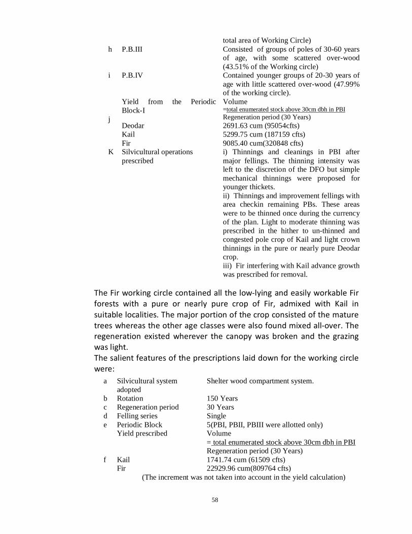
58
total area of Working Circle) h P.B.III Consisted of groups of poles of 30-60 years
of age, with some scattered over-wood (43.51% of the Working circle)
i P.B.IV Contained younger groups of 20-30 years of age with little scattered over-wood (47.99% of the working circle).
j
Yield from the Periodic Block-I
Volume =total enumerated stock above 30cm dbh in PBI Regeneration period (30 Years)
Deodar 2691.63 cum (95054cfts) Kail 5299.75 cum (187159 cfts) Fir 9085.40 cum(320848 cfts)
K Silvicultural operations prescribed
i) Thinnings and cleanings in PBI after major fellings. The thinning intensity was left to the discretion of the DFO but simple mechanical thinnings were proposed for younger thickets. ii) Thinnings and improvement fellings with area checkin remaining PBs. These areas were to be thinned once during the currency of the plan. Light to moderate thinning was prescribed in the hither to un-thinned and congested pole crop of Kail and light crown thinnings in the pure or nearly pure Deodar crop. iii) Fir interfering with Kail advance growth was prescribed for removal.
The Fir working circle contained all the low-lying and easily workable Fir forests with a pure or nearly pure crop of Fir, admixed with Kail in suitable localities. The major portion of the crop consisted of the mature trees whereas the other age classes were also found mixed all-over. The regeneration existed wherever the canopy was broken and the grazing was light. The salient features of the prescriptions laid down for the working circle were:
a Silvicultural system adopted
Shelter wood compartment system.
b Rotation 150 Years c Regeneration period 30 Years d Felling series Single e Periodic Block 5(PBI, PBII, PBIII were allotted only) f
Yield prescribed Volume = total enumerated stock above 30cm dbh in PBI Regeneration period (30 Years)
Kail 1741.74 cum (61509 cfts) Fir 22929.96 cum(809764 cfts)
(The increment was not taken into account in the yield calculation)

59
Zanglu working circle comprised of the broad-leaved forests of Division. The system of working adopted was coppice with standard. The rotation was arbitrarily fixed at 30 years for coppice and 60 years for standard. The circle was worked under one felling series and about 1/3rd of the area of circle was selected for working during 10 years plan period. Ten annual coupes were accordingly allotted, fairly scattered on the ground. Yield was prescribed area and a target of about 87 ha. (215 acres) to be worked annually was fixed. The outturn was estimated at 741.3 mdsa/ha. (300 mds/acre) or 60000 mds/year.
7.2.1 Results of the Working Plan
a) There are no two opinionson the fact that the introduction of shelter wood compartment system was too premature for Deodar regular Working Circle and ill applied for the FirWorking Circle. Despite of Debris burning, protection from grazing and closure of some areas, regeneration failed to come up to the desired extent. The areas where no natural regeneration was extent before the seeding fellings are where it has deficient could not be restocked adequately and little attention was paid to regenerate the artificially. Obviously it was a motivation under aunthsiasim of a zealod, as much stress was laid on theoretical aspects to the great detriment of the actual crop requirements.
b) In the Zanglu Working Circle, the fellings in absence of effective grazing protection proved disastrous and consequently were suspended in 1991 after only four coupes had been worked.
c) A considerably large area was treated as un-commercial as per the plan prescription.
d) Thinnings in actual practice, were carried out for one year except in Lidder Range where in 1932 and part of 1933 coupes were also worked.
e) By and large the prescriptions werefound sound and practicable. In spite of initial handicaps like lack of experience and enthusiasm, the Forest working was brought more or less on scientific lines which decidedly did some good.
7.3. Khushoo’s Plan (1940-1955): The revision of the Pathania’s plan was done in 1940 by Shri G.L. Khushoo. He retained more or less the broad outlines of the previous plan in that conversion to uniformity was advocated for all the easily accessible and well stocked Deodar, Kail Forests and the Fir Forests, leaving however, areas around Pahalgam. The compartments were properly laid out on the ground for the First time and large area considered un-commercial earlier was brought under the plan. The following Working Circles were constituted:-

60
a) Deodar -Kail Regular Working Circle. b) The Fir Regular Working Circle. c) The Pahalgam Location Working Circle. d) The Unregulated & Protection Working Circle. The Deodar-Kail Regular Working Circle comprised of all the easily accessibly commercial Deodar and Kail forests with such Fir as was associated with the Deodar-Kail species at the upper reaches. Save for a few changes, the working circle resembled the Deodar-Pine Working circle of the previous plan. Kail formed the predominant crop with a fair proportion of Deodar the ‘Panchalthan’ area of ‘Kuthar’ Range and lower parts of ‘Lidder’ Range. Kail and Deodar crop was abnormal in character and deficient so far as the mature and near mature age classes are concerned. Natural regeneration of both Kail and Fir was satisfactory except in PBI areas felled over in the previous plan. Enumeration in 15 cm (6”) diameter classes down to 30 cms (12”) dia.b.h.was conducted in the Working Circle and the figures were reduced by 5% as a safeguard for any possible in-accuracy committed. The prescriptions laid down for the working circle were:
a Silvicultural system adopted
Conversion to uniformity under shelter wood compartment system.
b Rotation 150 Years c Exploitable diameter 75 cm d Regeneration period 30 Years e Felling series Single f Periodic Block 5(PBIwas only allotted and rest were kept unassigned
and called PB un-allotted). g P.B.I Comprised of forests with mature overwood and
established regeneration and included areas felled under last plan. It constituted 15.5% of the total commercial area of the working circle. In actual practice, out of the areas under constituent species, the area under Deodar that was allotted was about twice the normal area.
h P.B. Un-allotted Occupied the rest 84.5% of the area of working circle. Definite compartments were prescribed to be gone over during the currency of the plan and annual coupe worked to about 749.87 ha. (1853 acres)
i Yield prescribed: i)For entire Working Circle
Deodar 1472.48 cum (52000 cYfts) Kail 6880.99 cum (243000 cfts) Fir 807.03 cum(28500 cfts)
ii) P.B.I = G.S. in P.B.I-Vol. of trees 30-45 ms dia class (Future crop)

61
30 Deodar 135.92 cu.m. (4800 cft.) Kail 3058.22 cu.m. (108000 cft.) Fir 6229.71 cu.m (220000 cft.) (The balance of yield to be realised from Unallotted Block) J Silvicultural operations
prescribed i) Disposal of debris, closure to grazing and completion of regeneration, works in compartments felled under last plan. ii) Cleaning, thinning and improvement marking over a period 15 years in un-allotted blocks. iii) B grade ordinary thinning in the poll crop upto 50cms dbh.
The Fir regular Working Circlecomprised of all the accessible and easy forests of Fir and was more or less identical with that of the last plan. The crop on the whole was mature to over mature. Thickets of regeneration and advance growth existed in open gaps were the selection type of fellings and grazing protection appeared to have been restored in the past. However, the compartments felled under the previous plan were dividing of regeneration. The PBI area was only enumerated in 15cm diameter-classes down to 30cm dbh and the enumeration figures were reduced by 5% as a safeguard against any possible in-accuracy committed. The important prescriptions summarized as under:
A Silvicultural system adopted Shelter wood compartment system to continue B Rotation 200 Years c Exploitable diameter 75cm d Regeneration period 40 Years, out of which 10 years were
considered to have elapsed. e Felling series Single f Periodic Block 5 (PBI was allotted only and the rest were
lumped in un-allotted block) g PBI Included areas with some advance growth and
also those felled under the last plan (17.3% of the entire working circle).
h Yield prescribed = total enumerated stock above 60cm dbh Regeneration period (10 Years)
Kail 566.34 cum (20000 cfts) Fir 11694.96 cum(413000 cfts)
i Other silviculture operations prescribed included disposal of debris, closures to grazing and regeneration majors in PBI are felled under the last plan. Improvement markings to the extent of 3114.85 cums (110000 cft) per annum and annual coupes of about 223.38 hec. (552 acres) were prescribed to the worked on a felling cycle of 30 years in the un-allotted block.

62
The Pahalgam location Working Circlecomprised of the compartments around the growing town ship of Pahalgam, on both sides of the Lidder nallah from Aru to Ganishbal and was constituted mainly from aesthetic point of view. The crop consisted mainly of Fir and Kail with a very little sprinkling of Deodar. Complete enumeration of all the fit trees down to 30cm dbh. was cared out. The prescriptions laid down for the working circle were
A Silvicultural system adopted Selection system modified on conservative lines.
B Exploitable size 75 cms dbh C Regeneration period 10 Years D
Yield prescribed Kail 283.17 cum (10000 cfts) Fir 3540.0 cum(125000 cfts)
No fellings were prescribed in compartment 36c/l on aesthetic grounds. The unregulated and protection working circle included all the inaccessible, illstocked, steep and precipitous forests and alpine grasslands. No specific operations for regular fellings were prescribed yet the allowance of or working compact forests under selection cum improvement system so as to meet petty local demands was given. Pohu and other broad leaved species were allowed to be worked for fuel.
7.3.1 Results of Working:
a) The simple but prudent prescriptions laid down in the plan were executed but with lesser enthusiasm. In the Deodar- Kail Working Circle, the thinning were neglected and little was done to regenerate the felled areas. The working also suffered woefully during 1947 due to lawlessness and laxity prevalent at that time. The possibility estimated by the Working Plan Officer proved optimistic as a total prescribed yield could not be worked out after practically going over all the compartments in PBI.
b) The fact of prescribing Uniform System for Fir forests was not in conformity with the silvicultural needs of the species for the terrain requirements of such forests and could have resulted in soil erosion, weed infestation and other such hazards however, a blessings is disguise as it was, in actual practice the marking rules and other prescription reduced the system to the status Indian Selection System. This evaded the otherwise in evitable deterioration of the site as an adequately close canopy was ensured. Nevertheless the felling conducted to meet the Firewood demands were of very extensive and heavy nature.
c) The sequence of fellings laid down for the Pahalgam Location W.C was more or less adhered to while as no specific operation other than

63
extraction of fuel wood was conducted in the unregulated and Protection W.C.
7.4. Fotidar’s Plan (1955-56 to 1969-70):
The Khushoo’s plan was revised by Shri A.N. Fotidar and period Revised plan started from the year 1955-56. The conservation of uniformity with respect to all the accessible and better stocksDeodar- Kail Forests was continued but Indian modification of selection system was prescribed for the Fir Forests. Tral Range was renamed as upper plantation Range under the Plantation Division Srinagar and as such excluded from the Kashmir Forest Division Plan. The following Working Circle were constituted:-
a) The Deodar -Kail Conversion Working Circle. b) The Fir Selection Working Circle. c) The Protection cum Improvement Working Circle.
The DeodarKail conversion Working Circlewas more or less identical in constitution with the Deodar-Kail regular working circle of the Khushoo’s Plan excluding the forests of Tral Range. The working circle consists of all the compacts, easily accessible and well stocked Deodar-Kail compartments having a little of Fir mixed over the upper reached. The crop was predominantly of Kail and mixed in uniform groups of poles and saplings over vast stretches. Middle aged and mature trees were deficient. Natural regeneration of both Kail and Deodar was satisfactory about 39% of area under the working circle was enumerated down to 30cm dbh. the summary of the prescriptions laid down for the working circle is given here under.
A Silvicultural system
adopted Shelter wood compartment system with slight modification so as to avoid sacrifice of immature step.
B Rotation 150 Years C Exploitable diameter 60 cm d Regeneration period 30 Years, out of which 15 years considered,expired during
the previous plan. E Conversion period 100 Years F Periodic Block Only two blocks viz Regeneration Block and Un-allotted
Block were identified in the working circle G Regeneration Block Much the same as the PBI of last plan with some new
additions and constituted 17.8% of the area of working circle.
h Unalloted block Area of the working circle other than the allotted to the regeneration block
I Yield prescribed: By Symthies modification of Von Montels formula. J For the entire W.C Volume
= G.S above the dbh corresponding to average age of advance growth Rotation- average age of advance growth
Deodar 4842.18 cum (171000 cfts) Kail 10930.3 cum (386000 cfts)

64
Fir 12714.26 cum(449000 cfts) K For Regeneration Block
Deodar 2746.73 cum (97000 cfts) Kail 4304.16 cum (152000 cfts) Fir 5125.35 cum(181000 cfts)
L
Silvicultural operations prescribed
i) Ordinary thinnings of B/C grade on 15 years thinning cycle in unallotted blocks. ii) Closure of compartments, whole or part of regeneration block vacated by the lessee to evade grazing therein. iii) Artificial regeneration of the old felled but un-regenerated areas.
The FirSelection Working Circleincluded all the commercial well stocked, accessible and workable Fir forests. The crop was mainly middle aged to over mature. The regeneration was generally in adequate to absent except at places were the inimical factors of excessive grazing and un-decomposed humus were not at play. The various prescriptions laid down for the working circle are:
The Protection cum improvement working circle included a vast number of poorly stocked compartments, some in accessible but well stocked compartments and the high level alpine pastures. Albeit the regular fellings were prohibited in the working circle, yet some selection-cum-improvement markings in the compact and mature Fir crop for mating petty demands of the concessionists and Firewood requirements were permitted.
7.4.1 Results of Working:
a) The annual yield prescribed for the Deodar- Kailconversion Working Circle was over estimated, and the main factors responsible included the non-differentiation of the converted crop from out of the regeneration block besides wrong inclusion of some predominantly Fir compartments viz 85b/V and 47b/L in the regeneration block of Deodar-Kail working circle compartment 39/L having mainly a young to middle aged crop, was incorrectly allotted to the regeneration block and no final felling was prescribed for the compartment of 28a/L.
a Silvicultural system Selection system modified to restrict selection cum improvement fellings among trees above 75 cms dbh and improvement fellings in the rest of the crop.
b Rotation 240 Years corresponding to 75 cms dbh c Felling cycle 40 Years d Yield prescribed By Brands Method
Kail 612 trees i.e 3143.17 cum (111000 cfts) Fir 1070 trees i.e 26617.8 cum(940000 cfts)
e Other silviculture operations prescribed: i. Disposal of felling refuse in the forests vacated by the lessee ii. Artificial regeneration majors in compartments 14/K and 38/L

65
b) The assessment of growing stock was not fool proof. The sample/partial enumeration conducted was mostly with respect to the well stocked compartments and the resultant stocking worked per unit area was on the higher side. Also the act of considering the 15 year old stocking figures of Khushoo’s plan was brought with grave errors.
c) The application of the sympathies/modification of Von Montels formula for yield calculation was not in consonance with the demands of the prevalent crop conditions. Besides, prescribing a huge annual yield for un-allotted block was anomaly.
d) The wise prescription of closing the worked and vacated coupes was not enforced and subsequently reflected in further deterioration of the site and stocking viz in compartment 36c/L.
e) Prescribing the selection for the Fir selection working circle was a step in the right direction but adoption of large felling cycle was not befitting the crop condition as a major part of the crop was predominantly over mature and subject to decay and heavily mortality.
f) In absence of a definite check over fellings, the actual felling intensity remained almost same and nearly all the Fir areas worked during the last plan were ever felled are felled drastically.
g) No development works were implemented in the protection working circle and contrary to it, the working circle was subject to uncontrolled Firewood extraction unregulated grazing and heavy concession markings which rendered several compartments to a degraded state viz 18, 19, 20a, 32a, 34, 42/NA, 4, 5, 16, 17, 62ab/V, 58/L and 119, 110, 111/K.
7.5. Quadir’s Plan (1970-71 to 1979-80): The Fotedar’s plan was revised by Shri Parvaiz Qadir whose 10 years plan period started in 1970-71. The broad outlines of the plan weremuch same as that of the previous plan. However, a rehabilitation working circle was constituted which had no separate entity but overlapped with other working circles. The forests of Achabal Rakh, Gudhar Rakh and part of Desu Rakh transferred to Kashmir Forest Division from the Directorate of Games were brought under the per view of the plan. The hitherto un-commercial Forests of Aru- Chandanwari were opened up for the commercial exploitation. The plan advocated conversion to uniformity for the Deodar- Kail Forest and selection for Fir Forests as here to fore. The following Working Circles were constituted.
a) The Deodar -Kail Conversion Working Circle. b) The Fir Selection Working Circle. c) The rehabilitation Working Circle (overlapping) d) The Protection cum Improvement Working Circle.

66
The DeodarKail Conversion Working Circleas usual included all the stocked and commercially exploitable forests were Deodar or Kail or both predominant with some avoidable mixture of Fir at upper reaches. Complete enumeration in 10cms diameter-classes down to 30cms dbh.o.b was conducted in the whole working circle which spread over an area of 28367.5 hac. The important prescription laid down for the working circles are prescribed below:
a Silvicultural system adopted Shelter wood compartment system. b Rotation 140 Years c Felling series Single d Regeneration period 25 Years e Conversion period 60 Years f Periodic Block Three PBs were recognized viz PBI, PB last &
PB-Unallotted g PBI Comprised of the areas were seeding cum
secondary felling have been finished but regeneration was too insufficient to permit final felling-group. i)The areas fully regenerated with seeding cum secondary felling done and were removal of mature over-wood was required Group A ii) The areas taken up from PB un-allotted of the last plan for conduction of felling –Group B (i); and the areas in which correction felling were prescribed –Group. B (ii).
h PB Last Consisted of all the converted areas where the removal of over-wood had already been completed.
i PB Un-allotted Included the rest of the area of working circle, the crop whereof had yet to pass through conversion.
j Exploitation period 15 Years k Annual yield prescribed in
PBI = total available volume in PBI Exploitation period
Deodar 3400 cum Kail 8800 cum Fir 7200 cum
For calculating the available volume of Deodar and Kail, all trees above 50cms dbh. o.b. in P.B.I group B (i) and P.B. un-allotted were considered while as in case of Fir, trees above 70cms dbh. o.b. were taken into account. Similarly in PBI Groups A (ii) and B (ii) all trees above 60 cms dbh.o.b of Kail and Deodar and above 70cms dbh.o.b (50% only) of Fir were considered. In P.B. Un-allotted B/C grade thinning in young pole crop below 40cms dbh.o.b was prescribed. A similar grade of thinning on a 20 year’s cycle was proposed for the P.B last as well.

67
Other Silvi-culture Operations prescribed: i. Disposal of slash after the main felling and thinning. ii. Supplementary marking of the trees badly damaged during felling.
iii. Shrub cutting in Deodar and Kail forests.
The Fir Selection Working Circlewas more or less identical with that of the previous plan, excepting a few conditions and alterations. It consisted of all the sell-stocked and potentially commercial Fir areas. The crop contained a high proportion of mature and over-mature trees but was, at places, deficient in younger age classes. The working circle, occupying an area of 30536.6 ha.was divided into two categories. The category ‘A’ comprised of well stocked and well regenerated forests (25844.7 ha.) whereas the category ‘B’ included areas with an open type of crop where the regeneration was nearly lacking (4691.9 ha.). The category ‘B’ areas were precluded from prescribing any yield. The prescriptions laid down for the working circle are given below.
a Silvicultural system adopted Selection system b Exploitable diameter 70cms for Fir and Spruce 60cms for
Kail. c Felling cycle 20 Years d Felling series Three viz Lidder felling series,
Arapat-Naubug felling series &Razparyin-Ahlan-Sandran felling series.
e) Yield calculation By stmthies safeguarding formula i)For Fir = x+5 f/60 x No. of over mature trees
of Fir in a compartment. ii) For Deodar and Kail = X+ f/40 x No. of over mature trees
of Deodar and Kail in a Compartment Where X = f/t (II—Z% of II) X = total recruitment to class I F= felling cycle (20 years) t=time taken by trees of Class II to grow to the exploitable size (25 years for Fir
and 36 years for Deodar and Kail) Z=% of class II trees that disappear in ‘t’ years (20% for Fir and 22% for
Deodar-Kail) The trees of the dia-classes 60-70 cms 70-90 cms and above 90cms were considered as class II, class I and over-mature trees for Fir while as dia classes 50-60, 60-70 and above 70cms constituted class II, class I and over mature trees for Deodar-Kail respectively. f Annual yield prescription:-
Lidder Felling Series 2713 class I trees Arapat- Naubug felling series 3130 class I trees Razparyin-Ahlan-Sandran felling series
2276 class I trees.
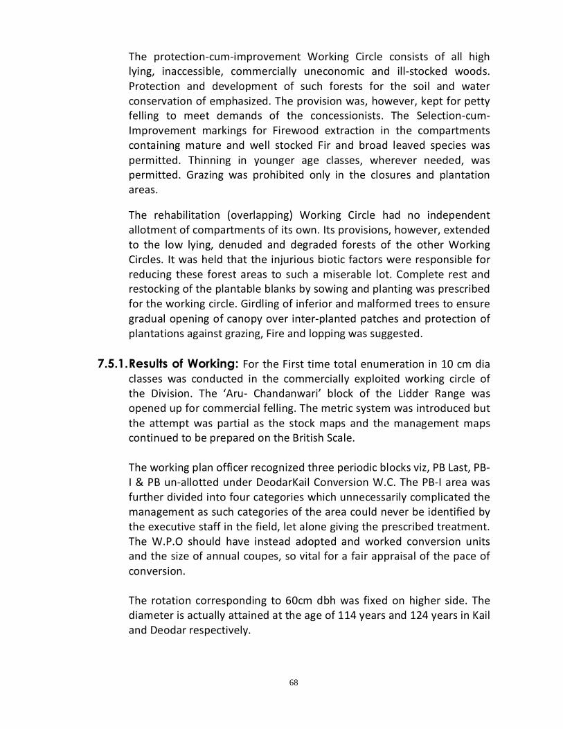
68
The protection-cum-improvement Working Circle consists of all high lying, inaccessible, commercially uneconomic and ill-stocked woods. Protection and development of such forests for the soil and water conservation of emphasized. The provision was, however, kept for petty felling to meet demands of the concessionists. The Selection-cum-Improvement markings for Firewood extraction in the compartments containing mature and well stocked Fir and broad leaved species was permitted. Thinning in younger age classes, wherever needed, was permitted. Grazing was prohibited only in the closures and plantation areas.
The rehabilitation (overlapping) Working Circle had no independent allotment of compartments of its own. Its provisions, however, extended to the low lying, denuded and degraded forests of the other Working Circles. It was held that the injurious biotic factors were responsible for reducing these forest areas to such a miserable lot. Complete rest and restocking of the plantable blanks by sowing and planting was prescribed for the working circle. Girdling of inferior and malformed trees to ensure gradual opening of canopy over inter-planted patches and protection of plantations against grazing, Fire and lopping was suggested.
7.5.1. Results of Working: For the First time total enumeration in 10 cm dia
classes was conducted in the commercially exploited working circle of the Division. The ‘Aru- Chandanwari’ block of the Lidder Range was opened up for commercial felling. The metric system was introduced but the attempt was partial as the stock maps and the management maps continued to be prepared on the British Scale.
The working plan officer recognized three periodic blocks viz, PB Last, PB-I & PB un-allotted under DeodarKail Conversion W.C. The PB-I area was further divided into four categories which unnecessarily complicated the management as such categories of the area could never be identified by the executive staff in the field, let alone giving the prescribed treatment. The W.P.O should have instead adopted and worked conversion units and the size of annual coupes, so vital for a fair appraisal of the pace of conversion.
The rotation corresponding to 60cm dbh was fixed on higher side. The diameter is actually attained at the age of 114 years and 124 years in Kail and Deodar respectively.

69
For the determination of conversion period, the age corresponding to the percentage the unconverted area bears to the rotation was found as 74 years. This was further lowered to the 60 years on the plea that the period so fixed would prevent the growing stock of and above 80 year age from decay and deterioration. The working plan officer should have better considered the average age of the regeneration or the converted crop which is our future and the king pin of the silvi-cultural system.
The present management itself takes care of big size trees whose indefinite retention is not allowed until necessitated on account of deficient regeneration of silvi-cultural non-availability.
Though the provision was kept in periodic block un-allotted for B/C grade thinning and the felling of silviculturally available Kail trees for the concessionists and departmental works, no separate yield was worked out therein. No proper check could therefore be exercised on felling in that Block and it is a sad commentary that some areas were so ruthlessly tapped as to nearly assume a converted look. The W.P.O identified types‘A’ and ‘B’ under the Fir Selection Working Circle and that no yield was prescribed for ‘B’ category (16.88% of total area of W.C) on account of the open nature of its crop. Such degraded areas could have easily been included under protection-cum-Improvement Working Circle for Reboisement measures. In fact nothing was done for the improvement of this category under the Fir Selection Working Circle.
The Rehabilitation (overlapping) W.C had no entity of its own. The degraded and denuded areas including therein should have been tackled effectively under a set of silvicultural prescriptions and improvement measures in an independent Rehabilitation Working Circle.
Though the plan laid great stress on the need of sowing and planting work in degraded areas, the plan prescription was implemented only to a minor degree and particularly very little was done to regenerate the failed PBI areas of the Deodar- Kail Conversion Working Circle.
7.6 Mr. Shamim Mohammad Khan - Revised Working Plan-1982-
83 to 1991-1992 The previous working plan was revised by Mr. Shamim Mohammad Khan in 1982 and remained invogue from 1982 to 1992. He retained more or less the broad outlines of the previous plan in which the conversion

70
touniformity was advocated for all the easily accessible and well stocked Deodar-Kail Forests and the Fir forests. The compartments were properly laid out on the ground and large areas considered un-commercial under the previous plan were surveyed and brought under the purview of plan. The following working circles were constituted 1) Deodar -Kail Conversion Working Circle. 2) Fir Selection Working Circle. 3) Bio Aesthetic Working Circle. 4) Reboisement Working Circle. 5) Protection Working Circle.
7.6.1 Deodar -Kail Conversion Working Circle.
Its constitution was more or less identical to that of the last Parvaiz Qadir’s plan except for Kail compartments of Noorabad Range as those were allotted to the Bio Aesthetic W.C. The W.C continued to be managed under shelter wood compartment system with an aim of conversion to uniformity through a conversion period of 100 years. The rotation was fixed at 120 years corresponding to the exploitation dia meter of 60 cm dbh. The W.C constituted two felling series: one, Lidder felling series and the second, the Kuthar-Verinag felling series. The Deodar Kail Conversion Working Circle
7.6.3 The Fir Selection Working Circle:-
Its constitution was again more or less identical to that of the last plan barring few Fir compartments allotted to Bio Aesthetic W.C and those of Noorabad Range. Managed under Indian Selection system for a rotation of 160 years and 60cm dbh.o.b exploitable size under a felling cycle of 32 years and constituted of three felling series.
A Silvicultural system adopted
Shelter wood compartment system.
B Rotation 120 Years C Exploitable diameter 60 cms D Regeneration period 30 Years E Conversion period 100 Years F Felling series Lidder felling series. G Periodic Block Floating (converted, conversion & un-
allotted). H Exploitation period 11 Years I Yield from Lidder felling
series:-
Deodar 786 cum Kail 2839 cum Fir 1854 cum
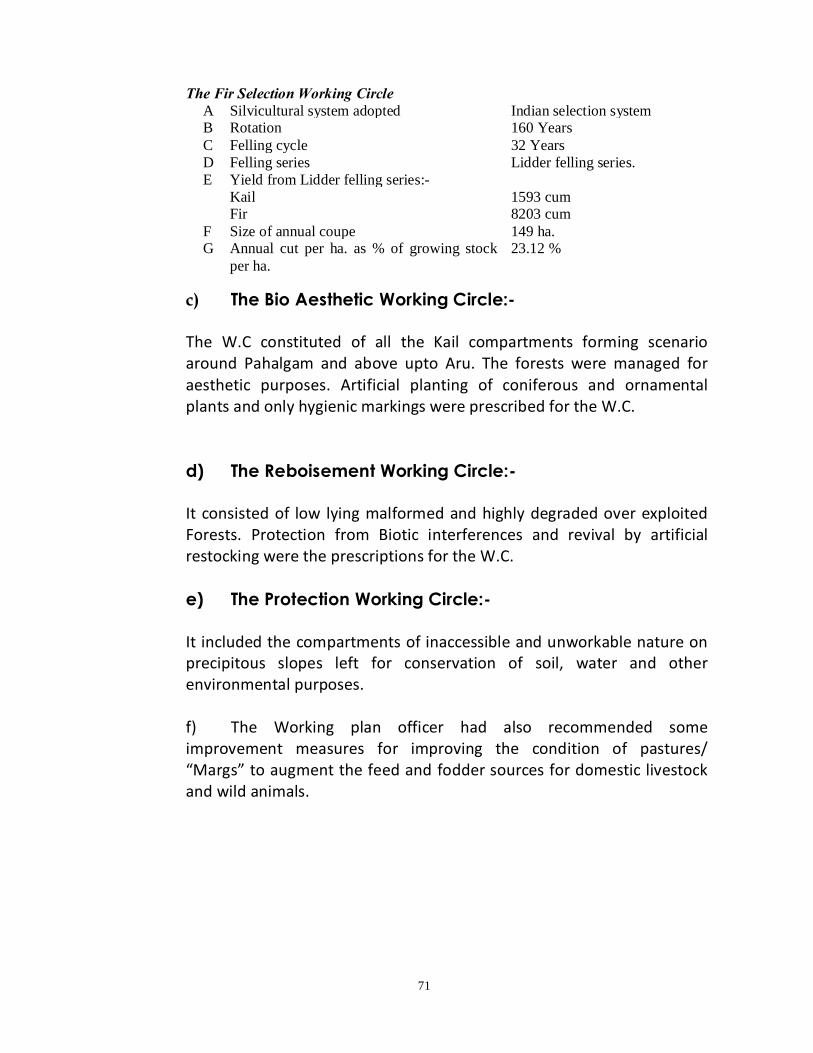
71
The Fir Selection Working Circle
A Silvicultural system adopted Indian selection system B Rotation 160 Years C Felling cycle 32 Years D Felling series Lidder felling series. E Yield from Lidder felling series:-
Kail 1593 cum Fir 8203 cum
F Size of annual coupe 149 ha. G Annual cut per ha. as % of growing stock
per ha. 23.12 %
c) The Bio Aesthetic Working Circle:- The W.C constituted of all the Kail compartments forming scenario around Pahalgam and above upto Aru. The forests were managed for aesthetic purposes. Artificial planting of coniferous and ornamental plants and only hygienic markings were prescribed for the W.C.
d) The Reboisement Working Circle:- It consisted of low lying malformed and highly degraded over exploited Forests. Protection from Biotic interferences and revival by artificial restocking were the prescriptions for the W.C.
e) The Protection Working Circle:- It included the compartments of inaccessible and unworkable nature on precipitous slopes left for conservation of soil, water and other environmental purposes. f) The Working plan officer had also recommended some improvement measures for improving the condition of pastures/ “Margs” to augment the feed and fodder sources for domestic livestock and wild animals.
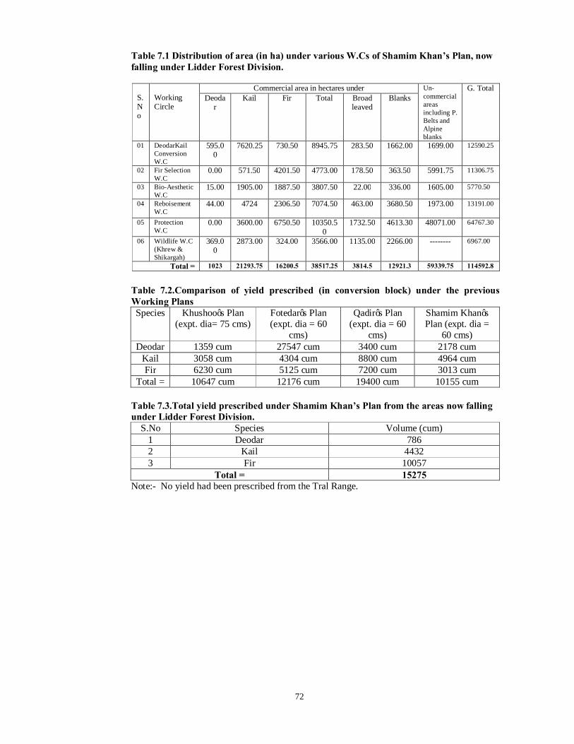
72
Table 7.1 Distribution of area (in ha) under various W.Cs of Shamim Khan’s Plan, now falling under Lidder Forest Division.
S. No
Working Circle
Commercial area in hectares under Un-commercial areas including P. Belts and Alpine blanks
G. Total Deoda
r Kail Fir Total Broad
leaved Blanks
01 DeodarKail Conversion W.C
595.00
7620.25 730.50 8945.75 283.50 1662.00 1699.00 12590.25
02 Fir Selection W.C
0.00 571.50 4201.50 4773.00 178.50 363.50 5991.75 11306.75
03 Bio-Aesthetic W.C
15.00 1905.00 1887.50 3807.50 22.00 336.00 1605.00 5770.50
04 Reboisement W.C
44.00 4724 2306.50 7074.50 463.00 3680.50 1973.00
13191.00
05 Protection W.C
0.00 3600.00 6750.50 10350.50
1732.50 4613.30 48071.00 64767.30
06 Wildlife W.C (Khrew & Shikargah)
369.00
2873.00 324.00 3566.00 1135.00 2266.00 -------- 6967.00
Total = 1023 21293.75 16200.5 38517.25 3814.5 12921.3 59339.75 114592.8
Table 7.2.Comparison of yield prescribed (in conversion block) under the previous Working Plans Species Khushoo’s Plan
(expt. dia= 75 cms) Fotedar’s Plan (expt. dia = 60
cms)
Qadir’s Plan (expt. dia = 60
cms)
Shamim Khan’s Plan (expt. dia =
60 cms) Deodar 1359 cum 27547 cum 3400 cum 2178 cum
Kail 3058 cum 4304 cum 8800 cum 4964 cum Fir 6230 cum 5125 cum 7200 cum 3013 cum
Total = 10647 cum 12176 cum 19400 cum 10155 cum
Table 7.3.Total yield prescribed under Shamim Khan’s Plan from the areas now falling under Lidder Forest Division.
S.No Species Volume (cum) 1 Deodar 786 2 Kail 4432 3 Fir 10057
Total = 15275 Note:- No yield had been prescribed from the Tral Range.

73
Table 7.4.Statement showing the position of marking conducted in Lidder Forest Division Bijbehara and handed over to SFC since 1997-98 to 2013-14
S. No Range Comptt: Year of Marking
Vol. Marked (cfts) Lease rate applied Working Circle Remarks
Deo Kail Fir Deo Kail Fir 1
Mattan
13b/L 1997-98 - 2254 46371 - 54.45 39.24 Fir Selection Converted Vol. 2 16a/L 1999-2000 - 2418 24450 - 54.45 39.24 Deodar-Kail Converted Vol. 3 2/L 2009-10 129 - 54.45 - Reboisement Converted Vol. 4 11b/L 2000-01 - 2684 13380 - 54.45 39.24 Deodar-Kail Converted Vol. 5 12b/L 2000-01 540 1712 8425 105.32 54.45 39.24 Deodar-Kail Converted Vol. 6 15b/L 1999-2000 - 2240 23900 - 54.45 39.24 Deodar-Kail Converted Vol. 7 20a/L 2000-01 - 2052 16344 - 54.45 39.24 Deodar-Kail
Converted Vol. 8 2003-04 - 29498 6620 - 54.45 39.24 Converted Vol. 9 20b/L 2000-01 - 7365 6809 - 54.45 39.24 Reboisement
Converted Vol. 10 2003-04 - 10988 4351 - 54.45 39.24 Converted Vol. 11
Pahalgam
14/AC 2009-10 1542 3688 54.45 39.24 Protection Converted Vol. 12
17/AC 1999-2000 - 6448 4834 - 54.45 39.24
Deodar-Kail Converted Vol.
13 2001-02 - 1123 2084 - 54.45 39.24 Converted Vol. 14 2003-04 - 7215 613 - 54.45 39.24 Converted Vol. 15 24/L 2009-10 3435 - 54.45 - Fir Selection Converted Vol. 16 27ac/L 1999-2000 - 2715 11690 - 54.45 39.24 Fir Selection Converted Vol. 17 27/L 2009-10 1156 105.32 54.45 39.24 Deodar-Kail Converted Vol. 18 31/L 1997-98 - 214 4958 - 54.45 39.24 Deodar-Kail Converted Vol. 19
31bc/L
1998-99 - 7265 12586 - 54.45 39.24
Deodar-Kail
Converted Vol. 20 2001-02 - 1662 21361 - 54.45 39.24 Converted Vol. 21 2003-04 71 9026 17901 105.32 54.45 39.24 Converted Vol. 22 2009-10 - 1049 11905 - 54.45 39.24 Converted Vol. 23 2012-13 - 2536 3457 - 54.45 39.24 Converted Vol. 24 2013-14 - 580 1148 - 54.45 39.24 Converted Vol. 25
32/L
1997-98 - 214 4958 - 54.45 39.24
Protection
Converted Vol. 26 1998-99 - 6522 14223 - 54.45 39.24 Converted Vol. 27 2001-02 - 2325 9499 - 54.45 39.24 Converted Vol. 28 2003-04 - 8333 4392 - 54.45 39.24 Converted Vol. Total= 1767 123544 279947
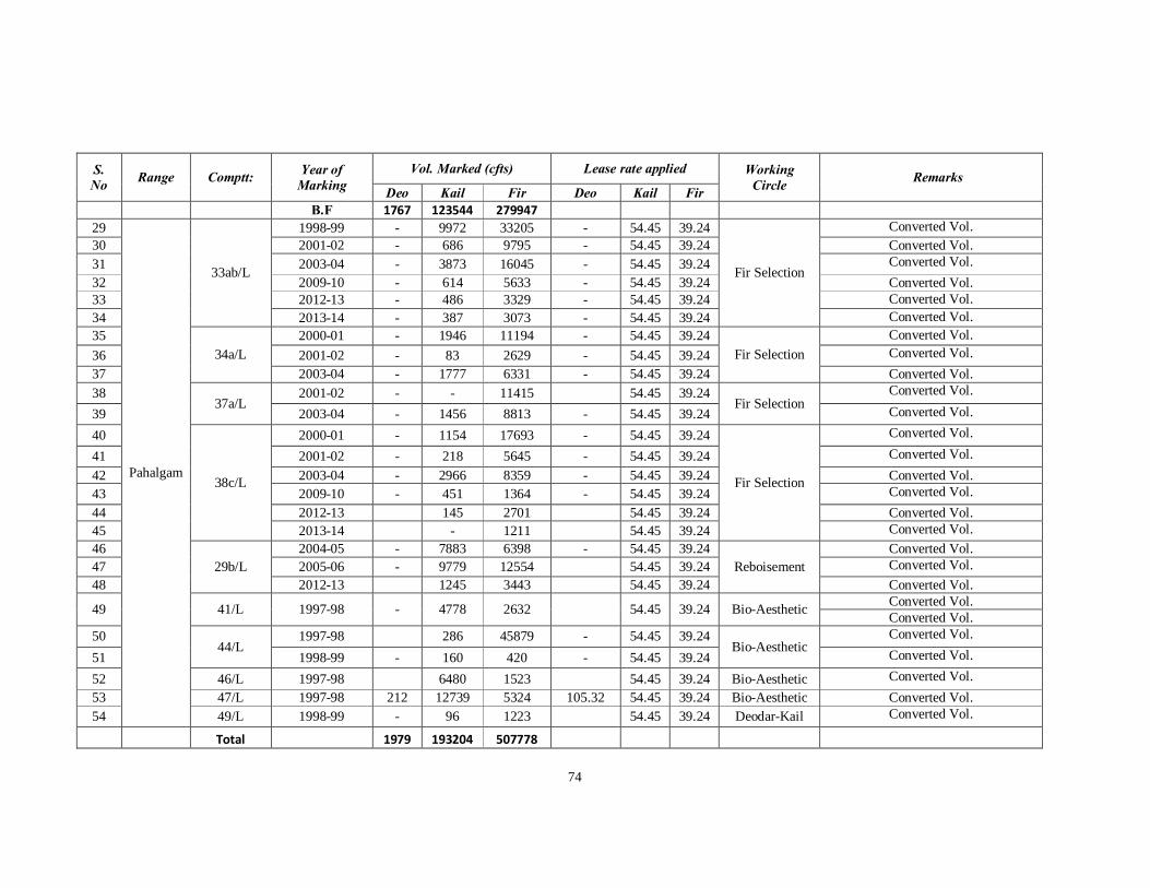
74
S. No Range Comptt: Year of
Marking Vol. Marked (cfts) Lease rate applied Working
Circle Remarks Deo Kail Fir Deo Kail Fir
B.F 1767 123544 279947 29
Pahalgam
33ab/L
1998-99 - 9972 33205 - 54.45 39.24
Fir Selection
Converted Vol. 30 2001-02 - 686 9795 - 54.45 39.24 Converted Vol. 31 2003-04 - 3873 16045 - 54.45 39.24 Converted Vol. 32 2009-10 - 614 5633 - 54.45 39.24 Converted Vol. 33 2012-13 - 486 3329 - 54.45 39.24 Converted Vol. 34 2013-14 - 387 3073 - 54.45 39.24 Converted Vol. 35
34a/L 2000-01 - 1946 11194 - 54.45 39.24
Fir Selection Converted Vol.
36 2001-02 - 83 2629 - 54.45 39.24 Converted Vol. 37 2003-04 - 1777 6331 - 54.45 39.24 Converted Vol. 38
37a/L 2001-02 - - 11415 54.45 39.24
Fir Selection Converted Vol.
39 2003-04 - 1456 8813 - 54.45 39.24 Converted Vol.
40
38c/L
2000-01 - 1154 17693 - 54.45 39.24
Fir Selection
Converted Vol.
41 2001-02 - 218 5645 - 54.45 39.24 Converted Vol. 42 2003-04 - 2966 8359 - 54.45 39.24 Converted Vol. 43 2009-10 - 451 1364 - 54.45 39.24 Converted Vol. 44 2012-13 145 2701 54.45 39.24 Converted Vol. 45 2013-14 - 1211 54.45 39.24 Converted Vol. 46
29b/L 2004-05 - 7883 6398 - 54.45 39.24
Reboisement Converted Vol.
47 2005-06 - 9779 12554 54.45 39.24 Converted Vol. 48 2012-13 1245 3443 54.45 39.24 Converted Vol.
49 41/L 1997-98 - 4778 2632 54.45 39.24 Bio-Aesthetic Converted Vol. Converted Vol.
50 44/L
1997-98 286 45879 - 54.45 39.24 Bio-Aesthetic
Converted Vol.
51 1998-99 - 160 420 - 54.45 39.24 Converted Vol.
52 46/L 1997-98 6480 1523 54.45 39.24 Bio-Aesthetic Converted Vol. 53 47/L 1997-98 212 12739 5324 105.32 54.45 39.24 Bio-Aesthetic Converted Vol. 54 49/L 1998-99 - 96 1223 54.45 39.24 Deodar-Kail Converted Vol.
Total 1979 193204 507778

75
7.7. Special Works of Improvement undertaken: 7.7.1 Buildings: A new forest complex is established in Bijbehara in which
conservator of Forest South Circle, Divisional Forest Officer Lidder and Range Officer Bijbehara is located. The residences of the officers are well maintained. The division is well served withan adequate number of rest houses both of forest department as well as those of P.W.D. The quarters to accommodate Range Officers present at Mattan, Pahalgam and Bijbehara. The well managed rest houses existing in Pahalgam i.e. Shanti Hut and Rest House. Recently built Guard Huts exists in various places. Several of the forest building have fallen into disrepair and needs to be upgraded and properly equipped with. Besides that several forest checkposts with single room without adequate facilities.
7.7.2 Momandanji and Katriteng Plantation: The Momandanji
Plantation has been established decades back by the Forest Department. As per the available records the Momandanji Plantation spreads on 61.47 Hectares. The plantation comprises on 13 Compartments. The species raised are Willow, Poplar, and Ash, while as in nursery Ash and Ulmus prickings has been planted. The extraction of the produce has taken place from time to time as per the departmental procedure.
7.7.3 The Katriteng Plantation is located on Katriteng village of Bijbehara. As per the available records the plantation occupies 5.97 hectares of land. The species raised willow, Poplar, Catalpa, Rubinia and Ash.
The extraction of the produce has taken place from time to time as per the departmental procedure.
7.7.4Roads
The most part of the Division is well connected by network of mettled and fare weather roads. Several farflung forest areas have been rendered commercial by their opening upto the vehicular transportation of timber. The Jammu Srinagar National Highway passes through the division. The principle mettled roads of the division extends between Anantnag to Pahalgam, Anantnag to Tral, Anantnag to Pampore, Bijbehara to Laganbal, Pahalgam to Chandanwari, Pahalgam to Aru, Seer to Hapatnar, Seer to Vail Nagbal, Tral to Naristan andTral to Lam.
Further there were numerous Kacha Roads were constructed inside the forests to bring the logs from forests kacha loading points (KLP) and from KLP to Pucca loading point (PLP). The detailed account is given in the Annexure VIII.
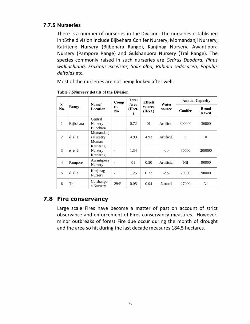
76
7.7.5 Nurseries
There is a number of nurseries in the Division. The nurseries established in t5the division include Bijbehara Conifer Nursery, Momandanji Nursery, Katriteng Nursery (Bijbehara Range), Kanjinag Nursery, Awantipora Nursery (Pampore Range) and Gulshanpora Nursery (Tral Range). The species commonly raised in such nurseries are Cedrus Deodara, Pinus walliachiana, Fraxinus excelsior, Salix alba, Rubinia sedocacea, Populus deltoids etc.
Most of the nurseries are not being looked after well. Table 7.5Nursery details of the Division
7.8 Fire conservancy
Large scale Fires have become a matter of past on account of strict observance and enforcement of Fires conservancy measures. However, minor outbreaks of forest Fire due occur during the month of drought and the area so hit during the last decade measures 184.5 hectares.
S. No. Range Name/
Location Comptt. No.
Total Area
(Hect.)
Effective area (Hect.)
Water source
Annual Capacity
Conifer Broad leaved
1 Bijbehara Central Nursery Bijbehara
- 0.72 01 Artificial 300000 30000
2 ………. Momandanji Nursery Moman
4.93 4.93 Artificial 0 0
3 ……… Katriteng Nursery Katriteng
- 1.34 -do- 30000 200000
4 Pampore Awantipora Nursery - 01 0.50 Artificial Nil 90000
5 ……… Kanjinag Nursery - 1.25 0.72 -do- 20000 90000
6 Tral Gulshanpora Nursery 29/P 0.05 0.04 Natural 27000 Nil
77
CHAPTER –VIII
STATISTICS OF GROWTH AND YIELD
8.1 Inventory method adopted
8.1.1 To assess the growing stock parameters most economically, efficiently and speedily within a predetermined degree of precision, the modern sampling technique was preferred in place of the conventional methods of total or partial count. Bitterlich’s method or what is popularly known as ‘point sampling’ was therefore adopted to survey the crop with the help of a fixed critical angle instrument the ‘wedge prism’. The method adopted shall be that of random sampling using probability proportional to the size. Point sampling is a convenient method for the assessment of growing stock in the coniferous forests and under the rugged terrain condition as we have in the valley and involves minimum personal and instrumental errors.
8.1.2 Once the points are located on the map and G.T sheet of the area, the next step is to objectively locate three points in the field by taking help of reference point for each sample point or through GPS. After locating the points, the point sampling exercise will be conducted for each point using a wedge prism of suitable basal area factor.
8.1.3 At each point, stems viewed through a fixed angle wedge prism a complete sweep of 3600 is made. The trees having the displacement smaller than the diameter at breast height (OB) of the trees are considered as tallied. The fully tally trees are counted as one while as the half tally trees are counted as half. The DBH (OB) and the height are recorded as the basic data for the assessment of the growing stock.
8.1.4 In the present analysis predetermined precision of 10% at 95% probability has been aimed at in order to attain this precision, the required intensity of sampling is calculated by the formula N= (CV% /SE %) 2 Where N= No. of samples CV= Coefficient of variation And SE = Standard error
8.1.5 Data collection: - The forests of Division were distributed, for the purpose into more or less homogenous strata. The primary stratification was governed by the condition of crop and the treatment warranted by it. The major strata where thus identified:-
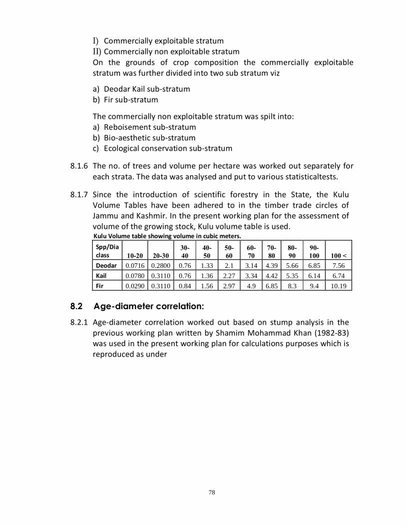
78
I) Commercially exploitable stratum II) Commercially non exploitable stratum On the grounds of crop composition the commercially exploitable stratum was further divided into two sub stratum viz
a) Deodar Kail sub-stratum b) Fir sub-stratum
The commercially non exploitable stratum was spilt into: a) Reboisement sub-stratum b) Bio-aesthetic sub-stratum c) Ecological conservation sub-stratum
8.1.6 The no. of trees and volume per hectare was worked out separately for each strata. The data was analysed and put to various statisticaltests.
8.1.7 Since the introduction of scientific forestry in the State, the Kulu
Volume Tables have been adhered to in the timber trade circles of Jammu and Kashmir. In the present working plan for the assessment of volume of the growing stock, Kulu volume table is used.
Kulu Volume table showing volume in cubic meters. Spp/Dia class 10-20 20-30
30-40
40-50
50-60
60-70
70-80
80-90
90-100 100 <
Deodar 0.0716 0.2800 0.76 1.33 2.1 3.14 4.39 5.66 6.85 7.56 Kail 0.0780 0.3110 0.76 1.36 2.27 3.34 4.42 5.35 6.14 6.74 Fir 0.0290 0.3110 0.84 1.56 2.97 4.9 6.85 8.3 9.4 10.19
8.2 Age-diameter correlation:
8.2.1 Age-diameter correlation worked out based on stump analysis in the previous working plan written by Shamim Mohammad Khan (1982-83) was used in the present working plan for calculations purposes which is reproduced as under

79
Table: 8.1 Age-diameter correlation worked out based on Stump Analysis Species Diameter (cm) Age (years) Pinus walliachiana (Kail) 5 23 15 41 25 56 45 71 45 87 55 105 65 124 75 147 85 175 95 208 105 250 Cedrus Deodara (Deodar) 5 25 15 45 25 61 35 78 45 95 55 114 65 135 75 160 85 190 95 227 105 273 Abies pindrow (Fir) 5 30 15 55 25 76 35 97 45 120 55 146 65 176 75 213 85 259 95 318 105 398
Source: Shamim Mohd. Khan’s revised working plan
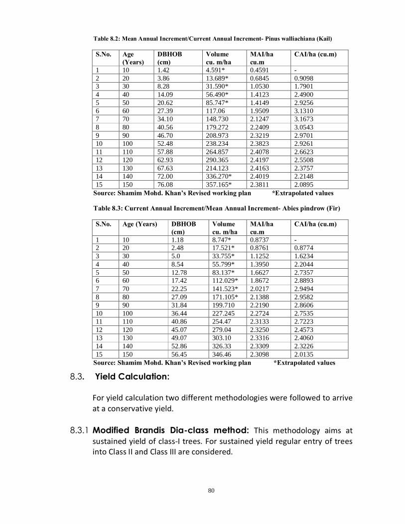
80
Table 8.2: Mean Annual Increment/Current Annual Increment- Pinus walliachiana (Kail)
S.No. Age (Years)
DBHOB (cm)
Volume cu. m/ha
MAI/ha cu.m
CAI/ha (cu.m)
1 10 1.42 4.591* 0.4591 - 2 20 3.86 13.689* 0.6845 0.9098 3 30 8.28 31.590* 1.0530 1.7901 4 40 14.09 56.490* 1.4123 2.4900 5 50 20.62 85.747* 1.4149 2.9256 6 60 27.39 117.06 1.9509 3.1310 7 70 34.10 148.730 2.1247 3.1673 8 80 40.56 179.272 2.2409 3.0543 9 90 46.70 208.973 2.3219 2.9701 10 100 52.48 238.234 2.3823 2.9261 11 110 57.88 264.857 2.4078 2.6623 12 120 62.93 290.365 2.4197 2.5508 13 130 67.63 214.123 2.4163 2.3757 14 140 72.00 336.270* 2.4019 2.2148 15 150 76.08 357.165* 2.3811 2.0895
Source: Shamim Mohd. Khan’s Revised working plan *Extrapolated values
Table 8.3: Current Annual Increment/Mean Annual Increment- Abies pindrow (Fir)
S.No. Age (Years) DBHOB (cm)
Volume cu. m/ha
MAI/ha cu.m
CAI/ha (cu.m)
1 10 1.18 8.747* 0.8737 - 2 20 2.48 17.521* 0.8761 0.8774 3 30 5.0 33.755* 1.1252 1.6234 4 40 8.54 55.799* 1.3950 2.2044 5 50 12.78 83.137* 1.6627 2.7357 6 60 17.42 112.029* 1.8672 2.8893 7 70 22.25 141.523* 2.0217 2.9494 8 80 27.09 171.105* 2.1388 2.9582 9 90 31.84 199.710 2.2190 2.8606 10 100 36.44 227.245 2.2724 2.7535 11 110 40.86 254.47 2.3133 2.7223 12 120 45.07 279.04 2.3250 2.4573 13 130 49.07 303.10 2.3316 2.4060 14 140 52.86 326.33 2.3309 2.3226 15 150 56.45 346.46 2.3098 2.0135
Source: Shamim Mohd. Khan’s Revised working plan *Extrapolated values
8.3. Yield Calculation: For yield calculation two different methodologies were followed to arrive
at a conservative yield. 8.3.1 Modified Brandis Dia-class method: This methodology aims at
sustained yield of class-I trees. For sustained yield regular entry of trees into Class II and Class III are considered.

81
The mean number of trees per hectare and volume per hectare for each dia-class of lowest confidence limit was extra exploited to the commercial area of working circle to arrive at total number of stems and volume in each of a dia-class for the commercial area of working circle. Based on the other survival coefficient each of the dia-class, potential availability is worked out species and dia-class wise. Then the entry of stems into the Class I category from Class II and Class III were worked out. In case of Deodar and Kail 60cm and above are considered as Class I 50-60cm and above are considered as Class II and 40-50cm dia-class is considered as Class III.
In case of Fir dia-class of 70cm and above is considered as Class I, 60-70cm as Class II and 50-60cm as Class III respectively.
8.3.2 Von Mantal’s method: As per the Von Mantal’s method annual yield is calculated as per the following formula. Yield = 2(Growing stock volume)/Rotation The Von Mantal’s formula also helps to arrive at a sustainable yield. The growing stock volume of all dia-class from the lowest dia-class i.e. 10-20cm is considered and yield is worked out accordingly.
8.4 Assessment of Growing Stock for Willow Plantations
8.4.1 For assessment of growing stock, the complete enumeration was carried out in both the plantations i.e. Momandanji and Katriteng for the species i.e. Willow and Poplar. The data was recorded in dia classes of 10cm.
To know the growing stock volume table has taken from the Working Plan Sindh Forest Division 2004-05 to 2013-14. The volume table is as under:- S. No. Dia. class (cm) Volume m3 1 10-20 0.09
2 20-30 0.28
3 30-40 0.54
4 40-50 0.76
5 50-60 0.94
6 60-70 1.55
7 70-80 1.98


