Embed Size (px)
Citation preview
Page 1 of 12
Introduction*!This! Oil! In! Place! (“OIP”)! study! presents! the! results! of! a! 3D! geological! and! petrophysical! static!model! used! to!calculate!the!range!of!OIP!over!the!UK!Weald!Basin!Area!of!Interest!(“AOI”)!and!over!eight!licences!in!which!UK!Oil! &! Gas! Investments! PLC! (“UKOG”)! have! interests!within! the! AOI.! The! study! utilizes! 86!wells,! with! updated!analyses! spatially! distributed! throughout! the! basin,! based! on! calibrated! values! determined! in! the!Horse!HillP1!(“HHP1”)!well.!!!The$OIP$calculated$in$the$Report$represents$the$total$gross$volume$of$all$hydrocarbons$in$the$ground$before$any$extraction$or$production,$and$does$not$differentiate$ light$moveable$oil$ versus$any$other$hydrocarbon$phases$present,$ neither$ have$ any$ potential$ economic$ cut=offs$ been$ applied.! These!OIP! numbers! therefore! should! be!regarded! as! Total! Petroleum! Initially! In! Place! as! defined! by! the! Society! of! Petroleum! Engineer’s! Petroleum!Resource!Management!System!of!resource!reporting.!!The!results!are!summarised!in!Table!1!below:!!
Table*1*–*Jurassic*Tight*Oil*Section*OIP*(billion*barrels,*“BBO”)**
Area* Weald*Basin*AOI*2!(1261*sq.*miles)*
UKOG’s*Licence*Interests*2** *(151*sq.*miles)* *
Gross*OIP* Aggregate*Gross*OIP* Aggregate*Net*OIP*Confidence*level* P90*Low* P50*Best* P10*High* P90*Low*
*P50*Best**
P10*High**
P90*Low**
P50*Best*!
P10*High*
Jurassic*Tight*Oil*1* 61.8! 124.3! 229.9! 8.1! 15.7! 29.4! 2.0! 3.9! 7.2!¹!Jurassic!Tight!Oil!is!defined!as!the!plays!contained!within!the!source!rock!shale!sequences!and!interbedded!tight!conventional!limestones!of!the!Kimmeridge!Clay,!Oxford!Clay!and!Lias!Shale!Formations.!Conventional!reservoirs!of!the!Corallian!and!Great!Oolite!and!of!the!overlying!Portland!section!are!excluded.*!2!Volumetric!estimates!by!Nutech.!!Table!2!and!Figure!1!show!the!45!updated!wells!used!to!populate!the!petrophysical!model.!!
Table*2*–*List*of*45*Updated*Wells*!
!
ALBURY_1 HOLTYE_1 STANMER_1ASHOUR_1 HOOK_LANE_1 STORRINGTON_1
BALCOMBE_1 HORNDEAN_4 TURNERS_HILL_1BAXTERS_COPSE_1 INWOOD_COPSE_1 URCHFONT_1BIDDENDEN_1 KNOCKHOLT_1 WALLCROUCH_1BORDON_1 LEE_ON_SOLENT_1 YARNBURY_1
BROCKHAM_1 LOMER_1 STOCKBRIDGE_5CHILWORTH_1 MIDDLETON_1 COLLENDEAN_FARM_1EGBURY_1 NETHERHAMPTON_1 HORSE_HILL_1
FAIRLIGHT_1 OLD_ALRESFORD_1 ODIHAM_1FARLEY_SOUTH_1 PAGHAM_1 STRAT_A1GODLEY_BRIDGE_1 PALMERS_WOOD_1 LOWER_KINGSWOOD_1HEDGE_END_1 ROGATE_1 BLETCHINGLEY_1HELLINGLY_2 ROTHERFIELD_1 BLETCHINGLEY_2
HOE_1 SOUTHWATER_1 EAGLESDEN_1

UKOG:!WEALD!BASIN!OIP! Page!2!
Figure*1*–*Locations*of*45*Updated*Wells*!
!!Figure!2!and!Table!3!show!the!list!and!locations!of!the!85!DECC/OGA!released!wells!in!the!database!ans!the!Horse!HillP1!well.!Figure!2!also!shows!the!AOI!and!the!locations!of!UKOG’s!eight!licence!areas.!It!should!be!noted!that!UKOG’s!Lidsey!licence!is!outside!the!AOI.!
Figure*2*–*Locations*of*86*Database*Wells,*Study*AOI*and*UKOG’s*Licences*
*
**********
UKOG:!WEALD!BASIN!OIP! Page!3!
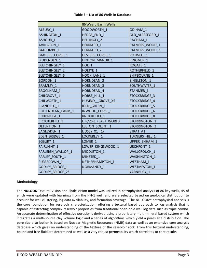
Table*3*–*List*of*86*Wells*in*Database**
**
Methodology*!The!NULOOK!Textural!Vision!and!Shale!Vision!model!was!utilized!in!petrophysical!analysis!of!86!key!wells,!45!of!ehich!were! updated!with! learnings! from! the!HHP1!well,! and!were! selected!based!on! geological! distribution! to!account!for!well!clustering,!log!data!availability,!and!formation!coverage.!!The!NULOOK™!petrophysical!analysis!is!the! core! foundation! for! reservoir! characterization,! offering! a! textural! based! approach! to! log! analysis! that! is!capable!of!extracting!complex!reservoir!properties!from!traditional!openPhole!well!log!data!such!as!triple!combo.!An!accurate!determination!of!effective!porosity!is!derived!using!a!proprietary!multiPmineral!based!system!which!integrates!a!multiPsource!clay!volume! logic!and!a!series!of!algorithms!which!yield!a!pores!size!distribution.!The!pore!size!distribution!is!based!on!Nuclear!Magnetic!Resonance!(NMR)!data!as!well!as!an!extensive!core!analysis!database!which! gives! an!understanding!of! the! texture!of! the! reservoir! rock.! From! this! textural! understanding,!bound!and!free!fluid!are!determined!as!well!as!a!very!robust!permeability!which!correlates!to!core!results.!!!
86#Weald#Basin#WellsALBURY_1 GOODWORTH_1 ODIHAM_1ASHINGTON_1 HEDGE_END_1 OLD_ALRESFORD_1ASHOUR_1 HELLINGLY_2 PAGHAM_1AVINGTON_1 HERRIARD_1 PALMERS_WOOD_1BALCOMBE_1 HERRIARD_2 PALMERS_WOOD_3BAXTERS_COPSE_1 HESTERS_COPSE_1 POTWELL_1BIDDENDEN_1 HINTON_MANOR_1 RINGMER_1BLETCHINGLEY_1 HOE_1 ROGATE_1BLETCHINGLEY_2 HOLTYE_1 ROTHERFIELD_1BLETCHINGLEY_6 HOOK_LANE_1 SHIPBOURNE_1BORDON_1 HORNDEAN_2 SINGLETON_1BRAMLEY_1 HORNDEAN_3 SOUTHWATER_1BROCKHAM_1 HORNDEAN_4 STANMER_1CHILGROVE_1 HORSE_HILL_1 STOCKBRIDGE_3CHILWORTH_1 HUMBLY__GROVE_X5 STOCKBRIDGE_4CLANFIELD_1 IDEN_GREEN_1 STOCKBRIDGE_5COLLENDEAN_FARM_1 INWOOD_COPSE_1 STOCKBRIDGE_6COXBRIDGE_1 KNOCKHOLT_1 STOCKBRIDGE_8CROCKERHILL_1 L_R/26I1_(EAST_WORLD STORRINGTON_1DETENTION_1 LEE_ON_SOLENT_1 STORRINGTON_2EAGLESDEN_1 LIDSEY_X1_(1) STRAT_A1EDEN_BRIDGE_1 LOCKERLEY_1 TURNERS_HILL_1EGBURY_1 LOMER_1 UPPER_ENHAM_1FAIRLIGHT_1 LOWER_KINGSWOOD_1 URCHFONT_1FARLEIGH_WALLOP_1 MIDDLETON_1 WALLCROUCH_1FARLEY_SOUTH_1 MINSTED_1 WASHINGTON_1FURZEDOWN_1 NETHERHAMPTON_1 WESTHAM_1GODLEY_BRIDGE_1 NORMANDY_1 WESTMESTON_1GODLEY_BRIDGE_2Z YARNBURY_1

UKOG:!WEALD!BASIN!OIP! Page!4!
A!triple!combo!log!consists!of:!!
• Nuclear o Neutron o Density o Gamma-Ray
• Resistivity !Where!possible,!and!where!the!available!curve!data!permits,!the!analytical!services!incorporate!all!aspects!of!the!NULOOK!technical!analysis:!
• NULOOK Textural Vision • NULOOK Shale Vision • NULOOK Fracture Intensity Vision
For! the! list! of! petrophysical! properties! each!of! these!NUTECH!Proprietary!Petrophysical! Processes! are!used! to!analyze,!please!see!Table!4!below:!
Table*4*–*NUTECH’s*Proprietary*Petrophysical*Processes*
NUTECH*Service*Name* Used*for*Calculating*Rock*Properties*
NULOOK*Textural*Vision**
1PClay!Volume!!2PLithology!&!Porosity!!3PBulk!Volume!Water!!4PRw!5PRock!Texture!!6PPermeability!!7PFlags!
NULOOK*Shale*Analysis*
1PShale!Volume(Vsh)!!2PTextural!Model!!3PIrreducible!Water!(BVI)!!4PTotal!Organic!Carbon(TOC)!5PVolume!Clay!6PLithology!7PBulk!Volume!Water!8PPermeability!9PShale!Quality!Flags!10PAdsorbed!and!Free!Gas!
NULOOK*Fracture*Intensity*Vision(FIV)* Fracture!Flags!
!!
!

UKOG:!WEALD!BASIN!OIP! Page!5!
The! analyst! initially! reviews! the! total! logged! intervals! of! the! wells! using! the! NULOOK™! Textural! Vision™! to!determine! the! lithology,! porosity,! permeability,! and! fluid! saturation!of! each!well.! Further! analysis!of! the! shale!formations!in!each!well!is!undertaken!using!NULOOK™!Shale!Vision™!to!assess!the!hydrocarbon!bearing!potential!of! the! source! rock,! followed! by! NULOOK™! Fracture! Intensity! Vision™! to! identify! the! potential! existence! of!naturally! occurring! fractures! within! the! well.! ! Shale! Vision™! zones! are! identified! utilizing! the! SHALE! FLAG,!denoted!by!a!purple!bar.!!The!criteria!are!as!follows:!
• High Gamma Ray readings • Density and Neutron porosity behavior • Resistivity • Caliper and SP (if available) as needed
There! are! areas! present! throughout! the! region! in! which! the! log! curves! provide! an! inconclusive! response! to!whether!the!formation!is!an!unconventional!organic!shale!or!not,!for!which!NUTECH!has!taken!the!conservative!approach!and!enabled!the!Shale!Flag.!
Figure!3!provides!snapshots!illustrating!the!NULOOK!NTV,!Shale,!and!Fracture!Intensity!results.!!
Figure*3*–*Snapshots*Illustrating*Results*!
!!
!!A! 3D! grid!model!with! color! zonation! of!model! is! generated! in! NUTECH’s!NUVIEW*unit,! as! shown! in! Figure! 4.!Within!this!grid!framework,!the!NULOOK!petrophysical!properties!are!distributed.!The!SHALEMOD!flag!is!used!to!distinguish!clay/shale!data!intervals!from!conventional!intervals.!For!the!volumetric!calculations,!PHIE!and!SW!are!the!main!log!property!components.!!!

UKOG:!WEALD!BASIN!OIP! Page!6!
Figure*4*–*3D*Grid*Model*!
**
NUVIEW!3D*static!geological!modeling!workflow:*
• Build!3D!grid!model!over!the!area!of!interest!zoned!by!well!correlation!formation!picks.!• Model!SHALEMOD!based!facies!using!stochastic!Sequential!Indicator!Simulation.!• Model!NULOOK!petrophysical!properties!within!each!facies!type!using!stochastic!Sequential!Gaussian!
Simulation.!• Calculate!3D!model!volumes!within!polygons!of!interest.!• Extract!property!maps!by!vertical!summation!within!each!zone!of!interest.!
*Results**The!ranges!of!calculated!geological!and!petrophysical!parameters!interpreted!in!each!well’s!NULOOK!and!NULIST!were!used!to!run!a!stochastic!simulation!of!OIP!over!the!Weald!Basin!for!key!prospective!tight!Jurassic!mudstone!and! limestone! benches! or! reservoir! units.! The! study! covered! OIP! for! the! following! reservoirs! (results! are!presented!in!map!and!tabular!form!in!the!annexure):!!
• Kimmeridge!Shale!tight!oil!• Kimmeridge!Limestone!(Micrite)!conventional!tight!oil!• Corallian!conventional!limestone!• Oxford!Clay!shale!tight!oil!• Oolite!conventional!limestone!!• Lias!Clay!shale!tight!oil!!
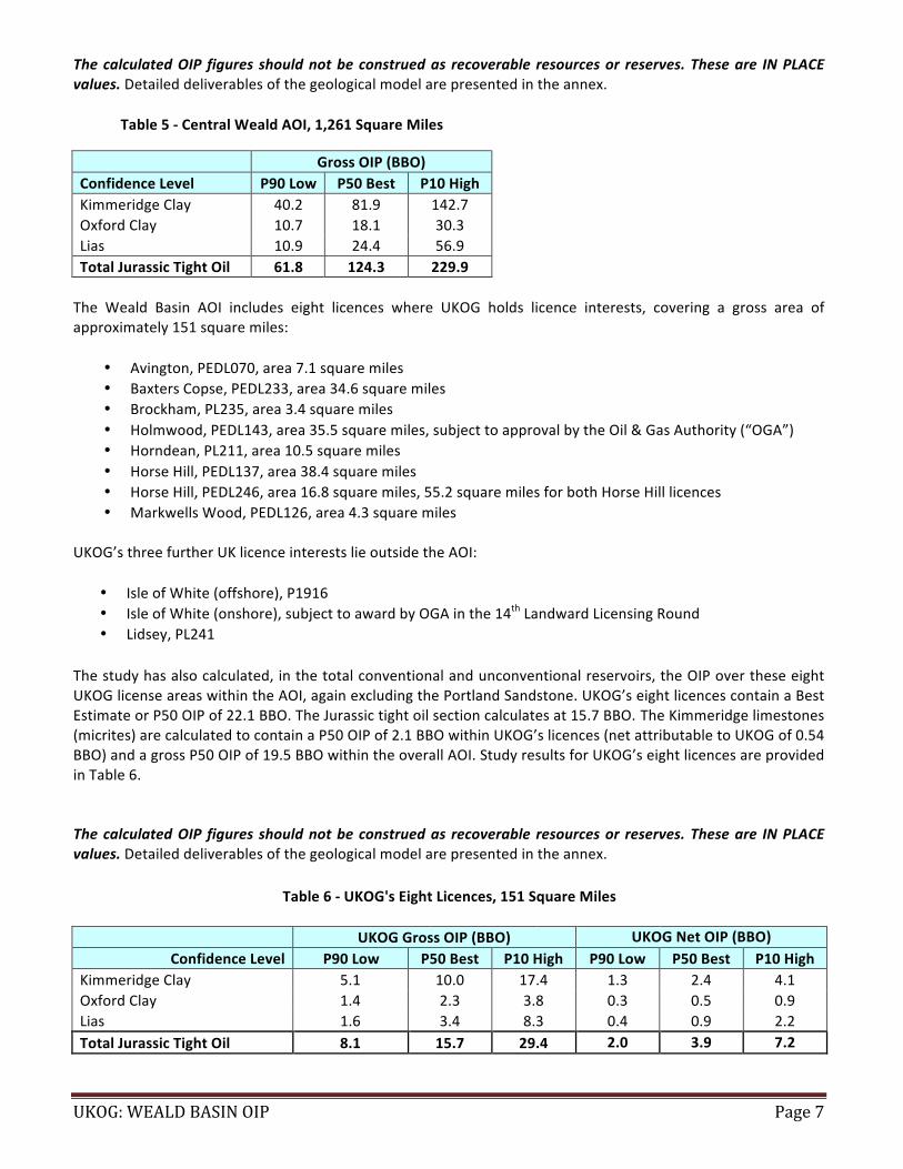
!The!study!calculates!that!the!total!conventional!and!unconventional!reservoirs,!in!the!Weald!Basin!AOI,!contain!a!Best!Estimate!or!P50!OIP!of!124!BBO!within!the!Jurassic!tight!oil!section!(Kimmeridge!Clay,!plus!Oxford!Clay,!plus!Lias!Clay).!It!should!be!noted!that!this!figure!excludes!the!Portland!Sandstone!reservoir.!The!most!significant!OIP,!is! contained! within! the! unconventional! shales! and! tight! conventional! limestone! (micrite)! sequences! of! the!Kimmeridge!which!calculates!a!Best!Estimate,!or!P50,!total!OIP!of!82!BBO.!The!Kimmeridge!limestones!(micrites)!are!calculated!to!contain!a!P50!OIP!of!20!BBO!over!the!Weald!AOI.!Study!results!for!the!AOI!are!provided!in!Table!5.!!
UKOG:!WEALD!BASIN!OIP! Page!7!
The$calculated$OIP$ figures$ should$not$be$construed$as$ recoverable$ resources$or$ reserves.!These$are$ IN$PLACE$values.!Detailed!deliverables!of!the!geological!model!are!presented!in!the!annex.!!
Table*5*b*Central*Weald*AOI,*1,261*Square*Miles*
! ! ! !** Gross*OIP*(BBO)*Confidence*Level* P90*Low* P50*Best* P10*High*Kimmeridge!Clay! 40.2! 81.9! 142.7!Oxford!Clay! 10.7! 18.1! 30.3!Lias! 10.9! 24.4! 56.9!Total*Jurassic*Tight*Oil* 61.8* 124.3* 229.9*!The! Weald! Basin! AOI! includes! eight! licences! where! UKOG! holds! licence! interests,! covering! a! gross! area! of!approximately!151!square!miles:!!
• Avington,!PEDL070,!area!7.1!square!miles!• Baxters!Copse,!PEDL233,!area!34.6!square!miles!• Brockham,!PL235,!area!3.4!square!miles!• Holmwood,!PEDL143,!area!35.5!square!miles,!subject!to!approval!by!the!Oil!&!Gas!Authority!(“OGA”)!• Horndean,!PL211,!area!10.5!square!miles!• Horse!Hill,!PEDL137,!area!38.4!square!miles!• Horse!Hill,!PEDL246,!area!16.8!square!miles,!55.2!square!miles!for!both!Horse!Hill!licences!• Markwells!Wood,!PEDL126,!area!4.3!square!miles!
!!UKOG’s!three!further!UK!licence!interests!lie!outside!the!AOI:!!
• Isle!of!White!(offshore),!P1916!• Isle!of!White!(onshore),!subject!to!award!by!OGA!in!the!14th!Landward!Licensing!Round!• Lidsey,!PL241!
!The!study!has!also!calculated,!in!the!total!conventional!and!unconventional!reservoirs,!the!OIP!over!these!eight!UKOG!license!areas!within!the!AOI,!again!excluding!the!Portland!Sandstone.!UKOG’s!eight!licences!contain!a!Best!Estimate!or!P50!OIP!of!22.1!BBO.!The!Jurassic!tight!oil!section!calculates!at!15.7!BBO. The!Kimmeridge!limestones!(micrites)!are!calculated!to!contain!a!P50!OIP!of!2.1!BBO!within!UKOG’s!licences!(net!attributable!to!UKOG!of!0.54!BBO)!and!a!gross!P50!OIP!of!19.5!BBO!within!the!overall!AOI.!Study!results!for!UKOG’s!eight!licences!are!provided!in!Table!6.!!!The$calculated$OIP$ figures$ should$not$be$construed$as$ recoverable$ resources$or$ reserves.!These$are$ IN$PLACE$values.!Detailed!deliverables!of!the!geological!model!are!presented!in!the!annex.!!
Table*6*b*UKOG's*Eight*Licences,*151*Square*Miles*
! ! ! !! ! !
** UKOG*Gross*OIP*(BBO)* UKOG*Net*OIP*(BBO)*Confidence*Level* P90*Low* P50*Best* P10*High* P90*Low* P50*Best* P10*High*
Kimmeridge!Clay! 5.1! 10.0! 17.4! 1.3! 2.4! 4.1!Oxford!Clay! 1.4! 2.3! 3.8! 0.3! 0.5! 0.9!Lias! 1.6! 3.4! 8.3! 0.4! 0.9! 2.2!Total*Jurassic*Tight*Oil* 8.1* 15.7* 29.4* 2.0* 3.9* 7.2*!
UKOG:!WEALD!BASIN!OIP! Page!8!
*Possible*US*Tight*Oil*Producing*Analogues**Nutech! considers! that! the! Kimmeridge! limestones! are! analogous! to! the! oil! productive! Austin! Chalk! and! Eagle!Ford!formations!of!the!US.!Furthermore,!the!analyzed!Kimmeridge!benches!are!possibly!analogous!to!the!known!oil! productive! hybrid! tight! oil! sections! of! the! Bakken! of! the! US!Williston! Basin,! the!Wolfcamp,! Bone! Springs,!Clearfork,!Spraberry,!and!Dean!Formations!in!the!US!Permian!Basin.!These!recovery!factors!are!achieved!with!the!use!of!well!stimulation!techniques. These!US!analogues!have!estimated!recovery!factors!of!between!3%!and!8%!and!in!a!few!cases!up!to!15%!of!contacted!Oil!in!Place!per!well..!These!recovery!factors!are!achieved!with!the!use!of!well!stimulation!techniques.!*!!!!!!!!!!!!!!!!!!!!!!!!!!!!!!!!!!!!!!

UKOG:!WEALD!BASIN!OIP! Page!9!
Annex*–*Detailed*Geological*Model*Results*(P90/P50/P10)*!
Table*7*b*Total*Weald*AOI,*1,261*Square*Miles*!
P90,*TOTAL*AOI*
Case!Bulk!volume![10^6!bbl]!
Net!volume![10^6!bbl]!
Pore!volume![10^6!RB]!
HCPV!Oil![10^6!RB]!
OIP![MMBO]!
Area![SEC]!
OIP![MMBO/SEC]!
P90!! ! ! !
!! 1,261! !!
! ! ! ! !!!
!!!
Zones!! ! ! !
!!!
!!UPR_KIMMERIDGE_CLAY! 2,223,547! 2,223,547! 167,118! 18,762! 14,432!
!11.4!
UPR_MICRITE! 508,011! 508,011! 28,917! 6,040! 4,646!!
3.7!MID_KIMMERIDGE_CLAY! 566,755! 566,755! 39,374! 5,125! 3,943!
!3.1!
MID_MICRITE! 450,316! 450,316! 27,196! 6,480! 4,985!!
4.0!LWR_KIMMERIDGE_CLAY_1! 985,496! 985,496! 69,401! 6,698! 5,153!
!4.1!
LWR_MICRITE! 126,551! 126,551! 7,257! 1,221! 939!!
0.7!LWR_KIMMERIDGE_CLAY_2! 2,419,734! 2,419,734! 149,435! 7,992! 6,148! !! 4.9!OXFORD_CLAY! 2,768,618! 2,768,618! 123,376! 13,905! 10,697!
!8.5!
LIAS! 7,407,612! 7,407,612! 172,495! 14,146! 10,882!!
8.6!
! ! ! ! !!!
!!!
Facies!! ! ! !
!!!
!!Kimmeridge*Total*
! ! ! !40,244*
!31.9*
Kimmeridge*Micrite*! ! ! !
10,570*!
8.4*Kimmeridge*Shale*
! ! ! !29,675*
!23.5*
Jurassic*Tight*Oil*Total*! ! ! !
61,823*!
49.0*
* *
P50,*TOTAL*AOI*
Case!Bulk!volume![10^6!bbl]!
Net!volume![10^6!bbl]!
Pore!volume![10^6!RB]!
HCPV!Oil![10^6!RB]!
OIP![MMBO]!
Area![SEC]!
OIP![MMBO/SEC]!
P90!! ! ! !
!! 1,261! !!
! ! ! ! !!!
!!!
Zones!! ! ! !
!!!
!!UPR_KIMMERIDGE_CLAY! 2,223,547! 2,223,547! 194,270! 35,810! 27,546!
!21.8!
UPR_MICRITE! 508,011! 508,011! 35,428! 10,738! 8,260!!
6.5!MID_KIMMERIDGE_CLAY! 566,755! 566,755! 46,112! 9,800! 7,538!
!6.0!
MID_MICRITE! 450,316! 450,316! 35,648! 12,292! 9,456!!
7.5!LWR_KIMMERIDGE_CLAY_1! 985,496! 985,496! 79,040! 14,528! 11,175!
!8.9!
LWR_MICRITE! 126,551! 126,551! 9,041! 2,288! 1,760!!
1.4!LWR_KIMMERIDGE_CLAY_2! 2,419,734! 2,419,734! 179,005! 21,034! 16,180! !! 12.8!OXFORD_CLAY! 2,768,618! 2,768,618! 148,182! 23,465! 18,050!
!14.3!
LIAS! 7,407,612! 7,407,612! 240,038! 31,679! 24,368!!
19.3!
! ! ! ! !!!
!!!
Facies!! ! ! !
!!!
!!Kimmeridge*Total*
! ! ! !81,915*
!64.9*
Kimmeridge*Micrite*! ! ! !
19,476*!
15.4*Kimmeridge*Shale*
! ! ! !62,439*
!49.5*
Jurassic*Tight*Oil*Total*! ! ! !
124,334*!
98.6*
* *
UKOG:!WEALD!BASIN!OIP! Page!10!
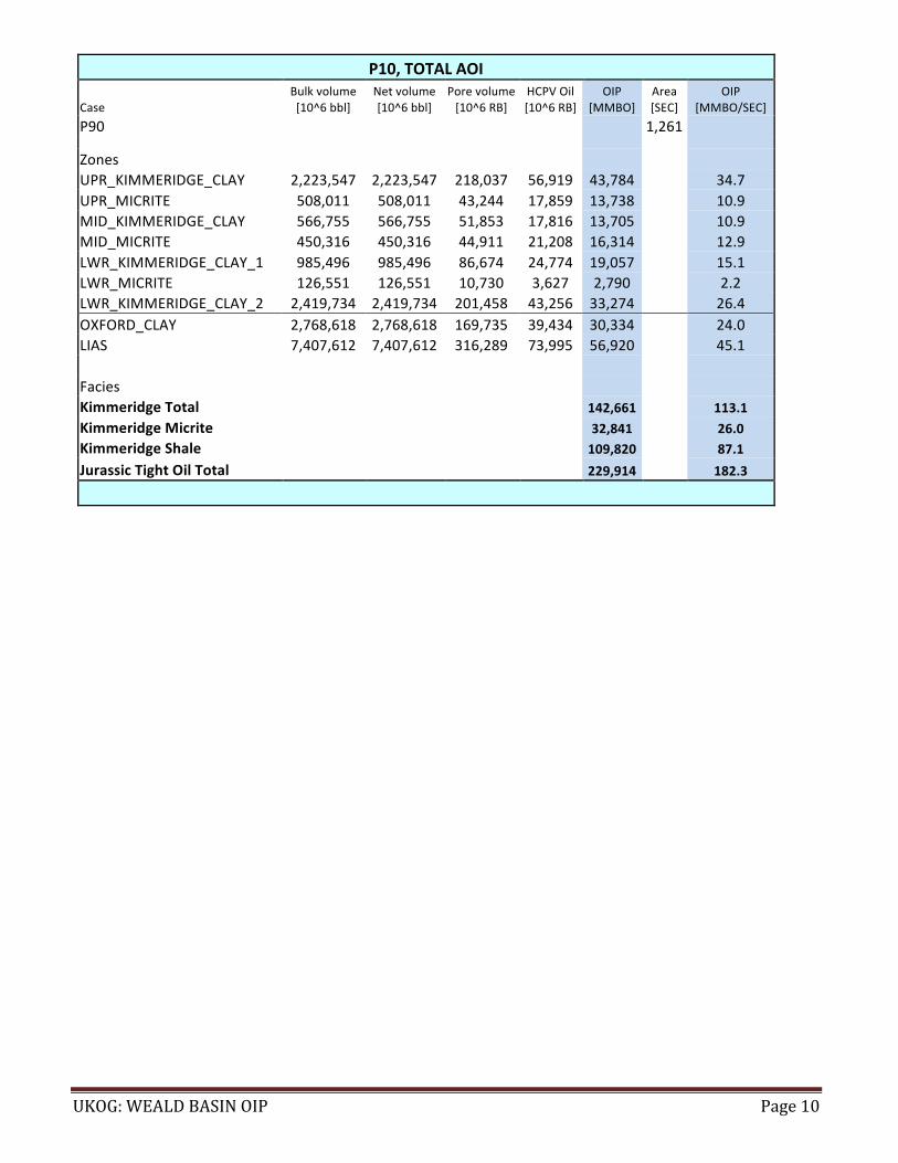
P10,*TOTAL*AOI*
Case!Bulk!volume![10^6!bbl]!
Net!volume![10^6!bbl]!
Pore!volume![10^6!RB]!
HCPV!Oil![10^6!RB]!
OIP![MMBO]!
Area![SEC]!
OIP![MMBO/SEC]!
P90!! ! ! !
!! 1,261! !!
! ! ! ! !!!
!!!
Zones!! ! ! !
!!!
!!UPR_KIMMERIDGE_CLAY! 2,223,547! 2,223,547! 218,037! 56,919! 43,784!
!34.7!
UPR_MICRITE! 508,011! 508,011! 43,244! 17,859! 13,738!!
10.9!MID_KIMMERIDGE_CLAY! 566,755! 566,755! 51,853! 17,816! 13,705!
!10.9!
MID_MICRITE! 450,316! 450,316! 44,911! 21,208! 16,314!!
12.9!LWR_KIMMERIDGE_CLAY_1! 985,496! 985,496! 86,674! 24,774! 19,057!
!15.1!
LWR_MICRITE! 126,551! 126,551! 10,730! 3,627! 2,790!!
2.2!LWR_KIMMERIDGE_CLAY_2! 2,419,734! 2,419,734! 201,458! 43,256! 33,274! !! 26.4!OXFORD_CLAY! 2,768,618! 2,768,618! 169,735! 39,434! 30,334!
!24.0!
LIAS! 7,407,612! 7,407,612! 316,289! 73,995! 56,920!!
45.1!
! ! ! ! !!!
!!!
Facies!! ! ! !
!!!
!!Kimmeridge*Total*
! ! ! !142,661*
!113.1*
Kimmeridge*Micrite*! ! ! !
32,841*!
26.0*Kimmeridge*Shale*
! ! ! !109,820*
!87.1*
Jurassic*Tight*Oil*Total*! ! ! !
229,914*!
182.3*
* *****************************

UKOG:!WEALD!BASIN!OIP! Page!11!
Table*8*b*UKOG’s*8*Licences,*151*Square*Miles*
P90,*UKOG*LICENCE*AREA*ONLY*
Case!Bulk!volume![10^6!bbl]!
Net!volume![10^6!bbl]!
Pore!volume![10^6!RB]!
HCPV!Oil![10^6!RB]!
OIP![MMBO]!
Area![SEC]!
OIP![MMBO/SEC]!
P90!! ! ! !
!! 151! !!
! ! ! ! !!!
!!!
Zones!! ! ! !
!!!
!!UPR_KIMMERIDGE_CLAY! 210,793! 210,793! 16,217! 2,881! 2,216!
!14.7!
UPR_MICRITE! 58,245! 58,245! 3,200! 584! 449!!
3.0!MID_KIMMERIDGE_CLAY! 63,947! 63,947! 4,423! 674! 519!
!3.4!
MID_MICRITE! 50,369! 50,369! 2,987! 658! 506!!
3.4!LWR_KIMMERIDGE_CLAY_1! 123,542! 123,542! 8,257! 763! 587!
!3.9!
LWR_MICRITE! 18,134! 18,134! 1,256! 189! 145!!
1.0!LWR_KIMMERIDGE_CLAY_2! 289,148! 289,148! 16,872! 870! 670! !! 4.4!OXFORD_CLAY! 319,105! 319,105! 14,518! 1,861! 1,431!
!9.5!
LIAS! 965,569! 965,569! 21,937! 2,017! 1,552!!
10.3!
! ! ! ! ! ! ! !Facies!! ! ! ! ! ! !Kimmeridge*Total*! ! ! !
5,091*!
33.7*Kimmeridge*Micrite*
! ! ! !1,101*
!7.3*
Kimmeridge*Shale*! ! ! !
3,991*!
26.4*Jurassic*Tight*Oil*Total*
! ! ! !8,074*
!53.5*
**P50,*UKOG*LICENCE*AREA*ONLY*
Case!Bulk!volume![10^6!bbl]!
Net!volume![10^6!bbl]!
Pore!volume![10^6!RB]!
HCPV!Oil![10^6!RB]!
OIP![MMBO]!
Area![SEC]!
OIP![MMBO/SEC]!
P90!! ! ! !
!! 151! !!
! ! ! ! !!!
!!!
Zones!! ! ! !
!!!
!!UPR_KIMMERIDGE_CLAY! 210,793! 210,793! 18,848! 4,711! 3,625!
!24.0!
UPR_MICRITE! 58,245! 58,245! 3,923! 1,097! 844!!
5.6!MID_KIMMERIDGE_CLAY! 63,947! 63,947! 5,274! 1,325! 1,019!
!6.8!
MID_MICRITE! 50,369! 50,369! 3,923! 1,272! 978!!
6.5!LWR_KIMMERIDGE_CLAY_1! 123,542! 123,542! 9,614! 1,783! 1,372!
!9.1!
LWR_MICRITE! 18,134! 18,134! 1,453! 358! 276!!
1.8!LWR_KIMMERIDGE_CLAY_2! 289,148! 289,148! 20,411! 2,389! 1,838! !! 12.2!OXFORD_CLAY! 319,105! 319,105! 17,533! 3,046! 2,343!
!15.5!
LIAS! 965,569! 965,569! 30,994! 4,474! 3,442!!
22.8!
! ! ! ! ! ! ! !Facies!! ! ! ! ! ! !Kimmeridge*Total*! ! ! !
9,952*!
65.9*Kimmeridge*Micrite*
! ! ! !2,098*
!13.9*
Kimmeridge*Shale*! ! ! !
7,854*!
52.0*Jurassic*Tight*Oil*Total*
! ! ! !15,736*
!104.2*
$$$$
UKOG:!WEALD!BASIN!OIP! Page!12!
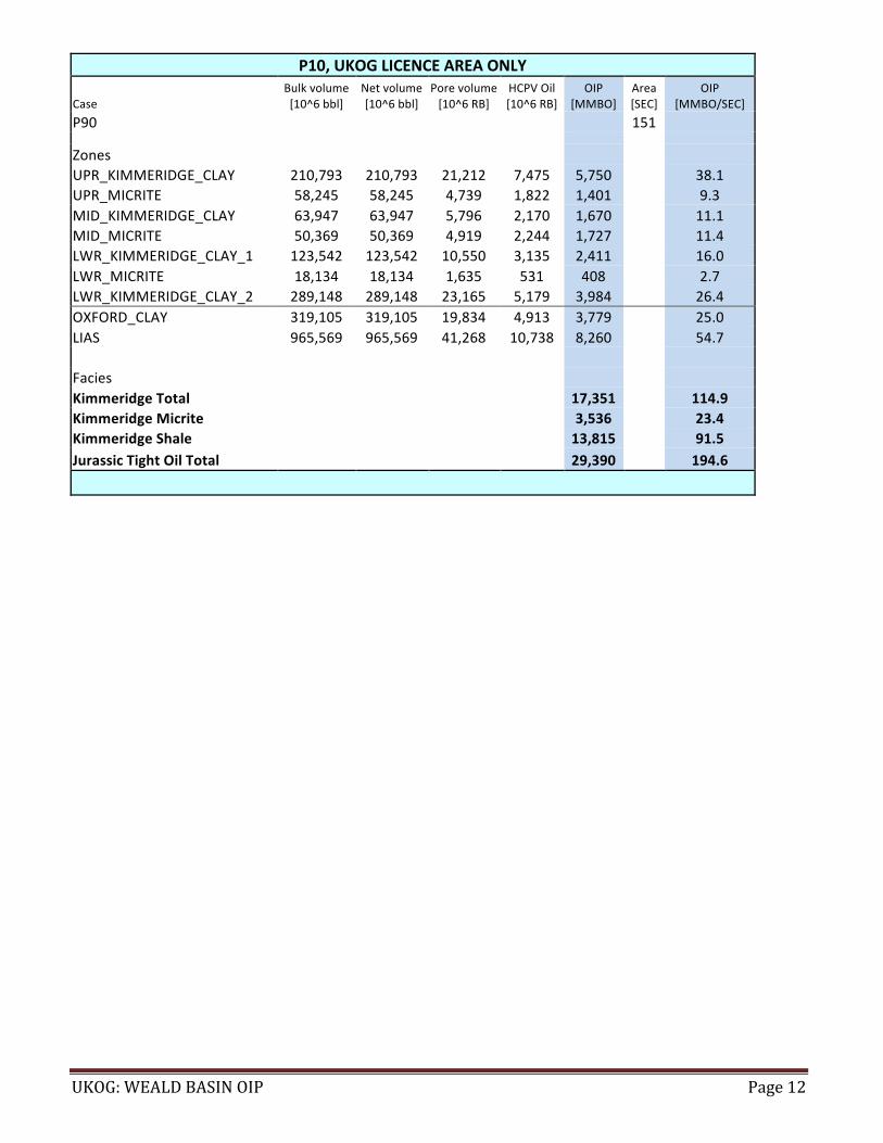
P10,*UKOG*LICENCE*AREA*ONLY*
Case!Bulk!volume![10^6!bbl]!
Net!volume![10^6!bbl]!
Pore!volume![10^6!RB]!
HCPV!Oil![10^6!RB]!
OIP![MMBO]!
Area![SEC]!
OIP![MMBO/SEC]!
P90!! ! ! !
!! 151! !!
! ! ! ! !!!
!!!
Zones!! ! ! !
!!!
!!UPR_KIMMERIDGE_CLAY! 210,793! 210,793! 21,212! 7,475! 5,750!
!38.1!
UPR_MICRITE! 58,245! 58,245! 4,739! 1,822! 1,401!!
9.3!MID_KIMMERIDGE_CLAY! 63,947! 63,947! 5,796! 2,170! 1,670!
!11.1!
MID_MICRITE! 50,369! 50,369! 4,919! 2,244! 1,727!!
11.4!LWR_KIMMERIDGE_CLAY_1! 123,542! 123,542! 10,550! 3,135! 2,411!
!16.0!
LWR_MICRITE! 18,134! 18,134! 1,635! 531! 408!!
2.7!LWR_KIMMERIDGE_CLAY_2! 289,148! 289,148! 23,165! 5,179! 3,984! !! 26.4!OXFORD_CLAY! 319,105! 319,105! 19,834! 4,913! 3,779!
!25.0!
LIAS! 965,569! 965,569! 41,268! 10,738! 8,260!!
54.7!
! ! ! ! !!!
!!!
Facies!! ! ! !
!!!
!!Kimmeridge*Total*
! ! ! !17,351*
!114.9*
Kimmeridge*Micrite*! ! ! !
3,536*!
23.4*Kimmeridge*Shale*
! ! ! !13,815*
!91.5*
Jurassic*Tight*Oil*Total*! ! ! !
29,390*!
194.6*
*!!!!!**


