Embed Size (px)
DESCRIPTION
Introduction of new electronic systems for aviation. Thor Breien, Dr. Ing Park Air Systems AS Presented by Linda Lavik. Subjects to be discussed. Navigation Systems in use for air traffic Why need for new systems Factors against transition from ground based to satellite based systems - PowerPoint PPT Presentation
Citation preview

1
Introduction of new electronic systems for aviation
Thor Breien, Dr. Ing
Park Air Systems AS
Presented by
Linda Lavik

2
Subjects to be discussed
• Navigation Systems in use for air traffic• Why need for new systems• Factors against transition from ground
based to satellite based systems• The Authorities, ATC / airport operators,
system suppliers, and airlines roles in the implementation process
• Experiences from SCAT-I

3
E-navigation in aviation
All professional air navigation is based on electronic systems due to the visibility limitations
IFR corresponds to E-navigation for maritime– IFR: Instrument Flight Rules– VFR: Visual Flight Rules

4
Navigation Systems in useHistory of air navigation
• Aviation started in 1903
• From 1919 bonfires and artificial lights, in addition to landmarks and maps, were used to help pilots find their way
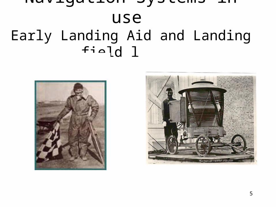
5
Navigation Systems in use Early Landing Aid and Landing field light

6
Navigation Systems in use History of air radio navigation
• 1920’s: Started use of radio navigation aids (NAVAIDS)
• In 1947 ICAO was founded as a specialized aviation UN agency and NAVAIDS international standardized. Several systems were then taken in use:
– CONSOL -DME (distance)
– LORAN -ILS (landing)
– VOR (bearing) -NDB (bearing/position)

7
Navigation Systems in use Typical today's Navigation and
Landing aids

8
Why need for new NAVAIDS?• Technology evolution
– The availability of GPS and extended use of computers in flight management systems
• Congestions in airspace– Need to increase capacity by moving from today's route network to Free
Flight navigation (Single European Sky)
• Cost reductions– Need for more cost-effective use of aircraft by shorter stopovers and less
fuel consumption– Lower Navigation fees; reduction of redundant NAVAIDS
• Increased safety– Introduction of NAVAIDS for more areas and airports will increase safety
and potential for fewer accidents

9
Factors against transition from ground based to satellite based systems
• For most of the users, no operational need for transition to a new system
• Large cost for re-certification
• Transition period with costly overlapping systems
• No incentives from ANSP / authorities

10
Why new NAVAIDS? Potential cost savings and
environmental benefits with GPS-based systems
Example Curved Approach withContinuous Descent
© 2002 The MITRE Corporation. All RightsReserved.

11
Why not just use satellite systems...
..and switch off the expensive ground infrastructure??
There are several obstacles:
• All aircraft must have installed new avionics
• International consensus on the transition required
• Political and legal aspects to be clarified
• Satellite systems must have proved their performance

12
Political and legal aspects to be clarified
• Who is responsible for any accidents?
• Who controls the signal availability?– Need for more systems
than GPS
• Reduced accessibility, who takes the delay / cancellation bill?

13
International coordination for introduction of new systems
• National and international Radio Navigation Plans are policy documents for the future use of existing and new navigation aids
• All plans agree on the main items:– Navigation and landing will be based on a mixture of
ground and satellite systems– Evolutionary introduction of satellite systems – Some ground based systems will be gradually
withdrawn– Maintain complementary ground systems until satellite
systems have received full acceptance

14
Who participate in the the NAVAIDS transition process?
• Authorities
• ATC / airport operators (Air Navigation Service Providers)
• System suppliers
• Airlines

15
The Authorities role
• ICAO (parallel to IMO) – establish the international agreed standards and set the
protection dates
• EUROCONTROL– develops, coordinates and plans for implementation of pan-
European air traffic management strategies
• Civil Aviation Authority– Establish national regulations– Issue certificates to put new systems into operations– Inspections of service providers, industry and airlines
according to JAA/EU regulations

16
The Air Navigation Service Providers’ role
• Clarify service needs based on input from airlines
• Define system requirements
• Collect/produce documentation for approval
• Acquire and put into operations
• Maintain the systems

17
The Airlines’ role
• Identify the needs for more cost-effective / safer navigation
• Define the avionics concept
• Collect/Produce documentation for certification
• Install the avionics in new aircraft, retrofit for existing aircraft

18
The system suppliers’ role
• Specify the design methodology, the system equipment functionality and performance
• Produce product documentation and safety assessments according to the CAA regulations
• Design and manufacture the system equipment

19
Certification of a first generation satellite-based landing system
• SCAT-I developed in accordance with USA specifications due to no international standard
• Certification process included approval of safety-critical software with very stringent QA-requirements
• Certification completed

20
SCAT-I Concept
-D ifferential corrections-Satellite health-FAS Data
GPS Data
GPS DataGPS Data
Monitor Data
21
Challenges for a system frontier
• System Requirements changing during the project due to better knowledge of GPS-weaknesses
• First time an approach is based on flying on information from a datalink and not a ”radiation beam”

22
Challenges
• Approval authorities not used to software-based NAVAIDS– Very much focus on integrity aspects
• No other companies in Norway to consult in such stringent SW-process
• Depending on avionics supplier’s equipment; completion of the common certification got to a halt due to partner’s financial problems

23
Status and outcome of the Park Air Systems’ development
• SCAT-I ground station certification completed in 2004, avionics in 2007
• Established and successfully implemented a development process for safety-critical software and products
• Foundation for further development within satellite navigation systems and other safety-critical products

24
The future for air navigation systems
• Based on more than one satellite system (e.g. GPS and Galileo)
• Some ground based NAVAIDS will remain for backup / supplement
• Ground systems will still handle the most safety-critical landings