Embed Size (px)
Citation preview
1
INTRODUCTION This catalog presents the archived documentation files for the datasets currently in the
Konza Prairie LTER site database. These datasets are affiliated with LTER scientists associated with the Konza Prairie LTER research program from 1981 to 1992. The purpose of this catalog is to assist scientists in the analysis and synthesis of this database. In addition to this catalog, a detailed methods manual documents the procedures used in collecting these data sets.
The design of the current Konza Prairie LTER database is straightforward. All data sets are in ASCII format (with exception of GIS coverages; See GIS01). The entire database is available at: http://www.konza.ksu.edu. The database is divided into subgroups. The subgroups correspond to the research groups that have developed on Konza or represents the data set. They are: Abiotic, Belowground, Consumer, Nutrient, Organic, Other, and Woody. The first letter of the data set code indicates which subgroup the file is in. The extension of the file name represents the year of the data set. For example the data set associated with prairie precipitation for 1986 (data set code APT01), is found in the subgroup abiotic under the file name of apt011.86. Data sets that do not conform to this naming procedure are listed in the abstract section of their corresponding data set code description. For the most part, these data sets involve data that comes from other sources than LTER investigators (e.g. USGS flow data or NADP). The subgroup woody contains the files of the dataset code PWV01.The subgroup Other is reserved for datasets that do not conform to the naming procedures (for now, datasets from the water supplementation experiment (WAT01) are here). To have consistent format of LTER data files, most LTER data sets have the first 16 columns of each line organized as: Variable Name Columns Format Units 1. Datacode 1-5 A5 2. Rectype 6 I1 3. Year 7-8 I2 4. Month 9-10 I2 5. Day 11-12 I2 6. Watershed 13-16 A4 Thus, each line has the data set code associated with it. Although, this was setup in the “days of computer cards” and it was important to have the data set code on each card, it is now useful to have this information in case of hardware failures (disk crashes, bad tapes, etc.) All quality control checks are managed by the principal investigator(s) associated with a data set. System backups are executed on a nightly basis on DAT 24 tape cartridges and twice a year on compact disks. Data requests for data not available online simply require the following information:
1) Formal written request and a statement of intended use. 2) Approval of the investigator and/or the Konza Prairie LTER Principal Investigator. 3) Request must be filed with the Konza Prairie LTER information manager. 4) Release of data (following approval) should include a cover letter specifying that: The
data are released for your use only and for the purposes outlined in your request. 5) Manuscripts using the data are to be provided to the Principal Investigator, LTER, Division
of Biology, Ackert Hall, Kansas State University, Manhattan, KS 66506 so that he/she may notify the appropriate investigators.
6) Publication of these data are allowed by the expressed permission of Konza Prairie LTER investigators named, who have primary responsibility for the data sets.

2
7) Acknowledgment should be made to recognize the contribution of data by Konza Prairie LTER. In addition, the format shown below is also to be included with the letter. Citation of a data set should use the following format: "Data from the Konza Prairie Research Natural Area were collected as part of the Konza Prairie LTER program (NSF grants DEB-8012166 and BSR- 8514327, BSR-9011662), Division of Biology, Kansas State University, Manhattan, KS. Data and supporting documentation are stored (Data Set Code(s)=_____) in the Konza Prairie Research Natural Area LTER Data Bank." Additionally, specific investigators might be cited for their contributions to the paper.
SITE DESCRIPTION CLIMATE SYNOPSIS: Temperate mid-continental climate. Yearly mean temperature is 13C with a range of extremes from 6 to 19C. The January mean temperature is -3²C (range -9 to 3C) and the July mean is 27C (range 20 to 33C). Annual precipitation is 835 mm of which about 75% occurs in the growing season. Mean snowfall for January is 150 mm with an annual total of 521 mm. Mean annual windspeed is 5 meters per second from the south. NARRATIVE: Tallgrass or bluestem prairie is one of the major ecosystem types of the conterminous United States (exceeded in area only by eastern deciduous forest). Undisturbed examples of tallgrass prairie are rare because this ecosystem type has been extensively converted to agroecosystems. Konza Prairie is representative of the Flints Hills, a dissected upland with hard chert- and flint-bearing limestone layers. The ridges are usually flat with shallow, rocky soils, whereas the larger and wider valleys have deep permeable soils. The steep-sided hills are characterized by exposed Permian limestone and shale strata that prevented cultivation. When acquired in the 1970's, the majority of Konza Prairie was dominated by native prairie species, especially big bluestem, indian grass, little bluestem, and switchgrass. Lowland areas with deep soils now have patches of these and other tallgrasses that grow to 2 to 3 m by late summer. Gallery forests on lower Kings Creek are dominated by bur and chinquapin oaks with green ash, hackberry, elm, and black walnut often common. The KSU herbarium contains more than 450 species of vascular plants collected from Konza Prairie. Woody plants have been mapped according to species and size on some portions of the site. Species lists have also been developed for a number of animal groups including birds, mammals, reptiles, amphibians, and aquatic invertebrates. Konza Prairie is managed to provide an array of burning and grazing (especially bison) treatments to facilitate research to evaluate the effects of fire and grazing on plant composition, primary production, consumer density and diversity, nutrient dynamics, soil chemistry, and hydrology (Fig. 1). This natural prairie also serves as a reference site from comparison to manipulated agricultural systems. Fire, started by both lightning and aboriginal man, influenced patterns and processes in the tallgrass prairie. To understand these effects, a series of spring burning treatments (primarily areas burned at 1,2,4,10, and 20 year intervals) are maintained on watershed units. These experimental burns are conducted in April before the dominant warm-season grasses begin active growth. Treatment boundaries follow watershed divides to facilitate analysis of hydrologic and nutrient responses to fire and frequency of fire. An extensive soil water/ground water monitoring system has been installed by the USGS on one of these watersheds. Bison were introduced into a fenced area of nearly 500 ha encompassing several different burn treatments in 1987. The area affected by bison will be enlarged to 1100 ha in 1991. Bison, free-ranging within the fenced area, are able to choose between burned and unburned prairie and

3
among sites representing an array of topographic/physiographic conditions. Cattle grazing still occurs sporadically on parts of Konza Prairie but not on the primary LTER research watersheds.

4
Table of Contents Table of Contents....................................................................................................................... 4
Abiotic Data .................................................................................................................................. 6 Data Set Code--AGW01 ............................................................................................................ 6 Data Set Code--AGW02 ............................................................................................................ 8 Data Set Code--ANA01 ............................................................................................................. 9 Data Set Code--APT01 ............................................................................................................ 13 Data Set Code--APT02 ............................................................................................................ 15 Data Set Code--ASD01............................................................................................................ 16 Data Set Code--ASD02,ASD04, ASD05,ASD06.................................................................... 17 Data Set Code--ASM01 ........................................................................................................... 19 Data Set Code--ASR01 ............................................................................................................ 20 Data Set Code--AST01 ............................................................................................................ 22 Data Set Code--AWE01........................................................................................................... 24 Data Set Code--AWT01........................................................................................................... 26 Data Set Code--AWT02........................................................................................................... 27
Belowground Data....................................................................................................................... 28 Data Set Code--BLGPVC ........................................................................................................ 28 Data Set Code--BMS01 ........................................................................................................... 29 Data Set Code--BNS01 ............................................................................................................ 31
Consumer Data............................................................................................................................ 32 Data Set Code--CAA01 ........................................................................................................... 32 Data Set Code--CAA02 ........................................................................................................... 33 Data Set Code--CAA03 ........................................................................................................... 35 Data Set Code--CBC01............................................................................................................ 38 Data Set Code--CBD01............................................................................................................ 44 Data Set Code--CBN01............................................................................................................ 45 Data Set Code--CBP01 ............................................................................................................ 46 Data Set Code--CGP01 ............................................................................................................ 48 Data Set Code--CGR01............................................................................................................ 49 Data Set Code--CGR02............................................................................................................ 53 Data Set Code--CGR03............................................................................................................ 56 Data Set Code--CGR04............................................................................................................ 59 Data Set Code--CGR05............................................................................................................ 60 Data Set Code--CMY01........................................................................................................... 62 Data Set Code--CPC01 ............................................................................................................ 64 Data Set Code--CPC02 ............................................................................................................ 65 Data Set Code--CSA01 ............................................................................................................ 66 Data Set Code--CSA02 ............................................................................................................ 68 Data Set Code--CSM04 ........................................................................................................... 70 Data Set Code--CSM07 ........................................................................................................... 72 Data Set Code--CSM10 ........................................................................................................... 73
GIS Data ...................................................................................................................................... 74 Data Set Code--GIS01 ............................................................................................................. 74
Nutrient Data ............................................................................................................................... 75

5
Data Set Code--NBC01............................................................................................................ 75 Data Set Code--NBS01 ............................................................................................................ 77 Data Set Code--NPL01 ............................................................................................................ 78 Data Set Code--NSC01 ............................................................................................................ 80 Data Set Code--NSW01........................................................................................................... 82 Data Set Code--NTF01 ............................................................................................................ 83 Data Set Code--NWC01 .......................................................................................................... 85
Producer Data.............................................................................................................................. 88 Data Set Code--PAB01 ............................................................................................................ 88 Data Set Code--PAB03 ............................................................................................................ 90 Data Set Code--PAB04 ............................................................................................................ 91 Data Set Code--PBB01 ............................................................................................................ 92 Data Set Code--PBB02 ............................................................................................................ 93 Data Set Code--PBB03 ............................................................................................................ 94 Data Set Code--PEB01 ............................................................................................................ 95 Data Set Code--PFS01 ............................................................................................................. 96 Data Set Code--PGL01 ............................................................................................................ 97 Data Set Code--PPH01 ............................................................................................................ 98 Data Set Code--PRE02 .......................................................................................................... 100 Data Set Code--PRW01 ......................................................................................................... 102 Data Set Code--PTN01 .......................................................................................................... 103 Data Set Code--PVC01 .......................................................................................................... 105 Data Set Code--PVC02 .......................................................................................................... 116 Data Set Code--PWV01......................................................................................................... 128
Other Data ................................................................................................................................. 130 Data Set Code--KPL01 .......................................................................................................... 130 Data Set Code--KFH01.......................................................................................................... 131 Data Set Code--KIC01 ........................................................................................................... 132 Data Set Code--OGD01 ......................................................................................................... 133 Data Set Code--OMB01 (preliminary!) ................................................................................. 135 Data Set Code--OPD01.......................................................................................................... 137 Data Set Code--PHOTO ........................................................................................................ 139 Data Set Code--WAT01......................................................................................................... 140

6
Abiotic Data
Data Set Code--AGW01 Title of Data Set--Belowground Water Chemistry from Wells on N04D Abstract: In 1988 and 1990, the U.S. Geological Survey, Lawrence, KS, drilled 35 wells at 16 sites within the N04D watershed at the Konza Prairie Research Natural Area. The wells range in depth from about 2 to 13 meters, and are nested to include wells completed in alluvium/colluvium near the N04D drainage and in two Permian-aged limestone’s. These sites comprise four transects running approximately east-west across the drainage, and occupy the lower 10% of the surface area of the watershed. The geology of the area is characterized by patchy, near-stream alluvium/colluvium which overlies bedrock, composed of thin (1-2 meter) limestones alternating with thicker (2-4 meter) shales. The limestones are fractured, and records of water levels in the wells show that in some parts of the watershed water levels are nearly constant, while in others they respond noticeably to precipitation events. Beginning in 1991, water samples for inorganic chemical analysis have been collected every four to six weeks by bailing wells to remove 1-2 well volumes. A bailed sample is then filtered through 0.45µ membrane filters by gravity feed. One 50-mL aliquot is reserved for alkalinity determination by titration with 0.02 N H2SO4. One 250-mL LDPE bottle is filled with 250 mL of sample and 5 mL of concentrated HNO3 for cation analysis by atomic absorption spectrophotometry (Na, K, Ca, Mg). One 250-mL LDPE bottle is filled to the brim for anion analysis by ion chromatography (Cl, SO4, NO3). The latter two samples are stored on ice and later in a refrigerator. Anion determination is completed within 1 to 3 days of collection. Keywords that describe the data set: Subsurface water chemistry, low-temperature aqueous geochemistry, inorganic ground-water chemistry, chemical hydrogeology. Date data commenced: 01/19/91 Date data terminated: / / Principle Investigator: G. L. Macpherson RECORD TYPE 1 Data Format Specification Variable Name Columns Format Units 1. Datacode 1-5 A5 2. Rectype 6 I1 3. Year 7-8 I2 4. Month 9-10 I2 5. Day 11-12 I2 6. Watershed N04D (always) 13-16 A4 7. Well_loc Well location 18-24 A7 8. N03 Concentration of N03 26-31 F5.2 mg/l

7
9. S04 Concentration of S04 33-39 F5.2 mg/l 10. Cl Concentration of Cl 41-44 F4.1 mg/l 11. Titralk Titration alkalinity (as HC03) 46-49 I4 mg/l Codes used: Well_loc Name Code Value ow observation well 1-4 Transects (1-4) , the lowest number in nearest the concrete weir 1-6 Number unique to the well site (1 is nearest the steam;3 is farthest from the stream on the east or northeast side. Well site number 4-6 are progressively further away from the stream on the west or southwest side of the stream Alpha chara. Eis=Eiss Limestone Eis1=Lower Eiss Limestone Eis2=Upper Eiss Limestone Mor=Morril Limestone Al=Alluvium-colluvium. Note:Files are NOT separated by year.

8
Data Set Code--AGW02 Title of Data Set—Depth and Nutrient Content of Groundwater from Wells near Kings Creek Abstract: Wells were drilled in two sites on Konza Prairie Research Natural Area in April, 1993 approximately 100 m from Kings Creek. The two sites are located in a grassland and an agricultural area. The grassland site is an old field that was planted with brome sometime prior to 1976. It has not been grazed for 15 years and is burned in late spring every 1-2 years. The agricultural site is currently under cultivation and historically has been cultivated from sometime between 1939 and 1950 to the present. It is approximately 1 km downstream in an area geologically similar to the old field. The soil at both sites is mapped as Reading silt loam (fine, mixed, mesic Typic Arguidolls). Samples are taken monthly by PVC bailers following removal of 1-2 well volumes. Samples are analyzed with same methods as stream water chemistry. Keywords that describe the data set: Organic and inorganic N & P content of groundwater, dissolved organic carbon Date data commenced: 5/17/96 Date data terminated: ongoing Principle Investigator: Walter Dodds RECORD TYPE 1 Data Format Specification Variable Name Columns Format Units 1. Datacode 1-5 A5 2. Rectype 6 I1 3. Year 7-8 I2 4. Month 9-10 I2 5. Day 11-12 I2 6. Watershed 13-16 A4 7. Well Number A1-A7, P1-P7 18-24 A7 8. Well Depth F4.1 ft from well head 9. Depth to Water F4.1 ft from well head 10. N03 Nitrate-nitrogen F6.1 ug/l 11 NH4 Ammonium-nitrogen F6.1 ug/l 12. P04 Orthophosphate F5.1 ug/l 13. TN Total N F7.1 ug/l 14. TP Total P F5.1 ug/l 15. DOC Dissolved Organic Carbon F6.3 mg/l 16. Comments

9
Data Set Code--ANA01 Title of Data Set--National Atmospheric Deposition Program Abstract: Data set contains results of chemical analysis of wetfall on Konza Prairie. Analysis done by the Central Analytical Lab (CAL), Champaign, IL as part of the National Atmospheric Deposition Program (NADP). Data is coordinated by the NADP/NTN Coordination Office at Fort Collins, CO. Data products from that office include: Annual Data Summaries, Semiannual Data Reports, Annual and Seasonal Averages, Monthly Averages, and Weekly data. Konza Prairie LTER maintains the weekly data in electronic form (file name NADP in subdirectory nutrient) while other summaries are available via hard copy. Keywords: wetfall, precipitation, precipitation chemistry, NADP, Ca, Mg, K, Na, NH4, NO3, Cl, SO4, PO4, pH, conductance Date data commenced: 08/17/82 Date data terminated: / / Principle Investigator: Alan K. Knapp Data Format Specification for NADP/NTN Weekly Data File {The following information comes from NADP/NTN office at Fort Collins, CO.} I. Headings First non-blank line: Program Name NATIONAL ATMOSPERHIC DEPOSTION PROGRAM/ NATIONAL TRENDS NETWORK Columns Format Second non-blank line: Date printed (yrmoda) 1-4 i6 Third and Fourth non-blank lines: Columns headings II. DATA (One data line for each week reported) CAL Code 1-4 c4 Date On (yrmoda) 6-11 i6 Date Off (yrmoda) 13-18 i6 Summ. Per yrmo 20-23 i4 Summ. Per. yrq 25-27 i3 Sample No. 30-34 c5 Limit of Detection symbol (<) for CA 36 c1 Ca concentration 37-42 f6.2 Limit of Detection symbol (<) for Mg 44 c1 Mg concentration 45-51 f7.3 Limit of Detection symbol (<) for K 53 cl K concentration 54-60 f7.3 Limit of Detection symbol (<) for Na 62 c1 Na concentration 63-69 f7.3

10
Limit of Detection symbol (<) for NH4 71 c1 NH4 concentration 72-77 f6.2 Limit of Detection symbol (<) for NO3 79 c1
NO3 concentration 80-85 f6.2 Limit of Detection symbol (<) for Cl 87 c1 CI concentration 88-93 f6.2 Limit of Detection symbol (<) for SO4 95 c1 SO4 concentration 96-101 f6.2 Limit of Detection symbol (<) for PO4 103 c1 PO4 concentration 103 f7.3 Lab pH 114-117 f4.2 Field pH 120-123 f4.2 Lab conductance 125-130 f6.1 Field conductance 131-136 f6.1 Sample volume 140-146 f7.1 Precipitation from rain gauge 148-154 f7.2 Sub ppt 157-164 f8.3 Lab type 168-169 c2 Valcode 174-175 c2 Invalcode 180-185 c6 Notes 189-197 c9 DESCRIPTION OF PARAMETERS INCLUDED IN NADP/NTN WEEKLY DATA FILES Cal code Alpha-numeric site identification code, first two characters of which are the abbreviation of the state in which the site is located (Konza Prairie Cal code is KS31) Dates On - Date sample bucket was installed on the collector, reported in Greenwich mean time (GMT), modayr. Off - Data sample bucket was removed from the collector, reported in Greenwich mean time (GMT), modayr. Summ. Per. yrmo - Month in which the sample is included for the purpose of computing weighed-mean concentrations, depositions and precipitation totals given as the year followed by the month (i.e., 8809 for September, 1988) yrq - Quarter in which the sample is included for the purpose of computing weighted-mean concentrations, depositions and precipitation totals, given as the year followed by a numeral indicating the specific seasonal period ( 1=winter, Dec-Feb; 2=spring, Mar- May; 3=summer, June-Aug; 4=fall, Sep-Nov.). Sample No. Sample number assigned by the Laboratory, given as a sequence letter followed by a 4-digit numeral. Ion concentrations
Concentrations of Ca, Mg, K, Na, NH4, NO3, Cl, SO4 and PO4 reported in mg/l. Concentrations which are below the detection limit of the analysis are indicated with a “<“ preceding the value;the value reported is the actual limit of the detection. (In calculating weighted-mean concentrations and depositions NTN substitutes one-half the reported detection limit for concentrations below the limit of detection.)

11
pH pH reported as the negative log of hydrogen ion concentration. lab - pH of the precipitation sample as measured at CAL field - pH of the precipitation sample as measured on site (Bushnell Hall) Conductivity Conductivity reported in microsiemens/cm. lab - conductivity of the precipitation sample as measured at CAL. field - conductivity of the precipitation sample as measured on site (Bushnell Hall). Sample Volume (Svol) Volume of sample captured by the sampler bucket in milliliters. Precipitation from Rain Gauge (RG ppt) Precipitation amount as measured by the rain gauge in millimeters. Trace amounts are indicated by -7.00. Sub ppt Precipitation amount used by NADP/NTN in calculating weighted-mean concentrations, depositions and precipitation totals. In most cases, sub ppt equals the rain gauge reading. Where the rain gage reading is a trace amount, sup ppt is assigned a value of 0.127mm; in cases where the rain gauge is missing or invalid, sub ppt is calculated by converting the sample volume to its equivalent depth. (The area of the sampler bucket used for this conversion is 678.9 square centimeters.) Lab type A code indicating the condition of the sample upon arrival at CAL w - sample volume of approximately 35 mL or more wa - sample volume less than 35 mL; dilution was required t - trace amount of less than approx. 10 mL; analyses are incomplete da - dry sample qa - quality assurance sample submitted in lieu of a wet-side sample bucket for a week during which no precipitation occurred Valcode A code which indicates whether a sample is considered valid according to NADP/NTN data validations rules. In the case of a valid sample, the code indicates how the sample is used in calculations of weighted-mean concentrations, depositions and data completeness estimates. 0 - invalid sample t - valid trace sample d - valid dry collection period w - valid sample of lave type w wa - valid samples of lab type wa Only samples of w and wa are used by NADP/NTN in calculating weighted-mean concentrations. Invalcode
A series of codes assigned to samples which are considered invalid by NADP/NTN for the purp- oses of computing weighted-mean concentrations, depositions and data completeness estimates. The codes indicate the reason for invalidation.
b - bulk sample (Collector was open continuously) u - undefined sample (Collector was open for > 6 hours and less than the entire sampling period when no precipitation was occurring.
f - filed protocol departure c - contaminated sample v - inadequate volume for analysis s - short sampling interval (< 6 days)

12
e - extended sampling interval (> 8 days) l - lab error i - incomplete chemical analysis n - no sample collected p - precipitation amount unknown x - reasons other than described above Notes
Coded summary of the CAL screening codes and remarks written on the Field Observer Report Form by field personnel, CAL staff, and Coordination Office Staff.
bu - bulk sample. Sample was continuously exposed to both wetfall and dryfall. (Collector was open continuously.) na - Results are not yet available (predominantly dry samples). nn - Information was never reported and will never be available. ns - No chemistry data will be reported because of extreme contamination, undefined sampling protocol, leakage, loss in the mail, etc. sp - Samples was collected at a nonapproved sampling site or with nonapproval equipment.

13
Data Set Code--APT01
Title of Data Set--Prairie Precipitation Abstract:
Data set contains daily records of precipitation on 11 raingauges at 10 sites on Konza Prairie. Three sites (HQ1, 020A and 002C; SE) have 7-day clocks (one revolution per week), while the other 8 have 24-hour clocks (one revolution per day). The Konza headquarters weather station has one of each type and both are operated year-round. The remaining raingauges are operated from April 1 to November 1. Precipitation amounts are recorded in mm. Data from all raingauges are recorded on daily bases (record type 1)while raingauges with one day clocks also have data recorded on 15 minute increment during storm events (record type 4). Keywords that describe data set: Precipitation Date data commenced:06/01/82 Date data terminated: / / Principle Investigator: John M. Briggs Comments: Headquarters raingauge 1 in operation continuously since June 1982; prairie raingauges at 004B, 020B and 002C (south end) in operation since April 1983. Raingauges at N01B, N04D (flume), N04D (prairie chicken blind) and 020A in operation since 02 April 1986. Raingauge HQ2 has been in operation since 20 August 1986. All raingauges except gauges at Headquarters are to be operated from April 1 to October 31 each year. RECORD TYPE 1 Data Format Specification Variable Description Columns Format Units 1. Datacode 1-5 A5 2. Rectype 6 I1 3. Year 7-8 I2 4. Month 9-10 I2 5. Day 11-12 I2 6. Ppthq Precip at Headquarters 14-18 F5.1 mm 7. Pptub Precip at 000B 20-24 F5.1 mm 8. Ppt4b Precip at 004B 26-30 F5.1 mm 9. Pptse Precip at 002C 32-36 F5.1 mm 10. Pptn1b Precip at N01B 38-42 F5.1 mm 11. Pptn4pc Precip at N04D (p.c. Blind) 44-48 F5.1 mm 12. Pptn4fl Precip at N04D (flume) 50-54 F5.1 mm 13. Pptk4 Precip at K04A 56-60 F5.1 mm 14. Pptua Precip at 020A 62-66 F5.1 mm 15. Pptn2b Precip at N02B 68-72 F5.1 mm 16. Ppthq2 Precip at Headquarters (2) 74-78 F5.1 mm

14
17. Comments 78-80 A2 RECORD TYPE 4 Data Format Specification Variable Name Columns Format Units 1. Datacode 1-5 A5 2. Rectype 6 I1 3. Year 7-8 I2 4. Month 9-10 I2 5. Day 11-12 I2 6. Time 14-17 A4 7. HQ2 Precip at Headquarters 19-22 F4.1 8. UB Precip at 000B 24-27 F4.1 9. 4B Precip at 004B 29-32 F4.1 10. N1B Precip at N01B 34-37 F4.1 11. N4PC Precip at N04D (p.c. blind) 39-42 F4.1 12. N4-F Precip at N04D (flume) 44-47 F4.1 13. K4 Precip at K04A 49-52 F4.1 14. N2B Precip at N02B 54-57 F4.1 15. Time Time of day in 2400 hour format 59-62 F4.1 18. Comments 64-80 A16 RECORD TYPE 5 Data Format Specification 1. Datacode 1-5 A5 2. Rectype 1-5 A1 3. Year 7-8 A2 4. Month 9-10 A2 5. Day 11-12 A2 6. Time 14-17 A4 7. N2wp Weighted precip at N02B 19-22 F4.1 8. N4wp Weighted precip at N04D 24-27 F4.1 9. N1wp Weighted precip at N01B 29-32 F4.1 10. Nuwp Weighted precip at N20B 34-37 F4.1 11. N2dt Weighted daily total at N02B 39-42 F4.1 12. N4wp Weighted daily total at N04D 44-47 F4.1 13. N1wp Weighted daily total at N01B 49-52 F4.1 14. Nuwp Weighted daily total at N20B 54-57 F4.1 15. Comment 59-80 A21

15
Data Set Code--APT02 Title of Data Set--Monthly temperature and precipitation records of Manhattan, KS Abstract:
Data set contains the monthly values of maximum, minimum and average temperatures
and monthly total precipitation for Manhattan, KS since 1985. Data are in three separate files, one for each measurement. Data comes from the Weather Data Library in the computer system office of the Cooperative Extension Service of Kansas State University, Manhattan Kansas. (211 Umberger Hall, (913) 532-6270. Keywords that describe data set: Temperature, Precipitation Date Data Commenced: 1985 Date Data terminated: Principle Investigator: John M. Briggs, Mary Knapp (Weather Data Library) Data Format Specification: The format is the same for all three files. 1. Year 2. January Value 3. February Value 4. March Value 5. April Value 6. May Value 7. June Value 8. July Value 9. August Value 10. September Value 11. October Value 12. November Value 13 Yearly average for temperature values or yearly total for precipitation values. Comments: All temperatures values are in degree Centigrade and all precipitation values are in mm. No column or format are given as the data can varied in its form from year to year. Also data files do not follow the LTER file naming procedure. Filenames (as of 01 March 1993) are: maxtemp.man--Maximum temperatures, mintemp.man--Minimum temperature, meantemp.man--Average temperatures, precip.man--Monthly precipitation.

16
Data Set Code--ASD01 Title of data set--Stream discharge in Kings creek at USGS site Abstract: The 1060 hectacre Kings creek watershed (STATION NUMBER 06879650) is a U.S. Geological survey hydrologic benchmark. (cf. Cobb, e.D. and J.E. Beisecker. 1971. USGS circular 460-d) flow is measured continuously with a bubble gage. The period of record started in March, 1979. The hydrologic regime is driven by the mid-continent climate characterized by summer thunderstorms and drought. The stream, at the gaging station, is fourth order in gallery forest. The riparian vegetation in the headwaters (1st & 2nd order) is tallgrass, or true, prairie. Flow occurred in spring and early summer in all years. Late summer, fall and winter records also include periods of no flow, the longest of these was ca. nine months. The time from base flow to peak flow for typical storm flow hydrographs is an hour or so and amplitude of ca. three meters above base flow has been recorded (Data comes from USGS office in Lawrence, Kansas; Contact person:Butch Lawcock, (913) 842-9709). Keywords that describe data set:stream, discharge, flow Date data commenced:04/01/79 Date data terminated: / / Principle Investigator: Walter K. Dodds The following are the first 10 header lines that describes the data format of the USGS file. The file name is called USGS. Actually data begins on line 11. UNITED STATES DEPARTMENT OF THE INTERIOR - GEOLOGICAL SURVEY - KANSAS 06/05/92 STATION NUMBER 06879650 KINGS C NR MANHATTAN, KS STREAM SOURCE AGENCY USGS LATITUDE 390607 LONGITUDE 0963542 DRAINAGE AREA 4.09 DATUM STATE 20 COUNTY 161 DISCHARGE, CUBIC FEET PER SECOND, WATER YEAR OCTOBER 1978 TO SEPTEMBER 1979 DAILY MEAN VALUES DAY OCT NOV DEC JAN FEB MAR APR MAY JUN JUL AUG SEP

17
Data Set Code--ASD02,ASD04, ASD05,ASD06 Title of data set--Stream discharge at the flumes on watersheds N04D, N00B, N01B, AND N02B Abstract: Discharge is measured on streams draining catchments with annual, 2-year, 4-year and 20-year burns. Measurements are taken at 5 minute intervals at a triangular throated flume. The prairie streams are 3rd-order and are intermittent. Daily and stormflow discharge records are available. Keywords that describe data set:hydrology, stream, flow, discharge, water Date data commenced:06/14/85 Date data terminated: / / Principle Investigator: Walter K. Dodds Format for file names and documentation. There are two files for each watershed for each year. One is for daily stream flow and one is for storm flow. ASD021--storm flow data for watershed N04D ASD022--daily flow data for watershed N04D ASD041--storm flow data for watershed N00B ASD042--daily flow data for watershed N00B ASD051--storm flow data for watershed N01B ASD052--daily flow data for watershed N01B ASD061--storm flow data for watershed N02B ASD062--daily flow data for watershed N02B Column format for daily flow files: datacode (1-6) date (7-12) (yymmdd) watershed (13-16) Day of year (19-22) mean discharge m3/sec (28-32) max discharge m3/sec (38-42) time of max discharge in 2400 hour format (45-48) min discharge (52-56) time of min discharge in 2400 hour format (59-62) Volume (71-74) Storm flow: datacode (1-6) date (7-12) (yymmdd) watershed (13-16) day of year (19-22) hour (2400 hour format) (25-28) discharge m3/sec (34-38)

18
stage height in centimeters (44-46)

19
Data Set Code--ASM01 Title of data set--Soil moisture Abstract:
Data set contains measurements of soil moisture (%volume) at various depths (25-200 cm) in deep soils for watersheds burned at 1 and 4 year intervals and unburned watersheds. Soil moisture measured by the neutron probe method.
Keywords that describe data set:soil moisture, neutron probe Date data commenced:05/01/83 Date data terminated: / / Principle Investigator: Alan K. Knapp RECORD TYPE 1 Data Format Specification Variable Name Columns Format Units 1. Datacode 1-5 A5 2. Rectype 6 I1 3. Year 7-8 I2 4. Month 9-10 I2 5. Day 11-12 I2 6. Watershed 13-16 A4 7. Tube # Access tube number 21 I1 8. D25 Value at 25 cm kg/m3 23-25 I3 kg/m3 9. D50 Value at 50 cm kg/m3 27-29 I3 kg/m3 10. D75 Value at 75 cm kg/m3 31-33 I3 kg/m3 11. D100 Value at 100 cm kg/m3 35-37 I3 kg/m3 12. D125 Value at 125 cm kg/m3 39-41 I3 kg/m3 13. D150 Value at 150 cm kg/m3 43-45 I3 kg/m3 14. D175 Value at 1755 cm kg/m3 47-49 I3 kg/m3 15. D200 Value at 200 cm kg/m3 51-53 I3 kg/m3 16. Comments 55-80 A26

20
Data Set Code--ASR01 Title of data set--Effects of burning on infiltration, overland flow, runoff and sediment and nutrient loss on tallgrass prairie using rainfall simulation. Abstract:
Rainfall simulation and overland flow experiments were performed on four plots at a single site on Konza from May to August, 1989. Two plots were treated with a late spring burn and two plots were left unburned. Five simulations were performed on burned plots and three simulatons on unburned plots. Each simulation consisted of a “dry run” followed 24 hours later by a “wet run”. The dry run consisted of rainfall applied at an intesity of approximately 60 mm/hour. The wet run was the same as a dry run, except when the rainfall was complete, overland flow was applied directly at the top of the plots to simulate run off coming from upslope. Measurements taken include overland flow velocity, water application rate, runoff, hydrograph, water flow depth, sediment content, nitrogen and phosphorus content and percent ground cover (See A.B. Duell, Effects of burning on infiltration, overland flow, and sediment loss on tallgrass prairie, M.S. thesis, Kansas State University, 82pp. for further details).
Keywords that describe data set:Fire, rainfall, simulation, nitrogen,phosphorus, sediments, over-land flow infiltration, runoff Date data commenced:89/06/16 Date data terminated:89/08/26 Principle Investigator: James K. Koelliker RECORD TYPE 1 Data Format Specification Variable Name Columns Format Units 1. Datacode 1-5 A5 2. Rectype 6 I1 3. Year 7-8 I2 4. Month 9-10 I2 5. Day 11-12 I2 6. Watershed 13-16 A4 7. Plot Burned or unburned 18 A1 8. Runtype Dry or wet run 20 A2 9. Realtime Time of simulation 22-26 F5.2 hours min. 10. Timesb Time since beginning of initiation of 28-30 I3 minutes rainfall 11. Rainint Rainfall intensity 32-34 I3 mm/hour 12. Cumrain Cummulative rainfall 36-38 I3 mm 13. Rorate Runoff rate 40-42 I3 mm/hour 14. Cumro Cummulative runoff 44-46 I3 mm

21
15. Turbid Turbidity of Runoff 48-49 I2 NTU 16. Tsolids Total solids in Runoff (inorganic+organic) 51-54 I3 mg/l 17. Tfsolids Total fixed solids in runoff 56-59 I4 mg/l (Inorganic solids) 18. Nitrate Nitrate-n concentrations in runoff 61-63 I3 µg/l 19. Totaln Total nitrogen concentrations in runoff 65-68 I4 µg/l 20. Totalp Total phosphorus concentrations in runoff 70-74 F5.1 µg/l 21. Comments 77-80 A3 RECORD TYPE 2--Nutrients in rainfall (well water) Data Format Specification Variable Name Columns Format Units 1. Datacode 1-5 A5 2. Rectype 6 I1 3. Year 7-8 I2 4. Month 9-10 I2 5. Day 11-12 I2 6. Watershed 13-16 A4 7. Tsolids Total solid (organic + inorganic) 19-21 I3 mg/l 8. Tfsolids Total fixed solids (Inorganic) 23-25 I3 mg/l 9. Nitrate Nitrate N concentration 28-30 I3 µg/l 10. Totaln Total Nitrogen concentration 32-35 I3 µg/l 11. Totalp Total Phosphorus concentration 37-40 F4.1 µg/l Codes used: Name Value Definition of code value Plot a burned plot b burned plot with overland flow c Unburned plot with overland flow d Unburned plot Runtype d Dry run--application of rainfall to saturate soil
w Wet run--measure runoff from rain and overland flow

22
Data Set Code--AST01 Title of data set--Long-term monitoring of soil temperature data in tallgrass prairie Abstract: Sensors monitor soil temperature at various levels. The sensors take readings in burned, unburned, and burned-clipped conditions. Raw data from a microprocessor is summarized into hourly readings and daily minimum, maximum, and mean temperatures. Keywords that describe data set:soil, soil temperature Date data commenced:04/23/87 Date data terminated: 10/01/93 Principle Investigator: John M. Briggs RECORD TYPE 1:hourly readings Data Format Specification Variable Name Columns Format Units 1. Datacode 1-5 A5 2. Rectype 6 I1 3. Year 7-8 I2 4. Month 9-10 I2 5. Day 11-12 I2 6. Watershed 13-16 A4 7. Time 18-21 I4 8. UB2 Unburned, 2cm depth 23-27 F4.2 deg C 9. UB10 Unburned, 25cm depth 29-33 F4.2 deg C 10. UB25 Unburned , 25cm depth 35-39 F4.2 deg C 11. B2 Burned, 2 cm depth 41-45 F4.2 deg C 12. B10 Burned, 10cm depth 47-51 F4.2 deg C 13. B25 Burned , 25cm depth 53-57 F4.2 deg C 14. Comments 61-80 A20 RECORD TYPE 2: Maximun daily temperatures RECORD TYPE 3: Minimun daily temperatures RECORD TYPE 2: Average daily temperatures Data Format Specification: same as for record type 1. Comments:Only data from 1987 and 1988 are complete and error free for the entire time period. In 1989, the UB25 and B25 were dropped and a burned and clipped (to simulate grazing) were added. Variable number 10 became B2CL (burned and clipped with temperatue probe at 2 cm) and variable 13 became B10CL (burned and clipped with temperature probe at 10 cm). Clipped is done at investigator descrisson and in 1989 only two clipps were done. In 1990, the plots were clipped 5th and 19th of June, 18th of July and 13 August. In 1991, the probes in the clipped plots

23
malfunctioned and no data was collected in these two treatments. In 1992, no data was collected on clipped plots.

24
Data Set Code--AWE01 Title of data set--Meteorological data Abstract: The following weather data are included in this data set: hourly -- mean temperature, mean relative humidity, mean wind speed, total precipitation total solar radiation, wind direction, max wind speed (sampled on the hour; record type 1) ; daily -- mean, maximum and minimum air temperature, relative humidity, total precipitation, total solar radiation; mean, maximum and minimum soil temperature, average wind speed (sampled at midnight; record type 2). These data are collectecd by a micrologger at headquarters on Konza Prairie. Keywords that describe data set: air temperature, soil temperature, relative humidity, windspeed, wind direction, solar radiation, precipitation, temperature, humidity Date data commenced: 04/22/82 Date data terminated: / / Principle Investigator: John M. Briggs RECORD TYPE 1 (Hourly values) Data Format Specification 1. Datacode 1-5 A5 2. Rectype 6 I1 3. Year 7-8 I2 4. Month 9-10 I2 5. Day 11-12 I2 6. Watershed 13-16 A4 7. Hour 21-24 I4 hours 8. Tair Air temperature 28-32 F6.2 deg C 9. Rhum Relative humidity 36-40 F5.2 % 10. Wspeed Wind speed 44-48 F5.3 m/s 11. Wdir Wind direction 52-56 F5.1 deg 12. Srad** Solar Radiation 60-64 F5.2 Joules/cm2 (reset - to 0) 13. Ppt Precipitation 72 I3 mm **** Caution!!! Hourly ppt. is not precise, use apt01 data instead. Ppt. removed after 1/1/00*** 14. stemp Soil Temperature at 25cm 76-80 deg C 15. Wmax Max wind speed (10 sec. execution interval)* 84-88 m/s RECORD TYPE 2 (Daily values) Data Format Specification 1. Datacode 1-5 A5 2. Rectype 6 I1 3. Year 7-8 I2
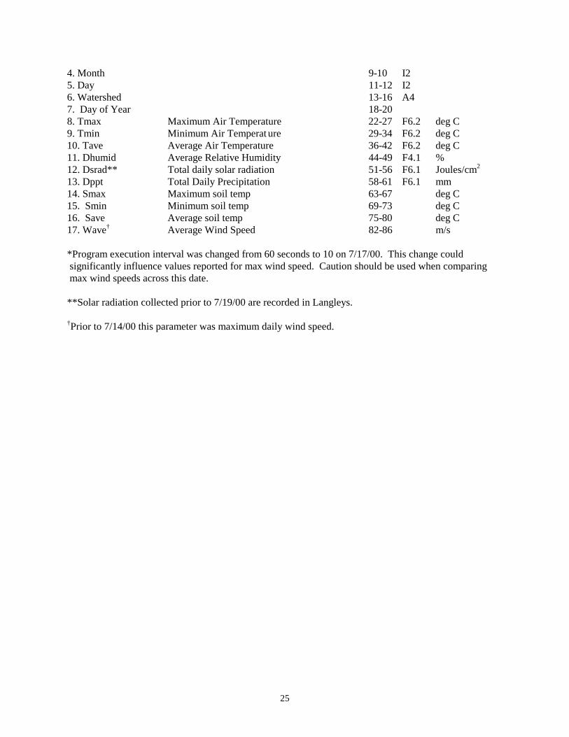
25
4. Month 9-10 I2 5. Day 11-12 I2 6. Watershed 13-16 A4 7. Day of Year 18-20 8. Tmax Maximum Air Temperature 22-27 F6.2 deg C 9. Tmin Minimum Air Temperat ure 29-34 F6.2 deg C 10. Tave Average Air Temperature 36-42 F6.2 deg C 11. Dhumid Average Relative Humidity 44-49 F4.1 % 12. Dsrad** Total daily solar radiation 51-56 F6.1 Joules/cm2
13. Dppt Total Daily Precipitation 58-61 F6.1 mm 14. Smax Maximum soil temp 63-67 deg C 15. Smin Minimum soil temp 69-73 deg C 16. Save Average soil temp 75-80 deg C 17. Wave† Average Wind Speed 82-86 m/s
*Program execution interval was changed from 60 seconds to 10 on 7/17/00. This change could significantly influence values reported for max wind speed. Caution should be used when comparing max wind speeds across this date. **Solar radiation collected prior to 7/19/00 are recorded in Langleys. †Prior to 7/14/00 this parameter was maximum daily wind speed.

26
Data Set Code--AWT01 Title of data set--Water temperature - discontinuous measurements in prairie streams Abstract:
Water temperature is measured on streams draining catchments with annual, 2-year, 4-year, and 20-year burns. Measurements of water temperature (degrees c) are made on irregular basis in each of the four streams where discharge is continuously monitored (see data set ASD02 and AWT02).
Keywords that describe data set:stream, water, temperature Date data commenced:04/24/85 Date data terminated: / / Principle Investigator: Walter K. Dodds RECORD TYPE 1 Data Format Specification 1. Datacode 1-5 A5 2. Rectype 6 I1 3. Year 7-8 I2 4. Month 9-10 I2 5. Day 11-12 I2 6. Time Central Standard Time 14-17 I4 CST 7. TempN1 Temperature at N01B flume 20-23 F4.1 deg C 8. TempN2 Temperature at N02B flume 26-29 F4.1 deg C 9. TempN4 Temperature at N04D flume 32-35 F4.1 deg C 10. TempNU Temperature at N20B flume 38-41 F4.1 deg C 11. Comments 44-80 A34

27
Data Set Code--AWT02 Title of data set--Water temperature - continuous measurements in prairie streams Abstract:
Water temperature is measured on streams draining catchments with annual, 2-year, 4-year, and 20-year burns. Hourly measurements of water temperature (degrees c) are made in each of the four streams where discharge is continuously monitored (see data set ASD02). Keywords that describe data set:stream, water, temperature Date data commenced:04/10/86 Date data terminated: / / Principle Investigator: Walter K. Dodds RECORD TYPE 1 1. Datacode 1-5 A5 2. Rectype 6 I1 3. Year 7-8 I2 4. Month 9-10 I2 5. Day 11-12 I2 6. Time Central Standard Time 14-17 I4 CST 7. TempN1 Temperature at N01B flume 20-24 F4.1 Deg C 8. TempN2 Temperature at N02B flume 27-31 F4.1 Deg C 9. TempN4 Temperature at N04D flume 34-38 F4.1 Deg C 10. TempNU Temperature at N20B flume 41-45 F4.1 Deg C 11. Comments 48-80 A33

28
Belowground Data
Data Set Code--BLGPVC Title of data set--Vegetation species composition for below ground plots Abstract: Two permanent plant composition plots were marked with conduit in each of the 64 plots. Canopy cover was recorded in a 5 m2 circular area surrounding each of the plots. Every 5 years, coverage is assessed in early June before the plots are mowed, and again in August. Date data commenced: 1989 Date data terminated: / / Principle Investigators: RECORD TYPE 1 Data Format Specification 1. Datacode 1-6 A6 2. Year 7-8 I2 3. Month 9-10 I2 4. Day 11-12 I2 5. SP Starting Plot(x) 14-15 I2 6. EP Ending Plot(y) 17-18 I2 7. Specode Species code 20-22 I3 8. Genus Abbreviation of genus 24-29 A6 9. Speci Abbreviation of species 31-35 A5 10. Vari Abbreviation of variety 37-40 A4 11. Cover Cover in plots listed previously 42-72 Codes used: Name Value Code Value Spcode 1-513 (see species list
attached to PVC02 entry)
Plot 1 0-1% Cover 2 2-5% Cover 3 5-25% Cover 4 25-50% Cover 5 50-75% Cover 6 75-95% Cover 7 95-100% Cover

29
Data Set Code--BMS01 Title of data set--Belowground plots: Mycorrhizae Spore Density Abstract:
Spore densities of 14 groups (13 species + unknown) are measured every two years on the 64 belowground plots (record type 1). Effects of burning, mowing, and n + p additions on spore densities (an index of vam infection rates). Community indices a percent root colonization (record type 2). Effects of burning, mowing, and n + p additions on mycorrhizal community composition and root colonization.
Keywords that describe data set: mycorrhizal, spores, vam, burning, mowing, nitrogen, phosphorus, belowground plots Date data commenced:06/11/87 Date data terminated: / / Principle Investigator: David C. Hartnett RECORD TYPE 1 (spore densities) 01. DATACODE 1-5 A5 02. RECTYPE 6 1 03. YEAR 8 I2 04. MONTH 9-10 I2 05. DAY 11-12 I2 06. BELO 13-16 A4 07. PLOT Belowground Plot id (1-64) 18-19 I2 08. BLOCK Super Plot (block) H A 21 A1 09. BURN Burn Treatment 23 A1 10. MOW Mow Treatment 25 A1 11. NUTRIENT Nutrient Treatment 27 A1 12. AGGREGAT # spores Glomus aggregatum 29-31 I3 13. FUSCICDA # spores Glomus fuscicdatum 33-35 I3 14. MOSSEAL # spores Glomus mosseal 37-39 I3 15. CLAROIDE # spores Glomus claroideum 41-42 I2 16. CONSTRIC # spores Glomus constrictum 44-45 I2 17. TORTUOSU # spores Glomus tortuosum 47-48 I2 18. ALBIDUM # spores Glomus albidum 50-51 I2 19. ETUNICAT # spores Glomus etunicatum 53-54 I2 20. UNIDENT # unidntfd glomus spp. 56-57 I2 21. GIGPELLU # spores Gigaspora pellucida 59-60 I2 22. GIGGIGAU # spores Gigaspora gigautea 62-63 I2 23. GIGCALOS # spores Gaspora calospira 65-66 I2 24. SCLCOROM # spores scler. corom. 68-69 I2 25. ENTOFRAP # spores entoph. freques 71-72 I2

30
Codes Used: Name Value Code Value Plot 1-64 Plot number Burn treatment U:B U=Unburn B=Burn Mow treatment U;M U=unmowed M=mowed Nutrient treatment C,N,P,B C=control, N=nitrogen P=Phosphorus B=Both RECORD TYPE 2 (community indices) 1. Datacode 1-5 A5 2. Rectype 6 A1 3. Year 7-8 I2 4. Month 9-11 I2 5. Day 12-13 I2 6. Watershed 13-16 A4 7. Plot Plot number (1-64) 18-19 I2 8. Subplot Sub plot 23 A1 9. Burn Burned treatment 25 A1 10. Mow Mow treatment 27 A1 11. Nutrient Nutrient treatment 29 A1 12. Myc. spore species richness 32-33 I2 13. Myc. Spore species eveness 35-39 F1.3 14. Myc. Spore species diversity 42-46 F1.3 15. Myc.Spore species total number 49-52 I4 16. Myc. Root Colonization (%) 55-56 I2 Codes Used: Name Value Code Value Plot 1-64 Plot number Burn treatment U:B U=Unburn B=Burn Mow treatment U;M U=unmowed M=mowed Nutrient treatment C,N,P,B C=control, N=nitrogen P=Phosphorus B=Both
31
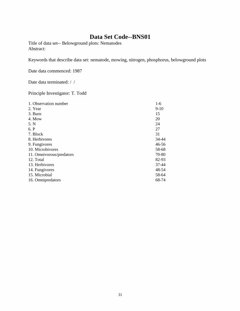
Data Set Code--BNS01 Title of data set-- Belowground plots: Nematodes Abstract: Keywords that describe data set: nematode, mowing, nitrogen, phosphorus, belowground plots Date data commenced: 1987 Date data terminated: / / Principle Investigator: T. Todd 1. Observation number 1-6 2. Year 9-10 3. Burn 15 4. Mow 20 5. N 24 6. P 27 7. Block 31 8. Herbivores 34-44 9. Fungivores 46-56 10. Microbivores 58-68 11. Omnivorous/predators 70-80 12. Total 82-93 13. Herbivores 37-44 14. Fungivores 48-54 15. Microbial 58-64 16. Omnipredators 68-74
32
Consumer Data
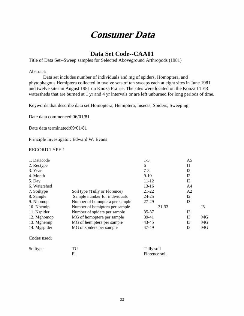
Data Set Code--CAA01 Title of Data Set--Sweep samples for Selected Aboveground Arthropods (1981) Abstract:
Data set includes number of individuals and mg of spiders, Homoptera, and phytophagous Hemiptera collected in twelve sets of ten sweeps each at eight sites in June 1981 and twelve sites in August 1981 on Knoza Prairie. The sites were located on the Konza LTER watersheds that are burned at 1 yr and 4 yr intervals or are left unburned for long periods of time. Keywords that describe data set:Homoptera, Hemiptera, Insects, Spiders, Sweeping Date data commenced:06/01/81 Date data terminated:09/01/81 Principle Investigator: Edward W. Evans RECORD TYPE 1 1. Datacode 1-5 A5 2. Rectype 6 I1 3. Year 7-8 I2 4. Month 9-10 I2 5. Day 11-12 I2 6. Watershed 13-16 A4 7. Soiltype Soil type (Tully or Florence) 21-22 A2 8. Sample Sample number for individuals 24-25 I2 9. Nhomop Number of homoptera per sample 27-29 I3 10. Nhemip Number of hemiptera per sample 31-33 I3 11. Nspider Number of spiders per sample 35-37 I3 12. Mghomop MG of homoptera per sample 39-41 I3 MG 13. Mghemip MG of hemiptera per sample 43-45 I3 MG 14. Mgspider MG of spiders per sample 47-49 I3 MG Codes used: Soiltype TU Tully soil Fl Florence soil

33
Data Set Code--CAA02 Title of data set--D-Vac Samples for Aboveground Arthropods, 1981 Abstract: Data set includes numbers of individuals and mg of Homoptera, Hemiptera, grasshoppers, ants, and spiders collected in D-Vac samples in August 1981 at one site for each of the 12 Konza Prairie LTER treatments ( 3 fire treaments x 2 soils x 2 grazing treatments). Nine D-Vac samples (each covering 640 square cm of ground) were taken at each site. Keywords that describe data set:Homoptera, Hemiptera, grasshoppers, ants, spiders Date data commenced:08/03/81 Date data terminated:08/07/81 Principle Investigator: Edward W. Evans RECORD TYPE 1 Data Format Specification 1. Datacode 1-5 A5 2. Rectype 6 I1 3. Year 7-8 I2 4. Month 9-10 I2 5. Day 11-12 I2 6. Watershed 13-16 A4 7. Soiltype Soil type (Tully or Florence) 21-22 A2 8. Sttime Time sampling started 24-27 I4 Hours 9. Endtime Time sampling ended 29-32 I4 Hours 10. Wind Wind speed at start of sampling 34-37 F4.1 Km/hr 11. Temp Air temp at start of sampling 39-42 F4.1 deg C 12. Relhum Relative humidity at ground level 44-45 I2 % 13. Cloudcov % Cloud cover directly overhead 47-49 I3 % Codes Used Soiltype TU Tully soil FL Florence soil RECORD TYPE 2 Data Format Specification 1. Datacode 1-5 A5 2. Rectype 6 I1 3. Year 7-8 I2

34
4. Month 9-10 I2 5. Day 11-12 I2 6. Watershed 13-16 A4 7. Soiltype Soil type (Tully or Florence) 21-22 I2 8. Sample Sample number (Total 9) for sites 24-25 I2 9. Nhomop Number of individuals (Homoptera) 27-29 I3 10. Nhemip Number of individuals (Hemiptera) 31-33 I3 11. Ngrshop Number of individuals (Grasshoppers 35-37 I3 12. Nant Number of individuals (Ants) 39-41 I3 13. Nspider Number of individuals (Spiders 43-45 I3 14. Mghomop MG of Homoptera per sample 47-49 I3 MG 15. Nehemip MG of Hemiptera per sample 51-53 I3 MG 16. Mggrshop MG of Grasshoppers (Acrididae) 55-57 I3 MG 17. Mgant MG of Ants per sample 59-61 I3 MG 18. Mgspider MG of Spiders per sample 63-65 I3 MG Codes used: Soiltype TU Tully soil FL Florence soil

35
Data Set Code--CAA03 Title of Data Set--D-Vac Sampling of Aboveground Arthropods (1982) ABSTRACT: Data set includes number of individuals for spiders and insect orders (Hemiptera and Coleoptera were split into phytophagous and predatory; hymenoptera was split into ants, parasitoid wasps, and all others) collected in d-vac samples in June-July and Aug 1982. On both occasions, eight sites were sampled: two upland and two lowland sites on both an annually burned and an unburned watershed. At each site on each occasion, fifteen d-vac samples (each covering 1570 sq. cm of ground) were taken. Keywords that describe data set:insects, spiders, d-vac, burning Date data commenced:06/21/82 Date data terminated:08/04/82 Principle Investigator: Edward W. Evans RECORD TYPE 1 Data Format Specification 1. Datacode 1-5 A5 2. Rectype 6 I1 3. Year 7-8 I2 4. Month 9-10 I2 5. Day 11-12 I2 6. Watershed 13-16 A4 7. Soiltype Soil type (Tully or Florence) 21-22 A2 8. Sttime Time sampling started 24-27 I4 hours 9. Endtime Time sampling ended 29-32 I4 hours 10. Wind Wind speed at start of sampling 34-37 F4.1 km/hr 11. Temp Air temp at start of sampling 39-42 F4.1 deg C 12. Relhum Relative humidity at ground level 44-45 I2 % 13. Cloudcov % cloud cover directly overhead 47-49 I3 % Code used: 1. Soiltype TU Tully soil 2. Soiltype Fl Florence soil RECORD TYPE 2 1. Datacode 1-5 A5 2. Rectype 6 I1 3. Year 7-8 I2 4. Month 9-10 I2 5. Day 11-12 I2 6. Watershed 13-16 A4 7. Soiltype Soil type (Tully or Florence) 21-22 A2 8. Repsite Replicate site for a watershed/soil 24 I1 9. Gprcode Group code 26-27 I2

36
10. Group Abbreviated name of taxon 29-47 A19 11. S1 Number of indviduals in sample #1 49-51 I3 12. S2 Number of indviduals in sample #2 53-55 I3 13. S3 Number of indviduals in sample # 3 57-59 I3 14. S4 Number of indviduals in sample # 4 61-63 I3 15. S5 Number of indviduals in sample # 5 65-67 I3 16. S6 Number of indviduals in sample # 6 69-71 I3 17. S7 Number of indviduals in sample # 7 73-75 I3 18. S8 Number of indviduals in sample # 8 77-79 I3 Codes used: 1. Soiltype tu Tully soils 2. Soiltype fl Florence soil 3. Grpcode 01 Thysanura 4. Grpcode 02 Orthoptera without mantids 5. Grpcode 03 Orthoptera mantids only 6. Grpcode 04 Psocoptera 7. Grpcode 05 Thysanoptera 8. Grpcode 06 Hemiptera phytophagous 9. Grpcode 07 Hemiptera predatory 10. Grpcode 08 Homoptera 11. Grpcode 09 Coleoptera phytophagous 12. Grpcode 10 Coleoptera predatory 13. Grpcode 11 Neuroptera larvaae 14. Grpcode 12 Neuroptera adults 15. Grpcode 13 Lepidoptera larvae 16. Grpcode 14 Lepidoptera adults 17. Grpcode 15 Diptera 18. Grpcode 16 Hymenoptera ants 19. Grpcode 17 Hymenoptera wasps 20. Grpcode 18 Hymenoptera bees 21. Grpcode 19 spiders 22. Grpcode 20 Phalangida 23. Grpcode 21 All arthropods (total) RECORD TYPE 3 1. Datacode 1-5 A5 2. Rectype 6 I1 3. Year 7-8 I2 4. Month 9-10 I2 5. Day 11-12 I2 6. Watershed 13-16 A4 7. Soiltype Soil Type (Tully or Florence) 21-22 A2 8. Repsite Replicate site for a watershed/soil type 24 I1 9. Gprcode Group code 26-27 I2 10. Group Abbreviated name of taxon 29-47 A19 11. S9 Number of indviduals in sample # 9 49-51 I3 12. S10 Number of indviduals in sample # 10 53-55 I3 13. S11 Number of indviduals in sample # 11 57-59 I3

37
14. S12 Number of indviduals in sample # 12 61-63 I3 15. S13 Number of indviduals in sample # 13 65-67 13 16. S14 Number of indviduals in sample # 14 69-71 I3 17. S15 Number of indviduals in sample # 15 73-75 I3 18. Total Total number of individuals in all samples combined 76-79 I4 Codes used: 1. Soiltype tu Tully soils 2. Soiltype fl Florence soil 3. Grpcode 01 Thysanura 4. Grpcode 02 Orthoptera without mantids 5. Grpcode 03 Orthoptera mantids only 6. Grpcode 04 Psocoptera 7. Grpcode 05 Thysanoptera 8. Grpcode 06 Hemiptera phytophagous 9. Grpcode 07 Hemiptera predatory 10. Grpcode 08 Homoptera 11. Grpcode 09 Coleoptera phytophagous 12. Grpcode 10 Coleoptera predatory 13. Grpcode 11 Neuroptera larvaae 14. Grpcode 12 Neuroptera adults 15. Grpcode 13 Lepidoptera larvae 16. Grpcode 14 Lepidoptera adults 17. Grpcode 15 Diptera 18. Grpcode 16 Hymenoptera ants 19. Grpcode 17 Hymenoptera wasps 20. Grpcode 18 Hymenoptera bees 21. Grpcode 19 spiders 22. Grpcode 20 Phalangida 23. Grpcode 21 All Arthropods (total)

38
Data Set Code--CBC01 Title of data set--Bird Check-List Abstract:
Presence, including documented nesting, of all bird species recorded on a weekly basis throughout the year. Keywords that describe data set:bird, phenology Date data commenced:01/01/71 Date data terminated: / / Principle Investigator: John L. Zimmerman RECORD TYPE 1 1. Datacode 1-5 A5 2. Rectype 6 I1 3. Species 4 character alphameric code unique for each species 8-11 A4 4. 2 Mar Status (see codes below) 13 A1 5. 9 Mar 14 A1 6. 16 Mar 15 A1 7. 23 Mar 16 A1 8. 30 Mar 17 A1 9. 6 Apr 18 A1 10. 13 Apr 19 A1 11. 20 Apr 20 A1 12. 27 Apr 21 A1 13. 4 May 22 A1 14. 11 May 23 A1 15. 18 May 24 A1 16. 25 May 25 A1 17. 1 Jun 27 A1 18. 8 Jun 28 A1 19. 15 Jun 29 A1 20. 22 Jun 30 A1 21. 29 Jun 31 A1 22. 6 Jul 32 A1 23. 13 Jul 33 A1 24. 20 Jul 34 A1 25. 27 Jul 35 A1 26. 3 Aug 36 A1 27. 10 Aug 37 A1 28. 17 Aug 38 A1 29. 24 Aug 39 A1 30. 31 Aug 41 A1 31. 7 Sep 42 A1 32. 14 Sep Status 43 A1 33. 21 Sep Status 44 A1

39
34. 28 Sep 45 A1 35. 5 Oct 46 A1 36. 12 Oct 47 A1 37. 19 Oct 48 A1 38. 26 Oct 49 A1 39. 2 Nov 50 A1 40. 9 Nov 51 A1 41. 16 Nov 52 A1 42. 23 Nov 53 A1 43. 30 Nov 55 A1 44. 7 Dec 56 A1 45. 14 Dec 57 A1 46. 21 Dec 58 A1 47. 28 Dec 59 A1 48. 5 Jan 60 A1 49. 12 Jan 61 A1 50. 19 Jan 62 A1 51. 26 Jan 63 A1 52. 2 Feb 64 A1 53. 9 Feb 65 A1 54. 16 Feb 66 A1 55. 23 Feb Status 67 A1 Codes used: Status 0 not recorded x recorded as present n nesting 1. Species agwt green-winged teal 2. Species barn common barn owl 3. Species basw barn swallow 4. Species bbcu black-billed cuckoo 5. Species belt belted kingfisher 6. Species bggn blue-gray gnatcatcher 7. Species bgwb black-throated green warbler 8. Species bhcb brown-headed cowbird 9. Species bitt american bittern 10. Species blea bald eagle 11. Species blgr blue grosbeak 12. Species blte black tern 13. Species bluj blue jay 14. Species blvo bell's vireo 15. Species blwb blackburnian warbler 16. Species blwt blue-winged teal 17. Species bnsw bank swallow 18. Species bobk bobolink 19. Species bobw northern bobwhite quail 20. Species bpwb blackpoll warbler 21. Species brbb brewer's blackbird 22. Species brcp brown creeper 23. Species brow barred owl 24. Species brwh broad-winged hawk

40
25. Species buff bufflehead 26. Species bwrn bewick's wren 27. Species bwwb black-and-white warbler 28. Species caeg cattle egret 29. Species cang canada goose 30. Species carn northern cardinal 31. Species catb gray catbird 32. Species ccos clay-colored sparrow 33. Species cfsw cliff swallow 34. Species chik black-capped chickadee 35. Species chps chipping sparrow 36. Species chuk chuck-will's widow 37. Species cogr common grackle 38. Species coop cooper's hawk 39. Species coot american coot 40. Species corm double-crested cormorant 41. Species crow american crow 42. Species cswb chestnut-sided warbler 43. Species cwax cedar waxwing 44. Species cwrn carolina wren 45. Species deju dark-eyed junco 46. Species dick dickcissel 47. Species down downy woodpecker 48. Species eblu eastern bluebird 49. Species ekng eastern kingbird 50. Species emdl eastern meadowlark 51. Species ewpw eastern wood-pewee 52. Species ferh ferruginous hawk 53. Species fgul franklin's gull 54. Species flds field sparrow 55. Species flik northern flicker 56. Species foxs fox sparrow 57. Species gadw gadwall 58. Species gbhe great blue heron 59. Species gcfc great crested flycatcher 60. Species gchk greater prairie chicken 61. Species gckt golden-crowned kinglet 62. Speceis geye common goldeneye 63. Species ghow great horned owl 64. Species glea golden eagle 65. Species glfh american goldfinch 66. Species gosh northern goshawk 67. Species gras grasshopper sparrow 68. Species greg great egret 69. Species grhe green-backed heron 70. Species gtgr great-tailed grackle 71. Species gthr gray-cheeked thrush 72. Species hair hairy woodpecker 73. Species hars harris' sparrow 74. Species hens henslow's sparrow

41
75. Species hfnk house finch 76. Species hood hooded merganser 77. Species hous house sparrow 78. Species hthr hermit thrush 79. Species hwrn house wren 80. Species inbu indigo bunting 81. Species kest american kestrel 82. Species kill killdeer 83. Species kywb kentucky warbler 84. Species lapl lapland longspur 85. Species lark horned lark 86. Species lbun lark bunting 87. Species lecs leconte's sparrow 88. Species lins lincoln's sparrow 89. Species lrks lark sparrow 90. Species lshr loggerhead shrike 91. Species ltfc least flycatcher 92. Species lwth louisiana waterthrush 93. Species lyel lesser yellowlegs 94. Species macl mccown's longspur 95. Species mall mallard 96. Species marh northern harrier 97. Species mawb magnolia warbler 98. Species mdov mourning dove 99. Species mdsp meadowlark sp 100. Species merl merlin 011. Species miss mississippi kite 102. Species mock northern mockingbird 103. Species mowb mourning warbler 104. Species mwrn marsh wren 105. Species nawb nashville warbler 106. Species nite common nighthawk 107. Species none no birds 108. Species noor northern oriole 109. Species nwth northern waterthrush 110. Species ocwb orange-crowned warbler 111. Species oror orchard oriole 112. Species osfc olive-sided flycatcher 113. Species ospr osprey 114. Species oven ovenbird 115. Species paru northern parula warbler 116. Species pbgr pied-billed grebe 117. Species pelc white pelican 118. Species pere peregrine falcon 119. Species phes ring-necked pheasant 120. Species phob eastern phoebe 121. Species phvo philadelphia vireo 122. Species pint northern pintail 123. Species plwb palm warbler 124. Species pmar purple martin

42
125. Species poor common poor-will 126. Species praf prairie falcon 127. Species purp purple finch 128. Species rbgr rose-breasted grosbeak 129. Species rbwo red-bellied woodpecker 130. Species rckt ruby-crowned kinglet 131. Species rcrb red crossbill 132. Species reds american redstart 133. Species revo red-eyed vireo 134. Species rgul ring-billed gull 135. Species rhwo red-headed woodpecker 136. Species rlgh rough-legged hawk 137. Species rngd ring-necked duck 138. Species rnut red-breasted nuthatch 139. Species robn american robin 140. Species rock rock dove 141. Species rsto rufous-sided towhee 142. Species rthb ruby-throated hummingbird 143. Species rtlh red-tailed hawk 144. Species rubb rusty blackbird 145. Species rudy ruddy duck 146. Species rwbb red-winged blackbird 147. Species rwrn rock wren 148. Species rwsw northern rough-winged swallow 149. Species saps yellow-bellied sapsucker 150. Species saup lesser scaup 151. Species savs savannah sparrow 152. Species scre eastern screech owl 153. Species sctn scarlet tanager 154. Species seow short-eared owl 155. Species shar sharp-shinned hawk 156. Species shov northern shoveler 157. Species sisk pine siskin 158. Species smil smith's longspur 159. Species snbu snow bunting 160. Species snip common snipe 161. Species snog snow goose 162. Species snow snowy owl 163. Species sogs song sparrow 164. Species solt solitary sandpiper 165. Species sora sora rail 166. Species spip sprague's pipit 167. Species spot spotted sandpiper 168. Species spsp sparrow sp 169. Species star european starling 170. Species stfc scissor-tailed flycatcher 171. Species sthr swainson's thrush 172. Species stvo solitary vireo 173. Species sutn summer tanager 174. Species swah swainson's hawk

43
175. Species swif chimney swift 176. Species swms swamp sparrow 177. Species swrn sedge wren 178. Species thra brown thrasher 179. Species tnwb tennessee warbler 180. Species tres american tree sparrow 181. Species trsw tree swallow 182. Species tsol townsend's solitaire 183. Species tuft tufted titmouse 184. Species turv turkey vulture 185. Species upld upland sandpiper 186. Species varl virginia rail 187. Species very veery 188. Species vess vesper sparrow 189. Species wavo warbling vireo 190. Species wevo white-eyed vireo 191. Species wfrg great white-front goose 192. Species whcs white-crowned sparrow 193. Species whip whip-poor-will 194. Species wifc willow flycatcher 195. Species wign american wigeon 196. Species will willet 197. Species wkng western kingbird 198. Species wlwb wilson's warbler 199. Species wmdl western meadowlark 200. Species wnut white-breasted nuthatch 201. Species wood wood duck 202. Species wpip water pipit 203. Species wthr wood thrush 204. Species wths white-throated sparrow 205. Species wwrn winter wren 206. Species ybch yellow-breasted chat 207. Species ybcu yellow-billed cuckoo 208. Species yhbb yellow-headed blackbird 209. Species ylwb yellow warbler 210. Species yrwb yellow-rumped warbler 211. Species ythr common yellowthroat 212. Species ytvo yellow-throated vireo

44
Data Set Code--CBD01 Title of data set--Bird Dates Abstract:
Dates of records of occurrence for all bird species reported on Konza Prairie. Keywords that describe data set:bird, phenology, presence, dates of occurence Date data commenced: 01/01/71 Date data terminated: 12/31/92 Principle Investigator: John L. Zimmerman RECORD TYPE 1 1. Datacode 1-5 A5 2. Rectype 6 I1 3. Species Name of Bird, 4 character Alphameric 7-10 A4 4. Date 1 6 digit year, month, day of record 12-17 I6 5. Date 2 6 digit year, month, day of record 19-24 I6 6. Date 3 6 digit year, month, day of record 26-31 I6 7. Date 4 6 digit year, month, day of record 33-38 I6 8. Date 5 6 digit year, month, day of record 40-45 I6 9. Date 6 6 digit year, month, day of record 47-52 I6 10. Date 7 6 digit year, month, day of record 54-59 I6 11. Date 8 6 digit year, month, day of record 61-66 I6 12. Date 9 6 digit year, month, day of record 68-73 I6 13. Date 10 6 digit year, month, day of record 75-80 I6 Codes used: Species See CBC01;same alphameric code

45
Data Set Code--CBN01 Title of data set--Bird Nest Abstract:
Dates by species of documented records of breeding -- either nests or dependent, fledged young -- with contents of nest, nest placement information and location on Konza Prairie recorded by grid square. Keywords that describe data set:bird, phenology, nest record Date data commenced:01/01/71 Date data terminated: 12/31/92 Principle Investigator: John L. Zimmerman RECORD TYPE 1 1. Datacode 1-5 A5 2. Rectype 6 I1 3. Year 7-8 I2 4. Month 9-10 I2 5. Day 11-12 I2 6. Species 4 character alphameric 14-17 A4 7. Grid KPRNA 200 m2 grid designations 19-22 A2 + I2 8. Eggs number of eggs in clutch 24-25 I2 9. Cbeggs number of cowbird eggs in clutch 27-28 I2 10. Young number of young in nest 30-31 I2 11. Cbyg number of cowbird young in nest 33-34 I2 12. Comment to indicate nest placement e.g 36-80 A45 2m high in Ulmus americana Codes used: Species 4 Character alphameric unique for each
species; see listing in CBD01

46
Data Set Code--CBP01 Title of data set--Bird Populations Abstract:
Records of bird species giving perpendicular distance of sighting from transect line for January, April, June, and October censuses on 16 separate transects. In addition to the watershed representing the LTER grassland treatments, transects are also run in the gallery forest and an upper watershed, forest edge habitat.
Keywords that describe data set:bird numbers, species diversity, species abundance Date data commenced:06/01/81 Date data terminated: / / Principle Investigator: Brett Sandercock RECORD TYPE 1 1. Datacode 1-5 A5 2. Rectype 6 I1 3. Year 7-8 I2 4. Month 9-10 I2 5. Day 11-12 I2 6. Watershed 13-16 A4 9. Century 21 I1 10. Transnum Transect number (#7 &11 invalid) 23-24 I2 11. Length Length of transect 26-29 I4 meters 12. Obsnum Observation number 31-33 I3 13. Distance Perpendicular distance to observed 35-37 I3 meters 14. Specname Species name 38-42 A4 15. Sex Sex of bird m-male f-female u-unknown 44 A1 16. Status Residency status code 46 A1 17. Comment For obsnum=1, includes start and time 48-80 A33 Codes used: Watershed S00A Shane Creek G00A North branch of Kings Creek L00A Lower Kings Creek (all other codes same as LTER watershed code list) Century 1 20th century 2 21st century Specname RWBB Red-winged Blackbird (etc. see attached list of species codes from CBC01 Sex M Male F Female

47
U Unknown Status P Year-round resident S Summer resident W Winter resident T Transient U Unknown residency status

48
Data Set Code--CGP01 Title of data set--Gall Insect Populations Abstract: Long-term monitoring of gall-insect densities on Solidago canadensis, Vernonia baldwinii, and Ceanothus herbaceous. Gall abundances are censused in watersheds burned at one- to twenty- year intervals to asses the role of fire frequency and time since fire on gall-insect population dynamics. The data sets contain the following: Watershed fire frequency, number of growing seasons since last fire, plant species, number of galled stems, and number of censused stems. Censuses conducted for the 1989-1996 growing seasons except 1992 and 1994, next scheduled census is fall 1997. See methods manual pages 64-65 for further sampling details. Keywords that describe data set: Gall-insects, population dynamics, fire, Diptera, Lepidoptera Compositae, Rhamnaceae, Ceanothus, Solidago, Vernonia Date data commenced:10/88 Date data terminated: 1996 Principle Investigator: P.A. Fay/D.C. Hartnett RECORD TYPE 1 Data Format Specification Variable Name Columns Format Units 1. Datacode 1-5 A5 2. Rectype 6 I1 3. Year 7-8 I2 4. Watershed 13-16 A4 5. Fire Frequency 20-21 I2 6. Last Fire 25-26 I2 7. Last Wildfire 32-33 I2 8. Species 40-50 A11 9. Census Replicate 55-56 I2 10. # Galled Stems 65-67 I3 11. # Sampled Stems 75-77 I3

49
Data Set Code--CGR01 Title of data set--Sweep Samples for Grasshoppers (1981) Abstract:
Sweep samples were taken for grasshoppers (Acrididae) at one site for each of the 12 Konza Prairie LTER treatments (3 fire treatments x 2 soils x 2 grazing treatments) in June, August, and September. At each site on each occasion, 18 sets of 10 sweeps each (180 sweeps total) were taken. Stored data include for each site on each occasion: total number of each species (all instars combined) collected and total number for each instar for each species (180 sweeps combined). Keywords that describe data set:grasshoppers, Acrididae, insects, sweep sampling Date data commenced:04/01/81 Date data terminated:12/01/81 Principle Investigator: Edward W. Evans RECORD TYPE 1 Data Format Specification Variable Name Columns Format Units 1. Datacode 1-5 A5 2. Rectype 6 I1 3. Year 7-8 I2 4. Month 9-10 I2 5. Day 11-12 I2 6. Watershed 13-16 A4 7. Soiltype Soil Type (Tully or Florence) 18-19 A2 8. Time Time sampling began 21-24 I4 Hours 9. Wind Wind speed at start of sampling 26-29 F4.1 Km hr-1
mean of 5 measurements at 30 second intervals 5’ aboveground 10. Temp Air temp at start of sampling 31-34 F4.1 deg C ground level in shade 11. RelHum Relative humidity at ground level 36-37 I2 % in shade at outset of sampling; determined by wet/dry bulb psychrometer 12. Cloudcov % of Cloud cover directly overhead 39-41 I3 % (estimated by eye) Codes used: 1. Soiltype Tu Tully soil 2. Soiltype Fl Florence soil RECORD TYPE 2 1. Datacode 1-5 A5

50
2. Rectype 6 I1 3. Year 7-8 I2 4. Month 9-10 I2 5. Day 11-12 I2 6. Watershed 13-16 A4 7. Soiltype Soil Type (Tully or Florence) 18-19 A2 8. Spcode Species Code 21-22 I2 9. Species* Abbreviated Species Name 24-43 A20 10. S1 Number of individuals in sample 1 45-46 I2 11. S2 Number of individuals in sample 2 48-49 I2 12. S3 Number of individuals in sample 3 51-52 I2 13. S4 Number of individuals in sample 4 54-55 I2 14. S5 Number of individuals in sample 5 57-58 I2 15. S6 Number of individuals in sample 6 60-61 I2 16. S7 Number of individuals in sample 7 63-64 I2 17. S8 Number of individuals in sample 8 66-67 I2 18. S9 Number of individuals in sample 9 69-70 I2 19. S10 Number of individuals in sample 10 72-73 I2 21. Total Total # of individuals all samples 76-79 I4 Codes used: 1. Soiltype Tu Tully soil 2. Soiltype Fl Florence soil 3. Species 01 brachystol magna 4. Species 02 schistocer lineata 5. Species 03 paratylotr brunneri 6. Species 04 hypochlkora alba 7. Species 05 campylacan olivacea 8. Species 06 hesperotet speciosus 9. Species 07 hesperotet viridis 10. Species 08 hesperotet species 11. Species 09 phoetaliot nebrascen 12. Species 10 melanoplus scudderi 13. Species 11 melanoplus sanguinip 14. Species 12 melanoplus femurrubr 15. Species 13 melanoplus packardii 16. Species 14 melanoplus different 17. Species 15 melanoplus keel luri 18. Species 16 melanoplus bivittatu 19. Species 17 melanoplus confusus 20. Species 18 melanoplus species 21. Species 25 eritettix simplex 22. Species 26 syrbula admirabil 23. Species 27 orphulella speciosa 24. Species 28 mermiria picta 25. Species 29 mermiria bivittata 26. Species 30 opeia obscura 27. Species 31 pseudopoma brachypte 28. Species 32 boopedon auriventr 29. Species 33 boopedon nubilum

51
30. Species 34 boopedon gracile 31. Species 35 ageneotett deorum 32. Species 36 mermiria species 33. Species 45 chortophag viridifas 34. Species 46 dissosteir carolina 35. Species 47 arphia xanthopte 36. Species 48 arphia simplex 37. Species 49 arphia conspersa 38. Species 50 hadrotetti trifascia 39. Species 51 hippiscus rugosus 40. Species 52 pardalopho apiculata 41. Species 53 pardalopho haldemani 42. Species 54 pardalopho species 43. Species 55 arphia species 44. Species 90 unknown 45. Species 95 total RECORD TYPE 3 Data Format Specification 1. Datacode 1-5 A5 2. Rectype 6 I1 3. Year 7-8 I2 4. Month 9-10 I2 5. Day 11-12 I2 6. Watershed 13-16 A4 7. Soiltype Soil type (Tully or Florence) 18-19 A2 8. Spcode Species Code 21-22 I2 9. Species Abbreviated species name 24-43 A20 10. S11 Number of individuals in sample 11 45-46 I2 11. S12 Number of individuals in sample 12 48-49 I2 12. S13 Number of individuals in sample 13 51-52 I2 13. S14 Number of individuals in sample 14 54-55 I2 14. S15 Number of individuals in sample 15 57-58 I2 15. S16 Number of individuals in sample 16 60-61 I2 16. S17 Number of individuals in sample 17 63-64 I2 17. S18 Number of individuals in sample 18 66-67 I2 18. Total Total # of individuals/all samples 69-71 I3 Codes used: see record type 2 RECORD TYPE 4 Data Format Specification 1. Datacode 1-5 A5 2. Rectype 6 I1 3. Year 7-8 I2

52
4. Month 9-10 I2 5. Day 11-12 I2 6. Watershed 13-16 A4 7. Soiltype Soil Type (Florence or Tully) 18-19 A2 8. Spcode Species code 21-22 I2 9. Species Abbreviated species name 24-43 A20 10. First # of individuals in first instar 45-47 I3 11. Second # of individuals in second instar 49-51 I3 12. Third # of individuals in third instar 53-55 I3 13. Fourth # of individuals in fourth instar 57-59 I3 14. Fifth # of individuals in fifth instar 61-63 I3 15. Adults Total number of adults 65-67 I3 16. Total Total # of individuals of all stages 69-72 I4 Codes used:See Record type 2

53
Data Set Code--CGR02 Title of data set--Sweep Samples for Grasshoppers Abstract: Sweep samples were taken for grasshoppers (Acrididae) at two sites for each of the 12 Konza Prairie LTER treatments (3 treatments x 2 soils x 2 grazing treatment x 2 replicate sites) in June, July and August. At each site on each occasion, 10 sets of 20 sweeps (200 sweeps total) were taken. Stored data include for each site on each occasion: total number of each species (all instars combined) collected and total number for each instar for each species (200 sweeps combined). Keywords that describe data set:grasshoppers, Acrididae, insects, sweep sampling Date data commenced:04/01/82 Date data terminated: / / Principle Investigator: Edward W. Evans RECORD TYPE 1 Data Format Specification 1. Datacode 1-5 A5 2. Rectype 6 I1 3. Year 7-8 I2 4. Month 9-10 I2 5. Year 11-12 I2 6. Watershed 13-16 A4 7. Soiltype Soil Type (Florence or Tully) 18-19 A2 8. Repsite Replicate site for a treatment 21 A1 9. Time Time sampling began 23-26 I4 Hours 10. Wind Wind speed at start of sampling 28-31 F4.1 km/hr Mean of 5 measurements taken a 30 second intervals 5’ above ground. 11. Temp Air temperature at start of sampling 33-36 F4.1 deg C 12. Relhum Relative humidity at ground level in 38-39 I2 % shade at outset of sampling determined by wet/dry bulb psychrometer. 13. Cloudcov % Cloud cover directly overhead 41-43 I3 % at start of sampling --- estimated by eye. Codes used: 1. Soiltype FL Florence soil 2. Soiltype TU Tully soil 3. Repsite A Replicate site A for treatment 4. Repsite B Replicate site B for treatment

54
RECORD TYPE 2 Data Format Specification 1. Datacode 1-5 A5 2. Rectype 6 I1 3. Year 7-8 I2 4. Month 9-10 I2 5. Day 11-12 I2 6. Watershed 13-16 A4 7. Soiltype Soil type (Tully or Florence) 18-19 A2 8. Repsite Replication site for a watershed/soil 21 A1 9. Spcode Species Code 23-24 I2 10. Species Abbreviated name of species 26-45 A20 11. S1 # of individuals in sample 1 47-48 I2 12. S2 # of individuals in sample 2 50-51 I2 13. S3 # of individuals in sample 3 53-54 I2 14. S4 # of individuals in sample 4 56-57 I2 15. S5 # of individuals in sample 5 59-60 I2 16. S6 # of individuals in sample 6 62-63 I2 17. S7 # of individuals in sample 7 65-66 I2 18. S8 # of individuals in sample 8 68-69 I2 19. S9 # of individuals in sample 9 71-72 I2 20. S10 # of individuals in sample 10 74-75 I2 21. Total Total # of individuals/all samples 77-79 I3 Codes used: 1. Soiltype FL Florence soil 2. Soiltype TU Tully soil 3. Repsite A Replicate site A for treatment 4. Repsite B Replicate site B for treatment 01 brachystol magna brachystola magna (girard) 02 schistocer lineata schistocerca lineata scudder 03 paratylotr brunneri aratylotropidia brunneri scudder 04 hypochlora alba hypochlora alba (dodge) 05 campylacan olivacea pylacantha olivacea (scudder) 06 hesperotet speciosus hesperotettix speciosus (scudder) 07 hesperotet viridis hesperotettix viridis pratensis (scudder) 08 hesperotet species hesperotettix speciosus or viridis 09 phoetaliot nebrascen phoetaliotes nebrascensis (thomas) 10 melanoplus scudderi melanoplus scudderi morse 11 melanoplus sanguinip melanoplus sanguinipes (fabricius) 12 melanoplus femurrubr melanoplus femurrubrum (degeer) 13 melanoplus packardii melanoplus packardii scudder 14 melanoplus different elanoplus differentialis (thomas) 15 melanoplus keel luri melanoplus keeleri luridus (dodge) 16 melanoplus bivittatu melanoplus bivittatus (say) 17 melanoplus confusus melanoplus confusus scudder 25 eritettix simplex eritettix simplex (scudder)

55
26 syrbula admirabil syrbula admirabilis (uhler) 27 orphulella speciosa orphulella speciosa (scudder) 28 mermiria picta ???? ermiria picta (walker) 29 mermiria bivittata???? mermiria bivittata (serville) 30 opeia obscura opeia obscura (thomas) 31 pseudopoma brachypte pseudopomala brachyptera (scudder) 32 boopedon auriventr boopedon auriventris mcneill 33 boopedon nubilum boopedon nubilum (say) 34 boopedon gracile boopedon gracile rehn 35 ageneotett deorum ageneotettix deorum (scudder) 36 mermiria species mermiria picta or bivittata 45 chortophag viridifas chortophaga viridifasciata (degeer) 46 dissosteir carolina dissosteira carolina (linnaeus) 47 arphia xanthopte arphia xanthoptera (burmeister) 48 arphia simplex rphia simplex scudder 49 arphia conspersa arphia conspersa scudder 50 hadrotetti trifascia hadrotettix trifasciatus (say) 51 hippiscus rugosus hippiscus rugosus (scudder) 52 pardalopho apiculata pardalophora apiculata (harris) 53 pardalopho haldemani pardalophora haldemanii (scudder) 90 unknown species identity unknown 95 total all individuals of all species combined RECORD TYPE 3 1. Datacode 1-5 A5 2. Rectype 6 I1 3. Year 7-8 I2 4. Month 9-10 I2 5. Day 11-12 I2 6. Watershed 13-16 A4 7. Soiltype Soil type (Tully or Florence) 18-19 A2 8. Repsite Replication site for a treatment 21 A1 9. Spcode Species code 23-24 I2 10. Species Abbreviated species name 26-45 A20 11. First # of individuals 1st instar 47-49 I3 12. Secthird # of individuals 2nd & 3rd instars 51-53 I3 13. Forth # of individuals 4th instar 55-57 I3 14. Fifth # of individuals 5th instar 59-61 I3 15. Female # of individuals of adult females 63-65 I3 16. Male # of individuals of adult males 67-69 I3 17. Total Total # of individuals/all samples 71-74 I4 Codes used:See record type 2.

56
Data Set Code--CGR03 Title of Data Set--Effects of Spring Burning on Grasshopper Nymphs (1982) Abstract: Sweep samples were taken for grasshoppers (Arcididae) at two upland sites on 5 watersheds at approximately two week intervals, June-Sept 1982. At each site on each occasion, 20 sets of 20 sweeps (400 sweeps total) were taken. Stored data include for each site on each occasion: total number of each species (all instars combined) collected and total number for each instar for each species (400 sweeps combined). Keywords that describe data set:grasshoppers, Acrididae, insects, sweep sampling Date data commenced:06/01/82 Date data terminated:09/02/82 Principle Investigator: Edward W. Evans RECORD TYPE 1 Data Format Specification 1. Datacode 1-5 A5 2. Rectype 6 I1 3. Year 7-8 I2 4. Month 9-10 I2 5. Day 11-12 I2 6. Watershed 13-16 A4 7. Repsite Replicate site for a watershed 18 A1 8. Time Time sampling began 20-23 I4 Hours 9. Wind Wind speed at start of sampling 25-28 F4.1 Km/hr (mean of 5 measurements taken at 30 second intervals 5' above ground) 10. Temp Air temp at start of sampling 30-33 F4.1 (C) 11. Relhum Relative humidity at ground level 35-36 I2 % in shade at outset of sampling determined by wet/dry bulb psychrometer. 12. Cloudcov % Cloud cover directly overhead 38-40 I3 % at start of sampling, estimated by eye. ground level in shade Codes used: Repsite A Replication site A for a treatment Repsite B Replication site B for a treatment RECORD TYPE 2 Data Format Specification

57
1. Datacode 1-5 A5 2. Rectype 6 I1 3. Year 7-8 I2 4. Month 9-10 I2 5. Day 11-12 I2 6. Watershed 13-16 A4 7. Repsite Replication site for watershed/soiltype 18 A1 8. Spcode Species code 20-21 I2 9. Species Abbreviated name of species 23-42 A20 10. S1 # of individuals in sample 1 44-45 I2 11. S2 # of individuals in sample 2 47-48 I2 12. S3 # of individuals in sample 3 50-51 I2 13. S4 # of individuals in sample 4 53-54 I2 14. S5 # of individuals in sample 5 56-57 I2 15. S6 # of individuals in sample 6 59-60 I2 16. S7 # of individuals in sample 7 62-63 I2 17. S8 # of individuals in sample 8 65-66 I2 18. S9 # of individuals in sample 8 68-69 I2 19. S10 # of individuals in sample 9 71-72 I2 Codes used: Repsite A Replication site A for a treatment Repsite B Replication site B for a treatment Spcode e.g. 01 e.g. Brachystola magna (see attached list) RECORD TYPE 3 Data Format Specification 1. Datacode 1-5 A5 2. Rectype 6 I1 3. Year 7-8 I2 4. Month 9-10 I2 5. Day 11-12 I2 6. Watershed 13-16 A4 7. Repsite Replication site for watershed/soil type 18 A1 8. Spcode Species code 20-21 I2 9. Species Abbreviated name of species 23-42 A20 10. S11 # of individuals in sample 11 44-45 I2 11. S12 # of individuals in sample 12 7-48 I2 12. S13 # of individuals in sample 13 50-51 I2 13. S14 # of individuals in sample 14 53-54 I2 14. S15 # of individuals in sample 15 56-57 I2 15. S16 # of individuals in sample 16 9-60 I2 16. S17 # of individuals in sample 17 62-63 I2 17. S18 # of individuals in sample 18 65-66 I2 18. S19 # of individuals in sample 19 68-69 I2 19. S20 # of individuals in sample 20 71-72 I2 20. Total 74-76 I3 Codes used:See Record type 2
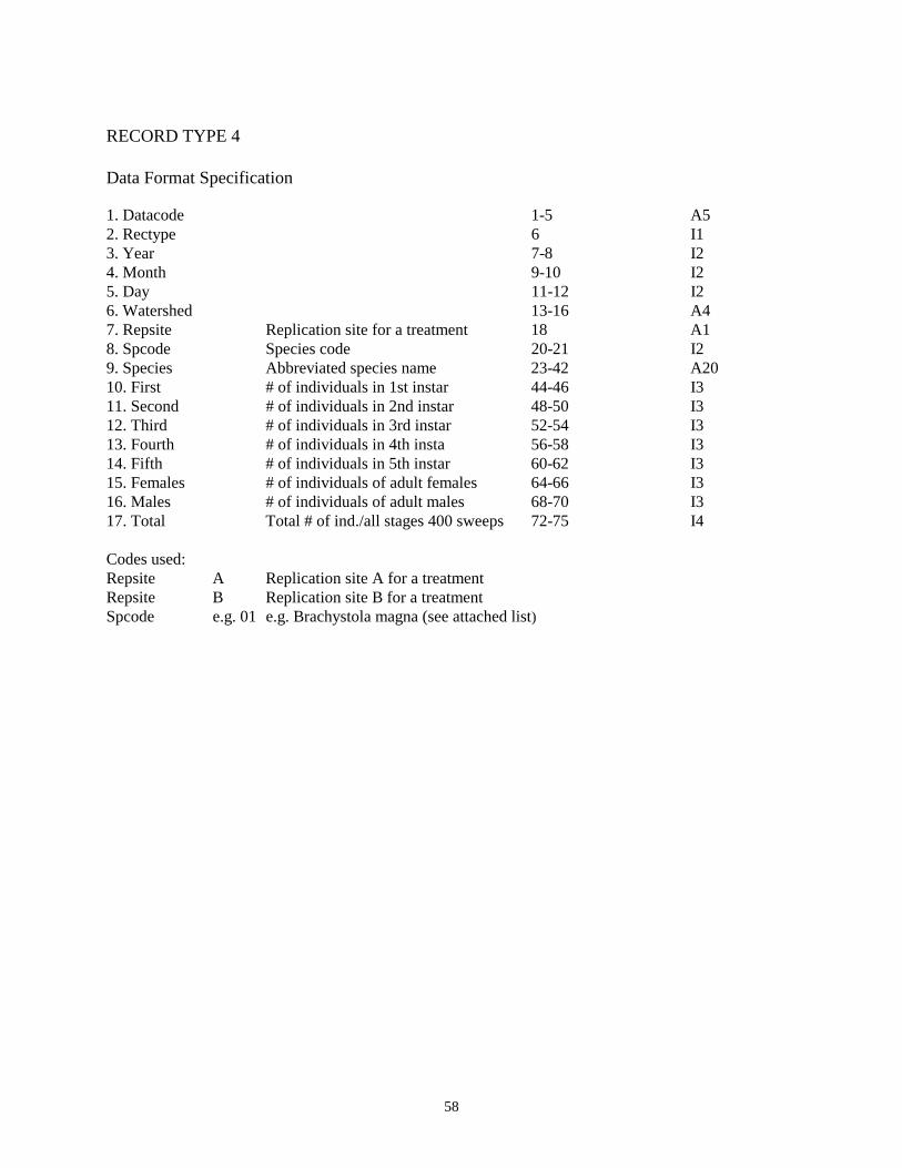
58
RECORD TYPE 4 Data Format Specification 1. Datacode 1-5 A5 2. Rectype 6 I1 3. Year 7-8 I2 4. Month 9-10 I2 5. Day 11-12 I2 6. Watershed 13-16 A4 7. Repsite Replication site for a treatment 18 A1 8. Spcode Species code 20-21 I2 9. Species Abbreviated species name 23-42 A20 10. First # of individuals in 1st instar 44-46 I3 11. Second # of individuals in 2nd instar 48-50 I3 12. Third # of individuals in 3rd instar 52-54 I3 13. Fourth # of individuals in 4th insta 56-58 I3 14. Fifth # of individuals in 5th instar 60-62 I3 15. Females # of individuals of adult females 64-66 I3 16. Males # of individuals of adult males 68-70 I3 17. Total Total # of ind./all stages 400 sweeps 72-75 I4 Codes used: Repsite A Replication site A for a treatment Repsite B Replication site B for a treatment Spcode e.g. 01 e.g. Brachystola magna (see attached list)

59
Data Set Code--CGR04 Title of data set--Sampling grasshoppers in tallgrass prairie: night trapping vs. sweeping (1982) Abstract: Two techniques, sweeping with a canvas net and night trapping with a portable trap, were compared as means of sampling acridid grasshoppers in burned and unburned tallgrass prairie. Data include number and identity (species and instar) of grasshoppers caught in individual traps on forty nights at each of two sites, and number and identity of grasshoppers caught in sets of 400 sweeps taken at roughly two week intervals at both sites throughout the summer. These data are stored in hard copy only, but have been summarized and analyzed by Evans et al. 1983; Environmental Entomology 12: 1449-1454. Keywords that describe data set:grasshoppers, Acrididae, insects, sweep sampling, night trapping Date data commenced:06/01/82 Date data terminated:09/30/82 Principle Investigator: Edward W. Evans

60
Data Set Code--CGR05 Title of data set--Effects of fire frequency on composition of grasshopper assemblages (1983) Abstract: See CGR02. Keywords that describe data set:grasshoppers, Acrididae, insects, sweep sampling Date data commenced:08/05/83 Date data terminated:08/10/83 Principle Investigator: Edward W. Evans RECORD TYPE 1 Data Format Specification 1. Datacode 1-5 A5 2. Rectype 6 I1 3. Year 7-8 I2 4. Month 9-10 I2 5. Day 11-12 I2 6. Watershed 13-16 A4 7. Repsite Replicate site for a watershed 18 I1 8. Spcode Species Code 20-21 I2 9. Species Abbreviaed species name 23-42 A20 10. S1 s1-s20 Number of individuals in sample 44-45 I2 11. S2 #1-20 (20 sweeps) 47-48 I2 12. S3 50-51 I2 13. S4 53-54 I2 14. S5 56-57 I2 15. S6 59-60 I2 16. S7 62-63 I2 17. S8 65-66 I2 18. S9 68_69 I2 19. S10 71-72 I2 30. Total Total number of individuals in all samples combined (400 sweeps) Variable Code Specification Form RECORD TYPE 2 1. Datacode 1-5 A5 2. Rectype 6 I1

61
3. Year 7-8 I2 4. Month 9-10 I2 5. Day 11-12 I2 6. Watershed 13-16 A4 7. Repsite Replicate site for a watershed 18 I1 8. Spcode Species Code 20-21 I2 9. Species Abbreviated species name 23-42 A20 10. S11 s1-s20 Number of individuals in sample 44-45 I2 11. S12 #1-20 (20 sweeps) 47-48 I2 12. S13 50-51 I2 13. S14 53-54 I2 14. S15 56-57 I2 15. S16 59-60 I2 16. S17 62-63 I2 17. S18 65-66 I2 18. S19 68-69 I2 19. S20 71-72 I2 20. Total Total number of individuals in all samples 74-76 I3 RECORD TYPE 3 1. Datacode 1-5 A5 2. Rectype 6 I1 3. Year 7-8 I2 4. Month 9-10 I2 5. Day 11-12 I2 6. Watershed 13-16 A4 7. Repsite Replicate site for a treatment 18 A1 8. Spcode Abbreviated species name 20-21 I2 9. Species Species code 23-42 A20 10. First # of individuals in 1st instar 44-46 I3 11. Second # of individuals in 2nd instar 48-50 I3 12. Third # of individuals in 3rd instar 52-54 I3 13. Fourth # of individuals in 4th instar 56-58 I3 14. Fifth # of individuals in 5th instar 60-62 I3 15. Female # of individuals of adult female 64-66 I3 16. Males # of individuals of adult males 68-70 I3 17. Total Total # of ind/all stages-400 sweeps 72-75 I4 14. Fifth Codes used: Repsite A Replicate site A for a treatment Repsite B Replicate site B for a treatment Spcode e.g. 01 e.g. Brachystola magna (see attached list)

62
Data Set Code--CMY01 Title of Data Set—Mycorrhizal Suppression Plots
Abstract: Twenty replicate permanent 2x2 m plots were established in early 1991 along a randomly located transect, with a 2m space between each plot, on the following watersheds: 1B, 1D, annually burned HQB, 10B, 20D and infrequently burned HQB. Ten of the plots were randomly assigned as long-term mycorrhizal suppression plots. In each of these plots, AM fungi were suppressed by the application of the fungicide benomyl as a soil drench (7.5 liters per plot) at the rate of 1.25 g/m2 (active ingredient). The mycorrhizal suppression plots were treated bi-weekly throughout each growing season (April through October) beginning in 1991. The control plots each received no fungicide, but an equivalent volume of water (7.5 liters) was applied bi-weekly. To evaluate the effectiveness of the fungicide, three soil cores (2.5 cm diameter x 14 cm deep) were removed from both fungicide-treated and control plots each October throughout the study. Roots were extracted from the soil, washed free of soil, stained in trypan blue (Phillips and Hayman, 1970), and examined microscopically to assess percentage root colonization by mycorrhizal fungi using a Petri dish scored in 1-cm squares (Daniels et al. 1981). The vegetation within all plots was sampled in May and September of 1991, 1993, and 1995. In each plot, the cover and frequency of each plant species was estimated using a modified point-frame method (Cook and Stubbendieck, 1986). A frame containing ten 1m long vertical pins arranged in parallel at 10 cm apart was placed systematically at 4 locations (each 25 cm apart) within the central 1 m2 of the plot (4 frames=40 pins per plot). Every contact of the aboveground structures of each plant species with each pin was recorded. From the pin-contact data, the relative cover was calculated for each plant species (total number of pin-contacts mad by individual of species x/total number of pin-contacts of all species) for each of the two sample dates each year and for each species the maximum value attained between the two sample dates was retained for analysis. The frequency ( percentage of the 10-pin frames in which species x was encountered) also was estimated for each plant species. The total number of pin contacts of all species was used as an index of total canopy density in each plot. Previous use of this pin-contact method on these tallgrass prairie sites showed that the total number of pin contacts of all species is also strongly correlated with total aboveground plant biomass (Hickman, 1996). Plant species richness (mean number of species per plot), species diversity (Shannon’s H’), and evenness were calculated using both types of abundance data (frequency and cover). Keywords that describe data set: Mycorrhizal fungi, plant species composition Data data commenced: spring 1991 Data data terminated: fall 1999 Principle Investigator: Gail Wilson RECORD TYPE 1 Data Format Specification 1. Datacode 1-5 A5

63
2. Rectype 6 A1 3. Year 7-8 I2 4. Month 9-11 I2 5. Day 12-13 I2 6. Transect 14 7. Burn u or b 16
u=infrequent b=annual 8. Plot 1-20 18-19 9. Fungicide myc=control 21-23
ben=fungicide 10. Species# species abbreviation code 25-27 (see PVC01 documentation for code list) 11. Form growth form 29 12. Sample repeated measure 1-4 31 13. Vegetative # vegetative pin contacts 33-35 14. Reproductive # reproductive pin contacts 37-38 Transects: a=HQB b=HQB c=1B d=10B e=1D f=20D

64
Data Set Code--CPC01 Title of data set--Census of greater prairie chicken on leks Abstract: Location of leks and number of birds per lek are censused during late April and early May across Konza Prairie to document year to year densities of greater prairie chickens. This dataset is continued by CPC02. Keywords that describe data set:greater prairie chicken, bird, leks Date data commenced:03/01/81 Date data terminated:04/18/99 Principle Investigator: John L. Zimmerman RECORD TYPE 1 Data Format Specification 1. Datacode 1-5 A5 2. Rectype 6 I1 3. Year 7-8 I2 4. Month 9-10 I2 5. Day 11-12 I2 6. Hour 13-16 A4 7. Numbirds Number of birds 18-20 I3 8. Gridloc Grid location of sighting 22-24 I3 9. Comments 26-80 A54

65
Data Set Code--CPC02 Title of data set--Census of greater prairie chicken on leks Abstract: Location of leks and number of birds per lek are censused during late April and early May across Konza Prairie to document year to year densities of greater prairie chickens. Keywords that describe data set:greater prairie chicken, bird, leks Date data commenced:04/19/99 Date data terminated: / / Principle Investigator: Christopher S. Smith RECORD TYPE 1 Data Format Specification 1. Datacode 1-5 A5 2. Rectype 6 I1 3. Year 7-8 I2 4. Month 9-10 I2 5. Day 11-12 I2 6. Watershed(s) 15-28 A13 7. Gridloc Grid location of sighting 31-33 I3 8. Numbirds Number of birds 36-38 I3 9. Comments 41-80 A40
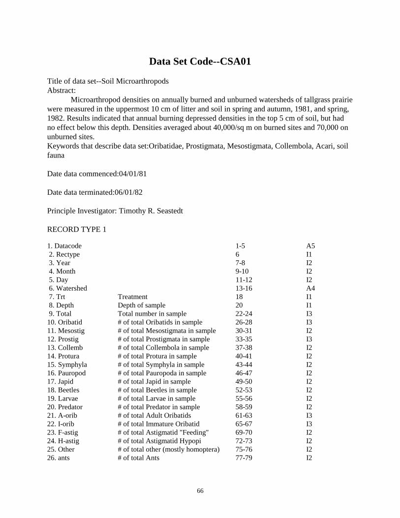
66
Data Set Code--CSA01 Title of data set--Soil Microarthropods Abstract: Microarthropod densities on annually burned and unburned watersheds of tallgrass prairie were measured in the uppermost 10 cm of litter and soil in spring and autumn, 1981, and spring, 1982. Results indicated that annual burning depressed densities in the top 5 cm of soil, but had no effect below this depth. Densities averaged about 40,000/sq m on burned sites and 70,000 on unburned sites. Keywords that describe data set:Oribatidae, Prostigmata, Mesostigmata, Collembola, Acari, soil fauna Date data commenced:04/01/81 Date data terminated:06/01/82 Principle Investigator: Timothy R. Seastedt RECORD TYPE 1 1. Datacode 1-5 A5 2. Rectype 6 I1 3. Year 7-8 I2 4. Month 9-10 I2 5. Day 11-12 I2 6. Watershed 13-16 A4 7. Trt Treatment 18 I1 8. Depth Depth of sample 20 I1 9. Total Total number in sample 22-24 I3 10. Oribatid # of total Oribatids in sample 26-28 I3 11. Mesostig # of total Mesostigmata in sample 30-31 I2 12. Prostig # of total Prostigmata in sample 33-35 I3 13. Collemb # of total Collembola in sample 37-38 I2 14. Protura # of total Protura in sample 40-41 I2 15. Symphyla # of total Symphyla in sample 43-44 I2 16. Pauropod # of total Pauropoda in sample 46-47 I2 17. Japid # of total Japid in sample 49-50 I2 18. Beetles # of total Beetles in sample 52-53 I2 19. Larvae # of total Larvae in sample 55-56 I2 20. Predator # of total Predator in sample 58-59 I2 21. A-orib # of total Adult Oribatids 61-63 I3 22. I-orib # of total Immature Oribatid 65-67 I3 23. F-astig # of total Astigmatid "Feeding" 69-70 I2 24. H-astig # of total Astigmatid Hypopi 72-73 I2 25. Other # of total other (mostly homoptera) 75-76 I2 26. ants # of total Ants 77-79 I2

67
Codes used: 1. Site UB Watershed 000b (old format) 2. Site 1C Watershed 001C 3. Site 1D Watershed 001D (3 and 4 not 4. Site D1 Watershed 001D consistent) 5. Site 4F Watershed 004F 6. Site NUD Watershed N00D 7. Site N1 Watershed N01B 8. Site N4 Watershed N04D 9. Site FN2 Forest transect N2: N branch Kings Cr. 10. Site FS3 Forest transect S3: S branch King Cr. 11. Site [number] Hulbert's plots 12. Trt T Tully 13. Trt F Florence 14. Trt U Unburned 15. Trt B Burned 16. Depth 0 0-5 cm deep 17. Depth 5 5-10 cm deep

68
Data Set Code--CSA02 Title of data set--Soil Macroarthropod Densities and Biomass ABSTRACT: Belowground densities and biomass of macroarthropods on annually burned and unburned watersheds were measured by hand-sorting techniques. Total herbivore biomass was greater in soils of annually burned sites, and was composed largely of white grubs (Scarabaeidae). Keywords that describe data set:soil herbivores, detritivores, predators, Scarabaeidae, Cicadidae Date data commenced:11/22/81 Date data terminated:04/01/83 Principle Investigator: Timothy R. Seastedt RECORD TYPE 1 Data Format Specification 1. Datacode 1-5 A5 2. Rectype 6 I1 3. Year 7-8 I2 4. Month 9-10 I2 5. Day 11-12 I2 6. Watershed 13-16 A4 7. Soil 21 A1 8. Trt 23-24 I2 9. Scarb-L # of Scarabaeidae beetle larvae 28-30 I3 #/.1m2 10. Scarb-A # of Scarabaeidae beetle adults 32 I1 #/.1m2 11. C-larv Chrysomelid, Weevil, misc herbivorous larvae 34-35 I2 #/.1m2 12. Cicada # of Cicada nymphs 37-38 I2 #/.1m2 13. Wire # of Wireworms 40 I1 #/.1m2 14. Pred-L # of Predaceous beetle larvae,carabids, etc 42-43 I2 #/.1m2 15. Millpd # of Millipedes 45-46 I2 #/.1m2 16. Centpd # of Centipede 48 I1 #/.1m2 17. Meloid # of Meloidae 50 I1 #/.1m2 18. Lep-L # of Lepidoptera larvae 52 I1 #/.1m2 19. Sow # of Sow bugs 54 I1 #/.1m2 20. Pred-A # of Adult beetles (predators) 56 I1 #/.1m2 21. Other # of other (cockroaches, etc. 58 I1 #/.1m2 22. Mherb of Misc herbivores 60 I1 #/.1m2 (e.g. adult chrysomelids) Start 1983 23. Mdet # of Misc detritivores 62-63 I1 #/.1m2 (e.g. Bibionidae larvae) Start 1983 24. Earth # of Earthworms 65-66 I1 #/.1m2 Start 1983

69
Codes Used: Name Value Code Value Soil T Tully TRT AB Annually burned UB Unburned 1B Burned once recently 2B Two year burn M3 Mowed 3 times a year M1 Mowed once a year RECORD TYPE 2 1. Datacode 1-5 A5 2. Rectype 6 I1 3. Year 7-8 I2 4. Month 9-10 I2 5. Day 11-12 I2 6. Watershed 13-16 A4 7. Soil 21 A1 8. Trt 23-24 I2 9. Bscarb-L # of Scarabaedidae beetle larvae 29-31 I3 g/.1m2 10. Bscarb-A Chrysomelid, Weevil, misc herbivorous larvae 33-34 I1 g/.1m2 11. Bc-larv # of Scarabaedidae beetel adults 36-37 I2 g/.1m2 12. Bcicada # of cicada nymphs 39-40 I2 g/.1m2 13. Bwire # of wireworms 42-43 I2 g/.1m2 14. Bprep-L # of predaceous beetle larvae (carabids, etc.) 45-46 I2 g/.1m2 15. Bmillpd # of Millipedes 48-50 I3 g/.1m2 16. Bcentpd # of Centipedes 52-53 I2 g/.1m2 17. Bmeloid # of Meloidae 55-56 I2 g/.1m2 18. Blep-L # of Lepidoptera larvae 58-59 I2 g/.1m2 19. Bsow # of Sow bugs 61-62 I2 g/.1m2 20. Bpred-A # of Adult beetles (predators) 64-66 I3 g/.1m2 21. Bother # of Other (cockroaches, etc.) 68-69 I2 g/.1m2 22. Bmherb # of Misc. herbivores (e.g. adult chrysomelids) 71-72 I2 g/.1m2 23. Bmdet # of Misc detritivores (e.g. Bibionidae larvae) 74-75 I2 g/.1m2 24. Bearth # of Earthworms 77-78 I2 g/.1m2 Codes used: Name Value Code Value Soil T Tully TRT AB Annually burned UB Unburned 1B Burned once recently 2B Two year burn M3 Mowed 3 times a year M1 Mowed once a year

70
Data Set Code--CSM04 Title of Data Set--Seasonal summary of numbers of small mammals on the LTER traplines in prairie Abstract: Data set contains seasonal summaries (spring, summer and fall) of the number of individuals of each species of small mammal caught (relative density) on each grassland census line. Each record contains trapline, year of last fire and number of individuals per species. These live trap records are based on daily captures during three 4-day trapping peroids, March, July and October, for each of 20 permanent census lines established on 10 fire-grazing treatments (2 lines per treatment). These 10 fire-grazing treatments are one unburned, one annual burn and one 4-year burn site to be grazed by native ungulates and one unburned, one annual burn, four 4-year burn and one 10-year burn site not grazed by ungulates. Keywords that describe data set: small mammals, rodents, density Date data commenced:10/01/81 Date data terminated: / / Principle Investigator: Donald W. Kaufman RECORD TYPE 1 Data Format Specification 1. Datacode 1-5 A5 2. Rectype 6 I1 3. Year 7-8 I2 4. Season Sampling season 9-10 A2 5. Watershed 13-19 A7 6. Line Line number 21 A1 7. PM Relative density of Peromyscus maniculatus 23-26 I4 8. Rmeg Relative density of Reithrodontomys megalotis 27-30 I4 9. PL Relative density of Peromyscus leucopus 31-34 I4 10. BH Relative density of Blarina hylophaga 35-38 I4 11. MO Relative density of Microtus ochrogaster 39-42 I4 12. SH Relative density of Sigmodon hispidus 43-46 I4 13. ST Relative density of Spermophilus tridecemlineatus 47-50 I4 14. SC Relative density of Synaptomys cooperi 51-54 I4 15. Rmon Relative density of Reithrodontomys montanus 55-57 I3 16. MM Relative density of Mus musculus 58-60 I3 17. PH Relative density of Perognathus hispidus 61-63 I3 18. ZH Relative density of Zapus hudsonius 64-66 I3 19. NF Relative density of Neotoma floridana 67-69 I3 20. CP Relative density of Cryptotis parva 70-72 I2 21. MP Relative density of Microtus pinetorum 73-75 I3 22. RN Relative density of Rattus norvegicus 76-78 I3 23. Century 79 I1

71
24. Cardnum 80 Codes used Season Sp Spring Su Summer Au Autumn Line E East W West N North S South

72
Data Set Code--CSM07 Title of data set--Seasonal summary of relative density of small mammals in wooded areas Abstract: No current description for this data set. Keywords that describe data set:small mammals, rodents, density Date data commenced:10/01/81 Date data terminated:03/28/88 Principle Investigator: Donald W. Kaufman RECORD TYPE 1 1. Datacode 1-5 A5 2. Rectype 6 I1 3. Year 7-8 I2 4. Season 9-10 A2 5. Watershed 13-19 A7 6. Line 21 A1 7. PL 23-36 I4 8. NF 27-30 I4 9. BH 31-34 I4 10. SH 35-38 I4 11. Rmeg 39-42 I4 12. MO 43-46 I4 13. MP 47-50 I4 14. ST 51-54 I4 15. ZH 55-57 I3 16. PM 58-60 I3 17. SC 61-63 I3 18. Rmon 64-66 I3 19. PH 67-69 I3 20. CP 70-72 I3 21. MM 73-75 I3 22. RN 76-78 I3 23. Century X 80 I1 See CSM04 for species codes. Codes used Season Sp Spring Su Summer Au Autumn Line L L1 or L2 line on ledges X XP line on "X" grid G G line on main grid

73
Data Set Code--CSM10 Title of data set--Seasonal summary of relative density of small mammals in brome fields Abstract: No current description for this data set. Keywords that describe data set:small mammals, rodents, density Date data commenced:10/01/81 Date data terminated:10/14/86 Principle Investigator: Donald W. Kaufman RECORD TYPE 1 Data Format Specification 1. Datacode 1-5 A5 2. Rectype 6 I1 3. Year 7-8 I2 4. Season 9-10 A2 5. Watershed 13-19 A7 6. Line 21 A1 7. PM 23-26 I4 8. Rmeg 27-30 I4 9. PL 31-34 I4 10. BH 35-38 I4 11. MO 39-42 I4 12. SH 43-46 I4 13. ST 47-50 I4 14. SC 51-54 I4 15. Rmon 55-57 I4 16. MM 58-60 I3 17. PH 61-63 I3 18. ZH 64-66 I3 19. NF 67-69 I3 20. CP 70-72 I3 21. MP 73-75 I3 22. RN 76-78 I3 23. Century 80 I3 Codes used:See CSM04

74
GIS Data
Data Set Code--GIS01 Title of data set--Geographical Information System coverages of Konza Prairie Abstract: A variety of coverages exist for Konza Prairie in either ARC/INFO or ERDAS format. For further information on these coverages contact the investigator listed below. These coverages are NOT in the “core” LTER data base, but reside in a different location. Keywords that describe data set: Geographical Information System Date data commenced: Date data terminated: Principle Investigator: John M. Briggs Current GIS Coverages (02 March 1993) include: 1) Digital Elevation Map (DEM). It has a horizontal resolution of 25 meters and a vertical scale in tenths of feet. 2) Slope derived from the DEM. 3) Aspect derived from the DEM. 4) Roads, trail, pipelines and powerlines. 5) Boundary Lines 6) Fence Lines 7) Geology 8) Research Treatment Areas 9) Soils 10) Woody trees and shrubs of selected watersheds (See PWV01). 11) Geomorphology 12) Stream drainage patterns 13) Aerial photographs of Konza Prairie showing extent of gallery forest in 1939, 1950,1969 and 1985.

75
Nutrient Data
Data Set Code--NBC01 Title of data set--Belowground Studies: Soil Chemistry Abstract: Effects of burning, mowing, and N + P additions on soil chemistry are measured on the 64 belowground plots every two years. Variables measured include P, N03, NH4, Mn, Cu, K, Zn, Ca, Fe, Mg, Na, ph, Organic matter and Organic-N. Keywords that describe data set:soil nutrients, chemistry nitrate, ammonia, phosphorus, belowground plots Date data commenced:06/01/86 Date data terminated: / / Principle Investigator: Arthur P. Schwab RECORD TYPE 1 Data Format Specification 1. Datacode 1-5 A5 2. Rectype 6 I1 3. Year 7-8 I2 4. Month 9-10 I2 5. Day 11-12 I2 6. Watershed 13-16 A4 7. PN Plot number 18-19 I2 8. Suprplot Super plot number (Block number) 21 A1 9. Burn Burned or unburned 23 A1 10. Mow Mowed or unmowed 25 A1 11. Nutrient Nutrient in Block 27 A1 12. Depth 29-30 I2 cm 13. Nitrate 32-36 F5.1 14. Ammonia 38-42 F5.1 15. Phsphros 44-46 I3 16. Total N 48-51 I4 17. PH 53-55 F3.1 18. Orgncmat 57-60 F4.1 19. K 62-65 I4 20. ZN 67-69 F3.1 21. FE 71-73 I3

76
22. Lime 75-78 I4 RECORD TYPE 2 Data Format Specification 1. Datacode 1-5 A5 2. Rectype 6 I1 3. Year 7-8 I2 4. Month 9-10 I2 5. Day 11-12 I2 6. Watershed 13-16 A4 7. PN 18-19 I2 8. Suprplot 21 A1 9. Burn 23 A1 10. Mow 25 A1 11. Nutrient 27 A1 12. Depth 29-30 I2cm 13. Nitrate 32-36 F5.1 14. Ammonia 38-42 F5.1 15. Phsphros 44-46 I3 16. MN 48-51 I4 17. PH 53-55 F3.1 18. CU 57-60 F4.1 19. K 62-65 I4 20. ZN 67-69 F3.1 21. FE 71-73 I3 22. Lime 75-78 I4

77
Data Set Code--NBS01 Title of data set--Soil Water Chemistry from Lysimeters on Belowground Plots Abstract: Soil water nitrogen composition is measured using porous cup lysimeters from samples from nitrogen fertilized and control plots. Measurements include nitrate, ammonium, phosphate, and organic nitrogen and phosphorus. Keywords that describe data set: Lysimeters, nitrogen, fertilizer, burning, nitrate, ammonium, phosphate, organic N and P, soil water Date data commenced: 04/18/1991 Date data terminated: / / Principle Investigator: John Blair RECORD TYPE 1 Data Format Specification 1. Datacode 1-5 A5 2. Rectype 6 I1 3. Year 7-8 I2 4. Month 9-10 I2 5. Day 11-12 I2 6. Watershed 13-16 A4 7. Plot # 18-19 I2 8. Volume 21-24 9. NO3 26-33 10. NH4 35-42 11. TPN 44-51 12. TPP 53-56 13. PO4 58-62 14. Comments 64-80

78
Data Set Code--NPL01 Title of data set--Prairie Litterfall Abstract: Litter falling to the soil surface of tallgrass prairie was measured using 5 cm x 100 cm litterfall troughs. Mass, nitrogen, and phosphorus content are measured monthly or seasonally. Variables of interest include burning frequency and soil type. Keywords that describe data set:litterfall, nitrogen, phosphorus, organic matter Date data commenced:07/01/81 Date data terminated: 12/11/90 Principle Investigator: John M. Blair RECORD TYPE 1 Data Format Specification 1. Datacode 1-5 A5 2. Rectype 6 I1 3. Year 7-8 I2 4. Month 9-10 I2 5. Day 11-12 I2 6. Watershed 13-16 A4 7. Soil Soil type 18-19 A2 8. AD Accumulation Day 21-23 I3 Days 9. Mass Oven-dry mass 25-29 F5.2 G/0.5X 10. ID Collector identification # 31-32 I2 11. Comments 35-80 Codes used: Soil TU Tully Soil FL Florence RECORD TYPE 2 1. Datacode 1-5 A5 2. Rectype 6 I1 3. Year 7-8 I2 4. Month 9-10 I2 5. Day 11-12 I2 6. Watershed 13-16 A4 7. Soil Soil type or slope 18-19 A2 8. Day Collection days 21-23 I3 Days 9. Mass Oven-dry mass 25-29 F5.2 10. N Nitrogen content 31-35 F5.3 1982;F4.2

79
11. P Phosphorus content 37-41 F5.3 %X 12. Collect Number of collectors composited 43-44 I2 13. Rep Ident. of sample groups w/chemistry 45 A1 Discon. 83 14. Comments 50-80 A31 15. Block Samples proc. togeth. w/=blk nos. 50 I1 Codes used: Soil TU Tully Soil FL Florence

80
Data Set Code--NSC01 Title of data set--Soil Chemistry and Bulk Density Abstract: Soil bulk density and chemical characteristics were measured on all LTER vegetation plots. Variables measured vary from sampling periods. Sampling is done every five years, thus a separate data format exists for each sampling period. Keywords that describe data set: nitrogen, organic matter, phosphorus, cations Date data commenced:10/01/81 Date data terminated: / / Principle Investigator: Arthur P. Schwab RECORD TYPE 1 Data Format Specification for 1982. 1. Datacode 1-5 A5 2. Rectype 6 I1 3. Year 7-8 I2 4. Month 9-10 I2 5. Day 11-12 I2 6. Watershed 13-16 A4 7. Soil 18-19 A2 8. Site 21 A1 9. Depth 23-24 I2 cm 10. CEC Cation exchange capacity 26-29 F4.1 Meq/10 11. pH 31-33 F3.1 12. CACO3 Calcium carbonate 35-38 I4 LB/Acr 13. P Phosphorus 40-41 I2 cm 14. Na Sodium 43-46 I3 ppm 15. K Potassium 48-51 I4 LB/Acr 16. O.M. Organic matter 53-56 F4.1 % Dry 17. Ca Calcium 58-61 I4 ppm 18. Mg Magnesium 63-65 I3 ppm 19. Totn Total Nitrogen 67-70 I4 % Dry 20. Bulkd Bulk Density 72-76 F5.3 g/cm3* Data Format Specification for 1987. 1. Datacode 1-5 A5 2. Rectype 6 I1 3. Year 7-8 I2 4. Month 9-10 I2 5. Day 11-12 I2 6. Watershed 13-16 A4 7. Soil 18-19 A2 8. Site 21 A1 9. Depth 23-24 I2 cm 10. pH 31-33 F3.1

81
11. P Phosphorus 40-41 I2 lb/acr 12. Na Sodium 43-46 I2 ppm 13. K Potassium 48-51 I4 LB/Acr 14. O.M. Organic Matter 53-56 F4.1 % Dry 15. Ca Calcium 58-61 I4 LB/Acr 16. Mg Magnesium 63-65 I3 17. Totn Total Nitrogen 67-70 I4 % Dry Data Format Specification for 1992. 1. Datacode 1-5 A5 2. Rectype 6 I1 3. Year 7-8 I2 4. Month 9-10 I2 5. Day 11-12 I2 6. Watershed 13-16 A4 7. Soil 18-19 8. Transect 21 9. Depth 23-24 I2 10. CEC Cation exchange capacity 26-29 F4.1 Meq/10 11. pH 31-33 F3.1 12. CACO3 Calcium carbonate 35-38 I4 LB/Acr 13. P Phosphorus 40-41 I2 cm 14. Na Sodium 43-46 I3 ppm 15. K Potassium 48-51 I4 LB/Acr 16. O.M. Organic matter 53-56 F4.1 % Dry 17. Ca Calcium 58-61 I4 ppm 18. Mg Magnesium 63-65 I3 ppm 19. Totn Total Nitrogen 68-71 F4.2 % Dry 20. C 73-76 F4.2 % 21. %h2o 78-81 F4.2 % 22. nh4 83-86 F4.2 23. no3 88-91 F4.2 24. lime 93-96 I4 LB/Acr 25. %sand 98-101 F4.1 % 26. %silt 103-106 F4.1 % 27. %clay 108-111 F4.1 %

82
Data Set Code--NSW01 Title of data set--Soil Water Chemistry Abstract: Soil water nitrogen composition is measured using porous cup lysimeters. Measurements include nitrate, ammonia, phosphate, and organic nitrogen and phosphorus. Variables of interest are rainfall patterns, vegetation types, and time since burning. Keywords that describe data set: lysimeters, nitrogen, nitrate, ammonia, organic, soil, water Date data commenced: 03/01/82 Date data terminated: 12/01/90 Principle Investigator: John M. Blair RECORD TYPE 1 Data Format Specification 1. Datacode 1-5 A5 2. Rectype 6 I1 3. Year 7-8 I2 4. Month 9-10 I2 5. Day 11-12 I2 6. Watershed 13-16 A4 7. Lysident Lysimeter identification number 21-22 I2 8. Depth Depth of sample 24 I1 dm 9. Volume Volume of sample 26-30 I5 ml 10. Nitrate Nitrate-nitrogen 32-37 F6.1 u/lX 11. Ammonia Ammonia-nitrogen 39-43 F5.1 u/lX End 12/83 12. TPN * = Organic -N+NH4+N03 45-48 I4 u/l Int. 01/83 13. Kjeldahl = Organic -N+NH4 50-53 I5 u/l End 12/82 14. PO4 * 56-60 F5. 1 u/l 1986 only 15. Comments 62-80 A25 * = on monthly composite samples only micrograms/liter 0-

83
Data Set Code--NTF01 Title of data set--Throughfall Abstract: Amounts and nitrogen content of water passing through the canopy of tallgrass prairie are compared to similar measurements of bulk precipitation. Measurements include nitrate, ammonia, phosphate and organic nitrogen and phosphorus content of bulk precipitation and throughfall. Variables of interest include vegetation type and amounts, time of year, and time since burning. Keywords that describe data set: nitrogen, canopy, throughfall, interception Date data commenced:03/19/82 Date data terminated: / / Principle Investigator: John M. Blair RECORD TYPE 1 Data Format Specification 1. Datacode 1-5 A5 2. Rectype 6 I1 3. Year 7-8 I2 4. Month 9-10 I2 5. Day 11-12 I2 6. Watershed 13-16 A4 7. ppt Amount of rainfall 18-22 F5.1 mm 8. ID Collector identification number 24-25 I2 9. THR Amount collected below canopy 27-31 F5.1 mm 10. Comments 34-80 A48 RECORD TYPE 2 Data Format Specification 1. Datacode 1-5 A5 2. Rectype 6 I1 3. Year 7-8 I2 4. Month 9-10 I2 5. Day 11-12 I2 6. Watershed 13-16 A4 7. Type 18 A1 B or T 8. ID Collector identification number 20-21 I2 9. Amount Sample volume 23-27 F5.1 mmX 10. NO3 Conc. of nitrate-n ppb 29-33 I5 ppb(u)

84
11. NH4 Conc. of ammonia-n ppb 35-39 I5 ppb(u) Can. 12/85 12. TPN Conc. of organic-n 41-45 I5 ppb(u) Tkn 83/01 13. PO4 Conc. of Phosphate 47-51 I5 ppb(ug) began 2/86 14. Comment 53-80 A28 Codes used: Type B Bulk precipitation collector Type T Throughfall collector
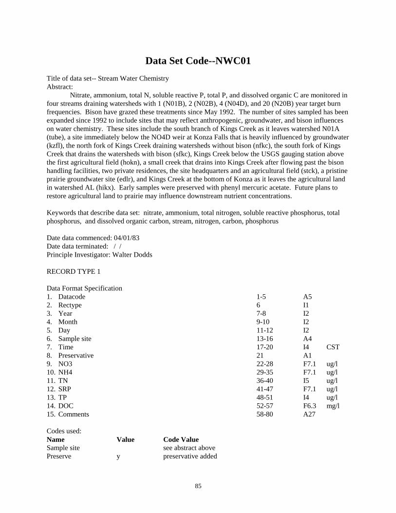
85
Data Set Code--NWC01 Title of data set-- Stream Water Chemistry Abstract: Nitrate, ammonium, total N, soluble reactive P, total P, and dissolved organic C are monitored in four streams draining watersheds with 1 (N01B), 2 (N02B), 4 (N04D), and 20 (N20B) year target burn frequencies. Bison have grazed these treatments since May 1992. The number of sites sampled has been expanded since 1992 to include sites that may reflect anthropogenic, groundwater, and bison influences on water chemistry. These sites include the south branch of Kings Creek as it leaves watershed N01A (tube), a site immediately below the NO4D weir at Konza Falls that is heavily influenced by groundwater (kzfl), the north fork of Kings Creek draining watersheds without bison (nfkc), the south fork of Kings Creek that drains the watersheds with bison (sfkc), Kings Creek below the USGS gauging station above the first agricultural field (hokn), a small creek that drains into Kings Creek after flowing past the bison handling facilities, two private residences, the site headquarters and an agricultural field (stck), a pristine prairie groundwater site (edlr), and Kings Creek at the bottom of Konza as it leaves the agricultural land in watershed AL (hikx). Early samples were preserved with phenyl mercuric acetate. Future plans to restore agricultural land to prairie may influence downstream nutrient concentrations. Keywords that describe data set: nitrate, ammonium, total nitrogen, soluble reactive phosphorus, total phosphorus, and dissolved organic carbon, stream, nitrogen, carbon, phosphorus Date data commenced: 04/01/83 Date data terminated: / / Principle Investigator: Walter Dodds RECORD TYPE 1 Data Format Specification 1. Datacode 1-5 A5 2. Rectype 6 I1 3. Year 7-8 I2 4. Month 9-10 I2 5. Day 11-12 I2 6. Sample site 13-16 A4 7. Time 17-20 I4 CST 8. Preservative 21 A1 9. NO3 22-28 F7.1 ug/l 10. NH4 29-35 F7.1 ug/l 11. TN 36-40 I5 ug/l 12. SRP 41-47 F7.1 ug/l 13. TP 48-51 I4 ug/l 14. DOC 52-57 F6.3 mg/l 15. Comments 58-80 A27 Codes used: Name Value Code Value Sample site see abstract above Preserve y preservative added

86
Preserve n no preservative added

87
Data Set Code: NWC02 Title of data set-- Stream Water Conductivity Abstract: Conductivity was monitored in four streams draining watersheds with 1 (N01B), 2 (N02B), 4 (N04D), and 20 (N20B) year target burn frequencies. Bison grazed these treatments since May 1992. Early samples were preserved with phenyl mercuric acetate. Keywords that describe data set: conductivity, salinity, stream Date data commenced: 04/01/83 Date data terminated: 6/21 /93 Principle Investigator: Walter Dodds RECORD TYPE 1 Data Format Specification 16. Datacode 1-5 A5 17. Rectype 6 I1 18. Year 7-8 I2 19. Month 9-10 I2 20. Day 11-12 I2 21. Sample site 13-16 A4 22. Type Type of Sample 17 A1 23. Timeint Time interval between bottles 19-20 I2 min 24. Sampool # of samples/ bottle 21-22 I2 25. Time Collection time last bottle 23-26 I4 CST 26. Estcode e = time estimated 27 A1 27. Preservative preserve added 28 A1 28. Conduct. Specific conductance 29-31 I3 uS/cm 29. Comments 32-80 A48 Codes used: Name Value Code Value Sample Site See abstract above Type g Grab sample Type I Isco (automatic) sample Estcode blank sample time unknown Estcode e sample time estimated Preserve y preservative added Preserve n no preservative added

88
Producer Data
Data Set Code--PAB01 Title of data set--Aboveground primary production Abstract: Data set contains estimates of standing crop biomass (grams per square meter) of live, graminoids, forbs and woody plants, current year's dead, and previous year's dead vegetation for 2 soil types (shallow and deep) and various burning-grazing treatments. Estimates made in mid-April, mid-July, and November from 1983-1988 but only at peak standing crop biomass starting in 1989. Twenty quadrats (0.1 square meters) are harvested for each soil/treatment type. In addition, bi-weekly estimates of standing crop biomass are taken on watersheds 001a and 020a. Keywords that describe data set: aboveground biomass, primary production, graminoids, forbs, current years dead, previous years dead Date data commenced: 04/01/84 Date data terminated: / / Principle Investigator: Alan K. Knapp RECORD TYPE 1 Data Format Specification 1. Datacode 1-5 A5 2. Rectype 6 I1 3. Year 7-8 I2 4. Month 9-10 I2 5. Day 11-12 I2 6. Watershed 13-16 A4 7. Soil Soil type tully, florence, or irwin 21-22 A2 8. Transect Transect (A, B, C, D, or X 24 A1 9. Plotnum Plot number (1-5 or 1-20 on 001a and 020a) 26-27 A2 10. Lvgrass Mass of live grass 29-34 F6.2 G/.1m2 11. Forbs Mass of forbs 36-41 F6.2 G/.1m2 12. Cuyrdead Mass of current years dead 43-48 F6.2 G/.1m2 13. Pryrdead Mass of previous years dead 50-55 F6.2 G/.1m2 14. Woody Mass of woody (As of 24 Aug 1992) 57-62 F6.2 Lead plant (Amorpha canescens Pursh) Wild rose (Rosa arkansana) Smooth sumac (Rhus glabra L.) New Jersey tea (Ceanothus herbaceous) Dogwood (Cornus drummondii) Buckbrush (Symphoricarpos orbiculatus Moench) Codes usedL Soil TU Tully soil Soil Fl Florence soil Soil IR Irwin soil

89
Notes: Due to sorting error, data from 1986-1988, should be used with caution. The peak estimates appear to be okay, but earlier dates appear to overestimate current years dead. RECORD TYPE 2 Data Format Specification 1. Datacode 1-5 A5 2. Rectype 6 I1 3. Year 7-8 I2 4. Month 9-10 I2 5. Day 11-12 I2 6. Watershed 13-16 A4 7. Soil Soil Type 21-22 A2 8. Transect Transect (A, B, C, D) 24 A1 9. Plotnum Plot number (1-5) 26 A1 10. Type (lv, cd, pd, fb) 29-30 A2 11. Mass Mass of sample 32-37 F6.2 g/.1m2 12. Nitrogen Percent Nitrogen 40-44 F5.3 % 13. Phosphor Percent Phosphorous 47-51 F5.3 % 14. Box Number 54-62 A9 15. Comments 64-80 A16 Codes used: Name Value Code Value Soil TU Tully soil Fl Florence soil IR Irwin soil Type lv Live grass cd Current Dead pd Previous dead fb Forbs RECORD TYPE 3--Aboveground biomass (1976-1979) Data Format Specification 1. Datacode 1-5 A5 2. Rectype 6 I1 3. Year 7-8 I2 4. Month 9-10 I2 5. Day 11-12 I2 6. Watershed 13-16 A4 7. ST Soil type 18-19 A2 8. LVM Mass of clipped sample (live) 21-24 F4.1 g/.1m2 9. LVVAR Variance of live mass samples 26-31 F6.2 g/.1m2 10. DM Mass of dead clipped vegetation 32-35 4.1 g/.1m2 11. DVAR Variance of dead mass 37-42 F6.2 g/.1m2 12. TOTM Mass of total veg. per .1 mxm plot g/.1m2 44-48 F5.1 g/.1m2 13. Totvar Variance of total mass data 50-55 F6.2 g/.1m2 14. # Number of clipped plots 57-58 I2

90
Data Set Code--PAB03 Title of Data Set--Aboveground Primary Production Prior to LTER Clipping Abstract: No current description for this data set. Keywords that describe data set: aboveground biomass, primary production, graminoids, forbs, current years dead, previous years dead Date data commenced: 1975 Date data terminated: 1983 Primary Investigator: John M. Briggs

91
Data Set Code--PAB04 Title of data set--Regional aboveground primary production Abstract: Aboveground primary production data from surrounding tallgrass prairie sites are combined with Konza Prairie LTER data. Methods vary slightly among sites, but in general, all aboveground biomass is harvested from quadrants at the time of peak aboveground biomass in burned and/or unburned, ungrazed productive tallgrass prairie sites at The Land Institute (South of Salina, KS), Arrapaho Prairie (in the sandhills of Western Nebraska), Nine-Mile Prairie (in Omaha, Nebraska), and the Ross Natural Area (in SE Kansas, near Emporia). Biomass is sorted into live graminoid, forb and woody plants, current year dead and previous years' dead components. Keywords that describe data set: aboveground biomass, NPP, regional NPP, graminoids, forbs, current year dead, previous year dead. Date data set commenced: varies with site Date data set terminated: / / Principle Investigator: Alan K. Knapp Data not yet entered into LTER data base (02 March 1993).

92
Data Set Code--PBB01 Title of data set--Aboveground biomass on belowground plots Abstract: Peak foliage biomass is measured annually in late summer on the 64 belowground plots. Effects of burning, mowing and N + P additions on aboveground NPP are measured. (1-2 0.1m2 quadrats harvested per plots). Keywords that describe data set: mowing, nitrogen, phosphorus, belowground plots Date data commenced: 11/15/86 Date data terminated: / / Principle Investigator: Charles W. Rice 1. Datacode 1-5 A5 2. Rectype 6 A1 3. Year 7-8 I2 4. Month 9-11 I2 5. Day 12-13 I2 6. Watershed 13-16 A4 7. Plot # Plot number (1-64) 18-19 I2 9. Replicate Code A or B 21 A1 10. Subplot Sub plot 23 A1 11. Burn Burned treatment 25 A1 12. Mow Mow treatment 27 A1 13. Nutrient Nutrient treatment 29 A1 14. Lvgrass Live grass (g/0.1m2) 32-36 F5.2 15. Forbs Forbs (g/0.1m2) 39-43 F5.2 16. Cuyrdd Current years dead (g/0.1m2) 46-50 F5.2 17. Pryrdd Previous years dead (g/0.1m2) 53-57 F5.2 18. Woody (As of 24 Aug 1992) 60-64 F5.2 lead plant-Amorpha canescens rose-Rosa arkansas (smooth) sumac-Rhus glabra New Jersey tea-Ceanothus ovatus dogwood-Cornus drummondi buck brush-symphoricarpos orbiculatus 19. Comments Comments 66-80 A14 Codes Used: Name Value Code Value Replicate A,B Code A or B Plot 1-64 Plot number Burn treatment U:B U=Unburn B=Burn Mow treatment U;M U=unmowed M=mowed Nutrient treatment C,N,P,B C=control, N=nitrogen P=Phosphorus B=Both

93
Data Set Code--PBB02 Title of data set--Biomass of Rhizomes, Nitrogen & Phosphorous Content on Belowground Studies Plots. Abstract: Standing crops of live and dead rhizomes (0.1 sq. m2 * 20cm deep samples) are taken in late summer every 5 years from 64 belowground plots. N & P content are determined on live and dead rhizomes. N& P for forb rhizomes are available for some plots in some years. **See archived rawdata files in Rm 215 Bushnell. Keywords that describe data set: Rhizomes, Belowground Plots, Nitrogen, Phosphorus Date data commenced:11/15/86 Date data terminated: / / Principle Investigator: Charles W. Rice RECORD TYPE 1: Data Format Specification 1. Datacode 1-5 A5 2. Rectype 6 I1 3. Year 7-8 I2 4. Month 9-10 I2 5. Day 11-12 I2 6. Watershed 13-16 A4 7. Plot Plot Number (1-64) 18-19 A2 8. Live Rhizomes Mass of Sample 22-26 F2.2 9. % Nitrogen % N of Live Rhizomes 29-33 F1.3 10. % Phosphorous % P of Live Rhizomes 35-39 F1.3 11. Dead Rhizomes Mass of Sample 42-46 F2.2 12. % Nitrogen % N of Dead Rhizomes 49-53 F1.3 13. % Phosphorous % P of Dead Rhizomes 55-59 F1.3 14. Live Forbs Mass of Sample 62-66 F2.2 15. % Nitrogen % N of Forbs 69-73 F1.3 16. % Phosphorous % P of Forbs 75-79 F1.3 Codes Used:

94
Data Set Code--PBB03 Title of data set--Biomass of Roots, Nitrogen &Phosphorous Content on Belowground Studies Plots. Abstract: Standing crops of live and dead grass roots(0.1 sq. m2 * 20cm deep samples) are taken in late summer every 5 years from 64 belowground plots. N&P content are determined on live and dead grass roots. N&P for forb roots are available for some plots in some year. **See archived rawdata files in Rm 215 Bushnell. Keywords that describe data set: Roots, Belowground Plots, Nitrogen, Phosphorus Date data commenced: 11/15/86 Date data terminated: / / Principle Investigator: Charles W. Rice RECORD TYPE1: Data Format Specification 1. Datacode 1-5 A5 2. Rectype 6 I1 3. Year 7-8 I2 4. Month 9-10 I2 5. Day 11-12 I2 6. Watershed 13-16 A4 7. Plot 18-19 A2 8. Live Roots 22-26 F2.2 9. % Nitrogen 29-33 F1.3 10. % Phosphorous 35-39 F1.3 11. Dead Roots 42-46 F2.2 12. % Nitrogen 49-53 F1.3 13. % Phosphorous 55-59 F1.3 14. Live Forbs 62-66 F2.2 15. % Nitrogen 69-73 F1.3 16. % Phosphorous 75-73 F1.3 Codes Used:

95
Data Set Code--PEB01 Title of data set--Primary Production in Grazing Exclosures Abstract: To determine long term effects of bison grazing on aboveground primary production. Keywords that describe data set: aboveground biomass, grasses, forbs, woody species Date data commenced: / /1992 Date data terminated: / / Principle Investigator: David Hartnett RECORD TYPE 1 Data Format Specification 1. Datacode 1-5 A5 2. Rectype 6 I1 3. Year 7-8 I2 4. Month 9-10 I2 5. Day 11-12 I2 6. Watershed 13-16 A4 7. (g or u) (g=grazed, u=ungrazed) 21 A2 8. Cage 23-24 A1 9. Plotnum Plot number 26-27 A2 10. Lvgrass Mass of live grass 30-34 F6.2 G/.1m2 11. Forbs Mass of forbs 37-41 F6.2 G/.1m2 12. Cuyrdead Mass of current years dead 44-48 F6.2 G/.1m2 13. Pryrdead Mass of previous years dead 50-55 F6.2 G/.1m2 14. Woody Mass of woody 58-62 F6.2

96
Data Set Code--PFS01 Title of data set--Reproductive effort of Big Bluestem, Indiangrass, and Little Bluestem on Belowground Plots Abstract: No current description for this data set. Keywords that describe data set: flower stem density, flower stem height, big bluestem, little bluestem,indiangrass, belowground plots Date data commenced: 07/01/86 Date data terminated: 10/15/88 Principle Investigator: David C. Hartnett RECORD TYPE 1 Data Format Specification 1. Datacode 1-5 A5 2. Rectype 6 A1 3. Year 7-8 I2 4. Month 9-11 I2 5. Day 12-13 I2 6. Watershed 13-16 A4 7. Plot Plot number (1-64) 18-19 I2 8. Subplot 21 A1 9. Burn Burn treatment 23 A1 10. Mow Mow treatement 25 A1 11. Nutrient Nutrient treatment 27 A1 12. Species Species name 29-32 A4 13. Fstemht Flower stem height 34-37 F4.2 meters 14. Fsdnsity Flower density 0.25m squared 39-41 I3 #/M Codes Used: Name Value Code Value Plot 1-64 Plot number Burn treatment U:B U=Unburn B=Burn Mow treatment U;M U=unmowed M=mowed Nutrient treatment C,N,P,B C=control, N=Nitrogen P=Phosphorus B=Both Species Ange Ange=Andropogon gerardii Species ANSC ANSC=Andropogon scoparius Species SONU SONU=Sorgastrum nutans

97
Data Set Code--PGL01 Title of data set--Gallery Forest Litterfall Abstract: Litterfall of a Kansas gallery forest is measured with 60, deep-dish litterfall collecters. Mass of wood, seeds, and foliage are recorded separately. Keywords that describe data set: forest, litterfall, wood, seed Date data commenced: 10/01/81 Date data terminated: / / Principle Investigator: John M. Briggs RECORD TYPE 1 Data Format Specification 1. Datacode 1-5 A5 2. Rectype 6 I1 3. Year 7-8 I2 4. Month 9-10 I2 5. Day 11-12 I2 6. Watershed 13-16 A4 7. Branch Branch of Kings Creek 18 A1 8. ID Identification number 20-21 I2 9. Mass Total (include wood & seed) 23-29 F7.2 10. Wood Woody mass 31-37 F7.2 11. Seed Seed mass (include husks, hulls 39-44 F6.2 12. Comment 48-80 A33 Codes used: Name Value Code Value Branch N North branch of Kings Creek S South branch of Kings Creek
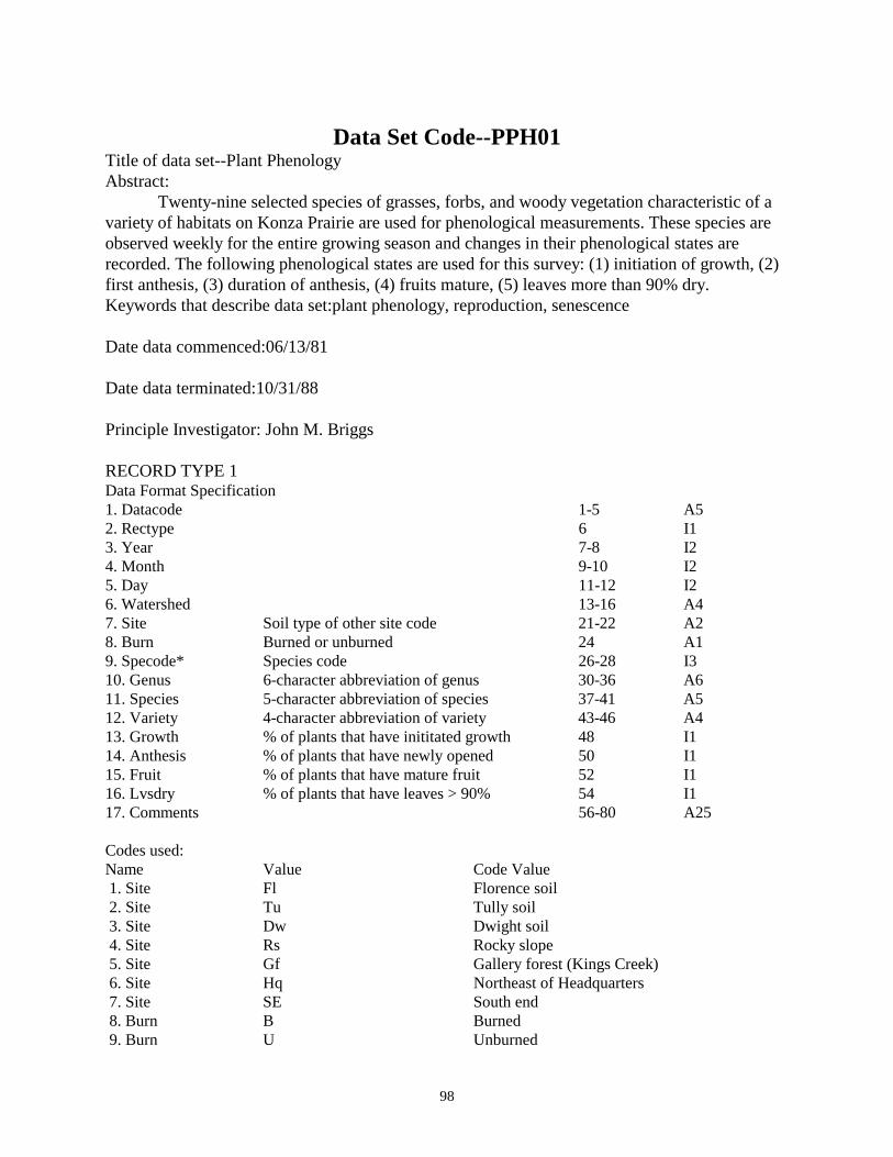
98
Data Set Code--PPH01 Title of data set--Plant Phenology Abstract: Twenty-nine selected species of grasses, forbs, and woody vegetation characteristic of a variety of habitats on Konza Prairie are used for phenological measurements. These species are observed weekly for the entire growing season and changes in their phenological states are recorded. The following phenological states are used for this survey: (1) initiation of growth, (2) first anthesis, (3) duration of anthesis, (4) fruits mature, (5) leaves more than 90% dry. Keywords that describe data set:plant phenology, reproduction, senescence Date data commenced:06/13/81 Date data terminated:10/31/88 Principle Investigator: John M. Briggs RECORD TYPE 1 Data Format Specification 1. Datacode 1-5 A5 2. Rectype 6 I1 3. Year 7-8 I2 4. Month 9-10 I2 5. Day 11-12 I2 6. Watershed 13-16 A4 7. Site Soil type of other site code 21-22 A2 8. Burn Burned or unburned 24 A1 9. Specode* Species code 26-28 I3 10. Genus 6-character abbreviation of genus 30-36 A6 11. Species 5-character abbreviation of species 37-41 A5 12. Variety 4-character abbreviation of variety 43-46 A4 13. Growth % of plants that have inititated growth 48 I1 14. Anthesis % of plants that have newly opened 50 I1 15. Fruit % of plants that have mature fruit 52 I1 16. Lvsdry % of plants that have leaves > 90% 54 I1 17. Comments 56-80 A25 Codes used: Name Value Code Value 1. Site Fl Florence soil 2. Site Tu Tully soil 3. Site Dw Dwight soil 4. Site Rs Rocky slope 5. Site Gf Gallery forest (Kings Creek) 6. Site Hq Northeast of Headquarters 7. Site SE South end 8. Burn B Burned 9. Burn U Unburned

99
10. Specode 001 Androp smith 11. Specode 002 Androp gerar 12. Specode 003 Androp scopa 13. Specode 004 Boutel curti 14. Specode 014 Dichan oligo scri 15. Specode 015 Panicu virga 16. Specode 017 Poa prate 17. Specode 018 Sorgha nutan 18. Specode 021 Sporob asper aspe 19. Specode 023 Sporob heter 20. Specode 032 Carex gravi lune 21. Specode 034 Carex meadi 22. Specode 040 Amorph canes 23. Specode 058 Aster erico 24. Specode 061 Astrag crass cras 25. Specode 065 Baptis austr mino 26. Specode 066 Baptis bract glab 27. Specode 091 Liatri punct 28. Specode 094 Lomati foeni 29. Specode 109 Dalea purpu purp 30. Specode 121 Salvia pitch 31. Specode 122 Schran nutta 32. Specode 128 Solida misso fasc 33. Specode 164 Cornus drumm 34. Specode 189 Tripsa dacty 35. Specode 200 Celtis occid 36. Specode 234 Rhus glabr 37. Specode 304 Quercu muehl 38. Specode 354 Populu delto moni 39. Growth 1 0-5% plants initiated growth 40. Growth 2 5-20% plants initiated growth 41. Growth 3 > 20% plants inititated growth 42. Anthesis 1 0-5% plants w/new open flower 43. Anthesis 2 5-20% plants w/new open flower 44. Anthesis 3 0-5% plants have mature fruit 46. Fruit 2 5-20% plants have mature fruit 47. Fruit 3 > 20% plants have mature fruit 48. Lvsdry 1 0-5% plants leaves > 90% dry 49. Lvsdry 2 5-20% plants leaves > 90% dry 50. Lvsdry 3 > 20% plants leaves > 90% dry

100
Data Set Code--PRE02 Title of data set--Reproductive effort of Big Bluestem, Indiangrass and Little Bluestem ABSTRACT: Data set contains estimates of flowering stem height (m), density (no. per sq. m) and production (grams per sq. m) and total seed weight (grams) and production (grams per sq. m) for big bluestem, indiangrass and little bluestem on 2 soil types (shallow and deep) with 6 burn-grazing treatment combinations. Sampling done once a year in October (end of growing season). (Sampling design slightly altered from pre01.) Keywords that describe data set:seed weight, flower stem density, flower stem height, big bluestem,little bluestem, indiangrass Date data commenced:09/01/82 Date data terminated: / / Principle Investigator: David C. Hartnett RECORD TYPE 1 Data Format Specification 1. Datacode 1-5 A5 2. Rectype 6 I1 3. Year 7-8 I2 4. Month 9-10 I2 5. Day 11-12 I2 6. Watershed 13-16 A4 7. Soil Soil type Florence or Tully 18-19 A2 8. Species Species name 21-24 A4 9. Transect Transect (A,B,C,D) 26 A1 10. Point Point number (1-20) 28-29 I2 # 11. Flwstht Flowering stalk height 31-34 F4.2 Meters 12. Seedwt Seed weight 36-39 F4.2 Grams 13. Seednum Number of seeds 41-44 I4 14. Comments 46-80 A35 Codes used: Name Value Code Value Species ANGE Andropogon gerardii Species ANSC Andropogon scoparius Species SONU Sorgastrum nutans Soil TU Tully soil Soil FL Florence soil RECORD TYPE 2 1. Datacode 1-5 A5

101
2. Rectype 6 I1 3. Year 7-8 I2 4. Month 9-10 I2 5. Day 11-12 I2 6. Watershed 13-16 A4 7. Soil Soil type (florence or tully) 18-19 A2 Tu or Fl 8. Species Species name 21-24 A4 9. Transect Transect (A,B,C,D) 26 A1 10. Plot Quadrat number 28-29 I2 11. Stalk Number of flowering stalks/0.25 sq. m 31-33 I3 #/.25 12. Flwstht Flowering stalk weight/0.25 sq m 35-40 P6.2 G/.25 13. Comments 3-80 A38 Codes Used: Name Value Code Value Species ANGE Andropogon gerardii Species ANSC Andropogon scoparius Species SONU Sorgastrum nutans Soil TU Tully soil Soil FL Florence soil

102
Data Set Code--PRW01 Title of data set--Root Windows Abstract: Eight root windows (40cm X 40cm) are used to measure root production and decay on a 2 factor-factorial experiment (Burning, Mowing). Root lengths are traced every two weeks during the growing season. Production, disappearance and standing crops (lengths) are calculated by 10 cm increments. Keywords that describe data set:root lengths, root growth, root, root decomposition, belowground Date data commenced:02/01/86 Date data terminated:10/ 03 /89 Principle Investigator: Timothy R. Seastedt NO DESCRIPTION OF DATA FILES!!!!!!

103
Data Set Code--PTN01 Title of data set--1D/UB Transect Studies Abstract: In 1989, single transects spanning upland-lowland-upland topographic positions were established in a long-term unburned and an annually burned watershed. Standing crop biomass data are collected in late season at 11 sites along each transect and sorted into live graminoids, forbs and woody plants, current year's dead, and previous years dead vegetation. Four 0.1 m2 quadrats are harvested at each of the 11 sites per watershed and all data except previous years' dead are combined to provide an estimate of aboveground NPP. In 1993, soil moisture measurements began along each transect at 15 and 30 cm depths (where possible) with a Time Domain Reflectomerty System. Measurements are made twice a month from March - October and intermittently during the winter months. In 1992, litter bags were also placed along the transect to assess landscape variation in decomposition processes. Keywords that describe the data set: Aboveground biomass, net primary production, graminoids, forbs, topography, landscape, soil moisture, decomposition. Date data commenced: 08/15/1989 Date data terminated: 09/00/1996 Principle Investigator: John Blair Record type 1 -- Aboveground biomass Data Format Specification for 1989 and 1991 1. Datacode 1-5 A5 2. Rectype 6 I1 3. Year 7-8 I2 4. Month 9-10 I2 5. Day 11-12 I2 6. Watershed 13-16 A4 8. Transect Transect (1-11) 23-24 I2 9. Plotnum Plot number (a,b,c,d) 27 A1 10. Lvgrass Mass of live grass 29-34 F6.2 G/.1m2 11. Forbs Mass of forbs 36-41 F6.2 G/.1m2 12. Cuyrdead Mass of current years dead 43-48 F6.2 G/.1m2 13. Pryrdead Mass of previous years dead 50-55 F6.2 G/.1m2 14. Comments 58-80 A23 Data Format Specification for 1990 1. Datacode 1-5 A5 2. Rectype 6 I1 3. Year 7-8 I2 4. Month 9-10 I2 5. Day 11-12 I2 6. Watershed 13-16 A4 7. Transect Transect (1-11) 18-19 I2

104
8. Lvgrass Mass of live grass 21-25 F5.2 G/.1m2 9. Lvgrse Standard error of live grass 27-32 F5.2 10. Forbs Mass of forbs 33-37 F5.2 G/.1m2 11. Forbse Standard error of forbs 38-43 F5.2 12. Cuyrdead Mass of current years dead 45-49 F5.2 G/.1m2 13. Cuyrdese Standard error of currents years dead 51-55 F5.2 14. Pryrdead Mass of previous years dead 57-62 F5.2 G/.1m2 15. Pryrdese Standard error of previous years dead 64-66 F5.2 16 Total Total aboveground biomass (Livegrass + forbs + current years dead) 70-74 F5.2 G/.1m2 17. Totalse Standard error of total aboveground biomass 76-80 F5.2 Data Format Specification for 1992 on. 1. Datacode 1-5 A5 2. Rectype 6 I1 3. Year 7-8 I2 4. Month 9-10 I2 5. Day 11-12 I2 6. Watershed 13-16 A4 8. Transect Transect (1-11) 23-24 I2 9. Plotnum Plot number (a,b,c,d) 27 A1 10. Lvgrass Mass of live grass 29-34 F6.2 G/.1m2 11. Forbs Mass of forbs 36-41 F6.2 G/.1m2 12. Cuyrdead Mass of current years dead 43-48 F6.2 G/.1m2 13. Pryrdead Mass of previous years dead 50-55 F6.2 G/.1m2 14. Woody (As of 24 Aug 1992) 57-62 A23 lead plant-Amorpha canescens rose-Rosa arkansas (smooth) sumac-Rhus glabra New Jersey tea-Ceanothus ovatus dogwood-Cornus drummondi buckbrush-symphoricarpos orbiculatus 15. Comments 64-80 Record Type 2—001d/020b TDR reading. Data Format Specification: 1: Datacode 1-5 A5 2: Rectype 6 I1 3: Year 7-8 I2 4: Month 9-10 I2 5: Day 11-12 I2 6: Watershed 13-16 A4 7: Depth 15 or 30 cm 19-22 A4 8: Tag Number 26-28 I3 9: Reading 30-37 I8 10: % Volumetric H2O based on the TOPP equation 39-47 I9 11: Comments 49-80 A41
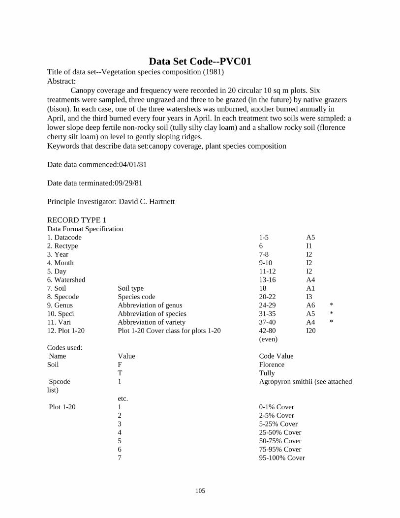
105
Data Set Code--PVC01 Title of data set--Vegetation species composition (1981) Abstract: Canopy coverage and frequency were recorded in 20 circular 10 sq m plots. Six treatments were sampled, three ungrazed and three to be grazed (in the future) by native grazers (bison). In each case, one of the three watersheds was unburned, another burned annually in April, and the third burned every four years in April. In each treatment two soils were sampled: a lower slope deep fertile non-rocky soil (tully silty clay loam) and a shallow rocky soil (florence cherty silt loam) on level to gently sloping ridges. Keywords that describe data set:canopy coverage, plant species composition Date data commenced:04/01/81 Date data terminated:09/29/81 Principle Investigator: David C. Hartnett RECORD TYPE 1 Data Format Specification 1. Datacode 1-5 A5 2. Rectype 6 I1 3. Year 7-8 I2 4. Month 9-10 I2 5. Day 11-12 I2 6. Watershed 13-16 A4 7. Soil Soil type 18 A1 8. Specode Species code 20-22 I3 9. Genus Abbreviation of genus 24-29 A6 * 10. Speci Abbreviation of species 31-35 A5 * 11. Vari Abbreviation of variety 37-40 A4 * 12. Plot 1-20 Plot 1-20 Cover class for plots 1-20 42-80 I20 (even) Codes used: Name Value Code Value Soil F Florence T Tully Spcode 1 Agropyron smithii (see attached list) etc. Plot 1-20 1 0-1% Cover 2 2-5% Cover 3 5-25% Cover 4 25-50% Cover 5 50-75% Cover 6 75-95% Cover 7 95-100% Cover

106
PVCNAMES: SPECIES LIST for 1981 001 agropy smith Agropyron smithii 002 androp gerar Andropogon gerardii 003 androp scopa Andropogon scoparius 004 boutel curti Bouteloua curtipendula 005 boutel graci Bouteloua gracilis 006 boutel hirsu bouteloua hirsuta 007 buchlo dacty buchloe dactyloides 008 chlori verti chloris verticillata 009 elymus canad elymus canadensis 010 elymus virgi elymus virginicus 011 eragro spect eragrostis spectabilis 012 koeler pyram koeleria pyramidata (k. cristata) 013 muhlen cusp muhlenbergia cuspidata 014 dichan oligo scri dichanthelium oligosanthes var scribnerianum (panicum o.) 015 panicu virga panicum virgatum 016 dichan acumi dichanthelium acuminatum (panicum praecocius) 017 poa prate poa pratensis 018 sorgha nutan sorghastrum nutans (s. avenaceum) 019 sparti pecti spartina pectinata 020 spheno obtus obtu sphenopholis obtusata var. obtusata 021 sporob asper aspe sporobolus asper var. asper 022 sporob crypt sporobolus cryptandrus 023 sporob heter sporobolus heterolepis 024 aristi oliga aristida oligantha 025 bromus japon bromus japonicus 026 bromus tecto bromus tectorum 027 festuc octof festuca octoflora 028 hordeu pusil hordeum pusillum 029 panicu capil panicum capillare 030 schedo panic schedonnardus paniculatus 031 carex brevi carex brevior 032 carex gravi lune carex gravida var. lunelliana 033 carex helio carex heliophila 034 carex meadi carex meadii 035 carex bland carex blanda 036 cyperu lupul lupu cyperus lupulinus subsp. lupulinus (C. filiculmis) 037 cyperu schwe cyperus schweinitzii 038 eleoch compr eleocharis compressa 039 eleoch eryth eleocharis erythropoda 040 amorph canes amorpha canescens 041 ceanot herba pube ceanothus herbaceus var. pubescens 042 rosa arkan rosa arkansana (r. suffulta) 043 sympho orbic symphoricarpos orbiculatus 044 achill mille lanu achillea millefolium subsp. lanulosa 045 allium canad allium canadense 046 ambros psilo ambrosia psilotachya 047 andros occid androsace occidentalis 048 anemon carol anemone caroliniana 049 antenn negle negl antennaria neglecta var. neglecta (A. campestris)

107
050 apocyn canna pocynum cannabinum (including a. sibiricum) 051 argemo polya argemone polyanthemos 052 artemi ludov ludo artemisia ludoviciana var. ludoviciana 053 asclep lanug sclepias lanuginosa (probably a. viridiflora) 054 asclep steno asclepias stenophylla 055 asclep verti asclepias verticillata 056 asclep virds asclepias viridis 057 asclep tuber nte asclepias tuberosa subsp. interior 058 aster erico aster ericoides 059 aster oblon aster oblongifolius 060 aster seric aster sericeus 061 astrag crass cras astragalus crassicarpus var. crassicarpus 062 astrag lotif astragalus lotiflorus 063 astrag platt astragalus plattensis 064 astrag canad astragalus canadensis 065 baptis austr mino baptisia australis var. minor 066 baptis bract glab baptisia bracteata var. glabrescens (b. leucophaea) 067 cacali plant cacalia plantaginea (c. tuberosa) 068 callir alcae callirhoe alcaeoides 069 callir invol callirhoe involucrata 070 cirsiu undul cirsium undulatum 071 conyza canad cana conyza canadensis var. canadensis (erigeron canadensis) 072 croton monan croton monanthogynus 073 delphi carol vire delphinium carolinianum subsp. virescens (d. virescens) 074 descur pinna brac descurainia pinnata var. brachycarpa 075 draba repta draba reptans 076 echina angus echinacea angustifolia (e. pallida var. angustifolia) 077 eriger strig stri erigeron strigosus var. strigosus 078 euphor margi euphorbia marginata 079 euphor spath uphorbia spathulata 080 euphor glypt euphorbia glyptosperma 081 gerani carol geranium carolinianum 082 hedeom hispi hedeoma hispida 083 hierac longi hieracium longipilum 084 hybant verti hybanthus verticillatus 085 hymeno scabi cory hymenopappus scabiosaeus var. corymbosus 086 kuhnia eupat cory kuhnia eupatoroides var. corymbulosa 087 lactuc serri lactuca serriola 088 lathyr polym poly lathyrus polymorphus var. polymorphus 089 lepidi densi lepidium densiflorum 090 lesped capit lespedeza capitata 091 liatri punct liatris punctata 092 linum sulca linum sulcatum 093 lithos incis lithospermum incisum 094 lomati foeni lomatium foeniculaceum 095 micros cuspi microseris cuspidata 096 coryph misso miss coryphantha missouriensis var.missouriensis(Mamillaria mis 097 oenoth macro macr oenothera macrocarpa subsp.macrocarpa (o. missouriensis) 098 artems ludov artemisia ludoviciana(no var.) see also 52 and 267 099 oenoth speci oenothera speciosa
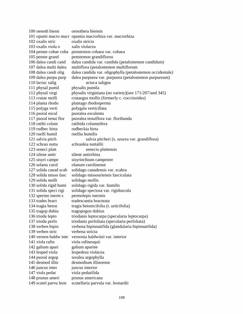
108
100 oenoth bienn oenothera biennis 101 opunti macro macr opuntia macrorhiza var. macrorhiza 102 oxalis stric oxalis stricta 103 oxalis viola o xalis violacea 104 penste cobae coba penstemon cobaea var. cobaea 105 penste grand penstemon grandiflorus 106 dalea candi cand dalea candida var. candida (petalostemon candidum) 107 dalea multi dalea multiflora (petalostemon multiflorum 108 dalea candi olig dalea candida var. oligophylla (petalostemon occidentale) 109 dalea purpu purp dalea purpurea var. purpurea (petalostemon purpureum) 110 lactuc salig actuca saligna 111 physal pumil physalis pumila 112 physal virgi physalis virginiana (no variety)(see 171/207/and 345) 113 cratae molli crataegus mollis (formerly c. coccinoides) 114 planta rhodo plantago rhodosperma 115 polyga verti polygala verticillata 116 psoral escul psoralea esculenta 117 psoral tenui flor psoralea tenuiflora var. floribunda 118 ratibi colum ratibida columnifera 119 rudbec hirta rudbeckia hirta 120 ruelli humil ruellia humilis 121 salvia pitch salvia pitcheri (s. azurea var. grandiflora) 122 schran nutta schrankia nuttallii 123 seneci platt senecio plattensis 124 silene antir silene antirrhina 125 sisyri campe sisyrinchium campestre 126 solanu carol olanum carolinense 127 solida canad scab solidago canadensis var. scabra 128 solida misso fasc solidago missouriensis fasciculata 129 solida molli solidago mollis 130 solida rigid humi solidago rigida var. humilis 131 solida speci rigi solidago speciosa var. rigiduscula 132 spermo inerm s permolepis inermis 133 trades bract tradescantia bracteata 134 tragia beton tragia betonicifolia (t. urticifolia) 135 tragop dubiu tragopogon dubius 136 trioda lepto triodanis leptocarpa (specularia leptocarpa) 137 trioda perfo triodanis perfoliata (specularia perfoliata) 138 verben bipin verbena bipinnatifida (glandularia bipinnatifida) 139 verben stric verbena stricta 140 vernon baldw inte vernonia baldwinii var. interior 141 viola rafin viola rafinesquii 142 galium apari galium aparine 143 lesped viola lespedeza violacea 144 psoral argop soralea argophylla 145 desmod illin desmodium illinoense 146 juncus inter juncus interior 147 viola pedat viola pedatifida 148 prunus ameri prunus americana 149 scutel parvu leon scutellaria parvula var. leonardii

109
150 agrost hyema agrostis hyemalis 151 lesped stipu espedeza stipulacea 152 asclep virdf asclepias viridiflora 153 eupato rugos eupatorium rugosum 154 comand umbel pall comandra umbellata subsp. pallida 155 agalin asper agalinis aspera (gerardia aspera) 156 acalyp virgi acalypha virginica 157 myosot verna myosotis verna 158 ulmus ameri ulmus americana 159 pariet pensy parietaria pensylvanica 160 ambros trifi ambrosia trifida 161 asclep syria asclepias syriaca 162 taraxa offic taraxacum officinale 163 medica lupul medicago lupulina 164 cornus drumm cornus drummondii 165 cyperu spp cyperus spp. 166 chenop album chenopodium album 167 panicu perlo panicum perlongum 168 leptol cogna leptoloma cognatum 169 capsel bursa capsella bursa-pastoris 170 stroph leios strophostyles leiosperma 171 physal virgi sono physalis virginiana var. sonorae 172 euphor corol euphorbia corollata 173 174 gaura parvi gaura parviflora 175 zigade nutta zigadenus nuttallii 176 onosmo molle occi onosmodium molle var. occidentale 177 rumex crisp r umex crispus 178 bromus inerm iner bromus inermis subsp. inermis 179 prunel vulga prunella vulgaris 180 teucri canad virg teucrium canadense var. virginicum 181 equise laevi quisetum laevigatum 182 lotus corni lotus corniculatus 183 grinde squar squa grindelia squarrosa var. squarrosa 184 rumex altis rumex altissimus 185 calyst macou calystegia macounii (convolvulus sepium) 186 melilo offic melilotus officinalis 187 verbas blatt verbascum blattaria 188 silphi integ laev silphium integrifolium var. laeve (s. speciosum) 189 tripsa dacty tripsacum dactyloides 190 setari glauc setaria glauca (s. lutescens) 191 lycopu ameri lycopus americanus 192 cynanc laeve cynanchum laeve 193 euphor denta euphorbia dentata 194 physal heter physalis heterophylla 195 digita sangu Digitaria sanguinalis 196 heliop helia scab heliopsis helianthoides var. scabra 197 carduu nutan carduus nutans 198 nepeta catar nepeta cataria 199 gledit triac gleditsia triacanthos
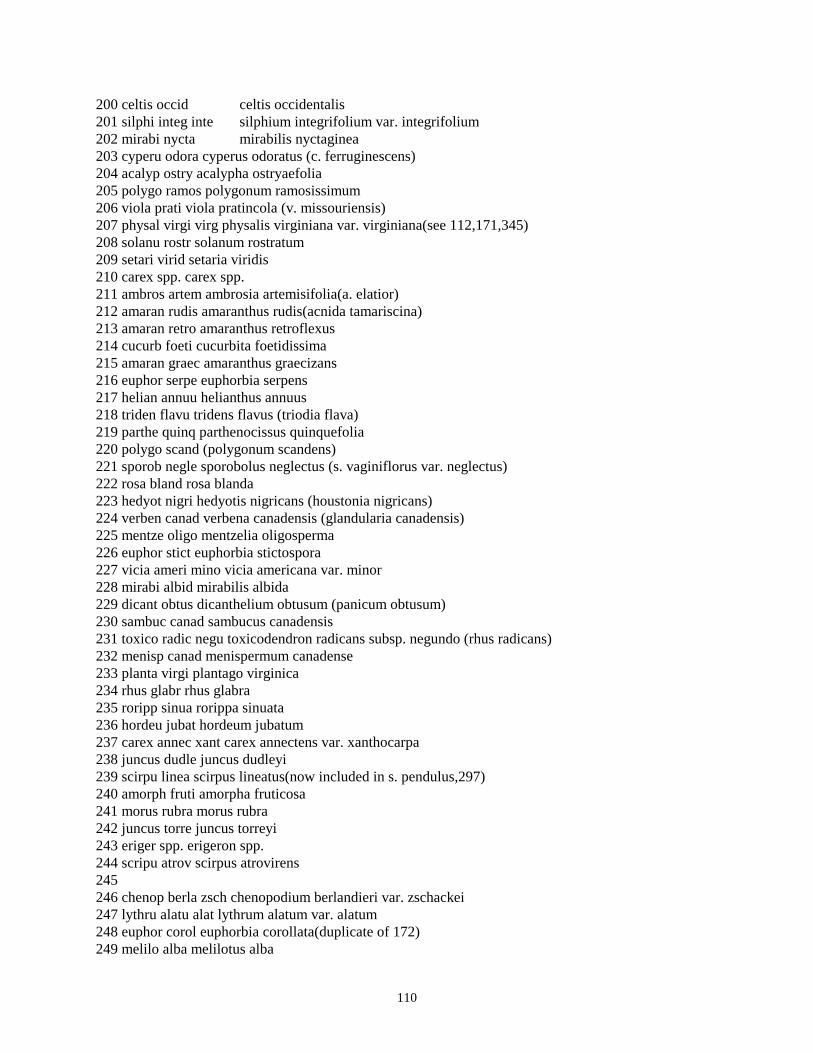
110
200 celtis occid celtis occidentalis 201 silphi integ inte silphium integrifolium var. integrifolium 202 mirabi nycta mirabilis nyctaginea 203 cyperu odora cyperus odoratus (c. ferruginescens) 204 acalyp ostry acalypha ostryaefolia 205 polygo ramos polygonum ramosissimum 206 viola prati viola pratincola (v. missouriensis) 207 physal virgi virg physalis virginiana var. virginiana(see 112,171,345) 208 solanu rostr solanum rostratum 209 setari virid setaria viridis 210 carex spp. carex spp. 211 ambros artem ambrosia artemisifolia(a. elatior) 212 amaran rudis amaranthus rudis(acnida tamariscina) 213 amaran retro amaranthus retroflexus 214 cucurb foeti cucurbita foetidissima 215 amaran graec amaranthus graecizans 216 euphor serpe euphorbia serpens 217 helian annuu helianthus annuus 218 triden flavu tridens flavus (triodia flava) 219 parthe quinq parthenocissus quinquefolia 220 polygo scand (polygonum scandens) 221 sporob negle sporobolus neglectus (s. vaginiflorus var. neglectus) 222 rosa bland rosa blanda 223 hedyot nigri hedyotis nigricans (houstonia nigricans) 224 verben canad verbena canadensis (glandularia canadensis) 225 mentze oligo mentzelia oligosperma 226 euphor stict euphorbia stictospora 227 vicia ameri mino vicia americana var. minor 228 mirabi albid mirabilis albida 229 dicant obtus dicanthelium obtusum (panicum obtusum) 230 sambuc canad sambucus canadensis 231 toxico radic negu toxicodendron radicans subsp. negundo (rhus radicans) 232 menisp canad menispermum canadense 233 planta virgi plantago virginica 234 rhus glabr rhus glabra 235 roripp sinua rorippa sinuata 236 hordeu jubat hordeum jubatum 237 carex annec xant carex annectens var. xanthocarpa 238 juncus dudle juncus dudleyi 239 scirpu linea scirpus lineatus(now included in s. pendulus,297) 240 amorph fruti amorpha fruticosa 241 morus rubra morus rubra 242 juncus torre juncus torreyi 243 eriger spp. erigeron spp. 244 scripu atrov scirpus atrovirens 245 246 chenop berla zsch chenopodium berlandieri var. zschackei 247 lythru alatu alat lythrum alatum var. alatum 248 euphor corol euphorbia corollata(duplicate of 172) 249 melilo alba melilotus alba

111
250 euphor pubis euphorbia pubiserrate(??) 251 dicant acumi vill dicanthelium acuminatum var.villosum(panicum villosissimum 252 lesped viola lespedeza violacea(duplicate of 143) 253 mirabi linea mirabilis linearis 254 255 monard fistu fist monarda fistulosa var. fistulosa 256 tricho brach trichostema brachiatum(isanthus brachiatus) 257 acalyp monoc acalypha monococca 258 probos louis proboscidea louisianica 259 monard citri monarda citriodora 260 zizia aurea zizia aurea 261 torili arven torilis arvensis 262 rhus aroma arom rhus aromatica var. aromatica 263 rhus aroma sero rhus aromatica var. serotina 264 arisae draco arisaema dracontium 265 asclep sulli asclepias sullivantii 266 krigia oppos krigia oppositifolia 267 artemi ludov mexi artemisia ludoviciana var.mexicana(see also 98 and 52) 268 sonchu asper sonchus asper 269 xanthi strum cana xanthium strumarium var. canadense 270 aster simpl ramo aster simplex var. ramosissimus 271 helian petio peti helianthus petiolaris var. petiolaris 272 dyssod pappo dyssodia papposa 273 lactuc canad (lactuca canadensis) 274 conyza ramos conyza ramosissima 275 silphi lacin silphium laciniatum 276 cynogl offic cynoglossum officinale 277 hackel virgi hackelia virginiana 278 nastur offic nasturtium officinale 279 erysim repan erysimum repandum 280 roripp palus rorippa palustris 281 lobeli cardi lobelia cardinalis 282 campan ameri campanula americana 282 cannab sativ sati cannabis sativa subsp. sativa 284 triost perfo perf triosteum perfoliatum var. perfoliatum 285 silene stell silene stellata 286 euonym atrop euonymus atropurpureus 287 chenop gigan chenopodium gigantospermum 288 chenop palle chenopodium pallescens 289 kochia scopa kochia scoparia 290 commel erect angu commelina erecta var. angustifolia 291 convol arven convolvulus arvensis 292 pentho sedoi penthorum sedoides 293 junipe virgi juniperus virginiana 294 295 carex hyste carex hystericina 296 scirpu valid scirpus validus 297 scirpu pendu scirpus pendulus 298 cyperu acumi cyperus acuminatus 299 euphor prost euphorbia prostrata

112
300 euphor nutan euphorbia nutans 301 euphor missu euphorbia missurica 302 euphor cyath euphorbia cyathophora 303 croton capit croton capitatus 304 quercu muehl quercus muehlenbergii 305 quercu macro quercus macrocarpa 306 hyperi perfo hypericum perforatum 307 aescul glabr argu aesculus glabra var. arguta 308 sisyri angus (sisyrinchium angustifolium) 309 carya cordi carya cordiformis 310 juglan nigra juglans nigra 311 agasta nepet agastache nepetoides 312 mentha arven mentha arvensis 313 salvia refle salvia reflexa 314 stachy palus (stachys palustris) 315 leonur cardi leonurus cardiaca 316 yucca glauc yucca glauca 317 gymnoc dioic gymnocladus dioica 318 crotal sagit crotalaria sagittalis 319 glycyr lepid glycyrrhiza lepidota 320 desmod gluti desmodium glutinosum 321 desman illin desmanthus illinoensis 322 cassia maril cassia marilandica 323 cassia chama cassia chamaecrista (c. fasciculata) 324 cercis canad cersis canadensis 325 abutil theop abutilon theophrasti 326 hibisc trion hibiscus trionum 327 malvas hispi malvastrum hispidum (sphaeralcea angusta) 328 morus alba morus alba 329 fraxin penns subi fraxinus pennsylvanica var. subintegerrima 330 calylo serru calylophus serrulatus (oenothera serrulata) 331 oenoth villo vill oenothera villosa subsp. villosa(o. strigosa) 332 spiran verna spiranthes vernalis 333 334 phryma lepto phryma leptostachya 335 phytol ameri phytolacca americana 336 planta rugel plantago rugelii 337 planta arist plantago aristata 338 planta patag pata plantago patagonica var. patagonica(p. purshii) 339 platan occid platanus occidentalis 340 muhlen racem muhlenbergia racemosa 341 muhlen frond muhlenbergia frondosa 342 panicu lanug fasc panicum lanuginosum var.fasciculatum(p. villosissimum) 343 aristi purpu purp aristida purpurea var. purpurea 344 cenchr longi cenchrus longispinus 345 physal virgi hisp physalis virginiana var. hispida 346 mimulu glabr frem mimulus glabratus var. fremontii 347 leucos multi leucospora multifida (conobea multifida) 348 bacopa rotun bacopa rotundifolia 349 ribes misso ribes missouriense

113
350 comman umbel umbe (commandra umbellata subsp. umbellata)(misidentified) 351 salix exigu inte salix exigua subsp. interior 352 salix nigra salix nigra 353 salix amygd salix amygdaloides 354 populu delto moni populus deltoides subsp. monilifera 355 zantho ameri zanthoxylum americanum 356 galium circa galium circaezans 357 geum canad geum canadense 358 fragar virgi fragaria virginiana 359 prunus angus prunus angustifolia 360 prunus besse (prunus besseyi - misidentified) 361 rubus ostry rubus ostryifolia 362 smilax hispi smilax hispida 363 clemat pitch clematis pitcheri 364 thalic dasyc thalictrum dasycarpum 365 nothol dealb notholaena dealbata 366 pellae glabe glab pellaea glabella var. glabella 367 woodsi obtus woodsia obtusa 368 polygo achor polygonum achoreum 369 polygo lapat polygonum lapathifolium 370 polygo pensy polygonum pensylvanicum 371 polygo persi polygonum persicaria 372 polygo punct polygonum punctatum 373 stipa spart stipa spartea 374 sitani hystr brev sitanion hystrix var. brevifolium 375 glycer stria glyceria striata 376 leersi oryzo leersia oryzoides 377 hystri patul hystrix patula 378 paspal setac muhl paspalum setaceum var. muhlenbergii 379 echino crusg echinochloa crusgalli 380 verben bract verbena bracteata 381 verben urtic verbena urticifolia 382 tilia ameri tilia americana 383 typha latif typha latifolia 384 solanu ameri solanum americanum (s. nigrum) 385 physal pubes miss physalis pubescens var. missouriensis 386 veroni caten cate veronica catenata var. catenata 387 verbas thaps verbascum thapsus 388 scroph lance scrophularia lanceolata 389 liatri asper liatris aspera 390 tribul terre tribulus terrestris 391 vitis ripar vitis riparia 392 botryc virgi botrychium virginianum 393 ruelli strep ruellia strepens 394 acer negun acer negundo 395 asimin trilo asimina triloba 396 chaero procu chaerophyllum procumbens 397 sanicu canad sanicula canadensis 398 arctiu minus arctium minus 399 aster drumm aster drummondii

114
400 aster laevi aster laevis 401 aster subul ligu aster subulatus var. ligulatus 402 bidens bipin bidens bipinnata 403 bidens cernu bidens cernua 404 bidens frond bidens frondosa 405 bidens polyl bidens polylepis 406 chryso canes chrysopis canescens 407 cirsiu altis cirsium altissimum 408 cirsiu vulga cirsium vulgare 409 eriger phila erigeron philadelphicus 410 eupato altis eupatorium altissimum 411 helian tuber helianthus tuberosus 412 liatri mucro liatris mucronata 413 verbes alter verbesina alternifolia 414 ostrya virgi ostrya virginiana 415 lithos arven lithospermum arvense 416 lithos canes lithospermum canescens 417 alliar petio alliaria petiolata 418 cameli micro camelina microcarpa 419 dentar lacin dentaria laciniata 420 draba cunei draba cuneifolia 421 hesper matro hesperis matronalis 422 thlasp arven thlaspi arvense 423 lobeli siphi lobelia siphilitica 424 dianth armer dianthus armeria 425 celast scand celastrus scandens 426 chenop stand chenopodium standleyanum (c. boscianum) 427 monole nutta monolepis nuttalliana 428 evolvu nutta evolvulus nuttallianus 429 ipomoe heder ipomoea hederacea 430 sicyos angul sicyos angulatus 431 cuscut glome cuscuta glomerata 432 astrag misso astragalus missouriensis 433 desmod panic dill desmodium paniculatum var. dillenii 434 desmod sessi desmodium sessilifolium 435 coryda micra corydalis micrantha 436 dicent cucul dicentra cucullaria 437 ellisi nycte ellisia nyctelea 438 ammann cocci ammannia coccinea 439 sida spino sida spinosa 440 maclur pomif maclura pomifera 441 stenos linif stenosiphon linifolius 442 phlox divar laph phlox divaricata var. laphamii 443 polygo amphi emer polygonum amphibium var. emersum (p. coccineum) 444 portul olera portulaca oleracea 445 lysima cilia lysimachia ciliata 446 ranunc abort ranunculus abortivus 447 prunus virgi prunus virginiana 448 penste tubae tuba penstemon tubaeflorus var. tubaeflorus 449 tomant densi tomanthera densiflora (gerardia densiflora)

115
450 veroni pereg xala veronica peregrina var. xalapensis 451 urtica dioic grac urtica dioica subsp. gracilis 452 lippia lance lippia lanceolata (phyla lanceolata) 453 verben hasta verbena hastata 454 alisma subco alisma subcordatum 455 sagitt latif sagittaria latifolia 456 trades ohien tradescantia ohiensis 457 allium stell allium stellatum 458 aspara offic asparagus officinalis 459 erythr albid erythronium albidum 460 najas guada najas guadalupensis 461 agrost stolo majo agrostis stolonifera var. major (a. alba) 462 androp ischa song andropogon ischaemum var. songaricus 463 erioch contr eriochloa contracta 464 phleum prate phleum pratense 465 potamo folio potamogeton foliosus 466 potamo nodos potamogeton nodosus 467 potamo pusil pusi potamogeton pusillus var. pusillus 468 veroni agres veronica agrestis 469 stroph helvo strophostyles helvola 470 lactuc ludov lactuca ludoviciana

116
Data Set Code--PVC02 Title of data set--Vegetation species composition Abstract: Canopy coverage and frequency were recorded in 20 circular 10 sq m plots. Six treatments were sampled, three ungrazed and three to grazed by native grazers. In each case one of the three watersheds was unburned, another burned annually in April, the third burned every four years in April. In each treatment two soils were sampled: a lower-slope deep fertile non-rocky soil (tully silty clay loam), and a shallow rocky soil (florence cherty silt loam) on level to gently sloping ridges. In 1983 another ungrazed annual burn area (1c) was added (both tully and florence soils) because original area (1d) appeared aberrant. Keywords that describe data set:canopy coverage, plant species composition Date data commenced:04/01/82 Date data terminated: / / Principle Investigators:David C. Hartnett/Scott L. Collins RECORD TYPE 1 Data Format Specification 1. Datacode 1-5 A5 2. Rectype 6 I1 3. Year 7-8 I2 4. Month 9-10 I2 5. Day 11-12 I2 6. Watershed 13-16 A4 7. Observer Number assigned to observer 17 I1 8. Soil Soil type (florence or tully) 18 A1 9. Specode Species code 20-22 I3 10. Genus Abbreviation of genus 24-29 A6 11. Speci Abbreviation of species 31-35 A5 12. Vari Abbreviation of variety 37-40 A4 13. A1-A5 Cover class for plots in transect A 42-50 I1 Even col. 14. B1-B5 Cover class for plots in transect B 52-60 I1 Even col. 15. C1-C5 Cover class for plots in transect C 62-70 I1 Even col. 16. D1-D5 Cover class for plots in transect D 72-80 I1 Even col. 17. E1-E5 * Cover class for plots in transect E * 82-90 I1 Even col. * Transect E only occurred on watershed N20B florence in 1986 and 1987. This transect is the same as the current transect D for this watershed and soil type. The old transect D was abandoned in 1987 prior to bison reintroduction. Codes used: Name Value Code Value Soil F Florence T Tully Spcode 1 Agropyron smithii (see attached list) etc.

117
Plot 1-20 1 0-1% Cover 2 2-5% Cover 3 5-25% Cover 4 25-50% Cover 5 50-75% Cover 6 75-95% Cover 7 95-100% Cover PVCNAMES: SPECIES LIST for 1982 on. 001 agropy smith agropyron smithii 002 androp gerar andropogon gerardii 003 androp scopa andropogon scoparius 004 boutel curti bouteloua curtipendula 005 boutel graci bouteloua gracilis 006 boutel hirsu bouteloua hirsuta 007 buchlo dacty buchloe dactyloides 008 chlori verti chloris verticillata 009 elymus canad elymus canadensis 010 elymus virgi elymus virginicus 011 eragro spect eragrostis spectabilis 012 koeler pyram koeleria pyramidata (k.cristata) 013 muhlen cuspi muhlenbergia cuspidata 014 dichan oligo scri dichanthelium oligosanthes var scribnerianum (panicum o.) 015 panicu virga panicum virgatum 016 dichan acumi dichanthelium acuminatum (panicum praecocius) 017 poa prate poa pratensis 018 sorgha nutan sorghastrum nutans (s. avenaceum)1 019 sparti pecti spartina pectinata 020 spheno obtus obtu phenopholis obtusata var. obtusata 021 sporob asper aspe sporobolus asper var. asper 022 sporob crypt sporobolus cryptandrus 023 sporob heter sporobolus heterolepis 024 aristi oliga aristida oligantha 025 bromus japon bromus japonicus 026 bromus tecto bromus tectorum 027 festuc octof festuca octoflora 028 hordeu pusil hordeum pusillum 029 panicu capil panicum capillare 030 schedo panic schedonnardus paniculatus 031 carex brevi carex brevior 032 carex gravi lune carex gravida var. lunelliana 033 carex helio carex heliophila 034 carex meadi carex meadii 035 carex bland carex blanda 036 cyperu lupul lupu cyperus lupulinus subsp. lupulinus (C. filiculmis) 037 cyperu schwe cyperus schweinitzii 038 eleoch compr eleocharis compressa

118
039 eleoch eryth eleocharis erythropoda 040 amorph canes amorpha canescens 041 ceanot herba pube ceanothus herbaceus var. pubescens 042 rosa arkan rosa arkansana (r. suffulta) 043 sympho orbic symphoricarpos orbiculatus 044 achill mille lanu achillea millefolium subsp.lanulosa 045 allium canad allium canadense 046 ambros psilo ambrosia psilotachya 047 andros occid androsace occidentalis 048 anemon carol anemone caroliniana 049 antenn negle negl antennaria neglecta var. neglecta (A. campestris) 050 apocyn canna apocynum cannabinum (including a. sibiricum) 051 argemo polya argemone polyanthemos 052 artemi ludov ludo artemisia ludoviciana var. ludoviciana 053 asclep lanug asclepias lanuginosa (probably a. viridiflora) 054 asclep steno asclepias stenophylla 055 asclep verti asclepias verticillata 056 asclep virds asclepias viridis 057 asclep tuber inte asclepias tuberosa subsp.interior 058 aster erico aster ericoides 059 aster oblon aster oblongifolius 060 aster seric aster sericeus 061 astrag crass cras astragalus crassicarpus var. crassicarpus 062 astrag lotif astragalus lotiflorus 063 astrag platt astragalus plattensis 064 astrag canad astragalus canadensis 065 baptis austr mino baptisia australis var. minor 066 baptis bract glab baptisia bracteata var. glabrescens (b. leucophaea) 067 cacali plant cacalia plantaginea (c. tuberosa) 068 callir alcae callirhoe alcaeoides 069 callir invol callirhoe involucrata 070 cirsiu undul cirsium undulatum 071 conyza canad cana conyza canadensis var. canadensis (erigeron canadensis) 072 croton monan croton monanthogynus 073 delphi carol vire delphinium carolinianum subsp. virescens (d. virescens) 074 descur pinna brac descurainia pinnata var. brachycarpa 075 draba repta draba reptans 076 echina angus echinacea angustifolia (e. pallida var. angustifolia) 077 eriger strig stri erigeron strigosus var. strigosus 078 euphor margi euphorbia marginata 079 euphor spath euphorbia spathulata 080 euphor glypt euphorbia glyptosperma 081 gerani carol geranium carolinianum

119
082 hedeom hispi hedeoma hispida 083 hierac longi hieracium longipilum 084 hybant verti hybanthus verticillatus 085 hymeno scabi cory hymenopappus scabiosaeus var. corymbosus 086 kuhnia eupat cory kuhnia eupatoroides var. corymbulosa 087 lactuc serri lactuca serriola 088 lathyr polym poly lathyrus polymorphus var. polymorphus 089 lepidi densi lepidium densiflorum 090 lesped capit lespedeza capitata 091 liatri punct liatris punctata 092 linum sulca linum sulcatum 093 lithos incis lithospermum incisum 094 lomati foeni lomatium foeniculaceum 095 micros cuspi microseris cuspidata 096 coryph misso miss coryphantha missouriensis var.missouriensis(Mamillaria mi) 097 oenoth macro macr oenothera macrocarpa subsp.macrocarpa (o. missouriensis) 098 artems ludov artemisia ludoviciana(no var.) see also 52 and 267 099 oenoth speci oenothera speciosa 100 oenoth bienn oenothera biennis 101 opunti macro macr opuntia macrorhiza var. macrorhiza 102 oxalis stric oxalis stricta 103 oxalis viola oxalis violacea 104 penste cobae coba penstemon cobaea var. cobaea 105 penste grand penstemon grandiflorus 106 dalea candi cand dalea candida var. candida (petalostemon candidum) 107 dalea multi dalea multiflora (petalostemon multiflorum 108 dalea candi olig dalea candida var. oligophylla (petalostemon occidentale) 109 dalea purpu purp dalea purpurea var. purpurea (petalostemon purpureum) 110 lactuc salig lactuca saligna 111 physal pumil physalis pumila 112 physal virgi physalis virginiana (no variety)(see 171/207/and 345) 113 cratae molli crataegus mollis (formerly c. coccinoides) 114 planta rhodo plantago rhodosperma 115 polyga verti polygala verticillata 116 psoral escul psoralea esculenta 117 psoral tenui flor psoralea tenuiflora var. floribunda 118 ratibi colum ratibida columnifera 119 rudbec hirta rudbeckia hirta 120 ruelli humil ruellia humilis 121 salvia pitch salvia pitcheri (s. azurea var. grandiflora)

120
122 schran nutta schrankia nuttallii 123 seneci platt senecio plattensis 124 silene antir silene antirrhina 125 sisyri campe sisyrinchium campestre 126 solanu carol solanum carolinense 127 solida canad scab solidago canadensis var. scabra 128 solida misso fasc solidago missouriensis fasciculata 129 solida molli solidago mollis 130 solida rigid humi solidago rigida var. humilis 131 solida speci rigi solidago speciosa var. rigiduscula 132 spermo inerm spermolepis inermis 133 trades bract tradescantia bracteata 134 tragia beton tragia betonicifolia (t. urticifolia) 135 tragop dubiu tragopogon dubius 136 trioda lepto triodanis leptocarpa (specularia leptocarpa) 137 trioda perfo triodanis perfoliata (specularia perfoliata) 138 verben bipin verbena bipinnatifida (glandularia bipinnatifida) 139 verben stric verbena stricta 140 vernon baldw inte vernonia baldwinii var. interior 141 viola rafin viola rafinesquii 142 galium apari galium aparine 143 lesped viola lespedeza violacea 144 psoral argop psoralea argophylla 145 desmod illin desmodium illinoense 146 juncus inter juncus interior 147 viola pedat viola pedatifida 148 prunus ameri prunus americana 149 scutel parvu leon scutellaria parvula var. leonardii 150 agrost hyema agrostis hyemalis 151 lesped stipu lespedeza stipulacea 152 asclep virdf asclepias viridiflora 153 eupato rugos eupatorium rugosum 154 comand umbel pall comandra umbellata subsp. pallida 155 agalin asper agalinis aspera (gerardia aspera) 156 acalyp virgi acalypha virginica 157 myosot verna myosotis verna 158 ulmus ameri ulmus americana 159 pariet pensy parietaria pensylvanica 160 ambros trifi ambrosia trifida 161 asclep syria asclepias syriaca 162 taraxa offic taraxacum officinale 163 medica lupul medicago lupulina 164 cornus drumm cornus drummondii 165 cyperu spp cyperus spp. 166 chenop album chenopodium album 167 panicu perlo panicum perlongum 168 leptol cogna leptoloma cognatum

121
169 capsel bursa capsella bursa-pastoris 170 stroph leios strophostyles leiosperma 171 physal virgi sono physalis virginiana var. sonorae 172 euphor corol euphorbia corollata 173 aster sp aster species . 174 gaura parvi gaura parviflora 175 zigade nutta zigadenus nuttallii 176 onosmo molle occi onosmodium molle var. occidentale 177 rumex crisp rumex crispus 178 bromus inerm iner bromus inermis subsp. inermis 179 prunel vulga prunella vulgaris 180 teucri canad virg teucrium canadense var. virginicum 181 equise laevi equisetum laevigatum 182 lotus corni lotus corniculatus 183 grinde squar squa grindelia squarrosa var. squarrosa 184 rumex altis rumex altissimus 185 calyst macou calystegia macounii (convolvulus sepium) 186 melilo offic melilotus officinalis 187 verbas blatt verbascum blattaria 188 silphi integ laev silphium integrifolium var. laeve (s. speciosum) 189 tripsa dacty tripsacum dactyloides 190 setari glauc setaria glauca (s. lutescens) 191 lycopu ameri lycopus americanus 192 cynanc laeve cynanchum laeve 193 euphor denta euphorbia dentata 194 physal heter physalis heterophylla 195 digita sangu digitaria sanguinalis 196 heliop helia scab heliopsis helianthoides var. scabra 197 carduu nutan carduus nutans 198 nepeta catar nepeta cataria 199 gledit triac gleditsia triacanthos 200 celtis occid celtis occidentalis 201 silphi integ inte silphium integrifolium var. integrifolium 202 mirabi nycta mirabilis nyctaginea 203 cyperu odora cyperus odoratus (c. ferruginescens) 204 acalyp ostry acalypha ostryaefolia 205 polygo ramos polygonum ramosissimum 206 viola prati viola pratincola (v. missouriensis) 207 physal virgi virg physalis virginiana var. virginiana (see 112,171,345) 208 solanu rostr solanum rostratum 209 setari virid setaria viridis 210 carex spp. carex spp. 211 ambros artem ambrosia artemisifolia (a. elatior) 212 amaran rudis amaranthus rudis (acnida tamariscina) 213 amaran retro amaranthus retroflexus 214 cucurb foeti cucurbita foetidissima 215 amaran graec amaranthus graecizans

122
216 euphor serpe euphorbia serpens 217 helian annuu helianthus annuus 218 triden flavu tridens flavus (triodia flava) 219 parthe quinq parthenocissus quinquefolia 220 polygo scand (polygonum scandens) 221 sporob negle sporobolus neglectus (s. vaginiflorus var. neglectus) 222 rosa bland rosa blanda 223 hedyot nigri hedyotis nigricans (houstonia nigricans) 224 verben canad verbena canadensis (glandularia canadensis) 225 mentze oligo mentzelia oligosperma 226 euphor stict euphorbia stictospora 227 vicia ameri mino vicia americana var. minor 228 mirabi albid mirabilis albida 229 dicant obtus dicanthelium obtusum (panicum obtusum) 230 sambuc canad sambucus canadensis 231 toxico radic negu toxicodendron radicans subsp. negundo (rhus radicans) 232 menisp canad menispermum canadense 233 planta virgi plantago virginica 234 rhus glabr rhus glabra 235 roripp sinua rorippa sinuata 236 hordeu jubat hordeum jubatum 237 carex annec xant carex annectens var. xanthocarpa 238 juncus dudle juncus dudleyi 239 scirpu linea scirpus lineatus(now included in s. pendulus,297) 240 amorph fruti amorpha fruticosa 241 morus rubra morus rubra 242 juncus torre juncus torreyi 243 eriger spp. erigeron spp. 244 scripu atrov scirpus atrovirens 245 allium sp allium species 246 chenop berla zsch chenopodium berlandieri var. zschackei 247 lythru alatu alat lythrum alatum var. alatum 248 euphor corol euphorbia corollata(duplicate of 172) 249 melilo alba melilotus alba 250 euphor pubis euphorbia pubiserrate(??) 251 dicant acumi vill dicanthelium acuminatum var. villosum(panicum villosissimu) 252 lesped viola lespedeza violacea(duplicate of 143) 253 mirabi linea mirabilis linearis 254 polani dodec trac polanisia dodecandra subsp. trachysperma 255 monard fistu fist monarda fistulosa var. fistulosa 256 tricho brach trichostema brachiatum(isanthus brachiatus) 257 acalyp monoc acalypha monococca 258 probos louis proboscidea louisianica 259 monard citri monarda citriodora 260 zizia aurea zizia aurea

123
261 torili arven torilis arvensis 262 rhus aroma arom rhus aromatica var. aromatica 263 rhus aroma sero rhus aromatica var. serotina 264 arisae draco arisaema dracontium 265 asclep sulli asclepias sullivantii 266 krigia oppos krigia oppositifolia 267 artemi ludov mexi artemisia ludoviciana var.mexicana (see also 98 and 52) 268 sonchu asper sonchus asper 269 xanthi strum cana xanthium strumarium var. canadense 270 aster simpl ramo aster simplex var. ramosissimus 271 helian petio peti helianthus petiolaris var. petiolaris 272 dyssod pappo dyssodia papposa 273 lactuc canad (lactuca canadensis) 274 conyza ramos conyza ramosissima 275 silphi lacin silphium laciniatum 276 cynogl offic cynoglossum officinale 277 hackel virgi hackelia virginiana 278 nastur offic nasturtium officinale 279 erysim repan erysimum repandum 280 roripp palus rorippa palustris 281 lobeli cardi lobelia cardinalis 282 campan ameri campanula americana 283 cannab sativ sati cannabis sativa subsp. sativa 284 triost perfo perf triosteum perfoliatum var. perfoliatum 285 silene stell silene stellata 286 euonym atrop euonymus atropurpureus 287 chenop gigan chenopodium gigantospermum 288 chenop palle chenopodium pallescens 289 kochia scopa kochia scoparia 290 commel erect angu commelina erecta var. angustifolia 291 convol arven convolvulus arvensis 292 pentho sedoi penthorum sedoides 293 junipe virgi juniperus virginiana 294 alopec carol alopecurus carolinianus 295 carex hyste carex hystericina 296 scirpu valid scirpus validus 297 scirpu pendu scirpus pendulus 298 cyperu acumi cyperus acuminatus 299 euphor prost euphorbia prostrata 300 euphor nutan euphorbia nutans 301 euphor missu euphorbia missurica 302 euphor cyath euphorbia cyathophora 303 croton capit croton capitatus 304 quercu muehl quercus muehlenbergii 305 quercu macro quercus macrocarpa 306 hyperi perfo hypericum perforatum 307 aescul glabr argu aesculus glabra var. arguta 308 sisyri angus (sisyrinchium angustifolium) 309 carya cordi carya cordiformis

124
310 juglan nigra juglans nigra 311 agasta nepet agastache nepetoides 312 mentha arven mentha arvensis 313 salvia refle salvia reflexa 314 stachy palus (stachys palustris) 315 leonur cardi leonurus cardiaca 316 yucca glauc yucca glauca 317 gymnoc dioic gymnocladus dioica 318 crotal sagit crotalaria sagittalis 319 glycyr lepid glycyrrhiza lepidota 320 desmod gluti desmodium glutinosum 321 desman illin desmanthus illinoensis 322 cassia maril cassia marilandica 323 cassia chama cassia chamaecrista (c. fasciculata) 324 cercis canad cersis canadensis 325 abutil theop abutilon theophrasti 326 hibisc trion hibiscus trionum 327 malvas hispi malvastrum hispidum (sphaeralcea angusta) 328 morus alba morus alba 329 fraxin penns subi fraxinus pennsylvanica var. subintegerrima 330 calylo serru calylophus serrulatus (oenothera serrulata) 331 oenoth villo vill oenothera villosa subsp. villosa (o. strigosa) 332 spiran verna spiranthes vernalis 333 polygo tenue polygonum tenue 334 phryma lepto phryma leptostachya 335 phytol ameri phytolacca americana 336 planta rugel plantago rugelii 337 planta arist plantago aristata 338 planta patag pata plantago patagonica var. patagonica (p. purshii) 339 platan occid platanus occidentalis 340 muhlen racem muhlenbergia racemosa 341 muhlen frond muhlenbergia frondosa 342 panicu lanug fasc panicum lanuginosum var. fasciculatum (p. villosissimum) 343 aristi purpu purp aristida purpurea var. purpurea 344 cenchr longi cenchrus longispinus 345 physal virgi hisp physalis virginiana var. hispida 346 mimulu glabr frem mimulus glabratus var. fremontii 347 leucos multi leucospora multifida (conobea multifida) 348 bacopa rotun bacopa rotundifolia 349 ribes misso ribes missouriense 350 comman umbel umbe (commandra umbellata subsp. umbellata) (misidentified) 351 salix exigu inte salix exigua subsp. interior 352 salix nigra salix nigra 353 salix amygd salix amygdaloides 354 populu delto moni populus deltoides subsp. monilifera 355 zantho ameri zanthoxylum americanum

125
356 galium circa galium circaezans 357 geum canad geum canadense 358 fragar virgi fragaria virginiana 359 prunus angus prunus angustifolia 360 prunus besse (prunus besseyi - misidentified) 361 rubus ostry rubus ostryifolia 362 smilax hispi smilax hispida 363 clemat pitch clematis pitcheri 364 thalic dasyc thalictrum dasycarpum 365 nothol dealb notholaena dealbata 366 pellae glabe glab pellaea glabella var. glabella 367 woodsi obtus woodsia obtusa 368 polygo achor polygonum achoreum 369 polygo lapat polygonum lapathifolium 370 polygo pensy polygonum pensylvanicum 371 polygo persi polygonum persicaria 372 polygo punct polygonum punctatum 373 stipa spart stipa spartea 374 sitani hystr brev sitanion hystrix var. brevifolium 375 glycer stria glyceria striata 376 leersi oryzo leersia oryzoides 377 hystri patul hystrix patula 378 paspal setac muhl paspalum setaceum var. muhlenbergii 379 echino crusg echinochloa crusgalli 380 verben bract verbena bracteata 381 verben urtic verbena urticifolia 382 tilia ameri tilia americana 383 typha latif typha latifolia 384 solanu ameri solanum americanum (s. nigrum) 385 physal pubes miss physalis pubescens var. missouriensis 386 veroni caten cate veronica catenata var. catenata 387 verbas thaps verbascum thapsus 388 scroph lance scrophularia lanceolata 389 liatri asper liatris aspera 390 tribul terre tribulus terrestris 391 vitis ripar vitis riparia 392 botryc virgi botrychium virginianum 393 ruelli strep ruellia strepens 394 acer negun acer negundo 395 asimin trilo asimina triloba 396 chaero procu chaerophyllum procumbens 397 sanicu canad sanicula canadensis 398 arctiu minus arctium minus 399 aster drumm aster drummondii 400 aster laevi aster laevis 401 aster subul ligu aster subulatus var. ligulatus 402 bidens bipin bidens bipinnata 403 bidens cernu bidens cernua 404 bidens frond bidens frondosa 405 bidens polyl bidens polylepis

126
406 chryso canes chrysopis canescens 407 cirsiu altis cirsium altissimum 408 cirsiu vulga cirsium vulgare 409 eriger phila erigeron philadelphicus 410 eupato altis eupatorium altissimum 411 helian tuber helianthus tuberosus 412 liatri mucro liatris mucronata 413 verbes alter verbesina alternifolia 414 ostrya virgi ostrya virginiana 415 lithos arven lithospermum arvense 416 lithos canes lithospermum canescens 417 alliar petio alliaria petiolata 418 cameli micro camelina microcarpa 419 dentar lacin dentaria laciniata 420 draba cunei draba cuneifolia 421 hesper matro hesperis matronalis 422 thlasp arven thlaspi arvense 423 lobeli siphi lobelia siphilitica 424 dianth armer dianthus armeria 425 celast scand celastrus scandens 426 chenop stand chenopodium standleyanum (c. boscianum) 427 monole nutta monolepis nuttalliana 428 evolvu nutta evolvulus nuttallianus 429 ipomoe heder ipomoea hederacea 430 sicyos angul sicyos angulatus 431 cuscut glome cuscuta glomerata 432 astrag misso astragalus missouriensis 433 desmod panic dill desmodium paniculatum var. dillenii 434 desmod sessi desmodium sessilifolium 435 coryda micra corydalis micrantha 436 dicent cucul dicentra cucullaria 437 ellisi nycte ellisia nyctelea 438 ammann cocci ammannia coccinea 439 sida spino sida spinosa 440 maclur pomif maclura pomifera 441 stenos linif stenosiphon linifolius 442 phlox divar laph phlox divaricata var. laphamii 443 polygo amphi emer polygonum amphibium var. emersum (p. coccineum) 444 portul olera portulaca oleracea 445 lysima cilia lysimachia ciliata 446 ranunc abort ranunculus abortivus 447 prunus virgi prunus virginiana 448 penste tubae tuba penstemon tubaeflorus var. tubaeflorus 449 tomant densi tomanthera densiflora (gerardia densiflora) 450 veroni pereg xala veronica peregrina var. xalapensis 451 urtica dioic grac urtica dioica subsp. gracilis 452 lippia lance lippia lanceolata (phyla lanceolata) 453 verben hasta verbena hastata

127
454 alisma subco alisma subcordatum 455 sagitt latif sagittaria latifolia 456 trades ohien tradescantia ohiensis 457 allium stell allium stellatum 458 aspara offic asparagus officinalis 459 erythr albid erythronium albidum 460 najas guada najas guadalupensis 461 agrost stolo majo agrostis stolonifera var. major (a. alba) 462 androp ischa song andropogon ischaemum var. songaricus 463 erioch contr eriochloa contracta 464 phleum prate phleum pratense 465 potamo folio potamogeton foliosus 466 potamo nodos potamogeton nodosus 467 potamo pusil pusi potamogeton pusillus var. pusillus 468 veroni agres veronica agrestis 469 stroph helvo strophostyles helvola 470 lactuc ludov lactuca ludoviciana 471 uniden 1 unidentified no. 1 472 uniden 2 unidentified no. 2 473 tritic aesti triticum aestivum 474 gailla pulch gaillardia pulchella 475 eriger annus erigerm annus 476 C3annu grass C3 annual grass 477 C3pere grass C3 perennial grass 478 C4annu grass C4 annual grass 479 C4pere tgras C4 perennial tall grass 480 C4pere mgras C4 perennial medium grass 481 C4pere sgras C4 perennial short grass 482 annual forb annual forb (C3) 483 perren forb perennial forb (all C3) 484 woody woody 485 C4forb C4 forb (all C4) 500 helian rigid helianthus rigidus 501 ophiog vulga ophioglossum vulgatum 502 poa compr poa compressa 503 potent simpl potentilla simplex 504 chaero taint chaerophyllum tainturieri 505 desmod canes desmodium canescens 506 chrysa leuca chrsanthemum leucanthemum 507 rubus occid rubus occidentalis 508 scroph maril scrophularia marilandica 509 lamium ample lamium amplexicaule 510 ulmus rubra ulmus rubra 511 robini pseud probinia pseudo-acacia 512 androp ischa andropogon ischaemum
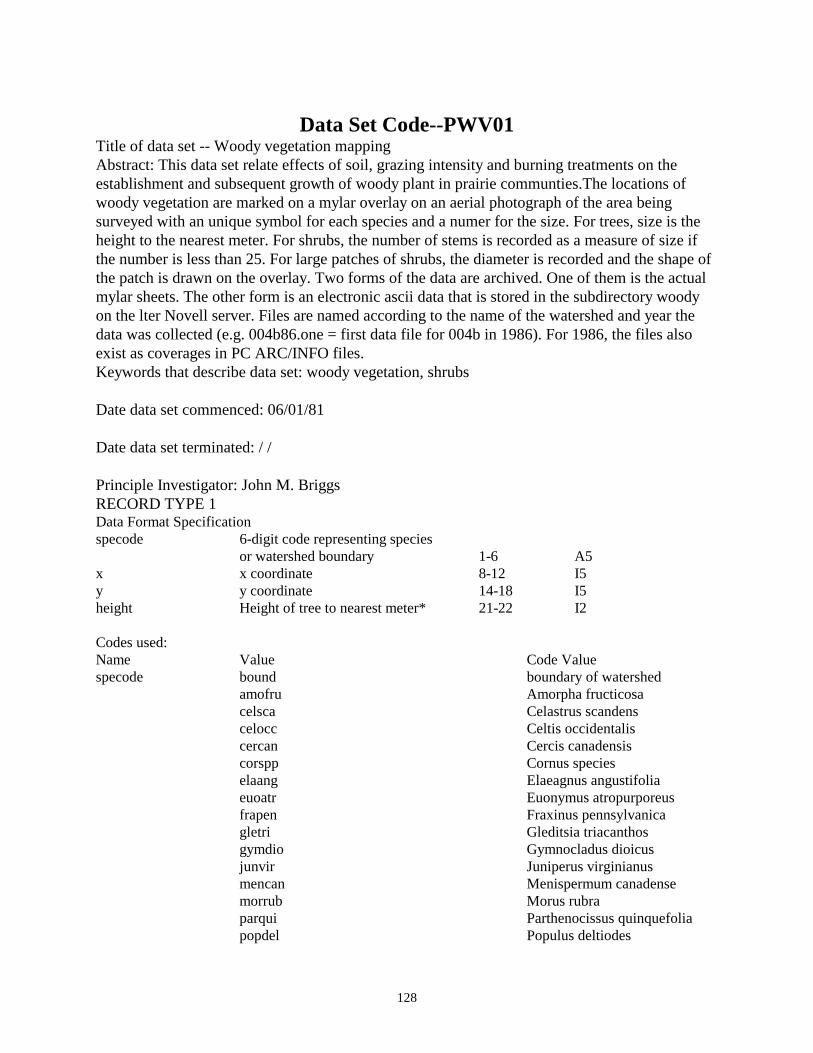
128
Data Set Code--PWV01 Title of data set -- Woody vegetation mapping Abstract: This data set relate effects of soil, grazing intensity and burning treatments on the establishment and subsequent growth of woody plant in prairie communties.The locations of woody vegetation are marked on a mylar overlay on an aerial photograph of the area being surveyed with an unique symbol for each species and a numer for the size. For trees, size is the height to the nearest meter. For shrubs, the number of stems is recorded as a measure of size if the number is less than 25. For large patches of shrubs, the diameter is recorded and the shape of the patch is drawn on the overlay. Two forms of the data are archived. One of them is the actual mylar sheets. The other form is an electronic ascii data that is stored in the subdirectory woody on the lter Novell server. Files are named according to the name of the watershed and year the data was collected (e.g. 004b86.one = first data file for 004b in 1986). For 1986, the files also exist as coverages in PC ARC/INFO files. Keywords that describe data set: woody vegetation, shrubs Date data set commenced: 06/01/81 Date data set terminated: / / Principle Investigator: John M. Briggs RECORD TYPE 1 Data Format Specification specode 6-digit code representing species or watershed boundary 1-6 A5 x x coordinate 8-12 I5 y y coordinate 14-18 I5 height Height of tree to nearest meter* 21-22 I2 Codes used: Name Value Code Value specode bound boundary of watershed amofru Amorpha fructicosa celsca Celastrus scandens celocc Celtis occidentalis cercan Cercis canadensis corspp Cornus species elaang Elaeagnus angustifolia euoatr Euonymus atropurporeus frapen Fraxinus pennsylvanica gletri Gleditsia triacanthos gymdio Gymnocladus dioicus junvir Juniperus virginianus mencan Menispermum canadense morrub Morus rubra parqui Parthenocissus quinquefolia popdel Populus deltiodes
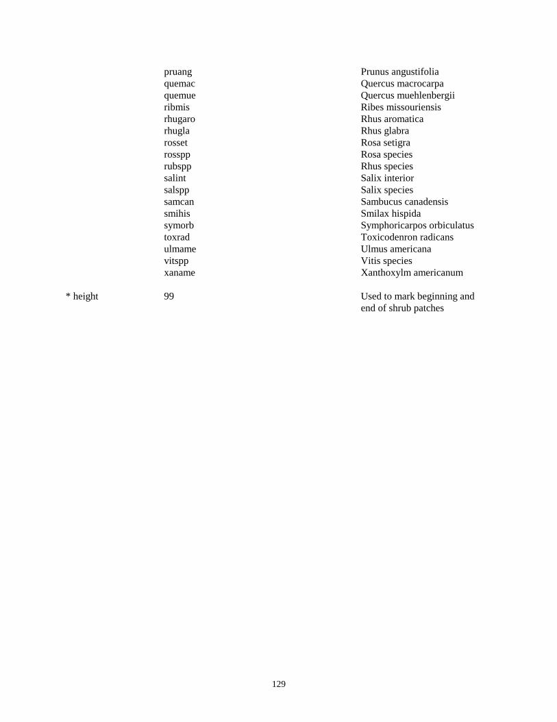
129
pruang Prunus angustifolia quemac Quercus macrocarpa quemue Quercus muehlenbergii ribmis Ribes missouriensis rhugaro Rhus aromatica rhugla Rhus glabra rosset Rosa setigra rosspp Rosa species rubspp Rhus species salint Salix interior salspp Salix species samcan Sambucus canadensis smihis Smilax hispida symorb Symphoricarpos orbiculatus toxrad Toxicodenron radicans ulmame Ulmus americana vitspp Vitis species xaname Xanthoxylm americanum * height 99 Used to mark beginning and end of shrub patches

130
Other Data
Data Set Code--KPL01 Title of data set--Konza Prairie Publication List Abstract: All publications that involve Konza Prairie are listed in a Word Perfect File (version 5.1). Listing are by year. A copy of the publication should be in the Konza Prairie Office (Room 212; phone # (913) 532-6620). A separate file lists master thesis and Ph.D. dissertations done on Konza Prairie. Keywords that describe data set:publications, thesis, dissertations Date data commenced:1972 Date data terminated: Principle Investigator: John M. Briggs File name is : bibliogr.wp5 (For Konza Prairie Publication List) disserta.wp5 (For thesis and dissertations)

131
Data Set Code--KFH01 Title of data set--Konza Prairie Fire History Abstract: A record of fire history on the Konza Prairie watersheds is in listed in three seperateWord Perfect 5.1 files. It has the date of a fire in a watershed. In addition, information on whether the fire was planned or accidental is noted. Prior to 1988, detailed information on each burn on Konza is available in hard copy from the Konza Prairie Office (Bushnell Room 212; (913) 532-6629.). Keywords that describe data set:fire history of Konza Prairie Date data commenced:1972 Date data terminated: Principle Investigator: John M. Briggs File Names: burn.one (1972 to 1980) burn.two(1981 to 1987) burn.thr (1988 to present)

132
Data Set Code--KIC01 Title of data set--Konza Prairie Insect Collection Species List Abstract: Keywords that describe data set: Arthropods, Insects, Pinned-specimens, Species List Date data set commenced: 1977 Date data set terminated: / / Principle Investigators: Phil Fay, Valerie Wright, Ted Evans RECORD TYPE 1--Konza Prairie Insect Collection Species List Data Format Specification 1. Order 1-14 A14 2. Family 15-31 A17 3. Subfamily 33-50 A18 4. Tribe 51-72 A22 5. Genus 73-92 A20 6. Species 94-121 A28 7. Subspecies 123-150 A28 8. # specimens 152-156 I5

133
Data Set Code--OGD01 Title of data set--Gallery Forest Foliage Decomposition Abstract: Decomposition of bur oak and hackberry foliage was measured for two years using litterbag methods. Mass, nitrogen and phosphorus content were measured. Keywords that describe data set: foliage decomposition, nitrogen, phosphorus Date data commenced:10/31/81 Date data terminated:10/26/83 Principle Investigator: Timothy R. Seastedt RECORD TYPE 1 Data Format Specification 1. Datacode 1-5 A5 2. Rectype 6 I1 3. Year 7-8 I2 4. Month 9-10 I2 5. Day 11-12 I2 6. Branch Location on Kings Creek (N or S Branch) 21 A1 7. Transect Location (see S3 or N2 on map with 22 I1 data set PGL01 8. Age Days in field 24-26 I3 Days 9. IWT Initial dry weight 28-31 F4.2 gX 10. FWT Final dry weight 33-36 F4.2 gX 11. Species Content of litter bag 38 A1 Codes used: Name Value Code Value Branch N North Branch S South Branch Species H Hackberry leaves B Bur Oak leaves S Scarab (larvae) excrement RECORD TYPE 2 Data Format Specification 1. Datacode 1-5 A5 2. Rectype 6 I1 3. Year 7-8 I2 4. Month 9-10 I2 5. Day 11-12 I2

134
6. Branch Location on Kings Creek 21 A1 7. Transect Location 22 I1 8. Age Days in Field 24-26 I3 9. Species Content of Litter bags 28 A1 10. PCTN Percent nitrogen 30-34 F5.3 X 11. PCTP Percent phosphorus 36-40 F5.3 X 12. IWT Initial weight 42-45 F4.2 gX 13. FWT Final weight 47-50 F4.2 gX Codes used: Variable Code Definition of Name Value Code Value Branch N North Branch S South Branch Species H Hackberry leaves B Bur Oak leaves S Scarab (larvae) excrement

135
Data Set Code--OMB01 (preliminary!) Title of data set--Microbial biomass Abstract: The purpose of this data set is to monitor long-term changes in microbial biomass on the belowground plots due to the effect on annual burning, mowing and nitrogen and phosphorus fertilization. Keywords that describe data set: microbial biomass, inorganic N, microbial biomass C and N, soil water content, nitrogen flush Data data commenced: 89/04/15 Data data terminated: / / Principle Investigator: Chuck Rice Data format specification: As of 09 April 1993, data and documentation are in spreadsheet files; contact principle investigator or LTER data manager for details. RECORD TYPE 1 1. Datacode 1-5 A5 2. Rectype 6 I1 3. Year 7-8 I2 4. Month 9-10 I2 5. Day 11-12 I2 6. Watershed 13-16 A4 7. Plot # 19-20 I2 8. Depth 23 I1 9. Burn 26 A1 10. Mow 29 A1 11. Nutrient 32 A1 12. Soil H2O (g/g) 37-42 I6 13. C flush (mg C/Kg) 45-52 I8 14. BMC (mg C/Kg) 56-63 I8 15. N flush (mg C/Kg) 67-74 I8 16. BMN (mg N/Kg) 77-84 I8 17. Total Inorganic N ( 87-93 I7 Codes Used: Name Value Code Value Plot 1-64 Plot number Depth 1,2,3 1=0-5, 2=5-15, 3=15-30 Burn treatment U:B U=Unburn B=Burn Mow treatment U;M U=unmowed M=mowed

136
Nutrient treatment C,N,P,B C=control, N=nitrogen P=Phosphorus B=Both

137
Data Set Code--OPD01 Title of data set--Prairie standing dead and litter Decomposition Abstract: Standing dead and litter decomposition of big bluestem foliage and flowering stems were measured for two years using litterbag methods. Mass, nitrogen and phosphorus content were measured. Keywords that describe data set: standing dead, nitrogen, phosphorus, litterbag Date data commenced: 10/31/81 Date data terminated: 10/26/83 Principle Investigator: Timothy R. Seastedt RECORD TYPE 1 Data Format Specification 1. Datacode 1-5 A5 2. Rectype 6 I1 3. Year 7-8 I2 4. Month 9-10 I2 5. Day 11-12 I2 6. Watershed 13-16 A4 7. Age Length of time spent in field-days 21-23 I3 Days 8. IFWT Initial foliage weight 25-28 F4.2 gX 9. FFWT Final foliage weight 30-33 F4.2 gX 10. ISWT Initial stem weight 35-39 F5.2 gX 11. FSWT Final stem weight 41-45 F5.2 gX 12. Type Organic matter type (standing dead, or litter) 47 A1 RECORD TYPE 2 1. Datacode 1-5 A5 2. Rectype 6 I1 3. Year 7-8 I2 4. Month 9-10 I2 5. Day 11-12 I2 6. Watershed 13-16 A4 7. Age Length of time spent in field- days 21-24 I3 Days 8. Type Dead matter typ e 26 A1 9. Foln % nitrogen in foliage 28-32 F5.3 % 10. Folp % phosphorus in foliage 34-38 F5.3 % 11. Stmn % nitrogen in stem 40-44 F5.3 % 12. Stmp % phosphorus in stem 46-50 F5.3 % 13. Ifwt Initial foliage weight 52-55 F4.2 g 14. Ffwt Final foliage weight 57-60 F4.2 g

138
15. Iswt Initial stem weight 62-65 F4.2 g 16. Fswt Final stem weight 67-70 F4.2 g 17. ID 72-74 I3 Codes used: Name Value Code Value Type L Litter S Standing dead

139
Data Set Code--PHOTO Title of data set--Aerial Photographs of Konza Prairie Abstract: Aerial photographs of Konza Prairie of various scales and years are available. A complete list of photographs is available from the Konza Prairie Office ( Bushnell Room 212; (913) 532-6620). A few of them have been incorporated into the GIS coverages (see GIS01). Keywords that describe data set:aerial photograph, historical land use Date data commenced:10/01/39 Date data terminated: / / Principle Investigator: John M. Briggs

140
Data Set Code--WAT01 Title of data set -- Irrigation Transect Studies Abstract: In 1991, an irrigation transect was established near the Konza Prairie HQ to assess the effects of supplemental water on ecological processes in tallgrass prairie. The site is burned annually in the spring. The transect spans upland, hillside and lowland topographic positions with irrigation and sampling points (12) located at 10 m intervals. Adjacent control transects are marked on both sides of the irrigation transect. Irrigation is scheduled according to estimates of actual evapotranspiration and measures of plant water status. In 1992, an additional 4 irrigation sprinklers were added to the transect (2 at each end). At the time of peak aboveground biomass (late August), 4 0.1 m2 quadrats are harvested at each of the 12 sites. Biomass is separated into live graminoid, forb and woody plant, and current year's dead biomass. Vegetative species composition was initially measured in 1991 at each site, and continues to be measured at midseason by using a modified Daubenmire canopy coverage technique in a 10 m2 circular plot. At approximately 10 day intervals, predawn and midday plant water potentials are measured in Andropogon gerardii at each site in both irrigated and control transects. In 1992, reproductive effort of the dominant grasses (Andropogon gerardii, Sorghastrum nutans, Andropogon scoparius) was assessed in irrigated and control transects by measuring heights and densities of flowering stalks. In 1993, soil moisture measurements at 15 and 30 cm depths were begun with a Time Domain Reflectometry system. Data set also includes measured natural precipitation and supplemental water added to the site. Keywords that describe data set: Irrigation, water stress, aboveground biomass, NPP, graminoids, forbs, current year dead, plant species composition, reproductive effort, soil moisture, plant water potential, Date data set commenced: 06/01/1991 Date data set terminated: / / Principle Investigator: Alan K. Knapp RECORD TYPE 1--Natural Precipitation and supplemental water added Data Format Specification 1. Datacode 1-5 A5 2. Rectype 6 I1 3. Year 7-8 I2 4. Month 9-10 I2 5. Day 11-12 I2 6. Watershed 13-16 A4 8. Transect Transect 24 A1 9. Plotnum Plot number (1-12) 26-27 A2 10. Lvgrass Mass of live grass 29-34 F6.2 G/.1m2 11. Forbs Mass of forbs 36-41 F6.2 G/.1m2 12. Cuyrdead Mass of current years dead 43-48 F6.2 G/.1m2 13. Pryrdead Mass of previous years dead 50-55 F6.2 G/.1m2

141
RECORD TYPE 2--Species Composition Data Format Specification 1. Datacode 1-5 A5 2. Rectype 6 I1 3. Year 7-8 I2 4. Month 9-10 I2 5. Day 11-12 I2 6. Watershed Always HQ 13-14 A2 7. Transect i or c 18 A1 *1991&1992 w or c 8. Species Number 20-22 I3 9. Genus 24-29 A6 10. Species 31-35 A5 11. Variety 37-40 A4 12. Plot Number (1-31) Skip plot #9 42-100(even) I59 *1991&1992 12 sampling locations skip plot #9 42-64 RECORD TYPE 3--Aboveground Biomass Data Format Specification 1. Datacode 1-5 A5 2. Rectype 6 I1 3. Year 7-8 I2 4. Month 9-10 I2 5. Day 11-12 I2 6. Watershed Always HQ 13-14 A2 7. Transect i or c 18 A1 8. Plot Number (1-8)(10-31) (1993-on) 20-21 I2 * (1-8)(10-13) (1991&1992) 9. Replicate(a-f) 24 A1 10. Mass of Livegrass 26-31 I6 11. Mass of Forbs 33-38 I6 12. Mass of Current Year’s Dead 41-46 I6 13. Mass of Previous Year’s Dead 48-53 I6 14. Mass of woody (As of 24 Aug 1992) 55-60 I6 lead plant-Amorpha canescens rose-Rosa arkansas (smooth) sumac-Rhus glabra New Jersey tea-Ceanothus ovatus dogwood-Cornus drummondi buckbrush-Symphoricarpos orbiculatus 15. Comments 63-80 I18 RECORD TYPE 41--Water Potential Measurements of Big Bluestem(1991-1993) Data Format Specification 1. Datacode 1-5 A5 2. Rectype 6 I1

142
3. Year 7-8 I2 4. Month 9-10 I2 5. Day 11-12 I2 6. Watershed Always HQ 13-14 A2 7. Treatment i or c 18 A1 8. Time a for AM, p for PM 20 A1 9. Plot Number (1-8)(10-13) 99=hack (1991&1992) 22-23 I2 * (1-15) (1993-on) 10. Rep1 25-29 I6 11. Rep2 31-35 I5 12. Rep3 37-41 I5 13. Rep4 43-47 I5 14. Rep5 49-53 I5 15. Rep6 55-59 I5 16. Rep7 61-65 I5 17. Comments 68-776 A9 *1993-present uses only Reps 1-3. RECORD TYPE 42--Water Potential Measurements of Big Bluestem(1994-present) Data Format Specification 1. Datacode 1-5 A5 2. Rectype 6 I1 3. Year 7-8 I2 4. Month 9-10 I2 5. Day 11-12 I2 6. Watershed Always HQ 13-14 A2 7. Treatment i or c (i=irrigated, c=control) 18 A1 8. Transect (1 or 2) (1=first transect, 2=second transect) 20 A1 9. Location (up or lw) (up-=upland, lw=lowaland) 22-23 I2 10. Plot (1 or 2) (1=first plot sampled) 25 I6 (2=second plot sampled) 11. Time (all p) (a=AM, p=PM) 27 I5 12. Rep1 29-33 I5 13. Rep2 35-39 I5 14. Rep3 41-45 I5 15. Rep4 47-51 I5 16. Rep5 53-57 I5 17. Rep6 59-63 I5 18. Rep7 65-69 I5 19. Rep8 71-75 I5 20. Comments RECORD TYPE 5--Reproductive Effort of Three Grasses Data Format Specification 1. Datacode 1-5 A5 2. Rectype 6 I1 3. Year 7-8 I2

143
4. Month 9-10 I2 5. Day 11-12 I2 6. Watershed Always HQ 13-14 A2 7. Transect i or c 18 A1 8. Plot Number (1-8)(10-13) skip #9 (1991&1992) 20-21 I2 * (1-8)(10-31) skip #9 (1993-on) 9. Quadrant (1-4) 24 I1 10. Species 26-29 A4 11. Number of Flowering Stalks 31-32 I2 12. Height #1 34-37 I4 meters 13. Height #2 39-42 I4 14. Height #3 44-47 I4 15. Height #4 49-52 I4 16. Height #5 54-57 I4 17. Height #6 59-62 I4 18. Height #7 64-67 I4 19. Height #8 69-72 I4 20. Height #9 74-77 I4 RECORD TYPE 6--Irrigation transect studies (HQ TDR Readings) Data Format Specification: 1. Datacode 1-5 A5 2. Rectype 6 I1 3. Year 7-8 I2 4. Month 9-10 I2 5. Day 11-12 I2 6. Watershed Always 00HQ 13-16 A4 7. Depth 15 or 30 cm 19-22 A4 8. Tag Number 26-28 I3 9. Reading 32-37 I8 10. % n2o 41-47 A41 11. Comments 49-80


![Specificaţii tehnice (F4.1) în coloanele , î, ò, ô]](https://img.dokumen.tips/doc/110x75/623bae143468554f2814f394/specificatii-tehnice-f41-n-coloanele-.jpg)