Embed Size (px)
Citation preview
1
OOrrtthhooiimmaaggee oorr mmaapp vviissuuaall iizzaattiioonn iinn uussee iinn ggeeooppoorrttaallss
CCaassee ssttuuddyy oonn tthhee FFrreenncchh GGeeooppoorrttaall
Charlotte Hoarau
ABSTRACT: This paper sets out the results of a statistical analysis of a survey on a panel of 45 cartographic websites using the API of the French Géoportail. Existing design choices, such as favored base maps, transparency levels of the displayed layers, scale visualization, have been studied from mixed representations in use. They have also been faced to the aim of the related applications, the user’s tasks (data visualization and interaction) and their resulting uses in order to define general trends about mixed representations.
KEYWORDS: fitness for use, mixed cartographic representation, geoportals, map, orthophoto
Introduction Various and heterogeneous geographic data are currently available. Users are able to access topographic maps, orthoimagery, thematic vector data, relief (DTM), etc. (Bianchin 2007). These representations provide different views of the real world: they are comparatively more or less realistic, synthesized, abstract, symbolized, hierarchically organized, etc. Different features of the real world appear in these representations: roads or buildings are located on topographic maps whereas tree species or agricultural crops may also be identified in orthoimagery. These geographic data are provided by national mapping agencies (NMA) such as the French IGN1, the USGS2; industrial/private companies such as Google3, Microsoft4; or participative communities such as OpenStreetMap5 (OSM). Users can visualize these data through geoportals and can also load them through web services in cartographic applications.
Online cartographic applications invite us to reconsider the concept of “base map” in the context of interactive digital maps (Feyt, 2011). The glossary term of the Open Geospatial Consortium6 defines base maps as “Spatial data sets that provide the background upon which more specific thematic data is overlaid and analyzed”. These layers appear as self-sufficient, do not need anything else to be displayed in a
1 http://www.ign.fr/ 2 http://www.usgs.gov/ 3 http://maps.google.fr/ 4 http://www.bing.com/maps/ 5 http://www.openstreetmap.org/ 6 http://www.opengeospatial.org/
Proceedings - AutoCarto 2012 - Columbus, Ohio, USA - September 16-18, 2012

cartographic application and are able to For example, the cartographic API OpenLregarding user interactionsvisualize two base layers at the same time. Moreover, they define the projection of the map and are displayed under tinformation to locate efficiently these overlays on the map.representations emerged paper, a mixed cartographidifferent data types or sourcesresearch works aim at designing new mixed cartographic representations: pseudomaps from OSM data in order to unit (Jenny, 2012) or maps inspiredrealism (Patterson, 2002). hybrid representation which superposes road vectors and toponyms on an imagery background and the possible representation in the administration mixing aerial imagery with a color map (Cf. are increasingly integrated into online cartographic applications navigate through different data reconsider the status of base maps:could be changed? For instanceto navigate from two base maps representations by transparency:
Figure 1 : Mixed cartographic repres
This paper aims to study mixed representations in use in cartographic applications. first sight, it may sound inconsistent self-sufficient amount of data. maps are the result of a technical opportunity or a popular trend, or a really efficient new cartographic representationmaps are mixed, and second to the tasks they are designed for.carto-websites. The second third part analyses them according to the interactivity and the them 7 http://openlayers.org/ 8 http://map.geo.admin.ch
2
and are able to provide a topographic context toFor example, the cartographic API OpenLayers7 distinguishes base layers from overlays
user interactions. Base layers are mutually exclusive layers:visualize two base layers at the same time. Moreover, they define the projection of the
under the overlays: they are supposed to provide the necessary information to locate efficiently these overlays on the map. However, mixed cartographic
in cartographic applications (Raposo, Brewer, 2011)paper, a mixed cartographic representation is defined as a representation mixing together different data types or sources by superposition, transparency, merging, etc
orks aim at designing new mixed cartographic representations: pseudoa in order to unit cartographic abstraction with natural appearance
inspired by artistic stylized views of the Earth in order to approach . Two examples of mixed representations are
hybrid representation which superposes road vectors and toponyms on an imagery and the possible representation in the geoportal of the Swiss federal
administration mixing aerial imagery with a color map (Cf. Figure 18
are increasingly integrated into online cartographic applications whichnavigate through different data and to modify their visualization. This trend leads us to reconsider the status of base maps: is a base map still a base for the
instance, the Swiss geoportal provides a cursor tool two base maps (Cf. Figure 1), and in doing so, to design mixed
representations by transparency:
Mixed cartographic representations from: a) the Swiss geoportal, b)
to study mixed representations in use in cartographic applications. sound inconsistent to mix base maps together because of their supposed
sufficient amount of data. Why are base maps mixed? We wonder ifmaps are the result of a technical opportunity or a popular trend, or a really efficient new cartographic representation. The case study presented here focuses
second on the resulting efficiency of these representations accordingthe tasks they are designed for. The first part describes a statistical survey
The second part provides results about mixed representataccording to the interactivity and the theme of the
provide a topographic context to overlaid data. base layers from overlays
are mutually exclusive layers: it is impossible to visualize two base layers at the same time. Moreover, they define the projection of the
he overlays: they are supposed to provide the necessary mixed cartographic
(Raposo, Brewer, 2011). In this representation mixing together
by superposition, transparency, merging, etc. Different orks aim at designing new mixed cartographic representations: pseudo-natural
cartographic abstraction with natural appearance in order to approach
are the Google Maps hybrid representation which superposes road vectors and toponyms on an imagery
of the Swiss federal 8). Interactive tools
which allow users to is trend leads us to
is a base map still a base for the representation if it a cursor tool allowing users
, and in doing so, to design mixed
, b) Google Maps
to study mixed representations in use in cartographic applications. At to mix base maps together because of their supposed
We wonder if mixed base maps are the result of a technical opportunity or a popular trend, or a really efficient new
first on how base on the resulting efficiency of these representations according
describes a statistical survey on a panel of about mixed representations while the
of the websites.
Proceedings - AutoCarto 2012 - Columbus, Ohio, USA - September 16-18, 2012
3
Survey on representations mixing orthoimages and map visualizations Our approach consists in a web survey which aims at analyzing existing mixed representations, their associated personalization tools and the uses of these applications, in order to question the fitness for use of the resulting cartographic applications but also to identify the potential shortcomings of these representations.
Panel of surveyed cartographic applications The Géoportail9 (i.e. the French Geoportal) provides to developers an OpenLayers based cartographic API to add dynamic maps on websites. Our survey panel is made of 45 websites randomly selected among these using the API (Application Programming Interface) of the Géoportail (Cf. list in Annex 1). Every website contains a cartographic application allowing an Internet user to visualize a map and most often to interact with it. The Géoportail infrastructure allows webmasters to access geographic data services such as imagery, topographic maps coming from IGN, geological maps coming from BRGM10, relief and elevation, cadastral parcels, administrative units, transport networks, buildings, hydrography, and institutional partnership data. The choice of this case study based on the French geoportal was guided by the wealth of geographic data provided by the geoportal and the possibility for us to cross observed information with a database recording statistics about the uses of the different layers in the cartographic applications.
Variable sets studied during the survey panel In order to describe existing representations in our survey panel, we have identified five main sets of variables to analyze: general information, the default base map, the loaded thematic data, the available interactive tools and statistics about the use of these representations as detailed below. In the one hand, most of these variables focus on default choices made by webmasters in order to estimate the potential fitness for use of mixed representations regarding some tasks or user profiles. Default choices mean the parameters of the visualization seen at the first visit of the websites, i.e. the characteristics of the cartographic representation that the webmaster has chosen to propose to the final user of the website11. For instance a default choice for a website could be to display an orthoimage or a scan of a map as the base map of the cartographic application. In the other hand, these variables mostly concern two aspects of cartographic user interfaces: some variables describe the design choices of the webmaster whereas other variables describe the resulting interface and cartographic visualization offered to the user. Some variables are then the result of others. For instance, a layer is visible or not by the user depending on if the webmaster defines that this layer is available, displayed, at the top of the layer superposition, and opaque. Furthermore some variables concern interactive tools to modify the representation. Therefore, what the user sees is both the result of what the webmaster designs and what the user clicks. 9 http://www.geoportail.gouv.fr 10 France's leading public institution in Earth science applications for the management of surface and subsurface resources and risks : http://www.brgm.fr/ 11Two of our selected websites have not always the same default choices because they register the visualization parameters of the last users’ visit letting them to design their own mixed cartographic representation.
Proceedings - AutoCarto 2012 - Columbus, Ohio, USA - September 16-18, 2012
4
First of all some general information about each website are collected together in order to be able to identify and describe the websites: their name, their URL address and the websites’ affiliated organism. In this group of variables, the general theme (hiking, sustainable development, history, real estate, transport, culture, geomatics, tourism, etc.) and the target audience (either a professional public or a general public or both) is also identified among some categories we propose in order to have a first idea on the aims of the websites. Some technical information is also collected about our websites: the API language and version number.
The second set of variables aims at describing default base maps. Collected variables register which base map is available (topographic map, orthoimagery, both of them, etc.) in the cartographic application and how it is designed (displayed or not, more or less transparent, above or below other layers, etc.). These variables aim to define what cartographic representation is visible for the final user. Moreover, the default scale and the size of the cartographic visualization are listed as relevant parameters of the visualization.
The third set of variables focuses on the thematic data. We look at loaded vector thematic layers coming from the Géoportail (hydrography, administrative units, buildings, etc.) but also from webmaster personal database with their structure (uploaded file or web service format) and their geometric type (point, line or polygon). We also analyze whether the user is able to load its own structured data in the cartographic application.
The fourth set of variables lists available interactive tools in order to quantify how the user is able to modify, personalize or adapt the cartographic visualization. Variables enumerate the tools which modify the order of the layers, their transparency level, their visibility and the size of the map. Moreover, the digitization tools are listed as well as the export and import functionalities.
The last set of variables contains statistics processed from an internal IGN database. For each selected website, visits and loaded data have been counted limiting the study to the uses of January 2012. Specific access to the different resources provided by the geoportal has also been collected in order to accurately quantify the uses of the users.
Descriptive statistics about Géoportail visualizations in use Several descriptive statistics are calculated from the different collected variables. Main results are provided here aiming at analyzing, first, default choices in cartographic representations and, second, available interactive tools.
Mixing topographic map and orthoimagery visualizations Default base maps are observed for each selected cartographic application. Figure 2 shows the proportions of the different displayed base maps. Some applications use simultaneously different cartographic APIs (Géoportail, GoogleMaps, OSM …), involving that non IGN base maps are observed by default. It should be noted that GoogleMaps and OSM APIs are used when a relief representation is needed. An elevation layer is available through the Géoportail but not with a shaded representation.
Proceedings - AutoCarto 2012 - Columbus, Ohio, USA - September 16-18, 2012

Figure 2: Default base maps of the selected cartographic applications
It is noteworthy that topographic maps are predominantly cartographic applications) as default base maps. This could be explained by the accuracy of these reference cartographic sources which fitcartographic quality of these representations and by the origunusual base maps for online cartographic applications.only topographic maps and imagery background are displayed by default as base maps. The Géoportail though provides other layers that could besuch as geological maps or displayed by default.Figure display a mixed cartographic representation by default, mixing IGN maporthoimagery by transparency.designed mixing topographic map and imby the Géoportail are not used by default to provide mixed representations. the survey, we note that maps, they are heterogeneous.variable: a majority of the selected cartographic applications (49%) display the imagery layer as a background under the map layer whereas 18% of the selected cartographic applications display the topographic mapplications (33%) does not present a only can be switched among base mapssurvey panel present different
Table 1 shows some examples within the survey panel which involve mixing topographic maps examples where the IGN topography maps are used as background layerthe left shows examples where the IGN orthoimagery is used as background layer.row of the table shows different transparency representations where both base maps are transparently displayed.representations are visually heterogeneous. Representations 1 and 2 display a unique base map. Representations 3, 4, 5 and 6base map but adding another one more or less transparently. 4 and 5 depict mixed representations with a very visible orthoimagery layer land occupation informationsimilar representations. Finally some representations, 7 and 8, display both base maps
12For instance: http://www.planorando.com
5
Default base maps of the selected cartographic applications
It is noteworthy that topographic maps are predominantly displayed (by 58% of the cartographic applications) as default base maps. This could be explained by the accuracy of these reference cartographic sources which fits for hiking activities, by the cartographic quality of these representations and by the originality of the displayunusual base maps for online cartographic applications. Another relevant result is that only topographic maps and imagery background are displayed by default as base maps.
provides other layers that could be used as original or old maps as Cassini which are sometimes available but never
Figure 2 shows that 20% of the selected cartographic applications a mixed cartographic representation by default, mixing IGN map
orthoimagery by transparency. Once again, we note that mixed representations are only designed mixing topographic map and imagery. The other potential base maps provided by the Géoportail are not used by default to provide mixed representations. the survey, we note that even though these mixed representations use the same base
heterogeneous. First, the order of superposition of these base maps is variable: a majority of the selected cartographic applications (49%) display the imagery layer as a background under the map layer whereas 18% of the selected cartographic applications display the topographic map under the imagery. Remainingapplications (33%) does not present a layer superposition, i.e. their base map is fixed or
among base maps12. Second, existing mixed representations of our survey panel present different levels of transparency of both base maps.
shows some examples within the survey panel which involve and orthoimagery base maps. The column on the right
examples where the IGN topography maps are used as background layershows examples where the IGN orthoimagery is used as background layer.
different transparency levels from not mixed representationsrepresentations where both base maps are transparently displayed. It appears that existing representations are visually heterogeneous. Representations 1 and 2 display a unique base map. Representations 3, 4, 5 and 6 design mixed representations giving priority to a given base map but adding another one more or less transparently. Particularly, r4 and 5 depict mixed representations with a very visible orthoimagery layer
tion: it highlights that different design choices. Finally some representations, 7 and 8, display both base maps
http://www.planorando.com.
Default base maps of the selected cartographic applications
displayed (by 58% of the cartographic applications) as default base maps. This could be explained by the accuracy
for hiking activities, by the inality of the displays of
Another relevant result is that only topographic maps and imagery background are displayed by default as base maps.
original base maps are sometimes available but never
that 20% of the selected cartographic applications a mixed cartographic representation by default, mixing IGN maps and IGN
Once again, we note that mixed representations are only agery. The other potential base maps provided
by the Géoportail are not used by default to provide mixed representations. Conducting use the same base
of superposition of these base maps is variable: a majority of the selected cartographic applications (49%) display the imagery layer as a background under the map layer whereas 18% of the selected cartographic
Remaining cartographic base map is fixed or
Second, existing mixed representations of our of transparency of both base maps.
shows some examples within the survey panel which involve different ways of on the right shows
examples where the IGN topography maps are used as background layers. The column on shows examples where the IGN orthoimagery is used as background layer. Each
not mixed representations to It appears that existing
representations are visually heterogeneous. Representations 1 and 2 display a unique base design mixed representations giving priority to a given
Particularly, representations 4 and 5 depict mixed representations with a very visible orthoimagery layer providing
: it highlights that different design choices could create very . Finally some representations, 7 and 8, display both base maps
Proceedings - AutoCarto 2012 - Columbus, Ohio, USA - September 16-18, 2012
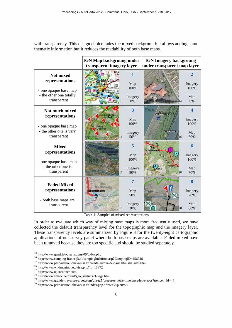
with transparency. This design choice fades the mixed background: it allows adding some thematic information but it reduces the readability of both base maps.
Not mixed representations
- one opaque base map - the other one totally
transparent
Not much mixed representations
- one opaque base map - the other one is very
transparent
Mixed representations
- one opaque base map
- the other one is transparent
Faded Mixed representations
- both base maps are
transparent
In order to evaluate which collected the default transparency level These transparency levels are summarized by applications of our survey panel where both base maps are available.been removed because they are too specific and should be studied separately.
13 http://www.geml.fr/observations/09/index.php14 http://www.camping-frankrijk.nl/campingluchtfoto.asp?CampingID=45673615 http://www.parc-naturel-chevreuse.fr/balade16 http://www.wikimaginot.eu/visu.php?id=1387217 http://www.openrunner.com/ 18 http://www.valroc.net/html/geo_sentiers21/sage.html19 http://www.grande-traversee-alpes.com/gta20 http://www.parc-naturel-chevreuse.fr/index.php?id=593&plan=27
6
with transparency. This design choice fades the mixed background: it allows adding some information but it reduces the readability of both base maps.
IGN Map backgroung under transparent imagery layer
IGN Imageryunder transparent
13
1
Map 100%
Imagery
0%
15
3
Map 100%
Imagery
50%
17
5
Map 100%
Imagery
80%
19
7
Map 50%
Imagery
30%
Table 1: Samples of mixed representations
In order to evaluate which way of mixing base maps is more frequently used, we have collected the default transparency level for the topographic map and the imagery layer.These transparency levels are summarized by Figure 3 for the twenty-applications of our survey panel where both base maps are available. been removed because they are too specific and should be studied separately.
http://www.geml.fr/observations/09/index.php frankrijk.nl/campingluchtfoto.asp?CampingID=456736
chevreuse.fr/balade-autour-de-paris.html#balades.titre http://www.wikimaginot.eu/visu.php?id=13872
http://www.valroc.net/html/geo_sentiers21/sage.html alpes.com/gta-gr5/preparez-votre-itinerance/les-etapes?troncon_id=44
chevreuse.fr/index.php?id=593&plan=27
with transparency. This design choice fades the mixed background: it allows adding some
Imagery backgroung under transparent map layer
14
2
Imagery 100%
Map 0%
16
4
Imagery 100%
Map 30%
18
6
Imagery 100%
Map 70%
20
8
Imagery 70%
Map 60%
is more frequently used, we have for the topographic map and the imagery layer.
-eight cartographic Faded mixed have
been removed because they are too specific and should be studied separately.
etapes?troncon_id=44
Proceedings - AutoCarto 2012 - Columbus, Ohio, USA - September 16-18, 2012

Figure 3: Transparency level of superposed topographic map and imagery base maps.
Figure 3 shows the different combof the base maps at the bottomof the representations of pointed out at the top Figure mixed representations portray an opaque imagery background and ten portray an otopographic map base map. an surprising superposition of layers by the webmasterdisplays a transparent map butthe map for the user. In consequence, these mixed representations. Twelve of the representations (43%) of the right arrow) display representation 4 or 6 of Tabletop) of them (2%) display a transparent imagery layer over a topographic map in background, like representation 3 or 5 of transparency levels shows that for the time being there is no consensus on the design of cartographic representation in between topographic maps and orthoimagery.is possible to extract general trends about mixed cartographic representations.hand, maps are more often to Figure 1 and. On the other hand, among the emerging mixed representations, shows that imagery is displayed with priority as a topographic map is superposed.display faded representations, like representation 7 or 8 of are transparent by default. This could be explained by the difficulty to design a mixed representation by transparency using two traditional base maps together.
Adding thematic information through complementary vector layersMixed representations display together data are also superposed layer will be available in their cartographic application. the different resources of the Géop22% of the cartographic applications of our survey
21 They are pointed in blue in Figure
7
Transparency level of superposed topographic map and imagery base maps.
shows the different combinations of transparency level, the superposition order at the bottom, and the resulting visualization for the user
of the representations of Figure 3 actually offer a not mixed representation: they are Figure 3 by the “mmaapp” and “iimmaaggeerryy” inserts. portray an opaque imagery background and ten portray an o
topographic map base map. Among these not mixed representations, four are the result of superposition of layers by the webmaster21: for instance,
s a transparent map but overlaid by an opaque imagery implying the invisibility of In consequence, these four cartographic applications offer wasted Twelve of the representations (43%) of Figure
display a transparent map over an opaque imagery backgrounTable 1, whereas only two (pointed out by the left arrow at the
m (2%) display a transparent imagery layer over a topographic map in , like representation 3 or 5 of Table 1. The diversity of the couples of
evels shows that for the time being there is no consensus on the design of cartographic representation in between topographic maps and orthoimagery.is possible to extract general trends about mixed cartographic representations.
, maps are more often offered as default opaque base maps representations according On the other hand, among the emerging mixed representations,
imagery is displayed with priority as a background layertopographic map is superposed. Furthermore, as few as three cartographic applications
ons, like representation 7 or 8 of Table 1, where both base maps are transparent by default. This could be explained by the difficulty to design a mixed
n by transparency using two traditional base maps together.
Adding thematic information through complementary vector layersMixed representations display together some base maps and sometimes thematic vector
in addition. Webmasters have the possibility to choose which layer will be available in their cartographic application. Figure 4 shows the availability the different resources of the Géoportail. For instance, cadastral parcel are available in 22% of the cartographic applications of our survey.
Figure 3.
Transparency level of superposed topographic map and imagery base maps.
the superposition order , and the resulting visualization for the user at the top. 50%
actually offer a not mixed representation: they are ” inserts. Four of these not
portray an opaque imagery background and ten portray an opaque esentations, four are the result of
instance, the website 11 implying the invisibility of
four cartographic applications offer wasted Figure 3 (pointed out by
map over an opaque imagery background, like (pointed out by the left arrow at the
m (2%) display a transparent imagery layer over a topographic map in The diversity of the couples of
evels shows that for the time being there is no consensus on the design of cartographic representation in between topographic maps and orthoimagery. However, it is possible to extract general trends about mixed cartographic representations. On the one
base maps representations according On the other hand, among the emerging mixed representations, Figure 3
background layer over which Furthermore, as few as three cartographic applications
, where both base maps are transparent by default. This could be explained by the difficulty to design a mixed
n by transparency using two traditional base maps together.
Adding thematic information through complementary vector layers base maps and sometimes thematic vector
have the possibility to choose which shows the availability of
For instance, cadastral parcel are available in
Proceedings - AutoCarto 2012 - Columbus, Ohio, USA - September 16-18, 2012

Figure
IGN topographic maps and orthoimagery are applications of our survey panel (respectively in 95% and 82%). The other resources are sometimes loaded, beginning withadministrative limits and roads.available regarding the objective of the website or if webmasters provide as much information as they can to enrich their cartographic application.large majority of cartographic applications (69%) only display base maps. Moreover, Figure 5b) shows that the addifferent sites: some webmasters have chosen to provide all the Géoportail resources in their cartographic application.
Figure 5: Available quantity of information in the s
Default scale of the survey panel cartographic representationDisplayed data sets (base maps and thematic information) build up the cartographic representation but this is also defined by the scale of the visualization. Thscales of our survey panel cartographic applications of our survey panel of these cartographic application
0,00
20,00
40,00
60,00
80,00
100,00
Web
site
per
cent
ages
2 base maps45%1 base
map22%
at least 2 base maps
& vector data…
Available layers
8
Figure 4: Availability and use of Géoportail data resources
IGN topographic maps and orthoimagery are available in the majority of the cartographic applications of our survey panel (respectively in 95% and 82%). The other resources are
beginning with administrative information like cadastral parcels, administrative limits and roads. We wonder if this complementary information is available regarding the objective of the website or if webmasters provide as much information as they can to enrich their cartographic application. Figure
majority of cartographic applications (69%) only display base maps. Moreover, b) shows that the added vector layers are not distributed
different sites: some webmasters have chosen to provide all the Géoportail resources in r cartographic application.
: Available quantity of information in the selected cartographic applications
survey panel cartographic representationDisplayed data sets (base maps and thematic information) build up the cartographic representation but this is also defined by the scale of the visualization. Th
our survey panel range from 1:4 000 to 1:8 000 000. Moreover, 20% of the cartographic applications of our survey panel do not have a fixed default scale. The scale of these cartographic applications is adaptive, for instance to hiking trails
Ressources Access
Available vector data
3 base maps2%
2 base
Available layers
0
5
10
15
20
9 11 41 42 19 46 8 10Num
ber
of lo
aded
laye
rs
Identifier of the websites
Superposition of vector data
Vector Layers All Layers
in the majority of the cartographic applications of our survey panel (respectively in 95% and 82%). The other resources are
administrative information like cadastral parcels, We wonder if this complementary information is
available regarding the objective of the website or if webmasters provide as much Figure 5a) shows that a
majority of cartographic applications (69%) only display base maps. Moreover, ded vector layers are not distributed uniformly through
different sites: some webmasters have chosen to provide all the Géoportail resources in
elected cartographic applications
survey panel cartographic representation Displayed data sets (base maps and thematic information) build up the cartographic representation but this is also defined by the scale of the visualization. The default map
Moreover, 20% of the default scale. The scale
trails.
Available vector data
7 25 1 29 18 38
Identifier of the websites
Superposition of vector data
All Layers Base maps
Proceedings - AutoCarto 2012 - Columbus, Ohio, USA - September 16-18, 2012
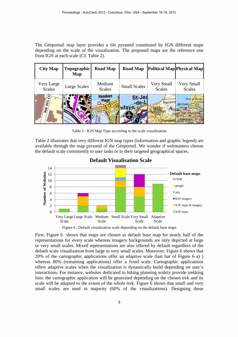
The Géoportail map layer provides depending on the scale of the visualization. The proposed maps are the reference one from IGN at each scale (Cf
City Map Topographic Map
Very Large Scales
Large Scales
Table 2
Table 2 illustrates that very different available through the map pyramid of the Géoportail. the default scale consistently to user tasks or to their targeted
Figure 6 : Default
First, Figure 6 shows that maps are chosen as default base map representations for every or very small scales. Mixed repredefault scale visualization20% of the cartographic applications offer an adaptive scale (last bar of whereas 80% (remaining applications) offer a fixed scaleoffers adaptive scales when the visualization is dynamically build depending on userinteractions. For instance, websites dedicated to hiking planning widely provide trekking lists: the cartographic application will be generated depending on the chosen trek and its scale will be adapted to the extensmall scales are used in majority (
0
2
4
6
8
10
12
14
Very Large Scale
Large Scale
Num
ber
of W
ebsi
tes
9
map layer provides a tile pyramid constituted by IGNdepending on the scale of the visualization. The proposed maps are the reference one from IGN at each scale (Cf. Table 2).
Topographic
Road Map Road Map Political Map
Scales Medium Scales
Small Scales Very Small
Scales
: IGN Map Type according to the scale visualization
that very different IGN map types (information and graphic legend) areavailable through the map pyramid of the Géoportail. We wonder if webmasterhe default scale consistently to user tasks or to their targeted geographical spaces
: Default visualization scale depending on the default base
shows that maps are chosen as default base map for nearly half representations for every scale whereas imagery backgrounds are only depicted at large or very small scales. Mixed representations are also offered by default regardless of the default scale visualization from large to very small scales. Moreover, Figure
aphic applications offer an adaptive scale (last bar of (remaining applications) offer a fixed scale. Cartographic applications
ive scales when the visualization is dynamically build depending on userinteractions. For instance, websites dedicated to hiking planning widely provide trekking
the cartographic application will be generated depending on the chosen trek and its scale will be adapted to the extent of the whole trek. Figure 6 shows that
scales are used in majority (60% of the visualizations).
Large Scale Medium Scale
Small Scale Very Small Scale
Adaptive Scale
Default Visualisation Scale
City map
Topo map
Road map
IGN different maps depending on the scale of the visualization. The proposed maps are the reference one
Political Map Physical Map
Very Small
Very Small Scales
map types (information and graphic legend) are webmasters choose
geographical spaces.
depending on the default base maps
for nearly half of the scale whereas imagery backgrounds are only depicted at large
by default regardless of the Figure 6 shows that
aphic applications offer an adaptive scale (last bar of Figure 6 a) ) Cartographic applications
ive scales when the visualization is dynamically build depending on user’s interactions. For instance, websites dedicated to hiking planning widely provide trekking
the cartographic application will be generated depending on the chosen trek and its shows that small and very
). Designing these
OSM
any
IGN imagery
IGN maps & imagery
IGN maps
World map
Default base maps
Proceedings - AutoCarto 2012 - Columbus, Ohio, USA - September 16-18, 2012

representations, webmasters clearly favor the visualization of the maximum extent of the targeted territory (and consecutively instance, the official website of the French order of land surveyorsinformation about the land register for the whole French territory; that is why its cartographic application ismedium, large and very visualizations). We assumeaccording to a given user task whereas large and very large because of the big extent of the webmasters mostly favor thevisualization when defining the default scale of the cartographic application despite that they surely use the Géoportail because of the availability of reference topographic maps.
Facing cartographic representations to useWe wonder if the existing cartographic representations of our survey panel are consistently designed according of the aim of the studied websites are first studied: the audience, the user tasks (data visualization, data interrogation) and the available interactive tools. The accesses to the different layers statistical database of the Géoportailcartographic applications. Then been faced to the design default choices studied below.
Aspects of the carto-website main aimsOur survey panel contains very different websiFigure 7 even though a majority of the survey panel (53%) is dedicated to different trekking activities. The targeted audience of the survey panel is the general public (87%) in majority; only 7% of the survey panel is
Figure 7: Main themes of our survey panel 22 http://www.geofoncier.fr/carto/
10
webmasters clearly favor the visualization of the maximum extent of the targeted territory (and consecutively the interest of the whole targeted audience).instance, the official website of the French order of land surveyorsinformation about the land register for the whole French territory; that is why its
s by default on a scale of 1:8 000 000. Figure and very large scales are not frequently used (20
We assume that adaptive and large scales have probably user task whereas large and very large have
the big extent of the resulting visible territory. Figure webmasters mostly favor their targeted audience rather than the visualization when defining the default scale of the cartographic application despite that
ly use the Géoportail because of the availability of reference topographic maps.
Facing cartographic representations to uses and users We wonder if the existing cartographic representations of our survey panel are consistently designed according to the main aim of the related website. of the aim of the studied websites are first studied: the theme of the website,
the user tasks (data visualization, data interrogation) and the available accesses to the different layers have also been processed from the
statistical database of the Géoportail as they convey the effective uses of the related . Then the main aims of the websites and the resulting
to the design default choices studied below.
website main aims Our survey panel contains very different websites according to their theme
even though a majority of the survey panel (53%) is dedicated to different trekking activities. The targeted audience of the survey panel is the general public (87%)
he survey panel is only dedicated to a professional audience.
s of our survey panel Figure 8: Superposed data to Géoportail base maps
webmasters clearly favor the visualization of the maximum extent of the of the whole targeted audience). For
instance, the official website of the French order of land surveyors22 provides legal information about the land register for the whole French territory; that is why its
Figure 6 shows also that es are not frequently used (20% of all the
probably been chosen have probably chosen
Figure 6 indicates that audience rather than the efficiency of the
visualization when defining the default scale of the cartographic application despite that ly use the Géoportail because of the availability of reference topographic maps.
and users We wonder if the existing cartographic representations of our survey panel are
website. Different aspects of the website, the targeted
the user tasks (data visualization, data interrogation) and the available been processed from the
as they convey the effective uses of the related of the websites and the resulting uses have
tes according to their theme as shown by even though a majority of the survey panel (53%) is dedicated to different
trekking activities. The targeted audience of the survey panel is the general public (87%) dedicated to a professional audience.
: Superposed data to Géoportail base maps
Proceedings - AutoCarto 2012 - Columbus, Ohio, USA - September 16-18, 2012

During the visit of the websitesometimes invited to observe, interrogate, import, symbolized or export data. shows that a majority of the cartographic applicationsvisualize through more or less complex vector layers. Moreover, 73% of the websites allow the user to query data by click or mouse over interactions which widely open popups providing attributes information. to load personal data and a very few of them offer to modify
As said above, the current cartographic representation for the user is not only the result of the webmaster design choices but furthermore of its own interaction on the cartographic application. In consequence, it is relevant to study how modify the cartographic representation in order to understand the the studied default choicesInteractive tools studied on our survey panel allow the user to personalize the baschoosing the visible layers among available layers, modifying their transparency level. panel applications provides theto create their own mixed cartographic representations. them to design faded mixed representations in ord
Figure
Resources’ uses
Uses have been processed for each websites distinguishing different layers and for the month of January 2012: they have been loaded a layer divided by the number of sessions that have visited the website in order to identify first which sites which layer is relatively more
Consistency between website aims, resulting uses and design choicesAll the compiled variables have be(MCA). The default base map, scale, map type and base maps transparency levels hbeen selected as active variables theme, the availability of interactive toolssupplementary variables. Usupplementary variables.
23 Data have been processed using the free software R. (Cf.
0% 20%
Inte
ract
ive
Too
ls Interactive Tools Availability
11
During the visit of the websites, users are widely stimulated by different tasks: they are invited to observe, interrogate, import, symbolized or export data. a majority of the cartographic applications (80%) provide their own data
through more or less complex vector layers. Moreover, 73% of the websites data by click or mouse over interactions which widely open
popups providing attributes information. However, only 13% of the websites allows users to load personal data and a very few of them offer to modify their symbolization.
t cartographic representation for the user is not only the result of the webmaster design choices but furthermore of its own interaction on the cartographic application. In consequence, it is relevant to study how webmasters make
artographic representation in order to understand the relative significance of s and the potential of these applications to offer personalization
Interactive tools studied on our survey panel allow the user to personalize the baschoosing the visible layers among available layers, in ordering these layers and modifying their transparency level. Figure 9 shows that a large majority opanel applications provides these three interactive tools. Therefore, users
ixed cartographic representations. In particular it is possible for aded mixed representations in order to highlight their own data.
Figure 9: Interactive tools to personalize the base map
processed for each websites distinguishing different layers and for the month of January 2012: they have been calculated by the number of sessions that have loaded a layer divided by the number of sessions that have visited the website in order to
involve the use of a given layer and second for a given site which layer is relatively more used than the others.
Consistency between website aims, resulting uses and design choicesAll the compiled variables have been analyzed by a multiple correspondence analysis
The default base map, scale, map type and base maps transparency levels hbeen selected as active variables conveying the default design choices
the availability of interactive tools, the user tasks have been studie. Uses have been faced to the results
Data have been processed using the free software R. (Cf. http://www.r-project.org/)
40% 60% 80%
Interactive Tools Availability
widely stimulated by different tasks: they are invited to observe, interrogate, import, symbolized or export data. Figure 8
provide their own data to through more or less complex vector layers. Moreover, 73% of the websites
data by click or mouse over interactions which widely open However, only 13% of the websites allows users
their symbolization.
t cartographic representation for the user is not only the result of the webmaster design choices but furthermore of its own interaction on the cartographic
webmasters make users able to relative significance of
to offer personalization. Interactive tools studied on our survey panel allow the user to personalize the base map in
ordering these layers and in majority of our survey
Therefore, users are widely able In particular it is possible for
highlight their own data.
processed for each websites distinguishing different layers and for the calculated by the number of sessions that have
loaded a layer divided by the number of sessions that have visited the website in order to involve the use of a given layer and second for a given site
Consistency between website aims, resulting uses and design choices analyzed by a multiple correspondence analysis23
The default base map, scale, map type and base maps transparency levels have conveying the default design choices whereas the main
have been studied as to the results as quantitative
100%
Layer Transparency
Layer Order
Layer Visibility
no yes
Proceedings - AutoCarto 2012 - Columbus, Ohio, USA - September 16-18, 2012

12
Both illustrations of the Figure 10 shows the MCA first factor map which both axes explain almost 40% of the variance between the different studied cartographic applications regarding active variables, i.e. the representation design. Figure 10 a) shows the repartition of the categories of the qualitative variables: active variables in red such as “MapType_Topo”, “ MapType_road”, “ MapType_world”, “ MapType_adaptive”, “ MapType_null”, which are the categories of the “MapType” variable, and illustrative variables in green. Figure 10 b) shows the quantitative variables which above all convey the uses of the different available layers and the global “Attending” of the websites.
Figure 10: MCA Factor Map; Result of the multiple correspondence analysis of the survey. a) MCA active and supplementary qualitative variables. b) MCA supplementary quantitative variables.
The common first axis (on the abscissa) conveys the opposition between cartographic applications which depict topographic maps (depicted by the “MapTransp_opaque” category of the map transparency variable, the “map” category of the default base map variable, etc.) and those using imagery background layers (depicted by the “MapTransp_null” category of the map transparency variable, the “img” category of the default base map variable, etc.). Mixed representations are located in between of this axis whereas cartographic representations that portray another default representation (superposed vector layers, Google Maps or OSM relief representations which are depicted by the “neither” category of the default base map variable) are closer to applications favoring map representation. The common second axis (on the ordinate) focuses on whether cartographic applications are adaptive or not: the scale and thus the map type could be adaptive or fixed by default by the webmaster.
Looking at Figure 10 a), in the one hand, it is noteworthy that “History” dedicated websites favor cartographic representations with a background layer whereas “Touristic” or “Hiking” websites favor map like representations. In the second hand, “Geomatics” and “Tracks” dedicated websites offers scale adaptive cartographic applications.
Looking at Figure 10 b) it is obvious that the map and the imagery layers are more loaded respectively in cartographic applications which favor map like representations and imagery background layer. Therefore, it is noteworthy that the cadastral parcels, the roads and the administrative limits (respectively depicted by the “CadastralUse”, “ RoadUse” and “AdminUse” variables) are more used superposed to an imagery background layer.
b) a)
Proceedings - AutoCarto 2012 - Columbus, Ohio, USA - September 16-18, 2012
13
Conclusions This paper sets out the results of a statistical analysis of a survey on a panel of 45 cartographic websites using the Géoportail API. Existing design choices have been studied from mixed representations in use and faced to the aim of the related applications and their resulting uses. This study draws general trends about mixed representations: topographic map are mostly used opaque whereas imagery layers are often used as background layers, scale is mostly defined regarding the targeted geographic space, and specific vector data are frequently superposed to an imagery background.
The emergence of mixed cartographic representations becomes manifest in the light of this survey of online cartographic applications. However, the high diversity of existing designs highlights the difficulty of defining an ideal mixed cartographic representation by consensus. The inconsistency of the superposition by transparency of traditional base maps initially designed as self-sufficient is clearly identified as a persistent scientific bottle-neck to design efficient mixed cartographic representations. The design of these new representations can not only be a succession of superposition order and transparency level considerations. Therefore, main results of the survey will be used in our PhD thesis, focusing on representations between abstraction and realism, in order to make sophisticated mixed cartographic representations. We assume that these representations could be used as new base maps. For instance, they could use efficient parts of available base maps in order to create in between representations that portray the “best” of each initial base maps without losing the readability of the remaining parts.
The high availability of interactive tools questions predefined traditional base maps: the user is increasingly invited to personalize the visualized representation. The base map thus becomes more adaptive and more dynamic depending on the user needs, the territory, the scale, and the application aim. One of the foreseen research issues of our PhD thesis is that the base map could change through the depicted territory using different symbolizations of the superposed features depending on their local graphic environment. Finally, we wonder who should make the map and especially the base map. In between cartographic representations and interactive navigation tools through these representations could thus be a way to invite the user to participate to the conception of the base map. The objective of both hopefully forthcoming results of our PhD these aims at guiding the user by available cartographic expertise. Thereby, the cartographer will offer an opportunity to the user to browse safely in between cartographic representations without the risk of damaging the readability of available base maps.
Acknowledgments The author would like to acknowledge the department of online information and the marketing department of the IGN France, which make available an access to the database recording the uses of the Géoportail web applications.
References Bianchin, A. (2007) Theoretical cartography issues in the face of new representations. In
23th International Cartographic Conference, 4-7 August, Moscow.
Proceedings - AutoCarto 2012 - Columbus, Ohio, USA - September 16-18, 2012

14
Feyt, G. (2011, July) Géomatique et fond de carte, vers un enrichissement mutuel: application à la contextualisation des problématiques territoriales. In 25th International Cartographic Conference, 3-8 July, Paris.
Jenny, B. (2012) Pseudo-natural Maps Research Project Website. http://cartography.oregonstate.edu/pseudo-natural Last visited 18/07/2012.
Patterson, T. (2002) Getting Real: Reflecting on the New Look of National Park Service Maps. Cartographic perspectives, vol. 43, pp
Raposo, P. and Brewer, C. A. (2011) Comparison of topographic map designs for overlay on orthoimage backgrounds. In 25th International Cartographic Conference, 3-8 July, Paris.
Annexes Annex 1: Sites Panel 1. http://www.ententelot.fr/ 2. http://www.geml.fr/observations/0
8/index.php 3. http://www.vinogeo.fr/vinogeo.ph
p?pays=PAYS_0001# 4. http://www.planorando.com/ 5. http://www.utagawavtt.com/gmap/
geoportail-carte-generale-topos-vtt 6. http://www.geofoncier.fr/carto/ 7. http://www.refuges.info/nav.php 8. http://www.visugpx.com/editgpx/ 9. http://www.openrunner.com 10. http://clic0.free.fr 11. http://offredeformation.picardie.fr 12. http://www.geocatalogue.fr/ 13. http://www.randogps.net/ 14. http://www.gpx-view.com 15. http://www.randovtt.com 16. http://www.centcols.org/util/geo/v
isuGP.php?code=FR-38-1398 17. http://www.plani-cycles.fr/ 18. http://www.wikimaginot.eu 19. http://inpn.mnhn.f 20. http://www.visorando.com/cherch
er-randonnee.html 21. http://www.parc-naturel-
chevreuse.fr/balade-autour-de-paris.html#balades.titre
22. http://www.parc-naturel-chevreuse.fr/index.php?id=593&plan=27
23. http://atlas.patrimoines.culture.fr 24. http://www.inrap.fr/archeologie-preventive/Sites-
archeologiques/p-30-Rechercher-un-site.htm 25. http://geodesie.ign.fr/fiches/ 26. http://www.vttrack.fr/ 27. http://chemineur.fr 28. http://www.victorb.fr/ 29. http://www.valroc.net/html/geo_sentiers21/sage.html 30. http://www.telecom-
bretagne.eu/ecole/campus_de_brest/geoportail_brest/index.php 31. http://www.mides.fr/geocaching-sur-geoportail-les-dernieres-
placees 32. http://cbnbp.mnhn.fr/cbnbp/carto/geoportail/viewer_releve.jsp
?idSite=20030224124911les 33. http://www.equipyrene.org/ign2/TP_carte2.php?iti=CDB_FR.
gpx 34. http://www.calculitineraires.fr/ign.php 35. http://www.archives.elysee.fr/president/les-dossiers/les-
dossiers.5.html 36. http://www.cdte56.fr/rando_boucle/ 37. http://www.ensg.eu/Plan-d-acces 38. http://www.montagne38.fr/geolocalisation/cartes.php 39. http://www.topoguidepdl.fr/85.html 40. http://j.garlenq.free.fr/spip.php?article5599 41. http://lyontoposvtt.free.fr/lyonnais-topos.htm 42. http://www.grande-traversee-alpes.com/gta-gr5/preparez-
votre-itinerance/les-etapes?troncon_id=44 43. http://www.camping-
frankrijk.nl/campingluchtfoto.asp?CampingID=456736 44. http://www.mdb-idf.org/spip/spip.php?article872 45. http://trobreiz.com/programme_fraternite/
Charlotte Hoarau, PhD Student, COGIT Laboratory, Paris Est University, IGN, France. Email <[email protected]>
Proceedings - AutoCarto 2012 - Columbus, Ohio, USA - September 16-18, 2012