Embed Size (px)
Citation preview
ISBD(CM) 1987 Revised Version 1999 1
ISBD(CM):
International Standard Bibliographic Descriptionfor Cartographic Materials
Proposals for a Revision to include Electronic Resources.
according to the guidelines providedby the IFLA Geography & Maps Section
ad hoc commission meetingParis, Bibliothèque Nationale de France
December 10, 1998
edited by Göran BäärnhielmThe Royal Library, Stockholm, Sweden
May 1999

ISBD(CM) 1987 Revised Version 1999 2
CONTENTS
*Introduction ................................................................................................................................................. 3
Preliminary notes*Scope, purpose and use................................................................................................................................. 4*Definitions ................................................................................................................................................. 5*Comparative outline of the ISBD(G) and the ISBD(CM), versions A and B................................................... 8Punctuation ............................................................................................................................................... 11*Sources of information ............................................................................................................................... 12Language and script of the description.......................................................................................................... 12Abridgements and abbreviations................................................................................................................... 13*Capitalization............................................................................................................................................. 13Examples ............................................................................................................................................... 13Misprints ............................................................................................................................................... 13Symbols etc. ............................................................................................................................................... 13
Specification of elements
1. *Title and statement of responsibility area.......................................................................................... 142. *Edition area ..................................................................................................................................... 203. *Variant A: Mathematical data area ................................................................................................... 22
*Variant B: Mathematical and technical data area .............................................................................. 254. Publication, distribution etc. area ....................................................................................................... 295. *Variant A: Physical and technical description area............................................................................ 33
*Variant B: Physical description area................................................................................................. 376. Series area......................................................................................................................................... 407. *Note area......................................................................................................................................... 438. Standard number (or alternative) and terms of availability area........................................................... 48
AppendicesA. Multi-level description....................................................................................................................... 49B. Bi-directional records (incomplete) .................................................................................................... 51C. *Specific material designations incl. definitions of electronic resource terms ...................................... 52D. French examples................................................................................................................................ 55E. English examples............................................................................................................................... 57F. *Electronic resource examples........................................................................................................... 59
Added or revised chapters have been marked with an *asterisk.

ISBD(CM) 1987 Revised Version 1999 3
Introduction
At the Geography & Maps Section Standing Committee Meeting II of the 64th IFLA General Conference, Amsterdam1998, it was proposed that the ISBD(CM) should be revised to include electronic resources. The background for this wasthe recent publication of ISBD(ER): International Standard Bibliographic Description for Electronic Resources (München1997), which was also presented at one of the conference sessions.
An ad hoc commission was selected, with Göran Bäärnhielm as the convenor, Lothar & Gudrun Zögner, Pierre-YvesDuchemin, Henrik Dupont, Olivier Loiseaux as members. The commission was to prepare a proposal that could bepresented for discussion at the next General Conference in Bangkok in August 1999.
The commission met at the Bibliothèque National de France on December 10, 1998. Göran Bäärnhielm had prepared anumber of questions for the discussion after consulting with Sten Hedberg of the Uppsala University Library, Jan Smits ofthe Koninklijke Bibliotheek, the Hague and Francis Herbert of the Royal Geographical Society, London. After a fruitfuldiscussion, where the main problems were outlined, Göran Bäärnhielm was commissioned to prepare a full revised versionof the ISBD(CM) in accordance with the guidelines that had come forward and to distribute it to the commission membersand other readers.
This revised version is now completed. It includes two variants, A and B, of areas 3 and 5, differing in structure andcontents. Alternative A is closely adapted to the ISBD(ER), while alternative B is more in line with the present structure ofthe ISBD(CM). Thus it has to be decided if the area 3 should be transformed to a medium-specific area in a general sense,while area 5 is confined to the description of the physical carrier, or if area 5 should contain both physical and technicalcharacteristics, and be valid also for online resources. In making this decision the future general development of the ISBDsshould be monitored carefully.
There are other matters for discussion also: 1) to what extent spatial data, not yet transformed into cartography, should beincluded; 2) what criteria should be adopted for what is a new edition of an electronic resource; 3) how should the structureand content of the Note area be designed; 4) what should be given as the scale of a digital map in area 3, the mapping scaleor the representational scale, which may vary between wide limits?
In the following text, additions to the ISBD(CM) 1987 have been marked with an *asterisk and underline. Page headersshow to what extent the chapters have been revised, and to which variant each chapter belongs. I have made no, or verylimited, changes in the wording of the various paragraphs that have been inserted from the ISBD(CM). So the whole maylook, admittedly, rather awkward and unbalanced, because the text referring to electronic resources is often much moredetailed than the treatment of paper maps. Proposals how that should be consolidated are welcome, as well as comments onto what extent the discussion of electronic resources should be simply left out with reference only to the ISBD(ER).
Most additions and electronic resource examples have been taken from the ISBD(ER), some from Jan Smits' LIBER paperDescribing geomatic data sets with ISBD and UNIMARC: problems and possible solutions, 1994, available at:http://www.konbib.nl/kb/skd/liber/articles/1meta-01.htm.Some definitions have been found in the US Federal Geographic Data Committe Content Standard for Digital GeospatialMetadata, available at : http://www.fgdc.gov/metadata/csdgm/v2_0698.txt
It is my hope that the readers of these pages will understand that the following text is a provisional version with omissionsand shortcomings (some misprints may be explained by OCR faults). Comments should be sent to the undersigned beforethe IFLA Conference in Bangkok, August 20, 1999, the earlier the better.
Stockholm, May 20, 1999
Göran BäärnhielmMap CuratorThe Royal Library - National Library of SwedenP.O. Box 5039, SE-102 41 Stockholm, Sweden.Fax +46-8-463 4328e-mail: [email protected]

ISBD(CM) 1987 Revised Version 1999 4
0 PRELIMINARY NOTES0.1 Scope, purpose and use0.1.1 Scope
The International Standard Bibliographic Description for Cartographic Materials referred to hereinafter as theISBD(CM) - specifies the requirements for the description and identification of such materials, assigns an order tothe elements of the description and specifies a system of punctuation for the description. Its provisions relate first tothe bibliographic records produced by national bibliographic agencies (in issues of the printed national bibliography,in other printed records and in associated machinereadable data files *electronic resources ), and second tobibliographic records of other cataloguing agencies, whether in machine-readable *electronic or printed form. (Inthe case of bibliographic data stored in a machine-readable medium, the ISBDs prescribe display conventions foreye-readable output, such as online displays or printed products, rather than the data structure used within themachine-readable medium itself.)
Cartographic materials are all materials representing, in whole or in part, the earth or any celestial body at any scale,such as two- and three-dimensional maps and plans; digital maps; *spatial datasets*, aeronautical, navigational andcelestial charts; globes; block-diagrams; map sections; aerial, satellite and space photographs; remote-sensingimagery; atlases; bird's-eye views, etc.
ISBD(CM) is primarily concerned *both with current publications in eye-readable form, such as printed maps, plansand globes *and with maps and spatial data in electronic form, for both local and remote access. It also makes someprovisions for the special cataloguing problems of older publications and manuscript maps.
ISBD(CM) is one of several published ISBDs; the others cover monographic publications (ISBD(M)), pre-1801monographs (ISBD(A)), printed music (ISBD(PM)), non-book materials (ISBD(NBM)), serials (ISBD(S)),*electronic resources (ISBD(ER)). Each ISBD is intended to embody a coherent set of stipulations for the categoryof materials with which it deals. Users will, on occasion, need to refer to several ISBDs, either for the purpose ofdescribing an item falling within the sphere of interest of two separate ISBDs (for example, a map published as amicroform), or for guidance on such matters as the treatment of special data for which the ISBD(CM) does notprovide (for example, for the pagination of atlases). All the ISBDs are based on the general ISBD (ISBD(G)) (seecomparative outline at 0.3).
0.1.2 PurposeThe primary purpose of the ISBDs is to provide the stipulations for compatible descriptive cataloguing worldwide inorder to aid the international exchange of bibliographic records between national bibliographic agencies andthroughout the international library and information community. By specifying the elements of *which comprise abibliographic description and by prescribing the order in which those elements should be presented and thepunctuation by which they should be demarcated, the ISBDs aim to (A) make records from different sourcesinterchangeable, so that records produced in one country can be easily accepted in library catalogues or otherbibliographic lists in any other country; (B) assist in the interpretation of records across language barriers, so thatrecords produced for users of one language can be interpreted by users of other languages; and (C) assist in theconversion of bibliographic records to machine-readable *electronic form.
0.1.3 UseThe ISBDs provide stipulations to cover the maximum amount of descriptive information required in a range ofdifferent bibliographic activities, and therefore include elements which are essential to one or more of thoseactivities, but not necessarily to all.It is recommended that the national bibliographic agency in each country, in accepting the responsibility of creatingthe definitive record for each item issued in that country, prepare the definitive description containing all themandatory elements set out in the relevant ISBD insofar as the information is applicable to the item being described.Certain elements are designated as optional and information on these can be included or omitted at the discretion ofthe agency.Other cataloguing organizations have a wider choice as they are not providing the definitive record for internationalexchange. They can select ISBD elements, mandatory or optional, for inclusion in their own records, provided thatthe elements selected are given in the prescribed order and transcribed with the prescribed punctuation according tothe relevant ISBD.The ISBD description forms a part of a complete bibliographic record and is not normally used by itself. The otherfactors which make up a complete bibliographic record, such as headings, subject information, uniform titles, filingdevices and tracings, are not included in the ISBD stipulations. The rules for such factors are normally given incataloguing codes.
0.2Definitions

ISBD(CM) 1987 Revised Version 1999 5
Definitions are given for those terms used in the ISBD(CM) in a special sense, or in one of several senses in general use.Some terms used in the normal bibliographic sense are also defined. *Terms recommended as electronic resourcedesignations and specific material designations are defined in Appendix C.
Accompanying material Any material accompanying the main part(s) of the item being described, andintended to be used with it.
Accompanying materialstatement
A brief description of accompanying material.
*Accuracy *The closeness of results of observations, computations or estimates to the truevalues or the values accepted as being true (FGDC Content Standard för DigitalGeospatial Metadata).
Alternative title The second part of a title proper that consists of two parts (each of which has theform of a title), joined by the word "or" or its equivalent in another language.
Area A major section of the bibliographic description, comprising data of a particularcategory or set of categories.
Avant-titre Other title information introducing the title proper, and occurring above the item'stitle proper on the item.
Bibliographic description A set of bibliographic data recording and identifying an item.
Common title That part of the title which is carried by a group of related items in addition to theirdifferent section titles. The common title serves to indicate this relationship andtogether with the section title identifies a given item. The common title may also becommon to a main item and its supplement(s) and to a main series and its sub-serieswhen the supplement(s)/sub-series has (have) dependent title(s).
Container Any housing for an item, a group of items, or part of an item, which is physicallyseparable from the material being housed.
Dependent title A title which by itself is insufficient to identify an item and which requires theaddition of the common title, or the title of the main item or the title of the mainseries. Examples are section titles, some supplement titles and some titles of sub-series.
Edition All copies of an item produced from substantially the same original input and issuedby the same agency, whether by direct contact or by photographic or other methods.See also Facsimile reprint.
Edition statement A word or phrase, or a group of characters, indicating that an item belongs to anedition.
Element A word or phrase, or a group of characters, representing a distinct unit ofbibliographic information and forming part of an area of the bibliographicdescription.
Facsimile reprint An item in which the main part is reproduced exactly from an earlier edition.
General material designation A term indicating, broadly, the class of material to which an item belongs.
Impression All copies of an edition produced at one time or in one operation.
ISBN (International StandardBook Number)
by an alphabetic prefix. The ISBN identifies an edition of a work issued by onespecific publisher and is unique to that edition. It is assigned by the national ISBNagency and is based on the ISO standard ISO 2108-1978.
ISSN (International StandardSerial Number)
An eight-figure number including a check digit and preceded by an alphabetic prefix.The ISSN together with the key title uniquely identifies a particular serial title (see

ISBD(CM) 1987 Revised Version 1999 6
ISDS Manual, Part 1). It is assigned by the International Serials Data System (ISDS)and is based on the ISO standard ISO3297-1986.
Item A physical manifestation *in any physical form* of a work or group of works in anyform, considered as an entity and as such forming the basis for a single bibliographicdescription.
Main series A numbered series which contains one or more sub-series.
Map projection Any systematic arrangement of meridians and parallels portraying the curved surfaceof a celestial sphere or spheroid upon a plane.
Map series A number of related but physically separate and bibliographically distinctcartographic units intended by the producer(s) or issuing body or bodies to form asingle group. For bibliographic treatment, the group is collectively identified by anycommonly occurring unifying characteristic or combination of characteristicsincluding a common designation (e.g. collective title, number, or a combination ofboth); sheet identification system (including successive or chronological numberingsystems); scale; publisher; cartographic specifications; uniform format; etc.
Map series designation Coded numeric or alphanumeric identification applied to a map series by thepublisher.
Map sheet title The title proper of an individual map sheet of a map series, exclusive of the mapseries title.
Multi-level description A method of bibliographic description based on the division of descriptiveinformation into two or more levels. The first level contains information common tothe whole or main publication. The second and subsequent levels contain informationrelating to the individual unit.
Multi-part item Material comprising two or more distinct items, no one of which is identifiable asbeing of primary importance.
Numbering The identification of each of the successive issues of a series.The designation caninclude a number, a letter, any other character or the combination of these, and thepertaining denomination (volume, number, etc.), and/or a date.
Other title information A word or phrase, or a group of characters, appearing in conjunction with, andsubordinate to, the title proper of the item. Other title information also occurs inconjunction with, and subordinate to, other titles (e.g. parallel titles, titles ofindividual works contained in the item, titles in series/sub-series statements). Othertitle information qualifies, explains or completes the title to which it applies, or isindicative of the character, contents, etc., of the item or the works contained in it, oris indicative of the motive for, or the occasion of, the item's production. The termincludes sub-titles and avant-titres, but does not include variant titles (i.e. other formsof the title proper).
Parallel edition statement The edition statement in another language and/or script.
Parallel title The title proper (or the title of an individual work given on an item with no collectivetitle proper) in another language and/or script; or a title in another language and/orscript presented as an equivalent of the title proper. Parallel titles also occur inconjunction with the titles proper in series/sub-series statements.
Prescribed punctuation Punctuation supplied by the bibliographic agency to precede or enclose theinformation given in each element (except the first element of area 1) or area of thebibliographic description.
*Publication* *Data being made available for public use.* (Jan Smits).
*Reprint *An item in which the main part is reproduced from an earlier printed edition. Minor

ISBD(CM) 1987 Revised Version 1999 7
changes in scale, colour etc. may be allowed. Cfr Facsimile.
Scale The ratio of distances on cartographic items to the actual distances they represent.
Section title The title specific to a section which serves to distinguish one part of a group ofrelated serials having a common title. The section title is dependent on the commontitle for identification of a serial whether distinctive or not.
Series A group of separate items related to one another by the fact that each item bears, inaddition to its own title proper, a collective title applying to the group as a whole, i.e.the title proper of a series. The separate items may or may not be numbered and/orlettered.
Series statement The main elements identifying a series, including any numbering of the separateitems within the series. Also includes a statement that an item forms part of a multi-part item. (See also Sub-series statement.)
Sheet A single piece of paper, vellum, etc., other than a broadside, with manuscript orprinted matter on one or both sides.
Specific material designation The term indicating the specific class of material to which the item belongs (seeAppendix C).
Statement of responsibility Name(s), phrase(s) or group(s) of characters relating to the identification and/orfunction of any persons or corporate bodies responsible for or contributing to thecreation or realization of the intellectual or artistic content of a work. Statements ofresponsibility may occur in conjunction with titles (e.g. the title proper, parallel titles,titles of individual works contained in the item, titles in series statements) or inconjunction with edition statements.
Sub-series A series which appears as part of a numbered series (main series). The sub-seriesmay or may not have a title dependent on that of the main series. (See also Commontitle, Dependent title.)
Sub-series designation Word or lettering or numbering or a combination of these, following the title of themain series; which can stand alone or in conjunction with the title of the sub- series.
Sub-series statement The main elements identifying a sub-series, including any numbering of the separateitems within the sub-series. In the case of a sub-series the title of which is dependenton the title of the main series, the sub-series statement includes both the title of theseries and the sub-series, and may include a sub-series designation. (See also Seriesstatement.)
Title A word or phrase, or group of characters, usually appearing on the item, naming theitem or the work (or any of a group of individual works) contained in it. An item mayhave several titles (e.g. on the item itself, on the container, or on the accompanyingtext or brochure), and these titles may be identical or may differ from one another.
Title proper The chief title of an item, i.e. the title of an item in the form in which it appears onthe item. The title proper includes any alternative title, but excludes parallel titles andother title information. For items containing several individual works the title properis the collective title. Items containing several individual works and lacking acollective title are considered not to have a title proper.

ISBD(CM) 1987 Revised Version 1999 8
0.3 Comparative outline of the ISBD(G) and the ISBD(CM).0.3.1 Outline of the ISBD(G)Note: Each area, other than the first, is preceded by a point, space, dash, space (. - )Area Prescribed preceding (or enclosing)
punctuation for elementsElement
1. Title and statement of responsibility area 1.1 Title proper[ ] 1.2 General material designation= 1.3 Parallel title: 1.4 Other title information
1.5 Statements of responsibility/ First statement, Subsequent statement
2. Edition area 2.1 Edition statement= 2.2 Parallel edition statement
2.3 Statements of responsibility relating to the edition/ First statement; Subsequent statement, 2.4 Additional edition statement
2.5 Statements of responsibility following an additionaledition statement
/ First statement; Subsequent statement
3. Material (or type of publication) specific area4. Publication, distribution, etc., area 4.1 Place of publication, distribution, etc.
First place; Subsequent place: 4.2 Name of publisher, distributor, etc.[ ] 4.3 Statement of function of publisher, distributor, etc., 4.4 Date of publication, distribution, etc.( 4.5 Place of manufacture: 4.6 Name of manufacturer,) 4.7 Date of manufacture
5. Physical description area 5.1 Specific material designation and extent of item: 5.2 Other physical details; 5.3 Dimensions of item+ 5.4 Accompanying material statement
6. Series area 6.1 Title proper of series= 6.2 Parallel title of series
Note: A series statement is enclosed by : 6.3 Other title information of seriesparentheses. When there are two or moreseries
6.4 Statements of responsibility relating to the series
statements, each is enclosed by parentheses / First statement; Subsequent statement, 6.5 International Standard Serial Number of series; 6.6 Numbering within series. 6.7 Enumeration and/or title of sub-series= 6.8 Parallel title of sub-series: 6.9 Other title information of sub-series
6.10 Statements of responsibility relating to the sub-series/ First statement; Subsequent statement, 6.11 International Standard Serial Number of subseries; 6.12 Numbering within sub-series
7. Note area8. Standard number (or alternative) and terms of
availability area8.1 Standard number (or alternative)
= 8.2 Key-title: 8.3 Terms of availability and/or price( ) 8.4 Qualification (in varying positions)

ISBD(CM) 1987 Revised Version 1999 9
0.3.2 Outline of the ISBD(CM) Revised Version, Variant ANote: Each area, other than the first, is preceded by a point, space, dash, space (. - )Area Prescribed preceding (or enclosing)
punctuation for elementsElement
l. Title and statement of responsibility area 1.1 Title proper[ ] 1.2 General material designation (optional)= *1.3 Parallel title: *1.4 Other title information
1.5 Statements of responsibility/ First statement; *Subsequent statement
2. Edition area 2.1 Edition statement2.3 Statements of responsibility relating to the edition
/ First statement; *Subsequent statement
3. Mathematical data area 3.1 Statement of scale, 3.2 Statement of accuracy (optional); 3.2 Statement of projection( 3.3 Statement of coordinates (optional);) 3.4 Statement of equinox
4. Publication, distribution, etc., area 4.1 Place of publication and/or distributionFirst place
; *Subsequent place*4.2 Name of publisher and/or distributor
[ ] 4.3 Statement of function of distributor (optional), 4.4 Date of publication and/or distribution( *4.5 Place of printing or manufacture (optional): *4.6 Name of printer or manufacturer (optional),) 4.7 Date of printing or manufacture (optional)
5. Physical and technical description area 5.1 Designation of electronic resource (when applicable)5.2 Technical characteristics.5.3 Extent of electronic resource (optional)5.4 Specific material designation and extent of physical
carrier: 5.5 Other physical details; 5.6 Dimensions+ *5.7 Accompanying material statement (optional)
6. Series area 6.1 Title proper of series or sub-series= *6.2 Parallel title of series or sub-series
Note: A series statement is enclosed by parenthesesWhen there are two or more series statements, each is
: *6.3 Other title information of series or sub-series(optional)
enclosed by parentheses 6.4 Statements of responsibility relating to series or sub-series
/ First statement; Subsequent statement, 6.5 International Standard Serial Number of series or sub-
series; 6.6 Numbering within series or sub-series
7. Note area
8. Standard number (or alternative) and terms ofavailability
8.1 Standard number (or alternative)
: 8.3 Terms of availability and/or price (optional)

ISBD(CM) 1987 Revised Version 1999 10
Outline of the ISBD(CM) Revised Version, Variant BNote: Each area, other than the first, is preceded by a point, space, dash, space (. - )Area Prescribed preceding (or enclosing)
punctuation for elementsElement
l. Title and statement of responsibility area 1.1 Title proper[ ] 1.2 General material designation (optional)= *1.3 Parallel title: *1.4 Other title information
1.5 Statements of responsibility/ First statement; *Subsequent statement
2. Edition area 2.1 Edition statement2.3 Statements of responsibility relating to the edition
/ First statement; *Subsequent statement
3. Mathematical and technical data area 3.1 Designation of electronic resource (when applicable)( ) 3.2 Extent of electronic resource (optional). - 3.3 Statement of scale, 3.4 Statement of accuracy (optional); 3.4 Statement of projection( 3.5 Statement of coordinates (optional);) 3.6 Statement of equinox
4. Publication, distribution, etc., area 4.1 Place of publication and/or distributionFirst place
; *Subsequent place*4.2 Name of publisher and/or distributor
[ ] 4.3 Statement of function of distributor (optional), 4.4 Date of publication and/or distribution( *4.5 Place of printing or manufacture (optional): *4.6 Name of printer or manufacturer (optional),) 4.7 Date of printing or manufacture (optional)
5. Physical description area 5.1 Specific material designation and extent: 5.2 Other physical details; 5.3 Dimensions+ *5.4 Accompanying material statement (optional)
6. Series area 6.1 Title proper of series or sub-series= *6.2 Parallel title of series or sub-series
Note: A series statement is enclosed by parenthesesWhen there are two or more series statements, each is.
: *6.3 Other title information of series or sub-series(optional)
enclosed by parentheses 6.4 Statements of responsibility relating to series or sub-series
/ First statement; Subsequent statement, 6.5 International Standard Serial Number of series or sub-
series; 6.6 Numbering within series or sub-series
7. Note area
8. Standard number (or alternative) and terms ofavailability
8.1 Standard number (or alternative)
: 8.3 Terms of availability and/or price (optional)

ISBD(CM) 1987 Revised Version 1999 11
General notes on the outline of ISBD(CM):A. Optional elements are indicated as such (see 0.1.3).B. Elements preceded by an asterisk can be repeated when necessary.C. Areas 6 (Series), 7 (Note) and 8 (Standard number, etc.) can be repeated when necessary.D. In the above outline, the terms "first statement...", "subsequent statement ...", and the like, denote the order in which
these statements are given in the description and have no other connotation.E. No provisions are included in the ISBD(CM) for element 8.2 of the ISBD(G) outline (Key title). Provisions
regarding qualifications to a standard number (or alternative) or to a statement of terms of availability and/or price(element 8.4 of the ISBD(G)) are included in elements 8.1 and 8.3 respectively, rather than as a separate element.
Whenever information normally associated with one area or element appears in the item linked linguistically as anintegral part of another area or element, it is transcribed as such.
0.4 Punctuation0.4.1 Each element of the description, except the first element of area 1, is either preceded or enclosed by prescribed
punctuation (see 0.4.3 for other exceptions). Prescribed punctuation is preceded and followed by a space (a singlespace on a typewriter or an em space in printing) with the exception of the comma (, ) and the point (. ) which areonly followed by a space. The inclusion of other punctuation with normal spacing is at the discretion of the nationalbibliographic agency or cataloguing organization, as is the spacing before and after such punctuation. ISBDpunctuation is retained even when this results in double punctuation (but see 0.4.7). For the punctuation of scriptswritten from right to left, see 0.4.11.
0.4.2 Parentheses, i.e. curved brackets ( ( ) ) and square brackets ( [ ] ) (see 0.4.8), are each to be treated as a singlepunctuation symbol, and the preceding space comes before the first (opening) parenthesis or square bracket and thefollowing space comes after the second (closing) parenthesis or square bracket (but see 0.10). If parentheses orsquare brackets are preceded or followed by prescribed punctuation that ends or begins with a space, only one spaceis given.
0.4.3 Each area of the ISBDs, other than area 1, is preceded by a point, space, dash, space (. - ), unless that area is clearlyseparated from the preceding area by paragraphing, typography or indentation, in which case the point, space, dash,space may be omitted or replaced by a point (.) given at the end of the preceding area.
0.4.4 When the first element of an area is not present in a description, the prescribed punctuation of the first element thatis present is replaced by a point, space, dash, space (. - ) preceding the area.
0.4.5 When an area is repeated, each repetition is preceded by a point, space, dash, space (. - ), except (a) in the conditiondescribed in 0.4.3, and (b) as provided in area 6, punctuation pattern B-C, for multiple series statements.
0.4.6 When an element is repeated, each repetition is preceded by the prescribed punctuation appropriate to the element.
0.4.7 When an element ends with a point and the prescribed punctuation for the element which follows begins with apoint, only one of the two points is given.
e.g. 3rd ed.not 3rd ed..
And then ... - 4th ed.not And then .... - 4th ed.
0.4.8 Three punctuation symbols can be used in several areas:A. Square brackets ( [ ] ) are prescribed punctuation to enclose particular elements in area 1 (see 1.2) and area 4
(see 4.3). Square brackets enclose information found outside the cartographic item (see 0.5) andinterpolations in the description (see 0.6, 0.7, 0.10. 0.11). When successive elements within the same area areobtained from outside the prescribed source, they are enclosed in a single pair of square brackets unless oneelement is the general material designation, which is always enclosed in its own pair of square brackets.When successive elements are in different areas, each element is enclosed in a separate pair of squarebrackets.
B. Marks of omission, i.e. three points (...), indicate the omission of some part of an element (see 0.7.1, 0.7.2).C. Parentheses ( ( ) ) are prescribed punctuation to enclose each series statement in area 6, to enclose certain
elements in area 4, and to enclose information within particular elements in areas 3, 5 and 8.One punctuation symbol, the plus sign ( + ) preceded and followed by a space, is prescribed punctuation inarea 5 (see 5.4).

ISBD(CM) 1987 Revised Version 1999 12
0.4.9 When in an area or an element the same information appears in two or more languages and/or scripts, the followingprovisions apply:
When one element is recorded in two or more languages and/or scripts, the information in each language and/orscript after the first is preceded by a space, equals sign, space ( = ).
When, in a single area, two or more elements are recorded in two or more languages and/ or scripts, the elements ineach language and/or script are given together with the appropriate preceding punctuation for each element. Thewhole group of elements for the first language and/or script recorded is preceded by punctuation appropriate to thefirst element and each group after the first is preceded by a space, equals sign, space ( = ).
0.4.10 An area or element that does not apply to the item is not normally included in the description. The preceding orenclosing prescribed punctuation of such an area or element is also omitted.
0.4.11 When information is given in scripts written from right to left, commas and semi-colons used as prescribedpunctuation are reversed when that is the style of the script. Similarly, the point, space, dash, space combination ofprescribed punctuation reads from right to left and the meanings of open and closed parentheses and square bracketsare reversed. The diagonal slash and groups of western arabic numerals which are not reversed in such scripts arenot reversed when given.
See Appendix B for the treatment of information given both in scripts written from left to right and in scripts writtenfrom right to left.
The complete punctuation pattern for each area is set out at the beginning of the area.
0.5 Sources of information
The information used in describing the cartographic item is taken from certain sources in the following order of preference.
1. The cartographic item, which includes:A. The cartographic item itself.B. The container (portfolio, cover, envelope, etc.) or case, the cradle and stand of a globe, etc., issued by the
publisher or manufacturer of the item.C. The accompanying text or brochure.
2. Sources outside the cartographic item such as a catalogue, bibliography, etc.
The first source of information is the source for areas 1, 2, 3, 4 and 6 where information taken from the second source isenclosed in square brackets ( [ ] ). Alternatively such information may be given in area 7.
*Observe that for electronic resources, information on the type and extent of resource may be taken from any source.*
0.6 Language and script of the descriptionElements in areas l, 2, 3, 4 and 6 are normally transcribed from the item and are, therefore, wherever practicable, inthe language(s) and/or script(s) in which they appear there. Interpolations are enclosed in square brackets and aregiven in the language and/or script of the context of that part of the description, except:
- prescribed abbreviations (see 0.7) and prescribed interpolations (see 0.10, 0.11);- general material designation (see 1.2) and statement of function of distributor (see 4.3) which, whensupplied, are given in the language and/or script chosen by the national bibliographic agency.
Terms used in areas 5, 7 and 8 are not enclosed in square brackets and are given in the language and/or script chosenby the national bibliographic agency, except:
- when variant title is provided in area 7;- when quotations are provided in area 7.
The description of items appearing in scripts other than that used by the national bibliographic agency may, ifnecessary, be transliterated or transcribed without brackets into the script used by the agency.
0.7 Abridgements and abbreviations0.7.1 In exceptional cases the abridgement of certain elements in the description is permitted, provided the omission takes
place at the end or in the middle of the element (e.g. a lengthy title proper, see 1.1.4). In such cases, the omission isindicated by marks of omission.

ISBD(CM) 1987 Revised Version 1999 13
0.7.2 In the case of the abridgement of a single statement of responsibility consisting of the names of several persons orcorporate bodies (see 1.5.4.2), the omission is indicated by marks of omission and the insertion of the prescribedabbreviation "et al." (= et alii, and others) enclosed in square brackets (or for non-roman script records, itsequivalent in another script).
0.7.3 Other abbreviations are prescribed in specific stipulations (e.g. 4.1.11, 5.3.1).
0.7.4 In various stipulations in the ISBDs, provision is made for the use of "standard abbreviations" (e.g. in the editionstatement, see 2.1.2) without specifying the forms of the abbreviations to be followed. These abbreviations are notprescribed but it is recommended that ISO 832-1975, Documentation - Bibliographic References - Abbreviations ofTypical Words, or similar national standards, be used.
The abbreviations used throughout the ISBDs in the examples, other than those prescribed above in 0.7.2 and 0.7.3,are illustrative and not prescriptive.
0.7.5 Except for specifically prescribed or permitted abridgements and abbreviations, the transcription of data in areas 1,2, 3 and 6 does not show abbreviations unless they appear in the source.
0.8 CapitalizationIn general, the first letter of the first word of each area should be a capital; the first letter of the first word of some elements(e.g. general material designation, parallel title, alternative title, section title) should also be a capital. Other capitalizationshould follow the appropriate usage for the language(s) and/or script(s) used in the description (see 0.6). When more thanone language and/or script appears in the description, each should be capitalized in accordance with the usage of thatlanguage and/or script even when this produces an inconsistent pattern of capitalization for the description as a whole.
*Note: For antiquarian cartographic objects, ISBD(A) capitalization could be applied*. Proposed by Jan Smits.
0.9 ExamplesThe examples given throughout the ISBDs are illustrative and not prescriptive except when the stipulations specify that theform found in the example(s) is to be followed.
In the English text of the ISBDs the terms used and the words or short phrases added to the examples in areas 5, 7 and 8 arein English. It is anticipated that in translations of the ISBDs, such terms and words and phrases will be given in thelanguage of the translation.
0.10 MisprintsInaccuracies or misspelled words are transcribed as they appear on the item. They may be followed by "sic" or "!",enclosed in square brackets which are preceded and followed by a space ( [sic] or [!] ). Alternatively, the correct versionmay be added, enclosed in square brackets, the correction being preceded by "i.e.", or its equivalent in another languageand/or script. Letters which have been omitted from misspelled words may be inserted, enclosed in square brackets (in thiscase not preceded or followed by a space).
e.g. Plane [sic] de CherbourgBarcelonette [i.e. Barcelonnette]
0.11 Symbols, etc.A symbol or other matter that cannot be reproduced by the typographic facilities available (normally, characters that areneither numeric nor alphabetic) is replaced by its description or its equivalency in letters or words, as appropriate. Thesubstitution is placed in square brackets and an explanatory note is made if necessary.
e.g. A≡* may be expressed as [Ed.] A [bar, bar, bar, star]

ISBD(CM) 1987 Revised Version 1999 14
SPECIFICATION OF ELEMENTS1 TITLE AND STATEMENT OF RESPONSIBILITY AREAContents 1.1 Title proper
1.2 General material designation (optional1.3 Parallel titles1.4 Other title information1.5 Statements of responsibility
Punctuation patternA. The general material designation is enclosed in square brackets, the first bracket being preceded and the second
followed by a space ( [ ] ).B. Each parallel title is preceded by a space, equals sign, space ( = )C. Each unit of other title information is preceded by a space, colon, space ( : ), unless a word or phrase is given on the
item to link a second or subsequent unit with the preceding unit.D. The first statement of responsibility following any title is preceded by a space, diagonal slash, space ( / ).E. Each subsequent statement of responsibility is preceded by a space, semi-colon, space ( ; ), unless the statements are
considered to form a single phrase.F. Titles of individual works by different authors contained in an item are separated by a point, space (. ), unless a
linking word or phrase is given on the item.G. Titles of individual works by the same author contained in an item are separated by a space, semi-colon, space ( ; ).H. In the case of a multi-part item, the part(s) of which are described on one level, the title of the part is separated from
the title common to all parts, if any, by a point, space (. ). When the part designation is followed by the part title, thepart title is preceded by a comma, space (, ).
ExamplesTitle proper [General material designation] = Parallel title = Parallel title / statement of responsibilityTitle proper [General material designation] : other title information : other title information / statement of responsibilityTitle proper [General material designation] : other title information = Parallel title : parallel other title information /
statement of responsibilityTitle proper [General material designation] / statement of responsibility = Parallel title / parallel statement of responsibilityTitle proper [General material designation] / statement of responsibility ; second statement of responsibility ; third
statement of responsibilityTitle [General material designation] ; title / statement of responsibility Title [General material designation] / statement of
responsibilityTitle / statement of responsibilityCommon title. Dependent title [General material designation]Common title. Dependent title designation, Dependent title [General material designation]
1.1 Title proper1.1.1 The title proper is the first element of the description even when it is preceded on the item by statements of
responsibility, edition statements, series statements, publication statements, date, price or other matter which is nottitle information.
1.1.2 The title proper is the chief title of the item. The title proper can take various forms:1.1.2.1 The title proper can consist of two parts (each of which may be considered to be a title) linked by the
word "or" (or its equivalent in another language). (The second part is defined as the alternative title.)e.g. Lutece, ou, Premier plan de la Ville de Paris
The West India atlas, or, A compendious description of the West Indies1.1.2.2 The title proper can include numbers or letters in order to distinguish the title proper from other titles (e.g.
scale statement, map series designation).e.g. International map of the world 1:1 000 000
World 1:5 000 000 series 1106North West Europe Army Air 1:250 000, GSGS 4042
1.1.2.3 The title proper can include a statement of responsibility, name of publisher or details relating to otherdescriptive elements (e.g. edition statement) when such information is linguistically an integral part of thetitle.
e.g. La Route ShellLa Route Total de nuitMundy's map of the twin cities Edmonton & Strathcona Johnson's Cody, Wyoming, street andavenue guide Champion map of Albany and Troy, N.Y., areaThe Oxford map of Qatar

ISBD(CM) 1987 Revised Version 1999 15
1.1.2.4 When an item contains two or more individual works and bears a collective title as well as the titles of theindividual works, the collective title is chosen as the title proper.
The titles of the individual works may be given in area 7 (see 7.7.1).e.g. Cartes pour servir à 1'histoire de 1'Amerique et des colonies jusqu'en 1763
1.1.2.5 The title proper can consist of a common title and a dependent title when a section, supplement, part, etc.,has a title or designation insufficient to identify it without the inclusion of the common title or title of themain publication.
e.g. Internationale Quartär-Karte von Europa. Blatt 8, MagnitogorskOrdnance Survey of Great Britain one inch to one mile map. Seventh series. Sheet 145,Banbury
1.1.2.6 The title proper can consist of the title of a section, supplement, part, etc., alone when this title can bedissociated from the common title or title of the main item. The common title is given if appropriate inarea 6.
e.g. Bathymetrie de la terminaison sud de I'arc insulaire des Nouvelles-HebridesIn area 6: (Contribution ä 1'etude geodynamique du Sud-Ouest Pacifique ; H.V. III-1)(Travaux et documents de 1'O.R.S.T.O.M. ; 147)
When the common title or title of the main item is linguistically an integral part of the title of the section,supplement, part, etc., the title proper consists of the integrated statement of both titles.
e.g. Geological basis for Vegetation of Southwest AfricaEditorial comment: Vegetation of Southwest Africa is the title of the main item.
1.1.2.7 There is no title proper for an item containing two or more individual works but lacking a collective title.For the transcription of such titles, see 1.1.4.2.
However, if on an item lacking a collective title, one work is the predominant part of the item, its title isconsidered as the title proper and the titles of the other works are given in a note (see 7.7.1).
1.1.3 Choice of title proper1.1.3.1 When the titles are in different languages and/or scripts (i.e. parallel titles, see 1.3), the title proper is the
title in the language and/or script of the cartographic item. When this criterion cannot be applied, the titlewhich is deemed most appropriate by the bibliographic agency is selected as the title proper.
1.1.3.2 Variant titles (other than parallel titles, see 1.3) not selected as title proper are given in area 7 (see7.1.1.2).
1.1.4 Transcription1.1.4.1 The title proper is transcribed from the item exactly as to wording, but not necessarily as to capitalization
or punctuation (see also 0.4, 0.6, 0.7). Exceptionally, a very lengthy title proper may be abridged in themiddle or at the end, if this can be done without changing the meaning of the title, without loss ofessential information and without introducing incorrect grammar. Omissions are indicated by marks ofomission.
e.g. Nouvelle carte des pays du Marche communLa CamargueCarte de pollution des eaux superficielles de Languedoc-Roussillon par les detergentsanioniquesA new and exact map of the Dominions of the King of Great Britain on ye continent of NorthAmericaAn accurate map of the State and Province of New-Hampshire in New EnglandSurface sediment facies of the Florida-Bahamas PlateauPlan general des marais mouilles et desseches des provinces du Bas Poitou, de 1'Aunis et de laSaintonge
1.1.4.2 When the item comprises two or more works without a title proper (see 1.1.2.7), the titles of theindividual works are successively transcribed.
e.g. Le Croisic; Batz / Editions MAJAC
When the number of individual works is very large, a concise descriptive title may be supplied; it isgiven, whenever possible, in the language of the item and is enclosed in square brackets.

ISBD(CM) 1987 Revised Version 1999 16
e.g. [Cartes de la medecine liberale en France, par secteurs sanitaires] [Maps of the counties ofEngland, Wales and Ireland]
1.1.5 When an item bears no title, a title is devised and recorded in square brackets. The title thus suppliedshould be concise, reflecting the area and the subject of the cartographic item and, whenever possible,should be given in the language of the item.
e.g. [Carte de la lune][Mining claims in parts of Gloucester and Restigouche counties, New Brunswick, Canada][Coast of Maine from Owls Head to Penmaquid Point]
1.2 General material designation (optional)1.2.1 The purpose of the general material designation is to indicate, in general terms and at an early point in the
description, the class of material to which the item belongs. The general material designation is given immediatelyafter the title proper. It is given in the language and script chosen by the bibliographic agency.
1.2.2 Inclusion of the general material designation is especially useful for non-book materials included in integrated
catalogues or bibliographies. When used, the general material designation for all materials described withISBD(CM) is "Cartographic material" or its equivalent in other languages and scripts. (See also the specific materialdesignation which is part of the first element in the physical description area: 5.1.)
*1.2.3 It should be observed that the general material designation "Cartographic material" should be used also forelectronic cartographic and spatial data resources*.
1.3 Parallel titles1.3.1 When the item bears titles in more than one language and/or script, the titles not chosen as title proper (see 1.1.3.1)
are transcribed as parallel title(s).e.g. Die Schweiz aus der Vogelschau = La Suisse vue ä vol d'oiseau = La Svizzera a volo d'uccello
= A bird's eye view of Switzerland1.3.4 Transcription
1.3.4.1 A parallel title appearing on the item is transcribed exactly as to wording, but not necessarily as tocapitalization and punctuation. Exceptionally, a parallel title may be abridged. Omissions are indicated bymarks of omission.
1.3.4.2 When the cartographic item bears more than one parallel title, these titles are transcribed in the orderindicated by the sequence of statements, if any.
1.3.4.3 Item without a title properWhen the item comprises two or more works without a title proper (see 1.1.2.7), and when each or any of theindividual works has a parallel title or titles, the parallel titles are given following the titles to which theyapply.
1.4 Other title information1.4.1 Other title information can appear in conjunction with and subordinate to the title proper, parallel title(s) or titles of
individual works contained in the item.e.g. Basse vallee de 1'Aude, exploitation des aquiferes, risques de pollution : situation en 1972
Motor road map of South-East England : showing trunk and other classified roads
1.4.2 A statement of other title information can include a statement of responsibility, a statement relating to publication ordistribution, details relating to other descriptive elements (e.g. edition statement) when such a statement islinguistically an integral part of the other title information.e.g. Esquisse geologique de la Thakkola, Nepal central : missions geologiques du C.N.R.S.
1.4.3 When the title is incomplete or ambiguous it may be completed by additional information supplied from the contentof the cartographic item. This addition enclosed in square brackets is treated as other title information.
e.g. Vegetation : [in Botswana]Departement de 1'Yonne : [carte routiere]Florida : [tourist map]Street map of Flagstaff, Arizona : [walking tours]
1.4.4 Transcription1.4.4.1 A statement of other title information is transcribed following the title to which it applies (see also 1.4.4.6).

ISBD(CM) 1987 Revised Version 1999 17
1.4.4.2 A statement of other title information is transcribed exactly as to wording, but not necessarily as tocapitalization, punctuation or order. Exceptionally, other title information may be abridged. Omissions areindicated by marks of omission.
1.4.4.3 A statement of other title information appearing on the item before the title proper (e.g. an avant-titre) istranscribed following the title proper when this is linguistically or otherwise possible. When this is notpossible, an avant-titre is given in area 7.
1.4.4.4 When a cartographic item bears more than one statement constituting other title information, thesestatements are transcribed in the order indicated by the sequence of statements, if any.
e.g. Distribution of principal kinds of soils : orders, suborders and great groups : National SoilSurvey classification of 1967
1.4.4.5 Item without a title properWhen an item has no title proper (see 1.1.2.7), and when there are statements of other title informationrelating to one or more of the titles of individual works present, these statements are given following the titlesto which they apply.
1.4.4.6 Parallel titles and parallel other title informationWhen an item bears one or more parallel titles and other title information in more than one language and/orscript, each statement of other title information follows the title to which it is linguistically related.
1.5 Statements of responsibility1.5.1 A statement of responsibility can be given with respect to any entity (person or corporate body) responsible for or
contributing to the creation of the intellectual or artistic content of the item described, or for its realization.
1.5.2 A statement of responsibility can relate to such entities as: cartographer, compiler, engraver, governmental mappingagency, colourist, reviser, scientific editor, etc.
A statement of responsibility can take various forms:1.5.2.1 It can consist of the name(s) of person(s) or corporate body or bodies, with or without a linking word or
short phrase indicative of the role of the person or corporate body.e.g. Institut geographique national
J. Moxonrealise et publie par les Editions Grafocarteedited by the Daily Expressby S. Hutchinsondedicated by ... Grenvile Collinspresented by ... Lewis Morrisengraved by Jukeslevee en 1817 par M. Givrysurveyed and drawn by E.M. Woodfordreproduced by W.H. Barrelldressee par Ernest Grangezcompiled by the Ministry of Housing and Local Government
1.5.2.2 It can consist of a phrase without a name when such a phrase denotes a contribution to the creation orrealization of the item, or is otherwise significant.
e.g. extracted from a chart drawn in 1785
1.5.2.3 It can include a noun or noun phrase as well as name(s) when such a phrase is indicative of the role of theperson or corporate body.
e.g. fruit symbols designed and drawn by Joseph A.W. Kislingbury, surveys and sketches by J.B.Armstrongd'apres les travaux de M. Alfred Grandidier
Other nouns or noun phrases are normally treated as other title information (see 1.4).
1.5.2.4 It can include details relating to other descriptive elements when such details are linguistically an integralpart of the statement of responsibility.
e.g. reduced from the original plan of three inches to one mile and planned to a scale of one inch &half to one mile by Isaac Johnson in June 1800

ISBD(CM) 1987 Revised Version 1999 18
1.5.2.5 It can consist of statements relating to appendices and other supplementary matter when such statementsappear on the item (see also 1.5.3.3).
e.g. with an introduction by Scott Keltie
1.5.2.6 A statement that is not connected with responsibility for the intellectual or artistic content of the item isnot considered a statement of responsibility. (For statements connected with such responsibility butpresent within other title information, see 1.4.) Statements such as mottoes, dedications, and statements ofprizes may be omitted or given in area 7 (see 7.7.8).
1.5.2.7 A statement of responsibility is not considered appropriate for the name of a responsible entity which islinguistically an integral part of other descriptive elements and which has been transcribed as such (e.g. aspart of the title proper, see 1.1.2.3; as part of other title information, see 1.4.2); as part of the statement ofpublication, distribution, etc., see area 4).An exception is made when the name of the responsible entity is explicitly repeated on the item in aformal statement of responsibility.
e.g. Michelin, autoroutes : [de France] / dresse par la Manufacture française des pneumatiquesMichelin
1.5.2.8 It can consist of the name of a corporate body acting as sponsor of a cartographic item even when thisfunction is not explicitly stated.
e.g. carte editee specialement par 1'Institut geographique national pour le Touring Club de Franceunder the patronage of the Royal Scottish Geographical SocietySwissair Photo
1.5.3 One or more statements of responsibility1.5.3.1 A single statement of responsibility occurs when the wording on the item shows a single statement. More
than one person or corporate body may be named in such a statement, as when they are represented asperforming the same functions or, although performing different functions, their names are linked by aconjunction.
e.g. par L. Meyere et J. Hansenwith additions by H.N. Ridley and the Rev. T.S. Leadrawn in 1791 ... from the observations made by Fleurieu in 1769 and by Vincente Tofino in1788
1.5.3.2 More than one statement of responsibility occurs when the wording shows multiple statements, as whenmore than one person or corporate body is represented as performing different functions and thestatements are not linked by a conjunction.
e.g. by G. Robertson ; engraved by Morrispar N. de Fer ; A. Coquart sculp.
1.5.3.3 A statement of responsibility relating to appendices and other supplementary matter (see 1.5.2.5) istreated as an additional statement of responsibility following the statement relating to the main part of anitem.
e.g. attributed to Thomas Cavendish the circumnavigator ; with descriptive text by F.C. Wieder
1.5.4 Transcription1.5.4.1 A statement of responsibility is transcribed expressed in the terms in which it appears on the item.
e.g. Santa Lucea harbour / by Lieut B. BayntonPlan of the town of Madras and its limits / as surveyed in 1822 for the use of the justices insessions, by W. RavenshawCarte des missions catholiques ä Madagascar / dessine et grave par R. Hausermann
1.5.4.2 When the names of several persons or corporate bodies are represented in a single statement ofresponsibility (see 1.5.3.1), the number of names transcribed is at the discretion of the bibliographicagency. Multiple names transcribed may be separated by commas or connected by linking words, asappropriate. If linking words are supplied, they are enclosed in square brackets. Omissions are indicatedby marks of omission and "et al." or its equivalent in another script, enclosed in square brackets.
e.g. Braunswyck et Meydburg / sculpserunt E.S. Hamersveldt et S. RogeriLincoln and environs : mapping out a holiday / Carla Joynes, Lizbeth Beame [for] Deckle &MurphyCroquis volcanologique du Tibesti, Sahara du Tchad, A.E.F. / B. Geze, H. Hudeley ... [et al.]Topography of the South Pacific / by J. Mammerickx ... [et al.]

ISBD(CM) 1987 Revised Version 1999 19
1.5.4.3 A statement of responsibility which precedes the title proper on the item is transcribed following the titleproper and other title information unless it is linguistically linked to such information (see 1.5.2.7).
The original position of the statement of responsibility may be stated in area 7 (see 7.1.5).
1.5.4.4 A statement of responsibility which includes the name of a corporate body expressed in a hierarchicalform is transcribed in the form and order given on the item.
e.g. Apache National Forest, Arizona and New Mexico / U.S. Depart- ment of Agriculture ForestService, South-Western RegionClimatological atlas of the British Isles / Air Ministry, Meteorological OfficeCarte des classes des reserves en eau utile : [en France] / Institut national de la rechercheagronomique, Service de la carte pedologique de France
1.5.4.5 When the statement of responsibility has no linguistic relationship to the title to which it relates, the nameof the person or corporate body is given following the diagonal slash.
1.5.4.6 Parallel titles and parallel statements of responsibility1.5.4.6.1 When an item bears one or more parallel titles and/or parallel statements of other title
information, and also has statements of responsibility in more than one language and/or script,each statement of responsibility follows the title or other title information to which it islinguistically related.e.g. Carte mineralogique de 1'Afrique / Organisation des Nations Unies pour 1'education, la
science et la culture ; Association des services geologiques africains = Mineral map ofAfrica / United Nations Educational, Scientific and Cultural Organization ; Associationof African Geological Surveys
1.5.4.6.2 When an item bears one or more parallel titles and/or parallel statements of other titleinformation, but the statement of responsibility is in only one language and/or script, thestatement of responsibility is given after the last parallel title or (parallel) other titleinformation transcribed.e.g. Carte de tapis vegetal de la region mediterraneenne = Vegetation map of the
Mediterranean region ... / by P. Lalande ; F.A.O. ; UNESCO
1.5.4.7 Item without a title proper1.5.4.7.1 When an item has no title proper (see 1.1.2.7), and when all the individual works have the
same statement of responsibility, the statement of responsibility is given after all the titles,parallel titles and statements of other title information.e.g. Frejus ; Le Var touristique / Provence Paris publicite
Daily Mail motor road map of London and ten miles round ; Motor road map of south-east England / Edward Sandford
1.5.4.7.2 When the individual works have difFerent statements of responsibility, each statement is givenafter the title(s), parallel title(s) and statement(s) of other title information to which it applies.
1.5.4.8 When the title proper consists of a common title and a dependent title (see 1.1.2.5), statements ofresponsibility are given after the parts of the title proper to which they refer. In case of doubt or if thestatement of responsibility refers to the title proper as a whole, it is given after the title proper.
e.g. Plan d'ensemble au 1:2 000 de la region d'Ile-de-France. Bloc 1-77-29, Bonnieres-sur-Seine /Ministere de 1'environnement et du cadre de vie, Etablissement public regional d'Ile-de-France.
ISBD(CM) 1987 Revised Version 1999 20
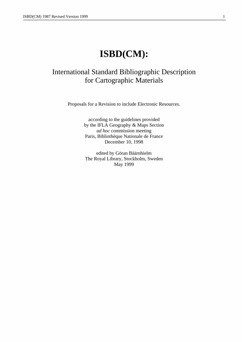
2 EDITION AREAContents2.1 Edition statement2.3 Statements of responsibility relating to the edition
Punctuation patternA. The edition area is preceded by a point, space, dash, space (. - ).B. The first statement of responsibility relating to the edition is preceded by a space, diagonal slash, space ( / ).C. Each subsequent statement of responsibility relating to the edition is preceded by a space, semi-colon, space ( ; ).
Examples. - Edition statement. - Edition statement / statement of responsibility. - Edition statement / statement of responsibility ; second statement of responsibility ; third statement of
responsibility
Note: For the expansion of this area, see ISBD(M).
2.1 Edition statement2.1.1 The edition statement consists of a term, phrase or group of characters relating toA. all copies of an item formally identified as constituting a named and/or numbered edition,orB. *all the copies of an item in a particular form or presentationhaving significant differences, in intellectual or artistic
content, from other copies in the same form or presentation, whether or :not the item bears any formal statement tothis effect.The edition statement normally includes either the word �edition� (or its equivalent , in another language), or arelated term together with an ordinal number (�2nd edition�, etc.), or a term indicating difference from othereditions ("new edition", "revised edition" etc.).
*For electronic resources, related terms such as "version", "level", "release" or "update" can indicate an editionstatement; however, these terms are sometimes used to indicate major or minor changes in an item and, as such,may not constitute a reliable guide to indicate a new edition. The edition statement can also include phrases, whichmay be linguistically associated, linking the edition to other elements of the description (e.g. original title in a formsuch as "new release of …").
*An edition occurs when there are significant differences in the intellectual or artistic content of the resource,including additions and deletions; a difference in the programming language; changes to upgrade or improve theefficiency of the resource; modifications in the programming language or operating system that allow the resourceto be compatible with other machines and operating systems.
*Differences that do not constitute a new edition include: a difference in the type of physical carrier (e.g. from diskto cassette) and/or the size of the physical carrier (e.g. 14 cm to 9 cm disk); differences in printer-related fileformats (e.g. ASCII vs. PostScript); differences in system-related formats (e.g. IBM vs. Macintosh); differencesrelating to the character code or to blocking or recording densities: differences in the output medium or displayformat (e.g. a remote access resource reproduced on floppy disk and optical disc). Normally, differences that do notconstitute a new edition do not warrant the creation of a separate bibliographic record, although a bibliographicagency may choose to create multiple bibliographic records.Comment: This should be a matter for discussion.
*When the electronic resource has multiple edition statements relating to parts or pieces of the item (e.g. aninteractive multimedia work), the statement(s) that relates (relate) to the item as a whole is (are) transcribed. Whenthere is no one statement that applies to the item, the statement(s) may be given in area 7.
*In the case of remote access electronic resources which are often frequently updated, the edition statement isomitted in area 2, and an appropriate note(s) is given in area 7 (see 7.2.2 and 7.8).
*An edition statement that appears only in the accompanying documentation is not regarded as an edition of theresource unless information in the documentation indicates that the statement applies to the resource.
2.1.2 The edition statement is transcribed in the terms in which it appears on the item. *It is enclosed in square bracketsif it does not appear on the prescribed source of information. Standard abbreviations may be used. Arabic numeralsare substituted for other numerals or spelled out numbers. *Explanatory phrases appended to the edition statementmay be given when they are considered necessary for identification of the edition.

ISBD(CM) 1987 Revised Version 1999 21
e.g. . - 2nd ed. rev. and enl.. - Sth ed.. - 3. erw. Aufi.. - Ed. reduite. - Ed. 3-GSGS. - Interactive ed., 1993 version
If the edition statement consists solely or chiefiy of characters that are neither numeric nor alphabetic, which cannotbe reproduced by the typographic facilities available (cf. 0.11), the characters are replaced by words or numbers, asappropriate, in square brackets. An explanation may be given in area 7 (see 7.2).
e.g. . - [Three asterisks] ed.
2.1.3 The edition statement which is an integral part of an element in another area (such as title proper) and has beentreated as such (see 1.1.2.3) is not repeated in the edition area.
*2.1.4 When no edition statement appears in the item, although it is known that the item contains significant changes fromprevious editions, a suitable edition statement in the language of the prescribed source of information and inaccordance with the provisions of 2.1.2 may be supplied, enclosed in square brackets.e.g. . - [New ed.]
. - [Apr. 1995 issue]
. - [Rev. ed., Aug. 1995J
. - [Version 1.5]
. - [School ed.]
2.3 Statements of responsibility relating to the edition2.3.1 Statements of responsibility relating to the edition can refer to persons or to corporate bodies and can indicate
functions such as that of a reviser of a new edition, or can name the person or body responsible for the provision ofsupplementary matter, of appendices, etc., in a new edition.e.g. Grand Quevilly, Petit Quevilly, Petit-Couronne, Seine-Maritime, plan topographique regulier / R. Choquard.
- Mis à jour / M. Pillot
2.3.2 Statements of responsibility relating to the edition in hand, or to parts of the edition in hand, but not to all editions ofthe work are given, in accordance with the provisions of 1.5, in the edition area when found on the item.e.g. . - New ed. / rev. under the direction of Rev. E.F.M. MacCarthy
2.3.3 Statements of responsibility relating to the edition in hand (as described in 2.3.2) but which do not name orotherwise identify a person or corporate body, are given as part of the edition statement (see 2.1.1). Such statementsoften appear as explanatory phrases.e.g. . - 2nd ed., with additions
2.3.4 The following statements of responsibility relating to the edition are not transcribed in the edition area:2.3.4.1 Statements of responsibility which clearly relate to the first published edition or to all published editions
of a work are given in area 1.2.3.4.2 Statements of responsibility which do not clearly relate to only one or only some editions of a work are
given in area 1.

ISBD(CM) Revised Version 1999Variant A: Area 3: Mathematical Data only, for Maps and Electronic Resources.
22
3 MATHEMATICAL DATA AREAContents
3.1 Statement of scale*3.2 Statement of accuracy (optional)3.3 Statement of projection3.4 Statement of co-ordinates (optional)3.5 Statement of equinox
Punctuation patternA. The mathematical data area is preceded by a point, space, dash, space (. - ).B. *The statement of accuracy is preceded by a comma, space (, ).C. The projection statement is preceded by a space, semi-colon, space ( ; ).D. The statements of co-ordinates and equinox are enclosed in one pair of parentheses (())E. The statement of equinox is preceded by a space, semi-colon, space ( ; ).
Examples. - Scale statement ; projection statement (co-ordinates ; equinox). - Scale statement (co-ordinates ; equinox). - Scale statement ; projection statement (co-ordinates). - Scale statement ; projection statement. - Scale statement
3.1. Statement of scale3.1.1 The scale is given as a representative fraction (RF), expressed as a ratio (1: ). The numeral one (1) is separated from
the denominator by a colon (:) which is not preceded or followed by a space. The RF may be preceded by the term"scale" or its equivalent in another language and/or script.
e.g. . - Scale 1:25 000. - Escala 1:100 000. - Echelle 1:50 000. - 1:1 000 000. - Scale 1:5 000-1:25 000
3.1.2 When the scale relates only to particular parts of the cartographic item, it is indicated as such.e.g. . - Scale 1:3 982 200 at equator
- Scale 1:59 304 960 along meridians
3.1.3 Any scale statement included in area 1 is repeated.e.g. Carte au 1:500 000 : [France] / Institut geographique national. - 1:500 000
3.1.4 When the RF is derived from a verbal scale statement, it is given in square brackets. The verbal expression of thescale may be transcribed following the RF.
e.g. . - [1:7 200], 1 pouce pour 100 toises. - Scale [1:63 360], one inch to one mile
3.1.5 When there is no numeral or verbal scale statement, the RF is computed from a bar scale, a graticule (i.e from 1 ° oflatitude which on average is 111 kilometers) or grid, or by comparison with a map of known scale, and is enclosedin square brackets.
e.g. . - [1:1 800 000 env.], 10 lieues de 25 au degre = [2,5 cm] (RF computed from bar scale). - [1:3 000 000 env.], 25 lieues communes de France = [3.8 cm] (RF computed from bar scale). - Scale [1:277 740 approx.] (RF computed from graticule)
3.1.6 When the cartographic item is not drawn or constructed to scale, or the scale cannot be determined, the phrase "Notdrawn to scale" or "Scale indeterminable", or their equivalents in other languages and/or scripts is substituted for ascale statement.
3.1.7 When a vertical scale is appropriate, such as on relief models, this scale is recorded following the horizontal scale.The vertical scale is to be specified as such.
e.g. . - Scale 1:1 744 080, vertical scale [1:96 000 approx.]. - 1:100 000, echelle altimetrique 1:100 000
3.1.8 The scale for celestial charts is expressed as an angular scale in mm per degree.
ISBD(CM) Revised Version 1999Variant A: Area 3: Mathematical Data only, for Maps and Electronic Resources.
23
e.g. . - Scale 88 mm per 1 °
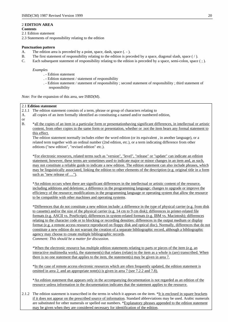
*3.2 Statement of accuracy (optional)For electronic resources, where scale often has no meaning, accuracy may be given as a substitute for or supplementto scale.
e.g. , standard deviation 1.8 m.
3.3 Statement of projection3.3.1 The statement of projection is mandatory when present on the cartographic item. When identified from other
sources, the statement of projection is optional; if it is given, it is supplied in square brackets.
3.3.2 The statement of projection consists of the name of the projection. Associated phrases related to the statement ofprojection may be added when necessary. Such phrases usually consist of statements pertaining to properties of theprojection applicable only to the cartographic item described (e.g. as regards meridians, parallels and/or ellipsoid).Standard abbreviations may be used.
e.g. ; proj. conique conforme de Lambert secante aux paralleles 48° et 77°; proj. conique conforme de Lambert, paralleles d'echelle conservee 45° et 49°; proj. de Mercator transverse universelle, ellipsoide de Clarke 1880; conic equidistant proj. standard parallels 40° and 21° N; transverse Mercator proj. 10 000 yards India Zone I grid, Everest spheroid; azimuthal equidistant proj. centered on Nicosia, N 35°10', E 33°22'
3.4 Statement of co-ordinates (optional)3.4.1 The co-ordinates delimit the greatest extent of the area covered.
3.4.2 For terrestrial maps, the co-ordinates are given in the following order:Westernmost extent of cartographic item (longitude)Easternmost extent of cartographic item (longitude)Northernmost extent of cartographic item (latitude)Southernmost extent of cartographic item (latitude)
Longitude and latitude are expressed in degrees (°), minutes (') and seconds (") of the sexagesimal system (360°circle); longitude is always taken from the Greenwich prime meridian.
The degrees, minutes and seconds of longitudes and latitudes are preceded by the appropriate initials for North (N),South (S), East (E) and West (W) or their equivalents in another language and/or script. The two sets of longitudeand latitude are separated from each other by a diagonal slash not preceded or followed by a space. Each longitudeor latitude is separated from its counterpart by a dash, not preceded or followed by a space.
e.g. (E 79°-E 86°/N 20°-N 12°)(E 110°30'-E 120°30'/N 25°15'-N 22°10')(E 15°00'00"-E 17°30'45"/N 1°30'12"-S 2°30'35")(W 74°50'-W 74°40'/N 45°05'-N 45°00')
3.4.3 For celestial charts, give as co-ordinates the right ascension of the centre of the chart, or the right ascensions of thewestern and eastern limits of the area covered by the chart, and the declination of the centre of the chart, or thedeclinations of the northern and southern limits of the area covered.
The right ascension is designated by "RA" or its equivalent in another language and/or script, followed by the hours,and, when necessary, minutes and seconds of the twentyfour hour clock.
The declination is designated by "Decl." or its equivalent in another language and/or script, followed by the degrees(°) and, when necessary, minutes (') and seconds (") of the sexagesimal system (360° circle), using a plus sign ( + )for the northern celestial hemisphere and a minus sign ( - ) for the southern celestial hemisphere.
The right ascensions and declinations are separated from each other by a diagonal slash not preceded or followed bya space. When two right ascensions and two declinations are given, each right ascension or declination is linked toits counterpart by the word "to" or its equivalent in another language and/or script.
When co-ordinates are given, the statement of equinox is always given also. The equinox is expressed as a yearpreceded by the abbreviation "eq." or its equivalent in another language and/or script. A statement for the epoch is

ISBD(CM) Revised Version 1999Variant A: Area 3: Mathematical Data only, for Maps and Electronic Resources.
24
added when it is known to differ from the equinox, and both are separated with a comma; the epoch is designated by"epoch" or its equivalent in another language and/or script.
e.g. (RA 16. hr. 30 min. to 19 hr. 30 min./Decl. -16° to -49° ; eq. 1950, epoch 1948)(RA 16 hr./Decl. -23° ; eq. 1950) (RA 2 hr./Decl. +30° ; eq. 1950)(RA 2 hr. 00 min. to 2 hr. 30 min./Decl. -30° to 45° ; eq. 1950)
For charts centered on a pole, the declination limit is indicated.e.g. (Centered at South Pole/Decl. limit -60°)
ISBD(CM) Revised Version 1999Variant B: Area 3: Type and Extent of Electronic Resource combined with Mathematical Data for both Maps andElectronic Resources.
25
3 MATHEMATICAL AND TECHNICAL DATA AREAContents
3.1 *Designation of electronic resource (when applicable)3.2 *Extent of electronic resource (optional)3.3 Statement of scale3.4 *Statement of accuracy (optional)3.5 Statement of projection3.6 Statement of co-ordinates (optional)3.7 Statement of equinox
Note: *3.1 and 3.2 describe the basic resource characteristics of an electronic resource. These characteristics include: (a)designation of the type of resource, and (b) information on the extent of resource. Other resource characteristics andthe system requirements conditional for use of an electronic resource are given in area 7.
*These provisions are for an electronic resource that is available by remote access which involves the use of aninput-output device (e.g. a terminal) connected electronically to a computer system to access it (e.g. a resource in anetwork). Designation of the type of resource is mandatory. Extent of resource may be given when the informationis available and the bibliographic agency desires to record it. Physical details relating to sound or colour of aresource available by remote access and accompanying material when present are given in a note (see 7.5.3).
*These provisions may also be given for an electronic resource that is available for local access, which is in aphysical carrier such as a cassette, disk/disc, cartridge or reel designed for the user to insert into the computer or intoa peripheral (e.g. CD-ROM player) attached to the computer, typically a microcomputer.
Punctuation patternA. The mathematical and technical data area is preceded by a point, space, dash, space (. - ).B. *Each statement of extent of an electronic resource is enclosed in one pair of parentheses (())·C. The statement of scale, when preceded by other area 3 elements, is preceded by a point, space, dash, space (. - ).D. *The statement of accuracy is preceded by a comma, space (, ).E. The projection statement is preceded by a space, semi-colon, space ( ; ).F. The statements of co-ordinates and equinox are enclosed in one pair of parentheses (())G. The statement of equinox is preceded by a space, semi-colon, space ( ; ).
When two designations of electronic resources are given, with or without a statement(s) of extent, the seconddesignation of resource is preceded by the word "and� or its equivalent in other languages .
Examples. - Designation of resource (extent of resource) and designation of resource (extent of resource). - Scalestatement, accuracy ; projection statement (co-ordinates ; equinox). - Designation of resource (extent of resource). - Scale statement, accuracy ; projection statement (co-ordinates). - Scale statement ; projection statement (co-ordinates ; equinox). - Scale statement (co-ordinates ; equinox). - Scale statement ; projection statement (co-ordinates). - Scale statement ; projection statement. - Scale statement
3.1 Designation of resource*The designation of resource identifies the particular type of resource(s) which constitutes the work and is given inthe language of the bibliographic agency. The designations for use in English are contained in Appendix C. Thesedesignations may appear in the prescribed source of information; when they are not present in the prescribed sourceof information, they are supplied without brackets based on examination of the work.
3.1.1 *When the electronic resource consists of data, the bibliographic agency may choose to identify the resource as"Electronic data" or "Data" (if the general material designation is given in the bibliographic description).Alternatively, the bibliographic agency may identify the particular type of data using the selective list ofdesignations given in Appendix C. When none of these terms is appropriate, an appropriate designation may besupplied, qualified by the word "electronic" or else used alone if the general material designation is given in thedescription. In the case where the designation is supplied, preference is given to a term that is currently wellestablished, in use by both the producers and users of the particular data resource, and is mutually exclusive of otherterms used as designations.

ISBD(CM) Revised Version 1999Variant B: Area 3: Type and Extent of Electronic Resource combined with Mathematical Data for both Maps andElectronic Resources.
26
e.g. . - Electronic data. - Electronic image data. - Electronic map data
3.1.2 *When the electronic resource consists of a program(s), the bibliographic agency may choose to identify theresource as "Electronic program(s)". Alternatively, the bibliographic agency may identify the particular type ofprogram using the selective list of designations given in Appendix C. When none of these terms is appropriate, anappropriate designation may be supplied, qualified by the word "electronic". In the case where the designation issupplied, preference is given to a term that is currently well established, in use by both the producers and users ofthe particular type of program, and is mutually exclusive of other terms used as designations.
e.g. . - Electronic application program. - Electronic CAD program. - Electronic mapping program. - Electronic games
3.1.3 *When the electronic resource consists of data and program(s), the bibliographic agency may choose to identify theresource as "Electronic data and program(s)". Alternatively, the agency may identify the particular type of data andprogram using the selective lists in Appendix C. The terms "interactive multimedia" and "online service(s)" may beused in conjunction with these lists or else alone as resource designations. When neither of these terms nor the termsin the lists are appropriate, an appropriate designation may be supplied, qualified by the word "electronic". In thecase where the designation is supplied, preference is given to a term that is currently well established, in use by boththe producers and users of the particular data resource and program(s) , and is mutually exclusive of other termsused as designations.
eg. . - Electronic data and program. - Electronic spatial data and mapping program. - Electronic interactive multimedia game. - Electronic interactive multimedia. - Electronic online service
3.1.4 *When the data or program is incidental and not primary in the resource, it is recommended that the bibliographicagency apply the primary term.
e.g. . - Electronic programEditorial comment: Data is incidental in the resource.
3.2 Extent of resource (optional)*Extent of resource may be given when the information is available and the bibliographic agency desires to recordit. When the resource is in a compressed form, the bibliographic agency may omit this information. Extent ofresource consists of the number of files that make up the content of the data or program, adding additional measuresof extent as appropriate. A statement of extent of resource is recorded in parentheses after the designation of theresource. The specific terms for extent of resource are given in the language of the bibliographic agency. The termsrecommended for use in English are contained in the examples.
3.2.1 *The number of files constituting the content of the data or program(s) is given in arabic numerals.e.g. . - Electronic map data (1 file)
. - Electronic CAD program (17 files)
. - Electronic spatial data (5 files) and mapping program (1 file)
3.2.2 *The number of records and/or bytes may be given for a data resource and the number of statements and/or bytesmay be given for a program. When the number of files is given, this further statement of extent is introduced with aspace, colon, space. The number of bytes may be variously expressed (e.g. "megabytes", "MB", "Mbytes") but aregiven in the form in which they appear in the source. The programming language of source code statements is givenin a note (see 7.5.1).
e.g. .- Electronic map data (800 records, 131,550 bytes). - Electronic spatial data (1 file : 1.2 GB) and mapping program (1 file : 2520 statements)
3.2.3 *For a multi-part resource, the number of records and/or bytes or the number of statements and/or bytes may begiven for each resource. When the numbers are numerous or complex, they may be given in a note (see 7.3).
e.g. . - Electronic data (2 files : 800, 1250 records, 2 Mbytes). - Electronic image data (7 files : 6700 records each). - Electronic data (2 files : 2540 records each) and programs (3 files : 7260, 3490, 5076 bytes)

ISBD(CM) Revised Version 1999Variant B: Area 3: Type and Extent of Electronic Resource combined with Mathematical Data for both Maps andElectronic Resources.
27
3.2.4 *The number of records and/or bytes or the number of statements and/or bytes may be approximated. When anestimate cannot be determined, a statement relative to the situation may be given in a note (see 7.3).
e.g. . - Electronic image data (ca. 3000-4000 records). - Electronic data (6 files : ca. 1.2 GB each).- Electronic map data (12 files)Note: Resource size varies
3.3 Statement of scale3.3.1 The scale is given as a representative fraction (RF), expressed as a ratio (1: ). The numeral one (1) is separated from
the denominator by a colon (:) which is not preceded or followed by a space. The RF may be preceded by the term"scale" or its equivalent in another language and/or script.
e.g. . - Scale 1:25 000. - Escala 1:100 000. - Echelle 1:50 000. - 1:1 000 000. - Scale 1:5 000-1:25 000
3.3.2 When the scale relates only to particular parts of the cartographic item, it is indicated as such.e.g. . - Scale 1:3 982 200 at equator
- Scale 1:59 304 960 along meridians
3.3.3 Any scale statement included in area 1 is repeated.e.g. Carte au 1:500 000 : [France] / Institut geographique national. - 1:500 000
3.3.4 When the RF is derived from a verbal scale statement, it is given in square brackets. The verbal expression of thescale may be transcribed following the RF.
e.g. . - [1:7 200], 1 pouce pour 100 toises. - Scale [1:63 360], one inch to one mile
3.3.5 When there is no numeral or verbal scale statement, the RF is computed from a bar scale, a graticule (i.e from 1 ° oflatitude which on average is 111 kilometers) or grid, or by comparison with a map of known scale, and is enclosedin square brackets.
e.g. . - [1:1 800 000 env.], 10 lieues de 25 au degre = [2,5 cm] (RF computed from bar scale). - [1:3 000 000 env.], 25 lieues communes de France = [3.8 cm] (RF computed from bar scale). - Scale [1:277 740 approx.] (RF computed from graticule)
3.3.6 When the cartographic item is not drawn or constructed to scale, or the scale cannot be determined, the phrase "Notdrawn to scale" or "Scale indeterminable", or their equivalents in other languages and/or scripts is substituted for ascale statement.
3.3.7 When a vertical scale is appropriate, such as on relief models, this scale is recorded following the horizontal scale.The vertical scale is to be specified as such.
e.g. . - Scale 1:1 744 080, vertical scale [1:96 000 approx.]. - 1:100 000, echelle altimetrique 1:100 000
3.3.8 The scale for celestial charts is expressed as an angular scale in mm per degree.e.g. . - Scale 88 mm per 1 °
3.4 Statement of accuracy (optional)For electronic resources, where scale often has no meaning, accuracy may be given as a substitute for or supplementto scale.
e.g. , standard deviation 1.8 m.
3.5 Statement of projection3.5.1 The statement of projection is mandatory when present on the cartographic item. When identified from other
sources, the statement of projection is optional; if it is given, it is supplied in square brackets.

ISBD(CM) Revised Version 1999Variant B: Area 3: Type and Extent of Electronic Resource combined with Mathematical Data for both Maps andElectronic Resources.
28
3.5.2 The statement of projection consists of the name of the projection. Associated phrases related to the statement ofprojection may be added when necessary. Such phrases usually consist of statements pertaining to properties of theprojection applicable only to the cartographic item described (e.g. as regards meridians, parallels and/or ellipsoid).Standard abbreviations may be used.
e.g. ; proj. conique conforme de Lambert secante aux paralleles 48° et 77°; proj. conique conforme de Lambert, paralleles d'echelle conservee 45° et 49°; proj. de Mercator transverse universelle, ellipsoide de Clarke 1880; conic equidistant proj. standard parallels 40° and 21° N; transverse Mercator proj. 10 000 yards India Zone I grid, Everest spheroid; azimuthal equidistant proj. centered on Nicosia, N 35°10', E 33°22'
3.6 Statement of co-ordinates (optional)3.6.1 The co-ordinates delimit the greatest extent of the area covered.
3.6.2 For terrestrial maps, the co-ordinates are given in the following order:Westernmost extent of cartographic item (longitude)Easternmost extent of cartographic item (longitude)Northernmost extent of cartographic item (latitude)Southernmost extent of cartographic item (latitude)
Longitude and latitude are expressed in degrees (°), minutes (') and seconds (") of the sexagesimal system (360°circle); longitude is always taken from the Greenwich prime meridian.
The degrees, minutes and seconds of longitudes and latitudes are preceded by the appropriate initials for North (N),South (S), East (E) and West (W) or their equivalents in another language and/or script. The two sets of longitudeand latitude are separated from each other by a diagonal slash not preceded or followed by a space. Each longitudeor latitude is separated from its counterpart by a dash, not preceded or followed by a space.
e.g. (E 79°-E 86°/N 20°-N 12°)(E 110°30'-E 120°30'/N 25°15'-N 22°10')(E 15°00'00"-E 17°30'45"/N 1°30'12"-S 2°30'35")(W 74°50'-W 74°40'/N 45°05'-N 45°00')
3.6.3 For celestial charts, give as co-ordinates the right ascension of the centre of the chart, or the right ascensions of thewestern and eastern limits of the area covered by the chart, and the declination of the centre of the chart, or thedeclinations of the northern and southern limits of the area covered.
The right ascension is designated by "RA" or its equivalent in another language and/or script, followed by the hours,and, when necessary, minutes and seconds of the twentyfour hour clock.
The declination is designated by "Decl." or its equivalent in another language and/or script, followed by the degrees(°) and, when necessary, minutes (') and seconds (") of the sexagesimal system (360° circle), using a plus sign ( + )for the northern celestial hemisphere and a minus sign ( - ) for the southern celestial hemisphere.
The right ascensions and declinations are separated from each other by a diagonal slash not preceded or followed bya space. When two right ascensions and two declinations are given, each right ascension or declination is linked toits counterpart by the word "to" or its equivalent in another language and/or script.
When co-ordinates are given, the statement of equinox is always given also. The equinox is expressed as a yearpreceded by the abbreviation "eq." or its equivalent in another language and/or script. A statement for the epoch isadded when it is known to differ from the equinox, and both are separated with a comma; the epoch is designated by"epoch" or its equivalent in another language and/or script.
e.g. (RA 16. hr. 30 min. to 19 hr. 30 min./Decl. -16° to -49° ; eq. 1950, epoch 1948)(RA 16 hr./Decl. -23° ; eq. 1950) (RA 2 hr./Decl. +30° ; eq. 1950)(RA 2 hr. 00 min. to 2 hr. 30 min./Decl. -30° to 45° ; eq. 1950)
For charts centered on a pole, the declination limit is indicated.e.g. (Centered at South Pole/Decl. limit -60°)

ISBD(CM) 1987 29
4 PUBLICATION, DISTRIBUTION, ETC., AREAContents4.1 Place of publication and/or distribution4.2 Name of publisher and/or distributor4.3 Statement of function of distributor (optional)4.4 Date of publication and/or distribution4.5 Place of printing or manufacture (optional)4.6 Name of printer or manufacturer (optional)4.7 Date of printing or manufacture (optional) 4.8 Special cases
Punctuation patternA. The publication, distribution, etc., area is preceded by a point, space, dash, space (. - ).B. A second or subsequent place is preceded by a space, semi-colon, space ( ; ). C. Each name is preceded
by a space, colon, space ( : ).D. A supplied statement of function of a distributor is enclosed in square brackets ( [ ] ). E. The date is
preceded by a comma, space (, ).F. The place of printing or manufacture, name of printer or manufacturer, and date of printing or
manufacture are enclosed in one pair of parentheses ( ( ) ). Within the parentheses the same punctuation isused as in B, C and E.
Examples. - Place of publication : name of publisher, date. - Place of publication ; place of publication : name of publisher, date (place of printing : name of printer,
date). - Place of publication : name of publisher ; place of publication : name of publisher, date. - Place of publication : name of publisher : name of publisher, date. - Place of distribution : name of distributor [function], date. - Place of publication : name of publisher, date (place of printing : name of printer)
4.0 The imprint is that of the edition or issue being described. In describing a facsimile or other photographic reprint,the place and name of the reprint publisher and the date of the reprint are given in area 4. The imprint of the editionreproduced is given in area 7.
e.g. . - London : London Topographical Society, 1898Note: Facsimile reprint. Originally published, London : R. Walton, [1654]
4.1 Place of publication and/or distribution4.1.1 The place of publication or distribution is the name of the town or other locality associated on the item with the
name of the publisher or distributor. If no publisher or distributor is named on the item, it is the place from whichthe item was issued or distributed.
4.1.2 When more than one place is associated with the name of a single publisher or distributor, the first named place isgiven. When the places do not appear in sequence, the place considered most important by the bibliographic agencyis given. A second or subsequent place may be given. When a second or subsequent place is omitted, the omissionmay be indicated by "etc." or its equivalent in another script, enclosed in square brackets.
e.g. . - London ; New York ; Paris [etc.]. - Berlin ; Köln ; Frankfurt am Main . - Wien [etc.]
4.1.3 When the names of more than one publisher are given, the place of publication for each publisher is givenimmediately before the name, unless it is the same as that of the firstnamed publisher.
4.1.4 When both a publisher and a distributor are given, the place of distribution is given if it differs from the place ofpublication.
4.1.5 The place of publication or distribution is given in the orthographic form and grammatical case in which it appearson the item.
e.g. . - V Praze
4.1.6 If it seems necessary for identification, a qualifier such as the name of a country, state, etc., may be added to theplace of publication or distribution. It is enclosed in parentheses if transcribed from the item or in square brackets iftranscribed from another source.
e.g. . - Cambridge (Mass.). - Cambridge [England]

ISBD(CM) 1987 30
. - Santiago [Chile]
. - London (Ontario)
When it seems necessary for identification, the full address of the publisher or distributor may be added to the placename. It is enclosed in parentheses if transcribed from the item or in square brackets if transcribed from anothersource.
e.g. . - St-Bruno-de-Montarville, Que (1985 La Duchesse). - Vancouver (571 Howe Street)
4.1.7 If it is considered necessary for identification, an alternative or corrected version of the place name may be supplied(see 0.10), enclosed in square brackets.
e.g. . - Christiania [i.e. Oslo]. - Lerpwl [i.e. Liverpool]
4.1.8 When the name of the place of publication or distribution appears on the cartographic item in more than onelanguage and/or script, the form of name in the language and/or script of the title is given. If this criterion does notapply, the form of name that appears first is given.
Parallel statements may be given, preceded by a space, equals sign, space. If these are not given, no indication ismade of the omission.
e.g. . - Bern = Berne
4.1.9 When a place of publication or distribution does not appear anywhere on the item, the name of the known city ortown is supplied in square brackets. If the city or town is uncertain, or unknown, the name of the probable city ortown followed by a question mark is supplied in square brackets.
e.g. . - [Evry]. - [Hamburg?]
4.1.10 When the name of a city or town cannot be given, the name of the state, province or country is given, according tothe same stipulations as are applicable to the names of cities or towns.
e.g. - CanadaEditorial comment: Known as place of publication; appears on the item.. - [Surrey]Editorial comment: Known as place of publication; appears outside the item.- [Guatemala?]Editorial comment: Uncertain as place of publication.
4.1.11 When no place can be given, the abbreviation "s.l." (sine loco) or its equivalent in another script is supplied,enclosed in square brackets.
e.g. . - [S.l.]
4.2 Name of publisher and/or distributor4.2.1 When more than one publisher is named on the cartographic item, the name which appears first is given. When the
names do not appear in sequence, the name considered most important by the bibliographic agency is given.Second and subsequent publishers may be given.
e.g. . - London : The Times ; Edinburgh : John Bartholomew & Son. - Paris : Institut geographique national ; Clermont-Ferrand : Ed. Parc des Volcans
When second or subsequent publishers are omitted, the omission may be indicated by "etc." or its equivalent inanother script, enclosed in square brackets.
e.g. . - London : The Times [etc.]
4.2.2 When the names of both a publisher and a distributor appear on the item, the name of the distributor may be given.When the name of the distributor does not appear on the item, it may be given in area 7. If only the distributor isnamed, this must be given.
4.2.3 The name of a publisher or distributor may be given in a shortened form, provided it can be understood andidentified without ambiguity.
e.g. : H.M. GoushaEditorial comment: Publisher's name appears as The H.M. Gousha Company

ISBD(CM) 1987 31
4.2.4 When the name of the publisher or distributor appears in full in area 1, either the full form may be repeated in area4, or an abbreviated form or identifying phrase may be given there. No square brackets are used for such shorterforms given in place of the full form, even if the shorter form is not shown on the item.
e.g. Societe d'editions geographiques may be given as: S.E.G. when it appears in full as a statement ofresponsibility in area 1.
4.2.5 When the name of a publisher or distributor appears on the cartographic item in more than one language and/orscript, the form of the name in the language and/or script of the title is given. If this criterion does not apply, theform of name that appears first is given. Parallel statements may be given, preceded by a space, equals sign, space (= ).
e.g. . - Bern : Bunkeskanzlei = Berne : Chancellerie federale
4.2.6 The name of the printer or manufacturer is not given as a substitute for the name of an unknown publisher ordistributor. However, when a person or corporate body combines the activities of printing or manufacturing andpublication or distribution, or when the responsibility is uncertain, a named printer or manufacturer is assumed to bealso the publisher.
e.g. . - Paris : Institut geographique nationalEditorial comment: I.G.N. is both a publisher and a manufacturer
4.2.7 When no name can be given as that of the publisher or distributor, the abbreviation "s.n." (sine nomine) or itsequivalent in another script is supplied, enclosed in square brackets.
e.g. . - Paris : [s.n] . - [S.l. : s.n.]
4.3 Statement of function of distributor (optional)4.3.1 When the item includes as an integral part of the imprint statement an indication of the function performed by the
distributor, the statement is transcribed in full.e.g. : to be sold by Jas. Gardner
4.3.2 When the function performed by the distributor is not explicitly stated, a brief word or phrase, indicating the natureof the activity, may be added enclosed in square brackets.
e.g. . - Ottawa : Department of Energy, Mines and Resources : Information Canada [distributor]. - Kobenhavn : Geodaetisk Institut ; [London] : Stanford [distributor]
4.4 Date of publication and/or distribution4.4.1 The date of publication of the edition or impression described is given.
4.4.2 When the same date applies to both publication and distribution or to more than one publisher or distributor, it isgiven after the last name or statement of function.
e.g. . - [Paris] : Institut geographique national ; [Chäteauroux] : Chambre d'agriculture de 1'Indre ; Blois :Chambre d'agriculture du Loir-et-Cher, 1981
4.4.3 If the publication date differs from the date of distribution, each date is given after the appropriate name or statementof function.
4.4.4 Dates of the Gregorian calendar are given in arabic numerals. Dates not of the Gregorian calendar are given as theyappear on the item with the equivalent date of the Gregorian calendar added in square brackets when it can beestablished.
e.g. , 1398 [1973 or 1974]
4.4.5 When the date that appears on the item is known to be incorrect, it is transcribed as it appears and a correction isgiven in square brackets.
e.g. , 1697 [i.e. 1967]
4.4.6 When there is no date of publication or distribution on the item, the copyright date or date of printing is given in itsplace. Both dates are indicated as such.
e.g. , cop. 1971
A copyright date may be added to the date of publication or distribution when the bibliographic agency considers itto be important.
e.g. , 1969, cop. 1967

ISBD(CM) 1987 32
4.4.7 When no date of publication or distribution, copyright date or date of printing can be ascertained for an item, anapproximate date of publication or distribution is given in square brackets.
e.g. , [ca 1935]
4.4.8 In describing an item consisting of parts published over a number of years, the dates of the first and last issued partsare both given and connected by a hyphen.
e.g. , 1968-1970
When the parts of such an item have not all been received, the date of the first published part is given, followed by ahyphen.
e.g. , 1968
4.4.9 The date of a manuscript cartographic item is given as if it were a date of publication unless it is already included inarea 1.
e.g. [Dog Creek Indian Reserve 46, Manitoba] / signed H. Martineau. - Scale [1:6 336], 50 chains to 1 in. -[Ca 1888]
4.5 Place of printing or manufacture (optional)&4.6 Name of printer or manufacturer (optional)
4.5.1&4.6.1
The place of printing or manufacture and the name of the printer or manufacturer must & begiven when they appear on the item and both the place of publication or distribution and thename of the publisher or distributor are unknown.
e.g. . - [5.1. : s.n.] , 1960 (Paris : impr. Michard)
4.5.2&4.6.2
The place of printing or manufacture and the name of the printer or manufacturer may & begiven if they appear on the item.
e.g. . - Paris : Ministere de 1'Interieur, 1979 (Bourges : Tardy Quercy)4.5.3&4.6.3
When multiple places of printing or manufacture and multiple names of printers ormanufacturers are given, the same punctuation is used as for multiple places of publicationor distribution and multiple names of publishers or distributors.
4.7 Date of printing or manufacture (optional)4.7.1 When the date of printing or manufacture is given in place of the date of publication or distribution (see 4.4.6), it is
not repeated here.
4.7.2 When the date of printing or manufacture differs from known dates already given (date of publication ordistribution, or copyright date), it may also be given.
4.7.3 The date of printing or manufacture may be given either as an element following the name of the printer ormanufacturer or by itself. In the latter case a word or brief phrase is added to clarify the date.
e.g. . - Amiens : Association d'etude et de cartographie regionale, 1975 (Amiens : Yvert, 1976). - Amiens : Association d'etude et de cartographie regionale, 1975 (1976 impr.)
4.8 Special casesThe publication and distribution statement is sometimes not limited to a list of places, names and dates but is formulated asa phrase. When it is deemed necessary for identification of issues, states, etc. or other purposes, to retain the phraseology ofelements as presented on the item (e.g. early cartographic publications), the statement may be transcribed as found on theitem. The prescribed punctuation is used.
e.g. . - A Paris : chez I.B.Nolin, sur le quay de 1'Horloge du Palais, vers le Pont Neuf, a l'enseigne de la place desVictoires, 1689. - [London] : Charles Street, Soho, January lst, 1795. - London : printed and published according to Act of Parliament for J.Almon in Picadilly, March 25th, 1776
ISBD(CM) 1987 Revised Version 1999Variant A: Area 5: Physical and Technical Description of Maps and Electronic Resources, including ResourceDesignation and Characteristics for both Local and RemoteAccess
33
5 PHYSICAL *AND TECHNICAL* DESCRIPTION AREA
Contents*5.1 Designation of electronic resource (when applicable)*5.2 Technical characteristics*5.3 Extent of electronic resource (optional)5.4 Specific material designation and extent of physical carrier5.5 Other physical details5.6 Dimensions5.7 Accompanying material statement (optional)
Note*5.1 - 5.3 describe the basic resource characteristics of an electronic resource. These characteristics include: (a) designationof the type of resource, (b) basic technical characteristics and (c) information on the extent of resource. Other resourcecharacteristics and the system requirements conditional for use of an electronic resource are given in area 7.
*Designation of the type of resource is mandatory. Technical characteristics and extent of resource may be given when theinformation is available and the bibliographic agency desires to record it.
Punctuation patternA. The technical and physical description is preceded by a point, space, dash, space (. - )B. Technical characteristics are preceded by a space, colon, space ( : )C. Each statement of extent of an electronic resource is enclosed in one pair of parentheses (())·D. The specific material designation and extent of the physical carrier of an electronic resource is preceded by a point,
space, dash, space (. - )E. Other physical details are preceded by a space, colon, space ( : )F. The dimensions statement is preceded by a space, semi-colon, space ( ; ).G. The accompanying material statement is preceded by a space, plus sign, space ( + ).Examples. - Designation of resource : technical characteristics (extent of resource) and designation of resource : technicalcharacteristics (extent of resource). - Specific material designation and extent : other physical details ; dimensions. - Specific material designation and extent : other physical details ; dimensions. - Specific material designation and extent : other physical details ; dimensions + accompanying material statement. - Specific material designation and extent ; dimensions
5.1 Designation of resource*The designation of resource identifies the particular type of resource(s) which constitutes the work and is given in thelanguage of the bibliographic agency. The designations for use in English are contained in Appendix C. These designationsmay appear in the prescribed source of information; when they are not present in the prescribed source of information, theyare supplied without brackets based on examination of the work.
5.1.1 *When the electronic resource consists of data, the bibliographic agency may choose to identify the resource as"Electronic data. Alternatively, the bibliographic agency may identify the particular type of data using the selectivelist of designations given in Appendix C. When none of these terms is appropriate, an appropriate designation maybe supplied, qualified by the word "electronic".e.g. . - Electronic data
. - Electronic spatial data
. - Electronic image data
. - Electronic map data
5.1.2 *When the electronic resource consists of a program(s), the bibliographic agency may choose to identify theresource as "Electronic program(s)". Alternatively, the bibliographic agency may identify the particular type ofprogram using the selective list of designations given in Appendix C. When none of these terms is appropriate, anappropriate designation may be supplied, qualified by the word "electronic".e.g. . - Electronic CAD program
. - Electronic mapping program
5.1.3 *When the electronic resource consists of data and program(s), the bibliographic agency may choose to identify theresource as "Electronic data and program(s)". Alternatively, the agency may identify the particular type of data andprogram using the selective lists in Appendix C. The terms "interactive multimedia" and "online service(s)" may be

ISBD(CM) 1987 Revised Version 1999Variant A: Area 5: Physical and Technical Description of Maps and Electronic Resources, including ResourceDesignation and Characteristics for both Local and RemoteAccess
34
used in conjunction with these lists or else alone as resource designations. When neither of these terms nor the termsin the lists are appropriate, an appropriate designation may be supplied, qualified by the word "electronic".eg. . - Electronic data and program
. - Electronic image data and retrieval program
. - Electronic spatial data and mapping program
. - Electronic online service
5.1.4 *When the data or program is incidental and not primary in the resource, it is recommended that the bibliographicagency apply the primary term.e.g. . - Electronic mapping program
Editorial comment: Data is incidental in the resource.
5.2 Technical characteristics5.2.1 *The abbreviation "sd.", or its equivalent in another language and/or script, is given as appropriate for an electronic
resource item which is specified to have sound or which is known to produce sound. Requirements for theproduction of sound (e.g. synthesizers, voice input modules) are given in a note (see 7.5.1).
5.2.2 *The characteristic of colour is given for an electronic item that is specified to display in two or more colours or isknown to produce two or more colours. The abbreviation "col.", or its another language and/or script, is given asappropriate. The use of "black and white" (b&w) for an item that is designed to display one colour (e.g. white, greenor amber phosphor on a dark background) is not given. Hardware required for the production of colour (e.g. colourcards, colour monitor) are given in a note (see 7.5.1).e.g. . - Electronic interactive multimedia atlas : sd, col.
. - Electronic online interactive atlas : col.
5.3 Extent of resource (optional)*Extent of resource may be given when the information is available and the bibliographic agency desires to record it. Whenthe resource is in a compressed form, the bibliographic agency may omit this information. Extent of resource consists of thenumber of files that make up the content of the data or program, adding additional measures of extent as appropriate. Thespecific terms for extent of resource are given in the language of the bibliographic agency. The terms recommended for usein English are contained in the examples.
5.3.1 *The number of files constituting the content of the data or program(s) is given in arabic numerals.e.g. . - Electronic map data (1 file)
. - Electronic spatial data (5 files) and mapping program (1 file)
5.3.2 *The number of records and/or bytes may be given for a data resource and the number of statements and/or bytesmay be given for a program. When the number of files is given, this further statement of extent is introduced with aspace, colon, space. The number of bytes may be variously expressed (e.g. "megabytes", "MB", "Mbytes") but aregiven in the form in which they appear in the source. The programming language of source code statements is givenin a note (see 7.5.1).e.g. .- Electronic map data (1 file : 40 MB)
. - Electronic spatial data (1 file : 1.2 GB) and mapping program (1 file : 2520 statements)
5.3.3 *For a multi-part resource, the number of records and/or bytes or the number of statements and/or bytes may begiven for each resource. When the numbers are numerous or complex, they may be given in a note (see 7.3).e.g. . - Electronic spatial data (2 files : 800, 1250 records, 2 Mbytes)
. - Electronic map data (7 files : 6700 records each)
. - Electronic spatial data (2 files : 2540 records each) and mapping programs (3 files : 7260, 3490, 5076bytes). - Electronic map data (4 files)Note: Resource size: 11,000, 33,006, 55,007, 91,325 bytes
5.3.4 *The number of records and/or bytes or the number of statements and/or bytes may be approximated. When anestimate cannot be determined, a statement relative to the situation may be given in a note (see 7.3).e.g. . - Electronic map data (ca. 3000-4000 records)
. - Electronic mapping program (23 files : ca. 35000 bytes each)Note: Resource size varies
5.4 Specific material designation and extent

ISBD(CM) 1987 Revised Version 1999Variant A: Area 5: Physical and Technical Description of Maps and Electronic Resources, including ResourceDesignation and Characteristics for both Local and RemoteAccess
35
5.4.1 The specific material designation identifies the particular class of material to which the cartographic item belongsand is given in the language chosen by the bibliographic agency (see Appendix C for a suggested list of Englishterms). *For electronic resources, the appropriate specific term is qualified by the word "electronic".
5.4.2 The number of physical units constituting an item is given in arabic numerals before the specific materialdesignation.e.g. . - 1 atlas
. - 2 diagrams
. - 1 map
. - 3 maps on 1 sheet
. - 1 map on 2 sheets
. - 1 electronic disk
. - 2 electronic tape cassettes
. - 4 electronic optical discs
5.4.3 *The identification of a particular optical disc format, when known, may be recorded in parentheses after thespecific material designation for an electronic optical disc. The following optical disc formats may be recorded asappropriate: CD-I, CD-ROM, Photo CD.e.g. . - 1 electronic optical disc (CD-ROM) , "
. - 2 electronic optical discs (Photo CD)
. - 1 electronic optical disc (CD-I)
*Other particular optical disc formats may be recorded if their identity is known, the bibliographic agency wishes torecord it,and the format is well established and in use by both the producers and users of the local access resource.
5.5 Other physical detailsOther physical details include method of production, colour, material from which the item is made, etc.
The cartographic item is assumed to be a printed item unless otherwise specified in the "other physical details."
e.g. . - 1 map : col., folded in cover. - 1 map : ms., col.. - 1 model : plaster. - 1 globe : wood. - 1 map : ink drawing, col.. - 1 map : photo reprod.. - 1 map : transparency, col.. - 1 map : both sides, col.. - 2 maps : back to back, col.
5.6 Dimensions5.6.1 The dimensions of the cartographic item are expressed in terms of centimetres rounded up to the next whole
centimetre. The term is abbreviated as "cm" (or its equivalent in another language and/or script).
5.6.2 The dimensions of two-dimensional items, other than circular items, are given in the form of length x width. Thedimensions of three-dimensional items other than globes and sections of spheres, are given in the form of length xwidth x height. The dimensions of globes, sections of spheres and circular two-dimensional items are given in termsof the diameter.The dimensions given, if not otherwise specified, are the dimensions of the part of the cartographic item carrying thegeographic detail.e.g. . - 1 map : col. ; 65 x 40 cm
. - 1 model : col., plastic ; 45 x 35 x 2 cm
. - 1 globe : col., relief pressed from metal ; 23 cm diam.
5.6.2.1*The diameter is given for an electronic disk/disc or a tape reel. The length and width of the tape of a reel may begiven.e.g. . - 1 electronic disk ; 14 cm
. - 1 electronic optical disc ; 12 cm
. - 1 electronic tape reel ; 26.7 cm

ISBD(CM) 1987 Revised Version 1999Variant A: Area 5: Physical and Technical Description of Maps and Electronic Resources, including ResourceDesignation and Characteristics for both Local and RemoteAccess
36
5.6.2.2 *The length of the face of an electronic chip cartridge is given.e.g. . - 1 electronic chip cartridge : 9 cm
5.6.2.3 *The length and height of an electronic tape cassette are given when they are other than the standard size (10 x 7cm) and the width of the tape is given when it is other than the standard width (4 mm).e.g. . - 1 electronic tape cassette ; 19 x 9 cm, 7 mm tape
5.6.3 Additional dimensions such as the dimensions of a map when folded, or the dimensions of individual sheets of acollectively described group, or the individual dimensions of mounted sheets may be given. When more than one setof measurements is given, the whole physical description area should be made in a clear and unambiguous fashion;that is, when it is not clear to which part(s) the dimensions apply, this is clarified by specification.
*For boxed electronic resource items such as a set of electronic disks/discs, with or without accompanying material,the dimensions of the container may be given. Alternatively, the phrase "in container" (or its equivalent in anotherlanguage and/or script) may be used, or the statement may be omitted.
*When the item consists of more than one physical carrier and they differ in size, the dimensions of the smallest orsmaller and the largest or larger are given, separated by a hyphen.e.g. . - 2 maps : col. ; 60 x 40 cm each sheet
. - 1 map in 365 sheets : col. ; 60 x 90 cm each or smaller
. - 1 map in sheets : col. ; 90 x 50 cm each or smaller folded in cover 25 x 16 cm
. - 1 map : col. ; 20 x 31 cm on sheet 37 x 50 cm
. - 1 map : col. ; 9 x 30 cm on sheet 40 x 60 cm, folded to 21 x 10 cm
. - 1 map in 4 sheets : col. ; 40 x 60 cm each, assembled 80 x 20 cm
. - 1 map : col. ; double hemisphere, 6 cm diam. each, on sheet 21 x 15 cm
. - 1 map : microfiche, col. ; 15 x 10 cm
. - 4 electronic tape cassettes ; in container, 12 x 36 x 20 cm
. - 2 electronic disks ; 9-14 cm
5.7 Accompanying material statement (optional)5.7.1 The term "accompanying material" denotes any physically separable part of the item not so far specified in the
physical description area, and which is issued (or intended to be issued) at the same time. Such a part may form oneof two or more mutually interdependent systems (e.g. an electronic disk combined with a sound tape and a manual)or may be a minor part of the item (e.g. an explanatory pamphlet). Depending on the number, nature, or extent of theaccompanying material it may be described in various ways:
a. in a separate entryb. in a multi-level descriptionc. in area 7d. at the end of the physical description in area 5.
If the accompanying material is described in area 5, the following rules apply.5.7.2 Accompanying material is described by a word or phrase indicating the nature of the material.
e.g. . - 1 map : col. ; 108 x 73 cm, folded to 30 x 21 cm + memoir. - 1 globe : col. ; 23 cm diam. + gazetteer. - 2 electronic disks ; 14 cm + 1 pamphlet. - 1 electronic optical disc (CD-ROM) ; 12 cm + 1 sound cassette
Additional descriptive information may be added in parentheses.e.g. . - 1 map in 4 sheets ; 25 x 38 cm each + manual (10 p. ; 30 cm)
. - 2 electronic disks ; 9 cm + user manual (110 p. : 23 cm)
5.8 AtlasesThe physical description of atlases, when described as monographs, is provided according to the ISBD(M) stipulations.e.g. . - 1 atlas (xiv, 226, 192 p.) : chiefly maps ; 37 cm

ISBD(CM) 1987 Revised Version 1999Variant B: Area 5: Physical Description, including Specific Material Designation, for Maps and Electronic Resources forLocal Access Only.
37
5 PHYSICAL DESCRIPTION AREA
Contents5.1 Specific material designation and extent5.2 Other physical details5.3 Dimensions5.4 Accompanying material statement (optional)
Punctuation patternA. The physical description area is preceded by a point, space, dash, space (. - )B. Other physical details are preceded by a space, colon, space ( : )C. The dimensions statement is preceded by a space, semi-colon, space ( ; ).D. The accompanying material statement is preceded by a space, plus sign, space ( + ).Examples. - Specific material designation and extent : other physical details ; dimensions. - Specific material designation and extent : other physical details ; dimensions + accompanying material statement. - Specific material designation and extent ; dimensions
5.1 Specific material designation and extent5.1.1 The specific material designation identifies the particular class of material to which the cartographic item belongs
and is given in the language chosen by the bibliographic agency (see Appendix C for a suggested list of Englishterms). *For electronic resources, the appropriate specific term is qualified by the word "electronic".
5.1.2 The number of physical units constituting an item is given in arabic numerals before the specific materialdesignation.
e.g. . - 1 atlas. - 2 diagrams. - 1 map. - 3 maps on 1 sheet. - 1 map on 2 sheets. - 1 electronic disk. - 2 electronic tape cassettes. - 4 electronic optical discs
5.1.3 *The identification of a particular optical disc format, when known, may be recorded in parentheses after thespecific material designation for an electronic optical disc. The following optical disc formats may be recorded asappropriate: CD-I, CD-ROM, Photo CD.
e.g. . - 1 electronic optical disc (CD-ROM). - 2 electronic optical discs (Photo CD). - 1 electronic optical disc (CD-I)
*Other particular optical disc formats may be recorded if their identity is known, the bibliographic agency wishes torecord it,and the format is well established and in use by both the producers and users of the local access resource.
5.2 Other physical details5.2.1 Other physical details include method of production, colour, material from which the item is made, etc.
The cartographic item is assumed to be a printed item unless otherwise specified in the "other physical details."
5.2.2 *The abbreviation "sd.", or its equivalent in another language and/or script, is given as appropriate for an electronicresource item which is specified to have sound or which is known to produce sound. Requirements for theproduction of sound (e.g. synthesizers, voice input modules) are given in a note (see 7.5.1).
5.2.3 *The characteristic of colour is given for an electronic resource item that is specified to display in two or morecolours or is known to produce two or more colours. The abbreviation "col.", or its another language and/or script, isgiven as appropriate. The use of "black and white" (b&w) for an item that is designed to display one colour (e.g.white, green or amber phosphor on a dark background) is not given. Hardware required for the production of colour(e.g. colour cards, colour monitor) are given in a note (see 7.5.1).
e.g. . - 1 map : col., folded in cover
ISBD(CM) 1987 Revised Version 1999Variant B: Area 5: Physical Description, including Specific Material Designation, for Maps and Electronic Resources forLocal Access Only.
38
. - 1 map : ms., col.
. - 1 model : plaster
. - 1 globe : wood
. - 1 map : ink drawing, col.
. - 1 map : photo reprod.
. - 1 map : transparency, col.
. - 1 map : both sides, col.
. - 2 maps : back to back, col.
. - 1 electronic disk : sd.
. - 2 electronic tape cassettes : col.
. - 1 electronic optical disc (CD-I) : sd., col.
5.3.2.1*The diameter is given for an electronic disk/disc or a tape reel. The length and width of the tape of a reel may begiven.
e.g. . - 1 electronic disk : col. ; 14 cm. - 1 electronic optical disc ; 12 cm. - 1 electronic tape reel ; 26.7 cm
5.3.2.2*The length of the face of an electronic chip cartridge is given.e.g. . - 1 electronic chip cartridge : sd., col. : 9 cm
5.3.2.3 *The length and height of an electronic tape cassette are given when they are other than the standard size (10 x 7cm) and the width of the tape is given when it is other than the standard width (4 mm).
e.g. . - 1 electronic tape cassette : col. ; 19 x 9 cm, 7 mm tape
5.3.3 Additional dimensions such as the dimensions of a map when folded, or the dimensions of individual sheets of acollectively described group, or the individual dimensions of mounted sheets may be given. When more than one setof measurements is given, the whole physical description area should be made in a clear and unambiguous fashion;that is, when it is not clear to which part(s) the dimensions apply, this is clarified by specification.
*For boxed electronic resource items such as a set of electronic disks/discs, with or without accompanying material,the dimensions of the container may be given. Alternatively, the phrase "in container" (or its equivalent in anotherlanguage and/or script) may be used, or the statement may be omitted.
*When the item consists of more than one physical carrier and they differ in size, the dimensions of the smallest orsmaller and the largest or larger are given, separated by a hyphen.
e.g. . - 2 maps : col. ; 60 x 40 cm each sheet. - 1 map in 365 sheets : col. ; 60 x 90 cm each or smaller. - 1 map in sheets : col. ; 90 x 50 cm each or smaller folded in cover 25 x 16 cm. - 1 map : col. ; 20 x 31 cm on sheet 37 x 50 cm. - 1 map : col. ; 9 x 30 cm on sheet 40 x 60 cm, folded to 21 x 10 cm. - 1 map in 4 sheets : col. ; 40 x 60 cm each, assembled 80 x 20 cm. - 1 map : col. ; double hemisphere, 6 cm diam. each, on sheet 21 x 15 cm. - 1 map : microfiche, col. ; 15 x 10 cm. - 4 electronic tape cassettes : sd., col. ; in container, 12 x 36 x 20 cm. - 2 electronic disks : col. ; 9-14 cm
5.4 Accompanying material statement (optional)5.4.1 The term "accompanying material" denotes any physically separable part of the item not so far specified in the
physical description area, and which is issued (or intended to be issued) at the same time. Such a part may form oneof two or more mutually interdependent systems (e.g. an electronic disk combined with a sound tape and a manual)or may be a minor part of the item (e.g. an explanatory pamphlet). Depending on the number, nature, or extent of theaccompanying material it may be described in various ways:
a. in a separate entryb. in a multi-level descriptionc. in area 7d. at the end of the physical description in area 5.
If the accompanying material is described in area 5, the following rules apply.

ISBD(CM) 1987 Revised Version 1999Variant B: Area 5: Physical Description, including Specific Material Designation, for Maps and Electronic Resources forLocal Access Only.
39
5.4.2 Accompanying material is described by a word or phrase indicating the nature of the material.e.g. . - 1 map : col. ; 108 x 73 cm, folded to 30 x 21 cm + memoir
. - 1 globe : col. ; 23 cm diam. + gazetteer
. - 2 electronic disks ; 14 cm + 1 pamphlet
. - 1 electronic optical disc (CD-ROM) . sd., col. ; 12 cm + 1 sound cassette
Additional descriptive information may be added in parentheses.e.g. . - 1 map in 4 sheets ; 25 x 38 cm each + manual (10 p. ; 30 cm)
. - 2 electronic disks ; 9 cm + user manual (110 p. : 23 cm)
5.5 AtlasesThe physical description of atlases, when described as monographs, is provided according to the ISBD(M) stipulations.
e.g. . - 1 atlas (xiv, 226, 192 p.) : chiefly maps ; 37 cm

ISBD(CM) 1987 40
6 SERIES AREAIntroductory noteArea 6 is only used when all parts of the item are published (or are intended to be published) in the same series orsub-series. In other cases the series or sub-series statement(s) may be given in area 7.
When an item belongs to more than one series and/or sub-series, the area is repeated.
In the case of series and sub-series, it is necessary to consult ISBD(S) for an understanding of the elementspertaining to area 6 (e.g. selection of sources, transcription of data). Especially important to note is the explanationof the term "common title" and "dependent title" in ISBD(S) 0.3.3.1, which states that these terms, as used instipulations, cover a) all common/section titles and b) those main/subseries titles in which the sub-series title isdependent.
Contents6.1 Title proper of series or sub-series6.2 Parallel title of series or sub-series6.3 Other title information of series or sub-series (optional)6.4 Statements of responsibility relating to the series or sub-series6.5 International Standard Serial Number of series or sub-series6.6 Numbering within the series or sub-series
Punctuation patternA. The series area is preceded by a point, space, dash, space (. - ).B. Each series statement is enclosed in parentheses ( ( ) ).C. A second and each subsequent series is preceded by a space.D. Each parallel title is preceded by a space, equals sign, space ( = ).E. Each statement of other title information is preceded by a space, colon, space ( : ).F. The first statement of responsibility is preceded by a space, diagonal slash, space ( / ).G. Each subsequent statement of responsibility is preceded by a space, semi-colon, space ( ; ) unless the statements
are considered to form a single phrase.H. The International Standard Serial Number is preceded by a comma, space (, ).I. Numbering within a series or sub-series is preceded by a space, semi-colon, space ( ; ).J. The section or sub-series designation or dependent title following a common title is preceded by a point, space (. ).K. The dependent title following a section or sub-series designation is preceded by a comma, space (, ).
Examples . - (First series) (Second series). - (Title proper of series = Parallel title of series). - (Title proper of series : other title information of series / statement of responsibility relating to series ;
numbering within series). - (Title proper of series, ISSN ; numbering within series). - (Common title. Section or sub-series designation, Dependent title). - (Common title. Dependent title = Parallel common title. Parallel dependent title)
6.1 Title proper of series or sub-series6.1.1 The title proper of the series or sub-series corresponds to the title proper in the bibliographic description of the series
or sub-series when it is described as a serial according to the provisions of area 1 of ISBD(S).e.g. . - (Bartholomew world travel series)
. - (Plan Guide Blay)
. - (JRO-Panoramakarte)
. - (Guides et plans Edicart's)
6.1.2 The title proper is given as it is found on the item. It is transcribed exactly as to wording, but not necessarily as tocapitalization and punctuation.
6.1.3 When a sub-series has a distinctive title, this is given in area 6. The title of the main series is given in area 7.e.g. . - (Land resources of central Nigeria)
Note: Main series: Land resource study
6.1.4 When the title proper is made up of a common title and the title of a section or dependent title of a sub-series, thecommon title is given first, followed by the section or sub-series designation and/or the section or sub-series title.The common title is not repeated in area 7.
e.g. . - (Historischer Atlas von Bayern. Teil Altbayern ; Heft 47)

ISBD(CM) 1987 41
6.1.5 When the item described is a separate part of a multi-part item, the title proper of the series is the title proper of themulti-part item described as a whole according to the provisions of area 1 of ISBD(CM).
e.g. . - (Carte geologique de la France ä 1:50 000 ; IV-19)
6.2 Parallel title of series or sub-series6.2.1 When the title proper of the series or sub-series appears on the item in more than one language and/or script, the
parallel series titles are given.e.g. . - (International map of the world 1:1 000 000 = Carte internationale du monde au 1:1 000 000)
6.2.2 When the title proper consists of a common title and a dependent title, the parallel common title and paralleldependent title are given after the whole title proper.
6.3 Other title information of series or sub-series (optionan6.3.1 Other title information relating to the series or sub-series may be given when it appears on the item and is
considered necessary for the identification of the series.e.g. . - (Old Ordnance Survey Maps : the Godfrey edition)
6.3.2 When the title proper consists of a common title and a dependent title, other title information, if given, follows thepart of the title proper to which it applies. In case of doubt, it is given after the whole title proper.
6.3.3 The edition statement relating to a series is treated as other title information. It is given according to the provisionsof area 2.
e.g. . - (National atlas : separate sales ed.)
6.4 Statements of responsibility relating to the series or sub-series6.4.1 When the title proper of the series or sub-series is a generic term, the first statement of responsibility is mandatory.
In other cases, first and subsequent statements of responsibility may be given when they appear on the item and areconsidered necessary for the identification of the series.
e.g. . - (Serie internationale / Recta Foldex ; 302). - (Tourist map / John Bartholomew)
Parallel statements of responsibility may be given, each preceded by a space, equals sign, space.e.g. . - (Miscellaneous report / Geological survey of Canada = Rapport divers / Commission geologique du
Canada)
6.4.2 When the title proper consists of a common title and a dependent title, each statement of responsibility is given afterthe part of the title proper to which it refers. In case of doubt it is given after the whole title proper.
6.5 International Standard Serial Number of series or sub-series6.5.1 The International Standard Serial Number (ISSN) relating to the series or sub-series is given when it is known and is
transcribed in accordance with the relevant standard.e.g. . - (Manuskripte des Geographischen Instituts der FU Berlin, ISSN 0170-6268)
6.5.2 When the title proper consists of the distinctive title of a sub-series, the ISSN of the main series is given with its titlein area 7.
6.5.3 When the title proper consists of a common title and a dependent title, the ISSN of the common title is omitted inarea 6 and is given in area 7.
6.6 Numbering within series or sub-series6.6.1 The numbering of the cartographic item within a series or sub-series is given in the terms in which it appears on the
item. Standard abbreviations may be used.e.g. . - (Collection des plans anciens de Paris ; 1)
. - (Plan net ; S75)
. - (Carte de le Region Ile-de-France ; X-3)
6.6.2 When the title proper consists of a common title and a dependent title, the numbering of the common title is omitted.An appropriate note or the collocation of the numbering of the series and sub-series may be given in area 7.
e.g. . - (Geological research reports. Map series ; no. 3)Note: Main series numbered 135

ISBD(CM) 1987 42
6.6.3 When the parts of a multi-part item within a series are numbered, the first and last numbers and/or letters are givenand connected by a hyphen when the numbering is continuous. In other cases, all the numbers/letters are given.
e.g. ; v. 11-15; v. 131, 145, 152

ISBD(CM) Revised Version 1999 43
7 NOTE AREAContents
Notes qualify and amplify the formal description where the rules for such description do not allow certaininformation to be included. They can, therefore, deal with any aspect of the physical make-up of the item or itscontents.
Notes, by their nature, cannot be enumerated exhaustively, but can be categorized in terms of the areas of theISBD(CM). In addition to notes relating to these areas, there may be notes relating to the description of thecartographic item which do not correspond to any specific ISBD area. Except where otherwise indicated, notes andtheir order of presentation are optional.
Punctuation PatternEach note is separated from the next one by a point, space, dash, space (. - ). These are omitted, or replaced by apoint, when each note is given on its own separate line.
Within notes it is recommended, where appropriate, that the prescribed punctuation of areas 1-6 be followed; forexample, a title is separated from a statement of responsibility by a space, diagonal slash, space ( / ).
7.1 Notes on the title and statement of responsibility area7.1.1 Notes on the title proper
7.1.1.1 Notes on the source of the title proper *(mandatory for electronic resources).e.g. . - Cover title
. - Title from publisher's catalogue
. - Title from P.L. Phillips' A list of maps of America, p. 502. - Title from title screen. - Title from container. - Title supplied by cataloguer. - Title from printout of title screen. - Title from first display of information
7.1.1.2 Notes giving variant and transliterated titlese.g. . - Title in left margin: Ville de Aix-les-Bains, Savoie
. - Cover title: Schweinfurt Stadtplan(Title proper on map is: Stadt Schweinfurt)
. - Title varies: 1921-1924, Official road map of metropolitan district; 1930-1941,Greater metropolitan district ; 1950-1963, Official road map New York and vicinity
(Most recent sheets have title: New York City and vicinity). - HTML title: CyberMedia. - File name: DUB.1
7.1.2 Notes on the language of the iteme.g. . - Legend in English, French and German (Title proper is in Dutch)
. - Except for the title and `La mer du Nord' the map is in English
. - Legend in 12 languages
. - French. Cover title in French, German and Italian. Legend in French, German, Italian,English and Dutch. - Greek and English. Text in Greek, English and German. Place names in Greek andromanized Greek.
7.1.3 Notes on parallel titles and other title information&
7.1.4 Parallel titles and other title information appearing on the item may be given in a note when they cannot be fittedinto area 1.
7.1.5 Notes on the statements of responsibilityThese may include statements of responsibility not taken from the item, notes on variant or expanded names andpseudonyms, and notes on persons or corporate bodies connected with the work which cannot be fitted into the bodyof the entry (because, for example, their function is not specified), notes on persons or corporate bodies connectedwith previous editions but not with the edition in hand.
e.g. . - Attributed to Blaeu by C. Koeman in: Atlantes Neerlandici, vol...., p.... - By ... from the declaration of copyright deposit

ISBD(CM) Revised Version 1999 44
. - Prepared by State Highway Dept. 1925-1948; prepared by General Drafting Co. 1949-1955;prepared by Engineering Services 1965; prepared by National Survey 1961-1962; prepared byState Highway Dept. 1963-1969; prepared by Dept. of Transportation 1970-
. - "Ground control was supplied by U.S. Coast and Geodetic Survey"
. - "Plotted ... by G. Petrie and D.P. Nicol, University of Glasgow, 1965. Field reconnaissance, 1962,and geomorphological interpretation by R.J. Price as part of Project No. 1469 of the Institute ofPolar Studies, the Ohio State University"
. - Previous editions by ...(This type of note should be restricted to a clear change in personal or corporate authorship, notmerely a change of the name of a personal or corporate author)
7.2 Notes on the edition area and the bibliographic history of the itemThese may include the source of the edition statement and details of the item's relationship to other items and toother editions, including the previous publication of reprints or reissues (see 4.0).
e.g. . - Copied from ... . - Based on .... - Facsimile reprint from a ms. original in the National Map Collection, Public Archives of Canada. - Reprod. from the map published by Nicolas Berey in Paris 1663. - Reprod. of: Johannis Hevelii Uranographia totum coelum stellatum. Gedani, 1690. - Cited in David McNeely Stauffer's American engravers upon copper and steel as appearing in the
Pennsylvania magazine, June, 1775. - Copy of original in Archivo General de Indias, Sevilla. - "Information from official map reproduced under Government Printer's Copyright No. 4219 on
9/10/69"
7.2.1 *Notes on the source of the edition statement (mandatory for electronic resources if applicable)
*The source of the edition statement shall be recorded whenever it differs from the source of the title.e.g. . - Ed. statement from booklet
. - Ed. statement from disk label
. - Ed. statement from information at end of resource
7.2.2 *Notes on the bibliographic history of the item
*These may include indication of the frequently changing contents of a remote access electronic resource.e.g. . - Frequently updated: Last update: 2/18/97
. - Updated weekly
. - Continuously updated; Version 7 dated: May 5, 1997
. - Update: depending on area 4, 6 or 8 years; the update programme is drawn up according to thepresent requirements of the Ministry of Defence.
*These may include details of the item's relationship to other items and to other editions, including reissues.e.g. . - Electronic version of the print publication issued in 1989
. - Replicates survey conducted in 1993 by author
*The following dates may be given when they are relevant to the content, use or condition of an electronic resource.
date(s) covered by the data content (=time for which the underlying data is valid)date(s) when the data were collecteddate(s) of supplementary files and accompanying material not described separately
e.g. . - New England sermons, 1802-1918. - Interview wave I: Apr-. 1991: wave II: Jan. 1992. - Data are representative of the 1990 census. - Data collected in May and June, 1995. - Supplementary files for sophomore and senior cohorts from 1993-1995. - Manual dated 1994
7.3 Notes on the mathematical data *and resource characteristics* area7.3.1 For celestial charts, the first note of the mathematical data area is the note on magnitude. The "limiting magnitude"
is expressed with the abbreviation "Limit. magn." or its equivalent in other languages and/or scripts, followed by anumber which may reach a maximum of 22.
e.g. . - Limit. magn. 3.5
ISBD(CM) Revised Version 1999 45
7.3.2 For photography and remote sensing imagery, the first note of the mathematical data area is the note onmathematical data pertaining to this type of cartographic item.
e.g. . - f6.016 inches, alt. (orig.) 8 000 ft(For an enlargement of an aerial photograph)
. - f5.944 inches, alt. 12 000 ft. - MSS Bands 3 and 4
(For remote sensing image)
7.3.3 Other notes related to the mathematical data areae.g. . - "This map is constructed by using a special projection system which gives a perspective effect
while the immediate lake area remains in scale". - Scale of original 1:1 300 approx.
(For an enlargement of an aerial photograph) . - Oriented with north to right. - Prime meridians: Ferro and Paris. - Scale departure graph: `Statute miles Mercator projection'
7.3.4 *For electronic resources, notes may include additional information about type and extent of resourcesupplementing the formal statement given in area 5 (Variant A) or area 3 (Variant B) and notes on other resourcecharacteristics. For Varian B, this is the place for information on certain characteristics of remote access resources,i.e. colour, which are, for local access resources, reported in area 5.
e.g. . - Extent of database: urban area ca. 1.6 Kb per hectare; rural area ca. 0.3 Kb per hectare
7.3.5 *Notes may include also an extensive description, if desired, of an electronic resource, its scale or accuracy (when itis not given in Area 3), layer structure, format of delivery (file formats, vector/raster etc.), topology, geodesy etc.
e.g. . - Format of delivery: SUF2, DGN (microstation format), DXF, DWG (autocad format); 9 inchmagnetic reeltape, Exabite (8 mm cassette); small files on diskette.. - Deliverable on 31-12-1992: Sheet 9W, 9O, 14W, 14O, 15W, 19W, 19O, 20W (excl. Texel);delivery per sheet or part thereof.. - Structure: All line-segments are noded and, when they have an identity of their own, fitted withtheir own coding; the polygons (objects) which thus are created are coded with a centroid.
7.4 Notes on the publication, distribution, etc., areaThese may include details of other publishers and printers of the item, notes on variant publication, distribution, etc.,information, notes on limited printing or distribution, and additional dates for example when there is a significantdifference in the date of publication or printing and the date of the situation depicted on the item.*These notes may include also information on recommended use, intended audience and restrictions on use of item(especially electronic resources).
e.g. . - Limited edition of 500 numbered copies. - Produced as an advertisement for Bell Telephone Company. - Date of information `based on aerial photography flown in 1950 and 1951'. - Based on 1961 statistics. - "Map based on uncontrolled aerial photography flown 1972. Map field checked 1973". - Public domain software. - Designed for those with a professional interest in analyzing spatial data (geographers, planners,meteorologists, etc.). - For use by library staff only
7.5 Notes on the physical description area *and system requirements for electronic resources.These may include additional physical description of the item supplementing the formal statements given in area 5and statements on particular physical peculiarities.
e.g. . - Watermark: C & I Honig. - In envelope, with title on flap. - Imperfect: Eastern portion and southwest corner wanting
*7.5.1 Notes on system requirements (mandatory for local access electronic resources)System requirements that are conditional for use of the item shall be recorded in a note for all local access electronicresources.

ISBD(CM) Revised Version 1999 46
System requirements are given as the first note. These requirements may include one or more technicalspecifications, usually given in the following order, and preceded by "System requirements" (or its equivalent inanother language and/or script).
Name, model and/or number of machine(s)Amount of memoryName of the operating system(s)Software requirements (including programming language)PeripheralsHardware (internal) modifications
Each requirement, other than the first, is preceded by a semi- colon.
When the item consists of two or more different physical carriers (e.g. an interactive multimedia item consisting ofan electronic disk and a videodisc), a separate system requirements note may be made to highlight distinctive systemfeatures associated with each physical carrier. Alternatively, the cataloguing agency may choose to make a singlesystem requirements note for both physical carriers.e.g. . - System requirements for electronic disk: Macintosh; at least 1MB; System 6.0.5 or later; HyperCard
version 1.0 or later; hard disk drive; connector cable (from Macintosh to videodisc player)Editorial comment: Separate system requirements note for different physical carrier.. - System requirements: Requires BinHex 4.0 to convert binary file. - System requirements: 3865X processor or higher; 2M RAM (4M recommended); Windows 3.0 or higher;hard disk with 8M free space; VGA adapter; col. monitor; mouse. - System requirements: UNIX workstation with Mosaic software
7.5.2 Notes relating to mode of access (mandatory for remote access electronic resources)Mode of access shall be recorded in a note for all remote access electronic resources.
Mode of access is given as the second note following the System requirements note (see 7.5.1), if given, and ispreceded by �Mode of access� (or its equivalent in another language and/or script). In the absence of a systemrequirements note, mode of access is given as the first note.e.g. . - Mode of access: Lexis system. Requires subscription to Mead Data Central, Inc.
. - Mode of access: World Wide Web. URL: http://www.un.org
. - Mode of access: Internet via ftp://ftp.nevada.edu
. --Mode of access: Gopher://gopher:peabody.yale.edu
. - Mode of access: Computer university network
. - Mode of-access: Mikenet
7.6 Notes on the series areaThese may include notes giving information about series in which the item has been issued (see area 6) and notes onseries editors.
7.7 Notes relating to the contents and subject matter7.7.1 Note giving the title of the works contained in item with collective title (see 1.1.2.4)
e.g. . - Contents: Les secteurs sanitaires ; Ensemble des medecins specialistes liberaux par secteur sanitaire au1.1.1979 ; Evolution de la densite des medecins liberaux par secteur sanitaire du 1.1.1976 au 1.1.1979
7.7.2 Description of insets and illustrationse.g. . - Insets: three maps: Structural regions ; Topographical regions ; Erosional and depositional regions. Scale
1:170 000 000 approx. 10 x 24 cm each. - North polar and South polar regions on polar proj. 8 cm diam. each, in left and right bottom corners. - Ills.: Decorative text cartouche in top left corner; peoples of the world and allegorical representations forEurope, Asia, Africa and America form the borders of the map - Includes descriptive index, text, colour illustrations describing types of buoys, ships, lighthouses, fishes,birds, seaweed, sea anemones, and coral, and 9 local maps. - Insets at 1:50 000: Paris, Madrid, Bern, Amsterdam, London. - Insets with indexes: Plant City, Brandon Area, Apollo Beach, Del Webb's Sun City Center. - Includes insets of the Liverpool and Nottingham regions, 3 suggested tourist itineraries, distance chart,text, and advertisements
7.7.3 Description of sections and similar representationse.g. . - Cross sections A-B; C-D; and E-F along bottom margin
. - Includes block diagram of area covered by map
. - Includes an index map to adjacent sheets

ISBD(CM) Revised Version 1999 47
7.7.4 Description of explanatory or related text on item or accompanying ite.g. . - Includes text describing the geology of the area covered, in English and French
. - Includes an index of populated places and distance table . - Has supplement: ...
7.7.5 Notes on the scope of the item or matter depicted on it *including the purpose or potential of electronic resources.e.g. . - "Not for navigation"
. - Shows dioceses
. - Shows names of owners of buildings and other real estate
. - Shows radial distances from City Hall
. - Also shows mineral deposits (Map is named `Road inap ... ')
. - Shows southernmost extent of the midnight sun
. - Contents: Coded vector-database with all topographic point-, line- and area- information, as is representedon the present maps of 1:10,000 and 1:25,000; classification of several topographic features ('layers') such asroads, water, buildings, etc.; within each theme there is subcoding.. - By means of the programme one can create maps in an infinite number of scenarios by manipulating influxas well as concentration-factor (of substances); the programme offers the possibility of creating detailed andgeneral maps in which are depicted how the effluents of rivers entering the North Sea and the substancesdissolved therein will, on average, be distributed over the North Sea.
7.7.6 Notes describing material on verso of the iteme.g. . - On verso: New map of South Hadley, Mass. Scale 1:15 000
. - Maps of 18 `Interchange layouts in Mahoning County' and maps of Craig Beach, Sebring, Beloit,Canfield, Poland, New Middletown, Washingtonville, Lowellville, Stouthers, Campbell, and Youngstown,with street index, on verso. - Text, indexes, colour illustrations, list of tourist facilities and radio stations, route mileage log, controlledaccess highway map, pictorial map, historic places map, and local route maps, on verso of some sheets. - On verso: text in Latin. Pagination: ii
7.7.7 Notes describing depiction of reliefe.g. . - Relief shown by contours, shading and gradient tints . - Relief and depths shown by contours
. - Relief shown pictorially and by shading. Depths shown by soundings and contours
. - "Ekvidistance 50 m" . - Soundings in fathoms
7.7.8 Miscellaneous notes unrelated to areas 1-6e.g. . - "This map must be read in conjunction with the text of the official plan"
. - Stamped on verso: West Bend Chamber of Commerce
. - Pressure sensitive label `New' above title
. - Dedicated to Louis XIV, King of France
*7.8 Notes relating to the resource describedThese may include notes on the edition or issue on which the description of a dynamic remote access resource isbased.
e.g. . - Description based on version dated: Oct. 4, 1997 13:22:11. - Description based on home page dated: 09/06/96. - Description of resource as of: May 19, 1996

ISBD(CM) 1987 48
8 STANDARD NUMBER (OR ALTERNATIVE) AND TERMS OF AVAILABILITY AREAIntroductory note
The area may be repeated when an item has more than one standard numberA. because it is issued in more than one format or by more than one publisher, distributor, etc.
orB. because it has a standard number for the individual unit and also a standard number for the whole group of whichit is a part.
In both cases, the standard number that specifically identifies the item being described is given first. Other numbers(e.g. for the whole group, for other publishers) are given next, as repetitions of the area.If the title of the whole group is given in area 6, the standard number for the whole group is not given with it but isgiven in area 8, with the standard number(s) for the individual unit(s).Each standard number recorded may be followed by any qualification needed to identify it further and/or by itsterms of availability and/or price, which also may be followed by a qualification. Standard numbers that arerepetitions of the area must be qualified. Standard numbers appearing on the item that relate to its bibliographichistory (e.g. ISBNs for earlier editions) are not given in area 8. When considered important, they may be given in anote (see 7.2).
Contents 8.1 Standard number (or alternative)8.3 Terms of availability and/or price (optional)
Punctuation patternA. The standard number (or alternative) and terms of availability area is preceded by a point, space, dash, space(. - ).
B. Terms of availability and/or price are preceded by a space, colon, space ( : ).
C. A qualification added either to a standard number or to the terms of availability and/ or price is enclosed inparentheses ( ( ) ).
D. Each subsequent standard number (or alternative) and terms of availability statement is preceded by a point,space, dash, space, (. - ) unless the areas are clearly separated by paragraphing, typography or indentation, in whichcase the point, space, dash, space may be omitted or replaced by a point given at the end of the preceding area.
Examples. - ISBN (qualification) : price. - ISBN (qualification) : price. - ISBN (qualification) : price. - ISBN : price (qualification). - Terms of availability
8.1 Standard number (or alternative)8.1.1 The ISBN or other standard number is given when known.8.1.2 The standard number is preceded by the letters ISBN, etc., and transcribed in accordance with the relevant standard.2
2) International Standard ISO 2108-1978(E) Documentation - International Standard Book Numbering(ISBN)
8.1.3 When a standard number is incorrectly printed on an item, the corrected number is given, if known, followed by apoint, space, dash, space and the invalid number is given as it appears, with the qualification "invalid" (or itsequivalent in another language and/or script) enclosed in parentheses.
e.g. . - ISBN 3-598-10478-2. - ISBN 3-597-10478-2 (invalid)
8.3 Terms of availability and/or price (optional)8.3.1 A statement of the terms on which the item is available may be given. In the case of an item offered for sale, the
price of the item is given in numerals with the official standard symbol for the currency.e.g. : £2.05
: 90F
8.3.2 Qualifications to the terms of availability and/or price are enclosed in parentheses.e.g. (available from Information Canada $1.25)
(U.S. Government Printing Office $2.50 (Cat. no...))General notes relating to terms of availability and/or price may be given in area 7.
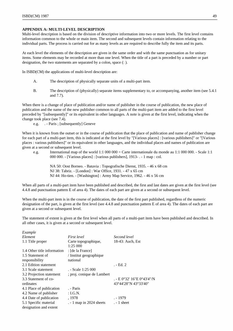
ISBD(CM) 1987 49
APPENDIX A: MULTI-LEVEL DESCRIPTIONMulti-level description is based on the division of descriptive information into two or more levels. The first level containsinformation common to the whole or main item. The second and subsequent levels contain information relating to theindividual parts. The process is carried out for as many levels as are required to describe fully the item and its parts.
At each level the elements of the description are given in the same order and with the same punctuation as for unitaryitems. Some elements may be recorded at more than one level. When the title of a part is preceded by a number or partdesignation, the two statements are separated by a colon, space (: ).
In ISBD(CM) the applications of multi-level description are:
A. The description of physically separate units of a multi-part item.
B. The description of (physically) separate items supplementary to, or accompanying, another item (see 5.4.1and 7.7).
When there is a change of place of publication and/or name of publisher in the course of publication, the new place ofpublication and the name of the new publisher common to all parts of the multi-part item are added to the first levelpreceded by "[subsequently]" or its equivalent in other languages. A note is given at the first level, indicating when thechange took place (see 7.4).
e.g. . - Paris ; [subsequently] Geneve
When it is known from the outset or in the course of publication that the place of publication and name of publisher changefor each part of a multi-part item, this is indicated at the first level by "[Various places] : [various publishers]" or "[Variousplaces : various publishers]" or its equivalent in other languages, and the individual places and names of publication aregiven at a second or subsequent level.
e.g. International map of the world 1:1 000 000 = Carte internationale du monde au 1:1 000 000. - Scale 1:1000 000. - [Various places] : [various publishers], 1913- . - 1 map : col.
NA 50: Oost Borneo. - Batavia : Topografische Dienst, 1935. - 46 x 68 cmNJ 38: Tabriz. - [London] : War Office, 1931. - 47 x 65 cmNJ 44: Ho-tien. - [Washington] : Army Map Service, 1962. - 46 x 56 cm
When all parts of a multi-part item have been published and described, the first and last dates are given at the first level (see4.4.8 and punctuation pattern E of area 4). The dates of each part are given at a second or subsequent level.
When the multi-part item is in the course of publication, the date of the first part published, regardless of the numericdesignation of the part, is given at the first level (see 4.4.8 and punctuation pattern E of area 4). The dates of each part aregiven at a second or subsequent level.
The statement of extent is given at the first level when all parts of a multi-part item have been published and described. Inall other cases, it is given at a second or subsequent level.
ExampleElement First level Second level1.1 Title proper Carte topographique,
1:25 00018-43: Auch, Est
1.4 Other title information : [de la France]1.5 Statement ofresponsibility
/ Institut geographiquenational
2.1 Edition statement . - Ed. 23.1 Scale statement . - Scale 1:25 0003.2 Projection statement ; proj. conique de Lambert3.3 Statement of co-ordinates
. - E 0°32' 16"E 0°43'4"/N43°44'28"N 43°33'40"
4.1 Place of publication . - Paris4.2 Name of publisher : I.G.N.4.4 Date of publication , 1978 . - 19795.1 Specific materialdesignation and extent
. - 1 map in 2024 sheets . - 1 sheet

ISBD(CM) 1987 50
5.2 Other physical details col.5.3 Dimensions ; folded to 23 x 12 cm ; 92 x 77 cm7 Notes New series at 1:25 000
from 1:50 000 series:"Serie bleue"
This analysis would result in the following description:
Carte topographique, 1:25 000 : [de la France] / Institut geographique national. - Scale 1:25 000 ; proj. conique conformede Lambert. - Paris : I.G.N., 1978- . - 1 map in 2024 sheets : col. ; folded to 23 x 12 cm. - New series at 1:25 000 from 1:50000 series: "Serie bleue"
18-43: Auch, Est. - Ed. 2. - E 0°32' 16"-E 0°43'4"/N 43°44'28"-N 43°33'40". - 1979. - 1 sheet ; 92 x 77 cm
Multi-level description is one of a number of choices for the bibliographic description of parts. Solely as an illustrationof the various choices resulting in descriptions on a single level, see the following examples:
A certain descriptions showing as the title proper the title common to the parts, with the titles of individualparts given in a contents note (cf. 7.7);
B certain descriptions showing as the title proper the title of each individual part, with the title common tothe parts given in the series area (cf. 6.1.5);
C certain descriptions showing as the title proper a combination of (a) the title common to the parts and (b)the title of each individual part (cf. 1.1.2.5);
D certain descriptions showing component part analysis (cf. the IFLA Guidelines for the application of theISBDs to the description of component parts).

ISBD(CM) 1987 51
APPENDIX B: BI-DIRECTIONAL RECORDSBi-directional records are multi-script records in scripts written from left to right and scripts written from right to left.
Unless the direction of the script changes within an element, each change of script begins on a new line of the description atthe appropriate margin. Prescribed punctuation is given at the start of the new element in the style required by the script,except for the prescribed point, comma or semi-colon, which are given at the end of the previous element in the stylerequired by the script (see also 0.4 Punctuation). Thus, the point of the point, space, dash, space (. - ) ends the previouselement and the dash begins the following element on a new line at the appropriate margin.
e.g. Carte generale du Liban
=/ dressee, dessinee et imprimee par le Service geographique des F.F.L.
= Map of Eretz Israel (Palestine) / edited by Nahua Ben-Horim
= Semenanjung Malaysia; 1:1 140 4801975
Peta dunia Islam [peta] = Map of the Muslim world
=/ Bahagian Ugama, Jabatan Perdana Menteri. - Skel 1:24 000 000. -Kuala Lumpur : Jabatan Perdana Menteri, 1976

ISBD(CM) Revised Version 1999Specific Material Designations incl. Electronic Resource Designations
52
APPENDIX C: SPECIFIC MATERIAL DESIGNATIONSThe following list of specific material designations for cartographic materials is suggested as a basis for constructing lists inEnglishlanguage countries.
Definitions of the terms are not included.
atlasdiagramglobemapmodelplanprofileremote-sensing imagesectionview
*Electronic Resource Designations (selection)Electronic data
Electronic font data
Electronic image data
Electronic numeric dataElectronic survey dataElectronic spatial data
Electronic representational dataElectronic map data
Electronic text data
Electronic program(s)Electronic application program(s)
Electronic CAD program(s)Electronic mapping program(s)
Electronic data and program(s)Editorial comment: Particular types of data and programs may be identified by combining terms in the selective lists above.The following terms may be used in conjunction with the above terms or alone as resource designations.
Electronic interactive multimedia
Electronic online service(s) (e.g. bulletin boards, discussion groups/lists, World Wide Web sites)
*Specific material designations with �electronic� in the designations:Electronic chip cartridge(s) ;Electronic disk(s)Electronic optical disc(s) iElectronic tape cassette(s)Electronic tape reel(s)
*Definitions (selection)
Application program A resource designed to help users perform a specific task. Examples range from genericproductivity programs, such as spreadsheets, database programs, and word processors,to games and speific purpose programs on business, education, and scientific subjectsand skills. Contrast with System program.
CAD program An application program used in computer-assisted design projects involving the designof scientific, engineering, and architectural models in two or three dimensions, rangingfrom single tools to buildings, aircraft, integrated circuits, and molecules.

ISBD(CM) Revised Version 1999Specific Material Designations incl. Electronic Resource Designations
53
Census data A resource consisting of mostly ve lists numeric data that give the official ion withcount of population and recording of economic status, age, sex, etc.
Chip cartridge A permanently encased ROM chip, from which electronic resource(s) may be read.
Data Information in the form of numbers , letters, graphics, images, sound, or a combinationof these. Types of data include font' data, image data, numeric data, sound data,representational data, and text- data.
Database program An application program that manipulates and manages the storage and retrieval of data,which is structured as fields, records, and files.
Disk A removable, flexible disk used for storage of electronic resources in magnetic form,read and written to by electron-magnetic impulse. Examples of magnetic disk formatsare: floppy disks (also called "diskettes") and hard disks.
Document A resource consisting of mostly text data created in the computer with the use of anapplication program (e.g. letters, articles, reports).
Electronic resource Material (data and/or program(s)) encoded for manipulation by computer. Includesmaterials that require the use of a peripheral (e.g. a CD-ROM player) attached to acomputer, and online service(s) (e.g. bulletin boards, discussion groups/lists, WorldWide Web sites).
Game An application program intended for recreational or educational use. Examples includechess, treasure hunts, war games, and simulations of air flights and world events.
Image data A resource consisting of mostly "pictures", as opposed to alphabetic and numericcharacters, on a. computer screen (e.g. photographs, drawings).
Interactive multimedia Media residing iw one or more physical carriers (e.g. an electronic optical disc andvideodisc) or in computer networks or systems. Interactive multimedia should exhibitthe following two characteristics: (1) user- controlled, nonlinear navigation usingcomputer technology, and. (2) the combination of two or more media (sound, text,graphics, images, animation, and video) that the user manipulates to control the orderand/or nature of the presentation.
Map data An electronic representation of all or part of the surface of the earth or of anothercelestial body.
Numeric data A resource consisting of mostly numbers or representation by numbers, such as recordscontaining census data, survey data, etc.
Online service A system-based activity that supports access to and use of information on the Internet.Online services are provided to users by service organizations and include bulletinboards, discussion groups/lists, World Wide Web sites, news and weather reports,among others.
Operating system Programs that manage the tasks and operations of a computer system, which mayinclude the sequencing of programs, input-output control, debugging, compilation,accounting, storage assignments, aata management, and related services.
Optical disc A removable, non-flexible disc, used for storage of electronic resources in optical form,read and written to by laser technology. Examples of optical disc formats are: CD-I(Compact-Disc Interactive), CD-ROM (Compact Disc Read-Only Memory), Photo CD(Phot Compact Disc) , WORM (Write Once Read Many), and interactive videodiscs.
Program A set of steps or routines instructing the computer to perform certain tasks, includingthe processing of data. Also called "software".
Programming language A language used by programmers to write computer programs, which may requireassembly, compilation, interpretation, or translation before a computer can execute it.
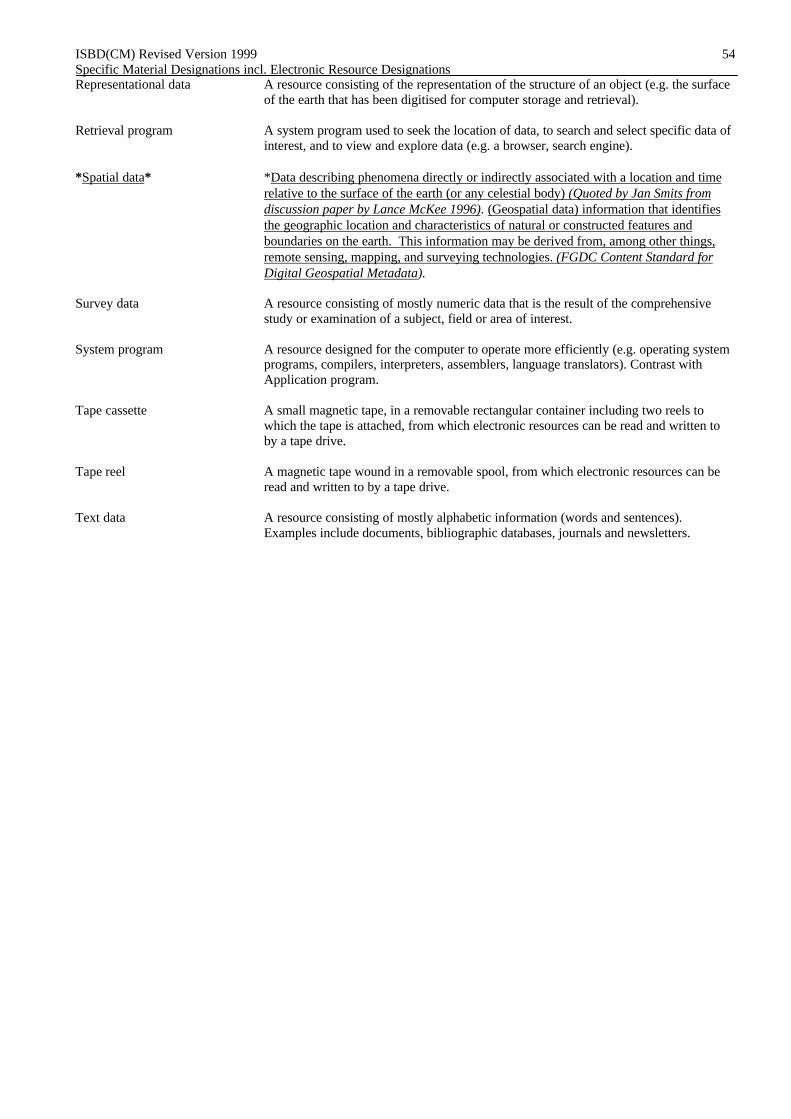
ISBD(CM) Revised Version 1999Specific Material Designations incl. Electronic Resource Designations
54
Representational data A resource consisting of the representation of the structure of an object (e.g. the surfaceof the earth that has been digitised for computer storage and retrieval).
Retrieval program A system program used to seek the location of data, to search and select specific data ofinterest, and to view and explore data (e.g. a browser, search engine).
*Spatial data* *Data describing phenomena directly or indirectly associated with a location and timerelative to the surface of the earth (or any celestial body) (Quoted by Jan Smits fromdiscussion paper by Lance McKee 1996). (Geospatial data) information that identifiesthe geographic location and characteristics of natural or constructed features andboundaries on the earth. This information may be derived from, among other things,remote sensing, mapping, and surveying technologies. (FGDC Content Standard forDigital Geospatial Metadata).
Survey data A resource consisting of mostly numeric data that is the result of the comprehensivestudy or examination of a subject, field or area of interest.
System program A resource designed for the computer to operate more efficiently (e.g. operating systemprograms, compilers, interpreters, assemblers, language translators). Contrast withApplication program.
Tape cassette A small magnetic tape, in a removable rectangular container including two reels towhich the tape is attached, from which electronic resources can be read and written toby a tape drive.
Tape reel A magnetic tape wound in a removable spool, from which electronic resources can beread and written to by a tape drive.
Text data A resource consisting of mostly alphabetic information (words and sentences).Examples include documents, bibliographic databases, journals and newsletters.

ISBD(CM) 1987
99-05-21 16:08
55
APPENDIX D: FRENCH EXAMPLESl. D.A.U. Clermont-Fd : [schema directeur d'amenagement et d'urbanisme de Clermont-Ferrand] : esquisse
2000 / Ministere de 1'Amenagement du territoire, de 1'equipement, du logement et du . tourisme, Directiondepartementale de 1'equipement. - 1:50 000 (E 2°55'-E 3°21'/N 45°55'-N 45°35'). - [Paris] : Ministere de1'Amenagement du territoire, de 1'equipement, du logement et du tourisme, 1974. - 1 carte : en coul. ; 100 x73 cm, sur f. 102 x 96 cm, pliee 30 x 21 cm.
Fond topographique I.G.N. [Institut geographique national]
2. [Plan d'Aix-en-Provence, Bouches-du-Rhöne]. - 1:10 000 (E 5°26'/N 43°32'). - Marseille : J.L. Argaud, 1974.- 1 plan : en coul. ; 39 x 53 cm, sur f. 40 x 54 cm, plie 20 x 12 cm + notice (32 p. ; 20 x 12 cm).
Au v°: Environs d'Aix, [1:47 000 env.]
3. Carte tectonique internationale de 1'Afrique / Association des services geologiques africains ; Organisationdes Nations Unies pour 1'education, la science et la culture = International tectonic map of Africa /Association of African Geological Surveys ; United Nations Educational, Scientific and CulturalOrganization. - 1:5 000 000. - Paris : ASGA : Unesco, 1968. - 1 carte en 9 feuilles : en coul. ; sur f. 67 x 93cm et 67 x 97 cm + notice (54 p. ; 27 x 21 cm).
1: Afrique nord-occidentale [ouest]. - (W 25°-E 5°/N 40°-N 13°). - 59x59 cm.2: Afrique nord-occidentale [centre]. - (E 5°-E 35°/N 40°-N 13°). - 59 x 59 cm.3: Afrique nord-orientale. - (E 34°-E 65°/N 40°-N 13°). - 59 x 65 cm.4: Afrique occidentale. - (W 20°-E 7°/N 14'-N 0°). - 30 x 59 cm.5: Afrique centrale. - (E 6°-E 35°/N 14°-S 15°). - 59 x 59 cm.6: Afrique orientale. - (E 34°-E 61 °/N 14°-S 15°). - 59 x 59 cm.7: Legende. - 59 x 59 cm.8: Afrique australe. - (E 5°-E 35°/S 13°-S 40°). - 59 x 59 cm.9: [Afrique sud-orientale ; Madagascar ; La Reunion ; Ile Maurice]. - (E 34°-E 61°/S 13°-S 26 - 32 x 59 cm.
4. Internes, deportes, fusilles, victimes civiles de 1'Allier / carte dressee par M. Naudin et M. Rougeron,correspondants departementaux du Comite d'histoire de la 2e guerre mondiale. - [1:266 000 env.] (E 2°15'-E3°59'/N 44°37'-N 45°57'). - [Paris : Comite d'histoire de la 2e guerre mondiale], 1972. - 1 carte : en coul. ; 40x 52 cm, sur f. 44 x 57 cm. La carte est inferieure ä la surface delimitee par les points de coordonnees
5. Vallee de la Saöne : carte des sols des zones temoins / I.N.R.A. ; cartes dressees par F. Balley. - 1:25 000. -Dijon : I.N.R.A., 1973. - 1 carte : en coul. ; 43 x 68 cm, sur f. 50 x 70 cm.
Zone d'Aisey et Richecourt, zone de Chaux-les-Port, zone de Gesincourt-Aboncourt zone de Fedry et zoned'Apremont. - Coordonnees non determinables. - Fond topographique I.G.N. [Institut geographique national]
6. Maroc touristique : carte routiere au l:l 000 000 / dressee par la Societe des editions Marcus. - 1:1 000 000(W 12°55'-W 1°45'/N 35°47'-N 27°58'). - Paris : Marcus, 1974. - 1 carte : en coul. ; 74 x 125 cm, sur f. 79 x126 cm, pliee 20 x 13 cm.
"Tableau schematique des distances kilometriques entre les principales villes du Maroc par les routes les plusdirectes". - Carton: "Quelques circuits touristiques".
7. Saint-Georges-de-Didonne, 17110 : [Charente-Maritime]. - 2e ed. - [1:12 000 env.] (W 1 °00' /N 45 ° 36' ). -Marly-le-Roi : L. Petit, 1974. - 1 plan : en coul. ; 27 x 42 cm, sur f. 30 x 43 cm, plie 16 x 12 cm + notice (56p. ; 16 x 12 cm). - (Petit Plan Petit).
Au v°: Repertoire des rues, des terrains de camping, des colonies et maisons de vacances
8. Plan de Paris ä vol d'oiseau / original dresse et dessine par G. Peltier de 1920 ä 1940. - Refection en 1974 parAndre Charon. - [1:7 000 env.] (E 2°20'/N 48°52'). - Paris : Blondel La Rougery, 1974. - 1 plan en 2 feuilles :en coul. ; chaque f. 128 x 87 cm, sur f. 132 x 91 cm.
9. Vraie description des Gaules, avec les confins d'Allemaigne & Italye / Jean Jolivet. - [1:2 000 000 env.] (W5°05'-E 12°29'/N 51°04'-N 41°54'). - Paris : Hier et demain, 1974. - 1 carte : en coul. ; 60 x 92 cm, sur f. 70 x100 cm + texte (8 p. ; 33 x 25 cm).

ISBD(CM) 1987
99-05-21 16:08
56
Reprod. en fac-sim. de 1'ed. de 1570 conservee ä la Bibliotheque nationale, Departement des Cartes et planssous la cote [Res. Ge C 4877], avec un texte de Edmond Pogon. - Dans un etui.
10. Saint-Malo, 35 : [Ille-et-Vilaine]. - lere ed. - [l:ll 000 env.] (W 2°O1'/N 48°39'). - Hennebont : MAJAC,1972. - 1 plan : en coul. ; 72 x 44 cm, sur f. 88 x 67 cm, plie 16 x 12 cm + notice (32 p. ; 16 x 12 cm). - (PlanGuide MAJAC).
11. Europe politique / par P. Kaeppelin, ... et E. Bruley, ... - 1:5 000 000 (W 9°27'-E 54°29'/N 70°59'-N 35°00'). -Paris : Hatier, [1962]. - 1 carte r°-v° : en coul. ; 90x 113 cm, sur f. 101 x 122 cm. - ([Collection des cartesmurales de la librairie Hatier] ; 14-14 bis).
Au v°: Carte muette. - Carton: "L'Europe dans le monde". - 1962 d'apres la declaration du depöt legalimprimeur
MULTI-LEVEL DESCRIPTION1. Carte aeronautique au 1:500 000 / O.A.C.I. - 1:500 000 ; proj. conique conforme de Lambert, paralleles
d'echelle conservee 45° et 49°. - Paris : I.G.N., 1974- . - 1 carte en 7 feuilles : en coul. ; chaque f. 82 x 108cm, sur f. 89 x 127 cm.Legende en français et en anglais. - Dans la marge, tableau d'assemblage
4: Dijon. - 13e ed. - (E 1°30'-E 8°30'/N 49°00'-N 45°15'). - 1984.5: Toulouse. - 13e ed. - (W 2°30'-E 4°00'/N 45°15'-N 42°15'). - 1984.6: Marseille. - 13e ed. - (E 1 °20' -E 7°50' /N 45°45' -N 42° 15' ). - 1984.7: Ajaccio. - 13e ed. - (E 5 °00' -E 11 °30' /N 44°30' -N 41 °00' ). - 1984.
2. Carte internationale du monde = International map of the world. - 1:1 000 000. - [Lieux divers] : [editeursdivers], 1913- . - 1 carte en 2122 feuilles : en coul. ; formats divers.Chaque coupure porte un titre parallele dans la langue du pays d'edition.
NA 50: Oost Borneo. - (E 114°-E 120°/N 4°-N 0°). - Batavia : Topographical Service, 1935. - 49 x 69 cm,sur f. 74 x 91 cm.
NJ 38: Tabriz. - (E 41 °-E 48°/N 40°-N 36°). - [London] : War Office, 1931. - 46 x 64 cm, sur f. 69 x 80 cm.
NQ 32/34: Kiruna - 2e éd. - (E 9°-E 25°/N 69°-N 64°). - Stockholm : Svenska Reproduktions AB, 1970. - 57x 80 cm, sur f. 74 x 82 cm.

ISBD(CM) 1987
99-05-21 16:08
57
APPENDIX E: ENGLISH EXAMPLES1. 3,000 plus : a wallchart of Scottish peaks over 3,000 feet / designed and drawn by G.D. Henderson. -
[1:315 000 approx.] - Edinburgh : J. Bartholomew, cop. 1982. - 1 map : col. ; 95 x 70 cm.
Based on information from Munro's tables 1981 published by the Scottish Mountaineering Trust. Includes alist of the 3000 ft tops in order of altitude, height in metres.
2. Middle East / J. Bartholomew & Son. - 1:4 000 000 ; conic proj. - Edinburgh : Bartholomew, cop. 1985. - 1map : col. ; 71 x 93 cm. folded in cover 26 x 14 cm. - (World travel map). ISBN 0 7028 0337 5.
3. Dyfed : administration areas / Cartographic Services, Welsh Office. - [ 1:250 000 approx.]. - [Cardiff?] :Cartographic Services, Welsh Office, cop. 1983. - 1 map ; 46 x 51 cm.
Shows County, District and Community boundaries as at lst April 1983. - Districts granted Borough statusunder the Local Government Act are identified by (B) placed adjacent to the name. - Based on the OrdnanceSurvey map.
4. Routeplanner : [Great Britain] / Ordnance Survey. - [Ed.] Z. - 1:625 000 (W 8°00'-E 1°20'/ N 60°50'-N49°55'). - Southampton : Ordnance Survey, cop. 1986. - 1 map : both sides, col., 159 x 99 cm on sheet 84 x106 cm.
Includes insets of major urban areas, insets showing National Parks etc., selected motorway junctions and aroad distances table.
5. Assessment of climatic factors in land capability for agriculture in Scotland / Macaulay Institute for SoilResearch. - 1:625 000. - Aberdeen : Macaulay Institute for Soil Research, cop. 1982. - 1 map : col. ; 72 x 87cm folded in cover 23 x 14 cm.
Cover title : Land capability for agriculture in Scotland, map of climatic guidelines. - At head of cover title :Soil Survey of Scotland.
6. B.N.O.C. U.K. continental shelf licence interests, 3lst December 1981 / cartography by BNOC ExplorationDrawing Office. - [1:2 000 000 approx.] ; Lambert conical orthomorphic proj. two standard parallels (W 15°-E 6°/N 64°-N 48°). - Glasgow : British National Oil Corporation, [1982?]. - 1 map : col. ; 93 x 54 cm.
7. Cotswold : [tourist map] / made and published by the Ordnance Survey. - [Ed.] A [bar, star]. reprinted withmajor changes and extended to include Chipping Norton. - 1:63 360. Southampton : Ordnance Survey, cop.1985. - 1 map : col. ; 188 x 79 cm. - (One inch to one mile tourist map / Ordnance Survey).
8. Germany = Deutschland = Germania = Allemagne = Alemania / Philip International. - 1:1 000 000 (E 5°-E14°/N 55°-N 47°). - London : George Philip, cop. 1976. - 1 map : col. ; 96 x 85 cm, folded to 25 x 13 cm. -(Road map = Carta automobilistica = Carte Routiere = Mapa de Carreteras ; 3)
9. 1:10,000 Barbados, OSD 218 / 1 / prepared by the Overseas Survey Directorate, Ordnance Survey. - Ed. 1-OSD 1986. - 1:10 000. - Southampton : Government of the United Kingdom (Ordnance Survey) for theGovernment of Barbados, 1986. - 1 map in 12 sheets : col. ; 90 x 90 cm each or smaller.
10. Pooley's planning chart : United Kingdom and Ireland : aerodromes, helipads, navigational aids, lowerairspace radar service. - 1986 Pooley's flight guide [ ed.]. - 1:1 000 000 ; Lamberts conformal conical proj.(W 11°-E 3°/N 60°-N 50°). - Elstree : Robert Pooley with the assistance of Decca Navigation, 1986. - 1 map: both sides, col ; 117 x 89 cm on sheet 60 x 89 cm.
11. Hertfordshire from space. - 1:100 000. - Borehamwood : Hunting Surveys and Consultants in associationwith Hertfordshire County Council, 1986. - 1 map : col. ; 58 x 66 cm.
A computer enhanced Landsat image of Herfordshire prepared from the red, green and blue bands of theThematic Mapper sensor on board Landsat 5.
12. Explore around the Thames : a practical guide to the non-tidal Thames / for all river users from B.C.M.Publications. - Pocket ed. - [Walton-on-Thames?] : B.C.M. Publications, cop. 1985. - 6 maps on 1 sheet : col; 13 x 61 cm or smaller on sheet 55 x 82 cm folded in cover 19 x 15 cm. (Navigation maps for road and river; no. 1).
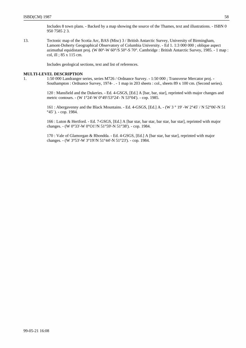
ISBD(CM) 1987
99-05-21 16:08
58
Includes 8 town plans. - Backed by a map showing the source of the Thames, text and illustrations. - ISBN 0950 7585 2 3.
13. Tectonic map of the Scotia Arc, BAS (Misc) 3 / British Antarctic Survey, University of Birmingham,Lamont-Doherty Geographical Observatory of Columbia University. - Ed 1. 1:3 000 000 ; oblique aspectazimuthal equidistant proj. (W 80°-W 60°/S 50°-S 70°. Cambridge : British Antarctic Survey, 1985. - 1 map :col, ill ; 85 x 115 cm.
Includes geological sections, text and list of references.
MULTI-LEVEL DESCRIPTION1. 1:50 000 Landranger series, series M726 / Ordnance Survey. - 1:50 000 ; Transverse Mercator proj. -
Southampton : Ordnance Survey, 1974- . - 1 map in 203 sheets : col., sheets 89 x 100 cm. (Second series).
120 : Mansfield and the Dukeries. - Ed. 4-GSGS, [Ed.] A [bar, bar, star], reprinted with major changes andmetric contours. - (W 1°24'-W 0°49'/53°24'- N 53°04'). - cop. 1985.
161 : Abergavenny and the Black Mountains. - Ed. 4-GSGS, [Ed.] A. - (W 3 ° 19' -W 2°45' / N 52°06'-N 51°45' ). - cop. 1984.
166 : Luton & Hertford. - Ed. 7-GSGS, [Ed.] A [bar star, bar star, bar star, bar star], reprinted with majorchanges. - (W 0°33'-W 0°O1'/N 51°59'-N 51°38'). - cop. 1984.
170 : Vale of Glamorgan & Rhondda. - Ed. 4-GSGS, [Ed.] A [bar star, bar star], reprinted with majorchanges. - (W 3°53'-W 3°19'/N 51°44'-N 51°23'). - cop. 1984.

ISBD(CM) Revised Version 1999
99-05-21 16:08
59
APPENDIX F: ELECTRONIC RESOURCE EXAMPLES
Swedish examplesCD-ROM raster topographic mapsVariant A
Gröna kartan [Cartographic material] : CD-ROM för Windows och Macintosh / Lantmäteriverket. - Scale1:50 000. - Gävle, 1996-. - Electronic map data : col. - 20 disks
Röda kartan [Cartographic material] : CD-ROM för Windows och Macintosh / [produced by]Lantmäteriverket. - Scale [1:250 000] (E 10°50'-E 24°11'/N 69°04'-N 55°20'). - Gävle : Kartförlaget, cop.1997. - Electronic map data and application programs : col. (52 files : 241 MB, 241 416 075 byte). -1 electronic optical disc (CD-ROM) ; 12 cm + manual (8 p. : 12 cm)Title from disc. - Language: Swedish. - Raster map. - Resolution: 1 pixel corresponds to 25x25 m. - Withcontour lines. - Includes mapping program Kartex version 2.12. - Includes place-name index. - Systemrequirements PC: 486/33 MHz processor; 4 MB RAM; 8 MB hard disk space; Windows 3.1/95/NT; CD-ROM 2x speed; 256 colours 640x480 graphics. - System requirements Macintosh: 68020 or Power Mac; 4MB RAM; 8 MB hard disk; Apple system 7.0; CD-ROM 2x speed; colour monitor
Variant B. Gröna kartan [Cartographic material] : CD-ROM för Windows och Macintosh / Lantmäteriverket. -
Electronic map data. - Scale 1:50 000. - Gävle, 1996-.. - 20 disks : col.
Röda kartan [Cartographic material] : CD-ROM för Windows och Macintosh / [produced by]Lantmäteriverket. - Electronic map data and application programs (52 files : 241 MB). - Scale [1:250 000](E 10°50'-E 24°11'/N 69°04'-N 55°20'). - Gävle : Kartförlaget, cop. 1997. - 1 electronic optical disc (CD-ROM) : col.; 12 cm + manual (8 p. : 12 cm)<Notes: as above>
Dutch examplesDynamic digital map on floppy-disk. Variant A
Transport atlas of the southern North Sea : display programme / Rijkswaterstaat ; Delft Hydraulics. - variousscales (W 005-E 012/N 063-N 050). - [The Hague] : Rijkswaterstaat, Service for Tidal Waters ; [Nijmegen :Mooren, dist., 1987]. - Electronic map data : col. (1 file, 260 Kb) and programmes (6 files, 93 Kb). - 1 disk :5¼ inch, DS,DD ; 14 cm + 1 atlas.Optional auto-scaling: a. logarithmic; b. reversed logarithmic.Maps can be presented in black and white as well as in color.By means of the programme one can create maps in an infinite number of scenarios by manipulating influx aswell as concentration-factor (of substances); the programme offers the possibility of creating detailed andgeneral maps in which are depicted how the effluents of rivers entering the North Sea and the substancesdissolved therein will, on average, be distributed over the North Sea.System demands: IBM (-compatible), MS-DOS, colour/graphic adaptercard; Olivetti, MS-DOS,colour/graphic adaptercardANNEX: Transport atlas of the southern North Sea / W.P.M. de Ruiter ... [et al.] ; graphic design andproduction: Mooren. Scales vary from [ca. 1:2,750,000 to ca. 1:8,000,000]. Contains maps of the North Seawith the influx of respectively The Channel, Firth of Forth, Tyne, Tees, Humber, Thames, Schelde,Rijn/Maas, IJsselmeer, Ems, Weser and Elbe; the maps show the distribution of various watermasses over theNorth Sea, with predominantly southwesterly winds of 3.5 m/s and 4.5 m/s. The atlas contains technicalinformation about how to start the programme.
Remote-access dynamic cartographic database[Digital topographic subject map of The Netherlands] / Topografische Dienst Nederland. - Situation on 31-12-1992. - Representational scale 1:5,000 to 1:25,000, standard deviation 1.8 m ; with coordinates of theshifted Dutch triangulation system (E 3°20'-E 7°15'/N 53°35'-N 50°45'). - Emmen : Topografische DienstNederland, 1991-... - Electronic map data (Ca. 1 980 Mb)Mapping scale 1:10,000.Update: depending on area 4, 6 or 8 years; the update programme is drawn up according to the presentrequirements of the Ministry of Defence.Extent of database: urban area ca. 1.6 Kb per hectare; rural area ca. 0.3 Kb per hectare.Format of delivery: SUF2, DGN (microstation format), DXF, DWG (autocad format); 9 inch magneticreeltape, Exabite (8 mm cassette); small files on diskette.Deliverable on 31-12-1992: Sheet 9W, 9O, 14W, 14O, 15W, 19W, 19O, 20W (excl. Texel); delivery persheet or part thereof.Language: English

ISBD(CM) Revised Version 1999
99-05-21 16:08
60
Contents: Coded vector-database with all topographic point-, line- and area- information, as is represented onthe present maps of 1:10,000 and 1:25,000; classification of several topographic features ('layers') such asroads, water, buildings, etc.; within each theme there is subcoding.Structure: All line-segments are noded and, when they have an identity of their own, fitted with their owncoding; the polygons (objects) which thus are created are coded with a centroid.Literature: Van basisbestand naar kernbestand : de Topografische Dienst als producent van een kernbestand1:10.000 / P.W. Geudeke. In: Kartografisch tijdschrift, 1993.XIX.2, pp. 24-28.