Embed Size (px)
Citation preview

IHP/IC-XXIII/Ref 9 Rev. Paris, 7 June 2018
English only
International Hydrological Programme
23rd session of the Intergovernmental Council (Paris, 11-15 June 2018)
WORLD’S LARGE RIVERS INITIATIVE (WLRI) REPORT Sub-item 6.9 of the provisional agenda
Summary
This document presents the World´s Large River Initiative (WLRI) report that includes the activities, proposed methodology of the initiative, outcomes of the working group meetings, publications and research, as well as an outlook of the initiave and a concept paper for further activities.

IHP/IC-XXIII/Ref 9 Rev. Page 2
WORLD’S LARGE RIVERS INITIATIVE (WLRI) REPORT
Title of the Initiative: World’s Large Rivers Initiative (WLRI)
Host Institution: UNESCO Chair on “Integrated River Research and Management” at the University of Natural Resources and Life Sciences, Vienna, Austria (BOKU)
Date of establishment: June 2014 (IHP-IC-21)
Report established by: Prof. Dr. Helmut Habersack (UNESCO Chairholder)
Dr. Doris Gangl (Senior Scientist)
Executive Summary
The World’s Large Rivers Initiative (WLRI) is of scientific nature and aims to create the knowledge base required for a holistic scientific assessment of the status and possible future of the world’s large rivers. Furthermore, it aims to develop innovative strategies based on best practices for their sustainable management. The WLRI serves as a scientific platform for peer learning that will ultimately compile global data in a comprehensive format, as accessible reference for innovation and development. Rivers are complex, dynamic and diverse ecosystems with major ecological, social, economic and cultural significance for their communities and the world at large. The WLRI was established as an IHP initiative at the 21st session of the Intergovernmental Council of the International Hydrological Programme (IHP-Council) in 2014 (Resolution XXI-3). It supports the achievement of internationally agreed commitments such as the Agenda 2030, in particular SDG 6, the United Nations Framework Convention on Climate Change, the Paris Agreement and the Convention on Biological Diversity. It further supports an integrated approach across UNESCO programmes such as the IHP, World Water Assessment Programme (WWAP), the Man and the Biosphere (MAB) Programme and the International Geoscience Programme. The WLRI directly contributes to MLA 3, Expected Result 7 of 39 C/5, strengthening Member States’ response to water security challenges, towards the achievement of water-related Sustainable Development Goals (SDGs) and targets, and other targets from relevant international water agendas. The WLRI is hosted by the UNESCO Chair on Integrated River Research and Management based at the University of Natural Resources and Life Sciences, Vienna, Austria who will continue to function as a secretariat of the WLRI at no cost to UNESCO. In accordance with Resolution XXI-3 adopted at the 21st session of the Intergovernmental Council of IHP a Working Group of member states of the IHP was established and met three times on 25 and 26 June 2015, 27 and 28 June 2016 and on 17 and 18 May 2018 to elaborate the scope, activities and desired outputs of the initiative. All delegations, international experts and all regions were invited, and representatives from over 30 Member States participated in the Working Group Meetings. The Working Group has fulfilled its mandate by clarifying the scientific scope of the initiative (definition of large rivers) as well as a common methodology, activities and desired outputs. After a testing phase of the methodology (Phase I) on three rivers (Danube, Mekong, Niger) on the basis of a harmonized and commonly agreed upon method for assessing the status of large rivers, up to 300 rivers will be assessed on a voluntary basis (Phase II). As a result, the first ever Global Status Report on WLRs will be produced. It will contribute to promoting an integrated and sustainable river management by providing comparable baseline information for decision makers, funding bodies, researchers, civil society and river managers. The WLRI was presented at a side event during the 23rd session of the IHP Intergovernmental Council. Other activities of the WLRI included the organization of World’s Large Rivers Conferences every three years e.g. in Manaus, Brazil in 2014 and in New Delhi, India in 2017, as well as numerous research and educational activities. The planning for the next World’s Large Rivers Conference in 2020 is ongoing. The scientific output of the previous conferences has led to publication of ten special issues in top SCI (Scientific Citation Index) journals (further three are in preparation).

IHP/IC-XXIII/Ref. 9 Rev. Page 3
3
Background and Aims
Rivers are complex, dynamic and diverse ecosystems with major ecological, social, economic and cultural significance. They are fundamental to life, water security and possess major cultural significance. Rivers provide people with multiple goods and services, such as drinking water, food, hydropower, navigation, irrigation and recreation. At the same time large rivers are among the most modified systems worldwide. Their basins are threatened by increasing human pressures and more frequent and severe floods and droughts driven by climate change and land-use alteration, which jointly alter morphology, increase pollution, degrade aquatic habitats and rapidly decrease biological diversity.
The WLRI is of scientific nature and aims to create the knowledge base required for a holistic scientific assessment of the status and possible future of the world’s large rivers. Furthermore, it aims to develop innovative strategies based on best practices for their sustainable management. The WLRI will, as a scientific platform for peer learning, ultimately compile global data in a comprehensive format creating an accessible reference for innovation and development. After a testing phase of the methodology (Phase I) on three rivers (Danube, Mekong, Niger) on the basis of a harmonized and commonly agreed upon method for assessing the status of large rivers, up to 300 rivers will be assessed on a voluntary basis (Phase II). As a result, the first ever Global Status Report on WLRs will be produced. It will contribute to promoting an integrated and sustainable river management by providing comparable baseline information for decision makers, funding bodies, researchers, civil society and river managers. Every three years, the WLRI organizes the World’s Large Rivers Conferences, aiming to gather scientists, discuss novel research and to publish articles in high-ranking scientific journals. Promoting and organising a variety of educational activities are also part of the initiative’s objectives.
The WLRI supports the achievement of internationally agreed commitments such as the Agenda 2030, in particular SDG 6, the United Nations Framework Convention on Climate Change and the Paris Agreement as well as the Convention on Biological Diversity. It further supports an integrated approach across UNESCO programmes such as the IHP, World Water Assessment Programme (WWAP), the Man and the Biosphere (MAB) Programme and the International Geoscience Programme. It directly contributes to MLA 3, Expected Result 7 of 39 C/5, strengthening Member States’ response to water security challenges, towards the achievement of water-related Sustainable Development Goals (SDGs) and targets, and other targets from relevant international water agendas.
Activities
Activity 1: Create a global overview of the present and future status of WLRs
On the basis of a common methodology for a holistic, scientific assessment of the status and possible future of WLRs – with member states participating on a voluntary basis –, the first ever Global Status Report on WLRs will be produced . (see Methodology and Research and Publications).
Activity 2: Close knowledge gaps, foster knowledge transfer
Several activities have been successfully implemented by the WLRI including student exchanges, outreach activities (e.g. Children University programme), the supervision of Master and PhD theses and the organisation of guest seminars (see Education). A website for information and data exchange has been set up (http://unesco-chair.boku.ac.at/). A separate website is maintained for the WLR Conferences (http://worldslargerivers.boku.ac.at/wlr/).
Activity 3: Formulate a collaborative International Research Action Plan on WLRs
A Working Group of member states of the IHP in fulfilment of its mandate in accordance with Resolution XXI-3 adopted at the 21st session of the Intergovernmental Council of IHP elaborated the scope, activities and desired outputs of the initiative (see Working Group Meetings).
Activity 4: Establish a World River Forum, World Rivers Day and WLRs Commission Meetings
Collaborations with several River Commissions were initiated at the three WLR Conferences (Vienna, Manaus, New Delhi) and the International Summit “Water and Climate – Meeting of the Great Rivers of the World” in Rome, Italy in October 2017 (see Interuniversity Exchanges / Partnerships).
Activity 5: Organise future Conferences on the World’s Large Rivers
Three International World’s Large Rivers Conferences have been organised in Vienna/Austria (2011), Manaus/Brazil (2014) and New Delhi/India (2017). The fourth conference will take place in 2020 and planning is currently underway (see International Conferences organized by the WLRI).

IHP/IC-XXIII/Ref 9 Rev. Page 4
Methodology
The methodology of the WLRI was elaborated in a Working Group (WG) of member states of the IHP. It is summarised in a Concept Paper (see Annex to this Reference Document) and also includes the background, aims and activities of the initiative. This Concept Paper was drafted in the follow-up of the first WG meeting, further developed during the 2nd WG meeting and finalized in the 3rd WG meeting.
Common Methodology for Activity 1 as defined in the Concept Paper:
The structural working plan for the global overview of the status and future of WLRs is divided into
three stages:
Concept Paper/(Pre-)Feasibility-Study:
The Concept Paper describes the common methodology and includes a set of parameters as well as
a list of three rivers (Danube, Mekong and Niger) for the first assessment.
Phase I:
Phase I is the testing phase of the methodology on three rivers. The outcome of this phase will be a
harmonized and commonly agreed method for assessing the status of WLRs as well as the status
report of these rivers.
Phase II:
Phase II will involve the assessment of up to 300 rivers. The end product will be a status report of the WLRs in order to support member states, upon their request, with strategies for sustainable river management regarding technical, economic, and ecological needs and to provide comparable baseline information for decision makers, funding bodies, researcher, civil society and river managers. This will be the first global status report on large rivers using a common methodology. The main outcomes will be presented in a similar way for all 300 rivers and compiled in a summary report (including the description of the methodology).
Selection of rivers:
The first step of the methodological approach was based on (a) an evaluation of expert suggestions, questionnaires and existing project information, (b) a database of the 100 largest rivers (according to river length, discharge, catchment size) in order to (c) select three large rivers for the testing phase (Phase I). The Working Group agreed that in order to facilitate an inclusive process other criteria like cultural and economic significance could be taken into account as well when moving into Phase II of the project. The comprehensive project data research (“data mining”) comprised existing World Bank and other projects of UN organisations on large rivers dealing with issues of the 4 thematic fields hydrology & hydraulics, sediment transport & morphodynamics, water quality & ecology and river management & socioeconomics. In particular, it was investigated how many research projects (incl. the project budget and the thematic focus) on large rivers had been conducted, especially in the recent past. Based on this evaluation, useful information on the regional / river basin-related research focus of the World Bank, UNDP and UNEP / GEF could be gathered.
To ensure a broad involvement and expert input of participating countries the attendees of the 1st Working Group Meeting of the WLRI were encouraged to send a preliminary list of ten large rivers (including brief reasons for their suggestions). Moreover, a questionnaire was drafted to additionally involve experts of the World Bank, UNEP, UNDP, GEF, ADB and WWF in the decision making process by asking for a list of ten economically, environmentally and socially relevant rivers from their organizations’ point of view.
Based on the priorities assigned to the list of preselected rivers by internal and external experts and discussions at the 2nd WG meeting, the three rivers Danube, Mekong and Niger were selected for Phase I. These rivers will serve as a proof of concept to test the methodology. Representatives responsible for supporting the WLRI team with data and contacts for those three rivers were chosen at the same meeting. These are Helmut Habersack (Danube), Gil Mahé (Niger) and Siegfried Demuth (Mekong).
On successful completion of Phase I, assessments will be completed for up to 300 large rivers in Phase II, whereby the maximum number will depend on the available financial means, provided data, participating countries etc. and thus could be much smaller.
Definition and Selection of Parameters
In the course of the 1st Working Group Meeting of the WLRI in 2015 in Vienna, a set of parameters was elaborated by the thematic coordinators of the WLRI. Based on the outcomes of the WG discussions, individual suggestions by experts and a web-based data research of existing online-

IHP/IC-XXIII/Ref. 9 Rev. Page 5
5
databases related to large rivers, a first draft set of parameters was decided upon. The parameters were categorized according to the thematic fields hydrology & hydraulics, sediment transport & morphodynamics, water quality & ecology and river management & socioeconomics.
After the 2nd Working Group Meeting questionnaires were distributed among all participants of the WLRI in order to select the parameters of highest importance for Phase I. Based on the feedback a refined list of parameters was determined. The chosen representatives for the rivers Danube, Mekong and Niger will assist the collection of data with regards to these parameters.
Analysis of three Rivers
With the aim to create a neutral, evidence-based status report of large rivers several standardized analytical approaches have to be derived dealing, for example, with the following aspects (extract):
Temporal / downstream development of parameters and derivation of standardized diagrams
Interrelation between parameters (e.g. mean annual discharge – suspended load; land use – river
morphology / ecological status)
Spatial and temporal heterogeneity of parameters
Extreme values
Working Group Meetings
Hosted by the UNESCO Chair on Integrated River Research and Management at the University of Natural Resources and Life Sciences, Vienna in Austria, a Working Group of member states of the IHP met three times in Vienna and defined the scope, including the definition of large rivers and a common methodology, as well as the activities and desired outputs of the initiative. All delegations, international experts and all regions were invited, and representatives from over 30 Member States participated in the Working Group meetings.
The 1st WLRI Working Group meeting took place from 24 to 25 June 2015 in Vienna and provided a forum for wide-ranging discussions on the scope of the WLRI and possible approaches for an integrated, international project for the assessment of the status and the future of WLRs. The methodology was defined, the scientific scope clarified and the development of a concept paper suggested. The definition of large rivers was discussed and agreed. For the purpose of the WLRI, the WMO definition of large rivers will be used (according to mean annual discharge), but can be extended during further development of the WLRI. In order to facilitate an inclusive process other quantitative and qualitative criteria can be taken into account (e.g. the natural, cultural and economic significance of rivers).
The 2nd WLRI Working Group meeting took place from 27 to 28 June 2016 in Vienna and further
developed the international and interdisciplinary project. The concept paper/pre-feasibility study was
presented and discussed. The parameters for the assessment of rivers in Phase I and II were
reviewed and debated. In addition, three rivers were selected for Phase I (Danube, Niger, Mekong).
The 3rd WLRI Working Group meeting took place from 17 to 18 May 2018. The concept paper was
finalised and first results of the project were presented. The next steps with regard to the project
funding (e.g. World Bank) were discussed.
International Conferences organized by the WLRI every three years
International Conferences on the Status and Future of the World´s Large Rivers (co-sponsored by
UNESCO, IAHR, IAHS, WASER and IAG)
1st international WLR Conference in Vienna, Austria from 11 to 14 April 2011
- First public discussion of the WLRI
- Recommendation of a collaborative, multidisciplinary and international initiative
2nd international WLR Conference in Manaus, Brazil from 21 to 24 July 2014
- Scientific presentations on all aspects of WLRs
- Discussion on the scope of the WLRI, scale definitions, WLRI activities and next WLR
conference venue
3rd international WLR Conference in New Delhi, India from 18 to 21 April 2017.
- Scientific presentations on all aspects of WLRs
- Discussion of the publication of further special issues SCI journals

IHP/IC-XXIII/Ref 9 Rev. Page 6
4th international WLR Conference: planned for 2020
- Currently in the planning phase
- More information announced in 2018
Other meetings:
- Besides organising the above mentioned meetings and conferences, the WLRI was
presented at more than 13 events by the UNESCO Chairholder and colleagues.
Research and Publications
Publications within WLRI:
The WLRI has published ten special issues with 143 articles and 554 authors following the International Conferences in top SCI journals. An additional three special issues are in preparation [see also Annex I].
In preparation:
International Journal of River Basin Management (ed. Habersack, Eder, Tritthart,
Liedermann (in prep.)): Major Issues in Large Rivers' Basin Management.
Hydrological Processes (ed. Habersack, Eder, Tritthart, Liedermann (in prep.)):
Hydrological Challenges for the Status and Future of World's Large Rivers.
Journal of Hydraulic Engineering (ed. Habersack, Eder, Tritthart, Liedermann (in prep.)):
Hydraulic Engineering in Large Rivers.
Published:
Hydrobiologia 814, 1-246 (ed. Habersack, Samek, Eder (2018)): Multifunctionality of
Large Rivers.
Environmental Science and Pollution Research 23, 11393-12490 (ed. Habersack, Samek
(2016)): Water quality issues and management of large rivers.
Natural Hazards 75, 1-105 (ed. Habersack, Haspel, Schober (2015)): Flood prevention
and mitigation at large rivers.
Water Resources Research 50, 3641-4544 (ed. Habersack, Haspel, Kondolf (2014)): Large
Rivers in the Anthropocene: Insights and tools for understanding climatic, land use,
and reservoir influences.
Hydrobiologia. 729, 1-259 (ed. Habersack, Haspel, Muhar, Waidbacher (2014)): Impact of
human activities on biodiversity of large rivers.
Geomorphology, 215, 1-106 (ed. Habersack, Haspel, Schober (2014)): Morphological
characterization and fluvial processes of large rivers at different time scales.
IHP/IC-XXIII/Ref. 9 Rev. Page 7
7
River Systems, 20, 145-287, (ed. Habersack, Hein (2013)): Integrating landscape,
catchment perspectives, ecology, management.
International Journal of River Basin Management. 11, 137-236 (ed. Habersack, Haspel,
Campell (2013)): Integrated management of large river systems.
Hydrological Processes. 27, 2103-2224 (ed. Habersack, Walling (2013)): The Hydrology
of Large Rivers.
International Journal of Sediment Research. 28, 431-598 (ed. Habersack, Haspel (2013)):
Sediment loads and processes in large rivers.
Publication of the WLR Conference Abstract Books:
Habersack, Filizola, Schober (Eds.) (2014): World's Large Rivers Conference 2014 Manaus,
Brazil, Conference Abstract Book.
National Institute of Hydrology India, University of Natural Resources and Life Sciences
Vienna (Eds.) (2017), Proceedings of the 3rd International Conference on the Status and
Future of the World's Large Rivers, Conference Abstract Book.
Concept paper:
A concept paper was drafted in the follow-up of the first WLRI Working Group (WG) meeting of member states of the IHP. It was further developed at the 2nd WG meeting and finalized at the 3rd WG meeting. The concept paper includes a common methodology to assess large rivers on a voluntary basis and further clarifies the scope, activities and desired outputs of the initiative.
Questionnaires:
A questionnaire to determine the rivers for phase I of the global project was drafted and distributed among WLRI members and experts of the World Bank, UNEP, UNDP, GEF, ADB, WWF, UNESCO and WMO. A second questionnaire was distributed after the 2nd Working Group meeting to select relevant parameters for Phase I.
Phase I:
In Phase I of the project the common methodology designed within the WLRI will be tested on the three rivers Danube, Mekong and Niger. Representatives acting as contact persons for these rivers have been assigned.
Further Research Activities:
The WLRI was the driving force behind the DREAM (Danube River Research and Management) project which aims at creating an international research network along the Danube River. It consists of a partnership of universities and research institutions and will be completed by the establishment of two large-scale hydraulic laboratories and the operation of research vessels. The laboratory associated with BOKU university is in its final planning phase. The construction will begin in 2018.
The WLRI supported the establishment of the Christian Doppler Laboratory for Sediment Research and Management and supports one of the work packages by linking it to the WLRI Phase II assessment of 300 large rivers.
Education
Theses:
2 Doctoral theses and 9 Master theses have been completed within the scope of the WLRI.
Further events:
Exchange of two students (MSc/PhD) and one scholar within the CEEPUS (Central European
Exchange Program for University Studies) project.

IHP/IC-XXIII/Ref 9 Rev. Page 8
Participation at the Children University 2015, 2016 and 2017 with the topic River ecological and
morphological issues at the Danube River. The Children University programme brings together
7-12-year-old children and researchers from university. The aim is to foster scientific curiosity and
make scientific research topics more accessible to the general public.
Guest seminars:
7 guest seminars were organised by the WLRI at which internationally renowned experts presented their research and which offered an opportunity for scientific discussions.
Prof. Gjetaj (University of Zagreb, Croatia)
Prof. Fotis Sotiropoulos (University of Minnesota, USA)
Prof. Koen Blanckaert (University of Hong Kong, China)
Dr. Arvind Singh (University of Central Florida, USA)
Prof. Paul Carling (University of Southampton, UK)
Prof. Vladimir Kukurin (University of Architecture, Civil Engineering and Geodesy, Bulgaria)
Dr. Graeme Smart (NIWA, New Zealand)
Interuniversity Exchanges / Partnerships
The WLRI started an interaction/partnership with several UNESCO Chairs, Cat. II Centers and other IHP Programmes (e.g. ISI, IDI, FRIEND participated in the 2nd Working Group Meeting) and the Transboundary Water Assessment Programme TWAP (letter of cooperation, M. MacDevette, UNEP, GEF).
As work package leaders for the sectoral themes of the project, the following institutions/persons have agreed to participate in the WLRI:
Hydrology & Hydraulics: Francis Chiew (Australia)
Sediment Transport & Morphodynamics: Edgardo Latrubesse (USA)
Water Quality & Ecology: Marnik Vanclooster (Belgium)
River Management & Socioeconomics: Luna Bharati (Nepal)
At the 2nd Working Group meeting the three rivers Danube, Mekong and Niger were chosen based on expert discussions and feedback questionnaires. Members of the following institutions have agreed to act as representatives responsible for supporting the WLRI team with data and contacts for those three rivers:
University of Natural Resources and Life Sciences (Austria): Helmut Habersack
IRD (France): Gil Mahé
International Centre for Water Resources and Global Change (Germany): Siegfried Demuth
The WLRI idea was presented at numerous conferences/meetings, e.g.:
9 - 19 February 2015: UNESCO Inception Meeting “Addressing Water Security: Climate
Impacts and Adaptation responses in Africa, the Americas, Asia and Europe”, Paris, France.
19 February 2015: Presentation of the WLRI at the World Bank, UNEP, Washington DC,
UNDP, New York, USA.
21 - 22 October 2015: WLRI meeting with UNESCO Liaison Office, Brussels, Belgium.
26 - 30 October 2015: International Conference on African Large River Basins Hydrology,
Hammamet, Tunisia [supported by WLR].
24 - 25 May 2016: Participation IHP Region I Meeting in Koblenz, Germany
13 - 17 June 2016: Participation at the 22nd session of the IHP Intergovernmental Council.
Paris, France
25 - 27 October 2016: Cooperation between WLRI and G-WADI in the course of the Global G-
WADI Conference in Bejing, China
30 November 2016: Presentation at the Western Balkans Sustainable Hydropower
Conference in Palais Ferstel, Vienna, Austria
15 - 16 June 2017: UNESCO IHP Region I Meeting in Perugia, Italy 19 June 2017: Meeting at UNESCO headquarters to discuss possible next steps for the WLRI.
Paris, France
IHP/IC-XXIII/Ref. 9 Rev. Page 9
9
20 - 22 June 2017: UNESCO IHP Bureau Meeting in Paris, France: Prof. Habersack in the
function of Vice-Chair of the IHP for Region I
5 - 7 July 2017: Helmut Habersack attended the UNESCO Chair Conference “Mobilising
UNESCO Chairs in Natural Science for Policy Action towards the 2030 Agenda” in Geneva,
Switzerland and presented a poster on the WLRI
23 - 25 October 2017: Participation at the International Summit “Water and Climate – Meeting
of the Great Rivers of the World”, future contribution of WLRI, in Rome, Italy
Further exchanges/partnerships include:
WASER – World Association for Sedimentation and Erosion Research
International Water Management Institute (IWMI), Sri Lanka / Nepal
International Commission for the Protection of the Danube River (ICPDR)
Institute for the Danube Region and Central Europe
UFAM Universidade Federal do Amazonas, Manaus, Brazil
Moscow State University, Russia
UNESCO Khartoum Office / University of Khartoum, Sudan
Rhodes University, South Africa
Technical University of Bucharest, Romania
Czech University of Life Sciences Prague, Czech Republic
University of Novi Sad, Serbia
Tsinghua University / ISI / ITRCS Peking UNESCO Cat. II Center, China
UNESCO Cat. II Centers (e.g. IRTCES, WRGC at BfG), China, Germany
University of California, Berkeley, USA
University of Exeter, UK
Collaboration with the proposed UNESCO Chair on Ecology and Ecohydrology for Water
(Security & Scarcity) of Prof. Pradeep Shrivastava at Barkatullah University, Department of
Environmental Science & Limnology, Bhopal, India
Prof. Habersack was elected President of the International Commission for the Hydrology of
the Rhine basin (CHR) in 2018
Outlook
The methodology for the global assessment of WLRs in the status report will be updated, if necessary, based on the results of Phase I and implemented in Phase II (applying the methodology up to approx. 300 rivers on a voluntary basis). Funding for the WLRI by the World Bank is currently being discussed. Regarding the WLR Conferences, the venue for the next conference will be selected in 2018. The preparations for the 4th conference in 2020 have started in January 2018. Those countries which have not been selected this time, will be invited to apply again for the 5th conference in 2023 (most likely this conference will take place in Africa). A cooperation with the International Network of Basin Organizations will be started. In interaction with the UNESCO Water Family, the closing of knowledge gaps, knowledge transfer to next generation scientists, stakeholders, decision makers, children (education) and the general public is envisaged. A strong emphasis will be given to achieving a gender balance in all activities related to the WLRI.
IHP/IC-XXIII/Ref 9 Rev. Page 10
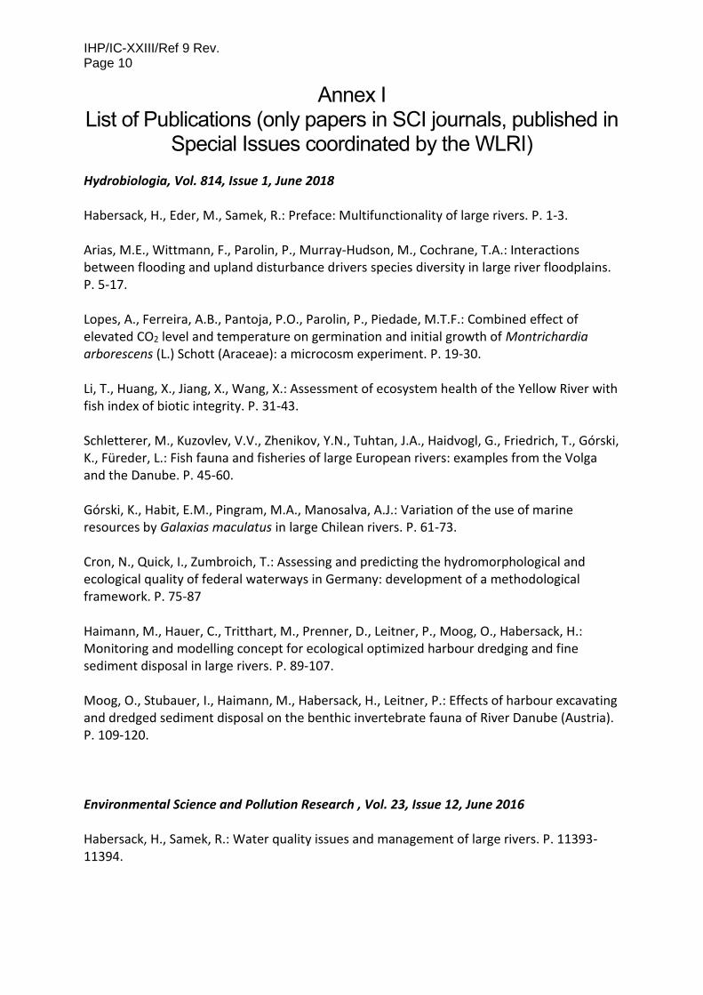
Annex I List of Publications (only papers in SCI journals, published in
Special Issues coordinated by the WLRI)
Hydrobiologia, Vol. 814, Issue 1, June 2018 Habersack, H., Eder, M., Samek, R.: Preface: Multifunctionality of large rivers. P. 1-3. Arias, M.E., Wittmann, F., Parolin, P., Murray-Hudson, M., Cochrane, T.A.: Interactions between flooding and upland disturbance drivers species diversity in large river floodplains. P. 5-17. Lopes, A., Ferreira, A.B., Pantoja, P.O., Parolin, P., Piedade, M.T.F.: Combined effect of elevated CO2 level and temperature on germination and initial growth of Montrichardia arborescens (L.) Schott (Araceae): a microcosm experiment. P. 19-30. Li, T., Huang, X., Jiang, X., Wang, X.: Assessment of ecosystem health of the Yellow River with fish index of biotic integrity. P. 31-43. Schletterer, M., Kuzovlev, V.V., Zhenikov, Y.N., Tuhtan, J.A., Haidvogl, G., Friedrich, T., Górski, K., Füreder, L.: Fish fauna and fisheries of large European rivers: examples from the Volga and the Danube. P. 45-60. Górski, K., Habit, E.M., Pingram, M.A., Manosalva, A.J.: Variation of the use of marine resources by Galaxias maculatus in large Chilean rivers. P. 61-73. Cron, N., Quick, I., Zumbroich, T.: Assessing and predicting the hydromorphological and ecological quality of federal waterways in Germany: development of a methodological framework. P. 75-87 Haimann, M., Hauer, C., Tritthart, M., Prenner, D., Leitner, P., Moog, O., Habersack, H.: Monitoring and modelling concept for ecological optimized harbour dredging and fine sediment disposal in large rivers. P. 89-107. Moog, O., Stubauer, I., Haimann, M., Habersack, H., Leitner, P.: Effects of harbour excavating and dredged sediment disposal on the benthic invertebrate fauna of River Danube (Austria). P. 109-120. Environmental Science and Pollution Research , Vol. 23, Issue 12, June 2016 Habersack, H., Samek, R.: Water quality issues and management of large rivers. P. 11393-11394.

IHP/IC-XXIII/Ref. 9 Rev. Page 11
Pantoja, N.G.P., Castro, L.M., Rocha, S.D., Silva, J.A., Ribeiro, J.S.P., Donald, A.R., Silva, L.M., Oliveira, T.C.S.: Quality of the Solimões River water for domestic use by the riverine community situated in Manacapuru-Amazonas-Brazil. P. 11395-11404. Moquet, J.S., Guyot, J.L., Crave, A., Viers, J., Filizola, N., Martinez, J.M., Oliveira, T.C., Sánchez, L.S.H., Lagane, C., Casimiro, W.S.L., Noriega, L., Pombos, R.: Amazon River dissolved load: temporal dynamics and annual budget from the Andes to the ocean. P. 11405-11429. Puig, A., Olguín Salinas, H.F., Borús, J.A.: Relevance of the Paraná River hydrology on the fluvial water quality of the Delta Biosphere Reserve. P. 11430-11447. Yang, H., Wang, G., Wang, L., Zheng, B.: Impact of land use changes on water quality in headwaters oft he Three Gorges Reservoir. P. 11448-11460. de Paula, J., Luizao, F.J., Piedade, M.T.F.: The size distribution of organic carbon in headwater streams in the Amazon basin. P. 11461-11470. Puig, A., Olguín Salinas, H.F., Borús, J.A.: Recent changes (1973-2014 versus 1903-1972) in the flow regime of the Lower Paraná River and current fluvial pollution warnings in its Delta Biosphere Reserve. P. 11471-11492. Yılmaz, E., Koç, C.: Organic pollution of the Büyük Menderes River, Turkey and effects on aquaculture. P. 11493-11506.
Natural Hazards, Vol. 75, Issue 1, February 2015 Habersack, H., Haspel, D., Schober, B.: Flood prevention and mitigation at large rivers. P. 1-3. Habersack, H., Schober, B., Hauer, C.: Floodplain evaluation matrix (FEM): An interdisciplinary method for evaluating river floodplains in the context of integrated flood risk management. P. 5-32. Schober, B., Hauer, C., Habersack, H.: A novel assessment of the role of Danube floodplains in flood hazard reduction (FEM method). P. 33-50. Skublics, D., Rutschmann, P.: Progress in natural flood retention at the Bavarian Danube. P. 51-67. Ionuş O., Licurici, M., Pătroescu, M., Boengiu, S.: Assessment of flood-prone stripes within the Danube drainage area in the South-West Oltenia Development Region, Romania. P. 69-88. Teodosiu, C., Robu, B., Cojocariu, C., Barjoveanu, G.: Environmental impact and risk quantification based on selected water quality indicators. P. 89-105.

IHP/IC-XXIII/Ref 9 Rev. Page 12
Geomorphology, Vol. 215, 15 June 2014 Habersack, H., Haspel, D., Schober, B.: Morphological characterization and fluvial processes of large rivers at different time scales. P. 1-2. Hohensinner, S., Jungwirth, M., Muhar, S., Schmutz, S.: Importance of multi-dimensional morphodynamics for habitat evolution: Danube River 1715–2006. Original research article. P. 3-19. Klasz, G., Reckendorfer, W., Gabriel, H., Baumgartner, C., Schmalfuss, R., Gutknecht, D.: Natural levee formation along a large and regulated river: The Danube in the National Park Donau-Auen, Austria. Original research article. P. 20-33. Qiu, W.-L., Zhang, J.-F., Wang, X.-Y., Guo, Y.-J., Zhuang, M.-G., Fu, X., Zhou, L.-P.: The evolution of the Shiwanghe River valley in response to the Yellow River incision in the Hukou area, Shaanxi, China. Original research article. P. 34-44. Sarker, M. H., Thorne, C. R., Aktar, M. N., Ferdous, M. R.: Morpho-dynamics of the Brahmaputra–Jamuna River, Bangladesh. Original research article. P 45-59 Dai, S.B., Lu, X.X.: Sediment load change in the Yangtze River (Changjiang): A review. Original research article. P. 60-73. Di Silvio, G., Nones, M.: Morphodynamic reaction of a schematic river to sediment input changes: Analytical approaches. Original research article. P. 74-82. Lewin, J., Ashworth, P.J.: Defining large river channel patterns: Alluvial exchange and plurality. Original research article. P. 83-98. Filizola, N., Latrubesse, E.M., Fraizy, P., Souza, R., Guimarães, V., Guyot J.-L.: Was the 2009 flood the most hazardous or the largest ever recorded in the Amazon? Original research article. P. 99-105. Water Resources Research Volume 50, Issue 5, May 2014 Habersack, H., Haspel, D., Kondolf, M.: Large Rivers in the Anthropocene: Insights and tools for understanding climatic, land use, and reservoir influences. P. 3641-3646. Gimeno, L.: Oceanic sources of continental precipitation. P. 3647-3649. Zheng, F., Simpson, A.R., Zecchin, A.C.: An efficient hybrid approach for multiobjective optimization of water distribution systems. P. 3650-3671. Landry, C.J., Karpyn, Z.T., Ayala, O.: Relative permeability of homogenous‐wet and mixed‐wet porous media as determined by pore‐scale lattice Boltzmann modeling. P. 3672-3689.

IHP/IC-XXIII/Ref. 9 Rev. Page 13
Cao, Q., Qi, Y.: The variability of vertical structure of precipitation in Huaihe River Basin of China: Implications from long‐term spaceborne observations with TRMM precipitation radar. P 3690-3705. Read, T., Bour, O., Selker, J.S., Bense, V.F., Le Borgne, T., Hochreutener, R., Lavenant, N.: Active‐distributed temperature sensing to continuously quantify vertical flow in boreholes. P. 3706-3713. Gutierrez, R.R., Abad, J.D.: On the analysis of the medium term planform dynamics of meandering rivers. P. 3714-3733. Li, J.Y., Ambikasaran, S., Darve, E.F., Kitanidis, P.K.: A Kalman filter powered by ‐matrices for quasi‐continuous data assimilation problems. P. 3734-3749. Yang, G., Bowling, L.C.: Detection of changes in hydrologic system memory associated with urbanization in the Great Lakes region. P. 3750-3763. Zhao, D., Lv, M., Zou, X., Wang, P., Yang, T., An, S.: What is the minimum river width for the estimation of water clarity using medium‐resolution remote sensing images? P. 3764-3775. Jha, B., Juanes, R.: Coupled multiphase flow and poromechanics: A computational model of pore pressure effects on fault slip and earthquake triggering. P. 3776-3808. Meire, D.W.S.A., Kondziolka, J.M., Nepf, H.M.: Interaction between neighboring vegetation patches: Impact on flow and deposition. P. 3809-3825. Czuba, J.A., Foufoula‐Georgiou, E.: A network‐based framework for identifying potential synchronizations and amplifications of sediment delivery in river basins. P. 3826-3851. Xiang, T., Vivoni, E.R., Gochis, D.J.: Seasonal evolution of ecohydrological controls on land surface temperature over complex terrain. P. 3852-3874. Luckmann, J., Grethe, H., McDonald, S., Orlov, A., Siddig, K.: An integrated economic model of multiple types and uses of water. P. 3875-3892. Ameli, A.A., Craig, J.R.: Semianalytical series solutions for three‐dimensional groundwater‐surface water interaction. P. 3893-3906. Langousis, A., Kaleris, V.: Statistical framework to simulate daily rainfall series conditional on upper‐air predictor variables. P. 3907-3932. Assouline, S., Narkis, K., Gherabli, R., Lefort, P., Prat, M.: Analysis of the impact of surface layer properties on evaporation from porous systems using column experiments and modified definition of characteristic length. P. 3933-3955. Vilhelmsen, T.N., Behroozmand, A.A., Christensen, S., Nielsen, T.H.: Joint inversion of aquifer test, MRS, and TEM data. P. 3956-3975.

IHP/IC-XXIII/Ref 9 Rev. Page 14
Maneta, M.P., Howitt, R.: Stochastic calibration and learning in nonstationary hydroeconomic models. P. 3976-3993. Cranswick, R.H., Cook, P.G., Shanafield, M., Lamontagne, S.: The vertical variability of hyporheic fluxes inferred from riverbed temperature data. P. 3994-4010. Naveau, P., Toreti, A., Smith, I., Xoplaki, E.: A fast nonparametric spatio‐temporal regression scheme for generalized Pareto distributed heavy precipitation. P. 4011-4017. de Barros, F.P.J., Fiori, A.: First‐order based cumulative distribution function for solute concentration in heterogeneous aquifers: Theoretical analysis and implications for human health risk assessment. P. 4018-4037. Sanchez‐Mejia, Z.M., Papuga, S.A., Swetish, J.B., van Leeuwen, W.J.D., Szutu, D., Hartfield, K.: Quantifying the influence of deep soil moisture on ecosystem albedo: The role of vegetation. P. 4038-4053. Masaki, Y., Hanasaki, N., Takahashi, K., Hijioka, Y.: Global‐scale analysis on future changes in flow regimes using Gini and Lorenz asymmetry coefficients. P. 4054-4078. Huang, C.S., Yang, S.Y., Yeh, H.D.: Groundwater flow to a pumping well in a sloping fault zone unconfined aquifer. P. 4079-4094. Chen, L., Zhong, Y., Wei, G., Cai, Y., Shen, Z.: Development of an integrated modeling approach for identifying multilevel non‐point‐source priority management areas at the watershed scale. P. 4095-4109. Richardson, A., Hill, C.N., Perron, J.T.: IDA: An implicit, parallelizable method for calculating drainage area. P. 4110-4130. Ricardo, A.M., Koll, K., Franca, M. J., Schleiss, A.J., Ferreira, R.M.L.: The terms of turbulent kinetic energy budget within random arrays of emergent cylinders. P. 4131-4148. Bajracharya, B.M., Lu, C., Cirpka, O.A.: Modeling substrate‐bacteria‐grazer interactions coupled to substrate transport in groundwater. P. 4149-4162. Mijic, A., LaForce, T.C., Muggeridge, A.H.: CO2 injectivity in saline aquifers: The impact of non‐Darcy flow, phase miscibility, and gas compressibility. P. 4163-4158. Vermeulen, B., Sassi, M.G., Hoitink, A.J.F.: Improved flow velocity estimates from moving‐boat ADCP measurements. P. 4186-4196. Xue, L., Zhang, D.: A multimodel data assimilation framework via the ensemble Kalman filter. P. 4197-4219.

IHP/IC-XXIII/Ref. 9 Rev. Page 15
Rona, M., Gasser, G., Negev, I., Pankratov, I., Elhanany, S., Lev, O., Gvirtzman, H.: A 3‐D hydrologic transport model of a water recharge system using carbamazepine and chloride as tracers. P. 4220-4241. Botto, A., Ganora, D., Laio, F., Claps, P.: Uncertainty compliant design flood estimation. P. 4242-4253. Netusil, N.R., Kincaid, M., Chang, H.: Valuing water quality in urban watersheds: A comparative analysis of Johnson Creek, Oregon, and Burnt Bridge Creek, Washington. P. 4254-4268. Gasser, G., Pankratov, I., Elhanany, S., Glazman, H., O. Lev: Calculation of wastewater effluent leakage to pristine water sources by the weighted average of multiple tracer approach. P. 4269-4282. Clubb, F.J., Mudd, S.M., Milodowski, D.T., Hurst, M.D., Slater, L.J.: Objective extraction of channel heads from high‐resolution topographic data. P. 4283-4304. Scholl, M.A., Murphy, S.F.: Precipitation isotopes link regional climate patterns to water supply in a tropical mountain forest, eastern Puerto Rico. P. 4305-4322. Huang, Q.: Impact evaluation of the irrigation management reform in northern China. P. 4323-4340. Drummond, J.D., Aubeneau, A.F., Packman, A.I.: Stochastic modeling of fine particulate organic carbon dynamics in rivers. P. 4341-4356. Koestel, J., Larsbo, M.: Imaging and quantification of preferential solute transport in soil macropores. P. 4357-4378. Nordbotten, J.M.: Finite volume hydromechanical simulation in porous media. P. 4379-4394. Khan, U., Tuteja, N.K., Ajami, H., A. Sharma: An equivalent cross‐sectional basis for semidistributed hydrological modelling. P. 4395-4415. Shi, X., Ye, M., Curtis, G.P., Miller, G.L., Meyer, P.D., Kohler, M., Yabusaki, S., Wu, J.: Assessment of parametric uncertainty for groundwater reactive transport modelling. P. 4416-4439. Hassan, M.A., Brayshaw, D., Alila, Y., Andrews, E.: Effective discharge in small formerly glaciated mountain streams of British Columbia: Limitations and implications. P. 4440-4458. Reeves, J.A., Knight, R., Zebker, H.A., Kitanidis, P.K., Schreüder, W.A.: Estimating temporal changes in hydraulic head using InSAR data in the San Luis Valley, Colorado. P. 4459-4473. Exner, M.E., Hirsh, A.J., Spalding, R.F.: Nebraska's groundwater legacy: Nitrate contamination beneath irrigated cropland. P. 4474-4489.
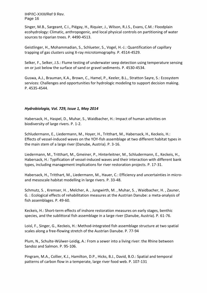
IHP/IC-XXIII/Ref 9 Rev. Page 16
Singer, M.B., Sargeant, C.I., Piégay, H., Riquier, J., Wilson, R.J.S., Evans, C.M.: Floodplain ecohydrology: Climatic, anthropogenic, and local physical controls on partitioning of water sources to riparian trees. P. 4490-4513. Geistlinger, H., Mohammadian, S., Schlueter, S., Vogel, H.‐J.: Quantification of capillary trapping of gas clusters using X‐ray microtomography. P. 4514-4529. Selker, F., Selker, J.S.: Flume testing of underwater seep detection using temperature sensing on or just below the surface of sand or gravel sediments. P. 4530-4534. Guswa, A.J., Brauman, K.A., Brown, C., Hamel, P., Keeler, B.L., Stratton Sayre, S.: Ecosystem services: Challenges and opportunities for hydrologic modeling to support decision making. P. 4535-4544. Hydrobiologia, Vol. 729, Issue 1, May 2014 Habersack, H., Haspel, D., Muhar, S., Waidbacher, H.: Impact of human activities on biodiversity of large rivers. P. 1-2. Schludermann, E., Liedermann, M., Hoyer, H., Tritthart, M., Habersack, H., Keckeis, H.: Effects of vessel-induced waves on the YOY-fish assemblage at two different habitat types in the main stem of a large river (Danube, Austria). P. 3-16. Liedermann, M., Tritthart, M., Gmeiner, P., Hinterleitner, M., Schludermann, E., Keckeis, H., Habersack, H.: Typification of vessel-induced waves and their interaction with different bank types, including management implications for river restoration projects. P. 17-31. Habersack, H., Tritthart, M., Liedermann, M., Hauer, C.: Efficiency and uncertainties in micro- and mesoscale habitat modelling in large rivers. P. 33-48. Schmutz, S. , Kremser, H. , Melcher, A. , Jungwirth, M. , Muhar, S. , Waidbacher, H. , Zauner, G. : Ecological effects of rehabilitation measures at the Austrian Danube: a meta-analysis of fish assemblages. P. 49-60. Keckeis, H.: Short-term effects of inshore restoration measures on early stages, benthic species, and the sublittoral fish assemblage in a large river (Danube, Austria). P. 61-76. Loisl, F., Singer, G., Keckeis, H.: Method-integrated fish assemblage structure at two spatial scales along a free-flowing stretch of the Austrian Danube. P. 77-94 Plum, N., Schulte-Wülwer-Leidig, A.: From a sewer into a living river: the Rhine between Sandoz and Salmon. P. 95-106. Pingram, M.A., Collier, K.J., Hamilton, D.P., Hicks, B.J., David, B.O.: Spatial and temporal patterns of carbon flow in a temperate, large river food web. P. 107-131

IHP/IC-XXIII/Ref. 9 Rev. Page 17
Schipper, A.M., Hendriks, A. J., Ragas, A.M.J., Leuven, R.S.E.W.: Disentangling and ranking the influences of multiple environmental factors on plant and soil-dwelling arthropod assemblages in a river Rhine floodplain area. P. 133-142. Rakowitz, G., Berger, B., Schludermann, E., Tritthart, M., Habersack, H., Keckeis, H.: Deep pools of the Danube River: ecological function or turbulent sink? P. 143-159. Górski, K., Collier, K. J., Hamilton, D. P., Hicks, B. J.: Effects of flow on lateral interactions of fish and shrimps with off-channel habitats in a large river-floodplain system. P. 161-174. Schletterer, M., Füreder, L., Kuzovlev, V.V., Zhenikov, Y.N., Grigorieva, I.L.: Lowland river reference condition: spatial and temporal patterns of the zoobenthos community in the Volga headwaters (2006–2010). P. 175-189. Urbanič, G.: Hydromorphological degradation impact on benthic invertebrates in large rivers in Slovenia. P. 191-207. Dokulil, M.T.: Potamoplankton and primary productivity in the River Danube. P. 209-227. Montero, J.C., Fernandez Piedade, M.T., Wittmann, F.: Floristic variation across 600 km of inundation forests (Igapó) along the Negro River, Central Amazonia. P. 229-246. Xu, M., Wang, Z., Duan, X., Pan, B.: Effects of pollution on macroinvertebrates and water quality bio-assessment. P. 247-259. International Journal of Sediment Research, Volume 28, Issue 4, December 2013 Habersack, H., Haspel, D.: Sediment loads and processes in large rivers. P. I Die Moran, A., El Kadi Abderrezzak, K., Mosselman, E., Habersack, H., Lebert, F., Aelbrecht, D., Laperrousaz, E.: Physical model experiments for sediment supply to the old Rhine through induced bank erosion. P. 431-447. Liu, J., Wang, G., Li, H., Gong, J., Han, J.: Water and sediment evolution in areas with high and coarse sediment yield oft he Loess Plateau. P. 448-457. Guerrero, M., Lamberti, A.: Bed-roughness investigation for a 2-D model calibration: the San Martìn case study at Lower Paranà. P. 458-469. Babic Mladenovic, M., Kolarov, V., Damjanovic, V.: Sediment regime of the Danube River in Serbia. P. 470-485. Liu, C., Sui, J., He, Y., Hirshfield, F.: Changes in runoff and sediment load from major Chinese rivers to the Pacific Ocean over the period 1955-2010. P. 486-495.

IHP/IC-XXIII/Ref 9 Rev. Page 18
Zhang, Y., Zhong, D., Wu, B.: Multiple temporal scale relationships of bankfull discharge with streamflow and sediment transport in the Yellow River in China. P. 496-510. Itoh, T., Horiuchi, S., Mizuyama, T., Kaitsuka, K.: Hydraulic model tests for evaluating sediment control function with a grid-type Sabo dam in mountainous torrents. P. 511-522. Cheng, C., Song, Z., Wang, Y., Zhang, J.: Parameterized expressions for an improved Rouse equation. P. 523-534. Behrends Kraemer, F., Chagas, C.I., Cosentino, D.J., Garibaldi, L.A.: Adsorption and affinity of Escherichia coli to different aggregate sizes of a silty clay soil. P. 535-543. Darwish, M.A.G.: Geochemistry of the High Dam Lake sediments, south Egypt: implications for environmental significance. P. 544-559. Haddadchi, A., Ryder, D.S., Evrard, O., Olley, J.: Sediment fingerprinting in fluvial systems: review of tracers, sediment sources and mixing models. P. 560-578. Gu, Z., Wu, X., Wang, X., Peng, S., Luo, H., Shi, X., Yu, D.: Using live vegetation volume to analyze the effects of plot Pinus massoniana Lamb on water and soil conservation under natural rainfall events. P. 579-587. Yang, W., Chen, M., Zhang, X., Guo, Z., Li, G., Ma, Q., Yang, J., Huang, Y.: Thorium isotopes (228Th, 230Th, 232Th) and applications in reconstructing the Yangtze and Yellow River floods. P. 588-595. International Journal of River Basin Management, Volume 11, Issue 2, 2013 Habersack, H., Haspel, D., Campbell, I.: Integrated Management of Large River Systems. P. 137. Evers, M., Nyberg, L.: Coherence and inconsistency of European instruments for integrated river basin management. P. 139-152. Habersack, H., Jäger, E., Hauer, C.: The status of the Danube River sediment regime and morphology as a basis for future basin management. P. 153-166. Connell, D.: Catchment management across borders in the Murray–Darling Basin. P. 167-173. Alexeevsky, N.I., Chalov, R.S., Berkovich, K.M., Chalov, S.R.: Channel changes in largest Russian rivers: natural and anthropogenic effects. P. 175-191. Abseno, M.M.: Role and relevance of the 1997 UN Watercourses Convention in resolving transboundary water disputes in the Nile. P. 193-203.

IHP/IC-XXIII/Ref. 9 Rev. Page 19
Pacini, N., Donabaum, K., de Villeneuve, P.H., Konecny, R., Pineschi, G., Pochon, Y., Salerno, F., Schwaiger, K., Tartari, G., Wolfram, G., Zieritz, I.: Water-quality management in a vulnerable large river: the Nile in Egypt. P. 205-219. Nones, M., Ronco, P., Di Silvio, G.: Modelling the impact of large impoundments on the Lower Zambezi River. P. 221-236. Hydrological Processes, Volume 27, Issue 15, July 2013 Habersack, H., Walling, D.: The Hydrology of Large Rivers. P. 2103-2104. Mahe, G., Lienou, G., Descroix, L., Bamba, F., Paturel, J.E., Laraque, A., Meddi, M., Habaieb, H., Adeaga, O., Dieulin, C., Chahnez Kotti, F., Khomsi, K.: The rivers of Africa: witness of climate change and human impact on the environment. P. 2105-2114. Piman, T., Lennaerts, T., Southalack, P.: Assessment of hydrological changes in the lower Mekong Basin from Basin-Wide development scenarios. P. 2115-2125. Mukhopadhyay, B.: Signature and hydrologic consequences of climate change within the upper-middle Brahmaputra Basin. P. 2126-2143. Kichigina, N.: Hydroclimatic changes and analysis of floods in large river basins of southern East Siberia. P. 2144-2152. Laraque, A., Castellanos, B., Steiger, J., Lòpez, J.L., Pandi, A., Rodriguez, M., Rosales, J., Adèle, G., Perez, J., Lagane, C.: A comparison of the suspended and dissolved matter dynamics of two large inter-tropical rivers draining into the Atlantic Ocean: the Congo and the Orinoco. P. 2153-2170. Lehner, B., Grill, G.: Global river hydrography and network routing: baseline data and new approaches to study the world’s large river systems. P. 2171-2186. Hudson, P.F., Sounny-Slitine, M.A., LaFevor, M.: A new longitudinal approach to assess hydrologic connectivity: Embanked floodplain inundation along the lower Mississippi River. P. 2187-2196. Pratibha, P., Bharati, L., Gurung, P., Kaushal, N., Smakhtin, V.: Environmentally sustainable management of water demands under changing climate conditions in the Upper Ganges Basin, India. P. 2197-2208. Hauer, C., Schober, B., Habersack, H.: Impact analysis of river morphology and roughness variability on hydropeaking based on numerical modelling. P. 2209-2224.

IHP/IC-XXIII/Ref 9 Rev. Page 20
River Systems, Volume 20, Issue 3-4, April 2013 Hein, T., Habersack, H.: Water Quality Issues of Large Rivers. P. 145-147. Bondareva, L., Zeer, G., Gerasimov, V., Zhizhaev, A.: Technogenic pollution and its migration in the water flow of the Yenisei River. P. 149-156. Hamner, S., Pyke, D., Walker, M., Pandey, G., Mishra, R.K., Mishra, V.B., Porter, C., Ford, T.E.: Sewage pollution of the River Ganga: an ongoing case study in Varanasi, India. P. 157-167. Derx, J., Farnleitner, A.H., Zessner, M., Blaschke, A.P.: Evaluating the effect of temperature induced water viscosity and density fluctuations in virus and DOC removal during river bank filtration – a scenario analysis. P. 169-184. Amano, A., Sakuma, T., Kazama, S., Gunawardhana, L.: Evaluation of diarrhea disease risk attributed to inundation water use on a local scale in Cambodia using hydrological model simulations. P. 185-196. Ogrinc, N., Scancar, J.: Suspended particulate matter and water quality of the Sava River Basin. P. 197-211. Tetzlaff, B., Haider, J., Kreins, P., Kuhr, P., Kunkel, R., Wendland, F.: Grid-based modelling of nutrient inputs from diffuse and point sources fort he state of North Rhine-Westphalia (Germany) as a tool for river basin management according to EU-WFD. P. 213-229. Campbell, I., Hart, B., Barlow, C.: Integrated Management in Large River Basins: 12 Lessons from the Mekong and Murray-Darling Rivers. P. 231-247. Shahraiyni, H.T., Ghafouri, M.R., Saghafian, B., Shouraki, S.B.: Evaluation of a novel fuzzy method and a conceptual model for a long-term daily streamflow simulation. P. 249-260. Lindenschmidt, K-E., Long, J.: A GIS approach to define the hydro-geomorphological regime for instream flow requirements using geomorphic response units (GRU). P. 261-275. Ágoston-Szabo, E., Schöll, K., Dinka, M.: Limnological characteristics of a Danube oxbow-lake (Danube-Dráva National Park, Hungary). P. 277-287.

IHP/IC-XXIII/Ref. 9 Rev. Page 21
Rivers covered
Rivers per continent
North America South America Africa
Australia Europe Asia

IHP/IC-XXIII/Ref 9 Rev. Page 22
Publication Statistics 554 authors
05
1015202530354045505560
Publications in Special Issues
10
23
8
3614
52
Topics covered in Special Issues
Hydrology & Hydraulics Sediment Transport & Morphodynamics
Water Quality Ecology
River Management & Socioeconomics Water Resources Research

IHP/IC-XXIII/Ref. 9 Rev. Page 23
Annex II (Currently under review)

Concept Paper
Roadmap of the World’s Large Rivers Initiative (WLRI)
IHP – International Hydrological Programme of UNESCO
UNESCO Chair on Integrated River Research and Management,
Vienna, Austria
Vienna, Austria

Concept Paper / (Pre-) Feasibility Study World’s Large Rivers Initiative (WLRI)
- 1 -
1. Background and Aims
Rivers are complex, dynamic and diverse ecosystems with major ecological, social, economic and cultural
significance. They are fundamental to life, water security and possess major cultural significance. Rivers
provide people with multiple goods and services, such as drinking water, food, hydropower, navigation,
irrigation and recreation. At the same time large rivers are among the most modified systems worldwide.
Their basins are threatened by increasing human pressures, more frequent and severe floods and droughts
driven by climate change and land-use alteration, which jointly alter morphology, increase pollution,
degrade aquatic habitats and rapidly decrease biological diversity.
The WLRI is of scientific nature and aims to create the knowledge base required for a holistic scientific
assessment of the status and possible future of the World’s Large Rivers. Furthermore, it aims to develop
innovative strategies based on best practices for their sustainable management. The WLRI will, as a
scientific platform for peer learning, ultimately compile global data in a comprehensive format creating an
accessible reference for innovation and development. After a testing phase of the methodology (Phase I)
on three rivers (Danube, Mekong, Niger) on the basis of a harmonised and commonly agreed upon method
for assessing the status of large rivers, up to 300 rivers will be assessed on a voluntary basis (Phase II). As a
result, the first ever global status report on WLRs will be produced. It will contribute to promoting an
integrated and sustainable river management by providing comparable baseline information for decision
makers, funding bodies, researchers, civil society and river managers. Every three years, the WLRI organises
the World’s Large Rivers Conferences, aiming to gather scientists, discuss novel research and to publish
articles in high-ranking scientific journals. Promoting and organising a variety of educational activities are
also part of the initiative’s objectives.
The WLRI supports the achievement of internationally agreed commitments such as the Agenda 2030 (in
particular SDG 6, but also SDG 1, 2, 3, 13 and 15), the United Nations Framework Convention on Climate
Change and the Paris Agreement, the Sendai Framework as well as the Convention on Biological Diversity.
It further supports an integrated approach across UNESCO programmes such as the IHP, World Water
Assessment Programme (WWAP), the Man and the Biosphere (MAB) Programme and the International
Geoscience Programme. It directly contributes to Main Line of Action (MLA) 3, Expected Result 7 of 39 C/5,
strengthening Member States’ response to water security challenges, towards the achievement of water-
related Sustainable Development Goals (SDGs) and targets, and other goals from relevant international
water agendas.
2. Objective of the WLRI
The collaborative and interdisciplinary World’s Large Rivers Initiative (WLRI) will, as a scientific platform for
peer learning, ultimately compile global data in a comprehensive format creating an accessible reference
for innovation and development for sustainable management of large rivers.
The specific objectives are:
• To analyse the current state and the future development of the WLRs.
• To establish a platform to build, facilitate, and harvest hydrological science synergies between
countries and to provide education and training at technical and tertiary level.
• To develop innovative strategies for the sustainable management of the WLRs for the benefit of both
humans and nature, while recognising the individuality of rivers.
• To collaborate with River Commissions.
• To organise future Conferences on the World’s Large Rivers.

Concept Paper / (Pre-) Feasibility Study World’s Large Rivers Initiative (WLRI)
- 2 -
3. Activities
Act. 1: Create a global overview of the present and future status of WLRs
Act. 2: Close knowledge gaps and foster knowledge transfer
Act. 3: Formulate a collaborative International Research Action Plan on WLRs
Act. 4: Establish a World River Forum, World Rivers Day and WLRs Commission Meetings
Act. 5: Organise future Conferences on the World’s Large Rivers
4. Scope of the WLRI
Within the WLRI „large“ is defined as a river with a mean annual discharge exceeding 2000 m³/s at the
mouth or with a drainage basin exceeding 500.000 km² or a river length exceeding 1000 km (measured at
the main stem). In order to facilitate an inclusive process other quantitative and qualitative criteria can be
taken into account (e.g. the natural, cultural and economic significance of rivers). The Working Group of
member states of the IHP agreed that each member state is welcome to nominate large rivers on a
voluntary basis.
5. Structural Working Plan of the WLRI
5.1. Work plan for Activity 1 – Create a global overview of the present
and future status of WLRs
To achieve the initiative’s objectives, Activity 1 of the WLRI proposes to create a global overview of the
present and future status of WLRs.
The present Concept Paper is embedded in the overall action plan of the WLRI, which was elaborated in a
Working Group of member states of the IHP in accordance with Resolution XXI-3 adopted at the 21st session
of the Intergovernmental Council of IHP. Figure 1 gives an overview of the general working steps.

Concept Paper / (Pre-) Feasibility Study World’s Large Rivers Initiative (WLRI)
- 3 -
Figure 1: Working plan including the main steps for Activity 1.
5.1.1. Common Methodology
5.1.1.1. Determination of three Rivers for Phase I
The first step of the methodological approach was based on (a) an evaluation of experts suggestions,
questionnaires and existing project information, (b) a database of the 100 largest rivers (according to river
length, discharge, catchment size) in order to (c) select three rivers for the testing phase (Phase I). A short
overview of the methodological steps is given in Figure 2.
Figure 2: Methodological approach for the determination of three rivers.
The comprehensive project data research (“data mining”) comprised existing projects of the World Bank
and UNDP on large rivers dealing with issues of the 4 thematic fields Hydrology & Hydraulics, Sediment
Transport & Morphodynamics, Water Quality & Ecology and River Management & Socioeconomics (period
of data collection: 1.12.2015 - 15.1.2016). In particular, it was investigated how many research
projects (incl. the project budget and the thematic focus) on large rivers have been conducted, especially
Expert
Discussion
Project
Research
Questionnaire
Database
100 largest rivers
(river length,
discharge,
catchment size)
List
Three selected rivers for Phase I
a) b) c)
Concept Paper
Preparation of an Executive Summary including a set of parameters, a common methodology and a list of three
selected rivers to be studied in Phase I.
Phase I
Testing phase of the methodology on three rivers. The assessment will be performed on existing databases
(“data mining”). During this phase, it will be clarified which databases are relevant and how these can be
accessed. Therefore, in Phase I such rivers will be selected, where data is easily and publically accessible. UNESCO
and IHP WLRI delegates will help to communicate with governments if data from governments is needed. The
outcome of this phase will be a harmonised and commonly agreed method for assessing the status of large rivers
as well as a status report of these rivers.
Phase II
Assessment of up to 300 rivers. Phase II will involve the assessment of up to 300 rivers. The end product will be
a status report of the WLRs in order to support member states, upon their request, with strategies for sustainable
river management regarding technical, economic, and ecological needs and to provide comparable baseline
information for decision makers, funding bodies, researchers, civil society and river managers. This will be the
first global status report of large rivers using a common methodology. The main outcomes will be presented in a
similar way for all 300 rivers and compiled in a summary report (including the description of the methodology).

Concept Paper / (Pre-) Feasibility Study World’s Large Rivers Initiative (WLRI)
- 4 -
in the recent past. Based on this evaluation, useful information on the regional / river basin-related
research focus of the World Bank, UNDP and UNEP / GEF could be gathered.
To ensure a broad involvement and expert input from participating countries the attendees of the
1st Working Group Meeting of the WLRI were encouraged to send a preliminary list of 10 large rivers
(including brief reasons for their suggestions). Moreover, a questionnaire has been drafted to additionally
involve experts of the World Bank, UNEP, UNDP, GEF, ADB and WWF in the decision making process by
asking for a list of 10 economically, environmentally and socially relevant rivers from their organisations’
point of view (see Appendix I).
In order to select only large rivers, the suggested rivers (with local researcher support) were synchronised
with a database of the 100 largest rivers (according to river length, discharge, catchment size). Based on
this step, a matrix of 100 rivers illustrating the results of the previously observed surveys could be
developed (see Appendix II).
Based on the priorities assigned to the list of preselected rivers by internal and external experts and the
discussions at the 2nd WLRI WG meeting, the three rivers Danube, Mekong and Niger were selected for
Phase I. These rivers will serve as a proof of concept to test the methodology. Representatives responsible
for supporting the WLRI team with data and contacts for those three rivers were chosen at the same
meeting. These are Helmut Habersack (Danube), Gil Mahé (Niger) and Siegfried Demuth (Mekong).
On successful completion of Phase I, assessments will be completed for up to 300 large rivers in Phase II,
whereby the maximum number will depend on the available financial means, provided data, participating
countries etc. and thus could be much smaller.
5.1.1.2. Definition and Selection of Parameters
In the course of the 1st Working Group Meeting of the WLRI in 2015 a set of parameters has been suggested
and elaborated by the thematic coordinators of the WLRI. Based on the outcomes of the WGs, individual
suggestions by experts and a web-based data research of existing Online-Databases related to large rivers
(see Appendix III), a first draft set of parameters was decided upon. The parameters have been categorised
according to the thematic fields Hydrology & Hydraulics, Sediment Transport & Morphodynamics, Water
Quality & Ecology and River Management & Socioeconomics (Table 1).
In the follow-up of the 2nd Working Group Meeting of the WLRI a questionnaire was distributed among the
members to support the selection of the parameters (see Appendix IV). Based on the feedback obtained a
refined list of parameters was established (Table 1). The proposed parameters were subsequently re-
assessed using SMART (specific, measurable, achievable, relevant, time-bound) indicator criteria. Based on
this analysis, a core list of parameters was decided upon in the course of the 3rd Working Group Meeting in
2018. The selected parameters will provide a common basis to analyse and compare WLRs.
The list of selected parameters is not exhaustive and will serve as a common basis to analyse and compare
rivers in Phase I. It will also provide the opportunity to test their feasibility on the three selected rivers
Danube, Mekong and Niger. The studies can lead to a reduction or increase in the number of parameters,
their specification and calculation. If data is not available for selected parameters at specific rivers, the
results obtained at other rivers can serve as an example for monitoring and modelling the missing
parameters in the future. Within Phase I a definition and glossary of the chosen parameters will be
elaborated. The study will use parameters for which data is available using existing monitoring (for example
at selected, representative points along the length of the river including the relevant temporal resolution)
and modelling results.
Concept Paper / (Pre-) Feasibility Study World’s Large Rivers Initiative (WLRI)
- 5 -
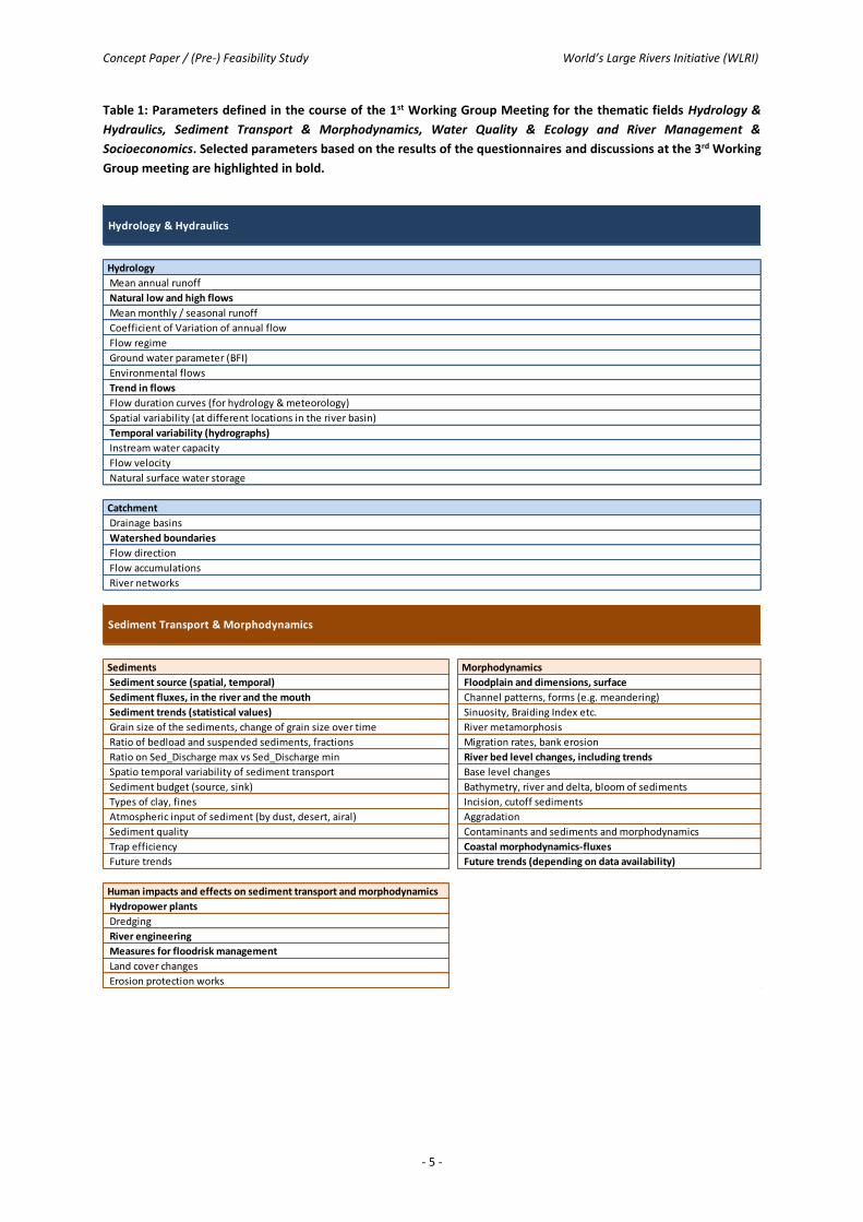
Table 1: Parameters defined in the course of the 1st Working Group Meeting for the thematic fields Hydrology &
Hydraulics, Sediment Transport & Morphodynamics, Water Quality & Ecology and River Management &
Socioeconomics. Selected parameters based on the results of the questionnaires and discussions at the 3rd Working
Group meeting are highlighted in bold.
Hydrology & Hydraulics
Hydrology
Mean annual runoff
Natural low and high flows
Mean monthly / seasonal runoff
Coefficient of Variation of annual flow
Flow regime
Ground water parameter (BFI)
Environmental flows
Trend in flows
Flow duration curves (for hydrology & meteorology)
Spatial variability (at different locations in the river basin)
Temporal variability (hydrographs)
Instream water capacity
Flow velocity
Natural surface water storage
Catchment
Drainage basins
Watershed boundaries
Flow direction
Flow accumulations
River networks
Sediments Morphodynamics
Sediment source (spatial, temporal) Floodplain and dimensions, surface
Sediment fluxes, in the river and the mouth Channel patterns, forms (e.g. meandering)
Sediment trends (statistical values) Sinuosity, Braiding Index etc.
Grain size of the sediments, change of grain size over time River metamorphosis
Ratio of bedload and suspended sediments, fractions Migration rates, bank erosion
Ratio on Sed_Discharge max vs Sed_Discharge min River bed level changes, including trends
Spatio temporal variability of sediment transport Base level changes
Sediment budget (source, sink) Bathymetry, river and delta, bloom of sediments
Types of clay, fines Incision, cutoff sediments
Atmospheric input of sediment (by dust, desert, airal) Aggradation
Sediment quality Contaminants and sediments and morphodynamics
Trap efficiency Coastal morphodynamics-fluxes
Future trends Future trends (depending on data availability)
Human impacts and effects on sediment transport and morphodynamics
Hydropower plants
Dredging
River engineering
Measures for floodrisk management
Land cover changes
Erosion protection works
Sediment Transport & Morphodynamics

Concept Paper / (Pre-) Feasibility Study World’s Large Rivers Initiative (WLRI)
- 6 -
Table 1 continued: Parameters defined in the course of the 1st Working Group Meeting for the thematic fields
Hydrology & Hydraulics, Sediment Transport & Morphodynamics, Water Quality & Ecology and River Management
& Socioeconomics. Selected parameters based on the results of the questionnaires and discussions at the 3rd
Working Group meeting are highlighted in bold.
Ecosystems and Biodiversity Water Quality and Pollution
Wetland disconnectivity Ecological status
Ecosystem impacts from anthropogenic influences Thermal pollution
Freshwater Species Nutrient pollution
Species richness Wastewater pollution
Livestock density Mercury accumulation
Fish diversity Biological oxygen demand
Rare and endangered species and biotic communities Freshwater alkalinity
Number of endemic species Anthropogenic nitrogen loading
Number of non-native fishes Anthropogenic phosphorus loading
Impervious surfaces Pesticide loading
Organic loading
Threats and Human Pressures Soil salinization
Threats to fish Potential acidification
Threats to other species (birds, mammals, amphibians and crocodiles) Areas of high loadings / pollution
WWF living plant index for freshwater Poorest water quality
Human footprint Water salinity
Extinction risk Emerging pollutants (e.g microplastics, antibiotics, EDCs)
Fishing pressure Heavy metals
Aquaculture pressure
Climate change induced changes species and biotic communities
Water Quality & Ecology
Water Use Water Stress and Water Resource Development
Hydropower (installed capacity, generation density) Environmental water stress
Irrigation Human water stress
Navigation Agricultural water stress
Recreation Water exploitation index
Fishing Water scarcity index
Mining Water management in urban areas
Industrial water use Dam density
Total freshwater withdrawal Level of river fragmentation
Level of flow regulation
Socioeconomics Consumptive water loss
Water Economics / Economic dependence on water resources Water storage capacity (existing and potential)
Societal wellbeing
Exposure to floods Governance
Exposure to droughts Legal framework (e.g. regional standards)
Water and health (e.g. spread of cholera) Level of cooperation
Pricing water Enabling environment
Environmental awareness
Disasters (biological, climatological, geophysical, hydrological,
meteorological and technological)
Religious and cultural practices
River Management & Socioeconomics
Concept Paper / (Pre-) Feasibility Study World’s Large Rivers Initiative (WLRI)
- 7 -
5.1.1.3. Analysis of 3 Rivers
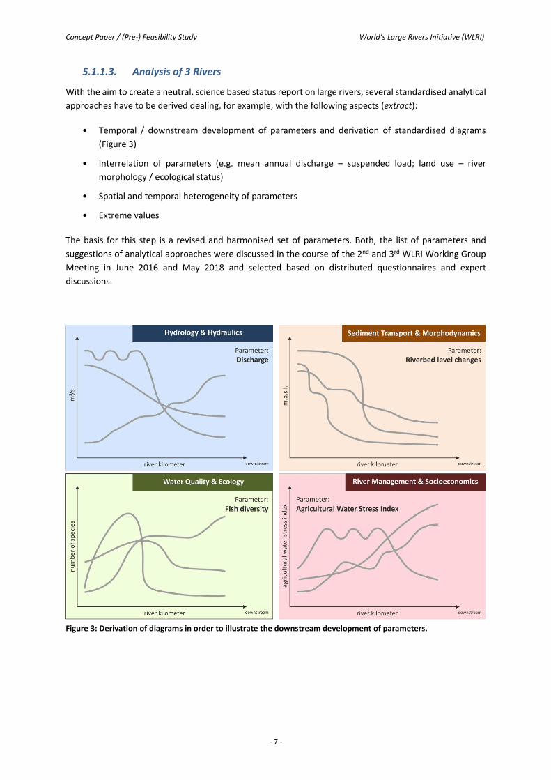
With the aim to create a neutral, science based status report on large rivers, several standardised analytical
approaches have to be derived dealing, for example, with the following aspects (extract):
• Temporal / downstream development of parameters and derivation of standardised diagrams
(Figure 3)
• Interrelation of parameters (e.g. mean annual discharge – suspended load; land use – river
morphology / ecological status)
• Spatial and temporal heterogeneity of parameters
• Extreme values
The basis for this step is a revised and harmonised set of parameters. Both, the list of parameters and
suggestions of analytical approaches were discussed in the course of the 2nd and 3rd WLRI Working Group
Meeting in June 2016 and May 2018 and selected based on distributed questionnaires and expert
discussions.
Figure 3: Derivation of diagrams in order to illustrate the downstream development of parameters.

Concept Paper / (Pre-) Feasibility Study World’s Large Rivers Initiative (WLRI)
- 8 -
5.2. Work Plan of Activity 2 – Close knowledge gaps and foster
knowledge transfer
In a concerted action, the research required to close knowledge gaps relating to WLRs will be identified and
promoted. Particular attention should be given to knowledge transfer to next generation scientists,
stakeholders, decision makers, children (education) and the general public. Training of experts should
therefore be a key element. A training course was organised at each of the three African Large Rivers
Hydrology Conferences. There are plans to develop online resources to support the training of future river
experts (including cooperation with other existing initiatives such as MOOCs for Africa).
5.3. Work Plan of Activity 3 – Formulate a collaborative International
Research Action Plan on WLRs
An action plan on WLRs research will be jointly developed with international scientific bodies and associations (e.g. UNESCO, IAHR, IAHS, WASER, IAG etc.) which will also co-sponsor future WLR conferences. The WLRI links to the Water Family (Category II Centres and Chairs) and other UNESCO programmes and initiatives by providing specific thematic knowledge and transferring it to individual rivers. These programmes include among others ISI, IFI, FRIEND-Water, HELP, G-WADI, IDI, PCCP, ISARM, UWMP, IIWQ and the Ecohydrology Programme (Figure 4).
The Working Group was concluded with the 3rd Working Group meeting as it fulfilled its mandate. After the 23rd session of the IGC a formal setting for the operationalisation of the Initiative will be established.
Figure 4: Interlinkages to other programmes and initiatives.
A key activity of the WLRI is the publication of research papers in SCI journals. To date, the WLRI has
published ten special issues with 143 articles and 554 authors following the International Conferences in
top SCI journals. An additional three special issues are currently in preparation.
5.4. Work Plan of Activity 4 – Establish a World River Forum, World River
Day and WLRs Commission Meetings
A World River Forum will be established in collaboration with other organisations (e.g. River Commissions)
which aims to bring together scientists, stakeholders and decision makers in order to promote and improve

Concept Paper / (Pre-) Feasibility Study World’s Large Rivers Initiative (WLRI)
- 9 -
the integrated management of WLRs. The UN World Rivers Day will be scientifically supported.
Collaborations with several River Commissions have been initiated and representatives will meet regularly
to exchange experiences, discuss best practices on integrated management and debate future needs.
In particular, a cooperation with the International Network of Basin Organizations INBO and regional
related networks (e.g. African Network of River Basin Organization, Asian Network of River Basin
Organization) is planned
5.5. Work Plan of Activity 5 – Organise future Conferences on the World’s
Large Rivers
A Conference on the Status and Future of WLRs will be held every three years with the aim of expanding
and disseminating scientific knowledge on the WLRs and their integrated and sustainable management.
Three International World’s Large Rivers Conferences have been organised in Vienna/Austria (2011),
Manaus/Brazil (2014) and New Delhi/India (2017) (Figure 5). The next WLR Conference will take place in
2020.
Figure 5: Impressions from the three World’s Large Rivers Conferences in Vienna, Austria (top), Manaus, Brazil
(middle) and New Delhi, India (bottom).
In addition to the World’s Large Rivers Conferences African Large Rivers Hydrology Conferences have
already been organised by the FRIEND-Water initiative in 2015 (Tunisia), 2016 (Senegal) and 2018 (Algeria).
The fourth Conference is planned for 2020 (Benin).

Concept Paper / (Pre-) Feasibility Study World’s Large Rivers Initiative (WLRI)
- 10 -
6. Outcomes of the World’s Large Rivers Initiative
The following list refers to the expected outcomes of the WLRI.
Outcome 1: First global status report on the world’s large rivers.
The report will include the thematic areas Hydrology & Hydraulics, Sediment Transport & Morphodynamics,
Water Quality & Ecology and River Management & Socioeconomics.
Outcome 2: Closed knowledge gaps and trained experts.
Manual for integrated river research and management including examples for best practices.
Outcome 3: Collaborative International Action Plan.
Cutting-edge research articles will be published and compiled in special issues in top SCI journals.
Outcome 4: World River Forum, World River Days and WLRs Commission Meetings.
Cooperation strategy with INBO and individual river commissions.
Outcome 5: Series of International Conferences on the World’s Large Rivers.
A conference on the status and future of WLRs is successfully implemented every three years. Additionally,
regional conferences are organised.
7. Roadmap and Outlook
The working plan of the WLRI comprises the following further working steps:
• 17th – 18th May 2018: 3rd Working Group Meeting of the WLRI in Vienna. The concept paper will be
finalised and first results presented.
• 11th – 15th of June 2018: UNESCO IHP Intergovernmental Council (IGC). The 23rd session of the IHP IGC
will review the performance of the initiative and decide to continue the WLRI as part of IHP’s workplan,
beyond the 23rd session of the IHP Intergovernmental Council. A side event will take place on 11th June
2018 at 13:30 in Room IX at the UNESCO Headquarters in Paris to present the WLRI and its activities.
• July 2018: Phase I of the WLRI will be started after having finalised the contracts concerning
extrabudgetary funds.
• July 2018: After the 23rd session of the IGC a formal setting for the operationalisation of the Initiative
will be established.
• 2020: 4th World’s Large Rivers Conference.

Concept Paper / (Pre-) Feasibility Study World’s Large Rivers Initiative (WLRI)
- 11 -
List of Acronyms
ADB Asian Development Bank
FAO Food and Agriculture Organization (UN)
GEF Global Environmental Facility
IGC Intergovernmental Council
IHP International Hydrological Programme (UNESCO)
UNEP United Nations Environment Programme
UNESCO United Nations Educational, Scientific and Cultural Organization
UNDP United Nations Development Programme
WHO World Health Organization
WLR World’s Large Rivers
WLRI World’s Large Rivers Initiative
WWF World Wide Fund for Nature

Concept Paper / (Pre-) Feasibility Study – APPENDIX I World’s Large Rivers Initiative (WLRI)
APPENDIX I
Questionnaire
on the Determination of 10 Large Rivers

Concept Paper / (Pre-) Feasibility Study – APPENDIX I World’s Large Rivers Initiative (WLRI)
APPENDIX I:
Questionnaire on the Determination of 10 Large Rivers
for further developing World´s Large Rivers Initiative (WLRI)
Please nominate in Table 1 the 10 most interesting large rivers (i.e. economically, environmentally
or socially relevant) of your organizations point of view and/or those actually covered e.g. by your
projects. Additionally in Table 2 we provide the 100 largest rivers (according to the river length) in
alphabetical order as an alternative possibility for your choice.
Kindly send the list of your selected rivers by e-mail, no later than 29th of January 2016 to
Please fill in rivers of high interest according to your point of view (or select rivers from Table 2).
Table 1: Suggestion of rivers that should be analyzed in Phase 1 of the WLRI project.
Or please mark the rivers of high interest according to your point of view.
River Country

Concept Paper / (Pre-) Feasibility Study – APPENDIX I World’s Large Rivers Initiative (WLRI)
University of Natural Resources and Life Sciences, Vienna Department of Water, Atmosphere and Environment E-mail: [email protected]
Table 2: Selection of rivers based on a list of 100 large rivers (by length; alphabetical order).
River Country
Aldan Russia ☐
Amazon – Ucayali – Apurímac Brazil, Peru, Bolivia, Colombia, Ecuador,
Venezuela, Guyana ☐
Amu Darya -- Panj Uzbekistan, Turkmenistan, Tajikistan,
Afghanistan ☐
Amur–Argun (Heilong Jiang) Russia, China, Mongolia ☐
Araguaia Brazil ☐
Arkansas United States ☐
Ayeyarwady (Irrawaddy) Myanmar ☐
Belaya Russia ☐
Beni Bolivia ☐
Benue Cameroon, Nigeria ☐
Blue Nile Ethiopia, Sudan ☐
Brahmaputra–Tsangpo
India (58.0%), China (19.7%), Nepal (9.0%),
Bangladesh (6.6%), Disputed India/China
(4.2%), Bhutan (2.4%)
☐
Churchill Canada ☐
Colorado (Texas) United States ☐
Colorado (western U.S.) United States, Mexico ☐
Columbia United States, Canada ☐
Congo–Chambeshi (Zaïre)
Democratic Republic of the Congo, Central
African Republic, Angola, Republic of the
Congo, Tanzania, Cameroon, Zambia, Burundi,
Rwanda
☐
Cooper–Barcoo Australia ☐

Concept Paper / (Pre-) Feasibility Study – APPENDIX I World’s Large Rivers Initiative (WLRI)
University of Natural Resources and Life Sciences, Vienna Department of Water, Atmosphere and Environment E-mail: [email protected]
Danube–Breg (Duna)
Romania (28.9%), Hungary (11.7%), Austria
(10.3%), Serbia (10.3%), Germany (7.5%),
Slovakia (5.8%), Bulgaria (5.2%), Croatia
(4.5%),…
☐
Dnieper Russia, Belarus, Ukraine ☐
Dniester Ukraine, Moldova ☐
Don Russia, Ukraine ☐
Ganges–Hooghly–Padma (Ganga) India, Bangladesh, Nepal, China ☐
Godavari India ☐
Guaporé (Itenez) Brazil, Bolivia ☐
Han P. R. China ☐
Içá (Putumayo) Brazil, Peru, Colombia, Ecuador ☐
Ili (Yili) P. R. China, Kazakhstan ☐
Indigirka Russia ☐
Indus Pakistan (93%), India, China ☐
Ishim Kazakhstan, Russia ☐
Japurá (Rio Yapurá) Brazil, Colombia ☐
Jubba–Shebelle Ethiopia, Somalia ☐
Juruá Peru, Brazil ☐
Kama Russia ☐
Kasai Angola, Democratic Republic of the Congo ☐
Khatanga Russia ☐
Kolyma Russia ☐
Lena Russia ☐
Limpopo Mozambique, Zimbabwe, South Africa,
Botswana ☐

Concept Paper / (Pre-) Feasibility Study – APPENDIX I World’s Large Rivers Initiative (WLRI)
University of Natural Resources and Life Sciences, Vienna Department of Water, Atmosphere and Environment E-mail: [email protected]
Lower Tunguska Russia ☐
Mackenzie–Slave–Peace–Finlay Canada ☐
Madeira–Mamoré–Grande–Caine–Rocha Brazil, Bolivia, Peru ☐
Magdalena Colombia ☐
Marañón Peru ☐
Mekong (Lancang Jiang) China, Myanmar, Laos, Thailand, Cambodia,
Vietnam ☐
Mississippi–Missouri–Jefferson United States (98.5%), Canada (1.5%) ☐
Murray–Darling Australia ☐
Murrumbidgee River Australia ☐
Negro Brazil, Venezuela, Colombia ☐
Nelson–Saskatchewan Canada, United States ☐
Niger
Nigeria (26.6%), Mali (25.6%), Niger (23.6%),
Algeria (7.6%), Guinea (4.5%), Cameroon
(4.2%), Burkina Faso (3.9%), Côte d'Ivoire,
Benin, Chad
☐
Nile – Kagera
Ethiopia, Eritrea, Sudan, Uganda, Tanzania,
Kenya, Rwanda, Burundi, Egypt, Democratic
Republic of the Congo, South Sudan
☐
Northern Salado Argentina ☐
Ob–Irtysh Russia, Kazakhstan, China, Mongolia ☐
Ohio–Allegheny United States ☐
Oka Russia ☐
Okavango Namibia, Angola, Botswana ☐
Olenyok Russia ☐
Orange South Africa, Namibia, Botswana, Lesotho ☐
Orinoco Venezuela, Colombia, Guyana ☐
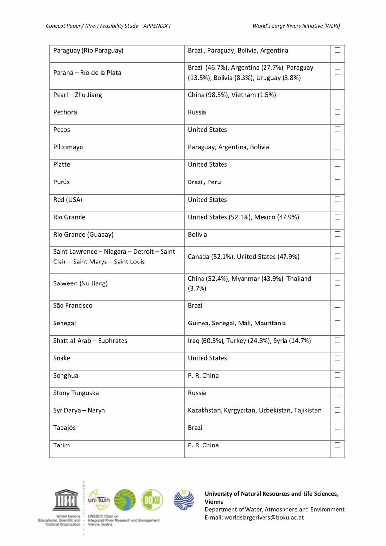
Concept Paper / (Pre-) Feasibility Study – APPENDIX I World’s Large Rivers Initiative (WLRI)
University of Natural Resources and Life Sciences, Vienna Department of Water, Atmosphere and Environment E-mail: [email protected]
Paraguay (Rio Paraguay) Brazil, Paraguay, Bolivia, Argentina ☐
Paraná – Río de la Plata Brazil (46.7%), Argentina (27.7%), Paraguay
(13.5%), Bolivia (8.3%), Uruguay (3.8%) ☐
Pearl – Zhu Jiang China (98.5%), Vietnam (1.5%) ☐
Pechora Russia ☐
Pecos United States ☐
Pilcomayo Paraguay, Argentina, Bolivia ☐
Platte United States ☐
Purús Brazil, Peru ☐
Red (USA) United States ☐
Rio Grande United States (52.1%), Mexico (47.9%) ☐
Río Grande (Guapay) Bolivia ☐
Saint Lawrence – Niagara – Detroit – Saint
Clair – Saint Marys – Saint Louis Canada (52.1%), United States (47.9%) ☐
Salween (Nu Jiang) China (52.4%), Myanmar (43.9%), Thailand
(3.7%) ☐
São Francisco Brazil ☐
Senegal Guinea, Senegal, Mali, Mauritania ☐
Shatt al-Arab – Euphrates Iraq (60.5%), Turkey (24.8%), Syria (14.7%) ☐
Snake United States ☐
Songhua P. R. China ☐
Stony Tunguska Russia ☐
Syr Darya – Naryn Kazakhstan, Kyrgyzstan, Uzbekistan, Tajikistan ☐
Tapajós Brazil ☐
Tarim P. R. China ☐

Concept Paper / (Pre-) Feasibility Study – APPENDIX I World’s Large Rivers Initiative (WLRI)
University of Natural Resources and Life Sciences, Vienna Department of Water, Atmosphere and Environment E-mail: [email protected]
Tigris Turkey, Iraq, Syria ☐
Tobol Kazakhstan, Russia ☐
Tocantins–Araguaia Brazil ☐
Ubangi–Uele Democratic Republic of the Congo, Central
African Republic, Republic of Congo ☐
Upper Ob -- Katun Russia ☐
Upper Yenisei -- Little Yenisei (Kaa-Hem) Russia, Mongolia ☐
Ural Russia, Kazakhstan ☐
Uruguay Uruguay, Argentina, Brazil ☐
Vilyuy Russia ☐
Vitim Russia ☐
Volga Russia ☐
Volta Ghana, Burkina Faso, Togo, Côte d'Ivoire, Benin ☐
Warburton–Georgina Australia ☐
Xingu Brazil ☐
Yangtze (Chang Jiang) China ☐
Yellow River (Huang He) China ☐
Yenisei–Angara–Selenge Russia (97%), Mongolia (2.9%) ☐
Yukon United States (59.8%), Canada (40.2%) ☐
Zambezi (Zambesi)
Zambia (41.6%), Angola (18.4%), Zimbabwe
(15.6%), Mozambique (11.8%), Malawi (8.0%),
Tanzania (2.0%), Namibia, Botswana
☐

Concept Paper / (Pre-) Feasibility Study – APPENDIX II World’s Large Rivers Initiative (WLRI)
APPENDIX II
Matrix illustrating the 100 Largest Rivers
(according to river length) related to the Expert and
Project-based Analysis
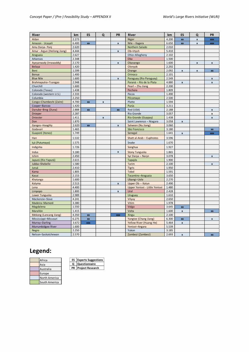
Concept Paper / (Pre-) Feasibility Study – APPENDIX II World’s Large Rivers Initiative (WLRI)
Legend:
River km ES Q PR River km ES Q PRAldan 2.273 Niger 4.200 xx x xxx
Amazon - Ucayali 6.400 xx x Nile – Kagera 6.650 xx x xxx
Amu Darya- Panj 2.620 Northern Salado 2.010
Amur - Argun (Heilong Jiang) 4.444 x Ob–Irtysh 5.410
Araguaia 2.627 Ohio–Allegheny 2.102
Arkansas 2.348 Oka 1.500
Ayeyarwady (Irrawaddy) 2.170 x Okavango 1.600 x x
Belaya 1.420 Olenyok 2.292
Beni 1.599 Orange 2.092 x x xx
Benue 1.400 Orinoco 2.101
Blue Nile 1.600 x Paraguay (Rio Paraguay) 2.549 x
Brahmaputra–Tsangpo 2.948 Paraná – Río de la Plata 4.880 x x
Churchill 1.600 Pearl – Zhu Jiang 2.200
Colorado (Texas) 1.438 Pechora 1.809
Colorado (western U.S.) 2.333 Pecos 1.490
Columbia 2.250 Pilcomayo 2.500
Congo–Chambeshi (Zaïre) 4.700 xx x Platte 1.594
Cooper–Barcoo 1.420 Purús 3.211
Danube–Breg (Duna) 2.888 xx xx Red (USA) 2.188 x
Dnieper 2.287 Rio Grande 3.057 x
Dniester 1.411 x Río Grande (Guapay) 1.438 x
Don 1.870 Saint Lawrence – Niagara 3.058 x
Ganges–Hooghly 2.620 xx x Salween (Nu Jiang) 3.060
Godavari 1.465 São Francisco 3.180 xx
Guaporé (Itenez) 1.749 Senegal 1.641 x xxx
Han 1.532 Shatt al-Arab – Euphrates 3.596
Içá (Putumayo) 1.575 Snake 1.670
Indigirka 1.726 Songhua 1.927
Indus 3.180 x Stony Tunguska 1.865
Ishim 2.450 Syr Darya – Naryn 3.078 x
Japurá (Rio Yapurá) 2.615 Tapajós 1.900
Jubba–Shebelle 1.580 Tarim 2.100 x
Juruá 2.410 Tigris 1.950
Kama 1.805 Tobol 1.591
Kasai 2.153 Tocantins–Araguaia 3.650
Khatanga 1.600 Ubangi–Uele 2.270
Kolyma 2.513 x Upper Ob -- Katun 2.490
Lena 4.400 Upper Yenisei - Little Yenisei 1.480
Limpopo 1.800 x Ural 2.428
Lower Tunguska 2.989 Uruguay 1.610
Mackenzie–Slave 4.241 Vilyuy 2.650
Madeira–Mamoré 3.380 Vitim 1.978
Magdalena 1.550 Volga 3.645 xx
Marañón 1.415 Volta 1.600 x xx
Mekong (Lancang Jiang) 4.350 xx xxx Xingu 2.100
Mississippi–Missouri 6.275 xx Yangtze (Chang Jiang) 6.300 xx x
Murray–Darling 3.672 xxx Yellow River (Huang He) 5.464 x
Murrumbidgee River 1.600 Yenisei–Angara 5.539
Negro 2.250 Yukon 3.185
Nelson–Saskatchewan 2.570 Zambezi (Zambesi) 2.693 x xx
Africa
Asia
Australia
Europe
North America
South America
ES Experts Suggestions
Q Questionnaire
PR Project Research

Concept Paper / (Pre-) Feasibility Study – APPENDIX III World’s Large Rivers Initiative (WLRI)
APPENDIX III
Overview of existing Online-Databases on Large Rivers

Concept Paper / (Pre-) Feasibility Study – APPENDIX III World’s Large Rivers Initiative (WLRI)
APPENDIX III: Overview of existing Online-Databases on Large Rivers
Hydrology and Hydraulics:
Joint Research Center (JRC)
The State of the World’s Rivers (Mapping the Health of the World’s Fifty Major River Basins)
Major River Basins of the World (Global Runoff Data Centre)
Transboundary Waters Assessment Programme (TWAP)
HydroSHEDS (Hydrological data and maps based on Shuttle Elevation Derivatives at multiple Scales)
World Atlas (The Rivers of the World)
Global Rivers Observatory (Woods Hole Research Center & Woods Hole Oceanographic Institution)
Vital Water Graphics (An Overview of the World’s Fresh and Marine Waters – 2nd Edition)
Geographically Referenced Global River Discharge Database (RivDIS v1.1)
World Resources Institute (Maps & Data)
Global Water System Project (GWSP Digital Water Atlas Project)
Sediment Transport & Morphodynamics:
Global River Sediment Yields Database (AQUASTAT Programme)
AQUASTAT Databases
Global Rivers Observatory (Woods Hole Research Center & Woods Hole Oceanographic Institution)
The State of the World’s Rivers (Mapping the Health of the World’s Fifty Major River Basins)
Vital Water Graphics (An Overview of the World’s Fresh and Marine Waters – 2nd Edition)
Water Quality & Ecology:
Joint Research Center (JRC)
The State of the World’s Rivers (Mapping the Health of the World’s Fifty Major River Basins)
World Water Quality Assessment – WWQA (UNEP, GEMS / Water)
Transboundary Waters Assessment Programme (TWAP)
Global Rivers Observatory (Woods Hole Research Center & Woods Hole Oceanographic Institution)
Freshwater Ecoregions of the World – FEOW (Interactive Map)
Vital Water Graphics (An Overview of the World’s Fresh and Marine Waters – 2nd Edition)
Rivers in Crises (Mapping dual threats to water security for biodiversity and humans)
World Resources Institute (Maps & Data)
Global Water System Project (GWSP Digital Water Atlas Project)
River Management & Socioeconomics:
Joint Research Center (JRC)
AQUASTAT Databases
Transboundary Waters Assessment Programme (TWAP)
The International Disaster Database (EM-DAT Database)
International Hydropower Association – IHA (Hydropower Maps)
The European Small Hydropower Association – ESHA (Small Hydropower Map)
Vital Water Graphics (An Overview of the World’s Fresh and Marine Waters – 2nd Edition)
Rivers in Crises (Mapping dual threats to water security for biodiversity and humans)
World Resources Institute (Maps & Data)
Global Water System Project (GWSP Digital Water Atlas Project)
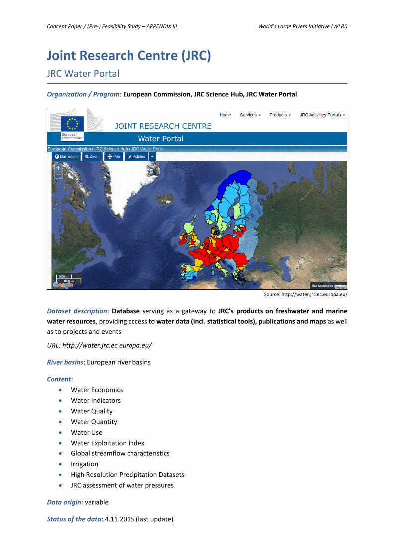
Concept Paper / (Pre-) Feasibility Study – APPENDIX III World’s Large Rivers Initiative (WLRI)
Joint Research Centre (JRC) JRC Water Portal
Organization / Program: European Commission, JRC Science Hub, JRC Water Portal
Source: http://water.jrc.ec.europa.eu/
Dataset description: Database serving as a gateway to JRC’s products on freshwater and marine
water resources, providing access to water data (incl. statistical tools), publications and maps as well
as to projects and events
URL: http://water.jrc.ec.europa.eu/
River basins: European river basins
Content:
Water Economics
Water Indicators
Water Quality
Water Quantity
Water Use
Water Exploitation Index
Global streamflow characteristics
Irrigation
High Resolution Precipitation Datasets
JRC assessment of water pressures
Data origin: variable
Status of the data: 4.11.2015 (last update)

Concept Paper / (Pre-) Feasibility Study – APPENDIX III World’s Large Rivers Initiative (WLRI)
The State of the World’s Rivers Mapping the Health of the World’s Fifty Major River Basins
Organization / Program: International Rivers, 2054 University Ave, Suite 300, Berkeley, CA 94704-
2644, USA
Source: http://www.internationalrivers.org/worldsrivers/
Dataset description: Interactive web database illustrating data on ecological health in the World’s 50
major river basins including the Congo, the Amazon and the Mekong basins
URL: http://www.internationalrivers.org/worldsrivers/
River basins: Albany, Amazon, Amu-Darya, Amur, Anadyr, Baker, Chubut, Churchill (Hudson Bay),
Columbia, Congo, Danube, Dnepr, Dvina, Fraser, Ganges-Brahmaputra, Godavari, Hai Ho, Indigirka,
Indus, Ayeyarwaddy, Khatanga, Koksoak, Kolyma, Lena, Mackenzie, Mekong, Mississippi, Nelson, Neva,
Niger, Nile, Ob, Orinoco, Parana, Pechora, Pyasina, São Francisco, St. Lawrence, Tigris-Euphrates,
Tocantins, Uruguay, Volga, Volta, Wisla, Yana, Yangtze, Yellow Yenisei, Yukon, Zambezi
Content:
River fragmentation (dams)
Biodiversity (freshwater species, threatened birds, mammals, amphibians and crocodile
species)
Water Quality (thermal pollution, mercury accumulation, poorest water quality)
Data origin: river basin boundaries: Global Runoff Data Centre – GRDC (2007); flow direction data sets
for Africa, Asia, North and South America and Europe: HYDRO1k Elevation Derivative Database;
additional basin data: Fekete, Vörösmarty and Lammers (2010); dams: Global Reservoir and Dam
(GRanD) Database, Consultative Group on International Agricultural Research (CGIAR) Challenge
Program on Water and Food – Mekong, United States National Inventory of Dams (NID), other
government dam inventories and original data collection by International Rivers
Status of the data: 2014 (last update)
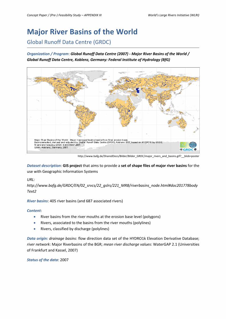
Concept Paper / (Pre-) Feasibility Study – APPENDIX III World’s Large Rivers Initiative (WLRI)
Major River Basins of the World Global Runoff Data Centre (GRDC)
Organization / Program: Global Runoff Data Centre (2007) - Major River Basins of the World /
Global Runoff Data Centre, Koblenz, Germany: Federal Institute of Hydrology (BfG)
http://www.bafg.de/SharedDocs/Bilder/Bilder_GRDC/major_rivers_and_basins.gif?__blob=poster
Dataset description: GIS project that aims to provide a set of shape files of major river basins for the
use with Geographic Information Systems
URL:
http://www.bafg.de/GRDC/EN/02_srvcs/22_gslrs/221_MRB/riverbasins_node.html#doc201778body
Text2
River basins: 405 river basins (and 687 associated rivers)
Content:
River basins from the river mouths at the erosion base level (polygons)
Rivers, associated to the basins from the river mouths (polylines)
Rivers, classified by discharge (polylines)
Data origin: drainage basins: flow direction data set of the HYDRO1k Elevation Derivative Database;
river network: Major Riverbasins of the BGR; mean river discharge values: WaterGAP 2.1 (Universities
of Frankfurt and Kassel, 2007)
Status of the data: 2007

Concept Paper / (Pre-) Feasibility Study – APPENDIX III World’s Large Rivers Initiative (WLRI)
Transboundary Waters Assessment Programme
(TWAP) River Basins Component
Organization / Program: GEF TWAP Project Coordination Unit (PCU), United Nations Environment
Programme (UNEP), P.O. Box 30552 (00100), Nairobi, Kenya
Source: http://twap-rivers.org/indicators/
Dataset description: Baseline assessment of the World’s transboundary water resources including an
interactive web database (TWAP RB Data Portal) illustrating indicator risk maps, result sheets (incl.
metadata) and river basin
URL: http://twap-rivers.org/
River basins: 286 global transboundary river basins
Content:
Water Quantity (environmental water stress, human water stress, agricultural water stress)
Water Quality (nutrient pollution, wastewater pollution)
Ecosystems (wetland disconnectivity, ecosystem impacts from dams, threat to fish, extinction
risk)
Governance (legal framework, hydropolitical tension, enabling environment)
Socioeconomics (economic dependence on water resources, societal wellbeing, exposure to
floods and droughts)
Data origin: country delineations: FAO GAUL (Global Administrative Unit Layers, 2014) using the
International Boundary dataset of the UNCS (UN Cartographic Section); indicator data: variable
Status of the data: variable

Concept Paper / (Pre-) Feasibility Study – APPENDIX III World’s Large Rivers Initiative (WLRI)
HydroSHEDS Hydrol. data and maps based on Shuttle Elevation Derivatives at multiple Scales
Organization / Program: WWF Conservation Science Program in partnership with the U.S.
Geological Survey, the International Centre for Tropical Agriculture, The Nature Conservancy and
the Center for Environmental Systems Research of the University of Kassel, Germany
http://hydrosheds.cr.usgs.gov/dataavail.php
Dataset description: Mapping product providing hydrographic information for regional and global-
scale applications (geo-referenced data set at various scales) based on high-resolution elevation data
obtained during a Space Shuttle flight for NASA's Shuttle Radar Topography Mission (SRTM)
URL: http://hydrosheds.cr.usgs.gov/index.php
River basins: worldwide
Content:
River networks
Watershed boundaries
Drainage basins
Flow direction
Flow accumulations
Data origin: Shuttle Radar Topography Mission (2000); SRTM elevation data, Version 1 (2005); SRTM
elevation data, Version 2 (2005); SRTM tiling format and data availability (2005); SRTM Water Body
Data (1998, 2003); Digital Chart of the World (DCW) global vectorized river network (1993, 1995);
ArcWorld global vectorized river network (1992); Global Lakes and Wetlands Database (GLWD) (2004)
Status of the data: South America: May 2006; Asia: March 2007; Central America: March 2007; Africa:
October 2007; Australia: March 2008; Europe: October 2008; North America: January 2009

Concept Paper / (Pre-) Feasibility Study – APPENDIX III World’s Large Rivers Initiative (WLRI)
World Atlas The Rivers of the World
Organization / Program: Euratlas-Nüssli, rue du Milieu 30, 1400 Yverdon-les-Bains, Switzerland
http://www.euratlas.net/geography/world/rivers/nile.html
Dataset description: Interactive web database illustrating the location and describing the mouth,
crossed countries and length of the major rivers of the World
URL: http://www.euratlas.net/geography/world/rivers/index.html
River basins: 119 rivers
Content:
River name
Outflow
Crossed countries
Length
Data origin: n.s.
Status of the data: 2001-2011 (last update)

Concept Paper / (Pre-) Feasibility Study – APPENDIX III World’s Large Rivers Initiative (WLRI)
Global Rivers Observatory Woods Hole Research Center & Woods Hole Oceanographic Institution
Organization / Program: National Science Foundation; additional funding from the Woods Hole
Oceanographic Institution (360 Woods Hole Road, MS 25 Woods Hole, MA 02543-1541, USA) and
the Woods Hole Research Center (149 Woods Hole Road Falmouth, MA 02540-1644, USA)
Source: http://www.globalrivers.org/
Dataset description: Project investigating river chemistry in Earth’s most significant river systems in
order to understand how climate change, deforestation and other disturbances are impacting river
chemistry and land-ocean linkages
URL: http://www.globalrivers.org/
River basins: currently 18 river basins (incl. Amazon, Congo, Danube, Fraser, Ganges-Brahmaputra,
Kolyma, Lena, Mackenzie, Ob’, Yangtze, Yenisey, Yukon)
Content:
River basin data (country, large-scale drainage area, drainage, population density, large cities,
cropland, developed, loss of original forest, large dams, suspended sediment, sediment
trapping efficiency)
Chemical composition of rivers near their mouths where they empty into the ocean
Data origin: variable
Status of the data: 2015 (last update)

Concept Paper / (Pre-) Feasibility Study – APPENDIX III World’s Large Rivers Initiative (WLRI)
Vital Water Graphics An Overview of the State of the World’s Fresh and Marine Waters (2nd Edition)
Organization / Program: UNEP GRID-Arendal – A Centre Collaborating with United Nations
Environment Programme (UNEP), Teaterplassen 3, 4836 Arendal, Norway
Source: http://www.unep.org/dewa/vitalwater/rubrique7.html
Dataset description: Report providing an overview, through a set of graphics, maps and other
illustrations, of the current state of the world’s fresh, coastal and marine waters (also illustrating the
causes and effects of trends that threaten the water resources)
URL: http://www.unep.org/dewa/vitalwater/rubrique7.html
River basins: worldwide (no specific reference to river basins)
Content:
Storage, distribution and circulation (freshwater resources, suspended sediment discharge,
river runoff throughout the 20th century, main world’s river basins etc.)
Water use and management (trends in global water use, freshwater use by sector, freshwater
use – country profiles, total population – access to an improved water source etc.)
A scarce and competitive resource (water supply per river basin, global waterstress and
scarcity, Water Scarcity Index, dependency ratio in renewable water etc.)
Water management in urban area (water competition between cities and agriculture etc.)
River’s fragmentation (level of river fragmentation and flow regulation, damming the world,
water storage capacity for selected countries etc.)
Pollution (biological oxygen demand, freshwater alkalinity, nitrate levels etc.)
Biodiversity in freshwater (fish diversity in freshwater systems, the WWF living plant index for
freshwater)
Water and political conflicts (disappearance of the Aral Sea, the Mekong River – survival for
millions etc.)
Water and health (the spread of cholera)
Pricing Water (increasing price with volume etc.)
Data origin: variable
Status of the data: 2008 (last update)
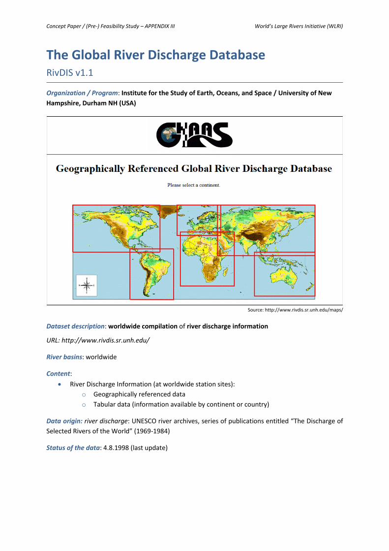
Concept Paper / (Pre-) Feasibility Study – APPENDIX III World’s Large Rivers Initiative (WLRI)
The Global River Discharge Database RivDIS v1.1
Organization / Program: Institute for the Study of Earth, Oceans, and Space / University of New
Hampshire, Durham NH (USA)
Source: http://www.rivdis.sr.unh.edu/maps/
Dataset description: worldwide compilation of river discharge information
URL: http://www.rivdis.sr.unh.edu/
River basins: worldwide
Content:
River Discharge Information (at worldwide station sites):
o Geographically referenced data
o Tabular data (information available by continent or country)
Data origin: river discharge: UNESCO river archives, series of publications entitled “The Discharge of
Selected Rivers of the World” (1969-1984)
Status of the data: 4.8.1998 (last update)

Concept Paper / (Pre-) Feasibility Study – APPENDIX III World’s Large Rivers Initiative (WLRI)
World Resources Institute Maps & Data
Organization / Program: World Resources Institute, 10 G Street NE Suite 800, Washington, DC
20002, USA
http://www.wri.org/resources/maps/water-stress-most-populous-river-basins
Dataset description: Global research organization focusing on six critical issues at the intersection of
environment and development (climate, energy, food, forests, water, and cities and transport)
producing maps, charts, data sets, infographics and other visual resources
URL: http://www.wri.org/
River basins: worldwide
Content:
Country and River Basin Rankings
Watersheds
Water Stress
Flood Risk
Forest Atlas
Mining and Critical Ecosystems
Data origin: various
Status of the data: various

Concept Paper / (Pre-) Feasibility Study – APPENDIX III World’s Large Rivers Initiative (WLRI)
Global Water System Project (GWSP) GWSP Digital Water Atlas Project
Organization / Program: GWSP International Project Office, Walter-Flex-Str. 3, Bonn, 53113
Germany
Source: http://atlas.gwsp.org/index.php?option=com_content&task=view&id=97&Itemid=63
Dataset description: project including a Digital Water Atlas describing the basic elements of the
Global Water System, the interlinkages of the elements and changes in the state of the Global Water
System by creating a consistent set of annotated maps
URL: http://atlas.gwsp.org/index.php
River basins: worldwide
Content:
Natural environmental, anthropic environment: anthroposphere (built environment, human
settlements, land setup), atmosphere (air, climate), biosphere (organisms, ecosystems),
environment (natural environment, anthropic environment), hydrosphere (freshwater,
marine water, waters), land (landscape, geography), lithosphere (soil, geological processes),
space, time (chronology)
Social aspects, environmental policy measures: administration, management, policy, politics,
institutions, planning, economics, finance, environmental policy, health, nutrition,
information, education, culture, environmental awareness, legislation, norms, conventions,
research, sciences, risks, safety, society
Human activities and products, effects on the environment: agriculture, forestry, animal
husbandry, fishery, chemistry, substances, processes, effects, impacts, energy, industry, crafts,
technology, equipments, physical aspects, noise, vibrations, radiations, products, materials,
recreation, tourism, resources (utilisation of resources), trade, services, traffic, transportation,
wastes, pollutants, pollution
Data origin: variable
Status of the data: variable

Concept Paper / (Pre-) Feasibility Study – APPENDIX III World’s Large Rivers Initiative (WLRI)
Global River Sediment Yields Database AQUASTAT Programme
Organization / Program: Food and Agriculture Organization of the United Nations (FAO),
AQUASTAT Programme
Source: FAO (Database of World’s rivers and their sediment yields)
Dataset description: database containing data on annual sediment yields in worldwide rivers and
reservoirs (searchable by river, country and continent)
URL: http://www.fao.org/nr/water/aquastat/sediment/index.stm
River basins: over 800 sediment data entries (worldwide)
Content:
River (name, number, order, notes, country, continent)
Sediment measurement (location of measurement, measurement site number, monitoring
start date and end date, unknown condition load, pre-dam conditions load, post-dam
conditions load, yield, reservoir, initial volume, final volume)
Data origin: sediment data: different sources by HR Wallingford, United Kingdom on behalf of the FAO
Land and Water Division
Status of the data: 2000 (last update)
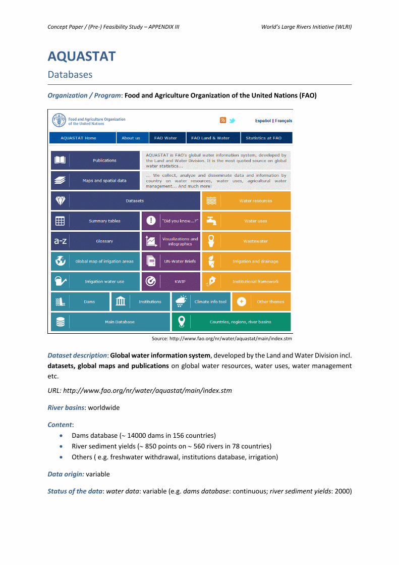
Concept Paper / (Pre-) Feasibility Study – APPENDIX III World’s Large Rivers Initiative (WLRI)
AQUASTAT Databases
Organization / Program: Food and Agriculture Organization of the United Nations (FAO)
Source: http://www.fao.org/nr/water/aquastat/main/index.stm
Dataset description: Global water information system, developed by the Land and Water Division incl.
datasets, global maps and publications on global water resources, water uses, water management
etc.
URL: http://www.fao.org/nr/water/aquastat/main/index.stm
River basins: worldwide
Content:
Dams database ( 14000 dams in 156 countries)
River sediment yields ( 850 points on 560 rivers in 78 countries)
Others ( e.g. freshwater withdrawal, institutions database, irrigation)
Data origin: variable
Status of the data: water data: variable (e.g. dams database: continuous; river sediment yields: 2000)

Concept Paper / (Pre-) Feasibility Study – APPENDIX III World’s Large Rivers Initiative (WLRI)
World Water Quality Assessment (WWQA) UNEP (GEMS/Water)
Organization / Program: International Centre on Water Resources and Global Change (hosted by the
Federal Institute of Hydrology, Germany / Initiative of the UN-Water Group led by the United
Nations Environment Programme UNEP with the Global Environment Monitoring System for Water
(GEMS/Water)
Source:http://www.unep.org/esm/Portals/50159/WWQA%20Report.pdf
Dataset description: ongoing project identifying current and future freshwater quality problem areas
in surface waters (especially in developing countries), evaluating policy options for addressing water
pollution and establishing a water-quality database to track the progress of surface water protection
URL:
http://www.unep.org/esm/Waterecosystems/WaterQuality/WorldWaterQualityAssessmentReport/t
abid/ 131715/Default.aspx
River basins: worldwide (especially developing countries)
Content:
Water Quality
Areas of high loadings / pollution
Sources of pollution
Policy options
Data origin: variable
Status of the data: variable

Concept Paper / (Pre-) Feasibility Study – APPENDIX III World’s Large Rivers Initiative (WLRI)
Freshwater Ecoregions of the World (FEOW) Interactive Map
Organization / Program: The Nature Conservancy (TNC) and World Wildlife Fund (WWF)
Source: http://www.feow.org/globalmap
Dataset description: collaborative project including an interactive web database providing a global
biogeographic regionalization of the Earth’s freshwater biodiversity and synthesizing biodiversity
and threat data for the resulting ecoregions
URL: http://www.feow.org/
River basins: 426 units (whose boundaries generally correspond with those of watersheds)
Content:
Species richness (fish, amphibians, turtles, crocodiles)
Number of endemic species (fish, amphibians, turtles, crocodiles)
Threats (human footprint, urban landcover, large cities, irrigation, converted lands, surface
water abstraction)
Data origin: ecoregional data: variable experts (contributors to FEOW are individuals who have either
delineated ecoregions, reviewed ecoregion delineations, contributed or reviewed species lists, or
authored or reviewed ecoregion descriptions
Status of the data: 2.10.2015 (last update); ecoregional data: variable

Concept Paper / (Pre-) Feasibility Study – APPENDIX III World’s Large Rivers Initiative (WLRI)
Rivers in Crisis Mapping dual threats to water security for biodiversity and humans
Organization / Program: City College of New York, USA & University of Wisconsin, Madison,
Wisconsin, USA & International Media Outreach, Toronto, Canada
http://www.riverthreat.net/maps/
Dataset description: global-scale initiative to quantify the impact of human-induced stressors on
human water security and riverine biodiversity (incl. an interactive mapping tool, pre-defined maps
and a Nature Article)
URL: http://www.riverthreat.net/index.html
River basins: worldwide
Content:
Catchment disturbance (cropland, impervious surfaces, livestock density, wetland
disconnectivity)
Pollution (soil salinization, anthropogenic nitrogen loading, anthropogenic phosphorus
loading, anthropogenic mercury deposition, pesticide loading, sediment loading, organic
loading, potential acidification, thermal alteration)
Water resource development (dam density, river fragmentation, consumptive water loss,
human water stress, agricultural water stress, change in residence time)
Biotic factors (Number and percent of non-Native Fishes, fishing pressure, aquaculture
pressure)
Data origin: variable (see also Nature Article “Global threats to human water security and river
biodiversity”)
Status of the data: variable

Concept Paper / (Pre-) Feasibility Study – APPENDIX III World’s Large Rivers Initiative (WLRI)
The International Disaster Database EM-DAT Database
Organization / Program: Centre for Research on the Epidemiology of Disasters (CRED), School of
Public Health of the Université catholique de Louvain, Brussels, Belgium
Source: http://www.emdat.be/
Dataset description: global database on natural and technological disasters that contains essential
core data on the occurrence and effects of more than 21000 disasters in the world from 1900 to
present and includes 4 dynamic search tools (countries, disaster profiles, disaster list, advanced
search) and pre-made disaster reference maps
URL: http://www.emdat.be/
River basins: worldwide (no specific reference to river basins)
Content:
Natural disasters (biological, climatological, extra-terrestrial, geophysical, hydrological,
meteorological)
Technological disasters
Complex disasters
Data origin: disaster data: various sources, including UN agencies, non-governmental organizations,
insurance companies, research institutes and press agencies (Priority is given to data from UN
agencies, governments and the International Federation of Red Cross and Red Crescent Societies.)
Status of the data: 2009 (last update); disaster data: variable

Concept Paper / (Pre-) Feasibility Study – APPENDIX III World’s Large Rivers Initiative (WLRI)
International Hydropower Association (IHA) Hydropower Maps
Organization / Program: International Hydropower Association (IHA), Chancery House, St Nicholas
Way, Sutton, London SM1 1JB, United Kingdom
Source: https://www.hydropower.org/world-installed-hydropower-capacity
Dataset description: Interactive web database illustrating data on hydropower installed capacities,
World generation density and intensity by population
URL: https://www.hydropower.org/maps
River basins: worldwide (no specific reference to river basins)
Content:
Installed hydropower capacity
Hydropower generation density
Hydropower generation intensity by population
Data origin: hydropower data: various sources (regulators, ministries, electricity associations, World’s
station owners and operators)
Status of the data: n.s.

Concept Paper / (Pre-) Feasibility Study – APPENDIX III World’s Large Rivers Initiative (WLRI)
The European Small Hydropower Association
(ESHA) Small Hydropower Map
Organization / Program: ESHA Secretariat, Renewable Energy House, Rue d’Arlon 67, Brussels,
Belgium
Source: http://www.esha.be/projects/projects/hydropower-map.html
Dataset description: Interactive web database illustrating data on small hydropower plants mainly in
Europe
URL: http://www.esha.be/projects/projects/hydropower-map.html
River basins: mainly in Europe (no specific reference to river basins)
Content:
Installed hydropower plant (type, power, planning, installation year, details)
Data origin: small hydropower data: various sources (broad network of organizations, regions, local
authorities, companies and other energy actors within the framework of the repowermap.org
initiative, which is a non-profit initiative supported by the European Union)
Status of the data: n.s.

Concept Paper / (Pre-) Feasibility Study – APPENDIX IV World’s Large Rivers Initiative (WLRI)
APPENDIX IV
Questionnaire on the Determination of the Parameters

Concept Paper / (Pre-) Feasibility Study – APPENDIX IV World’s Large Rivers Initiative (WLRI)
Questionnaire on the Determination of the Parameters
for further developing the World´s Large Rivers Initiative (WLRI)
Please nominate in the following table the 3-4 most important parameters (column: “high importance”) from your point of view in each category. The
categories are “Hydrology and Hydraulics”, “Sediment Transport and Morphodynamics”, “Water Quality and Ecology”, “River Management &
Socioeconomics”.
Further you can also mark the remaining parameters with a cross, either if you consider them of medium or low importance.
Additionally we ask you to mark if you think these parameters should be determined on river OR catchment level.
Based on your input we will select those parameters which will be used for the development of the methodology in Phase I (including analysis of the
existing situation, historic developments, future trends, variability, etc.).
Please send the list of your selected parameters by e-mail, no later than 16th of September 2016 to [email protected].

Concept Paper / (Pre-) Feasibility Study – APPENDIX IV World’s Large Rivers Initiative (WLRI)
Please mark the parameters according to your point of view.
Parameters Importance for Phase I To be determined on Further remarks e.g.:
comments regarding necessary time series, accuracy, etc. high medium low river level
catchment level
Hydrology & Hydraulics
Hydrology
Mean annual runoff
Low and high flows
Mean monthly / seasonal runoff
CV of annual flow
Flow regime
Ground water parameter (BFI)
Minimum flow (e.g. Q95)
Trend in flows
Flow duration curves (for hydrology & meteorology)
Spatial variability (at different locations in the river basin)
Temporal variability (hydrographs)
Additional Data in regard to the whole Catchment
Drainage basins
Watershed boundaries
Flow direction
Flow accumulations
River networks
…
…

Concept Paper / (Pre-) Feasibility Study – APPENDIX IV World’s Large Rivers Initiative (WLRI)
Parameters Importance for Phase I To be determined on Further remarks e.g.:
comments regarding necessary time series, accuracy, etc. high medium low river level
catchment level
Sediment Transport & Morphodynamics
Sediments
Sediment source (spatial, temporal)
Sediment fluxes, in the river and the mouth
Sediment trends (statistical values)
Grain size of the sediments, change of grain size over time
Ratio of bedload and suspended sediments, fractions
Ratio on Sed_Discharge max vs Sed_Discharge min
Spatio temporal variability of sediment transport
Sediment budget (source, sink)
Types of clay, fines
Atmospheric input of sediment (by dust, desert, aeolianl)
Sediment quality
Trap efficiency
Future trends
Morphodynamics
Floodplain and dimensions, surface
Channel patterns, forms
River metamorphosis
Migration rates, bank erosion
River bed level changes, including trends
Base level changes
Bathymetry, river and delta, bloom of sediments

Concept Paper / (Pre-) Feasibility Study – APPENDIX IV World’s Large Rivers Initiative (WLRI)
Parameters Importance for Phase I To be determined on Further remarks e.g.:
comments regarding necessary time series, accuracy, etc. high medium low river level
catchment level
Incision, cutoff sediments
Contaminants and sediments and morphodynamics
Coastal morphodynamics-fluxes
Future trends
Human impacts and effects on sediment transport and morphodynamics
Hydropower plants
Dredging
River engineering
Measures for floodrisk management
Land cover changes
Erosion protection works
…
…
…

Concept Paper / (Pre-) Feasibility Study – APPENDIX IV World’s Large Rivers Initiative (WLRI)
Parameters Importance for Phase I To be determined on Further remarks e.g.:
comments regarding necessary time series, accuracy, etc. high medium low
river level
catchment level
Water Quality & Ecology
Ecosystems and Biodiversity
Wetland disconnectivity
Ecosystem impacts from dams
Freshwater Species
Species richness
Livestock density
Fish diversity
Rare and endangered species and biotic communities
Number of endemic species
Number of non-native fishes
Impervious surfaces
Threats and Human Pressures
Threats to fish
Threats to other species (birds, mammals, amphibians and reptiles)
WWF living plant index for freshwater
Human footprint
Extinction risk
Fishing pressure
Aquaculture pressure
Climate change induced changes species and biotic communities

Concept Paper / (Pre-) Feasibility Study – APPENDIX IV World’s Large Rivers Initiative (WLRI)
Parameters Importance for Phase I To be determined on Further remarks e.g.:
comments regarding necessary time series, accuracy, etc. high medium low
river level
catchment level
Water Quality and Pollution
Ecological status
Thermal pollution
Nutrient pollution
Wastewater pollution
Mercury accumulation
Biological oxygen demand
Freshwater alkalinity
Anthropogenic nitrogen loading
Anthropogenic phosphorus loading
Pesticide loading
Organic loading
Soil salinization
Potential acidification
Areas of high loadings / pollution
Poorest water quality
Other aspects
Nutrients / minerals / OM / particles / aquatic life (species, fish …)
Need to define basin specific parameters
Quid biosensors /sediments and remote sensing
Need for SMART parameters and assessment methodologies (integrated in space and time)

Concept Paper / (Pre-) Feasibility Study – APPENDIX IV World’s Large Rivers Initiative (WLRI)
Parameters Importance for Phase I To be determined on Further remarks e.g.:
comments regarding necessary time series, accuracy, etc. high medium low river level
catchment level
River Management & Socioeconomics
Water Use
Hydropower (installed capacity, generation density)
Irrigation
Navigation
Recreation
Nutrition
Fishing
Mining
Freshwater withdrawal
Water Stress and Water Resource Development
Environmental water stress
Human water stress
Agricultural water stress
Water exploitation index
Water scarcity index
Water management in urban areas
Dam density
Level of river fragmentation
Level of flow regulation
Consumptive water loss
World storage capacity
…

Concept Paper / (Pre-) Feasibility Study – APPENDIX IV World’s Large Rivers Initiative (WLRI)
Parameters Importance for Phase I To be determined on Further remarks e.g.:
comments regarding necessary time series, accuracy, etc. high medium low river level
catchment level
River Management & Socioeconomics
Socioeconomics
Water Economics / dependence on water resources
Societal wellbeing
Exposure to floods
Exposure to droughts
Water and health (e.g. spread of cholera)
Pricing water
Environmental awareness
Disasters (biological, climatological, geophysical, hydrological, meteorological and technological)
Governance
Legal framework
Hydropolitical tensions / conflicts
Enabling environment
…
…
…