Embed Size (px)
Citation preview

Proceedings of the Fábos Conference on Landscape andGreenway PlanningVolume 6 Adapting to Expanding and ContractingCities Article 5
2019
Interlinking People and Nature through theTechnologized Urban GreenwayDorottya BekesiSzent Istvan University, Faculty of Landscape Architecture and Urbanism, [email protected]
Follow this and additional works at: https://scholarworks.umass.edu/fabos
Part of the Environmental Design Commons, Geographic Information Sciences Commons,Historic Preservation and Conservation Commons, Landscape Architecture Commons, Nature andSociety Relations Commons, Remote Sensing Commons, Urban, Community and RegionalPlanning Commons, and the Urban Studies and Planning Commons
This Article is brought to you for free and open access by ScholarWorks@UMass Amherst. It has been accepted for inclusion in Proceedings of theFábos Conference on Landscape and Greenway Planning by an authorized editor of ScholarWorks@UMass Amherst. For more information, pleasecontact [email protected].
Recommended CitationBekesi, Dorottya (2019) "Interlinking People and Nature through the Technologized Urban Greenway," Proceedings of the FábosConference on Landscape and Greenway Planning: Vol. 6 , Article 5.DOI: https://doi.org/10.7275/7rfb-gz17Available at: https://scholarworks.umass.edu/fabos/vol6/iss1/5

Interlinking People and Nature through the Technologized Urban Greenway
Dorottya Bekesi1
1Szent Istvan University - Faculty of Landscape Architecture and Urbanism, 29-43. Villanyi str., Budapest 1118, Hungary
Abstract The project area is located along the Danube River in Budapest, and as a peninsula, has a significant role in the city on an ecological level. In my research, I present the project from the industrial revolution up to the present day. In my concluding remarks, various design ideas for implementation on the peninsula and in its neighborhood were demonstrated. The abandoned Népsziget with its industrial site holds a lot of potential for cultural and environmental development. When it comes to city planning in Budapest the main issue is the decrease of greenfield territories in the suburban areas while the city area has many different sizes of brownfield sites which have a potential for restoration. The other important aspect of the area is its connection with the Danube River that needs to be taken into account because of the newly emerging effort to create resilient riverbanks in cities. I identified two strategies for the development of Népsziget. On a municipal level the connection of public transport, land use, green space character, and its core functions were improved. As a large-scale transportation development, a 5 km long greenway connection was created with the EuroVELO 6 bicycle route which runs along the riverside within the identified brownfield project area. The greenway, accessible for pedestrians and cyclists, has both cultural and educational functions and is digitally connected (through a private network) with the redesigned museum park that replaces the mentioned brownfield site in my plans. A special feature of the program is infrastructure running on renewable energy and providing information about the priority design area and the relationship between the city and water. It also personalizes the space by linking the user's electronic device to the new development area. The Nepsziget urban greenway project took shape through the shared vision of the cooperation of designers such as engineers (landscape design, civil, water construction, electrical), architects, scientists, and artists. It also includes many innovative constructions – solar panels, smart information columns, stormwater management, energy generating pavement, digital info post – that promote the ecological and sustainable functioning of the area. The concept creates a thematic route for active and passive recreation, including a park with cultural and technological innovations. The main positive aspect is the transformation of old, unused, and devastated areas and the provision of new functions.
1
Bekesi: Interlinking People and Nature
Published by ScholarWorks@UMass Amherst, 2019

Introduction Today, more than half of the Earth's population lives in cities and this number is steadily increasing. The related professions in urban design need to find ways to make these man-made habitats sustainable and livable for their inhabitants. Budapest, the capital of Hungary, has several islands, which are of utmost importance from the point of view of urban ecology: they help to ventilate the city. One of the least known islands of this capital on the Danube is the Népsziget, which is actually a peninsula. Connected to the 4th and 13th districts of the Pest side, it is a quiet, secluded little world that is only known and used by locals. The remnants of the former industrial activities (mainly ship and crane manufacturing) which define the area occupy the eastern side of the peninsula, and this is where my design site is located (Figure 1). This nearly 8 hectare dilapidated zone holds a lot of potential on the basis of its natural features and its proximity in the city. Existing, unused buildings give the site a special character, which has not yet found a new function in the capital. Another attraction is the Bay of Újpest, with its proximity and accessibility to water, a very valuable asset for a big city.
Settlement level District level Népsziget
Figure 1. - Location of the Népsziget
My research can be divided into two major sections, a foundational analysis and a detailed examination and research section. For foundational section I will describe the development of the brownfield areas, the problem of dilapidated areas, and the green surface system. The methods used in the examination were divided into three major groups. First, I performed historical research, I examined the historical evolution of Budapest's urban structure, and the role of the Népsziget in certain periods of urban development. The second branch of my research was the future development concepts and plans of various scales (agglomeration, urban, district) that affected Népsziget. The third method was to examine the current state of the area via a site visit, a digitally accessible control plan, and Google Maps.
2
Proceedings of the Fábos Conference on Landscape and Greenway Planning, Vol. 6, No. 1 [2019], Art. 5
https://scholarworks.umass.edu/fabos/vol6/iss1/5DOI: https://doi.org/10.7275/7rfb-gz17

Background and Literature Review
One of the decisive elements in the history of urban development was the complex - economic, social and technological - process of the Industrial Revolution, which fundamentally changed the structure of cities. The reason for the development of brownfields today is the change in the dominance of economic sectors. Instead of the primary (agriculture) and secondary (industry) sectors, the spread of tertiary (service) and quaternary (RDI, research, development, innovation) sectors, together with the transformation of urban area requirements, is typical. As a result of the changes, the limitation of the industrial functions in the transition zone can be observed. While this process took place relatively slowly and gradually in the Western European countries, after the change of regime in Hungary, buildings, halls and factories were abandoned quite suddenly. As a result, brownfield sites waiting to find new uses are relatively common in Hungary, and have not been utilized to this day due to chaotic ownership conditions and the lack of brownfield political policy. For the reasons already mentioned (complex ownership conditions, elusive site data, and possible pollution) investment capital generally favors greenfield investments. From an ecological point of view, the biggest problem with brownfield sites - due to their former industrial function - is the contamination of the geological medium. In Budapest, after the change of regime, progress was made to reduce soil contamination, but the proportion of polluted areas in the capital is still high. The visual conflict of rust areas is also a serious problem. Negative effects have an impact not only on the given sites, but also on their surroundings, which can result in significant attraction and depreciation in neighboring areas. Unguarded areas cause public safety issues, which can lead to lower real estate values and ultimately to segregation of the local population. Examining the green area density map of the capital, we can conclude that the brownfield sites in the transitional zone have a significant green area deficit which is similar to the downtown zone, due to the high ratio of developed and heat-absorbing surfaces (https://www.researchgate.net). The heat absorbing and retaining capability of the surfaces, as well as the obstruction of ventilation, have an adverse effect on the urban climate of Budapest and promote and enhances the urban heat island (UHI) effect. Budapest's green space system, like most European cities, is incomplete and needs to be improved (Probáld 1974). The uninhabited areas of the suburban areas of the city are connected with the green surface elements of the agglomeration, but moving towards the center of the city, these wedges become thinner and dispersed. The green ring, which connects the wedges, has gaps, and the expansion of the park system in Budapest is of paramount importance (Figure 2). Illustrations of a change in the function of brownfields can be found in several exemplary foreign and domestic projects: Domino Park (Williamsburg, Brooklyn), Zeche Zollverein (Germany), Millenáris Park (Hungary), Kopaszi Gát (Hungary) (Góczán et al. 1959).
3
Bekesi: Interlinking People and Nature
Published by ScholarWorks@UMass Amherst, 2019
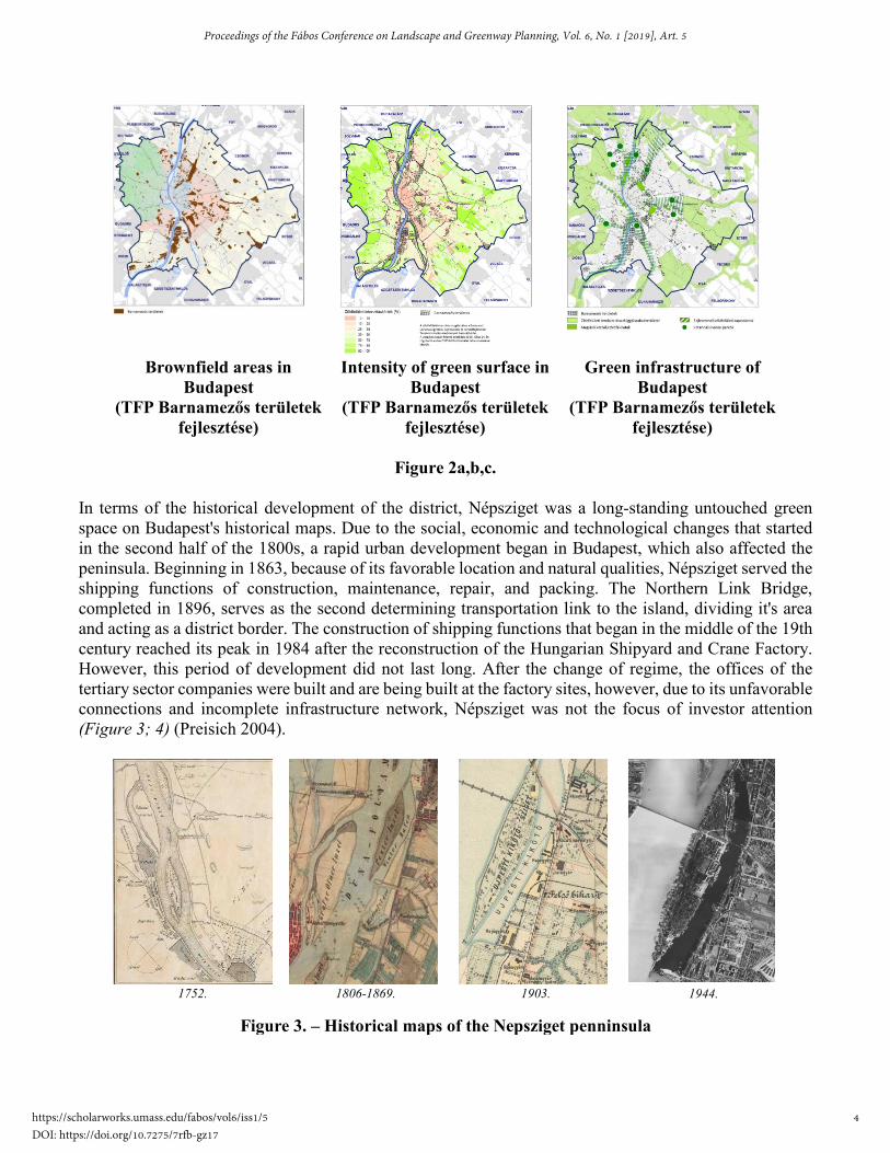
Brownfield areas in Budapest
(TFP Barnamezős területek fejlesztése)
Intensity of green surface in Budapest
(TFP Barnamezős területek fejlesztése)
Green infrastructure of Budapest
(TFP Barnamezős területek fejlesztése)
Figure 2a,b,c.
In terms of the historical development of the district, Népsziget was a long-standing untouched green space on Budapest's historical maps. Due to the social, economic and technological changes that started in the second half of the 1800s, a rapid urban development began in Budapest, which also affected the peninsula. Beginning in 1863, because of its favorable location and natural qualities, Népsziget served the shipping functions of construction, maintenance, repair, and packing. The Northern Link Bridge, completed in 1896, serves as the second determining transportation link to the island, dividing it's area and acting as a district border. The construction of shipping functions that began in the middle of the 19th century reached its peak in 1984 after the reconstruction of the Hungarian Shipyard and Crane Factory. However, this period of development did not last long. After the change of regime, the offices of the tertiary sector companies were built and are being built at the factory sites, however, due to its unfavorable connections and incomplete infrastructure network, Népsziget was not the focus of investor attention (Figure 3; 4) (Preisich 2004).
1752. 1806-1869. 1903. 1944.
Figure 3. – Historical maps of the Nepsziget penninsula
4
Proceedings of the Fábos Conference on Landscape and Greenway Planning, Vol. 6, No. 1 [2019], Art. 5
https://scholarworks.umass.edu/fabos/vol6/iss1/5DOI: https://doi.org/10.7275/7rfb-gz17

Figure 4. – Photos of the Ganz Danubius Ship and Crane Factory
Goals and Objectives The goal of this project is to showcase the potential of brownfields, present the ongoing development of Népsziget throughout history, and evaluate future concepts developed by the capital (http://budapest.hu). The municipal-level strategy is to connect the peninsula to the flow of the city. The goal of the concept plan developed for the object level planning area is to present new questions and creative solutions through the creation of a special recreation location. This is to be done by taking into account current technologies and societal needs.
Methods Long-term urban development strategies foresee the main direction of Népsziget development. The primary goal is to complete Budapest's incomplete green space system by revitalizing the area. The cultural park to be established on the peninsula, with its quality green areas, would help the capital to breath, increase its green surface coverage, and thus improve Budapest's climate. The spatial formation is based on the current types of (river) shore walls and their impact on the building and space, as well as the system of the former industrial crane tracks. Accordingly, the plan can be divided into three parts. In the northern part, the developed shoreline, as well as the system of existing hall buildings and crane rails, forms a grid-like unit that defines the area's lines. The straight lines formed by the rails have a stabilizing effect and fill the gap between existing buildings. Basically, this stage is characterized by the construction and artistic form. The transition between the northern and southern poles is considered to be the most complex design issue, as there is a building at the center area, with the space narrowing on either side: the Danube in the east, the fence of the border in the west. The western constricted space is formed by the building and the existing row of historically important Populus nigra 'Italica' trees, whereas the eastern side has a natural 'effect' of the Danube and the waterfront instead of
5
Bekesi: Interlinking People and Nature
Published by ScholarWorks@UMass Amherst, 2019

the hall, with a much softer shape and a significant visual connection with the bay and the opposite shore. For the concept, this area is a transition between the art and the natural world. The final stage of the design site is the part to the south of the digital museums, in which the southern protective forest and the waterfront form the soft natural line, the center of which is a circular form. The clean, simple element balances the strongly square north pole of the design and gives space to the building and recreational functions on a large, continuous lawn area. The 1: 1000-scale floor plan of the museum park is shown in (Figure 5).
Figure 5. – Concept Plan of the Digital Museum park
Results Revitalization of the peninsula takes place at two levels: the settlement level and the object level. The settlement-level strategy includes the development of new transport links, land use, character, and functional units of Népsziget. As part of the study I will focus on transportation development opportunities, highlighting the importance of a possible green way. The design level of the object defines the program and concept design of the area of the prominent Ganz Danubius Shipyard. The transport environment of Népsziget is good, but the peninsula itself is difficult to reach. At present, the area is accessible from three points: in the south via a pedestrian bridge, via a bicycle path on the railway bridge, or on the Zsilip street from the north, which is the only asphalted road that carries traffic. When expanding the transport links of the peninsula, it is important to emphasize that community and green modes of transport should be developed, as the only road on Népsziget - which is a dead end - cannot be expanded due to the formal features of the area. The Budapest City Structure Design Designates a New Pedestrian and Bicycle Bridge which would connect the peninsula to the 13th district of the capital. During my planning, I planned the intended pedestrian bridge, however, I moved it to within the design area. According to the original plan, the bridge would approach from Gács street in the 13th district over the bay and passing by the hall buildings, join the Népszigeti road (known as Zsilip utca in District 4). The disadvantage of this is that the route separates the hall building complex from the open space. My recommendation is to relocate the bridge to the northern tip of the planning area, which, as it crosses the 13th district of the capital, appears as an overpass over Váci út and passes to the parking lot of the Újpest
6
Proceedings of the Fábos Conference on Landscape and Greenway Planning, Vol. 6, No. 1 [2019], Art. 5
https://scholarworks.umass.edu/fabos/vol6/iss1/5DOI: https://doi.org/10.7275/7rfb-gz17

City Gate Bus Station. The bridge runs into a public transport hub and a P + R car park, which allows us to reach the park using more environmentally friendly modes of transport. In the interest of developing cycling and tourism on the peninsula, I propose the extension of the EuroVelo 6 section of Budapest. The newly designed green road infrastructure for 5 km of thematic, educational and cultural purposes would be closely linked to one of the planned elements of the Ganz Danubius Ship and Crane Factory, which will be described in detail in the Concept Plan. At the Fót road fork of the bicycle path, I open a new route towards Palotai Island, which runs along the Danube to the south and connects to Zsilip Street leading to the peninsula. We reach the planning area via Zsilip Street (Népszigeti út in the 13th district), through which we can get back to the EuroVelo 6 section of Váci via its pedestrian bridge (Figure 6).
Figure 6. – The greenway’s location in Budapest and a visualization of the digital column
As a complement to the main development direction of Népsziget, we can talk about the specific features of the Ganz Danubius Ship and Crane Factory. About the hall buildings with enormous interior space, about the non-thematic but characteristic location, and about location on the bank of the Danube. These features make it possible to create a unique image and atmosphere. Due to its location, the public park function is not sufficient, since there are many of those in the city center, so it must have another function that attracts the public. Based on the characteristics of the area, I imagined an alternative, artistic and museum park that displays elements related to ship and crane construction of the past. The buildings of the former crane factory would function as a digital museum in the area. In addition to a permanent exhibition featuring earlier industrial activities, special digital exhibitions requiring large interior space could be seen as unique in the Central European region. Thanks to its excellent acoustic qualities, the most exquisite hall with the greatest architectural value would become a venue for concerts and conferences with an interior dedicated to living green planted decor. Digital exhibitions are included in the two hall buildings that do not have high architectural quality, and are fitted with a digital projector on the south
7
Bekesi: Interlinking People and Nature
Published by ScholarWorks@UMass Amherst, 2019

side, connected with green columns. The planned posts can be linked to the visitor's mobile phone, so photographs of the greenway and its surroundings appear on the park-mounted projector, which is also the end of the thematic green road. By sending the photos taken on the green road, the visitor can see their own "project", which contributes to the creation of a community space. With the visitors adding photos to the overall picture of the park and interacting with it, the experience becomes more intense and interactive. The best photos will be exhibited at the end of each month, a useful investment for the 13th and 4th districts to complement their municipal identities. Accordingly, the area should have a dual function: on the one hand, as a public park it should serve as a quality physical and mental recreation venue for those who want to break away from the hustle and bustle of the city and, on the other hand, provide space for indoor and outdoor events and programs. For both functions, we already have existing elements (architectural and natural) in the area, which should be developed further. From an ecological point of view, not only diversity but also the presentation of variability would play an important role in my project. My goal is to create a more diverse association, complementing the current plant stock, which shows a constantly changing picture with the passing of the seasons. According to the new theme of the area, buildings with large interior space will be retained, their location and their impact on the outer space will be one of the basic elements of the open space architecture concept. In the design process, I consider it important to emphasize the idea of sustainability. In this case, this also means social, ecological, and economic sustainability. In other words, the development must also be financially viable. There are many examples in the Far East and in Western Europe, where after the construction of a park not only has the cost been recovered, but the area has become self-sustaining. In the case of self-sustainability, maintenance work in the park and the amount of money spent on it can be significantly reduced by using high quality materials and technology, and taking ecological aspects into account when choosing plants, using plant species that are suitable for our specific urban climate (Figures 7; 8; 9).
Figure 7. – View from the new pedestrian bridge
8
Proceedings of the Fábos Conference on Landscape and Greenway Planning, Vol. 6, No. 1 [2019], Art. 5
https://scholarworks.umass.edu/fabos/vol6/iss1/5DOI: https://doi.org/10.7275/7rfb-gz17

Figure 8. – Sunbathing with Vestre Bloc Sunbenches
Figure 9. – Rooftop bar on the old Crane Factory
The cultural park of Népsziget encompasses the three hall buildings, an information building, and the associated green space, which is a total area of 8 hectares. In terms of its theme, it is an alternative, green
9
Bekesi: Interlinking People and Nature
Published by ScholarWorks@UMass Amherst, 2019

area of art and recreation on the peninsula. Determining the maintenance and operation of the park is crucial to the long-term survival of the area: in this case, the site should be sustainable. When it comes to economic sustainability, the following revenues are intended. Firstly, the collection of an entrance fee for the exhibitions and events held in the halls. Halls featuring exhibitions of various themes would be open to those with single or combined tickets. Facility rental for conferences, concerts, and other cultural events. Secondly, revenue from the use of space for events and events in the cultural park can be expected such as exhibitions, fairs, and smaller alternative art festivals. It is very important that the park develop a unique image, which helps to promote the area and keep it public. A simple, clean design can appear on elements, tickets and information boards in the area. The income from the events will partly, and in the future entirely, cover the maintenance of the park and its elements, as well as the maintenance of the buildings and their service units. The location can be reached from three entry points: the new bicycle and pedestrian bridge over the Danube, through the existing imposing gate from Zsilip Street, and from the new coastal promenade. Functions in the park and the space separating walls follow the widening and narrowing pulse of the plan. The dividing walls, the hall buildings, and the woody vegetation provide a diverse view of forms which can be dotted, linear, or patchy. Accordingly, the design area can be divided into 6 large zones - Sunbathing, Exhibition and Outdoor, Reception Area and Promenade, Danube Terrace, Resting Lawn and Protective Forest - the borders of which are blurred and form temporary "flowing" spaces (Figure 10) (Békési 2019).
Figure 10. – 6 major zones of the concept plan of the museumpark
Discussion and Conclusion The planning area and the associated greenway concept have a positive – ecological, social and economic – impact on the role of the peninsula in the capital. In terms of its function, it would create a community space with a special visual experience that is not yet in place in Hungary, and which takes place in Europe in a way that takes into account the historical features of the area, with modern built elements and space design for the period of former shipbuilding. The area fits perfectly into the green infrastructure system of Budapest, thus achieving a higher green area ratio and an implemented green ring of the capital (with
10
Proceedings of the Fábos Conference on Landscape and Greenway Planning, Vol. 6, No. 1 [2019], Art. 5
https://scholarworks.umass.edu/fabos/vol6/iss1/5DOI: https://doi.org/10.7275/7rfb-gz17

additional brownfield areas) that would increase the value of the city and make it more livable for its inhabitants.
References Preisich, Gábor. (2004): Budapest városépítésének története, TERC Kereskedelmi és Szolgáltató Kft.,
Budapest, 52 Pp. Budapest 2030, Hosszútávú városfejlesztési stratégia,
http://budapest.hu/Documents/V%C3%A1ros%C3%A9p%C3%ADt%C3%A9si%20F%C5%91oszt%C3%A1ly/Budapest2030_HUN_%C3%B6sszefoglal%C3%B3.pdf, accessed October 14, 2018
Barnamezős területek rehabilitációja Budapesten. https://www.researchgate.net/publication/326760766_Barnamezos_teruletek_rehabilitacioja_Budapesten, accessed November 10, 2018
TFP Barnamezős területek fejlesztése, http://budapest.hu/Documents/TFP/Barnamez%C5%91s%20ter%C3%BCletek%20fejleszt%C3%A9se%20Tematikus%20Fejleszt%C3%A9si%20Program.pdf, accessed September 8, 2018
Góczán László.; Marosi Sándor.; Somogyi Sándor.; Szilárd Jenő.; (1959): Budapest természeti földrajza, Akadémia kiadó, Budapest, 38 Pp.
Probáld, Ferenc. (1974): Budapest városklímája, Akadémia kiadó, Budapest, 15 Pp. Magyar Országos Levéltár; Magyar Hajó és Darugyár, Általános Iratok, Műszaki igazgatóság –
Beruházás. A népszigeti telepre vonatkozó csarnok 1982-1984., Budapest, accessed March 21, 2017 Békési, Dorottya (2019): A Népszigeti felhagyott iparterület revitalizációs lehetőségei, Diplomamunka
11
Bekesi: Interlinking People and Nature
Published by ScholarWorks@UMass Amherst, 2019