Embed Size (px)
Citation preview

[1]
Interim Avoidance Strategy for the
Thames Basin Heaths Special Protection Area
First Revision Adopted November 2010
[2]
Contents
Page
1. Introduction ……………………………………………………………… 3 2. How the Special Protection Area affects Hart District ……..……. 4 3. Type of development and planning applications covered by the
Avoidance Strategy ……………………………………………………... 6
4. Avoidance Measures ……………………………………………………. 7 Annex 1 1. Introduction ………………………………………………………………... 12 2. Suitable Alternative Natural Greenspace (SANG) Tariff …………………. 13 3. Strategic Access Management and Monitoring (SAMM) Tariff ……………. 15 4. Calculating the tariff: loss of existing dwellings …………………………… 16 5. Planning Application Requirements ………………………………………... 16 6. Release of SANG, Monitoring and Review ………………………………... 17 Appendices Appendix 1: Hitches Lane SANG …………………………………………. 18 Appendix 2: Hawley Meadows and Blackwater Park SANG ……………... 23 Appendix 3: Strategic Access Management and Monitoring (SAMM) tariff
calculations …………………………………………………...
27

[3]
1. Introduction 1.1 This Avoidance Strategy has been prepared to facilitate residential development in areas of
Hart affected by the Thames Basin Heaths Special Protection Area (SPA). 1.2 The SPA is a network of heathland sites which are designated under the European Birds
Directive1 and the Habitats Directive2 and protected in the UK under the Habitats Regulations3. The SPA provides a habitat for the internationally important bird species of woodlark, nightjar and Dartford warbler. These birds are particularly subject to disturbance from walkers, dog walkers and cat predation because they nest on or near the ground.
1.3 Particular rules apply to development proposals in the vicinity of the SPA designed to ensure
that they are not likely to have significant adverse effects on the integrity of the SPA, either alone or in combination with other developments.
1.4 Under the Habitat Regulations the Council is the ‘competent authority’ to consider whether
applications for development are likely to have significant effect on the SPA. The Council shall agree to a plan or project (such as a planning authority) only after having ascertained that it will not adversely affect the integrity of the SPA.
1.5 The duty to consider the possibility of likely significant effects applies to all types of development, but it is residential development that has been most affected. Natural England advise that planning applications resulting in an increase in the number of dwellings within 5 kilometres of the SPA are, without ‘avoidance measures’, likely to have a significant effect on the SPA within the meaning of the Habitat Regulations. Natural England also advise that within 400 metres of the SPA ‘avoidance measures’ are unlikely to be effective and net residential development should be avoided.
1.6 The Local Authorities surrounding the Thames Basin Heaths SPA, together with the South
East England Partnership Board, Natural England and other bodies established the Thames Basin Heaths Joint Strategic Partnership (JSP). On 12th February 2009 the JSP agreed a Delivery Framework to enable the delivery of housing in the vicinity of the SPA without the likelihood of significant adverse effects on the SPA. The Delivery Framework sets out an approach based on avoidance measures in the form of Suitable Alternative Natural Greenspace (SANG), and Strategic Access Management and Monitoring (SAMM) for the SPA itself, funded by development.
1.7 This Avoidance Strategy has been informed by the Delivery Framework. It sets out the
avoidance measures needed to mitigate the effects of residential developments in Hart on the SPA. Development that provides, or makes the necessary contributions towards avoidance measures as set out in this Avoidance Strategy will avoid the need for a full Habitat Regulations Assessment4.
1 European Directive 79/409/EEC Conservation of Birds 2 European Directive 92/42/EEC Conservation of Habitats 3 The Conservation of Habitats and Species Regulations 2010 4 This principle has been established through the Dilly Lane High Court Judgement (Hart District Council v Secretary of State for Communities and Local Government, Luckmore Ltd and Barratt Homes Limited and Taylor Wimpey Developments Limited and Natural England [2008] EWHC 1204(Admin))

[4]
2. How the Special Protection Area affects Hart District 2.1 Map 1 shows the areas of SPA within Hart. It covers over 2,500 hectares and includes
Hazeley Heaths, Bramshill, Castle Bottom to Yateley and Hawley Commons, and parts of Bourley and Long Valley, and Eelmoor Marsh.
2.2 Following the standards set out in the Delivery Framework, Map 1 shows two zones around
the SPA – an Inner Exclusion Zone and a Zone of Influence. 2.3 The zones shown on Map 1 are indicative only. If there is any doubt over whether a site falls
within either zone the applicant will be expected to provide specific measurements.
The Inner Exclusion Zone The Inner Exclusion Zone is within 400m of the SPA, measured as the crow flies from the SPA perimeter to the point of access on the curtilage of the dwellings. Within this zone there is a presumption against new residential development as the impact on the SPA is likely to be such that it is not possible to conclude no adverse effect on the SPA. In exceptional circumstances it may be appropriate for Local Authorities to modify the extent of this Zone. An Appropriate Assessment would be required for any proposed development within the Inner Exclusion Zone to demonstrate that it would not have an adverse effect on the SPA.
The Zone of Influence The Zone of Influence is defined as the area outside the Inner Exclusion Zone that is within a 5km distance from the perimeter of the SPA, measured linearly as the crow flies from the primary point of access to the curtilage.

Map 1: The Thames Basin Heaths Special Protection Area and affected zones

[6]
3. Type of development and planning applications covered by the Avoidance Strategy
3.1 The measures set out in this Avoidance Strategy apply to proposed residential development
within the Zone of Influence. For clarity this applies to: 3.2 Small scale residential developments, whilst unlikely to have an individual impact on the SPA,
are likely to have an effect on the SPA in combination with other residential developments and therefore should provide a contribution towards the provision of avoidance measures. Consistent with the Delivery Framework this Strategy contains some flexibility in the provision of SANG for developments of less than 10 net new dwellings (see paragraph 4.3.1 (vi))
3.3 Large residential development proposals which, due to their scale and potential impact and
ability to offer their own alternative avoidance measures, will be considered by the Council and Natural England on a case-by-case basis. The numerical definition of ‘large development proposals’ and the ability of large schemes to provide their own avoidance measures will vary depending on the particular locality of the proposals.
3.4 Applications for large scale development proposals of over 50 units within 5km – 7km of the
SPA will be assessed on an individual basis. Where appropriate a full assessment may be required to ascertain whether the proposal could have a significant effect on the SPA.
3.5 Planning applications for non-residential uses in the vicinity of the SPA fall outside the scope
of this Strategy and will need to be screened to assess whether they are likely to have a significant impact and where necessary a full Habitats Regulations assessment should be undertaken.
3.6 The principles in this Avoidance Strategy apply to applications for full or outline planning
permission. Developers making outline planning applications will need to provide complete information on the number of dwellings, so that the required calculations for contributions may be made. Without being able to ascertain the exact number of dwellings, (and therefore likely occupants), the Council cannot satisfy itself that the level of any proposed SPA contribution is adequate, and so would be unable to grant planning permission.
3.7 Reserved matters, discharge of conditions or amendments to existing planning consents will
be considered on an individual basis by the Council and may be subject to the principles set out within this Avoidance Strategy or to a Habitats Regulations Assessment.
i. Proposals for 1 or more net new dwelling unit falling within Use Class C3
(Dwelling houses) including permanent pitches for gypsies and travellers;
ii. Proposals for 1 or more net new units of staff residential accommodation associated with Use Class C1 (Hotels) and C2 (Residential Institutions).

[7]
4. Avoidance Measures 4.1 There are two elements to the Avoidance Strategy: 4.2 Both elements will need to be addressed by any development that is considered to have a
likely impact on the SPA. SANG can either be provided by the developer, subject to various criteria being met (see paragraph 4.3.1) or by way of a financial contribution. The SAMM element can only be provided by way of a financial contribution.
4.3. Suitable Alternative Natural Greenspace (SANG) 4.3.1 The Thames Basin Heaths Delivery Framework sets out in detail the definition of SANG and
readers are advised to refer to the up-to-date version5. Some of the broad principles of SANG provision are as follows:
i. SANG should be provided on the basis of at least 8ha per 1000 population.
ii. SANG should be of at least 2ha in size, and located within a wider open space or
network of spaces.
iii. SANG provision should be funded by developer contributions; the calculation of costs should take account of acquisition costs, upgrading costs, and maintenance and management costs in perpetuity (that being a minimum of 80 years). Alternatively SANG may be provided by developers for individual developments. Where developers are providing their own SANG, account should be taken of advice provided by Natural England and the strategic Delivery Framework. A copy of Natural England’s SANG guidelines is available from Natural England on request.
iv. SANG should be provided on new or existing public open space, taking into account the
availability of land and its potential for improvement. Where it is proposed to use existing public open space as SANG, the existing patterns and rights of public use must be taken into account and protected. A visitor survey would be required to determine capacity of an existing public open space. When new land or existing public open space
5 Available to view on the SPA webpage at www.hart.gov.uk
1. The provision of Suitable Alternative Natural Greenspace (SANG).
These are areas of open space (either existing or new) designed to attract new residents away from the SPA;
2. Strategic Access Management and Monitoring (SAMM) measures. This is a co-ordinated visitor management and monitoring plan across the whole of the publicly accessible SPA.
[8]
is proposed as SANG, any existing nature conservation interests must be taken into account.
v. Developments of 10 or more net new dwellings can only contribute towards a SANG if
they are located within a SANG’s catchment. The catchment of a SANG will depend on the individual site characteristics and location, and their location within a wider green infrastructure network. The catchment is the radius from the outer edge of the SANG. As a guide, it should be assumed that:
i. SANG of 2-12ha will have a catchment of 2km; ii. SANG of 12-20ha will have a catchment of 4km; iii. SANG of 20+ha will have a catchment of 5km.
vi. Developments of less than 10 dwellings net do not need to be within the catchment of a
SANG provided there is available SANG capacity. However, regard will be given to the cumulative impact of the small development proposals with other anticipated developments within the vicinity – for example where the Council receives an application for planning permission for development which forms part of a more substantial proposal on the same land or adjoining land.
4.3.2 Annex 1 contains advice on which SANG applies to which developments, the
SANG tariffs and arrangements for managing the release of SANG mitigation capacity.
[9]
4.4 Strategic Access Management and Monitoring (SAMM) 4.4.1 The Strategic Access Management and Monitoring (SAMM) project will deliver one of the
two component measures required to avoid and mitigate against the impacts of housing development on the SPA (the other being provision of SANG). Through delivery bodies it will provide a strategic visitor management and monitoring service across the SPA, funded by a Section 106 tariff per net additional dwelling collected by affected authorities. This service will provide an additional complement of full time and seasonal wardens to support and supplement mechanisms already in place to direct and educate users of the SPA and contribute to a reduction in disturbance. Implementation of a monitoring strategy will provide assurances to developers that their financial contribution is being spent appropriately and that the agreed measures are effective.
4.4.2 The overall aim of the SAMM project is to protect the SPA from new recreational pressures
arising from new housing development through education and the diversion of users to alternative SANG sites.
4.4.3 An Outline Business Plan was agreed by the JSP Board in June 2009 which identified the
resources required to provide an effective SAMM project. The plan includes revenue for funding staff and project work, together with long term investment to fund the project in perpetuity.
4.4.4 The SAMM project will secure the employment of a Project Co-ordinator initially, and then
later (as funds allow) an Education Officer and ranger staff. These staff will work with existing rangers and wardens to provide consistent messages to SPA visitors and promote use of the SANGs. The project will provide a presence on all sites comprising the SPA but will focus resources according to clear priorities. The priority sites will be those where it is possible to have the greatest influence on visitor behaviour and appreciation of the SPA.
4.4.5 The project also includes a monitoring strategy which will measure both visitor use (of the SPA and the SANGs) and populations of the three SPA birds to ensure that the avoidance and mitigation measures are functioning effectively to avoid any adverse impact of development on the bird populations.
4.4.6 This work will be funded by contributions from all new additional residential dwellings within 5km of the SPA through a tariff set in accordance with the Natural England Guideline Methodology (NEGM).
4.4.7 The full calculation of the tariff that Hart District will collect is set out in Annex
1. Further details on the SAMM project including the NEGM can be found in the Natural England guidance note: Thames Basin Heaths Strategic Access Management and Monitoring Project – Calculation of Contributions.

[10]
Interim Avoidance Strategy
for the Thames Basin Heaths
Special Protection Area
Annex 1
January 2011
[11]
Contents
Page 1. Introduction …………………………………………………………………..... 12 2. Suitable Alternative Natural Greenspace (SANG) Tariff ………………. 13 3. Strategic Access Management and Monitoring (SAMM) Tariff ………... 15 4. Calculating the tariff: loss of existing dwellings ………………………....... 16 5. Planning Application Requirements ……………………………………....... 16 6. Release of SANG, Monitoring and Review ………………………………… 17 Appendices Appendix 1: Hitches Lane SANG ………………………………………………… 18 Appendix 2: Hawley Meadows and Blackwater Park SANG …………………....... 23 Appendix 3: SAMM tariff ……………………………………………………........... 27

[12]
1. Introduction 1.1 This Annex to the Interim Avoidance Strategy provides guidance on developer
contributions, including which SANG a development should contribute towards, the tariff for each SANG, the tariff for the SAMM project and arrangements for managing the release of SANG mitigation capacity. It also shows how the tariffs have been calculated. The intention is that this Annex will be updated annually or as necessary with up-to-date information.
1.2 All new development6 is expected to provide avoidance measures in line with the Avoidance
Strategy. 1.3 As detailed in the Avoidance Strategy a development can provide its own land as a SANG or
make a contribution towards a SANG identified by the Council, based upon the tariff set out in section 2 of this Annex.
1.4 All new development will be expected to make a financial contribution towards the SAMM
Scheme based on the tariff set out in section 3, on top of any contribution towards SANG. 1.5 Natural England agrees that providing a financial contribution to enhance a SANG and
towards the SAMM costs will mean that development proposals within the Zone of Influence will not be likely to have a significant effect on the SPA and there will therefore be no need to conduct an Appropriate Assessment.
6 As detailed in section 3 of the Interim Avoidance Strategy.

[13]
2. SANG tariff 2.1 There are currently two SANGs available to developers in Hart:
i. Hitches Lane, Fleet ii. Hawley Meadows and Blackwater Park
2.2 Map A shows the catchments for the different SANG. Where the catchments overlap the
SPA they have been drawn up to the Inner Exclusion Zone. 2.3 Map A also allocates different areas of the District to the different SANG so that developers
know which SANG tariff to apply. Four zones are identified:
Hitches Lane SANG Catchment The area within which residential developments of all sizes can pay into the Hitches Lane SANG
Less than 10 dwellings to Hitches Lane SANG
The area within which schemes of 1-9 dwellings (net) can pay into the Hitches Lane SANG
Hawley Meadows and Blackwater Park SANG catchment
The area within which residential developments of all sizes can pay into the Hawley Meadows and Blackwater Park SANG
Less than 10 dwellings to Hawley Meadows and Blackwater Park SANG
The area within which schemes of 1-9 dwellings (net) pay into the Hawley Meadows and Blackwater Park SANG.
2.4 These areas have, as far as possible, been defined on the principle that it is preferable that
occupants of a new development should not have to cross the SPA to get to a SANG. 2.5 It should be emphasised that whilst Map A indicates areas beyond the boundary of Hart
District, this Strategy only applies to sites within Hart.

[14]
Map 2: SANG catchments

[15]
2.6 The tariffs for these SANGs are set out in the table below
Table 1: SANG Tariff Contributions 2.7 The tariffs for each SANG vary because there are bespoke costs associated with each.
Further detail on each SANG and how the tariff is formulated can be found in Appendices 1 and 2.
2.8 Developer contributions will be ring-fenced for the capital investment and maintenance of
the particular SANG to which the development relates. 2.9 As part of this Strategy the Council is managing the release of SANG capacity, and intends
that 40% of the spare capacity is used for affordable housing (see section 6). 3. SAMM Tariff 3.1 The SAMM payment is required in addition to contributions towards SANG.
Dwelling size (nos. of bedrooms)
Household Occupancy
Tariff per person (£)
Contribution to SAMM costs (£) (Inc.
5% admin charge) 1 bed dwelling 1.30 263.00 359.00
2 – 3 bed dwelling 2.42 263.00 668.00 4+ bed dwelling 3.5 263.00 967.00
Table 2: SAMM Tariff Contributions 3.2 The full calculation of this tariff is set out in Appendix 3. Further details on the SAMM
project including the Natural England Guideline Methodology (NEGM) for calculating the tariff can be found in the Natural England guidance note: Thames Basin Heaths Strategic
7 The household occupancy is consistent with the occupancy rate used for the North East Hampshire Transport Strategy – NHTs.
Dwelling Size (nos. of bedrooms)
Household Occupancy7
Tariff per person (£)
SANG contribution per dwelling (£) (Inc.
5% admin charge)
Hitches Lane SANG
1 bed dwelling 1.3 2,968.00 4,051.00 2-3 bed dwelling 2.42 2,968.00 7,542.00 4+ bed dwelling 3.5 2,968.00 10,907.00
Hawley Meadows and Blackwater Park SANG
1 bed dwelling 1.3 2,600.00 3,549.00 2-3 bed dwelling 2.42 2,600.00 6,607.00 4+bed dwelling 3.5 2,600.00 9,555.00

[16]
Access Management and Monitoring Project – Calculation of Contributions. The NEGM will be reviewed every 2 years and may result in revisions to the tariff in future.
4. Calculating the tariff: loss of existing dwellings 4.1 Where a development involves the loss of one or more existing dwellings, the tariffs will be
calculated on the basis of net occupancy, i.e. taking account of the size of units to be lost. For example, if a 4 bed house is demolished for 3 no. three bed houses, the financial contribution towards SANG and SAMM costs would be calculated as follows:
Table 3: Calculating SANG/SAMM tariffs after loss of one or more existing dwellings 5. Planning Application Requirements 5.1 All residential developments likely to have a significant effect on the SPA will be expected to
pay the relevant SANG tariff (or provide SANG on site) and the SAMM tariff. If residential developers are unable, or unwilling, to make the necessary contributions towards avoidance measures the expectation remains that the proposed developed will be likely to have a significant effect on the SPA and the requirement for a Habitats Regulations Assessment will arise in accordance with Regulation 61 of the Habitats Regulations.
5.2 Developers will normally be expected to make contributions under an Agreement with the
Council. The payments of contributions will be three months in advance of the commencement, or on commencement itself provided appropriate surety arrangements are made. On phased developments the Council is open to negotiation on a case-by-case basis regarding the exact timing of payments.
5.3 Note that the value of the payment will be determined as of the date the Section 106
Planning Obligation is signed, and index linked (upwards only) until payment takes place. 5.4 For information on the developer contributions collected and how it has been, or is
proposed to be spent, please contact the Planning Policy Team in the first instance at [email protected].
SANG contribution (example using
contribution towards Hitches Lane)
SAMM contribution
Net occupancy of the new development
= (3 x 2.42) – (1 x 3.5) = 7.26 – 3.5 = 3.76
= (3 x 2.42) – (1 x 3.5) = 7.26 – 3.5 = 3.76
Financial Contribution = 3.76 x £2,968.00
= £11,159.68 = 3.76 x £263.00 = £988.88
5% administration charge = £557.98 = £49.44 Total financial contributions (SANG + SAMM) £12,756

[17]
6. Release of SANG, Monitoring and Review 6.1 The Hitches Lane SANG originally had spare capacity to mitigate an additional 2,240
persons (approximately 930 dwellings, assuming 2.4 persons per household). 6.2 The Hawley Meadows and Blackwater Park SANG has an overall capacity of 3,417 persons
shared equally between Hart, Rushmoor and Surrey Heath. This equates to 1,139 persons each (approximately 475 dwellings, assuming 2.4 persons per household).
6.3 The mitigation capacity of the SANGs is finite and the Council considers it prudent to
manage the release of SANG. In the first instance one third of the total spare capacity at each SANG is made available for mitigation purposes.
• At Hitches Lane, this means that capacity to mitigate an additional 747 persons
(approximately 311 dwellings) has been released. • At Hawley Meadows and Blackwater Park, this means that capacity to mitigate an
additional 379 people (approximately 158 dwellings) has been released. 6.4 In managing the release of SANG the Council’s objectives are:
i. To release some housing in the short term to enable an adequate land supply;
ii. To prevent a first come first served ‘free for all’ which could deplete all the spare capacity without regard to the Council’s key priorities and the achievement of the most sustainable pattern of development;
iii. To safeguard SANG for the managed release of housing sites to be allocated in the
forthcoming Local Development Framework, especially brownfield sites within settlements where it is unrealistic to expect SANG to be provided with the development;
iv. To ensure that a minimum of 40% of the spare mitigation capacity will be made available
for affordable housing, reflecting Key Priority 2 of the Council’s Corporate Plan 2007 – 2011 ‘Ensuring an adequate supply of affordable housing’ and the Local Plan target that 40% of homes on specific sites should be affordable.
6.5 The Council will monitor the depletion of mitigation capacity at both SANGs as planning
permissions are granted. It will provide Natural England with this information on a quarterly basis and will publish it on the Council’s website.
6.6 The release of further SANG capacity will be addressed as part of the strategic planning of
the area in the Local Development Framework, or earlier if required, through reviews of this Avoidance Strategy. The Strategy will also be updated should additional SANG land become available at other locations.

[18]
Appendix 1: Hitches Lane SANG The first SANG identified by the Council is the proposed 24 hectare Country Park to be provided as part of the development of 300 houses at Hitches Lane, Fleet, approximately 1 mile to the west of Fleet town centre.
Map B: Hitches Lane SANG
The total capacity of the Hitches Lane SANG is 3,000 persons based on the Natural England SANG standard of 0.008ha per person. Using the occupancy rate per number of bedrooms the development at Hitches Lane will have a potential occupancy rate of 760 persons. Therefore the remaining occupancy capacity of the SANG is for 2240 persons. This translates to approximately 930 dwellings depending on the size of dwellings built. As there is 24ha of SANG available the SANG provides a 5km catchment within the District. Costs of bringing the site up to a standard to be used as a SANG, and maintaining this use for perpetuity are detailed in Table J. Tables D-J sets out how the remaining capacity available at Hitches Lane was calculated as set out in section 2.
Hitches Lane SANG
Settlement boundaries
[19]
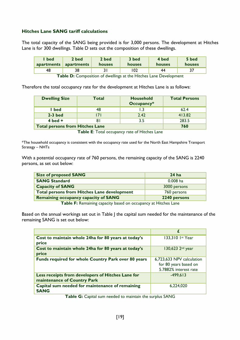
Hitches Lane SANG tariff calculations The total capacity of the SANG being provided is for 3,000 persons. The development at Hitches Lane is for 300 dwellings. Table D sets out the composition of these dwellings.
1 bed apartments
2 bed apartments
2 bed houses
3 bed houses
4 bed houses
5 bed houses
48 38 31 102 44 37 Table D: Composition of dwellings at the Hitches Lane Development
Therefore the total occupancy rate for the development at Hitches Lane is as follows:
Dwelling Size Total Household Occupancy*
Total Persons
1 bed 48 1.3 62.4 2-3 bed 171 2.42 413.82 4 bed + 81 3.5 283.5
Total persons from Hitches Lane 760 Table E: Total occupancy rate of Hitches Lane
*The household occupancy is consistent with the occupancy rate used for the North East Hampshire Transport Strategy – NHTs With a potential occupancy rate of 760 persons, the remaining capacity of the SANG is 2240 persons, as set out below:
Size of proposed SANG 24 ha SANG Standard 0.008 ha Capacity of SANG 3000 persons Total persons from Hitches Lane development 760 persons Remaining occupancy capacity of SANG 2240 persons
Table F: Remaining capacity based on occupancy at Hitches Lane
Based on the annual workings set out in Table J the capital sum needed for the maintenance of the remaining SANG is set out below:
£ Cost to maintain whole 24ha for 80 years at today’s price
133,310 1st Year
Cost to maintain whole 24ha for 80 years at today’s price
130,623 2nd year
Funds required for whole Country Park over 80 years 6,723,633 NPV calculation for 80 years based on 5.7882% interest rate
Less receipts from developers of Hitches Lane for maintenance of Country Park
-499,613
Capital sum needed for maintenance of remaining SANG
6,224,020
Table G: Capital sum needed to maintain the surplus SANG

[20]
Using the capital sum required for the maintenance of the remaining SANG and dividing it by the number of persons the tariff per person can be calculated equalling a rate of £2778.58 per person:
Capital sum needed for maintenance of remaining SANG
£6,224,020
Divided by number of persons 2240 persons Rate per person to cover SANG Maintenance £2778.58
Table H: developer contributions for Hitches Lane per person
Due to inflation the tariff has been increased in 2011 using the Retail Price Index (RPI) from April 2009-October 2010.
Rate per person to cover SANG Maintenance
RPI increase (April 2009 – October 2010)
Tariff per person (from 1st January 2011)
£2778.58 6.8% £2968 Table I: Hitches Lane SANG Tariff Inflation January 2011
Based on the occupancy rates the following tariff for the Hitches Lane SANG has been calculated:
C3 Dwelling Occupancy Rate Cost per dwelling 1 bed 1.3 £3858.40
2 – 3 bed 2.42 £7182.56 4+ bed 3.5 £10,388.00
Table J: Hitches Lane SANG tariff

[21]
Table K: Hitches Lane SANG: Annual Workings
Year 1 Year 2 £ £
Salaried Staff Basic 18,300 18,980 Direct Service recharge 22,030 22,030 National Insurance 1,270 1,330 Pension 3,320 3,440 Mileage 0 500 Professional Subscriptions 50 50 Training 500 500 Employee Related Insurances 60 60 Total Salaried Staff 45,530 46,890 Premises Costs
Planned Maintenance 0 0 Car park maintenance 940 940 Buildings Maintenance 12,350 12,350 Insurance 3,070 3,070 Building Cleaning 3,980 3,980 Window Cleaning 430 430 Electricity 430 430 Gas 720 720 Water & Sewerage 190 190 Rates 1,640 1,640 Grounds maintenance 1,000 1,000 5.1.8 hedgerows 450 450 5.3.3 herbicide treatment 1,100 1,100 5.3.4 grass cuts 400 400 5.3.5 meadow cuts 1,422 1,422 Refuse & St Cleansing 620 620 Total Premises 28,742 28,742 Transport Costs
Vehicle Maintenance (NORBA Contract) 2,200 2,200 Non Programmed Repairs Fuel 1,000 1,000 Insurance Claims Vehicle Running Expenses 300 300 Total Transport Costs 3,500 3,500 Supplies and Services
Equipment, Furniture & Materials 2,500 2,500 Clothing & Uniforms 200 200 Protective Clothing 500 500 Laundry & Hygiene 0 0 Printing & Stationery 200 200

[22]
Consultants 0 0 Management Plan Contractors Costs
5.1.2 woodland 200 200 5.1.3 replacement trees 100 100 5.1.3 maintenance of furniture 600 600 5.1.5 replanting 200 200 5.1.6 coppicing 250 250 5.1.7 tree safety 500 500 5.1.7 Pollard willow 2,000 2,000 5.2 water features 2,500 2,500 5.4.4 pathways 1,100 1,100 Amenity grassland 16 cut a year 3,670 3,670 Contractors Extra Costs 1,000 1,000 Hospitality 200 200 Direct Telephones 400 400 Licence Fees & Software Charges 100 100 Publicity 300 300 Trade Refuse Removal 1,300 1,300 Signs 6,000 1,200 Trailer 2,500 170 Fuel Store 4,000 800 Mower -small 3,000 600 Total Supplies and Services 33,320 20,590 Capital Height Barrier 0 250 Barbecues 0 1,600 Mower - tractor mounted 0 1,670 Jetties 0 0 Bird Hide 0 0 Ford Ranger Vehicle 0 2,140 Mid-range Tractor 0 2,140 Side mounted hedge flail 0 1,330 Total Capital 0 9,130 Expenditure 111,092 108,852 Additional Expenditure Contingency @12.5% 13,887 13,607 Improvements @7.5% 8,332 8,164 Total Expenditure 133,310 130,623 Income 0 0 Total Country Park 133,310 130,623

[23]
Appendix 2: Hawley Meadows and Blackwater Park SANG Hawley Meadows is located on the Hampshire / Surrey borders. It is c.27.5ha in extent and lies in three Local Authority areas namely Hart District, Surrey Heath Borough and Rushmoor Borough. Adjacent to this site is the area known as Blackwater Park, comprising an area of c.4ha and lies wholly within Hart District Council’s administrative area. Together these two areas form a contiguous 31.5ha site of publicly accessible land in the Blackwater Valley and together will make up the Hawley Meadows and Blackwater Park SANG. Hawley Meadows and Blackwater Park is a joint SANG between Hart District, Rushmoor Borough and Surrey Heath Borough Council.
Map C: Hawley Meadows and Blackwater Park SANG
With the size of the combined sites being 31.5ha, and using the standard of 0.008ha per person, the site can cater for 3,937 people. Following a visitor survey on the site it has been calculated that there are approximately 20,800 annual visits which would be generated by 520 people and therefore the remaining capacity is 3,417 people for the whole site. Apportioned by area the remaining capacity of Hawley Meadows is 2,983 people, Blackwater Park is 434 people. As there is 31.5ha of SANG available the SANG provides a 5km catchment within the District. The available capacity of the SANG of 3,417 persons will be shared out equally between the three local authorities. This provides mitigation for 1,139 persons for each authority (equivalent to approximately 475 dwellings at an average occupancy rate of 2.4 persons per dwelling). It has been agreed that an authority can pass on some or all of its allocation to another authority as considered appropriate. Hawley Meadows and Blackwater Park tariff calculations Costs of bringing the site up to a standard to be used as a SANG are set out in Table L. The figures are separated into one off set up costs, capital asset purchase with programmed replacement, and annual maintenance.
Hawley Meadows and Blackwater Park SANG
Settlement boundaries
Hart District Boundary
[24]
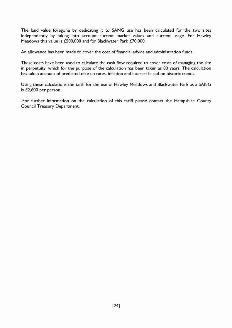
The land value foregone by dedicating it to SANG use has been calculated for the two sites independently by taking into account current market values and current usage. For Hawley Meadows this value is £500,000 and for Blackwater Park £70,000. An allowance has been made to cover the cost of financial advice and administration funds. These costs have been used to calculate the cash flow required to cover costs of managing the site in perpetuity, which for the purpose of the calculation has been taken as 80 years. The calculation has taken account of predicted take up rates, inflation and interest based on historic trends. Using these calculations the tariff for the use of Hawley Meadows and Blackwater Park as a SANG is £2,600 per person. For further information on the calculation of this tariff please contact the Hampshire County Council Treasury Department.

[25]
Table L: Work Programme Costs for Hawley Meadows and Blackwater Park SANG Planning & set up costs Unit cost (£) Quantity
HM Quantity
BP Total
Quantity Cost (£)
Hydrological study 5,000 1 1 5,000 Design of path and flood mitigation scheme 5,000 1 1 5,000 Construction of raised footpath in wettest area 30,000 1 1 30,000 Flood mitigation scheme including ground lowering & ditches 55,000 1 1 55,000 Grassland enhancement 1,000/ha 10 10 10,000 Tree clearance for new paths in woodlands 10,000 1 1 10,000 Total set up costs 115,000
Capital Asset costs Unit cost (£) Quantity
HM Quantity
BP Total
Quantity Initial
Costs (£) Replacement
period Annual costs
Access New footbridge over ditch Hawley meadows
20,000 1 1 20,000 20 1,000
Improve bridge over Cove Brook 20,000 1 1 20,000 20 1,000 Replace Hawley Car park bridge 1 50,000 1 1 0 20 2,500 Surfacing of riverside footpath 50 lm 2,200 2,200 110,000 10 11,000 Lay out of new unsurfaced routes 10 lm 1,750 250 2,000 20,000 10 2,000 Car park surface and entrance improvements
5,000 1 1 2 10,000 10 1,000
Furniture Gates 500 5 5 2,500 10 250 Seating 250 6 6 1,500 10 150 Signage & interpretation panels 1,500 per panel 3 2 5 7,500 6 1,250 Fencing for dog and cattle control 10 lm 2,000 2,000 20,000 10 2,000 Waymarking 50 15 5 20 1,000 5 200 Litter/Dog waste bins 600 2 1 3 1,800 5 360 Improvements to entrances including off site signage
1,000
1 2 3 3,000 5 600
Other Purchase of mower 12,000 1 1 12,000 5 2,400 Automatic visitor counters 1,000 1 1 2 2,000 5 400

[26]
Capital Asset costs Unit cost (£) Quantity HM
Quantity BP
Total Quantity
Initial Costs (£)
Replacement period
Annual costs
Site leaflet 3.000 1 3,000 5 600 Total capital asset costs 234,300 26,710
Maintenance costs Unit cost(£) Quantity HM
Quantity BP
Quantity Programme
Annual costs (£)
Bridge inspection & maintenance 1000 3 3 Bi annual 1,500 Path Maintenance 2 /lm 3,800 1,000 4,800 lm Annual 9,600 Hay cut 1,50 /ha 8 8ha Annual 1,200 Tree inspection & management for safety & biodiversity
500 4 1 5 Every 5 year 500
Specialised contractor & equipment hire
1,000 1 Annual 1,000
Litter/ dog waste bins servicing 500 p.a. 2 1 3 Annual 1,500 Visitor survey 3,000 1 Every 5 years 600 Maintenance of automatic counters 2 100 2 1 3 Annual 300
Biodiversity monitoring 2,000 1 Bi annual 1,000 Wardening salary & on costs of ½ ranger
40,000 p.a. 0.5 0.1 0.6 Annual 24,000
Transport costs for ranger (vehicle & fuel)
8,000 p.a. 0.5 0.1 0.6 Annual 4,800
Maintenance contingency 1 Annual 2,000 Total annual costs of maintenance
48,000
Notes
1. Bridge into site from Hawley Meadows car park is already in place but there is no duty on Hampshire CC to maintain hence it is included as maintenance and replacement cost only.
One automatic counter already in place in Hawley Meadows but no duty to maintain hence installation costs for one but maintenance costs for two

[27]
Appendix 3: Strategic Access Management and Monitoring (SAMM) tariff calculations A proportional tariff based on the number of bedrooms and occupancy rate has been agreed by Natural England and the eleven affected local authorities. In calculating the tariff a number of assumptions have been made at the strategic level by Natural England and at the local level by the Council. These are as follows: Strategic Level Assumptions:
Number of new dwellings predicted to be delivered annually within 5km of SPA (of all 11 authorities)
2842*
Total amount required annually to deliver the access management and monitoring project
£1,779,120**
Average Occupancy Rate of affected local authorities 2.4 Total number of predicted residents (2,842 x 2.4) 6,778 The tariff per person (1,779,120 / 6778) £263
Local Level Assumptions:
Total number of new dwellings predicted to be delivered within 5km of SPA over the period to 2026 (within Hart)
2640*
Occupancy rate based on number of bedrooms 1 bed 1.3 2-3 bed 2.42 4+ bed 3.5
* This figure is based on the South East Plan housing delivery figures. These figures will be reviewed at the earliest opportunity. ** Breakdown of how this figure was calculated is set out the Thames Basin Heaths Strategic Access Management and Monitoring Project – Calculation of Contributions. SAMM Tariff for Hart District Using these assumptions the SAMM tariff rate for Hart District has been calculated below to provide a proportional tariff.
Dwelling size (nos. of bedrooms)
Tariff per person (£)
Occupancy Tariff per dwelling(£)
(tariff per person x occupancy)
1 263 1.30 341.90 2 -3 263 2.42 636.46 4+ 263 3.5 920.50
Table M: Calculated SAMM tariff for Hart District

[28]
For full details of the methodology used in calculating the SAMM tariff please see Natural England’s guidance note: Thames Basin Heaths Strategic Access Management and Monitoring Project – Calculation of Contributions8.
8 Available to view on the SPA webpage at www.hart.gov.uk