Embed Size (px)
Citation preview

Intelligent Transport Systems StrategyThurrock Intelligent Road Management
2018 – 2022
Version 2.0

ITS Strategy 2018 - 2022Thurrock Intelligent Road Management
Version 2 | September 2017
Table of contentsChapter Pages
Vision 31. Introduction and Background 41.1. Definition of Intelligent Transport Systems 41.2. The Purpose of an ITS Strategy 41.3. The National Picture 41.4. Congestion Concerns in Thurrock 52. Policy Context 82.1. National Policies 82.2. Local Policies 93. Local Challenges 113.1. Local Road Network 113.2. Strategic Road Network (SRN) 133.3. Environmental Considerations 154. Vision, Aim and Strategic Objectives 165. Actions and Solutions through Collaboration 195.1. Collaboration Opportunities 196. ITS Infrastructure and Applicable Technologies 257. 5 Year ITS Roadmap 278. Emerging Trends in ITS 288.1. Global Trends 288.2. Data 298.3. Connected Autonomous Vehicles 308.4. Mobility as a Service 31Appendix A. Glossary 33Appendix B. Key Stakeholders Contacted 35

ITS Strategy 2018 - 2022Thurrock Intelligent Road Management
Version 2 | September 2017 3
VisionI am pleased to welcome you to the new Thurrock ITS Strategy for Congestion Management 2018 to 2022. Our strategy offers a 5-year road map for the use of technology to improve road network management and underlines our commitment to improving travel for our residents and businesses. Of course, congestion is not particular to Thurrock and its impact is often widespread. Managing congestion, therefore, requires us to work collaboratively with Highways England and neighbouring authorities, such as Kent and Essex County Councils, and other stakeholders. This joined up approach is a theme of our strategy as we look to minimise the disruption to our daily lives, improve the efficiency of our local businesses and provide improved access to the M25 and the broader Strategic Road Network.
The use of technology and the latest communications is increasing in our day to day lives and travel can benefit from these advancements. The use of ITS is now commonplace in the UK as an effective tool for traffic management and as an alternative to costly road building and improvements schemes. At a time when resources are scarce, Thurrock Council needs to adopt cost effective approaches to meet the challenges that face us and as Chair of the Thurrock Congestion Management Task Force I am determined to see Thurrock tackling local transport issues. The Council is actively seeking out new funding streams to implement our vision for technology based road management. The deployment of ITS will enable us to understand and monitor the road network. Our traffic managers will be equipped to intervene when things do go wrong and we will be able to share credible and accurate information with our partners and crucially, the travelling public, so you are able to make informed decisions regarding your travel. In short, ITS will enable us to develop the modern and resilient road network that you require.
Thurrock is ideally positioned as a place to live and for businesses to locate not least because of our proximity to London and the M25. There are significant local and regional opportunities for the people of Thurrock and they must be able to access them. I am all too aware of the impact congestion has on our daily lives whether it is the daily commute, a shopping trip, getting to a medical appointment or waiting for a delivery. Our strategy will help to start addressing these issues. I do not pretend it is the answer to all our problems but through the adoption of the latest traffic management techniques, integrated working with partners and positioning ourselves to take advantage of emerging approaches, Thurrock will be better placed to manage congestion in the future.
Councillor Brian Little

ITS Strategy 2018 - 2022Thurrock Intelligent Road Management
Version 2 | September 2017 4
1. Introduction and Background1.1. Definition of Intelligent Transport SystemsThe term Intelligent Transport System (ITS) refers to the application of information and communications technology to transport infrastructure, enabling data to be collected and shared to maximise the efficiency of the highway network.
ITS comprises a variety of technologies, ranging in their complexity and functionality. They include technologies designed to; monitor and capture data, manage and control systems and communicate valuable information to end users through an array of mediums (e.g. variable message signs).
ITS helps improve road safety, deliver quality network information and give environmental benefits such as carbon reduction through reduced congestion.
ITS are now commonplace in many local authorities and offer innovative and cost-effective solutions for improved traffic management, enabling network managers to be better informed and allowing ‘smarter’ user decisions to be made. To enable the success of ITS solutions, it is crucial to initially understand and quantify the issues that the network is facing and the impacts that these are having on the area. Monitoring the network is a vital requirement to identify and confirm problematic areas which would benefit from ITS intervention measures. Technology interventions can provide smoother traffic flows and improved information outputs for road users.
1.2. The Purpose of an ITS StrategyAn audit of Thurrock Council’s ITS assets was carried out in January 2017. Findings from the audit revealed that Thurrock Council’s ITS assets mainly consist of traffic signals, a legacy Urban Traffic Management Control System (UTMC) that is shared with Essex County Council and a small amount of Closed Circuit Television (CCTV) cameras. The recommendations from the ITS audit included producing an ITS Strategy, which would provide direction for the future use and improvement of ITS in Thurrock. For full ITS audit details please refer to: Thurrock ITS Audit – Findings and Recommendations – Rev 2.0.
Key drivers behind Thurrock Council’s ITS Strategy include, local congestion and the difficulties on and off the Strategic Road Network (SRN). To alleviate these problems, Thurrock Council plan on using this ITS Strategy to provide their road network managers with state-of-the-art tools, in the form of integrated ITS solutions, and by sharing road network information through collaboration with Highways England, its neighbouring Local Highway Authorities (LHAs) and other key stakeholders.
1.3. The National PictureThe Department for Transport (DfT) estimates that 324.3 billion vehicle miles were travelled on roads in Britain between April 2016 and March 2017. This represents a 1.7% growth on 2015/16 and over a 3% increase since the pre-recession peak in 2007. Indications are that road usage is set to increase further, reflecting both economic and population growth, and with it an increase in congestion and corresponding impacts on the economy and the environment. This unprecedented use of the road network presents significant challenges to Government, Highways England and LHAs.

ITS Strategy 2018 - 2022Thurrock Intelligent Road Management
Version 2 | September 2017 5
1.4. Congestion Concerns in ThurrockThurrock can be found south west of Essex on the River Thames (Figure 1). It is home to the Port of Tilbury, Intu Lakeside Retail Park, DP World London Gateway and other businesses. Thurrock has good commuting links due to its proximity to London, the M25 and the SRN. Thurrock’s location also makes it susceptible to congestion arising from incidents on the SRN not least at the Dartford Crossing.
An overview of Thurrock’s location and interaction with the Local Road Network (LRN) and SRN is illustrated in Figure 1. The SRN surrounding Thurrock is operated by Highways England. M25 Junction 30 is owned by Highways England, whilst Junction 31 is owned by Thurrock Council. The systems that operate these two junctions, currently operate independently of each other.
Figure 1. Map of Thurrock Identifying the Local & Strategic Networks and Key Points of Interest
Thurrock experiences significant and growing demand for road travel and as with the national picture, this trend is only likely to increase. The new local plan proposes 32,000 new homes by 2038 and Thurrock is also home to several logistic centres and the Port of Tilbury, all of which rely heavily on the LRN to access the SRN. Every year 25 million visits are made to the Lakeside Retail Parks off M25 Junction 31, and this number is set to increase. The rise in demand from the Dartford Crossing has impacted on Thurrock’s local network, and during events and incidents has compromised the suitability and accessibility of Thurrock’s LRN. The severe congestion and delays experienced undermines the efficacy of Thurrock’s businesses and diminishes Thurrock as a place to live and work.
The Thurrock Congestion Management Task Force has been established to address these issues and promote efficient network management in the short term. To support this, Thurrock Council is looking to develop technology based LRN management for Thurrock.
ITS Strategy 2018 - 2022Thurrock Intelligent Road Management
Version 2 | September 2017 6
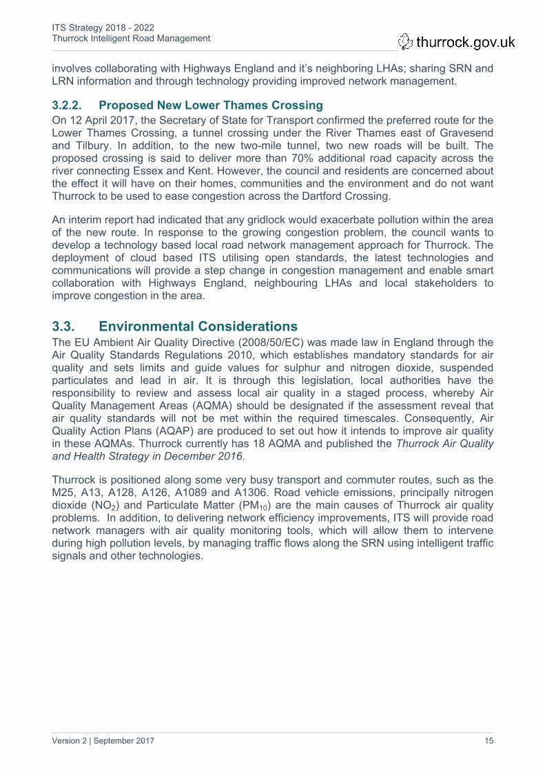
This Strategy sets out the approach for the deployment of cloud based Intelligent Transport Systems (ITS). Utilising open standards, the latest technologies and communications, ITS will help to provide a step change in congestion management and enable innovative collaboration with Highways England, neighbouring authorities and local stakeholders to improve congestion in the area.
Figure 2 (below), illustrates the increase in traffic on Thurrock’s road network (major roads) from 2000 to 2016.
Figure 2. All Motor Vehicle Traffic on Major Roads in Thurrock (2000 – 2016)1
The consequences of Thurrock Council adopting a ‘do-nothing' approach will be disastrous for local businesses, Thurrock’s residents and will impact future growth and prosperity in Thurrock. Thurrock plays an essential part in the country’s economy with the movement of goods through its two ports and logistic centres. The ports are expanding (e.g. Tilbury2 expansion plans) and the number of HGVs on Thurrock’s roads will only continue to increase (Figure 3 illustrates HGV growth in Thurrock).
1 Source for Figures 2 and 3: http://www.dft.gov.uk/traffic-counts/area.php?region=East+of+England&la=Thurrock

ITS Strategy 2018 - 2022Thurrock Intelligent Road Management
Version 2 | September 2017 7
Figure 3. Total HGV Traffic in Thurrock

ITS Strategy 2018 - 2022Thurrock Intelligent Road Management
Version 2 | September 2017 8
2. Policy Context2.1. National Policies
2.1.1. UK PolicyA report published by the Department for Transport (DfT) covering road traffic estimates for Great Britain for 2016, indicated that all motor vehicle traffic was 323.7 billion vehicle miles, 2.2% higher than the previous year. A breakdown has been provided under Figure 4.
During 2016, Essex was recorded as one of the five authorities in the South East/East to have the highest levels of traffic. The common factor between these authorities (i.e. Essex, Hertfordshire, Hampshire, Kent and Surrey) is all have large road networks and contain some of the major motorways of Great Britain.
This continual growth in traffic has presented many challenges in reducing congestion and improving road user experience. Expanding the road network is not always the best solution, in terms of; environmental and planning policies, and, costs and returns on investment. Consequently, alternative solutions like the adoption of ITS are essential to improving the management of existing road networks.
The EU Directive and Action Plan have been adopted into UK legislation, and now govern the development and deployment of ITS across the UK. It is this legislation, alongside the resulting ISO, CEN, and UK Standards to which LHAs must refer. Alongside recognised standards there are de facto standards, and industry guidance developed by organisations such as the UTMC Development Group (UDG). There are also organisations such as ITS UK, who encourage the promotion of ITS. Websites for these organisations have been provided below:
ITS UK: http://its-uk.org.uk/ UTMC: http://www.utmc.eu/

ITS Strategy 2018 - 2022Thurrock Intelligent Road Management
Version 2 | September 2017 9
Figure 4. Vehicle Miles Travelled by Selected Vehicle Types in Great Britain, 2006-20162
2.1.2. Creating Growth, Cutting Carbon: Making Sustainable Local Transport Happen White Paper (2011)
Under the Conservative and Liberal Democrat coalition government (2010-2015), a White Paper was published (January 2011), which acknowledges ITS having an increasingly important role in managing the road network.
The role of ITS is emphasised in the 2011 White Paper as a real option for improving the experience of road users by enabling more effective and reliable real time information, and increasing the smoothness of traffic flow. However, the White Paper indicates that for the real benefit of ITS to be realised, LHA’s are better placed to develop ITS strategies tailored to their unique road network challenges and requirements.
2.1.3. Traffic Management Act (2004) The responsibility for LHA’s to develop local ITS strategies is supported by the 2004 Traffic Management Act (TMA). Examples from the TMA include:
There is the requirement for LHAs to keep traffic moving freely and quickly on their roads and the roads of nearby authorities. LHAs are also to act towards securing more efficient use of their road network (Ref. Part 2 Section 16: Network Management Duty).
LHAs are required to identify potential causes (includes making future predictions) of road congestion or other disruption to the movement of traffic on their road network. With this information LHAs then need to apply appropriate mitigation measures and monitor their effectiveness (Ref. Part 2 Section 17 Arrangement for Network Management).
2.2. Local PoliciesIn response to local businesses and residents social, environmental and economic concerns (e.g. housing, air quality, employment and transport), Thurrock Council has produced several strategies. Each of these can be linked to this ITS Strategy, through common approaches, objectives and/or will have an impact on congestion on LRN and SRN in the future (see Table 2).
Strategy Key Notes
Thurrock Transport Strategy (2013-2021)
From the 31 policies defined, policy TTS16 (Network Efficiency) can be clearly identified to be supported by the ITS strategy. It requires Thurrock Council to investigate and deliver transport network management and efficiency improvements before increasing capacity. The use of ITS has been clearly identified. Using the latest technology, motorists will be provided with improved information on congestion, incidents, and collectively these technologies can be a powerful tool to manage congestion on Thurrock’s road network. The ITS strategy will also support the two air quality policies TTS22 and TTS23, by deploying air quality monitoring technology in Air Quality Management Areas.
2 Source: https://www.gov.uk/government/uploads/system/uploads/attachment_data/file/611304/annual-road-traffic-estimates-2016.pdf

ITS Strategy 2018 - 2022Thurrock Intelligent Road Management
Version 2 | September 2017 10
Connected Thurrock (2017-2020)
From the six themes covered, the first two themes share a similar approach:The first theme ‘A Connected Place’ identifies the need for a traffic management platform to control congestion and air quality using sensors. ITS Strategy identifies UTMC being the platform to control congestion, air quality sensors and other network management technologies.Theme two ‘Enabling Collaboration’ is another theme shared by the ITS strategy. The ITS strategy identifies that Thurrock Council cannot just rely on ITS but, will also need to collaborate with LHAs, Highways England and other key stakeholders.
A Housing Strategy for Thurrock (2015-2020)
The strategy identifies an additional 20,600 new homes needing to be built by 2031 (1,030 new homes per year). The increase in Thurrock’s population and demand for new homes has the potential to increase traffic on the LRN. Consequently, it is essential that any new housing estates built on new or reclaimed land incorporate the deployment of ITS to get the optimum out of Thurrock’s LRN.
Thurrock Traffic Management Plan (2012-2016)
The Traffic Management Plan aims to improve traffic flows and decrease the number and period of congestion incidents on Thurrock’s road network, through an efficacious network management system. The following objectives have been identified in this document:
To reduce the number of congestion incidents and disruptions related to: roadworks; road traffic accidents; events; and, parking.
To continue to minimise incidents and delays related to server weather.
To maintain and, where possible, improve journey times and speeds and therefore improve journey reliability.
To make the best and most effective use of data collection and information analysis.
Air Quality and Health Strategy (updated November 2016)
In 2015, Thurrock Council took the decision to develop an integrated Air Quality and Health Strategy. Through this strategy, the council is tackling the health problems associated with and worsened by air pollution within the borough. As part of this strategy, the opportunitywas also taken to review the existing Air Quality Action Plans (AQAP) associated with Thurrock’s 18 Air Quality Management Areas (AQMA).
This ITS strategy supports the Air Quality and Health strategy, by specifying the use of air quality monitoring technology in AQMA. In addition, technologies have been recommended to improve traffic flow movements on the SRN and act as mitigation measures against causes of traffic congestion.

ITS Strategy 2018 - 2022Thurrock Intelligent Road Management
Version 2 | September 2017 11
Table 1. Thurrock Council Strategies Common Objectives
3. Local Challenges3.1. Local Road NetworkRoads in Great Britain are some of the safest in the world, and LHAs and Highways England continue to make roads even safer. During 2006 there were 31,845 people killed or seriously injured on roads in Great Britain, 1,174 of them in Essex. The year 2013 saw this figure drop to 23,370 for Great Britain and 689 for Essex. Whilst some authorities within Essex have seen improvements Thurrock saw an increase in causalities on their road network (see Figure 4). With the introduction of ITS on Thurrock’s SRN network managers will be able to provide through VMS live road condition and incident information (e.g. slippery roads and collision ahead).
Figure 5. Number of Casualties by year in Thurrock3
Congestion in Thurrock is already an issue and based on recent traffic volume figures released by the DfT (Ref. Figure 1), traffic congestion in Thurrock is predicted to get worse. It is important that Thurrock Council invests in an intelligent road network with the technology to collaborate with key strategic stakeholders, such as Highways England and major distribution centres, if it is to respond to local challenges facing Thurrock.
3 Source: https://saferessexroads.org/collision-data/

ITS Strategy 2018 - 2022Thurrock Intelligent Road Management
Version 2 | September 2017 12
A sample of the local challenges and how ITS will help Thurrock to provide a response to them is given in the following table:
Local Challenge Description Role of ITS
Local Housing The local population is growing and fewer affordable homes are becoming available. Thurrock needs to build 1,030 each year until 2031 to keep up with demand. The local network will need to accommodate the additional cars that will come with the home owners.
Network Managers will have the tools, such as CCTV and vehicle detection, to monitor traffic flows and then implement intervention plans/ strategies.
Support the Creation of New Jobs
Continue to encourage new businesses into the area to create jobs and invest in the area. For example: $550m partnership between Solena Fuels and British Airways will see a new plant being constructed on the Thames Enterprise Park site. The target of 26,000 jobs needs to be reached by 2021. Historically Thurrock’s economy has been dominated by small number of key sectors, including transport, logistics, port functions and retail, which provide low wage jobs for local residents. Thurrock Economic Growth Strategy (2016- 2021) identifies the need to create more high value jobs to improve wage levels and increase productivity.
New businesses will not want to locate in the area, if they continually see and hear about traffic congestion events occurring on Thurrock’s roads. It is important that Thurrock’s network managers keep traffic moving and they will be able to achieve this by using monitoring technologies to identify slow moving or stationary traffic. Network managers will then be able to intervene by providing information to motorists, advising them of likely delays, and suggesting alternative routes.
Improve Air Quality Air pollution in terms of exhaust fumes, nitrogen oxide and particulates is linked to serious illnesses, making lung conditions worse and increasing hospital admissions. The risk of death from cardiovascular disease and heart attacks has also increased.Air Quality Management Areas already have been declared in Thurrock. During 2012 and 2013 Thurrock exceeded the EU limit of 40
Through pollution sensors, CCTV and other monitoring technology, the network managers will be able to identify initial signs of high pollution levels and react by implementing intervention plans (i.e. controlling traffic flows through intelligent traffic signals and providing information to motorist via VMS).

ITS Strategy 2018 - 2022Thurrock Intelligent Road Management
Version 2 | September 2017 13
Local Challenge Description Role of ITSmicrograms/m3 and in 2014 it only just came under with 39.7 micrograms/m3. During a recent Lower Thames Crossing Q&A session, Ian Wake (Director of Public Health, Thurrock Council) highlighted Thurrock’s death rate for cardiovascular disease and respiratory disease when compared to 15 most similar councils with similar population, Thurrock ended up being ranked the worst.
Local Businesses Thrive
For local businesses, such as Intu Lakeside Retail Park, to be viable and successful it is important that they attract customers locally and from outside Thurrock. At present, Intu Lakeside Retail Park has serious concerns about the frequent traffic congestion events taking place on LRN (A1306/ A126) and SRN (M25 Junction 30/31). Consequently, traffic congestion can deter shoppers from coming to Intu Lakeside Retail Park and may encourage customers to go to one of their competitors in a neighbouring authority. This can lead to lost revenue and put jobs at risk.
Thurrock’s Network Managers will have access to the SRN traffic data as well as data from its neighbouring authorities, which will help them manage traffic coming off from the M25 and onto Thurrock’s road network.
Movement of People and Goods
Keep traffic moving on local routes to ensure people and goods arrive at their destination on time. Delays cost local businesses money. HGV traffic in Thurrock has been on the increase since 2013 (Ref. Figure 3) and with the two large ports this will only continue to grow.
The ITS infrastructure will allow Thurrock’s network managers to share traffic information with the ports. This provides a more coordinated approach in tackling traffic congestion.
Table 2. Thurrock Objectives
3.2. Strategic Road Network (SRN)
3.2.1. Dartford CrossingThe Dartford Crossing is the main River Thames crossing to the East of London and is a strategic route for freight heading north from Dover. Southbound traffic crosses the river

ITS Strategy 2018 - 2022Thurrock Intelligent Road Management
Version 2 | September 2017 14
via the four lane Queen Elizabeth II (QEII) Bridge whilst northbound traffic uses the two adjacent tunnels. When operation of the crossing is compromised, such as partially or fully closed due to an incident or poor weather conditions, the high volume of traffic, particularly freight, causes severe levels of congestion in Thurrock. Consequently, work is being undertaken to improve network conditions and optimise the recovery of the network after a QEII Bridge or Dartford Tunnel closure. Recent incident examples have been provided on the following page4:
Congestion at the crossing can deter people undertaking journeys and can create hours of delays for road users trying to leave or access the Thurrock area. Furthermore, it discourages businesses to locate and invest in Thurrock and creates concerns for residents. Consequently, an approach is needed to help manage congestion and the potential causes of congestion. Thurrock Council’s approach is technology driven and
4 source: http://www.essexlive.news/dartfordcrossing
ITS Strategy 2018 - 2022Thurrock Intelligent Road Management
Version 2 | September 2017 15
involves collaborating with Highways England and it’s neighboring LHAs; sharing SRN and LRN information and through technology providing improved network management.
3.2.2. Proposed New Lower Thames CrossingOn 12 April 2017, the Secretary of State for Transport confirmed the preferred route for the Lower Thames Crossing, a tunnel crossing under the River Thames east of Gravesend and Tilbury. In addition, to the new two-mile tunnel, two new roads will be built. The proposed crossing is said to deliver more than 70% additional road capacity across the river connecting Essex and Kent. However, the council and residents are concerned about the effect it will have on their homes, communities and the environment and do not want Thurrock to be used to ease congestion across the Dartford Crossing.
An interim report had indicated that any gridlock would exacerbate pollution within the area of the new route. In response to the growing congestion problem, the council wants to develop a technology based local road network management approach for Thurrock. The deployment of cloud based ITS utilising open standards, the latest technologies and communications will provide a step change in congestion management and enable smart collaboration with Highways England, neighbouring LHAs and local stakeholders to improve congestion in the area.
3.3. Environmental ConsiderationsThe EU Ambient Air Quality Directive (2008/50/EC) was made law in England through the Air Quality Standards Regulations 2010, which establishes mandatory standards for air quality and sets limits and guide values for sulphur and nitrogen dioxide, suspended particulates and lead in air. It is through this legislation, local authorities have the responsibility to review and assess local air quality in a staged process, whereby Air Quality Management Areas (AQMA) should be designated if the assessment reveal that air quality standards will not be met within the required timescales. Consequently, Air Quality Action Plans (AQAP) are produced to set out how it intends to improve air quality in these AQMAs. Thurrock currently has 18 AQMA and published the Thurrock Air Quality and Health Strategy in December 2016.
Thurrock is positioned along some very busy transport and commuter routes, such as the M25, A13, A128, A126, A1089 and A1306. Road vehicle emissions, principally nitrogen dioxide (NO2) and Particulate Matter (PM10) are the main causes of Thurrock air quality problems. In addition, to delivering network efficiency improvements, ITS will provide road network managers with air quality monitoring tools, which will allow them to intervene during high pollution levels, by managing traffic flows along the SRN using intelligent traffic signals and other technologies.

ITS Strategy 2018 - 2022Thurrock Intelligent Road Management
Version 2 | September 2017 16
4. Vision, Aim and Strategic ObjectivesIt is through ITS that Thurrock Council will be able to accomplish its aim to investigate and deliver transport network management and efficiency improvements before increasing capacity (as identified in Thurrock Council’s Transport Strategy 2013 - 2026). ITS solutions will provide motorists with improved information on congestion, incidents and collectively they will provide network managers with the right tools to manage congestion on Thurrock’s road network.
Five objectives have been identified for this strategy: monitor; integrate; manage; inform; and, coordinate. ITS solutions identified for Thurrock will be assigned one of these five objectives. The table below summaries the deployment of ITS in Thurrock:
ITS Objectives ITS Solutions Technologies
Monitor ITS monitoring solutions such as CCTV will allow network managers to home in on areas of interest to provide vital visibility of the network and verification of network conditions and impacts. With a combination of other road network monitoring solutions (e.g. vehicle detection and air pollution monitoring) network managers will have the information to make effective decisions and interventions.
For example, monitoring will help to identify slow moving or stationary traffic, which could trigger information provision to users, advising them of likely delays, and suggesting alternative routes.
By storing captured data, this can be used for modelling purposes, informing future decision making and the design or redesign of infrastructure.
CCTV
Air Pollution
Vehicle Detection
Integrate Through a UTMC system and communications will Thurrock be able to integrate all their ITS solutions successfully and thereby obtain maximum benefits.
UTMC system to utilise the latest open standards to promote data collection, co-ordinated interventions for network management and collaboration with Highways England and neighbouring authorities.
ITS infrastructure has traditionally utilised a variety of communication channels from authority to authority, including fixed lines communications such as ADSL and the mobile phone data network. With developments in technology, there is an increasing recognition of the need to embrace a digital communications architecture and this should be core to future ITS deployment.
UTMC
Communications (includes digital solutions)

ITS Strategy 2018 - 2022Thurrock Intelligent Road Management
Version 2 | September 2017 17
ITS Objectives ITS Solutions Technologies
Manage The management of traffic signal control and other technology interventions, such as dynamic electronic signage (Variable Message Signs) can improve the effectiveness of traffic movements across the network as well as enabling a quick response to live incidents. For example, traffic signal timings may be changed dynamically to reflect traffic conditions, and information may be provided to network users well in advance of their approach to congestion, an accident or road closure, allowing them to make informed choices about their journey. This links with the Inform objective.
UTC and Traffic Signals
Bus Priority
Inform The provision of accurate and real-time information for road users in advance of and during their journeys can influence behaviour, and result in users making more informed decisions and smarter travel choices.
Information during journeys has traditionally been delivered using roadside infrastructure, VMS or in the case of highway incidents, radio bulletins.
Developments in mobile phone technology, and the emerging developments within in-car technology such as advanced satellite navigation and connected vehicles, enhance the provision of information directly to the user, or potentially their vehicles far easier.
VMS
Parking Guidance
Web
Mobile Apps
Coordinate Providing motorists with live traffic reports will enable smarter choices to be made. For example, drivers taking early breaks at service stations to avoid being caught up in traffic jams and becoming part of the problems.
Inter-authority collaboration will allow LHAs to keep traffic moving freely and quickly on their roads and the roads of nearby authorities (TMA requirement).
All ITS elements under the ‘Inform’ area are the technology enablers for this ITS objective.
Table 3. Deployment of ITS in Thurrock

ITS Strategy 2018 - 2022Thurrock Intelligent Road Management
Version 2 | September 2017 18
The relationship between aims, objectives, technology, collaboration and outcomes are summarise in the ITS Strategy Delivery Diagram (see Figure 6).
Figure 6. ITS Strategy Delivery Diagram

ITS Strategy 2018 - 2022Thurrock Intelligent Road Management
Version 2 | September 2017 19
5. Actions and Solutions through Collaboration
Thurrock Council will be collaborating with its neighbouring LHAs, Highways England and other key stakeholders to improve the efficiency of the LRN and SRN and how they interact. In addition, innovative technologies will be deployed on the LRN to provide Thurrock with the foundation for intelligent road management.
5.1. Collaboration OpportunitiesThis section concentrates on collaboration between Thurrock and key stakeholders (see Figure 7).
Thurrock Council
Local Highway
AuthoritiesHighways England
+ CPS
Local Businesses
Transport Operators
Emergency Services
Congestion Task Force
Thurrock Residents
Figure 7. Collaboration with Key Stakeholders

ITS Strategy 2018 - 2022Thurrock Intelligent Road Management
Version 2 | September 2017 20
5.1.1. Congestion Task ForceIn April 2016, the Thurrock Congestion Task Force was set up in response to mitigating against the impact of incidents on the M25 and Dartford Crossing on local traffic in Thurrock. Chaired by Thurrock Council, the task force has representatives from:
Highways England
Connect Plus Services, who maintain and operate the Area 5 and M25 network, including all adjoining trunk and slip roads on behalf of HE
Essex County Council
Essex Police
Thurrock Business Board
Thurrock Residents
Other agencies and community groups
The Task Force will have an essential role in implementing this ITS Strategy. The Task Force meetings will provide the platform for collaboration between the various representatives; whereby proposed ITS schemes can be openly discussed, lessons learnt and performance reviews of implemented ITS schemes can also be shared. The opportunity is also presented to join up with other schemes that are being implemented independently (e.g. Intu Lakeside Retail Park have plans to deploy a parking guidance system).
5.1.2. Highways EnglandHighways England is a particularly important partner for Thurrock Council due to Thurrock’s location, surrounded by the SRN. Thurrock to date has lacked the resource and tools to collaborate directly with Highways England, however, as the networks are so intrinsically linked it is important that this relationship is developed. Highways England have a programme in the South East, the Collaborative Traffic Management (CTM) programme, which aims to do exactly this, using ITS to share network information and data, enabling networks to be managed more effectively both independently and jointly.
Collaborative Traffic ManagementThe Highways England CTM Programme provides a great opportunity for Thurrock Council to collaborate with Highways England, and build a strong working relationship. The CTM programme, although a 4-year programme, is working to instil the collaborative principles into Highways England in the South East for the long term. A Highways England Network Manager has been appointed who will act as the main point of contact with LHAs and provide an operational interface with Thurrock Council.
CTM is the collaborative opportunity for Thurrock Council as the programme aims to improve congestion around key access points to the SRN, allowing traffic to access the network more effectively. This is crucial to the logistic centres located in Thurrock as well as the Thurrock residents, as most journeys outside of Thurrock will utilise the SRN.
CTM uses ITS to share data between LHAs and Highways England. A UTMC link is developed between the Highways England UTMC and the LHA UTMC. This allows for the effective sharing of journey time information, traffic events, incidents, accidents, CCTV images and the Traffic Management Cell events at the Dartford Crossing. This information

ITS Strategy 2018 - 2022Thurrock Intelligent Road Management
Version 2 | September 2017 21
provides the LHAs with visibility of the SRN and the impact this may have on their network. The sharing of data is two-way allowing Highways England to view the LRN and act when events or incidents might cause congestion on the SRN. Allowing the network to be managed holistically. Local operational strategies can be created which utilise data from both networks to trigger the strategy and implement a change on both authorities ITS assets such as VMS or traffic signal timings and the Highways England assets. This joint control of the network also allows the Highways England Regional Control Centres (RCCs) to manage the LHA network outside of the LHA operating hours.
As many of Thurrock’s primary trip generators are big businesses which have located in Thurrock due to its strategic links, information from these key businesses will need to feed into Thurrock Council’s UTMC system. This data is going to be paramount for Thurrock to understand the trends and fluctuations on their own network but as these businesses will be utilising the SRN, this information is also going to be very important to Highways England. Key businesses which real-time data will be required from are Intu Lakeside Retail Park, Port of Tilbury and DPD World, visibility of when there is likely to be large number of vehicles accessing the SRN is important, so information such as car park occupancy, and depot departure times are going to be crucial to any collaborative work.
5.1.3. Local Highway AuthoritiesEssex County Council (ECC) and Kent County Council (KCC) are the two LHAs that Thurrock Council will need to work with to ensure traffic is kept moving freely and quickly on their roads as well as on nearby roads in Essex and Kent (TMA requirement).
KCC and ECC have established ITS architectures that allows them to share their road network information with their neighbouring authorities and Highway England. Thurrock Council on the other hand has very little ITS infrastructure and is currently not in a technological position to share its road network information with its neighbouring authorities. Therefore, it is important that Thurrock Council works with ECC and KCC, whilst they implement ITS solutions and to ensure inter-connectivity between the three ITS architectures.
Essex County CouncilThurrock Council currently has a contract with ECC for the operation and maintenance of all ITS infrastructure within its boundary. ECC is responsible for the management of all ITS systems, including the UTC system and CCTV server, as well as day-to-day maintenance and monitoring of the network. The ITS Audit highlighted that there was little proactive use of ITS to respond to incidents and events in and around Thurrock. ECC acknowledges the current arrangement does not give Thurrock Council full control over their ITS assets.
Looking ahead, Thurrock Council will be more proactive in managing its own approach but, will continue to work closely with ECC to ensure existing relationships and communication channels are maintained. Thurrock Council also plan on sharing their data, assets and collaborating with ECC on network management plans. ECC envisages on doing the same. A new Memorandum of Understanding (MoU) between the two authorities will need to be in place, which will demonstrate their desire and commitment to working with each other.
Kent County CouncilKCC currently collaborates with Highways England through the CTM programme. The project looks at improving congestion in the Dartford area through utilising ITS. A link has

ITS Strategy 2018 - 2022Thurrock Intelligent Road Management
Version 2 | September 2017 22
been developed between KCC and Highways England, through which information on the Traffic Management Cell at Dartford Crossing, and journey time in the Dartford area is shared. This is then utilised to create strategies which are implemented on both KCC and Highways England assets.
KCC had the ITS systems in place to be able to collaborate with Highways England on this work, which enabled them to bid for funding from the Local Growth Fund (via South East Local Enterprise Partnership) and other funding streams. KCC would be a good authority for Thurrock Council to develop links with, as they would be able to share experiences about the best ways to win funding, and their working relationship with Highways England.
5.1.4. Local BusinessesLocal businesses are concerned about the impact local congestion is having on their business. Three of Thurrock’s larger businesses, DP World London Gateway, Port of Tilbury and Intu Lakeside Retail Park were approached to learn more about their concerns and how they could work with Thurrock Council to tackle this growing problem.
DPD World London GatewayThe UK's most integrated port - logistics hub can be found North of the River Thames in Thurrock, Essex. The state-of-the-art facility has a rail terminal and is the gateway to international markets. Freight distribution by road is via the A13 to Junction 30 of the M25 motorway. To alleviate freight congestion, DP World are obligated to Highways England to provide funding towards SRN improvements (e.g. Junction 30). However, DPD World does have the option to use their funding on alternative solutions that will help reduce traffic congestion caused by increasing freight movements.
They are keen to see the roll out of an intelligent road management system with the ability to fully integrate with similar systems of neighboring highway authorities, such as Highways England, ECC, Southend Council and Transport for London (TfL). Furthermore, there is the interest from DPD World to see their own on-site systems integrate with Thurrock Council’s system to ensure that driver choice is informed and influenced from the outset of a journey.
There is the long-term plan to have an onsite lorry park that would provide drivers with up-to-date traffic information, allowing them to make the decision to take their rest period earlier, at the lorry park, and avoid becoming caught up in traffic congestion. The lorry park would contribute towards reducing traffic congestion on both LRN and SRN. However, for Thurrock Council, Highways England and its neighboring LHAs to benefit from this scheme you would need to ensure that the deployed technology for the lorry park is integrated into Thurrock Council’s ITS architecture (see Section 6).
A letter of commitment from DP World London Gateway has been included in Thurrock Council’s recent National Productivity Investment Fund (NPIF) submission. A successful NPIF submission will help Thurrock Council implement their ITS Strategy.
Port of TilburyThurrock Council’s second port, Port of Tilbury is owned and has been operated by Forth Ports since 2012. It is in the Thames Gateway, the UK’s largest redevelopment zone, and is an important distribution centre for London and the South-East of England. In fact, the port is the UK’s third largest container port, handling 80 percent of London’s container traffic.

ITS Strategy 2018 - 2022Thurrock Intelligent Road Management
Version 2 | September 2017 23
Since acquiring the port, Forth Ports has invested over £35 million in a development programme. Recent injections of investment have positioned the port for growth in core markets and delivered state-of-the-art short sea container cranes, specialist facilities for vessels and a new fleet of straddle carriers integrated with a fully automated road truck reception gate and bespoke terminal operating system. There are further improvements in the pipeline including, a 568-space lorry park and 83,613 m2 of warehouses by 2021.
With improvements being made to the ports to allow for an increasing number of containers coming through, there is an equal need for the LRN and SRN to be better equipped to handle the extra HGV traffic.
In the past, Port of Tilbury has voiced its concerns about the growing congestion problem on the LRN and SRN through DPD World London Gateway. Thurrock Council is now acting through this ITS Strategy, which will see the delivery of intelligent road network management technologies being deployed. In addition to the use of technologies, the Council and the Ports must work together to integrate their systems, allowing sharing of network information and collaboration on joint intervention plans and strategies, to respond to incidents and manage traffic more efficiently on the LRN and SRN.
Intu Lakeside Retail ParkIntu Lakeside Retail Park is in West Thurrock and can be accessed from Junctions 30 and 31 of the M25 motorway. The A13, A1306 and West Thurrock Way also provide direct access. The site provides 13,000 free parking spaces.
Approximately 6,000 people are employed at Intu Lakeside Retail Park. All staff and retailers have access to the Travel Plan for the centre and they are regularly involved in events and awareness raising activities.
Intu Lakeside Retail Park recognise congestion having a huge impact upon access and the footfall recorded at the centre. Congestion on the local network often persuades people not to visit the centre and it also causes issues for staff who drive or get a bus to work. Regular congestion can lead to customers choosing to shop elsewhere.
Intu Lakeside is often (wrongly) seen to be responsible for congestion around the centre and the surrounding network and they are often criticised on social media for network issues which are outside of their control. Congestion often occurs because of very minor issues on the network and the lack of existing capacity. A lack of suitable and joined-up traffic signal provision means, that local roads often experience a ‘free for all’ scenario where roundabouts and junctions become blocked and traffic comes to a standstill. When this occurs, they have long periods of reduced footfall at the centre. Congestion linked to planned maintenance and schemes, also has a huge impact on Intu Lakeside Retail Park. Long term schemes often create congestion, journey delays and rat-running which can affect access to the shopping centre.
Information on congestion, incidents, and events is currently provided by Highways England via daily emailed updates from National Incident Liaison Officers (NILO) and Thurrock Council circulate Traffic Regulation Order (TRO) updates. There are screens at two of the main entrances, which have previously displayed Highways England network updates but, now are blank. These displays could be used to show information provided by the Council.

ITS Strategy 2018 - 2022Thurrock Intelligent Road Management
Version 2 | September 2017 24
There are plans for growth of Intu Lakeside Retail Park, they are currently delivering its £100 million leisure development. In addition, there are plans to expand its retail offer in the future. Intu Lakeside Retail Park are currently working with the Council to deliver a VMS scheme which supports their leisure development and provides a greater level of information to customers. This will include on-site and off-site VMS which will provide real time information relating to car park spaces and will direct customers to specific car parks as capacity is reached. It is essential that any VMS procured to serve Intu Lakeside Retail Park is part of the Councils wider VMS deployment strategy and be compatible with a UTMC system to ensure delivery of ITS system integration.
5.1.5. Transport OperatorsCongestion on Thurrock’s road network causes significant disruption to bus services with buses being severely delayed or having to be diverted to maintain some sort of service. This does not sit well with passengers and can cost bus operators as a business in lost revenue. Ensignbus and Arriva support the idea of having bus priority and having a new Real Time Passenger Information (RTPI) system. Improvements to public transport are also being assessed by Thurrock Council and will complement the aims and objectives laid out in this strategy.

ITS Strategy 2018 - 2022Thurrock Intelligent Road Management
Version 2 | September 2017 25
6. ITS Infrastructure and Applicable TechnologiesThurrock will be deploying technologies to tackle its growing congestion problem. The system architecture diagram (Figure 8) below provides an overview of the outputs, inputs and the interfaces between various technologies that will be adopted by Thurrock Council.
Figure 8. System Architecture

ITS Strategy 2018 - 2022Thurrock Intelligent Road Management
Version 2 | September 2017 26
There are five parts that make up Thurrock Council’s ITS architecture (see Figure 8):
(i) The UTMC system (the systems core).(ii) ITS inputs from road network monitoring technologies.(iii) ITS inputs from other data sources like the Port of Tilbury and DPD World
London Gateway.(iv) Interventions which can be undertaken by the network managers. (v) ITS outputs to inform road users about current traffic conditions.
The UTMC system will be the backbone of Thurrock Council’s ITS architecture and will be delivered in the early stages of Thurrock Council’s 5-year strategy. Thurrock Council’s UTMC system will utilise the latest open standards to promote data collection, coordinated interventions for network management and collaboration with Highways England and neighboring authorities including Junction 31, Junction 1A / 1B of the M25 (Dartford Crossing). It is envisaged that all the UTMC systems will be cloud based and hosted by the system providers. The UTMC will provide a single database which enables the development of integrated management tools for network operations, provides a consolidated output of traffic and travel information (for example to the public via web services), and allows managers to analyse stored data to identify trends.
The inclusion of strategy management tools within the UTMC allow operators to develop and save strategies for use within network management.
Section 7 outlines a 5-year delivery roadmap for ITS including:
UTC system and Traffic Signal upgrades at key junctions enabling the use of MOVA and SCOOT to offer adaptive and proactive junction management.
Traffic Detection measures (Bluetooth and Radar) to provide real time information to systems and network managers to enable timely interventions and improved incident and event management.
CCTV monitoring to provide vital visibility of the network and verification of network conditions and impacts.
VMS to offer front line information and notifications to road users, coordinating information on local and strategic road conditions.
Traffic and Travel Information services to provide open web based services providing information to stakeholders and road users.
Air quality monitoring through the provision of sensors to inform traffic management decisions and longer term operational and investment processes.
Through the UTMC system, it will be made possible to combine monitoring technologies to provide much more accurate and reliable traffic movement data. For example, radar detection and CCTV technologies are collectively used to capture freight data, such as vehicles taking inappropriate routes (e.g. HGV drivers taking shortcuts using Thurrock’s residential roads), and other freight specific information. This information is then made available to road network managers and others, such as Thurrock’s two ports (i.e. DP World London Gateway and Port of Tilbury).

ITS Strategy 2018 - 2022Thurrock Intelligent Road Management
Version 2 | September 2017 27
7. 5 Year ITS RoadmapThe ITS Strategy defines the objectives for ITS deployment and the technologies aligned to these objectives. The deployment of technologies has been prioritised and scheduled over the next 15 years. This is summarised in the table below:
YearsITS Objectives Technologies Vision Challenges
1 2 3 4 5
CCTV
Provide coverage of the key problem spots along the LRN, allowing Network Managers to fully understand what is occurring on the network. Aid the implementations of traffic management interventions, and be used to monitor the effect of applied solutions. Validate information captured from other ITS infrastructure and to verify information outputs and messaging.
Agreeing locations along the SRN. Specifying system requirements.
Vehicle Detection
Provide data on the volume and speed of traffic along SRN. Real time analysis of this data will allow the detection of incidents on the LRN, and trigger alarms within a control room environment, so interventions can take place, either automatically or through manual intervention.
Agreeing locations along the SRN. Specifying system requirements.Monitor
Air PollutionProvide live pollution level data (e.g. PM10 and NO2), allowing Network Managers to initiate intervention plans and use ITS when pollution levels reach pre-set thresholds limits. The technology deployed will help Thurrock Council to tackle its pollution problem.
Agreeing locations along the SRN. Agreeing pollution limits for monitoring. Specifying system requirements.
UTC & Traffic Signals
UTC provides the tools to centrally manage and control traffic signals. By linking traffic signals through a central intelligence, supported by network monitoring tools, the flow of traffic will be smoothed across the LRN, improving journey times and generating additional capacity.
Review of all signalised junctions along the SRN.
Specifying upgrade/ new requirements.Manage
Bus PriorityPriority given to late running vehicles, with the aim of improving schedule adherence and service reliability.
Not to compromise traffic flows elsewhere along the SRN when a green signal is given.
UTMC
It will be through the UTMC that two way sharing of live and historic traffic conditions along LRNs and SRN will be made possible for neighbouring LHAs, Highways England and other key stakeholders. The use of a single database will allow the development of integrated management tools for network operations. Provide a consolidated output of road traffic information, and allow Network Managers to analyse stored data to identify trends.
Setting up the UTMC links between Thurrock Council and its LHAs, Highways England and other key stakeholders, to enable the two-way sharing of information.
Specifying system requirements.
Integrate
CommunicationITS infrastructure has traditionally utilised a variety of communication channels from authority to authority, including fixed lines communications such as ADSL and the mobile phone data network. With developments in technology, there is an increasing recognition of the need to embrace a digital communications architecture and this should be core to this ITS Strategy.
Making sure the communications infrastructure is correctly installed and set up to avoid catastrophic effect on theoperation of all ITS (e.g. CCTV, VMS).
VMS/ Parking Guidance
Located alongside the LRN providing an effective means of information provision to road users. Provide live traffic information, including journey times, information on incidents, roadworks and alternative routes, and upcoming events which may impact upon the LRN. Through UTMC, VMS will be linked with other ITS infrastructure, for example providing car park guidance based on occupancy levels.
Agreeing locations along the SRN with stakeholders (e.g. Thurrock’s shopping centres).
Specifying system requirements.Inform
Mobile Apps & Web Services
Development of an integrated mobile phone application and website, providing live traffic information for all road users. Will provide all users with the ability to plan and avoid potential congestion and incidents.
Provision of accurate and real time information.
Caters for all users.
Inter-Authority Collaboration
Collaboration between LHAs and Highways England to keep traffic moving along the LRN and SRN. Sharing of data and co-ordination of systems, benefits can be maximised across a wider area. Technology enabler: UTMC system
Agreeing joint intervention plans to improve safety, air quality and traffic flow across LRN and SRN. Sharing assets/ information.
CoordinateSmart Choices
The provision of traffic information to motorists will allow motorists to make smarter choices. For example, HGV drivers taking breaks earlier to avoid becoming caught up in congestion/ long tailbacks.
Providing accurate information to motorists. Incorrect information will result in the motorist losing confidence/ trust in the system.
Table 4. 5 Year ITS Roadmap

ITS Strategy 2018 - 2022 Thurrock Intelligent Road Management
Version 2 | September 2017 28
8. Emerging Trends in ITS The adoption of ITS will enable Thurrock Council to further develop its service offering in this area as emerging approaches become more established. Intelligent Mobility (IM) is a new way of thinking about how to connect people, places and goods across all transport modes. It is about how we utilise a combination of systems thinking, technology and data across the transport network to inform decision making and enable behavioural change. IM combines a strong focus on putting the customer at the heart of the service offering with the requirement of integrating all transport systems and modes.
The five key areas identified that will shape the future of IM are:
1. Journey Management2. Mobility as a service (MaaS) – more relevant to public transport.3. Connected Autonomous Vehicles (CAVs)4. Data5. Cyber Security
By 2025 the overall IM market is estimated to be worth £900 billion per annum (Transport Systems Catapult). Of this £900 billion, it has been predicted that:
Network management will account for £94 billion. Customer experience will account for £90 billion. Data will account for £32 billion.
8.1. Global TrendsThe IM market place is being driven by a number of complex challenges and trends that are being seen globally:
Trend Urbanisation Sustainability Technological Development
Demographics
Consequence Congestion
New infrastructure
Changing habits and patterns
Health
Air Quality
Personalisation
On-demand services
Penetration of Smart Devices
Aging Population
Millennials
Outcome Investment required
Pressure on transport networks
Behavioural change
Vehicle changes
Regulation
New commercial models
Data analytics
New services and products
Accessibility issues
Pressure on transport capacity

ITS Strategy 2018 - 2022Intelligent Road Network Management
Version 2 | September 2017 29
The emerging IM themes offers the opportunity to address these trends and put the user at the heart of the transportation ecosystem.
Data, CAVs and MaaS are all areas that Thurrock Council can develop its offering within the IM market to meet some of its transportation policies and objectives.
8.2. DataData underpins each of the five key areas and is invaluable to many operations and areas, including transportation. Using data insights, offers the opportunity to encourage and incentivise users of the transport system towards more sustainable transport choices, whilst improving the user experience. Data also offers the opportunity to better manage network capacity.
Some Local Highway Authorities and Transport Bodies have experimented with putting new data sources into their UTMC system. As the Internet of Things (IoT) network increases along with Connected Vehicles, new data sources are going to add significant value. One current example is probe data that is aggregated by system suppliers such as Google, Inrix or TomTom. Their Application Programming Interfaces (APIs) can then be fed directly into the UTMC. This data can then be used by control centre operators to monitor and evaluate the performance of the LRN and respond accordingly or automatically through the use of strategies, to real time data. Mobile phone data can also be sourced from the main providers to provide inputs into transport models. The advantage to all these sources is that they do not require additional infrastructure to be installed on the roadside, offering significant financial and safety benefits. The diagram below shows how data can drive the next generation of cities:
Figure 9. Next Generation of Cities
However, there is a shortage or lack of skills in learning how to analyse and use big data to provide meaningful insights, particularly in the transportation sector. However, making the big datasets smaller and asking the right questions is vital to provide the correct insights to support the wider applications such as MaaS.

ITS Strategy 2018 - 2022Intelligent Road Network Management
Version 2 | September 2017 30
One recent example is TfL. TfL undertook a Wi-Fi trial on the London Underground. This allowed them, after anonymising and aggregating the data, to draw some significant insights as to passenger movements using the TfL network. This allowed TfL to properly understand passenger movements in greater granularity than they do from Oyster Card data.
It must be ensured that data, like technology, within IM is never the focus. Data and the insights it provides enables the user to be placed at the very centre of the transport ecosystem and enables a greater user experience.
As a starting point, it is suggested that Thurrock undertake a review of any existing data sources, before identifying any gaps where further data could help support the monitoring and evaluation of its road performance. It is also suggested that a review of Thurrock Council’s data skills would also be beneficial to identify specific roles that could be created to support data insights.
8.3. Connected Autonomous Vehicles (CAVs)Amongst all the technologies that are likely to bring significant disruption to the transportation market, CAVs are one of the most recognised and publicised. They represent a significant shift that alters not only private vehicles but would disrupt the whole transportation industry, including freight, air travel and marine travel. In a borough within a city like London, this offers countless opportunities as well as a significant number of challenges, mainly due to the complex environment and the number of different interactions the vehicles will have.
The DfT describes an autonomous vehicle as one that ‘is designed to be capable of safely completing journeys without the need for a driver in all traffic, road and weather conditions that can be managed by a competent driver’.
This level of autonomy is seen as the ‘end goal’, with the reality being that there are likely to be elements of full and partial autonomy delivered into the market place at different rates. Advanced driver assistance systems, a step towards autonomy, are already available, and include self-parking, lane control and autonomous emergency braking systems. The below diagram (Figure 10) introduces the levels of automation that are expected during the rollout of CAVs.

ITS Strategy 2018 - 2022Intelligent Road Network Management
Version 2 | September 2017 31
Figure 10. Levels of Automation
However, connected vehicle technologies possibly offer greater benefits, particularly in the shorter term. There are three types of connected vehicle technologies:
Vehicle to vehicle (V2V) technology, allowing vehicles to communicate with one another about for example, traffic conditions, or to warn of an object in the road ahead.
Vehicle to infrastructure (V2I) technology, allowing connectivity between vehicles and highway infrastructure, for example, vehicle to traffic signal communications to provide guidance on traffic signal phasing.
Vehicle to everything (V2X) technology, allowing connectivity between the vehicle and all appropriate technologies – including highway infrastructure and the cloud.
Utilising this technology and exploring how technologies can become more connected can bring short term benefits that reduce congestion and air pollution.
Connected and autonomous vehicle technologies are not necessarily reliant on one another. However, combining the connected and autonomous elements within vehicles allows for safer, quicker and more efficient movement.
It is proposed that a strategy is developed that can look at the benefits and opportunities for greater connectivity and automation within the authority. For now, this should focus around private vehicles. Many local authorities, private businesses (medium to large) are initiating automotive strategies to explore the business case and analysis of the opportunities that automation can bring.
8.4. Mobility as a ServiceMobility as a Service (MaaS), will be an essential building block and enable Thurrock Council to fulfil its Local Transport Plan, particularly addressing the growth agenda whilst

ITS Strategy 2018 - 2022Intelligent Road Network Management
Version 2 | September 2017 32
delivering regeneration and further growth. It is estimated that by 2030 the value of the MaaS sector will exceed $1Trillion (MaaS Global).
MaaS focuses around providing flexible, multi-modal travel that gets people from A to B. MaaS represents a shift from transport being an ownership/commodity based system to a service based ecosystem that focuses on offering the best possible transport for the end user.
MaaS has the potential to redefine the transport ecosystem and the experience for its users. Despite there being uncertainty as to how MaaS will develop in the coming years it will need to form a significant part of Thurrock Council’s planning. MaaS can be lined up to deliver significant benefits for policy makers, operational staff and the travellers themselves.
Various approaches to what a future MaaS system may look like are being developed An example is offered below (Figure 11 as provided by Atkins consultants).
Figure 11. 5 Step Core MaaS Connect Customer Journey
MaaS as with all disruptive technologies, has the potential to release significant benefits although this must be balanced with some drawbacks. Accepting and providing some regulation and policy around MaaS will enable the benefits of it to be realised whilst preventing some of the potential drawbacks. Becoming a MaaS enabled city not only brings benefits to travellers but can develop to include elements such as freight, parking, road user charging and policy. MaaS will also support collaboration with other LHA’s.
ITS Strategy 2018 - 2022Intelligent Road Network Management
Version 2 | September 2017 33
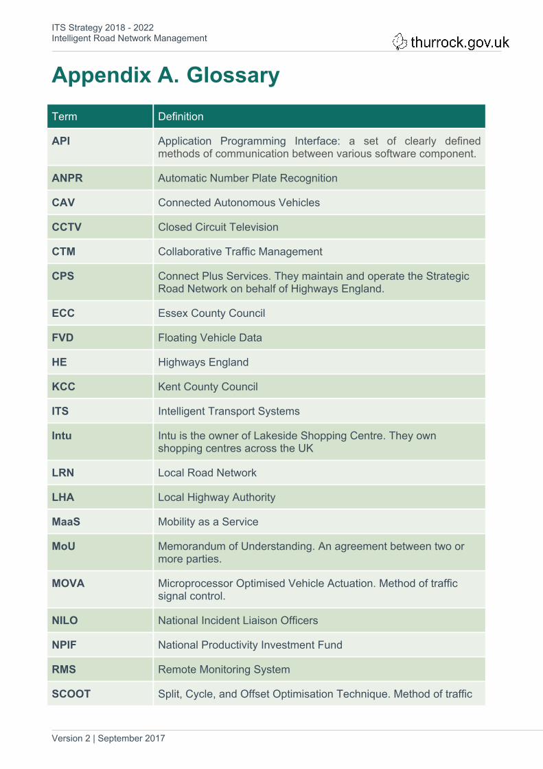
Appendix A. GlossaryTerm Definition
API Application Programming Interface: a set of clearly defined methods of communication between various software component.
ANPR Automatic Number Plate Recognition
CAV Connected Autonomous Vehicles
CCTV Closed Circuit Television
CTM Collaborative Traffic Management
CPS Connect Plus Services. They maintain and operate the Strategic Road Network on behalf of Highways England.
ECC Essex County Council
FVD Floating Vehicle Data
HE Highways England
KCC Kent County Council
ITS Intelligent Transport Systems
Intu Intu is the owner of Lakeside Shopping Centre. They own shopping centres across the UK
LRN Local Road Network
LHA Local Highway Authority
MaaS Mobility as a Service
MoU Memorandum of Understanding. An agreement between two or more parties.
MOVA Microprocessor Optimised Vehicle Actuation. Method of traffic signal control.
NILO National Incident Liaison Officers
NPIF National Productivity Investment Fund
RMS Remote Monitoring System
SCOOT Split, Cycle, and Offset Optimisation Technique. Method of traffic

ITS Strategy 2018 - 2022Intelligent Road Network Management
Version 2 | September 2017 34
Term Definition
signal control.
SIRI Set of rules for allowing computers to exchange real-time information about public transport services and vehicles.
SRN Strategic Road Network
TRO Traffic Regulation Order
UTC Urban Traffic Control. Method of traffic signal control.
UTMC Urban Traffic Management and Control

ITS Strategy 2018 - 2022Intelligent Road Network Management
Version 2 | September 2017 35
Appendix B. Key Stakeholders Consulted Thurrock Council
- Planning and Transportation
- Environment & Place
- ICT
Highways England
Neighbouring Local Highway Authorities: Essex County Council and Kent County Council
Thurrock Congestion Task Force
Technology Suppliers: Cloud Amber, Daktronics, Mott MacDonald, Siemens, Swarco
DP World London Gateway Port and Logistics
Port of Tilbury
Bus Operators: Ensignbus and Arriva
Intu Lakeside Retail Park