Embed Size (px)
Citation preview

Integrated HEC-RAS 2D Models for the Sacramento River Basin Floodplains and Bypass SystemsPresented by: Chakri Malakpet, PE, CFM, CH2M
Co-Authors:Yiguo Liang, PE, PhD, DWRRajmani Subedi, PE, PH, CFM, GISP, DWRRicky Doung, DWRMary Horvath, PE, CFM, CH2MPaul Robinson, CH2M
September 09th, 2016

Presentation Overview• DWR’s Initiative to develop Improved
H&H Tools• 2D Model Coverage• Potential Applications of the 2D Models• Challenges Faced and Lessons Learned
9/23/2016 2

DWR’s Initiative to Develop Improved H&H Tools
• To improve flood risk and ecosystem management in California Central Valley
• Supports major flood management efforts
9/23/2016 3
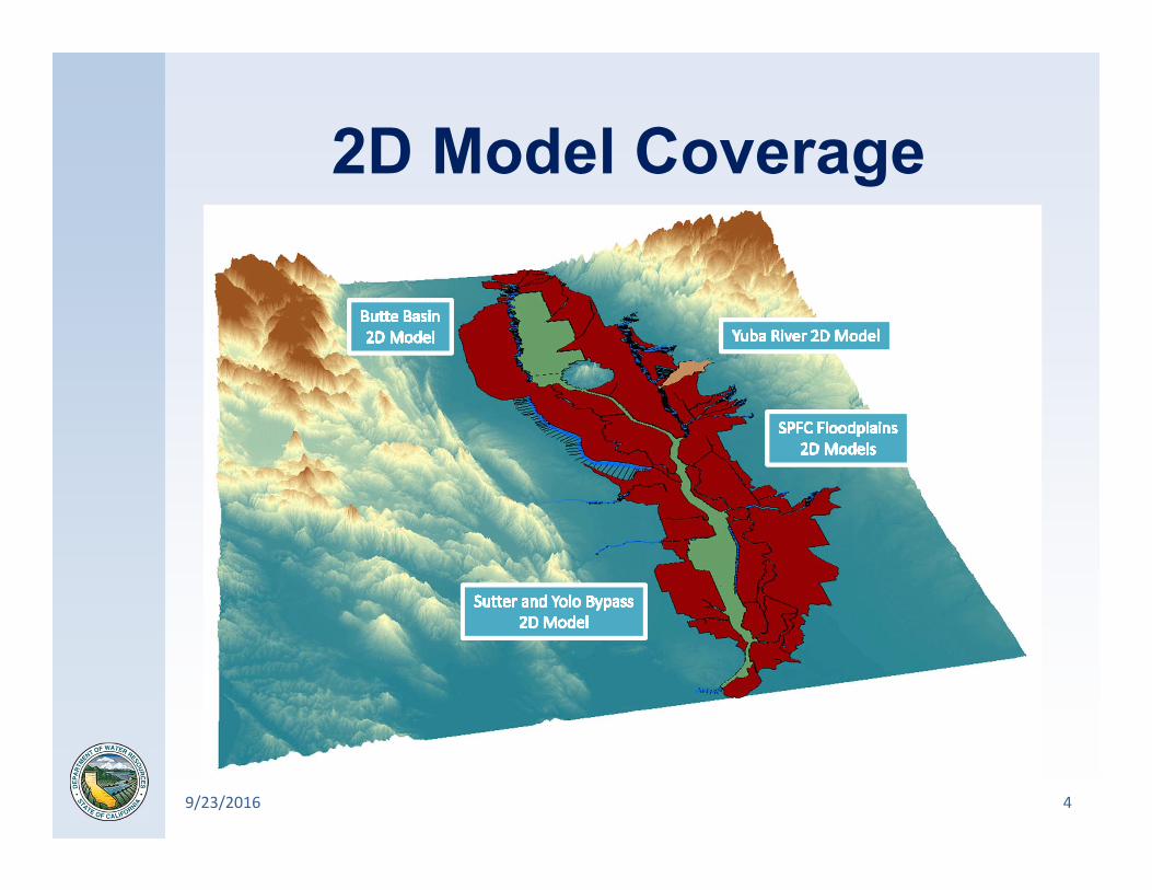
2D Model Coverage
9/23/2016 4

2D Model Elements
9/23/2016 5
Terrain DataCVFED LiDAR (3.125’ cell size)CVFED Channel Bathymetry
Land Use DataNLCD 2011 (30m cell size)
2D MeshUrban Areas = 200’ avg cell size
Non‐Urban Aeas = 400’ avg cell sizeBreak Lines (features > 3’ above ground)
Floodplain StructuresUnderpasses and Stream Crossings
Based on As‐built Drawings & Field Surveys
Inundation OutputsFlood Depth, WSE, Velocity, Arrival Time, Depth*Velocity, Recession,
Duration, Streampower etc
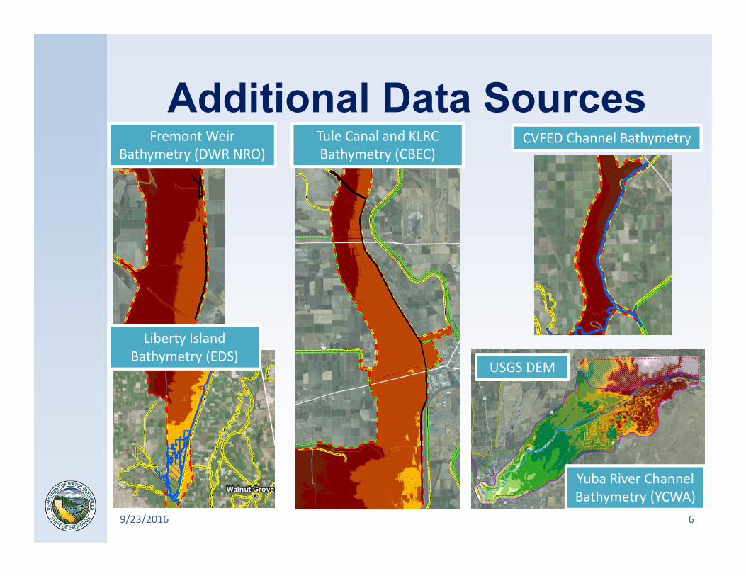
Additional Data Sources
9/23/2016 6
Yuba River ChannelBathymetry (YCWA)
Tule Canal and KLRC Bathymetry (CBEC)
Fremont Weir Bathymetry (DWR NRO)
Liberty Island Bathymetry (EDS)
USGS DEM
CVFED Channel Bathymetry

Potential Model Applications• Flood Risk Management Analyses• Emergency Response Planning• Coupled Flood Forecasting• Ecosystem Management Analyses
9/23/2016 7

Flood Risk Management Analyses• Scalable from
region to system level
9/23/2016 8

Flood Risk Management Analyses
• Scalable from region to system level
• Levee breach analysis to estimate flood damages
• Regional flood mitigation project design evaluation
9/23/2016 9

Emergency Response Planning
• Flood hazard and Zoning Maps for FEMA NFIP
• Flood emergency evacuation route planning
• Flood emergency response actions analyses
9/23/2016 10
Arrival Time Map
Velocity Map

Coupled Flood Forecasting
9/23/2016 11
45ºN
35ºN
25ºN
170ºE140ºE 160ºW 130ºW 100ºW
1 2 3 4 5 6 7
Temperature
Precipitation
Weather Forecasting
Watershed
Flood Forecasting
Streamflow

Ecosystem Management Analyses
• Ecosystem restoration impacts on flood elevations
• Weir modification impacts on bypass inundation
• Fish habitat suitability based on inundation depth, velocity and duration
9/23/2016 12
Sacramento Weir
Fremont Weir

Modeling Challenges Faced• 2D Mesh Development• Modeling bridges in 2D areas• Hydraulic structure instabilities• 1D-2D Connections• Geo-referencing lateral structures
9/23/2016 13

False Inundation due to Cell Leakage
2D Mesh Development• Extensive Break
Lines Required• Manual Adjustment
of 2D mesh is needed near break line intersections
9/23/2016 14

Bridge pier width and spacing used to modify weir embankment profile
Bridges in 2D Areas• No bridge modeling
routines in 2D areas• Bridges represented
by modifying weir profiles
9/23/2016 15
Variable max velocity due to bridge piers

• Oscillations of flow through the culverts
• 2D mesh refined to contain HW and TW cells within high ground
• Culvert invert raised slightly
Hydraulic Structure Instabilities
9/23/2016 16

1D-2D Connections• Initial conditions of
1D and 2D elements are critical
• Computational interval needs to satisfy recommended courant number
9/23/2016 17
2D Area on the downstream end
2D Area on the upstream end

Geo-referencing Lateral Structures
• HW stations are computed correctly when XS cutlinesend points are close to LS alignment
• LSs need to start and end at XSs
9/23/2016 18
Trim XS cutlines to lateral structure lines

Questions?
9/23/2016 19