Embed Size (px)
Citation preview

VOLUME 62 . SEPTEMBER 2020
Integrated geoscientific mapping in Giyani and surrounding areas during the COVID-19 pandemic
INSIDE:Integrated geoscientific mapping in Giyani and surrounding areas during the COVID-19 pandemic I 1Ndivhuwo Cecilia Mukosi
Ten years of work to map and describe a drowned, extinct landscape I 4Hayley Cawthra
Geoscience research enabled by integrated stakeholder engagement I 6Mbuyiseni Ngcobo
Rare-earth element minerals in Molteno coal and the implications for REE extractability I 9Themba Mothupi
Hats off to the graduates! I 11Dan Leshomo
Repurposing underutilised basalt and dolerite resources: resetting market perspectives of a low-value industrial resource to drive post-Covid economic growth I 14Vindina Mitha
The Council for Geoscience (CGS) recently embarked on an integrated and multidisciplinary geoscience mapping programme to systematically cover South Africa in detail in support of government’s economic recovery plan for the country. The results of the work completed in 2018/19 for the Giyani mapping project laid the foundation for the current integrated geoscientific mapping programme of the Giyani Greenstone Belt (GGB) and surrounding areas.
Administratively, the study area is part of the Mopani and Vhembe Districts. The local municipalities in the study area are the Greater Giyani, Greater
Letaba, Collins Chabane, Makhado and Thulamela Local Municipalities. Of these municipalities, a large portion of the study area is located in the Greater Giyani Local Municipality. The northeastern part of the area falls within the ambit of the Kruger National Park, which is part of the Great Limpopo Transfrontier Park, extending to Mozambique. The project aims to undertake geoscientific research to revive mineral exploration by generating mineral potential targets and to understand the tectonic and geological setting of the greenstone belt. The environmental challenges which could potentially have been caused by historical mining and exposure to
The CEO, Mr Mosa Mabuza, addressing community leaders at Khakhala Village, about 20 km west from the
town of Giyani in the Limpopo Province.

I GeoClips2
toxic metals will also be investigated. The research will use an integrated approach, including geological mapping and soil geochemical and geophysical investigations, hydrogeological studies and environmental impact studies related to historical mining investigations.
Owing to the earlier stringent level 5 lockdown restrictions due to COVID-19, stakeholder engagement only began in June 2020 when these restrictions were eased. The CGS delegation led by the CEO, Mr Mosa Mabuza, travelled to the project area to meet and engage with key stakeholders. Engagements took place with local community leaders and municipality staff, the South African Police Service (SAPS) and community members, mostly from villages around the study area. The purpose of the stakeholder engagement was to introduce the project to key stakeholders and to address how integrated mapping might respond to current societal challenges such as access to clean and sustainable water. The project area is part of the semi-arid region of the Limpopo Province and, as such, many villages in the area are faced with major water supply challenges. These challenges are mostly attributable to continued low rainfall, which has resulted in persistent low dam levels. Therefore, groundwater is the only dependable source of water for many communities in the area. Preliminary groundwater results from the analysis of TDS, EC, NO3, Cl, F and As in the project area show that a number of boreholes in the study area register excessive concentrations of these elements. For this reason, the groundwater is unsuitable for domestic use without treatment. The high levels of arsenic in the boreholes may be associated with sulphide minerals of the GGB rocks which are associated with gold mineralisation and historical gold mining in the area. Further assessments related to the quality of the groundwater and hydrogeological modelling will need to be conducted.
Local community members were hired as casual workers to assist the CGS team with fieldwork. Induction and training workshops were conducted in late June and early July 2020, respectively. The purpose of these workshops was
The CGS team conducting follow-up stakeholder engagement at Siandane Village, which is about 5 km away
from the town of Giyani.
to induct the casual workers, to equip them with geoscientific knowledge and to emphasise the importance of the fieldwork being carried out in the area. So far, 16 casual workers have been employed since the beginning of the follow-up study.
The magnetotelluric (MT) ground geophysical survey conducted in 2018/19 showed positive results which delineated the subsurface geometry of shear zones in the project area. These positive results laid the foundation for the current geophysical survey. The MT survey lines target deep crustal resolution (>15 km to view the depth and major structures of the belt), shallow–intermediate depth
(~5–10 km) as well as shallow depth (~2 km). These lines are all perpendicular to the structural fabric and proximal to presumed important shear zones.
One of the recommendations of the geochemical synthesis report of the Giyani area compiled in 2018/19 was to verify identified soil geochemical anomalies and to conduct follow-up fieldwork. Following the recommendations, nine geochemical anomalies were selected for further investigations, based on enriched concentrations. The follow-up soil geochemical survey was conducted in selected areas within the project area in July 2020. Data analysis and processing
Location of the study area in the Limpopo Province, South Africa.

GeoClips I 3Geoclips - Volume 62 - September 2020
Stakeholder engagement taking place at Mapuve Village, 10 km from Giyani. (Left to right) Councillor Tinyiko
Shivuri (Mapuve Village representative) and CGS employees, Ms Ndivhuwo Cecilia Mukosi, Mr David Ngobeni,
Mr Mbuso Kwela and Mr Mbuyiseni Ngcobo.
Mr Mesolane Ntsuku training casual workers in preparation of the MT ground geophysical survey.
Mr Ntsuku demonstrating to the casual workers how to assemble the transmitter in the
field in preparation of the controlled source audio-magnetotelluric survey in the area.
A team comprising a scientist and technical officer
collecting soil samples near Mahlathi Village.
The CGS team led by Mr Mabuza visiting a small-scale open pit gold mine near
the town of Giyani.

I GeoClips4
Members of the SAPS accompanied the CGS team in some areas where illegal miners are known to operate.
will be undertaken next to determine whether the anomalies require further exploration for economic purposes.
The publication of four 1:50 000-scale geological maps (2330AB Lwamondo, 2330AD Magoro, 2330BA Ka-Xitlhelani and 2330BC Giyani) is planned for this year. Current fieldwork will investigate mineralising systems along major structures at historical locations and along new target areas. Historical borehole data will be used to produce a 3D geological model of the study area, which will characterise the gold and base metal mineralisation system(s). Follow-up investigations on nine geochemical anomalies in the study area will further verify/explore their economic potential.
For more information contact:Ndivhuwo Cecilia MukosiGeoscience Mapping+27 (0)15 295 [email protected]
Ten years of work to map and describe a drowned, extinct landscapeArchaeological sites on the southern shores of South Africa hold the world’s richest records for determining the behavioural and cultural origins of species. At these locations, researchers have discovered the earliest evidence for symbolic behaviour, complex pyrotechnology, projectile weapons and the first use of foods from the sea – all dating back as far as 167 000 years (167 ka).
Back in 2011, the Council for Geoscience (CGS) teamed up with the Arizona State University Institute of Human Origins to map the seafloor in front of Pinnacle Point (Mossel Bay) that holds at least 30 sea caves containing Pleistocene archaeological deposits. Prof. Curtis Marean has led archaeological excavations at Pinnacle Point since the early 2000s and the work has demonstrated large hiatuses in the records, resulting from times of low sea levels when people followed
the coast outwards onto the exposed continental shelf. This abandonment of sites by the early inhabitants triggered a need to understand what lies below the sea. Through a joint submission, the team received a grant from the National Geographic Society to fund the cost of offshore mapping, forming the basis of Ms Hayley Cawthra’s PhD study, which was completed in 2014. Since that culmination of the first phase of work, the research questions have expanded and developed and the team continues to attempt to unravel as much as possible about the Pleistocene palaeoenvironment. From the perspective of the CGS, this has included months of work at sea, dozens of scuba dives, coring the seafloor and a thorough data mining exercise that has relied on legacy data. From a research perspective, in the last ten years, the “Palaeoscape” project has developed an entirely new way to reconstruct “palaeo-ecologies” or ancient ecosystems.
Quaternary sea levels fluctuate constantly and, for most of the last 2.6 million years, have been lower than present for 90% of the time. During the last 500 ka, the sea level has shifted between a highest elevation of +11 m and a lowest depth of 130 m relative to the present shoreline. Repeated exposure and drowning of terrestrial landscapes on what is now the continental shelf have led to complexity in understanding coastal palaeoscience records.
Global changes in relative sea level of up to 130 m below present during the Last Glacial Maximum (19–26.5 ka) and the penultimate glaciations during human occupation of South African coasts (~70 ka and ~160 ka) have had a profound influence on the movement of the earliest Homo Sapiens ancestors. Vast coastal plains and, hence, a significant portion of prehistory, were drowned during the

GeoClips I 5Geoclips - Volume 62 - September 2020
marine transgressions that ensued. There is increasing scientific evidence that traces of this unique prehistory have been preserved on the South African continental shelf, alongside growing awareness of cultural continuity. Around the world, the nature of human occupation of submerged coastal landscapes has rapidly emerged as a key topic in Quaternary science in the last decade, bolstered by enhancements in marine geophysical mapping methods that have vastly improved in the last 15–20 years.
Archaeological data from the Cape south coast show that the seafloor was the prime foraging habitat for early modern humans and, until recently, not much was known about this. That has now changed after a decade of work that has culminated in the publication of 22 articles in a special issue* of Quaternary Science Reviews entitled “The Palaeo-Agulhas Plain: a lost world and extinct ecosystem”. The team has also compiled a CGS special publication map, the first of its kind globally.
Work on the Cape south coast palaeoscape began with using the high-resolution South African regional climate model – running on United States
A. Looking out onto the Palaeo-Agulhas Plain from
the cave entrance at Pinnacle Point, South Africa. Left
is an artist’s impression of the research site ~20 000
years ago during glacial phases and lower sea levels
and right is where the ocean is today within metres
of the cave entrances at high tide. Image credit:
Dr Erich Fisher. B. Onshore topography and offshore
bathymetry with the mapped area of the Palaeo-
Agulhas Plain for context.
and South African supercomputers – to simulate glacial climate conditions. The team used this climate output to drive a vegetation model. Coupled with marine geophysics and sampling, isotopic studies of stalagmites and many other transdisciplinary avenues of research, the model output was validated and refined.
The special issue publication represents a unique example of a truly transdisciplinary palaeoscience effort, and a new model for going forward with research to recreate the nature of past ecosystems. The special issue covers themes of geoscience, palaeoclimate, palaeobotany, anthropology and computer modelling. Importantly, these results have helped in understanding why the archaeological records from these southern South African sites consistently reveal early and complex levels of human behaviour and culture. The Palaeo-Agulhas Plain, when exposed, was a fertile landscape, positioned next to some of the richest coastlines in the world. This unique confluence of food from the land and sea arguably cultivated the complex cultures revealed by the archaeology.
In this special issue, a fully integrated model of an extinct ecosystem is
presented. The research approach intertwines geophysical, biotic and anthropological evidence to produce an emergent system greater than the sum of its parts. This now mostly submerged 85 000 km2 region off the Cape south coast has had a profound and lasting effect on modern biological and anthropological landscapes. The Palaeo-Agulhas Plain extends southwards from the Cape Floristic Region (CFR), a region renowned for its high levels of plant biodiversity and endemism, and the most species-rich of all Mediterranean-climate ecosystems. In addition to this floristic diversity, the CFR is also home to the deepest record of early human cognitive and social evolution – particularly in multiple archaeological sites facing out on to the Palaeo-Agulhas Plain from the neo-coastline. Although Dingle and Rogers** (1972) had already recognised the plain as an important component of the southern African landscape, only recently could its potential ecological significance and uniqueness be appreciated through the application of modern technologies. Evidence presented throughout the work of Dingle and Rogers and the recent investigations carried out strongly suggests the Palaeo-Agulhas Plain was not simply an extension of the modern Cape environment, but a unique ecosystem unlike any existing in the world today. Unlike the deeply dissected, undulating landscape and high-energy erosional systems of the coastal foreland, the Palaeo-Agulhas Plain was relatively flat, with wide meandering rivers. Coastlines of the Palaeo-Agulhas Plain, dominated by beaches and aeolianite outcrops, lacked the rocky cliff coasts typical of much of the CFR’s south coast today. Only a remnant of the marine sediments and alluvium that characterised the Palaeo-Agulhas Plain exists on the modern coast near Cape Agulhas, and

I GeoClips6
For more information contact:Hayley CawthraGeoscience Mapping+27 (0)21 943 [email protected]
*The special issue is titled: The Palaeo-Agulhas Plain: A lost world and extinct ecosystem, edited by Naomi Cleghorn, Alastair J. Potts and Hayley C. Cawthra, published in May 2020 in Quaternary Science Reviews. DOI: 10.1016/j.quascirev.2020.106308.
the largely fertile soils of the Palaeo-Agulhas Plain contrast starkly with the impoverished soils of the contemporary coastal platform. The physiographic regime of the Palaeo-Agulhas Plain comprised ecosystems very different to the modern contemporary coastal lowlands, including vast areas of nutritious grassland and savannah, numerous wetlands, and a soft and highly dynamic coastline. The productivity of the terrestrial ecosystems supported a diverse and abundant plains fauna that included several megaherbivores not known from the region today. The emergent picture of this missing part of the landscape provides a new window to the context of early modern human evolution as well as the evolution of the modern CFR.
In organising the papers in the published volume, the editorial team set the stage with the development of the underlying palaeoenvironmental models and proxy evidence (e.g. geology, soils, vegetation, climate and the dynamic impact of sea-level change). With the establishment of the palaeoscape, the human-centred “resourcescape” was then explored, with a specific focus on building the datasets to inform human behavioural ecology models. This approach is critical to understanding and producing formal models of human environmental interactions. Finally, examples of how to integrate the palaeoscape and resourcescape into predictive (agent-based) models that can be used to develop specific hypotheses about the anthropological record were provided.
Geoscience research enabled by integrated stakeholder engagementSince March 2020, the Council for Geoscience (CGS) has adopted a new approach to stakeholder engagement
**The cited reference is: Dingle, R.V.
and Rogers, J., 1972. Pleistocene
palaeogeography of the Agulhas Bank.
Transactions of the Royal Society of
South Africa, 40, pp. 155–465.
Geological map of the Palaeo-Agulhas Plain, timestamped at the Last Glacial Maximum (~20 000 years before
present). The seafloor was exposed as a landscape and the sea level was 130 m lower than present. On the
Cape south coast shelf, this opened up 85 000 km2 of plains that are now drowned by high sea levels.
as an enabler for the implementation of the Integrated and Multidisciplinary Geoscience Mapping Programme. This
approach focusses on building coherent relationships with key stakeholders for the successful implementation of

GeoClips I 7Geoclips - Volume 62 - September 2020
CGS projects and to demonstrate the integral role of geoscience in solving socio-economic constraints for the benefit of society. Integrated stakeholder engagement lays the foundation for the scientific work to be implemented by the CGS. Initial engagements were led by the Management team of the CGS to demonstrate the role of science in the upliftment of communities. Several consultative meetings were held amongst spheres of government, traditional leaderships, the farming community and the public primarily to enable the CGS scientists to gain access to public and private land for the execution of geoscience research.
The CGS has been directed to contribute to the economic recovery from the COVID-19 pandemic and this has led to the reprioritisation and rethinking of how CGS projects are implemented. Additionally, it became time to review the stakeholder engagement programme. To this end, the CGS has consistently upheld the prescribed health and safety standards in all the engagements that have taken place during the strict COVID-19 pandemic restrictions. The CGS continues to exercise precautionary health and safety measures, as stipulated in the Regulations and Guidelines of the Disaster Management Act of 2002.
The CGS officials have been diligently adhering to the COVID-19 regulations through the usage of Personal Protective Equipment (PPE) such as masks and sanitisers as well as maintaining social distancing. In addition, the CGS donated branded cloth masks to communities with whom it interacted to demonstrate its commitment to the health and safety of these communities, while at the same time executing its legislated mandate.
The stakeholder engagements were led by the CEO, Mr Mosa Mabuza, whereby he presented an overview of the activities of the CGS, elaborating on the ongoing geoscience research projects in the various provinces of South Africa. In these meetings, Mr Mabuza emphasised that the CGS prides itself as a science council in empowering the people of South Africa with scientific evidence that underpins sustainable development in society. The overall basis of the
projects implemented by the CGS has focussed on the collection of fundamental geoscience data, which can have a far-reaching impact in addressing many of the development shortfalls experienced in the different regions. The following geoscience applications are being utilised to gather the data: geoscience mapping, geological modelling and geotechnical, geophysical, geochemical and hydrogeological applications.
The prioritised stakeholder engagements include the Giyani Greenstone Belt project in the Limpopo Province where iterative engagement sessions with key stakeholders in the Greater Giyani and Collins Chabane Local Municipalities, such as the traditional leaderships and
The CEO, Mr Mosa Mabuza, presenting the work of the CGS to the Tribal Council of Basani, about 23 km near
the town of Giyani.
representatives of the communities, have taken place. Owing to the collaborative nature of the engagements, communities often actively participate in the CGS projects. As a result, 16 local casual workers were employed on a rotational basis to assist the various geophysics, geochemistry and hydrogeology teams on the ground. This initiative is part of the CGS’s commitment to capacity building in the communities. There are also ongoing engagements with various academic institutions to explore possible areas of collaboration.
For the Maluti groundwater study project, the CGS delegation, led by Mr Mabuza, held stakeholder engagement meetings with the King of Bakoena, Morena
CGS officials and casual workers employed by the CGS working in the field in greater Giyani.
I GeoClips8
Moremoholo Mopeli, in QwaQwa, Free State Province. The Bakoena Royal Council coordinated a multi-stakeholder meeting with the MEC of Cooperative Governance and Traditional Affairs (CoGTA), the Maluti-A-Phofung Local Municipality, and representatives of Sedibeng Water and Free State Province Water and Sanitation. The project is currently underway and a memorandum of understanding has been drafted to enable collaboration and guide the exchange of data. CGS scientists have finalised the data analysis in preparation for the drilling planned to start soon.
The Maluti groundwater study extends to the Bergville area in KwaZulu-Natal and engagements are ongoing with the AmaNgwane Traditional Council and other traditional leaderships.
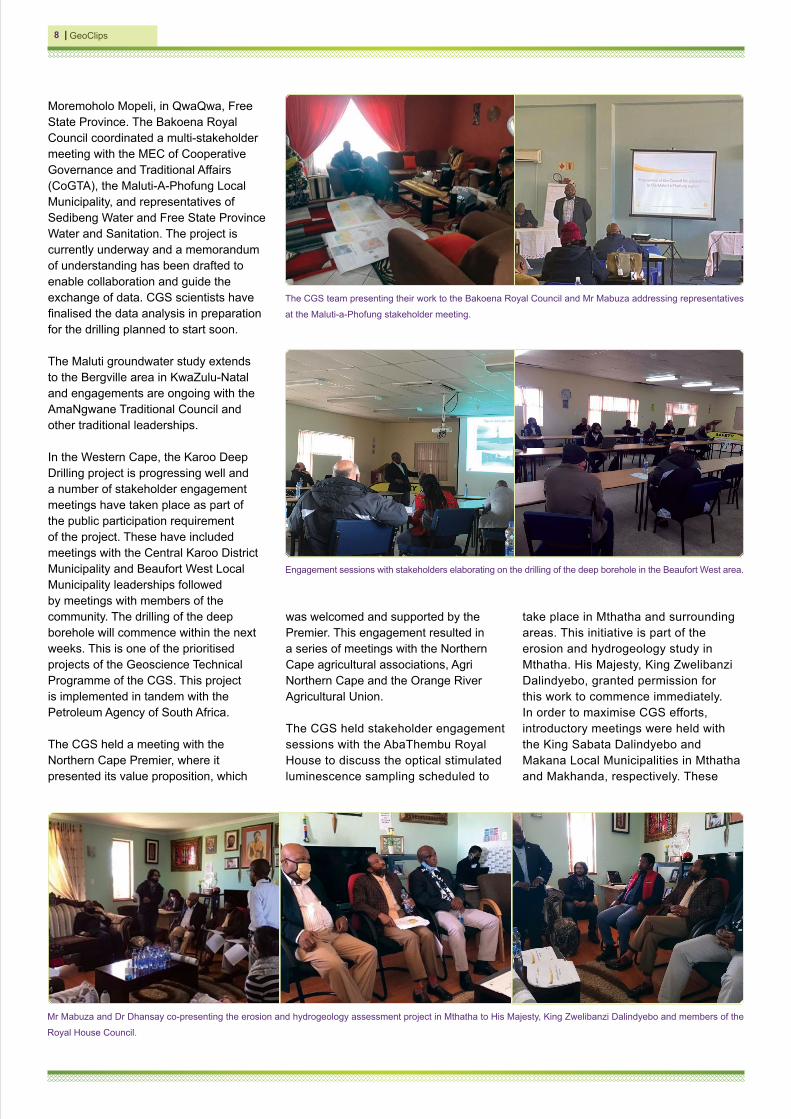
In the Western Cape, the Karoo Deep Drilling project is progressing well and a number of stakeholder engagement meetings have taken place as part of the public participation requirement of the project. These have included meetings with the Central Karoo District Municipality and Beaufort West Local Municipality leaderships followed by meetings with members of the community. The drilling of the deep borehole will commence within the next weeks. This is one of the prioritised projects of the Geoscience Technical Programme of the CGS. This project is implemented in tandem with the Petroleum Agency of South Africa.
The CGS held a meeting with the Northern Cape Premier, where it presented its value proposition, which
The CGS team presenting their work to the Bakoena Royal Council and Mr Mabuza addressing representatives
at the Maluti-a-Phofung stakeholder meeting.
was welcomed and supported by the Premier. This engagement resulted in a series of meetings with the Northern Cape agricultural associations, Agri Northern Cape and the Orange River Agricultural Union.
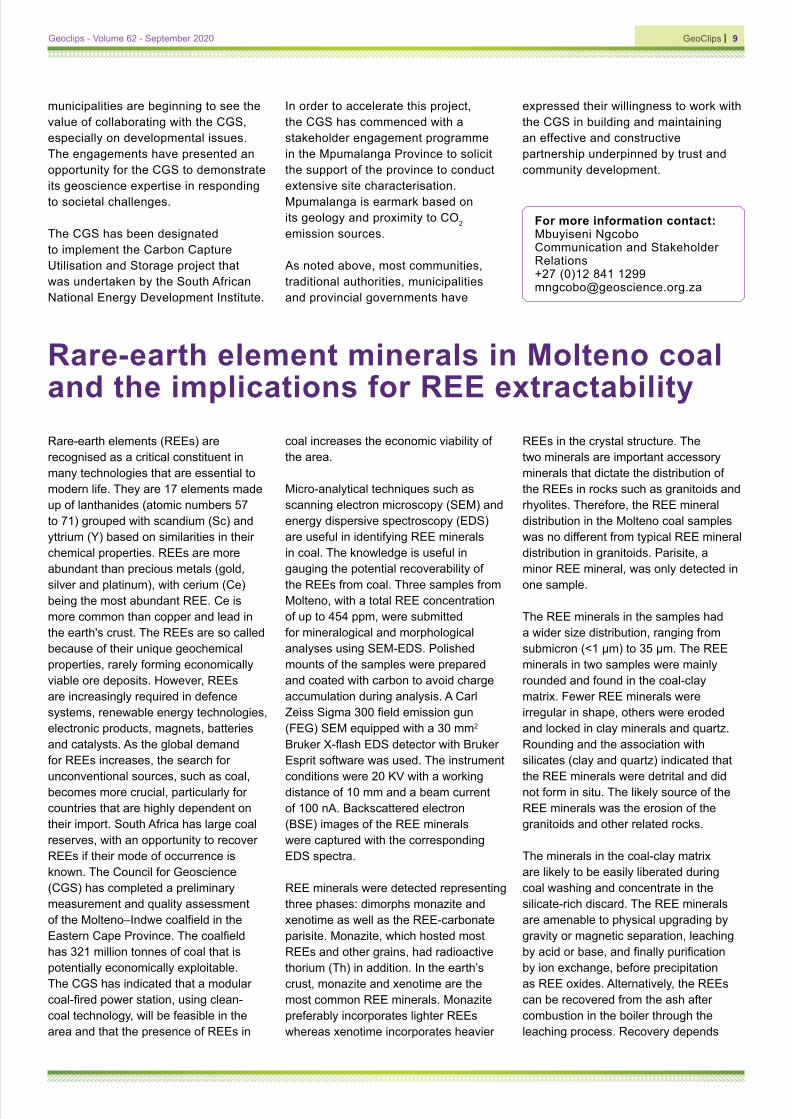
The CGS held stakeholder engagement sessions with the AbaThembu Royal House to discuss the optical stimulated luminescence sampling scheduled to
Mr Mabuza and Dr Dhansay co-presenting the erosion and hydrogeology assessment project in Mthatha to His Majesty, King Zwelibanzi Dalindyebo and members of the
Royal House Council.
Engagement sessions with stakeholders elaborating on the drilling of the deep borehole in the Beaufort West area.
take place in Mthatha and surrounding areas. This initiative is part of the erosion and hydrogeology study in Mthatha. His Majesty, King Zwelibanzi Dalindyebo, granted permission for this work to commence immediately. In order to maximise CGS efforts, introductory meetings were held with the King Sabata Dalindyebo and Makana Local Municipalities in Mthatha and Makhanda, respectively. These
GeoClips I 9Geoclips - Volume 62 - September 2020
For more information contact:Mbuyiseni NgcoboCommunication and Stakeholder Relations+27 (0)12 841 [email protected]
municipalities are beginning to see the value of collaborating with the CGS, especially on developmental issues. The engagements have presented an opportunity for the CGS to demonstrate its geoscience expertise in responding to societal challenges.
The CGS has been designated to implement the Carbon Capture Utilisation and Storage project that was undertaken by the South African National Energy Development Institute.
In order to accelerate this project, the CGS has commenced with a stakeholder engagement programme in the Mpumalanga Province to solicit the support of the province to conduct extensive site characterisation. Mpumalanga is earmark based on its geology and proximity to CO2 emission sources.
As noted above, most communities, traditional authorities, municipalities and provincial governments have
expressed their willingness to work with the CGS in building and maintaining an effective and constructive partnership underpinned by trust and community development.
Rare-earth element minerals in Molteno coal and the implications for REE extractabilityRare-earth elements (REEs) are recognised as a critical constituent in many technologies that are essential to modern life. They are 17 elements made up of lanthanides (atomic numbers 57 to 71) grouped with scandium (Sc) and yttrium (Y) based on similarities in their chemical properties. REEs are more abundant than precious metals (gold, silver and platinum), with cerium (Ce) being the most abundant REE. Ce is more common than copper and lead in the earth's crust. The REEs are so called because of their unique geochemical properties, rarely forming economically viable ore deposits. However, REEs are increasingly required in defence systems, renewable energy technologies, electronic products, magnets, batteries and catalysts. As the global demand for REEs increases, the search for unconventional sources, such as coal, becomes more crucial, particularly for countries that are highly dependent on their import. South Africa has large coal reserves, with an opportunity to recover REEs if their mode of occurrence is known. The Council for Geoscience (CGS) has completed a preliminary measurement and quality assessment of the Molteno–Indwe coalfield in the Eastern Cape Province. The coalfield has 321 million tonnes of coal that is potentially economically exploitable. The CGS has indicated that a modular coal-fired power station, using clean-coal technology, will be feasible in the area and that the presence of REEs in
coal increases the economic viability of the area.
Micro-analytical techniques such as scanning electron microscopy (SEM) and energy dispersive spectroscopy (EDS) are useful in identifying REE minerals in coal. The knowledge is useful in gauging the potential recoverability of the REEs from coal. Three samples from Molteno, with a total REE concentration of up to 454 ppm, were submitted for mineralogical and morphological analyses using SEM-EDS. Polished mounts of the samples were prepared and coated with carbon to avoid charge accumulation during analysis. A Carl Zeiss Sigma 300 field emission gun (FEG) SEM equipped with a 30 mm2 Bruker X-flash EDS detector with Bruker Esprit software was used. The instrument conditions were 20 KV with a working distance of 10 mm and a beam current of 100 nA. Backscattered electron (BSE) images of the REE minerals were captured with the corresponding EDS spectra.
REE minerals were detected representing three phases: dimorphs monazite and xenotime as well as the REE-carbonate parisite. Monazite, which hosted most REEs and other grains, had radioactive thorium (Th) in addition. In the earth’s crust, monazite and xenotime are the most common REE minerals. Monazite preferably incorporates lighter REEs whereas xenotime incorporates heavier
REEs in the crystal structure. The two minerals are important accessory minerals that dictate the distribution of the REEs in rocks such as granitoids and rhyolites. Therefore, the REE mineral distribution in the Molteno coal samples was no different from typical REE mineral distribution in granitoids. Parisite, a minor REE mineral, was only detected in one sample.
The REE minerals in the samples had a wider size distribution, ranging from submicron (<1 µm) to 35 µm. The REE minerals in two samples were mainly rounded and found in the coal-clay matrix. Fewer REE minerals were irregular in shape, others were eroded and locked in clay minerals and quartz. Rounding and the association with silicates (clay and quartz) indicated that the REE minerals were detrital and did not form in situ. The likely source of the REE minerals was the erosion of the granitoids and other related rocks.
The minerals in the coal-clay matrix are likely to be easily liberated during coal washing and concentrate in the silicate-rich discard. The REE minerals are amenable to physical upgrading by gravity or magnetic separation, leaching by acid or base, and finally purification by ion exchange, before precipitation as REE oxides. Alternatively, the REEs can be recovered from the ash after combustion in the boiler through the leaching process. Recovery depends
I GeoClips10
mainly on association, with locked REE minerals being impossible to upgrade physically and inaccessible to leaching reagents. Milling to liberate the locked REE phases from the gangue minerals is possible but will likely make the process more costly.
Based on the mineralogical results, there is a significant potential to recover REEs from the Molteno coal. However, detailed research to understand how REEs can be
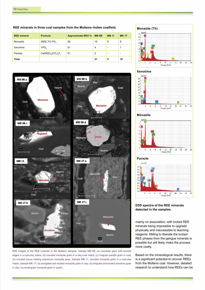
REE mineral Formula Approximate REO % MB 9B MB 11 MK 17
Monazite (REE,Th) PO4 65 15 5 9
Xenotime YPO4 61 4 - 1
Parisite Ca(REE)2(CO3)3F2 61 2 - -
Total 21 5 10
REE minerals in three coal samples from the Molteno–Indwe coalfield.
EDS spectra of the REE minerals detected in the samples.
BSE images of the REE minerals in the Molteno samples. Sample MB 9B: (a) monazite grain with smooth
edges in a coal-clay matrix; (b) rounded monazite grain in a clay-coal matrix; (c) irregular parisite grain in coal;
(d) rounded zircon hosting submicron monazite grain. Sample MB 11, rounded monazite grain in a coal-clay
matrix. Sample MK 17: (a) elongated and eroded monazite grain in clay; (b) irregular and eroded xenotime grain
in clay; (c) rectangular monazite grain in quartz.
Monazite (Th)
Xenotime
Monazite
Parisite

GeoClips I 11Geoclips - Volume 62 - September 2020
For more information contact:Themba MothupiLaboratory Services+27 (0)12 841 [email protected]
extracted efficiently and cost-effectively is required. Furthermore, research in chemical and physical characterisation to determine REE elemental distributions and REE phase compositions in coal is vital to developing economical
REE recovery processes. Therefore, detailed REE deportment studies of the mineralised coal using SEM-EDS, electron probe micro-analysis and laser ablation inductively coupled plasma mass spectroscopy should be conducted.
Hats off to the graduates!Congratulations to the Council for Geoscience (CGS) staff who recently received their Doctoral and Master’s degrees. The graduates are Thomas Muedi, Michelle Grobbelaar, Shonisani Magatshavha, Sisanda Makubalo, Nthabiseng Mashale, Mdumiseni (Mdu) Mazibuko, Prudence Mokoena, Ngqondi Nxokwana, Abraham Thomas, Minenhle Buthelezi and Sinesihle Khalimashe.
Thomas Muedi (Geoscience Mapping) received his PhD (Geology) degree from the Nelson Mandela University with his dissertation, Early Jurassic dolerites of the Karoo Large Igneous Province (KLIP): an analysis of their age and emplacement history from sea level to the Drakensberg Mountains in the Eastern Cape, South Africa.
The Karoo dolerites in the Eastern Cape represent igneous rocks across the KLIP that record the initial separation between Africa and Antarctica. Dr Muedi provides isotope and geochemical data demonstrating how and when these extrusive rocks intruded from sea level to nearly 2 000 m close to Lesotho. His results indicate that the KLIP was formed within less than 750 thousand years during a transition period that marks a global extension event 183 million years ago across the southernmost section of the Gondwana supercontinent. His results provide new information on how past climate change drove linked continental and oceanic ecosystems.
Michelle Grobbelaar (Engineering and Geohazards) obtained an MSc degree from the University of the Witwatersrand with her thesis, titled Predicting the effects of explosions placed on the earth’s surface.
Most equations used to predict the ground motion produced by explosions
Thomas Muedi with his promoter, Prof. Maarten de Wit.
were developed using confined blasts that were detonated with the intention of breaking rock for mining or tunnelling. The aim of the thesis was to determine whether the predictive equations developed for confined explosions can be used to predict the effects from surface explosions, with appropriate adjustments to the various coefficients.
Three predictive equations developed for buried explosions were tested. The study showed that the United States Bureau of Mines peak particle velocity predictive equation is the most reliable. In addition, the study showed that a predictive equation that uses the secondary atmospheric shock wave phenomenon produced better results. The method uses the scaled delay time parameter that is easier to measure. These equations may be utilised for demolition sites where old and potentially unstable explosives and obsolete equipment are destroyed at the ground surface and for assisting
in forensic seismology to determine the details of an unexpected explosion.
Shonisani Magatshavha (Internal Audit) received a Master of Business Administration (MBA) from the Graduate School of Business Leadership (SBL) of the University of South Africa. Her thesis was titled: The relationship between human resource practices, transparent organisational communication and organisational learning in the public sector.
The core objective of her research was to provide adequate solutions to one of the endemic challenges in the public sector, namely effective organisational learning. Organisational learning depicts a change in an organisation’s knowledge that occurs as a function of experience. In order to achieve this change, the research set out to investigate the relationship between three key factors in the public sector, i.e.

I GeoClips12
human resource practices, transparent organisational communication and organisational learning. Evidence from the research showed that even though there is a definite correlation between all three factors, transparent organisational communication stands out as the most important factor in ensuring organisational learning. Furthermore, organisational learning is a continuous process that also relates to innovation. Employees are encouraged both to acquire and produce new knowledge and, in this way, to improve organisational performance. Managers in the public sector can assist government to retain and grow knowledge by ensuring that there is transparent organisational communication.
Sisanda Makubalo (Geoscience Mapping) completed her MSc degree in Hydrogeology at the University of Pretoria with her thesis, Hydrogeochemistry of the groundwater in the Namaqualand region, South Africa: implications for surficial uranium mineralisation.
Since the discovery of the Yeelirrie deposit in Australia in 1972, exploration for surficial uranium deposits has been supported through hydrogeochemical studies of groundwater and the calculation of the carnotite solubility index (CSI). Groundwater sampling was conducted in Namaqualand to investigate groundwater quality, to establish the distribution of surficial uranium mineralisation and to delineate the uranium potential areas. Surficial uranium deposits are unconsolidated soils or sediments, usually of Tertiary to Recent age, with carnotite being the most common secondary uranium mineral. Namaqualand in the Northern Cape Province is an arid region with a sparse human population dependent largely upon stock farming. Other minor sectors in the area are mining and tourism. The complex Proterozoic metamorphic geology is overlain by Cenozoic deposits known for containing uranium in places. Eighty-six (86) groundwater samples were taken over an area of 25 000 km2 and analysed for various parameters in the field and laboratory. The CSI was calculated using hydrochemical data, and interpolated using inverse distance weighting (IDW)
and kriging to produce maps of potential carnotite mineralisation.
The salinity of the water varies from fresh to seawater, averaging 2 500 mg/L, with the pH in the 7–9 range. Major ion abundances indicate marine aerosol as the main source of Cl, Na, Mg and K, with rock weathering being more responsible for Ca and HCO3. Nitrate is occasionally high, the random distribution indicating farm animals as the source. Fluoride averages 2.4 mg/L and is strongly geologically controlled, but clearly enriched through evaporation. Uranium, averaging 0.155 mg/L (five times the guideline), has a complex distribution uncorrelated with bedrock geology and is enriched through evaporation or precipitation of secondary uranium minerals. Uranium may not necessary leach from the granites and gneisses into the groundwater, even if these rocks are enriched in uranium. The solubility of uranium in the groundwater is controlled by pH and Eh conditions. Uranium mostly occurs in solution as UO2(CO3)2
2- and UO2(CO3)3
4- at a pH range between 5.5 and 8 and an Eh range between -0.5 and +0.8 in the presence of carbonates.
The CSI values ranged from -6.71 to -2.99 with those ranging from 2.99 to -4 in close proximity to known surficial uranium occurrences. The use of the IDW and kriging interpolation methods revealed 28 areas with potential for carnotite mineralisation. The existence of suitable uranium source rocks, palaeochannels, climate and geomorphology makes the Namaqualand region prospective for calcrete-hosted uranium deposits. The CSI method, used to delineate areas with a potential for surficial uranium mineralisation in the Northern Cape, can be extrapolated to other areas with similar geological environments and climatic conditions. Given the uranium-related and other water quality risks, further work investigating the consequences of cumulative exposure for plants, animals and humans is warranted.
Nthabiseng Mashale (Economic Geology and Geochemistry) obtained an MSc in Economic Geology from the University of the Witwatersrand with her thesis, Prospectivity mapping using stream sediment geochemistry along the
Orange River Catchment for base metals, Prieska, Northern Cape, South Africa.
The Areachap Terrane which is part of the Namaqua-Natal Belt in the Northern Cape Province has volcanic-hosted Zn-Cu deposits. The primary objective of the study was to map base-metal mineralisation, determine the heavy-metal contents and delineate targets for follow-up studies. The spatial joint analysis tool was used to calculate the elements associated with their respective lithostratigraphies. The fuzzy OR overlay operation was applied to combine maps of relevant indicator elements. The concentrations of As, Ba, Ce, Cr, Cu, Hf, Nd, Ni, Rb, Sr, S, V, Zr and Zn showed a heterogeneous spatial distribution, reflected by a high coefficient of variation and large standard deviation. These element concentrations are extremely elevated in the stream sediments. There was a very high Cu-Zn correlation coefficient calculated for samples near the Copperton deposit. The Cr and Ni reflect ultramafic fraction of the stream sediments, and the Cr, Ni anomaly was traced along the catchment. Normal Q-Q plots for S, Zn, Pb and Ba have similar trends with outliers of the high coefficient of variations. The high Cu, Zn and Pb are derived from the ore mineral related volcanogenic massive sulfide deposits.
Mdumiseni (Mdu) Mazibuko (Human Resources) completed a Master of Business Leadership (MBL) degree at the Graduate School of Business Leadership (SBL) of the University of South Africa. His thesis, An investigation of the roles and perceptions of middle managers in change management processes: a case study of a state-owned entity in South Africa, discusses the role and perceptions of middle managers in change management processes in state-owned entities in South Africa. Mr Mazibuko examined the middle managers’ roles, perceptions and understanding of the concept of change management to uncover how they experience change management in the organisation and to explore how they could contribute to the successful implementation of change management. Purposive sampling was used and the qualitative method applied through face-to-face interviews with eight participants,

GeoClips I 13Geoclips - Volume 62 - September 2020
who were on the middle management level in the organisation.
The data were analysed using the thematic content analysis method. The findings showed that the participants had a comprehensive understanding of the change management concept. The role of middle managers in the change management process is significant for the successful implementation of organisational change. However, it could also be detrimental to the process if the managers are not involved in all the change management phases, as per the Kurt Lewin theory of change, which is commonly known as the three-step theory comprising the following three phases: unfreezing (where change is needed); moving (where change is initiated), and refreezing (when equilibrium is established). In essence, middle managers should be involved right from the change inception phase to its completion since failure to involve them could possibly result in them resisting the change and, ultimately, in an organisational failure to implement the change successfully.
The study recommends that middle managers be taken into consideration when the organisation introduces a change by ensuring that they understand the business reasons behind the change; frequent and consistent communication of accurate information during the change process is essential, and top management should treat middle managers as part of their team. These study findings and recommendations can guide organisations towards the successful implementation of change.
Prudence Mokoena (Laboratory Services) received an MSc degree in Chemistry from the University of Johannesburg. The aim of her thesis, Development of analytical strategies for extraction, preconcentration and determination of trace metals in environmental matrices (water and sediments), was to develop sample preparation techniques for the preconcentration/extraction of trace metals (As, Cd, Cr, Cu, Pb, Zn and Fe) in water and sediment samples prior to inductively coupled plasma optical emission spectrometric (ICP-OES)
analysis. Sediments and water samples were prepared using conventional hotplate digestion, microwave digestion and ultrasound-assisted dispersive solid-phase microextraction. Firstly, the effectiveness of acid digestion in freshwater sediment samples using dilute nitric acid on a hotplate was evaluated. Secondly, the microwave-assisted digestion method using dilute hydrogen peroxide was developed. The methods were successfully applied for the quantification of target analytes in real soil samples. Lastly, ultrasound-assisted dispersive solid-phase microextraction (UA-DSPME) was carried out for water samples using magnetic carbon nanofibers (Fe3O4@CNFs) as an adsorbent. The developed method had a linear response over 0.1–120 µg L−1 with acceptable correlation coefficients greater than 0.0995. The accuracy of the methods for sediment samples were determined using CRM015 and CRM052, with LODs and LOQs ranging between 0,02–0,09 µg g-1 and 0,07–0,30 µg g-1, respectively and recoveries ranging from 92–103% at a 95% confidence level. All the methods supported the green chemistry initiative, as less harmful acids were used at a shorter analysis time and waste generated during the analysis was minimised.
Ngqondi Nxokwana (Economic Geology and Geochemistry) completed his MSc (Geology) degree at the University of Pretoria. His study culminated in the thesis Physico-chemical properties of South African shales and siltstones in the context of geological CO2 storage.
Mr Nxokwana’s MSc project investigated the potential of the carbonaceous shales of the Ecca Group for geo-sequestration of anthropogenic carbon dioxide (CO2). This followed recent studies in other parts of the world, such as the United States of America and Brazil, which revealed that carbonaceous shales can adsorb significant amounts of CO2 in their organic matter known as kerogen. The study targeted the Whitehill and Prince Albert Formations.
To characterise the samples and understand their affinity for CO2 adsorption, various parameters were measured, namely mineralogy, elemental
composition, total organic content, kerogen maturity and low- and high-pressure volumetric adsorption.
The results showed that the Whitehill and Prince Albert Formations compared favourably with other basins known to store significant amounts of CO2, such as the Marcellus shale in the USA and the Irati in Brazil. The possibility of shale gas exploitation in these formations also presents an opportunity to sequester CO2 in the shales once the natural gas has been harvested.
Abraham Thomas* (Geophysics and Remote Sensing) completed a Master of Business Leadership (MBL) at the University of South Africa. His thesis, Perceived quality of strategic leadership in a state-owned research institution, focussed on the perceived strategic leadership quality experienced at different employment tiers through a survey on strategic leadership style, strategic thinking/mind-set, strategic decision-making, strategic alignment and overall organisational performance. The survey feedback was analysed using statistical techniques to assess leadership quality at different employment tiers and their influence/relationships on organisational performance. Perceptions of strategic leadership quality were assessed by examining three components (strategic mind-set, strategic decision-making and strategic alignment). Statistically significant findings of strong correlations (R) and R square values exceeding 0.3 were obtained for the linear regression analyses for exploring relationships between strategic leadership style and two variables of strategic leadership quality (strategic mind-set and strategic decision-making). For strategic alignment, the correlation was moderate, and the R square value was 0.282 for being statistically significant. The different linear relationships evident between organisational performance and the components of the perceived quality of strategic leadership experienced at different employment tiers were revealed through correlations. The regression analysis results also confirmed that the perceived quality of strategic leadership has some effect/influence on the overall organisational performance of the institution. The research could

I GeoClips14
indicate employment tiers that showed weak correlations for the relationship between strategic leadership quality and organisational performance.
Abraham Thomas won the second prize for the best papers of the second
For more information contact:Dan LeshomoHuman Resources+27 (0)12 841 [email protected]
UNISA Graduate School of Business Leadership Research Symposium and his paper was published in the Business & Social Sciences Journal. https://www.bssj-re.com/journalsview.php?showdetail=&Journal_ID=57.
Repurposing underutilised basalt and dolerite resources: resetting market perspectives of a low-value industrial resource to drive post-Covid economic growthPost-Covid societies are hard-pressed to reset and restart their economic engines in the interest of generating more longer-term and far-reaching social, economic and environmental benefits. This is an opportune moment to re-evaluate the efficacy of more mundane mineral resources and to flip conventional uses to allow for the possibility of generating better uses to upgrade intrinsic resource values. In the current context where there is a push towards local sourcing and resourcing, it is imperative to evaluate any market gaps and to respond in a phased upstart to support immediate-, medium- and longer-term economic prosperity.
Garden-variety basalt, together with its intrusive equivalents, is relatively common in most surface environments. Basalts form when volcanoes push molten rocks onto the earth’s surface. Below ground, the rocks are connected to the main chamber by an underground feeding system of cracks and crevices. When cooled, these rocks form intrusions of finer-grained dolerite or, at a deeper level, coarse-grained gabbro. Together, these have a range of novel uses currently unconsidered in the market.
Basalt and dolerite resources are used predominantly as high-bulk aggregate where the hardness and relative inertness make for hard-weathering material, prized in the construction and maintenance industries. Resource return is, however, relatively low, with commodity prices being dictated by distance to market
A good scattering of dolerite and basalt resources of variable composition (blue) occupies the Karoo Basin
in the main hinterland of South Africa. This is the exposed “plumbing” system to the basalt flows forming the
majestic Drakensberg escarpment. The Karoo Basin is also surrounded by a wealth of intrusions of similar rock
composition but of variable ages across South Africa.
coupled with exorbitant costs in transportation. The underutilisation of this abundant resource is attributed largely to underindustrialisation in rural provinces and the existence of more suitable resources in more developed areas.
The duality of rock dust within post-Covid food security: a simple
link to eradicate chronic childhood undernutrition and to sequester CO2Agriculture is set as a vehicle for South Africa’s post-Covid economic recovery but simultaneously creates significant carbon emissions (25% globally) that are notoriously difficult to decarbonise. Although plants, soils and the oceans are natural carbon sinks, atmospheric CO2 is

GeoClips I 15Geoclips - Volume 62 - September 2020
close to the tipping point of immeasurable return. Rain acts as a delivery to transfer atmospheric carbon to soil carbon as it works through the rivers to long-term storage in the ocean. The resultant acid rain – a natural atmospheric feedback mechanism – is no longer suited for the epic, unchecked atmospheric CO2 of modern-day times.
One of the proposed drawdown mechanisms suggested is using weathering-prone rock dust in agriculture. The theory is that by fast-tracking the known weathering susceptibility of basalt and dolerite rock dust, weak mineral bonds with iron, calcium and magnesium will break down readily, leach nutrients into the soil and simultaneously capture CO2, fixing it into the soil.
In the greater Amathole District in the Eastern Cape Province, the preferential siting of subsistence gardens on dolerite soils demonstrates that the fines (created by mechanical crushing as unavoidable quarry dust) may render this waste stream effective as a modern application of indigenous knowledge and wisdom. Combined with modern resources and sparked by current necessity, rock dust could become the vehicle to additionally address the scourge of chronic childhood undernutrition through the provision of produce naturally fortified by rock dust.
The institution of systems and procedures to generate streams of nutritionally dense (and pesticide-free) produce may work in the forgotten agricultural lands of the Amathole region
where the warm and humid climate promotes enhanced weathering, where carbon may be sequestered effectively within mere months.
Using rock dust to sequester CO2 may prove to be the vehicle for eradicating childhood undernutrition within the context of post-Covid economic recovery, but more than that, could become one of the ways in which agriculture generates circular-, ground-up economies by supplying fresh, high-value produce to urban markets.
Amathole “black granite’’: generating a Cape-based mineral wealth evolutionThe Kei River surroundings are poised to deliver prime potential for a new aesthetic industrial mineral – Amathole “black granite”.
Thick, extensive dolerite sills may be the next economic ignition for a long-overdue, Cape-based dimension stone industry. The discovery of dimension stone east of the Kei River in the late 1980s has shown the occurrence of suitably sized dolerite blocks derived from thick, voluminous dolerite sills between Butterworth and Komga. Based on historical trial mining accounts at Willowvale and Bojeni, it is clear that the intrusions are suited to extraction, as confirmed by the remote assessment of fracture patterns of the Butterworth, Kei Mouth and Komga sills.
East of the Kei River, where historically disadvantaged communities have few minerals-based disbursements,
trial drilling at Masaleni ~10 km north of Butterworth revealed four types of high-quality jet black to grey granite. The proximity to major infrastructure (the national road network, East London IDZ and the ports of East London and Ngqura) suggests a unique potential gateway for national consumption and international export. Upgrading investments in more higher-grade values for the “traditionally aggregate” mineral deposits between Butterworth and Komga could contribute to ongoing community prosperity and build community resilience as long-term co-benefits in a post-Covid society.
Basalt products: leveraging longer-term industrial wealth with the local manufacture of cast basalt and basalt fibreWith the global slowdown in international product exchange, countries are recognising the importance of maintaining domestic capacity for local manufacture to replace niche products. The basalt market forms one category of new-age products that makes sense to produce and procure locally, not only from the perspective of the wealth found in suitable raw resources, but also from the perspective of local support for internal industries, e.g. mining.
Basalt products are being touted as a new-age space-ready material that is formed by heating crushed basalt/dolerite to a molten state and casting it using standard commercial casting- and fibre-making methods to support production lines according to current needs and
Rock dust as a current waste stream is created during
the crushing of raw resources into aggregate. Rock
dust derived from dolerite and basalt could be used
as an efficient way to sequester CO2 while at the
same time shoring up the post-Covid economy and
eradicating chronic childhood undernutrition.
Upgrading resource values for dolerite and basalt involves the identification of black granite resources (polished Eastern Cape drill core, bottom left) in addition to delineating best sources for the basalt product market. A range of basalt fibre products can be generated to service a wide range of existing industries and manufacturing sectors and to infiltrate new markets where basalt properties far exceed existing products and compounds.

If you are not on our mailing list and you would like to receive a copy of GEOclips, please send an e-mail to:
Mahlako Mathabatha, Communication & Stakeholder Relations [email protected]
Private Bag X112, Pretoria 0001, South Africa / 280 Pretoria Street, Silverton, Pretoria 0184, South Africa
Tel: +27 (0)12 841 1911 / Fax: +27 (0)12 841 1221 / www.geoscience.org.za
functions. Apart from a crushed and consistent compositional supply, the requirement involves little pre-processing in respect of chemical addition or extensive preparation (e.g. in the case of cast products). From feeder to cast or mould, the variety of structured products, from complex and fractional to simple and complete, is limited only by human imagination and current functionality.
Owing to its natural constituent component, basalt products are generally far more environmentally friendly than their current counterparts, especially in the generation of negligible industrial waste. Strength characteristics, abrasion, heat, electrical and chemical resistance and, in the case of cast products, the property of increasing smoothness with time, make basalt products ideal for shoring up hard-wearing applications. These applications are found in power stations, steel plants, sewerage works, and in mechanised and industrialised process components such as bends, pipelines, trenches, disposal chutes, hoppers, cyclones, mill ducts, slag and slurry line conveyor belts, washing plants, flotation cells and centrifuges. In addition, applications where glass-, e- and carbon-fibre are traditionally used also benefit from the use of basalt products. Furthermore, the potential to revolutionise the construction industry, to replace ailing, degrading steel with inert basalt rebar has far-reaching implications for long-term builds.
With Africa’s current reliance on external support and technology, the global slowdown presents the double-edged sword that can be sharpened by generating local-base service sectors to support mechanisation and industrialisation in the manufacture and mining sectors. From a small population of Eastern Cape resources, it is already evident that South Africa has a wealth of raw resources available to generate and maintain an African-based basalt industry.
More resources are sure to be earmarked as the search matures.
The current ongoing resource evaluation envisions a South Africa that engages meaningfully in regional and global trade by transforming local economies with locally produced products derived from releveraging its views towards its industrial resource wealth. In some cases, the aim is to shore up existing industries (e.g. glass fibre) with smart(er) technologies using existing resources to drive new product streams in current
markets. In others, it is to provide a more holistic ground-up approach to local economic regeneration. Either way, the aim is the same: resetting market perspectives to generate upgrades in industrial mineral wealth and value, in view of resetting the post-Covid economy.
Cast basalt products are limited only by human imagination and current needs and are being touted as an
interplanetary colonisation material. Clockwise from top left: cast basalt tile linings, cast basalt tiles in sewerage
works, cast basalt pipes and linings, and cast basalt in an industrial concrete mixer.
For more information contact:Vindina MithaGeoscience Mapping+27 (0)41 581 [email protected]