Embed Size (px)
Citation preview

INITIAL STUDY / MITIGATED NEGATIVE DECLARATION March 2013 Corbett Creek Floodplain and Stream Restoration Project
Page 1 of 42
INITIAL STUDY/ MITIGATED NEGATIVE
DECLARATION
Map of Clark Property (APN 007-791-032)
Staff Project No. 13-001
Corbett Creek Floodplain and Stream Restoration Project March 2013
Exhibit 3: CEQA Mitigated Negative Declaration and Mitigation Monitoring Plan
INITIAL STUDY / MITIGATED NEGATIVE DECLARATION March 2013 Corbett Creek Floodplain and Stream Restoration Project
Page 2 of 42
Project: Staff Project No. 13-001 Corbett Creek Floodplain and Stream Restoration Project Lead Agency: City of Arroyo Grande Document Availability:
City of Arroyo Grande Community Development Department 300 East Branch Street Arroyo Grande, CA 93420
Project Description: The proposed project involves the acquisition by the Coastal San Luis Resource Conservation District (RCD) of a conservation easement over the 12.5-acre Clark Property located between Highway 227 (Carpenter Canyon Road) and Corbett Canyon Road and the design, permitting and construction of a floodplain/sediment detention basin on the easement property. The project also includes channel restoration of approximately nine hundred feet (900’) of Corbett Creek located downstream of the Clark Property. Currently there are no identified implementation funds for the channel restoration component of the project. The City will be directly involved in the project through permitting of the floodplain/sediment detention basin design and implementation activities. Summary Document Preparation: Pursuant to Section 21082.1 of the California Environmental Quality Act, the City of Arroyo Grande (the City) has independently reviewed and analyzed the Initial Study and Mitigated Negative Declaration for the proposed project and finds that these documents reflect the independent judgment of the City. The City, as lead agency, also confirms that the project mitigation measures detailed in these documents are feasible and will be implemented as stated in the Mitigated Negative Declaration. _________________________________ ______________ Teresa McClish, AICP Date Community Development Director _________________________________ ______________ Kelly Heffernon, AICP Date Associate Planner
Exhibit 3: CEQA Mitigated Negative Declaration and Mitigation Monitoring Plan

INITIAL STUDY / MITIGATED NEGATIVE DECLARATION March 2013 Corbett Creek Floodplain and Stream Restoration Project
Page 3 of 42
Table of Contents: Introduction .................................................................................................................................................. 5
Introduction and Regulatory Guidance..................................................................................................... 5
Lead Agency .............................................................................................................................................. 5
Purpose and Document Organization ....................................................................................................... 6
Summary of Findings................................................................................................................................. 6
Project Description........................................................................................................................................ 7
Introduction .............................................................................................................................................. 7
Background and Need for Project ............................................................................................................. 9
Other Required Public Agency Approvals ............................................................................................... 10
Related Projects ...................................................................................................................................... 10
Environmental Checklist ............................................................................................................................. 11
Project Information ................................................................................................................................. 11
Environmental Factors Potentially Affected ........................................................................................... 13
Determination ......................................................................................................................................... 13
Evaluation of Environmental Impacts ..................................................................................................... 14
Environmental Issues .................................................................................................................................. 15
1. Aesthetics ............................................................................................................................................ 15
2. Agriculture and Forestry Resources .................................................................................................... 16
3. Air Quality ........................................................................................................................................... 16
4. Biological Resources ............................................................................................................................ 18
5. Cultural Resources .............................................................................................................................. 21
6. Geology and Soils ................................................................................................................................ 23
7. Greenhouse Gas Emissions ................................................................................................................. 25
8. Hazards and Hazardous Materials ...................................................................................................... 25
9. Hydrology and Water Quality ............................................................................................................. 26
10. Land Use and Planning ...................................................................................................................... 29
11. Mineral Resources ............................................................................................................................ 30
12. Noise ................................................................................................................................................. 30
13. Population and Housing .................................................................................................................... 32
14. Public Services ................................................................................................................................... 32
15. Recreation ......................................................................................................................................... 33
16. Transportation/Traffic....................................................................................................................... 34
17. Utilities and Service Systems ............................................................................................................ 34
Exhibit 3: CEQA Mitigated Negative Declaration and Mitigation Monitoring Plan

INITIAL STUDY / MITIGATED NEGATIVE DECLARATION March 2013 Corbett Creek Floodplain and Stream Restoration Project
Page 4 of 42
Mandatory Findings of Significance ............................................................................................................ 36
Summary of Mitigation Measures .............................................................................................................. 37
References .................................................................................................................................................. 42
Exhibit 3: CEQA Mitigated Negative Declaration and Mitigation Monitoring Plan

INITIAL STUDY / MITIGATED NEGATIVE DECLARATION March 2013 Corbett Creek Floodplain and Stream Restoration Project
Page 5 of 42
Introduction
Introduction and Regulatory Guidance The Initial Study/Mitigated Negative Declaration (IS/MND) has been prepared by the City of Arroyo Grande (the City) to evaluate the potential environmental effects of the proposed project. This document has been prepared in accordance with the California Environmental Quality Act (CEQA), Public Resources Code §21000 et seq., and the State CEQA Guidelines, California Code of Regulations (CCR) §15000 et seq. An Initial Study is conducted by a lead agency to determine if a project may have a significant effect on the environment [CEQA Guidelines §15063(a)]. If there is substantial evidence that a project may have a significant effect on the environment, an Environmental Impact Report (EIR) must be prepared, in accordance with CEQA Guidelines §15064(a). However, if the lead agency determines that revisions in the project plans or proposals made by or agreed to by the applicant avoid, reduce or mitigate the potentially significant effects to a less-than-significant level, a Mitigated Negative Declaration may be prepared instead of an EIR [CEQA Guidelines §15070(b)]. The lead agency prepares a written statement describing the reasons a proposed project would not have a significant effect on the environment and, therefore, why an EIR need not be prepared. This IS/MND conforms to the content requirements under CEQA Guidelines §15071.
Trustee and Responsible Agencies The following public agencies have legal responsibilities for carrying out or approving portions of the project. A responsible agency must actively participate in the lead agency’s CEQA process, review the lead agency’s CEQA document, and use that document when making a decision on the project. The responsible agency must rely on the lead agency’s environmental document to prepare and issue its own findings regarding the project.
California Department of Fish and Wildlife (CDFW) – Regulatory agency
Regional Water Quality Control Board (RWQCB) – Regulatory agency
US Fish and Wildlife Service (FWS) – Regulatory agency
US Army Corps of Engineers (USACE) – Regulatory agency
California Coastal Conservancy (CCC) – Funder, grant contractor
California Department of Water Resources (DWR) – Funder, grant contractor
Coastal San Luis Resource Conservation District (RCD) – Project Manager
Lead Agency The lead agency is the public agency with primary approval authority over the proposed project. In accordance with CEQA Guidelines §15051(b)(1), "the lead agency will normally be an agency with general governmental powers, such as a city or county, rather than an agency with a single or limited purpose." The lead agency for the proposed project is the City of Arroyo Grande. The contact person for the lead agency is:
Kelly Heffernon, AICP Associate Planner City of Arroyo Grande Arroyo Grande, CA 93420 (805) 473-5420
Exhibit 3: CEQA Mitigated Negative Declaration and Mitigation Monitoring Plan
INITIAL STUDY / MITIGATED NEGATIVE DECLARATION March 2013 Corbett Creek Floodplain and Stream Restoration Project
Page 6 of 42
Purpose and Document Organization The purpose of this document is to evaluate the potential environmental effects of the proposed project. Mitigation measures have been identified and incorporated into the project to eliminate any potentially significant impacts or reduce them to a less-than-significant level. This document is organized as follows:
Introduction This chapter provides an introduction to the project and describes the purpose and organization of this document.
Project Description This chapter describes the reasons for the project, scope of the project, and project objectives.
Environmental Setting, Potential Impacts and Mitigation Measures This chapter identifies the significance of potential environmental impacts, explains the environmental setting for each environmental issue, and evaluates the potential impacts identified in the CEQA Environmental (Initial Study) Checklist. Mitigation measures are incorporated, where appropriate, to reduce potentially significant impacts to a less-than-significant level.
Mandatory Findings of Significance This chapter identifies and summarizes the overall significance of any potential impacts to natural and cultural resources, cumulative impacts, and impact to humans, as identified in the Initial Study.
Summary of Mitigation Measures This chapter summarizes the mitigation measures incorporated into the project as a result of the Initial Study.
References This chapter identifies the references and sources used in the preparation of this IS/MND. It also provides a list of those involved in the preparation of this document.
Summary of Findings Section 3 of this document contains the Environmental (Initial Study) Checklist that identifies the potential environmental impacts (by environmental issue) and a brief discussion of each impact resulting from implementation of the proposed project. In accordance with §15064(f) of the CEQA Guidelines, a Mitigated Negative Declaration shall be prepared if the proposed project will not have a significant effect on the environment after the inclusion of mitigation measures in the project. Based on the available project information and the environmental analysis presented in this document, there is no substantial evidence that, after the incorporation of mitigation measures, the proposed project would have a significant effect on the environment. It is proposed that a Mitigated Negative Declaration be adopted in accordance with the CEQA Guidelines.
Exhibit 3: CEQA Mitigated Negative Declaration and Mitigation Monitoring Plan

INITIAL STUDY / MITIGATED NEGATIVE DECLARATION March 2013 Corbett Creek Floodplain and Stream Restoration Project
Page 7 of 42
Project Description
Introduction The City of Arroyo Grande (the City) has prepared this Initial Study/Mitigated Negative Declaration (IS/MND) to evaluate the potential environmental effects of the Corbett Creek Floodplain and Stream Restoration Project (the “Project”). The Project specifically involves RCD’s acquisition of a 12.5 acre conservation easement, and the design and construction of a sedimentation and flood reduction basin on the easement property. This Initial Study also includes an analysis of a proposed sediment removal and creek restoration project downstream along Corbett Creek intended to reduce flooding in that area.
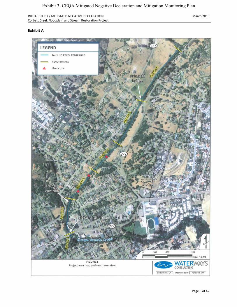
Project Scope and Location The project reach begins at the East Branch Street culvert and extends upstream approximately one (1) mile to the north end of the Clark Property (APN 007-791-032). As indicated in Exhibit A below, the focus of the Project area is identified as Reach 6. Additional environmental review will be performed for Reaches 1 through 5 once a scope of work is better defined. This IS/MND addresses impacts for Reaches 1 through 5 where they are foreseeable.
Exhibit 3: CEQA Mitigated Negative Declaration and Mitigation Monitoring Plan
INITIAL STUDY / MITIGATED NEGATIVE DECLARATION March 2013 Corbett Creek Floodplain and Stream Restoration Project
Page 8 of 42
Exhibit A
Exhibit 3: CEQA Mitigated Negative Declaration and Mitigation Monitoring Plan
INITIAL STUDY / MITIGATED NEGATIVE DECLARATION March 2013 Corbett Creek Floodplain and Stream Restoration Project
Page 9 of 42
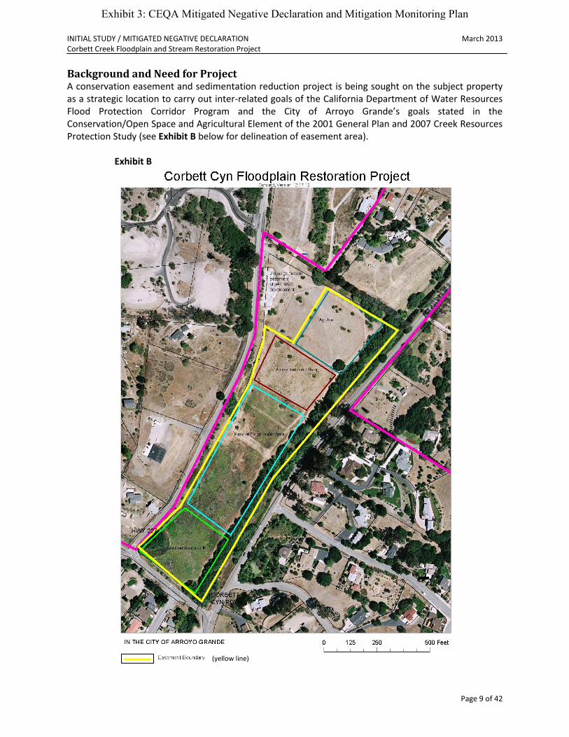
Background and Need for Project A conservation easement and sedimentation reduction project is being sought on the subject property as a strategic location to carry out inter-related goals of the California Department of Water Resources Flood Protection Corridor Program and the City of Arroyo Grande’s goals stated in the Conservation/Open Space and Agricultural Element of the 2001 General Plan and 2007 Creek Resources Protection Study (see Exhibit B below for delineation of easement area).
Exhibit B
(yellow line)
Exhibit 3: CEQA Mitigated Negative Declaration and Mitigation Monitoring Plan
INITIAL STUDY / MITIGATED NEGATIVE DECLARATION March 2013 Corbett Creek Floodplain and Stream Restoration Project
Page 10 of 42
The project consists of two components as follows:
1. The acquisition by RCD of a conservation easement in perpetuity over 12.50 acres of the 15.79-acre Clark Property at the confluence of Carpenter Creek and Corbett Creek to act as a floodplain and thereby attenuate peak flows. The conservation easement area will be used to construct a sediment basin, a floodwater detention area and a riparian habitat enhancement area. These easement acquisition and construction components of the project are identified in a technical study (Swanson Hydrology and Geomorphology, 2006) as critical to alleviating flooding on Corbett Creek and reducing stress on lower Arroyo Grande Creek through the reduction of peak flows and fine sediment. These project components have also been identified as providing an important location upon which to restore riparian and floodplain habitat within an urban wildlife corridor. Most of the engineering design, permitting, implementation and monitoring will be completed using grant funds obtained from the Department of Water Resources (DWR) through the Urban Streams Restoration Program. The estimated sediment delivery reduction provided by the site is approximately nine hundred (900) tons per year. Specific elements of the project include the following:
Conservation easement acquisition.
Sedimentation reduction through construction of active and passive sedimentation basins.
Restoration of floodplain and riparian habitat.
2. Design and permitting for a channel restoration project to re-establish the channel geometry of approximately nine hundred feet (900’) of Corbett Creek (Reach 4) and thereby increasing flow volumes. Issues that will be considered in the design process include a four-foot (4’) high head cut that is migrating upstream, sediment from uplands and developments that are clogging stormwater ditches and Corbett Creek, the increase in wetlands and marsh plants in the creek resulting in reduced creek flow volumes, and individual landowner’s activities in the floodplain that cause or encourage erosion. Currently there are no identified implementation funds for this component of the project.
Other Required Public Agency Approvals California Department of Fish and Wildlife Regional Water Quality Control Board US Fish and Wildlife Service US Army Corps of Engineers
Related Projects None.
Exhibit 3: CEQA Mitigated Negative Declaration and Mitigation Monitoring Plan

INITIAL STUDY / MITIGATED NEGATIVE DECLARATION March 2013 Corbett Creek Floodplain and Stream Restoration Project
Page 11 of 42
Environmental Checklist
Project Information Project Title: Corbett Creek Floodplain and Stream Restoration Project
(Staff Project No. 13-001)
Lead Agency Name & Address: City of Arroyo Grande 300 East Brach Street Arroyo Grande, CA 93420
Contact Person & Telephone Number:
Kelly Heffernon, Associate Planner (805) 473-5420
Project Location: 1. APN 007-791-032 (Clark Property) 2. Corbett Creek reach (multiple properties)
Project Sponsor Name & Address: City of Arroyo Grande 300 East Brach Street Arroyo Grande, CA 93420
General Plan Designation: 1. Low Density Residential (LD); Conservation Open Space (C/OS) 2. Low-Medium Density Residential (LM); Conservation
Open Space (C/OS)
Zoning: 1. Residential Hillside (RH); Public Facility (PF) (combining designation for the portion of the property containing the creek channel)
2. Residential Suburban (RS); Single Family (SF); Village Mixed Use (VMU); Village Core Downtown (VCD); Public Facility (PF) (combining designations for portions of properties containing the creek channel)
Description of Project: Acquisition of a conservation easement and design and
implementation of a sediment reduction project for the purpose of floodplain restoration, sediment capture and peak flow attenuation along specific reaches of Corbett Creek.
Surrounding Land Uses: The Clark Property contains a barn, equestrian trails, corals and vacant open space. Properties located downstream along the creek channel are primarily developed with single family residences with some commercially developed properties existing closer to the Village Core area. Several of the properties along this stretch are vacant.
Exhibit 3: CEQA Mitigated Negative Declaration and Mitigation Monitoring Plan

INITIAL STUDY / MITIGATED NEGATIVE DECLARATION March 2013 Corbett Creek Floodplain and Stream Restoration Project
Page 12 of 42
Project Setting: The City of Arroyo Grande is located in the southwestern portion of San Luis Obispo County, and the project site is located within the northeast section of the City of Arroyo Grande. The City is 5.45 square miles in size and is bounded by the Cities of Grover Beach and Pismo Beach to the southwest and west, and to the unincorporated County to the north, east and south. U.S. 101 extents northwest and southeast through the middle of the City, and Highway 227 runs east from U.S. 101 through the Village Area. Residential Rural and Suburban development characterize unincorporated areas to the north and southeast, and Agricultural uses dominate the Arroyo Grande Valley that extends northeast and south of the City. The project area is the reach of Corbett Creek from the northern City border to the village Commercial area in the center of the City at the confluence of Arroyo Grande Creek. The project area includes residential development adjacent to Corbett Creek except at the Village Core where there are four parcels zoned Village Core/Village Mixed Use upon which there is an existing unoccupied structure. Plans have been approved to develop a grocery store. The topography of the City ranges from moderate and steep hillsides to the north of U.S. 101 to relatively flat parcels toward the center of town, to moderate slopes further south. The project area has varying topographical gradients with an approximate 2-5% slope northeast. Corbett Creek runs north/south to Arroyo Grande Creek. The Wilmar Avenue fault is a potentially active fault adjacent to the City, and the Pismo fault underlies portions of Arroyo Grande but is inactive and poses very low potential fault rupture hazard to the City. No known active faults underlie the project area. The Corbett Creek reach is one of three (3) main tributaries within the City limits. The creek flows are generally perennial in the project reach with higher flows in the winter and very low flow in the summer. The area enjoys a Mediterranean climate with most precipitation occurring from November to March. Corbett Creek stream flows remain elevated in the spring as groundwater and subsurface flows contribute to the stream. The subwatershed is dominated by agriculture and rural residential land uses. At the project reach the channel is not formally channelized; however, encroachment activities by residents over the years have effectively channelized portions of the creek. Vegetation within the project area includes native and exotic grasses, native and exotic brush including blackberry and Willow trees, and ornamental landscaping on the residential properties.
Exhibit 3: CEQA Mitigated Negative Declaration and Mitigation Monitoring Plan
INITIAL STUDY / MITIGATED NEGATIVE DECLARATION March 2013 Corbett Creek Floodplain and Stream Restoration Project
Page 13 of 42
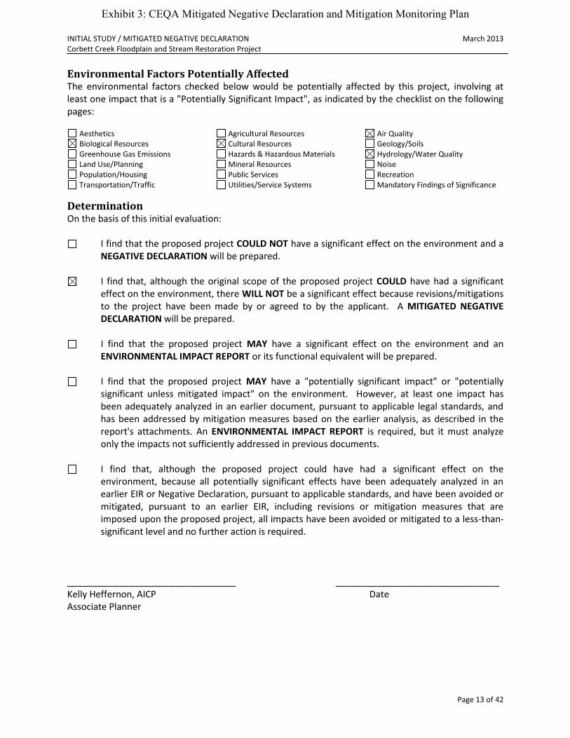
Environmental Factors Potentially Affected The environmental factors checked below would be potentially affected by this project, involving at least one impact that is a "Potentially Significant Impact", as indicated by the checklist on the following pages:
Aesthetics Agricultural Resources Air Quality Biological Resources Cultural Resources Geology/Soils Greenhouse Gas Emissions Hazards & Hazardous Materials Hydrology/Water Quality Land Use/Planning Mineral Resources Noise Population/Housing Public Services Recreation Transportation/Traffic Utilities/Service Systems Mandatory Findings of Significance
Determination On the basis of this initial evaluation:
I find that the proposed project COULD NOT have a significant effect on the environment and a NEGATIVE DECLARATION will be prepared.
I find that, although the original scope of the proposed project COULD have had a significant
effect on the environment, there WILL NOT be a significant effect because revisions/mitigations to the project have been made by or agreed to by the applicant. A MITIGATED NEGATIVE DECLARATION will be prepared.
I find that the proposed project MAY have a significant effect on the environment and an
ENVIRONMENTAL IMPACT REPORT or its functional equivalent will be prepared.
I find that the proposed project MAY have a "potentially significant impact" or "potentially significant unless mitigated impact" on the environment. However, at least one impact has been adequately analyzed in an earlier document, pursuant to applicable legal standards, and has been addressed by mitigation measures based on the earlier analysis, as described in the report's attachments. An ENVIRONMENTAL IMPACT REPORT is required, but it must analyze only the impacts not sufficiently addressed in previous documents.
I find that, although the proposed project could have had a significant effect on the
environment, because all potentially significant effects have been adequately analyzed in an earlier EIR or Negative Declaration, pursuant to applicable standards, and have been avoided or mitigated, pursuant to an earlier EIR, including revisions or mitigation measures that are imposed upon the proposed project, all impacts have been avoided or mitigated to a less-than-significant level and no further action is required.
_________________________________ ________________________________ Kelly Heffernon, AICP Date Associate Planner
Exhibit 3: CEQA Mitigated Negative Declaration and Mitigation Monitoring Plan

INITIAL STUDY / MITIGATED NEGATIVE DECLARATION March 2013 Corbett Creek Floodplain and Stream Restoration Project
Page 14 of 42
Evaluation of Environmental Impacts 1. A brief explanation is required for all answers, except "No Impact", that are adequately
supported by the information sources cited. A "No Impact" answer is adequately supported if the referenced information sources show that the impact does not apply to the project being evaluated (e.g., the project falls outside a fault rupture zone). A "No Impact" answer should be explained where it is based on general or project-specific factors (e.g., the project will not expose sensitive receptors to pollutants, based on a project-specific screening analysis).
2. All answers must consider the whole of the project-related effects, both direct and indirect, including off-site, cumulative, construction, and operational impacts.
3. Once the lead agency has determined that a particular physical impact may occur, the checklist answers must indicate whether that impact is potentially significant, less than significant with mitigation, or less than significant. "Potentially Significant Impact" is appropriate when there is sufficient evidence that a substantial or potentially substantial adverse change may occur in any of the physical conditions within the area affected by the project that cannot be mitigated below a level of significance. If there are one or more "Potentially Significant Impact" entries, an Environmental Impact Report (EIR) is required.
4. A "Mitigated Negative Declaration" (Negative Declaration: Less Than Significant with Mitigation Incorporated) applies where the incorporation of mitigation measures, prior to declaration of project approval, has reduced an effect from "Potentially Significant Impact" to a "Less Than Significant Impact with Mitigation." The lead agency must describe the mitigation measures and briefly explain how they reduce the effect to a less than significant level.
5. Earlier analyses may be used where, pursuant to the tiering, program EIR, or other CEQA process, an effect has been adequately analyzed in an earlier EIR (including a General Plan) or Negative Declaration [CCR, Guidelines for the Implementation of CEQA, § 15063(c)(3)(D)]. References to an earlier analysis should: a) Identify the earlier analysis and state where it is available for review. b) Indicate which effects from the environmental checklist were adequately analyzed in the
earlier document, pursuant to applicable legal standards, and whether these effects were adequately addressed by mitigation measures included in that analysis.
c) Describe the mitigation measures in this document that were incorporated or refined from the earlier document and indicate to what extent they address site-specific conditions for this project.
6. Lead agencies are encouraged to incorporate references to information sources for potential impacts into the checklist or appendix (e.g., general plans, zoning ordinances, biological assessments). Reference to a previously prepared or outside document should include an indication of the page or pages where the statement is substantiated.
7. A source list should be appended to this document. Sources used or individuals contacted should be listed in the source list and cited in the discussion.
8. Explanation(s) of each issue should identify: a) the criteria or threshold, if any, used to evaluate the significance of the impact addressed by
each question and b) the mitigation measures, if any, prescribed to reduce the impact below the level of
significance.
Exhibit 3: CEQA Mitigated Negative Declaration and Mitigation Monitoring Plan

INITIAL STUDY / MITIGATED NEGATIVE DECLARATION March 2013 Corbett Creek Floodplain and Stream Restoration Project
Page 15 of 42
Environmental Issues
1. Aesthetics
Environmental Setting The Clark Property is about 16 acres in size and is located adjacent to Corbett Creek, a tributary to Arroyo Grande Creek near the confluence of Carpenter and Corbett Creeks. The portion of the property to be encumbered with the proposed conservation easement consists primarily of open space, the creek and riparian corridor, and several small isolated wetlands. The primary residence and a series of fenced pastures currently occupy most of the property, with approximately six (6) acres of land in seasonal pasture. The conservation easement will encompass a portion of the fenced pasture area, but does not include any structures. The project would utilize approximately 12.5 acres for a conservation easement for the purpose of restoring a historic floodplain. The project would create a sedimentation basin, expand a wetland area, construct an earthen berm around the detention area to impound additional runoff, and install control structures. These improvements would help to attenuate peak storm flows, thereby increasing flood protection to urban and agricultural areas downstream. The proposed project would enhance the rural setting by placing existing open space in a perpetual conservation easement and by adding riparian vegetation. There are no visual impacts anticipated. Project improvements downstream along the Corbett Creek reach include channel restoration at strategic locations. Improvements include removing a four foot (4’) high head-cut that is migrating upstream, removal of sediment, and strategic removal of vegetation to increase conveyance capacity. These improvements have not yet been designed, but there are no expected visual impacts associated with this component of the project.
Would the project:
Potentially Significant
Impact
Less Than Significant
with Mitigation
Less Than Significant
Impact No Impact
a) Have a substantial adverse affect on a scenic vista?
b) Substantially damage scenic resources, including, but not limited to, trees, rock outcroppings, and historic buildings within a state scenic highway?
c) Substantially degrade the existing visual character or quality of the site and its surroundings?
d) Create a new source of substantial light or glare which would adversely affect day or nighttime views in the area?
Discussion a-d: No impacts.
Exhibit 3: CEQA Mitigated Negative Declaration and Mitigation Monitoring Plan

INITIAL STUDY / MITIGATED NEGATIVE DECLARATION March 2013 Corbett Creek Floodplain and Stream Restoration Project
Page 16 of 42
2. Agriculture and Forestry Resources
Environmental Setting The project area is not “Prime Farmland, Unique Farmland, or Farmland of Statewide Importance (Farmland), as shown on the maps prepared pursuant to the Farmland Mapping and Monitoring Program of the California Resources Agency”, nor is it located near any Farmland.
Would the project:
Potentially Significant
Impact
Less Than Significant
with Mitigation
Less Than Significant
Impact No Impact
a) Convert Prime Farmland, Unique Farmland, or Farmland of Statewide Importance (Farmland), as shown on the maps prepared pursuant to the Farmland Mapping and Monitoring Program of the California Resources Agency, to non-agricultural use?
b) Conflict with existing zoning for agricultural use or a Williamson Act contract?
c) Conflict with existing zoning for, or cause rezoning of, forest land (as defined in Public Resources Code section 12220)g)), timberland (as defined by Public Resources Code section 4526), or timberland zoned Timberland Production (as defined by Government Code section 51104(g))?
d) Result in the loss of forest land or conversion of forest land to non-forest use?
e) Involve other changes in the existing environment which, due to their location or nature, could result in conversion of Farmland to non-agricultural use?
* In determining whether impacts to agricultural resources are significant environmental effects, lead agencies may refer to the California Agricultural Land Evaluation and Site Assessment Model (1997), prepared by the California Department of Conservation as an optional model for use in assessing impacts on agricultural and farmland.
Discussion a-e: No impacts.
3. Air Quality
Environmental Setting San Luis Obispo County is in non-attainment status for ozone (O3), respireable particulate matter (PM10) and vinyl chloride under the California Air Resource Board (CARB) standards. The County is in attainment status for all other applicable CARB standards.
Exhibit 3: CEQA Mitigated Negative Declaration and Mitigation Monitoring Plan

INITIAL STUDY / MITIGATED NEGATIVE DECLARATION March 2013 Corbett Creek Floodplain and Stream Restoration Project
Page 17 of 42
Would the project:
Potentially Significant
Impact
Less Than Significant
with Mitigation
Less Than Significant
Impact No Impact
a) Conflict with or obstruct implementation of the applicable air quality plan?
b) Violate any air quality standard or contribute substantially to an existing or projected air quality violation?
c) Result in a cumulatively considerable net increase of any criteria pollutant for which the project region is in non-attainment under an applicable federal or state ambient air quality standard (including releasing emissions which exceed quantitative thresholds for ozone precursors)?
d) Expose sensitive receptors to substantial pollutant concentrations?
e) Create objectionable odors affecting a substantial number of people?
Discussion a: No impacts. b-c: The San Luis Obispo County Air Pollution Control District (APCD) has developed the CEQA Air Quality Handbook to evaluate project specific impacts and determine if air quality mitigation measures are needed, or if potentially significant impacts could result. The City refers to this Handbook for all projects subject to CEQA. Although the construction phase of the project is below the thresholds for significance, some mitigation is recommended. Construction for this project includes grading to expand the wetland area and to create the sedimentation basin. The “operation” phase of this project would include periodic maintenance of the sedimentation basin and is considered insignificant. It is anticipated that sedimentation removal might occur every five (5) to ten (10) years, and would largely depend on the severity of storm conditions. According to the general operational screening criteria in the APCD Handbook, the grading associated with the proposed project is not expected to generate potentially significant air quality impacts. However, emissions associated with project construction could affect adjacent properties and would add to the cumulatively significant effect that results in basin-wide exceedance of air quality standards. These temporary fugitive dust and combustion emissions can impact local air quality. Implementation of the following mitigation measures will reduce air quality impacts to a less than significant level:
MM 3.1: The following conditions shall be included on all project plans and adhered to for all grading-related permits:
Reduce the amount of disturbed area where possible.
Use water trucks or sprinkler systems in sufficient quantities to prevent airborne dust from leaving the site. Increase watering frequency when wind speeds exceed 15 MPH. Reclaimed (non-potable) water shall be used whenever possible.
All dirt stockpile areas should be sprayed daily or as needed using reclaimed (non-potable) water when feasible.
Exhibit 3: CEQA Mitigated Negative Declaration and Mitigation Monitoring Plan
INITIAL STUDY / MITIGATED NEGATIVE DECLARATION March 2013 Corbett Creek Floodplain and Stream Restoration Project
Page 18 of 42
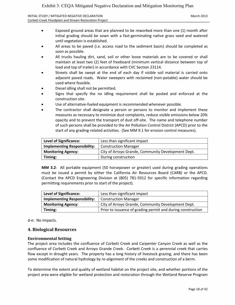
Exposed ground areas that are planned to be reworked more than one (1) month after initial grading should be sown with a fast-germinating native grass seed and watered until vegetation is established.
All areas to be paved (i.e. access road to the sediment basin) should be completed as soon as possible.
All trucks hauling dirt, sand, soil or other loose materials are to be covered or shall maintain at least two (2) feet of freeboard (minimum vertical distance between top of load and top of trailer) in accordance with CVC Section 23114.
Streets shall be swept at the end of each day if visible soil material is carried onto adjacent paved roads. Water sweepers with reclaimed (non-potable) water should be used where feasible.
Diesel idling shall not be permitted.
Signs that specify the no idling requirement shall be posted and enforced at the construction site.
Use of alternative-fueled equipment is recommended whenever possible.
The contractor shall designate a person or persons to monitor and implement these measures as necessary to minimize dust complaints, reduce visible emissions below 20% opacity and to prevent the transport of dust off-site. The name and telephone number of such persons shall be provided to the Air Pollution Control District (APCD) prior to the start of any grading-related activities. (See MM 9.1 for erosion control measures).
Level of Significance: Less than significant impact
Implementing Responsibility: Construction Manager
Monitoring Agency: City of Arroyo Grande, Community Development Dept.
Timing: During construction
MM 3.2: All portable equipment (50 horsepower or greater) used during grading operations must be issued a permit by either the California Air Resources Board (CARB) or the APCD. (Contact the APCD Engineering Division at (805) 781-5912 for specific information regarding permitting requirements prior to start of the project).
Level of Significance: Less than significant impact
Implementing Responsibility: Construction Manager
Monitoring Agency: City of Arroyo Grande, Community Development Dept.
Timing: Prior to issuance of grading permit and during construction
d-e: No impacts.
4. Biological Resources
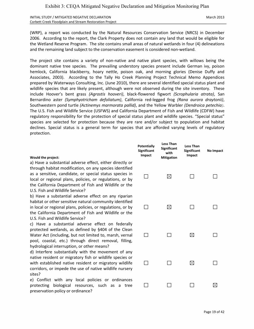
Environmental Setting The project area includes the confluence of Corbett Creek and Carpenter Canyon Creek as well as the confluence of Corbett Creek and Arroyo Grande Creek. Corbett Creek is a perennial creek that carries flow except in drought years. The property has a long history of livestock grazing, and there has been some modification of natural hydrology by re-alignment of the creeks and construction of a berm. To determine the extent and quality of wetland habitat on the project site, and whether portions of the project area were eligible for wetland protection and restoration through the Wetland Reserve Program
Exhibit 3: CEQA Mitigated Negative Declaration and Mitigation Monitoring Plan
INITIAL STUDY / MITIGATED NEGATIVE DECLARATION March 2013 Corbett Creek Floodplain and Stream Restoration Project
Page 19 of 42
(WRP), a report was conducted by the Natural Resources Conservation Service (NRCS) in December 2006. According to the report, the Clark Property does not contain any land that would be eligible for the Wetland Reserve Program. The site contains small areas of natural wetlands in four (4) delineations and the remaining land subject to the conservation easement is considered non-wetland. The project site contains a variety of non-native and native plant species, with willows being the dominant native tree species. The prevailing understory species present include German ivy, poison hemlock, California blackberry, hoary nettle, poison oak, and morning glories (Denise Duffy and Associates, 2003). According to the Tally Ho Creek Planning Project Technical Memo Appendices prepared by Waterways Consulting, Inc. (June 2010), there are several identified special status plant and wildlife species that are likely present, although were not observed during the site inventory. These include Hoover’s bent grass (Agrostis hooveri), black-flowered figwort (Scrophularia atrata), San Bernardino aster (Symphyotricham defoliatum), California red-legged frog (Rana aurora draytonii), Southwestern pond turtle (Actinemys marmorata pallid), and the Yellow Warbler (Dendroica petechia). The U.S. Fish and Wildlife Service (USFWS) and California Department of Fish and Wildlife (CDFW) have regulatory responsibility for the protection of special status plant and wildlife species. “Special status” species are selected for protection because they are rare and/or subject to population and habitat declines. Special status is a general term for species that are afforded varying levels of regulatory protection.
Would the project:
Potentially Significant
Impact
Less Than Significant
with Mitigation
Less Than Significant
Impact No Impact
a) Have a substantial adverse effect, either directly or through habitat modification, on any species identified as a sensitive, candidate, or special status species in local or regional plans, policies, or regulations, or by the California Department of Fish and Wildlife or the U.S. Fish and Wildlife Service?
b) Have a substantial adverse effect on any riparian habitat or other sensitive natural community identified in local or regional plans, policies, or regulations, or by the California Department of Fish and Wildlife or the U.S. Fish and Wildlife Service?
c) Have a substantial adverse effect on federally protected wetlands, as defined by §404 of the Clean Water Act (including, but not limited to, marsh, vernal pool, coastal, etc.) through direct removal, filling, hydrological interruption, or other means?
d) Interfere substantially with the movement of any native resident or migratory fish or wildlife species or with established native resident or migratory wildlife corridors, or impede the use of native wildlife nursery sites?
e) Conflict with any local policies or ordinances protecting biological resources, such as a tree preservation policy or ordinance?
Exhibit 3: CEQA Mitigated Negative Declaration and Mitigation Monitoring Plan
INITIAL STUDY / MITIGATED NEGATIVE DECLARATION March 2013 Corbett Creek Floodplain and Stream Restoration Project
Page 20 of 42
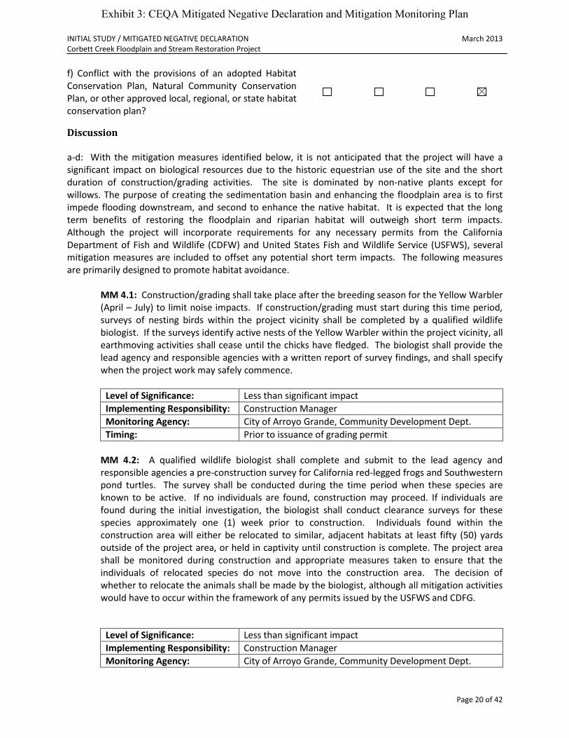
f) Conflict with the provisions of an adopted Habitat Conservation Plan, Natural Community Conservation Plan, or other approved local, regional, or state habitat conservation plan?
Discussion a-d: With the mitigation measures identified below, it is not anticipated that the project will have a significant impact on biological resources due to the historic equestrian use of the site and the short duration of construction/grading activities. The site is dominated by non-native plants except for willows. The purpose of creating the sedimentation basin and enhancing the floodplain area is to first impede flooding downstream, and second to enhance the native habitat. It is expected that the long term benefits of restoring the floodplain and riparian habitat will outweigh short term impacts. Although the project will incorporate requirements for any necessary permits from the California Department of Fish and Wildlife (CDFW) and United States Fish and Wildlife Service (USFWS), several mitigation measures are included to offset any potential short term impacts. The following measures are primarily designed to promote habitat avoidance.
MM 4.1: Construction/grading shall take place after the breeding season for the Yellow Warbler (April – July) to limit noise impacts. If construction/grading must start during this time period, surveys of nesting birds within the project vicinity shall be completed by a qualified wildlife biologist. If the surveys identify active nests of the Yellow Warbler within the project vicinity, all earthmoving activities shall cease until the chicks have fledged. The biologist shall provide the lead agency and responsible agencies with a written report of survey findings, and shall specify when the project work may safely commence.
Level of Significance: Less than significant impact
Implementing Responsibility: Construction Manager
Monitoring Agency: City of Arroyo Grande, Community Development Dept.
Timing: Prior to issuance of grading permit
MM 4.2: A qualified wildlife biologist shall complete and submit to the lead agency and responsible agencies a pre-construction survey for California red-legged frogs and Southwestern pond turtles. The survey shall be conducted during the time period when these species are known to be active. If no individuals are found, construction may proceed. If individuals are found during the initial investigation, the biologist shall conduct clearance surveys for these species approximately one (1) week prior to construction. Individuals found within the construction area will either be relocated to similar, adjacent habitats at least fifty (50) yards outside of the project area, or held in captivity until construction is complete. The project area shall be monitored during construction and appropriate measures taken to ensure that the individuals of relocated species do not move into the construction area. The decision of whether to relocate the animals shall be made by the biologist, although all mitigation activities would have to occur within the framework of any permits issued by the USFWS and CDFG.
Level of Significance: Less than significant impact
Implementing Responsibility: Construction Manager
Monitoring Agency: City of Arroyo Grande, Community Development Dept.
Exhibit 3: CEQA Mitigated Negative Declaration and Mitigation Monitoring Plan
INITIAL STUDY / MITIGATED NEGATIVE DECLARATION March 2013 Corbett Creek Floodplain and Stream Restoration Project
Page 21 of 42
Timing: Prior to issuance of grading permit and during construction
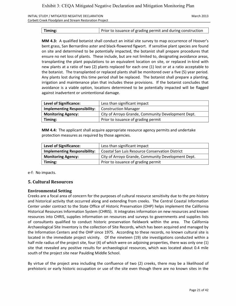
MM 4.3: A qualified botanist shall conduct an initial site survey to map occurrence of Hoover’s bent grass, San Bernardino aster and black-flowered figwort. If sensitive plant species are found on site and determined to be potentially impacted, the botanist shall prepare procedures that ensure no net loss of plants. These include, but are not limited to, designating avoidance areas, transplanting the plant populations to an equivalent location on site, or replaced in-kind with new plants at a ratio of two (2) plants replaced for each one (1) lost or at a ratio acceptable to the botanist. The transplanted or replaced plants shall be monitored over a five (5) year period. Any plants lost during this time period shall be replaced. The botanist shall prepare a planting, irrigation and maintenance plan that includes these provisions. If the botanist concludes that avoidance is a viable option, locations determined to be potentially impacted will be flagged against inadvertent or unintentional damage.
Level of Significance: Less than significant impact
Implementing Responsibility: Construction Manager
Monitoring Agency: City of Arroyo Grande, Community Development Dept.
Timing: Prior to issuance of grading permit
MM 4.4: The applicant shall acquire appropriate resource agency permits and undertake protection measures as required by those agencies.
Level of Significance: Less than significant impact
Implementing Responsibility: Coastal San Luis Resource Conservation District
Monitoring Agency: City of Arroyo Grande, Community Development Dept.
Timing: Prior to issuance of grading permit
e-f: No impacts.
5. Cultural Resources
Environmental Setting Creeks are a focal area of concern for the purposes of cultural resource sensitivity due to the pre-history and historical activity that occurred along and extending from creeks. The Central Coastal Information Center under contract to the State Office of Historic Preservation (OHP) helps implement the California Historical Resources Information System (CHRIS). It integrates information on new resources and known resources into CHRIS, supplies information on resources and surveys to governments and supplies lists of consultants qualified to conduct historic preservation fieldwork within the area. The California Archaeological Site Inventory is the collection of Site Records, which has been acquired and managed by the Information Centers and the OHP since 1975. According to these records, no known cultural site is located in the immediate project vicinity. Of the nineteen (19) site investigations conducted within a half mile radius of the project site, four (4) of which were on adjoining properties, there was only one (1) site that revealed any positive results for archaeological resources, which was located about 0.4 mile south of the project site near Paulding Middle School. By virtue of the project area including the confluence of two (2) creeks, there may be a likelihood of prehistoric or early historic occupation or use of the site even though there are no known sites in the
Exhibit 3: CEQA Mitigated Negative Declaration and Mitigation Monitoring Plan
INITIAL STUDY / MITIGATED NEGATIVE DECLARATION March 2013 Corbett Creek Floodplain and Stream Restoration Project
Page 22 of 42
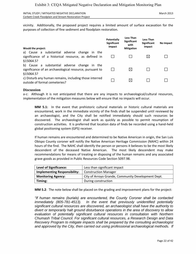
vicinity. Additionally, the proposed project requires a limited amount of surface excavation for the purposes of collection of fine sediment and floodplain restoration.
Would the project:
Potentially Significant
Impact
Less Than Significant
with Mitigation
Less Than Significant
Impact No Impact
a) Cause a substantial adverse change in the significance of a historical resource, as defined in §15064.5?
b) Cause a substantial adverse change in the significance of an archaeological resource, pursuant to §15064.5?
c) Disturb any human remains, including those interred outside of formal cemeteries?
Discussion a-c: Although it is not anticipated that there are any impacts to archaeological/cultural resources, implementation of the mitigation measures below will ensure that no impacts will occur.
MM 5.1: In the event that prehistoric cultural materials or historic cultural materials are encountered, work in the immediate vicinity of the finds shall be suspended until reviewed by an archaeologist, and the City shall be notified immediately should such resources be discovered. The archaeologist shall work as quickly as possible to permit resumption of construction activities. It is preferred that location data of finds be recorded using a hand-held global positioning system (GPS) receiver. If human remains are encountered and determined to be Native American in origin, the San Luis Obispo County coroner will notify the Native American Heritage Commission (NAHC) within 24 hours of the find. The NAHC shall identify the person or persons it believes to be the most likely descendent of the deceased Native American. The most likely descendent may make recommendations for means of treating or disposing of the human remains and any associated grave goods as provided in Public Resources Code Section 5097.98.
Level of Significance: Less than significant impact
Implementing Responsibility: Construction Manager
Monitoring Agency: City of Arroyo Grande, Community Development Dept.
Timing: During construction
MM 5.2: The note below shall be placed on the grading and improvement plans for the project: “If human remains (burials) are encountered, the County Coroner shall be contacted immediately (805-781-4513). In the event that previously unidentified potentially significant cultural resources are discovered, an archaeologist shall have the authority to divert or temporarily halt ground disturbance operations in the area of discovery to allow evaluation of potentially significant cultural resources in consultation with Northern Chumash Tribal Council. For significant cultural resources, a Research Design and Data Recovery Program to mitigate impacts shall be prepared by the consulting archaeologist and approved by the City, then carried out using professional archaeological methods. If
Exhibit 3: CEQA Mitigated Negative Declaration and Mitigation Monitoring Plan
INITIAL STUDY / MITIGATED NEGATIVE DECLARATION March 2013 Corbett Creek Floodplain and Stream Restoration Project
Page 23 of 42
it can be demonstrated that a project will cause damage to a unique archaeological resource, the City may require reasonable efforts to be made to permit any or all of these resources to be preserved in place or left in an undisturbed state.”
Level of Significance: Less than significant impact
Implementing Responsibility: Construction Manager
Monitoring Agency: City of Arroyo Grande, Community Development Dept.
Timing: Prior to issuance of grading permit
6. Geology and Soils
Environmental Setting The site has varying topographical gradients but generally consist of a 2-5% northeasterly slope. The soils on the Corbett Creek watershed are derived from soft, highly erodible sandstones. High levels of sediment in the creek have come from several locations of erosion and flooding events. The highest profile erosion sources came from the clearing and grading of an upslope property on James Way for a housing development. In 2001, a combination of heavy rains and soils with a high to very high hazard rating for water erosion led to the sedimentation of the James Way stormwater ditch and Corbett Creek, in turn causing flooding to adjacent homes. Homes along Corbett Creek in some cases are as little as twenty feet (20’) from the creek and are not elevated. The sediment was deposited in Corbett Creek, raising the streambed. Sediment accumulation has created marsh-like wetland areas that alter the form and function of the creek, diminishing the in-stream habitat and the conveyance of water and sediment. In addition to erosion, expansion of the urban fringe, road development and increases in impervious surfaces have resulted in changes in the timing and magnitude of peak flows in the creek. There are small berms in some localized areas along the north side of the active channel built by landowners. Another factor affecting stream function is a four foot (4’) high head-cut in the creek (as of 2007). If the head-cut was to progress upstream 2,700 feet, approximately 7,000 cubic yards of sediment would mobilize (Swanson Hydrology & Geomorphology, 2008) and be transported downstream to Arroyo Grande Creek, impacting steelhead habitat and increasing flooding challenges in the Zone 1/1A flood control channel. No active faulting is known to exist on or close to the subject property. The project is not within a known area containing serpentine or ultramafic rock or soils (i.e. low risk of naturally occurring asbestos).
Exhibit 3: CEQA Mitigated Negative Declaration and Mitigation Monitoring Plan

INITIAL STUDY / MITIGATED NEGATIVE DECLARATION March 2013 Corbett Creek Floodplain and Stream Restoration Project
Page 24 of 42
Would the project:
Potentially Significant
Impact
Less Than Significant
with Mitigation
Less Than Significant
Impact No Impact
a) Expose people or structures to potential substantial adverse effects, including the risk of loss, injury, or death involving:
i) Rupture of a known earthquake fault, as delineated on the most recent Alquist-Priolo Earthquake Fault Zoning Map, issued by the State Geologist for the area, or based on other substantial evidence of a known fault? (Refer to Division of Mines and Geology Special Publication 42.) ii) Strong seismic ground shaking? iii) Seismic-related ground failure, including liquefaction? iv) Landslides?
b) Result in substantial soil erosion or the loss of topsoil?
c) Be located on a geologic unit or soil that is unstable, or that would become unstable, as a result of the project and potentially result in on- or off-site landslide, lateral spreading, subsidence, liquefaction, or collapse?
d) Be located on expansive soil, as defined in Table 18-1-B of the Uniform Building Code (1994), creating substantial risks to life or property?
e) Have soils incapable of adequately supporting the use of septic tanks or alternative waste disposal systems, where sewers are not available for the disposal of waste water?
Discussion a: No impacts. b: The project is intended to alleviate risks from increasing head-cuts and deposition of sediment. The project does not alter geotechnical requirements or permit additional construction in geologically sensitive or hazardous areas. The project description integrates development and implementation of both short and long term Best Management Practices (BMPs) to address construction and long term maintenance of the sedimentation basins on the Clark Property, design of the head-cut remediation and BMPs for landowners on the project area. c-e: No impacts.
Exhibit 3: CEQA Mitigated Negative Declaration and Mitigation Monitoring Plan
INITIAL STUDY / MITIGATED NEGATIVE DECLARATION March 2013 Corbett Creek Floodplain and Stream Restoration Project
Page 25 of 42
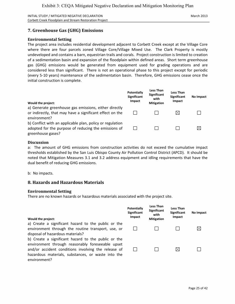
7. Greenhouse Gas (GHG) Emissions
Environmental Setting The project area includes residential development adjacent to Corbett Creek except at the Village Core where there are four parcels zoned Village Core/Village Mixed Use. The Clark Property is mostly undeveloped and contains a barn, equestrian trails and corals. Project construction is limited to creation of a sedimentation basin and expansion of the floodplain within defined areas. Short term greenhouse gas (GHG) emissions would be generated from equipment used for grading operations and are considered less than significant. There is not an operational phase to this project except for periodic (every 5-10 years) maintenance of the sedimentation basin. Therefore, GHG emissions cease once the initial construction is complete.
Would the project:
Potentially Significant
Impact
Less Than Significant
with Mitigation
Less Than Significant
Impact No Impact
a) Generate greenhouse gas emissions, either directly or indirectly, that may have a significant effect on the environment?
b) Conflict with an applicable plan, policy or regulation adopted for the purpose of reducing the emissions of greenhouse gases?
Discussion a: The amount of GHG emissions from construction activities do not exceed the cumulative impact thresholds established by the San Luis Obispo County Air Pollution Control District (APCD). It should be noted that Mitigation Measures 3.1 and 3.2 address equipment and idling requirements that have the dual benefit of reducing GHG emissions. b: No impacts.
8. Hazards and Hazardous Materials
Environmental Setting There are no known hazards or hazardous materials associated with the project site.
Would the project:
Potentially Significant
Impact
Less Than Significant
with Mitigation
Less Than Significant
Impact No Impact
a) Create a significant hazard to the public or the environment through the routine transport, use, or disposal of hazardous materials?
b) Create a significant hazard to the public or the environment through reasonably foreseeable upset and/or accident conditions involving the release of hazardous materials, substances, or waste into the environment?
Exhibit 3: CEQA Mitigated Negative Declaration and Mitigation Monitoring Plan

INITIAL STUDY / MITIGATED NEGATIVE DECLARATION March 2013 Corbett Creek Floodplain and Stream Restoration Project
Page 26 of 42
c) Emit hazardous emissions or handle hazardous or acutely hazardous materials, substances, or waste within one-quarter mile of an existing or proposed school?
d) Be located on a site which is included on a list of hazardous materials sites, compiled pursuant to Government Code §65962.5, and, as a result, create a significant hazard to the public or environment?
e) Be located within an airport land use plan or, where such a plan has not been adopted, within two miles of a public airport or public use airport? If so, would the project result in a safety hazard for people residing or working in the project area?
f) Be located in the vicinity of a private airstrip? If so, would the project result in a safety hazard for people residing or working in the project area?
g) Impair implementation of or physically interfere with an adopted emergency response plan or emergency evacuation plan?
h) Expose people or structures to a significant risk of loss, injury, or death from wildland fires, including areas where wildlands are adjacent to urbanized areas or where residences are intermixed with wildlands?
Discussion b: The project as proposed does not pose a significant hazard to the public or the environment. However, in the unlikely event that there is an equipment malfunction producing an oil or gas spill, procedures shall be followed as outlined under MM 9.1 (preparation of a Storm Water Pollution Prevention Plan). a, c- h: No impacts.
9. Hydrology and Water Quality
Environmental Setting The project area includes the confluence of Corbett and Carpenter Canyon Creeks as well as the confluence of Corbett and Arroyo Grande Creeks. Except for drought years, Corbett Creek maintains perennial flow and meanders from the City limits near Highway 227 to Arroyo Grande Creek in the commercial core of the City’s Village area. It has an active low flow channel/bank full morphology that narrows to approximately two-four feet (2’-4’) wide near Arroyo Grande Creek. The creek travels through the backyards of residences on Tally Ho Road where there is persistent flooding. There is a four foot (4’) high head-cut in the creek that was initially observed by field crews in 2007. If the head-cut were to progress upstream 2,700 feet, approximately 7,000 cubic yards of sediment would mobilize (Swanson Hydrology & Geomorphology, 2008) and be transported downstream to Arroyo Grande Creek, impacting steelhead habitat and increasing flooding challenges in the Zone 1/1A flood control channel. The project is intended to restore the riparian habitat and provide flood protection. Construction/grading activities and exposed soil could cause temporary erosion; however, implementation of Best Management Practices (BMPs) that are integrated into the project description and the mitigation measures below will mitigate the impacts to less that significant.
Exhibit 3: CEQA Mitigated Negative Declaration and Mitigation Monitoring Plan

INITIAL STUDY / MITIGATED NEGATIVE DECLARATION March 2013 Corbett Creek Floodplain and Stream Restoration Project
Page 27 of 42
Would the project:
Potentially Significant
Impact
Less Than Significant
with Mitigation
Less Than Significant
Impact No Impact
a) Violate any water quality standards or waste discharge requirements?
b) Substantially deplete groundwater supplies or interfere substantially with groundwater recharge, such that there would be a net deficit in aquifer volume or a lowering of the local groundwater table level (e.g., the production rate of pre-existing nearby wells would drop to a level that would not support existing land uses or planned uses for which permits have been granted)?
c) Substantially alter the existing drainage pattern of the site or area, including through alteration of the course of a stream or river, in a manner which would result in substantial on- or off-site erosion or siltation?
d) Substantially alter the existing drainage pattern of the site or area, including through alteration of the course of a stream or river, or substantially increase the rate or amount of surface runoff in a manner which would result in on- or off-site flooding?
e) Create or contribute runoff water which would exceed the capacity of existing or planned stormwater drainage systems or provide substantial additional sources of polluted runoff?
f) Substantially degrade water quality?
g) Place housing within a 100-year flood hazard area, as mapped on a federal Flood Hazard Boundary or Flood Insurance Rate Map, or other flood hazard delineation map?
h) Place structures that would impede or redirect flood flows within a 100-year flood hazard area?
i) Expose people or structures to a significant risk of loss, injury, or death from flooding, including flooding resulting from the failure of a levee or dam?
j) Result in inundation by seiche, tsunami, or mudflow?
Discussion a, c-f, h-i: Potentially significant impacts from soil erosion and an increase in sediment and turbidity to Arroyo Grande Creek could result from project grading and construction. Potentially significant impacts on hydrology and water quality from construction related activities can be reduced to a less-than-significant level with implementation of the mitigation measures listed below. The project site is within a floodway where waters flood onto horse pastures and therefore water quality impacts from equestrian use and manure accumulation may also be a concern. The project may bring surface water more frequently in contact with pastures and manure. However, the project would
Exhibit 3: CEQA Mitigated Negative Declaration and Mitigation Monitoring Plan

INITIAL STUDY / MITIGATED NEGATIVE DECLARATION March 2013 Corbett Creek Floodplain and Stream Restoration Project
Page 28 of 42
not worsen the water quality situation since no more horses would be added to the site, and some of the area currently used for horse corrals and pasture would be allocated to floodwater detention and riparian habitat enhancement. It is unknown at this time what the water quality impacts from nitrogen or bacteria will be from the project. Water quality monitoring will be carried out as required by the Storm Water Pollution Prevention Plan. The property owner is interested in BMPs to manage manure through composting. These BMPs would reduce potential bacteria pollutant loading, and would be implemented separately from this project. The continued equestrian use is not considered a potentially significant impact. There is a potential for berm failure that could impact downstream properties. This potential will be addressed through the design process, and applicable design standards will be used.
MM 9.1: The applicant shall prepare a Storm Water Pollution Prevention Plan (SWPPP) and Erosion Control Plan that specifies the implementation of Best Management Practices (BMPs) to avoid and minimize water quality impacts as required by the Regional Water Quality Control Board (RWQCB). At a minimum, the SWPP and Erosion Control Plan shall include:
Designation of equipment and supply staging and storage areas at least 100 feet from the outside edge of the creek 25-foot setback area. All vehicle parking, routine equipment maintenance, fueling, minor repair, etc., and soil and material stockpile, shall be done only in the designated staging area.
Major vehicle/equipment maintenance, repair, and equipment washing shall be performed off site.
A wet and dry spill cleanup plan that specifies reporting requirements and immediate clean up to ensure no residual soil, surface water or groundwater contamination would remain after clean up.
Designating concrete mixer washout areas at least 100 feet from outside edge of the creek 25-foot setback with the use of appropriate containment or reuse practices.
A temporary and excess fill stockpile and disposal plan that ensures that no detrimental affects to receiving waters would result.
Required site preparation and erosion control BMPs for any work that may need to be completed after October 15.
Level of Significance: Less than significant impact
Implementing Responsibility: Construction Manager
Monitoring Agency: City of Arroyo Grande, Community Development Dept.
Timing: Prior to issuance of grading permit and during construction
MM 9.2: To reduce erosion hazards due to construction activities, grading shall be minimized, and project contractors shall use runoff and sediment control structures, and/or establish a permanent plant cover on side slopes following construction.
Level of Significance: Less than significant impact
Implementing Responsibility: Construction Manager
Monitoring Agency: City of Arroyo Grande, Community Development Dept.
Exhibit 3: CEQA Mitigated Negative Declaration and Mitigation Monitoring Plan
INITIAL STUDY / MITIGATED NEGATIVE DECLARATION March 2013 Corbett Creek Floodplain and Stream Restoration Project
Page 29 of 42
Timing: Prior to issuance of grading permit and during construction
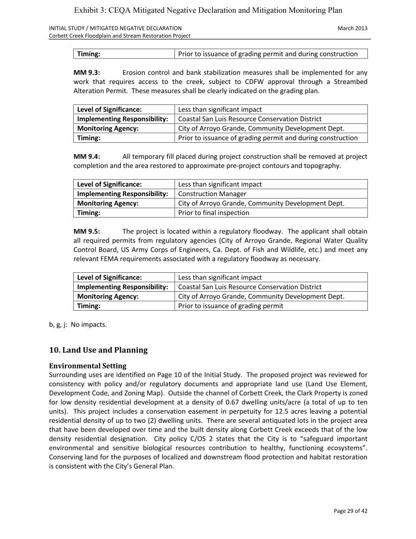
MM 9.3: Erosion control and bank stabilization measures shall be implemented for any
work that requires access to the creek, subject to CDFW approval through a Streambed Alteration Permit. These measures shall be clearly indicated on the grading plan.
Level of Significance: Less than significant impact
Implementing Responsibility: Coastal San Luis Resource Conservation District
Monitoring Agency: City of Arroyo Grande, Community Development Dept.
Timing: Prior to issuance of grading permit and during construction
MM 9.4: All temporary fill placed during project construction shall be removed at project
completion and the area restored to approximate pre-project contours and topography.
Level of Significance: Less than significant impact
Implementing Responsibility: Construction Manager
Monitoring Agency: City of Arroyo Grande, Community Development Dept.
Timing: Prior to final inspection
MM 9.5: The project is located within a regulatory floodway. The applicant shall obtain
all required permits from regulatory agencies (City of Arroyo Grande, Regional Water Quality Control Board, US Army Corps of Engineers, Ca. Dept. of Fish and Wildlife, etc.) and meet any relevant FEMA requirements associated with a regulatory floodway as necessary.
Level of Significance: Less than significant impact
Implementing Responsibility: Coastal San Luis Resource Conservation District
Monitoring Agency: City of Arroyo Grande, Community Development Dept.
Timing: Prior to issuance of grading permit
b, g, j: No impacts.
10. Land Use and Planning
Environmental Setting Surrounding uses are identified on Page 10 of the Initial Study. The proposed project was reviewed for consistency with policy and/or regulatory documents and appropriate land use (Land Use Element, Development Code, and Zoning Map). Outside the channel of Corbett Creek, the Clark Property is zoned for low density residential development at a density of 0.67 dwelling units/acre (a total of up to ten units). This project includes a conservation easement in perpetuity for 12.5 acres leaving a potential residential density of up to two (2) dwelling units. There are several antiquated lots in the project area that have been developed over time and the built density along Corbett Creek exceeds that of the low density residential designation. City policy C/OS 2 states that the City is to “safeguard important environmental and sensitive biological resources contribution to healthy, functioning ecosystems”. Conserving land for the purposes of localized and downstream flood protection and habitat restoration is consistent with the City’s General Plan.
Exhibit 3: CEQA Mitigated Negative Declaration and Mitigation Monitoring Plan
INITIAL STUDY / MITIGATED NEGATIVE DECLARATION March 2013 Corbett Creek Floodplain and Stream Restoration Project
Page 30 of 42
Would the project:
Potentially Significant
Impact
Less Than Significant
with Mitigation
Less Than Significant
Impact No Impact
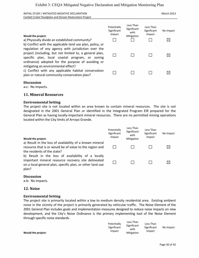
a) Physically divide an established community?
b) Conflict with the applicable land use plan, policy, or regulation of any agency with jurisdiction over the project (including, but not limited to, a general plan, specific plan, local coastal program, or zoning ordinance) adopted for the purpose of avoiding or mitigating an environmental effect?
c) Conflict with any applicable habitat conservation plan or natural community conservation plan?
Discussion a-c: No impacts.
11. Mineral Resources
Environmental Setting The project site is not located within an area known to contain mineral resources. The site is not designated in the 2001 General Plan or identified in the Integrated Program EIR prepared for the General Plan as having locally-important mineral resources. There are no permitted mining operations located within the City limits of Arroyo Grande.
Would the project:
Potentially Significant
Impact
Less Than Significant
with Mitigation
Less Than Significant
Impact No Impact
a) Result in the loss of availability of a known mineral resource that is or would be of value to the region and the residents of the state?
b) Result in the loss of availability of a locally important mineral resource recovery site delineated on a local general plan, specific plan, or other land use plan?
Discussion a-b: No impacts.
12. Noise
Environmental Setting The project site is primarily located within a low to medium density residential area. Existing ambient noise in the vicinity of the project is primarily generated by vehicular traffic. The Noise Element of the 2001 General Plan includes goals and implementation measures designed to reduce noise impacts on new development, and the City’s Noise Ordinance is the primary implementing tool of the Noise Element through specific noise standards.
Would the project:
Potentially Significant
Impact
Less Than Significant
with Mitigation
Less Than Significant
Impact No Impact
Exhibit 3: CEQA Mitigated Negative Declaration and Mitigation Monitoring Plan
INITIAL STUDY / MITIGATED NEGATIVE DECLARATION March 2013 Corbett Creek Floodplain and Stream Restoration Project
Page 31 of 42
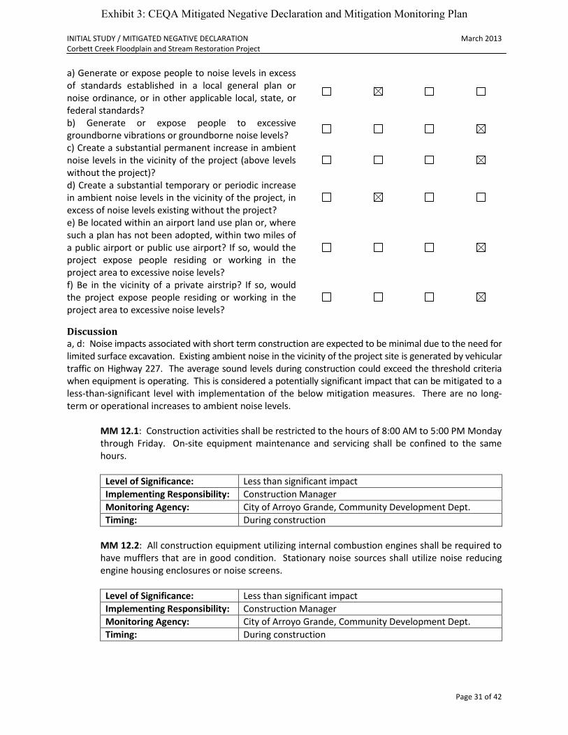
a) Generate or expose people to noise levels in excess of standards established in a local general plan or noise ordinance, or in other applicable local, state, or federal standards?
b) Generate or expose people to excessive groundborne vibrations or groundborne noise levels?
c) Create a substantial permanent increase in ambient noise levels in the vicinity of the project (above levels without the project)?
d) Create a substantial temporary or periodic increase in ambient noise levels in the vicinity of the project, in excess of noise levels existing without the project?
e) Be located within an airport land use plan or, where such a plan has not been adopted, within two miles of a public airport or public use airport? If so, would the project expose people residing or working in the project area to excessive noise levels?
f) Be in the vicinity of a private airstrip? If so, would the project expose people residing or working in the project area to excessive noise levels?
Discussion a, d: Noise impacts associated with short term construction are expected to be minimal due to the need for limited surface excavation. Existing ambient noise in the vicinity of the project site is generated by vehicular traffic on Highway 227. The average sound levels during construction could exceed the threshold criteria when equipment is operating. This is considered a potentially significant impact that can be mitigated to a less-than-significant level with implementation of the below mitigation measures. There are no long-term or operational increases to ambient noise levels.
MM 12.1: Construction activities shall be restricted to the hours of 8:00 AM to 5:00 PM Monday through Friday. On-site equipment maintenance and servicing shall be confined to the same hours.
Level of Significance: Less than significant impact
Implementing Responsibility: Construction Manager
Monitoring Agency: City of Arroyo Grande, Community Development Dept.
Timing: During construction
MM 12.2: All construction equipment utilizing internal combustion engines shall be required to have mufflers that are in good condition. Stationary noise sources shall utilize noise reducing engine housing enclosures or noise screens.
Level of Significance: Less than significant impact
Implementing Responsibility: Construction Manager
Monitoring Agency: City of Arroyo Grande, Community Development Dept.
Timing: During construction
Exhibit 3: CEQA Mitigated Negative Declaration and Mitigation Monitoring Plan
INITIAL STUDY / MITIGATED NEGATIVE DECLARATION March 2013 Corbett Creek Floodplain and Stream Restoration Project
Page 32 of 42
MM 12.3: A note shall be placed on the construction plans that no more than two (2) pieces of major earth moving equipment shall be allowed to operate simultaneously.
Level of Significance: Less than significant impact
Implementing Responsibility: Construction Manager
Monitoring Agency: City of Arroyo Grande, Community Development Dept.
Timing: Prior to issuance of grading permit and during construction
b-c, e-f: No impacts.
13. Population and Housing
Environmental Setting The project site is located within an established low and medium density residential area. Placing 12.5 acres of the roughly 16-acre Clark Property into a conservation easement would appear to reduce the residential development potential. However, because the 12.5-acre property is located within a floodplain area, it is unlikely that housing opportunities are lost. With 3.5 acres remaining of the 16 acre site, two (2) homes could be constructed at a density of 0.67 dwelling units per acre under the Residential Hillside (RH) zoning district. Downstream along the Corbett Creel reach, the only properties with development potential (i.e. vacant) are zoned Village Mixed Use (VMU) and Village Core (VC). These zoning designations allow commercial and residential development. The proposed project would not impede development of these properties.
Would the project:
Potentially Significant
Impact
Less Than Significant
with Mitigation
Less Than Significant
Impact No Impact
a) Induce substantial population growth in an area, either directly (for example, by proposing new homes and businesses) or indirectly (for example, through extension of roads or other infrastructure)?
b) Displace substantial numbers of existing housing, necessitating the construction of replacement housing elsewhere?
c) Displace substantial numbers of people, necessitating the construction of replacement housing elsewhere?
Discussion a-c: No impacts.
14. Public Services
Environmental Setting Public services to the project site are readily provided by the City of Arroyo Grande.
Exhibit 3: CEQA Mitigated Negative Declaration and Mitigation Monitoring Plan

INITIAL STUDY / MITIGATED NEGATIVE DECLARATION March 2013 Corbett Creek Floodplain and Stream Restoration Project
Page 33 of 42
Would the project:
Potentially Significant
Impact
Less Than Significant
with Mitigation
Less Than Significant
Impact No Impact
a) Result in significant environmental impacts from construction associated with the provision of new or physically altered governmental facilities, or the need for new or physically altered governmental facilities, to maintain acceptable service ratios, response times, or other performance objectives for any of the public services:
Fire protection?
Police protection?
Schools?
Parks?
Other public facilities?
Discussion a: No impacts.
15. Recreation
Environmental Setting The project site is a private facility with recreational uses and is not a public facility. The property owner utilizes the site primarily for corralling and grazing horses, with most of the site left in vacant open space. The project will not affect any existing private or public parks within the area, either by creating more demand for parks or diminishing the use of parks.
Would the project:
Potentially Significant
Impact
Less Than Significant
with Mitigation
Less Than Significant
Impact No Impact
a) Increase the use of existing neighborhood and regional parks or other recreational facilities, such that substantial physical deterioration of the facility would occur or be accelerated?
b) Include recreational facilities or require the construction or expansion of recreational facilities that might have an adverse physical effect on the environment?
Discussion a: No impacts. b: The site will continue to serve as an equestrian recreational use. The existing facilities will remain, with some reduction in corral and grazing areas (see Exhibit B above under Background and Need for Project).
Exhibit 3: CEQA Mitigated Negative Declaration and Mitigation Monitoring Plan
INITIAL STUDY / MITIGATED NEGATIVE DECLARATION March 2013 Corbett Creek Floodplain and Stream Restoration Project
Page 34 of 42
16. Transportation/Traffic
Environmental Setting The project site is located within an established low and medium density residential area with access from Highway 227/Carpenter Canyon Road, Corbett Canyon Road, and Tally Ho Road where street parking is available and level of service is acceptable (LOS C or better). The project does not generate any trips that would impact the surrounding street network LOS or the backbone circulation system of the City.
Would the project:
Potentially Significant
Impact
Less Than Significant
with Mitigation
Less Than Significant
Impact No Impact
a) Cause a substantial increase in traffic, in relation to existing traffic and the capacity of the street system (i.e., a substantial increase in either the number of vehicle trips, the volume to capacity ratio on roads, or congestion at intersections)?
b) Exceed, individually or cumulatively, the level of service standards established by the county congestion management agency for designated roads or highways?
c) Cause a change in air traffic patterns, including either an increase in traffic levels or a change in location, that results in substantial safety risks?
d) Contain a design feature (e.g., sharp curves or a dangerous intersection) or incompatible uses (e.g., farm equipment) that would substantially increase hazards?
e) Result in inadequate emergency access?
f) Result in inadequate parking capacity?
g) Conflict with adopted policies, plans, or programs supporting alternative transportation (e.g., bus turnouts, bicycle racks)?
Discussion a-g: No impacts.
17. Utilities and Service Systems
Environmental Setting The project site is located within the incorporated City Limits of Arroyo Grande. Utilities are available from both the City and other regional entities.
Would the project:
Potentially Significant
Impact
Less Than Significant
with Mitigation
Less Than Significant
Impact No Impact
Exhibit 3: CEQA Mitigated Negative Declaration and Mitigation Monitoring Plan
INITIAL STUDY / MITIGATED NEGATIVE DECLARATION March 2013 Corbett Creek Floodplain and Stream Restoration Project
Page 35 of 42
a) Exceed wastewater treatment restrictions or standards of the applicable Regional Water Quality Control Board?
b) Require or result in the construction of new water or wastewater treatment facilities or expansion of existing facilities?
Would the construction of these facilities cause significant environmental effects?
c) Require or result in the construction of new storm water drainage facilities or expansion of existing facilities?
d) Have sufficient water supplies available to serve the project from existing entitlements and resources or are new or expanded entitlements needed?
e) Result in a determination, by the wastewater treatment provider that serves or may serve the project, that it has adequate capacity to service the project’s anticipated demand, in addition to the provider’s existing commitments?
f) Be served by a landfill with sufficient permitted capacity to accommodate the project’s solid waste disposal needs?
g) Comply with federal, state, and local statutes and regulations as they relate to solid waste?
Discussion a-g: No impacts.
Exhibit 3: CEQA Mitigated Negative Declaration and Mitigation Monitoring Plan
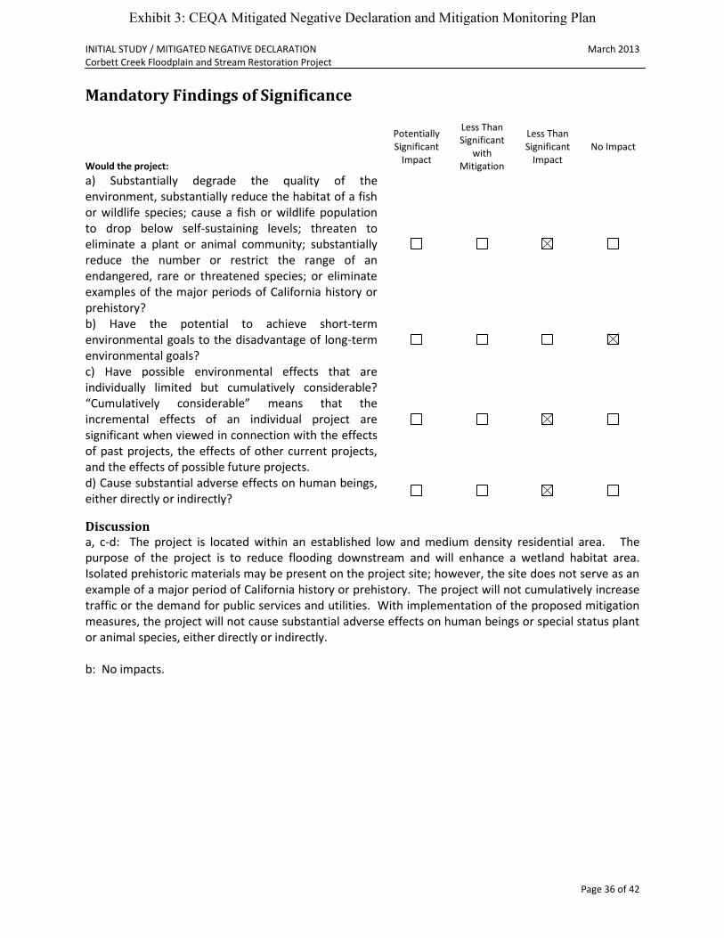
INITIAL STUDY / MITIGATED NEGATIVE DECLARATION March 2013 Corbett Creek Floodplain and Stream Restoration Project
Page 36 of 42
Mandatory Findings of Significance
Would the project:
Potentially Significant
Impact
Less Than Significant
with Mitigation
Less Than Significant
Impact No Impact
a) Substantially degrade the quality of the environment, substantially reduce the habitat of a fish or wildlife species; cause a fish or wildlife population to drop below self-sustaining levels; threaten to eliminate a plant or animal community; substantially reduce the number or restrict the range of an endangered, rare or threatened species; or eliminate examples of the major periods of California history or prehistory?
b) Have the potential to achieve short-term environmental goals to the disadvantage of long-term environmental goals?
c) Have possible environmental effects that are individually limited but cumulatively considerable? “Cumulatively considerable” means that the incremental effects of an individual project are significant when viewed in connection with the effects of past projects, the effects of other current projects, and the effects of possible future projects.
d) Cause substantial adverse effects on human beings, either directly or indirectly?
Discussion a, c-d: The project is located within an established low and medium density residential area. The purpose of the project is to reduce flooding downstream and will enhance a wetland habitat area. Isolated prehistoric materials may be present on the project site; however, the site does not serve as an example of a major period of California history or prehistory. The project will not cumulatively increase traffic or the demand for public services and utilities. With implementation of the proposed mitigation measures, the project will not cause substantial adverse effects on human beings or special status plant or animal species, either directly or indirectly. b: No impacts.
Exhibit 3: CEQA Mitigated Negative Declaration and Mitigation Monitoring Plan
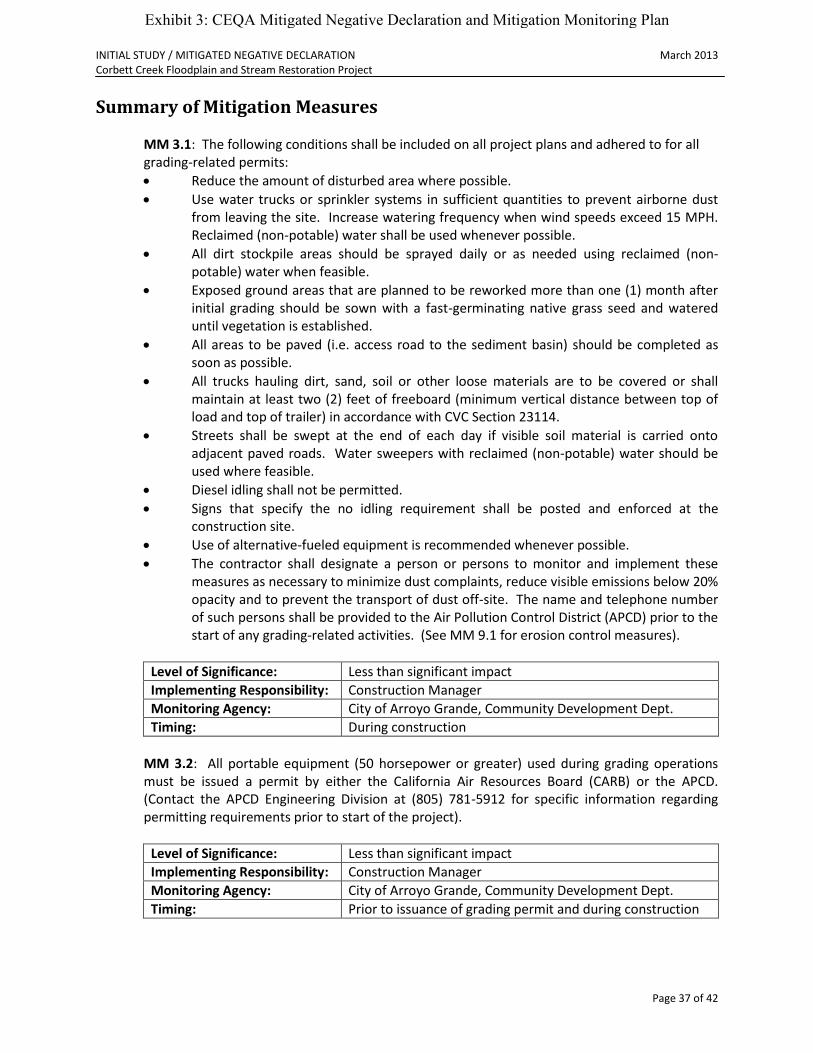
INITIAL STUDY / MITIGATED NEGATIVE DECLARATION March 2013 Corbett Creek Floodplain and Stream Restoration Project
Page 37 of 42
Summary of Mitigation Measures
MM 3.1: The following conditions shall be included on all project plans and adhered to for all grading-related permits:
Reduce the amount of disturbed area where possible.
Use water trucks or sprinkler systems in sufficient quantities to prevent airborne dust from leaving the site. Increase watering frequency when wind speeds exceed 15 MPH. Reclaimed (non-potable) water shall be used whenever possible.
All dirt stockpile areas should be sprayed daily or as needed using reclaimed (non-potable) water when feasible.
Exposed ground areas that are planned to be reworked more than one (1) month after initial grading should be sown with a fast-germinating native grass seed and watered until vegetation is established.
All areas to be paved (i.e. access road to the sediment basin) should be completed as soon as possible.
All trucks hauling dirt, sand, soil or other loose materials are to be covered or shall maintain at least two (2) feet of freeboard (minimum vertical distance between top of load and top of trailer) in accordance with CVC Section 23114.
Streets shall be swept at the end of each day if visible soil material is carried onto adjacent paved roads. Water sweepers with reclaimed (non-potable) water should be used where feasible.
Diesel idling shall not be permitted.
Signs that specify the no idling requirement shall be posted and enforced at the construction site.
Use of alternative-fueled equipment is recommended whenever possible.
The contractor shall designate a person or persons to monitor and implement these measures as necessary to minimize dust complaints, reduce visible emissions below 20% opacity and to prevent the transport of dust off-site. The name and telephone number of such persons shall be provided to the Air Pollution Control District (APCD) prior to the start of any grading-related activities. (See MM 9.1 for erosion control measures).
Level of Significance: Less than significant impact
Implementing Responsibility: Construction Manager
Monitoring Agency: City of Arroyo Grande, Community Development Dept.
Timing: During construction
MM 3.2: All portable equipment (50 horsepower or greater) used during grading operations must be issued a permit by either the California Air Resources Board (CARB) or the APCD. (Contact the APCD Engineering Division at (805) 781-5912 for specific information regarding permitting requirements prior to start of the project).
Level of Significance: Less than significant impact
Implementing Responsibility: Construction Manager
Monitoring Agency: City of Arroyo Grande, Community Development Dept.
Timing: Prior to issuance of grading permit and during construction
Exhibit 3: CEQA Mitigated Negative Declaration and Mitigation Monitoring Plan

INITIAL STUDY / MITIGATED NEGATIVE DECLARATION March 2013 Corbett Creek Floodplain and Stream Restoration Project
Page 38 of 42
MM 4.1: Construction/grading shall take place after the breeding season for the Yellow Warbler (April – July) to limit noise impacts. If construction/grading must start during this time period, surveys of nesting birds within the project vicinity shall be completed by a qualified wildlife biologist. If the surveys identify active nests of the Yellow Warbler within the project vicinity, all earthmoving activities shall cease until the chicks have fledged. The biologist shall provide the lead agency and responsible agencies with a written report of survey findings, and shall specify when the project work may safely commence.
Level of Significance: Less than significant impact
Implementing Responsibility: Construction Manager
Monitoring Agency: City of Arroyo Grande, Community Development Dept.
Timing: Prior to issuance of grading permit
MM 4.2: A qualified wildlife biologist shall complete and submit to the lead agency and responsible agencies a pre-construction survey for California red-legged frogs and Southwestern pond turtles. The survey shall be conducted during the time period when these species are known to be active. If no individuals are found, construction may proceed. If individuals are found during the initial investigation, the biologist shall conduct clearance surveys for these species approximately one (1) week prior to construction. Individuals found within the construction area will either be relocated to similar, adjacent habitats at least fifty (50) yards outside of the project area, or held in captivity until construction is complete. The project area shall be monitored during construction and appropriate measures taken to ensure that the individuals of relocated species do not move into the construction area. The decision of whether to relocate the animals shall be made by the biologist, although all mitigation activities would have to occur within the framework of any permits issued by the USFWS and CDFG.
Level of Significance: Less than significant impact
Implementing Responsibility: Construction Manager
Monitoring Agency: City of Arroyo Grande, Community Development Dept.
Timing: Prior to issuance of grading permit and during construction
MM 4.3: A qualified botanist shall conduct an initial site survey to map occurrence of Hoover’s bent grass, San Bernardino aster and black-flowered figwort. If sensitive plant species are found on site and determined to be potentially impacted, the botanist shall prepare procedures that ensure no net loss of plants. These include, but are not limited to, designating avoidance areas, transplanting the plant populations to an equivalent location on site, or replaced in-kind with new plants at a ratio of two (2) plants replaced for each one (1) lost or at a ratio acceptable to the botanist. The transplanted or replaced plants shall be monitored over a five (5) year period. Any plants lost during this time period shall be replaced. The botanist shall prepare a planting, irrigation and maintenance plan that includes these provisions. If the botanist concludes that avoidance is a viable option, locations determined to be potentially impacted will be flagged against inadvertent or unintentional damage.
Level of Significance: Less than significant impact
Implementing Responsibility: Construction Manager
Monitoring Agency: City of Arroyo Grande, Community Development Dept.
Timing: Prior to issuance of grading permit
Exhibit 3: CEQA Mitigated Negative Declaration and Mitigation Monitoring Plan

INITIAL STUDY / MITIGATED NEGATIVE DECLARATION March 2013 Corbett Creek Floodplain and Stream Restoration Project
Page 39 of 42
MM 4.4: The applicant shall acquire appropriate resource agency permits and undertake protection measures as required by those agencies.
Level of Significance: Less than significant impact
Implementing Responsibility: Coastal San Luis Resource Conservation District
Monitoring Agency: City of Arroyo Grande, Community Development Dept.
Timing: Prior to issuance of grading permit
MM 5.1: In the event that prehistoric cultural materials or historic cultural materials are encountered, work in the immediate vicinity of the finds shall be suspended until reviewed by an archaeologist, and the City shall be notified immediately should such resources be discovered. The archaeologist shall work as quickly as possible to permit resumption of construction activities. It is preferred that location data of finds be recorded using a hand-held global positioning system (GPS) receiver. If human remains are encountered and determined to be Native American in origin, the San Luis Obispo County coroner will notify the Native American Heritage Commission (NAHC) within 24 hours of the find. The NAHC shall identify the person or persons it believes to be the most likely descendent of the deceased Native American. The most likely descendent may make recommendations for means of treating or disposing of the human remains and any associated grave goods as provided in Public Resources Code Section 5097.98.
Level of Significance: Less than significant impact
Implementing Responsibility: Construction Manager
Monitoring Agency: City of Arroyo Grande, Community Development Dept.
Timing: During construction
MM 5.2: The note below shall be placed on the grading and improvement plans for the project: “If human remains (burials) are encountered, the County Coroner shall be contacted immediately (805-781-4513). In the event that previously unidentified potentially significant cultural resources are discovered, an archaeologist shall have the authority to divert or temporarily halt ground disturbance operations in the area of discovery to allow evaluation of potentially significant cultural resources in consultation with Northern Chumash Tribal Council. For significant cultural resources, a Research Design and Data Recovery Program to mitigate impacts shall be prepared by the consulting archaeologist and approved by the City, then carried out using professional archaeological methods. If it can be demonstrated that a project will cause damage to a unique archaeological resource, the City may require reasonable efforts to be made to permit any or all of these resources to be preserved in place or left in an undisturbed state.”
Level of Significance: Less than significant impact
Implementing Responsibility: Construction Manager
Monitoring Agency: City of Arroyo Grande, Community Development Dept.
Timing: Prior to issuance of grading permit
Exhibit 3: CEQA Mitigated Negative Declaration and Mitigation Monitoring Plan
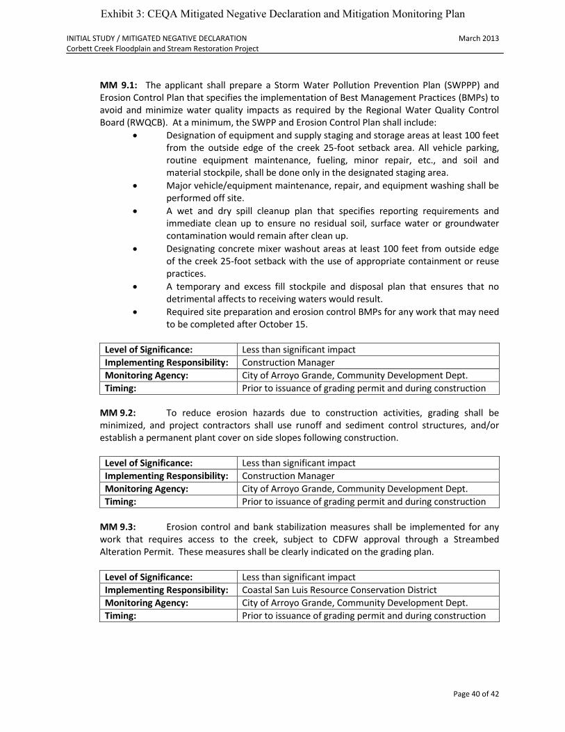
INITIAL STUDY / MITIGATED NEGATIVE DECLARATION March 2013 Corbett Creek Floodplain and Stream Restoration Project
Page 40 of 42
MM 9.1: The applicant shall prepare a Storm Water Pollution Prevention Plan (SWPPP) and Erosion Control Plan that specifies the implementation of Best Management Practices (BMPs) to avoid and minimize water quality impacts as required by the Regional Water Quality Control Board (RWQCB). At a minimum, the SWPP and Erosion Control Plan shall include:
Designation of equipment and supply staging and storage areas at least 100 feet from the outside edge of the creek 25-foot setback area. All vehicle parking, routine equipment maintenance, fueling, minor repair, etc., and soil and material stockpile, shall be done only in the designated staging area.
Major vehicle/equipment maintenance, repair, and equipment washing shall be performed off site.
A wet and dry spill cleanup plan that specifies reporting requirements and immediate clean up to ensure no residual soil, surface water or groundwater contamination would remain after clean up.
Designating concrete mixer washout areas at least 100 feet from outside edge of the creek 25-foot setback with the use of appropriate containment or reuse practices.
A temporary and excess fill stockpile and disposal plan that ensures that no detrimental affects to receiving waters would result.
Required site preparation and erosion control BMPs for any work that may need to be completed after October 15.
Level of Significance: Less than significant impact
Implementing Responsibility: Construction Manager
Monitoring Agency: City of Arroyo Grande, Community Development Dept.
Timing: Prior to issuance of grading permit and during construction
MM 9.2: To reduce erosion hazards due to construction activities, grading shall be minimized, and project contractors shall use runoff and sediment control structures, and/or establish a permanent plant cover on side slopes following construction.
Level of Significance: Less than significant impact
Implementing Responsibility: Construction Manager
Monitoring Agency: City of Arroyo Grande, Community Development Dept.
Timing: Prior to issuance of grading permit and during construction
MM 9.3: Erosion control and bank stabilization measures shall be implemented for any
work that requires access to the creek, subject to CDFW approval through a Streambed Alteration Permit. These measures shall be clearly indicated on the grading plan.
Level of Significance: Less than significant impact
Implementing Responsibility: Coastal San Luis Resource Conservation District
Monitoring Agency: City of Arroyo Grande, Community Development Dept.
Timing: Prior to issuance of grading permit and during construction
Exhibit 3: CEQA Mitigated Negative Declaration and Mitigation Monitoring Plan

INITIAL STUDY / MITIGATED NEGATIVE DECLARATION March 2013 Corbett Creek Floodplain and Stream Restoration Project
Page 41 of 42
MM 9.4: All temporary fill placed during project construction shall be removed at project completion and the area restored to approximate pre-project contours and topography.
Level of Significance: Less than significant impact
Implementing Responsibility: Construction Manager
Monitoring Agency: City of Arroyo Grande, Community Development Dept.
Timing: Prior to final inspection
MM 9.5: The project is located within a regulatory floodway. The applicant shall obtain
all required permits from regulatory agencies (City of Arroyo Grande, Regional Water Quality Control Board, US Army Corps of Engineers, Ca. Dept. of Fish and Wildlife, etc.) and meet any relevant FEMA requirements associated with a regulatory floodway as necessary.
Level of Significance: Less than significant impact
Implementing Responsibility: Coastal San Luis Resource Conservation District
Monitoring Agency: City of Arroyo Grande, Community Development Dept.
Timing: Prior to issuance of grading permit
MM 12.1: Construction activities shall be restricted to the hours of 8:00 AM to 5:00 PM Monday through Friday. On-site equipment maintenance and servicing shall be confined to the same hours.
Level of Significance: Less than significant impact
Implementing Responsibility: Construction Manager
Monitoring Agency: City of Arroyo Grande, Community Development Dept.
Timing: During construction
MM 12.2: All construction equipment utilizing internal combustion engines shall be required to have mufflers that are in good condition. Stationary noise sources shall utilize noise reducing engine housing enclosures or noise screens.
Level of Significance: Less than significant impact
Implementing Responsibility: Construction Manager
Monitoring Agency: City of Arroyo Grande, Community Development Dept.
Timing: During construction
MM 12.3: A note shall be placed on the construction plans that no more than two (2) pieces of major earth moving equipment shall be allowed to operate simultaneously.
Level of Significance: Less than significant impact
Implementing Responsibility: Construction Manager
Monitoring Agency: City of Arroyo Grande, Community Development Dept.
Timing: Prior to issuance of grading permit and during construction
Exhibit 3: CEQA Mitigated Negative Declaration and Mitigation Monitoring Plan
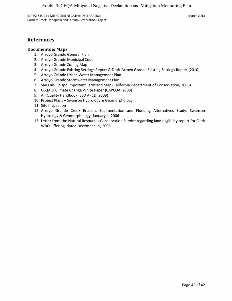
INITIAL STUDY / MITIGATED NEGATIVE DECLARATION March 2013 Corbett Creek Floodplain and Stream Restoration Project
Page 42 of 42
References
Documents & Maps 1. Arroyo Grande General Plan 2. Arroyo Grande Municipal Code 3. Arroyo Grande Zoning Map 4. Arroyo Grande Existing Settings Report & Draft Arroyo Grande Existing Settings Report (2010) 5. Arroyo Grande Urban Water Management Plan 6. Arroyo Grande Stormwater Management Plan 7. San Luis Obispo Important Farmland Map (California Department of Conservation, 2006) 8. CEQA & Climate Change White Paper (CAPCOA, 2008) 9. Air Quality Handbook (SLO APCD, 2009) 10. Project Plans – Swanson Hydrology & Geomorphology 11. Site Inspection 12. Arroyo Grande Creek Erosion, Sedimentation and Flooding Alternatives Study, Swanson
Hydrology & Geomorphology, January 4, 2006 13. Letter from the Natural Resources Conservation Service regarding land eligibility report for Clark
WRO Offering, dated December 19, 2006
Exhibit 3: CEQA Mitigated Negative Declaration and Mitigation Monitoring Plan