Embed Size (px)
Citation preview

February 2013
NEP: SASEC Road Connectivity Project
Mechipul-Chandraghadi-Birtamod Subproject
Prepared by the Department of Road, Ministry of Physical Planning, Works and Transport Management for the Asian Development Bank.
Initial Environmental Examination

ii
CURRENCY EQUIVALENTS
(as of 21 February 2013) Currency unit – Nepalese rupee (NR)
NR1.00 – $ 0.0115340254 $1.00 – NR86.700000
ABBREVIATIONS
AADT Average Annual Daily Traffic AC Asphaltic Concrete ADB Asian Development Bank ADF Asian Development Fund ADT Average Daily Traffic AIDS Acquired Immune Deficiency Syndrome amsl Above Mean Sea Level AP Affected People ARI Acute Respiratory Infection BOD Biological Oxygen Demand B.S. Bikram Sambat ºC Degree Celsius CBOs Community Based Organizations CBR California Bearing Ratio CBS Central Bureau of Statistics CDMA Code Division Multiple Access CF Community Forest CFUG Community Forest User Group ch Chainage CITES Convention on International Trade in Endangered Species CMVC Classified Manual Vehicle Counts CO Carbon Monoxide COI Corridor of Impact CR Critically Endangered DBST Double Bituminous Surface Treatment DCP Dynamic Cone Penetrometer DDC District Development Committee DFID Department for International Development, UK DG Diesel Generating DFO District Forest Office DoHM Department of Hydrology and Metrology DHO District Health Office DHs District Hospitals DNPWC Department of National Parks and Wildlife Conservation DOF Department of Forest DOLIDAR Department of Local Infrastructure Development and Agricultural Roads DOR Department of Roads DSC Design and Supervision Consultant DUDBC Department of Urban Development and Building Construction EA Executing Agency EAG Environmental Assessment Guidelines EFDRP Emergency Flood Damage Rehabilitation Project - ADB EIA Environmental Impact Assessment EMG Environment Management Guidelines EMP Environmental Management Plan EMoP Environmental Monitoring Plan

iii
EN Endangered EPA Environment Protection Act EPR Environmental Protection Rules ES Environmental Specialist ESMF Environmental and Social Management Framework EWH East-West Highway FGD Focus Group Discussion FIDIC Federation International Des Ingenieurs-Conseils FM Frequency Modulation FS Feasibility Study FUG Forest User Group FY Fiscal Year GESU Geo-Environmental and Social Unit GHG Green House Gases GON Government of Nepal HFT Himalayan Frontal Thrust HH Household HMGN His Majesty Government of Nepal HIV Human Immunodeficiency Virus I Indeterminate IA Implementing Agency ICIMOD International Centre for Integrated Mountain Development IEE Initial Environmental Examination IUCN International Union for Conservation of Nature ISRC Intensive Study and Research Centre JICA Japan International Co-operative Agency Km Kilometer LC Least Concern LR Lower Risk LPG Liquefied Petroleum Gas LRMP Land Resource Mapping Project m Metre masl meters above sea level mm milimeter MCT Main Central Trust MoFSC Ministry of Forest and Soil Conservation MHH Mid-Hill Highway MoEnv Ministry of Environment MoPPW Ministry of Physical Planning and Works MRM Mahendra Raj Marg NAAQS Nepal Ambient Air Quality Standard NEP Nepal NGO Non Government Organization NH National Highway NOx Nitrogen Oxide NPC National Planning Commission NPWC National Parks and Wildlife Conservation nt Near Threatened NTFPs Non-timber Forest Products OD Origin-Destination OHS Occupational Health and Safety PD Project Directorate PPE Personal Protective Equipment PIP Priority Investment Plan PIU Project Implementation Unit
iv
PPMO Public Procurement Monitoring Office PPTA Project Preparatory Technical Assistance RCC Reinforced Cement Concrete RCP Road Connectivity Project - ADB RCSP Road Connectivity Sector Project - ADB REA Rapid Environmental Assessment RIP Road Improvement Project- DOR RNDP Road Network Development Project - ADB ROW Right of Way RRRSDP Rural Rehabilitation and Reconstruction Sector Development Project – ADB RSDP Road Sector Development Project – WB SC Supervision Consultant SD Surface Dressing SDC Social Development Consultant SEA Strategic Environmental Assessment SPS Safeguard Policy Statements SRCP SASEC Road Connectivity Project STD Sexually Transmitted Disease STEP Sub-regional Transport Enhancement Project – ADB TA Technical Assistance TMO Transport Management Office TOR Terms of Reference TPPF Transport Project Preparation Facility – ADB WECS Water and Energy Commission Secretariat UN United Nations UNESCO United Nations Educational, Scientific and Cultural Organization VDC Village Development Committee VU Vulnerable ZOI Zone of Influence
WEIGHTS AND MEASURES
dBA decibels A KWH Kilowatt-Hour K VA Kilo-Volt- Ampere MLd Millions of Litres Per
Day ppb Parts Per Billion pph Persons Per Hectare ppm Parts Per Million
NOTES
(i) The Nepalese calendar year (B.S) runs from mid April to mid April. Unless otherwise stated, year ranges written in the form 2011/012 denote a single calendar year.
(ii) The fiscal year (FY) of the Government ends on 15 July. FY before a calendar Year denotes the year in which the fiscal year ends.
(iii) Acts and Regulations are cited under the name of the ministry from which they originate. The official version of Acts and Regulations is published in the Nepal Gazette (in Nepali). Some Acts and Regulations are published by other Government agencies in English (Unofficial translations).
This initial environmental examination is a document of the borrower. The views expressed

v
herein do not necessarily represent those of ADB's Board of Directors, Management, or staff, and may be preliminary in nature. Your attention is directed to the “terms of use” section of this website. In preparing any country program or strategy, financing any project, or by making any designation of or reference to a particular territory or geographic area in this document, the Asian Development Bank does not intend to make any judgments as to the legal or other status of any territory or area.

vi
CONTENTS EXECUTIVE SUMMARY .................................................................................................... vii I. INTRODUCTION ....................................................................................................... 1
A. Project Background/Rationale ........................................................................ 1 B. Purpose of the Study ..................................................................................... 3 C. Extent of IEE .................................................................................................. 3 D. IEE Report Content ........................................................................................ 3 E. Methods Adopted to Prepare the IEE Report ................................................. 3 F. Sources of Information and Data .................................................................... 4 G. Public Consultation ........................................................................................ 4
II. POLICY, LEGAL AND ADMINISTRATIVE FRAMEWORK ....................................... 6 A. ADB Safeguard Policy Statement, 2009 ......................................................... 6 B. Nepal‟s Legal Framework and Regulatory Requirements for the Project ........ 6 C. Guidelines for the Road Sector .................................................................... 10 D. International Conventions and Treaties ........................................................ 11 E. Permissions and Clearance Required for the Project ................................... 12
III. DESCRIPTION OF THE PROJECT ........................................................................ 14 A. The SASEC Road Connectivity Project (SRCP) ........................................... 14 B. The Menchipul-Chandragadhi-Birtamod Road ............................................. 14 C. Key Upgrading Activities ................................................................................ 4 D. Materials Required and Sourcing ................................................................... 5 E. Project Implementation Schedule and Cost.................................................... 5 F. Category of the Project .................................................................................. 5
IV. DESCRIPTION OF THE ENVIRONMENT ................................................................. 7 A. Physical Resources ....................................................................................... 7 B. Ecological Resources .................................................................................... 9 C. Economic Development ............................................................................... 11 D. Social and Cultural Resources ..................................................................... 12
V. ANTICIPATED ENVIRONMENTAL IMPACTS AND MITIGATION MEASURES .... 15 A. Impact on Physical Environment .................................................................. 15 B. Ecological Resources .................................................................................. 23
VI. PUBLIC CONSULTATION AND INFORMATION DISCLOSURE ........................... 28 A. Consultation Method and Information Disclosed .......................................... 28 B. Compliance with Relevant Regulatory Requirements ................................... 28 C. Information Disclosure ................................................................................. 29
VII. ENVIRONMENTAL MANAGEMENT PLAN AND GRIEVANCE READDRESSAL MECHANISM ...................................................................................................................... 30
A. Environmental Management Plan ................................................................ 30 B. Environmental Monitoring Programme (EMoP) ............................................ 30 C. Institutional Setting and Proposed Implementation Arrangement ................. 30 D. Grievance Re-dress Mechanism .................................................................... 0
VIII. CONCLUSION AND RECOMMENDATION ................................................................ 52 IX. SELECTED REFERENCES .................................................................................... 53
Appendixes: Appendix A: REA Appendix B: Environmental Management Plan Appendix C: Environmental Monitoring Plan Appendix D: NAAQS Appendix E: Noise Quality Standard Appendix F: Drinking Water and Irrigation Water Quality Standards Appendix G: Borrow Pit Management Guideline
vii
EXECUTIVE SUMMARY
A. Introduction
1. The proposed SASEC Road Connectivity Project (SRCP) will finance improvements of two strategic high-priority highways and three feeder roads, a total of 186 km, in the eastern region of Nepal. These would be important as to provide an alternate road for the East-West Highway (EWH) and improve access to rural and hilly areas as well as to non-connected district headquarters. While the Project will contribute to development and expansion of the Strategic Road Network (SRN), it will include an institutional capacity assessment, specifically including road safety and road maintenance, which will form the basis for a capacity development program.
2. The project roads are: (i) EWH-Koshi Bridge1 (Chatara)-EWH (61-km two-lane highway), providing alternate route for EWH in case of closure of the main Koshi Bridge in Sunsari District, whose substructures are prone to damages by floods; (ii) Leguwaghat-Bhojpur Road (66-km intermediate-lane mid-hill highway), providing a connection as part of improvement to Hile-Pakhribas-Leguwaghat-Bhojpur Road, one of the major linkages along MHC; (iii) Halesi-Diktel Road (35-km intermediate-lane mid-hill highway) linking Diktel with the Hilepani-Hilesi section, which is being improved under Road Improvement Project funded by EXIM Bank of India, to complete Hilepani-Diktel Linkage of MHC. (iv) Mechipul-Chandragadhi-Birtamod Road (12-km double-lane feeder road) providing connection between EWH at Birtamod and a new bridge under construction across Mechi River, which will connect to NH31 in India and NH5 in Bangladesh; and (v) Manthali-Ramechhap Road (13-km single-lane feeder road) providing a connection between the new Ramechhap District headquarters at Manthali in the Tamakoshi River valley and the old town of Ramechhap and former headquarters. The project roads were selected from over 80 roads identified by the Department of Roads (DOR), for improvement based on their environmental, social and economic impacts.
B. Policy, Legal and Administrative Framework
3. The ADB SPS, 2009 aims to avoid, minimise or mitigate harmful environmental and social impacts and help the borrower strengthen their safeguard system. It also provides a platform for participation by affected community in project design and implementation.
4. All roads proposed to be upgraded under the SASEC Road Connectivity Project (SRCP) were screened and categorized using Rapid Environmental Assessment (REA). The REA consist of questions relating to: (i) the sensitivity and vulnerability of environmental resources in the project area, and (ii) the potential for the project to cause significant adverse environmental impacts.
5. All project roads under the SRCP were classified as Category “B” except for EWH-Koshi Bridge (Chatara)-EWH road which is categorized as “A”. This IEE was preared for the proposed Menchipul-Chandragadhi-Birtamod Road upgading.
C. Description of Menchipul-Birtamod Section
6. The Mechipul-Chandragadhi-Birtamod (12.160 km) starts at Jhapa Chowk, at the cross-road of Mechi Highway in the Bhadrapur Bus Stand and ends at Birtamod bazaar. It
1 The longest crossing structure in Nepal linking the major eastern provinces to the rest of the country through EWH in
Sunsari District of Koshi Province.
viii
traverses agricultural land and settlement/market areas. The key upgrading activities are: geometry improvement, pavement upgrading, drainage improvement, installation of retaining structures; slope protection/stabilization, off-road works, and traffic management and road safety.
D. Description of Environment
7. The project area is located falls in the tropical region of Nepal with a high annual rainfall of 2,540 mm. In general, the soils of project area are predominantly developed by the alluvial fan, apron complex. Geologically, the road corridor consists of main sediments of Gangetic Plain. Basically, sand, silt and clay are the main sediments along the road corridor. The road alignment lies close to the Himalayan Frontal Thrust (HFT).
8. The road alignment does not pass through any forest area. However, the road corridor contains a variety of birds some of which are protected under the National Parks and Wildlife Conservation Act, 1973 or falls under the various IUCN categories and CITES appendices.
9. Agriculture is the major source of economic development in the project district and the agriculture system is the well-developed. The project district is the pocket area for the production of tea. The project area does not contain any renowned religious, cultural, archaeological and historical sites.
E. Anticipated Environmental Impacts and Mitigation Measures
10. The significant impacts during construction are air quality deterioration due to increase in fugitive dust emissions from materials hauling and unloading, ground shaping, hot mix plant operation, quarry operation, and unpaved road travel. Nuisance to nearby residents due to increase in noise from heavy equipment operation, hindrance in accessibility to common property resources, and increase in traffic on road sections where construction is on-going. Land use conversion from agricultural or residential to built-up area (road) due to expansion of road right-of-way adequate for an intermediate-lane carriageway. Surface water quality deterioration of the rivers and rivulets, and siltation of waterways from silt-laden surface runoff coming from the construction site. Health and safety risk due to increase in heavy equipment traffic particularly to children and near pedestrian crossing points. During operation stage, the main impact may be on the surface water hydrology since the construction of a road across several river/rivulets in the flood-affected sections can act as impediment to natural flow of water.
11. Other than the permanent change in land use, all identified impacts are short-duration and co-terminus with the construction stage, and are easy to mitigate. All private lands that will be converted, including structures that will be relocated will be justly compensated in compliance to existing laws.
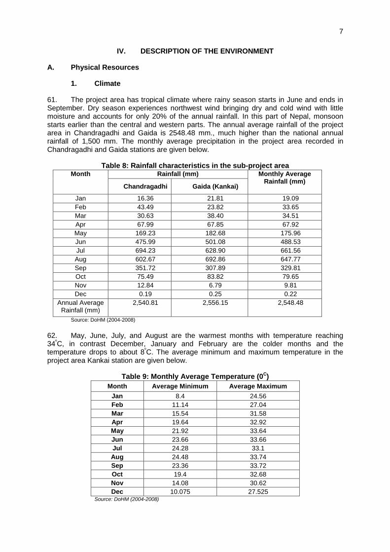
Public Consultation and Information Disclosure 12. Extensive consultations were held with stakeholders‟ that includes local and beneficiary population, government departments/agencies, fishermen, road users and NGOs. Discussions were documented and findings and recommendations were presented to the design engineers to serve as guide. Several recommendations were incorporated in the environmental management and monitoring plans. This IEE report will be disclosed in the DOR and ADB websites in compliance to the ADB Safeguard Policy Statement (2009).

ix
F. Conclusion and Recommendation
13. The IEE study of the proposed Mechipul-Chandragadhi-Birtamod road project reveals that the identified environmental impacts will occur in limited areas only and mainly during construction period. The implementation of proposed mitigation measures for identified adverse impacts will minimize as well as mitigate the adverse impacts on environment. The Resettlement Plan and compensation to the affected people should be ensured. Therefore, this IEE study is sufficient for approval of the proposed project, and recommended for implementation with incorporation of mitigation measures and environmental monitoring plan in the bid documents.

1
I. INTRODUCTION
A. Project Background/Rationale
1. The proposed SASEC Road Connectivity Project (SRCP) will finance improvements of two strategic high-priority highways and three feeder roads, a total of 186 km, in the eastern region of Nepal. These would be important as to provide an alternate road for the East-West Highway (EWH) and improve access to rural and hilly areas as well as to non-connected district headquarters. While the Project will contribute to development and expansion of the Strategic Road Network (SRN), it will include an institutional capacity assessment, specifically including road safety and road maintenance, which will form the basis for a capacity development program.
2. The Project is consistent with the Government's transport strategy and development plans. Nepal's Three Year Interim Plan (TYIP) 2007/08-2009/10 emphasizes on continuous development of SRN and strengthening EWH, while the proceeding plan, the Three Year Plan Approach Paper (TYPAP) 2010/11-2012/13, aims to (i) connect the regional centers and all 75 district headquarters (ii) complete the Mid-Hill East-West Corridor (MHC) and (iii) strengthen the system of regular maintenance and management of road structures by providing regular maintenance of 8,300 km. and periodic maintenance of 1,500 km. roads. The Sector Wide Road Program (SWRP), Priority Investment Plan (PIP) and, SRN, currently calls for the expansion of the country‟s road improvement program from 7,917 km of the country's total road length of 18,828 km, to 9,900 km by 2016.
3. The project roads are: (i) EWH-Koshi Bridge2 (Chatara)-EWH (61-km two-lane highway), providing alternate route for EWH in case of closure of the main Koshi Bridge in Sunsari District, whose substructures are prone to damages by floods; (ii) Leguwaghat-Bhojpur Road (66-km intermediate-lane mid-hill highway), providing a connection as part of improvement to Hile-Pakhribas-Leguwaghat-Bhojpur Road, one of the major linkages along MHC; (iii) Halesi-Diktel Road (35-km intermediate-lane mid-hill highway) linking Diktel with the Hilepani-Halesi section, which is being improved under Road Improvement Project funded by EXIM Bank of India, to complete Hilepani-Diktel Linkage of MHC. (iv) Mechipul-Chandragadhi-Birtamod Road (12-km double-lane feeder road) providing connection between EWH at Birtamod and a new bridge under construction across Mechi River, which will connect to NH31 in India and NH5 in Bangladesh; and (v) Manthali-Ramechhap Road (13-km single-lane feeder road) providing a connection between the new Ramechhap District headquarters at Manthali in the Tamakoshi River valley and the old town of Ramechhap and former headquarters. The project roads were selected from over 80 roads identified by the Department of Roads (DOR), for improvement based on their environmental, social and economic impacts.
4. The outputs will be (i) upgrading of 62 km of single-lane tracks to 2-lane national highways, (ii) upgrading of 114 km of single-lane earth roads to intermediate-lane and single-lane Mid-Hill Highway, (iii) upgrading of 12 km of intermediate-lane feeder road to double-lane feeder road, and (iii) capacity assessment and recommendation for enhancement of DOR and RBN‟s capacity in road safety and road maintenance, respectively.
5. The proposed road improvement will provide better access between EWH at Birtamod and the new bridge under construction across the Mechi River, connecting NH31 in India to NH5 in Bangladesh. The bridge project includes construction of a 0.6 km approach road through the centre of Bhadrapur.
2 The longest crossing structure in Nepal linking the major eastern provinces to the rest of the country through EWH in
Sunsari District of Koshi Province.

2
Figure 1: Map for Nepal SASEC Road Connectivity Project
Source: TPPF Feasibility Study, 2010
6. Bhadrapur Municipality is a commercial centre and an emerging city. At present, the road connects the EWH at Birtamod with Chandragadhi and Bhadrapur. The road is sealed with most of its length having a carriageway of 5.5 m except for a 0.5 km section in Birtamod that has been widened to 14.5 m with footpaths. The main purpose of the road improvement is to provide a two lane highway connection between the EWH at Birtamod to Bhadrapur and extend it to Mechi

3
River where a new bridge is under construction. This road will connect to NH-31 in India and NH-5 in Bangladesh and will help in cross-border/ regional transportation between these countries and Nepal.
B. Purpose of the Study
7. Objectives: The main objective of the IEE study is to identify the impacts from the construction and operation of the Proposal on the physical, biological, socio-economic and cultural environments of the project area. The IEE study recommends practical and site specific environmental mitigation and enhancement measures, prepare and implement environmental monitoring plan and make sure that IEE is sufficient for the proposed road project.
8. Need: This IEE is a requirement of the ADB for environmental Category B projects like the upgrading of the Menchipul-Birtamod Road and the report conforms with the provisions of the Environmental Assessment Guidelines, 2003; and Safeguard Policy Statement, 2009 of ADB.
C. Extent of IEE
9. This IEE covers the proposed upgrading of the project road including ancillary facilities like camp, quarry, material storage, and plant operations. This IEE Report was prepared based on the information and data available through the engineering design studies including socio-economic and resettlement studies; and field visits, public consultations and discussions, collection of primary and secondary information and data. The study has established a core zone of impact for 100 metres on either side of the existing road.
D. IEE Report Content
10. The IEE has been prepared based on the requirements of the Environment Protection Act (EPA), 1996 and Environment Protection Rules (EPR), 1997 of the Government of Nepal (GON), and the ADB Safeguard Policy Statement (SPS), 2009. The content covers following eight chapters, including this introduction chapter:
Chapter-1: Introduction Chapter-2: Policy, Legal and Administrative Framework Chapter-3: Description of Project Chapter-4: Description of Environment Chapter-5: Anticipated Impacts and Mitigation Measures Chapter-6: Public Consultation and Information Disclosure, Chapter-7: Environmental Management Plan and Grievance Redress
Mechanism Chapter-8: Conclusion and Recommendation
E. Methods Adopted to Prepare the IEE Report
11. Appropriate methods were applied to accomplish the IEE study. The ADB Safeguard Policy Statement (2009) and ADB Environmental Assessment Guidelines (2003) were reviewed for outlining the contents of the study. Then, the relevant documents were collected and reviewed for the study purpose. Information and data pertaining to all components of environment namely, physical, biological and socio-economic and cultural environment were gathered through both the primary and secondary sources. The stepwise activities comprise:
Consultation with DOR, ADB Directorate, GESU/DOR, MoPPW officials
Review of ADB and GON policy including legal requirements
Project visits and consultation with affected people and stakeholders including primary information collection
4
Review of ADB TA 7411-NEP:RCP Final Reports including Supplementary Appendices
Review of relevant documents for secondary information and data collection
Preparation of updated IEE Draft Report and submit to ADB and GON for comments and feedback
Preparation of Final IEE Report incorporating ADB and GON comments and feedbacks
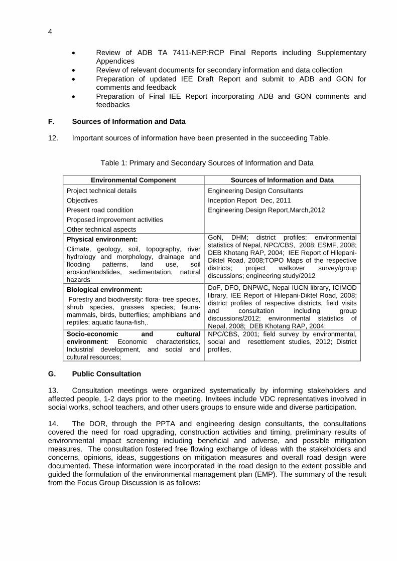
F. Sources of Information and Data
12. Important sources of information have been presented in the succeeding Table.
Table 1: Primary and Secondary Sources of Information and Data
Environmental Component Sources of Information and Data
Project technical details
Objectives
Present road condition
Proposed improvement activities
Other technical aspects
Engineering Design Consultants
Inception Report Dec, 2011
Engineering Design Report,March,2012
Physical environment:
Climate, geology, soil, topography, river hydrology and morphology, drainage and flooding patterns, land use, soil erosion/landslides, sedimentation, natural hazards
GoN, DHM; district profiles; environmental statistics of Nepal, NPC/CBS, 2008; ESMF, 2008; DEB Khotang RAP, 2004; IEE Report of Hilepani-Diktel Road, 2008;TOPO Maps of the respective districts; project walkover survey/group discussions; engineering study/2012
Biological environment:
Forestry and biodiversity: flora- tree species, shrub species, grasses species; fauna- mammals, birds, butterflies; amphibians and reptiles; aquatic fauna-fish,.
DoF, DFO, DNPWC, Nepal IUCN library, ICIMOD library, IEE Report of Hilepani-Diktel Road, 2008; district profiles of respective districts, field visits and consultation including group discussions/2012; environmental statistics of Nepal, 2008; DEB Khotang RAP, 2004;
Socio-economic and cultural environment: Economic characteristics, Industrial development, and social and cultural resources;
NPC/CBS, 2001; field survey by environmental, social and resettlement studies, 2012; District profiles,
G. Public Consultation
13. Consultation meetings were organized systematically by informing stakeholders and affected people, 1-2 days prior to the meeting. Invitees include VDC representatives involved in social works, school teachers, and other users groups to ensure wide and diverse participation.
14. The DOR, through the PPTA and engineering design consultants, the consultations covered the need for road upgrading, construction activities and timing, preliminary results of environmental impact screening including beneficial and adverse, and possible mitigation measures. The consultation fostered free flowing exchange of ideas with the stakeholders and concerns, opinions, ideas, suggestions on mitigation measures and overall road design were documented. These information were incorporated in the road design to the extent possible and guided the formulation of the environmental management plan (EMP). The summary of the result from the Focus Group Discussion is as follows:

5
Table 2: Summary of Consultations for Mechipul-Chandragadhi-Birtamod Road Upgrading Location VDC/
Municipality Date No. of
Participants Issues Raised
Anarmani Ward no. 3; Jhapa
Anarmani 13
February
2012
12 Suggested for effective compensation of land and houses including other private properties. Suggested for protection of community facilities Cash compensation has been demanded for building structures and standing crops It was suggested that existing road is very unsafe for local people and settlements are on both sides of the road and need to cross the road very frequently by the people for daily activities. Good drainage system in market, settlements area protection of water sources has been demanded. Expressed need for pedestrian path at bazaar areas.
Bhadrapur, Jhapa
Bhadrapur 11
February
2012
5

6
II. POLICY, LEGAL AND ADMINISTRATIVE FRAMEWORK
A. ADB Safeguard Policy Statement, 2009
15. The ADB SPS, 2009 aims to avoid, minimize, or mitigate harmful environmental and social impacts and help the borrower strengthen their safeguard system. It also provides a platform for participation by affected community in project design and implementation.
16. All roads proposed to be upgraded under the SASEC Road Connectivity Project (SRCP) were screened and categorized using Rapid Environmental Assessment (REA). The REA consist of questions relating to: (i) the sensitivity and vulnerability of environmental resources in the project area, and (ii) the potential for the project to cause significant adverse environmental impacts. These roads are then classified into one of the following categories:
Category A. Projects with potential for significant adverse environmental impacts. An Environmental Impact Assessment (EIA) is required to address significant impacts.
Category B. Projects judged to have some adverse environmental impacts, but of lesser degree and/or significance than those for category A projects. An IEE is required to determine whether or not significant environmental impacts warranting an EIA are likely. If an EIA is not needed, the IEE is regarded as the final environmental assessment report.
Category C. Projects unlikely to have adverse environmental impacts. No EIA or IEE is needed although environmental implications are still reviewed.
17. All project roads under the SRCP were classified as Category “B” except for EWH-Koshi Bridge (Chatara)-EWH road which is categorized as “A” due to its proximity to the Koshi Tappu Wildlife Reserve.
18. All ADB investments are subject to an environmental assessment to address environmental impacts and risks. The environmental assessment starts with screening and categorization; followed by baseline data collection, impact analysis, environmental management planning, information disclosure, consultation and participation, grievance redressal mechanism development, EMP implementation, and reporting.
B. Nepal’s Legal Framework and Regulatory Requirements for the Project
19. In Nepal, various legal instruments are in place to ensure the integration of environmental aspects in development proposals. This IEE reviewed the following legislative provisions and environmental guidelines to ensure compliance of the Project.
1. Policies
a. Interim Constitution of Nepal, 2007 (with latest amendments)
20. The Interim Constitution of Nepal provisions the right for every person to live in a clean environment. Article 35[5] also provisions that the State shall make necessary arrangements to maintain the natural environment. The State shall give priority to special protection of the environment, and rare wildlife, and prevent further damage due to physical development activities, by increasing awareness of the general public about environmental cleanliness.
b. The Tenth Plan (2002-2007)
21. The Tenth Plan (2002-2007) has identified EIA as a priority area, and it emphasizes on environmental monitoring of the projects that are under GoN EIA process. The Plan focuses on

7
the need for setting-up national environmental standards with the strategy of internalizing environmental management into the development programmes. The Plan has also realized to carry out Strategic Environmental Assessment (SEA) with the long term policy of promoting environmental governance. The Plan emphasized on the local participation in environment conservation, according to the Local Self Governance Act 2055, through the local bodies and making them responsible and capable to manage local natural resources.
c. Three Year Interim Plan (2007/08 - 2009/010)
22. One of the objectives of the Transport sector is to develop the identified eight trade and transit corridors between neighbouring Countries India and China. Other objective of the transport sector related to the project is to develop and operate safe roads by suitable road safety and traffic management activities including raising public awareness on such activities.
23. The environmental strategies of the Interim Plan are to launch development programs by internalizing environmental management; mobilize non-government private sector, local agencies and the public in increasing public awareness on environment; determine and implement additional by - Laws on air, water, soil and sound pollution; and by making action plans prioritize and implement Treaties and Conventions on environment, which Nepal has endorsed.
24. One of the policies of the Interim Plan is to institutionalize the environmental monitoring auditing through an effective implementation of approved environmental reports (IEE and EIA).
25. National Transport Policy, 2001/2002: The goal of the policy is to develop a reliable, cost effective, safe facility oriented and sustainable transport system that promotes and sustains the economic, social, cultural and tourism development of the Kingdom of Nepal as a whole.
26. Forest Policy: The Ministry of Forests and Soil Conservation (2009) also requires that all the costs related to the clearing off the forest, its transportation to the approved location and works related to environmental mitigation shall be borne by the project itself.
2. Acts and Rules
a. Environment Protection Act, 1996
27. The Environment Protection Act, 1996 and Environment Protection Rules, 1997 (as amended) contain several provisions to institutionalize the integration of environmental aspects in development projects including road sector, and empowers Ministry of Environment approve EIA report. Similarly, in case of IEE level study, line Ministry, which is Ministry of Physical Planning and Works is authorized to approve the Final IEE Report.
28. The Act recognizes the interdependence between development and the environment and shows the concerns for minimizing the impacts of environmental degradation on people, animal, and plant species and their physical surroundings. The Act obliges the proponent to undertake IEE and EIA of proposal, plans or projects which may cause changes in existing environmental condition and authorizes Ministry of Environment to clear all EIA and line Ministry for IEE study,
29. Empowers Ministry of Environment to prohibit the use of any matter, fuel, equipment or plant, which has adverse effects on the environment. The Act has provisions for polluters to compensate affected persons from polluting activities and empowers government to provide additional incentives to any industry, occupation, technology or process, which has positive impacts on environmental conservation. It provides the establishment of an Environmental Protection Fund to be used for environmental protection, pollution control and heritage conservation, and it gives the government authority to declare specific area as environmentally protected areas.
8
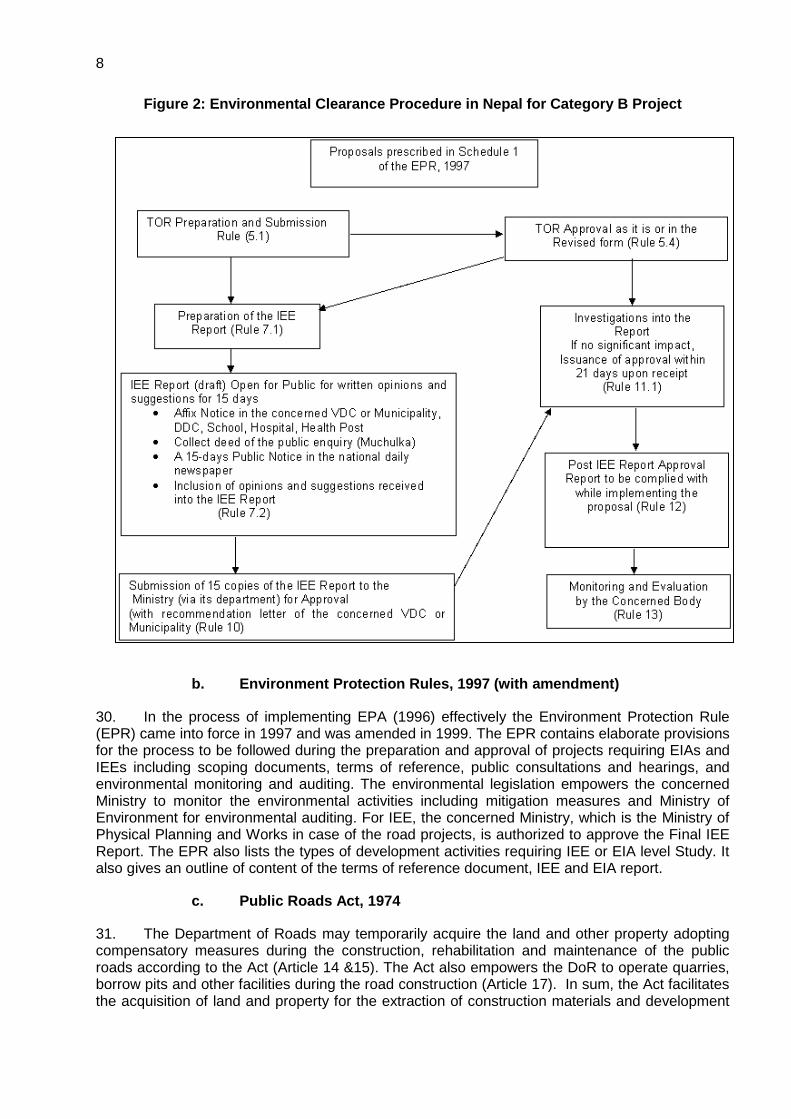
Figure 2: Environmental Clearance Procedure in Nepal for Category B Project
b. Environment Protection Rules, 1997 (with amendment)
30. In the process of implementing EPA (1996) effectively the Environment Protection Rule (EPR) came into force in 1997 and was amended in 1999. The EPR contains elaborate provisions for the process to be followed during the preparation and approval of projects requiring EIAs and IEEs including scoping documents, terms of reference, public consultations and hearings, and environmental monitoring and auditing. The environmental legislation empowers the concerned Ministry to monitor the environmental activities including mitigation measures and Ministry of Environment for environmental auditing. For IEE, the concerned Ministry, which is the Ministry of Physical Planning and Works in case of the road projects, is authorized to approve the Final IEE Report. The EPR also lists the types of development activities requiring IEE or EIA level Study. It also gives an outline of content of the terms of reference document, IEE and EIA report.
c. Public Roads Act, 1974
31. The Department of Roads may temporarily acquire the land and other property adopting compensatory measures during the construction, rehabilitation and maintenance of the public roads according to the Act (Article 14 &15). The Act also empowers the DoR to operate quarries, borrow pits and other facilities during the road construction (Article 17). In sum, the Act facilitates the acquisition of land and property for the extraction of construction materials and development

9
of other facilities as well as to maintain greenery along the roadside with adoption of compensatory measures.
d. Forest Act, 1993 (with amendments)
32. The Forest Act, 1993 recognizes the importance of forests in maintaining a healthy environment. The Act requires decision makers to take account of all forest values, including environment services and biodiversity, not just production of timber and other commodities. The basis of Act is resource oriented rather than use oriented.
33. The Forest Act, 1993, (with amendment) contains several provisions to ensure the development, conservation, management and sustainable use of forest resources, based on approved work plan. The work plan should contain a list of activities that should be implemented in the different forest categories - national forests, community forests, leasehold forests, private forests, and religious forests. Section 23 of the Act empowers the government to delineate any part of the national forest, which has „special environmental, scientific or cultural importance‟, as a protected forest. Section 49 of the Act prohibits reclaiming lands, setting fires, grazing cattle, removing and damaging forest products, felling trees of plants, wildlife hunting and extracting boulders sand and soil from the National forest without the prior approval. However, the government may enforce Section 68 of the Forest Act to provide parts of any type of forest for the implementation of a national priority plan with the assurance that it does not adversely affect the environment significantly. As provisioned under the Act, while clearing the forest on the RoW of road, the implementing authority will co-ordinate with the District Forest Office. If necessary, the compensatory re-plantation will also be carried out at the rate of 1:25 under the provision of the Act.
e. Forest Rule, 1995
34. The Forest Rules 1995 (with amendment) further elaborate legal measures for the conservation of forests and wildlife. Based on forest legislation, thirteen plant species are included in the level protection list. Of them, GoN has banned the felling, transportation and export of Champ (Michelia champaca), Khayer (Acacia catechu) and Sal (Shorea robusta). The Rule also stipulates that the entire expenses for cutting and transporting the forest products in a forest area to be used by the approved project shall be borne by the proponent of the project.
f. Forest Products Collection and Sales Distribution Guidelines, 2001
35. Clause 3 to 10 of the Guideline have specified various procedure and formats for getting approvals for vegetation clearance, delineation of lands for vegetation clearance, evaluation of the wood volume etc. and government offices and officials responsible for the approval, delineation and valuation.
g. Local Self-Governance Act, 1999
36. The Local Self-Governance Act, 1999 empowers the local bodies for the conservation of soil, forest, and other natural resources and implementation of environmental conservation activities. The Village Development Committees (VDCs), Municipalities and District Development Committees (DDCs) are mandated to take up the responsibilities for the formulation and implementation of a programme relating to the protection of the environment and biodiversity, and to give adequate priority for the protection of the environment during the formulation of local level plans and programme.
h. Land Acquisition Act, 1977
37. The Land Acquisition Act (1977, as amended 1993) guides the compulsory acquisition of land. GoN can acquire land at any place and in any quantity by giving compensation pursuant to
10
the Act for the land acquired for any public purpose(s) or for operation of any development project initiated by GoN institutions
i. Soil and Watershed Conservation Act, 1982
38. Soil and Watershed Conservation Act makes provision to control floods landslides (watershed conservation rules, 1985). The watershed conservation office is authority and district watershed conservation committee must implement watershed conservation practices and public participation for soil and land protection.
j. Water Resources Act, 1992
39. Water resources act (1992) makes provision for the rational use of surface and underground water. The act seeks to prevent environment and hazardous effects from the use of water and prohibit water pollution by chemicals, industries waste. Water may only be used in manner that does not permit soil erosion, landslide or flood. Pollution of drinking water is prohibited under the Nepal drinking water corporation act (1989).
3. The Aquatic Animal Protection Act, 1961 (with amendment)
40. This Act indicates an early recognition of the value of wetlands and aquatic animals. Section 3 renders punishment to any party introducing poisonous, noxious or explosive materials into a water source, or destroying any dam, bridge or water system with the intent of catching or killing aquatic life. Under Section 4 of the Act, Government is empowered to prohibit catching, killing and harming of certain kinds of aquatic animals by notification in Nepal Gazette.
4. Motor Vehicle and Transportation Management Act, 1993
41. This act sets standard for vehicles emission and mechanical condition for vehicle registration by the Transport Management Office (TMO) and the TMO can deny a permit based on environmental factor. Standard are set for petrol and diesel engine under the Nepal Vehicle Mass Emission Standard,1999.
C. Guidelines for the Road Sector
42. Guidelines, including the draft EIA Guidelines for Road Sector, 1996, facilitate the proponents to prepare environmental assessment reports. These guidelines have been thoroughly reviewed and all pertinent issues have been incorporated during the preparation of this Report. The DOR Environmental Management Guidelines (EMG), 1997 provides guidance to the Proponent to integrate environmental mitigation measures, particularly on the management of quarries, borrow pits, stockpiling of materials and spoil disposal, earthworks and slope stabilization, location of stone crushing plants, etc. The Environmental Guidelines for Local Development also encourages the Proponent to incorporate environmental issues during project design and implementation.
1. Environmental Management Guidelines, GESU/DoR
43. Originally, a Unit was set up in 1988 as the Environmental Management Coordination Unit of the DoR to support the Arun Access Road for the proposed Arun-III Hydropower Project and reformed as a permanent cell under Planning & Design Branch with a new name as Geo-Environment Unit (GEU) in the year 1994.
44. In 2005, DoR, in its Master Plan for Strategic Road Network, stressed on development of road to supplement Poverty Reduction Program. After the initiation of implementation of enhancing poverty reduction impacts in some road projects in 2006, assisted by Asian

11
Development Bank (ADB), the role of GEU was further expanded to incorporate the social aspects of road development projects. Thus DoR has renamed GEU into Geo- Environmental & Social Unit (GESU) to cover the social aspect and render prompt and efficient services with the development & strengthening of the roads.
45. Environmental Management Guidelines, GESU/DOR, July 1999 have been prepared as part of the program undertaken jointly by GoN and the World Bank under the Road Maintenance and Rehabilitation Project. These Guidelines were formally approved by Minister level decision on Kartik 22, 2053 BS (1997). The Guidelines are the part of operational practices for all road maintenance, rehabilitation and construction activities under DoR. The guideline consists of environmental mitigation measures to be incorporated into DOR Sub-projects, procedures for public participation, and socio-economic considerations. The environmental mitigation measures are broken down into twelve categories including (i) quarries; (II) borrow pits; (iii) spoil and construction waste disposal; (iv) work camp location and operation; (v) labour camp location and operation (vi) earthwork/slope stabilization (vii) use of bitumen (viii) stockpiling of materials (ix) explosive, combustible and toxic materials management (x) setting up and operation of stone crushing plants (xi) water management (xii) air and water pollution.
46. Implementation methods for undertaking mitigation measures for each of the activities are also given in the guideline. The Guideline suggests methods for determining how and when the public should be included in the environmental analysis. The guidelines also advise on socio-economic impacts and strategies for reducing or avoiding the potential negative impacts and for maximizing the beneficial impacts to local residents. The socio-economic impacts include important issues of land acquisition and compensation and other economic impacts with markets for agriculture production, agriculture inputs, nutrition, extraction of natural resources beyond replenishment, migration and influx of migrants, land speculation, illegal logging and mining, portering, etc. It also includes impacts on cultural heritage.
47. The Environmental and Social Management Framework (ESMF), DoR/GESU, 2008 The Environmental and Social Management Framework (ESMF) is prepared to compile in an overview and guidance manner, various safeguard and compliance aspects of environmental and social issues related with the road construction and development.
48. The ESMF intends to provide technical and managerial inputs and guidance into the design of the strategic roads (both designated for rehabilitation and, to lesser extent, to new construction), through identification of key environmental and social issues related to the foreseen projects, mitigate potential impacts and concerns and, devise opportunities to enhance the benefits. The framework integrates in a step-wise approach the most important environmental and social considerations into all stages of project preparation, implementation, monitoring and operation.
2. Other Guidelines and Manuals
49. The following guidelines were reviewed and applied during the preparation of the report:
Reference Manual for Environmental and Social Aspects of Integrated Road Development; MoPPW/DoR.HMGN,2003
Environmental Management Guidelines for Roads and Bridges,GEU/DoR,1997
Public Work Directives, HMGN,2002
Guide to Road Slope Protection Works, DoR D. International Conventions and Treaties
50. Nepal is a signatory to many international agreements, conventions etc. related to environmental conservation:

12
The Basel Convention on the Control of Transboundary Movements of Hazardous Wastes and Their Disposal, 1989
The Vienna Convention for Protection of Ozone Layer, 1985
UN Framework Convention on Climate Change, 1992
The Agreement on the Network of Aquaculture Centres in Asia and the Pacific, 1988
The Plant Protection Agreement for the South East Asia and the Pacific (as amended), 1956,
The Convention on International Trade in Endangered Species of Wild Fauna and Flora, (CITES), 1973
The Ramsar Convention (Convention on Wetlands of International Importance Especially as Water Fowl Habitat), 1971
The Convention for Protection of the World Cultural and Natural Heritage, 1972
The UN Convention to Combat Desertification, 1994
E. Permissions and Clearance Required for the Project
51. The legal framework of the country consists of several acts, notifications, rules, and regulations to protect environment and wildlife. List of required clearances / permissions related to environment has been summarized in Table 3.

13
Table 3: Permissions and Clearance Required
S.N. Clearance Act/Rule/Notification/Guideline Concerned
Agency Responsibility
A. Pre-construction Stage
1
Environmental Clearance (categorized as “B” with IEE requirement)
Environment Protection Act 1996 and Environment Protection Rules, 1997 (with amendments).
Ministry of Physical Planning and Works
Department of Roads / PD, DOR (ADB)
2 Land Acquisition and Compensation
Land Acquisition Act , 1977(with amendments)
Ministry of Physical Planning and Works
Department of Roads / PD, DOR (ADB)
3
Forestry clearance for felling of Trees
Forest Act, 1993 (with amendment), Forest Rule, 1995, Forest Products Collection and Sales Distribution Guidelines, 2001 and Local Self-Governance Act, 1999
Ministry of Forest and Soil Conservation
Department of Roads / PD, DOR (ADB)
B. Implementation Stage
4
Permission for construction material quarrying (stone, cobble, sand, gravel, soil etc)
Local Self-Governance Act, 1999 and Soil and Watershed Conservation Act, 1982 and Watershed Conservation Rule, 1985. EPA,1996 and EPR, 1997 (with amendments)
Concerned Project and Concerned VDC, DDC and Municipality
Contractor
5
Consent to operate Hot mix plant, Crushers, Batching Plant
Local Self-Governance Act, 1999 Concerned Project and Concerned VDC, DDC and Municipality
Contractor
6
Consent for disposal of sewage from labour camps
Water Resource Act, 1992 Concerned Project Contractor
7 Pollution Under Control Certificate
Motor Vehicle and Transportation Management Act, 1993
Department of Transport
Contractor
Source: TPPF Consultants (2012)

14
III. DESCRIPTION OF THE PROJECT
A. The SASEC Road Connectivity Project (SRCP)
52. The proposed SASEC Road Connectivity Project (SRCP) will finance improvements of two strategic high-priority highways and three feeder roads, a total of 186 km, in the eastern region of Nepal. These would be important as to provide an alternate road for the East-West Highway (EWH) and improve access to rural and hilly areas as well as to non-connected district headquarters. While the Project will contribute to development and expansion of the Strategic Road Network (SRN), it will include an institutional capacity assessment, specifically including road safety and road maintenance, which will form the basis for a capacity development program. Gender and social inclusion will be addressed through a livelihood program that will include special support that will be targeting women involved in road construction activities in the project area.
53. The project roads are: (i) EWH-Koshi Bridge3 (Chatara)-EWH (61-km two-lane highway), providing alternate route for EWH in case of closure of the main Koshi Bridge in Sunsari District, whose substructures are prone to damages by floods; (ii) Leguwaghat-Bhojpur Road (66-km intermediate-lane mid-hill highway), providing a connection as part of improvement to Hile-Pakhribas-Leguwaghat-Bhojpur Road, one of the major linkages along MHC; (iii) Halesi-Diktel Road (35-km intermediate-lane mid-hill highway) linking Diktel with the Hilepani-Halesi section, which is being improved under Road Improvement Project funded by EXIM Bank of India, to complete Hilepani-Diktel Linkage of MHC. (iv) Mechipul-Chandragadhi-Birtamod Road (12-km double-lane feeder road) providing connection between EWH at Birtamod and a new bridge under construction across Mechi River, which will connect to NH31 in India and NH5 in Bangladesh; and (v) Manthali-Ramechhap Road (13-km single-lane feeder road) providing a connection between the new Ramechhap District headquarters at Manthali in the Tamakoshi River valley and the old town of Ramechhap and former headquarters. The project roads were selected from over 80 roads identified by the Department of Roads (DOR), for improvement based on their environmental, social and economic impacts.
B. The Menchipul-Chandragadhi-Birtamod Road
54. The Mechipul-Chandragadhi-Birtamod road has a total length of 12.16 km located in Jhapa district of the eastern development region of Nepal. The road alignment passes through one municipality and 3 VDCs of the district. The road provides connectivity to settlements, market centres, the Indian border,4 and EWH on Birtamod. The salient features of the road upgrading are shown in below.
Table 4: Salient Features of the Sub-Project
Name of the Project SASEC Road Connectivity Project
Name of the Road Section Mechipul-Chandragadhi-Birtamod
Road
LOCATION
Start Point Sangam Chowk
End Point Birtamod Bazar
3 The longest crossing structure in Nepal linking the major eastern provinces to the rest of the country through EWH in Sunsari
District of Koshi Province. 4 after completion of Mechi Bridge

15
Municipality and VDCs
Bhadrapur; and Chandragadhi, Garamani and Anarmani
GEOGRAPHICAL FEATURES
Terrain Plain
Alignment Plain
Altitude 85 to 125 masl
Climate Tropical
Road Type
Classification of road Feeder Road (Two Lane)
Length of Road 12.16 km
Type of Pavement DBST
Standard of Pavement Overseas Road Note 31 (RN 31)
and/or AASHTO design method
Design Parameters
Design Speed 80-100 (max) km/hr
Right of Way 50 m
Carriageway Width 7 m
Total Formation (Road Way) Width 13 m
Shoulder Width 3 m
Camber of Carriage way 3%
Camber of Shoulder 4%
Minimum Horizontal Curve Radius 220%
Minimum Length of Vertical Curve
Maximum Grade Change 0.5-0.6 %
Minimum Length of Vertical Curve 50-60 m
Gradient
Maximum Gradient 5 %
Exceptional Gradient 5 %
Maximum Gradient at Bridge Approach 5%
Maximum Average Gradient 3%
Minimum Length of Recovery at Grade Specified
600@2%
Hairpin Bends:

16
Design Speed
20 km/hr
Min. spacing between centers of bends 200 m
Maximum Gradient 3.5%
Minimum Gradient 0.5 %
Maximum super elevation 7%
Minimum Radius of Curve 14 m
55. The road starts at Jhapa Chowk, south end of Bhadrapur and runs along north-south direction and ending at Biratmod on EWH. Road sections are in various pavement conditions: poor within first 4.5 km from Bhadrapur-to Chandragadhi characterized by partial to heavy distress, and fair to poor onward. The existing road is flat to gentle in grade. About 16% of road length has single lane carriageway and rest about 84 % intermediate lane. Table 5 shows further details on existing situation and identification of upgrading requirements.


0
Figure 3: Location Map

1
Table 5: Identification of Upgrading Requirements of the Road Section Chainage Description of Existing Situation Identification of Upgrading Requirements Type of Upgrading Works
1 0+000 to 1+380
(Jhapa Chowk to Sang am Chowk)
Road starts at Jhapa Chowk, at the cross-road
of Mechi Highway (Chaaraali-Kechana sector)
with road to Bhadrapur Bus Stand, straight
alignment going along west side of Bhadrapur,
road formation low to moderate, susceptible to
flooding between (ch 0+000 to 0+295) and
drainage problem between (ch 0+433 to
0+535), formation width variable (5.1-8.7 m,
average 6.9 m), grade flat to gentle, single
lane carriageway, pavement surface
distressed and damaged at places (e.g.
drainage/flooding problem area), shoulder in
poor condition.
- Geometry (widening, localized profile
raising)
- Drainage - Pavement
- Earthworks for widening and
formation raising, reshaping and
grade adjustment
- Relocation of monument at Bhang Chowk and removal of roundabout or extra widening
- Drainage (e.g. along built-up fronts) - Widening/reconstruction of culverts - Pavement reconstruction or
widening + strengthening existing - Traffic signs, safety measures
2 1+380 to 2+210
(Sang am Chowk-Sagarmatha Chowk)
Road formation on shallow to medium high
embankment, formation width variable (6.7-
11.3 m, average 8.9 m, wide at Sagarmatha
Chowk), grade flat to gentle, carriageway –
intermediate lane, pavement surface
distressed, shoulder in poor condition,
drainage poor (e.g. prone to flooding at
Sagarmatha Chowk)
- Geometry (minor refinement, widening)
- Drainage - Pavement
- Earthworks for widening, reshaping
- Removal of roundabout at Sagaramatha Chowk to ease traffic and drainage management
- Drainage (e.g. along built-up fronts) - Widening/reconstruction of culverts - Pavement reconstruction or
widening + strengthening existing - Traffic signs, safety measures
3 2+210 to 3+900
(Sagarmatha Chowk-Mahendra Chowk)
Road formation on shallow to medium high
embankment, formation width variable (7.2-
10.6 m, average 9.1 m), narrow at culverts,
grade flat to gentle but steep at culvert,
carriageway – intermediate lane, pavement
surface distressed, shoulder-gravel and earth,
fair to poor condition, drainage poor (e.g.
- Geometry (minor refinement, widening,
localized profile raising )
- Drainage - Pavement - Road junctions
- Earthworks for formation widening,
reshaping, localized profile raising
- Drainage (e.g. along built-up fronts) - Widening/reconstruction of culverts - Pavement reconstruction or
widening + strengthening existing - Repairs at junctions - Traffic signs, safety measures
2
Section Chainage Description of Existing Situation Identification of Upgrading Requirements Type of Upgrading Works
prone to occasional flooding between ch
3+350 to 3+500).
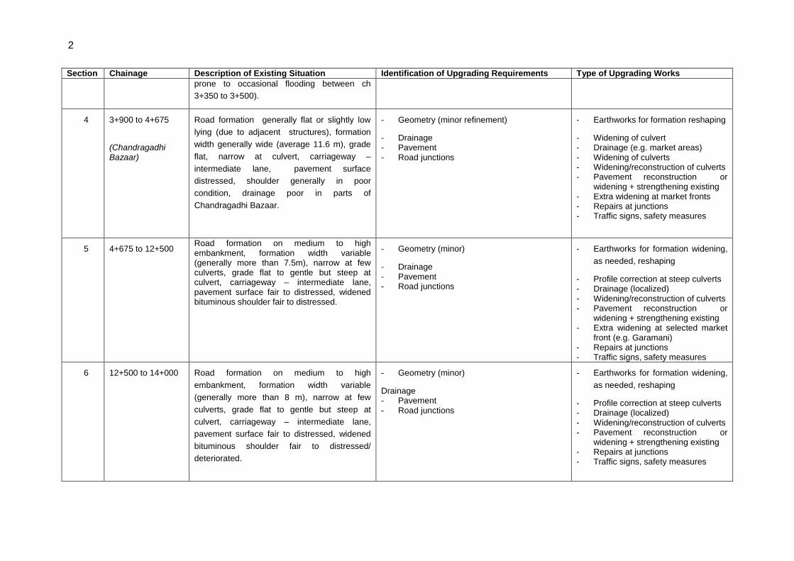
4 3+900 to 4+675
(Chandragadhi Bazaar)
Road formation generally flat or slightly low
lying (due to adjacent structures), formation
width generally wide (average 11.6 m), grade
flat, narrow at culvert, carriageway –
intermediate lane, pavement surface
distressed, shoulder generally in poor
condition, drainage poor in parts of
Chandragadhi Bazaar.
- Geometry (minor refinement)
- Drainage - Pavement - Road junctions
- Earthworks for formation reshaping
- Widening of culvert - Drainage (e.g. market areas) - Widening of culverts - Widening/reconstruction of culverts - Pavement reconstruction or
widening + strengthening existing - Extra widening at market fronts - Repairs at junctions - Traffic signs, safety measures
5 4+675 to 12+500 Road formation on medium to high embankment, formation width variable (generally more than 7.5m), narrow at few culverts, grade flat to gentle but steep at culvert, carriageway – intermediate lane, pavement surface fair to distressed, widened bituminous shoulder fair to distressed.
- Geometry (minor)
- Drainage - Pavement - Road junctions
- Earthworks for formation widening,
as needed, reshaping
- Profile correction at steep culverts - Drainage (localized) - Widening/reconstruction of culverts - Pavement reconstruction or
widening + strengthening existing - Extra widening at selected market
front (e.g. Garamani) - Repairs at junctions - Traffic signs, safety measures
6 12+500 to 14+000 Road formation on medium to high
embankment, formation width variable
(generally more than 8 m), narrow at few
culverts, grade flat to gentle but steep at
culvert, carriageway – intermediate lane,
pavement surface fair to distressed, widened
bituminous shoulder fair to distressed/
deteriorated.
- Geometry (minor)
Drainage - Pavement - Road junctions
- Earthworks for formation widening,
as needed, reshaping
- Profile correction at steep culverts - Drainage (localized) - Widening/reconstruction of culverts - Pavement reconstruction or
widening + strengthening existing - Repairs at junctions - Traffic signs, safety measures
3
Section Chainage Description of Existing Situation Identification of Upgrading Requirements Type of Upgrading Works
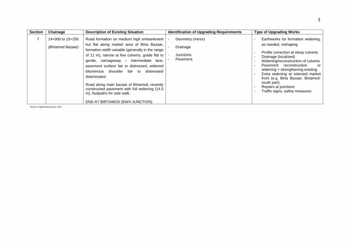
7 14+000 to 15+250
(Birtamod Bazaar)
Road formation on medium high embankment
but flat along market area of Birta Bazaar,
formation width variable (generally in the range
of 11 m), narrow at few culverts, grade flat to
gentle, carriageway – intermediate lane,
pavement surface fair to distressed, widened
bituminous shoulder fair to distressed/
deteriorated.
Road along main bazaar of Birtamod, recently constructed pavement with full widening (14.5 m), footpaths for side walk. END AT BIRTAMOD (EWH JUNCTION)
- Geometry (minor)
- Drainage
- Junctions - Pavement
- Earthworks for formation widening,
as needed, reshaping
- Profile correction at steep culverts - Drainage (localized) - Widening/reconstruction of culverts - Pavement reconstruction or
widening + strengthening existing - Extra widening at selected market
front (e.g. Birta Bazaar, Birtamod-south part)
- Repairs at junctions - Traffic signs, safety measures
Source: Engineering Survey, 2012

4
56. Summary of the existing and proposed works (drainage and retaining) structures of the proposed project is presented in below.
Table 6: Summary of Existing and Proposed Works
SN Particulars Total, Km 3-15.160
Existing Road Works
1 Side Drains 6719
Lined Side Drains, (m) 1674
2 Cross Drainage Structures 0
Pipe Culverts, (no)
Causeway, (no) 22
Requiring Repair and Rehabilitation 22
Pipe Culverts, (no) 0
Causeway, (no)
3 Retaining Structures 19
Retaining Structures (all types), (m) 16
Requiring Repair and Rehabilitation, (no) 0
Proposed Works for road upgrading
1 Side Drains
Lined Side Drains, (m) 7915
2 Cross Drainage Structures
Pipe Culvert , (no) 0
Causeway, (no) 0
3 Retaining Structures 212
Retaining Structures (all types, no) 0
Source: Engineering Survey, 2012
C. Key Upgrading Activities
57. The key upgrading activities are: geometry improvement, pavement upgrading, drainage improvement, installation of retaining structures; slope protection/stabilization, off-road works, and traffic management and road safety. Typical cross-sections of the Terai roads are given in Figure 4.
Geometry Improvement: Involves widening of road width to 13 m to meet the design standards including structures along religious and cultural sites, markets centres and built-up areas. To enhance serviceability of road, hard stand parking/stopping vehicles and drainage will be provided. These proposed location and length of widening are shown in the succeeding Table.

5
Table 7: List of Road Widening at Markets and Built-up Area
SN Chainage Location Detail
Start End
1 3+875 4+160 Mahendra Chowk Pavement widening to 13m
2 4+160 4+675 Lekhnath Chowk
3 8+100 8+200 Chalise Chowk
4 9+800 9+900 Harchana
5 11+700 12+025 Garamani
6 15+620 15+246 Birtamod Source: Consultant's Survey, 2012
Pavement upgrading: Strengthening, resurfacing and new construction on re-aligned sections.
Drainage Improvement: Improvement of side drains, natural drainage systems, culverts and causeways. Several road sections are susceptible to flooding and drainage problem at ch 0+000 to 0+295, ch. 0+433 ,ch. 0+535. ch 3+350 to 3+500 along the 3+900 to 4+675 along the Chandragadi bazar. Overtopping problem exists between chainage 15+000 and 15+250.
Road Safety Measures: Provision of signs, delineators, barriers and pavement markings, minor realignment at identified black spots including pedestrian foot paths in market areas. The project has proposed for installation of 16 posts, 48 traffic signs and 400 delineators.
Bridges: There are 4 existing bridges along this road. The Devaniya Bridge has 7.5m wide carriageway with sidewalks are provided on both sides. Other 3 bridges have intermediate lane carriageway without sidewalks. The overall condition of bridge is satisfactory. No new bridge is required along this road.
D. Materials Required and Sourcing
58. The major sources of surface dressing chips are Ratuwa Khola about 9 km north of Damak, Chisang Khola about 15 km west of Urlabari and, Gachiya Khola about 4 km east of Itahari. Base course material and concrete aggregate could be obtained by selection technique and double cone crushing of cobbles and gravels from Hardiya Khola, Timai Khola, and Biring Khola along the EWH. At present crusher plants are under construction at Hadiya Khola and Biring Khola. Coarse sand and stone for masonry works could be obtained from the above mentioned Kholas. Major source of sand could be from various points at Mechi River.
E. Project Implementation Schedule and Cost
59. The implementation of SRCP is expected to start on 2013 and the project road will take 18 months to complete followed by a 12 months defect liability period. The total estimated base cost for the road upgrading is US$1.69 M. The cost of implementing dust and noise mitigation, provision of personal protective equipment, compensatory plantation, and bio-engineering is US$22,984.
F. Category of the Project
60. The Asian Development Bank‟s Roads and Highways-Rapid Environmental Assessment (REA) Checklist (Appendix A) along with the Project/Site Description were prepared in September, 2010. The project road alignment passes through the ridges of cultivated bari (upland cultivated), forests, grazing land, settlements/villages/bazaar, and others (rock-out crops and rivulets). The project area does not fall under any sensitive areas

6
- world heritage sites; ecologically sensitive and wetland area; national park, wildlife reserve and conservation area, hunting reserves. The anticipated impacts through improvement of the proposed road are minor, local, short term and reversible. The upgrading of Menchipul-Chandragadhi-Birtamod upgrading project is classified as Category- B in accordance with ADB`s Safeguard Policy Statement, 2009.
Figure 3: Typical Cross-sections of the Terai Roads
7
IV. DESCRIPTION OF THE ENVIRONMENT
A. Physical Resources
1. Climate
61. The project area has tropical climate where rainy season starts in June and ends in September. Dry season experiences northwest wind bringing dry and cold wind with little moisture and accounts for only 20% of the annual rainfall. In this part of Nepal, monsoon starts earlier than the central and western parts. The annual average rainfall of the project area in Chandragadhi and Gaida is 2548.48 mm., much higher than the national annual rainfall of 1,500 mm. The monthly average precipitation in the project area recorded in Chandragadhi and Gaida stations are given below.
Table 8: Rainfall characteristics in the sub-project area Month Rainfall (mm) Monthly Average
Rainfall (mm) Chandragadhi Gaida (Kankai)
Jan 16.36 21.81 19.09
Feb 43.49 23.82 33.65
Mar 30.63 38.40 34.51
Apr 67.99 67.85 67.92
May 169.23 182.68 175.96
Jun 475.99 501.08 488.53
Jul 694.23 628.90 661.56
Aug 602.67 692.86 647.77
Sep 351.72 307.89 329.81
Oct 75.49 83.82 79.65
Nov 12.84 6.79 9.81
Dec 0.19 0.25 0.22
Annual Average Rainfall (mm)
2,540.81 2,556.15 2,548.48
Source: DoHM (2004-2008)
62. May, June, July, and August are the warmest months with temperature reaching 34ºC, in contrast December, January and February are the colder months and the temperature drops to about 8ºC. The average minimum and maximum temperature in the project area Kankai station are given below.
Table 9: Monthly Average Temperature (0C)
Month Average Minimum Average Maximum
Jan 8.4 24.56
Feb 11.14 27.04
Mar 15.54 31.58
Apr 19.64 32.92
May 21.92 33.64
Jun 23.66 33.66
Jul 24.28 33.1
Aug 24.48 33.74
Sep 23.36 33.72
Oct 19.4 32.68
Nov 14.08 30.62
Dec 10.075 27.525 Source: DoHM (2004-2008)

8
63. Though there is lack of secondary information on air quality for the project area, the ambient air quality is expected to be within the National Ambient Air Quality Standards (NAAQS) of Nepal (Appendix D) as there are no industries and traffic volume is very low. Due to similar reason, noise levels in the project area are expected to be within permissible standards prescribed by the Ministry of Environment (MoEnv) of the GON (Appendix F).
2. Topography and Soils
64. The road alignment passes through plain terrain between elevations 85 to 125 masl predominantly developed by the alluvial fan, apron complex. According to Land Resources Mapping Project (LRMP, 1986), soils in the project area are classified into Typic Dystrochrept characterized as deep, moderately to poorly drained with angular blocky structures sandy loam textures but still suitable for road construction. The area is generally flat with minor relief caused by ongoing river action and some tectonism.
3. Land Use Patterns
65. Land use patterns on the direct corridor of impacts (CoI) of 100 metres either side from the centreline of the road were observed and noted during alignment walkover. The major land use patterns include agriculture land (low land), settlements, commercial market centres and built up areas, including river, stream and rivulet channels.The land use patterns along the road corridor are shown in Table 10.
Table 10: Land Use Pattern along the Road Corridor
Chainage
Land Use Type From To
0+00 4+770 Main Commercial Market Areas
4+770 7+500 Mixed (Agriculture + Settlement Areas)
7+500 11+990 Agricultural Land (Low Land Area)
11+990 15+125 Mixed (Agriculture+ Settlement Areas)
15+125 15+925 Settlement Areas
4. Hydrology and Drainage
a. Surface Water
66. Major rivers flowing within the project area are Devaniya River and Rekha Khola. The Devaniya is a perennial river with source originating from the Siwaliks, but water level reduces greatly during dry season. Further, a large number of small streams flow within the project area. Due to flat and even terrain, surface runoff persists and the project area suffers from inundation and water-logging problems especially during monsoon season.
67. Although the secondary information on water quality of these rivers are not available, it is assumed that the quality of these water resources is up to the prescribed standards (Appendix F). There is no any industry and other sources of pollution along the entire river course.
b. Ground Water
68. The project lies in the Terai region where the ground water table is shallow, between 0-10 m below ground surface. Ground water is the main source for drinking water and other

9
domestic purposes. However, the tubewells water studied by different organizations reported that quality is not fit for human consumption as it contains arsenic and other contaminations.
5. Geology/Seismology
69. Nepal is a highly seismic sensitive country, lying between collisions of Indian and Eurasian plates and moving continuously resulting devastating earthquakes. Nepal experienced catastrophic damages in 1934 and 1988 earthquakes. There are no guidelines or standards on building earthquake resistant road structures in Nepal. There is however, a guideline for the construction of buildings5.
B. Ecological Resources
1. Aquatic Biodiversity
70. The project area contains habitats for flora and fauna. Among aquatic fauna species local wild fish such as Mungri (Clarias batrachus), Garai (Channa punctata), Dedhawa (Esomus danricus), Buduna (Garra gotyla gotyla), Bulla (Glossogobius giuris), Tengra (Mystus spp.), Pothia sidre (Puntius conchonius), and Darahi (Puntius ticto) were reported in Devaniya khola and Rekha khola and their tributaries.
2. Wildlife
a. Mammals
71. Wild mammals of any conservation significance were not reported within the project area. The project area comprises agricultural land, settlement and commercial market centers and built up areas.
b. Birds
72. Birds species observed and reported by the people in project are presented below. Some of the birds species are protected under the National Parks and Wildlife Conservation Act, 1973 and listed under various CITES appendices and IUCN categories.
5 Department of Urban Development and Building Construction (DUDBC), Ministry of Physical Planning and
Works(MoPPW) (Reprinted 2007), Guidelines for Earthquake Resistant Building Construction : Earthen Building

10
Table 11: Commonly found birds species along the road corridor Name CITES IUCN NPWC
Act Local English Scientific
Bhangera Sparrow Passer domesticus - - -
Kag Crow Corvus splendens - - -
Koili Asian Koel Eudynamus scolopacea - - -
Dhukur Laughing Dove Streptopelia senegalensis 3 - -
Bakulla Cattle egret Bubulcus ibis 3 - -
Kalo Kag Indian Jungle Crow Corvus macrorhynchos - - -
Panihans Pink-headed Duck Rhodonessa caryophyllacea 1 Critically
Endangered
(CR)
Source: Field Survey, 2012
c. Reptiles
73. Reptiles reported by locals found in the project area include land tortoise, cobra, common rat snake, and checkered keelback. The details of the reptiles found in the project area are presented below.
Table 12: Reptiles found in the sub-project area
Name CITES IUCN NPWC Act
Local English Scientific Kachhuwa Land tortoise Testudinidae
species 1 - -
Goman Cobra Naja naja 2 - - Dhaman common rat
snake Ptyas mucosus
2 - -
Dhodiya Checkered Keelback
Xenochrophis piscator
3
Source: Field Survey, 2012
3. Forests and Vegetation
74. The road alignment does not pass through any forest area. The major tree species available along the road corridor is presented in the succeeding Table. Sal is the protected plant species and is banned for felling, transportation, and export under the Forest Regulations, 1995 (amended in 2001).

11
Table 13: List of the major tree species found along the road corridor
Name Scientific Name Family
Bar Ficus bengalensis L. Moraceae
Kadam Anthocephalus cadamba Rubiaceae
Pipal Ficus religiousa Moraceae
Pithari Trewia nudiflora Euphorbiaceae
Sal Shorea robusta Dipterocarpaceae
Siris Albizia lebbeck Mimosaceae
Sissau Dalbergia sissoo Leguminosae
Source: Field Survey, 2012
C. Economic Development
1. Industries
75. Altogether there are 1,104 large and small-scale industries operating in Jhapa district. Large industries include textile, beverage, distilleries, pipe and steel, textile, tobacco, cement, and soap/detergent. The major small scale industries include food processing and wood related factories.
2. Infrastructure Facilities
a. Water Supply
76. The principal source of drinking water in the district is ground water. Household level access to pipeline or tubewell, borehouse in the for Jhapa district is 82.8%. Improved source of drinking water includes water from piped line or tube-well/borehole6.
b. Market Centres
77. The major market centres in the district include Kankadbhitta known as the eastern gate of Nepal and major business centre, Damak, Jhapa bazaar, Dhulabari, Surunga, Khudunabari, Bhadrapur, Chandragadhi, Birtamod and Gauriganj. These market centres are famous for agricultural and industrial products.
c. Communication
78. Coverage of telephone line per thousand populations for the district is 8.62%. The communication facility has increased significantly in the last five years with the development of cellular and CDMA phones . Landline phones are available throughout the road corridor. In addition, there are FM Radio stations, television towers including cable networks and local newspapers .
d. Transportation
79. Road network is the dominant mode of transportation in the district. The total length of road in Jhapa district is 618.24 km of which 176.28 km are bituminous, 275.96 km gravel and 166 km of earth surfaced roads. Two national highways- Mechi Highway (56 km) and East- West Highway (54.75 km) passes through the district. The road density and population
6 CBS, 2001
12
influenced per km road in the district is 259.77/100 km2 and 1,185 respectively7. This district is linked to various headquarters of other districts including the capital of the country-Kathmandu through road transport. There is one domestic airport located in the Bhadrapur municipality from where daily flights operate to Kathmandu.
3. Power Sources and Transmission
80. Electricity is available throughout the road corridor and about 32.7% of households in the district have access. Electricity is supplied by mainly by the Nepal Electricity Authority, and some from the numerous micro-hydropower and solar system. The households in the city area have access to LPG while households in the rural area mainly depend on firewood, dung-cake, bio-gas, and kerosene for cooking.
4. Agriculture Development
81. About 91,252 ha (58.31% of the total area) is the agricultural land, which is the major source of economic development in the district. Irrigation facility is available for about 59,643 ha (65.36%) of agricultural land. The major crops and cropping patterns in the district is paddy-wheat-maize, paddy-wheat-paddy, paddy-vegetables, sugarcane-sugarcane, in irrigated condition, and maize + pulses-oilseeds in the rain-fed condition. The district is a major pocket area for the tea production. Further, people have started commercial production of banana, tomato, potato, coconut, beetle, nut, fishery, black pepper, and rubber.
5. Mineral Resources and Development
82. Limited mineral resources exist in the district. Many perennial and seasonal rivers carry sand, boulders and stones which are being extracted by the locals for construction purposes. Apart from their use in the local level, these construction materials are supplied to the urban areas in the neighbouring districts as well as nearby Indian cities.
6. Tourism Development
83. The major tourist places in the district are Kachnkawal, Chandragadhi, Domukha, Warne tea garden, Kalwalgudi, and Bahradashi. The major religious places in the district include Satasidham, Kichhakbadh, Arjundhara, Birat pond, Kankaimai, Samaygadh, Chillagadh, Krishnathumki and Patalganga. These sites are not within the road‟s COI.
D. Social and Cultural Resources
1. Population and Communities
84. The road alignment passes through one municipality and three VDCs of the district. The total population of the project area is 80,471 and is male dominated at 50.48% with average household size of 4.89. The population density of the project district is 428.5/ km2. The demographic characteristics of the project are presented below.
7 ISRC, 2008

13
Table 14: Demographic characteristic of the sub-project area
VDCs
Population
Total Total HHs Average HH Size
Male Female
Number Percent Number Percent
Bhadarpur 9,133 50.33 9,012 49.67 18,145 3,896 4.66
Chandragadhi 7,971 49.66 8,081 50.34 16,052 3,303 4.86
Garamani 9,202 49.71 9,310 50.29 18,512 3,465 5.34
Anarmani 14,219 51.22 13,543 48.78 27,762 5,899 4.71
Total 40,525 50.23 39,946 49.77 80,471 16,563 4.89
Source: CBS, 2001
2. Religion and Ethnicity
85. Main religions in the project area are Hinduism, Buddhism and Islam with diverse ethnic groups. The major ethnic groups in the project area consist of Hill Brahmin, Chhetri, Magar, Tharu, Newar, Muslim, Limbu, Rai, Tamang, and Dalit.
3. Literacy Rate and Education Level
86. The project district has one of the highest literacy rates in Nepal. According to the Census of 2001, the literacy rate of Jhapa district is 66.93%.
4. Occupational status
87. Majority of the population in the project-rural areas are employed in agriculture, fisheries, and labour works. In urban centers, people are engaged in professional employment, services (government, private sectors), trade and business, and other craft sectors.
5. Health and Sanitation
88. All VDCs in the project district have the facility of sub-health post. The health posts/sub-health posts provide basic health facilities including immunization programmes and minor healthcare. Apart from this, the District Public Health Office and District Hospital in the district headquarters focusing on preventive/public health and curative services. Mechi Eye Hospital, famous for cataract surgery is located in the project district.
89. In the project area, city households have access to toilets, but those in rural areas still resorts to open defecation. About 63.1% households in the district have access to toilet facility. The major diseases that prevailed in the district include skin diseases, acute respiratory tract infection (ART), diarrhoeal diseases, intestinal worms, gastritis, pyrexia of unknown origin, ear infection, clinical malaria, typhoid and abdominal pain.
6. Educational Facilities
90. The educational infrastructure and services in the project are well developed that has led to high literacy rate next only to Kathmandu.
7. Physical or Cultural Resources
91. The project area does not contain any renowned religious, cultural, archaeological and historical sites. There are some temples, places of worships, cultural sites and religious trees found in proximity of the road alignment. Table below presents a list of places falling in

14
the proximity of the alignment and having importance for historic reasons or with associated religious values or tourism potential.
Table 15. Possible impacts on common property resources
Location (Chainage) Property Resources
1+382 Statue of Bhanu Bhakta Acharya
4+500 Rajat Chowk
4+500 Chandragadhi Gate
5+075 Statue of Lekhnath Paudyal Source:Resettlement Study, 2010
15
V. ANTICIPATED ENVIRONMENTAL IMPACTS AND MITIGATION MEASURES
92. Environmental impacts of the proposed road improvement activities or actions during construction and operation stages have been identified and assessed in this study. The impacts have been predicted in terms of their magnitude (i.e. minor, moderate and major), extent (i.e. local, regional, national and trans-boundary) and duration (i.e. short-term, medium-term and long-term) along with their nature (i.e., direct and indirect, reversible and irreversible).
93. Mitigation measures are actions to be taken by DoR, mainly through its contractors that avoid, reduce or compensate the potential adverse environmental consequences of the project activities. Proposed mitigation measures either enhance beneficial impacts or minimize adverse impacts. Aspirations expressed by the stakeholders during the consultations were incorporated to the extent possible.
A. Impact on Physical Environment
94. No significant impacts are expected on the physical environment during pre-construction stage. Only 8 trees will be felled along the entire stretch which will compensated at a rate of 1:25.
1. Air Quality
a. Construction Stage
95. The potential sources of air pollution during the construction stage include: dust from earth works; emissions from the operation of construction equipment and machines; fugitive emissions from vehicles plying the road; fugitive emissions during the transport of construction materials; air pollution other than dust arise from combustion of hydrocarbons particularly from the hot mix plants, and localised increased traffic congestion in construction areas.
96. Most of the emissions will be in the form of coarse particulate matter and will settle down in close vicinity of construction site. Installation of crusher unit will also lead to air pollution. Hot mix plant will generate carbon monoxide (CO), un-burnt hydrocarbon, sulphur di-oxide, particulate matters, and nitrogen oxides (NOx) emissions. This may affect the air quality of nearby areas especially due to emission discharge from low height stack. The impact will be minor, local, short-term, direct and reversible.
97. Construction materials will be sourced from the rivers and kholas namely, Kankai River and Ninda khola.No large quarries will be operated and hence the likelihood of pollution from quarry sites will be minimal.
98. Construction materials will be transported away from settlement areas and other sensitive locations as mentioned elsewhere in this report. Vehicles used for transporting aggregates will be covered by tarpaulin.
99. Mitigation Measures. Following mitigation measures will be applied to avoid or minimize the impacts during construction. They include:
Water sprinkling, water fogging, broom sweeping will be carried out in dust prone locations, unpaved haulage roads8, earthworks, stockpiles including asphalt mixing plant areas.
8 Water Flushing/Broom Sweeping can reduce emission from 0-96%

16
Open burning of solid wastes (plastic, paper, organic matters) will be prohibited.
Use of dust control methods (such as covers, water suppression paved or unpaved road surfaces, or increase moisture content for open materials storage piles) will be practiced.
A regular vehicle maintenance and repair program will be implemented.
Masks and personal protective equipment (PPE) will be provided to the construction workers to minimize inhalation of respirable suspended particulate matters.
Mixing plants and asphalt (hot mix) plants including crushers and the batching plants will be located at least 1 km downwind from the nearest settlement only after receiving permission from the Supervision Consultant. Hot mix plant will be fitted with stack /chimney of adequate height as prescribed by Supervision Consultant to ensure enough dispersion of exit gases.
Bitumen emulsion and bitumen heaters will be used to the extent feasible.
Only crushers licensed by GON will be used.
LPG or kerosene will be used as fuel source in construction camps instead of wood. Tree cutting for fuel wood will be restricted.
Diesel Generating (DG) sets will be fitted with adequate stack height as per
regulations (Height of stack = height of the building + 0.2 KVA (Kilo-Volt-Ampere).
Diesel with low sulphur containing will be used in DG sets as well as other machineries.
100. Air quality will be monitored during construction stage and if monitored parameters are above the prescribed limit, suitable control measures will be applied
b. Operation Stage
101. Vehicular emission9 will be the main source of air pollution during operation stage.
The forest in the project area will serve as a sink for pollutants. Open and vast agricultural land area along the road alignment will also help to disperse the pollutants in the air. In addition free flow of existing vehicles and improved road conditions will restrict the air pollution in settlement areas.
102. Mitigation Measures. Mitigation measures to address possible air quality deterioration during operation phase include:
Roadside pollution absorbent tree species (Eucalyptus species, Azadirachta indica, Jacarando mimosifolia, Melia azadirach, Albizzia procera, Grevelia robusta etc) especially at settlement areas will help to reduce pollution due to dust.
DoR will coordinate with relevant agencies on the implementation of the Nepal Vehicle Mass Emission Standard, 2056 (2000)10.
Air pollution from dust will be controlled with provision of paved shoulders, especially in the sensitive/built up areas.
DoR will provide informatory road signs reminding the motorist to properly maintain their vehicles to economize on fuel consumption and protect the environment.
DoR will partner with Development organizations (NGO, INGO and CBOs) to motivate the local communities to maintain greenery in the project area by planting fodder, fuel wood and fruit trees including flowering plants.
9 Similar to other combustion processes, emissions from vehicles include CO, NOx, SO2, PM and VOCs 10 This standard is similar to the European Standard, popularly known as the EURO-1 standard.

17
2. Noise Level
a. Construction Stage
103. Level of ambient noise may increase temporarily in the close vicinity to maintenance of workshops and vehicles, and earthmoving equipment. These activities are expected to produce noise levels in the range of 80 - 95 dB (A) at a distance of about 5 m from the source. Although this level of noise is higher than the permissible limit for ambient noise level for residential/commercial areas, this level will occur only intermittently and temporarily. Further, this noise level will attenuate with increase in distance from the noise source. Impact due to noise during construction activities will be minor to sensitive receptors since most of the settlements are located at a distance from the road.
b. Operation Stage
104. Noise generated by traffic movement will be the main source of noise during operation stage. Traffic congestion and pedestrian interferences may increase the use of horns. This may disturb nearby sensitive locations such as hospitals, schools, religious and cultural sites.
105. Mitigation Measures. Effective traffic management and good riding conditions will be maintained to reduce the noise level throughout the stretch and speed limitation and honking restrictions will be enforced near sensitive locations. Effectiveness of the multilayered plantation will be monitored.
3. Vibration
a. Construction Stage
106. There is likelihood of damage of infrastructures (crack formation) due to the vibration caused by the operation of heavy machines and equipment.
107. Mitigation Measures. Mitigation measures to be implemented by the contractor includes:
Precaution will be taken while using the machines and equipment, especially nearby public and private infrastructures.
Contractor will aware the operator for careful handling of machines and equipment.
Blasting will be avoided to the extent possible.
Where required controlled blasting techniques will be adopted.
The contractor will inform the VDC and community in due time about operations that bear the risk of nuisance and accidents.
b. Operation Stage
108. There is high possibility of vibration due to the plying of heavy/overloaded buses and trucks that may damage the infrastructure.
109. Mitigation Measures. The loaded vehicles plying on the road will be monitored by MoPPW as per Nepal Road Standard, 2027 B.S. (with revision). Drivers will be made aware about the capacity of the road and bridges, and consequences of plying of overloaded vehicle on them.

18
4. Impact on Land and Soil
a. Construction Stage
110. Land and soil may be contaminated through inappropriate construction methods and improper management of spoils. Pollution risks may originate from transportation of hazardous materials during road construction and subsequent traffic operation. There will be temporary change in the land use pattern by access road and construction camp. This will also result in loss of soil productivity.
111. Mitigation Measures. The top soil (0-25 cm) from the productive land (borrow areas, road widening areas, etc.,) will be preserved and reused for plantation and restoration purposes. It will be ensured that any land taken on lease or used community or/ government land for access road and construction camp will be restored back to its original land use before handing it over back to land owner.
112. All third party suppliers of chemicals will be required to demonstrate capability to respond to spills. All chemical haul trucks will possess necessary warning symbols and label consistent with international good practices and contact names and numbers of the operator.
b. Operation Stage
113. Better access can lead to conversion of agriculture land for residential and commercial purposes close to roads, especially in bazaar area. This may result in loss of productive land and agricultural production.
114. Mitigation Measures. DOR has a policy of 25 m ROW protection in highways (According to ESMF, the standard ROW of highway in Nepal is 25 m on either side from the centreline of the road11. Strict implementation of this policy will be observed.
5. Soil Erosion
a. Construction Stage
115. Soil erosion may occur in the bridge sites where embankment level is high.
116. Mitigation Measures. During road improvement only required vegetation will be cleared and eroded bare slopes will be re-vegetated immediately. Minor civil engineering in combination with bioengineering techniques will be applied to protect existing rill/sheet/gully erosion.
b. Operation Stage
117. Soil erosion occurs due to both natural and induced phenomena thus continuous monitoring of the road condition is imperative; especially during and after rainy season.
118. Mitigation Measures. DOR has established a system to check roads employing Length-Persons and their supervisor. They are responsible for routine and recurrent maintenance of roads like cleaning up drains and soil deposited on the roads.
11 The GON has already paid compensation for the 15 m ROW (15 m either side from the centreline of the road for this road
section)

19
6. Borrow Pits and Quarry Sites
a. Construction Stage
119. Kankai River and Ninda Khola are the major rivers in the subproject area and contain abundant sources of construction materials. Hence, soils, stones, sand and gravels can be used from the rivers beds without developing large size borrow pits and quarry sites.
120. Apart from the availability of suitable quality of the construction materials, selection of locations for borrows pits and quarry sites depend on a large number of other factors. Such factors include fragility of landscape, legal aspects, aesthetic value of the landscape, and ownership of lands, protected and sensitive areas including approval from the concerned authority.
121. Mitigation Measures. Borrow pits and quarry sites will be selected avoiding protected and sensitive areas, nearby settlements, water sources, and in forest areas and fertile agriculture lands. The potential sites will be the waste lands and low quality of lands. Approval from authorities of government and land owners will be taken. Suitable size of borrow pits and quarry sites will be operated as per required volume of materials.
122. Top soil will be stockpiled and preserved to spread during reinstatement of the site. In turn, preserved top soil will be spread and grasses seeding with long mulch and tree planting will be carried out as a part of bioengineering. Leguminous plant species will be planted in order to restore nitrogen in the soil.
123. Monitoring of borrow pits and quarry sites restoration plan in tune with the proposed restoration plan is given in Appendix F.
b. Operation Stage
124. In Nepal, generally borrow pits and quarry sits are developed nearby the road alignment and are left without restoring properly. Such sites eventually have become causes of landslides and soil erosion. Not only that they have also damaged road alignments.
125. Mitigation Measures. DOR will orient Length-men (road maintenance staff) in order to check and maintain drains and erosion and also to protect vegetative covers on the restored sites of borrows and quarries.
126. Borrow pits and quarry sites have been selected avoiding protected and sensitive areas, nearby settlements, water sources, and in forest areas and fertile agriculture lands. The potential sites will be the waste lands and low quality of lands.
c. Construction Stage
127. Soils of the cultivated land nearby road may be contaminated from mixing of construction materials such as stones, sands, gravels including bitumen, lubricants, paints and other chemicals.
128. Soils of haulage roads including construction/labour camps and workshop areas will be compacted due to movement of construction vehicles, machineries, and equipments. Such activities will impair productive potentiality of the cultivated lands.
129. Soils will be contaminated due to inappropriate disposal of liquid waste like lubricating oil, fuel spills, and vehicle/equipment washing effluent; and solid wastes like fuel

20
filters, oily rags likely to be generated from repair and maintenance of transport vehicles, construction equipment and machineries.
130. Mitigation Measures. Contractor will practice waste minimization. Unavoidable solid and liquid wastes will be stored at designated places prior to disposal. To avoid soil contamination at the wash-down and re-fuelling areas, oil interceptors will be provided. Oil and grease spill and oil soaked materials will be collected and stored in labelled containers (Labelled: WASTE OIL and hazardous sign be displayed).
131. Detailed plan of action including locations will be prepared by the Contractor for construction camps, haulage roads, workshop and storage area for different materials and approval will be taken through the Supervision Consultant. The storage area will be paved with gentle slope to a corner and connected with a chamber to collect or recover any oil spills.
132. Contractor will minimise soil compaction in the adjoining farmlands by restricting movement to haulage route of construction vehicles, machinery and equipment. Approach roads, to the extent possible, will be constructed on waste/barren land and rocky area to reduce the compaction induced impact on soil.
133. All land will be restored after the completion of road improvement activity.
134. Temporary latrine pits will be provided in the construction camps and will be restored after the completion of activity.
135. Solid waste generated from construction camp will be segregated for recycling and re-use. The non-biodegradable and recyclable waste will be sold off. Efforts will be made to compost biodegradable wastes in small size compost pits by the Contractor. Non biodegradable and non saleable waste will be disposed off in a secured and safe location. They will not be burnt in any case.
d. Operation Stage
136. No impact on soil is anticipated during operation stage of the project except near low lying areas and near bridge approaches where unexpected rainfall may erode soil.
7. Siltation and Surface Water Quality of Streams
a. Construction Stage
137. The project area belongs to hilly region where the ground water table is deep with limited use of ground water exists. No impact on this resource is anticipated. However, the project corridor contains few perennial and plenty of seasonal streams and rivulets. These will provide water requirements of all construction activities. The quality of the springs is exceptional as it continue to provide the domestic water to households.
i. Mitigation Measures
138. Mitigation measures to be implemented by the Contractor include:
prohibit the disposal of excavated spoils and debris into river water.
Construction activity including materials piling for bridge construction will not be undertaken during monsoon season (June- September).

21
All chemicals and oil will be stored away from water and concreted platform with catchments pits for spills collection.
Arrange training programme to all equipment operators, drivers, and warehouse personnel on immediate response for spill contamination and eventual cleanup. Further, emergency procedures and reports preferably written in easy to understand local dialect will be distributed to the equipment operators, drivers and warehouse personnel.
Silt fencing and/or brush barrier will be installed for collecting sediments before letting them into the water body. Silt/sediment will be collected and stockpiled for possible reuse as surfacing of slopes for re-vegetation.
All wastes arising from the construction sites will be disposed off in an environmentally accepted manner. The wastes will be collected, stored and transported to the approved disposal sites.
No vehicles or equipment will be washed, parked or refuelled near river water, to avoid contamination of river water from fuel and lubricants.
Large labour camps will be avoided along the alignment and will be located away from settlements and river sides. Construction labourers will be preferably recruited from the local community. Sewage from labour camps will be treated through septic tanks. No untreated sanitary wastewater will be discharged into the river water.
The detailed mitigation measures to protect from solid waste, chemicals including other hazardous materials have been dealt with under soil contamination and compaction in the study.
Water quality of the major rivers will be monitored during construction and operation stages for the comparison.
b. Operation Stage
139. No major or long-term impact is anticipated during the operation stage on the river water due to the project implementation activities. Oil-contaminated runoff from the road during monsoon will have minimal impacts considering their low concentration.
140. Mitigation Measures. As in the other roads, DOR will engage road Length-men to check road condition including cleaning up of soils deposited on roads by erosion and slides, drain blockade/ chocking. The Length- man supervisor will inform to Divisional Road Office in case of large landslide and major road blockade.
8. Hydrology and Drainage
a. Construction Stage
141. Obstruction of natural drainage basins by road may modify the natural flow of surface runoff by concentrating flow at certain points only. As a result, velocity of flow may increase. In turn, diversion or disruption of natural surface water and drainage patterns is inevitable.
142. Mitigation Measures. Existing natural drainage system will be maintained and not disturbed. Causeways will be provided in each perennial and seasonal streams as well as rivulets. In addition, adequate number of cross drainage structures has been provided to ease natural flow of water especially during unusual rainfall.

22
143. The size of drainage structures has been designed to accommodate increasing volumes of water. At suitable locations, pipes for delivering irrigation water from upper terraces to lower terraces will be provided beneath the road, especially at khet area.
144. Channels used by the farmers for cardamom irrigation will be maintained as it is.
b. Operation Stage
145. The road site is prone to landslides and soil erosion due to soil and geological characteristics of the project area. Consequently, drain blockage/choking will be perpetual problem and more severe during rainy season.
146. Mitigation Measures. As in the other roads under it, DOR will engage Length- men (road maintenance staff) for regular check up of the road condition including cleaning up the erosion, slides, drain blockade/ chocking etc. Length Person`s supervisor will inform to regional engineer in case of large landslides and major road blockade.
9. Management of Construction Spoils/Wastes
a. Construction Stage
147. Careful management of construction debris/ waste is essential. The debris generated through excavation of existing roads constitutes bitumen and other pavement materials with various chemicals, oils, and grease that pose hazard to human health. Safe and careful management of debris/waste generated through road excavation is vital.
148. Mitigation Measures. The Contractor will prepare a detailed management plan including suitable disposal locations for spoils/wastes and that will be approved by the Supervision Consultant.
149. Locations for disposal of construction spoils/waste will be selected with the consent of local community, VDC representatives, and those sites will be located at least 1 km away from the settlements, schools, hospitals, religious and cultural sites, water sources including other environmentally sensitive areas.
150. No spoils or waste is allowed to be disposed on the valley side of the road.
10. Natural Hazard
a. Construction Stage
151. Flood and Siltation: The project area is prone to flooding during rainy season and the rivers carry large amount of sand and gravel during rainy season12.
152. Earthquake: The project area lies in the eastern development region of Nepal which has experienced several major earthquakes.
153. Mitigation Measures. The road embankment level has been designed to be higher than the highest flow level and/or flood level. The project structures will be designed with the consideration of probability of earthquake.
12 Hydrological information is not available for this project.
23
b. Operation Stage
154. The road improvement design and construction will be better able to cope with natural hazards.
B. Ecological Resources
1. Vegetation
155. Land use pattern along the road corridor is agriculture and settlement areas. Hence, trees are distributed sparsely. The major tree species along the road alignment are Bar (Ficus bengalensis), Kadam (Anthocephalus cadamba), Pipal (Ficus religiosa), Pithari (Trewia nudiflora), Sal (Shorea robusta), Siris (Albizia lebbeck) and Sisau (Dalbergia sisau).
156. Project road improvement activities will have no impact on biological environment (ecological resources) during pre-construction stage.
a. Construction Stage
157. Around 8 trees will be required to be felled during the construction period.
158. Mitigation Measures. The Contractor will ascertain the number and types of trees to be felled in coordination with the tree/land owners for clearance of trees.
159. Compensatory plantation will be carried out at the rate of 25 saplings for each felled tree in available locations; for this purpose, the Contractor will consult landowners and supply saplings as per their preference.
160. Compensatory plantation will be carried out at the rate of 25 saplings for each tree felled in available locations.
161. During construction only necessary trees will be felled.
b. Operation Stage
162. Positive impacts on vegetation are expected during the project operation due to increasing vegetative covers and aesthetic value of landscapes along the road alignment. No adverse impacts are anticipated during operation stage.
c. Enhancement measures
163. The project will coordinate with land/tree owners for plant protection and management of the planted saplings up to 5 years growing periods/ or will follow DOR practice.
2. Aquatic biodiversity
a. Construction Stage
164. Although different species of fishes are available in riversand its tributaries, organised fishing practice was not reported by the local people.
165. There is possibility of destructive fishing activities by the construction crews such as use of electric current, pesticides including dynamites.
24
166. Through the project improvement activities accidental spill of materials, chemicals, and oils will deteriorate quality of river water.
167. Mitigation Measures. Fishing activities by the construction workers will be discouraged.
b. Operation Stage
168. No impact is anticipated during operation stage, hence no mitigation measures proposed. However, periodic observation will be carried out by DOR to check siltation, bank erosion and others.
3. Impacts due to Construction/Labour Camp
a. Construction Stage
169. Poor siting and improper management of construction camp may lead to several adverse impacts on environment like (i) loss of vegetation due to use of wood as fuel source for cooking (ii) deterioration in nearby surface water bodies‟ quality (iii) compaction and contamination of soil due to uncontrolled disposal of solid waste (iv)Poor sanitation may result to transmission of communicable diseases among the workers and the host communities. This include the possible spread of sexually transmitted disease, diseases from improper handling and supply of foodstuffs, poor water supply, insect-borne diseases, and alcoholic and drug.
170. Mitigation Measures. To address the potential impacts from the construction camp, the following measures will be implemented by the Contractor:
Construction camp shall be sited at such locations so as to utilise the existing infrastructure. No productive land should be utilised for construction camp. All sites must be graded, ditched and rendered free from depressions to avoid water stagnation. Accommodation and ancillary facilities including recreational facility for workers shall be erected and maintained to standards and scales approved by the resident engineer.
All camps should maintain minimum distance of 500 m from habitation and water bodies.
All construction camps shall be provided sanitary latrines and urinals with provision of septic tanks attached with soak pits. Storm water drains shall be provided for the flow of used water outside the camp. Drains and ditches shall be treated with bleaching powder on a regular basis.
Garbage bins must be provided in the camp and regularly emptied and disposed off in a hygienic manner. LPG cylinders shall be provided as fuel source for cooking to avoid any tree cutting.
At every workplace, the Contactor will ensure, in collaboration with local health authorities that a readily available first-aid unit including an adequate supply of sterilized dressing materials and appliances shall be provided. Workplaces remote and far away from regular hospitals shall have indoor health units with one bed for every 250 workers. Suitable transport shall be provided to approach the nearest hospital. At every workplace an ambulance containing the prescribed equipment and nursing staff shall be provided.
Ensure the good health and hygiene of all workers to prevent sickness and epidemics. These include the HIV/AIDS prevention program to reduce the risk and transfer of HIV virus between and among the workers and community, promote early diagnosis and assist affected individuals. Activities under the program include monthly information, education, and consultation

25
communication campaigns to workers, drivers, delivery crew, and communities on the risk, dangers, and impacts of STD and HIV/AIDS.
Ensure that sufficient supply of suitable and hygienically prepared food at reasonable price is available to the workers.
Provide adequate and safe water supply for the use of the workers.
Ensure that all precautions to protect the workers from insect and pest to reduce the risk to health. This includes the use of insecticides which should comply with local regulations.
No alcoholic liquor or prohibited drugs will be imported to, sell, give, and barter to the workers of host community.
Migrant workers may be the potential carriers of various diseases. Local community may get exposed to the diseases carried by migrant workers. Regular health check-up and immunization camps shall also be organized for the workers and nearby population.
4. Safety of Construction Workers and Accident Risk to Local Community
a. Construction Stage
171. This aspect includes (i) safety of general public, (ii) safety of construction workers, (iii) safety of road users, (iii) safety to cattle, (iv) Unsafe/ hazardous traffic conditions due to construction vehicle movement during construction stage, and, (v) conduct of safety audit.
172. Children are one of the most vulnerable to injury from collisions with moving vehicles due to their lack of understanding of traffic hazards, behaviour while at play, and their small size makes it difficult for the motorist to see.
173. Mitigation Measures. The Contractor will ensure that internationally accepted and practiced safety measures are adopted during (i) road works (ii) handling of large construction equipments and machineries (iii) handling of chemicals including hazardous materials and inflammable substances (iii) welding/hot work (iv) electrical works etc. Other mitigation measures include:
The occupational health and safety (OHS) Clauses established by the DOR will be included in the work contracts. This refers basically the FIDIC rules for road construction works encompassing all accident prevention measures which can happen at work sites and in the camps.
The Contractor will arrange all personal protective equipments (PPEs) for workers, including first aid facilities at construction sites. An emergency plan will be prepared duly approved by the Supervision Consultant Engineer/ES to respond to any instance of safety hazard.
Entry to the construction sites and equipment storage sites will be restricted.
Pedestrian/cyclist and cattle passageways will be provided at identified locations.
The Contractor will arrange to prepare a comprehensive traffic management plan to avoid disruption of the existing traffic due to construction activities.
Provision of temporary or permanent barriers like fence or plants to avoid pedestrian crossing except at designated crossing points will be provided.
Installation of speed bumps to control speed near designated pedestrian crossing areas will be arranged.
The contractor will be responsible for erecting signs and signals on sensitive and risky areas, which should be visible from long distance.

26
After construction is completed in a particular section, it will be opened for normal traffic operation.
Use of delineators, traffic cones, empty bitumen drums, barricades, and flag men will be used to ensure traffic management and safety.
174. Regular safety audit on safety measures will be conducted during construction. The audit will cover manpower and their safety, machinery, temporary works, equipment and vehicles, materials storage and handling, construction procedures and environment, site safety guidelines, and other miscellaneous services.
b. Operation Stage
175. The provision of service roads and crossings has been made in the road design for safe movement of people and animals across the roads. Other issues related during operational stage are monitoring of emergencies and establishing procedures to carry out rescues during sudden disasters such as floods and accidents.
176. Mitigation Measures. Monitoring and supervision by DOR is required especially during monsoon season.
5. Impact due to Transportation and Storage of Materials
a. Construction Stage
177. In general, the sources of construction materials include (i) locally available resources, and (ii) materials that need to be transported from large markets of the country. Locally available resources consist of soil, water, stone, sand, gravel, aggregates and other similar items. Materials that will be transported from large markets/outside the project area include cement, iron, pipes, bitumen, large and small equipment and machineries and fuels and lubricating oils. The locally available materials will be transported from nearby locations along the road alignment.
178. Mitigation Measures. These materials will be stored nearby the construction sites without damaging farm lands. While oils, fuels, bitumen and other chemicals will be stored on concreted platform with spill collection pits and cement will be covered by water proof tarpaulin. They will be located at least 500 m away from the habitat.
179. Use of haulage trucks higher than the carrying capacity of the haulage roads and existing roads will be avoided. The contractor will be responsible for repair and maintenance of damaged existing road by the haulage trucks.
6. Impact on Common Property Resources
a. Construction Stage
180. The following community properties will be affected by the road improvement.
Table 16: Possible impacts on common property resources
Location (Chainage) Property Resources
1+382 Statue of Bhanu Bhakta Acharya
4+500 Rajat Chowk
4+500 Chandragadhi Gate
5+075 Statue of Lekhnath Paudyal
Source: Source: Resettlement Study, 2010
27
181. Chance findings of archaeological or other religious and culturally important objects, which can be at risk of destruction or lost if not properly handled.
182. Mitigation Measures. The affected community properties will be shifted and replaced after due consultation with the affected community members.
183. All archeological, religious, or culrurally important fossils and artifacts found by the Contractor will be promptly inform the CSC and DOR and await instructions. The Contractor will avoid any actions that bear the risk to destroy the sites or alter their scientific or aesthetic values.
184. The CSC will inform the Department of Archaeology (DOA) to seek guidance.
b. Operation Stage
185. Increase vehicular traffic may cause congestions near archeological or religious sites causing nuisance.
186. Mitigation Measures. The DOR will install pertinent road information signs to minimize nuisance and guide road users.

28
VI. PUBLIC CONSULTATION AND INFORMATION DISCLOSURE
A. Consultation Method and Information Disclosed
187. Public consultations were organized at two levels, namely; district headquarter, and project. The key objectives of consultations were to present the project objectives, initial project design, general construction activities timing project concept, preliminary screening of impacts, and relevant environmental policies, rules, and regulations and seek suggestions and opinions from stakeholders in order to avoid and minimize environmental impacts.
B. Compliance with Relevant Regulatory Requirements
188. As per GoN rule, a 15 days Public Notice on the project is published in a national daily newspaper and inclusion of opinions and suggestions received into the IEE report is mandatory (EPR 97, clause 7.2). The ADB SPS 2009, requires consultation to be carried out during the early stage of IEE report preparation. Public consultations were undertaken consistent with the ADB requirements.
189. During consultation, local beneficiaries, affected people and stakeholders expressed various ideas and opinions viz. usage of indigenous techniques and local practices for stabilizing slopes through the usage of locally available grass and shrub species, importance of natural drainage patterns and their maintenance, and effective supervision and monitoring of implementation activities by the Supervision Consultant, were incorporated in the mitigation plan.
190. The consultation purposes and methods that were undertaken during the process are highlighted below.
Table 17: Consultation with Affected People and Stakeholders
Stakeholders Purpose Method
Dis
tric
t le
vel
To brief the project and project objectives
Request for the relevancy of the project
To assess protected areas, wildlife reserves, forest situation, community managed forests, and other projects and programs ongoing in the district
Request for relevant secondary information
Official letter
Formal and informal meeting with district level stakeholders. viz. officials of Chief District Development Office, District Development Committee, District Forest Office, District Soil Conservation Office, and other relevant district level agencies
VD
C L
eve
l
Disseminate all five principles of ADB Safeguard Policy including information dissemination, information solicitation, integration, co-ordination and engagement into dialogue
Information dissemination about the project, project approach, likely environmental impacts-both: beneficial and adverse, and enhancement measures for beneficial and mitigation measures for adverse impacts and sharing on ideas, suggestions and perception
Earlier requests were made to stakeholders (affected people, NGOs, vulnerable groups of people, including the poor and Indigenous people) through VDC to attend meeting.
Group meetings/consultations, individual meeting/sharing including focus group discussions
Collection of ideas, opinions and suggestions from affected peoples, stakeholders
Welcomed the project Shared difficulties faced such as more travel time and more pollution due to congestion, risk of accidents and pedestrian unfriendly due to improper geometry, risk of residential buildings through vibration, improper drainage, increased dust pollution, etc. It was more specifically mentioned that existing road is very unsafe for local people. This point seems to be very logical as there is settlement throughout the road

29
Stakeholders Purpose Method
and people need to cross the road very frequently for their daily activities. Further, benefits mentioned through wide roads include: no/very less congestion hence improve travel time, less pollution, pedestrian friendly road, and minimum effect of fugitive air pollution and noise level due to wide road and consequently less use of honk, low risk of accidents.
Suggested for proper maintenance of natural drainage systems and RoW/COI, Reinstatement of water supply systems, irrigation canals, electricity poles, cable, and telephone poles, cultural and religious sites, compensation of land and houses including other private properties
C. Information Disclosure
191. Information was initially disclosed during the public consultations in line with feasibility study and detailed engineering design stages. The DOR continues to hold consultation and disclosure consistent with the requirements of the Environmental Protection Act and Rule for project required to preare an IEE. Furthermore, ADB encourages governments to upload all documents onto their own website. The full IEE report will be disclosed on the ADB and DoR websites and made available to the interested parties upon request. During road upgrading of the Menchipul-Birtamod, annual monitoring reports will also be disclosed in the websites.
192. Several meetings, workshops, and focus group discussions (FGDs) were held with stakeholders and affected people to keep them abreast of the SRCP and to get feedback and incorporate in the detailed design. DOR will also make copies of the IEE report and any other project reports for interested people available in the Nepali language.

30
VII. ENVIRONMENTAL MANAGEMENT PLAN AND GRIEVANCE REDDRESSAL MECHANISM
A. Environmental Management Plan
193. The Environmental Management Plan (EMP) contains the agreement between DOR and ADB detailing the implementation of mitigation measures, monitoring program, cost estimates, and institutional arrangement to ensure that no significant adverse impacts results from the investment.
194. The basic objectives of the EMP are to:
establish the roles and responsibilities of all parties involved in the project‟ s environmental management;
ensure implementation of recommended actions aimed at environmental management and its enhancement; and
ensure that the environment and its surrounding areas are protected and developed to meet the needs of the local communities including other stakeholders and safeguard and the interests of the common people.
195. A detailed EMP is prepared and presented in Appendix B and will form part of the biding documents.
196. The estimated budget for implementing the key measures EMP i.e. bioengineering, compensatory plantation, provision of personal protective equipment, and dust and noise control for Menchipul-Chandragadhi-Birtamod is NRs. 1,955,700.
B. Environmental Monitoring Programme (EMoP)
197. Environmental monitoring is an essential component of EMP. The environmental monitoring programme (EMoP) is prepared to monitor the implementation performance of the EMP.
198. Environmental monitoring plan is prepared focusing on the following objectives:
ensure that impacts do not exceed the established legal standards
check the implementation of mitigation measures in the manner described in the IEE report
monitor implementation of the EMP
provide an early warning of potential environmental damage
check whether the proposed mitigation measures have achieved the intended results, and or/ other environmental impacts occurred
199. The monitoring plan will be used for performance monitoring of the project. A monitoring plan defining all parameters to be monitored, with tentative location, project stages for measurements, implementation and institutional responsibility for different environmental components is prepared for all stages of project and presented in Appendix C.
C. Institutional Setting and Proposed Implementation Arrangement
a. Project Organisation
200. The overall organisation structure of SRCP is shown in the succeeding Figure. MoPPW will be the Executing Agency (EA) and DOR will be the Implementing Agency (IA) for SRCP. More specifically, the PIU Project Directorate will be the key institution for the successful

31
implementation of the project and ensure compliance to ADB safeguards as contemplated in the environmental management and monitoring plans.
201. The GESU will provide both technical advisory and independent audit roles to the Project Directorate to ensure the project stays in compliance. The GESU, after reviewing and approving the EMP will review monitoring reports submitted by the SC. On an annual basis, the GESU is authorized to conduct environmental audits of road projects.
b. Capability to Implement Environmental Safeguards
202. Both the EA and the IE have extensive experience in implementing ADB-financed road projects. The Project Directorate (ADB), established in 1987, will be maintained within DOR and serve as the Project Implementation Unit (PIU). The Project Director will have overall responsibility for all aspects of project implementation and management including procurement, contract administration, progress monitoring, financial management, reporting, land acquisition and resettlement.

32
Figure 4: Project Organization to Implement the EMP
Executing Agency Ministry of Physical Planning and
Works
Asian Development Bank
Implementing Agency
Department of Roads
Project Implementation Unit Project Directorate ADB
Project Director
Geo- Environmental and Social Unit (GESU)
Road Sector Skill Development Unit
(RSSDU)
Supervision Consultant
Civil Works Contractor
GESU-SRCP


0
c. Capacity Building
203. No later than 2 months from the issuance of notice to proceed, the appointed environment focal person of the Contractor will meet with the SC and DOR GESU to review and enhance the EMP. All environment focal person will undergo regular training and workshop organized by the SC and GESU/DOR.
D. Grievance Re-dress Mechanism
204. The concern/grievances from local/affected people may come up related to inappropriate implementation of various components of EMP or the overall road upgrading itself. These issues will be addressed through acknowledgement, evaluation and corrective action and response approach. A grievance redress mechanism (GRM) will be established to receive, evaluate, and facilitate the resolution of affected people‟s concerns, complaints, and grievances about the social and environmental performance of the project. The GRM aims to provide a trusted way to voice and resolve concerns linked to the project, and to be an effective way to address affected people‟s concerns. The GRM for the project is outlined below, and consists of three levels with time-bound schedules and specific persons to address grievances.
1. First Level GRM
205. The Supervision Consultant, in behalf of the DOR will take the lead in administering the mechanism. Grievances maybe lodge verbally or in writing to construction camp, VDCs, or the District DoR Office. Each grievance will be properly documented regarding its nature and identfication details of the complainant taken. The register book will delineate: (i) date of grievance registered, (ii) name/address of grievance lodger (stakeholder), (iii) nature of grievance being lodged, (iv) location/site of fault works requiring corrections. The steps of implementation as follows:
The community awareness consultants, design supervision consultant, and contractors are to hold local community meetings to notify the local residents and businesses of the temporary disturbance, and to inform them of the project. If a local area committee (LAC) exists, they should also be informed. If any complaints arise, the contractors and PMU can immediately resolve the complaint on site. The PMU branch offices can also be involved in grievance redress at this stage. The PMU office phone number will be posted in public areas within the project area and construction sites.
Any person with a grievance related to the project can contact the project to file a complaint. The PMU branch offices are staffed with a consumer relations officer to field and resolve complaints. The consumer relations officer or branch manager will document the complaint, and immediately address and resolve the issue with the contractor within 1-2 days, if the complaint remains unresolved at the field level.
The branch manager may seek the assistance of the DSC safeguards specialists (the environmental specialist or social safeguards specialist) to help resolve the issue. The consumer relations officer or branch manager will notify the PMU safeguards unit that a complaint was received, and whether it was resolved. The branch manager will fully document the four items mentioned above in the register book (name of the person, date complaint was received, nature of complaint, location, and when the conflict has been resolved, it should document how the complaint was resolved).

1
2. Second Level GRM
206. Should the grievance remained unresolved, the branch manager will forward the complaint to the PMU safeguards unit. The person filing the grievance will be notified by the consumer relations officer or Branch Manager that the grievance was forwarded to the PMU safeguards unit. For enviromental issues, the environment officer will address the grievance. During the implementation of the corrective measure, the SC will conduct regular monitoring to ensure its effective and timely implementation. Grievances will be resolved through continuous interactions with DPs, and the PMU will answer queries and resolve grievances regarding various issues, including environmental, social, or livelihood impacts. Corrective measures will be undertaken at the field level by the PMU safeguards staff within 7 days. The relevant safeguards unit staff will fully document the following information: (i) name of the person, (ii) date complaint was received, (iii) nature of complaint, (iv) location, and (v) how the complaint was resolved. In cases were the corrective measures were found inadequate, the SC will design additional remedies.
3. Third Level GRM
207. Should the grievance remain unresolved, the PMU‟s project director will activate the third level of the GRM by referring the issue (with written documentation) to the local Grievance Redress Committee (GRC), who will, based on review of the grievances, address them in consultation with the PMU safeguards unit, project director, and DPs. The local GRC will consist of members of the PMU, DPs, and local area committee, among others determined to provide impartial, balanced views on any issues. The GRC should consist of around five persons. A hearing will be called with the GRC, if necessary, where the DP can present his or her concern/issues. The process will promote conflict resolution through mediation. The local GRC will meet as necessary when there are grievances to be addressed. The local GRC will suggest corrective measures at the field level and assign clear responsibilities for implementing its decision within 15 days. The functions of the local GRC are as follows: (i) to provide support to DPs on problems arising from environmental or social disruption, asset acquisition (if necessary), and eligibility for entitlements, compensation, and assistance; (ii) to record grievances of DPs, categorize and prioritize them, and provide solutions within 15 days; and (iii) to report to the aggrieved parties developments regarding their grievances and decisions of the GRC. The PMU safeguards officers will be responsible for processing and placing all papers before the GRC, recording decisions, issuing minutes of the meetings, and taking follow-up action to see that formal orders are issued and the decisions carried out.
4. Fourth Level GRM
208. In the event that a grievance is not addressed by the contractor, DSC, branch office, PMU, or GRC, the DP can seek legal redress of the grievance in the appropriate courts, the fourth level of the GRM, which is the formal legal court system. The grievance redress mechanism and procedure is depicted in Figure 9.

2
Figure 5: Grievances Resolution Steps and Processes


52
VIII. CONCLUSION AND RECOMMENDATION
209. The proposed project has been categorized as Category „B‟ based on environmental screening and assessment of likely impacts while the initial environmental examination ascertains that it is unlikely to cause any significant environmental impacts. Few impacts were identified attributable to the proposed project, all of which are localized and temporary in nature and easy to mitigate.
210. Improvement of the proposed road will not have any significant adverse impacts. Although the project improvement activities may cause some adverse impacts, but many beneficial impacts have been envisaged. The major benefit is the promotion of international trade with India and Bangladesh including the enhancement of socio-economic condition of the people in the region. Further, the study shows that adverse impacts are minor, short-term and reversible with minimal residual effects.
211. The project area does not fall in any national park, wildlife reserve, conservation area, hunting area, and world heritage site of historical, archaeological, paleontological or architectural significance. The land use patterns of the corridor of impact cover mainly agriculture lands and settlements/bazaar areas.
212. Since the road alignment does not pass through forest area, there will be no any impact on wild mammals. However, there are some bird species protected under the National Parks and Wildlife Conservation Act, 1973 of Government of Nepal. Further, some bird species also falls under the IUCN category and CITES appendices but these will not be disturbed by the project activities. Only eight trees will be felled at various locations.
213. The significant impacts during construction are air quality deterioration due to increase in fugitive dust emissions from materials hauling and unloading, ground shaping, hot mix plant operation, quarry operation, and unpaved road travel. Nuisance to nearby residents due to increase in noise from heavy equipment operation, hindrance in accessibility to common property resources, and increase in traffic on road sections where construction is on-going. Land use conversion from agricultural or residential to built-up area (road) due to expansion of road right-of-way adequate for an intermediate-lane carriageway. Surface water quality deterioration of the rivers and rivulets, and siltation of waterways from silt-laden surface runoff coming from the construction site. Health and safety risk due to increase in heavy equipment traffic particularly to children and near pedestrian crossing points. During operation stage, the main impact may be on the surface water hydrology since the construction of a road across several river/rivulets in the flood-affected sections can act as impediment to natural flow of water.
214. Other than the permanent change in land use, all identified impacts are short-duration and co-terminus with the construction stage, and are easy to mitigate. All private lands that will be converted, including structures that will be relocated will be justly compensated in compliance to existing laws.
215. The initial environmental examination of the project ascertains that the project is unlikely to cause any significant environmental impacts. No additional studies or need of undertaking detailed EIA is envisaged at this stage. The Executing Agency shall ensure that EMP and EMoP is included in Bill of Quantity (BOQ) and forms part of bid document and civil works contract. The same shall be revised if necessary during project implementation or if there is any change in the project design and with approval of ADB.

53
IX. SELECTED REFERENCES
ADB, 2003. Environmental Assessment Guidelines. The Asian Development Bank, Manila.
ADB, 2009. ADB Policy Paper: Safeguard Policy Statement. The Asian Development Bank, Manila.
ADB/ICIMOD. 2006. Environment Assessment of Nepal: Emerging Issues and Challenges. The Asian Development Bank, Manila and the International Centre for Integrated Mountain Development (ICIMOD), Kathmandu.
DDC Jhapa, 2005. District Profile of Jhapa, District Development Committees, Jhapa, Nepal.
DOR, 2002. Twenty Year Road Plan 2002. The Department of Roads, Ministry of Physical Planning and Works, Kathmandu.
DOR, GESU, 2000. Policy Document (Draft), Environmental Assessment in the Strategic Road Network, Geo-Environment and Social Unit, Department of Roads Ministry of Physical Planning and Works, Kathmandu.
DOR, GESU, 2008. Environmental and Social Management Framework, Geo-Environment and Social Unit, Department of Roads Ministry of Physical Planning and Works, Kathmandu.
DOR, GESU,1997. Environmental Management Guidelines, MoWT, Kathmandu.
DOR, GESU. 2003. Reference Manual for Environmental and Social Aspects of Integrated Road Development , the Department of Roads, Ministry of Physical Planning and Works, Kathmandu.
DOR, GESU. 2009. Roadside Geotechnical Problems: A Practical Guide to Their Solution, Geo-Environment and Social Unit, Department of Roads, Ministry of Physical Planning and Works, Kathmandu.
EQMS INDIA PVT.LTD. INDIA, 2010. Initial Environmental Examination (SH-19 :Pichore-Chanderi-Mungawali-Ondere-Kurwai Project Road), TA : 9198 (IND) : TA Clusters for Advanced Project Preparedness for Poverty Reduction –Madhya Pradesh State Roads. The Asian Development Bank, Manila.
GON, MOFSC, DNPWC, KTWR, 2009. Koshi Tappu Wildlife Reserve and Buffer Zone Management Plan (2009-2013). Government of Nepal, Ministry of Forests and Soil Conservation Department of National Parks and Wildlife Conservation Koshi Tappu Wildlife Reserve, Kathmandu.
HMGN Ministry of Physical Planning and Works 2001 (2058 BS). The National Transport Policy, Kathmandu.
HMGN. 1973. National Parks and Wildlife Conservation Act, 1973 and Conservation Area Management Rules, 1996. Ministry of Forests and Soil Conservation, Kathmandu.
HMGN. 1995. Forest Act, 1992, and its Rules, 1995. Ministry of Forests and Soil Conservation, Kathmandu, A guide to the Environment and Social Issues Associated with New Road Construction and Upgrading.
HMGN. 2000. Environment Protection Act, 1997 and Environment Protection Rules, 1997 (amended in 1999). Ministry of Law, Justice and Parliamentary Affairs, Law Books Management Board for MoPE, Kathmandu.
HMGN. 2000. Local Self-Governance Act, 1999, and Local Self-Governance Rules, 2000. HMGN
IFC. 2007. Environmental Health and Safety (EHG) Guidelines, General EHG Guidelines: Environmental Air Emission and Ambient Air Quality; Contaminated Land; Hazardous Materials; Noise Level; Occupational Health and Safety; Waste Management; Water Conservation; International Finance Corporation, the World Bank Group.
54
IUCN. 2005. Nepal's Illustrated Biodiversity Primer. The World Conservation Union, Kathmandu.
LRMP, 1987. Land System Report. Land Resources Mapping Project, the Kenting Earth Science, Canada, Kathmandu.
MMM Group Limited (formerly ND LEA Inc.), Canada in association with CEMAT Consultants (Pvt.) Ltd., Nepal, et al., 2010. Updated Initial Environmental Examination Study of Okhaldhunga-Salleri Road (Draft Final). Road Connectivity Sector I Project PPTA for Sub-regional Transport Enhancement Project (VO4), ADB Grant No. 0051-NEP (SF). Department of Roads, Project Directorate (ADB), Ministry of Physical Planning and Works, Kathmandu.
MOFSC, 2000. Revised Forestry Sector Policy. Ministry of Forest and Soil Conservation (MOFSC) GON, Kathmandu.
Uprety, B.K, 2003.Environmental Impact Assessment: Process and Practice. Mrs. Uttara Uprety. Kathmandu.
WB, 1997. Roads and the Environment: World Bank Technical Paper No. 376. The World Bank.
WSP imc GEOCE in association with Consultants. 2010 (October). Draft Main Report on Feasibility Study of RCP. Asian Development Bank, TA 7411 (NEP): Road Connectivity Project (RCP). Department of Roads, Ministry of Physical Planning and Works, Kathmandu.
WSP imc in association with GEOCE Consultants, 2010 (July). Interim Report on Feasibility Study of RCP. The Asian Development Bank, TA 7411 (NEP): Road Connectivity Project (RCP). Department of Roads, Ministry of Physical Planning and Works, Kathmandu.
WSP imc in association with GEOCE Consultants. 2010 (September). Engineering Study on Feasibility Study (Appendices) of RCP. Asian Development Bank, TA 7411 (NEP): Road Connectivity Project (RCP). Department of Roads, Ministry of Physical Planning and Works, Kathmandu.
WSP imc in association with GEOCE Consultants. 2011 (February). Final Main Report on Feasibility Study of RCP. Asian Development Bank, TA 7411 (NEP): Road Connectivity Project (RCP). Department of Roads, Ministry of Physical Planning and Works, Kathmandu.
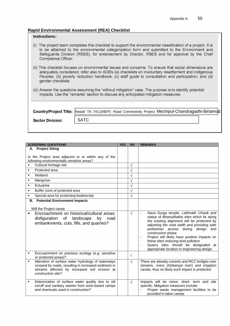
Appendix A 55
Rapid Environmental Assessment (REA) Checklist
SCREENING QUESITIONS YES NO REMARKS
A. Project Siting
Is the Project area adjacent to or within any of the following environmentally sensitive areas?
Cultural heritage site √ Protected area √ Wetland √ Mangrove √ Estuarine √ Buffer zone of protected area √ Special area for protecting biodiversity √ B. Potential Environment Impacts
Will the Project cause
Encroachment on historical/cultural areas; disfiguration of landscape by road embankments, cuts, fills, and quarries?
√ - Nava Durga temple, Lekhnath Chowk and statue of Bhanubhakta sites which lie along the existing alignment will be protected by adjusting the road width and providing safe pedestrian access during design and construction phase
- Project will likely have positive impacts on these sites reducing dust pollution
- Quarry sites should be designated at appropriate location in engineering design
Encroachment on precious ecology (e.g. sensitive or protected areas)?
√
Alteration of surface water hydrology of waterways crossed by roads, resulting in increased sediment in streams affected by increased soil erosion at construction site?
√ There are already culverts and RCC bridges over streams, rivers (Debaniya river) and irrigation canals, thus no likely such impact is predicted.
Deterioration of surface water quality due to silt runoff and sanitary wastes from work-based camps and chemicals used in construction?
√ Impacts will be minor, short- term and site specific. Mitigation measures include: - Proper waste management facilities to be
provided in labor camps
Nepal/ TA 7411(NEP): Road Connectivity Project Mechipul-Chandragadhi-Birtamod Rd SATC

56 Appendix A
SCREENING QUESITIONS YES NO REMARKS
- Disallow storage of chemicals within 100 m periphery of permanent water course or spring
- Contaminated run off from storage areas need to be captured in ditches or ponds
- Apply sealing or binding materials in the case of major spills of hazardous materials (liquids)
Increased local air pollution due to rock crushing, cutting, and filling works, and chemicals from asphalt processing?
√ Impacts will be minor, site specific, and short-term. Mitigation measures include: - Locate static plants at least 100 m from
occupied buildings and 800 m sites deemed by the Engineer
- Locate asphalt plants 1 km away from residential areas, schools, hospitals.
- Stone crushing plants should be fitted with approved dust control devices and operate in accordance with manufactures specifications and should be operated in day time only
- Sprinkle water on sites with ongoing construction activities in order to control dust nuisance
- Control vehicle speed
Risks and vulnerabilities related to occupational health and safety due to physical, chemical, biological, and radiological hazards during project construction and operation?
√ - Facilities for occupational health and safety
will be provided and detailed in the EMP. - Training will be provided on materials and,
equipment handling and use of protective gear and clothing
Noise and vibration due to blasting and other civil works?
√ - Blasting is not necessary and likely impact of noise and vibration through other civil works will be minimal.
Dislocation or involuntary resettlement of people √ - Some people likely to have resettlement impact. Separate Resettlement Plan will be prepared if required.
Dislocation and compulsory resettlement of people living in right -of -way?
√ - Some houses may need to be relocated and resettlement plan for the people living in right -of –way will be prepared
Disproportionate impacts on the poor, women and children, indigenous people or other vulnerable groups
√ - Improvement of the road is expected to increase sub-regional traffic between Nepal and India. This also likely to increase trade and transit activities in the bordering areas. New scope of economic opportunities may emerge for the poor, women and children, indigenous people or other vulnerable groups. Similarly, increase sub-regional traffic in border areas may also bring several adverse social impacts such as smuggling, human drug and organ trafficking, prostitution and HIV, AIDS and alike.
Other social concerns relating to inconveniences in living conditions in the project areas that may trigger cases of upper respiratory problems and stress?
√ Impacts will be minor, site specific, and short-term. Mitigation measures include:
- Locate asphalt plants 1 km away from residential areas, schools, hospitals.
- Control dust nuisance by the periodic sprinkling of water
Hazardous driving conditions where construction interference
√ Impacts will be minor, site specific, and short-term. Mitigation measures include: - Provide proper alternative traffic
management plan during construction - Construct interchanges in such a way that
traffic flow is not disturbed - Define alternative routes - Ensure proper traffic management on the
road crossings near proposed interchanges
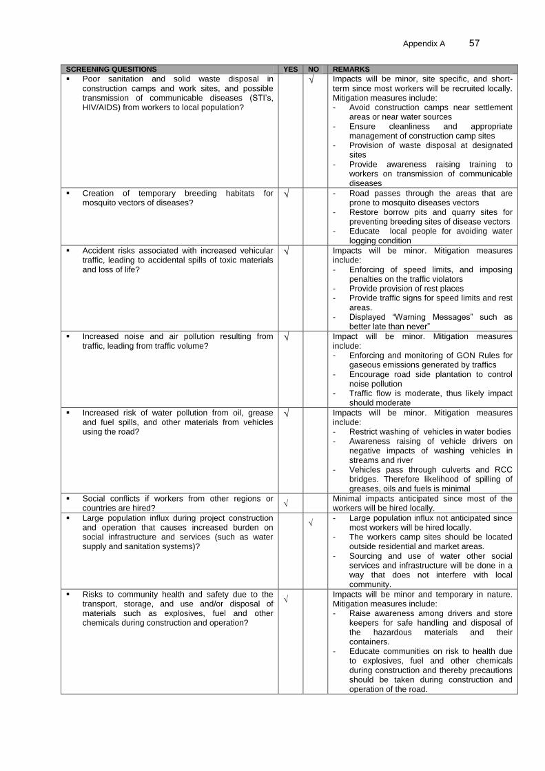
Appendix A 57
SCREENING QUESITIONS YES NO REMARKS
Poor sanitation and solid waste disposal in construction camps and work sites, and possible transmission of communicable diseases (STI‟s, HIV/AIDS) from workers to local population?
√ Impacts will be minor, site specific, and short-term since most workers will be recruited locally. Mitigation measures include: - Avoid construction camps near settlement
areas or near water sources - Ensure cleanliness and appropriate
management of construction camp sites - Provision of waste disposal at designated
sites - Provide awareness raising training to
workers on transmission of communicable diseases
Creation of temporary breeding habitats for mosquito vectors of diseases?
√ - Road passes through the areas that are prone to mosquito diseases vectors
- Restore borrow pits and quarry sites for preventing breeding sites of disease vectors
- Educate local people for avoiding water logging condition
Accident risks associated with increased vehicular traffic, leading to accidental spills of toxic materials and loss of life?
√ Impacts will be minor. Mitigation measures include: - Enforcing of speed limits, and imposing
penalties on the traffic violators - Provide provision of rest places - Provide traffic signs for speed limits and rest
areas. - Displayed “Warning Messages” such as
better late than never”
Increased noise and air pollution resulting from traffic, leading from traffic volume?
√ Impact will be minor. Mitigation measures include: - Enforcing and monitoring of GON Rules for
gaseous emissions generated by traffics - Encourage road side plantation to control
noise pollution - Traffic flow is moderate, thus likely impact
should moderate
Increased risk of water pollution from oil, grease and fuel spills, and other materials from vehicles using the road?
√ Impacts will be minor. Mitigation measures include: - Restrict washing of vehicles in water bodies - Awareness raising of vehicle drivers on
negative impacts of washing vehicles in streams and river
- Vehicles pass through culverts and RCC bridges. Therefore likelihood of spilling of greases, oils and fuels is minimal
Social conflicts if workers from other regions or countries are hired?
√ Minimal impacts anticipated since most of the workers will be hired locally.
Large population influx during project construction and operation that causes increased burden on social infrastructure and services (such as water supply and sanitation systems)?
√ - Large population influx not anticipated since
most workers will be hired locally. - The workers camp sites should be located
outside residential and market areas. - Sourcing and use of water other social
services and infrastructure will be done in a way that does not interfere with local community.
Risks to community health and safety due to the transport, storage, and use and/or disposal of materials such as explosives, fuel and other chemicals during construction and operation?
√ Impacts will be minor and temporary in nature. Mitigation measures include: - Raise awareness among drivers and store
keepers for safe handling and disposal of the hazardous materials and their containers.
- Educate communities on risk to health due to explosives, fuel and other chemicals during construction and thereby precautions should be taken during construction and operation of the road.

58 Appendix A
SCREENING QUESITIONS YES NO REMARKS
Community safety risks due to both accidental and natural causes, especially where the structural elements or components of the project are accessible to members of the affected community or where their failure could result in injury to the community throughout project construction, operation and decommissioning.
√ - Restriction of the local people from the
construction areas, - Use of traffic and warning signs at and near
the construction site - Educate the contractors and the local people
on traffic safety - Enforcement of speed limits, traffic rules and
regulations; - Installation of warning signs, speed
breakers, pedestrian crossings and specific areas for bus stops due to increased number of vehicles and increased speeds.

Appendix C 59
Appendix B Environmental Management Plan
Environmental Issues / Components
Mitigation Measures Location Time Frame Mitigation Cost
Institutional Responsibility
Implementation Supervision
[0] Pre-Construction Stage (Upon issuance of Notice to Proceed) The Contractor will complete the following activities no later than 30 days upon iisuance of Notice to Proceed 1.) Submit appointment letter and resume of the Contractor‟s Environmental Focal Person (EFP) to DOR Project Directorate 2.) EFP will engage CSC-Environment Specialist and DOR/PD to a meeting to discuss in detail the EMP, seek clarification and recommend corresponding revisions if necessary 3.) EFC will request CSC-ES copy of monthly monitoring formats and establish deadlines for submission. 4.) EFC will submit for CSC-ES approval an action plan to secure all permits and approvals needed to be secured during construction stage which include but not limited to: i) operation of crushers and hot mix plants, ii) transport and storage of hazardous materials (e.g. fuel, lubricants, explosives), iii) waste disposal sites, iv) temporary storage location, iv) water use, and v) emission compliance of all vehicles. Arrangements to link with government health programs on hygiene, sanitation, and prevention of communicable diseases will also be included in the action plan. 5) EFC will submit for approval of CSC-ES the construction camp layout before its establishment. [A]Construction Stage
Physical Environment
Micro-Climate 8 trees will be removed alon the right of way (ROW)
- 1:25 compensatory plantation
- Avoid or minimize clearing of trees,
shrubs and bushes
Throughout the road alignment especially at forest areas
Before tree felling
8 trees x 25 x 1.1 (mortality) x NRS90 = NRs 19,800
Compensatory plantation to be implemented by Forest Department. Funds will come from DOR
SC, DOR/PD
Air Quality
Emissions from plants, vehicles, unpaved road travel, and hauling of materials.
- Carryout water sprinkling and fogging,
broom sweeping in dust prone
locations, unpaved haulage roads,
earthworks, stockpiles and asphalt
mixing plant areas.
- Prohibit open burning of solid wastes
(plastic, paper, organic matters).
- Control dust nuisance using covers,
spraying water on unpaved road
surfaces, or increase moisture content
for open materials storage piles.
- All vehicles to comply with Nepal
Emissions Standards
- Provide masks and personal protective
Throughout the road corridor mainly nearby settlements, bazaar, religious, cultural and archeological sites
During Construction Stage
Dust and noise control NRS100,000
Contractor SC, DOR/PD

60 Appendix B
Environmental Issues / Components
Mitigation Measures Location Time Frame Mitigation Cost
Institutional Responsibility
Implementation Supervision
equipment (PEP) to all workers
exposed in dusty conditions.
- Locate mixing and asphalt (hot mix)
plants, and crushers and batching
plants at least 1 km downwind from the
nearest settlements only after
receiving approval from the
Supervision Consultant.
- Operate Hot Mix plant with stack of
adequate height as prescribed by SC
to ensure enough dispersion of exit
gases.
- Use crushers only licensed by GON.
- use LPG or kerosene as fuel source
for cooking and bitumen heating
- Operate Diesel Generating (DG) sets
with adequate height.
- Use diesel with low sulphur content in
DG sets as well as other machineries
Noise Level Temporary increase in ambient noise level in the close vicinity of various construction activities
- Locate temporary construction facilities
such as labour camps, vehicle
maintenance workshops, stone
crusher, quarry, borrow pit and earth
moving equipment at least 1km away
from settlements and other sensitive
areas.
- take advantages of natural topography
as a noise buffer
- Install silencers in construction
equipment and machinery, and repair
and maintain in time.
- Select equipment and machinery with
Throughout the road corridor nearby settlements, bazaar areas, schools, hospitals, religious and cultural and archeological heritage sites.
During Construction Stage
Included in Engineers‟ Estimate
Supervision Consultant and Contractor
SC, DOR/PD

Appendix C 61
Environmental Issues / Components
Mitigation Measures Location Time Frame Mitigation Cost
Institutional Responsibility
Implementation Supervision
lower sound power levels for the use.
- Provide protection devices such as
earplugs/ or earmuffs to workers
during operation of high noise
generating machines.
- Perform construction activities only
between 5 A.M. and 8 P.M. to avoid
disturbance to nearby communities at
night.
- Initiate multilayered plantation during
construction near built up areas close
to the road alignment.
- Use noise barriers such as earth
mounts or walls of wood, metal that
form a solid obstacle between the road
and roadside community, especially in
schools and hospitals sites.
Vibration and Blasting
Damage to infrastructure due to vibration from heavy machines and blasting
- Observe precaution while operating
machines and equipment, especially
nearby public and private
infrastructures.
- Minimize/avoid blasting.
- Prior information to VDC and
community on blasting operations.
Throughout the road length
During Construction Stage
Included in Engineers‟ Estimate
Contractor SC, DOR/PD

62 Appendix B
Environmental Issues / Components
Mitigation Measures Location Time Frame Mitigation Cost
Institutional Responsibility
Implementation Supervision
Impact on Land and Soil
Contamination from inappropriate construction and management practices
- Preserved top soil for reuse in
plantation and restoration purposes.
- Restore back to any land taken on
lease or used.
Throughout the road alignment
During Construction Stage
Included in Engineers‟ Estimate
Contractor SC, DOR/PD
Landslide and Soil Erosion Landslide and soil erosion due to construction
- Clear only required vegetation and re-
vegetate bare slopes.
- Apply civil and bioengineering techniques to stabilize landslide and soil erosion.
Throughout the road COI at landslide and erosion prone area
During Construction Stage
NRs 1,215,700 cost of bio engineering works
Contractor SC, DOR/PD
Borrow Pit and Quarry Site
Slope failure, sedimentation, water logging, change in the aesthetic values of the landscape, damage to sensitive areas due to improper selection and management of borrow pit and quarry sites for the construction materials
- avoid protected and sensitive areas,
nearby settlements, water sources,
forest areas and fertile agriculture
lands in siting borrow pit.
- Select borrow and quarry sites at
waste and low quality of lands.
- Obtain approval from authorities of
government and private land owners.
- Operate borrow pits and quarry sites
as per required volume of materials.
- Stockpile and preserve top soil to
spread for restoration of sites.
Throughout the sub-project corridor wherever additional soil and stones required
During Construction Stage
Included in Engineers‟ Estimate
Contractor SC, DOR/PD
Soil Contamination and Compaction
- Before operation obtain approval for
labour camps, haulage roads,
Throughout the road alignment
During Construction
Included in Engineers‟
Contractor SC, DOR/PD
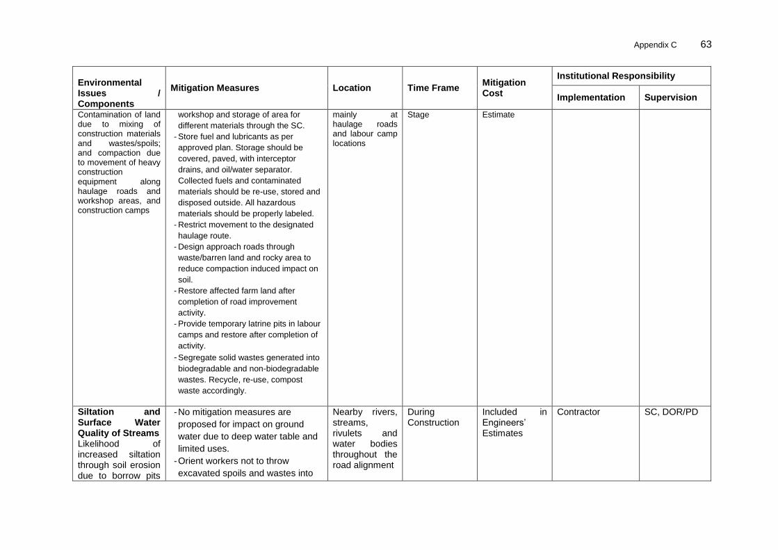
Appendix C 63
Environmental Issues / Components
Mitigation Measures Location Time Frame Mitigation Cost
Institutional Responsibility
Implementation Supervision
Contamination of land due to mixing of construction materials and wastes/spoils; and compaction due to movement of heavy construction equipment along haulage roads and workshop areas, and construction camps
workshop and storage of area for
different materials through the SC.
- Store fuel and lubricants as per
approved plan. Storage should be
covered, paved, with interceptor
drains, and oil/water separator.
Collected fuels and contaminated
materials should be re-use, stored and
disposed outside. All hazardous
materials should be properly labeled.
- Restrict movement to the designated
haulage route.
- Design approach roads through
waste/barren land and rocky area to
reduce compaction induced impact on
soil.
- Restore affected farm land after
completion of road improvement
activity.
- Provide temporary latrine pits in labour
camps and restore after completion of
activity.
- Segregate solid wastes generated into
biodegradable and non-biodegradable
wastes. Recycle, re-use, compost
waste accordingly.
mainly at haulage roads and labour camp locations
Stage Estimate
Siltation and Surface Water Quality of Streams Likelihood of increased siltation through soil erosion due to borrow pits
- No mitigation measures are
proposed for impact on ground
water due to deep water table and
limited uses.
- Orient workers not to throw
excavated spoils and wastes into
Nearby rivers, streams, rivulets and water bodies throughout the road alignment
During Construction
Included in Engineers‟ Estimates
Contractor SC, DOR/PD
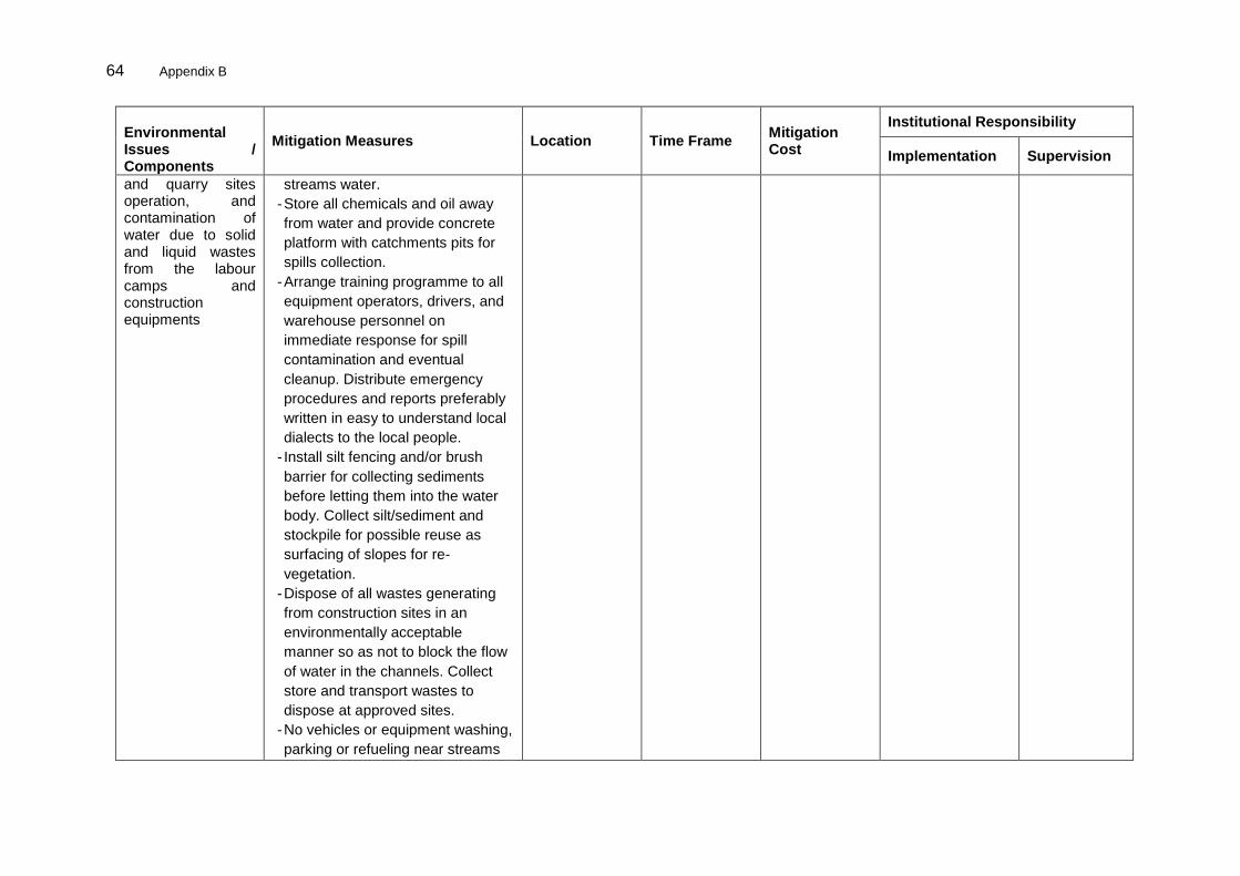
64 Appendix B
Environmental Issues / Components
Mitigation Measures Location Time Frame Mitigation Cost
Institutional Responsibility
Implementation Supervision
and quarry sites operation, and contamination of water due to solid and liquid wastes from the labour camps and construction equipments
streams water.
- Store all chemicals and oil away
from water and provide concrete
platform with catchments pits for
spills collection.
- Arrange training programme to all
equipment operators, drivers, and
warehouse personnel on
immediate response for spill
contamination and eventual
cleanup. Distribute emergency
procedures and reports preferably
written in easy to understand local
dialects to the local people.
- Install silt fencing and/or brush
barrier for collecting sediments
before letting them into the water
body. Collect silt/sediment and
stockpile for possible reuse as
surfacing of slopes for re-
vegetation.
- Dispose of all wastes generating
from construction sites in an
environmentally acceptable
manner so as not to block the flow
of water in the channels. Collect
store and transport wastes to
dispose at approved sites.
- No vehicles or equipment washing,
parking or refueling near streams

Appendix C 65
Environmental Issues / Components
Mitigation Measures Location Time Frame Mitigation Cost
Institutional Responsibility
Implementation Supervision
water, so as to avoid
contamination of streams water
from fuel and lubricants.
- Provide chute drains to drain
surface runoff and prevent erosion
from slopes.
- Avoid large labour camps along
the alignment and locate away
from settlements and river sides.
- Recruit construction labours
preferably from the local
community.
- Manage sewage of labour camps
without creating pollution in
streams water and other public and
private areas.
- No untreated sanitary wastewater
will be discharged into streams
water.

66 Appendix B
Environmental Issues / Components
Mitigation Measures Location Time Frame Mitigation Cost
Institutional Responsibility
Implementation Supervision
Hydrology and Drainage
Modification of the surface water due to intersection of the drainage basin by the road
- Retain existing natural drainage
system without disturbing them.
- Provide causeways in each perennial
and seasonal streams as well as
rivulets.
- Provide adequate cross drainage
structures to avoid natural flow of
water especially for unusual rainfall.
- Maintain channels used by the farmers
for cardamom irrigation as they are.
Throughout the road COI especially rivers, streams, rivulets and bridge site areas
During Construction
Included in Engineers‟ Estimate
Contractor SC, DOR/PD
Management of Construction Spoils/Wastes
Generation of spoils due to the excavation of existing roads that constitute bitumen and other pavement materials
- All disposal sites will have consent of
local community, VDC representatives.
Use spoils/waste for construction
purposes as far as possible.
Throughout the road COI wherever spoils need to be managed
During Construction
Included in Engineers‟ Estimate
Contractor SC, DOR/PD
Biological Environment
Forestry and Biodiversity Likely impact from clearance of trees, shrubs and bushes along the roadside
- The Contractor will determine number
and types of trees to be felled through
the detailed design/or its verification
and will coordinate with CFUGs then
apply to DFO for clearance process
- Contractor will seek necessary help
with SC to obtain approval for clearing
trees, if needed
- Trees will be felled only after receiving
permissions from the concern
authorities.
Throughout the road alignment especially at forest areas
At the beginning of construction
8*25*1.1*90= Rs 19,800 Cost is calculated assuming 10% mortality and per sapling & caring cost for 5 years Rs 90)
Contractor SC, DOR/PD

Appendix C 67
Environmental Issues / Components
Mitigation Measures Location Time Frame Mitigation Cost
Institutional Responsibility
Implementation Supervision
- The Contractor will coordinate with
CFUGs and manage felled trees.
- Cleare only necessary hillside slopes
with vegetative covers in connection
with road improvement.
- Prohibit throwing spoils including
bitumen containers and other
wastes/spoils generated from roads
excavation in and around the forest
areas.
Aquatic Biodiversity
Likelihood of destructive fishing by the construction workers
Discourage destructive fishing by the construction workers (there is no fishing sites at the COI).
All areas of water bodies throughout the alignment
During Construction
- Contractor SC, DOR/PD
Socio-economic Environment Impacts due to Construction/Labour Camp
Likely haphazard disposal of solid waste, competition on public facilities, impairment of aesthetic value of the landscape, poor sanitation, transmission of communicable diseases and other social conflicts
- To extet possible, utilize existing
houses for workers/staff lodging.
- Provide basic facilities such as fire
precaution, lavatories and showers,
potable water supply, clean eating
area, lighting, safe access, air supply,
LPG gas/kerosene, and others.
- first aid facilities at camp sites. Prepare
contingency plan for emergency and
large injury cases in collaboration with
VDC level health/sub-posts/ posts.
- All workers, staff, and communities
undergo STD, HIV awareness by
linking with existing government
programs.
- Restrict open space defecation and
pollution of stream sites and public
All labour camp locations throughout the road alignment
During Construction
Included in Engineers‟ Estimate
Contractor SC, DOR/PD

68 Appendix B
Environmental Issues / Components
Mitigation Measures Location Time Frame Mitigation Cost
Institutional Responsibility
Implementation Supervision
places by workers.
- Ensure that sufficient and good quality
of food stuff at market price including
adequate and safe drinking water has
been supplied to the workers.
Safety of Construction Workers and Accident Risks to Local Community
Increased risk of accidents to construction workers and local community
- Ensure that internationally accepted
and practiced safety measures are
adopted during (i) road works (ii)
handling of large construction
equipments and machineries (iii)
handling of chemicals including
hazardous materials and inflammable
substances (iii) welding/hot work (iv)
electrical works etc.
- Include the occupational health and
safety (OHS) Clauses established by
the DOR in the work contracts
encompassing all accident prevention
measures which can happen at work
sites and in the camps.
- Arrange all personal protective
equipments (PPEs) for workers,
including first aid facilities at
construction sites.
- Prepare an emergency plan duly
approved by the SC to respond to any
instance of safety hazard.
- Restrict entry to the construction sites
and equipment storage sites.
- Prepare an implement comprehensive
traffic management plan to avoid
disruption of the existing traffic due to
All construction camps and throughout the road alignment
During Construction
Personal protective equipment NRs62,000
Contractor
DOR/PD

Appendix C 69
Environmental Issues / Components
Mitigation Measures Location Time Frame Mitigation Cost
Institutional Responsibility
Implementation Supervision
construction activities.
- CSC Conduct regular safety audit on
safety measures during construction.
The audit will cover manpower and
their safety, machinery, temporary
works, equipment and vehicles,
materials storage and handling,
construction procedures and
environment, site safety guidelines,
and miscellaneous services.
CSC
Transportation and Storage of Materials
Likely impact due to transportation and storage of materials such as oils, fuel, bitumen, blasting materials, construction materials, etc
- Proper storage (paved, covered, with
interceptor drains and oil/water
separator) and labeled for storage.
- Equip with fire extinguishers and first
aid kit all storage and transporter of
hazardous materials.
- Avoid the use of haulage trucks higher
than the carrying capacity of the
haulage roads and existing roads. The
contractor will be responsible for repair
and maintenance of damaged existing
road by the haulage trucks.
Construction camp and approved temporary storage areas
During Construction
Included in Engineers‟ Estimate
Contractor SC, DOR/PD
Impact on common Property Resources
Likely damage to common properties such as public utilities and facilities, religious, historical and cultural sites etc
- Implement mitigation measures to
control dust, noise, nd traffic
- Chance find f archeological artifacts
importance, the Contractor will be
immediately inform SC and DOR to
seek further guidance.
Throughout the road COI
During Construction
Included in Engineers‟ Estimate
Contractor SC, DOR/PD

70 Appendix B
Environmental Issues / Components
Mitigation Measures Location Time Frame Mitigation Cost
Institutional Responsibility
Implementation Supervision
Impact on common Property Resources Likely of damage of common properties such as public utilities and facilities, religious, historical and cultural sites etc
- Avoid any actions that bear the risk
to destroy the sites or alter their
scientific or aesthetic or social
values.
- In the case of accidental damage of infrastructure of archaeological importance, the contractor will be obliged to inform DOR immediately through SC. Further, he (the Contractor) will also be obliged to carry out immediate corrective and repair measures, as suggested by concerned authority.
Throughout the road COI
During Construction
included in Engineers‟ Estimate
Contractor SC, DOR /PD
[B] Operation Stage
Physical Environment
Micro-Climate Change in the micro-climate due to emission of GHG from operation of vehicles
- As part of transport rules, condition
of vehicles will be monitored
regularly and rules will be enforced
effectively. In addition, reduction in
emission of GHG is also
anticipated due to the reduced
travel time and improved road
condition.
Throughout the road corridor
During Operation
To be determined by DOR
DOR DOR
Air Quality Emission of GHG from the operation of vehicles
- Shifting cropping /land use
patterns from traditional cereals to
high value horticultural crops along
the ROW in the cultivated area
could be one of the preferred
solutions to maintain
environmental and economic
Throughout the road corridor
During Operation
To be determined by DOR
DOR DOR
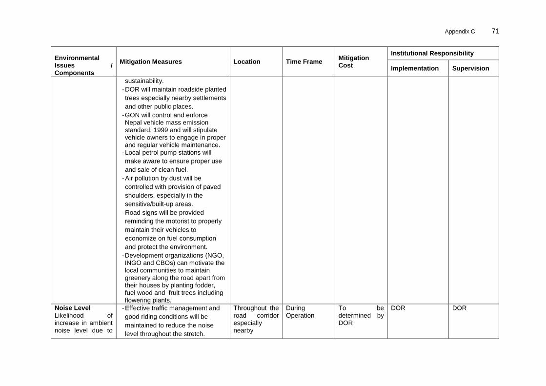
Appendix C 71
Environmental Issues / Components
Mitigation Measures Location Time Frame Mitigation Cost
Institutional Responsibility
Implementation Supervision
sustainability.
- DOR will maintain roadside planted
trees especially nearby settlements
and other public places.
- GON will control and enforce Nepal vehicle mass emission standard, 1999 and will stipulate vehicle owners to engage in proper and regular vehicle maintenance.
- Local petrol pump stations will
make aware to ensure proper use
and sale of clean fuel.
- Air pollution by dust will be
controlled with provision of paved
shoulders, especially in the
sensitive/built-up areas.
- Road signs will be provided
reminding the motorist to properly
maintain their vehicles to
economize on fuel consumption
and protect the environment.
- Development organizations (NGO, INGO and CBOs) can motivate the local communities to maintain greenery along the road apart from their houses by planting fodder, fuel wood and fruit trees including flowering plants.
Noise Level Likelihood of increase in ambient noise level due to
- Effective traffic management and
good riding conditions will be
maintained to reduce the noise
level throughout the stretch.
Throughout the road corridor especially nearby
During Operation
To be determined by DOR
DOR DOR

72 Appendix B
Environmental Issues / Components
Mitigation Measures Location Time Frame Mitigation Cost
Institutional Responsibility
Implementation Supervision
operation of vehicles and use of horns
- Speed limitation and honking
restrictions will be enforced near
sensitive locations, like hospitals,
schools etc
- Effectiveness of the multilayered
plantation will be monitored.
- Awareness will be created
amongst the residents about likely
noise levels from road operation at
different distances.
settlements, bazaar areas, religious, cultural and archeological sites
Vibration Possibility of vibration due to plying of heavy and over loaded vehicles
- Loaded vehicles plying on the road
will be monitored by MPPW as per
Nepal Road Standard, 2027 B.S.
(First revision-2045 B.S.).
- Drivers will be made aware about
capacity of the road and bridges,
and their consequences.
Throughout the road COI
During Operation
To be determined by DOR
DOR DOR
Impact on Land and Soil Conversion of agricultural land to built up areas for commercial purpose, especially in market centers
In general, the policy of DOR is of 15 and 25 m either sides from the centreline for feeder road and highway, respectively. But in case of this road 20 m of corridor of impacts (COI) for 13 m of formation width has been followed.
Throughout the road COI mainly nearby built-up areas and farm areas
During Operation
To be determined DOR
DOR DOR

Appendix C 73
Environmental Issues / Components
Mitigation Measures Location Time Frame Mitigation Cost
Institutional Responsibility
Implementation Supervision
Soil Erosion Occurrence of landslide and soil erosion due to both natural and induced phenomena.
- DOR has established a system to
check roads employing Length-
Persons and their supervisor. They
are responsible for routine and
recurrent maintenance of roads
like cleaning up drains, soil
deposited on the roads due to
minor slope failure and erosion.
Along the road corridor, especially near bridges where embankment level is high
During Operation
To be determined by DOR
DOR DOR
Borrow Pit and Quarry Site Likelihood of landslide and soil erosion due to incomplete restoration of borrow pit and quarry site along the road alignment
- DOR will orient supervisor in order
to check and maintain drains and
erosion and also to protect
vegetative covers on the restored
sites of borrows and quarries.
Especially at borrow pits and quarry sites used areas throughout the alignment
During Operation
To be determined DOR
DOR DOR
Soil Contamination and Compaction Possibility of soil erosion and deterioration of borrow areas if not rehabilitated properly
- Locations of quarry sites and
borrow pits, haulage roads, and
camp site will be monitored and if
found not restored properly then
the Contractor will be asked for
correction of these works under
defect liability period
All borrow, quarry, haulage roads and camp sites throughout the alignment
During Operation
To be determined by DOR
DOR DOR
Siltation and Surface Quality of Rivers Possibility of
- As provisioned, DOR will engage
road Length-Persons. They will
check road condition including
All areas nearby streams and rivulets throughout the
During Operation
To be determined by DOR
DOR DOR

74 Appendix B
Environmental Issues / Components
Mitigation Measures Location Time Frame Mitigation Cost
Institutional Responsibility
Implementation Supervision
contamination of surface water by oil and lubricants during monsoon season
cleaning up soils deposited on
roads by erosion and slides drain
blockade/ chocking. The Length-
Persons supervisor will inform to
Divisional Engineer in case of large
landslide and major road blockade.
road alignment
Hydrology and Drainage Blockage/Chocking of natural drainage pattern due to landslide and soil erosion
- As provisioned , DOR will engage
Length-persons for regular check
up of the road condition including
cleaning up the erosion, slides,
drain blockade/ chocking etc.,.
Length -Persons supervisor will
inform to regional engineer in case
of large landslides and major road
blockade.
All areas nearby streams and rivulets throughout the road alignment
During Operation
To be determined by DOR
DOR DOR
Natural Hazard Likely impact of natural hazard such as flooding, siltation and earthquake
- Development organizations will
play role in awareness rising about
the risk of natural hazards
including preventive cure and
preparedness on safety measures
to local communities.
All sites nearby streams and rivulets throughout the road alignment
During Operation
To be determined by DOR
DOR DOR
Ecological Resources
Vegetation Increased possibility of poaching and logging due to improved access
- The project will involve local
people in maintaining of planted
trees and their management
activities.
Vegetation areas along the road corridor
During Operation
To be determined by DOR
DOR DOR
Socio-economic Environment

Appendix C 75
Environmental Issues / Components
Mitigation Measures Location Time Frame Mitigation Cost
Institutional Responsibility
Implementation Supervision
Accident Risks to Local Community and Community Increased risk of road accident
- Monitoring and supervision by
DOR is required, to ensure the
safe travelling.
Throughout the road alignment
During Operation
To be determined by DOR
DOR DOR
Impact on Common Property Resources Increased noise, vibration and air pollution
- The DOR will install traffic signals
such as “NO HORN” and “SPPED
LIMIT” nearby the archaeological
sites.
Throughout the road alignment especially at sensitive locations
During Operation
To be determined by DOR
DOR DOR
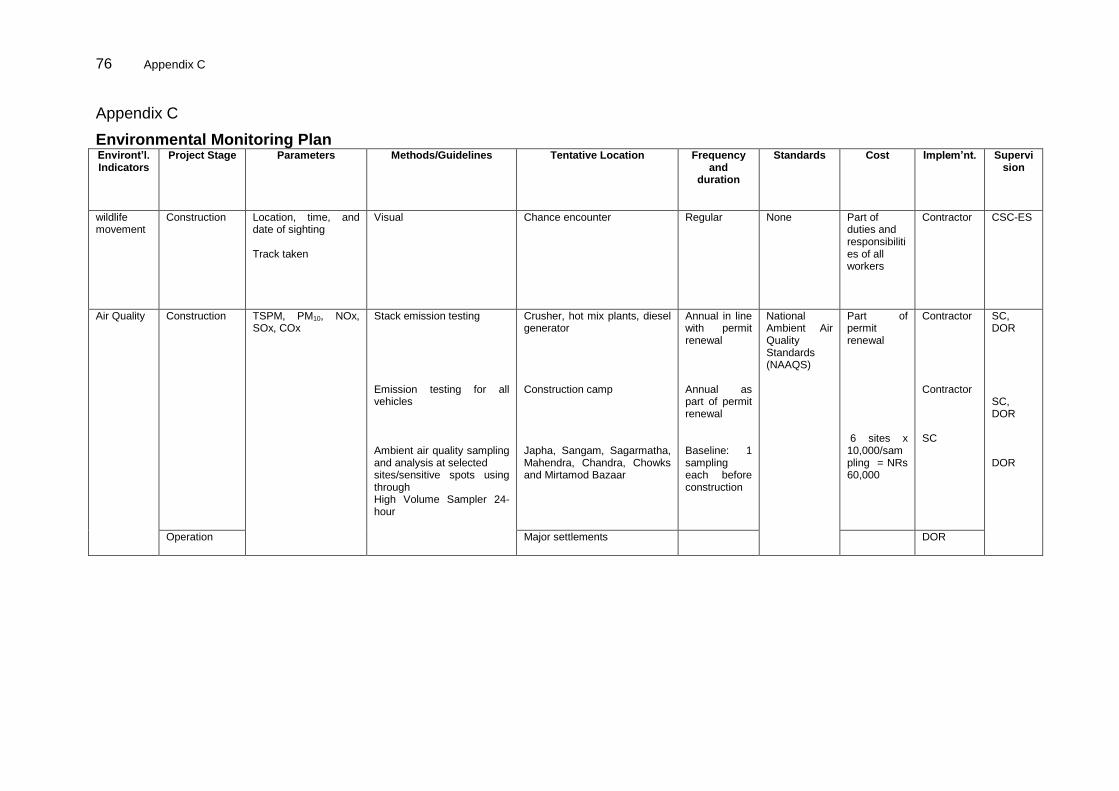
76 Appendix C
Appendix C
Environmental Monitoring Plan Environt’l. Indicators
Project Stage Parameters Methods/Guidelines Tentative Location Frequency and
duration
Standards Cost Implem’nt. Supervision
wildlife movement
Construction Location, time, and date of sighting Track taken
Visual Chance encounter Regular None Part of duties and responsibilities of all workers
Contractor CSC-ES
Air Quality Construction TSPM, PM10, NOx, SOx, COx
Stack emission testing Emission testing for all vehicles Ambient air quality sampling and analysis at selected sites/sensitive spots using through High Volume Sampler 24-hour
Crusher, hot mix plants, diesel generator Construction camp Japha, Sangam, Sagarmatha, Mahendra, Chandra, Chowks and Mirtamod Bazaar
Annual in line with permit renewal Annual as part of permit renewal Baseline: 1 sampling each before construction
National Ambient Air Quality Standards (NAAQS)
Part of permit renewal 6 sites x 10,000/sampling = NRs 60,000
Contractor Contractor SC
SC, DOR SC, DOR DOR
Operation Major settlements
DOR

Appendix C 77
Environt’l. Indicators
Project Stage Parameters Methods/Guidelines Tentative Location Frequency and
duration
Standards Cost Implem’nt. Supervision
Water Quality
Construction BOD, Turbidity, E.Coli, TSS, Oil and Grease Drinking water quality parameters Clogging of drains from silt with oil
Collect and analyze sample from source
Observation of blockage of waterways - extent and secondary impacts
Water pollution incidents due to unsafe disposal of waste and spoil, analyzing effects on local fisheries
Observations on vehicle and equipment washing practices in rivers
Groundwater well sampling
Streams and rivers (Devaniya River and Rekha Khola) Construction camp final discharge effluent Contractor‟s camp
Quarterly Nepal Water Quality Guidelines for the Protection of Aquatic Ecosystems National Drinking Water Quality Standards (NDWQS) and
Part of construction cost
SC SC Contractor
PD/DOR PD/DOR SC, DOR
Operation Visual All drains Annually before the on-set of rainy season
Agency budget
DOR
Soil Quality Construction Stage
Check for contamination from material spills and compaction due to heavy equipment
Visual
Agricultural Land, oil spillage locations and other probable hazardous materials contamination location or as suggested by SC
Continuing during construction
Should be the same as baseline before start of construction
Part of construction cost and Grievance redress mechanism
Contractor SC, DOR
Operation Stage
Agricultural Land, oil spillage locations and other probable hazardous materials contamination location or as suggested by SC
Continuing Clean up of spills is responsibility of polluter
DOR
Camp site

78 Appendix C
Environt’l. Indicators
Project Stage Parameters Methods/Guidelines Tentative Location Frequency and
duration
Standards Cost Implem’nt. Supervision
Noise Levels
Construction (1 hr Leq dB(A)) WHO Standards
Point source measurements in dB (A) at settlement sites/sensitive spots for noise level at 2, 5 and 15 m from road shoulder
Traffic volume measurements
Camp site and major settlement sites
Nepal Ambient Noise Level as per NHRC
Part of construction cost
Contractor SC, PD/DOR
Operation Major road intersections, residential, commercial and sensitive receivers along the road alignment or suggested by SC
Once during the first year of operation
Part of agency budget
DOR
Landslide and Soil Erosion
Construction Magnitude, extent and location
Visual Along the entire stretch Regular None Part of construction cosr
Contractor SC, PD/DOR
Operation Magnitude, extent and location
Throughout the road alignment,
DOR SC, PD/DOR
Siltation by rivers and drainage congestion
Construction Siltation and presence of construction spoils and wastes
Blockage of waterways - extent and secondary impacts
Direct Observation
Throughout the road alignment, especially at the drainage congestion areas as mentioned in the IEE report or as suggested by SC
Continuing during construction phase
Visual Observation
Construction contract
Contractor SC, PD/DOR
Operation Siltation
Blockage of waterways - extent and secondary impacts
Annual DOR Length Person System
DOR
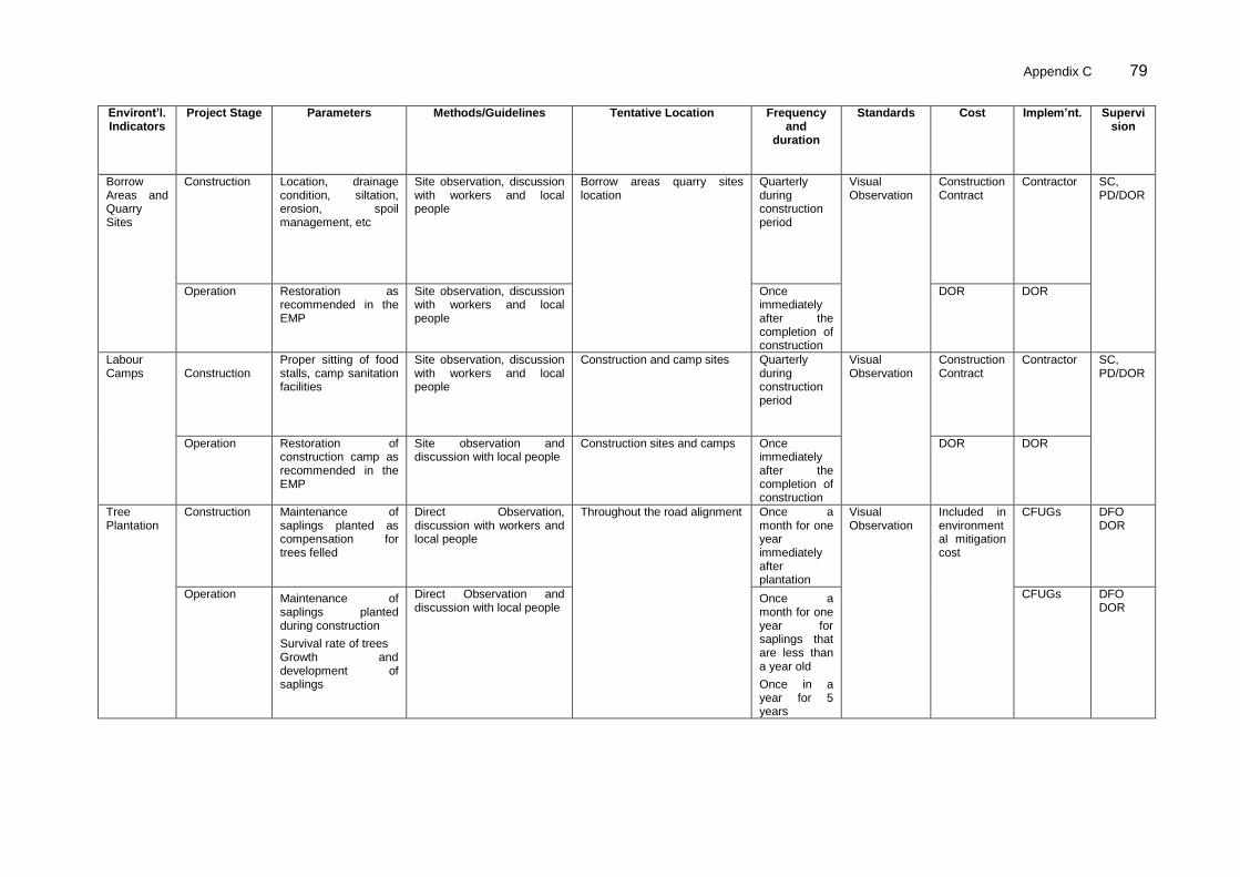
Appendix C 79
Environt’l. Indicators
Project Stage Parameters Methods/Guidelines Tentative Location Frequency and
duration
Standards Cost Implem’nt. Supervision
Borrow Areas and Quarry Sites
Construction Location, drainage condition, siltation, erosion, spoil management, etc
Site observation, discussion with workers and local people
Borrow areas quarry sites location
Quarterly during construction period
Visual Observation
Construction Contract
Contractor SC, PD/DOR
Operation Restoration as recommended in the EMP
Site observation, discussion with workers and local people
Once immediately after the completion of construction
DOR DOR
Labour Camps
Construction
Proper sitting of food stalls, camp sanitation facilities
Site observation, discussion with workers and local people
Construction and camp sites Quarterly during construction period
Visual Observation
Construction Contract
Contractor SC, PD/DOR
Operation Restoration of construction camp as recommended in the EMP
Site observation and discussion with local people
Construction sites and camps Once immediately after the completion of construction
DOR DOR
Tree Plantation
Construction
Maintenance of saplings planted as compensation for trees felled
Direct Observation, discussion with workers and local people
Throughout the road alignment
Once a month for one year immediately after plantation
Visual Observation
Included in environmental mitigation cost
CFUGs DFO DOR
Operation Maintenance of saplings planted during construction
Survival rate of trees Growth and development of saplings
Direct Observation and discussion with local people
Once a month for one year for saplings that are less than a year old
Once in a year for 5 years
CFUGs DFO DOR
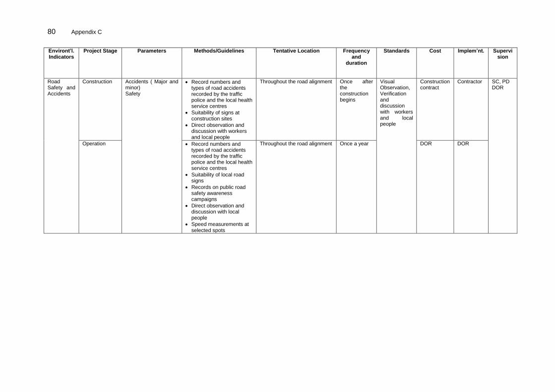
80 Appendix C
Environt’l. Indicators
Project Stage Parameters Methods/Guidelines Tentative Location Frequency and
duration
Standards Cost Implem’nt. Supervision
Road Safety and Accidents
Construction Accidents ( Major and minor) Safety
Record numbers and types of road accidents recorded by the traffic police and the local health service centres
Suitability of signs at construction sites
Direct observation and discussion with workers and local people
Throughout the road alignment Once after the construction begins
Visual Observation, Verification and discussion with workers and local people
Construction contract
Contractor SC, PD DOR
Operation Record numbers and types of road accidents recorded by the traffic police and the local health service centres
Suitability of local road signs
Records on public road safety awareness campaigns
Direct observation and discussion with local people
Speed measurements at selected spots
Throughout the road alignment Once a year DOR DOR
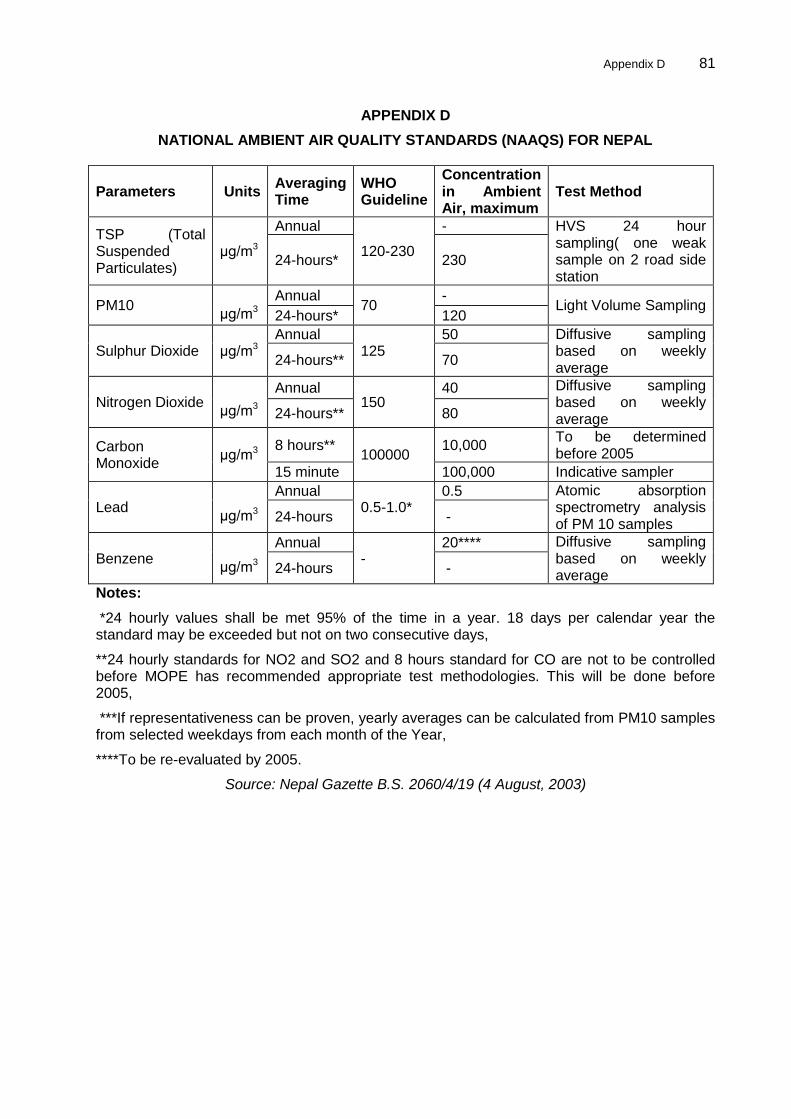
Appendix D 81
APPENDIX D
NATIONAL AMBIENT AIR QUALITY STANDARDS (NAAQS) FOR NEPAL
Parameters Units Averaging Time
WHO Guideline
Concentration in Ambient Air, maximum
Test Method
TSP (Total Suspended Particulates)
μg/m3
Annual
120-230
- HVS 24 hour sampling( one weak sample on 2 road side station
24-hours* 230
PM10 μg/m3
Annual 70
- Light Volume Sampling
24-hours* 120
Sulphur Dioxide μg/m3 Annual
125 50 Diffusive sampling
based on weekly average
24-hours** 70
Nitrogen Dioxide μg/m3
Annual 150
40 Diffusive sampling based on weekly average 24-hours** 80
Carbon Monoxide
μg/m3 8 hours**
100000 10,000
To be determined before 2005
15 minute 100,000 Indicative sampler
Lead μg/m3
Annual 0.5-1.0*
0.5 Atomic absorption spectrometry analysis of PM 10 samples
24-hours -
Benzene μg/m3
Annual -
20**** Diffusive sampling based on weekly average
24-hours -
Notes:
*24 hourly values shall be met 95% of the time in a year. 18 days per calendar year the standard may be exceeded but not on two consecutive days,
**24 hourly standards for NO2 and SO2 and 8 hours standard for CO are not to be controlled before MOPE has recommended appropriate test methodologies. This will be done before 2005,
***If representativeness can be proven, yearly averages can be calculated from PM10 samples from selected weekdays from each month of the Year,
****To be re-evaluated by 2005.
Source: Nepal Gazette B.S. 2060/4/19 (4 August, 2003)
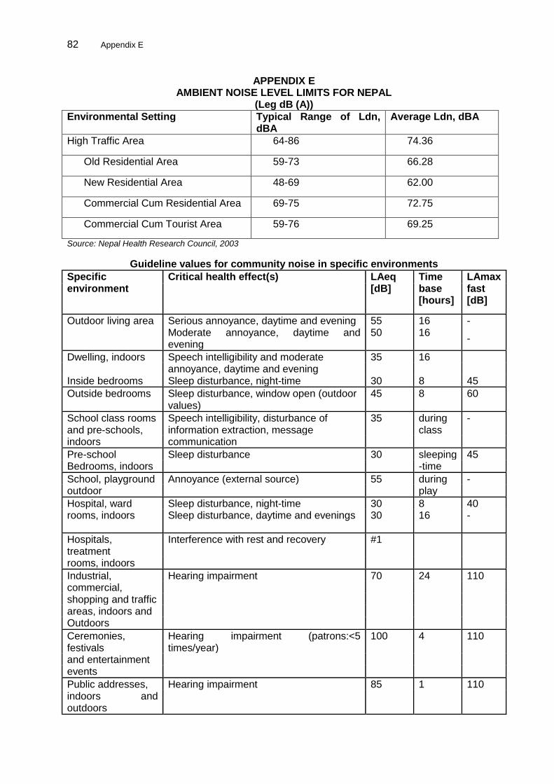
82 Appendix E
APPENDIX E AMBIENT NOISE LEVEL LIMITS FOR NEPAL
(Leg dB (A))
Environmental Setting Typical Range of Ldn, dBA
Average Ldn, dBA
High Traffic Area 64-86 74.36
Old Residential Area 59-73 66.28
New Residential Area 48-69 62.00
Commercial Cum Residential Area 69-75 72.75
Commercial Cum Tourist Area 59-76 69.25
Source: Nepal Health Research Council, 2003
Guideline values for community noise in specific environments
Specific environment
Critical health effect(s) LAeq [dB]
Time base [hours]
LAmax fast [dB]
Outdoor living area Serious annoyance, daytime and evening 55 16 - Moderate annoyance, daytime and
evening 50 16
-
Dwelling, indoors Speech intelligibility and moderate 35 16 annoyance, daytime and evening Inside bedrooms Sleep disturbance, night-time 30 8 45
Outside bedrooms Sleep disturbance, window open (outdoor 45 8 60 values)
School class rooms Speech intelligibility, disturbance of 35 during - and pre-schools, information extraction, message class indoors communication
Pre-school Sleep disturbance 30 sleeping 45 Bedrooms, indoors -time
School, playground Annoyance (external source) 55 during - outdoor play
Hospital, ward Sleep disturbance, night-time 30 8 40 rooms, indoors Sleep disturbance, daytime and evenings 30 16 -
Hospitals, treatment
Interference with rest and recovery #1
rooms, indoors
Industrial, Hearing impairment 70 24 110 commercial, shopping and traffic areas, indoors and Outdoors
Ceremonies, festivals
Hearing impairment (patrons:<5 times/year)
100 4 110
and entertainment events
Public addresses, Hearing impairment 85 1 110 indoors and outdoors

Appendix E 83
Specific environment
Critical health effect(s) LAeq [dB]
Time base [hours]
LAmax fast [dB]
Music through Hearing impairment (free-field value) 85 #4 1 110
headphones/ Earphones
Impulse sounds from
Hearing impairment (adults) - -
140 #2
toys, fireworks and firearms Hearing impairment (children) - - 120 #2
Outdoors in parkland
Disruption of tranquility #3
and conservation
areas
Source: WHO, 1999

84 Appendix F
APPENDIX F NEPAL’S DRINKING WATER QUALITY STANDARDS
Maximum Concentration
Group Parameter Unit Limits
Turbidity NTU 5 (10)**
pH 6.5-8.5*
Color TCU 5 (15)**
Taste & Odor
Would not be objectionable
Total Dissolved Solids
mg/l 1000
Electrical Conductivity
μc/cm 1500
Iron mg/l 0.3 (3)**
Physical Manganese mg/l 0.2
Arsenic mg/l 0.05
Cadmium mg/l 0.003
Chromium mg/l 0.05
Cyanide mg/l 0.07
Fluoride mg/l 0.5-1.5*
Lead mg/l 0.01
Ammonia mg/l 1.5
Chloride mg/l 250
Sulphate mg/l 250
Nitrate mg/l 50
Copper mg/l 1
Chemical Total Hardness mg/l 500
Calcium mg/l 200
Zinc mg/l 3
Mercury mg/l 0.001
Aluminum mg/l 0.2
Residual Chlorine mg/l 0.1-0.2*
Micro Germs
E-Coli MPN/100ml
0
Total Coli form MPN/100ml 95 % in sample Notes:
* These standards indicate the maximum and minimum limits.
** Figures in parenthesis are upper range of the standards recommended.
Source: Ministry of Physical Planning and Works (Nepal Gazette (B.S. 2063/03/12)

Appendix F 85
Nepal Water Quality Guidelines for the Protection of Aquatic Ecosystem
S.N.
Parameter name
Target Water
Quality Range
Chronic Effect Value
Acute Effect Value
1. Aluminium (mg/l) At pH <6.5: 5 10 100
At pH >6.5:10 20 150
2. Ammonia (µg/L) < 7 < 15 < 100
3. Arsenic (µg/L) < 10 < 20 < 130
4. Atrazine (µg/L) < 10 < 19 < 100
5. Cadmium
Soft water (60 mg/l CaCO3) < 0.15 0.3 3
Medium water
(60 – 119 mg/l) < 0.25 0.5 6
Hard water 120 – 180 mg/l < 0.35 0.7 10
Very Hard > 180 mg/l < 0.40 0.8 13
6. Chlorine (Residual) µg/L < 0.2 0.35 5
7. Chromium (VI) µg/L 7 10 200
8. Chromium (III) µg/L < 12 24 340
9. Copper µg/L
Soft water (60 mg/l CaCO3) < 0.3 0.53 1.6
Medium water
(60 – 119 mg/l) < 0.8 1.5 4.6
Hard water 120 – 180 mg/l < 1.2 2.4 7.5
Very Hard > 180 mg/l < 1.40 2.8 12
10. Cyanide µg/L 1 4 110
11. Dissolved Oxygen (%
saturation)
80 – 120 > 60 > 40
12. Endosulphan (µg/L) < 0.01 0.02 0.2
13. Fluoride (µg/L) < 750 1500 2540
14. Iron
The iron concentration should not be allowed to vary by more than 10
% of the background dissolved iron concentration for a particular site or case, at a specific time.
15. Lead µg/L
Soft water (60 mg/l)
CaCO3)
< 0.2 0.5 4
Medium water (60 – 119 mg/l) < 0.5 1.0 7
Hard water 120 – 180 mg/l < 1.0 2.0 13
Very Hard > 180 mg/l < 1.2 2.4 16
16. Manganese (µg/L) < 180 370 1300
17. Mercury (µg/L) < 0.04 0.08 1.7

86 Appendix F
S.N.
Parameter name
Target Water
Quality Range
Chronic Effect Value
Acute Effect Value
18. Nitrogen (inorganic)
Inorganic nitrogen concentrations should not be changed by more than
15 % from that of the water body under local unimpacted conditions at any time of the year;
The trophic status of the water body should not increase above its present level, though a decrease in trophic status is permissible (see Effects);
The amplitude and frequency of natural cycles in inorganic nitrogen concentrations should not be changed.
19. pH
All aquatic ecosystems
pH values should not be allowed to vary from the range of the background pH values for a specific site and time of day, by > 0.5 of a pH unit, or by > 5 %, and should be assessed by whichever estimate is more conservative.
20. Phenols (µg/l) <30 60 500
21. Phosphorus (inorganic) All surface waters
Inorganic phosphorus concentrations should not be changed by > 15
% from that of the water body under local, unimpacted conditions at any time of the year; The trophic status of the water body should not increase above its present level, though a decrease in trophic status is permissible (see Effects);
The amplitude and frequency of natural cycles in inorganic phosphorus concentrations should not be changed.
22. Selenium (µg/l) < 2 5 30
23.
Temperature
(All aquatic ecosystems)
Water temperature should not be allowed to vary from the background average daily water temperature considered to be normal for that specific site and time of day, by > 2ºC, or by > 10%, whichever estimate is the more conservative.
24.
Total Dissolved Solids (TDS)
(All inland waters)
• TDS concentrations should not be changed by > 15 % from the normal cycles of the water body under un impacted conditions at any time of the year;
• The amplitude and frequency of natural cycles in TDS concentrations should not be changed.
25.
Total Suspended Solids
(All inland waters)
Any increase in TSS concentrations must be limited to < 10 % of the background TSS concentrations at a specific site and time.
26. Zinc (µg/l) < 2 3.6 36
TDS = total dissolved solids, TSS = total suspended solids. Source: Department of Irrigation, Ground Water Project (Nepal Gazette (Number 10, B.S., 2065-03-02))
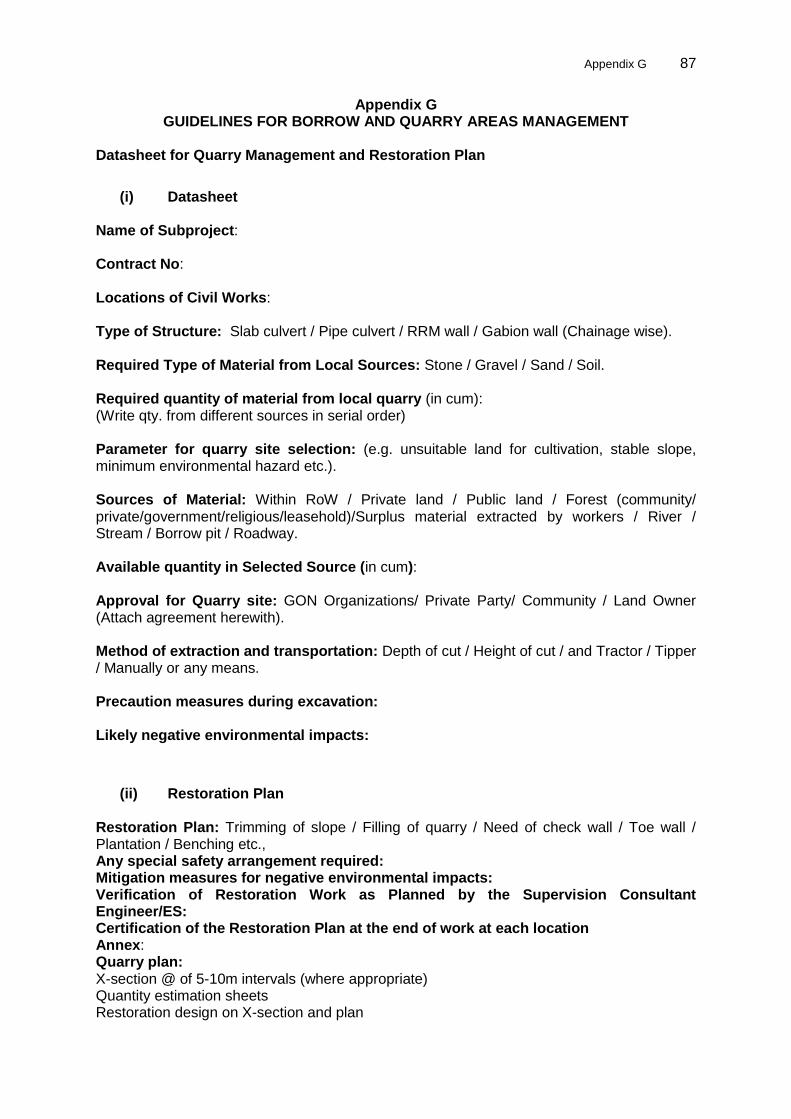
Appendix G 87
Appendix G GUIDELINES FOR BORROW AND QUARRY AREAS MANAGEMENT
Datasheet for Quarry Management and Restoration Plan
(i) Datasheet Name of Subproject: Contract No: Locations of Civil Works: Type of Structure: Slab culvert / Pipe culvert / RRM wall / Gabion wall (Chainage wise). Required Type of Material from Local Sources: Stone / Gravel / Sand / Soil. Required quantity of material from local quarry (in cum): (Write qty. from different sources in serial order) Parameter for quarry site selection: (e.g. unsuitable land for cultivation, stable slope, minimum environmental hazard etc.). Sources of Material: Within RoW / Private land / Public land / Forest (community/ private/government/religious/leasehold)/Surplus material extracted by workers / River / Stream / Borrow pit / Roadway. Available quantity in Selected Source (in cum): Approval for Quarry site: GON Organizations/ Private Party/ Community / Land Owner (Attach agreement herewith). Method of extraction and transportation: Depth of cut / Height of cut / and Tractor / Tipper / Manually or any means. Precaution measures during excavation: Likely negative environmental impacts:
(ii) Restoration Plan Restoration Plan: Trimming of slope / Filling of quarry / Need of check wall / Toe wall / Plantation / Benching etc., Any special safety arrangement required: Mitigation measures for negative environmental impacts: Verification of Restoration Work as Planned by the Supervision Consultant Engineer/ES: Certification of the Restoration Plan at the end of work at each location Annex: Quarry plan: X-section @ of 5-10m intervals (where appropriate) Quantity estimation sheets Restoration design on X-section and plan

88 Appendix G
Submitted by: Checked by: Approved by: Note: The payment of each structure will be made only after filling of the data by the contractor for Quarry Management and Restoration Plan. Final payment will be dependent on verification and approval by SC at the end construction of each respective structure.

Appendix G 89
Guideline for Quarries and Borrows Management and Restoration Plan Preparation Introduction 1. The guideline makes effort to highlight points to be considered in preparing quarry management and restoration plan. The purpose of this document is to provide reference to select quarry and borrow sits and check the quarry management and restoration plan submitted by the Contractor. The guideline has been prepared taking into consideration to the works mentioned in contract and EIA/EMP. Quarry Site 2. Quarry is a place from which construction materials (soil, stone, sand, gravel, etc.,) are extracted. Quarry site potential depends upon availability of sources (quantity) and suitability of materials. Parameter to be Considered for Quarry Site Selection 3. Quarry site should be located 1 km away from the villages/settlement area, drinking water supply sources, community infrastructure such as school, health post, bridge, etc., religious sites, cultivated land, protected forests, natural drainage systems. Quarry will not be located at wildlife conservation area. River gravel will not be extracted from flowing water due the disturbance of raising sediment and danger of resulting oil/fuel leaks. 4. Quarry sites should be selected in stable area, in agriculturally unsuitable land and away from the above mentioned sites. In addition to this, local communities will be consulted and take approval from respective owner before selecting the place for quarry operation. Likely Negative Environmental Impacts 5. The potential negative impacts are disruption of natural landscape and vegetation, accelerated erosion and landslides, slope stability, disturbance in natural drainage patterns, siltation due to surface water, water pollution and dust pollution. In case of riverbeds, scouring of riverbeds resulting endangerment of bridges and continuous degradation of river regime and detrimental effects on aquatic lives and their habitats. Quarry Operation 6. Prohibition to work during the night time 7. Barricade to site to control free movement of local people Points to be Considered in Restoration Plan 8. In order to prepare quarry management and restoration plan the following points should be taken into consideration: 9. The plan must contain site restoration measures such as spoil management, slope stabilisation, drainage pattern, etc. 10. Suitability of proposed mitigation measures for negative environmental impacts is needed to be conformed and verified. 11. Provision of drainage system during operation and no risk of likelihood of depositions of debris from quarry to lower catchments are important. 12. The plan must contain provision of spoil collection and appropriate management during operation, if necessary. 13. The plan should mention use of safety gears during working hours in the quarry site, and appropriate means of safeguarding for passer-by and nearby households. 14. The plan should include suitable bioengineering techniques where appropriate.
90 Appendix G
15. Acceptance of Restoration Work: The Supervision Consultant should satisfy himself and accept the restoration works carried out by the Contractor. The mentioned teams` engineer/ES will make sure that quarries are operated and closed according to the submitted plan. 16. The payment of each works structure should only be made after filling of the data by the Contractor for quarry management and restoration plan and acceptance by the Supervision Consultant. Final payment will be dependent on verification and approval by SC at the end construction of each respective structure. 17. Site Supervision: The Supervision Consultant engineer/ES shall supervise the following parameters and indicators:
Implementation of mitigation measures as per design plan;
No evidence of water ponding or presence of fresh gullies;
Proper site closure;
Natural contours and vegetation restoration;
Engineer‟s report testifying to completion of restoration work. 18. Other details will be submitted in Appendices.