Embed Size (px)
Citation preview

I n g l es i d e Chas e Res er ve - P l a n o f M a n age me n t
© E C O L O G I C AL AU S T R AL I A P T Y L T D i
DOCUMENT TRACKING
ITEM DETAIL
Project Name Ingleside Chase Reserve - Plan of Management
Project Number 10SUTPLA-0011
File location G:\Synergy\Projects\10SUTPLA\10SUTPLA-0011 Ingleside Chase Escarpment Plan of Management\Report
Prepared by Martin Sullivan
Approved by Beth Medway
Status Final
Version Number R5
Last saved on November 2010
ACKNOWLEDGEMENTS
This document has been prepared by Eco Logical Australia Pty Ltd with support from Pittwater Council
Disclaimer This document may only be used for the purpose for which it was commissioned and in accordance with the contract between Eco Logical Australia Pty Ltd and Pittwater Council. The scope of services was defined in consultation with Pittwater Council, by time and budgetary constraints imposed by the client, and the availability of reports and other data on the subject area. Changes to available information, legislation and schedules are made on an ongoing basis and readers should obtain up to date information.
Eco Logical Australia Pty Ltd accepts no liability or responsibility whatsoever for or in respect of any use of or reliance upon this report and its supporting material by any third party. Information provided is not intended to be a substitute for site specific assessment or legal advice in relation to any matter. Unauthorised use of this report in any form is prohibited.

I n g l es i d e Chas e Res er ve - P l a n o f M a n age me n t
© E C O L O G I C AL AU S T R AL I A P T Y L T D ii
Contents Executive Summary ................................................................................................................................ 1
1 Introduction ................................................................................................................................. 2
1.1 Context ......................................................................................................................................... 2
1.1.1 Vision ............................................................................................................................................ 2
1.2 Study area .................................................................................................................................... 2
1.3 Project needs and objectives ........................................................................................................ 4
1.4 Consultation .................................................................................................................................. 5
1.4.1 Previous community consultation ................................................................................................. 5
1.4.2 Community consultation ............................................................................................................... 5
1.4.3 Community Engagement Plan ...................................................................................................... 6
2 Relevant Legislation ................................................................................................................... 7
2.1 Local Government Act 1993 ......................................................................................................... 8
2.2 Further Categorisation as Bushland and Watercourse .............................................................. 11
2.3 Environmental Planning and Assessment Act 1979 .................................................................. 12
2.4 State Environmental Planning Policy (Infrastructure) 2007 ........................................................ 12
2.5 (Other) State Environmental Planning Policies (SEPP) ............................................................. 12
2.6 Pittwater Local Environmental Plan 1993 ................................................................................... 13
3 Council Development and Community Activities ................................................................. 14
3.1 Key directions of council ............................................................................................................. 14
3.2 Management principles For Natural Areas ................................................................................. 14
3.3 Council Development and Uses for all Natural Areas ................................................................ 14
3.4 Council management .................................................................................................................. 15
3.5 Community activities ................................................................................................................... 16
4 Resource Overview & Site Features ....................................................................................... 21
4.1 Values statement ........................................................................................................................ 21
4.2 Site history .................................................................................................................................. 21
4.3 Topography, geology & soils ...................................................................................................... 22
4.3.1 Topography ................................................................................................................................. 22
4.3.2 Geology and soils ....................................................................................................................... 22
4.3.3 Acid Sulfate Soils ........................................................................................................................ 25
4.3.4 Erosion and sedimentation ......................................................................................................... 25
4.4 Water quality and flow ................................................................................................................ 25

I n g l es i d e Chas e Res er ve - P l a n o f M a n age me n t
© E C O L O G I C AL AU S T R AL I A P T Y L T D iii
4.4.1 Water quality ............................................................................................................................... 25
4.4.2 Surface flow ................................................................................................................................ 26
4.4.3 Hydrological modifications .......................................................................................................... 26
4.5 Plant and plant communities ...................................................................................................... 26
4.5.1 Vegetation communities ............................................................................................................. 26
4.5.2 Rare and threatened flora ........................................................................................................... 31
4.5.3 Weeds ......................................................................................................................................... 32
4.5.4 Bushfire and minimum fire intervals ........................................................................................... 33
4.6 Local fauna ................................................................................................................................. 35
4.6.1 Significant fauna ......................................................................................................................... 35
4.6.2 Pest species ............................................................................................................................... 38
4.7 Habitat and connectivity ............................................................................................................. 38
4.8 Aboriginal heritage ...................................................................................................................... 38
4.9 Infrastructure............................................................................................................................... 39
4.9.1 Stormwater ................................................................................................................................. 39
4.9.2 Sewer overflows ......................................................................................................................... 39
4.9.3 Recreation .................................................................................................................................. 40
4.9.4 Encroachments ........................................................................................................................... 40
4.10 Visual and landscape character ................................................................................................. 42
5 Management Issues ................................................................................................................. 46
6 Objectives and Actions ............................................................................................................ 50
6.1 Vision .......................................................................................................................................... 50
6.2 Actions ........................................................................................................................................ 50
6.3 Priorities ...................................................................................................................................... 50
6.4 Biodiversity management actions ............................................................................................... 51
6.5 Water and sediment management actions ................................................................................. 54
6.6 Recreation management actions ................................................................................................ 54
6.7 Community engagement and education actions ........................................................................ 55
6.8 Management and financial arrangements actions...................................................................... 55
6.9 Management Zones .................................................................................................................... 56
6.9.1 Management Zone 1 .................................................................................................................. 56
6.9.2 Management Zone 2 .................................................................................................................. 56
6.9.3 Management Zone 3 .................................................................................................................. 57
6.9.4 Management Zone 4 .................................................................................................................. 58
6.9.5 Management Zone 5 .................................................................................................................. 59
6.9.6 Management Zone 6 .................................................................................................................. 59
6.9.7 Management Zone 7 .................................................................................................................. 60
6.9.8 Management Zone 8 .................................................................................................................. 61

I n g l es i d e Chas e Res er ve - P l a n o f M a n age me n t
© E C O L O G I C AL AU S T R AL I A P T Y L T D iv
7 Implementation ......................................................................................................................... 62
7.1 General ....................................................................................................................................... 62
7.2 Funding and resources ............................................................................................................... 62
7.3 Statutory approvals and licences ............................................................................................... 62
7.4 Species for replanting ................................................................................................................. 63
7.5 Monitoring and adaptive management ....................................................................................... 63
References ............................................................................................................................................. 64
Appendix A: Vegetation Community Profiles ..................................................................................... 66
Appendix B: Native Flora Species ....................................................................................................... 73
Appendix C: Weed Control Techniques .............................................................................................. 86
Appendix D: Species Suitable For Revegetation ............................................................................... 89
Appendix E: Mater Maria Licence Area ............................................................................................... 91

I n g l es i d e Chas e Res er ve - P l a n o f M a n age me n t
© E C O L O G I C AL AU S T R AL I A P T Y L T D v
List of Figures Figure 1: Study Area .................................................................................................................................. 3
Figure 2: Zoning ....................................................................................................................................... 20
Figure 3: Soil Landscapes ........................................................................................................................ 24
Figure 4: Vegetation Mapping .................................................................................................................. 28
Figure 5: Ingleside Chase Reserve Fire History ...................................................................................... 34
Figure 6: Management Zones and Actions .............................................................................................. 53
List of Tables Table 1: Land Categories under the LGA ................................................................................................. 8
Table 2: Community Land Categories ...................................................................................................... 11
Table 3: Soil Landscapes (Chapman and Murphy 1989) ......................................................................... 23
Table 4: Vegetation Communities of the Ingleside Chase Reserve ......................................................... 27
Table 5: Relevant Recovery Actions for Swamp Sclerophyll Forest in the Ingleside Chase Reserve .... 29
Table 6: Rare or threatened plants in Ingleside Chase Reserve ............................................................. 31
Table 7: Weed species in the Ingleside Chase Escarpment .................................................................... 32
Table 8: Minimum fire intervals ................................................................................................................ 35
Table 9: Significant fauna recorded or expected to occur in Ingleside Chase Reserve .......................... 36
Table 10: Management issues for Ingleside Chase Reserve (grouped by themes identified in Pittwater Natural Areas Draft Plan of Management Part 1, 2009) .......................................................................... 46
Table 11: Biodiversity management actions for Ingleside Chase Reserve .............................................. 51
Table 12: Water and sediment management actions for Ingleside Chase Reserve ................................ 54
Table 13: Recreation management actions for Ingleside Chase Reserve ............................................... 54
Table 14: Community learning actions for Ingleside Chase Reserve ...................................................... 55
Table 15: Management and financial arrangements actions for Ingleside Chase Reserve..................... 55
Table 16: Environmental approvals .......................................................................................................... 63

I n g l es i d e Chas e Res er ve - P l a n o f M a n age me n t
© E C O L O G I C AL AU S T R AL I A P T Y L T D vi
Abbreviations
ABBREVIATION DESCRIPTION
CMA Catchment Management Authority
DECC Department of Environment and Conservation (now DECCW)
DECCW Department of Environment, Climate Change and Water
EEC Endangered Ecological Community
ELA Eco Logical Australia Pty Ltd
KTP Key threatening process
LGA Local Government Area
NPWS National Parks and Wildlife Service
PoMs Plans of management
RTA Roads and Traffic Authority
WSUD Water Sensitive Urban Design

I n g l es i d e Chas e Res er ve - P l a n o f M a n age me n t
© E C O L O G I C AL AU S T R AL I A P T Y L T D 1
Executive Summary
Ingleside Chase Reserve covers approximately 70 ha within the Pittwater Local Government Area (LGA). The reserve is largely located within Ingleside but crosses the boundaries of Warriewood in the
east and Elanora Heights in the south. The reserve forms part of a significant vegetated link which connects Ku-ring-gai and Garigal National Parks with the Irrawong Reserve, Warriewood Wetlands and Narrabeen Lagoon. This corridor has been recognised as one of the most important habitat areas in
the greater Sydney region.
Ingleside Chase Reserve protects a wide diversity of vegetation communities including a number of communities which are both rare within Pittwater and the region. This includes Coachwood Warm Temperate Rainforest and Sandstone Heath which are both rare within Pittwater, but are adequately
conserved within the Sydney Basin Bioregion, and Ingleside Escarpment Wet Sclerophyll Forest which is rare in a local and regional context. A degraded patch of Swamp Sclerophyll Forest, an Endangered Ecological Community listed under the NSW Threatened Species Conservation Act 1995 occurs in the
reserve adjacent to Irrawong Reserve.
The reserve provides known habitat for at least one plant species on the Rare or Threatened Plants (ROTAP) list, nine species which are considered threatened in northern Sydney and eight species considered locally rare and being of significance in the Pittwater LGA.
Twelve threatened mammals, six bats, two frogs and twelve birds have been recorded or are expected
to occur or utilise habitats within the Ingleside Chase Reserve. This is in addition to the entire corridor being recognised as being significant habitat for 207 terrestrial species including: 166 birds, 20 mammals, 15 reptile and 5 frogs.
Ingleside Chase Reserve is considered a significant resource to the local community with a range of
informal access tracks offering opportunities for passive recreation such as nature walks and bird watching. The reserve also forms a naturally vegetated backdrop to the Warriewood Valley which enhances the leafy character of the Pittwater area.
Ingleside Chase Reserve is one of the best remaining examples of high quality urban bushland
remnants in Sydney. The vast majority of the reserve is in good condition and requires only minimal maintenance. Considering the high quality of the majority of the reserve, it is essential to address several current management issues, particularly those issues associated with Mullet Creek to reduce
gradual degradation of the reserve. A broader focus on catchment wide issues is also required.
A large section of vegetation upslope and to the north west of the reserve is currently functioning as a buffer and it is essential that any future development in this area is undertaken in a sympathetic manner to minimise potential impacts on the reserve. Considering the high ecological value of the land and the
potential impacts its’ development will have on the reserve and biodiversity, it is recommended that the land be permanently set aside for conservation.
The Ingleside Plan of Management addresses current issues and presents a vegetation management plan with a focus on controlling weeds, managing encroachments, improving visitor amenity, involving
the community and improving the overall quality of the Mullet Creek catchment.

I n g l es i d e Chas e Res er ve - P l a n o f M a n age me n t
© E C O L O G I C AL AU S T R AL I A P T Y L T D 2
1 Introduction 1.1 CONTEXT
Pittwater Council has undertaken extensive negotiations for the acquisition of remnant bushland on the Ingleside Escarpment since the development of the original Warriewood/Ingleside Escarpment (North)
Plan of Management (Gondwana Consulting 2005). These negotiations were undertaken using funds from a special environmental levy and have resulted in the acquisition of an additional 30 ha of remnant bushland to the south of the existing reserve including the majority of the former Heydon Estate from
the State Government and several portions of Uniting Church land. With the inclusion of this additional bushland, the Ingleside Chase Reserve now includes approximately 70 ha of remnant bushland and is the largest area of bushland managed by Pittwater Council.
Eco Logical Australia was contracted to prepare the new Plan of Management for the Ingleside Chase
Reserve for Pittwater Council, with support from Pittwater Council and in consultation with the community and relevant stakeholders. The updated plan will contribute to achieving several state, catchment and local targets. The Plan identifies works and actions for long-term viability of the
Ingleside Chase Reserve. It builds on three key documents recently prepared by/for Council:
Pittwater Natural Areas (Draft) Plan of Management (Pittwater Council Dec 2009); Warriewood/Ingleside Escarpment (North) Plan of Management (Gondwana Consulting 2005);
and
Warriewood Ingleside Escarpment Bushfire Management Plan (Brian Parry & Associates 2005).
1.1.1 Vision
Ingleside Chase Reserve is the largest remaining area of remnant bushland under the management of
Pittwater Council and provides habitat for significant flora and fauna as well as providing connectivity between Ku-ring-gai and Garigal National Parks through to Irrawong Reserve, Warriewood Wetlands and Narrabeen Lagoon. Ingleside Chase Reserve is a significant asset for the local community and will
be particularly important in conserving biodiversity in the future, particularly in a changing climate. As in the previous management plan (Gondwana Consulting 2005), the ‘vision’ for Ingleside Chase Reserve remains unchanged:
To protect and restore the Ingleside Chase Reserve as an important remnant area of the natural
environment of Pittwater and a major scenic element of this area’s landscape, through appropriate management measures which effectively conserve the area’s natural, scenic and cultural values, while providing for the appropriate and sustainable use and enjoyment of the area
and its assets by neighbours and other community members both now and into the future.
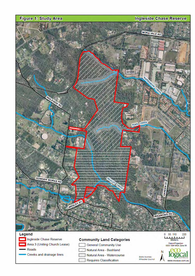
1.2 STUDY AREA
Ingleside Chase Reserve includes approximately 70 ha of largely undisturbed natural vegetation and provides a vegetated link from Narrabeen Lagoon, through the Warriewood Wetlands and Irrawong Reserve to Ku-ring-gai and Garigal National Parks. Ingleside Chase Reserve and the surrounding
areas are depicted in Figure 1.
I n g l es i d e Chas e Res er ve - P l a n o f M a n age me n t
© E C O L O G I C AL AU S T R AL I A P T Y L T D 3
Figure 1: Study Area

I n g l es i d e Chas e Res er ve - P l a n o f M a n age me n t
© E C O L O G I C AL AU S T R AL I A P T Y L T D 4
The study area provides habitat for many fauna species including several listed on the Threatened Species Conservation Act 1995 (TSC Act) and the Environment Protection and Biodiversity
Conservation Act 1999 (EPBC Act). Ingleside Chase Reserve and the vegetation of Warriewood Wetlands and Irrawong Reserve form one of the most important habitat areas in the greater Sydney region (DECC 2008).
Ingleside Chase Reserve is bounded to the east by new residential development of the Warriewood
Valley, to the south by the residential area of Elanora Heights, to the west by rural allotments and remnant native vegetation and to the north by Mona Vale Road. Areas to the east of Ingleside Chase Reserve are being progressively developed into residential estates in line with the Warriewood Valley
Urban Land Release Planning Strategy. Rural areas to the west of Ingleside Chase Reserve are part of a longer term strategy for the development of the area.
The northern section of Ingleside Chase Reserve contains the upper catchment of both Narrabeen and Fern Creeks. The upper tributaries of Mullet Creek flow into and combine in the southern half of
Ingleside Chase Reserve before entering the Warriewood Wetlands.
1.3 PROJECT NEEDS AND OBJECTIVES
Ingleside Chase Reserve and the vegetation of Warriewood Wetlands and Irrawong Reserve are of
regional conservation significance (DECC 2008) and are highly valued by the local community. The reserve provides opportunities for passive recreation and supports habitat for a range of threatened flora and fauna. The high ecological values of Ingleside Chase Reserve are further enhanced by a
range of functions played for the broader community. The reserve provides a leafy backdrop to the urban areas of Warriewood and North Narrabeen and a number of natural attractions such as the Mullet Creek waterfall and vistas through to the ocean and headlands are well known to local residents.
Natural bushland in the Pittwater area protects and supports native plants and animals and their habitats as well as providing recreational and outdoor educational opportunities for local residents and visitors to the area. Large areas of native vegetation help to inspire interest and provide relief from
everyday life in the ever-increasing metropolitan landscape of the Sydney region. These natural areas also support important features of historical significance including Aboriginal heritage sites that otherwise may have been destroyed or lost to the public (Gondwana Consulting 2005).
Due to the relatively steep slopes within the Ingleside Chase Reserve, development of the surrounding
areas, particularly the Warriewood Valley and the rural area of Ingleside has had minimal effect on the reserve. The primary factors currently affecting the reserve include uncontrolled access and weed plumes associated with nutrient laden stormwater entering the reserve via the tributaries of Mullet
Creek. These challenges and the need to resolve them for the benefit of the community and the biodiversity value of the reserve combined with new property acquisition, has led to the need for a revised plan of management to guide the conservation and management of Ingleside Chase Reserve
into the future.
The existing Plan of Management for the northern section of the Ingleside Chase Reserve (Gondwana Consulting 2005) is now five years old and has reached its review period and requires updating. This update reflects new property acquisitions and amalgamations into a much larger public reserve and
changes within the local, state and federal legislation and policy environment.
Pittwater Council has recently prepared a Pittwater Natural Areas (Draft) Plan of Management (Dec 2009). Part 1 (Generic Management Issues) is an overarching document that sets out the directions for future planning and management of open space in Pittwater LGA. The aim of this overarching Plan is
to ensure that the natural area reserves of the Pittwater area retain their environmental, recreational,

I n g l es i d e Chas e Res er ve - P l a n o f M a n age me n t
© E C O L O G I C AL AU S T R AL I A P T Y L T D 5
scenic, cultural and social values by addressing key management issues such as conservation, access and public safety.
This Plan of Management for Ingleside Chase Reserve has been developed to fulfil the above
overarching aim. More specifically it provides:
a description of environmental areas and values;
a description of the management issues;
a list of prioritised works and activities including:
o measures to manage threats to biodiversity values;
o measures to address the issue of surrounding land uses encroaching into the reserve;
o identification of recreation areas, values and appropriate future recreation options; and
o activities and management actions aiming to engage the local community.
1.4 CONSULTATION
1.4.1 Previous community consultation
The previous Plan of Management was developed by Gondwana Consulting (2005) in consultation with the community. An Escarpment Plan of Management Subcommittee was established to oversee and provide comment for inclusion in the Plan of Management for the reserve. A range of issues were
raised by the subcommittee, including (Gondwana Consulting 2005):
access routes and type(s) of access;
user groups and managing the number of users;
protection of water ways;
long-term weed management;
appropriate incorporation of past and present Guringai (Aboriginal) heritage;
mechanisms to ensure allocation of resources for at least essential long-term maintenance and erosion control;
bushfire management – need for an escarpment wide strategy;
categorisation of land (appropriate location of general community use); and
zoning to achieve the highest level of environmental protection and to stop, as far as possible,
any future sale of the land.
In addition to the issues raised by subcommittee, three primary community values were identified during
the process of community land acquisition for the Ingleside Chase Reserve, namely:
scenic amenity;
importance as a wildlife refuge and as habitat for plants and animals – particularly small birds
and threatened species; and
corridor values – the escarpment as a link between National Parks.
1.4.2 Community consultation
A range of stakeholders were consulted during the preparation of this Plan of Management. Representation was sought from local government, special interest groups, residents, the Uniting
Church and the broader community.
Prior to the draft exhibition of this Plan of Management, on-site consultation was undertaken with the Uniting Church to discuss current and future management of the southern section of land which has

I n g l es i d e Chas e Res er ve - P l a n o f M a n age me n t
© E C O L O G I C AL AU S T R AL I A P T Y L T D 6
been amalgamated into the Ingleside Chase Reserve under this plan. Discussions were also held with Sydney Conference & Training Centre to ascertain the current usage and desires for the future
management of the Reserve. Due to the timing of this plan, a range of other stakeholders were unavailable for comment prior to the exhibition of the draft plan. It has been assumed that the draft exhibition will adequately capture any issues or needs that other stakeholders may have.
1.4.3 Community Engagement Plan
A pivotal component of any plan of management, particularly when dealing with such a large area of natural bushland with high ecological, social and education values, is to ensure adequate community engagement and consultation. People within the local community are best placed to provide insight for
a plan of management as they have lived in the area and ‘experienced’ the reserve over time and witnessed the on-going development of the region. This local knowledge and interest will be essential in formalising the final plan of management for Ingleside Chase Reserve and will help to form
management objectives and targets which will be supported by the community.
It has been proposed to publicly exhibit the Ingleside Chase Reserve Plan of Management for a period of six weeks after which a public meeting and forum will be held to discuss any issues or comments which may arise.

I n g l es i d e Chas e Res er ve - P l a n o f M a n age me n t
© E C O L O G I C AL AU S T R AL I A P T Y L T D 7
2 Relevant Legislation
Legislation and policy that has been taken into consideration in the development of the Ingleside Chase
Reserve Plan of Management is listed below. Please refer to the Pittwater Natural Areas Draft Plan of Management (Part 1): Generic Management Issues (Pittwater Council 2009) for a full explanation of the legislation/policy and its applicability to this Plan of Management.
Environmental Planning and Assessment Act 1979;
Environmental Protection and Biodiversity Conservation Act 1999 (Commonwealth);
Fisheries Management Act 1994;
Local Government Act 1993;
Noxious Weeds Act 1993;
Pittwater Local Environment Plan 1993;
Protection of Environment Operations Act 1997;
Rural Fires Act 1997;
State Environment Planning Policies for Infrastructure, Bushland in Urban Areas (SEPP 19), Koala Habitat Protection (SEPP 44), Coastal Protection (SEPP 71), Coastal Wetlands (SEPP 14); and
Threatened Species Conservation Act 1995.
There are a number of other plans that relate to this Plan of Management. These include:
Warriewood/Ingleside Escarpment (North) Plan of Management (Gondwana Consulting 2005): Prepared for the conservation of the northern section of the Ingleside Chase Reserve;
Warriewood Ingleside Escarpment Bushfire Management Plan (Brian Parry & Associates 2005): Developed to guide Council and the Rural Fire Service’s management of the Ingleside Chase
Reserve from a bushfire and biodiversity perspective;
Ingleside Park Plan of Management (Pittwater Council 1997): Prepared for the conservation of
the central section of the Ingleside Chase Reserve;
Irrawong Reserve Plan of Management (Pittwater Council 1996): Prepared for Irrawong
Reserve which is part of the Mullet Creek catchment;
Mullet Creek Rehabilitation Plan (Pittwater Council 2008). Prepared for the long term
restoration of Mullet Creek which passes through the reserve;
Warriewood Wetland Plan of Management (Pittwater Council and Eco Logical Australia 2010):
Prepared for the conservation of the Warriewood wetlands within the context of the entire catchment which includes Mullet Creek;
Warriewood Valley Urban Land Release Water Management Specification 2001: Developed to ensure that the development of the Warriewood Valley is carried out in an ecologically sustainable manner within the realm of the water environment;
Warriewood Valley Urban Land Release Planning Strategy 1995: Guides rezoning and development of land within the valley;
Narrabeen Lagoon Estuary Management Plan 2002: Aims to achieve long-term sustainable management of the lagoon;

I n g l es i d e Chas e Res er ve - P l a n o f M a n age me n t
© E C O L O G I C AL AU S T R AL I A P T Y L T D 8
Management Plan for Threatened Flora and Fauna 2000: Provides detailed information about the threatened species and communities known to occur in Pittwater LGA (as of 2000).
Management and threat abatement measures consistent with the TSC Act are provided; and
Habitat and Wildlife Corridors Conservation Strategy 1995: Classifies remnant bushland in
Pittwater LGA according to its habitat and wildlife corridor values. Recommendations for protection and enhancement of these areas are presented.
2.1 LOCAL GOVERNMENT ACT 1993
The Local Government Act, 1993, (LGA) emphasises council’s responsibility to actively manage public
land and to involve the community in developing a strategy for management. The Act requires that councils classify public land as Operational or Community. The LGA requires a PoM to be prepared for Community land.
The PoM outlines the use and management of Community land. Community land is categorised and subject to separate core objectives as listed in
Table 1. Reserves can be put into one or more of the following categories:
natural area (further categorised as bushland, wetland, escarpment, watercourse or foreshore);
general community use;
sportsground;
park; or
area of cultural significance.
Table 1: Land Categories under the LGA
CATEGORISATION OF ‘NATURAL
AREAS’ FURTHER CATEGORISATION OF ‘NATURAL AREAS’
Core objectives LGA 36E
Conserve biodiversity and maintain
ecosystem functions in respect of the land, or
the feature or habitat in respect of which the
land is categorised as a natural area.
Maintain the land, or that feature of habitat, in its natural state and
setting.
Provide for the restoration and
regeneration of the
Bushland
Core objectives - LGA 36J
Ensure the ongoing ecological viability of the land by protecting the ecological biodiversity and habitat values of the land, the flora and fauna and other ecological
values of the land.
Protect the aesthetic, heritage, recreational, educational and scientific values of the land.
Promote the management of the land in a manner that protects and enhances the values and quality of the land and facilitates public enjoyment of the land, and to implement
measures directed to minimising or mitigating any disturbance caused by human intrusion.
Restore degraded bushland.
Protect existing landforms such as natural drainage lines, watercourses and foreshores.
Retain bushland in parcels of a size and configuration that will enable the existing plant and animal communities to survive in the long term.
Protect bushland as a natural stabiliser of the soil surface.

I n g l es i d e Chas e Res er ve - P l a n o f M a n age me n t
© E C O L O G I C AL AU S T R AL I A P T Y L T D 9
CATEGORISATION OF ‘NATURAL
AREAS’ FURTHER CATEGORISATION OF ‘NATURAL AREAS’
land.
Provide for community use of and access to
the land in such a manner as will
minimise and mitigate any disturbance
caused by human intrusion, and assist in
and facilitate the implementation of any provisions restricting to use and management of the land that are set out in a recovery plan
or treat abatement plan prepared under the Threatened Species
Conservation Act 1995 or the Fisheries
Management Act 1994.
Wetland
Core objectives – LGA 36K
Protect the biodiversity and ecological values of wetlands, with particular reference to their hydrological environment (including water quality and water flow), and to the flora,
fauna and habitat values of the wetlands.
Restore and regenerate degraded wetlands.
Facilitate community education in relation to wetlands, and the community use of wetlands, without compromising the ecological values of wetlands.
Escarpment
Core objectives LGA s 36L
Protect any important geological geomorphological or scenic features of the escarpment.
Facilitate safe community use and enjoyment of the escarpment.
Watercourse
Core objectives – LGA 36M
Manage watercourses so as to protect the biodiversity and ecological values of the in-stream environment, particularly in relation to water quality and water flows,
Manage watercourses so as to protect the riparian environment, particularly in relation to riparian vegetation and habitats and bank stability
Restore degraded watercourses.
Promote community education and community access to and use of the watercourse, without compromising the other core objectives of the category.
Foreshore (note: below the high water mark is Crown land)
Core objectives – LGA s 36N
Maintain the foreshore as a transition area between the aquatic and the terrestrial environment, and to protect and enhance all functions associated with the foreshore’s
role as a transition area.
Facilitate the ecologically sustainable use of the foreshore, and to mitigate impact on the foreshore by community use.
Additional Land Categories (not Natural Areas) that may apply
General Community Use
Core objectives - LGA s 36
Promote, encourage and provide for the use of the land, and to provide facilities on the land, to meet the current and future needs of the local community and of the wider public:
in relation to public recreation and the physical, cultural, social and intellectual welfare or development of individual members of the public; and
in relation to purposes for which a lease, licence or other estate may be granted in respect of the land (other than the provision of public utilities and works associated with or ancillary to public utilities).
Park
Core objectives LGA s 36G

I n g l es i d e Chas e Res er ve - P l a n o f M a n age me n t
© E C O L O G I C AL AU S T R AL I A P T Y L T D 10
CATEGORISATION OF ‘NATURAL
AREAS’ FURTHER CATEGORISATION OF ‘NATURAL AREAS’
to encourage, promote and facilitate recreational, cultural, social and educational pastimes and activities, and
to provide for passive recreational activities or pastimes and for the casual playing of games, and
to improve the land in such a way as to promote and facilitate its use to achieve the other core objectives for its management.
Area of Cultural Significance
Core objectives – LGA s 36H
To retain and enhance the cultural significance of the area (namely its Aboriginal, aesthetic, archaeological, historical, technical or research or social significance) for past, present or future generations by the active use of
conservation methods.
Those conservation methods may include any or all of the following methods:
the continuous protective care and maintenance of the physical material of the land or of the context and setting of the area of cultural significance,
the restoration of the land, that is, the returning of the existing physical material of the land to a known earlier state by removing accretions or by reassembling existing components without the introduction of new material,
the reconstruction of the land, that is, the returning of the land as nearly as possible to a known earlier state,
the adaptive reuse of the land, that is, the enhancement or reinforcement of the cultural significance of the land by the introduction of sympathetic alterations or additions to allow compatible uses (that is, uses that involve no changes to the cultural significance of the physical material of the area, or uses that involve changes that are
substantially reversible or changes that require a minimum impact),
the preservation of the land, that is, the maintenance of the physical material of the land in its existing state and the retardation of deterioration of the land.
(3) A reference in subsection (2) to land includes a reference to any buildings erected on the land.
As “Community Land” the Ingleside Chase Reserve has to be categorised into one or more of the following categories – natural area, sportsground, park, an area of cultural significance, or general community use.
A public hearing for the categorization was conducted on the 10th February 2005 and at the Council
meeting of the 14th of March 2005 Council resolved to adopt the community land categories recommended by the Independent Chairperson.
Recommendations being (in part) as follows;
“2 that the categorization as presented to the public hearing and shown on the attached categorisation Map (Figure 4 in this Draft Plan of Management) be adopted.
3 That the adopted community land categories of “Natural Area –Bushland. “Natural Area –
Watercourse” and General Community Use” as well as the further recommendations of the independent chairperson be included in the Draft Warriewood/Ingleside Escarpment Plan of Management prior to its public exhibition”.
The chosen category of “natural area” for the greater majority of Ingleside Chase Reserve was in
response to the reserve’s resources, values and significance as detailed in the preceding sections - as well as the categorisation guidelines and core management objectives set out in the Act and the input from the public during the categorisation process.

I n g l es i d e Chas e Res er ve - P l a n o f M a n age me n t
© E C O L O G I C AL AU S T R AL I A P T Y L T D 11
The “General Community Use” category was applied to land in the vicinity of the carpark off Ingleside Road and to an existing cleared area, adjoining the Mater Maria Catholic College land. Categorisation
of this section of the Mater Maria land is in keeping with the licence agreement, included in the contract of sale, between the Catholic Church and Pittwater Council. The proposed purpose of this categorisation is to enable a demountable shade structure to be erected for the purpose of outdoor
education, quiet reflection and equivalent passive activities. The location of the area is shown on Figure 1 and a detail survey of the licence area is contained in Appendix E.
2.2 FURTHER CATEGORISATION AS BUSHLAND AND WATERCOURSE
The Local Government Act 1993 also requires that lands categorised as “natural area” be further categorised into one or more of the following – bushland, wetland, escarpment, watercourse, foreshore, or a category prescribed by the regulations. Again guidelines for the further categorisation of natural
areas are presented in the Act’s Regulations. The “core objectives for management” for each category are also set out in section 36 of the Act.
In consideration of the reserve’s resources, values and significance as detailed in the preceding sections - as well as the categorisation guidelines and core management objectives set out in the Act -
the “natural area” categorisation of the greater majority of the Ingleside Chase Reserve was further categorised as follows.
The majority of the natural area category, which dominates the reserve, was categorised as “bushland”.
The small riparian corridors (50m wide) along the reserve’s larger watercourses – Mullet Creek and its tributaries in the south, and the tributaries of Narrabeen Creek in the north – were categorised as
“watercourse”.
The extent of these two categories is shown in Figure 1 and set out in Table 2.
Table 2: Community Land Categories
LAND DESCRIPTION COMMUNITY LAND CATEGORY
Lots 35//11784 and D//337891 (Ingleside Park) Natural Area – Bushland, Natural Area - Watercourse and an area of General Community Use
Lot 11 to Lot 16, DP 131704 (former Healesville Estate)
Natural Area – Bushland and Natural Area - Watercourse
Part of Mater Maria Natural Area -– Bushland and an area of General Community Use
Lot 2 DP 1093237 (former Heydon Estate) Requires Classification
Part of Lot 62 DP30255 (Uniting Church land) Requires Classification, however this land will provide for outdoor recreational, religious and educational activities
and associated equipment (all of low environmental impact), ancillary to or associated with the adjacent
Elanora Conference Centre.
Lot 70 DP 32253 Requires Classification

I n g l es i d e Chas e Res er ve - P l a n o f M a n age me n t
© E C O L O G I C AL AU S T R AL I A P T Y L T D 12
2.3 ENVIRONMENTAL PLANNING AND ASSESSMENT ACT 1979
The Environmental Planning and Assessment Act 1979 (EP&A Act) forms the basis of town planning in
New South Wales. The EPAA provides the legislative power for the preparation of State Environmental Planning Policies (SEPPs); Regional Environmental Plans (REPs); and Local Environmental Plans (LEPs.) This includes the Pittwater Local Environmental Plan 1993.
2.4 STATE ENVIRONMENTAL PLANNING POLICY ( INFRASTRUCTURE) 2007
The Infrastructure SEPP includes generic provisions to allow for development to be exempt or require a
Part V Assessment. There are 23 classes of infrastructure development where a DA is not required and only a Part V Assessment has to be undertaken. Some of the relevant classes of infrastructure development that may be carried out by or on behalf of council on a public reserve are:
roads, cycle ways, single storey car parks, ticketing facilities and viewing platforms greater than
100 sq m;
information facilities such as information boards;
lighting;
landscaping, including irrigation schemes;
amenity facilities; and
environmental management works.
2.5 (OTHER) STATE ENVIRONMENTAL PLANNING POLICIES (SEPP)
Bushland in Urban Areas (SEPP 19) - protects and preserves bushland within certain urban areas, as part of the natural heritage or for recreational, educational and scientific purposes. The policy is designed to protect bushland in public open space zones and reservations, and to ensure that bush
preservation is given a high priority when local environmental plans for urban development are prepared.
Littoral Rainforests (SEPP 26) - protects littoral rainforests, a distinct type of rainforest well suited to harsh salt-laden and drying coastal winds. The policy requires that the likely effects of proposed
development be thoroughly considered in an environmental impact statement.
Koala habitat Protection (SEPP 44) - encourages the conservation and management of natural vegetation areas that provide habitat for koalas to ensure permanent free-living populations will be maintained over their present range. The policy applies to 107 local government areas. Local councils
cannot approve development in an area affected by the policy without an investigation of core koala habitat. The policy provides the state-wide approach needed to enable appropriate development to continue, while ensuring there is ongoing protection of koalas and their habitat.
Coastal Protection (SEPP 71) - aims to ensure that the coastal zone is protected in accordance with the
principles of ecologically sustainable development. SEPP 71 defines a category and development assessment process for development in sensitive coastal locations, including land within 100m above mean high water mark of the sea, a bay or an estuary.
Coastal Wetlands (SEPP 14) - ensures coastal wetlands are preserved and protected for environmental
and economic reasons. The policy applies to local government areas outside the Sydney metropolitan

I n g l es i d e Chas e Res er ve - P l a n o f M a n age me n t
© E C O L O G I C AL AU S T R AL I A P T Y L T D 13
area that front the Pacific Ocean. The policy identifies over 1300 wetlands of high natural value from Tweed Heads to Broken Bay and from Wollongong to Cape Howe. Land clearing, levee construction,
drainage work or filling may only be carried out within these wetlands with the consent of the local council and the agreement of the Director General of the Department and Planning. Such development also requires an environmental impact statement to be lodged with a development application. The
policy is continually reviewed. It has, for example, been amended to omit or include areas, clarify the definition of the land to which the policy applies and to allow minimal clearing along boundaries for fencing and surveying.
2.6 PITTWATER LOCAL ENVIRONMENTAL PLAN 1993
The Pittwater Local Environmental Plan (PLEP) contains the land use planning controls and standards to allow the orderly and economic and sustainable development of lands in the LGA. The PLEP is
made up of a zoning map and written instrument that categorises development or land uses as either permissible or prohibited. All development must comply with the provisions of the relevant zoning. The PLEP allows development to be carried out without consent when authorised in an ‘adopted’ POM.

I n g l es i d e Chas e Res er ve - P l a n o f M a n age me n t
© E C O L O G I C AL AU S T R AL I A P T Y L T D 14
3 Council Development and Community Activities
3.1 KEY DIRECTIONS OF COUNCIL
This Plan of Management has been developed to be consistent with the management directions of
Pittwater Council’s Strategic Plan.
A key direction for Pittwater Council is valuing and caring for the natural environment. This involves the need to be a model community that leads the way towards sustainable living by reducing ecological footprints, protecting and enhancing the bush, beaches and waterways as well as achieving long-term
sustainability of biodiversity. The key strategies include:
supporting viable and thriving biodiversity and sustainable ecosystems;
Sustainably managing our areas of urban forest, bushland and waterways; and
providing a diverse range of accessible recreational opportunities for a broad range of ages, abilities and interests inspired by bush, beach and water.
3.2 MANAGEMENT PRINCIPLES FOR NATURAL AREAS
A set of management principles have been developed by Pittwater Council to ensure natural areas are
managed according to best practice. These principles are designed to foster the protection, conservation and enhancement of natural areas and include:
minimise negative impacts on the natural environment;
continue to review management practices to keep up-to-date with best practices;
integrate a well-connected network of natural area reserves with:
o a dominance of the urban forest; and
o maximisation of wildlife corridors.
integration of activity nodes in neighbouring parklands;
provide a diverse range of recreational, economic and social opportunities in reserves where appropriate, while conserving the natural environment and its ecosystems; and
manage natural risks and issues for adjoining residents.
The management strategies and actions in this Plan of Management for Ingleside Chase Reserve have been prepared in accordance with the above principles.
3.3 COUNCIL DEVELOPMENT AND USES FOR ALL NATURAL AREAS
Development of Community land
Permissible Uses Exempt
In the case of development on Community land any land use must:
1. be for a purpose that promotes or is related to the use and enjoyment of that land;

I n g l es i d e Chas e Res er ve - P l a n o f M a n age me n t
© E C O L O G I C AL AU S T R AL I A P T Y L T D 15
2. be consistent with the purposes for which the land was reserved or otherwise set aside for public use;
3. does not substantially diminish public use of, or access to that land; and
4. does not adversely affect the natural environment, the heritage significance of the heritage
items or heritage conservation areas or the existing amenity of the area.
In the case of development that is exempt development; an environmental assessment of the development may be required under the EPAA Part V process.
List of Prohibited Uses
Prohibited activities include, but are not limited to the following list:
dumping of refuse (including building materials, soil, fill, household waste, etc.);
private alienation or encroachment;
recreational motor vehicles, including four-wheel driving, motor bike or trail bike riding or similar, other than use for filming on a short term basis;
removal of habitat features such as soil, rocks, stones, fire wood, pebbles and the like;
No domestic animals including dogs and cats are allowed into the reserve; and
Bicycle riding of any form.
Specific Development of Individual Reserves
In the case of development at the reserves, some of the reserves may allow; or conversely prohibit,
certain development. In these circumstances the development will be listed in the reserve chapter of Part 2.
3.4 COUNCIL MANAGEMENT
The Ingleside Chase Reserve is public land managed by Pittwater Council. The reserve currently consists of a number of different zones (Figure 2):
Zone 7a: Environment Protection "A" over the northern and southern sections of the reserve (including the former Heydon Estate);
Zone 6a: Existing Recreation “A” over the central portion of the reserve (Ingleside Park);
Zone 9d: Arterial Road Reservation for a distance of 15m from the existing road reserve along Mona Vale Road;
Zone 1a: Non-urban “A” over a narrow section adjoining the arterial road reservation along Mona Vale Road; and
Zone 5a: Special Uses “A” over the land in the south of the reserve acquired from the Uniting Church.
It is envisaged that land zoned 5a formerly of the Uniting Church will be rezoned 7a – Environment Protection “A”, once fully incorporated into the Ingleside Chase Reserve. A section of the reserve (known as Area 3 – refer Figure 1) is subject to a 99 year lease from Pittwater Council. This section of
the reserve adjoins the existing Uniting Church Conference Centre and is intended to be used for
I n g l es i d e Chas e Res er ve - P l a n o f M a n age me n t
© E C O L O G I C AL AU S T R AL I A P T Y L T D 16
outdoor recreational, religious and educational activities and associated equipment (all of low environmental impact), ancillary to or associated with the adjacent Elanora Conference Centre. The
principles of this plan of management are to be applied to Area 3 to ensure consistency throughout the reserve and catchment as a whole.
As stated in the Pittwater Local Environment Plan 1993, the objectives of Zone 7a are to:
identify areas having significant natural, cultural and heritage conservation values; and
ensure that the ecology and environmental qualities of land within the zone are enhanced and protected from adverse impact arising from development of land in the vicinity.
Current management of the Ingleside Chase Reserve consists primarily of weed control and bushfire hazard reduction works. The majority of weed control works to date have been undertaken along Mullet
Creek and its tributaries. The aims of the bush regeneration works in Mullet Creek are to preserve the biodiversity of Mullet Creek through a staged program of woody weed and aquatic weed removal and replanting of endemic plant species. The Mullet Creek works commenced in July 2008 and will
continue through to December 2010 with a particular focus on highly invasive noxious and environmental weeds such as Ludwigia (Ludwigia peruviana), Giant Reed (Arundo donax), Bamboo (Phyllostachys spp.), Madeira Vine (Anredera cordifolia), Privet (Ligustrum spp.), Lantana (Lantana
camara), Willows (Salix spp.), Coral Trees (Erythrina spp.) and aquatic weeds.
Bushfire management hazard reduction works have been undertaken across several areas within the Ingleside Chase Reserve and consisted primarily of woody weed control pre-fire to minimise the risk of weed invasion post-fire. Several areas which were prepared for hazard reduction works by the RFS
were not subsequently burnt due to unforseen issues with the management of containment lines and rainfall.
Several informal walking tracks currently traverse the Ingleside Chase Reserve from Irrawong Reserve in the south through to Ingleside Park in the central section of the reserve. Informal mountain bike
tracks cross through the reserve and have created significant safety and environmental issues.
No formal track works have been undertaken, however there is potential to create a track which links the Warriewood valley to future development in the Ingleside area, or a loop track which traverses a range of vegetation types.
3.5 COMMUNITY ACTIVITIES
Ingleside Chase Reserve is not heavily utilised by the local community. The main access to the reserve is via Ingleside Park which is located on Ingleside Road. Within Ingleside Park, there is a small sealed
car park area which accommodates approximately 17 vehicles. With the closure of access to Ingleside Road from Mona Vale Road, only limited traffic (local only) passes the Ingleside Chase Reserve. In addition, there is no signage indicating the presence of the reserve from the nearby arterial Powder
Works Road. The combination of these factors is likely to limit the potential visitor numbers.
Without a formal track network, only the local community immediately surrounding the reserve (including Mater Maria) are likely to utilise the reserve. The most commonly undertaken activities within the reserve include walking, bird watching and mountain biking. The remainder of the reserve is not
often visited due to a lack of access through the remnant bushland.

I n g l es i d e Chas e Res er ve - P l a n o f M a n age me n t
© E C O L O G I C AL AU S T R AL I A P T Y L T D 17
The community or a lessee can seek a permit to carry out certain activities. New works and certain activities are subject to Council approval. Guidelines are available in the relevant Council Policies.
Policies include, but are not limited to, the following polices:
Beach and Rockpool Management (Policy No 88);
Climate Control (Policy No 176);
Dog Control (Policy No 30);
Film Permit (Policy No 96) – Amended September 2005;
Flood Risk Management Policy for Pittwater June 2001;
Geotechnical Risk Management Policy for Pittwater – 2008 (Policy No 178) Interim Policy;
Land – Disposal of Surplus (Policy No 92);
Naming of Streets and Pathways (Policy No 44);
Parking – Issue of Annual Permits – Waving of Parking Fees (Policy No 18);
Pittwater Foreshore and Ocean Front Access (Policy No 171);
Pittwater Sustainability Policy (Policy No 164);
Plagues in Parks and Reserves (Policy No. 157);
Prohibited Activities on Council and Public Reserves (Policy No. 86);
Public Reserves and Other Land – Resumption for Public Utilities (Policy No 56);
Reserves, Beaches and Headlands Booking Policy No 93);
Sale of Drainage Reserves (Policy No 57);
Signs – Council Facilities (Policy No 129) “Signs as Remote Supervision – Best Practice Manual, 1999.”;
Storage of Craft – Dinghies / Boats (Policy No. 26);
Sustainability Policy (Policy No. 164);
Temporary Storage on Council Reserves (Policy No. 84);
Urban Stormwater – Integrated (Policy No. 69);
Volunteer Bush Regeneration- Guidelines (Policy No. 90); and
Watercourse Preservation (Policy No. 67).

I n g l es i d e Chas e Res er ve - P l a n o f M a n age me n t
© E C O L O G I C AL AU S T R AL I A P T Y L T D 18
Activity Controls
Disturbance Activities that may be Permissible with Consent
Some disturbance activities may be permissible subject to Council authorisation, establishment of a bond and generally the issuing of a licence. The types of activities that may cause disturbance includes
commercial activities such as filming, collection of plant propagules and similar material, or other activities as identified by the appropriate Council staff.
Other disturbance activities may also be permissible under SEPP 19 Clause 6 (1) which allows the following activities without development consent:
bushfire hazard reduction;
facilitating recreational use of bushland in accordance with a plan of management referred to in
clause 8 of SEPP 19;
lines for electricity or telecommunication purposes;
pipelines to carry water, sewerage or gas or pipelines licensed under the Pipelines Act 1977, or
constructing or maintaining main roads.
However, a consent authority shall not consent to the carrying out of development referred to in subclause (1) unless:
(a) it has made an assessment of the need to protect and preserve the bushland having regard to the aims of this Policy;
(b) it is satisfied that the disturbance of the bushland is essential for a purpose in the public interest
and no reasonable alternative is available to the disturbance of that bushland; and
(c) it is satisfied that the amount of bushland proposed to be disturbed is as little as possible and, where bushland is disturbed to allow construction work to be carried out, the bushland will be reinstated upon completion of that work as far as is possible.
Reserve bookings
Occasionally reserves may be sought for special uses. Any such use is subject to discussions with
Council to assess the appropriateness of the site and will attract a booking fee.
Leases, licences and other estates
A lease or licence is issued by Council for activities that either result in exclusive control for a set period or intermittent, short term occupation. Activities need to take into account the direct and indirect adverse impacts of the proposed activity. If the impact is deemed to be beyond the limit of acceptable
change for the natural area, the lease or licence for that activity should not be issued.
Council may enter into a lease, licence or tenure for whole or part of the lands covered in this plan provided that:

I n g l es i d e Chas e Res er ve - P l a n o f M a n age me n t
© E C O L O G I C AL AU S T R AL I A P T Y L T D 19
management is in accordance with this plan and relevant with Council policies and guidelines as current at the time of application;
any agreement would be subject to compatible use of the reserve and for the benefit of the
wider public;
granting of the lease or licence is in accordance with the provisions of the Local Government Act 1993 or the Crown Lands Act 1989 as applicable (refer to Tenures of Crown Land under Chapter 3 Legislation); and
granting of a lease or licence is in accordance with the aims and objectives of State
Environmental Planning Policy 19 - Bushland in Urban Areas.
This PoM authorises all existing leases and licences applying to the reserves covered in the PoM until the expiry of their current term or amendment.

I n g l es i d e Chas e Res er ve - P l a n o f M a n age me n t
© E C O L O G I C AL AU S T R AL I A P T Y L T D 20
Figure 2: Zoning
I n g l es i d e Chas e Res er ve - P l a n o f M a n age me n t
© E C O L O G I C AL AU S T R AL I A P T Y L T D 21
4 Resource Overview & Site Features 4.1 VALUES STATEMENT
The values of the Ingleside Chase Reserve include:
biodiversity including numerous threatened animals and rare plant communities;
habitat and wildlife corridor provision;
recreation;
aesthetic / visual amenity (a significant landscape feature of the Pittwater LGA); and
ecosystem services such as sediment and nutrient filtering;
The Ingleside Chase Reserve is the largest area of bushland managed by Pittwater Council and
consists entirely of remnant bushland which is now scarce in urban Sydney. The reserve provides habitat for a range of threatened fauna species and contains a diverse range of plant communities, some of which are rare in a regional context. The vast majority of the reserve is considered to be in
good condition which is important for conserving the biodiversity of the region.
The Ingleside Chase Reserve is part of a significant biodiversity corridor which links the adjoining Ku-ring-gai and Garigal National Parks through Irrawong Reserve to the Warriewood Wetlands. This corridor has been identified as having some of the highest fauna values in the Sydney Metropolitan
CMA (DECC 2008).
4.2 SITE HISTORY
The biodiversity of the Ingleside escarpment was initially conserved over approximately 11.9 ha in the
central portion of the current reserve at Ingleside Park. The vegetation of Ingleside Park consists of Hawkesbury sandstone open-woodland which is known to support a diverse fauna assemblage including the threatened species Powerful Owl, (Ninox strenua), Giant Burrowing Frog (Heleioporus
australiacus) and Red-crowned Toadlet (Pseudophryne australis).
As part of the planning process for the Ingleside and Warriewood urban release areas, a number of environmental studies were conducted including land capability, visual impact and ecology. These studies found that the majority of the Ingleside escarpment was physically and ecological constrained
and any form of urban development on the escarpment was not recommended (Gondwana Consulting 2005). In response to these studies, Pittwater Council sought to protect and conserve the Ingleside escarpment through the acquisition of as much privately owned escarpment bushland as practicable.
In order to achieve this goal, Pittwater Council proposed an environmental levy on rate income to fund
the public purchase of such land. The Minister for Local Government subsequently approved the financial agreements for the environmental levy (E-levy) on 20 June 2000 with approximately $5M in funds raised over a five year period (Gondwana Consulting 2005).
Negotiations by Pittwater Council allowed for the acquisition of approximately 28 ha of the former
Healesville Estate on 6 September 2002 following a land exchange for Pittwater Council’s Ingleside Depot. The Healesville Estate section of the Ingleside escarpment constitutes the most northern section of the reserve and consists of open woodland on the upper slopes transitioning into taller forest
on the lower slopes and around creeklines is likely to support a similar faunal assemblage to Ingleside

I n g l es i d e Chas e Res er ve - P l a n o f M a n age me n t
© E C O L O G I C AL AU S T R AL I A P T Y L T D 22
Park. A small section of the Ingleside escarpment totalling 4 ha was acquired from Mater Maria Catholic College in 2005 by Pittwater Council, completing the northern section of the current reserve.
Recent negotiations with the State Government and the Uniting Church have allowed for the
incorporation of a further 27 ha of remnant bushland, including the former Heydon Estate, into the Ingleside Chase Reserve. With the incorporation of these lands, the Ingleside Chase Escarpment now covers approximately 70 ha of remnant bushland and forms the missing link in the regional biodiversity
corridor linking Ku-ring-gai and Garigal National Parks with Warriewood Wetlands and the ocean.
Several other significant parcels of privately owned bushland occur within the vicinity of the Ingleside Chase Reserve, particularly in the northwest adjoining Ingleside Road and Mona Vale Road. It was previously envisaged that Pittwater Council would pursue every opportunity to bring as much of this
land as possible into public ownership (Gondwana Consulting 2005).
4.3 TOPOGRAPHY, GEOLOGY & SOILS
The types of organisms (flora and fauna) in terrestrial ecosystems are determined by the local and
regional climate, the topography (slope, elevation and aspect which affects the local climate and the soil), the geology and soil, the other organisms in the area, and the history of disturbance events (El-Shaarawi & Piegorsch 2002).
4.3.1 Topography
Ingleside Chase Reserve is situated on the Ingleside escarpment which rises steeply from the floor of the Warriewood Valley to a height of over 120m AHD at Ingleside. Ingleside Chase Reserve is
relatively steep with average slopes of 40o, however slopes range from less than 10o to over 60 o in some areas. The topography of the site is characterised by a series of relatively flat sandstone benches, steep slopes and sandstone cliffs. Cutting through the landscape are a series of steep gullies
associated with the northern and southern arms of Mullet Creek in the south and Narrabeen Creek in the north.
From the sandstone benches within the reserve there are extensive vistas to the ocean ranging from Mona Vale headland in the north to Narrabeen headland in the south.
4.3.2 Geology and soils
The Ingleside Chase Reserve is situated primarily on Hawkesbury Sandstone geology, with a small intrusion of Quaternary Alluvium associated with the floodplain of Mullet Creek in the south of the
reserve.
Four soil landscapes have been mapped at a 1:100,000 scale across the Ingleside Chase Reserve (Figure 3, Chapman and Murphy 1989), including:
Hawkesbury (ha) soil landscape: from the north to the central section of the reserve on ridges and upper slopes. The vegetation occurring on the Hawkesbury soil landscape is characterised
by open eucalypt woodland (dry sclerophyll forest) and tall open-forest (wet sclerophyll forest) in gullies;
Lambert (la): in the central and north-western sections of the reserve in association with the Hawkesbury soil landscape. The vegetation occurring on the Lambert soil landscapes is characterised by open and closed-heathland, scrub and occasional low eucalypt open
woodland;

I n g l es i d e Chas e Res er ve - P l a n o f M a n age me n t
© E C O L O G I C AL AU S T R AL I A P T Y L T D 23
Watagan (wn): on the lower steep slopes in the east of the reserve, downslope of Hawkesbury sandstone soil landscapes. The vegetation occurring on the Watagan soil landscape is
characterised by tall eucalypt open-forest (wet sclerophyll) with closed-forest (rainforest) in sheltered positions; and
Gymea (gy): in the south of the reserve adjoining the Uniting Church land. The vegetation occurring on the Gymea soil landscape is characterised by open-forest (dry sclerophyll forest) and eucalypt woodland.
Detailed descriptions of these landscapes are provided in Table 3.
Table 3: Soil Landscapes (Chapman and Murphy 1989)
SOIL LANDSCAPE
LANDSCAPE DESCRIPTION SOIL DESCRIPTION LIMITATIONS
Hawkesbury (ha)
Rugged, rolling to very steep hills on Hawkesbury Sandstone. Local relief 40-200 m, slopes >25%. Rock outcrop >50%. Narrow crests and ridges, narrow incised valleys, steep sideslopes with rocky benches, broken scarps and boulders.
Shallow (>50 cm), discontinuous Lithosols/Siliceous Sands associated with rock outcrop; Earthy Sands, Yellow Earths and some Yellow Podzolic Soils on inside of benches and along joints and fractures; localised Yellow and Red Podzolic Soils associated with shale lenses; Siliceous Sands and secondary Yellow Earths along drainage lines.
Extreme soil erosion hazard, mass movement (rock fall) hazard, steep slopes, rock outcrop, shallow, stony, highly permeable soil, low soil fertility
Lambert (la)
Undulating to rolling low hills on Hawkesbury Sandstone. Local relief 20-120 m, slopes <20%. Rock outcrop >50%. Broad ridges, gently to moderately inclined slopes, wide rock benches with low broken scarps, small hanging valleys and areas of poor drainage.
Shallow (<50 cm), discontinuous Earthy Sands and Yellow Earths on crests and inside of benches; shallow (<20 cm) Siliceous Sands/Lithosols on leading edges; shallow to moderately deep (<150 cm) Leached Sands, Grey Earths and Gleyed Podzolic Soils in poorly drained areas; localised Yellow Podzolic Soils associated with shale lenses.
Very high soil erosion hazard, rock outcrop, seasonally perched water tables, shallow, highly permeable soil, very low soil fertility.
Watagan (wn)
Rolling to very steep hills on fine-grained Narrabeen Group sediments. Local relief 60-120 m, slopes >25%. Narrow convex crests and ridges, steep colluvial side slopes, occasional sand stone boulders and benches.
Shallow to deep (30-200 cm) Lithosols/Siliceous Sands and Yellow Podzolic Soils on sandstones; moderately deep (100-200 cm) Brown, Red and Gleyed Podzolic Soils on shales.
Mass movement hazard, steep slopes, severe soil erosion hazard, occasional rock outcrop
Gymea (gy)
Undulating to rolling rises and low hills on Hawkesbury Sandstone. Local relief 20-80 m, slopes 10-25%. Rock outcrop <25%. Broad convex crests, moderately inclined side slopes with wide benches, localised rock outcrop on low broken scarps.
Shallow to moderately deep (30-100 cm) Yellow Earths and Earthy Sands on crests and inside of benches; shallow (<20 cm) Siliceous Sands on leading edges of benches; localised Gleyed Podzolic Soils and Yellow Podzolic Soils on shale lenses; shallow to moderately deep (<100 cm) Siliceous Sands and Leached Sands along drainage lines.
Localised steep slopes, high soil erosion hazard, rock outcrop, shallow highly permeable soil, very low soil fertility.

I n g l es i d e Chas e Res er ve - P l a n o f M a n age me n t
© E C O L O G I C AL AU S T R AL I A P T Y L T D 24
Figure 3: Soil Landscapes

I n g l es i d e Chas e Res er ve - P l a n o f M a n age me n t
© E C O L O G I C AL AU S T R AL I A P T Y L T D 25
4.3.3 Acid Sulfate Soils
Potential acid sulfate soils are natural soils that form in seawater or brackish water environments. They generally occur in low lying and flat locations which are often flood prone or swampy, and are common
in every estuary and estuarine floodplain in NSW.
Land that may contain potential acid sulfate soils has been identified from maps provided by the former NSW Department of Land and Water Conservation. These maps, known as Acid Sulfate Soil Planning Maps, establish five classes of land based on the probability of acid sulfate soils being present (Class 1
being the most likely and Class 5 being the least likely). The entire Ingleside Chase Reserve has been mapped as Class 5 and is therefore unlikely to contain acid sulfate soils.
4.3.4 Erosion and sedimentation
Erosion is limited to headwaters of Mullet Creek within Ingleside Chase Reserve; however the creeks within the reserve act as a distribution network for sediments eroded upstream in the catchment. Downstream of the reserve, the Mullet Creek floodplain has been subject to extensive sedimentation as
a result of erosion of the Hawkesbury Sandstone in the upper catchment.
During the field investigation in June 2010, it was observed that significant accumulations of sediment had been lost from the upstream catchment of the northern and southern arms of Mullet Creek where major bush regeneration works targeting Coral Trees had recently been undertaken. The loss of this
sediment is most likely due to a combination of illegal road works and exposure of topsoil. This sediment is likely to pass through the reserve and accumulate in the valley floor in Irrawong Reserve and Warriewood Wetlands. Restoration works including bank stabilisation and planting have been
proposed as part of the Mullet Creek Rehabilitation Plan (Pittwater Council 2008).
4.4 WATER QUALITY AND FLOW
4.4.1 Water quality
An extensive program of water quality monitoring has been undertaken in the Warriewood Valley between 2000 and 2009 as a condition of development associated with the Warriewood Valley Urban
Land Release. Monitoring sites are situated downslope of Ingleside Chase Reserve in Mullet and Fern Creeks as well as within Warriewood Wetlands.
Overall, the key issues for water quality in the Warriewood Valley are (Pittwater Council 2001):
elevated nutrient concentrations (nitrogen and phosphorus) during both wet and dry conditions. These levels have been attributed to land use within the Valley potentially including the
upstream land uses and previous market gardens in the area;
an approximate 60% reduction in nitrogen concentrations within Narrabeen Creek between
1999 and 2008. This has been attributed to land release activities including sewage infrastructure upgrades, installation of water sensitive design features and creek rehabilitation works;
elevated faecal coliform levels during wet weather events. This is attributed to the presence of septic systems within the catchment and potential sewer overflows;
depleted levels of dissolved oxygen, particularly during dry weather conditions; and
periodic blue-green algae blooms in Narrabeen Creek.
Considering the limited upstream development and largely vegetated catchment, the water quality leaving the Ingleside Chase Reserve is generally much higher than further downstream in the

I n g l es i d e Chas e Res er ve - P l a n o f M a n age me n t
© E C O L O G I C AL AU S T R AL I A P T Y L T D 26
Warriewood Valley. It is imperative to ensure that no change to catchment pollutant loads or hydrology occurs as part of future land release and development in Ingleside.
The water quality monitoring program ceased in 2009. This program was funded by developer
contributions. However, recent changes to legislation regarding how developer contributions are allowed to be spent have resulted in a cessation of funding for this program.
4.4.2 Surface flow
The northern section of Ingleside Chase Reserve contains the upper catchment of both Narrabeen and
Fern Creeks. Narrabeen Creek flows south-east around the north of Warriewood and eventually discharges to Narrabeen Lagoon via a short section of Mullet Creek. Fern Creek flows south-east through a predominantly reconstructed drainage line and discharges to Warriewood Wetlands. The
upper tributaries of Mullet Creek flow into and combine in the southern half of Ingleside Chase Reserve before entering Warriewood Wetland and discharging into Narrabeen Lagoon.
Mullet Creek provides the primary surface water input to the Warriewood Wetland (MHL 1998). Fern Creek provides a lesser input from the north of the catchment.
4.4.3 Hydrological modifications
The hydrology of the Ingleside Chase Reserve is generally considered to be representative of natural conditions with the exception of Mullet Creek. As the northern section of the reserve contains the upper
catchment of both Narrabeen and Fern Creeks, these drainage lines have been unaltered and are considered to be in near pristine condition.
The following modifications have been made to the Mullet Creek catchments which are likely to impact on the hydrological regime:
three large dams upstream of Ingleside Chase Reserve (approximately 60 m, 1 km and 1.4km
upstream respectively). These dams effectively capture all the water in the upper catchment of the southern arm of Mullet Creek. It is likely that flows into Mullet Creek via the southern arm are restricted during most periods, except for during high rainfall;
rural development over approximately 50% of the upper catchment of Mullet Creek including Monash and Elanora Golf Courses;
a small causeway across Mullet Creek from Wesley Street to the old Ingleside Scout Hall; and
Mona Vale Road along the upper western extent of the catchment.
Future development in Ingleside has the potential to modify the hydrology of the catchment and further
exacerbate issues currently experienced downstream of the Ingleside Chase Reserve. It is recommended that future land release and development in Ingleside complies with water management specifications in a similar manner to those specifications developed for the Warriewood Valley.
4.5 PLANT AND PLANT COMMUNITIES
4.5.1 Vegetation communities
The distribution of vegetation communities within the northern section of Ingleside Chase Reserve was originally mapped as part of the Warriewood/Ingleside Escarpment (North) Plan of Management (Gondwana Consulting 2005). The following vegetation communities were identified:
Hawkesbury Sandstone Open Forest;
Lower Warriewood/Ingleside Escarpment Forest;
Hawkesbury Sandstone Gully; and
Sandstone Heath.

I n g l es i d e Chas e Res er ve - P l a n o f M a n age me n t
© E C O L O G I C AL AU S T R AL I A P T Y L T D 27
Eco Logical Australia remapped the vegetation within the entire Ingleside Chase Reserve in June 2010. While the original vegetation mapping was used as a base, a number of additional vegetation
communities were identified and adjustments were made to vegetation boundaries through the combination of interpretation of high resolution aerial photography, 1 m contours and extensive field validation. The vegetation communities identified are outlined in Table 4 and Figure 4.
Table 4: Vegetation Communities of the Ingleside Chase Reserve
VEGETATION COMMUNITY
PREVIOUS CLASSIFICATION
(GONDWANA CONSULTING 2005)
CONSERVATION STATUS AREA OF
OCCUPANCY
Hawkesbury Sandstone Woodland
Hawkesbury Sandstone Open Forest
Adequately conserved 33 ha
Hawkesbury Sandstone Low Open Woodland
(a component of Hawkesbury Sandstone
Woodland)
Hawkesbury Sandstone Open Forest
Adequately conserved 3.9 ha
Ingleside Escarpment Wet Sclerophyll Forest
Lower Warriewood Ingleside Escarpment
Forest Regionally rare community 18.8 ha
Sandstone Heath Sandstone Heath Rare in Pittwater, adequately conserved
regionally 5.5 ha
Sandstone Gully Forest Hawkesbury Sandstone
Gully Adequately conserved 3.8 ha
Coachwood Warm Temperate Rainforest
Areas of this vegetation community have been
included in Hawkesbury Sandstone Gully
Rare, other local occurrences include Allenby Park in Warringah LGA and sheltered gullies in Ku-ring-gai and
Garigal National Parks.
2.6 ha
Swamp Sclerophyll Forest N/A Endangered 1.0 ha
Disturbed / Weeds N/A N/A 1.2 ha
A description of the biophysical and floristic characteristics of each vegetation community is provided in Appendix A.

I n g l es i d e Chas e Res er ve - P l a n o f M a n age me n t
© E C O L O G I C AL AU S T R AL I A P T Y L T D 28
Figure 4: Vegetation Mapping

I n g l es i d e Chas e Res er ve - P l a n o f M a n age me n t
© E C O L O G I C AL AU S T R AL I A P T Y L T D 29
Endangered Ecological Communities
Only one of the vegetation communities in Ingleside Chase Reserve corresponds to an Endangered
Ecological Community (EECs) listed under the NSW Threatened Species Conservation Act 1995 (TSC Act), namely Swamp Sclerophyll Forest. The location of Swamp Sclerophyll Forest in the Ingleside Chase Reserve is included in Figure 4.
EECs face a very high risk of extinction in NSW in the near future. Threats to Swamp Sclerophyll
Forest include (DECCW 2010a):
further clearing for urban and rural development, and the subsequent impacts from fragmentation;
flood mitigation and drainage works;
management of water and tidal flows;
land filling and earthworks associated with urban and industrial development;
grazing and trampling by stock and feral animals (particularly pigs);
changes in water quality, particularly increased nutrients and sedimentation;
weed invasion;
climate change;
activation of acid sulfate soils;
removal of dead wood;
rubbish dumping; and
frequent burning which reduces the diversity of woody plant species.
Strategies required to recover EECs have been identified in the Priority Action Statement for Swamp Sclerophyll Forest (DECCW 2010b). Possible actions for Swamp Sclerophyll Forest at the Ingleside Chase Reserve are listed in Table 5. Not all actions may be relevant or feasible at Ingleside Chase
Reserve. All management recommendations put forward in this Plan of Management are consistent with the stated recovery actions.
Table 5: Relevant Recovery Actions for Swamp Sclerophyll Forest in the Ingleside Chase Reserve
RECOVERY STRATEGY / ACTION APPLICABLE FOR INGLESIDE
CHASE RESERVE?
Captive Husbandry or ex-situ collection/propagation
Collect seed for NSW Seedbank. Develop collection program in collaboration with BGT - all known provenances (conservation collection).
Investigate seed viability, germination, dormancy and longevity (in natural environment and in storage).
Community and land-holder liaison/ awareness and/or education
Enhance the capacity of persons involved in the assessment of impacts on this EEC to ensure the best informed decisions are made.
Liaise with landholders and undertake and promote programs that ameliorate threats such as grazing and human disturbance.
Habitat management: Ongoing EIA - Advice to consent and planning authorities
Prepare identification and impact assessment guidelines and distribute to

I n g l es i d e Chas e Res er ve - P l a n o f M a n age me n t
© E C O L O G I C AL AU S T R AL I A P T Y L T D 30
RECOVERY STRATEGY / ACTION APPLICABLE FOR INGLESIDE
CHASE RESERVE?
consent and determining authorities.
Habitat management: Site Protection (eg Fencing/Signage)
Identify and prioritise other specific threats and undertake appropriate on-ground site management strategies where required.
Habitat management: Weed Control
Undertake weed control for Bitou Bush and Boneseed at priority sites in accordance with the approved Threat Abatement Plan and associated PAS
actions X
Habitat Protection (inc vca/ jma/ critical habitat nomination etc)
Use mechanisms such as Voluntary Conservation Agreements to promote the protection of this EEC on private land.
Research
Determine location, species composition and threats to remaining remnants to assist with prioritising restoration works.
Investigate the ecology of Swamp sclerophyll forest species with particular emphasis on the importance of drying and wetting cycles in maintaining
ecosystem health.
Undertake research to determine minimum fire frequency.
Survey/Mapping and Habitat assessment
Collate existing information on vegetation mapping and associated data for this EEC and identify gaps in knowledge. Conduct targeted field surveys and
ground truthing to fill data gaps and clarify condition of remnants.
While Swamp Sclerophyll Forest is the only Endangered Ecological Community protected under
legislation, Ingleside Chase Reserve protects a wide diversity of vegetation communities including a number of communities which are both rare within Pittwater and rare within the region. This includes Coachwood Warm Temperate Rainforest and Sandstone Heath which are both rare within Pittwater, but
are adequately conserved within the Sydney Basin Bioregion and Ingleside Escarpment Wet Sclerophyll Forest which is rare in a local and regional context. These vegetation communities support a large diversity of native plants and animals, many of which are also considered rare or threatened.
Vegetated Buffer
In total, approximately 65% of the Ingleside Chase Reserve has some form of native vegetation outside
the zoned reserve boundary that acts as a buffer. In some instances this buffer is considerable, consisting of over 280 m of remnant woodland.
The current buffering capacity of the surrounding vegetation is limited in the south of the reserve, while the surrounding vegetation in the northern half of the reserve is effectively buffering the reserve from
surrounding impacts. The northern buffer, particularly in the west of the reserve, has the potential to be compromised by future development in Ingleside. This land is currently zoned “1(a), Non-Urban” and therefore has potential to be developed at a later stage. The vegetation comprising the north-western

I n g l es i d e Chas e Res er ve - P l a n o f M a n age me n t
© E C O L O G I C AL AU S T R AL I A P T Y L T D 31
buffer is substantial and forms part of a large biodiversity corridor which links the adjoining Ku-ring-gai and Garigal National Parks through Irrawong Reserve to the Warriewood Wetlands.
As the vegetation of the north-western buffer is located upslope of the Ingleside Chase Reserve
(Management Zone 7, Figure 6), it is imperative that any future development in this area is undertaken in a sympathetic manner to minimise potential impacts on the reserve. Considering the high ecological value of the land and the potential impacts its’ development may have on the reserve and biodiversity, it
is recommended that the land be acquired and permanently set aside for conservation.
4.5.2 Rare and threatened flora
Only two threatened flora species have been recorded within the immediate vicinity (i.e. 1 km) of Ingleside Chase Reserve, namely Tetratheca glandulosa Glandular Pink-bell) and Grevillea caleyi
(Caley's Grevillea). While suitable habitat for Glandular Pink-bell occurs within the confines of the reserve, no potential habitat for Caley's Grevillea was identified. Considering the size and condition of the reserve, there is potential for a wide range of threatened species to occur.
One species on the Rare or Threatened Plants (ROTAP) list, nine species which are considered
threatened in northern Sydney (Smith and Smith 2000) and eight species considered locally rare and being of significance in the Pittwater LGA were identified at Ingleside Chase Reserve (Table 6).
Table 6: Rare or threatened plants in Ingleside Chase Reserve
SPECIES COMMON NAME STATUS
Acacia oxycedrus Spike Wattle Locally rare
Bertya brownii ROTAP 2RC – Nationally rare
Blechnum camfieldii Water Fern Threatened in northern Sydney
Blechnum indicum Swamp Water Fern Threatened in northern Sydney
Boronia mollis Soft Boronia Locally rare
Cymbidium suave Native Cymbidium Locally rare
Duboisia myoporoides Corkwood Locally rare
Eucalyptus capitellata Brown Stringybark Threatened in northern Sydney
Eucalyptus robusta Swamp Mahogany Threatened in northern Sydney
Eupomatia laurina Bolwarra Threatened in northern Sydney
Ficus obliqua Small-leaved Fig Threatened in northern Sydney
Lepidosperma elatius Tall Sword-sedge Threatened in northern Sydney
Liparis reflexa Tom Cats Locally rare
Olearia tomentosa Downy Daisy-bush Locally rare
Prostanthera denticulata Rough Mintbush Threatened in northern Sydney
Podolobium ilicifolium Native Holly Locally rare
Solanum aviculare Kangaroo Apple Threatened in northern Sydney
Solanum prinophyllum Forest Nightshade Locally rare

I n g l es i d e Chas e Res er ve - P l a n o f M a n age me n t
© E C O L O G I C AL AU S T R AL I A P T Y L T D 32
Eucalyptus robusta (Swamp Mahogany) occurs in low numbers in the south-east of Ingleside Chase Reserve in the Swamp Sclerophyll Forest. Swamp Mahogany is listed as a Protected Species under
the NSW National Parks and Wildlife Act 1974 (NPW Act) and as a major feed tree for Koalas under SEPP 44 (Koala Habitat Protection). Swamp Mahogany is an important winter flowering food source for a number of birds, including listed threatened/migratory species. These factors highlight the importance
of protecting Swamp Mahogany within the Mullet Creek system.
4.5.3 Weeds
Weed infestations within Ingleside Chase Reserve are concentrated around the upper and lower sections of Mullet Creek, with other weed infestations associated with encroachments and minor
drainage lines. Eleven noxious and fourteen environmental weeds have been recorded in Ingleside Chase Reserve (Table 7).
Garden and aquarium escapees and dumping of green waste are a major source of weed invasion into Ingleside Chase Escarpment. The seriousness of this threat has recently been recognised by the
Australian Government. ‘Loss and degradation of native plant and animal habitat by invasion of escaped garden plants, including aquatic plants’ was listed on the EPBC Act as a key threatening process (KTP) in January 2010 (Commonwealth of Australia 2010). General threat abatement
measures for this KTP are provided by DEWHA (Commonwealth of Australia 2010), and specific actions to be undertaken in Ingleside Chase Escarpment are detailed in Section 6.5.
The NSW Noxious Weeds Act 1993 specifies the duties of landholders, including Councils, for control of noxious weeds.
Table 7: Weed species in the Ingleside Chase Escarpment
SPECIES COMMON NAME STATUS IN PITTWATER LGA
Acetosa sagittata Rambling Dock, Turkey Rhubarb 4
Ageratina adenophora Crofton Weed Environmental Weed
Ageratina riparia Mistflower Environmental Weed
Andropogon virginicus Whisky Grass, Broomsedge Environmental Weed
Arundo donax Giant Reed 4
Asparagus aethiopicus Asparagus Fern 4
Bidens pilosa Farmer's Friend Environmental Weed
Cestrum parqui Green Cestrum 3
Cinnamomum camphora Camphor-laurel Environmental Weed
Cortaderia selloana Pampas Grass 3
Egeria densa Dense Waterweed 5
Erythrina crista-galli Cockspur Coral Tree Environmental Weed
Erythrina x sykesii Coral Tree Environmental Weed
Genista monspessulana Montpelier Broom Environmental Weed
Hedychium gardnerianum Yellow Ginger, Ginger Lily Environmental Weed
Hydrocotyle bonariensis Beach Pennywort Environmental Weed

I n g l es i d e Chas e Res er ve - P l a n o f M a n age me n t
© E C O L O G I C AL AU S T R AL I A P T Y L T D 33
SPECIES COMMON NAME STATUS IN PITTWATER LGA
Isolepis prolifera Budding Club-rush Environmental Weed
Lantana camara Lantana 4
Ludwigia peruviana Ludwigia 3
Nephrolepis cordifolia Fishbone Fern Environmental Weed
Ochna serrulata Mickey Mouse Plant 4
Oxalis corniculata Yellow Wood-sorrel 5
Rubus fruticosus (sp. agg) Blackberry 4
Senna pendula var. glabrata Senna Environmental Weed
Tradescantia fluminensis Wandering Jew Environmental Weed
Noxious Weed Class Requirements: 3 - The plant must be fully and continuously suppressed and destroyed 4- The growth and spread of the plant must be controlled according to the measures specified in a management plan published by the local control authority and the plant may not be sold, propagated or knowingly distributed 5 - The requirements in the Noxious Weeds Act 1993 for a notifiable weed must be complied with
4.5.4 Bushfire and minimum fire intervals
The entire Ingleside Chase Reserve was burnt by wildfire in 1994, which has resulted in a relatively even age class of vegetation across the reserve. It is likely that a number of sheltered gullies, particularly those dominated by Coachwood Warm Temperate Rainforest would have escaped the fire
due to a number of factors including aspect and moisture. Three hazard reduction burns have been undertaken within the confines of the reserve by the RFS since 1994. One of these burns was along the boundary of the Uniting Church Conference Centre in the south of the reserve in 2004. In 2005, two
hazard reduction burns were undertaken, one in the central portion of the reserve at Ingleside Park and another immediately adjoining Mater Maria College (Figure 5).
The Bush Fire Environmental Assessment Code for NSW (RFS 2006) provides a streamlined environmental assessment process for use by issuing authorities and certifying authorities in determining bush fire hazard reduction certificates. The Bushfire Environmental Assessment Code has
regard to the principles of ecologically sustainable development and considerations under section 111 of the EP&A Act. The Bushfire Environmental Assessment Code specifies the minimum fire intervals for Vegetation Classes (Keith 2004) for both Strategic Fire Advantage Zones (SFAZ) and Land
Management Zones (LMZ).
Strategic Fire Advantage Zone (SFAZ): Are zones in which vegetation can be managed to reduce fine fuel load and structure to a level that provides fire fighters with an area in which they have a high probability of success in containing bushfires burning within, or into, the area. This zone allows fine
fuels to be reduced by approximately 50-80% within the area, with the vertical structure of fine fuels (shrubs) also reduced.
Land Management Zone (LMZ): Zone in which vegetation can be managed to provide a mosaic of areas with varying fuel load structures. This zone should maintain or enhance biodiversity, but should
also allow for fuel-reduced areas in which fire fighting suppression efforts are safer and have a greater chance of success.

I n g l es i d e Chas e Res er ve - P l a n o f M a n age me n t
© E C O L O G I C AL AU S T R AL I A P T Y L T D 34
Figure 5: Ingleside Chase Reserve Fire History

I n g l es i d e Chas e Res er ve - P l a n o f M a n age me n t
© E C O L O G I C AL AU S T R AL I A P T Y L T D 35
The majority of the Ingleside Chase Reserve would consist of land management zones (LMZs) for the conservation of biodiversity. The minimum fire intervals for each vegetation community within Ingleside
Chase Reserve, their corresponding Keith Vegetation Class and minimum fire intervals have been included in Table 8 and mapped in Figure 5. It should be noted that the fire intervals specified are the absolute minimum for hazard reduction and do not necessarily represent the most appropriate fire
regime for each vegetation community. Hazard reduction burns within the reserve should aim to result in a mosaic of burnt and unburnt areas to facilitate fauna habitat.
Table 8: Minimum fire intervals
VEGETATION COMMUNITY KEITH VEGETATION CLASS
MINIMUM FIRE INTERVAL
SFAZ LMZ
Sandstone Heath Sydney Coastal Heaths 7 10
Hawkesbury Sandstone Open Woodland
Hawkesbury Sandstone Low Open Woodland
Sydney Coastal Dry Sclerophyll Forest 7 10
Sandstone Gully Forest Sydney Coastal Dry Sclerophyll Forest 7 10
Swamp Sclerophyll Forest Coastal Swamp Forest 7 10
Ingleside Escarpment Wet Sclerophyll Forest
North Coast Wet Sclerophyll Forest 25 30 (low intensity fire only)
Coachwood Warm Temperate Rainforest
Northern Warm Temperate RainforestsNo burning permitted
No burning permitted
The fire intervals outlined in Table 8 vary from those identified in the Warriewood Ingleside Escarpment Bushfire Management Plan (Brian Parry & Associates 2005), therefore it is recommended that a review
and update of the Bushfire Management Plan is undertaken.
4.6 LOCAL FAUNA
The Ingleside Chase Escarpment supports a large number of native animals including birds, mammals
(including bats) and aquatic species. The biodiversity corridor from the Ingleside Escarpment to Warriewood Wetland provides habitat for 207 terrestrial species (recorded during the last decade), including: 166 birds, 20 mammals, 15 reptile and 5 frogs (DECC 2008). Ingleside Chase Reserve
provides essential habitat for a large number of these species, including several that are listed under state and federal environmental legislation.
4.6.1 Significant fauna
A list of significant fauna recorded or expected to occur in Ingleside Chase Reserve is provided in Table 9. This list is based on the table provided in the Warriewood/Ingleside Escarpment (North) Plan of Management (Gondwana Consulting 2005), with updates from the NPWS Atlas (DECCW 2010c) and
DEWHA Protected Matters Search (DEWHA 2010). A total of twelve mammals, six bats, two frogs, and twelve birds have been recorded or are expected to occur or utilise habitats within the Ingleside Chase Reserve.
Threats to these species include (but are not limited to):

I n g l es i d e Chas e Res er ve - P l a n o f M a n age me n t
© E C O L O G I C AL AU S T R AL I A P T Y L T D 36
loss, fragmentation and removal of habitat, including hollow-bearing and feed or nesting trees;
competition and predation from introduced species e.g. foxes, dogs, cats;
disturbance to roosting and nesting sites;
inappropriate fire regimes impacting habitat and prey availability; and
road kill.
Actions required to recover these species include (but are not limited to):
maintain, enhance and protect existing habitat;
identify and protect key feeding, roosting and nesting sites/trees;
maintain and enhance wildlife corridors;
minimise disturbance to nesting and roosting sites;
control introduced species e.g. foxes, dogs, cats;
employ appropriate fire management regimes; and
Prohibit dogs and cats from the reserve
Table 9: Significant fauna recorded or expected to occur in Ingleside Chase Reserve
SPECIES COMMON NAME LOCALLY
SIGNIFICANT REGIONALLY SIGNIFICANT
THREATENED IN NSW
THREATENED NATIONALLY
Mammals
Acrobates pygmaeus Feathertail Glider
X
Cercartetus nanus Eastern Pygmy-possum
V
Dasyurus maculatus Spotted-tail Quoll
V V
Dasyurus viverrinus Eastern Quoll
E
Isoodon obesulus Southern Brown Bandicoot
E E
Perameles nasuta Long-nosed Bandicoot
X X
Petaurus breviceps Sugar Glider
X
Petaurus norfolcensis Squirrel Glider
V
Petaurus norfolcensis
Squirrel
Glider (Endangered
Population)
E
Phascolarctos cinereus Koala
V
Phascolarctos cinereus
Koala (Endangered
Population)
E

I n g l es i d e Chas e Res er ve - P l a n o f M a n age me n t
© E C O L O G I C AL AU S T R AL I A P T Y L T D 37
SPECIES COMMON NAME LOCALLY
SIGNIFICANT REGIONALLY SIGNIFICANT
THREATENED IN NSW
THREATENED NATIONALLY
Wallabia bicolor Swamp Wallaby X
Bats
Falsistrellus tasmaniensis Eastern False Pipistrelle
V
Miniopterus schreibersii Common Bent-wing Bat
V
Mormopterus norfolkensis Eastern Freetail Bat
V
Nyctinomus australis White-striped Freetail Bat
X
Pteropus poliocephalus Grey-headed Flying Fox
V V
Scoteanax rueppellii Greater Broad-nosed Bat
V
Reptiles
Demansia psammophis Yellow-faced Whip Snake
X
Morelia spilota ssp. spilota Diamond Python
X
Phyllurus platurus
Southern Leaf-tailed Gecko
X X
Varanus rosenbergi Heath Monitor
X V
Frogs
Heleioporus australiacus Giant Burrowing Frog
V V
Pseudophryne australis Red-crowned Toadlet
V
Birds
Accipiter fasciatus Brown Goshawk
X
Calyptorhynchus lathami Glossy-black Cockatoo
V
Centropus phasianinus Pheasant Coucal
X
Glossopsitta pusilla Little Lorikeet
V
Lathamus discolor Swift Parrot
E E

I n g l es i d e Chas e Res er ve - P l a n o f M a n age me n t
© E C O L O G I C AL AU S T R AL I A P T Y L T D 38
SPECIES COMMON NAME LOCALLY
SIGNIFICANT REGIONALLY SIGNIFICANT
THREATENED IN NSW
THREATENED NATIONALLY
Lopholaimus antarcticus Topknot Pigeon
X
Ninox connivens Barking Owl V
Ninox strenua Powerful Owl V
Ptilinopus magnificus Wompoo Fruit-dove
V
Ptilinopus supurbus Superb Fruit-dove
V
Tyto novae-hollandiae Masked Owl
V
Xanthomyza phrygia Regent Honey Eater
E E, Migratory
Legend:
V = Vulnerable, E = Endangered
This table has been prepared utilising the information provided in the Warriewood/Ingleside Escarpment
(North) Plan of Management (Gondwana Consulting 2005), with updates from the NPWS Atlas (DECCW 2010c) and DEWHA Protected Matters Search (DEWHA 2010)
4.6.2 Pest species
Although no formal fauna surveys have been undertaken, a range of common introduced species such as foxes and rabbits are likely to occur within the confines of the Ingleside Chase Reserve from time to time, however no major evidence of these species was observed at the time of inspection. These Feral
animals are considered to present a threat to native flora and fauna.
Domestic dogs and cats that escape from yards or dogs that walk unleashed in the reserve are also a threat to native fauna.
4.7 HABITAT AND CONNECTIVITY
Ingleside Chase Reserve is part of a significant habitat corridor that takes in the Ingleside Escarpment, Irrawong Reserve and the Warriewood Wetlands. This corridor has been identified as having some of the highest fauna values in the Sydney Metropolitan CMA (DECC 2008). Pittwater Council has mapped
key habitat corridors throughout the LGA and Ingleside Chase Reserve has been identified as a major habitat area.
The reserve contains a number of habitat elements that are utilised by a variety of animals, including threatened and migratory species. Woodland and forested areas contain fallen timber, dead and
hollow-bearing trees while drainage lines provide instream vegetation and snags and areas of open water. Significant areas of Coachwood Warm Temperate Rainforest provide habitat for specialist faunal species and connectivity.
4.8 ABORIGINAL HERITAGE
Prior to European settlement in 1788, Aboriginal people lived in the Pittwater area for thousands of years. Ingleside Chase Reserve is within the Eora Nation and is part of the homeland of the Guring-gah
whose traditional country is approximately the coastal area between Narrabeen Lakes and Broken Bay

I n g l es i d e Chas e Res er ve - P l a n o f M a n age me n t
© E C O L O G I C AL AU S T R AL I A P T Y L T D 39
and possibly further north. The Gai-Mariagal Aboriginal People, whose traditional country extends between Port Jackson and Narrabeen Lakes, are also likely to have had an association with the
escarpment area (Gondwana Consulting 2005).
The diverse range of food resources in the Pittwater-Barrenjoey area and local lagoons would have attracted Aboriginal people to the area. Fish, crustaceans and shellfish were available from estuarine and coastal areas. The animals on land such as possums, koalas, birds and eggs were another
important source of protein. The forests and woodlands provided a plentiful supply of plant foods and medicines throughout the year (Gondwana Consulting 2005).
Ridgelines, such as at Ingleside and the spur down to the coast that provides the current route of Mona Vale Road, originally served as important movement corridors for Aboriginal People (Gondwana
Consulting 2005).
An abundance of Aboriginal heritage exists on the escarpment and surrounding land including many rock carvings depicting people and animals, information relating to hunting and water sources. In addition there are paintings in rock overhangs and other signs of the importance of the area to
Aboriginal people (Plate 1). Today the escarpment and surrounding area provides the Aboriginal People living in the Northern Beaches and wider Sydney Region with a resource for links with tradition and on-going education (Gondwana Consulting 2005).
Plate 1: Aboriginal hand painting
4.9 INFRASTRUCTURE
4.9.1 Stormwater
The stormwater drainage network located upslope of the Ingleside Chase Reserve is relatively basic, capturing overland flows from rural residential areas, Monash and Elanora Golf Courses and Mona Vale
Road and directing it into Ingleside Chase Reserve through the existing network of natural creeklines such as Mullet, Fern and Narrabeen Creeks and minor drainage lines.
4.9.2 Sewer overflows
Elevated faecal coliform levels have been recorded downstream of the Ingleside Chase Reserve in Warriewood Wetland and the creeks of Warriewood Valley during wet weather events. This is attributed

I n g l es i d e Chas e Res er ve - P l a n o f M a n age me n t
© E C O L O G I C AL AU S T R AL I A P T Y L T D 40
to the presence of septic systems within the catchment and potential sewer overflows (Cardno Lawson Treloar 2001).
4.9.3 Recreation
Recreational activities at Ingleside Chase Reserve currently include walking/running, dog walking, mountain biking, and bird watching. Both mountain biking and dog walking are currently prohibited activities in the reserve. Council will consider allowing mountain biking subject to approval of a plan for
a sustainable bike path and having no environmental impact. These activities are generally confined to the more utilised walking trails through the reserve, however there are many informal tracks crisscrossing the reserve.
The existing informal track network provides access from the rural areas of Ingleside through the
reserve to both Mater Maria Catholic College and further south through Irrawong Reserve, the Warriewood Wetlands and ultimately to Warriewood Shopping Centre. There is no formal access to the northern section of the reserve.
4.9.4 Encroachments
The south-western side of the Ingleside Escarpment Reserve is directly adjacent to a new rural residential development with encroachments and waste dumping being problematic. Direct clearing of
native vegetation within the boundaries of the reserve was observed as well as cleared and eroding access and large areas of weedy fill material deposited during the construction of new dwellings (Plates 2 - 5). Sheep grazing within the reserve was also identified on one property. These encroachments are
posing a major risk to the condition of the reserve, particularly as these areas adjoin wet Sandstone Heath and a number of minor drainage lines which are highly susceptible to disturbance.
Plate 2: Cleared and mown vegetation within the boundary of the Ingleside Chase Reserve

I n g l es i d e Chas e Res er ve - P l a n o f M a n age me n t
© E C O L O G I C AL AU S T R AL I A P T Y L T D 41
Plate 3: Cleared and eroding access track within the Ingleside Chase Reserve
Plate 4: Cleared vegetation and sheep grazing within the boundary of the Ingleside Chase Reserve

I n g l es i d e Chas e Res er ve - P l a n o f M a n age me n t
© E C O L O G I C AL AU S T R AL I A P T Y L T D 42
Plate 5: Constructed stormwater drainage outlet
4.10 VISUAL AND LANDSCAPE CHARACTER
Landscapes within the study area include:
moderate density residential – large residential development within the Warriewood Valley;
rural residential – predominantly single dwellings on large properties with a mixture of native
bushland and established gardens, generally upslope of the reserve;
bushland – native vegetation, natural backdrop for the Warriewood Valley; and
creeks and wetlands – numerous natural creeks and large wetlands.
Ingleside Chase Reserve offers a fantastic range of vistas from ocean views, creeks and waterfalls, rainforest and many other vegetation communities. The escarpment forms a scenic natural backdrop to the Warriewood Valley and protects the visual amenity of the rapidly developing coastal areas of the
northern beaches. The high ecological values of Ingleside Chase Reserve are further enhanced by natural attractions such as the Mullet Creek waterfall and vistas through to the ocean and headlands. Natural bushland in the Pittwater area protects and supports native plants and animals and their
habitats as well as providing recreational and outdoor educational opportunities for local residents and visitors to the area.
As development continues in the surrounding areas of Ingleside and Warriewood, the natural bushland character and visual qualities of the Ingleside Chase Reserve will become even more pronounced. The
bushland of the Ingleside Chase Reserve will become even more highly valued as both a scenic backdrop and a place for passive recreation and reflection.

I n g l es i d e Chas e Res er ve - P l a n o f M a n age me n t
© E C O L O G I C AL AU S T R AL I A P T Y L T D 43
Plate 6: View of the Ingleside Chase Reserve from new residential development in Warriewood Valley
Plate 7: Ocean views towards Mona Vale headland from within Ingleside Chase Reserve

I n g l es i d e Chas e Res er ve - P l a n o f M a n age me n t
© E C O L O G I C AL AU S T R AL I A P T Y L T D 44
Plate 8: Ocean views towards Narrabeen headland from within Ingleside Chase Reserve
Plate 9: Waterfall at the base of Mullet Creek near Irrawong Reserve

I n g l es i d e Chas e Res er ve - P l a n o f M a n age me n t
© E C O L O G I C AL AU S T R AL I A P T Y L T D 45
Plate 10: Waterfall on the northern tributary of Mullet Creek in Coachwood Warm Temperate Rainforest
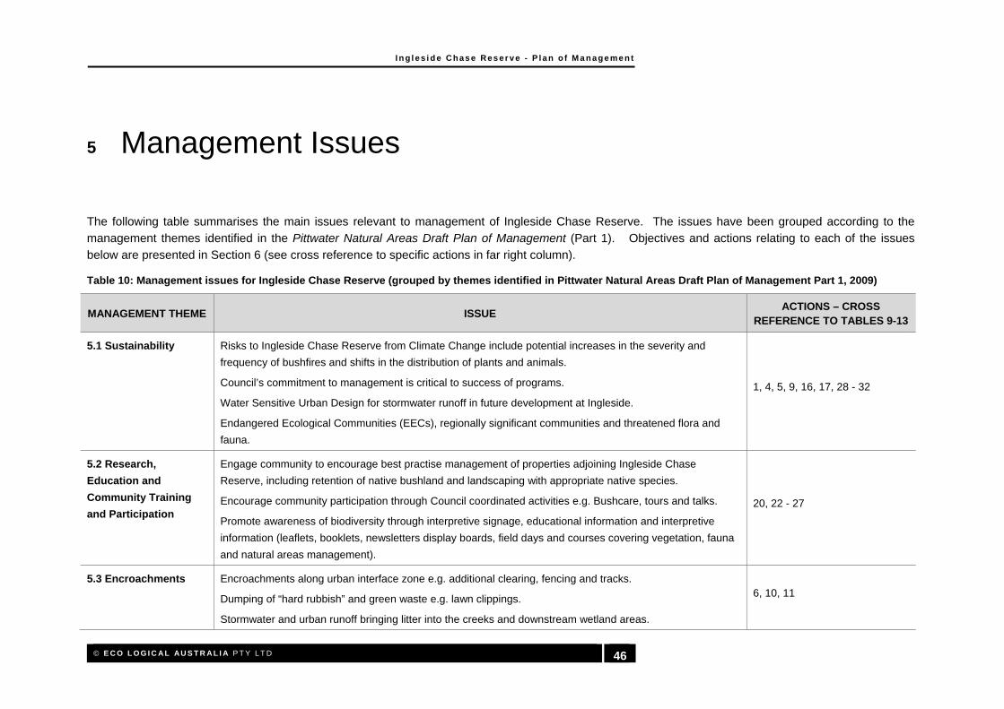
I n g l es i d e Chas e Res er ve - P l a n o f M a n age me n t
© E C O L O G I C AL AU S T R AL I A P T Y L T D 46
5 Management Issues
The following table summarises the main issues relevant to management of Ingleside Chase Reserve. The issues have been grouped according to the management themes identified in the Pittwater Natural Areas Draft Plan of Management (Part 1). Objectives and actions relating to each of the issues
below are presented in Section 6 (see cross reference to specific actions in far right column).
Table 10: Management issues for Ingleside Chase Reserve (grouped by themes identified in Pittwater Natural Areas Draft Plan of Management Part 1, 2009)
MANAGEMENT THEME ISSUE ACTIONS – CROSS
REFERENCE TO TABLES 9-13
5.1 Sustainability Risks to Ingleside Chase Reserve from Climate Change include potential increases in the severity and
frequency of bushfires and shifts in the distribution of plants and animals.
Council’s commitment to management is critical to success of programs.
Water Sensitive Urban Design for stormwater runoff in future development at Ingleside.
Endangered Ecological Communities (EECs), regionally significant communities and threatened flora and
fauna.
1, 4, 5, 9, 16, 17, 28 - 32
5.2 Research,
Education and
Community Training
and Participation
Engage community to encourage best practise management of properties adjoining Ingleside Chase
Reserve, including retention of native bushland and landscaping with appropriate native species.
Encourage community participation through Council coordinated activities e.g. Bushcare, tours and talks.
Promote awareness of biodiversity through interpretive signage, educational information and interpretive
information (leaflets, booklets, newsletters display boards, field days and courses covering vegetation, fauna
and natural areas management).
20, 22 - 27
5.3 Encroachments Encroachments along urban interface zone e.g. additional clearing, fencing and tracks.
Dumping of “hard rubbish” and green waste e.g. lawn clippings.
Stormwater and urban runoff bringing litter into the creeks and downstream wetland areas.
6, 10, 11

I n g l es i d e Chas e Res er ve - P l a n o f M a n age me n t
© E C O L O G I C AL AU S T R AL I A P T Y L T D 47
MANAGEMENT THEME ISSUE ACTIONS – CROSS
REFERENCE TO TABLES 9-13
5.4 View Conservation
and Management
Visual amenity is reduced by limited views off existing track network. 1, 19 - 21
5.5 Bushland on
Private Property
Significant areas of native bushland adjoin the Ingleside Chase Reserve that are under the management of a
range of landowners including state and private. 14 - 15
5.6 Land Managed by
Other Authorities
Area 3 in the south of the reserve adjoining the Uniting Church land is subject to a 99 year lease from
Pittwater Council. 1, 2, 3, 8, 9, 10, 11
5.7 Water Catchment
5.7.1 Stormwater and
Surface Runoff
Water quality issues associated with elevated nutrient levels.
Potential for increased urban runoff (including pollution and sediment) from surrounding urban development.
Degradation of creeklines and surrounding bushland
2, 3, 10, 11, 16, 17, 23
5.7.2 Soil Erosion and
Sedimentation
Increased erosion potential associated with surrounding urban development.
Increased scouring and reduced stabilisation of natural creek banks.
Evidence of sediment loss upstream which is likely to be impacting vegetation communities, particularly those
downstream in Irrawong Reserve and in the Warriewood Wetlands.
Localised flooding along Mullet Creek in the west of the Ingleside Chase Reserve during heavy rain.
2, 3, 11, 14
5.8 Geotechnical Risk
Management
Potential landslide risk for development upslope of the Ingleside Chase Reserve 14, 15
5.9 Biodiversity Biodiversity is currently at risk from weed invasion, feral animals, and inappropriate fire regimes.
Identified as a major habitat area and part of the Ingleside-Warriewood Habitat Corridor.
Large areas of natural bushland part of the corridor which connect Ingleside Chase Reserve with Garigal and
Ku-ring-gai National Parks are on private land not zoned for conservation.
1 - 15
5.9.1 Plant Communities Three rare and one Endangered Ecological Community occur within Ingleside Chase Reserve covering
approximately 40% of the reserve.
One species on the Rare or Threatened Plants (ROTAP) list, nine species which are considered threatened
in northern Sydney and eight species considered locally rare and being of significance in the Pittwater LGA
1 - 15

I n g l es i d e Chas e Res er ve - P l a n o f M a n age me n t
© E C O L O G I C AL AU S T R AL I A P T Y L T D 48
MANAGEMENT THEME ISSUE ACTIONS – CROSS
REFERENCE TO TABLES 9-13
were recorded in Ingleside Chase Reserve.
Minor areas of weed invasion associated with nutrient rich stormwater.
Some Eucalyptus dieback along the southern section of Mullet Creek near Irrawong Reserve.
5.9.2 Vegetation
Restoration
Current management of the Ingleside Chase Reserve consists primarily of weed control and bushfire
management hazard reduction works.
Staged program of woody weed and aquatic weed removal and extensive replanting of endemic plant
species along Mullet Creek
1 - 15
5.9.3 Weed
Management
Weed invasion within Ingleside Chase Reserve is associated with increased nutrients in stormwater,
encroachments and other disturbances.
Invasive noxious and environmental weeds such as Ludwigia (Ludwigia peruviana), Bamboo (Phyllostachys
spp.), Madeira Vine (Anredera cordifolia), Privet (Ligustrum spp.), Lantana (Lantana camara), Willows (Salix
spp.), Coral Trees (Erythrina spp.) and aquatic weeds
Limited community awareness and involvement in the reserve.
1 - 15
5.9.4 Local Fauna and
Introduced animals
Threatened mammals (including bats), reptiles, frogs and birds all recorded within the reserve.
Significant bird diversity due to a wide variety of habitats.
Ingleside Chase Reserve forms a major component of a regional biodiversity corridor.
Current threats include introduced animals (e.g. rabbits, foxes, mosquito fish), household pets (cats and
dogs) and inappropriate fire regimes.
1 - 15
5.10 Fire Management Fire management for biodiversity and asset management is required.
The recommended minimum fire interval for the majority of vegetation within the reserve is 10 years, with the
exception of the Ingleside Escarpment Wet Sclerophyll Forest (30 years) and Coachwood Warm Temperate
Rainforest (no burning permitted).
Inappropriate fire regimes have the potential to adversely impact the biodiversity of the reserve.
Aboriginal Heritage within the reserve is largely undocumented and has the potential to be impacted.
1, 4, 9, 26

I n g l es i d e Chas e Res er ve - P l a n o f M a n age me n t
© E C O L O G I C AL AU S T R AL I A P T Y L T D 49
MANAGEMENT THEME ISSUE ACTIONS – CROSS
REFERENCE TO TABLES 9-13
5.11 Recreational Uses Main recreational uses are walking and bird watching.
Bike riding and dog walking are prohibited in Ingleside Chase Reserve but occur regularly.
19 - 21
5.13 Walking Tracks,
Vehicle Access and
Parking
Walking track network is largely informal and unsigned.
Vehicle Parking at Ingleside Park can accommodate approximately 17 vehicles, but is located off Ingleside
Road with no through traffic.
Access through the reserve is likely to increase with future development in Ingleside and the Warriewood
Valley
20, 21, 26
5.14 Heritage An abundance of Aboriginal Heritage is likely to exist both within the Ingleside Chase Reserve and on
adjoining lands.
No detailed investigations have been undertaken into the Aboriginal Heritage and significance of the reserve
to the Aboriginal people.
26
5.15.Risk Management
and Public Safety
Potential risks from encroachments and illegal structures.
Risk from inappropriate use of walking trails.
Unstable steep slopes and natural hazards from rockfall and landslides.
Potential risks from chemical weed/pest management to people and domestic animals.
1, 6, 20, 21
I n g l es i d e Chas e Res er ve - P l a n o f M a n age me n t
© E C O L O G I C AL AU S T R AL I A P T Y L T D 50
6 Objectives and Actions 6.1 VISION
The overarching vision for the management of natural areas in Pittwater LGA is set out in the Pittwater Natural Areas Draft Plan of Management (Pittwater Council 2009) and states that:
Pittwater’s natural areas contribute to the green landscape character of the locality
and are valued for their cultural, educational, scientific, economic, environmental and recreational opportunities.
The vision statement for Ingleside Chase Reserve (Section 1.1.1) has expanded on this overarching vision for the Pittwater LGA. Four primary goals have been developed in accordance with the vision for
the management of the Ingleside Chase:
conservation of biodiversity;
to provide appropriate opportunities for passive recreation and environmental education;
to rehabilitate degraded areas; and
to improve water and sediment quality in the catchment.
The management strategies and actions in this Plan of Management have been designed to work
towards achieving these management goals for Ingleside Chase Reserve.
6.2 ACTIONS
In recognition that the vast majority of the reserve is in pristine condition, the focus of this Plan of
Management is to ensure continued conservation and maintenance of values across the reserve, with minor rehabilitation works to be implemented progressively over the next five years. The development of the surrounding catchment (particularly upslope in Ingleside) is major factor influencing the future
viability of the reserve.
Actions to address the above key directions are presented in Table 11 to Table 15 according to the following management themes:
biodiversity;
water;
recreation;
community learning; and
financial management.
Each action is prioritised and has performance measures and responsibilities allocated, which are discussed below. All location-specific actions are marked on Figure 6.
6.3 PRIORITIES
Priorities have been allocated as follows:
high priority – to be completed within two years;
medium priority – to be completed within the next five years; and

I n g l es i d e Chas e Res er ve - P l a n o f M a n age me n t
© E C O L O G I C AL AU S T R AL I A P T Y L T D 51
low priority – to be completed where practicable.
It is more efficient and cost-effective to prevent degradation than to restore ecosystems that become degraded. Therefore highest priority is given to maintaining or improving areas that are in the best
ecological condition.
6.4 BIODIVERSITY MANAGEMENT ACTIONS
Biodiversity is the main priority for the management of Ingleside Chase Reserve due to the high faunal diversity, rare vegetation communities and plants and the importance of the reserve in regional
connectivity. A range of management actions have been developed in Table 11 with management zones further outlined in Section 6.9 and on Figure 6.
Table 11: Biodiversity management actions for Ingleside Chase Reserve
NO. ACTION PRIORITY PERFORMANCE MEASURES
RESPONSIBILITY
BIODIVERSITY: On-ground works
1
Implement vegetation management program (refer Section 6.5). Ensure on-going
commitment to follow up works before major control programs are commenced.
High Improved condition of vegetation and
fauna habitat.
2
Plant indigenous native vegetation in areas surrounding the reserve. Focus on plantings in
near-by housing developments’ open space/residential areas and existing residences
adjacent to Ingleside Chase Reserve.
Future developments within Ingleside should be required to plant local native species if located
within 50 m of the reserve, or within 50 m of any tributary of Mullet Creek.
Medium Increase proportion of native vegetation
within the catchment.
3
Consider need to remove any substantial build-up of dead weed biomass from reserve,
particularly from bush regeneration works along Mullet Creek.
Low Excess weed biomass removed
appropriately if necessary.
BIODIVERSITY: Monitoring and review
4
Review of Ingleside Chase Reserve Fire Management Plan is due in 2010. The review
should include revision of hazard reduction strategies based on the updated vegetation mapping (Figure 4) and the minimum fire
intervals outlined in Table 8.
High
Fire Management Plan updated based on this information and a more strategic approach to biodiversity conservation through hazard reduction is adopted.
5
Monitor Ingleside Chase Reserve for changes associated with climate change e.g. shift in species distribution, arrival of new species.
Determine timeframes and thresholds for climate change mitigation actions.
Low Management actions developed.
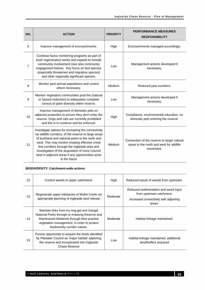
I n g l es i d e Chas e Res er ve - P l a n o f M a n age me n t
© E C O L O G I C AL AU S T R AL I A P T Y L T D 52
NO. ACTION PRIORITY PERFORMANCE MEASURES
RESPONSIBILITY
6 Improve management of encroachments. High Encroachments managed accordingly.
7
Continue fauna monitoring programs as part of bush regeneration works and expand to include community involvement (see also community
engagement below). Key focus on bird species (especially threatened and migratory species)
and other regionally significant species.
Low Management actions developed if
necessary.
8 Monitor pest animal populations and control
where necessary. Medium Reduced pest numbers.
9 Monitor vegetation communities post fire (natural
or hazard reduction) to adequately complete census of plant diversity within reserve.
Low Management actions developed if
necessary.
10
Improve management of domestic pets on adjacent properties to ensure they don't enter the reserve. Dogs and cats are currently prohibited
and this is to continue and be enforced.
High Compliance, environmental education, no
domestic pets entering the reserve.
11
Investigate options for increasing the connectivity via wildlife corridors, of the reserve to large areas of bushland and national parks to the north and west. This may involve creating effective creek line corridors through the Ingleside area and
investigation of the acquisition of more Council land in adjacent areas if any opportunities arise
in the future
Medium Connection of the reserve to larger natural
areas to the north and west for wildlife movement.
BIODIVERSITY: Catchment-wide actions
12 Control weeds in upper catchment. High Reduced inputs of weeds from upstream.
13 Regenerate upper tributaries of Mullet Creek via appropriate planning of Ingleside land release
Moderate
Reduced sedimentation and weed input from upstream catchment.
Increased connectivity with adjoining areas.
14
Maintain links from Ku-ring-gai and Garigal National Parks through to Irrawong Reserve and
Warriewood Wetlands through best practise vegetation management, in order to protect
biodiversity corridor values.
Moderate Habitat linkage maintained.
15
Pursue opportunity to acquire the lands identified by Pittwater Council as ‘major habitat’ adjoining
the reserve and incorporated into Ingleside Chase Reserve
Low Habitat linkage maintained, additional
land/buffers acquired

I n g l es i d e Chas e Res er ve - P l a n o f M a n age me n t
© E C O L O G I C AL AU S T R AL I A P T Y L T D 53
Figure 6: Management Zones and Actions
6.5

I n g l es i d e Chas e Res er ve - P l a n o f M a n age me n t
© E C O L O G I C AL AU S T R AL I A P T Y L T D 54
WATER AND SEDIMENT MANAGEMENT ACTIONS
Table 12: Water and sediment management actions for Ingleside Chase Reserve
NO. ACTION PRIORITY PERFORMANCE MEASURES
16 Ensure all adjacent development complies with
relevant DCPs and Water Sensitive Urban Design criteria.
High Compliance.
17 Determine feasibility of a water quality monitoring
program if funding becomes available to undertake water quality management works.
High Water quality monitoring undertaken
if funding available.
18
Address the issue of increased nutrient flow from above the reserve. Investigate nutrient sources and
where possible mitigate the flow of nutrients and educate landowners in how they can minimise excess
nutrients from entering the catchment and having a downstream impact on the reserve.
High Compliance, environmental
education, reduced nutrient input from upstream catchment.
6.6 RECREATION MANAGEMENT ACTIONS
Location specific actions are marked on Figure 6.
Table 13: Recreation management actions for Ingleside Chase Reserve
NO. ACTION PRIORITY PERFORMANCE MEASURES
19
Establish and maintain a bush regeneration program for biodiversity conservation and to visually improve reserve entry. Refer to Management Zone 4a and
Figure 6.
Medium Visitor facilities upgraded, weed
abundance reduced.
20 Improve visitor acces through the upgrade to the
existing track network. Refer to Management Zone 5 and Figure 6.
Medium Track network upgraded and visitor
numbers increase.
21
Investigate the feasibility of establishing a new reserve entry point via Wesley Street with new visitor facilities and track works. Refer to Management Zone
8 and Figure 6
Low New access point established, visitor facilities installed, tracks upgraded
22
Investigate the feasibility of a recognised mountain bike track in the reserve, which would
involve comprehensive and rigorous environmental impact assessment and having no
environmental impact. If deemed appropriate, the design and maintenance of such a track
would involve community participation, establishment of a working committee and
liaison with interest groups. Any track would be designed in line with maximising environmental viability, safety of cyclists and pedestrians and
built to associated standards.
High
Provide a local and regional recreation facility, encourage
community participation, discourage the formation of illegal and informal
bike tracks in the reserve which cause environmental damage.

I n g l es i d e Chas e Res er ve - P l a n o f M a n age me n t
© E C O L O G I C AL AU S T R AL I A P T Y L T D 55
6.7 COMMUNITY ENGAGEMENT AND EDUCATION ACTIONS
Table 14: Community learning actions for Ingleside Chase Reserve
NO. ACTION PRIORITY PERFORMANCE MEASURES
23 Liaise with residents who are known to be
encroaching into the reserve. High
Removal of existing and reduced new encroachments.
24
Investigate implementing native plant give-away program. This is particularly important for the upper
Mullet Creek catchment where on-the ground riparian reconstruction works are required on private property
Low Increase in native vegetation in the
catchment.
25
Investigate establishment of community biodiversity monitoring group to report fauna sightings and monitor weed hotspots. Consider the creation of a Bushcare
group and/or from community information events.
Moderate On-going monitoring of weeds and
wildlife by residents.
26
Develop and distribute information pack to new residents highlighting values of the Ingleside Chase Reserve and opportunities to be involved in use and enjoyment (including management) e.g. Bushcare,
recreational opportunities.
High New residents receive information
pack.
27
Once tracks are upgraded, prepare a trail map in a style similar to those of the national parks which gives
an overview of the reserve, brief history, flora and fauna, vegetation communities and permitted uses
within the reserve
Low Trail map developed and available via the Pittwater Council Website.
28 Conduct detailed investigation into the Aboriginal
heritage significance of the reserve. Moderate
Aboriginal heritage report prepared, heritage items identified and
appropriately protected.
6.8 MANAGEMENT AND FINANCIAL ARRANGEMENTS ACTIONS
Table 15: Management and financial arrangements actions for Ingleside Chase Reserve
NO. ACTION PRIORITY PERFORMANCE MEASURES
29 Ensure management actions are coordinated across
relevant sections of Council. High
All relevant sections of Council aware of management activities.
30 Assign responsibility for investing, accessing and
reporting on grant funding. High Grant funding secured.
31 Ensure follow-up works for major weed control
treatment programs is available prior to implementation to ensure long-term success.
Moderate On-going works included in budgets.
32 Do not invest substantial resources in up-front works if
commitment to on-going and follow-up needs is not secure.
High Commitment to on-going works
33 Use this Plan of Management to support grant
applications and to secure internal funding. High Grants secured.

I n g l es i d e Chas e Res er ve - P l a n o f M a n age me n t
© E C O L O G I C AL AU S T R AL I A P T Y L T D 56
6.9 MANAGEMENT ZONES
Vegetation management zones have been identified for Ingleside Chase Reserve (Figure 6). Information regarding the management of each zone is provided below and information regarding
control methods of weed species found in the reserve is provided in Appendix D.
6.9.1 Management Zone 1
Management Zone 1: Restoration
Objective: Maintain works in Mullet Creek. Investigate options for future funding.
Description:
Primary works within zone 1 have focussed on highly invasive noxious and environmental weeds
such as Ludwigia (Ludwigia peruviana), Bamboo (Phyllostachys spp.), Madeira Vine (Anredera
cordifolia), Privet (Ligustrum spp.), Lantana (Lantana camara), Willows (Salix spp.), Coral Trees
(Erythrina spp.) and aquatic weeds. Secondary works are required to prevent re-establishment of
weeds and restore degraded areas.
Resilience: Low resilience. Illegal track works and subsequent removal of dense stands of weeds has resulted
in limited establishment of native species and has increased erosion in the catchment.
Strategy:
Continue works in accordance with the Mullet Creek Rehabilitation Plan (Pittwater Council 2008).
Works will include:
Primary weed control in Zone 1 adjoining Irrawong Reserve;
Secondary bush regeneration of previously treated areas;
Bank reconstruction and stabilisation where required;
Extensive replanting; and
On-going maintenance and regular monitoring.
Investigations into future funding options are required to ensure continued works along Mullet
Creek.
Priority High
6.9.2 Management Zone 2
Management Zone 2a and 2b: Manage Encroachments / Restoration
Objective: Control weeds and address encroachments.
Description:
Zone 2a: Encroachments are occurring in the interface zone between the reserve and adjoining
properties in the south west of the reserve.
Encroachments include direct clearing of native vegetation, 4WD access tracks, weedy fill material
and grazing. These encroachments pose a major risk to the condition of the reserve, particularly as
these areas adjoin the wet Sandstone Heath and a number of minor drainage lines which are
particularly susceptible to disturbance.
Zone 2b: A small area within the reserve behind Mater Maria Catholic College was observed to be
utilised by mountain bikes and has been cleared in the past.
Resilience:
Zone 2a: Low-Moderate resilience. Some areas in the interface zone would respond to assisted
natural regeneration while others require restoration through weed control and planting.
Zone 2b: Moderate. This area has natural soils and regeneration is occurring around the peripheral
areas.
Strategy: Zone 2a: Manage encroachments in the interface zone through a combination of:

I n g l es i d e Chas e Res er ve - P l a n o f M a n age me n t
© E C O L O G I C AL AU S T R AL I A P T Y L T D 57
Clear boundary definition (fencing, pegs and signage);
Develop fire management strategies (provide access and reduce fuel loads) – where this is
not currently a requirement of the adjoining properties;
Remove and prohibit encroachments;
Undertake bush regeneration activities;
Plant densely to create a buffer; and
Encourage custodianship from local residents.
Zone 2b: Restore degraded area through a combination of:
Temporary exclusion fencing; and
Signage.
Priority High
6.9.3 Management Zone 3
Management Zone 3a and 3b: Bush Regeneration / Active Monitoring
Objective: Continue program of bush regeneration for biodiversity conservation.
Description:
Zone 3a: Bush regeneration and hazard reduction works have been undertaken in Zone 3a along
the boundary of the Uniting Church conference centre.
Zone 3b: Bush regeneration works have been undertaken along the southern section of this zone
(Mullet Creek) and the majority of this area is in excellent condition.
Resilience:
Zone 3a: Moderate-High resilience. Bush regeneration within this zone has been successful and
recent hazard reduction works have encouraged germination of a range of native species.
Zone 3b: High. These sections of Narrabeen and Mullet Creek are in excellent condition and
consist of dense gully forest and Coachwood Warm Temperate Rainforest.
Strategy:
Zone 3a: It is important to continue bush regeneration and hazard reduction works along the
interface between the Uniting Church Conference centre and the reserve to minimise the risk of
weed establishment and wildfire.
Works should include:
Secondary bush regeneration of previously treated areas; and
On-going maintenance and monitoring.
Zone 3b: Regular monitoring of the condition of this zone is required to prevent the establishment of
weeds along Mullet and Narrabeen Creek.
Bush regeneration required within this zone is generally minimal due to the excellent condition of
the creeks, however should the need for work be identified during monitoring
Works should include:
Annual monitoring;
Bush regeneration (as required); and
Maintenance.
Monitoring activities would generally consist of an annual traverse along each section of Zone 3b to
identify any area of weed establishment for rectification works. The Coachwood Warm Temperate
Rainforest sections of the reserve appear to be less susceptible to weed establishment due to a
range of factors including shading.
Bush regeneration works within this zone are to be undertaken in accordance with the fuel

I n g l es i d e Chas e Res er ve - P l a n o f M a n age me n t
© E C O L O G I C AL AU S T R AL I A P T Y L T D 58
Management Zone 3a and 3b: Bush Regeneration / Active Monitoring
management program and maintenance of Asset Protection Zones (APZ) as currently undertaken
by the Uniting Church.
Priority Medium
6.9.4 Management Zone 4
Management Zone 4a and 4b: Weed Control / Reserve Entry Improvements
Objective: Establish and maintain a bush regeneration program for biodiversity conservation and to visually
improve reserve entry.
Description:
Zone 4a: This zone is currently the only formal entry point for the reserve. Minor areas of weed
infestation occur in this zone, generally associated with disturbed edges or poorly draining areas.
Zone 4b: This zone occurs in the upper catchment of a tributary of Narrabeen Creek downslope of
Mona Vale Road and is dominated by Lantana (Lantana camara).
Resilience:
Zone 4a: Moderate-High resilience. The majority of this zone is natural bushland with a small area
of mown exotic grass adjoining the reserve carpark. Minor bush regeneration works would be
required to increase the condition of this zone.
Zone 4b: High. The dominance of Lantana in this zone has not affected the resilience, as the
surrounding area is natural bushland. Minor bush regeneration works would be required to increase
the condition of this zone.
Strategy:
Zone 4a: It is important to establish and maintain a bush regeneration program along the interface
between the reserve entry, car parking area and the reserve itself. Additional minor works to
improve the entry to the reserve in this location would improve visitor amenity.
Bush regeneration works should include:
Primary bush regeneration targeting weeds around the reserve entry and along the track;
Secondary bush regeneration; and
On-going maintenance.
Reserve entry improvements should include:
Increasing visibility of reserve from adjoining areas (e.g. signage from Powder Works
Road)
New reserve signage;
Information kiosk including information on walking tracks, flora and fauna and permissible
uses;
Dense planting along the northern boundary of the zone to screen adjoining properties;
Track upgrades including minor drainage works and signage.
Zone 4b: Establish and maintain a bush regeneration program in this zone to remove the Lantana
infestation and re-establish native vegetation.
Works should include:
Primary bush regeneration targeting Lantana along the drainage line;
Secondary bush regeneration; and
On-going maintenance and monitoring.
Priority Medium

I n g l es i d e Chas e Res er ve - P l a n o f M a n age me n t
© E C O L O G I C AL AU S T R AL I A P T Y L T D 59
6.9.5 Management Zone 5
Management Zone 5: Monitoring and Track Works
Objective: Maintain biodiversity and improve visitor amenity.
Description:
This zone is the core bushland within the reserve which is generally in excellent condition. Potential
threats to this community are through gradual degradation and development in the surrounding
catchment.
Resilience: High. This zone contains many different vegetation communities in excellent condition.
Strategy:
The majority of this zone does not require any immediate vegetation management and it is
recommend that passive monitoring (through community feedback, bird watching and bush
regeneration contractors in the vicinity) be used to identify changes.
The existing informal track network is largely in good condition for bushwalking with most tracks of a
standard equivalent to those within the adjoining national parks. There are some areas which have
undergone minor to moderate erosion due to mountain bike and motorbike usage which should be
upgraded. The following works are suggested:
Close access to mountain bikes and motorbikes through signage, reserve fencing and
community education;
Upgrade the existing track network (Figure 6) in a sympathetic manner which requires
minimal vegetation clearing and is constructed with suitable materials (e.g. crushed
sandstone, timber).
Install directional and interpretative signage along the track (for example, information on
vegetation communities, significant fauna and Aboriginal heritage).
Extend the existing formal track from Irrawong Reserve through Ingleside Chase Reserve
to Ingleside. A bridge is required across Mullet Creek in the vicinity of the waterfall (Zone
1) and stairs are required to be installed up the steep slopes in the Ingleside Escarpment
Wet Sclerophyll Forest as this section of the track is steep and slippery.
Close and rehabilitate the many informal side tracks through the use of local material
removed during track upgrades (i.e. trees and branches). Install “rehabilitation in
progress” or “track closed” signs if required.
Investigate the feasibility of formalising an access track and viewing platform to the
waterfall on the northern arm of Mullet Creek (refer Plate 10).
Investigate the feasibility of creating a new track network which links access to the reserve
from Wesley St, through the old scout hall location (Zone 8), around the escarpment on the
contour and links up with the existing track network behind Westpac College (refer Figure
6).
Develop promotional and educational materials to encourage visitors to the reserve.
Material should include a trail map, information on vegetation communities, significant
fauna and Aboriginal heritage and permitted uses in the reserve.
Priority Medium
6.9.6 Management Zone 6
Management Zone 6a and 6b: Mullet Creek Restoration (upstream)
Objective: Improve the ecological and hydrological character of the upper Mullet Creek catchment
Description: These zones encompass an area of 20 m on either side of the top of bank of all tributaries flowing
into Mullet Creek in Ingleside. The majority of these tributaries have been modified and exist in a

I n g l es i d e Chas e Res er ve - P l a n o f M a n age me n t
© E C O L O G I C AL AU S T R AL I A P T Y L T D 60
Management Zone 6a and 6b: Mullet Creek Restoration (upstream)
highly disturbed state, contributing to increased sedimentation and weed dispersal into Ingleside
Chase Reserve.
Resilience: Low. These zones have been previously identified in poor condition and most areas require
revegetation while others require reconstruction.
Strategy:
All works in these zones should be conducted in accordance with the Mullet Creek Rehabilitation
Plan (Pittwater Council 2008).
Works would include:
Community consultation;
Primary weed control;
Secondary bush regeneration of previously treated areas;
Bank reconstruction and stabilisation where required;
Extensive replanting; and
On-going maintenance and monitoring.
Increasing landowner awareness of the issues associated with a degraded catchment is important
and there are good opportunities to enhance the riparian corridor through collaborations with
residents and local nurseries.
Any proposed alterations to the hydrology of the southern arm of Mullet Creek should be
investigated and assessed for environmental flow impacts.
Future development within the upper catchment of Mullet Creek in Ingleside should be regulated in
accordance with the Water Management Act 2000 (WM Act) to ensure all land within 40 m of the
top of bank of a watercourse is adequately assessed and appropriate riparian buffers restored.
Priority Medium
6.9.7 Management Zone 7
Management Zone 7: Ingleside Chase Reserve Buffer
Objective: Maintain ecological corridor integrity and connectivity with Ku-ring-gai and Garigal National Parks.
Description:
This zone is located directly upslope to the west of the northern section of the reserve and has been
identified as ‘major habitat’ in the Habitat and Wildlife Corridors Conservation Strategy (Pittwater
Council 1995).
The mapped section of this zone consists of all native vegetation upslope of the northern section of
the reserve to the crest of the ridge. Extensive areas of native vegetation which form part of the
major habitat corridor occur to the west of this zone.
Future development in the Ingleside area has the potential to significantly impact this ecological
corridor through increased edge effects and downslope movement of nutrients and weeds.
Resilience: High. Currently this zone consists entirely of remnant bushland with a number of informal access
trails.
Strategy:
The strategy for this zone follows a tiered approach to maximise biodiversity conservation:
1. Pittwater Council should pursue every opportunity to acquire the lands identified as ‘major
habitat’ adjoining the reserve and these lands should be incorporated into Ingleside Chase
Reserve;
2. If the lands identified as ‘major habitat’ cannot be acquired, then Council should look to
impose strict development controls on the land to ensure a fully vegetated buffer of 20 m is
applied to protect the reserve from downslope effects of development. This buffer should

I n g l es i d e Chas e Res er ve - P l a n o f M a n age me n t
© E C O L O G I C AL AU S T R AL I A P T Y L T D 61
Management Zone 7: Ingleside Chase Reserve Buffer
be in addition to any requirements under the RF Act in terms of asset protection.
Development within this zone and adjoining bushland to the west should be sympathetic to
the surrounding bushland and aim to retain as much natural bushland as practicable.
In the instance that the land within this zone is acquired by Council, a number of existing trails
would need to maintained and or/closed to public access.
Priority Low
6.9.8 Management Zone 8
Management Zone 8: Future Reserve Entry / Picnic Area
Objective: Establish a new entry to the reserve with visitor facilities and a new track network.
Description:
This zone encompasses the former Ingleside Scout hall which was destroyed by wildfire. With the
acquisition of this land and an easement off Wesley Street from the Uniting Church, Pittwater
Council has enabled an additional point of entry to the reserve to be established.
Resilience:
Low. Currently this zone consists of an overgrown access track with a variable surface (including an
unstable creek crossing) and the remnants of the Ingleside Scout hall, of which only a concrete slab
remains.
Strategy:
There are two main options for this zone:
1. Remove the concrete slab, remove the access track and rehabilitate the entire area; or
2. Establish a new reserve entry off Wesley Street.
Works required to establish a new reserve entry would be likely to include:
Assessment of the capacity of the easement of Wesley Street and the surrounding area in
terms of increased visitor numbers;
Development of car parking, creek crossing, access tracks and signage;
Construction of visitor facilities at the Ingleside Scout hall site (e.g. signage, picnic tables
etc);
Upgrade to the existing track network (refer Management Zone 5) to increase connectivity
between the Wesley Street access and the remaining reserve;
On-going maintenance activities.
Priority Low

I n g l es i d e Chas e Res er ve - P l a n o f M a n age me n t
© E C O L O G I C AL AU S T R AL I A P T Y L T D 62
7 Implementation 7.1 GENERAL
In order to achieve the vision of conserving the natural, scenic and cultural values of Ingleside Chase Reserve, a range of management actions have been proposed (refer Section 6). These management
actions are intended to be undertaken progressively over the next 10 years. To facilitate management and prioritise works, the reserve has been divided into eight discrete management zones which aim to address both current and future management issues (Figure 6). Considering the near pristine quality of
the majority of the reserve, it is imperative to address current management issues within the reserve, particularly those associated with the degradation of Mullet Creek and then focus on catchment wide issues which have the potential to significantly affect the reserve in the future.
These prioritised steps are recommended to facilitate on-ground works and further investigation:
1. Continue restoration of the upper and lower catchments of Mullet Creek in accordance with the
Mullet Creek Rehabilitation Plan.
2. Address encroachments along the western boundary of the reserve.
3. Establish and maintain bush regeneration works to improve visual amenity and conserve biodiversity.
4. Investigate options for increasing pubic amenity (access points, track upgrades, education).
5. Proactively address upstream catchment issues through a joint community and council restoration program.
6. Ensure development controls are established to avoid, reduce and mitigate impacts on Ingleside Chase Reserve from future development.
7. Acquire additional land for incorporation into the reserve where practicable.
7.2 FUNDING AND RESOURCES
Limited funds are currently available to implement this Plan of Management. Additional funding and in-
kind contributions should be sought from a range of sources, for example:
State and Commonwealth government environmental grants.
Future Council levies for projects environmental works.
Bushcare volunteers and other community groups (e.g. schools, scouts) can assist with bush regeneration and revegetation; with supervision, plants and equipment provided by Council.
Donations e.g. Pittwater Natural Heritage Association.
7.3 STATUTORY APPROVALS AND LICENCES
Approvals required for tasks described in this Plan of Management are outlined here. These are in
addition to requirements under the Noxious Weeds Act 1993.
Ecological impact studies are generally required for any works which have the potential to impact on state or federally listed threatened species, populations and ecological communities. These impacts must be assessed in accordance with the Threatened Species Conservation Act 1995 (TSC Act) and

I n g l es i d e Chas e Res er ve - P l a n o f M a n age me n t
© E C O L O G I C AL AU S T R AL I A P T Y L T D 63
Environmental Protection and Biodiversity Conservation Act 1999 (EPBC Act). These works would include upgrades to visitor facilities, track works or bush regeneration in Swamp Sclerophyll Forest.
The requirements for environmental approvals are detailed in Table 16.
Table 16: Environmental approvals
TASK APPROVAL REQUIREMENTS
Upgrade to existing track network
Upgrades to the existing track network are exempt from Development Consent under the Infrastructure SEPP, provided the project is undertaken by Council.
However, a flora and fauna study should be undertaken to identify the likelihood of significant impacts to threatened species/communities. If significant impact is found to be likely, then a Species Impact Statement (SIS) (in accordance with the Threatened Species Conservation Act 1995) and/or Environmental Impact Statement (EIS) (under EP&A Act)
may be required. Matters of National Environmental Significance under the Commonwealth Environment Protection and Biodiversity Conservation Act 1999 should be considered when
preparing the flora and fauna study to determine if a Referral is required.
A licence from DECCW will be required to undertaken works in an EEC.
Vegetation management and
weed control. A licence from DECCW will be required to undertaken works in an EEC.
7.4 SPECIES FOR REPLANTING
Local provenance species should be used for replanting where possible. Allowances should be made for replacement planting and on-going maintenance.
A preliminary list of flora species suited to different applications is given in Appendix E. It includes
some of the species that could be used for replanting. Species suitable for residential gardens can been identified through Council’s Native Plants for Your Garden website:
http://www.pittwater.nsw.gov.au/environment/species_lists
7.5 MONITORING AND ADAPTIVE MANAGEMENT
Monitoring has been incorporated in many actions within the Plan of Management e.g. terrestrial and aquatic species, water quality, habitats. Accurate record keeping will assist ongoing management. Results of monitoring will be essential to inform adaptive management practices, particularly during the
future development of the Ingleside area.
Environmental managers often deal with considerable uncertainty and complexity about how ecosystems and the physical environment interact. Adaptive management is a widely accepted approach to natural resource management that involves learning from implementation. By following the
adaptive management cycle, practitioners ensure that learning is focussed on management needs and that new knowledge feeds back to inform future management choices.
It is recommended that this plan undergo review in 10 years, however if significant changes occur in the catchment (including urban subdivision in Ingleside or additional land acquisition for the reserve) the
plan of management should be revised to reflect these changes and manage new issues.

I n g l es i d e Chas e Res er ve - P l a n o f M a n age me n t
© E C O L O G I C AL AU S T R AL I A P T Y L T D 64
References Brian Parry & Associates (2005). Warriewood Ingleside Escarpment Bushfire Management Plan. Prepared for Pittwater Council
Cardno Lawson Treloar (2001). Warriewood Valley Urban Land Release Water Management Specification. Report prepared for Pittwater Council. http://www.pittwater.nsw.gov.au/__data/assets/pdf_file/0004/6682/Warriewood_Water_R5.pdf
Chapman, G.A. and Murphy, C.L. (1989). Soil Landscapes of the Sydney 1:100 000 sheet. Soil Conservation Service of NSW, Sydney.
Commonwealth of Australia (2010). Listing advice: Loss and degradation of native plant and animal habitat by invasion of escaped garden plants, including aquatic plants. [online] http://www.environment.gov.au/biodiversity/threatened/ktp/garden-plants.html
DECC (2008). Rapid Fauna Habitat Assessment of the Sydney Metropolitan Catchment Management Authority Area. Department of Environment and Climate Change, Hurstville
DECCW (2010a) Swamp Sclerophyll Forest on Coastal Floodplains – profile [online] http://www.threatenedspecies.environment.nsw.gov.au/tsprofile/profile.aspx?id=10786. Department of Environment, Climate Change and Water, Hurstville.
DECCW (2010b) Swamp sclerophyll forest on coastal floodplains - Priority actions [online] http://www.threatenedspecies.environment.nsw.gov.au/tsprofile/pas_profile.aspx?id=10786. Department of Environment, Climate Change and Water, Hurstville.
DECCW (2010c) NSW National Parks and Wildlife Atlas of NSW Wildlife. [online] http://wildlifeatlas.nationalparks.nsw.gov.au/wildlifeatlas/watlas.jsp. Department of Environment, Climate
Change and Water, Hurstville.
DEWHA (2010). Protected Matters Search Tool. [online] http://www.environment.gov.au/erin/ert/epbc/index.html. Department of the Environment, Water, Heritage and the Arts, Canberra.
El-Shaarawi, A. and Piegorsch, W. (2002). Encyclopedia of Environmetrics. John Wiley & Sons, Ltd Press, West Sussex.
Gondwana Consulting (2005). Warriewood/Ingleside Escarpment (North) Plan of Management. Report prepared for Pittwater Council.
Keith, D. (2004). Ocean Shores to Desert Dunes: The Native Vegetation of New South Wales and the ACT, Department of Environment and Conservation, Hurstville.
MHL (1998) Warriewood Wetland Plan of Management (Part 2), Report to Pittwater Council. Manly Hydraulics Laboratory.
Pittwater Council (1995). Habitat and Wildlife Corridors Conservation Strategy. Report prepared by
Pittwater Council from a discussion paper by Paul Burcher, Sydney.
Pittwater Council (1995). Warriewood Valley Urban Land Release Planning Strategy.
Pittwater Council (1996). Irrawong Reserve Plan of Management.

I n g l es i d e Chas e Res er ve - P l a n o f M a n age me n t
© E C O L O G I C AL AU S T R AL I A P T Y L T D 65
Pittwater Council (1997). Ingleside Park Plan of Management. [online] http://www.pittwater.nsw.gov.au/__data/assets/pdf_file/0012/10650/Ingleside_Park_POM.pdf
Pittwater Council (2000). Management Plan for Threatened Flora and Fauna.
Pittwater Council (2008). Mullet Creek Rehabilitation Plan. Report prepared for Pittwater Council by
Hyder Consulting.
Pittwater Council (2009). Pittwater Natural Areas (Draft) Plan of Management.
Pittwater Council and Eco Logical Australia (2010). Warriewood Wetlands Plan of Management. Report prepared for Pittwater Council.
RFS (2006). Bush Fire Environmental Assessment Code for New South Wales. NSW Rural Fire Service.
SKM (2010). Mullet Creek Environmental Flow Assessment – Stage 1. Report prepared for Pittwater Council.
Smith, P. and Smith J. (2000). Warringah Natural Area Survey. Report prepared for Warringah Council.
Specht, R.L. and Specht A. (2002). Australian Plant Communities: Dynamics of Structure, Growth and Biodiversity. Oxford University Press.
WBM Oceanics Pty Ltd (2002). Narrabeen Lagoon Estuary Management Plan. Report prepared for Warringah and Pittwater Councils.

I n g l es i d e Chas e Res er ve - P l a n o f M a n age me n t
© E C O L O G I C AL AU S T R AL I A P T Y L T D 66
Appendix A: Vegetation Community Profiles
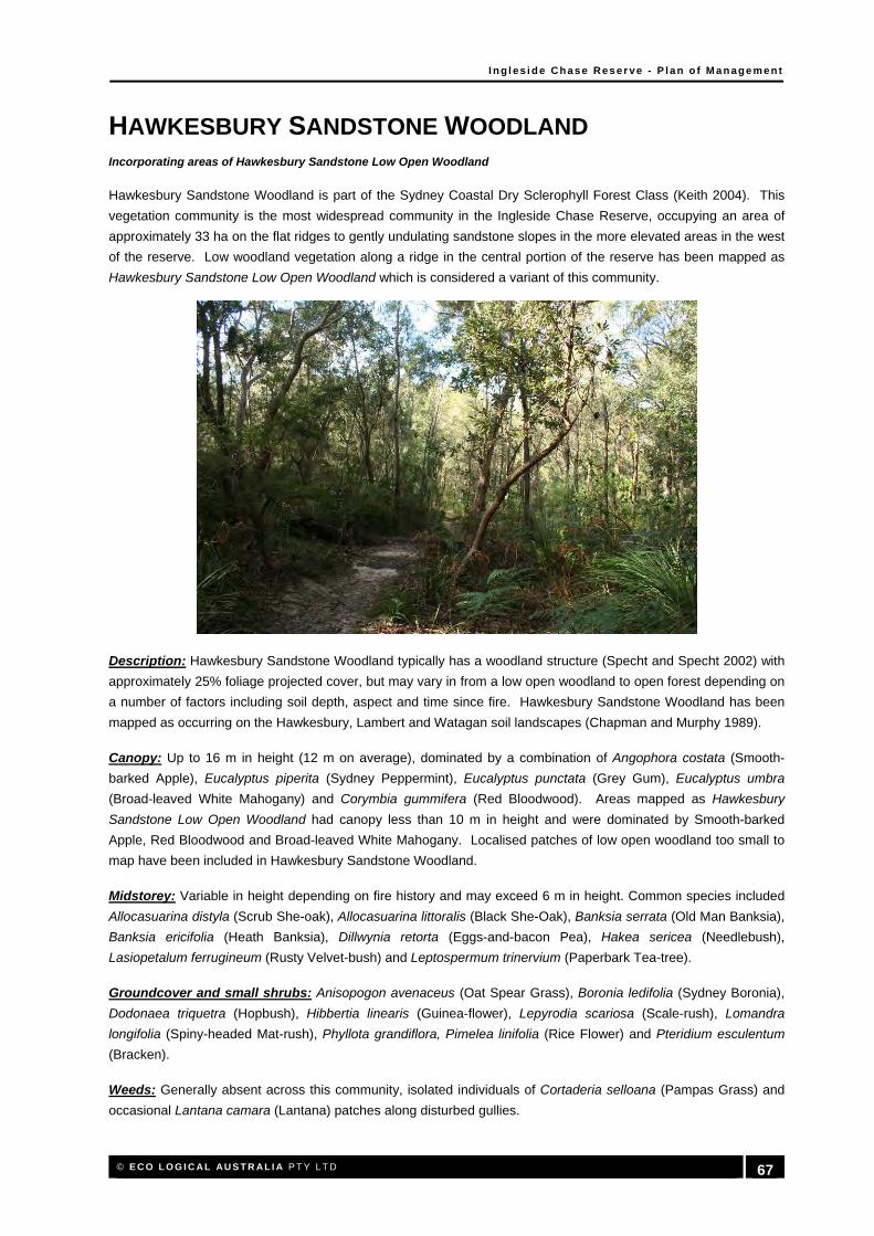
I n g l es i d e Chas e Res er ve - P l a n o f M a n age me n t
© E C O L O G I C AL AU S T R AL I A P T Y L T D 67
HAWKESBURY SANDSTONE WOODLAND Incorporating areas of Hawkesbury Sandstone Low Open Woodland
Hawkesbury Sandstone Woodland is part of the Sydney Coastal Dry Sclerophyll Forest Class (Keith 2004). This
vegetation community is the most widespread community in the Ingleside Chase Reserve, occupying an area of
approximately 33 ha on the flat ridges to gently undulating sandstone slopes in the more elevated areas in the west
of the reserve. Low woodland vegetation along a ridge in the central portion of the reserve has been mapped as
Hawkesbury Sandstone Low Open Woodland which is considered a variant of this community.
Description: Hawkesbury Sandstone Woodland typically has a woodland structure (Specht and Specht 2002) with
approximately 25% foliage projected cover, but may vary in from a low open woodland to open forest depending on
a number of factors including soil depth, aspect and time since fire. Hawkesbury Sandstone Woodland has been
mapped as occurring on the Hawkesbury, Lambert and Watagan soil landscapes (Chapman and Murphy 1989).
Canopy: Up to 16 m in height (12 m on average), dominated by a combination of Angophora costata (Smooth-
barked Apple), Eucalyptus piperita (Sydney Peppermint), Eucalyptus punctata (Grey Gum), Eucalyptus umbra
(Broad-leaved White Mahogany) and Corymbia gummifera (Red Bloodwood). Areas mapped as Hawkesbury
Sandstone Low Open Woodland had canopy less than 10 m in height and were dominated by Smooth-barked
Apple, Red Bloodwood and Broad-leaved White Mahogany. Localised patches of low open woodland too small to
map have been included in Hawkesbury Sandstone Woodland.
Midstorey: Variable in height depending on fire history and may exceed 6 m in height. Common species included
Allocasuarina distyla (Scrub She-oak), Allocasuarina littoralis (Black She-Oak), Banksia serrata (Old Man Banksia),
Banksia ericifolia (Heath Banksia), Dillwynia retorta (Eggs-and-bacon Pea), Hakea sericea (Needlebush),
Lasiopetalum ferrugineum (Rusty Velvet-bush) and Leptospermum trinervium (Paperbark Tea-tree).
Groundcover and small shrubs: Anisopogon avenaceus (Oat Spear Grass), Boronia ledifolia (Sydney Boronia),
Dodonaea triquetra (Hopbush), Hibbertia linearis (Guinea-flower), Lepyrodia scariosa (Scale-rush), Lomandra
longifolia (Spiny-headed Mat-rush), Phyllota grandiflora, Pimelea linifolia (Rice Flower) and Pteridium esculentum
(Bracken).
Weeds: Generally absent across this community, isolated individuals of Cortaderia selloana (Pampas Grass) and
occasional Lantana camara (Lantana) patches along disturbed gullies.

I n g l es i d e Chas e Res er ve - P l a n o f M a n age me n t
© E C O L O G I C AL AU S T R AL I A P T Y L T D 68
INGLESIDE ESCARPMENT WET SCLEROPHYLL FOREST
Ingleside Escarpment Wet Sclerophyll Forest is part of the North Coast Wet Sclerophyll Forest Class (Keith 2004).
This vegetation community is the second most abundant community in the Ingleside Chase Reserve, occupying an
area of approximately 19 ha on the steep shale escarpment foot slopes in the east of the reserve. Ingleside
Escarpment Wet Sclerophyll Forest is considered rare in a regional context.
Description: Ingleside Escarpment Wet Sclerophyll Forest is a tall, moist forest which typically has the structure of
an open forest (Specht and Specht 2002) with greater than 40% foliage projected cover. Ingleside Escarpment
Wet Sclerophyll Forest has been mapped as occurring primarily on the Watagan soil landscape (Chapman and
Murphy 1989).
Canopy: Up to 25 m in height (20 m on average), dominated by a combination of Allocasuarina torulosa (Forest
She-oak), Angophora costata (Smooth-barked Apple), Eucalyptus piperita (Sydney Peppermint), Eucalyptus umbra
(Broad-leaved White Mahogany) and Syncarpia glomulifera (Turpentine).
Midstorey: Well developed and up to 6 m in height, consisting primarily of rainforest and mesic species. Commonly
recorded species included Acmena smithii, Livistona australis (Cabbage Palm), Pomaderris ferruginea, Pomaderris
intermedia and Synoum glandulosum (Scentless Rosewood).
Groundcover and small shrubs: Boronia mollis (Soft Boronia), Calochlaena dubia (False Bracken), Cissus
antarctica (Kangaroo Vine), Cissus hypoglauca (Water Vine), Lepidosperma elatius (Tall Sword-sedge) and
Notelaea longifolia (Mock-olive).
Weeds: Generally absent across this community, however lower slopes adjoining Mullet Creek were more
disturbed with species such as Lantana camara (Lantana), Senna pendula var. glabrata (Senna) and Tradescantia
fluminensis (Wandering Jew).

I n g l es i d e Chas e Res er ve - P l a n o f M a n age me n t
© E C O L O G I C AL AU S T R AL I A P T Y L T D 69
SANDSTONE HEATH
Sandstone Heath is part of the Sydney Coastal Heaths Class (Keith 2004). This vegetation community has a
restricted distribution, occurring in the north-west and south-west of the reserve on the generally flat to gently
undulating sandstone plateaus at the top of the escarpment. While adequately reserved regionally, Sandstone
Heath has a restricted distribution in the Pittwater LGA and is of conservation significance.
Description: The Sandstone Heath in the Ingleside Chase Reserve is a tall, dense practically impenetrable heath
which has the structure of closed scrub (Specht and Specht 2002) with greater than 40% foliage projected cover.
Sandstone Heath has been mapped as occurring primarily on the Lambert, Gymea and Watagan soil landscape
(Chapman and Murphy 1989).
Canopy: Up to 4 m in height, dominated by a combination of Allocasuarina distyla (Scrub She-oak), Banksia
ericifolia (Heath Banksia), Hakea teretifolia (Dagger Hakea) and Kunzea ambigua (Tick-bush). Occasional
emergent Angophora costata (Smooth-barked Apple) and Corymbia gummifera (Red Bloodwood) were observed in
this community but were generally less than 10 m in height.
Midstorey and shrub layer: Consists of sparse shrubs amongst the dense canopy. Commonly recorded species
included Epacris longiflora (Fuchsia Heath), Leptospermum polygalifolium subsp. polygalifolium (Yellow Tea-tree),
Phebalium squamulosum (Scaly Phebalium) and Woollsia pungens (Woollsia).
Groundcover: Due to the density of the heath, the ground layer was very sparse, consisting only of scattered
individuals of Gonocarpus teucrioides (Raspwort), Empodisma minus (Tanglefoot), Caustis pentandra and other
sedges.
Weeds: This community has been moderately to highly impacted by weeds due to predominantly to rural and
residential land use to the west which have resulted in encroachments, increase nutrients and weed invasion.
Common weeds along disturbed edges include Andropogon virginicus (Whisky Grass), Bidens pilosa (Farmer's
Friend), Cynodon dactylon (Couch), Hydrocotyle bonariensis (Beach Pennywort), Lantana camara (Lantana),
Paspalum urvillei (Vasey Grass) and Senna pendula var. glabrata (Senna).

I n g l es i d e Chas e Res er ve - P l a n o f M a n age me n t
© E C O L O G I C AL AU S T R AL I A P T Y L T D 70
SANDSTONE GULLY FOREST
Sandstone Gully Forest is part of the Sydney Coastal Dry Sclerophyll Forest Class (Keith 2004). This vegetation
community commonly occurs along drainage lines in gently undulating country, or in moderately sloping north
facing drainage lines where there is greater exposure to the sun. Sandstone Gully Forest is considered a wetter
variant of Hawkesbury Sandstone Woodland and is characterised by the topographical location and a greater
dominance of Eucalyptus piperita (Sydney Peppermint) than in other areas. Sandstone Gully Forest is well
conserved in a regional context.
Description: Sandstone Gully Forest typically has an open forest structure (Specht and Specht 2002) with
approximately 40% foliage projected cover, but may vary in from open woodland to closed forest depending on a
number of factors including soil depth, aspect and time since fire. Sandstone Gully Forest has been mapped as
occurring on the Hawkesbury, Lambert and Watagan soil landscapes (Chapman and Murphy 1989).
Canopy: Up to 20 m in height (16 m on average), generally dominated by Eucalyptus piperita (Sydney
Peppermint), with a combination of other canopy species, including Angophora costata (Smooth-barked Apple),
Corymbia gummifera (Red Bloodwood), Eucalyptus punctata (Grey Gum) and Syncarpia glomulifera (Turpentine).
Midstorey: Variable in height depending on fire history and may exceed 6 m in height. Common species included
Allocasuarina littoralis (Black She-Oak), Callicoma serratifolia (Blackwattle), Dodonaea triquetra (Hopbush),
Elaeocarpus reticulatus (Blueberry Ash) and Pomaderris spp.
Groundcover and small shrubs: Calochlaena dubia (False Bracken), Cissus hypoglauca (Water Vine), Gahnia
clarkei (Saw-sedge), Lepidosperma elatius (Tall Sword-sedge), Prostanthera denticulata (Rough Mintbush) and
Pteridium esculentum (Bracken).
Weeds: Generally absent across the majority of this community, isolated patches of Lantana camara (Lantana)
along disturbed gullies.
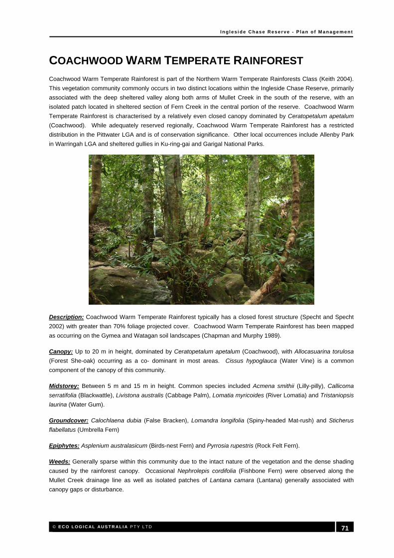
I n g l es i d e Chas e Res er ve - P l a n o f M a n age me n t
© E C O L O G I C AL AU S T R AL I A P T Y L T D 71
COACHWOOD WARM TEMPERATE RAINFOREST
Coachwood Warm Temperate Rainforest is part of the Northern Warm Temperate Rainforests Class (Keith 2004).
This vegetation community commonly occurs in two distinct locations within the Ingleside Chase Reserve, primarily
associated with the deep sheltered valley along both arms of Mullet Creek in the south of the reserve, with an
isolated patch located in sheltered section of Fern Creek in the central portion of the reserve. Coachwood Warm
Temperate Rainforest is characterised by a relatively even closed canopy dominated by Ceratopetalum apetalum
(Coachwood). While adequately reserved regionally, Coachwood Warm Temperate Rainforest has a restricted
distribution in the Pittwater LGA and is of conservation significance. Other local occurrences include Allenby Park
in Warringah LGA and sheltered gullies in Ku-ring-gai and Garigal National Parks.
Description: Coachwood Warm Temperate Rainforest typically has a closed forest structure (Specht and Specht
2002) with greater than 70% foliage projected cover. Coachwood Warm Temperate Rainforest has been mapped
as occurring on the Gymea and Watagan soil landscapes (Chapman and Murphy 1989).
Canopy: Up to 20 m in height, dominated by Ceratopetalum apetalum (Coachwood), with Allocasuarina torulosa
(Forest She-oak) occurring as a co- dominant in most areas. Cissus hypoglauca (Water Vine) is a common
component of the canopy of this community.
Midstorey: Between 5 m and 15 m in height. Common species included Acmena smithii (Lilly-pilly), Callicoma
serratifolia (Blackwattle), Livistona australis (Cabbage Palm), Lomatia myricoides (River Lomatia) and Tristaniopsis
laurina (Water Gum).
Groundcover: Calochlaena dubia (False Bracken), Lomandra longifolia (Spiny-headed Mat-rush) and Sticherus
flabellatus (Umbrella Fern)
Epiphytes: Asplenium australasicum (Birds-nest Fern) and Pyrrosia rupestris (Rock Felt Fern).
Weeds: Generally sparse within this community due to the intact nature of the vegetation and the dense shading
caused by the rainforest canopy. Occasional Nephrolepis cordifolia (Fishbone Fern) were observed along the
Mullet Creek drainage line as well as isolated patches of Lantana camara (Lantana) generally associated with
canopy gaps or disturbance.

I n g l es i d e Chas e Res er ve - P l a n o f M a n age me n t
© E C O L O G I C AL AU S T R AL I A P T Y L T D 72
SWAMP SCLEROPHYLL FOREST
Swamp Sclerophyll Forest is part of the Coastal Swamp Forest Class (Keith 2004). This vegetation community
occurs in the south-eastern section of the reserve along Mullet Creek and is contiguous with much larger areas of
this community in Irrawong Reserve and the Warriewood Wetlands. Swamp Sclerophyll Forest is characterised by
vegetation occurring on alluvial flats with a canopy dominated by Eucalyptus robusta (Swamp Mahogany). Within
Ingleside Chase Reserve, the remaining Swamp Sclerophyll Forest is in poor condition and is dominated by weeds.
Swamp Sclerophyll Forest is an Endangered Ecological Community listed under the Threatened Species
Conservation Act 1995 (TSC Act) and is of high conservation significance in the Pittwater LGA.
Description: Swamp Sclerophyll Forest within the reserve has an open forest structure (Specht and Specht 2002)
with greater than 30% foliage projected cover, but may vary in from open woodland to closed forest depending on a
number of factors including past clearing and disturbances such as weeds. Swamp Sclerophyll Forest has been
mapped as occurring on the Watagan soil landscape (Chapman and Murphy 1989).
Canopy: Up to 18 m in height, dominated by Eucalyptus robusta (Swamp Mahogany) and Eucalyptus botryoides
(Bangalay).
Midstorey: Sparse and up to 10 m in height. Common species included Acmena smithii (Lilly-pilly), Cyathea
cooperi (Straw Tree-fern) and Glochidion ferdinandi (Cheese Tree).
Groundcover: Hypolepis muelleri (Harsh Ground Fern) and Stephania japonica var. discolor.
Weeds: Within Ingleside Chase Reserve, this vegetation community is dominated by weeds including Acer
negundo (Box-elder Maple), Erythrina crista-galli (Cockspur Coral Tree), Lantana camara (Lantana), Senna
pendula var. glabrata (Senna) and Tradescantia fluminensis (Wandering Jew).

I n g l es i d e Chas e Res er ve - P l a n o f M a n age me n t
© E C O L O G I C AL AU S T R AL I A P T Y L T D 73
Appendix B: Native Flora Species
Note:
1. Families are group under the headings 1. Pteridophytes, 2. Gymnosperms, 3. Dicotyledons, 4. Monocotyledons
2. An '*' before species indicates exotic species, # indicates non-local native 3. A sample flora assemblage obtained from a short term survey, such as the present one, cannot be considered comprehensive, but rather indicative of the actual flora assemblage.
4. It can take many years of flora surveys to record all of the plant species occurring within any area, especially species that are only apparent in some seasons
5. Not all species can be accurately identified in a ‘snapshot’ survey due to absence of flowering or fruiting material.
FAMILY SPECIES COMMON NAME ELA ECOTONE
1. Pteridophytes
Adiantaceae Adiantum aethiopicum Common Maidenhair Fern X
Adiantaceae Adiantum hispidulum Rough Maidenhair Fern X
Aspleniaceae Asplenium australasicum Birds‐nest Fern X X
Aspleniaceae Asplenium flabellifolium Necklace Spleenwort X
Blechnaceae Blechnum camfieldii Water Fern X
Blechnaceae Blechnum cartilagineum Gristle Fern X X
Blechnaceae Blechnum indicum Swamp Water Fern X
Blechnaceae Doodia caudata Small Rasp Fern X
Cyatheaceae Cyathea australis Rough Tree‐fern X X
Cyatheaceae Cyathea cooperi Straw Tree‐fern, Scaly Tree‐Fern X
Davalliaceae Davallia pyxidata Hare's‐foot Fern X
Davalliaceae * Nephrolepis cordifolia Fishbone Fern X X
Dennstaedtiaceae Histiopteris incisa Batswing Fern, Oak Fern X
Dennstaedtiaceae Hypolepis muelleri Harsh Ground Fern X
Dennstaedtiaceae Pteridium esculentum Bracken X X

I n g l es i d e Chas e Res er ve - P l a n o f M a n age me n t
© E C O L O G I C AL AU S T R AL I A P T Y L T D 74
FAMILY SPECIES COMMON NAME ELA ECOTONE
Dicksoniaceae Calochlaena dubia Rainbow Fern, False Bracken X X
Gleicheniaceae Gleichenia dicarpa Pouched Coral‐fern X X
Gleicheniaceae Gleichenia microphylla Scrambling Coral Fern X
Gleicheniaceae Gleichenia rupestris Rock Coral Fern X
Gleicheniaceae Sticherus flabellatus Shiny Fan Fern, Umbrella Fern X X
Lindsaeaceae Lindsaea linearis Screw Fern X X
Osmundaceae Todea barbara King Fern X X
Polypodiaceae Pyrrosia rupestris Rock Felt Fern, Creeping Fern X X
Psilotaceae Psilotum nudum Skeleton Fork‐fern X
Schizaeaceae Schizaea dichotoma Branched Comb Fern X
Selaginellaceae Selaginella uliginosa X
Sinopteridaceae Cheilanthes sieberi subsp. sieberi Rock Fern X
Thelypteridaceae Christella dentata Binung X
2. Gymnosperms
Pinaceae * Pinus radiata Monterey Pine, Radiata Pine X
Podocarpaceae Podocarpus spinulosus X X
3. Dicotyledons
Acanthaceae Pseuderanthemum variabile Pastel Flower X
Aceraceae * Acer pseudoplatanus Sycamore Maple X
Apiaceae Actinotus helianthi Flannel Flower X
Apiaceae Actinotus minor Lesser Flannel Flower X X
Apiaceae * Hydrocotyle bonariensis Beach Pennywort X X
Apiaceae Hydrocotyle laxiflora Stinking Pennywort X
Apiaceae Hydrocotyle peduncularis Pennywort X
Apiaceae Platysace lanceolata Lance‐leaf Platysace X X
Apiaceae Platysace linearifolia X X
Apiaceae Trachymene incisa X
Apiaceae Xanthosia pilosa Woolly Xanthosia X X

I n g l es i d e Chas e Res er ve - P l a n o f M a n age me n t
© E C O L O G I C AL AU S T R AL I A P T Y L T D 75
FAMILY SPECIES COMMON NAME ELA ECOTONE
Apiaceae Xanthosia tridentata Rock Xanthosia X X
Apocynaceae * Asclepias curassavica Blood Flower X
Apocynaceae Marsdenia suaveolens Scented Milkvine X X
Apocynaceae Parsonsia straminea Common Silkpod, Monkey Rope X
Araliaceae Astrotricha floccosa Star‐hairs X X
Araliaceae Polyscias sambucifolia Elderberry Panax X
Asteraceae * Ageratina adenophora Crofton Weed X X
Asteraceae * Ageratina riparia Mistflower X
Asteraceae * Bidens pilosa Farmer's Friend, Cobblers Pegs X X
Asteraceae * Cirsium vulgare Black Thistle, Spear Thistle X
Asteraceae * Conyza sp. X
Asteraceae * Conyza sumatrensis Tall Fleabane X
Asteraceae * Coreopsis lanceolata Calliopsis, Coreopsis X
Asteraceae * Crassocephalum crepidioides Thickhead X
Asteraceae * Gnaphalium coarctatum Cudweed X X
Asteraceae * Hypochaeris radicata Catsear, False Dandelion X
Asteraceae Lagenophera stipitata Blue Bottle‐daisy X
Asteraceae Olearia tomentosa Downy Daisy‐bush X X
Asteraceae * Senecio madagascariensis Fireweed, Madagascar Ragwort X
Asteraceae * Sonchus oleraceus Common Sow‐thistle, Milk‐thistle X
Baueraceae Bauera rubioides Dog Rose, River Rose X
Bignoniaceae Pandorea pandorana Wonga Vine X
Brassicaceae * Rorippa nasturtium‐aquaticum Watercress X X
Casuarinaceae Allocasuarina distyla Scrub She‐oak X X
Casuarinaceae Allocasuarina littoralis Black She‐Oak X X
Casuarinaceae Allocasuarina torulosa Forest She‐oak X X
Celastraceae Maytenus silvestris X
Chloanthaceae Chloanthes stoechadis Common Chloanthes X

I n g l es i d e Chas e Res er ve - P l a n o f M a n age me n t
© E C O L O G I C AL AU S T R AL I A P T Y L T D 76
FAMILY SPECIES COMMON NAME ELA ECOTONE
Cunoniaceae Callicoma serratifolia Blackwattle X X
Cunoniaceae Ceratopetalum apetalum Coachwood X X
Cunoniaceae Ceratopetalum gummiferum NSW Christmas Bush X X
Cunoniaceae Schizomeria ovata Crabapple, White Birch X
Dilleniaceae Hibbertia aspera Rough Guinea‐flower X
Dilleniaceae Hibbertia dentata Guinea‐flower X X
Dilleniaceae Hibbertia empetrifolia Trailing Guinea‐flower X
Dilleniaceae Hibbertia linearis Guinea‐flower X X
Droseraceae Drosera binata Forked Sundew X
Droseraceae Drosera peltata Pale Sundew X
Elaeocarpaceae Elaeocarpus reticulatus Blueberry Ash X X
Ericaceae ‐ Styphelioideae Dracophyllum secundum Dragon Heath X
Ericaceae ‐ Styphelioideae Epacris longiflora Fuchsia Heath X X
Ericaceae ‐ Styphelioideae Epacris pulchella X X
Ericaceae ‐ Styphelioideae Leucopogon ericoides Beard‐heath X
Ericaceae ‐ Styphelioideae Leucopogon lanceolatus Lance‐leaf Beard‐heath X
Ericaceae ‐ Styphelioideae Leucopogon microphyllus X X
Ericaceae ‐ Styphelioideae Monotoca elliptica Tree Broom‐heath X
Ericaceae ‐ Styphelioideae Monotoca scoparia Prickly Broom‐heath X
Ericaceae ‐ Styphelioideae Styphelia longifolia X
Ericaceae ‐ Styphelioideae Styphelia tubiflora Pink Fivecorners X X
Ericaceae ‐ Styphelioideae Woollsia pungens Woollsia X X
Euphorbiaceae Amperea xiphoclada Broom Spurge X
Euphorbiaceae Bertya brownii X
Euphorbiaceae Breynia oblongifolia Coffee Bush X
Euphorbiaceae Glochidion ferdinandi Cheese Tree X X
Euphorbiaceae Homalanthus populifolius Bleeding Heart, Native Poplar X X
Euphorbiaceae Micrantheum ericoides X X

I n g l es i d e Chas e Res er ve - P l a n o f M a n age me n t
© E C O L O G I C AL AU S T R AL I A P T Y L T D 77
FAMILY SPECIES COMMON NAME ELA ECOTONE
Euphorbiaceae Phyllanthus hirtellus Thyme Spurge X X
Euphorbiaceae Ricinocarpos pinifolius Wedding Bush X
Eupomatiaceae Eupomatia laurina Bolwarra X
Fabaceae Caesalpinioideae * Senna pendula var. glabrata Senna X X
Fabaceae Faboideae Aotus ericoides Common Aotus X
Fabaceae Faboideae Bossiaea heterophylla X
Fabaceae Faboideae Bossiaea scolopendria X
Fabaceae Faboideae Desmodium rhytidophyllum Tick‐trefoil X
Fabaceae Faboideae Dillwynia retorta Eggs‐and‐bacon Pea, Parrot Pea X X
Fabaceae Faboideae * Erythrina crista‐galli Cockspur Coral Tree X
Fabaceae Faboideae * Erythrina x sykesii Coral Tree X
Fabaceae Faboideae * Genista monspessulana Montpelier Broom X
Fabaceae Faboideae Glycine clandestina Twining Glycine X
Fabaceae Faboideae Gompholobium latifolium Golden Glory Pea X
Fabaceae Faboideae Hardenbergia violacea False Sarsaparilla X
Fabaceae Faboideae Hovea linearis Narrow‐leaf Hovea X
Fabaceae Faboideae Phyllota grandiflora X X
Fabaceae Faboideae Phyllota phylicoides Common Phyllota X
Fabaceae Faboideae Platylobium formosum Handsome Flat‐pea X X
Fabaceae Faboideae Podolobium ilicifolium Native Holly, Prickly Shaggy‐pea X
Fabaceae Faboideae Pultenaea daphnoides Large‐leaf Bush‐pea X X
Fabaceae Faboideae Pultenaea flexilis X X
Fabaceae Faboideae Pultenaea stipularis X X
Fabaceae Faboideae Pultenaea tuberculata X X
Fabaceae Faboideae * Trifolium repens White Clover X
Fabaceae Mimosoideae Acacia echinula X X
Fabaceae Mimosoideae Acacia longifolia Sydney Golden Wattle X X
Fabaceae Mimosoideae Acacia longissima X

I n g l es i d e Chas e Res er ve - P l a n o f M a n age me n t
© E C O L O G I C AL AU S T R AL I A P T Y L T D 78
FAMILY SPECIES COMMON NAME ELA ECOTONE
Fabaceae Mimosoideae Acacia oxycedrus Spike Wattle X X
Fabaceae Mimosoideae Acacia parramattensis Parramatta Wattle X
Fabaceae Mimosoideae Acacia sophorae Coastal Wattle X
Fabaceae Mimosoideae Acacia suaveolens Sweet Wattle X
Fabaceae Mimosoideae Acacia terminalis subsp. angustifolia Sunshine Wattle X X
Fabaceae Mimosoideae Acacia ulicifolia Prickly Moses, Prickly Wattle X X
Goodeniaceae Dampiera stricta Blue Dampiera X
Goodeniaceae Goodenia ovata X
Haloragaceae Gonocarpus teucrioides Raspwort X
Hydrocharitaceae * Egeria densa Dense Waterweed X
Lamiaceae Hemigenia purpurea X
Lamiaceae Plectranthus parviflorus Cockspur Flower X
Lamiaceae Prostanthera denticulata Rough Mintbush X
Lauraceae Cassytha glabella Devil's Twine, Dodder‐laurel X
Lauraceae Cassytha pubescens Devil's Twine, Dodder‐laurel X X
Lauraceae * Cinnamomum camphora Camphor‐laurel X
Lauraceae Endiandra sieberi Hard Corkwood X X
Lobeliaceae Pratia purpurascens Whiteroot X
Loganiaceae Logania albiflora Narrowleaf Logania X
Loganiaceae Mitrasacme polymorpha Mitre Weed X
Malvaceae * Sida rhombifolia Paddy's Lucerne X X
Meliaceae Melia azedarach White Cedar, Persian Lilac X
Meliaceae Synoum glandulosum Scentless Rosewood X X
Menispermaceae Sarcopetalum harveyanum Pearl Vine X
Menispermaceae Stephania japonica var. discolor Snake Vine X X
Moraceae Ficus coronata Creek Sandpaper Fig X
Moraceae Ficus obliqua Small‐leaved Fig X

I n g l es i d e Chas e Res er ve - P l a n o f M a n age me n t
© E C O L O G I C AL AU S T R AL I A P T Y L T D 79
FAMILY SPECIES COMMON NAME ELA ECOTONE
Moraceae Ficus rubiginosa Port Jackson Fig, Rusty Fig X X
Myrsinaceae Myrsine variabilis Muttonwood X
Myrtaceae Acmena smithii Lilly‐pilly X
Myrtaceae Angophora costata Smooth‐barked Apple X X
Myrtaceae Angophora hispida Dwarf Apple X X
Myrtaceae Austromyrtus tenuifolia Narrow‐Leaved Midgenberry X
Myrtaceae Callistemon citrinus Scarlet Bottlebrush X X
Myrtaceae Callistemon linearis Narrow‐leaved Bottlebrush X X
Myrtaceae Callistemon rigidus Stiff Bottlebrush X X
Myrtaceae Callistemon salignus White Bottlebrush, Pink‐tips X
Myrtaceae Corymbia gummifera Red Bloodwood X X
Myrtaceae Darwinia fascicularis subsp. fascicularis X
Myrtaceae Eucalyptus botryoides Bangalay X
Myrtaceae Eucalyptus capitellata Brown Stringybark X X
Myrtaceae Eucalyptus haemastoma Broad‐leaved Scribbly Gum X X
Myrtaceae Eucalyptus oblonga Narrow‐leaved Stringybark X
Myrtaceae Eucalyptus piperita Sydney Peppermint X X
Myrtaceae Eucalyptus punctata Grey Gum X X
Myrtaceae Eucalyptus resinifera subsp. resinifera Red Mahogany X
Myrtaceae Eucalyptus robusta Swamp Mahogany X X
Myrtaceae Eucalyptus sieberi Silvertop Ash X X
Myrtaceae Eucalyptus umbra Broad‐leaved White Mahogany X X
Myrtaceae Kunzea ambigua Tick‐bush X X
Myrtaceae Leptospermum polygalifolium subsp. polygalifolium Yellow Tea‐tree, Tantoon Tea‐Tree X X
Myrtaceae Leptospermum squarrosum Peach‐flowered Tea‐tree X X

I n g l es i d e Chas e Res er ve - P l a n o f M a n age me n t
© E C O L O G I C AL AU S T R AL I A P T Y L T D 80
FAMILY SPECIES COMMON NAME ELA ECOTONE
Myrtaceae Leptospermum trinervium Paperbark Tea‐tree X X
Myrtaceae Lophostemon confertus Brush Box X
Myrtaceae # Melaleuca armillaris Bracelet Honey‐myrtle X
Myrtaceae Melaleuca ericifolia Swamp Paperbark X
Myrtaceae Melaleuca hypericifolia Hillock Bush X
Myrtaceae Syncarpia glomulifera Turpentine X X
Myrtaceae Tristania neriifolia Dwarf Water Gum X
Myrtaceae Tristaniopsis collina Mountain Water Gum X
Myrtaceae Tristaniopsis laurina Water Gum, Kanuka Box X X
Ochnaceae * Ochna serrulata Mickey Mouse Plant X
Oleaceae * Jasminum polyanthum Jasmine X
Oleaceae Notelaea longifolia Mock‐olive X
Onagraceae * Ludwigia peruviana Ludwigia X
Oxalidaceae * Oxalis corniculata Yellow Wood‐sorrel X
Oxalidaceae Oxalis perennans Oxalis X
Passifloraceae * Passiflora edulis Passionfruit X
Pittosporaceae Billardiera scandens Appleberry, Dumplings, Snotberry X X
Pittosporaceae Bursaria spinosa Australian Boxthorn X
Pittosporaceae Citriobatus pauciflorus Orange‐thorn X
Pittosporaceae Pittosporum revolutum Yellow Pittosporum X
Pittosporaceae Pittosporum undulatum Sweet Pittosporum X X
Plantaginaceae * Plantago lanceolata Plantain, Ribwort X
Polygonaceae * Acetosa sagittata Rambling Dock, Turkey Rhubarb X
Polygonaceae Persicaria strigosa Bristly Knotweed X
Polygonaceae * Rumex crispus Curled Dock X
Proteaceae Banksia ericifolia Heath Banksia X X
Proteaceae Banksia integrifolia Coast Banksia X
Proteaceae Banksia oblongifolia X

I n g l es i d e Chas e Res er ve - P l a n o f M a n age me n t
© E C O L O G I C AL AU S T R AL I A P T Y L T D 81
FAMILY SPECIES COMMON NAME ELA ECOTONE
Proteaceae Banksia paludosa Swamp Banksia X
Proteaceae Banksia serrata Saw Banksia, Old Man Banksia X X
Proteaceae Banksia spinulosa var. collina Hill Banksia X
Proteaceae Conospermum longifolium subsp. longifolium Long‐leaf Coneseeds X
Proteaceae Grevillea buxifolia Grey Spider‐flower X X
Proteaceae Grevillea linearifolia Linear‐leaf Grevillea X X
Proteaceae Grevillea sericea X X
Proteaceae Hakea gibbosa Needlebush X X
Proteaceae Hakea sericea Needlebush, Silky Hakea X X
Proteaceae Hakea teretifolia Needlebush, Dagger Hakea X X
Proteaceae Lambertia formosa Mountain Devil, Honey‐flower X
Proteaceae Lomatia myricoides River Lomatia X
Proteaceae Lomatia silaifolia Native Parsley, Crinklebush X
Proteaceae Persoonia lanceolata Geebung X X
Proteaceae Persoonia levis Broad‐leaved Geebung X X
Proteaceae Persoonia linearis Narrow‐leaf Geebung X
Proteaceae Persoonia pinifolia Pineleaf Geebung X
Proteaceae Petrophile pulchella Conesticks X
Ranunculaceae Clematis aristata Traveller's Joy, Old Man's Beard X
Rhamnaceae Pomaderris elliptica X
Rhamnaceae Pomaderris ferruginea X
Rhamnaceae Pomaderris intermedia X
Rosaceae * Rubus fruticosus (sp. agg) Blackberry X
Rubiaceae Morinda jasminoides Morinda X
Rubiaceae Opercularia aspera Common Stinkweed X
Rubiaceae Opercularia varia Stinkweed X X
Rubiaceae Pomax umbellata Pomax X

I n g l es i d e Chas e Res er ve - P l a n o f M a n age me n t
© E C O L O G I C AL AU S T R AL I A P T Y L T D 82
FAMILY SPECIES COMMON NAME ELA ECOTONE
Rutaceae Asterolasia correifolia Star‐bush X
Rutaceae Boronia ledifolia Sydney Boronia, Ledum Boronia X
Rutaceae Boronia mollis Soft Boronia X X
Rutaceae Boronia pinnata Pinnate Boronia X X
Rutaceae Correa reflexa Native Fuchsia X
Rutaceae Crowea saligna X X
Rutaceae Eriostemon australasius Wax Plant X X
Rutaceae Leionema dentatum X X
Rutaceae Phebalium squamulosum Scaly Phebalium X X
Rutaceae Zieria pilosa Pilose‐leafed Zieria X X
Rutaceae Zieria smithii Sandfly Zieria, Stinkwood X X
Santalaceae Leptomeria acida Sour Currant Bush X
Sapindaceae Dodonaea triquetra Hopbush X X
Solanaceae * Cestrum parqui Green Cestrum X
Solanaceae Duboisia myoporoides Corkwood, Duboisia X
Solanaceae Solanum aviculare Kangaroo Apple X
Solanaceae * Solanum mauritianum Tree Tobacco, Wild Tobacco X X
Solanaceae * Solanum nigrum Blackberry Nightshade X
Solanaceae Solanum prinophyllum Forest Nightshade X
Sterculiaceae Lasiopetalum ferrugineum Rusty Velvet‐bush X X
Thymelaeaceae Pimelea linifolia Rice Flower X X
Verbenaceae Clerodendrum tomentosum Hairy Clerodendrum X
Verbenaceae * Lantana camara Lantana X X
Verbenaceae * Verbena bonariensis Purpletop X
Violaceae Viola hederacea Native Violet, Ivy‐leaved Violet X X
Vitaceae Cissus antarctica Kangaroo Vine X
Vitaceae Cissus hypoglauca Native Grape, Water Vine X X
4. Monocotyledons

I n g l es i d e Chas e Res er ve - P l a n o f M a n age me n t
© E C O L O G I C AL AU S T R AL I A P T Y L T D 83
FAMILY SPECIES COMMON NAME ELA ECOTONE
Alliaceae * Agapanthus praecox subsp. orientalis Agapanthus X
Anthericaceae * Chlorophytum comosum Spider Plant X
Araceae * Alocasia sp. X
Araceae Gymnostachys anceps Settlers' Flax, Settlers' Twine X
Arecaceae Livistona australis Cabbage Palm, Cabbage‐tree Palm X X
Asparagaceae * Asparagus aethiopicus Asparagus Fern X X
Commelinaceae Commelina cyanea Blue Spiderwort X
Commelinaceae * Tradescantia fluminensis Wandering Jew X X
Cyperaceae Caustis flexuosa Old‐man's Whiskers, Curly‐wig X X
Cyperaceae Caustis pentandra X
Cyperaceae Cyathochaeta diandra X
Cyperaceae Cyperus polystachyos X
Cyperaceae Ficinia nodosa Knobby Club‐rush X
Cyperaceae Fimbristylis dichotoma X
Cyperaceae Gahnia clarkei Saw‐sedge X X
Cyperaceae Gahnia erythrocarpa X
Cyperaceae Gahnia sieberiana Red‐fruited Saw‐sedge X
Cyperaceae * Isolepis prolifera X
Cyperaceae Lepidosperma elatius Tall Sword‐sedge X
Cyperaceae Lepidosperma laterale Variable Sword‐sedge X X
Cyperaceae Schoenus ericetorum Heath Bog‐rush X
Cyperaceae Schoenus melanostachys Black Bog‐rush X X
Iridaceae Patersonia sericea Native Iris, Silky Purple‐flag X
Juncaceae * Juncus bufonius Toad Rush X
Lomandraceae Lomandra confertifolia subsp. rubiginosa X
Lomandraceae Lomandra glauca Pale Mat‐rush X

I n g l es i d e Chas e Res er ve - P l a n o f M a n age me n t
© E C O L O G I C AL AU S T R AL I A P T Y L T D 84
FAMILY SPECIES COMMON NAME ELA ECOTONE
Lomandraceae Lomandra longifolia Spiny‐headed Mat‐rush X X
Lomandraceae Lomandra multiflora Many‐flowered Mat‐rush X
Lomandraceae Lomandra obliqua X
Orchidaceae Acianthus fornicatus Gnat Orchid X
Orchidaceae Cryptostylis erecta Tartan Tongue Orchid X
Orchidaceae Cryptostylis subulata Large Tongue‐orchid X
Orchidaceae Cymbidium suave Native Cymbidium X
Orchidaceae Dendrobium linguiforme Tongue Orchid X
Orchidaceae Dendrobium speciosum Rock Orchid, Rock‐lily X
Orchidaceae Liparis reflexa Tom Cats X
Orchidaceae Pterostylis grandiflora Superb Greenhood X
Orchidaceae Pterostylis nutans Nodding Greenhood X
Orchidaceae Pterostylis sp. Greenhood Orchid X
Philesiaceae Eustrephus latifolius Wombat Berry X
Philesiaceae Geitonoplesium cymosum Scrambling Lily X
Phormiaceae Dianella caerulea var. producta Blue Flax‐lily X X
Poaceae * Andropogon virginicus Whisky Grass, Broomsedge X X
Poaceae Anisopogon avenaceus Oat Spear Grass X
Poaceae Aristida vagans Threeawn Speargrass X
Poaceae * Arundo donax Giant Reed X
Poaceae Austrostipa pubescens Speargrass X
Poaceae * Cortaderia selloana Pampas Grass X X
Poaceae Cymbopogon refractus Barbed Wire Grass X
Poaceae * Cynodon dactylon Couch, Bermuda Grass X
Poaceae Digitaria parviflora Smallflower Finger Grass X
Poaceae * Ehrharta erecta Panic Veldgrass X
Poaceae * Eleusine indica Crowsfoot Grass X
Poaceae Entolasia marginata Bordered Panic X

I n g l es i d e Chas e Res er ve - P l a n o f M a n age me n t
© E C O L O G I C AL AU S T R AL I A P T Y L T D 85
FAMILY SPECIES COMMON NAME ELA ECOTONE
Poaceae Entolasia stricta Wiry Panic X
Poaceae Eragrostis brownii Brown's Lovegrass X
Poaceae Eragrostis sp. Love Grass X
Poaceae Imperata cylindrica Blady Grass X X
Poaceae Microlaena stipoides Meadow Rice‐grass, Weeping Grass X
Poaceae Oplismenus aemulus Broad‐leaved Basket Grass X
Poaceae Oplismenus imbecillis Narrow‐leaved Basket Grass X
Poaceae Panicum simile Two‐colour Panic X
Poaceae Paspalidium distans Spreading Panicgrass X
Poaceae * Paspalum urvillei Vasey Grass X X
Poaceae * Pennisetum clandestinum Kikuyu X X
Poaceae Poa affinis Poa Tussock X
Poaceae * Setaria palmifolia Palm Grass X
Poaceae * Setaria parviflora Slender Pigeon Grass X X
Poaceae Tetrarrhena juncea Wiry Ricegrass X
Poaceae Themeda australis Kangaroo Grass X
Restionaceae Baloskion tetraphyllum Tassel Cord‐rush, Tassel Rush X
Restionaceae Empodisma minus Tanglefoot X
Restionaceae Lepyrodia scariosa Scale‐rush X X
Smilacaceae Smilax glyciphylla Sweet Sarsaparilla X X
Uvulariaceae Schelhammera undulata Lilac Lily X
Xanthorrhoeaceae Xanthorrhoea arborea Forest Grass‐tree X X
Xanthorrhoeaceae Xanthorrhoea media Grass Tree X
Xanthorrhoeaceae Xanthorrhoea resinifera Grass‐tree X
Zingiberaceae * Hedychium gardnerianum Yellow Ginger, Ginger Lily X

I n g l es i d e Chas e Res er ve - P l a n o f M a n age me n t
© E C O L O G I C AL AU S T R AL I A P T Y L T D 86
Appendix C: Weed Control Techniques
SPECIES COMMON NAME CONTROL METHODS
Acetosa sagittata Turkey Rhubarb
Remove and bag propagules (if present)
Tubers must be dug from the ground using a trowel and bagged.
Dispose of all propagules at a registered green waste disposal centre.
Ageratina adenophora Crofton Weed
Remove and bag propagules (if present) and then plants can be hand pulled without breaking the root system. Assist the plant by handling the plant at the base and using a garden fork or knife to slowly pry out of the ground. Uprooted plants should be placed upside-down with their roots in the air, to dry out
Cestrum parqui Green Cestrum
Remove and bag propagules (if present)
Small plants and seedlings can be hand pulled without breaking the root system. Assist the plant by handling the plant at the base and using a garden fork or knife to slowly pry out of the ground. Uprooted plants should be placed upside-down with their roots in the air, to dry out.
Larger plants should be stem-scraped at the nodes and immediately painted with roundup.
Cinnamomum
camphora Camphor Laurel
Trees less than 3 metres must be stem injected or cut close to ground and stump painted within 30 seconds, using a registered herbicide.
Trees 3 metres or higher may be removed by cutting trees close to ground and paint stump within 30 seconds, or stem inject where this will not pose a risk to life or property, using a registered herbicide.
Dispose of all propagules at a registered green waste disposal centre or chip.
Conyza sp Fleabane
Remove and bag propagules (if present) and then small plants (<1cm trunk diameter) can be hand pulled without breaking the root system. Assist the plant by handling the plant at the base and using a garden fork or knife to slowly pry out of the ground. Uprooted plants should be placed upside-down with their roots in the air, to dry out.
Coreopsis lanceolata Common Tick-seed
Small plants can be hand pulled without breaking the root system. Assist the plant by handling the plant at the base and using a garden fork or knife to slowly pry out of the ground. Uprooted plants should be placed upside-down with their roots in the air, to dry out.
Larger infestations can be sprayed with a registered herbicide. Spray infestations as flowers first appear to prevent see set.
Dispose of all propagules at a registered green waste disposal centre.

I n g l es i d e Chas e Res er ve - P l a n o f M a n age me n t
© E C O L O G I C AL AU S T R AL I A P T Y L T D 87
Cortaderia selloana Pampas Grass
Remove and bag propagules (if present)
Small plants and seedlings can be hand pulled without breaking the root system. Assist the plant by handling the plant at the base and using a garden fork or knife to slowly pry out of the ground. Uprooted plants should be placed upside-down with their roots in the air, to dry out.
Larger plants should be cut close to ground and paint stump within 30 seconds.
Ehrharta erecta Panic Veldgrass
Remove and bag propagules (if present)
Small plants and seedlings can be hand pulled without breaking the root system. Assist the plant by handling the plant at the base and using a garden fork or knife to slowly pry out of the ground. Uprooted plants should be placed upside-down with their roots in the air, to dry out.
Large infestations can be sprayed with a registered herbicide. Follow-up spray will be necessary prior to seeding.
Erythrina crista-galli Cockspur Coral Tree
Small plants (<1cm trunk diameter) can be hand pulled without breaking the root system. Assist the plant by handling the plant at the base and using a garden fork or knife to slowly pry out of the ground. Uprooted plants should be placed upside-down with their roots in the air, to dry out.
Trees (> 5cm trunk diameter) can be drilled/frilled and saplings (< 5cm trunk diameter) can be cut and painted and a registered herbicide applied. Herbicide should be applied within 30 seconds of making the cut to ensure maximum intake by the plant. Ringbarking has proven to be ineffective. Follow-up control may be necessary.
Dispose of all plant material at a registered green waste disposal centre.
Hedychium
gardnerianum Yellow Ginger
Tubers must be dug from the ground using a trowel and bagged.
Dispose of all plant material at a registered green waste disposal centre.
Lantana camara Lantana
Small plants and seedlings can be hand pulled without breaking the root system. Assist the plant by handling the plant at the base and using a garden fork or knife to slowly pry out of the ground. Uprooted plants should be placed upside-down with their roots in the air, to dry out.
Larger plants (> 5cm trunk diameter) can be cut and painted and a registered herbicide applied. Herbicide should be applied within 30 seconds of making the cut to ensure maximum intake by the plant.
Ludwigia peruviana Ludwigia
Remove and bag propagules (if present)
Small plants and seedlings can be hand pulled without breaking the root system. Assist the plant by handling the plant at the base and using a garden fork or knife to slowly pry out of the ground. Uprooted plants should be placed upside-down with their roots in the air, to dry out.
Larger plants and infestations will require chemical control. Chemical control is to be undertaken in accordance with the requirements of the local control authority.
Dispose of all plant material at a registered green waste disposal centre.
Ochna serrulata Mickey Mouse Plant Small plants can be hand pulled without breaking the root system. Assist the plant by handling the plant at the
base and using a garden fork or knife to slowly pry out of the ground. Uprooted plants should be placed

I n g l es i d e Chas e Res er ve - P l a n o f M a n age me n t
© E C O L O G I C AL AU S T R AL I A P T Y L T D 88
upside-down with their roots in the air, to dry out.
Larger plants should be stem-scraped at ground and immediately painted with roundup.
Dispose of all propagules at a registered green waste disposal centre.
Rubus fruticosus Blackberry
Small infestations can be dug out, however all parts of the root system must be removed to avoid reshooting. This control technique is not advisable on slopes, riparian zones or in situations where accelerated erosion may potentially occur.
Herbicide control is most effective from November to April, when the plant is flowering /fruiting and actively growing. The weed must not be treated when dormant. Blackberry can be sprayed with a registered herbicide. Several follow-up treatments may be required.
Cut and paint techniques can be effective during flowering.
Senna pendula var.
glabrata Cassia
Remove and bag propagules (if present)
Small plants and seedlings can be hand pulled without breaking the root system. Assist the plant by handling the plant at the base and using a garden fork or knife to slowly pry out of the ground. Uprooted plants should be placed upside-down with their roots in the air, to dry out.
Larger plants (> 5cm trunk diameter) can be cut and painted and a registered herbicide applied. Herbicide should be applied within 30 seconds of making the cut to ensure maximum intake by the plant.
Tradescantia
fluminensis Wandering Jew
Infestations require mechanical removal (e.g. raking) as spraying is not entirely effective, however it can help to rake and roll difficult areas after initial spray.
Rake and roll into pile. Turn and compact regularly. Monitor pile and allow to decompose on site.
Black builders plastic can be utilised to smother dense infestations.
Dispose of hand weeded plant material at a registered green waste disposal centre.
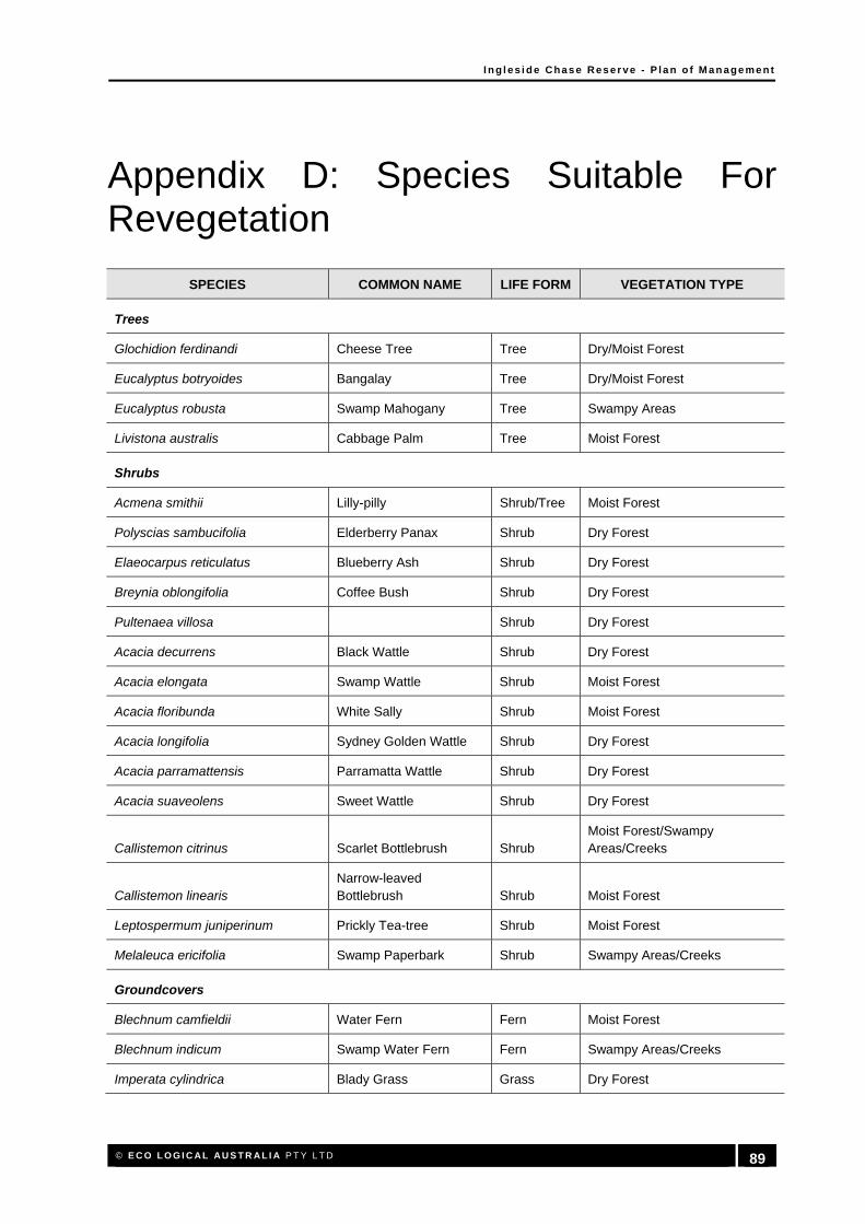
I n g l es i d e Chas e Res er ve - P l a n o f M a n age me n t
© E C O L O G I C AL AU S T R AL I A P T Y L T D 89
Appendix D: Species Suitable For Revegetation
SPECIES COMMON NAME LIFE FORM VEGETATION TYPE
Trees
Glochidion ferdinandi Cheese Tree Tree Dry/Moist Forest
Eucalyptus botryoides Bangalay Tree Dry/Moist Forest
Eucalyptus robusta Swamp Mahogany Tree Swampy Areas
Livistona australis Cabbage Palm Tree Moist Forest
Shrubs
Acmena smithii Lilly-pilly Shrub/Tree Moist Forest
Polyscias sambucifolia Elderberry Panax Shrub Dry Forest
Elaeocarpus reticulatus Blueberry Ash Shrub Dry Forest
Breynia oblongifolia Coffee Bush Shrub Dry Forest
Pultenaea villosa Shrub Dry Forest
Acacia decurrens Black Wattle Shrub Dry Forest
Acacia elongata Swamp Wattle Shrub Moist Forest
Acacia floribunda White Sally Shrub Moist Forest
Acacia longifolia Sydney Golden Wattle Shrub Dry Forest
Acacia parramattensis Parramatta Wattle Shrub Dry Forest
Acacia suaveolens Sweet Wattle Shrub Dry Forest
Callistemon citrinus Scarlet Bottlebrush Shrub Moist Forest/Swampy Areas/Creeks
Callistemon linearis Narrow-leaved Bottlebrush Shrub Moist Forest
Leptospermum juniperinum Prickly Tea-tree Shrub Moist Forest
Melaleuca ericifolia Swamp Paperbark Shrub Swampy Areas/Creeks
Groundcovers
Blechnum camfieldii Water Fern Fern Moist Forest
Blechnum indicum Swamp Water Fern Fern Swampy Areas/Creeks
Imperata cylindrica Blady Grass Grass Dry Forest

I n g l es i d e Chas e Res er ve - P l a n o f M a n age me n t
© E C O L O G I C AL AU S T R AL I A P T Y L T D 90
SPECIES COMMON NAME LIFE FORM VEGETATION TYPE
Isachne globosa Swamp Millet Grass Swampy Areas/Creeks
Oplismenus aemulus Broad-leaved Basket Grass Grass Moist Forest
Themeda australis Kangaroo Grass Grass Dry Forest
Ludwigia peploides subsp. montevidensis Water Primrose Herb Swampy Areas/Creeks
Viola hederacea Native Violet Herb Moist Forest
Alocasia brisbanensis Herb Moist Forest
Commelina cyanea Blue Spiderwort Herb Moist Forest
Lomandra longifolia Spiny-headed Mat-rush Herb Dry/Moist Forest
Dianella caerulea Blue Flax-lily Herb Dry/Moist Forest
Dianella caerulea var. producta Herb Dry/Moist Forest
Baumea articulata Jointed Twig-rush Sedge/RushMoist Forest/Swampy Areas/Creeks
Baumea juncea Bare Twig-rush Sedge/RushMoist Forest/Swampy Areas/Creeks
Bolboschoenus caldwellii Club-rush Sedge/Rush Swampy Areas/Creeks
Carex appressa Tall Sedge Sedge/RushMoist Forest/Swampy Areas/Creeks
Eleocharis sphacelata Tall Spike-rush Sedge/Rush Swampy Areas/Creeks
Gahnia sieberiana Red-fruited Saw-sedge Sedge/RushMoist Forest/Swampy Areas/Creeks
Schoenoplectus validus River Club-rush Sedge/RushMoist Forest/Swampy Areas/Creeks
Juncus usitatus Sedge/Rush Dry/Moist Forest
Climbers
Pandorea pandorana Wonga Vine Climber Dry Forest
Hardenbergia violacea False Sarsaparilla Climber Dry Forest
Kennedia rubicunda Dusky Coral-pea Climber Dry Forest
Clematis glycinoides Headache Vine Climber Dry/Moist Forest
Morinda jasminoides Morinda Climber Moist Forest
Cayratia clematidea Slender Grape Climber Dry/Moist Forest
Cissus hypoglauca Native Grape, Water Vine Climber Dry/Moist Forest

I n g l es i d e Chas e Res er ve - P l a n o f M a n age me n t
© E C O L O G I C AL AU S T R AL I A P T Y L T D 91
Appendix E: Mater Maria Licence Area

I n g l es i d e Chas e Res er ve - P l a n o f M a n age me n t
© E C O L O G I C AL AU S T R AL I A P T Y L T D 92
HEAD OFFICE
Suite 4, Level 1 2-4 Merton Street Sutherland NSW 2232 T 02 8536 8600 F 02 9542 5622
SYDNEY
Suite 604, Level 6 267 Castlereagh Street Sydney NSW 2000 T 02 9993 0566 F 02 9993 0573
ST GEORGES BASIN
8/128 Island Point Road St Georges Basin NSW 2540 T 02 4443 5555 F 02 4443 6655
CANBERRA
Level 2 11 London Circuit Canberra ACT 2601 T 02 6103 0145 F 02 6103 0148
HUNTER
Suite 17, Level 4 19 Bolton Street Newcastle NSW 2300 T 02 4910 0125 F 02 4910 0126
NAROOMA
5/20 Canty Street Narooma NSW 2546 T 02 4476 1151 F 02 4476 1161
COFFS HARBOUR 35 Orlando Street Coffs Harbour Jetty NSW 2450 T 02 6651 5484 F 02 6651 6890
ARMIDALE
92 Taylor Street Armidale NSW 2350 T 02 8081 2681 F 02 6772 1279
BRISBANE
93 Boundary St West End QLD 4101 T 1300 646 131
WESTERN AUSTRALIA
108 Stirling Street Perth WA 6000 T 08 9227 1070 F 08 9227 1078
WOLLONGONG
Level 2 25 Atchison Street Wollongong NSW 2500 T 02 8536 8615 F 02 4254 6699