Embed Size (px)
Citation preview

Infrastructure Planning Extrinsic Material 2017 1
Infrastructure Planning - Extrinsic material
October 2017

2 Infrastructure Planning Extrinsic Material 2017
This page is left purposely blank

Infrastructure Planning Extrinsic Material 2017 3
Contents
PARKS AND LAND FOR COMMUNITY FACILITIES NETWORK .......................................................... 4
1. PURPOSE ................................................................................................................................................ 4
2. PLANNING ASSUMPTIONS ...................................................................................................................... 4
2.1 ASSUMPTIONS FOR RESIDENTIAL DEVELOPMENT .................................................................................................. 4
Table 1 Rate of land provision for the park network ..................................................................................... 4
2.2 ASSUMPTIONS FOR NON-RESIDENTIAL DEVELOPMENT ........................................................................................... 4
Table 2 —Rate of land provision for community facilities network .............................................................. 5
3. ESTABLISHMENT COST OF EXISTING INFRASTRUCTURE .......................................................................... 5
4. ESTABLISHMENT COST OF FUTURE INFRASTRUCTURE ............................................................................ 5
4.1 LAND ACQUISITION COST ................................................................................................................................. 6
4.2 EMBELLISHMENT COST ................................................................................................................................... 6
4.3 ESTIMATED TIMING ........................................................................................................................................ 6
5. LIST OF SUPPORTING DOCUMENTS ........................................................................................................ 6
Table 3 List of supporting documents for parks and land for community facilities network ........................ 6
STORMWATER NETWORK ........................................................................................................................ 7
1. PURPOSE ................................................................................................................................................ 7
2. PLANNING ASSUMPTIONS ...................................................................................................................... 7
2.1 ASSUMPTIONS FOR RESIDENTIAL DEVELOPMENT .................................................................................................. 7
Table 4 Demand generation rate for stormwater network ........................................................................... 8
2.2 ASSUMPTIONS FOR NON-RESIDENTIAL DEVELOPMENT ........................................................................................... 9
Table 5 Floor space conversion rates as per ANZSIC categories .................................................................... 9
3. ESTABLISHMENT COST OF EXISTING INFRASTRUCTURE ........................................................................ 10
4. ESTABLISHMENT COST OF FUTURE INFRASTRUCTURE .......................................................................... 10
Table 6 Future stormwater trunk infrastructure ......................................................................................... 10
4.1 LAND ACQUISITION COST ............................................................................................................................... 11
4.2 ESTIMATED TIMING ..................................................................................................................................... 11
5. LIST OF SUPPORTING DOCUMENTS ...................................................................................................... 11
Table 7 List of supporting documents for stormwater network .................................................................. 11
TRANSPORT NETWORK .......................................................................................................................... 12
1. PURPOSE .............................................................................................................................................. 12
2. PLANNING ASSUMPTIONS .................................................................................................................... 12
2.1 ASSUMPTIONS FOR RESIDENTIAL DEVELOPMENT ................................................................................................ 12
2.2 ASSUMPTIONS FOR NON-RESIDENTIAL DEVELOPMENT ......................................................................................... 12
3. ESTABLISHMENT COST OF EXISTING INFRASTRUCTURE ........................................................................ 12
4. ESTABLISHMENT COST OF FUTURE INFRASTRUCTURE .......................................................................... 13
4.1 LAND ACQUISITION COST ............................................................................................................................... 13
4.2 ESTIMATED TIMING ..................................................................................................................................... 13
5. LIST OF SUPPORTING DOCUMENTS ...................................................................................................... 13
Table 8 List of supporting documents for transport network ...................................................................... 13

4 Infrastructure Planning Extrinsic Material 2017
Parks and Land for Community Facilities Network
1. Purpose
The purpose of this report is to summarise the methodology and assumptions used to undertake the transport infrastructure planning and prepare Schedule of Works for the Local Government Infrastructure Plan (LGIP).
The outputs of infrastructure planning, which includes Desired standards of services, Plans for trunk infrastructure, catchment demand & infrastructure cost, are published in various sections of LGIP and hence they are not repeated in this report. This report is to be read in conjunction with LGIP and Schedule of Works Model.
2. Planning Assumptions
Parks network planning is based on the in-house analysis of existing network and Parks and Amenities Strategy 2015 adopted by Council. Under this strategy, Council undertook stocktake of existing park land, categorise each of them and decided on the level of service for each category of park land including characteristics of parks and their embellishments. This study was very effective for LGIP parks planning as it provided information on all existing parks, classified each one in trunk/ non-trunk and was a clear decision of level of service (including embellishments) to be provided for each park. Another study undertaken was Vibrant and Active Towns and Villages which covered requirements of town centre and vibrancy in future. This project reflected some of the future projects for parks network.
2.1 Assumptions for residential development
Parks and land for community facilities network is planned for Statistical Area 2 (SA2) catchments, as this network is directly dependent on the population. Desired standards of services provide the rate of provision (also listed in below table 1) while the detailed design and embellishment standards are included in the planning scheme policy on Infrastructure. This allows for consistency in parks development either by Council or contributed by developers in lieu of charges.
Table 1 Rate of land provision for the park network
Park type* Rate of land provision (hectares / 1,000 persons)
Corridor 1.0
Premier 0.2
Recreation 1.4
Sports 1.8
Total 4.4
*Park types (e.g. environmental) other than listed above are considered as non-trunk parks.
2.2 Assumptions for non-residential development
Scenic Rim is a rural regional area and hence demand generated on parks and land for community facilities network by non-residential development is comparatively low and hence not

Infrastructure Planning Extrinsic Material 2017 5
considered for network planning purposes. Demand placed by tourist component is significant in particular catchment of Tamborine - Canungra SA2. In absence of detailed data, this component is unplanned. Though existing facilities are not considered at capacity and hence does not create undue issues.
Land for community facilities network planning was undertaken in-house similar to the parks strategy. Stocktake was undertaken for all the community facilities (where land is owned by Council), categorised them in various asset class and catchments. Consult and decide the level of service with the network planners and future infrastructure requirements. Below table 1 provides the rate of provision for land for community facilities.
Table 2 —Rate of land provision for community facilities network
Facility type Facility hierarchy
Rate of provision (Facility : EP)
Minimum land size (Land area/Facility GFA)
Community/Civic facility
General community space Local 1:10,000 Town Residential : 1,000m2 / 200m2
Rural Residential : not applicable
Community centre Region 1:30,000 Town Residential : 2,000m2/ 300m2
Rural Residential : not applicable
Cultural facility
Library Region 1:30,000 Town Residential : 3,000m2 / 1,800m2
Rural Residential : not applicable
Art gallery or dedicated art space
Region 1:30,000 2,000m2 / 500m2
Museum Region 1:30,000 4000m2 / 1200m2
Sporting facility
Indoor sports facility Region 1:30,000 4,000m2 / 500m2
Aquatic centre Region 1:30,000 5,000m2 (land area)
3. Establishment cost of existing infrastructure
The establishment costs of existing trunk infrastructure have been sourced from Council's Financial Asset Register 2013-14, as 2014 is considered base year for preparation of LGIP. Existing parks, which are not valued in the Council's Financial Asset Register and are generally having tenure as reserve, have nil land cost and only embellishment costs are included in the Schedule of Works modelling.
4. Establishment cost of future infrastructure
Council's 10 year capital works program adopted for 2016/17 on parks network are used for costing future upgrades and from catchment analysis, new parks are identified. Establishment cost for new parks is derived from the land valuation report.
6 Infrastructure Planning Extrinsic Material 2017
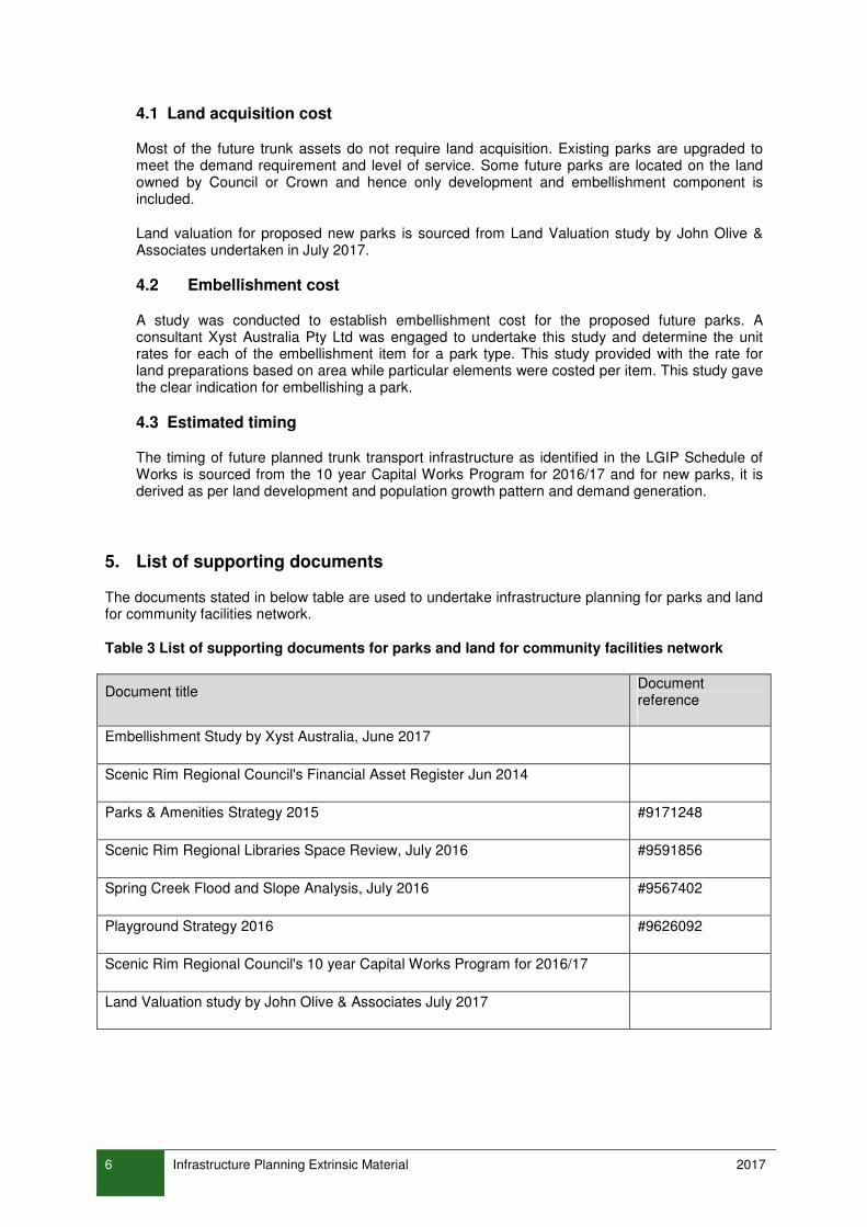
4.1 Land acquisition cost
Most of the future trunk assets do not require land acquisition. Existing parks are upgraded to meet the demand requirement and level of service. Some future parks are located on the land owned by Council or Crown and hence only development and embellishment component is included.
Land valuation for proposed new parks is sourced from Land Valuation study by John Olive & Associates undertaken in July 2017.
4.2 Embellishment cost
A study was conducted to establish embellishment cost for the proposed future parks. A consultant Xyst Australia Pty Ltd was engaged to undertake this study and determine the unit rates for each of the embellishment item for a park type. This study provided with the rate for land preparations based on area while particular elements were costed per item. This study gave the clear indication for embellishing a park.
4.3 Estimated timing
The timing of future planned trunk transport infrastructure as identified in the LGIP Schedule of Works is sourced from the 10 year Capital Works Program for 2016/17 and for new parks, it is derived as per land development and population growth pattern and demand generation.
5. List of supporting documents
The documents stated in below table are used to undertake infrastructure planning for parks and land for community facilities network.
Table 3 List of supporting documents for parks and land for community facilities network
Document title Document reference
Embellishment Study by Xyst Australia, June 2017
Scenic Rim Regional Council's Financial Asset Register Jun 2014
Parks & Amenities Strategy 2015 #9171248
Scenic Rim Regional Libraries Space Review, July 2016 #9591856
Spring Creek Flood and Slope Analysis, July 2016 #9567402
Playground Strategy 2016 #9626092
Scenic Rim Regional Council's 10 year Capital Works Program for 2016/17
Land Valuation study by John Olive & Associates July 2017

Infrastructure Planning Extrinsic Material 2017 7
Stormwater Network
1. Purpose
The purpose of this report is to summarise the methodology and assumptions used to undertake the stormwater infrastructure planning and prepare Schedule of Work for the Local Government Infrastructure Plan (LGIP).
The outputs of infrastructure planning, which includes Desired standards of services, Plans for trunk infrastructure, catchment demand & infrastructure cost, are published in various sections of LGIP and hence they are not repeated in this report. This report is to be read in conjunction with LGIP and Schedule of Works Model.
2. Planning Assumptions
Stormwater infrastructure planning and system assessment is an ongoing program targeting various catchments in Scenic Rim. The purpose of this program is to monitor the stormwater system and fix the concerns raised, through capital works program. Under this program, four studies were undertaken as follows:
1. Beaudesert Stormwater System Assessment & Improvement Plan by Aurecon December 2014
2. Boonah Stormwater System Assessment & Improvement Plan by Aurecon December 2014
3. Stormwater System Assessment & Improvement Plan Kalbar Study Area by CDM Smith August 2016
4. Stormwater System Assessment & Improvement Plan Canungra Study Area by CDM Smith August 2016
These studies were directly used to create catchments for the network, validate the existing trunk infrastructure and to undertake demand analysis in conjunction with the draft planning scheme information on zones and existing land uses. Future trunk infrastructure is recommended in these reports, which is used to inform Stormwater Schedule of Works programme.
Further assessment is under progress for Tamborine Mountain catchment though sufficient information is not yet available for this catchment to be included in the LGIP.
Impervious area for residential and non-residential development was calculated using different methodologies. It is mainly due to the availability of data in different forms.
2.1 Assumptions for residential development
For residential development, impervious area was calculated based on fraction of the developable area for different planning scheme zones as represented in Table 4. Demand generation rate for stormwater network were prepared having regard to recommended rates shown in the Queensland Urban Drainage Manual, 2013.

8 Infrastructure Planning Extrinsic Material 2017
Table 4 Demand generation rate for stormwater network
Planning scheme zone Planning scheme precinct Fraction Impervious used in LGIP planning
Low Density Residential 0.6
Low-Medium Density Residential
0.6
Rural
60Ha
Rural A
Rural B
500 sqm per dwelling
500 sqm per dwelling
500 sqm per dwelling
Rural Residential
No subdivision
3000 sqm
1 Ha
0.0
0.1
0.1
The timing of future residential development was based on the Scenic Rim's population and dwelling model. Considering existing land use pattern, fraction impervious was not applied uniformly and few exceptions were made as listed below:
1. Lot area < 500 sqm, with ultimate existing dwellings, impervious area =developable area
2. Lot area > 500 sqm, with ultimate existing dwellings, impervious area = 300 sqm
3. Where ultimate dwelling = 0, impervious area = 0
4. Ultimate dwelling is same as existing & only one dwelling and developable area <1000 sqm then impervious area = 300sqm
5. Ultimate dwelling is same as existing & only one dwelling and developable area >1000 sqm then impervious area = 500sqm
6. impervious area = 300sqm per dwelling, in Major, District and Local Centre and Mixed Use zones
7. where lot area >600 but <100 sqm impervious area = 0.6*lot area,
8. where lot area < 600 sqm, impervious area = lot area
9. ultimate dwelling is same as existing and only 2 dwellings, then impervious area = 300sqm per dwelling, where lot area < 600 sqm, impervious area = lot area
10. where existing dwelling is not equal to ultimate dwelling, impervious area = 300 sqm per dwelling

Infrastructure Planning Extrinsic Material 2017 9
2.2 Assumptions for non-residential development
For non-residential development, impervious area is calculated based on the gross floor area projections by applying standard conversion rates to the employment forecast. Similar principles are used as that of non-residential growth projections i.e. jobs and gross floor area projections, for calculating impervious hectare for non-residential development in the stormwater catchments.
Jobs data was sourced from the Department of Transport and Main Roads via data sharing agreement based on the Statistical Area 1 (SA1) geographical boundary and ANZSIC employment categories.
These data was converted into Gross Floor Area using the industry conversion rates for area required per employee. Data was then categorised into LGIP non-residential categories by grouping various ANZSIC sub-categories.
GFA for manufacturing was measured manually in 2016 for each of the properties listed as having Manufacturing businesses in ABR. ABR has data on all businesses in the Scenic Rim with their operating address and is updated every year and is classified with ANZSIC categories. This research formulates GFA for manufacturing under Industry for year 2016.
From these data, conversion rate is standardised for future (2021, 2026…..ultimate) & past (2014 & 2011) years. GFA for these years are extrapolated using the conversion rate only for manufacturing industry. The deviation from the normal process is undertaken as the gross floor area conversion rate for various manufacturing types varies from 30 to 200 sqm per job.
Table below represents the standard industry conversion rates for each category of employment by ANZSIC divisions and LGIP projection types to the required gross floor area for work.
Table 5 Floor space conversion rates as per ANZSIC categories
LGIP type ANZSIC Divisions Floor space (Sqm)
Commercial/ Retail Retail Trade - retail 29
Commercial/ Retail Retail Trade - commercial 45
Community Purpose/ Other/ Retail
Other Services 29
Community Purposes Health Care and Social Assistance 35
Community Purposes Arts and Recreation Services 35
Community Purposes Public Administration and Safety 35
Industry Mining (WC + storage) 55
Industry Manufacturing Based on survey data
Industry Construction (WC + storage) 55
Industry Wholesale Trade 220
Industry Transport, Postal and Warehousing 220
Industry Electricity, Gas, Water and Waste Services 120
Retail Accommodation and Food Services 29
Retail Financial and Insurance Services 25
Retail Rental, Hiring and Real Estate Services 25

10 Infrastructure Planning Extrinsic Material 2017
LGIP type ANZSIC Divisions Floor space (Sqm)
Retail Professional, Scientific and Technical Services 25
Retail Administrative and Support Services 25
Retail Education and Training 35
Retail/ Industry Information Media and Telecommunications 120
Rural Agriculture, Forestry and Fishing 0
3. Establishment cost of existing infrastructure
The establishment costs of existing trunk infrastructure have been sourced from Council's Financial Asset Register 2013-14, as 2014 is considered base year for preparation of LGIP.
4. Establishment cost of future infrastructure
Stormwater infrastructure planning is based on system assessment and improvement plan which has covered vital catchments across the region. From these studies, few recommendations are made to resolve current issues and are non-trunk in nature though four recommendations are considered as trunk infrastructure requirement, as below:
Table 6 Future stormwater trunk infrastructure
Asset Class Description Asset Valuation (2014) Land Valuation (2017)
Detention Basin
Devine Drive Basin A - Boonah $119,000 $9,333
Detention Basin
Devine Drive Basin B - Boonah $297,500 $23,333
Detention Basin
Devine Drive Basin C - Boonah $408,000 $75,000
Town Drain Brisbane St & Short St - Beaudesert
$1,870,000 $0
Costing of the above listed new trunk infrastructure was derived using various sources. The costing for town drain in Beaudesert was calculated in the Beaudesert Stormwater System Assessment and Improvement Plan report by Aurecon Consulting.
Costing for the proposed detention basins at Boonah was based on the Stormwater Management Unit Cost Rates for Logan Priority Infrastructure Plan. Infrastructure Policy officers at Logan City Council were in agreement to use the information. The Manager Works at Scenic Rim also confirmed that it will be appropriate to use this information as cost rate, though the actual costing may differ, depending on the site analysis, detailed design and timing of construction.

Infrastructure Planning Extrinsic Material 2017 11
4.1 Land acquisition cost
The land acquisition cost for future trunk infrastructure cost is only accounted for Detention Basins, as Town Drain is planned in road reserve hence no land acquisition cost is required. For Detention Basins, land acquisition cost was calculated using the fair value methodology from Land Valuation study by John Olive & Associates undertaken in July 2017.
4.2 Estimated Timing
The timing of future planned trunk stormwater infrastructure as identified in the LGIP Schedule of Works has been established based on proposed development and growth as recognized in the Council's land development projections model. This methodology ensures that future trunk infrastructure is planned for implementation to support and service the development.
5. List of supporting documents
The documents stated in below table are used to undertake infrastructure planning for stormwater network.
Table 7 List of supporting documents for stormwater network
Document title Document reference
Scenic Rim Regional Council's Financial Asset Register Jun 2014
Scenic Rim Regional Council's 10 year Capital Works Program for 2016/17
Stormwater System Assessment & Improvement Plan Kalbar Study Area by CDM Smith Aug 2016
Stormwater System Assessment & Improvement Plan Canungra Study Area by CDM Smith Aug 2016
Beaudesert Stormwater System Assessment & Improvement Plan by Aurecon Dec 2014
Boonah Stormwater System Assessment & Improvement Plan by Aurecon Dec 2014
Land Valuation study by John Olive & Associates July 2017

12 Infrastructure Planning Extrinsic Material 2017
Transport Network
1. Purpose
The purpose of this report is to summarise the methodology and assumptions used to undertake the transport infrastructure planning and prepare Schedule of Works for the Local Government Infrastructure Plan (LGIP).
The outputs of infrastructure planning, which includes Desired standards of services, Plans for trunk infrastructure, catchment demand & infrastructure cost, are published in various sections of LGIP and hence they are not repeated in this report. This report is to be read in conjunction with LGIP and Schedule of Works Model.
2. Planning Assumptions
Transport planning is based on the Transport Infrastructure Review conducted by Veitch Lister Consulting in September 2015. This study was an extension on the information built in Scenic Rim's Priority Infrastructure Plan for transport network. As Transport Infrastructure Review was based on the high growth scenario, where demographics for year 2031 are nearly for ultimate development, the timing recommendation for new infrastructure is deferred and in line with current growth.
Catchments used in the Transport Infrastructure Review study are based on priority infrastructure areas as individual catchments and Outside PIA - rural area as one catchment.
Desired standards of services are notated in LGIP while the details on the design and typical cross-sections are located in the planning scheme policy Infrastructure.
The Principal Cycle Network Plan (PCNP) published by the Department of Transport and Main Roads is considered for prioritising shared pathways, though the rural regional nature of the Scenic Rim Region reduces the priority for cycle network.
2.1 Assumptions for residential development
Unit of demand for transport network is vehicle trip ends per day. It is assumed that 6 vehicle trip ends per day are undertaken by dwellings inside Priority Infrastructure Area (PIA) and 8 vehicle trip ends per day for dwellings outside PIA. These assumptions are based on the information used in road network planning by Scenic Rim and are consistent with the industry standards.
2.2 Assumptions for non-residential development
Scenic Rim is a rural regional area and hence demand placed on transport network by non-residential development is comparatively low and complex. So in demand generation table of Schedule of Works Model and LGIP, transport demand is only accountable towards residential development.
3. Establishment cost of existing infrastructure
The establishment costs of existing trunk infrastructure have been sourced from Council's Financial Asset Register 2013-14, as 2014 is considered base year for preparation of LGIP.

Infrastructure Planning Extrinsic Material 2017 13
4. Establishment cost of future infrastructure
Council's 10 year capital works program adopted for 2016/17 on roads, bridges and footpath network are used to influence the Schedule of Works for LGIP. Valuation year for future works varies as different sources are used. Most of the network is sourcing valuation amount and timing from the 10 year Capital Works Program for 2016/17, so valuation year is 2016. Construction cost of Eastern Ring Road is sourced from the study Rate Build-up for Council Standards Road Sections by AECOM undertaken in September 2014.
4.1 Land acquisition cost
Most of the future trunk assets do not require land acquisition. Bridges are upgraded from timber to concrete structure and most of the roads are upgraded from lower to higher category road with added services. New footpaths are constructed in road reserves, so no new land is required except for Eastern Ring Road.
Land valuation for Eastern Ring Road is sourced from Land Valuation study by John Olive & Associates undertaken in July 2017.
4.2 Estimated Timing
The timing of future planned trunk transport infrastructure as identified in the LGIP Schedule of Works is sourced from the 10 year Capital Works Program for 2016/17 and for works outside the timeframe are as per land development pattern and demand generation.
5. List of supporting documents
The documents stated in below table are used to undertake infrastructure planning for transport network.
Table 8 List of supporting documents for transport network
Document title Document reference
Transport Infrastructure Review by Veitch Lister Consulting, September 2015
Scenic Rim Regional Council's 10 year Capital Works Program for 2016/17
Scenic Rim Regional Council's Financial Asset Register Jun 2014
Rate Build-up for Council Standards Road Sections by AECOM, September 2014
#9918358
Supplementary Assessments of Brisbane/William Street Intersection by Veitch Lister Consulting Aug 2016
Land Valuation study by John Olive & Associates July 2017