Embed Size (px)
Citation preview

J. SE Asian Appl. Geol., Sep–Dec 2009, Vol. 2(3), pp. 217–224
INFLUENCE OF GEOLOGICAL CONDITIONTOWARDS SLOPE STABILITY ON LANDSLIDE:CASE STUDY IN TENGKLIK VILLAGE,TAWANGMANGU DISTRICT, KARANGANYARREGENCY, CENTRAL JAVA PROVINCE,INDONESIA
Najib∗1, Dwikorita Karnawati2, and Ignatius Sudarno2
1Geological Engineering Department, Diponegoro University, Semarang, Indonesia2Department of Geological Engineering, Gadjah Mada University, Yogyakarta, Indonesia
Abstract
A rain-induced landslide has occured in Guyon Vil-lage, Tengklik Tawangmangu District Karangan-yar Regency, Central Java Province, Indonesia onFebruary 2009. The movement was initiated bycrack occurrence, 30 cm in depth and 2 meter inlength. Such crack continuously developed in depth,extention and numbers, until then it resulted in landsubsidence up to 260 cm in depth. Accordingly, tenhouses were damaged and ten of families must beevacuated. This subsidence is very potential to fur-ther grow and create more consequences for humanlife and houses / land damage. Therefore, this re-search is carried out to understand the influence ofgeological factors and rainfall to the landslide phe-nomena. This research conducted engineering ge-ology investigation such as mapping, drilling, in-situ test, XRD test, soil mechanic test and slopestability analysis by limit equilibrium method i.e.Seep/W and Slope/W. By those research activities,the cause and mechanism of landslide can be under-stood. Rainfall characteristics which triggered suchlandslide can also be identified.
Based on those investigations, it is found that thelandslide occurred in slow rate sliding (creep) due to
∗Corresponding author: NAJIB, Geological Engineer-ing Department, Diponegoro University, Semarang, In-donesia. E-mail: najib [email protected]
the control of slope stratigraphy conditions and gen-tle slope inclination, which is induced by rainfall.Stratigraphy condition that plays important role inlandslide mechanism are the permeable layers con-sisted of sandy silt (shear strength 12 kPa) and siltysandstone (shear strength 18 kPa) overlaid above im-permeable andesite breccia (shear strength 104 kPa).Undulating slope may induce landslide in creep ro-tational type. Based on slope stability simulation,it is known that rainfall triggered landslide is rain-fall 20 mm/ day average precipitation in 55 days andrainfall 20 mm/ day average precipitation in 49 daysfollowed by one day with 178 mm/ day average pre-cipitation.Keywords: Landslides, slope stability
1 Background
Karanganyar regency is located in Central Javaprovince known has potential landslide. Thisregion is located in slope of Lawu Mountain.The topography is predominated by hilly areawith high soil layer fertility and relatively thicksoil. This condition is prone to landslide.
Based on the landslide mapping by Ge-ological Engineering research team in 2002,Karanganyar area is divided into several zonesof landslide susceptibility from low suscepti-bility to high susceptibility. One of area that
217

NAJIB et al.
included in high zone of susceptibility level isTengklik village, Tawangmangu district.
On February 2009, a landslide occured inTengklik village. The movement was initiatedby crack occurrence, 30 cm in depth and 2 meterin length on February 2009. Such crack continu-ously developed in depth, extention and num-bers, until then it resulted in land subsidenceup to 260 cm in depth. Accordingly, ten houseswere damaged and ten of families must be evac-uated. This subsidence is very potential to fur-ther grow and create more consequences for hu-man life and houses/land damage.
Therefore, this research is carried out to un-derstand influence of geological factors andrainfall which affected to landslide in Tengklik.
2 Research Methods
This research method is devided into two steps :Field and Laboratory Investigation. The formerare geological investigation, core drilling, andfield testing. The latter are X-Ray Diffractiontest, engineering rock/soil characteristics testand analysis of slope stability using limit equi-librium method (Slope/W and Seep/W pro-gram).
Field investigation consists of field reconnais-sance and detail survey. The former surveywas conducted to understand general conditionof area. The latter survey was carried to col-lect morphology data, geology, soil, hidrologycondition, land use and landslide data. Coredrilling was carried in order to obtain subsur-face condition and at the same time also con-ducted field testing such as permeability testand standard penetration tests (SPT). Besides,hole drillings were also used to observe watertable fluctuation before, during, and after rain-ing season.
The result of rock and soil drilling core testedin laboratory was then used to analyzed engi-neering soil and rock properties. Testing of soilengineering properties were including grainsize, spesific gravity, atterberg limit, water con-tent, porosity, pore value and shear strength(cohesion and internal friction angle). Testingof rock engineering properties were includingspesific gravity, water content, porosity, pore
value and shear strength. Those data was usedfor landslide and slope stability analysis. More-over, X Ray Difraction test was also conductedto determine type of the clay.
Table 1: Kinds of field and laboratory investiga-tion in this research
Finite Element Method (FEM) is used for ana-lyzing the flow of groundwater in the slope andFactor of Safety (FS) computed based on LimitEquilibrium Method. Those analyses adoptedSEEP/ W and SLOPE/ W program (Geostudio2004 program, V.6.01). SEEP/ W program usedfinite element to simulated rainfall infiltrationand counted the time from pore water pressuredistribution in the slope. SLOPE/ W computedFS from limit equilibrium analysis in the differ-ent pattern from pore water pressure distribu-tion resulting from SEEP/ W. In the Geostudio2004 program (SEEP/ W and SLOPE/ W ) sev-
218 c© 2010 Department of Geological Engineering, Gadjah Mada University

INFLUENCE OF GEOLOGICAL CONDITION TOWARDS SLOPE STABILITY ON LANDSLIDE
eral parameters were needed as listed in the Ta-ble 2.
Table 2: Parameters that were used in SEEP/ Wdan SLOPE/ W program
3 Result and Discussion
3.1 Landslide Condition
On early February 2009, landslide happenedin Tengklik affected land subsidence up to 260centimeter in depth and 5-30 centimeter inwidth (Figure 1). This landslide affected infras-tructures such that street, 27 houses and 33 fam-ilies must be evacuated.
Based on The Laser Distance measurement,the length of landslide from the crown until thetoe is approximately 173,9 meter in length and94,5 meter in width. On the crown part of land-slide, lithology was settling around 80 centime-ters – 260 centimeters. Direction of cracks on thecrown is N 333◦ E and the direction of landslideis N 2600 E. The cracks in the body of landslidegenerally have direction N 255◦ E.
According to the type of landslide move-ment, this area has a rotational creep. Thistype is recognized on its soil mass movement(Hardiyatmo, 2006). Creeps generally happenon slope with 20◦, controlled by plasticity ofsoil or rock layer such as silt, clay, claystone ortuff (Karnawati, 2005). In Tengklik, landslidehappened which is slope 10-20◦ and montmo-rillonite found in silty sandstone as sements.
3.2 Slope Stability Analysis
SEEP/ W analysis was undertaken by creat-ing meshing on the landslide section. It is di-vided into two layers, i.e sandy silt and siltysandstone. Andesite breccia did not undergomeshing due to assumption of it as imperme-able layer. Both of those layers gave values ofhydraulic function (hydraulic conductivity (K),volumetric water content (VWC) and grain size.K value of sandy silt is 1.44 × 10⁻⁷ m/sec andits VWC is 0,35.
K value of silty sandstone is 1.03 × 10⁻⁶ andits VWC is 0,65. Grain size measurement isbased on hydrometer analysis result. SEEP/ Wprogram used steady state and transient anal-ysis in which the boundary fuction used unitflux (q) vs Time boundary. Step function is usedin the particular time of raining as happened inthe field. For instance, in the type of rain e.g.antecedent type, in the first day rain lasted for8 hours then water infiltrated to the ground in16 hours. Hence, the second day rainfall condi-tion was the same first day. This condition hap-pened continuing up to several days or weeksbased on the planning of simulation.
Antecedent rainfall was made to be 20mm/day intensity and the peak of rainfallin one day was made to be 178 mm/ day in-tensity. Those values are based on previousresearch by Karnawati (2000a) and data ofrainfall intensity in Tawangmangu area beforelandslide happened. Assumption of 8 hours isbased on daily rainfall in the field that the typeof rainfall is antecedent and the intensity is low(around 20 mm/ day). Assumption of the peakof rainfall happened in 16 hours is based ondaily rainfall in the field that thas type of heavyrain with the high intensity of rainfall (morethan 100 mm/day). The initial condition beforerainy season is obtained by using groundwatertable in Oktober 2009. Furthermore, a simu-lation conducted on antecedent rainfall hadcondition of 20 mm/day rainfall intensity in 8hours. In the 7th day, over half of the slope wasin saturated condition up to the middle of theslope. In 14th day, the change of groundwatertable is relatively stable. In the 21st day, up-per part and middle of slope was in saturatedwater condition. All of the slope was wholly
c© 2010 Department of Geological Engineering, Gadjah Mada University 219

NAJIB et al.
Figure 1: Crown of landslide (dash-line). (a) Cracks rose on 2 February 2009; (b) subsidence on 9February 2009
saturated with water in 39th day. The criti-cal slope condition was happened in 56th day.Simulation of 178 mm/day in 18 hours onlymade the half of slope in saturated condition. Ifthe simulation combined rainfall in 20 mm/daycontinued with rainfall 178 mm/day intensity,critical slope condition would happened in 49thday.
Modelling in SLOPE/ W simulation by us-ing Mohr Coulomb model determined entryand exit model for slide plane. Engineeringproperties used unit weight (γb), cohesion (c)and internal friction angle (see Table 3). Af-terwards, result of SEEP/W simulation is com-bined with SLOPE/ W simulation and the re-sults are shown in Table 4.
Table 3: Data of soil /rock engineering prop-erties based on laboratory test, simulation andliteratures
3.3 Inducement of Landslide
3.3.1 Slope Stratigraphy
According to the engineering geological map(Figure 2), the research location is divided intothree soil/rock units, i.e. sandy silt unit, siltysandstone unit and andesite breccia unit. Theyoungest unit is sandy silt with thickness 5 – 7,5meter and up to 7,5 meter in depth. Based onits physical properties, the unit of soil is inter-mediately weathered up to residual soil condi-tion (based on weathering classification, Wyllieand Mah, 2004). The second unit is silty sand-stone with thicknes around 3 – 5, 5 meter and4 - 13 meter in depth. It has physical proper-ties of highly weathered, intermediate – ratherloose compactness and intermediate hardness.In this rock unit, andesite fragment is found in7,5 meter depth (BH-2) – 12,5 meter (BH-1). An-desite breccia is the oldest rock unit which hasthickness of 7 meter and 8 meter (BH-2) – 13 me-ter (BH-1) in depth. Fragments of this unit areandesites which have size from pebble to graveland of volcanic sand matrix.
Based on the stratigraphy strata and physicalproperties of rock / soil (SPT test and perme-ability test result), soft rock or soil (sandy siltand silty sandstone) onto hard rock (andesitebreccia). Water was infiltrated and filled intothose rock units. When the water flew onto an-desite breccia unit, it could not emerge this rockand finally created slide plane.
220 c© 2010 Department of Geological Engineering, Gadjah Mada University

INFLUENCE OF GEOLOGICAL CONDITION TOWARDS SLOPE STABILITY ON LANDSLIDE
Figu
re2:
Engi
neer
ing
geol
ogic
alm
ap
c© 2010 Department of Geological Engineering, Gadjah Mada University 221
NAJIB et al.
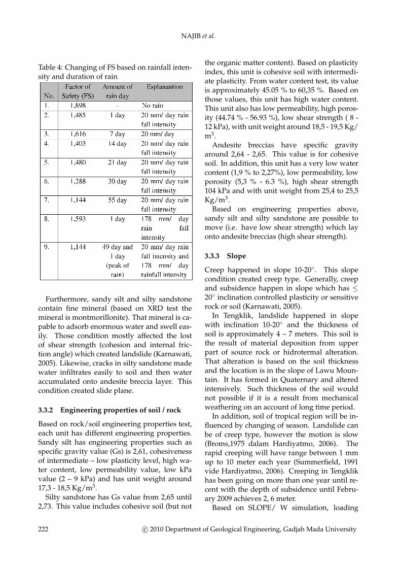
Table 4: Changing of FS based on rainfall inten-sity and duration of rain
Furthermore, sandy silt and silty sandstonecontain fine mineral (based on XRD test themineral is montmorillonite). That mineral is ca-pable to adsorb enormous water and swell eas-ily. Those condition mostly affected the lostof shear strength (cohesion and internal fric-tion angle) which created landslide (Karnawati,2005). Likewise, cracks in silty sandstone madewater infiltrates easily to soil and then wateraccumulated onto andesite breccia layer. Thiscondition created slide plane.
3.3.2 Engineering properties of soil / rock
Based on rock/soil engineering properties test,each unit has different engineering properties.Sandy silt has engineering properties such asspecific gravity value (Gs) is 2,61, cohesivenessof intermediate – low plasticity level, high wa-ter content, low permeability value, low kPavalue (2 – 9 kPa) and has unit weight around17,3 - 18,5 Kg/m3.
Silty sandstone has Gs value from 2,65 until2,73. This value includes cohesive soil (but not
the organic matter content). Based on plasticityindex, this unit is cohesive soil with intermedi-ate plasticity. From water content test, its valueis approximately 45.05 % to 60,35 %. Based onthose values, this unit has high water content.This unit also has low permeability, high poros-ity (44.74 % - 56.93 %), low shear strength ( 8 -12 kPa), with unit weight around 18,5 - 19,5 Kg/m3.
Andesite breccias have specific gravityaround 2,64 - 2,65. This value is for cohesivesoil. In addition, this unit has a very low watercontent (1,9 % to 2,27%), low permeability, lowporosity (5,3 % - 6.3 %), high shear strength104 kPa and with unit weight from 25,4 to 25,5Kg/m3.
Based on engineering properties above,sandy silt and silty sandstone are possible tomove (i.e. have low shear strength) which layonto andesite breccias (high shear strength).
3.3.3 Slope
Creep happened in slope 10-20◦. This slopecondition created creep type. Generally, creepand subsidence happen in slope which has ≤20◦ inclination controlled plasticity or sensitiverock or soil (Karnawati, 2005).
In Tengklik, landslide happened in slopewith inclination 10-20◦ and the thickness ofsoil is approximately 4 – 7 meters. This soil isthe result of material deposition from upperpart of source rock or hidrotermal alteration.That alteration is based on the soil thicknessand the location is in the slope of Lawu Moun-tain. It has formed in Quaternary and alteredintensively. Such thickness of the soil wouldnot possible if it is a result from mechanicalweathering on an account of long time period.
In addition, soil of tropical region will be in-fluenced by changing of season. Landslide canbe of creep type, however the motion is slow(Broms,1975 dalam Hardiyatmo, 2006). Therapid creeping will have range between 1 mmup to 10 meter each year (Summerfield, 1991vide Hardiyatmo, 2006). Creeping in Tengklikhas been going on more than one year until re-cent with the depth of subsidence until Febru-ary 2009 achieves 2, 6 meter.
Based on SLOPE/ W simulation, loading
222 c© 2010 Department of Geological Engineering, Gadjah Mada University

INFLUENCE OF GEOLOGICAL CONDITION TOWARDS SLOPE STABILITY ON LANDSLIDE
triggered by buildings with undulating slideplane would not influence the FS. If it is put inthe toe of landslide, it will add the retaining ofthe slope (i.e. FS value will increase).
3.3.4 Rainfall
In rainy season, rain happens continuouslywith low or high rainfall intensity. This phe-nomena is then followed by infiltration of waterinto soil or rocks. Hence, groundwater table in-creases in the slope, heightens pore water pres-sure and lower shear strength. Then, creepingwill occur (Gostelow, 1991 vide Hardiyatmo,2006).
Groundwater infiltrates sandy silt and siltysandstone and afterwards it is occupied abovethe impermeable layer (the andesite breccia).The more the rainfall intensity (i.e. higher orlonger), the more water infiltrates to the perme-able layer and become saturated.
Except the infiltration of water that enhancesgroundwater level, infiltration of water risesthe unit weight of the soil/rock (heighten loadmass of soil / rock). It vanishes the stress suc-tion between andesite breccias and rock unitabove on it and intensifies pore water pressurein the soil/ rock as well.
Based on the combination between SEEP/Wand SLOPE/W, normal rainfall (around 20mm/day) that happens in several weeks willextremely influence factor of safety. When theslope was not influenced by groundwater table,value of FS is high (FS=1.898). When the slopewas influenced by groundwater table fluctua-tion (rainfall intensity is 20 mm/ day in severalweeks and rainfall intensity in178 mm/ day inone day), the value of FS decreased from 1.268– 1.288. When the groundwater table nearlyreached ground surface, value of FS was incritical condition (FS = 1.121 – 1.144, see Figure3 and 4). It can be concluded that a slope willbe in critical condition if the groundwater tableincrease significantly. The rapidness of infil-tration and increasing of groundwater tableinto the soil/ rock is controlled by stratigraphicconditions.
Figure 3: SLOPE/W and SEEP/W simulationwith 20 mm/day rainfall in 55 days
Figure 4: SLOPE/W and SEEP/W simulationwith 20 mm/day rainfall intensity in 49 daysand continuing raining 178 mm/day rainfall in-tensity in 1 day
4 Summary
4.1 Conclusions
Based on the result, it can be concluded that:
1. A stratigraphic condition that controlslandslide is permeable unit rocks/soiltype, consisted of sandy silt and silty sand-stone and laid above impermeable layer(andesite breccias).
(a) Undulating slope does not signifi-cantly induce landslide, but causeskind of landslide in the location, i.e. arotational landslide.
(b) Engineering properties which aredifferent among units (the shearstrength of sandy silt is 12 kPa andthe shear strength of silty sandstoneis 18 kPa) lay onto andesite breccias(shear strength is 104 kPa) and effectunstable slope.
c© 2010 Department of Geological Engineering, Gadjah Mada University 223

NAJIB et al.
2. Based on SLOPE/ W and SEEP/ W simu-lation, rain that can induce landslide is therain with rainfall intensity close to 20 mm/day in 55 days and rain with rainfall 20 mmday in 49 days, continued by one day ofpeak rain if 178 mm/ day rainfall intensity.
4.2 Suggestion
Reducing landslide effects can be held in Tengk-lik by closing cracks with the cement or imper-meable materials, installing impermeable mate-rial on footstep ways, installing drainage ditchand closing cracks on ditchs; all of the abovewill reduce infiltration to the landslide.
References
Anonim (2002) Inventarisasi Daerah RawanTanah Longsor di Kabupaten Boyolali,Wonogiri, Karanganyar dan Sragen, JurusanTeknik Geologi Fakultas Teknik UniversitasGadjah Mada, Jogjakarta
Abramson,L.W.,Lee, T.S., Sharma,S.,and Boyce,G.M, 2002, Slope stability and stabilizationmethods, 2nd Edition, John Wiley and Sons,N.Y
Craig, R.F. (1987) Soil mechanic, fourth Edition,Department of Civil Engineering Universityof Dundee, Chapman and Hall
Cronin, V.S. (1992) Compound Landslides;Natur and Hazard Potential of SecondaryLandslides within Host Landslides, Land-slide Mitigation, Geological Society of Amer-ica Volume IX, Colorado.
Deere, D.U., and patton, F.D. (1971) Slope Sta-bility in Residual Soils, In Proc.4th Panameri-can Conference on Soil Mechanics and Foun-dation Engineering, vol.1. Caracas.
Gasmo, J.M, Rahardjo,H., and Leong, E.C.(2000) Infiltration Effects on Stability of aresidual soil slope, Computers and Geotech-nics 157, pp.145-165
Hardiyatmo, H.C (2006) Penanganan TanahLongsor dan Erosi,Gadjah Mada UniversityPress, Jogjakarta
Karnawati, D. (2005) Bencana Alam dan Ger-akan Massa Tanah di Indonesia dan UpayaPenanggulangannya, Jurusan Teknik GeologiFakultas Teknik Universitas Gadjah Mada,Jogjakarta
Krahn, J. (2004) Stability Modeling withSlope/W – An Engineering methodology,Geo Studio 2004, Geo-slope International,Ltd.
Moore, D.M., Reynolds, R.C. (1997) X-RayDiffraction and The Identification and Anal-ysis of Clay Minerals, Oxford UniversityPress,New York
Surono,B.Toha, I. Sudarno (1992) Peta GeologiLembar Surakarta-Giritontro, skala 100.000,Pusat Penelitian dan Pengembangan Ge-ologi, Bandung
Rogers, J.D. (1992) Recent Developments inLandside Mitigation Technique, landslides/Landslide Mitigation, Landslide Mitigation,Geological Society of America Volume IX,Colorado.
Terzaghi, K dan Peck, R.B (1967) Soil Mechan-ics In Engineering Practice,2nd Edition, JohnWilley and Sons, New York.
Wyllie D.C, Mah C.W (2004) Rock Slope Engi-neering, Civil and Mining 4th Edition, SponPress, London.
224 c© 2010 Department of Geological Engineering, Gadjah Mada University