Embed Size (px)
Citation preview
Geoderma 239–240 (2015) 304–316
Contents lists available at ScienceDirect
Geoderma
j ourna l homepage: www.e lsev ie r .com/ locate /geoderma
Indicators of agricultural soil genesis under varying conditions of landuse, Steppe Crimea
Fedor Lisetskii a, Vladimir F. Stolba b,⁎, Olga Marininа a
a Belgorod State National Research University, 308015, Belgorod, ul. Pobedy 85, Russiab Aarhus University, Nordre Ringgade 1, DK-8000 Aarhus C, Denmark
⁎ Corresponding author.E-mail address: [email protected] (V.F. Stolba).
http://dx.doi.org/10.1016/j.geoderma.2014.11.0060016-7061/© 2014 Elsevier B.V. All rights reserved.
a b s t r a c t
a r t i c l e i n f oArticle history:Received 12 May 2014Received in revised form 29 October 2014Accepted 8 November 2014Available online 20 November 2014
Keywords:Soil formationIdle landsAgrogenic soilsChronosequenceAgrogenic indicatorsCrimea
This study investigates the effects of agricultural exploitation of soils of the north-western Crimea, the active andlarge-scale cultivation of which began with the Greek colonization of the area. In order to compare soils using awide spectrum of physical and chemical properties, the studied objects (virgin land, post-antique idle land, con-tinually plowed land, modern-day plowed land, idle land of the modern era) have been grouped into achronosequence. This makes it possible to apply the method of factor sequences of agrogenic transformationsin soils, which takes into account different periods of human activities. The other factors involved in soil forma-tion are considered to be relatively invariable. From the mass of physiochemical properties of these soils thathave endured long-term agricultural stress, the most informative indicators of agrogenesis have been identified.The authors propose a procedure for calculating an integral agrophysical soil indicator based on five parametersthat can be used to determine the soil structure and cloddiness as well as water-stability, the amount of water-stable aggregates and theirmeanmass-weighted diameter. Based on the estimates of their agrophysical state, thefollowing sequence has been determined for the soils studied: Post-antique idle land b virgin land b idle land ofthemodern era b continuously plowed land bmodern-day plowed land. It has been established that the previouspractices of land use favorably affect the agrophysical properties of soils.The loss of organic carbon in continually plowed land is 51%, while in modern-day plowed and idle lands itamounts to 39% and 27–32% respectively. The reproduction of soil organic matter (SOM) and its quality, partic-ularly of its labile content, which is responsible for the agrophysical properties of a plow horizon, is central to soilfertility management for sustainable agriculture. One observed effect of long-term agrogenic stresses in plowedhorizons of Chernozems is a decrease inmicroelements such as Co, Ni, Mn, Cu, Zn, Pb, as well as phosphorus andpotassium. It is estimated that the micronutrient content of plowed land is 5–6% lower than that of virgin soils.Even after 2280 years of renaturation, soils of post-antique idle lands preserve in their pedomemory the signs ofagrogenesis. In terms of soil quality, the overall agrogenic transformation of soils cultivated during the recentperiod (the last 150–165 years) is 15% lower than that of the continually plowed lands. The fallowing regimeprovides conditions that allow soils to regenerate within a few decades. The use of renaturation effects thatmimic the fallowing regime opens up new possibilities for resource-saving sustainable agriculture.This study, therefore, shows the informative potential of soils that have continuously, orwith restorative periods,been subjected to long-term agrogenic impacts under different practices of land use. It also considers how thisinformation may be actively employed to comprehend the long-term transformations of the material andenergetic organization of soils.
© 2014 Elsevier B.V. All rights reserved.
1. Introduction
Land resources constitute themajor productionmeans in agricultureand will remain fundamental for provision of plant and animal food forthe foreseeable future. Pedogenic processes are heterochronous; manyof them, such as those related to soil fertility reproduction, take hun-dreds, if not thousands of years. In order to develop resource-saving
technologies of land use, which could prevent soil degradation, it is im-portant to understand trends in the long-term changes observed for thematerial and energetic organization of soils under different practices ofland use. Alongwith the experimentallyworked fieldswhere functionaltransformations in the system “agrotechnologies–soils” are observedover many decades (Blake et al., 2000), soils in regions with a longagrarian history, which have experienced continuous, or with restor-ative periods, anthropogenic impacts, can be very informative. Soilagrogenic features that result from pedogenesis on an evolutionaryscale only become apparent after a considerable period of agrogenesis.
305F. Lisetskii et al. / Geoderma 239–240 (2015) 304–316
Eventually, anthropogenic processes lead to the formation of anthropo-genic soils, which stimulate an on-going development of soil classifica-tion (Bryant and Galbraith, 2003).
Multidisciplinary investigations of the soil agrogenesis influ-enced by ancient arable agriculture have a very wide geography:Western Europe and particularly the Mediterranean (Rueckeret al., 1998; Sanchez-Maranon et al., 2002; Scalenghe et al., 2002;Delgado et al., 2007; Freppaz et al., 2008; Bellin et al., 2009;Stanchia et al., 2012); Eastern Europe, including its central part(Dolotov, 1984; Karavaeva, 2000; Polyakova and Platonycheva,2012), the regions of Greco-Roman land use in Southern Ukraine(Lisetskii, 2008; Lisetskii and Rodionova, 2012) and the Crimea(Cordova and Lehman, 2005; Lisetskii et al., 2013) as well as thenorthern Caucasus (Korobov and Borisov, 2013); Asia (Lisitsynaand Kostyuchenko, 1976; Kostyuchenko and Lisitsyna, 1976; Gonget al., 2000; Wilkinson, 2003; Miyaji, 2003; Pietsch and Mabit,2012); Africa (Mighall et al., 2012; Nyberg et al., 2012) and theNew World (Sandor et al., 1990; Dick et al., 1994; Eash andSandor, 1995; Sandor and Eash, 1995; Harden, 1996; Sandor,2006; Goodman-Elgar, 2008; Londono, 2008; Homburg and Sandor,2011; Fonte et al., 2012).
The present study aims to identify the most informative indicatorsof agrogenesis from a wider group of physicochemical properties ofsoils, which continuously, or with restorative phases, underwent long-term agricultural stress. This task benefits from the diversity of soils inthe areas of the northern Black Sea littoral that have been affected bythe Greek colonization.
2. Study area
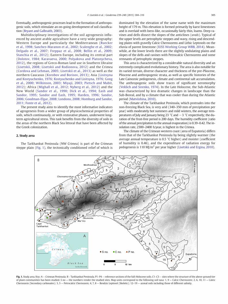
The Tarkhankut Peninsula (NW Crimea) is part of the Crimeansteppe plain (Fig. 1), the tectonically conditioned relief of which is
Fig. 1. Study area. Key:А— Crimean Peninsula; В – Tarkhankut Peninsula. Р1–Р4— reference secof plant communities has been studied. S no — the numbers render the studied sites. Map unChernozem (Secondary carbonates); 3, 5 — Petrocalcic Chernozem; 4, 7, 8 — Rendzic Leptosol
dominated by the elevation of the same name with the maximumheight of 179 m. This elevation is formed primarily by karst limestonesand is overlaid with loess-like, occasionally fairly thin, loams. Deep ra-vines and dells dissect the slopes of the anticlines (uvals). Typical ofthe upper levels are petrophytic steppes and wavy, rising and descend-ing plains with gravelly Calcic Chernozems and Lithic Leptosols on theeluvia of parent limestone (IUSS Working Group WRB, 2014). Mean-while, at the lower levels there are the slightly undulating plains andslopes of the dells and ravines with Petrocalcic Chernozems and someremnants of petrophytic steppes.
This area is characterized by a considerable natural diversity and anextremely complicated evolutionary history. The area is also notable forits varied terrain, diverse character and thickness of the pre-Pliocene,Pliocene and anthropogenic strata, as well as specific histories of theLate Cainozoic pedogenesis, climate and continental salt accumulation.The anthropogenic soils show traces of significant xeromorphy(Veklich and Sirenko, 1974). In the Late Holocene, the Sub-Atlanticwas characterized by less dramatic changes in landscape than theSub-Boreal, and by a climate that was cooler than during the Atlanticperiod (Matviishina, 2010).
The climate of the Tarkhankut Peninsula, which protrudes into thenon-freezing Black Sea, is very arid (340–350 mm of precipitation peryear) with moderately hot summers and mild winters, the average tem-peratures of July and January being 23 °C and−3 °C respectively; the du-ration of the frost-free period is 200 days. The humidity coefficient (ratioof the annual precipitation to the annual evaporation) is 0.39–0.42. The in-solation rate, 2300–2400 h/year, is highest in the Crimea.
The climate of the Crimean western coast (area of Eupatoria) differsfrom that of the Tarkhankut Peninsula by being slightly warmer (theaverage annual temperature is 0.5 °C higher) and moister (coefficientof humidity is 0.46), and the expenditure of radiation energy forpedogenesis is 110 MJ/m2 per year higher (Lisetskii and Ergina, 2010).
tions of the full-Holocene soils. С1–С3— siteswhere the structure of the above-ground tierits correspond to the following soil taxa: 1, 9 — Calcic Chernozem; 2, 6, 10, 11 — Calcic(Skeletic); 12–19— azonal soils including those of different salinity.
306 F. Lisetskii et al. / Geoderma 239–240 (2015) 304–316
The data available, such as the emergence of settlements, finds ofbronze sickles (Kolotukhin, 2003; Stolba, 2012) and fossil grain re-mains (Korpusova and Lyashko, 1990), as well as pollen of cerealiain the bottom sediments of mineral lakes (Sapelko and Subetto,2007; Stolba et al., 2012), suggests that agriculture has existed inthe area since the Bronze Age (second half of the 3rd and the 2ndmillennia BC), when local pastoralist societies will have made thetransition to a more sedentary mode of life. However, it was notuntil around 360 BC when the Greek colonists from Chersonesosoccupied the region that a wide web of rural settlements emerged,and the area was divided for large-scale and regular exploitationof the land and soil resources. By around 270 BC, however, theChersonesean countryside (chora) had become desolate followingnomadic attacks, which perhaps were triggered by abrupt climatic
Table 1Description of the studied sites.
Site Location Nearest archaeological site Land type in thesecondhalf of the 20thcentury
Mous
S4 5 km W of the villageofChernomorskoe
Rural settlements of the 4th–3rd c.BC on the periphery of the landdivision system
Virgin land Vir
S11 Cape Tarkhankut 4.5 km SW of the fortifiedfarmhouse of Karadzha 3,4th–2nd c. BC
Virgin land Vir
S12 v. Olenevka 0.6 km SW of townsite ofKaradzha, 4th c. BC–1st c. AD
Orchard in 19th–20thcent.
Tr
S15 8 km W of the cityof Eupatoria
3 km NW of Chaika, 4th c. BC–1stc. AD; 8.5 kmW of Kerkinitis(6th–2nd c. BC); traces of landdivision
Arable field Ar
S16 15 km W of the cityof Eupatoria
2.5 km E ofAirchi, 4th c. BC–1st c. AD;traces of land division
Arable field Ar
S1 1.5 km E of v.Olenevka
Farmhouses of the 4th–3rd c. BCwithin the system of landdivision
Pasture land Pa
S2 1.5 km E of v.Olenevka
Farmhouses of the 4th–3rd c. BCwithin the system of landdivision
Pasture land Pa
S14 1.5 km E of v.Olenevka
Farmhouses of the 4th–3rd c. BCwithin the system of landdivision
Pasture land Pa
S3 5.3 km SW of v.Chernomorskoe
6.5 km NE of Bolshoi Kastel;rural settlements of the 4th–3rd c.BC on the periphery of the landdivision system
Idle (at least in1956–1990s)
Pa
S6 4.5 km W of v.Krasnaya Polyana
8 km SE of Panksoye II,4th–3rd c. BC
Arable field Ar
S7 5.5 km S of v.Krasnaya Polyana
8.5 km N of Belyaus, 4th c.BC–1st c. AD
Arable field Ar
S9 4.5 km SW of v.Mar'ino
1.5 km NW of the farmhouse andland plot at Cape Oirat, 4th c.BC–1st c. AD
Arable field Ar
S5 11.3 km NE of v.Chernomorskoe
1.4 km W of the settlement ofMezhvodnoe, 4th–2nd c. BC
Arable field (1956),plantage tillage(1967);idle since 1970
Air
S8 5 km N of v.Krasnaya Polyana
8.5 km E of Panksoye II, 4th–3rd c.BC
Arable field (1956);idle since 1988.
Idltill
S10 5 km SW of v.Mar'ino
2 km NW of the farmhouse andland plot at Cape Oirat, 4th c.BC–1st c. AD
Arable field (1956);idle since 1990s
Idltill
S13 v. Olenevka 1 km SW of the townsite ofKaradzha, area of necropolis
Orchard in 19thcent.;idle since the early20th cent.
Idlor
a The components of the agrogenic series of soils are abbreviated as follows: VL— virgin lanplowed land; CPL— continually plowed land. Duration of the phases in years is specified in bratative duration. The total duration of the potential agrogenic impacts is referred to the beginning6th century BC); consequently T is assumed as 2500 years.
b Stipa capillata L.c Stipa lessingiana Trin. & Rupr.
changes (Stolba, 2005a, 2005b). The revival of the chora in the late3rd through the mid-2nd century BC was on a smaller scale. Thismeans that the active phase of Greek land use on the Tarkhankutpeninsula spanned no more than 160–170 years. The agriculturalhistory of the ancient city of Kerkinitis (modern-day Eupatoria),the earliest Greek foundation in western Crimea, appears to havebeen considerably longer, with an estimate of around 300–350 yearsof rural settlement. Excavations at the Late-Scythian settlement ofTarpanchi (modern-day village of Okunevka), which revealed a granarywith a large deposit of charred grains of wheat and barley (Shcheglov,1963; Chtcheglov, 1992), testify to a fairly brief, hardly exceeding halfa century, period of post-Greek, Scythian, agriculture in the 2nd–1stcenturies BC. Medieval nomads and Crimean Tatars held sway overthe Steppe Crimea once Greek dominance was on the wain, and it was
dern-daye
Vegetation(2011)
Agrogenesis durationa Position of thesoil inagrogenicseriesa
gin land Feathergrassb VL(2500) VL
gin land Steppe grasses VL(2500) VL
ee nursery Biota orientalis VL(~1800)–CPL(~500)–MPL(below 188)
CPL
able field Fallow CPL(below 600)–PIL(~1950)–MPL(150–165)
CPL
able field Winter wheat CPL(below 600)–PIL(~1950)–MPL(150–165)
CPL
sture land Grasses/graminoidsb
VL(N155)–CPL(below 65)–PIL(2280)
PIL
sture land Grasses/graminoidsb
VL(N155)–CPL(below 65)–PIL(2280)
PIL
sture land Grasses/graminoidsb
VL(N155)–CPL(below 65)–PIL(2280)
PIL
sture land Feathergrass/herbsb
VL(N155)–CPL(N65)–PIL(b2280)
PIL
able field Winter wheat VL(N2300)–MPL(150–165) MPL
able field Vetch VL(N2300)–MPL(150–165) MPL
able field Winter wheat VL(N2300)–MPL(150–165) MPL
field Feathergrass/herbsb
VL(N100)–CPL(below 400)–PIL(~2000)–MPL(~26)–MIL(10)–MPL(1)–MIL(43)
MIL (?)
e land afterage
Weeds VL(N2300)–MPL(~130–140)–MIL(23)
MIL
e land afterage
Steppe grassesc VL(N2300)–MPL(130–145)–MIL(20)
MIL
e land afterchard plantation
Steppe grassesb,c VL(N2300)–MPL(below 70)–MIL(90)
MIL
ds; PIL — post-antique idle land; MIL — idle land in the modern era; MPL — modern-dayckets: N stays where exceeding of the specified number of years is possible, ~ marks a ten-of large-scale land development in the rural surroundings of Kerkinitis (second half of the

307F. Lisetskii et al. / Geoderma 239–240 (2015) 304–316
not until the beginning of the Russian colonization at the turn of the18th and 19th centuries that farming again became significant for theregion's economy. Based on the local history of agricultural develop-ment, the total duration of the current period of land use is estimatedto be between 150–165 years.
3. Materials and methods
The main objects of our pedogenetic investigations are presentedin Table 1. This study deploys the method of factor sequences(chronosequences) of agrogenic transformations in soils. In thisapproach objects are grouped into chronosequences in the waythat, while comparing the properties of virgin and/or recently plowedsoils, as well as different durations of development and the extent ofcultivation (Ivanov and Alexandrovskiy, 1987), one of the factors varies,whereas the others remain constant. Using Jenny's list of soil formationfactors (Jenny, 1941) with our additions, the application of the factorchronosequences can be expressed by the formula:
S1 ¼ f Ct1; T h1ð Þcl;r;p;τ…
� �…
SN ¼ f CtN;T hNð Þcl;r;p;τ…� �
;
8<: ð1Þ
where:
S1…N properties of soils in the sequence of agrogenic transforma-tions (1,2,…N);
T(h1…hN) periods of human activities related to the use of land re-sources (plowing, irrigation, fertilization, amelioration etc.)or phases of intended or historically determined renaturation(long-term fallow);
С(t1…tN) successions of natural plant communities and changes ofexploited areas chronologically related to periods of humanactivities;
cl climate;r topography;p parent materials;τ absolute age of soils.
Time in itself is not a soil-forming factor, but over time theother factors promote pedogenic processes. Estimation of numerical orchronometric age of soil is very difficult but relative dating canbe conducted on the basis of chronosequences (Goldberg and MacPhail,2006). A number of archaeological studies have been attempted at datingcultural phases and specific human activities throughmaturity or imma-turity of buried soils (Goldberg and MacPhail, 2006).
As the studied objects of an agrogenic sequence have been selectedwithin the automorphous areas of the landscape, the influence ofwater erosion – an essential factor of soil degradation in the steppezone including the region under study – is thus eliminated.
Our study draws on the concept which defines the part of the soilprofile involved in cultivation as a layer, whereas this layer's upper, ho-mogeneous and agronomically valuable part is considered a distinctivegenetic horizon (P) (Karavaeva et al., 1985). Soil samples have beentaken from three horizons: 1) the upper, most intensively cultivatedlayer (0–17(22) сm); 2) underlying layer (the one which underliesthe cultivated layer or, in case of idle land, the post-agrogenic layer;usually, 22–40 сm); and 3) parentmaterial (horizon С). In order to facil-itate comparison, samples of virgin soils were taken at similar depths.
The agrophysical properties of soils have been evaluated on the basisof their structural composition and wet aggregate stability. The struc-tural composition was evaluated by dry sieving (3 replicates). Theresulting nine particle size fractions (from N7 to b0.25 mm) wereused to calculate the total amount of 0.25 to 10 mm aggregates (STR),the coefficient of structure (Kstr, a ratio of the mass of structural
aggregates of 1–7 mm to the sum of the aggregates of b1 and N7 mm)and cloddiness of the structure (DEFL, a content of structural aggregatesof N1 mm). The water-stable aggregates were evaluated by wet sieving(into 6 size fractions, from 5 to b0.25 mm), the results of which wereused to calculate the percentage of aggregates measuring N0.25 mm(Σd N 0.25 mm) and weighted average aggregate diameter (d). The co-efficient of water stability (W) was determined by Andrianov's (1947)method,which is based on evaluating the amount of aggregates degrad-ed in still water over the 10-min period and employs a sieve coveredwith filter paper pressed with a ring. The method was replicated 5times; every time 50 aggregates of each of 5–3, 3–2, 2–1, and1–0.5 mm fractions were analyzed.
Five parameters enumerated above were used to determine thecomposite agrophysical parameter of soil (APS), which we suggestmay be calculated using the following formula:
APS ¼ 100 � V1
V1 optð Þ� V2
V2 optð Þ�… � Vn
Vn optð Þ
!1n
; ð2Þ
where:
Vn, Vn(opt) actual and optimal values of a specific agrophysical parame-ter of soil respectively;
n number of agrophysical parameters of soil.
The plowing exhaustion (Dpl, %) was determined through theexpression:
Dpl ¼ 100 � STRb−STRt
STRb
� �; ð3Þ
where:
STRt, STRb total amount of agronomically valuable structural aggre-gates by dry sieving (N0.25mm) in the plowed (t) and under-lying (b) horizons (or in the lower layer when idle lands areconcerned) respectively.
The soil granulometric index (Р, %) was calculated as the ratiobetween the amounts of active and passive particles participating inthe structural formation, i.e. Р = 100(а / (b + c)) where a — parti-cles of b0.001 mm; b — 0.001–0.005 mm; and c — 0.005–0.05 mm(Vadyunina and Korchagina, 1961). The total porosity was calculat-ed from the bulk and real densities.
The agrochemical group of indicators included the content of CO2 incarbonates measured by acidometry, bulk nitrogen content as deter-mined by Kjeldahl's procedure, and pHH2O.
For evaluation of soil organic matter (SOM), the soil organic carbon(SOC) and labile organic matter were determined and group analysis ofhumus was conducted (according to Ponomareva and Plotnikova's mod-ification of Tyurin's method). SOM was fractionated into 3 humic acid(Cha), 4 fulvic acid (Cfa), and base-insoluble fractions. A detailed descrip-tion of this fractionation method can be found in Ponomareva andPlotnikova (1980) and Slepetiene and Slepetys (2005). The content ofavailable phosphorus and exchangeable potassium was determined byMachigin's method for calcareous soils, using 1% ammonium carbonate((NH4)2CO3) solution (Machigin, 1952; Arinushkina, 1970). In the rare in-stances of non-carbonated soils, determinations weremade by Chirikov'smethod, using 0.5Macetic acid (СН3СООН) solution (Arinushkina, 1970).
Bulk chemical composition of the soils and rocks was measured byXRF. The microelement accumulation capability, determined as pro-posed by Shaw (1964), is a clarke (mass ratio of an element in theEarth's crust) of a group of elements in the soil that acts as an averagequantitative estimate of the soil's capability to accumulate the elements,as compared to that of the lithosphere. We use a modification of this

308 F. Lisetskii et al. / Geoderma 239–240 (2015) 304–316
factor, whereby its total value is determined not as an arithmeticalmean but as a geometrical mean value.
The expression for the eluviation coefficient (Kе) includes theoxides (Liu et al., 2009) to which we add MnO: Kе = (SiO2 /(MnO + CaO + K2O + MgO + Na2O)). Variance analysis of soilproperties and cluster analysis by Ward's method in Euclidean spacewere carried out using STATISTICA software. Soils were classifiedusing the World Reference Base (WRB).
The quality of soils (SQ) of the agrogenic series was evaluated bycalculating the geometrical mean value on the basis of the most infor-mative indicators of agrogenesis as proposed by Storie (1978): SQ =(X1 · X2 · … · Xn)1 / n, where X1,X2,… Xn are indicators of agrogenesis.
4. Results and discussion
4.1. Character of parent materials
According to the regionalization scheme of the Crimea developed onthe basis of paleogeographical data (Veklich and Sirenko, 1974), uni-formwestern and central parts, which constitute the Black Sea denuda-tion plain, can be distinguished in the composition of the Tarkhankutelevation. TheHolocene soil formationwas preceded here by the forma-tion of the Black Sea loess horizon when the area was dominated byperiglacial semi-desert landscapes with wormwood and saltbush plantcommunities on loess. Interlayers of thin brown soil suggest, however,certain disruptions in the process of loess formation (Matviishina,2010; Gerasimenko, 2011). There is also a notable period of loess accu-mulation at the Pleistocene–Holocene transition (12.8–10.3 ka BP),when the formation of loess did not impede the development ofsteppes,which are thought to have beenmore xeric than in the previousperiod (Matviishina, 2010; Cordova et al., 2011). As loess is in one wayor another transformed by soil formation, the loess-like loams and claysof Tarkhankut contain the pedogenic organic matter, geochemicalindications of the internal substance migration, etc.
Of the twopredominant types of parentmaterial, the loams, usually ofa medium and heavy granulometric composition, can be clearly differen-tiated from limestone eluvium by a more considerable accumulation ofMn, Sr, Zn, Cu, Ni, Cr, Si, Pb and Co (in order of decreasing concentrations)(Table 2). Despite the aforementioned dissimilarity between the twotypes of parentmaterials, the extent of their chemicalweathering definedas a ratio Si/(Al +Mn+ Fe) is identical. This can be explained by the fact
Table 2Chemical composition of parent rocks on the Tarkhankut Peninsula (data for Horizon C (cm) o
Component Unit Loess-like loamsa
S1. 54–58 S14. 58–60 S15. 58–60 S16. 56–58 Avera
SiO2 % 35.2 26.4 44.7 38.6 36.2CaO % 19.8 17.8 18.3 11.8 16.9Al2O3 % 9 6.8 10.3 9 8.8Fe2O3 % 2.4 3.3 2.6 3.5 3MgO % 2.2 2.5 2.5 2 2.3TiO2 % 0.5 0.6 0.6 0.7 0.6Na2О % 2 2.7 2.1 1.8 2.2P2O5 % 0.1 0.1 0.1 0.1 0.1K2O % 1.3 1.1 1.3 1.3 1.3MnO ppm 649.4 1042.2 1014.6 1194.7 975.2Sr ppm 278.2 434.6 215.7 282.8 302.8Cr ppm 79.8 103 82.2 102.7 91.9Zn ppm 65.5 115.5 68.8 106.5 89.1Ni ppm 36.9 67 42.3 62.6 52.2Cu ppm 23.2 44.5 30.4 54.5 38.1Pb ppm 16.6 26.6 15.4 28.2 21.7Co ppm 11.2 12.1 13.3 20.3 14.2V ppm 60.6 60.6 64.9 74.7 65.2As ppm 6.2 5.6 7.4 7.3 6.6Zr ppm 249.8 251 246.2 280.4 256.8
a This type of parent material is also characteristic of sites: S2, S6, S7, S9, S10 and S12.b This type of parent material is also characteristic of sites: S4 and S8.
that the content of silica is 1.4 times higher in loams than in eluvium oflimestones. As suggested by Gerrard (1981), the intensity of chemicalweathering can be determined through the molar ratio CaO/ZrO2, giventhat the calcium-containing minerals are less resistant to weatheringthan those containing zirconium. In our case, judging by the ratio CaO/ZrO2, loam is chemicallymore transformed than the carbonated eluvium.Thus, these primary properties of the parent materials of the TarkhankutPeninsula predetermined the genetic differences between the soilswhichformed on them during the Holocene.
4.2. Restorative successions of plant communities
Whenever plowing was abandoned, the adaptive transformation ofthe structure of the steppe communities during this restorative periodoccurred syngenetically with the renaturation of soils, which is consis-tent with the notion of co-evolution of soils and biota and the conceptof soils as extended composite phenotypes (Phillips, 2009). As appearsfrom Expression (1), the establishment of chronosequences of theagrogenic soil transformations should take into account that the periodsof human activity are chronologically related to successions of naturalvegetation and changes of exploited areas. Therefore, factor Сt variesover time and space.
The studies of vegetation in agricultural areas of southern Ukrainethat were recently abandoned have demonstrated that, by contrastwith the active fields, the flora of abandoned fields is replenished withnew species, mainly zonal anthropophilic types, that can make-up 20%of the flora. Meanwhile, the share of the zonal steppe species tripled:from 9% to 27% (Bondarenko and Vasil'eva, 2008). In the area we stud-ied, the restorative successions on idle lands of different ages have thestructure as the phytomass of the above-ground tier, which is differentfrom that of indigenous communities (Table 3).
The ratio of steppe graminoids, that are known to pass from the rhi-zome gramineous to turf gramineous stage of demutation as the lengthof the fallowing period increases, is notably larger in the post-antique(Stipa sp., Festuca valesiaca Gaudin, Bromopsis cappadocica (Boiss. &Balansa) Holub) and modern idle lands (Stipa lessingiana Trin. & Rupr.,Koeleria cristata (L.) Pers.), whereas on virgin lands only one speciesremains (Stipa capillata L.).
The deposition of above-groundmortmass (R+ SC) depends on theamount of green mass (F) and the mortmass decomposition rate. Themore active the production process and the lower the destruction
f soil profiles — S no. in Fig. 1).
Eluvium of carbonate rocksb
ge S3. 34–40 S5. 50–54 S11. 30–40 S13. 47–50 Average
± 3.8 31 31.4 11.9 26.5 25.2 ± 4.6± 1.8 28 21.4 29.7 26.9 26.5 ± 1.8± 0.7 8.7 7.9 7.1 9.4 8.3 ± 0.5± 0.3 2 2.2 1.9 2.3 2.1 ± 0.1± 0.1 3 2.2 3.2 2.9 2.9 ± 0.2± 0.04 0.4 0.6 0.4 0.5 0.5 ± 0.05± 0.2 2.5 2 2.7 2.5 2.4 ± 0.1± 0 0.1 0.2 0.3 0.2 0.2 ± 0.4± 0.1 1.2 1.1 1.4 1.2 1.2 ± 0.1± 115.6 520.9 1222.7 430.6 722.1 724.1 ± 177.0± 46.5 212.4 227.7 237.9 242.1 230 ± 6.6± 6.3 75.3 79.7 69.3 75.5 74.9 ± 2.1± 12.8 65.3 61.4 68.5 73.8 67.2 ± 2.6± 7.4 33.3 36 32.9 37.2 34.8 ± 1.0± 7.0 15 22.6 14.9 23.2 18.9 ± 2.3± 3.3 8.8 11.7 12.7 10.7 11 ± 0.8± 2.1 6.2 11.4 3.3 7.8 7.2 ± 1.7± 3.3 53.4 56.7 46.8 57.1 53.5 ± 2.4± 0.4 7.2 8.7 4.5 7.2 6.9 ± 0.9± 7.9 215.8 293.9 219.7 222.4 237.9 ± 18.7

Table 3Structure of phytomass of the above-ground tier under conditions of virgin and idle lands.
Sitenumbera
Typeoflandb
Н,сm
TPC,%
Number ofplantspecies
Compositionof herbagec
Mass of dry substance,g m−2
F R SC
C1 VL 36 75 17 1 + 2 + 14 159.16 254.52 182.00C2 PIL 32 95 12 4 + 2 + 6 85.56 181.68 112.04C3 MIL 29 70 12 2 + 1 + 9 118.88 117.56 61.00
Abbreviations:Н— height of herbage; TPC— total projective cover; F— green phytomass;R — plant debris; SC— litter.
a Locations of the sites are shown in Fig. 1.b See Table 1, note a, for abbreviations.c The numbers specify respectively graminoids + legumes + herbs.
309F. Lisetskii et al. / Geoderma 239–240 (2015) 304–316
rate, the larger the accumulation of the above-ground mortmass. In theconditions studied, the maximum amount of above-ground mortmasshas been recorded in virgin lands (436 gm−2), while in idle lands it de-creases. Values for idle lands of themodern era are 1.6 times lower thanfor the post-antique idle lands. The ratio (R + SC)/F reflects the rela-tionship between the specific rates of the plant-substance accumulationand destruction processes. On virgin lands, all the structural elements ofthe above-ground phytomass (i.e. F, R and SC) have the highest values,while for post-antique idle lands, the above-groundmortmass accumu-lates most actively and the amount of the growing greenmass is lower.It seems that in the idle lands of themodern era the destruction of plantsubstance occurs more intensively.
The comparisonwith indigenous communities has demonstrated thatthe differences in the edification structure of restored vegetation remainnoticeable even after 16–35 centuries of development (Lisetskii, 1998).Thus, the duration of a succession does not smooth away the dissimilar-ities in productivity caused by the ontogenetic maturity of soils.
4.3. Character of soil diversity
The soil cover of the Tarkhankut Peninsula is fairly diverse (Fig. 1),the predominant types being Calcic Chernozems and Rendzic Leptosols(Table 4). In terms of the fine-earth thickness, i.e. the distance from thetop surface down to the roof of the solid bed rocks, Calcic Chernozemsare characterized by a thick profile, while soils on limestone eluvia aremedium- or weakly developed. The limestone eluvium, which servesas parent material for Rendzic Leptosols, contains 19–20 mass percentof detritus, of which over 50% exceed 7 mm in diameter. Therefore, allthe soils formed on this kind of parentmaterial are, to a greater or lesserextent, rich in detritus. In the majority of the peninsula's soils, carbon-ates are present already in the topsoil layer. The upper soil horizon's
Table 4Reference soil profiles on the Tarkhankut Peninsula.
Sectiona A.s.l.(m)
Soilcodeb
Structure of the profile:horizons
Horizonthickness(cm)
НСl(cm)c
А А + АВ
Calcic Chernozem — modern-day plowed landР1 125 1 Ag–Apg–Ah–AB1–B2–
BCCa–C54 73 71
Calcic Chernozem (secondary carbonates) — virgin landР2 14 2 Ad–A′–Ah–AB1–B2–BC–C 51 67 0
Petrocalcic Chernozem — virgin landР3 8 3 Ah–AB1–B2 23 49 0
Rendzic Leptosol (Skeletic) — virgin landР4 65 4 Ad–Ah–AB1–B2–D 36 48 0
Abbreviations: A.s.l.— altitude above sea level.a For locations of the sections, see Fig. 1.b Soil codes correspond to nos. in Fig. 1.c Depth to effervescence with 10% HCl.
color is brown of varying intensity. The soils that have formed on theweathering products of carbonate rocks tend to be lighter.
Physicochemical properties of soils in reference sections P1–P4(Table 5) make it possible to identify the main differences betweenthe dominant soils of Tarkhankut. Calcic Chernozems on loess-likeloams are dark brown in their humus-accumulative horizon. They arecharacterized by an alkaline reaction of the soil solution and a gentle de-crease of humus content down the profile; soil effervescence starts at adepth of 70 cm with impregnation with carbonates found only in hori-zon BC (73–105 cm); the biological accumulation of phosphorus is re-corded in the uppermost 30-cm thick stratum. Calcic Chernozemswith secondary carbonates differ from the above by having a shorterprofile and the presence of carbonates throughout the profile, as wellas the accumulation of mobile phosphates in the lower section of theprofile. Petrocalcic Chernozems have a medium-thick profile stronglyimpregnated with carbonates which act as a geochemical barrier.Rendzic Leptosols on limestone eluvia, at a depth of 40–55 cm, lie on ashield of limestone.
4.4. Properties of soils of the agrogenic series
Soil, like any self-organizing natural system, undergoes certainfluctuating processes and changes of state as well as several stages ofirreversible development including generation, formation and destruc-tion. Anthropogenic soil formation is a complex and controversial processwhere, due to acceleration, deceleration and distortion of elemental soilprocesses, their combination occurs. In terms of their impact on fertility,these processes can be divided into the progressive, pseudo-progressive(determined by a phenomenon such as the allopseudomorphosis(Lisetskii, 2008)) and degradative, among which thirteen (Krupenikov,2005) to forty types of degradation are now distinguished. Correspond-ingly, also man-made soils register these changes, and, in the case ofslow irreversible processes they also ‘memorize’ them as either positiveor negative soil properties. In soil, as an ecosystem, processes of a charac-teristically long duration (i.e. the time interval required for a certainprocess to attain a relative equilibrium with natural factors) can beconsidered an accumulation of residual properties of processes of shortercharacteristic duration.
4.4.1. Agrophysical propertiesGranulometrically, the studied soils can mainly be defined as loamy
(clay contentb 27%) (Table 6). The broadvariation range of the structur-al property indicator (P) is explained by the differences in the ratio be-tween the amounts of active, binding particles and passive particles,which participate in the structural formation as passive material. Thehigher the P value, the greater the structuring ability of the soil. As canbe seen in Table 6, soils of the agrogenic series (virgin and post-antique long-term fallow lands) are characterized by low P values.
The set of indicators selected for characterization of the agrophysicalcondition of soils facilitates evaluation of the differences between soilsthrough their anti-erosion and anti-deflation stability and structure,which results from cultivation or bioturbations. While using Expres-sion (2), the establishment of an optimal value of a particular indicatoris of importance. Traditionally, the virgin soil is taken as a reference.However, a number of agrophysical parameters of a soil do not changeunidirectionally over the course of its natural and agrogenic evolution.The virgin soils differ in having the maximum values of coefficient W,which expresses the water stability of soil aggregates of all dimensionsduring their humidification and thus is diagnostic of the soils' stabilityagainst water erosion. The soils of the post-antique idle lands exceedthe other soils in indicator d, which characterizes the agronomic impor-tance of water-stable aggregates through their diameter and mass(Bulygin and Nearing, 1999). In the fields that only recently have beencultivated the cloddiness of the structure, which determines the soil re-sistivity to wind erosion, can be successfully regulated by means of themechanical working — an advantage the continually plowed lands do
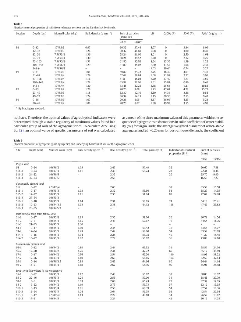
Table 5Physicochemical properties of soils from reference sections on the Tarkhankut Peninsula.
Section Depth (cm) Munsell color (dry) Bulk density (g cm−3) Sum of particles(mm) in %
рН СаСО3 (%) SOM (%) Р2О5a (mg kg−1)
b0.01 b0.001
Р1 0–12 10YR3/3 0.97 60.32 37.44 8.07 0 3.44 8.0912–32 10YR3/3 1.24 60.32 41.60 7.98 0 3.00 8.4932–54 7.5YR3/4 1.36 58.24 41.60 8.01 0 2.50 1.6854–73 7.5YR4/4 1.30 58.24 39.52 8.20 0 2.12 4.2573–105 7.5YR5/4 1.31 61.80 35.02 8.54 13.55 1.59 1.22105–248 7.5YR6/4 1.29 61.80 35.02 8.60 13.55 1.06 2.38248+ 7.5YR6/4 – – – 9.03 19.46 0.74 3.27
Р2 0–51 10YR5/3 1.01 59.80 24.72 8.75 18.39 3.61 4.3751–67 10YR5/4 1.29 57.68 28.84 9.08 21.92 2.27 3.9567–108 10YR5/4 1.16 61.8 35.02 8.70 27.40 1.73 3.59108–145 10YR7/4 1.28 65.92 32.96 8.61 25.81 0.89 9.49145+ 10YR7/4 1.30 63.48 32.28 8.58 25.64 1.21 19.88
Р3 0–23 10YR5/2 1.29 20.20 8.08 8.73 47.61 4.72 15.7723–49 10YR5/3 1.18 32.30 12.10 8.30 44.34 3.36 9.5349–73 10YR7/3 1.24 36.34 14.15 8.15 50.36 2.13 9.47
Р4 0–36 10YR5/3 1.07 20.21 4.05 8.37 36.06 4.25 5.2336–48 10YR5/2 1.08 20.20 8.07 8.38 49.92 3.55 4.98
a By Machigin's method.
310 F. Lisetskii et al. / Geoderma 239–240 (2015) 304–316
not have. Therefore, the optimal values of agrophysical indicators weredetermined through a stable regularity of maximum values found in aparticular group of soils of the agrogenic series. To calculate APS usingEq. (2), an optimal value of specific parameters of soil was calculated
Table 6Physical properties of agrogenic (post-agrogenic) and underlying horizons of soils of the agrog
Site Depth (сm) Munsell color (dry) Bulk density (g cm−3) Real dens
Virgin landS4 0–24 10YR6/2 1.05 2.47S11–1 0–24 10YR7/3 1.11 2.48S11-2 24–32 10YR6/6 – 2.35S11-3 32–34 10YR7/6 2.58
Continually plowed landS12 0–22 2.5YR5/4 – 2.66S15-1 0–17 10YR5/3 1.03 2.32S15-2 17–27 10YR5/3 1.11 2.30S15-3 27–54 10YR5/3 – –
S16-1 0–10 10YR5/3 1.14 2.31S16-2 10–23 10YR4/3.5 1.33 2.38S16-3 23–35 10YR4.5/3 – –
Post-antique long-term fallow landS1-1 0–17 10YR5/4 1.15 2.35S1-2 17–21 10YR5/3 1.15 2.43S1-3 21–33 10YR5/3 1.30 –
S3-1 0–17 10YR5/3 1.09 2.34S3-2 17–34 10YR5/3 1.23 2.49S14-1 0–15 10YR5/3 1.04 2.25S14-2 15–27 10YR5/3 1.02 2.27
Modern-day plowed landS6-1 0–12 10YR4/2 0.89 2.44S6-2 12–20 10YR4/2 1.26 2.41S7-1 0–17 10YR4/2 0.96 2.54S7-2 17–26 10YR3/3 1.10 2.66S9-1 0–14 10YR6/3.5 0.88 2.49S9-2 14–21 10YR5/3 1.18 2.62
Long-term fallow land in the modern eraS5-1 0–22 10YR5/3 1.12 2.49S5-2 22–46 10YR5/3 1.28 2.56S8-1 0–9 10YR3/3 0.93 2.69S8-2 9–22 10YR4/2 1.19 2.75S10-1 0–13 10YR5/4 1.01 2.55S10-2 13–24 10YR5/5 1.24 2.64S13-1 0–17 7.5YR5/4 1.13 2.22S13-2 17–31 10YR4/5 – 2.24
as amean of the threemaximumvalues of this parameterwithin the se-quence of agrogenic transformations in soils: coefficient of water stabil-ity (W) for virgin lands; the average weighted diameter of water-stableaggregates andΣd N 0.25mm for post-antique idle lands; the coefficient
enic series.
ity (g cm−3) Total porosity (%) Indicator of structuralproperties (P, %)
Sum of particles(mm)
b0.01 b0.001
57.49 32 20.60 7.8855.24 22 22.44 8.36
20 25.70 9.90– 16.58 7.27
38 35.58 15.5855.60 51 38.27 14.3551.74 89 47.67 24.78
– – –
50.65 74 54.18 25.4144.12 148 47.46 29.82
–
51.06 26 30.78 14.5652.67 19 44.54 11.76
– – –
53.42 37 33.58 16.0750.60 54 33.57 23.0953.78 49 41.20 15.4555.07 36 43.88 17.10
63.52 34 58.59 24.3647.72 65 55.12 36.8962.20 140 48.93 38.2258.65 104 52.50 32.1364.66 80 24.44 14.1454.96 95 45.91 24.48
55.02 33 38.06 19.9750.00 34 38.43 20.7965.43 29 37.37 14.9556.73 57 32.12 15.3560.39 54 37.57 16.3653.03 53 42.84 22.6449.10 31 26.52 13.87
42 30.19 14.28

Table 7Physical properties of soils of the agrogenic series.
Sitea Kstr DEFL (%) Σd N 0.25 mm (%) d (mm) W APS Dpl (%)
Virgin land (VL)S4 1.16 59.5 54.35 0.89 92.9 6.00 0S11 0.81 54.5 41.62 0.75 90.4 2.66 0
Continually plowed land (CPL)S12-1 0.92 72.8 28.81 0.44 65.1 1.18S15-1 0.72 55.4 29.75 0.38 68.7 0.66 8.4S15-2 1.09 74.9 28.07 0.38 62.3 1.16S16-1 1.35 74.3 22.43 0.25 25.7 0.31 4.4S16-2 1.10 81.5 39.83 0.34 22.1 0.57
Post-antique idle land (PIL)S1-1 1.15 67.2 47.94 0.78 87.1 5.37 −1.6S1-2 1.30 67.5 43.04 0.86 84.8 5.87S3-1 1.33 65.7 54.85 1.11 89.1 9.21 0.04S3-2 1.74 71.9 40.97 0.80 84.5 7.25S14-1 1.11 59.8 47.08 1.73 89.3 8.21 1.5S14-2 1.66 68.7 45.79 1.29 87.4 12.56
Modern-day plowed land (MPL)S6-1 0.79 66.2 23.40 0.23 19.6 0.12 2.0S6-2 1.29 84.5 28.80 0.38 25.5 0.65S7-1 0.80 87.6 21.97 0.29 35.3 0.33 0.01S7-2 0.80 88.7 42.62 0.56 57.4 2.03S9-1 0.79 71.7 23.90 0.30 24.9 0.22 3.0S9-2 1.26 78.1 28.07 0.42 41.2 1.02
Idle land in the modern era (MIL)S5-1 2.16 81.6 44.94 0.97 79.6 10.31 −1.0S5-2 1.69 80.8 42.04 0.75 65.2 5.98S8-1 1.10 67.8 37.69 0.51 73.7 2.25 1.6S8-2 1.27 85.1 39.53 0.79 80.1 5.77S10-1 0.92 66.7 32.83 0.63 79.6 2.15 1.7S10-2 0.62 76.4 37.75 0.65 76.9 1.91S13-1 0.77 59.6 30.84 0.52 88.6 1.39 3.0S13-2 0.88 65.9 36.85 0.50 83.6 1.91
Abbreviations: Kstr — coefficient of structural properties; DEFL — cloddiness of thestructure; Σd N 0.25 mm — percentage of water-stable aggregates measuring N0.25 mm;d—weighted average diameter of water-stable aggregates; W— coefficient of water stabil-ity, according to Andrianov; APS— agrophysical index of soil; Dpl — plowing exhaustion.
a Numerals 1 and 2 stay for horizons: 1— upper, most exposed tomechanical cultivation;2 — underlying (either the horizon underlying the plow zone or post-agrogenic [for idlelands]).
311F. Lisetskii et al. / Geoderma 239–240 (2015) 304–316
of structure for idle lands in themodern era; cloddiness of the structure(DEFL) for modern-day plowed lands. The calculations of the compositeagrophysical soil indicator using Expression (2) and the data fromTable 7 have demonstrated that according to their mean values of APS,i.e. their agrophysical quality, soils form the following decreasing se-quence: post-antique idle land (8.1) – virgin land (4.3) – idle land inthe modern era (4.0) – continually plowed lands (1.0) – modern-dayplowed lands (0.7). The positive effect of previous cultivation onagrophysical qualities of dry-steppe soils has already been demonstrat-ed in a study of soils in the rural territory of the ancient Greek city ofOlbia (Lisetskii, 2008).
Based on the stratum-by-stratum data on the physical properties ofsoils (Table 7), the plowing exhaustion of the upper soil horizon А (Dpl)was calculated to vary from1 to 8%. TheDpl value (%) calculated throughExpression (3) may be interpreted in two different ways depending onthe soil condition. When the soil's total humic horizon is thicker than40 cm and the soil has been continually cultivated (to the depth of20–22 cm), the increase of the Dpl value is diagnostic of the extent ofdegradation (abrasion) of agronomically valuable structural elementsin the plow zone as compared to the underlying horizon. The soilsthat only have been cultivated more recently and not exhausted byplowingwill have Dpl values close to zero. The values of Dpl can, howev-er, also be negative, as, for example, in idle lands, since the soil's struc-tural properties refurbish faster in the upper rather than lower layers.In such case, the Dpl index is indicative of the degree of functional soilrenaturation. According to the data presented in Table 7, the plowing
exhaustion of the continually plowed lands is twice as high comparedto the modern-day plowed lands, and the post-antique idle lands areclose to virgin lands, while in the idle lands of the modern era, thelower parts (usually deeper than 13(17)–22 cm) of the plow zone stillretain traces of agricultural stresses in their soil structure.
In regions with combined water and wind erosion it is not onlythe structural condition that is important for the evaluation of theagrophysical condition of soils, but also the protective properties ofthe soil. These can reveal themselves under the action of a destructiveagent and are conditioned by the combination of physicochemical prop-erties (SOMand its quality, ratio of Ca in the absorbing complex, carbon-ate content in the soils etc.) The agrophysical condition of soils, in ouropinion, is best expressed through the composite agrophysical soil indi-cator (APS) proposed here, which in the integral evaluation takes intoaccount the limiting (most sensitive) factor.
4.4.2. Chemical properties and composition of SOMIn natural steppe Chernozems, due to the biological accumulation of
phosphorus during theHolocene, the relative content of P2O5 in horizonA was 22% higher in the lower layers of soil. Meanwhile, the amount ofmobile phosphates in the accumulative horizon increased 4.5 fold overthe first 2000 years of the natural soil formation (Lisetskii and Ergina,2010). In the agrocenoses ‘biopumping’ of phosphorus into the uppersoil horizons diminishes as a result of harvesting.
Virgin lands and idle lands of themodern era contain small and me-dium amounts (10–30 mg kg−1) of mobile phosphates (Table 8), andrepresent the soils with the smallest value in the post-antique idlelands (9–10 mg kg−1). Due to the retention of the previously appliedphosphate fertilizers, the content of phosphates in the modern-dayplowed lands is high (N30 mg kg−1), and in the continually plowedlands very high (N70 mg kg−1).
According to the scale generally accepted in agrochemistry(Arinushkina, 1970), all soils of the agrogenic series have a high contentof exchangeable potassium— 300–400 mg kg−1 (Table 8). The contentof K2О, however, is very high in all arable soils (N400 mg kg−1), beingonly slightly lower than in virgin lands. According to this criterion, idlelands of different periods do not differ much from each other.
In idle lands and currently cultivated soils, the share of exchangeablecalcium in the absorbing complex of the upper horizon amounts to88–89%. In continually plowed and virgin soils, due to decalcination,this value is lower amounting to 83% and 78% respectively.
The data in Table 5 demonstrate that virgin soils (P2–P4) containfrom 3.4 to 4.6% of SOM in horizon A. The study of soils in the rural ter-ritory of the ancient city of Olbia showed that continually plowed landshad lost 46% of organicmatter,while the newly developed soils cultivat-ed over the last 100–130 years only 44% (Lisetskii, 2008). The presentstudy shows that the loss of carbon in the continually plowed soilsamounts to 51% C, in the modern-day plowed soils — to 39%, in theidle lands of the modern era — to 32% and in the post-antique idlelands— to 27%, as compared to the C content in the 0–23 cm layer of vir-gin soils (P3 in Table 5). The loss of humus impacts the agrophysicalproperties of soils, since the binding of microaggregates into macroag-gregates occurs during the coagulation of finely dispersed elementarysoil particles, which involves C and polyvalent cations. The favorablephysical and chemical properties of the steppe and the forest soils areexclusively associated with the high concentration of organic matter(Miralles et al., 2009).
Natural soils are characterized by the humate type (Сha/Сfa =1.5–2.0),withhumus being very rich in nitrogen. The idle-land soils,regardless of the duration of the fallowing regime, are the closest tovirgin soils in terms of the N content in humus. The high N ratio(Orlov et al., 2004) is also characteristic of the continually plowedsoils. In the newly developed plowed soils the C:N value is between8–14 (i.e.middle to low).
In terms of the humification rate of SOM in the soils of the agrogenicseries, which can be calculated as (Сha/С) / 100% (Orlov et al., 2004), the

Table 8Chemical properties and state of humus of soils of the agrogenic series.
Site рНH2O СаСО3, % Exchange bases, mmol(equiv.)/100 g
Р2О5 K2О С, % Сha:С, % Сha:Сfa N bulk,% C:N Clabile/С,%
Са++ Mg++ Na+ mg/kg (Machigin method)
Virgin landS4 8.1 63.3 7.2 1.4 0.5 17.4 539.6 2.08 26.6 1.1 0.225 5.1 9.3S11-1 8.3 59.5 10.2 2.2 0.8 11.7 458.4 1.94 11.3 0.6 0.213 9.4 5.6S11-2 8.6 60.9 5.9 2.0 2.0 6.2 615.6 1.39 9.1 0.6 0.218 7.8 5.5
Continually plowed landS12 8.2 27.9 13.3 3.9 1.0 69.9 349.4 1.36 15.6 1.7 0.233 7.0 5.0S15-1 8.1 24.5 17.4 2.9 0.1 110.3 463.1 1.33 22.7 2.1 0.195 5.7 5.8S15-2 8.2 24.8 12.7 3.4 0.3 14.9 283.3 0.96 22.3 1.2 0.183 3.7 3.4S15-3 8.6 25.7 11.0 2.2 1.5 4.9 209.6 0.91 12.7 0.8 0.175 6.0 3.3S16-1 8.2 17.4 22.1 2.0 0.4 79.8 412.9 1.48 64.3 2.0 0.220 2.4 10.8S16-2 8.2 10.4 23.1 3.6 0.3 10.9 291.6 1.33 28.5 0.9 0.263 3.7 4.7S16-3 8.2 8.1 22.4 3.4 0.5 5.1 216.6 1.25 47.0 2.5 0.245 3.1 6.9
Post-antique long-term fallow landS1-1 8.1 22.6 16.9 1.5 0.5 69.9 233.9 1.80 34.5 4.6 0.268 4.7 4.9S1-2 8.2 14.9 15.8 1.5 0.5 110.3 353.8 1.65 16.8 0.9 0.240 6.0 2.5S1-3 8.2 28.1 15.4 1.4 0.5 14.9 511.7 1.39 85.2 3.4 0.230 1.6 18.4S3-1 8.2 29.1 18.7 2.3 0.3 4.9 424.2 2.22 20.1 1.0 0.225 6.8 7.6S3-2 8.2 39.8 11.5 2.0 0.3 79.8 215.8 1.44 10.2 0.9 0.163 12.5 2.4S14-1 8.1 19.2 13.6 1.6 0.4 10.9 368.9 1.97 25.3 1.9 0.260 5.3 5.8S14-2 8.2 24.5 11.1 1.1 0.3 5.1 199.0 1.53 15.7 0.8 0.198 5.6 4.5
Modern-day plowed landS6-1 7.5 1.8 19.8 2.4 0.5 78.4 (173.6)a 425.7 (298.5)a 1.80 25.6 3.2 0.138 14.5 5.8S6-2 7.8 1.1 14.5 2.7 0.1 20.5 (136.3)a 311.9 (146.8)a 1.58 25.5 1.0 0.195 5.1 5.9S7-1 8.2 3.7 16.1 1.3 0.4 48.5 420.8 1.70 25.6 1.1 0.198 8.7 4.5S7-2 7.8 7.6 22.1 2.6 0.6 8.4 222.3 1.50 24.5 3.6 0.233 7.5 2.5S9-1 8.0 21.4 14.7 1.4 0.1 80.9 459.4 1.50 18.7 1.3 0.208 7.6 4.9S9-2 8.2 23.3 14.6 1.7 0.1 16.2 248.3 1.15 15.8 1.4 0.215 6.2 3.1
Long-term fallow land in the modern eraS5-1 8.2 23.5 16.2 2.0 0.7 9.1 194.6 1.46 21.7 1.9 0.228 6.1 3.0S5-2 8.4 17.3 17.3 3.3 0.8 5.8 215.5 1.46 20.8 1.2 0.153 9.3 4.7S8-1 8.0 23.5 16.2 1.7 0.1 22.0 338.1 2.56 17.8 1.0 0.230 7.8 4.1S8-2 8.1 24.1 23.5 1.2 0.1 7.7 217.8 2.35 29.6 1.6 0.213 7.6 5.6S10-1 8.1 26.5 13.8 1.5 0.5 16.1 393.7 1.60 19.0 2.5 0.235 7.0 3.2S10-2 8.2 28.3 18.5 1.5 0.5 8.6 127.3 1.27 72.3 0.8 0.230 1.5 11.7S13-1 8.2 37.2 12.3 1.6 0.3 12.6 298.5 1.84 16.1 0.8 0.240 6.0 6.4S13-2 8.3 39.9 10.6 1.1 0.5 8.6 176.3 1.46 9.5 0.5 0.173 7.9 4.5
Abbreviations: C — total organic carbon (TOC); Clabile — labile fraction of TOC; Cha and Cfa — carbon contents of humic and fulvic acids, respectively.a Chirikov's method.
312 F. Lisetskii et al. / Geoderma 239–240 (2015) 304–316
lowest values are recorded in the idle lands of the modern era and thevirgin carbonated soils. The middle values (20–30%) are characteristicof the post-antique idle lands, while the continually plowed soils,despite the widely varying values and the general decrease of SOMdue to cultivation, show a tendency for a high degree of humification.
In the soils of the Chernozemic series, the reproduction of a certainamount of SOM, which ensures acceptable agrophysical properties ofthe plowed horizon, and of the quality of SOM, particularly of its labilepart, is a priority in soil fertility management for sustainable land use.
4.4.3. Geochemical propertiesThe geochemical indicator Si/(Al + Fe), which characterizes the
processes of intra-soil chemical weathering, is also valuable fordistinguishing between the virgin soils and the cultivated as well asidle lands of different periods (Table 9). The virgin soils on eluvium ofdense carbonate rocks (S4, S11) have the lowest content of silica (15–16%), while in the cultivated soils the Si/(Al + Fe) value is higher. Yet,in the agrogenic series, the plowed soils on eluvium retain their distinc-tiveness from those formed on loams. To a certain degree, the relativeenrichment in silica of the plow zone can result from wind erosion,technological dusting and, to a lesser extent, from water erosion, asthe soils under study are predominantly situated in the flat areas.
The processes of eluviation characterized by coefficient Ke werefound to be the most active in some soils of the modern-day plowed
lands (Fig. 1: S6, S7), which can be explained by their geneticproperties— they are Calcic Chernozems with secondary carbonates.
Good diagnostic capability for assessing the extent and durationof the agrogenic transformation of soils is demonstrated by the ‘coef-ficient of leaching’ β (Jenny, 1931), which is calculated as the ratioβ = b of soil (in horizon n) / b of rock, where b = (K2O + Na2O) / Al2O3.As alumina remains virtually immobile while all the other compo-nents are, to a greater or lesser extent, vulnerable to erosion duringsoil formation and weathering, the lower the β value the bigger arethe losses of alkalis as compared to that of alumina.
For the genetically specific soils (S6, S7) mentioned above it is natu-ral that the β values in the plow zone (β1) were, sometimes lower by0.02–0.05, than in the underlying horizon (β2). The process of activeleaching observable in natural conditions occurs differently under theimpact of agrogenesis. It has been demonstrated (Lisetskii, 2008) thatthe post-antique soils differ from the virgin ones by a, on average,39 ± 8% thicker humus horizon and a deeper, by 22 ± 5%, sinking ofthe new formations of СаСО3. This is explained by the intensificationof the mineral mass hydrolysis in continually plowed lands with theincrease of the incoming part of the water balance and formation of aperiodical flushing regime.
Remarkably, the greatest difference between the β1 and β2 values(0.37) has been recorded in the continuously plowed lands near the an-cient city of Kerkinitis (S15). This is probably due to these lands beingsubjected to agricultural stress for a longer duration than in other

Table 9Bulk chemical composition of soils of the agrogenic series (Horizon Ар).
Chemical components andgeochemical indicators
Units VL CPL PLFL MPL MLFL Average
S4 S11 S12 S15 S16 S1 S2 S3 S14 S6 S7 S9 S5 S8 S10 S13
SiO2 % 15.7 15.4 42.5 38.8 48.4 44.6 46.2 34.2 41.8 57.6 53.6 43.5 43.7 42.0 40.9 28.3 39.8Al2O3 % 6.2 8.1 10.0 9.1 11.0 10.9 11.0 9.2 9.9 11.0 11.4 10.0 9.0 10.4 9.7 8.7 9.7Fe2O3 % 1.5 1.8 2.5 3.2 3.2 2.7 2.9 2.4 2.8 3.4 3.3 2.8 2.5 2.7 2.7 2.5 2.7CaO % 35.9 33.6 16.0 14.2 10.4 13.7 10.6 20.0 13.1 1.3 3.8 12.4 11.2 14.4 14.8 22.9 15.5MgO % 3.9 3.6 2.2 2.2 2.0 2.0 1.5 2.4 1.9 1.1 1.5 2.0 1.9 2.0 2.1 2.4 2.2Na2O % 3.2 3.1 1.9 1.9 1.6 1.6 1.1 2.0 1.6 0.9 1.0 1.6 1.6 1.7 1.8 2.3 1.8K2O % 1.4 1.4 1.6 1.4 1.7 1.7 1.8 1.4 1.6 2.0 1.7 1.6 1.7 1.5 1.5 1.3 1.6TiO2 % 0.4 0.4 0.6 0.7 0.8 0.7 0.7 0.5 0.7 0.9 0.9 0.6 0.8 0.7 0.6 0.5 0.6P2O5 % 0.3 0.2 0.2 0.1 0.1 0.2 0.2 0.2 0.2 0.1 0.1 0.2 0.2 0.2 0.1 0.2 0.2MnO % 0.1 0.1 0.1 0.1 0.1 0.1 0.1 0.1 0.1 0.1 0.1 0.1 0.2 0.1 0.1 0.1 0.1Sr mg/kg 349 215 256 262 170 218 169 158 210 125 121 175 169 155 179 247 198.5V mg/kg 38.9 46.5 65.6 72.0 79.3 64.8 55.1 63.1 70.6 83.4 87.3 80.9 75.5 73.0 70.2 65.4 68.2Cr mg/kg 65.9 70.5 81.5 95.2 92.4 82.4 82.5 76.7 86.3 106 94.2 84.3 80.4 84.2 80.3 78.3 83.8Zn mg/kg 61.2 65.2 71.4 105 81.9 72.6 88.5 67.9 71.1 75.1 74.7 71.0 66.3 68.5 70.8 67.6 73.7Ni mg/kg 25.1 30.6 40.3 58.3 52.7 45.0 46.4 41.2 44.3 52.5 51.3 45.4 42.0 44.3 44.1 39.1 43.9Cu mg/kg 6.7 20.0 29.5 46.2 45.1 37.0 38.0 32.9 37.9 54.8 51.9 39.6 33.1 41.5 37.1 30.1 36.4Pb mg/kg 14.5 12.6 16.8 21.9 19.2 15.7 20.7 13.7 17.5 19.4 25.8 16.8 23.9 21.4 15.5 20.9 18.5Zr mg/kg n/d 118 263 246 272 289 n/d 216 259 398 329 259 298 258 227 209 260.1Co mg/kg 2.0 2.8 10.9 14.5 17.7 11.9 17.1 8.6 11.9 17.1 17.4 10.4 11.9 11.1 11.2 9.8 11.6Si/(Al + Fe) Dimensionless 1.59 1.22 2.61 2.36 2.61 2.54 2.57 2.29 2.52 3.05 2.79 2.60 2.92 2.45 2.53 1.93 2.41(K2O + Na2O)/Al2O3 Dimensionless 0.72 0.56 0.34 0.36 0.29 0.31 0.26 0.38 0.32 0.26 0.24 0.32 0.37 0.31 0.34 0.41 0.36(CaO + MgO)/Al2O3 Dimensionless 6.41 4.60 1.81 1.80 1.12 1.44 1.10 2.44 1.51 0.22 0.46 1.44 1.46 1.57 1.74 2.92 2.00Ke Dimensionless 0.35 0.37 1.96 1.96 3.08 2.34 3.06 1.32 2.29 10.8 6.70 2.46 2.64 2.14 2.02 0.97 2.78Rn
a Dimensionless 1.39 1.35 1.27 1.31 1.27 1.31 1.30 1.38 1.28 1.30 1.30 1.28 1.40 1.37 1.27 1.38 1.32
Abbreviations: VL— virgin land; MLFL — long-term fallow land in the modern era; MPL — modern-day plowed land; PLFL — post-antique long-term fallow land; CPL — continually plowed land.a For soils from sites S3–5, S8, S11 and S13 (on eluvium of carbonate rocks), coefficient Rn is calculated on the basis of six elements (Ti, Zn, Pb, Ca, P, K); for other soils (on loams) by nine elements (Ni, Zn, Mn, Pb, Cu, Si, Co, P, K).
313F.Lisetskiietal./G
eoderma239
–240(2015)
304–316

Fig. 2. Results of the cluster analysis of soils of the agrogenic series according to indicatorsof agrogenesis (APS, SOC, P2O5, Rn, Ke). Note: Site numbers onaxis X correspond to those inTable 1.
Fig. 3. Dependence of soil quality (SQ) on the duration and intensity of agricultural stressin the ranked series of soils of the agrogenic series (1–5). Key: 1— virgin land; 2— idle landin themodern era; 3—modern-day plowed land; 4— post-antique idle land; 5— contin-ually plowed land.
314 F. Lisetskii et al. / Geoderma 239–240 (2015) 304–316
parts of the Tarkhankut Peninsula. In the post-antique idle lands, thedif-ference in valuesβ1 and β2 is somewhat smaller (up to 0.18) than in thecontinually plowed lands. The same peculiarity has also been noted inthe top part of an ancient earthen division wall (S1) suggesting thatthe surface of these walls might have been cultivated in the Greek peri-od, for instance, for the purpose of viti- and/or horticulture. Soils of thenewly developed lands have β1 N β2 (except for S10 where the valuesare fairly similar).
The ratio between the mobile components and a stable componentof the soil (in our case alumina) is indicative of the intensity of processesof chemical decomposition and eluviation. Using themolecular ratios ofoxides (K2O + Na2O)/Al2O3 and (CaO + MgO)/Al2O3, a more active,cultivation-conditioned transformation of Ca and Mg, as compared toK and Na, was established in comparable soils of the agrogenic series(in objects S3, S8, and S13 as compared to S4 and S11). The continuouslyplowed lands and the post-antique idle lands differ considerably fromother soils in terms of another indicator used in our analysis, namely,the decrease of molar ratio CaO/ZrO2 in the plow zone as a result ofmore intensive and/ormore prolonged agricultural stress since themin-erals containing calcium aremore easily weathered than thosewith thechemically stable and biologically inert zirconium. The same peculiarityhas also been found in the soil at S5, which initially seemed to be a post-antique idle land.
Of particular interest is the depletion of microelements in plowedsoils compared to virgin lands: on average, in the continuously plowedsoils, the Rn value is 6% lower, whereas in the plowed lands of themodern era and post-antique idle lands this value is 5% lower. Thus inChernozems, the prolonged agrogenic stresses lead to a reducedamount ofmicroelements such as Co, Ni, Mn, Cu, Zn, Pb, aswell as phos-phorus and potassium.
4.5. Indicators of agrogenesis
Not all of the soil properties can be linked directly to the durationand intensity of agrogenic transformation. The initial pedogenetic dif-ferences of soils are not completely erased by subsequent agriculturaldevelopment. But, it has been possible to determine a set of universal in-dicators of agrogenesis that are more sensitive to agricultural use.
The question ariseswhether the long periods of regeneration (in ourcase, 2300 years) can return the soils cultivated in antiquity to the stateand properties characteristic of the virgin soils. In other words, what isthe position of the post-agrogenic idle lands within the agrogenic se-quence of soils: before the idle lands of the modern era or after?
A unique opportunity for comprehending the role of slow-actingprocesses of pedogenesis is offered by the continuously plowed soils.The soils cultivated in classical antiquity have undergone the sameagrogenic transformation as the newly developed soils of the modernera. Nevertheless, they have remained distinguishable from the latterthrough the relict traits accumulated during previous periods ofcultivation.
As can be seen in the dendrogram in Fig. 2, soils of the agrogenic se-ries form two large clusters: cultivated and uncultivated soils. Allplowed soils and those occupied by natural or semi-natural steppevegetation form clusters with a smaller inter-cluster distance. Thus,the cluster analysis supports the selection of indicators of agrogenesis.
The heuristic potential of these indicators serves as an additional val-idation of their selection. Prior to the field investigation, the soil at siteS5 was identified as idle land of the modern era. As can be seen on anarchival aerial photo from the 1950s, there was a cultivated field here.In 1967, this areawas plowed for planting fruit trees or vines, but quick-ly abandoned, and in 1970, an airfield was built on the plot. The analyt-ical results have demonstrated, however, that the soil of S5 differs fromthe recent idle lands (sites S8, S10 and S13) in four out of five indicatorsof agrogenesis (except APS index), resembling instead the post-antiqueidle lands. Such re-attribution is supported by archaeological evidence,namely, the presence of the 4th–2nd century BC Greek settlement of
Mezhvodnoe situated just 1.4 km east of site S5 (Stolba, 2012). The tracesof ancient land division revealed in its surroundings (Chtcheglov, 1992)leave little room for doubt about this area's agriculture heritage in thelate Classical and early Hellenistic periods.
The quality of soils (SQ) of the agrogenic series was evaluated bycalculating the geometrical mean value on the basis of the most in-formative indicators of agrogenesis: the quantity (SOC) and quality(Cha/SOC) of SOM, amount of mobile phosphates, agrophysical condi-tion of the soil (based on APS index), eluviation coefficient and averagequantitative estimate of the soil's capability to accumulate elements(Ni, Zn, Mn, Pb, Cu, Si, Co, P, K). Fig. 3 demonstrates that, despite thedifferences in duration of cultivation (from 220 to 800 years), the con-tinuously plowed soils form a compact group with close values of soilquality (SQ). This indicates that, after attaining a certain level of equilib-riumwith the changing environmental factors, the process of agrogenictransformation of soils slows down considerably.
Even after 2000 years of renaturation, soils of the post-antique idlelands retain in their ‘memory’ agrogenic pedorecords, at least according

315F. Lisetskii et al. / Geoderma 239–240 (2015) 304–316
to the aggregate of the indicators listed above. According to indicatorSQ, the overall transformation of soils of the current stage of develop-ment (150–165 years) is about 15% lower as compared to continuouslyplowed soils. Under fallowing conditions, they are capable of fast regen-eration within a few decades. It therefore seems that resource-savingsustainable agriculture could benefit from management methods thatincorporate a fallowing regime.
5. Conclusions
1. Among the numerous physical and chemical properties of soils, themost informative indicators of agrogenesis have been defined. Thiswas facilitated by the fact that the studieswere conducted in a regionwhere the onset of large-scale systematic farming coincides withGreek colonization. A long agricultural history with various practicesof land use made it possible to group the attributed and parameter-ized soil objects into the chronosequence: virgin land, post-antiqueidle land, continually plowed land, modern-day plowed land, andidle land in the modern era. The informative potential of the soils,which continually (or with some restorative phases) underwentlong-term agricultural stress under different practices of farming,provides insight into the long-term transformations of the materialand energetic structure of soils.
2. The newmethod of calculating an integral agrophysical soil indicatorbased on structural properties, cloddiness and water stability,amount of water-stable aggregates and their mean mass-weighteddiameter has allowed the grouping of the studied objects into aranked sequence: post-antique idle land b virgin b idle land in themodern era b continually plowed land b modern-day plowed land.Thus, prior practices of land use have a positive effect on theagrophysical soil properties.The reproduction of soil organic matter (SOM) and its quality, partic-ularly of its labile content, which is responsible for the agrophysicalproperties of a plow horizon, is key to soil fertility management insustainable agriculture.
3. It has been established that the reproduction of soil organic matter(SOM) and its quality, particularly its labile content which affectsthe agrophysical properties of a plow zone, is the first priority formanagement of soil fertility in a sustainable agriculture. Observa-tions suggest that one effect of long-term agrogenic stresses is a5–6% reduction in microelements in plowed soils compared withvirgin soils.
4. It has been shown that even after two millennia of renaturation thepost-antique idle lands preserve the footprints of agrogenesis,which in the form of an aggregate of diagnostic soil properties definepedomemory. According to soil quality, the overall agrogenic trans-formation of soils of the current phase of development (150–165 years) is 15% lower than for the continuously plowed soils. Ifabandoned, as is often the case for soils of medium and poor qualityon the northern coast of the Black Sea, the arable lands are capable offast regeneration within a few decades of the fallowing regime.Therefore, management methods that incorporate a fallowing re-gime have great potential in resource-saving sustainable agriculture.
Acknowledgments
This study was carried out with financial support from the DanishCouncil for Independent Research | Humanities (grant no. 09-069235)and the Ministry of Education and Science of the Russian Federation(as part of the state assignment for the Belgorod State National ResearchUniversity; activity type: ‘Organization of Scientific Research’; no. 2014/420-1). The authors also wish to thank the anonymous reviewers fortheir detailed and constructive comments which greatly contributedto the improvement of our manuscript.
References
Andrianov, P.I., 1947. Strength of soil lump and methods of its determination.Pochvovedenie 2, 96–101 (in Russian).
Arinushkina, Е.V., 1970. Manual for the Chemical Analysis of Soils. University Press,Moscow (in Russian).
Bellin, N., vanWesemael, B., Meerkerk, A., Vanacker, V., Barbera, G.G., 2009. Abandonmentof soil and water conservation structures in Mediterranean ecosystems. A case studyin south east Spain. Catena 76, 114–121.
Blake, L., Goulding, K.W.T., Mott, C.J.B., Poulton, P.R., 2000. Temporal changes in chemicalproperties of air-dried stored soils and their interpretation for long-term experi-ments. Eur. J. Soil Sci. 51, 345–353.
Bondarenko, О.Yu, Vasil'eva, Т.V., 2008. Transformation of ecological and coenotic struc-ture of flora in the abandoned agrarian lands in southern Ukraine. Restoration ofdisturbed natural ecosystems. Lebed'; Donezk, in Ukrainian, pp. 77–80.
Bryant, R.B., Galbraith, J.M., 2003. Incorporating anthropogenic processes in soil classifica-tion. In: Eswaran, H., et al. (Eds.), Soil Classification: A Global Desk Reference. CRCPress, Boca Raton, pp. 57–66 (Fla.).
Bulygin, S.Yu, Nearing, M.A., 1999. Formation of Ecologically Balanced Agrolandscapes:The Problem of Soil Erosion. Eney Ltd., Kharkiv (in Ukrainian).
Chtcheglov, A., 1992. Polis et chora: Cité et territoire dans le Pont-Euxin. Les Belles Lettres,Paris.
Cordova, C.E., Lehman, P.H., 2005. Holocene environmental change in southwesternCrimea (Ukraine) in pollen and soil records. The Holocene 15, 263–277.
Cordova, C.E., Gerasimenko, N.P., Lehman, P.H., Kliukin, A.A., 2011. Late Pleistocene andHolocene paleoenvironments of Crimea: Pollen, soils, geomorphology, andgeoarchaeology. In: Buynevich, I.V., Yanko-Hombach, V., Gilbert, A.S., Martin, R.E.(Eds.), Geology and Geoarchaeology of the Black Sea Region: Beyond the FloodHypothesisGSA Special Papers 473. Geological Society of America, Boulder, pp.133–164.
Delgado, R., Martín-García, J.M., Calero, J., Casares-Porcel, M., Tito-Rojo, J., Delgado, G.,2007. The historic man-made soils of the Generalife garden (La Alhambra, Granada,Spain). Eur. J. Soil Sci. 58, 215–228.
Dick, R.P., Sandor, J.A., Eash, N.S., 1994. Soil enzyme activities after 1500 years of terraceagriculture in the Colca Valley, Peru. Agric. Ecosyst. Environ. 50, 123–131.
Dolotov, V.A., 1984. Old-arable soil as used for two thousand years. Pochvovedenie 1,103–106 (in Russian).
Eash, N.S., Sandor, J.A., 1995. Soil chronosequence and geomorphology in a arid valley inthe Andes of southern Peru. Geoderma 65, 59–79.
Fonte, S.J., Vanek, S.J., Oyarzun, P., Parsa, S., Quintero, D.C., Rao, I.M., Lavelle, P., 2012. Path-ways to agroecological intensification of soil fertility management by smallholderfarmers in the Andean Highlands. Adv. Agron. 116, 125–184.
Freppaz, M., Agnelli, A., Drusi, B., Stanchi, S., Galliani, C., Revel Chion, V., Zanini, E., 2008.Soil quality and fertility: studies in the Valle d'Aosta. In: Fontanari, E., Patassini, D.(Eds.), Terraced Landscapes of the AlpsProjects in Progress. Marsilio, Venice, pp.37–39.
Gerasimenko, N.P., 2011. Climatic and environmental oscillations in southeastern Ukrainefrom 30 to 10 ka, inferred from pollen and lithopedology. In: Buynevich, I.V., Yanko-Hombach, V., Gilbert, A.S., Martin, R.E. (Eds.), Geology and Geoarchaeology of theBlack Sea Region: Beyond the Flood HypothesisGSA Special Papers 473. GeologicalSociety of America, Boulder, pp. 117–132.
Gerrard, A.J., 1981. Soils and Landforms: An Integration of Geomorphology and Pedology.George Allen & Unwin, London.
Goldberg, P., MacPhail, R., 2006. Practical and Theoretical Geoarchaeology. Blackwell Pub-lishing Ltd., New York.
Gong, Z., Putian, L., Jie, C., Xuefeng, H., 2000. Classical farming systems of China. J. Crop.Prod. 3, 11–21.
Goodman-Elgar, M., 2008. Evaluating soil resilience in long-term cultivation: a studyof pre-Columbian terraces from Paca Valley, Peru. J. Archaeol. Sci. 35,3072–3086.
Harden, C., 1996. Interrelationships between abandonment and land degradation: a casefrom the Ecuadorian Andes. Mt. Res. Dev. 16, 274–280.
Homburg, J.A., Sandor, J.A., 2011. Anthropogenic effects on soil quality of ancient agricul-tural systems of the American Southwest. Catena 852, 144–154.
IUSS Working Group WRB, 2014. World Reference Base for Soil Resources 2014. Interna-tional soil classification system for naming soils and creating legends for soil maps.World Soil Resources Reports 106. FAO, Rome.
Ivanov, I.V., Alexandrovskiy, A.L., 1987. Methods for the study of the evolution of soils.Sov. Soil Sci. 19, 90–101.
Jenny, H., 1931. Behavior of potassium and sodium during the process of soil formation.Mo. Agric. Exp. Station Res. Bull. 162, 42–52.
Jenny, H., 1941. Factors of Soil Formation. Mc Graw-Hill, New York.Karavaeva, N.A., 2000. Long-term agrogenic evolution of soddy-podzolic soil. Eurasian
Soil Sci. 33, 147–155.Karavaeva, N.A., Zharikov, S.N., Konchin, A.E., 1985. Arable soils of the Non-Chernozem
area: a process-evolutional approach to studies. Pochvovedenie 11, 114–125(in Russian).
Kolotukhin, V.A., 2003. Late Bronze Age of the Crimea. Stilos, Kiev (in Russian).Korobov, D.S., Borisov, A.V., 2013. The origins of terraced field agriculture in the Caucasus:
new discoveries in the Kislovodsk basin. Antiquity 87, 1–18.Korpusova, V.N., Lyashko, S.N., 1990. Catacomb burial with wheat in the Crimea. Sov.
Archeol. 3, 166–175.Kostyuchenko, V.P., Lisitsyna, G.N., 1976. Genetic features of ancient-irrigated soils.
Pochvovedenie 2, 3–13.Krupenikov, I.A., 2005. Typification of the anthropogenic processes of degradation of
chernozems. Eurasian Soil Sci. 38, 1347–1354.
316 F. Lisetskii et al. / Geoderma 239–240 (2015) 304–316
Lisetskii, F.N., 1998. Autogenic succession of steppe vegetation in postantique landscapes.Russ. J. Ecol. 4, 217–219.
Lisetskii, F.N., 2008. Agrogenic transformation of soils in the dry steppe zone under theimpact of antique and recent land management practices. Eurasian Soil Sci. 8,805–817.
Lisetskii, F.N., Ergina, E.I., 2010. Soil development on the Crimean Peninsula in the LateHolocene. Eurasian Soil Sci. 43, 601–613.
Lisetskii, F.N., Rodionova, M.E., 2012. Soil and landscape changes in ancient agriculturalareas (exemplified by antique Olbia). Geogr. Nat. Resour. 33, 327–335.
Lisetskii, F.N., Stolba, V.F., Ergina, E.I., Rodionova, M.E., Terekhin, E.A., 2013. Post-agrogenicevolution of soils in ancient Greek land use areas in the Herakleian Peninsula, South-West Crimea. The Holocene 23, 504–514.
Lisitsyna, G.N., Kostyuchenko, V.P., 1976. Soil as a source of information in studies of an-cient agriculture (after the results of investigations in arid regions of the USSR in1969–1973). Sov. Archeol. 1, 23–41 (in Russian).
Liu, G., Li, L., Wu, L., Wang, G., Zhou, Z., Du, S., 2009. Determination of soil loss tolerance ofan entisol in Southwest China. Soil Sci. Soc. Am. J. 73, 412–417.
Londono, A.C., 2008. Pattern and rate of erosion inferred from Inca agricultural terraces inarid Southern Peru. Geomorphology 99, 13–25.
Machigin, B.P., 1952. Methods of Agrochemical, Agrophysical and Microbiological Re-search in Irrigated Cotton Areas. AN UzSSR, Tashkent (In Russian).
Matviishina, Zh.M. (Ed.), 2010. Spatial and Temporal Correlation of PalaeogeographicConditions of the Quaternary Period in the Territory of Ukraine. Naukova dumka,Kiev (in Ukrainian).
Mighall, T.M., Foster, I.D.L., Rowntree, K.M., Boardman, J., 2012. Reconstructing recent landdegradation in the semi-arid Karoo of South Africa: a palaeoecological study atCompassberg, Eastern Cape. Land Degrad. Dev. 23, 523–533.
Miralles, I., Ortega, R., Almendros, G., Sánchez-Marañón, M., Soriano, M., 2009. Soil qualityand organic carbon ratios in mountain agroecosystems of South-east Spain.Geoderma 150, 120–128.
Miyaji, A., 2003. Analysis of Cultivated Fields and Their Soils in Japanese Archaeology: SoilMicromorphology. In: Boschian, G., Langohr, R., Limbrey, S., Macphail, R.I. (Eds.), Sec-ond International Conference on Soils and Archaeology, Pisa, 12th–15th May, 2003.Felici, Pisa.
Nyberg, G., Bargués Tobella, A., Kinyangi, J., Ilstedt, U., 2012. Soil property changes over a120-yr chronosequence from forest to agriculture in western Kenya. Hydrol. EarthSyst. Sci. 16, 2085–2094.
Orlov, D.S., Biryukova, O.N., Rozanova, M.S., 2004. Revised system of the humus statusparameters of soils and their genetic horizons. Eurasian Soil Sci. 37, 798–805.
Phillips, J.D., 2009. Soils as extended composite phenotypes. Geoderma 149, 143–151.Pietsch, D., Mabit, L., 2012. Terrace soils in the Yemen Highlands: using physical, chemical
and radiometric data to assess their suitability for agriculture and their vulnerabilityto degradation. Geoderma 185–186, 48–60.
Polyakova, N.V., Platonycheva, Yu.N., 2012. Some regularities of anthropogenic transfor-mation of gray forest soils. Russ. Agric. Sci. 38, 297–300.
Ponomareva, V.V., Plotnikova, T.A., 1980. Humus and Soil Formation. Nauka, Leningrad(In Russian).
Ruecker, G., Schad, P., Alcubilla, M.M., Ferrer, C., 1998. Natural regeneration of degradedsoils and site changes on abandoned agricultural terraces in Mediterranean Spain.Land Degrad. Dev. 19, 488–501.
Sanchez-Maranon, M., Soriano, M., Delgado, G., Delgado, R., 2002. Soil quality in Mediter-ranean mountain environments: effects of land use change. Soil Sci. Soc. Am. J. 66,948–958.
Sandor, J.A., 2006. Ancient agricultural terraces and soils. In: Warkentin, B. (Ed.), Foot-prints in the Soil: People and Ideas in Soil History. Elsevier, Amsterdam, pp. 505–534.
Sandor, J.A., Eash, N.S., 1995. Ancient agricultural soils in the Andes of South Peru. Soil Sci.Soc. Am. J. 59, 170–179.
Sandor, J.A., Gersper, P.L., Hawley, J.W., 1990. Prehistoric agricultural terraces and soils inthe Mimbres Area, New Mexico. World Archaeol. 22, 70–86.
Sapelko, T.V., Subetto, D.A., 2007. Vegetation change reconstruction during the Holocenein the north-western Crimea, based on pollen data. In: Yanko-Hombach, V. (Ed.),Extended Abstracts IGCP 521–481 Joint Meeting and Field Trip, Gelendzhik-Kerch, September 8–17, 2007. Rosselkhozakademiya Printing House, Moscow,pp. 135–136.
Scalenghe, R., Bonifacio, E., Celi, L., Ugolini, F.C., Zanini, E., 2002. Pedogenesis in disturbedAlpine soils. Geoderma 109, 207–224.
Shaw, D.M., 1964. Interprétation geochimique des éléments en traces dans les rochescristallines. Masson, Paris.
Shcheglov, A.N., 1963. Excavations at the settlement of Tarpanchi in 1960. Soobš. Chers.Muz. 3, 67–75 (In Russian).
Slepetiene, A., Slepetys, J., 2005. Status of humus in soil under various long-term tillagesystems. Geoderma 127, 207–215.
Stanchia, S., Freppaza, M., Agnellib, A., Reinschc, T., Zaninia, E., 2012. Properties, bestmanagement practices and conservation of terraced soils in Southern Europe (fromMediterranean areas to the Alps): a review. Quat. Int. 265, 90–100.
Stolba, V.F., 2005a. Monetary crises in the early Hellenistic poleis of Olbia, Chersonesosand Pantikapaion. A re-assessment. In: Alfaro, C., Marcos, C., Otero, P. (Eds.), XIIICongreso Internacional de Numismática, Madrid 2003Actas-Proceedings-Actes.Ministerio de Cultura, Madrid, pp. 395–403.
Stolba, V.F., 2005b. The oath of Chersonesos and the Chersonesean economy in the earlyHellenistic period. In: Archibard, Z.H., Davis, J.K., Gabrielsen, V. (Eds.), Making, Mov-ing and Managing: The New World of Ancient Economies, 323–31 BC. Oxbow, Ox-ford, pp. 298–321.
Stolba, V.F., 2012. La vie rural en Crimée antique: Panskoe et ses environs. Études Let. 1–2,311–364.
Stolba, V.F., Subetto, D.A., Sapelko, T.V., 2012. Paleo-limnological investigations in LakeDžarylgač. In: Bilde, P.G., Attema, P., Winther-Jacobsen, K. (Eds.), The DžarylgačSurvey Project. University Press, Aarhus, pp. 49–50.
Storie, R.E., 1978. Storie Index Soil Rating. Division of Agricultural Sciences, University ofCalifornia, Berkeley.
Vadyunina, A.F., Korchagina, Z.A., 1961. Methods for Investigating the Physical Propertiesof Soils and Earth Materials (in Field and Laboratory). Vysshaya shkola, Moscow (inRussian).
Veklich,М.F., Sirenko, N.А., 1974. Regionalization of the Plains in Southern Ukraine on theBasis of Palaeogeographic Data. In: Veklich, M.F. (Ed.), Palaeogeography and Engi-neering Geology of southern Ukraine (Late Cainozoic). AN USSR, Kiev (in Russian),pp. 34–44.
Wilkinson, T.J., 2003. Archaeological Landscapes of the Near East. University of ArizonaPress, Tucson.