Embed Size (px)
Citation preview

INDIAN
@ E-mail to [email protected] [email protected]
INDIAN OCEAN
Editi
I. IndII. PerIII. TemIV. MaV. RaVI. CoVII. CoVIII. Co
------------------------- Mariners are rPost Box No. 75, Ddiscovery of new Hydrographic NoteEditions dated 1st Ja
Government of Indi
(O
Write
National Hyd107-A, RajpuDehradun – 2INDIA
Non N
ex of Charts manent Noticporary and
rine Informatdio Navigatiorrection to Sarrection to Lirrection to Li----------------equested to ehradun -24 dangers or (IH 102), wnuary, 1st A
a Copyright
CHARTS AND PUBLICATION
riginal, Authentic and most up-to-date)to Fax to Contact Person visit rographic Office +91- 135 - 2748373 Asst Hydrographer www.hydrobharat.org r Road Marine Safety Services 48 001 +91- 135 - 2747360-65
REACH US 24 HOURS A DAY
INDIAN OTICES TO MARINERS o. 12, dated 15 June 2003
(Notices 238 – 254)
CONTENTS
Affected. es.
Preliminary Notices. ion. nal Warnings. iling Direction. st of Lights. st of Radio Signals. ------------------------------------------------------------------------------------------------------------------ notify the Chief Hydrographer to the Government of India, National Hydrographic Office, 8001, INDIA [Fax: 0091- (135) - 2748373 Grams: Hydro Dehradun immediately on the suspected dangers to navigation and of changes or defects in aids to navigation. A
hich is a convenient form on which to send in a report, is attached with Notices to Mariners pril, 1st July and 1st October.
KR Srinivasan Rear Admiral Chief Hydrographer to the Government of India
(Published on 1st and 15th of every month) . Permission not required to make copies of these Notices but such copies are not to be sold.

2
EXPLANATORY NOTES Charts and Positions The Notices in section II give instructions for the corrections of Indian and Admiralty Charts including the information on new Indian Charts and Publications. Geographical positions refer to the horizontal datum of the current edition of the largest scale chart unless otherwise stated. Bearings are true reckoned clockwise from 000o to 3590; those relating to lights are from seaward. Symbols referred to are those shown on the chart 5020. Alterations to depth contours, deletion of depths to make way for new detail, etc; are not mentioned unless they have some navigational significance.
Blocks and notes, if any, accompanying notices in Section II are placed after Section VIII.
Temporary and Preliminary Notices These are indicated by (T) and (P) after the notice number and are placed in Section III. A list of those in force published quarterly and text are published in Annual Edition of Indian Notices to Mariners. Charts are not corrected for them before issue, they should be corrected in pencil on receipt.
Original Information A star adjacent to the number of a notice indicates that the notice is based on original information. Sailing Directions Corrections or the sailing Directions are given in Section VI. A summary of corrections in force will be issued in Section VI of the Edition dated 1st January, 1st April, 1st July and 1st October. Lights When a light is affected by a notice its Lights List number is quoted. The correction of the Light List is given in Section VII and should be incorporated as per instructions given on page 11 of the list of Lights. It may be published in earlier or later Edition than the chart correcting notice.
The range of a light is the nominal range; geographical range is given in parenthesis if less than the nominal range. Radio Signals The corrections in Section VIII should be cut and pasted in the appropriate volumes of the List of Radio Signals.
Radio Navigational Warnings Updating information is published by fortnightly Notices to Mariners supplemented by the radio warnings for items of immediate importance. It should be borne in mind that they may be based on reports which can not always be verified before promulgation, and that is some time necessary to be selective and promulgate only the more important items to avoid over loading users; the reminder being included in the revised Edition of the charts and publications concerned. Laws and Regulations While in the interest of the safety of shipping, the Hydrographic Office makes every endeavour to include in its publications details of the laws and regulations of all countries pertaining to navigation, it must be clearly understood: -
(a) that no liability whatsoever can be accepted for failure to publish details of any particular law or regulation, and
(b) that publication of details of a law or regulation is solely for the safety and convenience of shipping and implies no recognition of the International validity of the law or regulation.
Correction of Charts and Publications by the users Indian Notices to Mariners contains important information and should be used to keep the specified charts and books up to date. THE USE OF CHARTS AND ASSOCIATED PUBLICATIONS
Reliance on Charts and Associated Publications While every effort is made to ensure the accuracy of the information on Indian charts and other publication, it should be appreciated that it may not always be complete and up-to-date. The mariners must be the final judge of the reliance he can place on the information given, bearing in mind his particular circumstances, local pilotage guidance and judicious use of available navigational aids.
The positions of Hydrographic objects shown on the Indian charts and publications are given in Everest da-tum. However, the positions of vessels obtained from Global Positioning System (GPS) are on World Geodetic System 1984 datum. There will always exist variation in position obtained by visual fixing (Everest Datum) and GPS position (WGS 84 datum). Before plotting GPS positions on charts, datum shift values given on the chart are to be applied in order to agree with the charted position. These datum shift values are not uniform, particularly in areas off Andaman & Nicobar and Lakshdweep Islands, as these places are not strictly adjusted to mainland network (datum). Mariners are
3
advised to use alternate source of position information particularly when closing the shore or navigating in the vicinity of danger. Charts Charts should be used with prudence; there are areas where the source data are old incomplete or of poor qual-ity. The mariners should use largest scales appropriate for his particular purpose; apart from being the most detailed, the larger scale are usually corrected first. When extensive information (such as new hydrographic survey) is received, some months must elapse before it can be fully incorporated in published charts.
On small-scale charts of ocean areas where hydrographic information is, in many cases still sparse, charted shoal may be in error as regards position, least depth and extent. Undiscovered dangers may exist particularly away from well-established routes. Further Guidance The mariner’s Hand Book (NP 100) gives full explanation of the limitation of charts. In their own interest, all users should study it.

I
4
INDEX OF CHARTS AFFECTED (Edition No. 12 dated 15 June 2003)
INDIAN Chart No.
Folio No.
Notice No.
31 5 252(P) 32 (INT 754) 5 238, 252(P) 41 6 246 203 2 249(T) 216 3 250(T), 251(T) 217 3 251(T) 258 (INT 7348) 3 251(T) 286 1 240 288 1 238 289 1 238 301 5 253(T), 254(T) 351 (INT 7419) 5 253(T), 254(T) 355 (INT 7405) 5 252(P) 356 5 252(P) 409 6 238 433 7 246 2020 3 245 2024 3 250(T) 2051 2 249(T) 2060 2 249(T) 2068 2 249(T) 2073 3 251(T) 2078 (INT 7346) 3 245 3008 5 252(P) 3026 5 252(P) 4036 6 238
ADMIRALTY Chart No.
Folio No.
Notice No.
1238 40 244 1358 45 247 2403 45 247 2882 40 242, 243 2884 40 242, 243 3736 40 241 3773 40 242 3785 40 240 3831 45 248 3833 45 247 3947 45 247 4041 46 248 4042 46 248

II
5
PERMANENT NOTICES
INDIAN HYDROGRAPHIC CHARTS AND PUBLICATIONS *238 (12/03) (a): NEW INDIAN CHARTS
Chart No. Date of
Publication Title, Limits & Description Scale Folio Price
Rs.
4036 31.12.2002 ANDAMAN SEA – INDIA NICOBAR ISLANDS
1:50 000 6 1000.00
APPROACHES TO PULO MILLOW Limits:
70 21' .20N; 930 29' .01E. 70 34' .20N; 930 46' .70E.
PULO MILLOW ANCHORAGE 1:25 000 Limits:
70 22'. 20N; 930 33' .15E. 70 29' .20N; 930 42' .05E.
288 31.12.2002 QATAR TO SHATT AL ‘ARAB 1:750 000 1 1000.00
Limits: 240 19'. 27N; 470 41' .00E. 300 34' .90N; 520 16' .15E.
32 (INT 754) 31.12.2002 INDIA AND SRILANKA 1:1 500 000 5 1000.00
KOCHI (COCHIN) TO VISHAKHAPATNAM
Limits: 040 25'. 00N; 750 45' .00E. 180 00' .00N; 840 40' .00E.
(b): INDIAN CHARTS PERMANENTLY WITHDRAWN
Chart to be withdrawn Main Title On Publication of New Chart 288 SHATT AL ‘ARAB TO QATAR 288 32 COCHIN TO VISHAKHAPATNAM 32 (INT 754)
(C) CHARTS AFFECTED BY THE FOREGOING
Chart No. Last Correction
Details
289 (167/03) Insert new magenta limit and chart number 288 as follows: Limits: a) 28o 00'. 00N., 52o 16' .15E. b) 24o 19'. 27N., 52o 16' .15E. c) 24o 19'. 27N., 50o 25' .00E. 409 (272/00) Insert new magenta limit and chart number 4036 as follows: Limits: North: 07o34'. 20N. East: 93o 46'. 70N. South: 07o21'. 20N. West: 93o 29'. 01N. (NHO, Dehradun: HJ/NM/Pub)
II
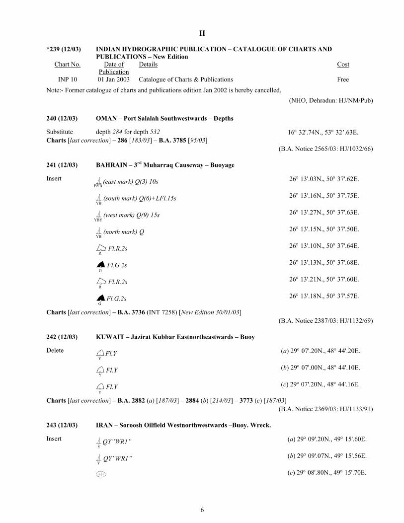
*239 (12/03) INDIAN HYDROGRAPHIC PUBLICATION – CATALOGUE OF CHARTS AND
PUBLICATIONS – New Edition Chart No. Date of
Publication Details Cost
INP 10 01 Jan 2003 Catalogue of Charts & Publications Free Note:- Former catalogue of charts and publications edition Jan 2002 is hereby cancelled.
(NHO, Dehradun: HJ/NM/Pub)
240 (12/03) OMAN – Port Salalah Southwestwards – Depths
Substitute depth 284 for depth 532 16° 32'.74N., 53° 32’.63E. Charts [last correction] – 286 [183/03] – B.A. 3785 [95/03]
(B.A. Notice 2565/03: HJ/1032/66)
241 (12/03) BAHRAIN – 3rd Muharraq Causeway – Buoyage
Insert (east mark) Q(3) 10s YB
26° 13'.03N., 50° 37'.62E.
(south mark) Q(6)+LFl.15s YB
26° 13'.16N., 50° 37'.75E.
(west mark) Q(9) 15s BY
26° 13'.27N., 50° 37'.63E.
(north mark) Q YB
26° 13'.15N., 50° 37'.50E.
Fl.R.2s
26° 13'.10N., 50° 37'.64E.
Charts [last corre
B
Y
242 (12/03)
Delete
Charts [last corre
243 (12/03)
Insert
R
Fl.G.2s
26° 13'.13N., 50° 37'.68E.
Fl.R.2s
26° 13'.21N., 50° 37'.60E.
RG
Fl.G.2s
26° 13'.18N., 50° 37'.57E.
Gction] – B.A. 3736 (INT 7258) [New Edition 30/01/03] (B.A. Notice 2387/03: HJ/1132/69)
KUWAIT – Jazirat Kubbar Eastnortheastwards – Buoy
Fl.Y
(a) 29° 07'.20N., 48° 44'.20E.
YFl.Y
(b) 29° 07'.00N., 48° 44'.10E.
YFl.Y
(c) 29° 07'.20N., 48° 44'.16E.
Yction] – B.A. 2882 (a) [187/03] – 2884 (b) [214/03] – 3773 (c) [187/03] (B.A. Notice 2369/03: HJ/1133/91)
IRAN – Soroosh Oilfield Westnorthwestwards –Buoy. Wreck.
QY”WR1”
(a) 29° 09'.20N., 49° 15'.60E.
YQY”WR1”
(b) 29° 09'.07N., 49° 15'.56E.
Y6
(c) 29° 08'.80N., 49° 15'.70E.
II
(d) 29° 08'.67N., 49° 15'.66E.
Delete (e) close S. of (c) above
(f) close S. of (d) above
Charts [last correction] – B.A. 2882 (a,c,e)[242/03] – 2884 (b,d,f) [242/03] (B.A. Notice 2368/03: HJ/1133/90)
244 (12/03) IRAQ – Khawr az Zubayr – Danger area. Legend. Notes
Insert circular limit of danger line, radius 100m, centred on (a) 30° 09'.36N., 47° 54'.00E.
legend, Wrecks (see Note) close E. of (a) above the accompanying note, WRECKS, centred on: 30° 12'.00N., 48° 04'.80E. Delete former note, WRECKS, centred on: 30° 11'.20N., 48° 00'.80E. Charts [last correction] – B.A. 1238 [327/97]
(B.A. Notice 2367/03: HJ/1133/02)
*245 (12/03) INDIA – West Coast – Port of Mormugao – Legend
Insert legend, Mooring area, centred on: (a) 15° 24'.77N., 73° 48'.38E.
Delete legend, Proposed mooring area, centred on: (b) 15° 24'.77N., 73° 48'.38E.
Charts [last Correction]: 2078 (INT 7346) [228/03] – 2020 [228/03] (Mormugao Port Trust: HJ/1030/56)
246 (12/03) THAILAND – West Coast – Ko Yao Yai Southwards – Hin Mu Sang – Light. Islet.
Substitute Fl(2)15M for Islet (a) 7° 47'.9N., 98° 38'.2E. Fl(2)4s6m15M for Islet (b) 7° 47'.85N., 98° 37'.77E. Charts [last correction] – 41 (a) [218/03] – 433 (b) [213/00]
(B.A. Notice 2490/03: HJ/928/71)
247 (12/03) MALACCA STRAIT – Johor – Tanjung Piai Westwards – Legend. Buoyage. Radar beacon
Insert legend, (buoyed), at (a) 1° 15'.10N., 103° 25'.25E.
(north mark) Q (b) 1° 15'.5N., 103° 25'.3E.
BY
(north mark) Q (c) 1° 15'.51N., 103° 25'.40E.
BY
(east mark) Q(3) (d) 1° 15'.0N., 103° 25'.8E.
YBB
(east mark) Q(3) (e) 1° 15'.01N., 103° 25'.90E.
YBB
radar beacon, Racon (D),at light-buoy (f) (d) above radar beacon, Racon (D),at light-buoy (g) (e) above
(south mark)Q(6)+LFl (h) 1° 14'.5N., 103° 25'.3E.
YB
(south mark)Q(6)+LFl (i) 1° 14'.51N., 103° 25'.40E.
YB
(west mark)Q(9) (j) 1° 15'.0N., 103° 24'.8E.
BYY
(west mark)Q(9)
(k) 1° 15'.01N., 103° 24'.90E.
BYY7
II
8
Delete Fl(2)5s (l) 1° 14'.8N., 103° 24'.4E.
Fl(2)5s (m) 1° 15'.3N., 103° 24'.5E.
Fl(2)5s (n) 1° 15'.3N., 103° 24'.5E.
Fl(2)5s (o) 1° 15'.3N., 103° 24'.6E.
Charts [last correction] – B.A. 1358 (a,l) [204/03] – 2403 (b,d,f,h,j,m) [204/03] – 3833 (b,d,f,h,j,n) [204/03] – 3947 (c,e,g,i,k,o) [204/03]
(B.A. Notice 2413/03: HJ/927/16)
248 (12/03) SINGAPORE STRAIT – Singapore – Johor Shoal Southwards – Submarine cable.
Insert submarine cable, joining: (a) 1° 15'.71N., 104° 04'.13E. (existing cable) 1° 16’.00N., 104° 03'.94E. (existing cable) and (b) 1° 14'.84N., 104° 04'.82E. (existing cable) 1° 14'.89N., 104° 04'.88E. (c) 1° 14'.81N., 104° 04'.86E. (existing cable) legend, Buried, oriented 120° / 300°, centred on: (d) 1° 17'.60N., 104° 01'.90E. (e) 1° 17'.49N., 104° 02'.10E. Delete submarine cable, joining: (f) (a) above 1° 15'.90N., 104° 03'.79E. and (g) (b) above (h) (c) above Charts [last correction] – B.A. 3831(a,f) [157/03] – 4041 (a,d,f) [202/03] – 4042 (a,b,c,e,f,g,h) [112/03]
(B.A. Notice 2353/03: HJ/927/15)
III
9
TEMPORARY AND PRELIMINARY NOTICES
*249 (T) (12/03) INDIA – West Coast – Off Vadinar – Lighterage Operations
Cancel INM 408 (T)/02
1. Lighterage operation will be shifted from LPO Mumbai to LPO Vadinar in area bounded by: (a) 22° 34'. 5N., 69° 38'.0E. (b) 22° 33'. 1N., 69° 38'.0E. (c) 22° 30'. 0N., 69° 37'.3E. (d) 22° 30'. 0N., 69° 36'.0E. (e) 22° 33'. 2N., 69° 36'.0E. 2. All ships and crafts are advised to maintain VHF channel 12 and give wide berth. Charts affected – 2051 – 2060 – 2068 – 203 (SCI, Mumbai: HJ/1131/20)
*250 (T) (12/03) INDIA – West Coast – Honavar Port – Intimation
Cancel INM 257 (T)/02
1. Honavar Port is closed for monsoon w.e.f 16 May 2003. Port will reopen on 16 Sep 2003. 2. All mariners are advised to take caution for above warning. Charts affected – 2024 – 216
(Honavar Port Trust: HJ/1030/45)
*251 (T) (12/03) INDIA – West Coast – Kundapura Port – Intimation
Cancel INM 258 (T)/02
1. Kundapura Port is closed for monsoon w.e.f 16 May 2003. Port will reopen on 16 Sep 2003. 2. All mariners are advised to take caution for above warning. Charts affected – 2073 – 216 – 217 – 258 c
(Kundapura Port Trust: HJ/1030/35)
*252 (P) (12/03) INDIA – East Coast – Vadarevu Anchorage – Light
1. A new light house at Vadarevu in position 15° 48'.0N., 80° 25'.0E. is switched on for trial purpose with character Group flashing two every 15 seconds. 2. Mariners are advised not to use light for navigation. Charts affected – 3008 – 3026 – 355 (INT 7405) – 356 – 31 – 32 (INT 754)
(DLL, Chennai: HJ/1029/59)
*253 (T) (12/03) INDIA – East Coast – Approaches to Hugli River – Sunk vessel
1. Vessel MV Fortune Carrier sunk in approx position 21° 01'.037N., 88° 19'.583E. 2. Mariners are advised to exercise caution. Charts affected – 301 – 351 (INT 7419)
(Kolkatta Port Trust: HJ/1129/11)
III
10
*254 (T) (12/03) INDIA – East Coast – Approaches to Hugli River – Submerged vessel
Cancel INM 236 (T)/03
1. MV Sagitiga Binu has now capsized and lying on her starboard side on a partially submerged condition in position 21° 06'. 7N., 88° 20'.4E. 2. Mariners are advised to keep well clear and exercise caution. Charts affected – 301 – 351 (INT 7419)
(Kolkata Port Trust: HJ/1129/11)

IV
11
MARINE INFORMATION
DETAILS OF PORT INFORMATION ON KAKINADA ANCHORAGE PORT
(a) Rules for vessels navigating through Channels/routes:
The port of Kakinada having 100 Sq. Kms Water spread Bay is situated on the East Coast of India at Latitude 16o 56'N. and Longitude 86o 15' E with the protection of naturally formed 18 Kms long and 1.5 Kms wide Godavari sand spit. More than 2.0 Million of trade per annum is being handled at Kakinada Anchorage Port.
(b) Regulation of Ship Reporting System:
The Master/ Agents should intimate ETA of their Vessels calling at Kakinada Anchorage Port and get bearing position from the Harbour Master for safe anchor of their Vessels in the Anchorage.
(c) Marine Communication in Port:
The Port control VHF is working round the clock in calling channel 16 and special contacts made with the Vessels in roads at the following timings
0545 Hours to 0615 Hrs.
0745 Hours to 0815 Hrs. 1045 Hours to 1115 Hrs. 1245 Hours to 1315 Hrs. 1445 Hours to 1515 Hrs. 1745 Hours to 1815 Hrs. 1945 Hours to 2015 Hrs. 2245 Hours to 2315 Hrs.
(d) Pilot Services: Open Roadstead Port and no Pilotage required for Vessels calling at Anchorage Port. (e) Port Health Clearance Procedures for Arriving Vessels:
Indian Port Health Rules are Applicable to all the Ports in Andhra Pradesh. The Port Health Officer is issuing the free Prepatique/Health Clearance certificates to the Ships Calling at Kakinada Port.
(f) Immigration Clearance Formalities:
Port Registration Officer is looking after the Immigration Clearance formalities at Kakinada Port.
(g) Port clearance formalities for arriving and departing Vessels:
Section 39 (1) of the Indian Ports Act 1908 (XV of 1908) requires that within 24 hours after the arrival within the limits of any port or any Vessel liable to the payment of Port Dues. The Master of the Vessel shall report her arrival to the Port Officer (Conservator) and Section 37 of the Customs Act 1962 (Act 52 of 1962) requires that every Vessel arriving at a Port shall be entered at the Custom House.
If the Port Officer or the Officer for the time being in charge is satisfied that the Master of Vessel about
to clear has complied with all the requirements of the Port and with provisions of section 92 of the English Merchant Shipping Act 1894 and of Section 11 of the Merchant Shipping Act 1958, he shall grant him a certificate of clearance.
IV
12
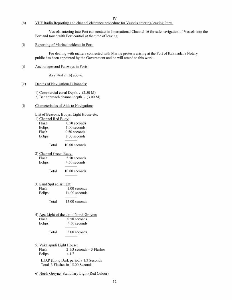
(h) VHF Radio Reporting and channel clearance procedure for Vessels entering/leaving Ports:
Vessels entering into Port can contact in International Channel 16 for safe navigation of Vessels into the Port and touch with Port control at the time of leaving.
(i) Reporting of Marine incidents in Port:
For dealing with matters connected with Marine protests arising at the Port of Kakinada, a Notary public has been appointed by the Government and he will attend to this work.
(j) Anchorages and Fairways in Ports: As stated at (b) above. (k) Depths of Navigational Channels: 1) Commercial canal Depth. . (2.50 M) 2) Bar approach channel depth. . (3.00 M) (l) Characteristics of Aids to Navigation: List of Beacons, Buoys, Light House etc. 1) Channel Red Buoy: Flash 0.50 seconds Eclips 1.00 seconds Flash 0.50 seconds
Eclips 8.00 seconds __________ Total 10.00 seconds __________ 2) Channel Green Buoy:
Flash 5.50 seconds Eclips 4.50 seconds __________ Total 10.00 seconds __________
3) Sand Spit solar light: Flash 1.00 seconds
Eclips 14.00 seconds __________ Total 15.00 seconds __________
4) Aga Light of the tip of North Groyne:
Flash 0.50 seconds Eclips 4.50 seconds __________ Total. 5.00 seconds __________ 5) Vakalapudi Light House: Flash 2 1/3 seconds – 3 Flashes Eclips 4 1/3
L.D.P (Long Dark period 8 1/3 Seconds Total 3 Flashes in 15.00 Seconds 6) North Groyne: Stationary Light (Red Colour)
IV
13
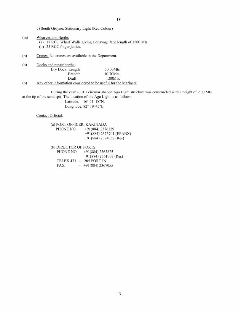
7) South Groyne: Stationary Light (Red Colour)
(m) Wharves and Berths (a) 17 RCC Wharf Walls giving a quayage face length of 1500 Mts. (b) 25 RCC finger jetties.
(n) Cranes: No cranes are available in the Department. (o) Docks and repair berths: Dry Dock: Length 50.00Mts. Breadth 10.70Mts. Draft 1.80Mts. (p) Any other information considered to be useful for the Mariners: During the year 2001 a circular shaped Aga Light structure was constructed with a height of 9.00 Mts. at the tip of the sand spit. The location of the Aga Light is as follows:
Latitude: 16° 51' 18"N. Longitude: 82° 19' 45"E.
Contact Official: (a) PORT OFFICER, KAKINADA PHONE NO. +91(884) 2376129 +91(884) 2375701 (EPABX) +91(884) 2374038 (Res) (b) DIRECTOR OF PORTS: PHONE NO. +91(884) 2363825 +91(884) 2361007 (Res) TELEX 473 – 205 PORT IN FAX – +91(884) 2367055

V
14
NAVIGATIONAL WARNINGS
Refer to Notice No. 12 (Special Edition, Notice to Mariners – 1999). Navigational Warning pertaining to Navigational Warning Area (NAVAREA VIII) is reproduced in this section. Text of NAVAREA VIII known to be cancelled prior to the date indicated are not given. Serial numbers only of Navigational warnings in force, pertaining to other NAVAREAS are given.
(1) Navarea I (N.E. Atlantic) (15 June 2003) 200 Received
(2) Navarea II (E. Atlantic) (15 June 2003)
Nil
(3) Navarea III (Mediterranean) (15 June 2003) 385 Received
(4) Navarea IV (N.W. Atlantic) (15 June 2003) 184 Received
(5) Navarea V (W. Atlantic) (15 June 2003)
Nil
(6) Navarea VI (S.W. Atlantic) (15 June 2003)
Nil
(7) Navarea VII (S.E. Atlantic) (15 June 2003) 083 Received
(8) Navarea VIII (Indian Ocean) (15 June 2003) 326 Received
2003: 276 279 282 284 288 290 294 295 298 305 306 307 310 315 316 318 319 320 322 323 324. 299 to 304. Cancelled.
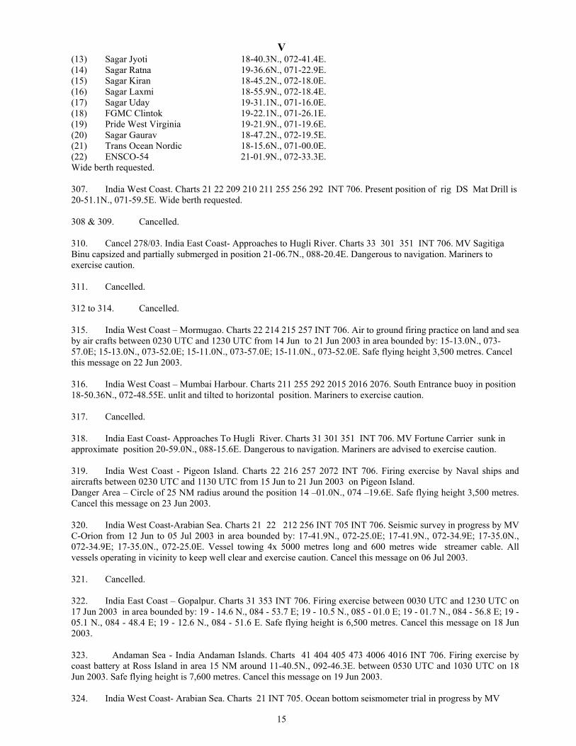
305. Cancel Navarea 250 Of 2003. India East Coast. Charts 31 32 354 355 357 INT 706. Present position of oil rigs as on 04 Jun 2003 as follows: (a) Aban-II 16-18.7N., 081-53.8E. (b) Sagar Vijay in Vizag Port Wide berth requested. 306. Cancel Navarea 251 253 254 267 277 of 2003. India West Coast. Charts 21 22 209 210 211 255 256 292 INT 706. Present position of oil rigs as on 04 Jun 2003 as follows: (1) Pride Pennvania 18-38.8N., 072-14.9E. (2) Hitdrill 19-21.9N., 071-12.7E. (3) Kedarnath 20-26.5N., 071-36.4E. (4) Trident-II 19-29.7N., 071-22.9E. (5) CE Thornton 19-40.8N., 071-44.7E. (6) JT Angel 19-19.9N., 071-20.0E. (7) Frontier Ice 16-03.3N., 072-39.9E. (8) PN III 19-25.6N., 071-16.2E. (9) ED Holt 19-31.7N., 071-22.3E. (10) Ida 19-38.9N., 071-21.0E. (11) Sagar Pragati 19-36.1N., 071-21.1E. (12) Sagar Shakti 19-25.2N., 071-17.0E.
V
15
(13) Sagar Jyoti 18-40.3N., 072-41.4E. (14) Sagar Ratna 19-36.6N., 071-22.9E. (15) Sagar Kiran 18-45.2N., 072-18.0E. (16) Sagar Laxmi 18-55.9N., 072-18.4E. (17) Sagar Uday 19-31.1N., 071-16.0E. (18) FGMC Clintok 19-22.1N., 071-26.1E. (19) Pride West Virginia 19-21.9N., 071-19.6E. (20) Sagar Gaurav 18-47.2N., 072-19.5E. (21) Trans Ocean Nordic 18-15.6N., 071-00.0E. (22) ENSCO-54 21-01.9N., 072-33.3E. Wide berth requested. 307. India West Coast. Charts 21 22 209 210 211 255 256 292 INT 706. Present position of rig DS Mat Drill is 20-51.1N., 071-59.5E. Wide berth requested. 308 & 309. Cancelled. 310. Cancel 278/03. India East Coast- Approaches to Hugli River. Charts 33 301 351 INT 706. MV Sagitiga Binu capsized and partially submerged in position 21-06.7N., 088-20.4E. Dangerous to navigation. Mariners to exercise caution. 311. Cancelled. 312 to 314. Cancelled. 315. India West Coast – Mormugao. Charts 22 214 215 257 INT 706. Air to ground firing practice on land and sea by air crafts between 0230 UTC and 1230 UTC from 14 Jun to 21 Jun 2003 in area bounded by: 15-13.0N., 073-57.0E; 15-13.0N., 073-52.0E; 15-11.0N., 073-57.0E; 15-11.0N., 073-52.0E. Safe flying height 3,500 metres. Cancel this message on 22 Jun 2003. 316. India West Coast – Mumbai Harbour. Charts 211 255 292 2015 2016 2076. South Entrance buoy in position 18-50.36N., 072-48.55E. unlit and tilted to horizontal position. Mariners to exercise caution. 317. Cancelled. 318. India East Coast- Approaches To Hugli River. Charts 31 301 351 INT 706. MV Fortune Carrier sunk in approximate position 20-59.0N., 088-15.6E. Dangerous to navigation. Mariners are advised to exercise caution. 319. India West Coast - Pigeon Island. Charts 22 216 257 2072 INT 706. Firing exercise by Naval ships and aircrafts between 0230 UTC and 1130 UTC from 15 Jun to 21 Jun 2003 on Pigeon Island. Danger Area – Circle of 25 NM radius around the position 14 –01.0N., 074 –19.6E. Safe flying height 3,500 metres. Cancel this message on 23 Jun 2003. 320. India West Coast-Arabian Sea. Charts 21 22 212 256 INT 705 INT 706. Seismic survey in progress by MV C-Orion from 12 Jun to 05 Jul 2003 in area bounded by: 17-41.9N., 072-25.0E; 17-41.9N., 072-34.9E; 17-35.0N., 072-34.9E; 17-35.0N., 072-25.0E. Vessel towing 4x 5000 metres long and 600 metres wide streamer cable. All vessels operating in vicinity to keep well clear and exercise caution. Cancel this message on 06 Jul 2003. 321. Cancelled. 322. India East Coast – Gopalpur. Charts 31 353 INT 706. Firing exercise between 0030 UTC and 1230 UTC on 17 Jun 2003 in area bounded by: 19 - 14.6 N., 084 - 53.7 E; 19 - 10.5 N., 085 - 01.0 E; 19 - 01.7 N., 084 - 56.8 E; 19 - 05.1 N., 084 - 48.4 E; 19 - 12.6 N., 084 - 51.6 E. Safe flying height is 6,500 metres. Cancel this message on 18 Jun 2003. 323. Andaman Sea - India Andaman Islands. Charts 41 404 405 473 4006 4016 INT 706. Firing exercise by coast battery at Ross Island in area 15 NM around 11-40.5N., 092-46.3E. between 0530 UTC and 1030 UTC on 18 Jun 2003. Safe flying height is 7,600 metres. Cancel this message on 19 Jun 2003. 324. India West Coast- Arabian Sea. Charts 21 INT 705. Ocean bottom seismometer trial in progress by MV

V
16
Mezen from 15 Jun 2003 to 22 Jun 2003 area bounded by: (a) 17-35.0N., 066-04.0E. (b) 17-28.0N., 066-23.0E. (c) 17-14.0N., 065-18.0E. (d) 17-23.0N., 066-05.0E. Vessel towing streamer 300 metres long. All vessels operating in vicinity to keep clear and exercise caution. Cancel this message on 23 Jun 2003. 325 & 326. Cancelled.
(9) Navarea IX (Persian Gulf, Red Sea, NW Arabian Sea) (15 June 2003) 131 Received
(10) Navarea X (Australia, New Guinea) (15 June 2003) 015 Received
(11) Navarea XI (Malacca Strait, China Sea, N. Pacific)
(15 June 2003) 0244 Received
(12) Navarea XII (N.E.Pacific) (15 June 2003)
122 (18) Received
(13) Navarea XIII (N.W.Pacific) (15 June 2003)
Nil
(14) Navarea XIV (S.W. Pacific) (15 June 2003) 060 Received
(15) Navarea XV (S.E. Pacific) (15 June 2003)
Nil
(16) Navarea XVI (E. Pacific) (15 June 2003)
Nil
(17) Hydropacks (15 June 2003)
800 (62) Received
(18) Hydrolants (15 June 2003)
915 (53) Received

VI
CORRECTION TO SAILING DIRECTIONS INP 1 West Coast of India Pilot (1981 Edition) Gulf of Khambhat approaches – Alang
147
After Line No.27, Insert
Alang General information. Alang anchorage (21° 30’N., 72° 20’E) is a major shipbreaking area. Ships are beached for breaking twice a month at HW of over 10m. There is no restriction on the size of vessel, but vessels must arrive free of cargo. Notice of ETA. 72, 48 and 24 hours notice is required.
Anchorage. Anchorage is about 5 miles SSW of Piram Island in 11 m of water. Services. Airport at Bhavnagar, 50 km distant.
Useful marks: Alang Light (21° 24’.2N., 72° 11’.1E) Other navigational aids: Racon (21° 24’.2N., 72° 11’.1E) at Alang Lighthouse. Racon (21° 35’.9N., 72° 21’.2E) at Piram Island Lighthouse.
(B.A 23/03) (12/03)
Mandapam
91
After Line No.23, Insert
Twister. A twister of approx base diameter 8 -10 metres was sighted off North Mandapam anchorage on 28 Apr 2003. It was formed directly below a patch of cumulonimbus clouds and touched the surface of the sea. The phenomenon lasted for about 8-10 minutes and dissipated thereafter.
(CGS Mandapam) (12/03)
17

VII
CORRECTIONS TO LIST OF LIGHTS
Edition No. 12 dated 15 June 2003
D 7264 Raastamar 10 26.6 44 58.9
Fl W 5s 22 8 Red column, white bands, on framework tower
fl 1.Ra refl
* * * * * D 7692.1 - 26 34.4
54 00.6 Fl R … … … Reported 2003
* * * * * * * *
D 7692.15 - 26 34.4 54 00.4
Fl G … … … Reported 2003
* * * * * * * * D 7363.451 --- Rear 24 26.7
54 29.8 Lit … …
11 Light reported to be W
* E 6140 Jebel at Tair 15 32.8
41 49.8 Fl W 5s 162 17 White round metal tower and
lantern 20
fl 0.2. Vis 311° -202°(251°). TE 2003
* F 0651 -Tippu Sultan Gudda 13 39.6
74 39.5 Fl (2)W 10s 18 8 6-side column on round hut
9 fl0.5, ec 1, fl 0.5, ec 8. Shown 16.9-15/5. TE 2003
* F 9534 - Lan Tay 7 34.6
108 52.4 Mo(U)W 15s … … Platform
* *
K 0879 -Tg Pinanginang 2 30.1 99 59.5
Fl W 5s 12 11 … fl 0.9. TE 2003
*
18
VIII
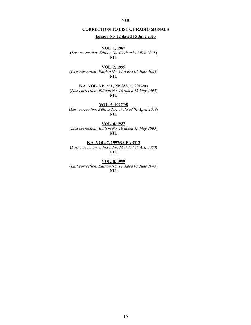
CORRECTION TO LIST OF RADIO SIGNALS
Edition No. 12 dated 15 June 2003
VOL. 1, 1987
(Last correction: Edition No. 04 dated 15 Feb 2003) NIL
VOL. 2, 1995
(Last correction: Edition No. 11 dated 01 June 2003) NIL
B.A. VOL. 3 Part 1, NP 283(1), 2002/03
(Last correction: Edition No. 10 dated 15 May 2003) NIL
VOL. 5, 1997/98
(Last correction: Edition No. 07 dated 01 April 2003) NIL
VOL. 6, 1987
(Last correction: Edition No. 10 dated 15 May 2003) NIL
B.A, VOL. 7, 1997/98-PART 2
(Last correction: Edition No. 16 dated 15 Aug 2000) NIL
VOL. 8, 1999
(Last correction: Edition No. 11 dated 01 June 2003) NIL
19

To accompany Notice to Mariners (244/03)
On. B.A. Chart 1238
WRECKS Numerous wrecks are known to exist within the area of this chart. However their precise locations are not known and mariners are advised to proceed with caution. Certain wrecks in the area may also contain unexploded ordnance. STRANDED WRECK in position 30° 09’.36N., 47° 54’00E. is considered to be particularly hazardous and a wide berth is recommended.