Embed Size (px)
Citation preview

Independent RevIew of the BUnd wALL At the poRt of GLAdStone
Report on findingsApril 2014

Independent Review of the Bund Wall at the Port of Gladstone Report on Findings – April 2014
iiii
© Commonwealth of Australia 2014
this work is copyright. Apart from any use as permitted under the Copyright Act 1968, no part may be reproduced by any process without prior written permission from the Commonwealth. Requests and enquiries concerning reproduction and rights should be addressed to the department of the environment, public Affairs, Gpo Box 787 Canberra ACt 2601 or email [email protected]
the views and opinions expressed in this publication are those of the authors and do not necessarily reflect those of the Australian Government or the Minister for the environment.
while reasonable efforts have been made to ensure that the contents of this publication are factually correct, the Commonwealth does not accept responsibility for the accuracy or completeness of the contents, and shall not be liable for any loss or damage that may be occasioned directly or indirectly through the use of, or reliance on, the contents of this publication.
iiiContents
Contents
Glossary vi
Executive summary vii
1. Introduction 1
1.1. Background 1
1.2. Scope and membership of the Review 1
1.3. Support for the Review 2
2. Legislative and regulatory context 5
2.1 Background 5
2.2 Australian Government assessment process 5
2.3 Queensland Government assessment and approval process 9
2.4 Australian Government approval process 10
3. Design, construction and functioning of the outer bund wall 11
3.1 Background 11
3.2 Assessment of the bund wall design 14
3.2.1 overall bund footprint 14
3.2.2 Geological and/or geomorphic variation of the seabed 15
3.2.3 Characteristics and placement of the geotextile fabric liner 16
3.3 Assessment of the bund wall construction and function 17
4 Monitoring requirements and operations 19
4.1 Background 19
4.2 provision of baseline data 23
4.3 Selection of relevant chemical, physical and biological parameters and trigger values 24
4.4 Adequacy of water quality monitoring sites 25
4.4.1 Relationship to the reclamation bund 27
Independent Review of the Bund Wall at the Port of Gladstone Report on Findings – April 2014
iviv
4.4.2 port Curtis Integrated Monitoring program 27
4.4.3 Reference sites 28
4.5 timing of sampling 29
4.6 Community concerns about the monitoring program 29
5. Department of the Environment responsibilities regarding the functioning of the bund wall 33
5.1 Background 33
5.2 department of the environment response to ‘leak’ allegation 34
5.3 factors contributing to departmental response 35
5.3.1 Resourcing 35
5.3.2 Specification of conditions 36
5.3.3 fisherman’s Landing 37
5.3.4 Regulatory cooperation 38
5.4 Business improvement 39
5.5 Conditions of Approval 40
5.6 Community confidence 40
Appendix 1: Gladstone bund wall submissions 42
Appendix 2: Summary of regulatory framework documents 43
Appendix 3: References 44
Appendix 4: Map caveats 46
vContents
List of Figures
Figure 1: Location of the Port of Gladstone 6
Figure 2: Western Basin Strategic Dredging and Disposal Project spatial extent 7
Figure 3: Geographic relationship between the Western Basin Strategic Dredging and Disposal Project and the original Fisherman’s Landing referral 8
Figure 4: GHD concept design 11
Figure 5: Final design (similar to the original EIS design) 12
Figure 6: Map of impact zones and monitoring sites for the Western Basin Strategic Dredging and Disposal Project 21
Figure 7: Water quality monitoring sites in Gladstone Harbour 28
Figure 8: Gladstone Ports Corporation image of sinker lines 31
Independent Review of the Bund Wall at the Port of Gladstone Report on Findings – April 2014
vivi
Glossary
ANZECC: Australian and new Zealand environment and Conservation Council
The Department: Australian Government department of the environment administering the Environment Protection and Biodiversity Conservation Act 1999
DCMP: dredging and Construction Management plan
DERM: department of the environment and Resource Management (Queensland)
DTRP: dredge technical Reference panel
EIS: environmental Impact Statement
EPBC Act: Environment Protection and Biodiversity Conservation Act 1999 (Cwlth)
EPBC approval: approval under the Environment Protection and Biodiversity Conservation Act 1999
GPC: Gladstone ports Corporation Limited, the approval holder for the western Basin Strategic dredging and disposal project. GpC is a government owned corporation constituted under the provision of the Government Owned Corporations Act 1993.
The Minister: Australian Government Minister for the environment
NTU: nephelometric turbidity units
Paleochannel: remnant of an inactive river or stream channel that has been either filled or buried by younger sediment
TEP: transitional environmental program
The Panel: Gladstone Bund wall Independent Review panel
Percentile trigger: maximum acceptable deviation from a water quality reference point based on a relatively undisturbed system. for example, a 90th percentile trigger is exceeded when turbidity measurements are in the highest 10 per cent of values recorded as the baseline reference values.
Port of Gladstone: area defined by the Port of Gladstone port limits together with adjoining islands and landside areas, including reclamation areas, that support existing or consented industrial developments or are proposed to cater for future port-related industrial activities and supporting infrastructure
The Review: Gladstone Bund wall Independent Review
The previous (independent) review: independent review of environmental management arrangements and governance of the port of Gladstone, undertaken in 2013
WBDDP: port of Gladstone western Basin Strategic dredging and disposal project
WQMP: water Quality Management plan

viiexecutive Summary
Executive summary
Gladstone ports Corporation has approvals under Australian and Queensland government legislation for the port of Gladstone western Basin Strategic dredging and disposal project. the approvals allow for a maximum of 46 million cubic metres of dredge spoil to be removed and disposed of both offshore and within a constructed reclamation area.
Between June 2011 and July 2012, during the western Basin Strategic dredging and disposal project, events relating to the performance of the bund wall occurred. the Gladstone Bund wall Independent Review was commissioned to examine and report on information relevant to the design, construction and functioning of the outer bund wall of the western Basin Strategic dredging and disposal project and to consider the adequacy of monitoring requirements.
the terms of Reference for the Gladstone Bund wall Independent Review do not mandate the examination of issues pertaining to the ecological consequences of the construction and performance of the bund wall, including possible impacts on ecosystem health. however, the Review is relevant to the community’s legitimate expectations for the achievement of economic, social and environmental outcomes for the port of Gladstone, and, more broadly, the Great Barrier Reef.
the panel found that aspects of the design and construction of the bund wall were not consistent with industry best practice. Inadequate restraint of a geotextile liner, piping of water and sediment through paleochannels under the wall and the erosion of mud outside the wall all contributed to changes in turbidity in the vicinity of the bund wall.
the Australian Government approval of the port of Gladstone western Basin Strategic dredging and disposal project reduced the footprint of the bund by 100 hectares on the landward side of the reclamation area. this led to the proponent revising the design of the bund wall, which then impacted on the wall’s functioning. the revised design changed the near-shore hydrodynamics and resulted in the mobilisation of additional sediment along the western side of the constructed bund wall.
One of the key elements of the final design was the screening of the core rock to remove material of less than 12 millimetre diameter and the placement of a geotextile liner on the internal face of the bund wall. The geotextile was inadequately restrained, exposing it to significant disruption by hydraulic pressure and internal wave action within the bund. this affected the capacity of the bund wall to retain sediment, and therefore increased turbidity in the vicinity of the wall. turbidity increases in the vicinity of the bund wall were also influenced by piping under the wall and mud wave erosion on the outside of the wall.
while considerable water quality monitoring was undertaken in Gladstone harbour, the location of monitoring sites was inadequate to provide attribution of changes in turbidity during construction and dredging operations. Compliance monitoring sites were inadequate to identify and then assist in managing discharge from the bund wall. Record-keeping practices in relation to compliance monitoring were also inadequate, impacting negatively on the ability of the department of the environment to ensure adequate compliance with its Conditions of Approval.
Independent Review of the Bund Wall at the Port of Gladstone Report on Findings – April 2014
viiiviii
while the Australian Government did approve the port of Gladstone western Basin Strategic dredging and disposal project subject to a number of conditions, these conditions lacked sufficient specificity to enable their effective assessment and/or enforcement. In particular, the lack of specificity created uncertainty in how the condition was to be applied, thereby limiting the department of the environment’s ability to respond to alleged breaches of conditions.
Other deficiencies evident in the Australian Government’s actions include:
• inconsistencies in decision-making processes
• inadequate resources applied to compliance monitoring, including poor record keeping and inadequate follow-up when breach allegations persisted
• lack of coordination between the jurisdictions, particularly on compliance monitoring – a critical issue given that the main regulator for the western Basin Strategic dredging and disposal project was the Queensland Government.
The consequences of these deficiencies were compounded by a fragmented framework of Australian and Queensland government regulation.
The Panel also identified instances where incidents were not reported to regulators in a timely manner and various categories of information were not made immediately available to the public. The Panel was, however, unable to find evidence of monitoring data or other information being withheld by either governments or the proponent. Rather, there was a complex set of reporting requirements with a considerable amount of data collected by different sources and for varying purposes. This contributed to the low level of public confidence in the monitoring and reporting regime.
This Review has found a number of significant deficiencies in the overall performance of the environmental regulators and the Gladstone ports Corporation responsible for the construction of the wall. With the benefit of hindsight, some actions taken by both Australian and Queensland governments and the proponent in the delivery of the western Basin Strategic dredging and disposal project were less than optimal.
There is insufficient evidence to attribute motive or, indeed, overall long-term harm from these deficiencies. In fact, genuine attempts were made by all parties to reduce impacts on the environment. there were, however, numerous instances where government regulations and approval conditions, management actions, and monitoring results were poorly communicated to the general public. this led to poor understanding of the western Basin Strategic dredging and Disposal Project among a number of stakeholders and a general loss of community confidence and trust in governments and the Gladstone ports Corporation.
The Review has made a number of findings and recommendations consistent with its Terms of Reference.

ixexecutive Summary
Finding 1. Modelling to understand potential consequences of the change in size and shape of the reclamation area on tidal velocities, bed shear stress and associated sediment transport should have been undertaken prior to final approval of the design and commencement of construction.
Finding 2. the overall design of the bund wall was consistent with industry best practice for addressing the known geological and/or geomorphic variation of the adjacent seabed.
Finding 3. while additional groundwater modelling could have been undertaken by the proponent to better understand the likely consequences of piping to inform the final design and construction method of the bund wall, it would have been difficult for the designers to anticipate the observed piping failure.
Finding 4. The design of the bund wall with respect to the technical specifications of the geotextile liner did meet industry best practice and/or recognised industry standards.
Finding 5. the design of the bund wall with respect to the placement and restraint of the geotextile liner did not meet industry best practice and/or recognised industry standards.
Finding 6. the observed elevated turbidity in the vicinity of the bund wall was due to a combination of factors, including changed water velocities that occurred as a result of the bund’s presence, the poor initial sealing of the bund resulting from the structurally compromised geotextile liner, the unexpected piping resulting from the physical characteristics of paleochannels, and the erosion of mud on the outside of the bund wall.
Finding 7. the observed impacts of constructing and sealing the bund were greater than predicted during the environmental impact statement phase of the project.
Finding 8. Gladstone ports Corporation consulted in a timely and extensive manner with stakeholders, consultants and the dredge technical Reference panel once turbidity exceedances were observed.
Finding 9. Gladstone ports Corporation’s response to seal the inside of the bund wall with settled dredged material was appropriate under the circumstances.
Findings and recommendations
Design, construction and functioning of the outer bund wall
Recommendation 1. for the construction of bund walls in coastal environments with high geological and/or geomorphic variation, governments should require proponents to explicitly assess the risk of piping and to implement appropriate controls.

Independent Review of the Bund Wall at the Port of Gladstone Report on Findings – April 2014
xx
Recommendation 2. for constructions of bund walls in coastal environments, any geotextile materials designed to filter sediment should:
• be placed on the inner bund wall material and then be overlaid and secured by core material
• be keyed into the rock armour material to prevent slippage and deformation from occurring prior to placement of the core material
• be laid on the bund wall such that no wrinkles, gaps, folds or deformations occur in the material, with all joints sewn to create seams and to conform to the requirements of Australian Standards 3706: Geotextiles – Methods of test. overlaps in the fabric should be directed vertically down the slope of the armour material.
Recommendation 3. Governments should require proponents of bund wall structures to ensure that potential impacts on sediment transport from the construction phase of a bund wall be understood prior to final approval.
Recommendation 4. Gladstone ports Corporation, its contractors and the Queensland and Australian governments should publish in the peer-reviewed literature the lessons from an engineering perspective on the construction of the bund wall to inform future design and impact assessment.
Monitoring requirements and operations
Finding 10. Although there are some differences between the Australian and Queensland government Conditions of Approval, the two sets of approval conditions with respect to water quality monitoring are complementary and provided an objective basis to manage construction and dredging activities.
Finding 11. A single water quality management plan was designed and prepared to comply with Australian and Queensland government Conditions of Approval. the water Quality Management plan for the western Basin Strategic dredging and disposal project did not meet best practice, as it failed to include all updated trigger levels.
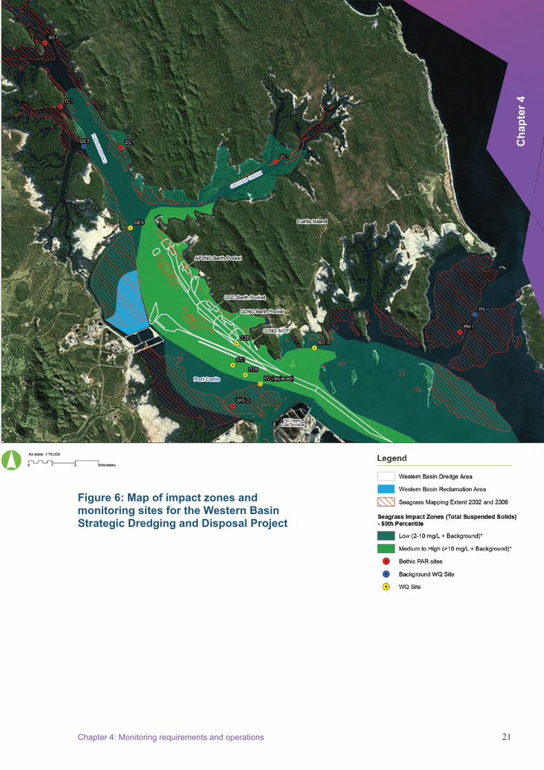
Finding 12. the location of low-, medium- and high-impact zones could not be easily determined, in part due to differences in some definitions between the Australian and Queensland governments.
Finding 13. the status of the approved water Quality Management plan and its subsequent revisions was not clearly documented and then effectively communicated to relevant advisory bodies (e.g. the dredge technical Reference panel) and the general public.
xiexecutive Summary
Finding 14. the baseline water quality datasets do not fully meet Australian and new Zealand environment and Conservation Council guidelines (i.e. two full dry and wet seasons of monitoring to establish a baseline) with dry season data being available at only three of the six sites; however, what is available does provide a useful baseline.
Finding 15. the monitoring framework underpinning the water Quality Management plan is consistent with the Australian and Queensland government Conditions of Approval.
Finding 16. the development and utilisation of a light attenuation trigger for the low-impact monitoring sites is considered best practice; however, this was poorly implemented in relation to the overall water Quality Management plan and poorly communicated to the general public.
Finding 17. Significant community misunderstanding exists as to the expected impacts on water quality across the low- and medium/high-impact zones.
Finding 18. the processes for initially determining and subsequently modifying the boundaries of the low- to medium/high-impact zone were poorly documented.
Finding 19. the location of monitoring sites was inadequate to provide detailed analysis of changes in turbidity at the scale of individual projects.
Finding 20. no compliance monitoring sites existed to identify and then assist in managing discharge from the bund wall.
Finding 21. the port Curtis Integrated Monitoring program was not designed for identifying and managing the consequences arising from dredging generally and the bund wall specifically.
Finding 22. while the use of reference sites to provide additional information to assist in decision making is good practice, in Gladstone harbour the methods for evaluating possible non-dredging related causes of the turbidity increases were only generally described and qualitative, thereby limiting their effectiveness.
Finding 23. through voluntary monitoring activities Gladstone ports Corporation did obtain additional datasets on harbour water quality during the construction of the bund. Gladstone ports Corporation was not under any legal obligation to make these data public.
Finding 24. the movement of site C3 was necessary given the bund construction and had no bearing on management decisions. no silt curtains were used along the north-eastern wall; inoperative dredge pipes were mistaken by some members of the community for silt curtains.
Finding 25. the effectiveness of monitoring would have been improved by including more sites in the low-impact zone.
Finding 26. Specific conditions for monitoring around the bund wall were inadequate and conditions only called for management responses to exceedances in the low-impact zone.

Independent Review of the Bund Wall at the Port of Gladstone Report on Findings – April 2014
xiixii
Finding 27. the roles of the co-existing conditions for monitoring associated with the western Basin Strategic dredging and disposal project, Queensland Government monitoring activity and the voluntary port Curtis Integrated Monitoring program are not well understood by the community.
Recommendation 5. the Australian and Queensland governments should endeavour to align their respective Conditions of Approval to the maximum extent possible, particularly in terms of defining the extent, severity and duration of acceptable impacts and stating where no impacts are acceptable.
Recommendation 6. future water quality management plans should aim to address all condition/permit requirements within a single internally consistent document. where this is not feasible or practical, plans should explicitly explain the relationships between the different approvals/permits and how and where they are addressed.
Recommendation 7. the Australian and Queensland governments and project proponents should ensure that the status of water quality management plans and any revisions therein are effectively and efficiently managed and communicated to relevant advisory bodies and the general public.
Recommendation 8. high-quality background environmental data should be recognised as critical environmental infrastructure and its acquisition and maintenance be a high priority for the Australian and Queensland governments.
Recommendation 9. Consideration should be given by the Australian and Queensland governments to the development of spring and neap tide criteria in tropical coastal systems, either as a replacement for the seasonal criteria or to provide an additional level of assurance.
Recommendation 10. Governments and proponents should clearly communicate the location and purpose of water quality monitoring sites to the general public.
Recommendation 11. for large and complex developments in sensitive marine environments such as Gladstone harbour, governments and proponents should implement a single integrated monitoring framework that encapsulates reference, long-term and management monitoring sites with clear reporting requirements and decision pathways.
xiiiexecutive Summary
Finding 28. there is poor community understanding that enforcement action need not be taken if remedial action is taken quickly to address a possible breach.
Finding 29. Record-keeping practices in relation to compliance monitoring were inadequate, impacting negatively on the ability of the department of the environment to ensure adequate compliance with its Conditions of Approval.
Finding 30. Insufficient resourcing for Department of the Environment monitoring compromised the Australian Government’s ability to adequately ensure compliance with its Conditions of Approval.
Finding 31. departmental attendance at post-approval advisory and technical bodies, such as the dredge technical Reference panel, is essential for appropriately monitoring major projects.
Finding 32. Many of the Australian Government conditions lacked sufficient specificity to enable their effective assessment and/or enforcement. In particular, the lack of specificity relating to condition 8 limited the department of the environment’s ability to respond to alleged breaches of conditions by creating uncertainty about how the condition was to be applied.
Finding 33. failure to reconsider the ‘not a controlled action’ decision for fisherman’s Landing under the Environment Protection and Biodiversity Conservation Act 1999 led to fragmented Australian Government regulation of the western Basin Strategic dredging and disposal project.
Finding 34. Although Australian and Queensland government officers monitored compliance with their respective Conditions of Approval, there was limited information sharing between the two jurisdictions. further, there was no clear understanding by either jurisdiction as to how the Australian and Queensland governments would cooperate on regulation of the western Basin Strategic dredging and disposal project.
Finding 35. Business improvement processes being implemented by the department of the environment are likely to lead to better compliance and enforcement for major projects.
Finding 36. finalisation of the approval bilateral agreements between the Australian and state governments has the potential to deliver better compliance and enforcement for major projects.
Finding 37. the Gladstone healthy harbour partnership provides an appropriate mechanism to ensure independent oversight of the appropriateness of monitoring and management methods, including broader considerations of cumulative impacts.
Department of the Environment responsibilities regarding the functioning of the bund wall
Independent Review of the Bund wall at the port of Gladstone Report on findings – July 2014
xivxiv
Recommendation 12. the Australian Government (and state governments where relevant) should ensure proponents of major projects better inform community understanding of what conditions of approval mean, what might constitute a breach of conditions and when enforcement action might be taken.
Recommendation 13. Australian Government record-keeping practices should be improved to ensure the integrity of the compliance and enforcement system, including adequate written justification for decisions about whether or not a breach of conditions has occurred.
Recommendation 14. Resource levels within the department of the environment should be sufficient to ensure adequate monitoring capacity, including for active participation in post-approval technical committees.
Recommendation 15. Internal processes within the department of the environment should ensure that the advice of compliance officers relating to the measurability and enforceability of conditions is fully considered, with adequate justification being recorded when that advice is not accepted.
Recommendation 16. project expansion should trigger a requirement to both reconsider cumulative impacts and avoid regulatory fragmentation. Relevant powers exist in the Environment Protection and Biodiversity Conservation Act 1999 to require referral of a larger action and to reconsider a decision.
Recommendation 17. for major projects either currently implemented or under regulatory assessment, consideration should be given to establishing joint arrangements across jurisdictions to work cooperatively to ensure seamless compliance monitoring.
Recommendation 18. Increased resourcing being applied to monitoring and compliance in the department of the environment should be maintained as a matter of priority.
Recommendation 19. the Australian Government should establish clear protocols to provide greater confidence in industry-collected data and information for decision making and environmental oversight, through a process involving peak industry and professional bodies, publicly funded research agencies, universities, state governments and environmental non-government organisations.

1Chapter 1: Introduction
Cha
pter
1
1 Introduction
the port of Gladstone western Basin Strategic dredging and disposal project (wBddp) is being undertaken by the Gladstone ports Corporation (GpC). this project was approved under Queensland law on 23 July 2010, and under Australia’s national environmental law, the Environment Protection and Biodiversity Conservation Act 1999 (epBC Act), in october 2010 (epBC 2009/4904).i the approvals allow for a maximum of 46 million cubic metres of dredge spoil to be removed and disposed of offshore and within a constructed reclamation area. Stage 1A, accounting for approximately 25 million cubic metres of dredging, has been completed.
1.1 Background during the construction of the reclamation area, events relating to the performance of the bund wall occurred and were reported to the relevant government authorities.
In february 2013, the Australian Government commissioned an independent review of the environmental management and governance of the port of Gladstone (the previous Independent Review) in response to a request from the world heritage Committee. the outcomes of the previous Independent Review can be found at www.environment.gov.au/topics/marine/great-barrier-reef/port-gladstone-review.
Information previously unavailable to the department of the environment and the 2013 Independent Review has recently become publicly available.
1.2 Scope and membership of the Reviewon 30 January 2014 the Minster for the environment, the hon Greg hunt Mp, announced the appointment of an independent panel (the panel) to conduct a review (the Review) into the bund wall at the port of Gladstone. the Minister appointed dr Andrew Johnson and Ms Anthea tinney as co-chairs of the Review and dr Ian Cresswell as a panel member. the terms of reference for the Review are set out below.
Terms of reference
The terms of reference for the Gladstone Bund Wall Independent Review are to:
1. examine and report on information relevant to the design and construction and functioning of the outer bund wall of the western basin reclamation area that has become available since the Independent Review reported on its findings.
2. provide advice as required to assist with the department’s current review of the outer bund wall leak incidents in 2011 and 2012.
3. consider the adequacy of monitoring requirements and operations.
4. seek submissions from relevant stakeholders on the design, construction and other matters relating to the subsequent leaking of the bund wall.

Independent Review of the Bund Wall at the Port of Gladstone Report on Findings – April 2014
22
the Review examined the relevant available information surrounding the events that led to the reporting of concerns regarding the integrity of the bund wall and the events that led to GpC being granted a transitional environmental program by the Queensland Government.
the Review also examined information that was made available to the department of the environment during 2011 and 2012 relevant to the bund wall performance, as well as a number of other information resources including:
• engineering advice available to regulators at the time of the change in bund wall design
• information that was available to the previous Independent Review
• reported compliance with relevant Australian Government approval processes and agreed management approaches.
the Review also examined the adequacy of water quality monitoring relevant to the construction and operation of the bund wall.
In undertaking this Review, the panel noted that many stakeholders used the term ‘leak’ when describing their perspective on the performance of the bund wall. the panel considers that in the case of the wBddp, an appropriately constructed bund wall would have been a ‘permeable’ wall – in other words, one that does allow water to flow through the wall in both directions but does not allow suspended sediment or other coarse material to pass through the wall. this is an important consideration for ensuring water quality and for the management of potential acid sulphate soils. this bund wall was not designed to act as a fully sealed dam.
1.3 Support for the ReviewSecretariat support for the Review was provided by the department of the environment, with the head of the secretariat seconded from an area of the department with no direct relationship to past or present EPBC Act referrals. The Panel was also supported by an independent legal officer to advise it on relevant matters including probity, process and procedural fairness.
the panel members met a number of times during the period of the Review, either in person or by teleconference or videoconference.
The Panel members executed a deed outlining confidentiality and privacy obligations in respect of the Review, and declared any conflicts of interest upon their appointment. Conflict of interest was a standing agenda item for meetings of the panel.
A call for public submissions to the Review was made on 13 february 2014, through advertisements placed in the local, state and national press. A background paper accompanied the call for submissions; this contained information about the Review and guidance on provision of submissions. public submissions closed on 28 february 2014. All submissions were provided in full to the panel for their consideration. Submissions can be viewed at www.environment.gov.au/marine/gbr/gladstone-bund-wall-review/submissions.
22
3Chapter 1: Introduction
Cha
pter
1
the panel commissioned independent expert advice from engineers Australia and the western Australian Marine Science Institution on matters pertaining to engineering and water quality monitoring respectively. the panel also met with a number of stakeholders throughout the review process.
the department of the environment undertook an internal review of the bund wall that ran concurrently with this Review. The Panel considered a draft report on the findings from the departmental review as part of its deliberations. the panel also provided input into the department of the environment’s internal review in accordance with this Review’s second term of Reference.
the panel thanks the experts who provided legal, engineering and water quality monitoring advice during the Review. Finally, the Panel expresses its gratitude to the secretariat for the significant contribution they made to the Panel’s deliberations and the finalisation of this report.

44 Independent Review of the Bund Wall at the Port of Gladstone Report on Findings – April 2014
5
Cha
pter
2
Chapter 2: Legislative and regulatory context
2 Legislative and regulatory context
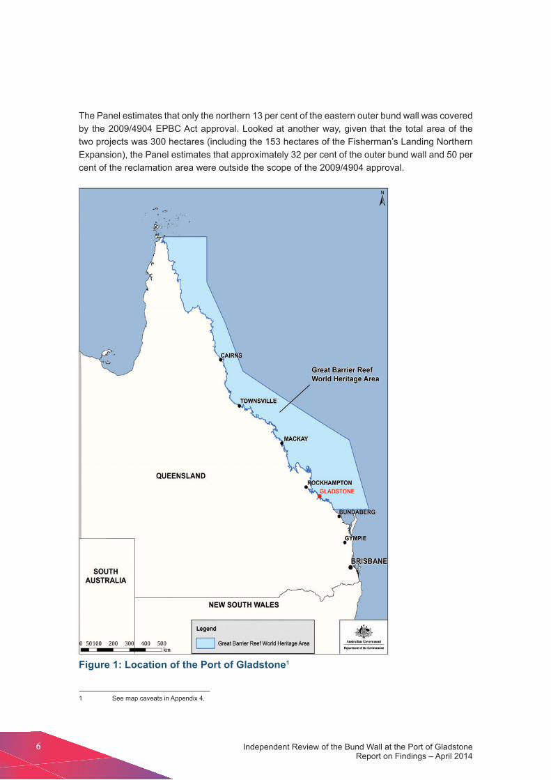
2.1 BackgroundIn examining and reporting on the design, construction and functioning of the outer bund wall of the wBddp in Gladstone harbour, central Queensland (figure 1), the panel sought to understand the legislative and regulatory frameworks that guided decision making by relevant governments. the translation of these frameworks into assessment and approval processes similarly guided the actions of the proponent through the construction process. Accordingly, these processes provide essential context for the Panel’s findings and recommendations.
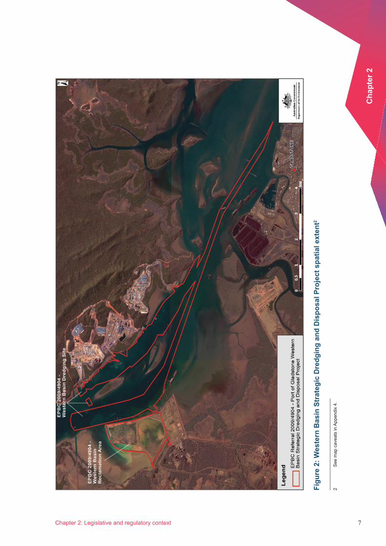
2.2 Australian Government assessment processAny action that is likely to have a significant impact on a matter of national environmental significance must be referred for assessment and approval under the epBC Act. the wBddp was referred under the epBC Act on 20 May 2009 and determined to be a ‘controlled action’ in June 2009. figure 2 shows the location of the wBddp.
Under section 45 of the epBC Act, the Commonwealth environment Minister may enter into a bilateral agreement with a state or territory on behalf of the Australian Government. Such agreements seek to reduce duplication of environmental assessment and approval processes by allowing the Australian Government to ‘accredit’ particular state or territory assessment and approval processes. the wBddp was covered by an assessment bilateral agreement with the Queensland Government, so the action was assessed under the accredited Queensland Government assessment process.
part of the reclamation area proposed for the wBddp had been previously referred under the epBC Act in 2000. this earlier referral (epBC 2000/124)ii was for the fisherman’s Landing northern expansion reclamation area. the fisherman’s Landing referral was determined to be ‘not a controlled action’ under the epBC Act. this decision meant that Australian Government approval was not required for the project, provided it was undertaken in accordance with the referral (and subject to any other state or local government requirements). figure 3 shows the geographic relationship between the wBddp and the original fisherman’s Landing referral.
the wBddp epBC Act referral 2009/4904 notes that the fisherman’s Landing northern expansion component of the project had been previously referred under the epBC Act and determined to be ‘not a controlled action’ (epBC 2000/124). the referral intended that the fisherman’s Landing northern expansion remain as a separate project, and the department of the environment concurred with this. Given that the wBddp expanded the physical extent of the proposed fisherman’s Landing northern expansion bund wall, most (but not all) of the eastern bund wall was outside the scope of the approval and therefore not controlled by the epBC Act.
66 Independent Review of the Bund Wall at the Port of Gladstone Report on Findings – April 2014
the panel estimates that only the northern 13 per cent of the eastern outer bund wall was covered by the 2009/4904 epBC Act approval. Looked at another way, given that the total area of the two projects was 300 hectares (including the 153 hectares of the fisherman’s Landing northern expansion), the panel estimates that approximately 32 per cent of the outer bund wall and 50 per cent of the reclamation area were outside the scope of the 2009/4904 approval.
Figure 1: Location of the Port of Gladstone1
1 See map caveats in Appendix 4.
7
Cha
pter
2
Chapter 2: Legislative and regulatory context
Figu
re 2
: Wes
tern
Bas
in S
trat
egic
Dre
dgin
g an
d D
ispo
sal P
roje
ct s
patia
l ext
ent2
2 S
ee m
ap c
avea
ts in
App
endi
x 4.

88 Independent Review of the Bund Wall at the Port of Gladstone Report on Findings – April 2014
Figu
re 3
: Geo
grap
hic
rela
tions
hip
betw
een
the
Wes
tern
Bas
in S
trat
egic
Dre
dgin
g an
d D
ispo
sal P
roje
ct a
nd th
e or
igin
al
Fish
erm
an’s
Lan
ding
refe
rral
3
3 S
ee m
ap c
avea
ts in
App
endi
x 4.
9
Cha
pter
2
Chapter 2: Legislative and regulatory context
2.3 Queensland Government assessment and approval processA project of economic, social and/or environmental significance to Queensland may be declared a ‘coordinated project’ under the State Development and Public Works Organisation Act 1971 (Qld).iii the project proponent must then prepare an environmental impact statement (eIS) when a coordinated project has the potential to cause environmental, social or economic impacts.
Several Queensland Government departments are responsible for reviewing an environmental Impact Statement (eIS), with the Queensland Government’s evaluation being coordinated by the Office of the Coordinator-General. On 24 April 2009,iv the wBddp was declared to be a ‘significant project’4 for which an eIS was required under the State development and public works organisation Act.
Where review of the EIS shows that further work or clarification is needed, the proponent may be asked to produce a Supplementary Information document (SId) for the project. once the eIS has been undertaken to the appropriate standard, an evaluation report (an assessment of the eIS) is prepared by the Coordinator-General. the evaluation report includes the Coordinator-General’s decision on whether the project should proceed subject to certain conditions or be refused on the grounds that its environmental impacts cannot be adequately addressed.
draft terms of reference for the wBddp eIS were advertised for public and advisory agency comment in July 2009. the eIS included a concept design of the reclamation area bund wall that had been developed by the engineering firm GHD. This concept design placed a geotextile liner within the bund wall, with final design specifications to be developed following approval of the EIS.
on conclusion of the eIS consultation process in december 2009, the Coordinator-General determined that Gladstone ports Corporation (GpC) should prepare a SId to the eIS.v the SId was made available for comment in April 2010 to advisory agencies and those who made public submissions to the eIS.
the Western Basin Dredging and Disposal Project – Coordinator-General’s report for an environmental impact statement (July 2010)vi recommended that the wBddp, as described in detail in the eIS and SId, could proceed subject to 143 conditions.
the report directed that the bund wall be constructed generally in accordance with the eIS. It included a condition that all fine material (less than 12 millimetres in diameter) be removed from the material used to construct the bund in order to reduce the turbidity plume created during bund wall construction and that a geotextile liner be applied to the internal side of the wall to prevent the release of fine sediments from the reclamation area other than through a designated discharge point.
development approvalvii for the bund wall and temporary shore access construction project was provided by the Queensland department of the environment and Resource Management (deRM) in february 2011. the development approval was granted subject to 54 conditions and included final design specifications.
4 In december 2012, a change to the Queensland assessment process resulted in current and future reference to ‘coordinated projects’ rather than ‘significant projects’.

Independent Review of the Bund wall at the port of Gladstone Report on findings – April 2014
1010
2.4 Australian Government approval processfollowing the assessment undertaken under the Australian Government – Queensland Government bilateral agreement, the department of the environment sought further information from GpC to address remaining departmental concerns and information gaps. In response, GpC carried out further work and provided analysis and options to the department, including project changes to reduce environmental impacts. these changes included reshaping and reduction of the proposed reclamation area by 100 hectares to its final form, with disposal of some dredge spoil at an existing offshore site.
the wBddp was approved under the epBC Act in october 2010 with 52 conditions, viii
which covered:
• quantities to be dredged and placed either offshore or within the reclamation area
• size and shape of the reclamation area
• dredging operations
• development of a dredging and construction management plan (dCMp)
• development of a water quality monitoring program, including establishment of a dredge technical reference panel (dtRp)
• establishment of the port Curtis and port Alma ecosystem Research and Monitoring program
• specification of environmental offsets.
The Australian Government did not approve the final bund wall design specifications prior to construction commencing; it did so through approval of the dCMp (onshore offshore) in July 2011.

1111
Cha
pter
3
Chapter 3: Design, construction and functioning of the outer bund wall
3 Design, construction and functioning of the outer bund wall
3.1 BackgroundIn June 2010, GpC sought tenders for the design and construction of the outer bund wall. to inform the tender submission and assessment process, GpC contracted Ghd to provide a concept design (figure 4).ix This design placed a geotextile liner within the bund wall and also specified a geotextile capable of withstanding tearing during the application of covering rock material during construction. In its tender documentation, however, GpC clearly indicated that alternative designs were permitted.
Figure 4: GHD concept design
10
A
B
GEOTEXTILE FILTER(REFER NOTE 4).
EASTERN BUND(LENGTHS A,B,F)
RL 7.00
SOFT MATERIAL BELOW BUND FOOTPRINT TOBE REMOVED/DISPLACED BY CONTRACTOR'SOWN METHOD
SEA BED (VARIES)
NORTHERN BUND(LENGTH G)
3%
PORT DATUM (LAT) 0.00m
HAT 5.12m LAT
MSL 2.41m LAT
RL 5.20
PRELIMINARY LEVEL
C
D
GEOTEXTILE FILTER(REFER NOTE 4).
RL 7.00
SEA BED (VARIES)
PORT DATUM (LAT) 0.00m
GEOTEXTILE TO BE KEYED IN TRENCH INACCORDANCE WITH MANUFACTURERSRECOMENDATIONS.TYPICAL
5
RL 5.20
PRELIMINARY LEVEL
CORE AND ARMOUR TO BE FOUNDED ON COMPETENT MATERIAL (FIRM TO STIFF CLAY OR BETTER)
VAR
IES
FOUNDING LEVEL VARIES (REFER TO INVESTIGATION DATA)
SOFTCLAY
SOFTCLAY
CORE AND ARMOUR TO BE FOUNDED ON COMPETENT MATERIAL (FIRM TO STIFF CLAY OR BETTER)
FOUNDING LEVEL VARIES (REFER TO INVESTIGATION DATA)
AC001 SCALE 1 :100
BC001 SCALE 1 :100
VAR
IES
1.5
1
1.5
1
1.5
1
HARBOUR1.5
1
RECLAMATION
BUNDCONTROL LINE
3%
150mm RUNNING SURFACE
BUNDCONTROL LINE
150mm RUNNING SURFACE
HARBOURRECLAMATION
SOFT MATERIAL BELOW BUND FOOTPRINT TOBE REMOVED/DISPLACED BY CONTRACTOR'SOWN METHOD
NOTIONAL DISPLACEDSOFT CLAY PROFILE
GEOTEXTILE TIE-IN DETAIL TO BECONFIRMED BY CONTRACTOR
NOTIONAL DISPLACEDSOFT CLAY PROFILE
GEOTEXTILE TIE-IN DETAIL TO BECONFIRMED BY CONTRACTOR
7.9
= ZONE GRADINGZONE MATERIAL DESCRIPTION D15 (mm) D50 (mm) D85 (mm)
A CORE 25 75 155
B ARMOUR LAYER 175 300 435
C CORE 25 75 155
D ARMOUR LAYER 175 300 435
A
0.9
2.1 7.9
1.6
2.1
10
5
5
GEOTEXTILE TO BE KEYED IN TRENCH INACCORDANCE WITH MANUFACTURERSRECOMENDATIONS.TYPICAL
MHWS 4.20m LAT
HAT 5.12m LAT
MSL 2.41m LAT
MHWS 4.20m LAT
2.8
this drawing must not beused for Construction unlesssigned as Approved
date
Checkdrafting
dateApprovedCheckeddrawnRevisionno A1original Size
title
project
Client
Check
designed
Approved
drawn
Scale
designConditions of Use.this document may only be used byGhd's client (and any other person whoGhd has agreed can use this document)for the purpose for which it was preparedand must not be used by any otherperson or for any other purpose.
DO NOT SCALE
Note: * indicates signatures on original issue of drawing or last revision of drawing
CLIentS peopLe peRfoRMAnCe
Plot Date: Cad File No:26 March 2010 - 9:54 AM N:\AU\Brisbane\Projects\42\16100\10 CADD\Drawings\42-16100-C002.dwgPlotted by: Liam houghton
42-16100-C002 DAS Shown
L hoUGhton t ShIeLd
n wAttS d MILLeR
0 1 4 5m32
SCALE 1:100 AT ORIGINAL SIZE
2 / 100 Goondoon Street Gladstone QLd 4680 Australiapo Box 373 Gladstone QLd 4680T 61 7 4973 1600 F 61 7 4972 6236E [email protected] W www.ghd.com.au
TIDAL PLANESLAT
MLWS
MLWN
AHD
MHWN
MHWS
HAT
0.0m
0.76m
1.66m
2.43m
3.30m
4.20m
5.12m
(QUEENSLAND TIDE TABLES 2010)FISHERMAN'S LANDING
MSL 2.41m
NOTES1. ALL DIMENSIONS IN METRES.2. ALL REDUCED LEVELS IN METRES RELATIVE TO PORT DATUM. (LAT).3. ABBREVIATIONS:
HAT HIGHEST ASTRONOMICAL TIDEMHWS MEAN HIGH WATER SPRINGSMSL MEAN SEA LEVELLAT LOWEST ASTRONOMICAL TIDERL REDUCED LEVEL
4. GEOTEXTILE SHALL BE IN ACCORDANCE WITH THE BUNDSPECIFICATION
5. SEA BED LEVEL AND FOUNDING LEVEL VARY.6. CONTRACTOR TO REVIEW AVAILABLE INVESTIGATION DATA AND DETERMINE VOLUME REQUIREMENTS BASED ON OWN ASSESMENT.
1212 Independent Review of the Bund Wall at the Port of Gladstone Report on Findings – April 2014
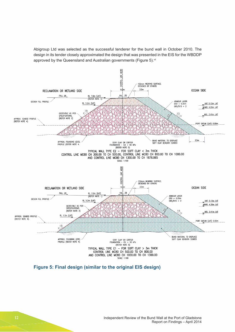
Abigroup Ltd was selected as the successful tenderer for the bund wall in october 2010. the design in its tender closely approximated the design that was presented in the eIS for the wBddp approved by the Queensland and Australian governments (figure 5).vii
Figure 5: Final design (similar to the original EIS design)
13
Cha
pter
3
Chapter 3: Design, construction and functioning of the outer bund wall
As described in Chapter 2, key elements of the successful design included the screening of the core rock to remove material of less than 12 millimetres in diameter and the placement of a geotextile liner on the internal face of the bund wall. the liner was keyed into the wall at the top and the bottom but not covered in core material. Abigroup Ltd’s engineering subcontractors (SMeC) recommended that, given the deployment of the geotextile on the internal face of the bund wall, a geotextile liner of lighter weight and strength than originally specified be used.
the reclamation area, which encompassed the fisherman’s Landing extension and the wBddp, was constructed in eight months from december 2010 to July 2011. Construction was staged so that work under the earlier Fisherman’s Landing approval was done first, between December 2010 and March 2011, and the works approved under the wBddp started from March 2011.
From June 2011, GPC and its contractors identified performance issues with the geotextile liner as a result of its ‘ballooning’ off the wall during spring tides. over subsequent spring tidal cycles, localised bunching and tearing of the textile occurred in some areas. these local failures of the geotextile liner were repaired by the construction contractors.
dredging of the wBddp and deposition of dredge spoil within the bund wall commenced on 6 September 2011. on 7 September 2011,X a Queensland Government officer reported increased turbidity in the harbour around the bund and commenced discussions with GpC on the matter. on 16 September 2011,x deRM issued GpC with a non-compliance warning notice after a site inspection found that elevated turbidity adjacent to the bund was likely being caused by sediment passing through the bund wall and by scouring of the mudflat to the north of the reclamation area.
on 20 September 2011,x deRM again inspected the site and found GpC to be in breach of deRM conditions 20–22. Queensland Government officers found that water exiting from the bund was eroding the mud waves along the outside of the wall and generating turbidity outside the footprint of the wBddp.
on 26 September 2011,x the reclamation area was inspected again by Queensland Government officers, who observed that water was continuing to exit through the bund and eroding the mud waves along the outside of the wall. following this inspection, the Queensland Government considered that no further action was required as the issue was to be managed under the turbidity Management plan (tMp) developed in consultation with the dtRp and approved as a component of the wQMp.
during october 2011, under the tMp, GpC began trialling a number of remediation techniques to seal the bund. The remediation trials identified that a 20 metre width of dredge spoil needed to be placed against the bund wall to seal it. It was recognised by GpC that implementing this remedial action was likely to create high turbidity levels around the bund and nearby harbour. GpC considered that this was to be best managed under the transitional environmental program (tep),xi
which was approved by DERM in June 2012. GPC notified the relevant government authorities that it considered the bund wall to be sealed in August 2012.
1414 Independent Review of the Bund Wall at the Port of Gladstone Report on Findings – April 2014
3.2 Assessment of the bund wall design
3.2.1 Overall bund footprint
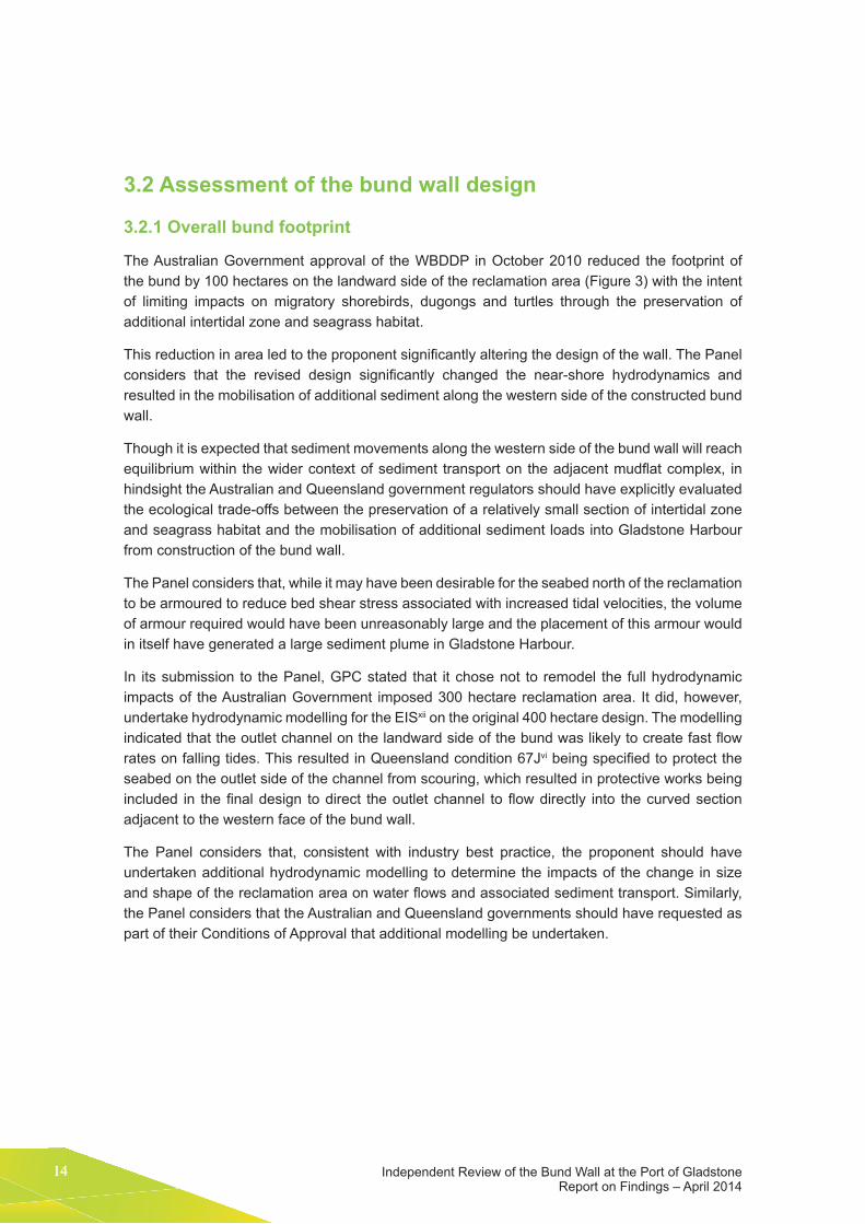
the Australian Government approval of the wBddp in october 2010 reduced the footprint of the bund by 100 hectares on the landward side of the reclamation area (figure 3) with the intent of limiting impacts on migratory shorebirds, dugongs and turtles through the preservation of additional intertidal zone and seagrass habitat.
This reduction in area led to the proponent significantly altering the design of the wall. The Panel considers that the revised design significantly changed the near-shore hydrodynamics and resulted in the mobilisation of additional sediment along the western side of the constructed bund wall.
though it is expected that sediment movements along the western side of the bund wall will reach equilibrium within the wider context of sediment transport on the adjacent mudflat complex, in hindsight the Australian and Queensland government regulators should have explicitly evaluated the ecological trade-offs between the preservation of a relatively small section of intertidal zone and seagrass habitat and the mobilisation of additional sediment loads into Gladstone harbour from construction of the bund wall.
the panel considers that, while it may have been desirable for the seabed north of the reclamation to be armoured to reduce bed shear stress associated with increased tidal velocities, the volume of armour required would have been unreasonably large and the placement of this armour would in itself have generated a large sediment plume in Gladstone harbour.
In its submission to the panel, GpC stated that it chose not to remodel the full hydrodynamic impacts of the Australian Government imposed 300 hectare reclamation area. It did, however, undertake hydrodynamic modelling for the eISxii on the original 400 hectare design. the modelling indicated that the outlet channel on the landward side of the bund was likely to create fast flow rates on falling tides. this resulted in Queensland condition 67Jvi being specified to protect the seabed on the outlet side of the channel from scouring, which resulted in protective works being included in the final design to direct the outlet channel to flow directly into the curved section adjacent to the western face of the bund wall.
the panel considers that, consistent with industry best practice, the proponent should have undertaken additional hydrodynamic modelling to determine the impacts of the change in size and shape of the reclamation area on water flows and associated sediment transport. Similarly, the panel considers that the Australian and Queensland governments should have requested as part of their Conditions of Approval that additional modelling be undertaken.

15
Cha
pter
3
Chapter 3: Design, construction and functioning of the outer bund wall
FINDING
Finding 1. Modelling to understand potential consequences of the change in size and shape of the reclamation area on tidal velocities, bed shear stress and associated sediment transport should have been undertaken prior to final approval of the design and commencement of construction.
3.2.2 Geological and/or geomorphic variation of the seabed
The presence of paleochannels under the reclamation area was identified during geotechnical investigations by the proponent. to ensure the stability of the wall over these channels, the proponent and its contractor proposed using a ‘mud wave’ technique to place large rocks onto the seabed, displacing the seabed laterally to the inside and outside of the foot of the wall in the form of a wave.
It was considered that the resulting rock and sediment layer would be stable and could be expected to be generally impermeable unless differential water pressure was of sufficient magnitude to force out some of the mud from between the rocks (a process known as piping). whether piping occurs depends on the hydraulic gradient and the internal stability of the mud and rock combination; this assessment would require groundwater modelling in combination with an examination of the sediment grading.
the panel considers that, while additional groundwater modelling could have been undertaken by the proponent to better understand the likely consequences of piping to inform the final design and construction method of the bund wall, it would have been difficult for the designers to anticipate the observed piping failure. It was reasonable to expect that the mud would provide a seal in an environment where the differential head on either side of the bund is small.
FINDING
Finding 2. the overall design of the bund wall was consistent with industry best practice for addressing the known geological and/or geomorphic variation of the adjacent seabed.
Finding 3. while additional groundwater modelling could have been undertaken by the proponent to better understand the likely consequences of piping to inform the final design and construction method of the bund wall, it would have been difficult for the designers to anticipate the observed piping failure.
RECOMMENDATION
Recommendation 1. for the construction of bund walls in coastal environments with high geological and/or geomorphic variation, governments should require proponents to explicitly assess the risk of piping and to implement appropriate controls.

1616 Independent Review of the Bund Wall at the Port of Gladstone Report on Findings – April 2014
3.2.3 Characteristics and placement of the geotextile fabric liner
As mentioned earlier, key elements of the final design included the screening of the core rock to remove material of less than 12 millimetres in diameter and the placement of a geotextile liner on the internal face of the bund wall. the liner was keyed into the wall at the top and the bottom but not covered in core material.
As the bund wall core rock particles were a minimum of 12 millimetres in diameter (and hence the core was highly permeable), for the geotextile liner to successfully prevent the passage of suspended sediment to Gladstone harbour it must be less permeable than the core of the wall.
the panel considers that the geotextile liner must be suitably restrained (typically by covering it with rock) to prevent it being susceptible to hydraulic pressure and disruption, until the bund is full of dredge material.
the panel also considers that, while the choice of the geotextile was considered appropriate, the use of a largely unrestrained exposed geotextile liner on the internal wall of a bund is not accepted best practice. the lack of restraint made the geotextile highly susceptible to disruption by hydraulic pressure as a result of tidal lag and internal wave action within the bund.
Had the specified geotextile liner been placed under a rock layer and hence adequately secured, the design (and subsequent construction) would be considered as meeting best industry practice. the panel considers that if the geotextile liner had been placed under rock then it was unlikely to have been damaged by the overlaying rock placement. the weight of core rocks should not have caused tearing, nor should the weight of the armour rocks, assuming they were placed carefully.
FINDING
Finding 4. the design of the bund wall with respect to the technical specifications of the geotextile liner did meet industry best practice and/or recognised industry standards.
Finding 5. the design of the bund wall with respect to the placement and restraint of the geotextile liner did not meet industry best practice and/or recognised industry standards.
RECOMMENDATION
Recommendation 2. for constructions of bund walls in coastal environments, any geotextile materials designed to filter sediment should:
• be placed on the inner bund wall material and then be overlaid and secured by core material
• be keyed into the rock armour material to prevent slippage and deformation from occurring prior to placement of the core material
• be laid on the bund wall such that no wrinkles, gaps, folds or deformations occur in the material, with all joints sewn to create seams and to conform to the requirements of Australian Standards 3706: Geotextiles – Methods of Test. Overlaps in the fabric should be directed vertically down the slope of the armour material.

17
Cha
pter
3
Chapter 3: Design, construction and functioning of the outer bund wall
3.3 Assessment of the bund wall construction and function The first spring tides after dredge spoil began to be placed in the reclamation area occurred in mid-September 2011 and coincided with the first of a number of exceedances of the turbidity triggers specified in the Queensland Government approvals.
during construction of the bund wall, it was observed that the geotextile liner on the internal face was ‘ballooning’ off the wall. this process – known as ‘tidal lag’ – was caused by the tide inside the bund being smaller and later than the harbour tide, which generated flows through the bund in both directions due to water elevation differences on either side of the bund wall.
over a period of several months in late 2011, coinciding with the spring tides, localised bunching and tearing of the textile occurred along the bund wall that compromised its structural and functional integrity.
the panel considers that much of the observed turbidity in the vicinity of the bund wall was due to bund leakage, piping under the wall and mud wave erosion on the outside of the wall.
during September 2011, GpC took further measures to address the turbidity exceedances associated with the reclamation area.xiii This included contracting:
• Golder & Associates to investigate options to remedy the performance of the geotextile
• Asia Pacific Applied Science Associates (ApASA) to assess current velocity and direction around the bund
• BMt wBM to model sources of turbidity
• vision water Quality Monitoring and ApASA to conduct additional water quality monitoring.
By october 2011, remedial options for securing the geotextile in place were being trialled. these included dredge spoil and quarry overburden being deposited on the geotextile to hold it in place, and injection techniques to deliver concrete and bentonite grout into the bund wall. these interventions were considered by GpC to be unsuccessful.
In addition to trialling remediation techniques for securing the geotextile, in october 2011 GPC began to divide the reclamation into southern and northern halves to restrict flows to the paleochannels through the construction of an internal bund wall. the southern cell was sealed with dredge spoil by May 2012.
trials to seal the bund wall with dredge spoil during november 2011 demonstrated that a 20 metre wide wall of settled dredge spoil was effective at sealing the wall and paleochannels. GpC then applied to the Queensland Government for a tep to allow this approach to be implemented. Approval for the tep was granted in June 2012 and the bund system was considered by GpC and the Queensland Government to have been effectively sealed in August 2012. the panel considers that, under the circumstances, the approach adopted by GpC to remedy the failure was appropriate.
1818 Independent Review of the Bund Wall at the Port of Gladstone Report on Findings – April 2014
FINDING
Finding 6. the observed elevated turbidity in the vicinity of the bund wall was due to a combination of factors, including changed water velocities that occurred as a result of the bund’s presence, the poor initial sealing of the bund resulting from the structurally compromised geotextile liner, the unexpected piping resulting from the physical characteristics of paleochannels, and the erosion of mud on the outside of the bund wall.
Finding 7. the observed impacts of constructing and sealing the bund were greater than predicted during the environmental impact statement phase of the project.
Finding 8. Gladstone ports Corporation consulted in a timely and extensive manner with stakeholders, consultants and the dredge technical Reference panel once turbidity exceedances were observed.
Finding 9. Gladstone ports Corporation’s response to seal the inside of the bund wall with settled dredged material was appropriate under the circumstances.
RECOMMENDATION
Recommendation 3. Governments should require proponents of bund wall structures to ensure that potential impacts on sediment transport from the construction phase of a bund wall be understood prior to final approval.
Recommendation 4. Gladstone ports Corporation, its contractors and the Queensland and Australian governments should publish in the peer-reviewed literature the lessons from an engineering perspective on the construction of the bund wall to inform future design and impact assessment.

19
Cha
pter
4
Chapter 4: Monitoring requirements and operations
4 Monitoring requirements and operations
4.1 BackgroundApproval conditions that relate to monitoring were specified by the Australian Government (EPBC 2009/4904), by the Queensland Coordinator-General’s report on the wBddp (2010), and by the subsequent deRM5 development approvalsvii for construction in february 2011 and dredging in June 2011. the relevant water quality conditions were consolidated into a single wQMpxiv
designed to comply with the Australian Government and Queensland Government conditions.
Key objectives of the wQMp are set out in the Australian Government Conditions of Approvalviii (condition 22) and the Queensland Government Conditions of Approvalvi (condition 27). they include:
• verifying the results of plume modeling and predicted effects, including the spatial extent, magnitude and duration of elevated turbidity and/or elevated light attenuation in the vicinity of dredging and related activities
• providing information that can be used to alter dredge methods and/or implement mitigation in an adaptive management framework to ensure protection of sensitive marine ecosystems
• preparing a water quality management plan to identify, assess and manage the impacts from dredging and construction of the reclamation area on the water quality of the project area.
the deRM construction development approvalvii also contained conditions related to the construction of the bund reclamation area. the primary objectives of this permit (deemed to be most relevant to this Review) were to:
• ensure that the bund walls are constructed to minimise impact and ensure that dredge spoil is contained within the bund
• ensure that the release of contaminants from any potential acid sulphate soils is minimised.
5 following the change of government in Queensland in 2011, the deRM was abolished and its functions were allocated to the department of environment and heritage protection; department of national parks, Recreation, Sport and Racing; department of natural Resources and Mines; department of energy and water Supply; and department of Science, Information technology, Innovation and the Arts.

Independent Review of the Bund wall at the port of Gladstone Report on findings – April 2014
20
the deRM dredging development approval conditions also refer to the fisherman’s Landing northern expansion and western Basin Bund Construction water Quality Monitoring program. while the deRM development Approvalxv contains trigger criteria based on the 99th percentile of background water quality data from when it was first approved in June 2011, it allows for variations to the trigger criteria by approval in writing. Based on additional data provided by GpC and its own review – and in consultation with the stakeholders – the Queensland department of environment and heritage protection then revised the 99th percentile turbidity trigger limits,xvi to higher levels of permitted turbidity (ntU) for the low-impact monitoring sites Qe4 and St1 in May 2012.
the key elements of the management regime in both sets of primary approval conditions were the wQMp and the dCMp (dredge management plan in the Queensland Government conditions). These elements are interrelated: the WQMP is designed to provide environmental information, criteria and decision schemes, and the dCMp to manage the dredging and construction activities based on the outputs of the wQMp.
Both sets of conditions recognised the degree of uncertainty surrounding the contemporary state of knowledge around predicting and managing the effects of large scale dredging in tropical environments. Both sets of conditions also required the establishment of a dtRp to assist in refinement and implementation of the WQMP and, importantly, to assist in interpreting the monitoring data to assess the need for and extent of any dredging management.
having a single wQMp is recognised by the panel as a best practice approach for aligning the respective Australian Government and Queensland Government Conditions of Approval to the maximum extent possible, particularly when defining the extent, severity and duration of acceptable impacts. Alignment of conditions should allow the streamlining of formal compliance auditing by assisting proponents to clearly demonstrate compliance, and assisting regulators to evaluate and enforce compliance if required. however, this was not achieved in the wBddp due to turbidity trigger levels being updated in the Queensland Government development permits and then not reflected in revisions of the WQMP.
The WQMP was revised a number of times after it was first approved in April 2011. The version in effect at the time of this Review was approved on 11 September 2013 (Revision 10)xiv. It is not clear to the Panel what the basis was for the modifications, whether they incorporated the advice of the dtRp, or by what mechanism they may have been approved. the status of each version of the wQMp and exactly which version(s) was/were being used at any point in the dredging program is also unclear to the panel.
the wQMp sets internal trigger levels to provide early warning and opportunities for pre-emptive management to reduce the risk of potential breaches of reportable triggers. the Queensland approval conditions require monitoring for action in the low-impact zone (figure 6)xiv and monitoring for impact in the medium-impact zone (Queensland Government condition 47). the initial stage of the wQMp saw the implementation of monitoring that managed water quality within zones of predicted high, medium and low impact, with water quality triggers based on background conditions and predicted sediment plume loading from dredging. the wQMp is a ‘living document’ that has gone through 10 revisions. It now includes the implementation of management light incidence and attenuation triggers and only utilises two zones of impact management (a medium- to high-impact zone and a low-impact zone) designated based on the 50th percentile of the modelled plume elevation due to dredging.
21
Cha
pter
4
Chapter 4: Monitoring requirements and operations
Figure 6: Map of impact zones and monitoring sites for the Western Basin Strategic Dredging and Disposal Project

Independent Review of the Bund wall at the port of Gladstone Report on findings – April 2014
22
the Queensland Government Conditions of Approval require monitoring and management to be focused on the low-impact zone to ensure that there are no impacts on benthic communities in this zone. The Australian Government conditions use the terms ‘exposed’ (defined as being within the vicinity of dredging and other project-related activities) and ‘reference’ (not defined). The Australian Government conditions also require triggers for management actions when impacts are observed in areas predicted to be impacted by dredge activities and when impacts are observed in areas where they have not been predicted. the conditions do not require management monitoring in the high-impact zone where it is accepted that there will be significant impacts; however, the WQMP established three monitoring sites in the high-impact zone to monitor physicochemical properties for research purposes and to inform the monitoring of long-term harbour health and change.
the wQMp is based on turbidity triggers derived from statistical analysis of datasets collected prior to dredging. these ‘before’ datasets provide the benchmark to assess the extent, magnitude and duration of any dredging-related effects. the Conditions of Approval make reference to the AnZeCC guidelines,xvii which in turn provide guidance to managers and identify a number of issues to consider when developing criteria using baseline data. the Conditions of Approval recommend moving to criteria based on seagrass light requirements in preference to turbidity per se, but also recognise that there was insufficient knowledge to require that change immediately.
the wQMp (figure 6)xiv recognises a gradient of impact arising from the dredging and disposal activities. for management purposes and consistency with the Conditions of Approval, the area is divided into three zones based on interrogation of modelling outputs. The first, closest to the turbidity-generating activities, is the zone of high to medium impact. Seagrasses are the key ecological receptor, and losses in this zone are likely to be between 40 and 100 per cent. outside this is a zone of low impact/influence where no losses of seagrass are predicted. In the third zone, located outside the high/medium- and low-impact zones, no influence of turbidity-generating activities is expected.
the Conditions of Approval require monitoring and management to be focused on the zone of low impact, to ensure that there are no impacts on benthic communities in this zone. Seagrasses are the key benthic communities found in the vicinity of the dredging areas and the reclamation bund, whereas seagrass and corals are the focus for the offshore spoil placement area.
Although the low-impact zone is defined as the area where no impacts are predicted to occur, the WQMP recognises that there may be significant short-term impacts on seagrasses within the low-impact zone. the wQMp allows for a permit for marine plant removal within the low-impact zone, which was granted for the bund wall project. while this seems to be at odds with the intent of the Conditions of Approval applying to this proposal, this is a common practice to mitigate the risk of unintended seagrass death.

23
Cha
pter
4
Chapter 4: Monitoring requirements and operations
4.2 Provision of baseline data the AnZeCC water quality guidelines provide guidance on collecting and analysing environmental data for the purposes of deriving environmental quality guidelines. Key considerations are variability and periodicity. one of the most important periodicity factors is seasonality, both intra-annual (seasonal) and inter-annual (between years). the more data that are available the better, but to account for seasonality the guidelines recommend at least 24 months (two seasonal cycles) of data be used to derive locally relevant guidelines. this advice is primarily related to typical
FINDING
Finding 10. Although there are some differences between the Australian and Queensland government conditions of approval, the two sets of approval conditions with respect to water quality monitoring are complementary and provided an objective basis to manage construction and dredging activities.
Finding 11. A single water Quality Management plan was designed and prepared to comply with Australian and Queensland government conditions of approval. the water Quality Management plan for the western Basin Strategic dredging and disposal project did not meet best practice, as it failed to include all updated trigger levels.
Finding 12. the location of low, medium and high-impact zones could not be easily determined, in part due to differences in some definitions between the Australian and Queensland governments.
Finding 13. the status of the approved water Quality Management plan and its subsequent revisions was not clearly documented and then effectively communicated to relevant advisory bodies (e.g. the dredge technical Reference panel) and the general public.
RECOMMENDATION
Recommendation 5. the Australian and Queensland governments should endeavour to align their respective conditions of approval to the maximum extent possible, particularly in terms of defining the extent, severity and duration of acceptable impacts and stating where no impacts are acceptable.
Recommendation 6. future water quality management plans should aim to address all condition/permit requirements within a single internally consistent document. where this is not feasible or practical, plans should explicitly explain the relationships between the different approvals/permits and how and where they are addressed.
Recommendation 7. the Australian and Queensland governments and project proponents should ensure that the status of water quality management plans and any revisions therein are effectively and efficiently managed and communicated to relevant advisory bodies and the general public.
Independent Review of the Bund wall at the port of Gladstone Report on findings – April 2014
24
regular (e.g. monthly or weekly) sampling that would generate 24 to 104 values over a 24-month period, thereby ensuring greater confidence that the full range of conditions have been measured than if only part of the year had been sampled.
Automated techniques with high-frequency sampling (e.g. in situ sensors and data loggers) are preferable to regular (e.g. weekly or monthly) sampling. not all parameters are amenable to this type of sampling (e.g. nutrients and metals) but the physical/chemical stressors such as temperature, salinity and turbidity are relatively easy to monitor at high frequency with in situ sensors and data recorders. The WBDDP monitoring program was designed to address the identified risk of data loss due to equipment failure through the deployment of duplicate instruments. Instrument malfunction is to be expected; wherever possible, duplicate instruments should be – and were – deployed to reduce the risk of data losses occurring due to equipment failure.
FINDING
Finding 14. the baseline water quality datasets do not fully meet Australian and new Zealand environment and Conservation Council guidelines (i.e. two full dry and wet seasons of monitoring to establish a baseline) with dry season data being available at only three of the six sites; however, what is available does provide a useful baseline.
4.3 Selection of relevant chemical, physical and biological parameters and trigger valuesthe monitoring framework underpinning the wQMp was consistent with an adaptive management approach outlined in the Australian Government and Queensland Government Conditions of Approval. For instance, specific turbidity criteria (in NTU) were developed for sites in the zones of low impact and high to medium impact; however, the trigger values were based on a statistical analysis of background values rather than the light requirements of seagrass as required by the Conditions of Approval, with a directed research component to ascertain appropriate light-based requirements.
the 80th and 95th percentiles of turbidity were used as the basis for internal alert and external reporting triggers respectively in the wQMp. the logic and assumptions behind the data analyses, manipulations and selected trigger levels were clearly presented. trigger levels were determined for wet and dry seasons to account for the regional climatic drivers of turbidity. however, spring versus neap tidal states appear to be the strongest and most consistent drivers of background turbidity. A strong spring to neap cyclic signal pattern is evident in practically all of the time series turbidity datasets. the difference between spring and neap periods appears to be proportionally greater than the difference between wet and dry seasons.
RECOMMENDATION
Recommendation 8. high-quality background environmental data should be recognised as critical environmental infrastructure and its acquisition and maintenance be a high priority for the Australian and Queensland governments.

25
Cha
pter
4
Chapter 4: Monitoring requirements and operations
Based on examination of the minutes of the dtRp,xviii the panel considers that there was considerable effort directed towards developing and refining seagrass-related light-based criteria consistent with the approval requirements. during the course of the project the trigger levels for key management monitoring sites (the low-impact zone monitoring stations Qe4 and BG10) were changed to reflect revised scientific understanding of the light requirements for seagrass (as set out in the Australian and Queensland government Conditions of Approval). however, the wQMp does not include these changed trigger criteria based on the 99th percentile of background data for sites; it is the deRM permitxvi that outlines these values.
Given that the wQMp is designed to be a single coherent guide to water quality monitoring for the dredging and spoil disposal program, it is not clear why there is no reference to the requirements of the deRM permit and why the deRM requirements were not integrated into the wQMp. It is also unclear how these light-based criteria were formally put into operation during the dredging program or used as the basis for triggering formal compliance actions.
the panel encourages the continued development and use of indicators and criteria designed to maintain critical light levels, particularly when they can be coupled with readily measurable and direct indicators of sub-lethal stress. Light attenuation is considered more robust than turbidity as it is a direct measure of the transparency of the water, which in turn directly controls light availability to the seagrasses.
FINDING
Finding 15. the monitoring framework underpinning the water Quality Management plan is consistent with the Australian and Queensland Government conditions of approval.
Finding 16. the development and utilisation of a light attenuation trigger for the low impact monitoring sites is considered best practice; however, this was poorly implemented in relation to the overall water Quality Management plan and poorly communicated to the general public.
4.4 Adequacy of water quality monitoring sitesAs previously discussed, the WQMP identifies different impact zones (Figure 6) for the WBDDP. Monitoring sites are spread across these zones but only exceedances at sites in the low-impact zone trigger a management response. data recorded from monitoring sites in the medium/high-impact zone are intended to be used for research purposes and to inform the monitoring of long-term harbour health and change.
RECOMMENDATION
Recommendation 9. Consideration should be given by the Australian and Queensland Governments to the development of spring and neap tide criteria in tropical coastal systems, either as a replacement for the seasonal criteria or to provide an additional level of assurance.
Independent Review of the Bund wall at the port of Gladstone Report on findings – April 2014
26
there are inconsistencies in the way the wQMp sets out the name and location of the nominated monitoring sites for the low-impact zones relevant to the bund wall (Qe4, St1, p2B and BG10). figure 6 (taken from the wQMp) shows only site Qe4 within the low-impact zone. Site BG10 is located on the boundary with the medium- to high-impact zone but it is not possible, based on the resolution of figure 6, to determine whether it is inside or outside. Site p2 was inside the low-impact zone but was replaced with site p2B, which is inside the medium- to high-impact zone, thus precluding its use as a monitoring site that would trigger a management response. As such, and assuming site BG10 is within the low-impact zone, only two rather than four turbidity monitoring sites were used for triggering management within the wBddp area (i.e. sites Qe4 and BG10).
the wQMp indicates that where actual measurements exceed those expected from the modelled results (which form the basis of the low-, medium- and high-impact zones) they will be examined in detail and, in consultation with the Queensland Government and the dtRp, the zones of impact and/or internal alert and external reporting trigger levels can be re-evaluated. the minutes of the dtRp meeting of 11 March 2011 note concerns that the impact zones in the plan were based on older eIS data and ‘have been re-adjusted to the latest dredging scenarios and expected dredging equipment and techniques’.
Given the importance of the impact zones with respect to the Conditions of Approval and associated management of the dredging program, it was important to ensure that the boundaries were accurately defined and auditable. Furthermore, the process for modifying them should be clearly set out. this is particularly important if the impact zones are not in the primary approval documentation but in a management plan that is subject to a secondary approval.
FINDING
Finding 17. Significant community misunderstanding exists as to the expected impacts on water quality across the low- and medium/high-impact zones.
Finding 18. the processes for initially determining and subsequently modifying the boundaries of the low- to medium/high-impact zone were poorly documented.
RECOMMENDATION
Recommendation 10. Governments and proponents should clearly communicate the location and purpose of water quality monitoring sites to the general public.

27
Cha
pter
4
Chapter 4: Monitoring requirements and operations
4.4.1 Relationship to the reclamation bund
Based on figure 6 (taken from the wQMp) there are two sites in the inshore area that are used for reactive management. Site BG10 is more than 8 kilometres west-southwest of the reclamation area and on the other side of channel dredging area. the panel considers it to be of no value for identifying and managing turbidity from the bund wall.
Site Qe4 is located within the western basin, approximately 1.8 kilometres north and upstream of the reclamation area. the panel considers this site to have marginal utility for managing turbidity from the bund wall; its utility would be greatest on flood tides and when there is no dredging in the flow path upstream of the bund wall or between the wall and the monitoring site.
While the DERM permit identifies site P2 (and QE4) as a compliance monitoring site for managing the effects of the bund wall, it is approximately 7 kilometres downstream of the discharge point at the northern tip of the bund wall. the panel considers that it is too far away to be able to differentiate turbidity from the bund wall, dredging operations or, potentially, vessel movements.
FINDING
Finding 19. the location of monitoring sites was inadequate to provide detailed analysis of changes in turbidity at the scale of individual projects.
Finding 20. no compliance monitoring sites existed to identify and then assist in managing discharge from the bund wall.
4.4.2 Port Curtis Integrated Monitoring Program
the port Curtis Integrated Monitoring program (pCIMp)xix is a voluntary program conducted by Gladstone harbour stakeholders that provides a number of monitoring sites with good geographic coverage of the harbour. these sites were not part of the conditioned monitoring program associated with the wBddp. Similarly, a number of seagrass monitoring sites established as part of the pCIMp and additionally for the wBddp provided very useful information about the ecological effects of anthropogenic and natural pressures that influence system health at the whole of Gladstone harbour scale.
FINDING
Finding 21. the port Curtis Integrated Monitoring program was not designed for identifying and managing the consequences arising from dredging generally and the bund wall specifically.

Independent Review of the Bund wall at the port of Gladstone Report on findings – April 2014
28
4.4.3 Reference sites
Reference sites located outside the area of influence of dredging and disposal activities were established to identify turbidity effects that may be due to factors unrelated to the wBddp activities (figure 7)xiii. the panel considers that the locations of the reference sites were reasonable in that they were not predicted to be affected by dredging or disposal. however, the methods for evaluating possible non-dredging-related causes of the turbidity increases were only generally described and qualitative. the utility of reference sites is very high, as they contribute further lines of evidence to assist in decision making, but it is important to establish a priori how they are to be used and the decision schemes that apply.
FINDING
Finding 22. while the use of reference sites to provide additional information to assist in decision making is good practice, in Gladstone harbour the methods for evaluating possible non-dredging related causes of the turbidity increases were only generally described and qualitative, thereby limiting their effectiveness.
Figure 7: Water quality monitoring sites in Gladstone Harbour
29
Cha
pter
4
Chapter 4: Monitoring requirements and operations
4.5 Timing of samplingthe wQMp was underpinned by continuous high-frequency sampling using permanently deployed in situ sensors with data recorded on loggers that were either downloaded periodically or telemetered in near real time. the panel considers this type of monitoring system to be best practice in that it provides near real-time access to information to allow for adaptive (and proactive) management of turbidity-generating activities, as well as for timely formal compliance-related reporting. telemetered systems also provide early warning of potential sensor malfunction, helping to ensure that a largely continuous time series record can be maintained. dual sensors were utilised to help reduce the frequency and duration of breaks in time series data.
the wQMp included regular monitoring on weekly/monthly cycles to provide supplementary information (e.g. depth profiles of turbidity, light attenuation, nutrients, chlorophyll A and metals). the panel considers analysing both total and dissolved metals monthly a positive approach that adds value to the efficacy of the whole program.
4.6 Community concerns about the monitoring programthe panel examined a number of community concerns about the monitoring, reporting and communication of data. It has been alleged that GpC was in possession of a September–october 2011 water quality management report from vision environmentxx that identified the presence of algal blooms and elevated metals in Gladstone harbour and that this information was provided to the Queensland Government. It has also been alleged that both parties then withheld this information from stakeholders during 2011.
A timeline provided by GpC,xxi for the production of the September–october 2011 water quality management report indicates that a series of discussion papers to inform management meetings during this time were provided to GpC from 14 october 2011 until 3 february 2012, and that GpC did not receive the final consolidated September–October report until March 2012.
the panel considers that GpC was actively investigating water quality in Gladstone harbour through voluntary additional monitoring work during the time to which the allegations apply but that it was not in possession of a complete analysis of and report on findings until March 2012.
during this Review, some stakeholders raised with the panel as a matter of concern the movement of monitoring site C3 (figure 7) and the possible use of silt curtains to shield the water quality monitoring instruments from the worst of the turbidity.
Site C3 was originally a pCIMp background monitoring site; however, as it was located within the footprint of the reclamation area it was moved (december 2010) to near the eastern wall of the bund prior to construction commencing.
It was suggested to the panel that the site was then moved periodically to avoid the worst of the turbidity emanating from the bund. Some stakeholders contended that the intent of this was to avoid exceeding trigger values that would require a management response (such as ceasing dredging).
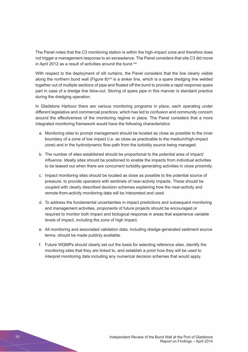
Independent Review of the Bund wall at the port of Gladstone Report on findings – April 2014
30
the panel notes that the C3 monitoring station is within the high-impact zone and therefore does not trigger a management response to an exceedance. the panel considers that site C3 did move in April 2012 as a result of activities around the bund.xxii
with respect to the deployment of silt curtains, the panel considers that the line clearly visible along the northern bund wall (figure 8)xxii is a sinker line, which is a spare dredging line welded together out of multiple sections of pipe and floated off the bund to provide a rapid response spare part in case of a dredge line blow-out. Storing of spare pipe in this manner is standard practice during the dredging operation.
In Gladstone harbour there are various monitoring programs in place, each operating under different legislative and commercial practices, which has led to confusion and community concern around the effectiveness of the monitoring regime in place. the panel considers that a more integrated monitoring framework would have the following characteristics:
a. Monitoring sites to prompt management should be located as close as possible to the inner boundary of a zone of low impact (i.e. as close as practicable to the medium/high-impact zone) and in the hydrodynamic flow path from the turbidity source being managed.
b. the number of sites established should be proportional to the potential area of impact/influence. Ideally sites should be positioned to enable the impacts from individual activities to be teased out when there are concurrent turbidity-generating activities in close proximity.
c. Impact monitoring sites should be located as close as possible to the potential source of pressure, to provide operators with sentinels of near-activity impacts. these should be coupled with clearly described decision schemes explaining how the near-activity and remote-from-activity monitoring data will be interpreted and used.
d. to address the fundamental uncertainties in impact predictions and subsequent monitoring and management activities, proponents of future projects should be encouraged or required to monitor both impact and biological response in areas that experience variable levels of impact, including the zone of high impact.
e. All monitoring and associated validation data, including dredge-generated sediment source terms, should be made publicly available.
f. future wQMps should clearly set out the basis for selecting reference sites, identify the monitoring sites that they are linked to, and establish a priori how they will be used to interpret monitoring data including any numerical decision schemes that would apply.

31
Cha
pter
4
Chapter 4: Monitoring requirements and operations
Figure 8: Gladstone Ports Corporation image of sinker lines
Independent Review of the Bund wall at the port of Gladstone Report on findings – April 2014
32
FINDING
Finding 23. through voluntary monitoring activities Gladstone ports Corporation did obtain additional datasets on harbour water quality during the construction of the bund. Gladstone ports Corporation was not under any legal obligation to make these data public.
Finding 24. the movement of site C3 was necessary given the bund construction and had no bearing on management decisions. no silt curtains were used along the north-eastern wall; inoperative dredge pipes were mistaken by some members of the community for silt curtains.
Finding 25. the effectiveness of monitoring would have been improved by including more monitoring sites in the low impact zone.
Finding 26. Specific conditions for monitoring around the bund wall were inadequate and conditions only called for management responses to exceedances in the low impact zone.
Finding 27. the roles of the co-existing conditions for monitoring associated with the western Basin Strategic dredging and disposal project, Queensland Government monitoring activity and the voluntary port Curtis Integrated Monitoring program are not well understood by the community.
RECOMMENDATION
Recommendation 11. for large and complex developments in sensitive marine environments such as Gladstone harbour, governments and proponents should implement a single integrated monitoring framework that encapsulates reference, long-term and management monitoring sites with clear reporting requirements and decision pathways.

33
Cha
pter
5
Chapter 5: Department of the Environment responsibilities regarding the functioning of the bund wall
5. Department of the Environment responsibilities regarding the functioning of the bund wall
5.1 BackgroundConcerns relating to the functioning of the bund wall have continued to be raised with the Australian Government Minister for the environment. Because this Review was commissioned by the Minister and one of its tasks was to provide input into the department of the environment’s internal review of the matter, this chapter relates specifically to the actions of the Department. It does not, therefore, deal with the compliance actions of the Queensland Government. As discussed in Section 3.1, breaches were issued by the Queensland Government for leaks from the bund wall and a tep was implemented in response.
Assessment of projects under the epBC Act is undertaken by the environment assessment officers of the Department of the Environment. Following approval, project management passes to the Department’s compliance and enforcement officers, who are responsible for responding to allegations of non-compliance with the epBC Act, and monitoring and auditing approved projects. Allegations of non-compliance may relate to approved projects (which are handled in the first instance by the post-approvals monitoring teams) or projects without approvals (which are the responsibility of the compliance team). Where a monitoring officer determines that a breach of approval conditions is likely to have occurred, the allegation is referred to the compliance section for further action.
not all allegations received by the department warrant compliance action, as some are outside the scope of the epBC Act. Many allegations are received each year about approved projects that are not relevant to epBC Act approval conditions. Additionally, the department’s approach to approved projects encourages voluntary compliance. If a proponent immediately takes action to rectify a potential breach, the department would usually consider it to be acting responsibly and therefore would not normally take enforcement action against it.
the distinguishing characteristic of the wBddp was the complexity of the regulatory arrangements governing it. not only were there different regulatory bodies (Australian and Queensland government) but there was also inconsistency in the conditions applied by each jurisdiction. Appendix 2 provides a summary of the documents that make up the regulatory framework for the wBddp.
Independent Review of the Bund wall at the port of Gladstone Report on findings – April 2014
34
5.2 Department of the Environment response to ‘leak’ allegation on 4 october 2011, the department of the environment received an allegation that the bund wall surrounding the western Basin dredging project reclamation area appeared to be leaking. This allegation was examined by the monitoring officer responsible for the WBDDP to determine whether a breach was likely to have occurred. In this instance, the monitoring officer concluded that it was not necessary to pass the matter to the compliance section as a likely breach of conditions. The matter was then closed within the monitoring section. As filing in relation to the decision was incomplete, the panel was unable to determine on what basis this decision was made.
the dtRp was established under condition 18 of the epBC Act approval. Among other duties, the dtRp must assess any exceedance of trigger values and seagrass changes at key monitoring locations and advise of changes to dredging practices, through the dCMp, as required (condition 19c)viii.
The DTRP was first formally notified of turbidity associated with bund wall discharge during a meeting on 15 September 2011. the suite of management measures that GpC was required to implement when exceedances occurred was set out in the wQMp; the measures included reporting to and seeking advice from the dtRp. the department received the minutes of the September dtRp meeting on 12 october 2011. on the same day, the dtRp advised the department that the turbidity exceedances were thought to be due to seepage through the bund wall but that this was being addressed and multiple actions were being undertaken to address turbidity.
As GpC was acting in accordance with the approved management plans and advice from the dtRp, the department of the environment considered that GpC had responded appropriately to the reported exceedances. however, the panel considers that it is also possible that the bund discharge issues had not been fully explained to the department, as records examined by the panel refer to clean water from the bund causing scouring. Similarly, an october 2011 audit report commissioned by GpC on compliance with epBC Act conditions does not mention the issue.
The previous review reported that the Department of the Environment did not find the ‘leak’ through the bund wall to be a contravention or breach of conditions. this statement was based on advice provided by the department to the previous review. however, as there was no investigation of the allegation to make a finding on whether a breach occurred, the Panel considers it more accurate to say that at the time the department found that compliance action was not warranted rather than that there was not a breach. there remains uncertainty about whether a breach occurred, as condition 8 lacked sufficient specificity to allow it to be properly assessed.
35
Cha
pter
5
Chapter 5: Department of the Environment responsibilities regarding the functioning of the bund wall
Oversight of the WBDDP within the Department of the Environment required significant staff engagement and almost daily contact with GpC. departmental staff undertook three site visits to the reclamation area in August 2011, february 2012 and June 2012. however, record-keeping practices were not adequate and there are no site visit reports documenting inspections of the bund wall. The information on file implies that departmental staff were not aware of discharges from the bund wall during the site visit undertaken in february 2012.
FINDING
Finding 28. there is poor community understanding that enforcement action need not be taken if remedial action is taken quickly to address a possible breach.
Finding 29. Record-keeping practices in relation to compliance monitoring were inadequate, impacting negatively on the ability of the department of the environment to ensure adequate compliance with its Conditions of Approval.
5.3 Factors contributing to departmental response
5.3.1 Resourcing
At the time when the department of the environment received information relating to the performance of the bund wall, the number of approvals monitoring officers relative to the workload nationally was low. In September 2011, over 800 projects were being monitored by the department with only about 10 staff to undertake monitoring duties. this resource constraint restricted the department’s ability to provide adequate monitoring of the wBddp. the panel also understands that the inadequate level of resourcing, and competing demands from other projects requiring assessment and approval, prevented the Department from assigning officers to attend DTRP meetings.
the large number of approved projects across Australia (currently around 1200) means that departmental monitoring officers cannot confirm project compliance on the ground in real time. Monitoring and compliance officers primarily depend on desktop checks and rely on members of the public and state agencies to report suspected breaches of the legislation.
RECOMMENDATION
Recommendation 12. the Australian Government (and state governments where relevant) should ensure proponents of major projects better inform community understanding of what conditions of approval mean, what might constitute a breach of conditions and when enforcement action might be taken.
Recommendation 13. Australian Government record-keeping practices should be improved to ensure the integrity of the compliance and enforcement system, including adequate written justification for decisions about whether or not a breach of conditions has occurred.

Independent Review of the Bund wall at the port of Gladstone Report on findings – April 2014
36
FINDING
Finding 30. Insufficient resourcing for Department of the Environment monitoring compromised the Australian Government’s ability to adequately ensure compliance with its conditions of approval.
Finding 31. departmental attendance at post-approval advisory and technical bodies, such as the dredge technical Reference panel, is essential for appropriately monitoring major projects.
5.3.2 Specification of conditions
the ability to enforce Conditions of Approval depends on how clearly the conditions are worded. Prior to project approval, compliance officers provide input on whether the proposed conditions are measurable, legal and enforceable. However, the assessment officers are not required to incorporate this feedback or to provide justification for failing to change conditions in response to that advice. Although recommendations were made to improve the enforceability of the proposed conditions for the wBddp, including conditions relating to the bund wall, these recommendations were not adopted. The records examined by the Panel do not provide justification for the advice not being adopted.
the importance of condition clarity is illustrated by condition 8. this condition requires that ‘the design, construction materials and construction methodology and management for the outer bund wall of the western Basin land reclamation area must ensure appropriate design of the reclamation area to prevent water quality impacts from leaching material through the bund wall, decant waters and storm-water run-off’.
Condition 8 does not define certain key terms including ‘water quality impacts’ and ‘leaching’, which are essential for determining whether the condition has been complied with. Comments made by compliance officers prior to approval noted that the wording of condition 8 was open to interpretation and therefore difficult to audit. No changes were made to the wording to improve the department’s ability to ensure compliance with the condition. the lack of clarity of this condition as approved has limited the department’s subsequent ability to respond to alleged breaches of conditions, by creating uncertainty as to how the condition was intended to be applied.
environmental impact is controlled both from direct conditions and from approved management plans that are required by the conditions. Condition 21 of the Australian Government approval requires GpC to develop a water quality monitoring program; conditions 22–24 provide further instruction on the development of the wQMp, which relates to water quality impacts from
RECOMMENDATION
Recommendation 14. Resource levels within the department of the environment should be sufficient to ensure adequate monitoring capacity, including for active participation in post-approval technical committees.

37
Cha
pter
5
Chapter 5: Department of the Environment responsibilities regarding the functioning of the bund wall
dredging rather than from construction of the bund wall. the wQMp, developed in accordance with the conditions, addresses turbidity from dredging and offshore disposal but did not guide the management of turbidity resulting from bund construction or reclamation activities.
FINDING
Finding 32. Many of the Australian Government conditions lacked sufficient specificity to enable their effective assessment and/or enforcement. In particular, the lack of specificity relating to condition 8 limited the department of the environment’s ability to respond to alleged breaches of conditions by creating uncertainty about how the condition was to be applied.
5.3.3 Fisherman’s Landing
the department of the environment’s response to the alleged leak of the bund wall was dictated by the approval history of the project. the construction phase of the wBddp was partially covered by the fisherman’s Landing ‘not a controlled action’ decision (epBC 2000/124), and the sequencing of approved management plans meant that the department did not approve the bund design (which was detailed in a management plan after construction). This created difficulty for the department in managing environmental impacts during construction, as epBC approval decision 2009/4904 only applied to a portion of the bund wall and reclamation area (see figure 3).
Under section 78 of the epBC Act, the Minister may revoke a decision as to whether an action is a ‘controlled action’ under the Act and substitute a new decision. Such reconsiderations are restricted to certain circumstances, such as where the Minster is satisfied that the substitution is warranted by substantial new information about the impacts of the action or by a change in circumstances that was not foreseen at the time of the first decision and relates to impacts on protected matters. however, the Minister must not revoke such a decision after the action has been approved or refused, or after the action is taken.
As the fisherman’s Landing referral (2000/124) was determined not to be a ‘controlled action’, and as such did not require approval under the epBC Act, and as the action had not taken place at the time of the wBddp referral, the Minister had the option at that time to reconsider the original fisherman’s Landing ‘not a controlled action’ decision. Additionally, under section 74A of the EPBC Act, the Minister may decide not to accept a referral if satisfied that the referred action is a component of a ‘larger’ action that the proponent proposes to take. In such cases the Minster may request the person proposing to take the larger action to refer this larger proposal under section 70 of the Act.
RECOMMENDATION
Recommendation 15. Internal processes within the department of the environment should ensure that the advice of compliance officers relating to the measurability and enforceability of conditions is fully considered, with adequate justification being recorded when that advice is not accepted.
Independent Review of the Bund wall at the port of Gladstone Report on findings – April 2014
38
following project approval, the epBC Act provides powers to revoke, vary or add to approval conditions (section 143 of the Act). these changes may be made in a range of circumstances such as where any condition has been contravened; where the action has had or will have a significant impact on a matter of national environmental significance that was not identified at the assessment stage and the change to conditions is necessary to protect it; or where the approval holder agrees to the condition change and the Minster is satisfied that the change is necessary or convenient for protecting the matter of national environmental significance. These powers remain open to the Department of the Environment in relation to the WBDDP if the Minister is satisfied that the requirements under the Act needed to vary the conditions have been met.
FINDING
Finding 33. failure to reconsider the ‘not a controlled action’ decision for fisherman’s Landing under the Environment Protection and Biodiversity Conservation Act 1999 led to fragmented Australian Government regulation of the western Basin Strategic dredging and disposal project.
5.3.4 Regulatory cooperation
Both the Australian and Queensland government regulators stipulated conditions on the wBddp as part of their approval processes. these separate sets of conditions were designed to be consistent and complementary. however, in practice the two sets of conditions were complex and created uncertainty for the public in understanding how the project was being regulated.
for example, the Australian Government conditions required that GpC develop a wQMp with turbidity trigger values based on the light requirements of seagrass, but did not specify what those triggers must be. trigger levels were determined in the wQMp, which was developed in accordance with both the state and Australian Government conditions; it set trigger levels for internal reporting (80th percentile) and for management and external reporting to the Queensland Government, the department of the environment and the dtRp (95th percentile). where the 95th percentile was exceeded, the dtRp was to provide advice to GpC on management of the turbidity.
Additionally the State environmental Authority (previously known as environmentally Relevant Activity Permit) specified a 99th percentile action trigger. The lack of understanding of this process and the responses required for various triggers reduced public confidence in water quality management in Gladstone harbour.
RECOMMENDATION
Recommendation 16. project expansion should trigger a requirement to both reconsider cumulative impacts and avoid regulatory fragmentation. Relevant powers exist in the Environment Protection and Biodiversity Conservation Act 1999 to require referral of a larger action and to reconsider a decision.

39
Cha
pter
5
Chapter 5: Department of the Environment responsibilities regarding the functioning of the bund wall
Aside from the different conditions that applied to the wBddp, the overall regulatory complexity – with the Australian Government having power over only part of the bund wall and the Queensland Government having major regulatory responsibility for the construction – meant that there appeared to be little understanding of who had responsibility for monitoring which impacts. The Panel considers that Australian Government officials visiting the bund wall focused only on matters of national environmental significance and not on the impacts of the construction or the actual performance of the wall.
FINDING
Finding 34. Although Australian and Queensland government officers monitored compliance with their respective conditions of approval, there was limited information sharing between the two jurisdictions. further, there was no clear understanding by either jurisdiction as to how the Australian and Queensland governments would cooperate on regulation of the western Basin Strategic dredging and disposal project.
5.4 Business improvement the panel understands that the department of the environment is currently undertaking a range of business improvement processes to ensure that adequate monitoring resources are allocated to the actions with the highest risks to matters of national environmental significance. Since June 2012 there has been a significant increase in monitoring capacity (now around 30 staff), which allows greater oversight of more projects.
the panel supports these business improvements, which are aimed at addressing many of the deficiencies associated with the WBDDP. Improved internal processes include:
• adopting a more risk-based approach to compliance monitoring, including taking into account the proponent’s previous record of compliance
• allocating resources on the basis of the perceived risk of the project
• ensuring that appropriate processes are in place for dealing with the receipt and documentation of breach allegations and detailed documentation of site inspections
• developing standard condition sets to assist in applying conditions that enable effective monitoring and compliance
• bringing future approvals for major projects under the ‘one stop shop’ and focusing on outcomes-based conditions.
RECOMMENDATION
Recommendation 17. for major projects either currently implemented or under regulatory assessment, consideration should be given to establishing joint arrangements across jurisdictions to work cooperatively to ensure seamless compliance monitoring.

Independent Review of the Bund wall at the port of Gladstone Report on findings – April 2014
40
5.5 Conditions of ApprovalCondition setting has historically been undertaken late in the assessment and approval process, resulting in limited time to develop conditions that all parties consider effective and achievable. The revised procedure is for assessment officers to engage early with the proponent regarding conditions, allowing for more extended consultation and development of more considered conditions. further, a process for capturing the lessons learnt from existing conditions is being used to guide the drafting of conditions for new approvals.
the panel considers that business improvements being implemented by the department will be important for the many legacy projects that will remain after the approval bilateral arrangements between the states and the Australian Government come into force. furthermore, the panel considers that the finalisation of approval bilaterals will help to overcome many of the deficiencies noted by the panel around the lack of coordination between the conditions of the different regulators and should lead to seamless compliance monitoring. there should also be better regulatory intelligence-sharing between jurisdictions, and joint compliance communication protocols and appropriate resourcing levels.
FINDING
Finding 35. Business improvement processes being implemented by the department of the environment are likely to lead to better compliance and enforcement for major projects.
FINDING
Finding 36. finalisation of the approval bilateral agreements between the Australian and State Governments has the potential to deliver better compliance and enforcement for major projects.
5.6 Community confidenceThe importance of public confidence and the need for constant communication with the public from the proponent and governments about changes that are occurring cannot be underestimated. the previous review noted a lack of confidence by some stakeholders in the scientific investigations and assessments within the port of Gladstone, including claims of misrepresentation and interference in data collection.
RECOMMENDATION
Recommendation 18. Increased resourcing being applied to monitoring and compliance in the department of the environment should be maintained as a matter of priority.

41
Cha
pter
5
Chapter 5: Department of the Environment responsibilities regarding the functioning of the bund wall
The lack of community confidence also extends to the data and information collected by industry consultants, including universities and publicly funded research agencies. this type of data collection is very common around Australia, and lack of confidence in the results severely erodes the ability of government agencies to provide oversight of environmental management that is run by the industry proponent.
In relation to Gladstone harbour there is a commercial separation between the proponent (GpC) and the design/collection/analysis of environmental studies required for decision approval and compliance monitoring; nevertheless there is ongoing community concern about the independence of these data. As with most major projects, there is no required process for peer review of the design or compilation of reports. while GpC has made all reports required under Conditions of Approval available publicly via its website, some stakeholders question the credibility of the results. Much of this concern is historical, relating to reporting at the time of the construction of the bund wall, but it is also ongoing and continues to pervade discussions of development in Gladstone harbour.
the previous review recommended to the Australian Government that a more open and active engagement with advisory and technical bodies associated with monitoring of the major projects in particular and the port in general was warranted. this Review reiterates that position and affirms the value of the independent Gladstone Healthy Harbour Partnership and its Independent Science Panel as a mechanism to rebuild community confidence in the science underpinning management of Gladstone harbour.
Community confidence in the regulatory framework and proponents’ actions would also be assisted by a better understanding of what the regulating agencies consider to be acceptable levels of impact at different stages of major projects. Impact levels are expected to vary across the life of a project, and greater impacts may be expected during construction phases. this information should be readily available to the public to assist their understanding of expected project impacts.
FINDING
Finding 37. the Gladstone healthy harbour partnership provides an appropriate mechanism to ensure independent oversight of the appropriateness of monitoring and management methods, including broader considerations of cumulative impacts.
RECOMMENDATION
Recommendation 19. the Australian Government should establish clear protocols to provide greater confidence in industry-collected data and information for decision making and environmental oversight, through a process involving peak industry and professional bodies, publicly funded research agencies, universities, state governments and environmental non-government organisations.
Independent Review of the Bund Wall at the Port of Gladstone Report on Findings – April 2014
4242
Appendix 1: Gladstone bund wall submissions
Submissions to the Review in order by date received:
1. Gladstone Conservation Council (A)
2. Gladstone Conservation Council (B)
3. Individual submission 1
4. Individual submission 2
5. Individual submission 3
6. natural Resource Assessments
7. Digsfish Services
8. Individual submission 4
9. Gladstone ports Corporation
10. wwf – Australia and Australian Marine Conservation Society
11. Capricorn Conservation Council
12. Individual submission 5
13. Save the Reef
14. Individual submission 6
15. Queensland Seafood Industry Association

43Chapter 5: Department of the Environment responsibilities regarding the functioning of the bund wall
Appendix 2: Summary of regulatory framework documents
Document type Whole wall
Wall other than
eastern bund
Eastern bund wall
Commonwealth epBC Act referral form Yes Yesenvironmental Impact Statement Yes Yesenvironmental Impact Statement Supplementary Information document
Yes Yes
Queensland Coordinator-General’s imposed conditions Yes YesQueensland department of environment and heritage development Approval for an environmentally Relevant Activity
Yes Yes
Queensland tidal works permit Yes YesepBC Act Conditions of Approval (2009/4904) Yesdredge Spoil Management plan YesAcid Sulphate Soil Management plan Yesdredge Management plan Yesflora and fauna Management plan Yeswater Quality Management plan YesBund Construction Management plan YesReclamation environmental Management plan Yesecosystem Research and Monitoring program Yesturbidity Management plan YesSeagrass Light-Based Management plan Yesterms of Reference of the dredge technical Reference panel
Yes
terms of Reference of the ecosystem Research and Monitoring panel
Yes
Queensland transitional environmental program Yes
Independent Review of the Bund Wall at the Port of Gladstone Report on Findings – April 2014
4444
Appendix 3: References
Endnotesi. Australian Government (2009) port of Gladstone western Basin Strategic dredging and
Disposal Project, Gladstone, QLD (EPBC 2009/4904), http://www.environment.gov.au/cgi-bin/epbc/epbc_ap.pl?name=current_referral_detail&proposal_id=4904
ii. Australian Government (2001) Gladstone Port Authority/Marine Infrastructure/Gladstone/QLD/Fisherman’s Landing Port Facility, http://www.environment.gov.au/cgi-bin/epbc/epbc_ap.pl?name=current_referral_detail&proposal_id=124
iii. Queensland Government (1971) State Development and Public Works Organisation Act 1971, https://www.legislation.qld.gov.au/LEGISLTN/CURRENT/S/StateDevA71.pdf
iv. Queensland Government (2009) Queensland Government Gazette p. 78, https://publications.qld.gov.au/en/storage/f/2013-02-21t001748/24.04.09Combined.pdf
v. Ghd and Gladstone ports Corporation (2010) western Basin dredging and disposal project – eIS Supplementary Information document
vi. Queensland Coordinator-General (2010) western Basin dredging and disposal project – Coordinator-General’s report for an environmental impact statement
vii. department of environment and Resource Management (february 2011) decision notice
viii. Australian Government (2010) Decision on approval of action: Approved with conditions, http://www.environment.gov.au/epbc/notices/assessments/2009/4904/approval.pdf
ix. Ghd (2010) CS100015 LnG Scope of works and Issued for Construction IfC drawings RPEQ Recertified
x. ehp (2014) Site visit chronology
xi. Gladstone ports Corporation (2012) transitional environmental program – western Basin Bund Sealing
xii. Ghd and Gladstone ports Corporation (2010) western Basin dredging and disposal project – environmental Impact Statement
xiii. Gladstone ports Corporation (2014) Submission paper
xiv. Aurecon (2013) western Basin project dredging and offshore disposal works (Stage 1) water Quality Management plan Revision 10
xv. department of environment and Resource Management (June 2011) Development approval decision notice SPDE01611411
45Chapter 5: Department of the Environment responsibilities regarding the functioning of the bund wall
xvi. department of environment and heritage protection (May 2012) decision to change development approval conditions: Development approval number SPDE01611411
xvii. Australian and new Zealand environment and Conservation Council (2000) ANZECC water quality guidelines
xviii. dredge technical Reference panel (february 2011 – october 2013), dtRp minutes
xix. Port Curtis Integrated Monitoring Program, http://www.pcimp.com.au/
xx. vision environment Queensland (2012) WBDDP Water Quality: September and October 2011
xxi. Gladstone ports Corporation (2014) doCSCQpA-#1047022-v3-env_wBddp_dates_environmental_reports_were_received_and_the_dtRp_meetings_held
xxii. email communication between the department of the environment and GpC (9 April 2014)
Independent Review of the Bund Wall at the Port of Gladstone Report on Findings – April 2014
4646
Appendix 4: Map caveats
Figure 1: Location of the Port of Gladstone
Acknowledgements: Geoscience Australia (2004). Australia, Coastline and State Borders. Geoscience Australia (2006). Cities/towns.
Coordinate System: GCS GDA 1994
Datum: GDA 1994
Units: Degree
Disclaimer: the Commonwealth gives no warranty in relation to the data (including accuracy, reliability, completeness or suitability) and accepts no liability (including, without limitation, liability in negligence) for any loss, damage or costs (including consequential damage) relating to any use of the data.
produced by the environmental Resources Information network (eRIn).
Australian Government department of the environment. © Commonwealth of Australia, 2014.
Figure 2: Western Basin Dredging and Disposal Project
Acknowledgements: department of the environment (2014). epBC Referrals Spatial database. department of the environment (2013). Great Barrier Reef world heritage Area. digitalGlobe (2013). Gladstone, Qld Geoeye-1 satellite colour image – 50cm (acquired 30/06/2013 – 03/07/2013).
Coordinate System: GCS GDA 1994
Datum: GDA 1994
Units: Degree
Disclaimer:
the Commonwealth gives no warranty in relation to the data (including accuracy, reliability, completeness or suitability) and accepts no liability (including, without limitation, liability in negligence) for any loss, damage or costs (including consequential damage) relating to any use of the data.
produced by the environmental Resources Information network (eRIn).
Australian Government department of the environment. © Commonwealth of Australia, 2014.
Figure 3: Geographic relationship between the Western Basin Dredging and Disposal Project and the original Fisherman’s Landing referral
Acknowledgements: department of the environment (2014). epBC Referrals Spatial database. department of the environment (2013). Great Barrier Reef world heritage Area. digitalGlobe (2013). Gladstone, Qld Geoeye-1 satellite colour image – 50cm (acquired 30/06/2013 – 03/07/2013).
Coordinate System: GCS GDA 1994
Datum: GDA 1994
Units: Degree
Disclaimer:
the Commonwealth gives no warranty in relation to the data (including accuracy, reliability, completeness or suitability) and accepts no liability (including, without limitation, liability in negligence) for any loss, damage or costs (including consequential damage) relating to any use of the data.
produced by the environmental Resources Information network (eRIn).
Australian Government department of the environment. © Commonwealth of Australia, 2014.