Embed Size (px)
Citation preview

Initial Environmental Examination
This report has been submitted to ADB by the Program Implementation Unit, Uttarkhand Emergency Assistance Project (R&B), Government of Uttarakhand, Dehradun and is made publicly available in accordance with ADB’s public communications policy (2011). It does not necessarily reflect the views of ADB.
Project Number: 47229-001 December 2014
IND: Uttarakhand Emergency Assistance Project
Submitted by
Uttarakhand Emergency Assistance Project (Roads & Bridges), Government of Uttarakhand, Dehardun


i
Initial Environmental Examination
July 2014
India: Uttarakhand Emergency Assistance Project
Restoration Work of (1) Nandprayag-Ghat Motor Road (Package No:
UEAP/PWD/C7) and (2) Rudraprayag-Pokhari-Karanprayag Motor
Road (Package No: UEAP/PWD/C7) (3) Chamoli-Kund Motor Road
(Package No: UEAP/PWD/C8)
Prepared by State Disaster Management Authority, Government of Uttarakhand, for
the Asian Development Bank.
ii
ABBREVIATIONS
ADB - Asian Development Bank ASI - Archaeological Survey of India BOQ - Bill of Quantity CTE - Consent to Establish CTO - Consent to Operate DFO - Divisional Forest Officer DSC - Design and Supervision Consultancy DOT - Department of Tourism CPCB - Central Pollution Control Board EA - Executing Agency EAC - Expert Appraisal Committee EARF - Environment Assessment and Review Framework EC - Environmental Clearance EIA - Environmental Impact Assessment EMMP - Environment Management and Monitoring Plan EMP - Environment Management Plan GoI - Government of India GRM - Grievance Redressal Mechanism IA - Implementing Agency IEE - Initial Environmental Examination IST - Indian Standard Time LPG - Liquid Petroleum Gas MDR - Major District Road MoEF - Ministry of Environment and Forests NAAQS - National Ambient Air Quality Standards NDBR - Nanda Devi Biosphere Reserve NDNP - Nanda Devi National Park NH - National Highway ODR - Other District Road OM - Operations Manual PIU - Project Implementation Unit PMU - Project Management Unit PWD - Public Works Department REA - Rapid Environmental Assessment RSPM - Respirable Suspended Particulate Matter SDMA - State Disaster Management Authority SH - State Highway SPCB - State Pollution Control Board SPM - Suspended Particulate Matter SPS - Safeguards Policy Statement SRTC - State Road Transport Corporation UCADA - Uttarakhand Civil Aviation Development Authority UEAP - Uttarakhand Emergency Assistance Project UEPPCB - Uttarakhand Environment Protection and Pollution Control
Board UJS - Uttarakhand Jal Sansthan VR - Village Road
iii
WEIGHTS AND MEASURES
cm - centimeter Crore – 100 lakhs = 10,000,000 Lakh – 100 thousand = 100,000 Km – Kilometer Kmph - Kilometer per hour Lpd – liters per day M – Meter mg/l – milligrams per liter Mm – Millimeter MSL - Mean sea level た - Microgram =10-6 meter たg/m3 – Micrograms per cubic meter たS/cm - Micro Siemens per centimeter NTU - Nephalometric turbidity unit ppm – Parts per million
iv
TABLE OF CONTENTS
EXECUTIVE SUMMARY 1 I INTRODUCTION 4 A. Project background/rationale 4 B. Uttarakhand Emergency Assistance Project (UEAP) 4 C. Purpose of the environmental assessment 5 D. Extent of IEE 5 E. IEE contents 5 F. Methodology 6 G. Public consultation 7
II POLICY, LEGAL AND ADMINISTRATIVE FRAMEWORK 8
III DESCRIPTION OF THE PROJECT 12 A. Project location 12 B. Proposed category of the project 13 C. Key rehabilitation and reconstruction activities 13 D. Project implementation schedule 14 IV DESCRIPTION OF THE ENVIRONMENT 17 A. Physical Environment 17
1.
eography 17
2.
eology 19
3.
hysiography 21
B. Pedology 21 C. Climate and meteorology 22 D. Air and noise quality 22
1.
ir quality 22
2.
oise quality 23
E. Hydrology 24 1. Water drainage 24
2.
ater quality 24
F. Mineral resources 25 G. Seismology 25 H. Ecology 26
1.
orestry 26
2.
iodiversity 28
3.
iosphere reserves 31
4.
ishery 32
I. Socio-economic 33
1.
ocial and cultural development 33
2.
and use and land use pattern 33
J. Health 34 K. Literacy 35 L. Cultural and archaeological resources 35 M. Economic development 36 1. 36
v
ransportation and communication
2.
ndustrial development 37
3.
griculture, forestry and fishery 37
N. Fisheries 41 O. Energy and electric power potential 42 P. Aesthetic and tourism 42 V ANTICIPATED ENVIRONMENTAL IMPACTS AND MITIGATION MEASURES 43 5.1 Negative impacts related project location, preliminary planning and Design 43 A. Impact and mitigation measure during planning and design phase 43 B. Impacts during construction phase 43
a.
mpacts on the physical environment and mitigation measures 44
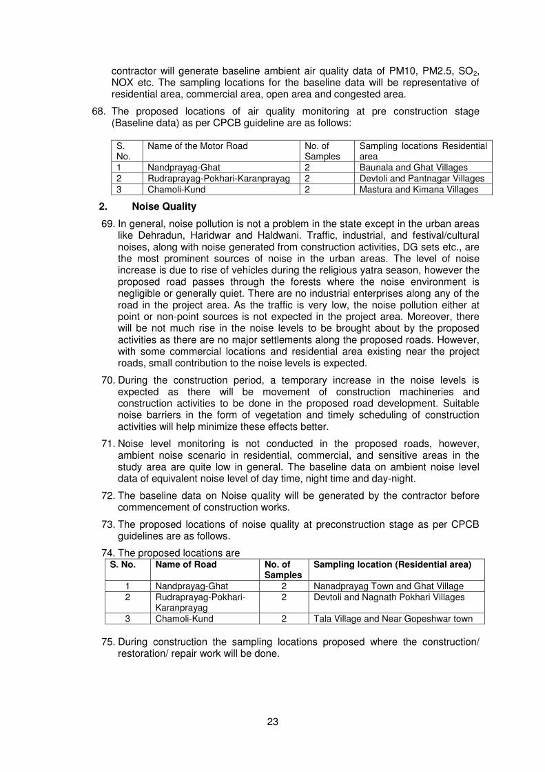
i. lteration of surface water hydrology of waterways crossed by roads, resulting in increased sediment in streams affected by increased soil erosion at construction site.
44
ii.
mpacts on water quality 44
iii.
isfiguration of landscape by road embankments, cuts, fills and quarries. 44
iv.
oss of productive soil 45
v.
ompaction and contamination of soil 45
b.
mpacts on environmental quality 45
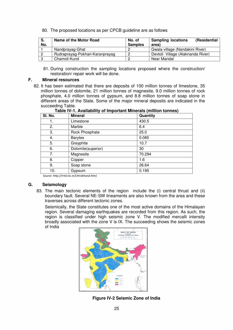
i.
ncrease in local air pollution due to rock crushing, and filling works and chemicals from asphalt processing.
45
ii.
oise and vibration from civil works 46
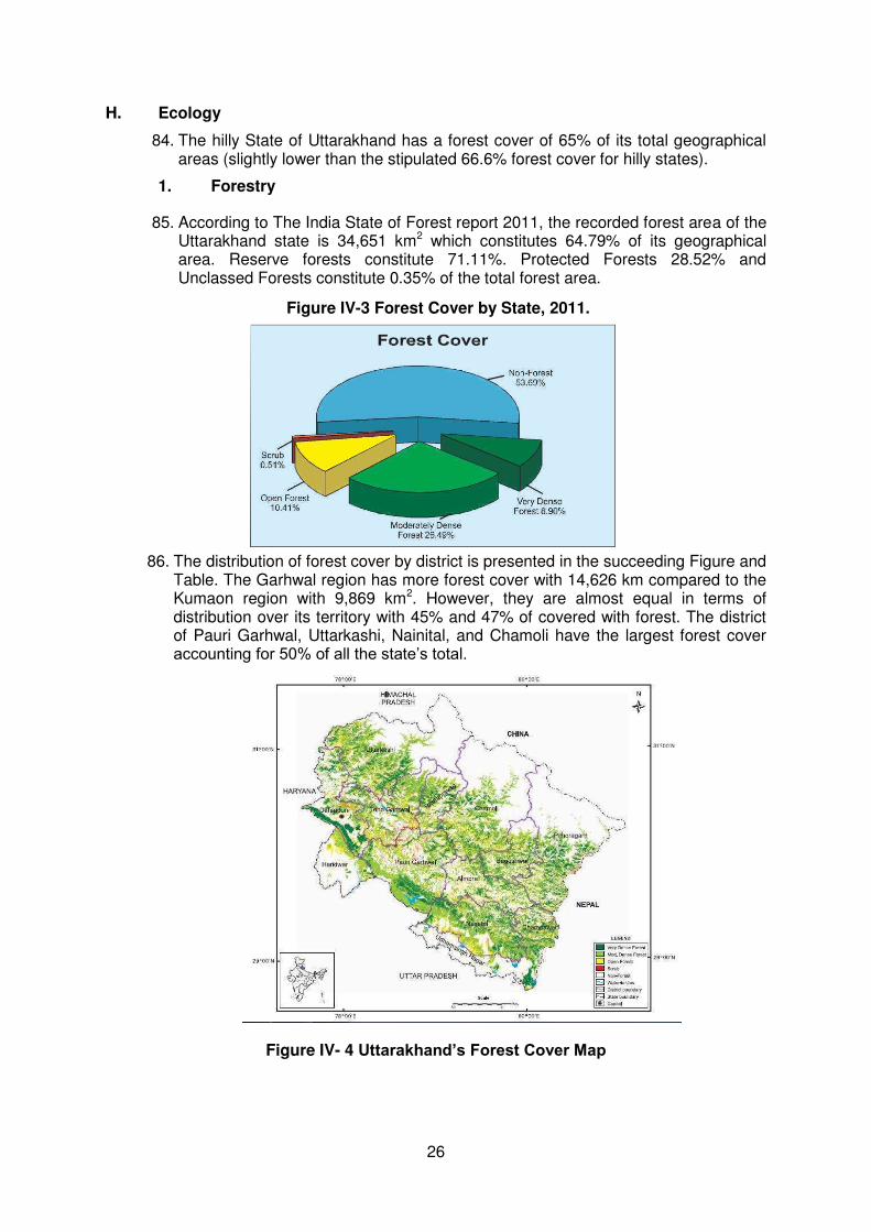
C. Impacts on the socio-economic 47
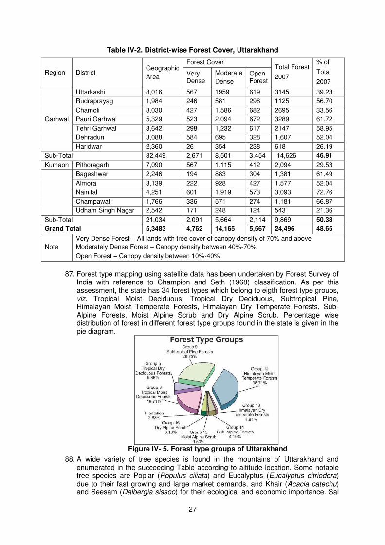
i.
ncroachment on historical and cultural areas 47
ii.
mpacts on occupational health and safety 47
iii.
mpacts on community health and safety 47
VI INFORMATION DISCLOSURE, CONSULTATION AND PARTICIPATION 49
A.
ublic participation during the preparation of the IEE 49
B.
uture consultation and disclosure 53
C.
onsultation during detailed design 52
D.
onsultation during construction 53
E.
ublic disclosure 53
F.
roject disclosure 53
VII ENVIRONMENTAL MANAGEMENT PLAN & GRIEVANCE AND REDRESS MECHANISM
54
A. Environment management plan 54 B. Institutional arrangement 54
I.
EAP, SDMA (PMU) 55
II. 56

vi
EAP, IA, FPIU
III.
he Engineer (DSC) 56
IV.
nvironmental expert of engineer (DSC) 56
V.
he Contractor 56
C. Environmental monitoring programme 85 D. Performance indicators 85
E.
rievance redress mechanism 86
E. Environmental budget
88 IX CONCLUSION AND RECOMMENDATION 91

vii
LIST OF TABLES
TABLE II-1 : Applicable environmental national and state requirements for UEAP 8 TABLE III-1 : Distribution of road sections to be improved by district 14 TABLE IV-1 : Availability of important minerals (million tonnes) 25 TABLE IV-2 : District-wise forest cover, Uttarakhand 27 TABLE IV-3 : Predominant top-canopy (tree) species according to altitude 28 TABLE IV-4 : Wildlife in Uttarakhand 28 TABLE IV-5 : National parks in Uttarakhand 29 TABLE IV-6 : Wildlife sanctuaries in Uttarakhand 29 TABLE IV-7 : List of major flora 30 TABLE IV-8 : List of major fauna 31 TABLE IV-9 : Land utilisation in Uttarakhand 33 TABLE IV-10 : Demographic, Socio-economic and Health profile of Uttarakhand
State as compared to India figures 34
TABLE IV-11 : Health infrastructure of Uttarakhand 35 TABLE IV-12 : Transportation of Uttarakhand State 37 TABLE IV-13 : Area under principal crops and productivity in Uttarakhand 39 TABLE IV-14 : Ecological sub-regions and altitude-wise major agriculture crops 40 TABLE IV-15 : Mode of irrigation and drainage system in Uttarakhand 41 TABLE VII-1 : Environmental management and monitoring plan 58 TABLE VII-2 : Performance indicator for EMMP 85 TABLE VII-3 : Environmental monitoring for Air, Water, Noise and Soil 87 TABLE VII-4 : Environmental Budget for Nandprayag - Ghat Motor Road 88 TABLE VII-5 : Environmental Budget for Rudraprayag-Pokhari-Karanprayag Motor
Road 89
TABLE VII-6 : Environmental Budget for Chamoli Kund Motor Road
90
viii
LIST OF APPENDICES
APPENDIX A Rapid Environmental Assessment (REA) 92 APPENDIX B Public consultation and stakeholders analysis 108 APPENDIX C Site photographs 115 APPENDIX D MoEF issued specific guidelines in July 2013 for State of Uttarakhand
for expediting forest cleatrances to carry out the emergency work in forest areas (excluding works in national parks and sanctuaries)
118
APPENDIX 1 Disposal site management 121 APPENDIX 2 Environmental standards 124 APPENDIX 3 Oil inceptors 131 APPENDIX 4 Typical bituminous disposal pit 132 APPENDIX 5 Work safety in common operation and in construction 133 APPENDIX 6 Tree plantation strategy 144 APPENDIX 7 Enhancement measures 148 APPENDIX 8 Guidelines for management of road section through forest area 150 APPENDIX 9 Arrangement of traffic during construction 152 APPENDIX 10 General guidelines for contractor construction water management plan 157 APPENDIX 11 Environmental friendly construction methodology 158 APPENDIX 12 Borrow area management 162 APPENDIX 13 Soil erosion and sedimentation control 166 APPENDIX 14 Locating quarries, rehabilitating quarries and guidelines of stone
crushers 168
APPENDIX 15 Storage, handling, use and emergency responses for hazardous chemical
171
APPENDIX 16 Site and management of construction camp 174

ix

1
Executive Summary
The Uttarakhand Emergency Assistance Project (UEAP) involving 3 existing road sections with a total length of 69.51 km of State Highways, Major District Roads, and motor bridges across 2 districts. The key road upgrading components includes restoration of disaster affected roads in hilly terrain to a single lane standard (3.75 m carriageway and 6.0 m formation width), and all roads in the plain areas to the intermediate lane standard (5.5 m carriageway and 9.0 m formation width); conducting repairs and pavement overlay; strengthening of culverts and bridges; construction of new bridges and cross-drainage structures; and providing all necessary road furniture and road safety hardware. The present IEE relates to the existing project road namely Nandprayag-Ghat Road sections with a total length of 18.493 km and the affected road length of 14.51 km of Other District Road (ODR), Rudraprayag-Pokhari-Karanprayag motor road with a total length of 75.510 km and affected section of 14.51 km of Other District Road (ODR) and Chamoli-Kund Motor Road with a total length of 84.200 km and affected section of 33.00 km of State Highway (SH-36) sections. Consistent with the Environmental Assessment and Review Framework each of the 3 roads viz. Nandprayag Ghat, Rudraprayag-Pokhari-Karanprayag and Chamoli-Kund road were screened using ADB rapid environmental assessment (REA) checklist-roads. The environmental screening revealed that no protected or sensitive areas were traversed. All impacts are site specific; few are irreversible and some of impacts can be readily mitigated supporting an environmental “Category B” classification. Uttarakhand lies in the northern part of India amidst the magnificent Himalayas and dense forests. The State is bordering Himachal Pradesh in the north-west and Uttar Pradesh in the South and shares international borders with Nepal and China. The State is comprised of 13 districts divided into two regions and also called administrative divisions; the Kumaon and Garhwal. Sensitive Environmental Features. The following section enumerates and describes the sensitive environmental feature that influenced the project design and mitigation measures. o Geology and soils. The State is part of the Western Himalaya and divided into four zones according altitude namely, the Tarai-Bhabar-Shivalik (Sub-Himalayas) with altitude ranging from 750-1,200 meters, Lesser-Himalayas between 1,000 – 3,500 meters, Greater-Himalayas between 3,500-4,800m with snow-line rising to 5,400m, and Trans Himalaya (Tethys) averaging 5,300m. In general, the region is geologically and pedologically unstable and prone to slides and erosion. Soils of the Uttarakhand Himalayas in general are quite shallow, gravely impregnated with un-weathered fragments of parent rocks. o Climate. The overall climatic condition in the State is governed by the southwest monsoon. It has a sub-tropical to temperate climate, with three pronounced seasons; viz. summer, winter, and monsoon. The hilly terrain of the Himalayan region has snow cover and is severely cold during winter with snowfall normally occurring during the months of December to March. The climatic conditions of Almora, Nainital, Pithoragarh, Chamoli, Uttarkashi, Pauri and Dehradun are humid and cold. The Kumaon region is under the Intermediate Zone, with moderate temperature and rainfall.
o Air Quality. The pristine environment and sparse population suggest that most part of the State have a very good air quality while noise pollution is not a problem except in the urban areas like Dehradun, Haridwar and Haldwani.
o Seismicity. The State constitutes one of the most active domains of the Himalayan region. Several damaging earthquakes are recorded from this region. As such, the region is classified under high seismic zone IV & V.
o Forest. Uttarakhand is ranked 9
th in all-India in terms of forest covered area with 24,495
km2of forestland The district of Pauri Garhwal, Uttarkashi, Nainital, and Chamoli have the largest
forest cover accounting for 50% of all the state’s total. The State Govt. of Uttarakhand has declared the oak tree (Quercus sp.) as a Kalpvriksha or wish fulfilling divine tree often treated as the signature plant of the Kumaon Himalayas as numerous logos and insignias with a stylized version of the deodar inscribed on them.
2
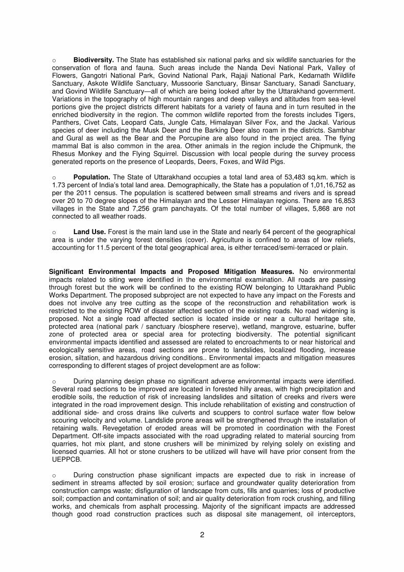
o Biodiversity. The State has established six national parks and six wildlife sanctuaries for the conservation of flora and fauna. Such areas include the Nanda Devi National Park, Valley of Flowers, Gangotri National Park, Govind National Park, Rajaji National Park, Kedarnath Wildlife Sanctuary, Askote Wildlife Sanctuary, Mussoorie Sanctuary, Binsar Sanctuary, Sanadi Sanctuary, and Govind Wildlife Sanctuary—all of which are being looked after by the Uttarakhand government. Variations in the topography of high mountain ranges and deep valleys and altitudes from sea-level portions give the project districts different habitats for a variety of fauna and in turn resulted in the enriched biodiversity in the region. The common wildlife reported from the forests includes Tigers, Panthers, Civet Cats, Leopard Cats, Jungle Cats, Himalayan Silver Fox, and the Jackal. Various species of deer including the Musk Deer and the Barking Deer also roam in the districts. Sambhar and Gural as well as the Bear and the Porcupine are also found in the project area. The flying mammal Bat is also common in the area. Other animals in the region include the Chipmunk, the Rhesus Monkey and the Flying Squirrel. Discussion with local people during the survey process generated reports on the presence of Leopards, Deers, Foxes, and Wild Pigs. o Population. The State of Uttarakhand occupies a total land area of 53,483 sq.km. which is 1.73 percent of India’s total land area. Demographically, the State has a population of 1,01,16,752 as per the 2011 census. The population is scattered between small streams and rivers and is spread over 20 to 70 degree slopes of the Himalayan and the Lesser Himalayan regions. There are 16,853 villages in the State and 7,256 gram panchayats. Of the total number of villages, 5,868 are not connected to all weather roads.
o Land Use. Forest is the main land use in the State and nearly 64 percent of the geographical area is under the varying forest densities (cover). Agriculture is confined to areas of low reliefs, accounting for 11.5 percent of the total geographical area, is either terraced/semi-terraced or plain.
Significant Environmental Impacts and Proposed Mitigation Measures. No environmental impacts related to siting were identified in the environmental examination. All roads are passing through forest but the work will be confined to the existing ROW belonging to Uttarakhand Public Works Department. The proposed subproject are not expected to have any impact on the Forests and does not involve any tree cutting as the scope of the reconstruction and rehabilitation work is restricted to the existing ROW of disaster affected section of the existing roads. No road widening is proposed. Not a single road affected section is located inside or near a cultural heritage site, protected area (national park / sanctuary /biosphere reserve), wetland, mangrove, estuarine, buffer zone of protected area or special area for protecting biodiversity. The potential significant environmental impacts identified and assessed are related to encroachments to or near historical and ecologically sensitive areas, road sections are prone to landslides, localized flooding, increase erosion, siltation, and hazardous driving conditions.. Environmental impacts and mitigation measures corresponding to different stages of project development are as follow: o During planning design phase no significant adverse environmental impacts were identified. Several road sections to be improved are located in forested hilly areas, with high precipitation and erodible soils, the reduction of risk of increasing landslides and siltation of creeks and rivers were integrated in the road improvement design. This include rehabilitation of existing and construction of additional side- and cross drains like culverts and scuppers to control surface water flow below scouring velocity and volume. Landslide prone areas will be strengthened through the installation of retaining walls. Revegetation of eroded areas will be promoted in coordination with the Forest Department. Off-site impacts associated with the road upgrading related to material sourcing from quarries, hot mix plant, and stone crushers will be minimized by relying solely on existing and licensed quarries. All hot or stone crushers to be utilized will have will have prior consent from the UEPPCB. o During construction phase significant impacts are expected due to risk in increase of sediment in streams affected by soil erosion; surface and groundwater quality deterioration from construction camps waste; disfiguration of landscape from cuts, fills and quarries; loss of productive soil; compaction and contamination of soil; and air quality deterioration from rock crushing, and filling works, and chemicals from asphalt processing. Majority of the significant impacts are addressed though good road construction practices such as disposal site management, oil interceptors,

3
occupational safety, soil erosion and sedimentation control, and site and management of construction camp of this report contains these good practices that are applicable to all roads under UEAP. o During operation phase, no significant adverse impacts are expected due to a relatively low volume of traffic, and the improvements in road safety introduced through the investment program will make these roads safer.
Information Disclosure, Consultation, Participation, and Grievance and Redress Mechanism. Wide stakeholder consultation and participation was observed during the environmental examination of UEAP. Highlight of all consultations were documented and applicable recommended measures particularly in minimizing shifting of structures, potential conflict with migrant workers, and competing demand for local resources were incorporated in the design and the environmental management plan. This IEE report will be disclosed in the ADB website pursuant to the Bank’s Public Communication Policy and in the SDMA website. Environmental Management Plan. The Environmental Management Plan (EMP), to form part of the bidding documents, adopted the procurement package scheme and facilitates subsequent compliance monitoring by the contractor. Conclusion. The initial environmental examination ascertains that the sub-project is unlikely to cause any significant environmental impacts in affected section of roads. No additional studies or need of undertaking detailed EIA is envisaged at this stage. The Executing Agency shall ensure that EMP and EMoP is included in Bill of Quantity (BOQ) and forms part of bid document and civil works contract. The same shall be revised if necessary during project implementation or if there is any change in the project design and with approval of ADB.
The IEE is based upon the Environmental Assessment and Review Framework (EARF) which is in consistent with the ABD‘s Safeguard Policy Statement (SPS) 2009. The subproject is classified as _Category “B” for Environment and does not require further Environmental Impact Assessment.
4
I. INTRODUCTION
A. Project Background/Rationale
1. About 90% of passenger and freight traffic in the State of Uttarakhand moves by road. Rail services offer freight and passenger connections to the neighbouring states through four rail heads in the State's southern low-lying plain region. The hilly and mountainous terrain that covers more than 90% of the State's land area would preclude the development of railway infrastructure catering to intrastate services.
2. The roads subsector in the State comprises of road infrastructure, which is primarily
administered by the Public Works Department (PWD); and transport services, which are overseen by the Transport Department. The PWD is responsible for planning, financing, constructing, and maintaining roads, bridges, and related government buildings.
3. The overall road network in the State is 31,929 km. The road network is
administered by the PWD and comprises of 1151 km of national highways (NH)1, 3,788 km of State Highways (SH), 3,290 km of Major District Roads (MDR), 2,945 km of -Other District Roads (ODR), 15402 km of Village Roads (VR), and 1773 Motor Bridges. Additionally, PWD also administers 3,736 km of bridle roads/tracks and 1,073 bridle bridges. The Border Roads Organization manages about 1,623 km of NHs, SHs, MDRs, and ODRs.
4. The Transport Department is responsible for issuing licenses for vehicles and
operators, operating permits for private freight and passenger service operators, and managing the State Road Transport Corporation (SRTC). Private operators provide the bulk of the freight and passenger services under permits issued by the State transport authorities. Privately operated passenger transport predominates in the rural hill areas.
5. Roads are the lifeline of the State. The quality of the road network in Uttarakhand
has however been poor and constraints the economy of the State. The mountainous terrain, rivers that are prone to flash floods, fragile geology and ecology and lack of adequate funding for development and maintenance, is further aggravated by flash floods, massive landslides, erosion and caving of roads caused by cloud bursts and heavy rains during the monsoon period. The PWD faces a major challenge in opening of disrupted roads during the monsoon season every year.
B. THE UTTARAKHAND EMERGENCY ASSISTANCE PROJECT (UEAP)
6. Uttarakhand being a tourist and pilgrimage State attracts a large number of tourist and pilgrims. A major disaster during 15-17th June 2013 resulted in severe damages in several parts of Uttarakhand, which has a mountainous terrain and a fragile geology. Several towns have been washed away by the unprecedented flash floods and landslides, and a large number of houses, public buildings, roads, bridges, urban, rural, and tourism infrastructure, power generation and distribution facilities have been damaged. The impact on the affected population due to the loss of connectivity has been manifold. The State machinery is currently focused on emergency restoration and connectivity works. The affected regions are susceptible to further damages during the on-going rainy season.
5
7. Based on the request of India, a Rapid Joint Damage and Needs Assessment
(RJDNA) was undertaken by Asian Development Bank (ADB) and the World Bank. ADB agreed to assist the Government of India (GOI) with reconstruction and rehabilitation efforts for which the Uttarakhand Emergency Assistance Project (UEAP) has been formulated as a multi-sector emergency loan in sector loan modality. The executing agency (EA) for the UEASP will be Government of Uttarakhand (GOU) and State Disaster Management Authority (SDMA). The primary implementing agencies (lA’s) will be Public Works Department (PWD) for roads, bridges, urban roads, and trekking routes including eco-trails ; Department of Tourism (DOT) for tourism infrastructure, Uttarakhand Civil Aviation Development Authority (UCADA) for helipads; and Uttarakhand Jal Sanstahan (UJS) for urban water supply, or any successor hereto. Some other state agencies such as Forest Department, Kumaon Mandal Vikas Nigam Limited, and Garhwal Mandal Vikas Nigam Limited are likely to be entrusted with some works under UEASP under these primary lAs.
8. Due to bad weather, continued flooding and landslides, and the inaccessibility of the
affected areas, the field visits for preliminary investigation are still not possible. Under these circumstances, the available data and information has been relied upon to prepare this environmental assessment and review framework (EARF). The EARF was prepared in accordance with ADB's Safeguard Policy Statement (2009) (SPS 2009). The recommendations are consistent with the environmental and related legislations of the GOI at the national, state and local levels. A realistic and engineering assessment with preliminary field surveys and investigations would be undertaken only after some improvement in weather and connectivity.
C. Purpose of the Environmental Assessment
9. The purpose of the study is to identify the environmental issues to be considered at project planning and design stage, assesses environmental consequences due to project intervention and suggests mitigation measures to minimise the adverse environmental impacts, if any, associated with construction and operation.
10. Initial environmental examination (IEE) has four basic objectives; (i) asses relevant
potential impacts and risks associated with the proposed road upgrading, (ii) assess the compliance with ADB environmental safeguard requirements and applicable environmental laws, and (iii) incorporate mitigation measures in the project design, (iv) Preparation of Environmental Management & Monitoring Plan (EMMP).
D. Extent of IEE
11. IEE was conducted based on preliminary Detailed Project Report (DPR). The IEE covers all activities proposed under the project. The core zone of impact is taken as 100 meters either side of the alignment. However, the study area is considered up to 7 km on either side of road alignment for larger analysis of landuse and other environmental features. Assessment is carried out for all components of environment covering terrestrial and aquatic ecology, soil, water, noise and socio economic aspects.
E. IEE Content
12. The IEE has been largely structured as per ADB’s SPS, 2009 and it’s Environmental Assessment Guidelines (2003) and Environmental Safeguards – A good practice
6
sourcebook (December 2012). This includes following eight chapters including this introduction Chapter.
Chapter 1- Introduction
Chapter 2- Policy, Legal and Administrative Framework
Chapter 3- Description of Project
Chapter 4- Description of Environment
Chapter 5- Anticipated Impacts and Mitigation Measures
Chapter 6- Information Disclosure, Consultation, and Participation
Chapter 7- Environment Management Plan and Grievance Redress Mechanism
Chapter 8 Conclusion and Recommendation
13. Two stand-alone companion documents form part of this IEE Report. Volume 1 is a compilation of the individual environmental screening checklists for the 3 roads and Volume 2 provides detailed good engineering practices in road construction which are referred to in Chapter 5.
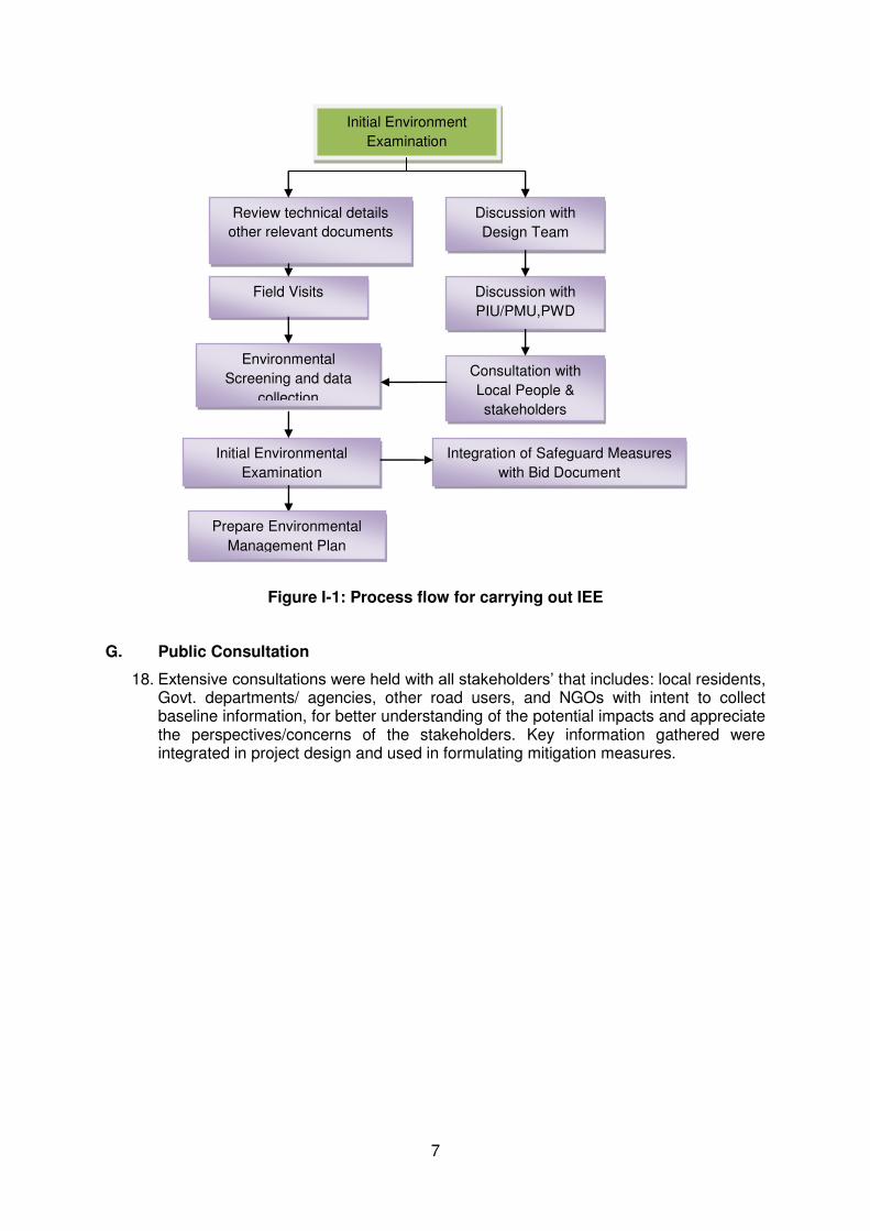
F. Methodology for Environmental Assessment
14. A kick-off meeting for the project was arranged between the technical and engineering team of PIU/PMU, PWD Dehradun and Design Consultant in order to get the team members apprised of the project background, present status, approach and methodology to be followed and sources of secondary data / reports for the project roads.
15. The environmental and social team conducted field visit in May 2014 and undertook environmental screening of the project road in accordance with ADB requirements as stipulated in Environmental Assessment Guidelines 2003 and MoEF Notification 2006 with relevant subsequent amendments. The identified environmental issues were assessed for their severity to further determine the environmental categories in which they fall. The ADB’s REA checklist for this road section is attached as Appendix- A
16. During field environmental survey, public consultations have been conducted to obtain the views of local people, project affected persons and local administrative representatives. Focused Group Discussion has been adopted as tool for this public consultation. Consultations were also conducted with stakeholders to collect secondary as well as primary data. Various maps for project area, district planning maps etc. have been studied to have initial understanding of the project area.
17. Based on analysis of collected data and information, potential adverse environmental impacts have been identified and examined using standard “Checklist Method”. Thereafter possible mitigation measures have been identified. Based on the findings of impact assessment comprising the key elements embodied in this IEE, an Environmental Monitoring and Management Plan (EMMP) have been developed. Continued discussions undertaken with the executive agency and technical team of the consultant for integrating environmental management measures into the project.
7
Figure I-1: Process flow for carrying out IEE
G. Public Consultation
18. Extensive consultations were held with all stakeholders’ that includes: local residents, Govt. departments/ agencies, other road users, and NGOs with intent to collect baseline information, for better understanding of the potential impacts and appreciate the perspectives/concerns of the stakeholders. Key information gathered were integrated in project design and used in formulating mitigation measures.
Initial Environment
Examination
Discussion with
Design Team
Discussion with
PIU/PMU,PWD
Field Visits
Review technical details
other relevant documents
Consultation with
Local People &
stakeholders
Environmental
Screening and data
collection
Initial Environmental
Examination
Integration of Safeguard Measures
with Bid Document
Prepare Environmental
Management Plan
8
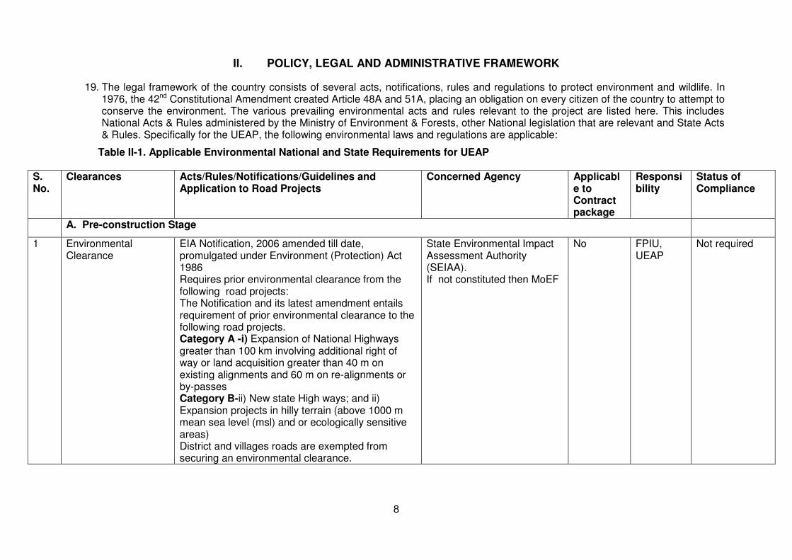
II. POLICY, LEGAL AND ADMINISTRATIVE FRAMEWORK
19. The legal framework of the country consists of several acts, notifications, rules and regulations to protect environment and wildlife. In 1976, the 42nd Constitutional Amendment created Article 48A and 51A, placing an obligation on every citizen of the country to attempt to conserve the environment. The various prevailing environmental acts and rules relevant to the project are listed here. This includes National Acts & Rules administered by the Ministry of Environment & Forests, other National legislation that are relevant and State Acts & Rules. Specifically for the UEAP, the following environmental laws and regulations are applicable:
Table II-1. Applicable Environmental National and State Requirements for UEAP
S. No.
Clearances Acts/Rules/Notifications/Guidelines and Application to Road Projects
Concerned Agency Applicable to Contract package
Responsibility
Status of Compliance
A. Pre-construction Stage
1 Environmental Clearance
EIA Notification, 2006 amended till date, promulgated under Environment (Protection) Act 1986 Requires prior environmental clearance from the following road projects: The Notification and its latest amendment entails requirement of prior environmental clearance to the following road projects. Category A -i) Expansion of National Highways greater than 100 km involving additional right of way or land acquisition greater than 40 m on existing alignments and 60 m on re-alignments or by-passes Category B-ii) New state High ways; and ii) Expansion projects in hilly terrain (above 1000 m mean sea level (msl) and or ecologically sensitive areas) District and villages roads are exempted from securing an environmental clearance.
State Environmental Impact Assessment Authority (SEIAA). If not constituted then MoEF
No FPIU, UEAP
Not required
9
S. No.
Clearances Acts/Rules/Notifications/Guidelines and Application to Road Projects
Concerned Agency Applicable to Contract package
Responsibility
Status of Compliance
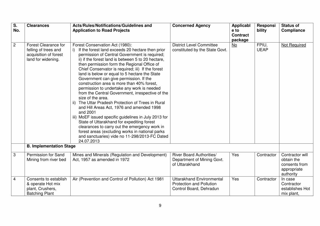
2 Forest Clearance for felling of trees and acquisition of forest land for widening.
Forest Conservation Act (1980): i) If the forest land exceeds 20 hectare then prior
permission of Central Government is required; ii) if the forest land is between 5 to 20 hectare, then permission form the Regional Office of Chief Conservator is required; iii) If the forest land is below or equal to 5 hectare the State Government can give permission. If the construction area is more than 40% forest, permission to undertake any work is needed from the Central Government, irrespective of the size of the area.
ii) The Uttar Pradesh Protection of Trees in Rural and Hill Areas Act, 1976 and amended 1998 and 2001
iii) MoEF issued specific guidelines in July 2013 for State of Uttarakhand for expediting forest clearances to carry out the emergency work in forest areas (excluding works in national parks and sanctuaries) vide no 11-298/2013-FC Dated 24.07.2013
District Level Committee constituted by the State Govt.
No FPIU, UEAP
Not Required
B. Implementation Stage
3 Permission for Sand Mining from river bed
Mines and Minerals (Regulation and Development) Act, 1957 as amended in 1972
River Board Authorities/ Department of Mining Govt. of Uttarakhand
Yes Contractor Contractor will obtain the consents from appropriate authority
4 Consents to establish & operate Hot mix plant, Crushers, Batching Plant
Air (Prevention and Control of Pollution) Act 1981 Uttarakhand Environmental Protection and Pollution Control Board, Dehradun
Yes Contractor In case Contractor establishes Hot mix plant,
10
S. No.
Clearances Acts/Rules/Notifications/Guidelines and Application to Road Projects
Concerned Agency Applicable to Contract package
Responsibility
Status of Compliance
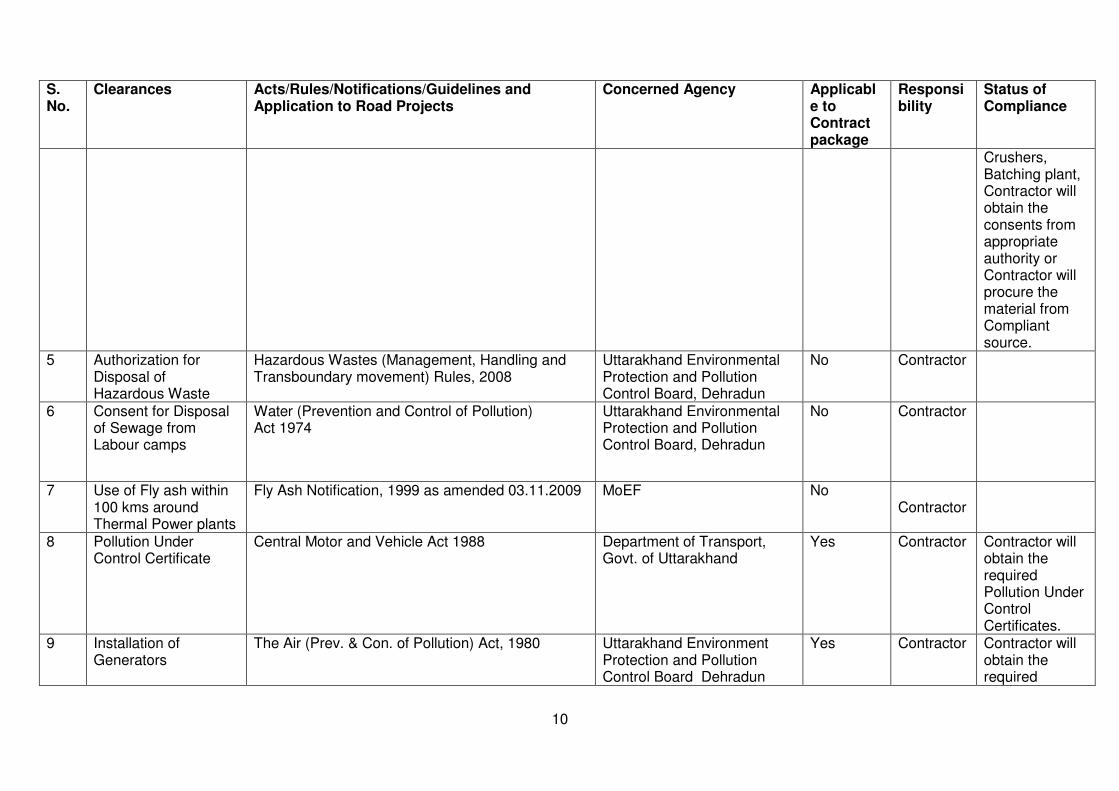
Crushers, Batching plant, Contractor will obtain the consents from appropriate authority or Contractor will procure the material from Compliant source.
5 Authorization for Disposal of Hazardous Waste
Hazardous Wastes (Management, Handling and Transboundary movement) Rules, 2008
Uttarakhand Environmental Protection and Pollution Control Board, Dehradun
No Contractor
6 Consent for Disposal of Sewage from Labour camps
Water (Prevention and Control of Pollution) Act 1974
Uttarakhand Environmental Protection and Pollution Control Board, Dehradun
No Contractor
7 Use of Fly ash within 100 kms around Thermal Power plants
Fly Ash Notification, 1999 as amended 03.11.2009 MoEF No Contractor
8 Pollution Under Control Certificate
Central Motor and Vehicle Act 1988 Department of Transport, Govt. of Uttarakhand
Yes Contractor Contractor will obtain the required Pollution Under Control Certificates.
9 Installation of Generators
The Air (Prev. & Con. of Pollution) Act, 1980 Uttarakhand Environment Protection and Pollution Control Board Dehradun
Yes Contractor Contractor will obtain the required

11
S. No.
Clearances Acts/Rules/Notifications/Guidelines and Application to Road Projects
Concerned Agency Applicable to Contract package
Responsibility
Status of Compliance
NOC/Consents.
10 Employing Labour/workers
The Building and Other Construction Workers (Regulation of Employment and Conditions of Service) Act, 1996,
District Labour Commissioner Yes Contractor Details to be provided
11 Permission for extraction of boulder and sand from river beds
Mines & Minerals (Regulation and Development) Act, 1957 and its amended 10th May 2012
Department of Mines and Geology. Uttarakhand Environment Protection and Pollution Control Board Dehradun
Yes Civil Work Contractor
Details to be provided
12 License for Storing Diesel and other explosives
Petroleum (Amended) Rules, 2011. Hazardous Wastes (Management, Handling and Transboundary movement) Rules, 2008
Commissioner of Explosives and Uttarakhand Environmental Protection and Pollution Control Board – Dehradun
No Contractor
12
III. DESCRIPTION OF THE PROJECT
A. Project Location
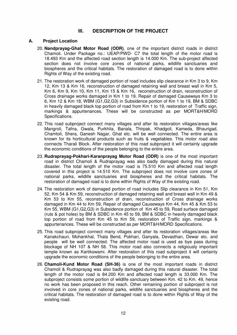
20. Nandprayag-Ghat Motor Road (ODR), one of the important district roads in district Chamoli. Under Package no.: UEAP/PWD- C7 the total length of the motor road is 18.493 Km and the affected road section length is 14.000 Km. The sub-project affected section does not involve core zones of national parks, wildlife sanctuaries and biospheres and the critical habitats. The restoration of damaged road is to done within Rights of Way of the existing road.
21. The restoration work of damaged portion of road includes slip clearance in Km 3 to 9, Km 12, Km 13 & Km 16, reconstruction of damaged retaining wall and breast wall in Km 5, Km 6, Km 9, Km 10, Km 11, Km 15 & Km 16, reconstruction of drain, reconstruction of Cross drainage works damaged in Km 1 to 19, Repair of damaged Causeways Km 3 to 6, Km 12 & Km 18, WBM (G1,G2,G3) in Subsidence portion of Km 1 to 19, BM & SDBC in heavily damaged black top portion of road from Km 1 to 19, restoration of Traffic sign, markings & appurtenances. These will be constructed as per MORT&H/MORD Specifications.
22. This road subproject connect many villages and after its restoration villages/areas like Mangroli, Tafna, Gwala, Purkhila, Banala, Thirpak, Khadgoli, Kameda, Bhaurigad, Chamtoli, Shera, Ganesh Nagar, Ghat etc. will be well connected. The entire area is known for its horticultural products such as fruits & vegetables. This motor road also connects Tharali Block. After restoration of this road subproject it will certainly upgrade the economic conditions of the people belonging to the entire area.
23. Rudraprayag-Pokhari-Karanprayag Motor Road (ODR) is one of the most important road in district Chamoli & Rudraprayag was also badly damaged during this natural disaster. The total length of the motor road is 75.510 Km and affected road length covered in this project is 14.510 Km. The subproject does not involve core zones of national parks, wildlife sanctuaries and biospheres and the critical habitats. The restoration of damaged road is to done within Rights of Way of the existing road.
24. The restoration work of damaged portion of road includes Slip clearance in Km 51, Km 52, Km 54 & Km 59, reconstruction of damaged retaining wall and breast wall in Km 49 & Km 53 to Km 55, reconstruction of drain, reconstruction of Cross drainage works damaged in Km 44 to Km 59, Repair of damaged Causeways Km 44, Km 45 & Km 53 to Km 55, WBM (G1,G2,G3) in Subsidence portion of Km 45 to 59, Road surface damaged (ruts & pot holes) by BM & SDBC in Km 45 to 59, BM & SDBC in heavily damaged black top portion of road from Km 45 to Km 59, restoration of Traffic sign, markings & appurtenances. These will be constructed as per MORT&H/MORD Specifications.
25. This road subproject connect many villages and after its restoration villages/areas like Kanakchauri, Mohankhal, Thala Bend, Pokhari, Ganyala, Devasthan, Dewar etc. and people will be well connected. The affected motor road is used as bye pass during blockage of NH 107 & NH 58. This motor road also connects a religiously important temple known as Kartikswami. After restoration of this road subproject it will certainly upgrade the economic conditions of the people belonging to the entire area.
26. Chamoli-Kund Motor Road (SH-36) is one of the most important roads in district Chamoli & Rudraprayag was also badly damaged during this natural disaster. The total length of the motor road is 84.200 Km and affected road length is 33.000 Km. The subproject consists some portion of wildlife sanctuary between Km. 42 to Km. 49, hence no work has been proposed in this reach. Other remaining portion of subproject is not involved in core zones of national parks, wildlife sanctuaries and biospheres and the critical habitats. The restoration of damaged road is to done within Rights of Way of the existing road.

13
27. The restoration work of damaged portion of road includes Slip clearance in Km 70, Km 71, Km 74, Km 75, Km 76, Km 77, Km 80, Km 82 to Km 85, reconstruction of damaged retaining wall and breast wall in Km 1, Km 3, Km 4, Km 6, Km 15, Km 16, Km 18, Km 21, Km 33, Km 34, Km 37 to Km 41, Km 65, Km 74, Km 78, Km 80, Km 82, reconstruction of drain, reconstruction of Cross drainage works damaged in Km 26, Km 31, Km 41, Km 70, Km 71, Km 74, Km 75, Km 78, Km 81, Km 82, Km 84 & Km 85, Repair of damaged Causeways Km 26, Km 37, Km 41 & Km 78, WBM (G1,G2,G3) in Subsidence portion of Km 1 to 11, Km 31, Km 36 to 41, Km 70, Km 71, Km 74 to 78 & Km 80 to 85, Road surface damaged (ruts & pot holes) by BM & SDBC in Km 1 to 11, Km 31, Km 70, Km 71, Km 74 to 78 & Km 80 to 85, BM & SDBC in heavily damaged black top portion of road from Km 36 to Km 41, restoration of Traffic sign, markings & appurtenances. These will be constructed as per MORT&H/MORD Specifications.
28. This road subproject connect many villages and after its restoration villages/areas like Kotiyalsain, Patiyaldhar, Subhashnagar, Talla Naigwad, Malla Naigwad, Gopeshwar, Gangolgaon, Sagar, Mandal, Chopta, Dugalbitta, Daida, Mastura, Ukhimath, Sansari, Mangoli and Chunni etc. will be well connected. This road was used as subway for relief of victims during disaster for traffic diversion of Kedarnath and Rudraprayag area because NH-107 was washed out at Augustmuni, Tilwara, Banswara etc. The entire area is known for producing fruits & vegetables and the affected motor road is used as Chardham Yatra route. This motor road also connects Tungnath temple. After restoration of this road subproject it will certainly upgrade the economic conditions of the people belonging to the entire area.
B. Proposed Category of the Project
29. Pursuant to the requirements of the ADB Safeguard Policy Statement (2009) and Operation Manual Bank Policy on Environmental Safeguard of the Nandprayag Ghat, Rudraprayag-Pokhari-Karanprayag and Chamoli-Kund motor road sections proposed for upgrading were screened to identify significance of potential impacts, determine the most environmentally sensitive component, establish the needed level of assessment, and prescribe the information disclosure and consultations requirement to be complied by the Uttarakhand-PWD. Consistent with the Environmental Assessment and Review Framework, Nandprayag-Ghat, Rudraprayag-Pokhari-Karanprayag and Chamoli-Kund road were screened using the ADB rapid environmental assessment (REA) checklist-roads and highways for State Highways and district roads.
30. The environmental screening revealed that the affected section of sub project does not transverse through any protected or sensitive areas. There are no rare, threatened, and endangered species (flora and fauna) within the subproject corridor of impact. Majority being hills roads, the most significant environmental impacts are potential increase in erosion, siltation, and landslide.
31. Proposed Nandprayag-Ghat, Rudraprayag-Pokhari-Karanprayag and Chamoli-Kund are existing roads and no expansion or realignments are proposed. The project roads are passing through forest but the work will be confined to the existing ROW belonging to Uttarakhand Public Works Department. All impacts are site specific, few are irreversible and related to minor alignment correction and road widening, and all impacts can be readily mitigated supporting a Category B classification.
C. Key Rehabilitation and Reconstruction Activities
32. Road improvement component will include restoration of damaged portion of 2 Other District Roads and one State Highway within available RoW; conducting repairs and pavement resurfacing ; strengthening / repairing of culverts and bridges; constructing of cross-draining structures; and providing all necessary road furniture and roadside safety hardware. Summary of roads to be upgraded/improved is provided below:

14
Table IIII-1 Distribution of Road Sections to be upgraded under UEAP, by Hierarchy and Length
Name of Road Category Nos. Affected Length (km)
% of Total
Nandprayag-Ghat Other District Road 1 14.00 20.14
Rudraprayag-Pokhari-Karanprayag
Other District Road 1 14.51 20.87
Chamoli-Kund (SH- 36) State Highway Above 1000 masl
1 33.00 58.98
Total 3 69.51 100
In case of Chamoli Kund motor road, that road started below 1000 MSL and goes upto 1000 MSL but it is not violating EIA notification 2006 amended in 2009 since only repairing work of disaster affected damaged portions restricted to existing ROW is proposed and no expansion activity is envisaged.
D. Project Implementation Schedule
33. The implementation period for the UEAP is around 3 years with a construction period of around 3 years. All UEAP components are expected to be completed by December 2017
The implementation period for affected 69.51.00 km road is 15 months.
Map/Site Plan Nanadprayag-Ghat Motor Road (Proposed section mark red)

15
Rudraprayag-Pokhari-Karanprayag Motor Road (Proposed section mark Green)
Chamoli-Kund Motor Road (Proposed section mark Red)
16
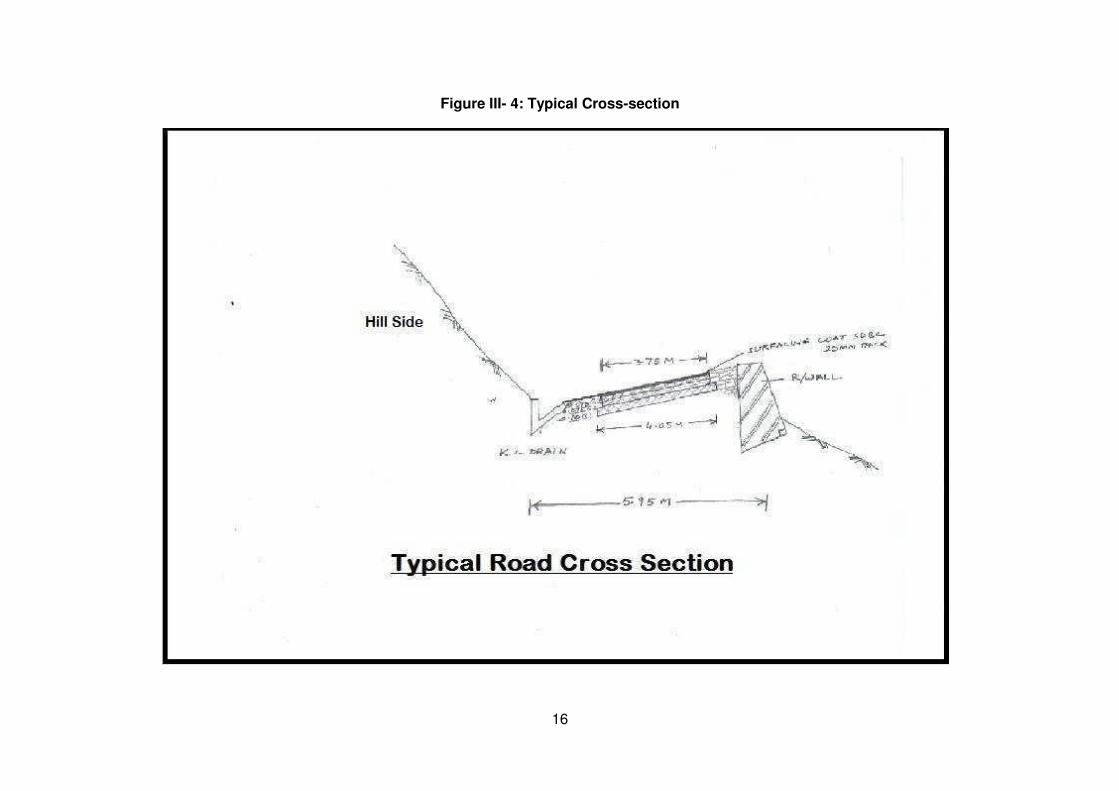
Figure III- 4: Typical Cross-section
17
IV. DESCRIPTION OF THE ENVIRONMENT
A. PHYSICAL ENVIRONMENT
34. This section presents a brief description of the existing environment, including its physical, ecological resources, and socio-economic development of Sub project roads. Broad aspects on various environmental parameters such as geography, climate and meteorology, physiography, geology, seismology, ecology, socio-cultural and economic development parameters that are likely to be affected by the proposed roads improvement are presented. These aspects are disaggregated at the state and district levels covered in the road improvement project. Secondary information was compiled from relevant government agencies like the Forest Department, Wildlife Department, State Environment Protection, and Pollution Control Board and Metrological Department.
1. Geography
35. Uttarakhand lies in the northern part of India amidst the magnificent Himalayas and dense forests. The State is bordering Himachal Pradesh in the north-west and Uttar Pradesh in the South and shares international borders with Nepal and China. The State is comprised of 13 districts, these are; Pithoragarh, Almora, Nainital, Bageshwar, Champawat, Uttarkashi, Udham Singh Nagar, Chamoli, Dehradun, Pauri, Tehri Garhwal, Rudraprayag, and Haridwar. Geographically, the state lies in the northern Himalayas between 28o53’24” to 31o27’50” North latitude and 77o34’27” to 81o02’22” East longitude. The State has an area of 53,484 sq. km. and a population of about 10 million as per census 2011.
Nandprayag- Ghat Motor Road
36. Nandaprayag is located at 30.33°N 79.33°E. It has an average elevation of 1,358 metres (4,455 feet). Nandaprayag is one of the Panch Prayags (five confluences) of Alaknanda River, and lies at the confluence of Alaknanda River and Nandakini River
Rudraprayag-Pokhari- Karanprayag
37. Pokhari is located at 30.34°N 79.19°E. It has an average of 372 meters. Similarly Karanprayag is located at 30.27°N 79.25°E. It has an average elevation of 1,451 metres (4,760 feet). Karanprayag is one of the Panch Prayags (five confluences) of Alaknanda River, situated at the confluence of the Alaknanda, and Pindar River.
Chamoli Kund Motor Road
38. Chamoli is located at 30.42°N 79.56°E. It has an average of 1069 m above mean sea level. Similarly Kund is located at 30.65°N 79.56°E. It has an average of 976 m above mean sea level.
39. Uttarakhand is divided into two regions and also called administrative divisions, basically following terrain: the Kumaon and Garhwal. The Kumaon division located southeast of the state and composed of Almora, Bageshwar, Champawat, Nainital, Pithoragarh, and Udham Singh Nagar. The Kumaon region is part of the vast Himalayan track and and the sub-mountains of Terai and Bhabhar. The region is drained by Gori, Dhauli, and Kali from the Tibetan mountains, and Pindari and Kaliganga which ultimately joins Alaknanda River. The Garwhal division is composed of Chamoli, Uttarkashi, Rudraprayag, Tehri Garhwal, Pauri, Dehradun, and Haridwar districts.and is entirely on rugged mountain ranges dissected by valley, and deep gorges. The Alaknanda River, the main source of the Ganges, traces its headwaters in this region.

18
Figure IV-1: Districts of Uttarakhand
40. The State is part of the Western Himalaya is further divided into four zones namely, the Tarai-Bhabar-Shivalik (Sub-Himalayas), Lesser-Himalayas, Greater-Himalayas, and Trans Himalaya (Tethys). These are briefly described below:
(i) Tarai-Bhabar-Shiwalik (sub-Himalaya). South of the Lesser Himalayas, Tarai- Bhabar-Shiwalik is the outermost zone overlooking foot-hills and plains. With an altitude ranging from 750-1,200 metres, the Shiwaliks are the foot-hills just above the Bhabar and Tarai. Once famous for the swamps and insalubrious climate and inhabited by Tribal people only, the Shiwaliks are reclaimed and developed into a fertile land and are now supporting a large population. The Garwhal region is located in the Shiwalik hills.
(ii)The Lesser Himalayas. The northern zone is composed of gneisses and granites, this portion has great complexity of structure having the most favorable climatic conditions for human habitation. The elevation varying from 1,000 metres to 3,500 metres from low lying river valleys to peaks close to the Great Himalayas, the Lesser Himalayas, with moderately steep slopes, consists of many fertile and flat river valleys. The Lesser Himalayas is watered by the rivers Kosi, Gomti, Saryu, Ramganga, and Gagas. The banks of these rivers locally called as 'seras' and are highly fertile. The major Lesser Himalayan settlements situated in the region as per project districts include Pithoragarh (Lohaghat, Champawat, Gangolihat, Berinag), Bageshwar (Kapkot) and Almora (Ranikhet, Dwarahat, Chaukhutia, Someshwar and Kausani). The cross profiles of the fluvial valleys show convex form with steep valley sides, interlocking spurs descending towards the main channel, hanging valleys, waterfalls and rapids, and terraced agricultural fields on the gentle slopes on the valley sides. The clustering of villages is confined mainly on the gentle slopes of the ridges on the fluvial terraces.
(iii)The Greater Himalayas. The region is the northernmost zone consisting of perpetually snow-covered ranges between 3,500 to 4,800 metres although the snow-line rises to 5,400 metres during summers at some places. The zone contains a number of glaciers (i.e. Pindari, Milam, Nandakot, Kafni, Untadhura, Gori and Poting) giving rise to a number of snow-fed rivers (i.e. Pinder, Ranganga (Eastern and Western), Dharamganga, Saryu, and Kali. Except from the Pinder and the Ram Ganga (W), all are tributaries of the Kali which separates Kumaon from Nepal in the extreme north-east.
(iv)The Trans-Himalayas (Tethys). The Trans Himalayan region itself is an ill-defined mountain region covering an area of about 1,000 km (600 miles) and having a width ranging from 225 km (140 miles) to about 32 km (20 miles). Unlike the main Himalayas,
19
the Trans Himalayan Mountains are not divided by deep river gorges. On the Roof of the World, passes average 5,330 m (17,500 ft) in height, with the highest being the Chargoding Pass at a height of 5,885 m (19,308 ft).
41. The districts of Haridwar and Udham Singh Nagar are the Terai regions having elevation of about 300 m above MSL whereas the Uttarkashi, Chamoli, and Pithoragarh districts are located in the upper high altitude region with ground elevation of above 4,500 m above MSL.
2. Geology
42. The geology of the region shows that the Himalayas are the young mountains in the world. During early Mesozoic times, or the secondary geological period, the land mass now covered by them was occupied by the great geosynclinals Tethys sea. The probable date of the commencement of the elevation of the Himalayas is about the close of the Mesozoic period, but the unravelling of the story of their structure has only just begin, and in many cases no dating of the rocks is yet possible, though they include ancient and relatively recent crystalline intrusive, rocks and sediments allied to the peninsular part of India.
43. Geologically the area belong to the Lesser Himalayas and lies in a tectonic fore deep. The Lesser Himalayas are comprised of fanglomerates followed by bedded quartzites, slates, phyllites and low-grade schists. The rock types are ranging from green schist to lower amphibolite facies. The main rock types are schists, phyllites and quartzites. Central Crystallines: Archaen
44. The central crystalline rocks are well exposed in the Higher Himalaya of Alaknanda valley of district Chamoli. The rocks of Central Crystalline Group form the oldest crystalline basement of the Himalaya. The gneisses, migmatites, crystalline schist, thick quartzite with conspicuous horizons of calc-silicates with psammite gneisses in the upper part form bulk of the metasediments.
45. The major geological formations of the Central Crystallines along with the lithology are given in succeeding table Table. Major geological formations of the Central Crystallines along with the lithology
Geological Formation Lithology
Badrinath Garnet, Sillimanite, Muscovite and kyanite, migmatites, calc-silicates. Leucogranite, pegmatite and garnet amphibolite.
Pandukeshwar Banded quartzite gneiss and interbedded quartz mica-schist, para-amphibolite
Joshimath Garnet mica-gneiss, staurolite and kyanite-gneisses, garnet amphibolite.
Bhimgora Quartzite White quartzite with gneiss and schist
Ragsi Mica-schist.
Garhwal Group (Supersequence): Palaeoproterozoic
46. The Garhwal Group forms the most extensive Group of rocks in district Chamoli. The rocks of palaeoproterozoic time-span are grouped in Garhwal Group. It forms the major part of the Lesser Himalaya and is represented by thick sequence of low-grade metasediments consisting of quartzite with penecontemporaneous
20
mafic metavolcanics and carbonate rocks. Garhwal Group is limited in the north by the Main central Thrust and in the south by the Main Boundary Fault.
47. The Garhwal Group consists of quartzite, phyllite, slate and limestone. Acid and basic igneous rocks intrude the Garhwal Group. Vaikrita Group: Mesoproterozoic to Neoproterozoic
48. Vaikrita group (Supersequence) of rocks represents the higher-grade metamorphics of the Higher Himalaya pervasively penetrated by young Tertiary granite. The rocks comprising, this group, are micaceous schists, talcose rocks, phyllites and gneisses overlying mainly the granite gneisses. Spatial extension wise the Vaikrita Group includes the metasedimentaries exposed between the granite-gneisses constituting the Central Crystalline and the overlying Martoli Group and its equivalents.
49. The granite intrudes both the Vaikrita and Martoli Groups and includes biotite granite, tourmaline granodiorite, tourmaline aplite and pegmatite.
Lesser Himalaya (Supersequence): Mesoproterozoic to Neoproterozoic 50. This supersequence, in Lesser Himalaya, is represented by two groups, viz. the
older Jaunsar Group and the younger Dudatoli Group. These two groups are briefly described below.
Jaunsar Group: 51. The rocks of this group are continuously exposed in the outer Lesser Himalaya. In
Chamoli district it is exposed in the southwestern part. It is divided into three formations, viz. Mandhali, Cahndpur & Nagthat, and consists mainly of phyllite, quartzite and slate Tethys Himalaya:
52. Martoli Group is represented by a thick sequence of unmetamorphosed to feebly metamorphosed rocks in district Chamoli. The rocks of this group are exposed Alaknanda River basin. The main rock types are silver grey phyllite with interbedded thin quartzite, garnetiferous grey phyllite, foliated quartzite with biotite bearing phyllite, thin laminated greenish grey, brown purple quartzite slate with thin calcareous lenses. Ordovician to Carboniferous (Supersequence)
53. The development of this supersequence is restricted to the Tethys Himalayan zone only. There is no record from Lesser Himalaya where the rocks of Martoli Group are unconformably overlain by the rocks of early Permian period. In the Tethys Himalaya this supersequence comprises the Sumna and Kanawar Groups. The rocks of the Sumna Group range in age from Early Ordovician to Devonian and it is divided into Ralam and Garbyans formations. The rock types are purple conglomerate, purple to greenish grey quartzite, quartzite with bands of calcilutite, calc-siltstone and brown dolomictic limestone with chlorite layers in the lower part. The sequence of limestone and black shale unconformably overlying the Sumna Group constitute the Kanawar Group. The rock types are sandy dolomite, carbonaceous shale, limestone and quartzite, which conformably lie over the Sumana Group. Late Permian to Late Triassic (Supersequence)
54. In district Chamoli the rocks of Lilang Group are exposed in its northeastern part. Chocolate limestone is the main geological formation of this group, which consists of limestone alternating with thin greenish black shale

21
3. Physiography
55. Uttarakhand lies in the Northern part of India amidst the magnificent Himalayas and dense forests. The state is bordering Himachal Pradesh in the north-west and Uttar Pradesh in the South and has international borders with Nepal and China. The State today with 13 Districts can be grouped into three distinct geographical regions, the High mountain region, the Mid-mountain region and the Terai region. Uttarakhand consists of 13 districts viz., Pithoragarh, Almora, Nainital, Bageshwar, Champawat, Uttarkashi, Udham Singh Nagar, Chamoli, Dehradun, Pauri, Tehri Garhwal, Rudraprayag and Haridwar. The project roads fall in Western Himalayas Physiographic Zones.
56. Physiographically the district, which lies in a region of tectonic or folded and over thrust mountain chains, has strata are structurally marked by complex folds, reverse faults, over thrusts and nappes of great dimensions, all these as well as frequent earthquake of varying intensity give region to believe that the region is still unstable. Although any movement or tremor of the earth’s crust in the district is not produced by volcanic activity, the Chaukhamba peak a pair to be the crater of an extinct volcano.
B. Pedology
57. The soils are natural, dynamic, heterogeneous, non-renewable resource, which support plant and animal life. The tract of Chamoli district consists of outward succession of ridges viz; Greater Himalaya and Lesser Himalaya of decreasing height. These hills posses very little level land. The soils have developed from rocks like granite, schist, gneiss, phyllites, shales, slate etc. under cool and moist climate. Very steep to steep hills and Glacio-fluvial valleys are dominantly occupied with very shallow to moderately shallow excessively drained, sandy-skeletal to loamy-skeletal, neutral to slightly acidic with low available water capacity soils. They have been classified as Lithic/Typic Cryorthents. These soils are in general under sparse vegetation. The Lesser Himalayan range is mainly composed of highly compressed and altered rocks like granite, phyllites, quartzite etc. and a major part of it is under forest. Intermittent sparse patchy terraced cultivation is also practiced on fairly steep hill slopes whereas dry and wet cultivation are prevalent on the uplands and low-lying valleys respectively. The broader valley slopes dominantly have deep, well drained, fine-loamy, moderately acidic and slightly stony.
58. The Baseline data on soil quality will be generated by the contractor before commencement of construction works.
59. The proposed monitoring locations as per CPCB guideline monitoring location are as follows:
S. No.
Name of the Motor Road No. of Samples
Sampling locations
1 Nandprayag-Ghat 1 Gwala village 2 Rudraprayag-Pokhari-Karanprayag 1 Devtoli Village 3 Chamoli-Kund 1 Near Gwad Village
60. During construction the sampling locations proposed where the construction/
restoration/ repair work will be done.
C. Climate and Meteorlogy
61. The State of Uttarakhand, with its highly varying topographical features, has shown an equally variegating climatic condition, ranging from hot and sub-humid tropical in the southern tract of Bhabhar to temperate, cold alpine, and glacial climates in the northern part of the high mountains.
22
62. Factors such as elevation, slope, proximity of glaciers, forests, mountain peaks and ridges and direction of mountain ranges together give rise to the great variations in climatic conditions, even at the micro and local levels. These attributes determine the temperature range as well as the distribution of rainfall.
63. However, the overall climatic condition in the State is governed by the southwest monsoon. It has a sub-tropical to temperate climate, with three pronounced seasons; summer, winter, and monsoon. The hilly terrain of the Himalayan region has snow cover and is severely cold during winter with snowfall normally occurring during the months of December to March. The climatic conditions of Almora, Nainital, Pithoragarh, Chamoli, Uttarkashi, Pauri and Dehradun are humid and cold.
64. The climate varies from Sub-tropical monsoon type (mild winter, hot summer) to tropical upland type (mild winter, dry winter, short warm summer). The northern, northwestern, northeastern and western part of the district is perennially under snow cover, here the climate is sub-arctic type as the area is represented by lofty Himalayan Range. Severe winter and comparatively higher rainfall are the characteristic features of the northern part. The year may be divided into four seasons viz. the cold winter season, (December to February), the hot weather season (March to May), southwest monsoon season (June to September) followed by post monsoon season (October to November). The normal maximum and minimum temperature varies between 31 and –2.9ºC respectively.
65. Larger part of the district is situated on the southern slopes of the outer Himalayas, monsoon currents can penetrate through trenched valleys, the rainfall reaches its maximal in the monsoon season that spans betweens June to September. Rainfall, spatially, is highly variable depending upon the altitude. In the Lesser Himalayan Zone (1000-3000m amsl) maximum rainfall occurs about 70 to 80% in southern half. August is the rainiest month. Rainfall rapidly decreases after September and it is the least in November. About 55 to 65% rainfall occurs in the northern half in Central Himalayan Zone. About 17% of the annual precipitation occurs in winter season. The winter precipitation is in association with the passage of the western disturbances and is mostly in the form of snowfall, particularly at higher elevations. The precipitation during the pre- monsoon month, which is about 7% of the annual total and the post-monsoon months, is frequently associated with thunderstorms. Its average normal annual rainfall is 1230.8 mm. The actual rainfall for the year 2003 is 986 mm.
66. The relative humidity is high during monsoon season, generally exceeding 70% on the average. The driest part of the year is the pre-monsoon period when the humidity may drop to 35% during the afternoon. The normal annual average humidity is 64% during morning and 56% during evening.
D. Air and Noise quality
1. Air Quality
67. The pristine environment and sparse population suggest that most part of the State have a very good air quality. Any point or non-point pollution sources of air pollution were not observed throughout the survey period. It was observed that the traffic on the roads is too low to cause unbearable air pollution due to vehicular exhaust. In addition, almost all the sub-project roads are passing through forests having good vegetation coverage hence vehicular emissions are easily sequestered. Finally, there are no industries recorded in or along the project roads and hence any other source of atmospheric air pollution is not expected. The town and villages does not have any pollution monitoring mechanism, so no previous data is available. However, as per observations and feedback from the residents, the air quality is good. Before commencement of construction activities, the
23
contractor will generate baseline ambient air quality data of PM10, PM2.5, SO2, NOX etc. The sampling locations for the baseline data will be representative of residential area, commercial area, open area and congested area.
68. The proposed locations of air quality monitoring at pre construction stage (Baseline data) as per CPCB guideline are as follows:
S. No.
Name of the Motor Road No. of Samples
Sampling locations Residential area
1 Nandprayag-Ghat 2 Baunala and Ghat Villages
2 Rudraprayag-Pokhari-Karanprayag 2 Devtoli and Pantnagar Villages
3 Chamoli-Kund 2 Mastura and Kimana Villages
2. Noise Quality
69. In general, noise pollution is not a problem in the state except in the urban areas like Dehradun, Haridwar and Haldwani. Traffic, industrial, and festival/cultural noises, along with noise generated from construction activities, DG sets etc., are the most prominent sources of noise in the urban areas. The level of noise increase is due to rise of vehicles during the religious yatra season, however the proposed road passes through the forests where the noise environment is negligible or generally quiet. There are no industrial enterprises along any of the road in the project area. As the traffic is very low, the noise pollution either at point or non-point sources is not expected in the project area. Moreover, there will be not much rise in the noise levels to be brought about by the proposed activities as there are no major settlements along the proposed roads. However, with some commercial locations and residential area existing near the project roads, small contribution to the noise levels is expected.
70. During the construction period, a temporary increase in the noise levels is expected as there will be movement of construction machineries and construction activities to be done in the proposed road development. Suitable noise barriers in the form of vegetation and timely scheduling of construction activities will help minimize these effects better.
71. Noise level monitoring is not conducted in the proposed roads, however, ambient noise scenario in residential, commercial, and sensitive areas in the study area are quite low in general. The baseline data on ambient noise level data of equivalent noise level of day time, night time and day-night.
72. The baseline data on Noise quality will be generated by the contractor before commencement of construction works.
73. The proposed locations of noise quality at preconstruction stage as per CPCB guidelines are as follows.
74. The proposed locations are S. No. Name of Road No. of
Samples Sampling location (Residential area)
1 Nandprayag-Ghat 2 Nanadprayag Town and Ghat Village
2 Rudraprayag-Pokhari- Karanprayag
2 Devtoli and Nagnath Pokhari Villages
3 Chamoli-Kund 2 Tala Village and Near Gopeshwar town
75. During construction the sampling locations proposed where the construction/
restoration/ repair work will be done.
24
E. Hydrology
1. Water drainage
76. Uttarakhand has tremendous water resources such as glaciers, lakes, rivers and other water bodies. Most of these have tourism importance like Milam, Pindari, Sunder Dhunga and Heeramani Glaciers; However these water bodies are located away from the road corridors. The main drainage patterns are dendritic, sub-dendritic, trellis, sub-rectangular and rectangular. The major rivers are Alaknanda, Dhauli Ganga, Pindar are of antecedent type, where the drainage in the structurally disturbed area of subsequent type. The Ganges system drains the major part of the region covering the whole of the Garhwal, except the western part of Uttarkashi district, and the western part of Garhwal Himalayas from an altitude of 7,138 m meet at Devprayag and flow as the Ganges thereafter. The Bhagirathi is the main stream while the Alaknanda, Saraswati, Dauli Ganga, Berahi Ganga, Nandakini, Mandakini, Madhu Ganga, Pindar, Atagad, Bhilangana, Jad Ganga, the Kaldi Gad and the Haipur are the main tributaries to the Alaknanda and/or Bhagirathi, ultimately contributing to the waters of Ganges.
2. Water quality
77. The predominantly hilly State of Uttarakhand has a varied hydro geological setup and is divided broadly in to two distinct hydro geological regimes viz. the Gangetic alluvial plain and the Himalayan mountain belt. The former is covered with a vast expanse of alluvium and unconsolidated sedimentary material of varying size fractions (ranging from boulder to clay) and is a promising zone for ground water development. The latter zone, being predominantly hilly, offers much less potential for large scale development of ground water. Ground water in the hilly region occurs mostly in fissures/fractures and emerges as springs. The springs are amenable to small scale development of ground water resources in the State. The sub-project town has the potential to explore sub-surface water especially using river bank filtration system.
78. The entire Chamoli district is having predominantly rural population. A large part of the district is perennially under snow covered. The villages are scattered over the hill slopes and valleys. The rural population depends upon the springs, perennial streams and rivers for their domestic and irrigational requirements. The water supplies in the villages are inadequate and at several places the sources are far from the inhabitation, which causes great hardship to villagers. However, some efforts are being made by state agencies, local bodies such as Jal Nigam, Swajal Yojna, Gram Sabha to facilitate the water supply by constructing bore wells (shallow tube wells) and installing hand pumps in the district and tapping the source of spring at higher reaches and supply the water in the different villages through gravitational method. In the area where low discharge springs/seepage occur, the water collection tanks are constructed at the higher altitudes and after collecting the water in storage tank it is supplied to the villages at lower altitudes. Many of such type of schemes have been made by the state agencies in the district.
79. The baseline data on Water quality will be generated by the contractor before commencement of construction works.
25
80. The proposed locations as per CPCB guideline are as follows
S. No.
Name of the Motor Road No. of Samples
Sampling locations (Residential area)
1 Nandprayag-Ghat 2 Gwala village (Nandakini River)
2 Rudraprayag-Pokhari-Karanprayag 2 Devtoli Village (Alaknanda River)
3 Chamoli-Kund 2 Near Mandal
81. During construction the sampling locations proposed where the construction/
restoration/ repair work will be done.
F. Mineral resources
82. It has been estimated that there are deposits of 100 million tonnes of limestone, 35 million tonnes of dolomite, 21 million tonnes of magnesite, 9.0 million tonnes of rock phosphate, 4.0 million tonnes of gypsum, and 8.8 million tonnes of soap stone in different areas of the State. Some of the major mineral deposits are indicated in the succeeding Table.
Table IV-1. Availability of Important Minerals (million tonnes) Sl. No. Mineral Quantity
1. Limestone 430.5
2. Marble 6.4
3. Rock Phosphate 25.0
4. Barytes 0.085
5. Greyphite 10.7
6. Dolomite(superior) 30
7. Magnesite 70.294
8. Copper 1.6
9. Soap stone 26.64
10. Gypsum 0.195
Source: http://rrtd.nic.in/Uttrakhand.htm)
G. Seismology
83. The main tectonic elements of the region include the (i) central thrust and (ii) boundary fault. Several NE-SW lineaments are also known from the area and these traverses across different tectonic zones.
Seismically, the State constitutes one of the most active domains of the Himalayan region. Several damaging earthquakes are recorded from this region. As such, the region is classified under high seismic zone V. The modified mercalli intensity broadly associated with the zone V is IX. The succeeding shows the seismic zones of India
Figure IV-2 Seismic Zone of India
26
H. Ecology
84. The hilly State of Uttarakhand has a forest cover of 65% of its total geographical areas (slightly lower than the stipulated 66.6% forest cover for hilly states).
1. Forestry
85. According to The India State of Forest report 2011, the recorded forest area of the Uttarakhand state is 34,651 km2 which constitutes 64.79% of its geographical area. Reserve forests constitute 71.11%. Protected Forests 28.52% and Unclassed Forests constitute 0.35% of the total forest area.
Figure IV-3 Forest Cover by State, 2011.
86. The distribution of forest cover by district is presented in the succeeding Figure and Table. The Garhwal region has more forest cover with 14,626 km compared to the Kumaon region with 9,869 km2. However, they are almost equal in terms of distribution over its territory with 45% and 47% of covered with forest. The district of Pauri Garhwal, Uttarkashi, Nainital, and Chamoli have the largest forest cover accounting for 50% of all the state’s total.
Figure IV- 4 Uttarakhand’s Forest Cover Map
27
Table IV-2. District-wise Forest Cover, Uttarakhand
Region District Geographic
Area
Forest Cover Total Forest
2007
% of
Total
2007
Very Dense
Moderate
Dense
Open Forest
Garhwal
Uttarkashi 8,016 567 1959 619 3145 39.23
Rudraprayag 1,984 246 581 298 1125 56.70
Chamoli 8,030 427 1,586 682 2695 33.56
Pauri Garhwal 5,329 523 2,094 672 3289 61.72
Tehri Garhwal 3,642 298 1,232 617 2147 58.95
Dehradun 3,088 584 695 328 1,607 52.04
Haridwar 2,360 26 354 238 618 26.19
Sub-Total 32,449 2,671 8,501 3,454 14,626 46.91
Kumaon Pithoragarh 7,090 567 1,115 412 2,094 29.53
Bageshwar 2,246 194 883 304 1,381 61.49
Almora 3,139 222 928 427 1,577 52.04
Nainital 4,251 601 1,919 573 3,093 72.76
Champawat 1,766 336 571 274 1,181 66.87
Udham Singh Nagar 2,542 171 248 124 543 21.36
Sub-Total 21,034 2,091 5,664 2,114 9,869 50.38
Grand Total 5,3483 4,762 14,165 5,567 24,496 48.65
Note
Very Dense Forest – All lands with tree cover of canopy density of 70% and above
Moderately Dense Forest – Canopy density between 40%-70%
Open Forest – Canopy density between 10%-40%
87. Forest type mapping using satellite data has been undertaken by Forest Survey of
India with reference to Champion and Seth (1968) classification. As per this assessment, the state has 34 forest types which belong to eigth forest type groups, viz. Tropical Moist Deciduous, Tropical Dry Deciduous, Subtropical Pine, Himalayan Moist Temperate Forests, Himalayan Dry Temperate Forests, Sub-Alpine Forests, Moist Alpine Scrub and Dry Alpine Scrub. Percentage wise distribution of forest in different forest type groups found in the state is given in the pie diagram.
Figure IV- 5. Forest type groups of Uttarakhand
88. A wide variety of tree species is found in the mountains of Uttarakhand and enumerated in the succeeding Table according to altitude location. Some notable tree species are Poplar (Populus ciliata) and Eucalyptus (Eucalyptus citriodora) due to their fast growing and large market demands, and Khair (Acacia catechu) and Seesam (Dalbergia sissoo) for their ecological and economic importance. Sal

28
(Shorea robusta), which is highly adapted to sandy soil are being used to stabilize river banks and islands in river beds. Oak (Quercus sp.) is another important species considered to be amongst the best wood in the world specially for making agriculture implements due to its very heavy hard with twisted fibers. The State Govt. of Uttarakhand has declared the oak tree (Quercus sp.) as a Kalpvriksha or wish fulfilling divine tree often treated as the signature plant of the Kumaon Himalayas as numerous logos and insignias with a stylized version of the deodar inscribed on them. Deodar grows in the temperate to alpine climate that is found between 3500 and 12000 feet in this region. Finally Chir pine (Pinus roxburghii) a source of resin, which is used for producing resin and terpentine.
Table IV- 3 . Predominant Top-Canopy (Tree) Species According to Altitude
Sl. No. Common Name English Name Botanical Name Altitude (m.) 1. Kachnar Orchid tree Bauhinia variegata 600-900
2. Cheed Chir Pine Pinus roxburghii 600-900
3. Shal tree Shal tree Shorea robusta 600-750
4. Banj Oak tree Quercus incana 1700-2000
5. Kail Blue pine Pinus wallichiana 1800-2400
6. Buransh Rose tree Rhododendron arboretum
200-2100
7. Deodar Cedar tree Cedrus deodara 1800-2400
8. Raga Himalayan fir-low level Abies pindrow 2100-2900
10. Raga Himalayan fir-high level Abies spectabilis 2900-3600
11. Spruce Spruce Picea smithiana 2400-2900
12. Thuner Himalayan Yew Texus baccata 2400-2700
13. Surai Cypress Cupressus torulosa 2300-2400
14. Pangar House Chestnut Aesculus indica 1800-2100
15. - Strawberry tree Cornus capitata 2000-2300
16. Bhojpatra Betula Betula utilis 3000-3500
17. Buransh Rose Wood Rhododendron arboreum
1700-2000
18. Simaru Rose Wood R. campanulatum 2200-3000
19. Moru Oak tree Quercus dilatata 2000-2500
20. Kharsu/Khoru Oak tree Quercus semicarpifolia 2200-2400
2. Biodiversity
89. The State of Uttarakhand is endowed with rich bio-diversity as manifested by its approximately 64 percent forest cover. The State has established six national parks and six wildlife sanctuaries for the conservation of flora and fauna. Such areas include the Nanda Devi National Park, Valley of Flowers, Gangotri National Park, Govind Pashu Vihar National Park, Rajaji National Park, Jim Corbett National Park, Kedarnath Wildlife Sanctuary, Askot Musk Deer Sanctuary, Mussoorie Sanctuary, Binsar Wildlife Sanctuary, Sanadi Sanctuary, and Govind Wildlife Sanctuary—all of which are being looked after by the Uttarakhand government. A positive remark on the State is that it maintains rich wildlife outside their protected areas.
Table IV- 4. Wildlife in Uttarakhand
Sl. No. Protected Areas Year Unit Statistics
1. National Parks
(i) Number 2011-12 No. 6
(ii) Area 2011-12 Sq. Km. 4915

29
2. Wildlife Sanctuaries
(i) Number 2011-12 No. 6
(ii) Area 2011-12 Sq. Km. 2420
3. Important Wild Animals
(i) Tiger 2008 No. 178
(ii) Leopard 2008 No. 2335
(iii)Elephant 2008 No. 1346
(iv) Musk Deer 2008 No. 376
(v) Black Bear 2008 No. 1935
vi) Sloth Bear 2008 No. 172
vii) Brown Bear 2008 No. 14
90. The Himalayas represent one of the most fascinating biota (fauna and flora) all over the world, both in terms of quality and quantity. This is evident from the fact that more than 50 percent of all biota can be found only in the Himalayan region. Such fact is brought about by the region’s uniqueness in terms of favorable climatic conditions, natural habitats, and soil types.
91. The State of Uttarakhand is represented by Biogeographic Zones 2B Western
Himalaya and 7B Siwaliks 1 in this region. About 18.7 % of the total area under the Forest Department has been clearly earmarked for biodiversity conservation by the creation and management of 12 Protected Areas (PA) and a biosphere reserve in the State.
Table IV- 5. National Parks in Uttarakhand Sl. No.
National Park Year of Establishment
Area (sq.km)
District
1. Corbett NP 1936 521 Garhwal
2. Nanda Devi NP 1982 630 Chamoli
3. Valley of Flower NP 1982 87 Chamoli
4. Rajaji NP 1983 820 Dehradun and Haridwar
5. Gangotri NP 1989 2390 Uttarkashi
6. Govind NP 1990 472 Uttarkashi Source: Wildlife and Protected Areas, ENVIS, 2002
Table IV- 6. Wildlife Sanctuaries in Uttarakhand Sl.No. Sanctuary Year of
Establishment Area
(sq.km.) District
1. Govind WLS 1955 521 Uttarkashi
2. Kedarnath WLS 1972 957 Chamoli
3. Askot WLS 1986 600 Pithoragarh
4. Sonanadi WLS 1987 301 Garhwal
5. Binsar WLS 1988 46 Almora
6. Musoorie WLS 1993 11 Dehradun Source: Wildlife and Protected Areas, ENVIS, 2002
92. Variations in the topography of high mountain ranges and deep valleys and altitudes from sea-level portions give the project districts different habitats for a variety of fauna and in turn resulted in the enriched biodiversity in the region. The common wildlife reported from the forests includes Tigers, Panthers, Civet Cats, Leopard Cats, Jungle Cats, Himalayan Silver Fox, and the Jackal. Various species of deer including the Musk Deer and the Barking Deer also roam in the districts. Sambhar and Gural as well as the Bear and the Porcupine are also found in the project area. The flying mammal Bat is also common in the area. Other animals in the region include the Chipmunk, the Rhesus Monkey and the Flying Squirrel.
1. 1 Negi, A.S., Status, Distribution and Management of Mountain Ungulates in Uttaranchal, Envis Bulletine, 2002
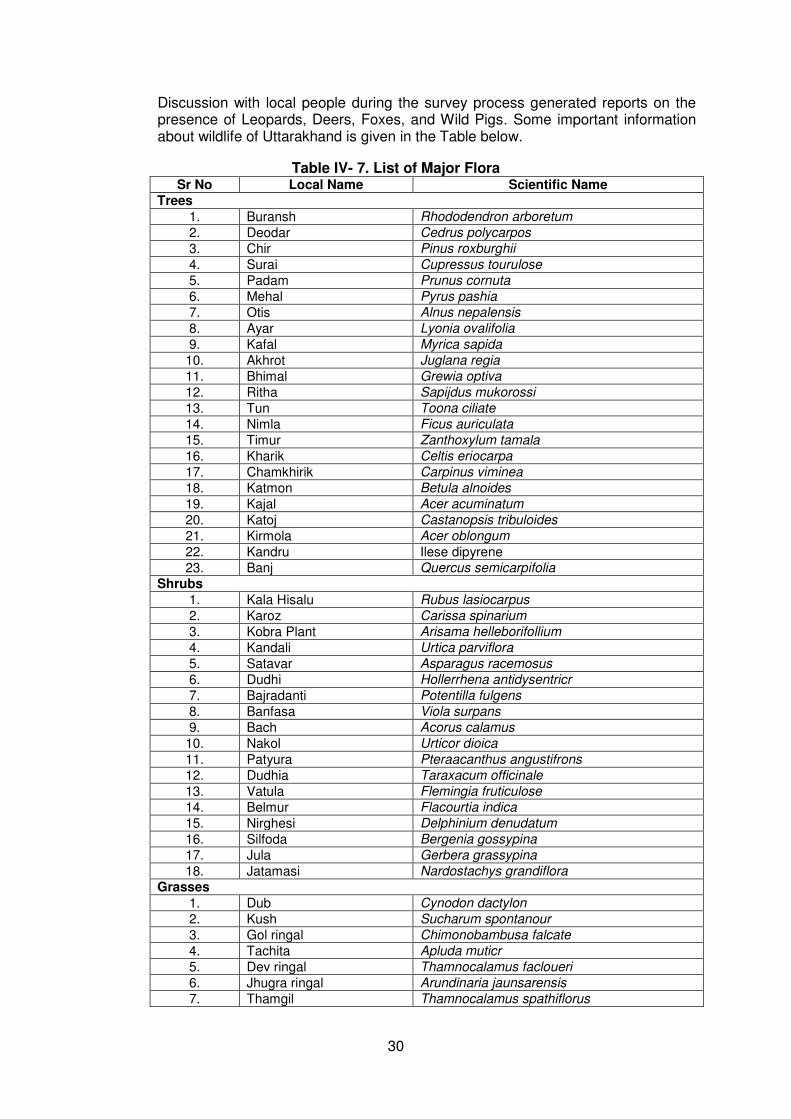
30
Discussion with local people during the survey process generated reports on the presence of Leopards, Deers, Foxes, and Wild Pigs. Some important information about wildlife of Uttarakhand is given in the Table below.
Table IV- 7. List of Major Flora Sr No Local Name Scientific Name
Trees 1. Buransh Rhododendron arboretum
2. Deodar Cedrus polycarpos
3. Chir Pinus roxburghii
4. Surai Cupressus tourulose
5. Padam Prunus cornuta
6. Mehal Pyrus pashia
7. Otis Alnus nepalensis
8. Ayar Lyonia ovalifolia
9. Kafal Myrica sapida
10. Akhrot Juglana regia
11. Bhimal Grewia optiva
12. Ritha Sapijdus mukorossi
13. Tun Toona ciliate
14. Nimla Ficus auriculata
15. Timur Zanthoxylum tamala
16. Kharik Celtis eriocarpa
17. Chamkhirik Carpinus viminea
18. Katmon Betula alnoides
19. Kajal Acer acuminatum
20. Katoj Castanopsis tribuloides
21. Kirmola Acer oblongum
22. Kandru Ilese dipyrene
23. Banj Quercus semicarpifolia
Shrubs 1. Kala Hisalu Rubus lasiocarpus
2. Karoz Carissa spinarium
3. Kobra Plant Arisama helleborifollium
4. Kandali Urtica parviflora
5. Satavar Asparagus racemosus
6. Dudhi Hollerrhena antidysentricr
7. Bajradanti Potentilla fulgens
8. Banfasa Viola surpans
9. Bach Acorus calamus
10. Nakol Urticor dioica
11. Patyura Pteraacanthus angustifrons
12. Dudhia Taraxacum officinale
13. Vatula Flemingia fruticulose
14. Belmur Flacourtia indica
15. Nirghesi Delphinium denudatum
16. Silfoda Bergenia gossypina
17. Jula Gerbera grassypina
18. Jatamasi Nardostachys grandiflora
Grasses
1. Dub Cynodon dactylon
2. Kush Sucharum spontanour
3. Gol ringal Chimonobambusa falcate
4. Tachita Apluda muticr
5. Dev ringal Thamnocalamus facloueri
6. Jhugra ringal Arundinaria jaunsarensis
7. Thamgil Thamnocalamus spathiflorus

31
Table IV- 8. List of Major Fauna
Sl. No. Wild Animals Local Name Scientific Name
1 Guldar Panthera Pardus 2 Kala Bhalu Selenarctos thibetanus 3 Ghural Memorhaedus goral 4 Kakar Muntiacus muntjak 5 Khirao Capricornis sumatraensis 6 Jangli Suar Sus-scrofa cristatus
7 Chitrola Martes flarigula
8 Langoor Presbyits entellus
9 Khargosh Lepus nigricollis
10 Sehi Hystrix indica
11 Gidar Canis aureus indicus
12 Jangli Billi Felis chaus
13 Gilehri Eurambulus pennanti
14 Bandar Macaques mulatta
Birds
1 Chir Fijent Catreus wallichii
2 Kalij Fijent Lophura Leucomelana
3 Koklaj Fijent Pucrassia macrolophus
4 Kala Irgal Letinaetus makavensis
5 Karorla Urocissa erythsorhyncha
6 Ullu Strix aluco nivicola
7 Baaj Flaco severaus
8 Kala Titar Francolinus francolinus
9 Papiha Cuculus varius
10 Tota Psittacula humalayana
11 Chakor Alectoris graeca chuker
12 Hariyal Treron spenura
13 Pashchimi Tregopan Tragopan meloccephalus
14 Bulbul Pyconotus cafer
15 Maina Aerioctheres tristis
16 Fakhta Streptobelia orientalis meena
17 Gidh Gyps himalayensis
18 Kauwa Carvus macrornynchos
19 Saat Bahen Teyrdoides striatus
20 Neelkanth Garrulus Lanaclatus
3. Biosphere reserve
93. The Biosphere Reserve is the top category after Wildlife Sanctuary and National Park in the Country. Out of the 14 Biosphere Reserves situated in India, the Nanda Devi Biosphere Reserve (NDBR)—established second among the 14—is situated in the State of Uttarakhand. It extends in the three districts of Chamoli (Garhwal), Pithoragarh, and Bageshwar (Kumaon). The Nanda Devi National Park (NDNP) and the Valley of Flowers are UNESCO World Heritage Site declared in 1988. The NDNP is located in the transition range between the Zanskar range and Himalayan foothills with 97 species of plants including many rare and almost extinct plants like Saussurea sudhanshui, Nardostachys grandiflora, Picrorhiza kurroa, Cypripedium elegans, C. himalaicum, Dioscorea deltoidea and Allium stracheyi. There are also

32
83 animal species including the Bharal (Pseudois nayaur), Himalayan Musk Deer (Moschus chrysogaster), Mainland Serow (Capricornis sumatraensis), Himalayan Tahr (Hemitragus jemlahicus), Goral (Nemorhaedus goral), Snow Leopard (Panthera uncia), Common Leopard (Panthera pardus), Himalayan Black Bear (Selenarctos thibetanus), Common Langur (Presbytis entellus), and Rhesus Macaque (Macaca mullata). Also, there are about 114 avian species and 27 species of butterflies in the NDNP
94. The Rajaji National Park was established in 1983 protecting sections of the tropical deciduous forest area of the Shivalik Hill range on the Himalayan foothills. The Park covers 820.42 square kms, along the Haridwar, Dehradun and Pauri Garhwal. The park has a vast Sal forest, and mixed forest mostly covered with Acacia catechu and Vetiveria zizanioides. It is refuge to approximately 49 species of mammals, 315 species of birds, 49 species of reptiles, 10 species of amphibians and 49 of Piscean species. This park has the largest population of elephants in Uttarakhand and a large population of tigers and leopards. Notable animals seen in the par are the Wild Cat, Goral, Rhesus Macaque, Himalayan Yellow Throated Marten, Monitor, Lizard, Indian Hare, Sloth, Himalayan Black Bear, King Cobra, Jackal, Barking Deer, Sambar, Wild boar, Indian Langur, Indian Porcupine and Pythons. The population of birds consists of the Great Pied Hornbill, Himalayan Pied Kingfisher, Sparrows, Fire Tailed Sunbird and the Peacock (Indian National Bird).
95. The Jim Corbett National Park covers 520 sq kms of Savannah-type grasslands and Sal forests. Declared as a Tiger Reserve in 1973, the Park has a rich diversity including the White Tiger, Throated Martem, Himalayan Palm Civet, Indian Grey Mongoose, Para, Kakka, Ghoral, Bar-headed Goose, Duck, Grepe, Snipe, Turtles, Python, Common Otter, Porcupine, Clack-taped Hare, Chital, Spotted Deer, Viper, Cobra, Krait, King Cobra, Tortoise, Graylag, Sandpiper, Gull, Cormorants and Egrets. There are 488 species of flora found protected in the Park including Sal, Savannah Grass, Anogeissus-Acacia catechu forests, Mallotus philippensis, Jamun and Diospyros tomentosa.
96. The Govind National Park covers an area of 957 sq. kms in Uttarakashi and a sanctuary for the endangered Snow Leopard and some other 15 species of mammals and 150 species of birds that includes the Himalayan Black bear, Brown bear, Musk deer, Bharal, Himalayan Tahr, Serow and Common leopard. The endangered birds found in this region are Monal Pheasant, Koklas Pheasant, Bearded Vulture Himalayan Snow Cock, Golden Eagle, Western Tragopan, Steppe Eagle and Black Eagle. Other varieties of birds include Owls, Pigeons, Minivets, Thrush, Warblers, Bulbul, Cuckoo and Finches.
97. The Valley of Flowers is a World Heritage Site located in Chamoli. There are hundreds of species mostly being Orchids, Poppies, Primula, Calendulas, Iris, Lily, Roses, Violets, Rhododendron, Angelica, Himalayan Fritillary, Daisies and Anemones and also supports a variety of mammals like the Himalayan Tahr, Snow Leopard, Musk Deer, Red Fox, Common Langur (a type of monkey), Bharal, Serow, Himalayan Black Bear, Himalayan Brown Bear, Pica (Mouse hare). A huge variety of butterflies and birds are also found in the valley including Himalayan Golden Eagle, Griffon Vulture, Snow Partridge, Himalayan Snow Cock, Himalayan Monal, Snow Pigeon, and Sparrow Hawk.
4. Fishery
98. Fish abound in almost all streams of the district and riparian villages find in it an important supplement to their ordinary food. The common species found here are asela or saul, mahasher, kalabans or karaunch and fucta or phar kata. Other species found in the district include gadara, gadiyal or guluwa, tarra, symplu and
33
nama, nawoo or japa. No interference with fishery activities is envisaged by execution of the proposed subprojects.
I. Socio-economic
1. Social and cultural development
99. The State of Uttarakhand occupies a total land area of 53,483 sq. km. which is 1.73 percent of India’s total land area. The native people of Uttarakhand are generally called either Garhwali or Kumaoni depending on their place of origin in either the Kumaon or Garhwal region. According to the 2011 census of India, Uttarakhand has a population of 10,116,752 comprising 5,154,178 males and 4,962,574 females, with 69.45% of the population living in rural areas. The state is the 20th most populous state of the country having 0.84% of the population on 1.69% of the land. The population density of the state is 189 people per square kilometre having a 2001–2011 decadal growth rate of 19.17%. The gender ratio is 963 females per 1000 males. The crude birth rate in the state is 18.6 with the total fertility rate being 2.3. The state has an infant mortality rate of 43, a maternal mortality rate of 188 and a crude death rate of 6.6.
100. According to the 2011 census, Chamoli district had population of 391,605 of which male and female were 193,991 and 197,614 respectively. In 2001 census, Chamoli had a population of 370,359 of which males were 183,745 and remaining 186,614 were females.
101. The rural sector of mountainous region of Uttarakhand is poorly developed and the inhabitants are economically poor due to tough terrain, paucity of agricultural land, limited avenues of employment and number of other constrains. In this regard, the road improvement project is seen as a solution towards economic development
2. Landuse and landuse pattern
102. The land use pattern of Uttarakhand is strongly governed by the following: elevation, climate, mountainous terrain, lithological type, topography, surface hydrology, sunlight in the fields of forestry and agriculture, alpine meadows, sparse vegetation (scrub), grazing land, barren land, and human settlement. The human settlements are mainly located in the shallow water zones or around the localities nearer to springs.
103. Forest is the main land use in the State and nearly 64% of the geographical area is under the varying forest densities (cover). Tree line is clearly demarcated above 2900 m elevation. Agriculture is confined to areas of low reliefs which are underlined by weak rock formation (i.e. schists, phyllites, weathered gneisses, and crushed quartzite). The cultivated land, approximately 11.5% of the total geographical area, is either terraced/semi-terraced or plain. Other land use categories such as meadows, grazing lands, and scrubs do not exhibit definite relationship with lithology. It is also observed that the south-facing hill slopes are covered by lush green forests.
Table IV-9. Land Utilization in Uttarakhand
Sl. No. Land-use
Period /
Year
Unit Statistics
1. Total Reported Area 2010-11 Hectare 56,72,636
2. Forest Area 2010-11 Hectare 34,84,803
3. Culturable Waste Land 2010-11 Hectare 310,390
4. Fallow Land 2010-11 Hectare 1,27,793
(i) Current Fallow 2010-11 Hectare 43,295
(ii) Fallow Land other than Current Fallow 2010-11 Hectare 84,498
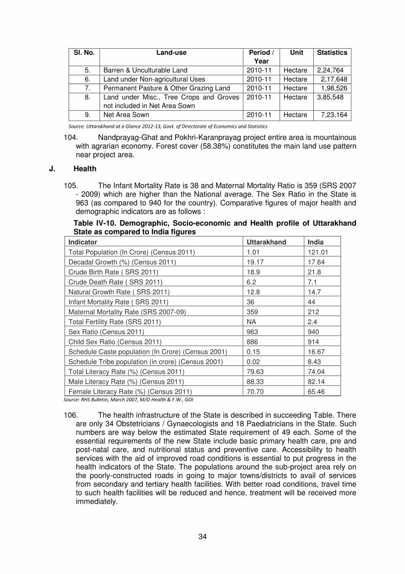
34
Sl. No. Land-use
Period /
Year
Unit Statistics
5. Barren & Unculturable Land 2010-11 Hectare 2,24,764
6. Land under Non-agricultural Uses 2010-11 Hectare 2,17,648
7. Permanent Pasture & Other Grazing Land 2010-11 Hectare 1,98,526
8. Land under Misc., Tree Crops and Groves
not included in Net Area Sown
2010-11 Hectare 3,85,548
9. Net Area Sown 2010-11 Hectare 7,23,164
Source: Uttarakhand at a Glance 2012-13, Govt. of Directorate of Economics and Statistics
104. Nandprayag-Ghat and Pokhri-Karanprayag project entire area is mountainous with agrarian economy. Forest cover (58.38%) constitutes the main land use pattern near project area.
J. Health
105. The Infant Mortality Rate is 38 and Maternal Mortality Ratio is 359 (SRS 2007 - 2009) which are higher than the National average. The Sex Ratio in the State is 963 (as compared to 940 for the country). Comparative figures of major health and demographic indicators are as follows :
Table IV-10. Demographic, Socio-economic and Health profile of Uttarakhand State as compared to India figures
Indicator Uttarakhand India
Total Population (In Crore) (Census 2011) 1.01 121.01
Decadal Growth (%) (Census 2011) 19.17 17.64
Crude Birth Rate ( SRS 2011) 18.9 21.8
Crude Death Rate ( SRS 2011) 6.2 7.1
Natural Growth Rate ( SRS 2011) 12.8 14.7
Infant Mortality Rate ( SRS 2011) 36 44
Maternal Mortality Rate (SRS 2007-09) 359 212
Total Fertility Rate (SRS 2011) NA 2.4
Sex Ratio (Census 2011) 963 940
Child Sex Ratio (Census 2011) 886 914
Schedule Caste population (In Crore) (Census 2001) 0.15 16.67
Schedule Tribe population (in crore) (Census 2001) 0.02 8.43
Total Literacy Rate (%) (Census 2011) 79.63 74.04
Male Literacy Rate (%) (Census 2011) 88.33 82.14
Female Literacy Rate (%) (Census 2011) 70.70 65.46 Source: RHS Bulletin, March 2007, M/O Health & F.W., GOI
106. The health infrastructure of the State is described in succeeding Table. There are only 34 Obstetricians / Gynaecologists and 18 Paediatricians in the State. Such numbers are way below the estimated State requirement of 49 each. Some of the essential requirements of the new State include basic primary health care, pre and post-natal care, and nutritional status and preventive care. Accessibility to health services with the aid of improved road conditions is essential to put progress in the health indicators of the State. The populations around the sub-project area rely on the poorly-constructed roads in going to major towns/districts to avail of services from secondary and tertiary health facilities. With better road conditions, travel time to such health facilities will be reduced and hence, treatment will be received more immediately.
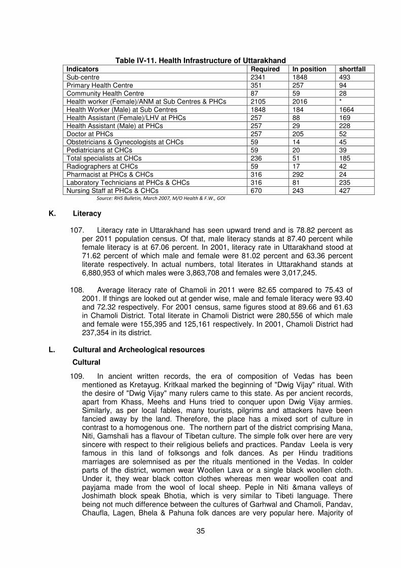
35
Table IV-11. Health Infrastructure of Uttarakhand
Indicators Required In position shortfall Sub-centre 2341 1848 493
Primary Health Centre 351 257 94
Community Health Centre 87 59 28
Health worker (Female)/ANM at Sub Centres & PHCs 2105 2016 *
Health Worker (Male) at Sub Centres 1848 184 1664
Health Assistant (Female)/LHV at PHCs 257 88 169
Health Assistant (Male) at PHCs 257 29 228
Doctor at PHCs 257 205 52
Obstetricians & Gynecologists at CHCs 59 14 45
Pediatricians at CHCs 59 20 39
Total specialists at CHCs 236 51 185
Radiographers at CHCs 59 17 42
Pharmacist at PHCs & CHCs 316 292 24
Laboratory Technicians at PHCs & CHCs 316 81 235
Nursing Staff at PHCs & CHCs 670 243 427 Source: RHS Bulletin, March 2007, M/O Health & F.W., GOI
K. Literacy
107. Literacy rate in Uttarakhand has seen upward trend and is 78.82 percent as per 2011 population census. Of that, male literacy stands at 87.40 percent while female literacy is at 67.06 percent. In 2001, literacy rate in Uttarakhand stood at 71.62 percent of which male and female were 81.02 percent and 63.36 percent literate respectively. In actual numbers, total literates in Uttarakhand stands at 6,880,953 of which males were 3,863,708 and females were 3,017,245.
108. Average literacy rate of Chamoli in 2011 were 82.65 compared to 75.43 of 2001. If things are looked out at gender wise, male and female literacy were 93.40 and 72.32 respectively. For 2001 census, same figures stood at 89.66 and 61.63 in Chamoli District. Total literate in Chamoli District were 280,556 of which male and female were 155,395 and 125,161 respectively. In 2001, Chamoli District had 237,354 in its district.
L. Cultural and Archeological resources
Cultural
109. In ancient written records, the era of composition of Vedas has been mentioned as Kretayug. Kritkaal marked the beginning of "Dwig Vijay" ritual. With the desire of "Dwig Vijay" many rulers came to this state. As per ancient records, apart from Khass, Meehs and Huns tried to conquer upon Dwig Vijay armies. Similarly, as per local fables, many tourists, pilgrims and attackers have been fancied away by the land. Therefore, the place has a mixed sort of culture in contrast to a homogenous one. The northern part of the district comprising Mana, Niti, Gamshali has a flavour of Tibetan culture. The simple folk over here are very sincere with respect to their religious beliefs and practices. Pandav Leela is very famous in this land of folksongs and folk dances. As per Hindu traditions marriages are solemnised as per the rituals mentioned in the Vedas. In colder parts of the district, women wear Woollen Lava or a single black woollen cloth. Under it, they wear black cotton clothes whereas men wear woollen coat and payjama made from the wool of local sheep. Peple in Niti &mana valleys of Joshimath block speak Bhotia, which is very similar to Tibeti language. There being not much difference between the cultures of Garhwal and Chamoli, Pandav, Chaufla, Lagen, Bhela & Pahuna folk dances are very popular here. Majority of

36
area being rural in nature, agriculture is the mainstay of bulk of population. Apart from agriculture, people in higher reaches also rear sheep & goats, the wool of which is used to manufacture a variety of items.
110. In higher reaches of Chamoli, horticulture is also practiced with apple, peaches, walnut, apricot etc. being the major fruits grown. In valleys malta production is carried on a massive scale. A part from fruits, potatoes are also cultivated in the high-altitude region, whereas in comparatively lower areas wheat, mandva, paddy, barley, soyabean, pulses are cultivated. Because of geographical relief, cultivation is not possible in places other than valleys – hence affecting the livelihood of natives substantially. Subsequently, the unemployed youth is forced to turn to plains in search of better employment opportunities. Apart from wool, Ringal-mats, Ringal baskets and Ringal containers are also made. For the development of woolen handicraft industry, many cottage industrial units have been established, giving financial assistance to the artisans.
Archaeological 111. In district Chamoli some archaeological resources notified by ASI, GoI are
Rudranath temple, Gopeshwar, Trident – Gopeshwar, Two temples – Pandukeshwar, Remains of sixteen temples, Adibadri, fort with walls and ruins of dwelling houses inside it and with flight of steps – Khal and rock inscription in survey plot no. 89 (Mandal).
M. Economic development
1. Transportation and communication
112. Transportation system is a key factor in the socio-economic development of any State. Roads are logically the critical inputs to the growth of all the sectors. Aside from road systems, the State of Uttarakhand is connected to other states via rail and air transportation systems. Dehradun, Haridwar and Kathgodam are the major railway stations connected to various parts of the country. Jolly Grant near Dehradun is the lone airport present in the State. As per statistical data from 2006-07, Uttarakhand has a total road network of 23,274 km of which 2,228.90 km comprises the National Highway (1,328.30 km with State PWD and 900.60 km with BRTF); 1,553.00 km comprises the State Highway; 579.85 km covers the MDR; 7,154.88 km comprises the ODR (6723.90 km with State PWD and 430.98 km with BRTF), and 7,250.53 km to the Village Road. Light vehicle roads constitute of about 2,633 km.
113. Density of road length per 100 sq. Km. is 45 km which is very low compared to the national average of 97 km. Only about seven percent of the roads in the State are built in two-lane standards while 50 percent are paved. About a third of the higher class paved roads are in poor condition and over 70 percent of the light-vehicle roads need to be repaired or rehabilitated. Due to the lack of road connectivity, vast areas of the State are inaccessible. Such problem influences the population to ‘chunk’ in far flung areas of the State remaining to be under-developed and devoid of educational and health facilities and employment opportunities.
114. The road density per 100 sq. km. of the total area in Garhwal region is 30 km whereas road density in Kumaon region is 37 km. In terms of population, Garhwal region has 234 km of roads per lakh and the corresponding figure in Kumaon is 266 km. Motor vehicles has increased with the annual growth rate of 11 percent accounting to 44,7000 vehicles in 2003. PWD is the principal agency responsible for the management of roads in the State.
As per PWD records following table gives the scenario of roads of the Uttarakhand state.

37
Table IV-12. Transportation of Uttarakhand state.
S.N. Items Year/ Period
Unit Statistics
(A) Motor Roads Maintained by PWD
(i)National Highways 2011-12 Km. 1375.76
(ii)State Highways 2011-12 Km. 3788.20
(iii)Major District Roads 2011-12 Km. 3289.74
(iv)Other District Roads 2011-12 Km. 2945.04
(v)Rural Roads 2011-12 Km. 14543.89
(vi) L.V. Roads 2011-12 Km. 858.22 (B) Motor Roads Maintained by BRTF
(i)Total length of Roads 2011-12 Km. 1281.32 (C) Motor Roads Maintained by Local Bodies
(i)District Panchayats 2011-12 Km. 862.45
(ii)Urban Local Bodies & Others 2011-12 Km. 1974.30 (D) Roads Maintained by Other Departments
(i)Irrigation 2011-12 Km. 741
(ii)Cane Development 2011-12 Km. 885
(iii) Forest 2011-12 Km. 3257
(iv) Others 2011-12 Km. 1685 (E) Postal and Communication Services
(i)Post Offices 2011-12 No. 2718
(ii)Telephone Exchanges 2011-12 No. 477
(iii)Telegraph Offices 2011-12 No. 2 (iv)PCOs 2011-12 No. 8429
(v)Telephone Connections (Including WLL)by BSNL 2011-12 No. 278751
(vi) Mobile phone by BSNL 2011-12 No. 1360674
2. Industrial Development
115. The State has very few industrial units mainly because of lack resources. In the hilly terrains, industries promoted include food processing, fruit processing, medicinal/herbal plants, and horticultural/floriculture-based industries. In the plain districts of Haridwar, Udham Singh Nagar, and other places, capital intensive and high-value addition industries are being encouraged by the government. In 2003-04, there were 178 large and medium-scale industries with total investment of Rs. 500,700 lacs providing employment to about 44,000 employees. Small scale industries, on the other hand, employ about 129,782 of the population.
116. In recent years, Uttarakhand has emerged as one of the most attractive industrial destinations in India. In this regard, the government is encouraging private participation in all industrial activities in the State. The New Industrial Policy announced in 2003 by the State government puts in place the regulatory framework for Uttarakhand's industrialisation. The New Industrial Policy indicates that private resources may be tapped while promoting integrated Industrial States in Uttarakhand. The State government provides assistance in establishing small and medium sized agro parks, food parks, and the likes which in turn are expected to provide common infrastructure facilities for storage, processing, grading, and marketing.
3. Agriculture, Forestry and Fishery
117. Agriculture is the main economic activity in the State as per latest land-use statistics. The total reported area for agricultural activity is 55.66 lakh hectares. In the hills, the major crops grown include wheat, paddy, mandua, ramdana and potato whereas in the plains the major crops are wheat, paddy, pulses, and sugarcane.
118. The pattern of land ownership is unlike that found in the rest of India. Most of the Uttarakhand farmers are owner-cultivators. Tenant farming and sharecropping are rare while landholdings are generally small and limited to family farms—approximately
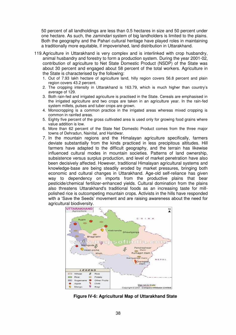
38
50 percent of all landholdings are less than 0.5 hectares in size and 50 percent under one hectare. As such, the zamindari system of big landholders is limited to the plains. Both the geography and the Pahari cultural heritage have played roles in maintaining a traditionally more equitable, if impoverished, land distribution in Uttarakhand.
119. Agriculture in Uttarakhand is very complex and is interlinked with crop husbandry, animal husbandry and forestry to form a production system. During the year 2001-02, contribution of agriculture to Net State Domestic Product (NSDP) of the State was about 30 percent and engaged about 58 percent of the total workers. Agriculture in the State is characterised by the following: 1. Out of 7.93 lakh hectare of agriculture land, hilly region covers 56.8 percent and plain
region covers 43.2 percent. 2. The cropping intensity in Uttarakhand is 163.79, which is much higher than country’s
average of 129. 3. Both rain-fed and irrigated agriculture is practised in the State. Cereals are emphasised in
the irrigated agriculture and two crops are taken in an agriculture year. In the rain-fed system millets, pulses and tuber crops are grown.
4. Monocropping is a common practice in the irrigated areas whereas mixed cropping is common in rainfed areas.
5. Eighty five percent of the gross cultivated area is used only for growing food grains where value addition is low.
6. More than 62 percent of the State Net Domestic Product comes from the three major towns of Dehradun, Nainital, and Haridwar.
7. In the mountain regions and the Himalayan agriculture specifically, farmers deviate substantially from the kinds practiced in less precipitous altitudes. Hill farmers have adapted to the difficult geography, and the terrain has likewise influenced cultural modes in mountain societies. Patterns of land ownership, subsistence versus surplus production, and level of market penetration have also been decisively affected. However, traditional Himalayan agricultural systems and knowledge-base are being steadily eroded by market pressures, bringing both economic and cultural changes in Uttarakhand. Age-old self-reliance has given way to dependency on imports from the productive plains that bear pesticide/chemical fertilizer-enhanced yields. Cultural domination from the plains also threatens Uttarakhand's traditional foods as an increasing taste for mill-polished rice is outcompeting mountain crops. Activists in the hills have responded with a ‘Save the Seeds’ movement and are raising awareness about the need for agricultural biodiversity.
Figure IV-6: Agricultural Map of Uttarakhand State
39
120. In the mountain regions and the Himalayan agriculture specifically, farmers deviate substantially from the kinds practiced in less precipitous altitudes. Hill farmers have adapted to the difficult geography, and the terrain has likewise influenced cultural modes in mountain societies. Patterns of land ownership, subsistence versus surplus production, and level of market penetration have also been decisively affected. However, traditional Himalayan agricultural systems and knowledge-base are being steadily eroded by market pressures, bringing both economic and cultural changes in Uttarakhand. Age-old self-reliance has given way to dependency on imports from the productive plains that bear pesticide/chemical fertilizer-enhanced yields. Cultural domination from the plains also threatens Uttarakhand's traditional foods as an increasing taste for mill-polished rice is outcompeting mountain crops. Activists in the hills have responded with a ‘Save the Seeds’ movement and are raising awareness about the need for agricultural biodiversity.
121. Agriculture is also practiced in the river valleys of Uttarakhand—a small 10-15 percent of the total land area. Over hundreds of years, many of the slopes have been cut into field terraces, a common characteristic of mountain agriculture throughout the world. The region's farmers have also developed advanced manure, crop rotation, and intercropping systems. Most of the land on hilly slopes is non-irrigated. Three types of agriculture can be found in most river valleys with each particularly suited to the type of land. These are as follows:
Katil (Forest edge land)
Hoe cultivation, with a standard rotation of 3 crops in 5 years Major crops are Finger millet/Mandua (Eleusine coracana), Barnyard
millet/Jhangora (Echinochloa frumentesia) and Chaulai/Ram Dana (Amaranthus polygamous, Amaranthus blitum)
Upraon (Hillside land)
Permanently terraced but unirrigated Major crops are Finger millet/Mandua (Eleusine coracana), Barnyard
millet/Jhangora (Echinochloa frumentesia) and Chaulai (Amaranthus polygamous) etc.
Talaon (Valley bottom land)
Paddy cultivation, low-lying, irrigated, double cropped Major crops area Wheat (Triticum aestivum), Paddy (Oryza sativa),
Sugarcane (Saccharum officinarum) etc. Table IV-13. Area under Principal Crops and Productivity in Uttarakhand
Sl. No.
Items Year/ Period
Unit Statistics
Area Under Principal Crops (Provisional) 1. Cereals 2011-12 Hectare 896774
(i) Rice 2011-12 Hectare 280108 (ii) Wheat (Triticum aestivum) 2011-12 Hectare 369209 (iii) Barley (Hordeum vulgare) 2011-12 Hectare 22508 (iv) Maize (Zea mays) 2011-12 Hectare 28038 (v) Finger millet (Eleusine coracana) 2011-12 Hectare 125163
(vi) Sanwan 2011-12 Hectare 63002
(vii)Other 2011-12 Hectare 8746
2. Pulses 2011-12 Hectare 55690 (i) Urad (Phaseolus radiatus) 2011-12 Hectare 12980 (ii) Lentil (Lens esculenta) 2011-12 Hectare 12295 (iii) Pea (Pisum sativum) 2011-12 Hectare 3451 (iv) Gahat (Mycrotoma biflorum) 2011-12 Hectare 12033 (v) Rajma (Dolichos lablab) 2011-12 Hectare 4614
(vi) Gram 766
(vii) Bhatt (Black Soyabeen) 2011-12 Hectare 5734

40
Sl. No.
Items Year/ Period
Unit Statistics
(viii) Others 2011-12 Hectare 3817
3. Oil Seeds 2011-12 Hectare 29705 (i) Mustard (Brassica compestris) 2011-12 Hectare 14294 (ii) Seasmum (Sesamun indicum) 2011-12 Hectare 2020 (iii) Groundnut (Arechis hypogea) 2011-12 Hectare 1112 (iv) Soyabean (Glycin max) 2011-12 Hectare 12279
4. Other Crops 2011-12 (i) Sugarcane (Saccharum officinarum) 2011-12 Hectare 108255 (ii) Onion (Allium cepa) 2011-12 Hectare 2353
Agriculture Productivity (Provisional) 1. Cereals 2011-12 Qtl./Hectare 22.03
(i) Rice 2011-12 Qtl./Hectare 21.20 (ii) Wheat (Triticum aestivum) 2011-12 Qtl./Hectare 23.80 (iii) Barley (Hordeum vulgare) 2011-12 Qtl./Hectare 12.64 (iv) Maize (Zea mays) 2011-12 Qtl./Hectare 14.66 (v) Finger millet (Eleusine coracana) 2011-12 Qtl./Hectare 13.92
2. Pulses 2011-12 Qtl./Hectare 8.15 (i) Urad (Phaseolus radiatus) 2011-12 Qtl./Hectare 8.13 (ii) Lentil (Lens esculenta) 2011-12 Qtl./Hectare 8.19 (iii) Pea (Pisum sativum) 2011-12 Qtl./Hectare 9.54 (iv) Gahat (Mycrotoma biflorum) 2011-12 Qtl./Hectare 8.04 (v) Rajma (Dolichos lablab) 2011-12 Qtl./Hectare 10.27
(vi) Gram Qtl./Hectare 7.85
(vii) Bhatt (Black Soyabeen) 2011-12 Qtl./Hectare 9.83
3. Oil Seeds 2011-12 Qtl./Hectare 8.34 (i) Mustard (Brassica compestris) 2011-12 Qtl./Hectare 8.00 (ii) Seasmum (Sesamun indicum) 2011-12 Qtl./Hectare 2.26 (iii) Groundnut (Arechis hypogea) 2011-12 Qtl./Hectare 12.72 (iv) Soyabean (Glycin max) 2011-12 Qtl./Hectare 14.46
4. Other Crops 2011-12 Qtl./Hectare (i) Sugarcane (Saccharum officinarum) 2011-12 Qtl./Hectare 609.33 (ii) Onion (Allium cepa) 2011-12 Qtl./Hectare 55.69
Table IV-14. Ecological Sub-Regions and Altitude-wise Major Agriculture Crops
Sl. No. Ecological Sub-Region Altitudinal
Gradient (m) Major Agriculture Crops
1. Lower Dun, Terai 300-600 Wheat (Triticum aestivum), Paddy (Oryza sativa) and Sugarcane (Sachharum officinarum).
2. Upper Dun, Bhabar, lower Shivaliks
600-1,200 Wheat (Triticum aestivum), Paddy (Oryza sativa), Maize (Zea mays) Chaulai (Amaranthus species) Finger millet/ Mandua (Eleusine coracana) and Barnyard millet (Echinochloa frumentesia)
3. Middle Garhwal-Kumaon 1,200-1,800 Wheat (Triticum aestivum), Paddy (Oryza sativa), Cheena (Panicum miliaceum), Potato (Solanum tuberosum), Barley (Hordeum vulgare) Finger millet (Eleusine coracana) and Barnyard millet (Echinochloa frumentesia),
4. Upper Garhwal-Kumaon 1,800-2,400 Wheat (Triticum aestivum) Barley (Hordeum vulgare) Potato (Solanum tuberosum),

41
Sl. No. Ecological Sub-Region Altitudinal Gradient (m)
Major Agriculture Crops
Chaulai (Amaranthus species), Cheena (Panicum miliaceum) and Phaphra (Fagopyum tataricum)
5. Cold Zone 2,400-3,600 Summer Crops: Wheat (Triticum aestivum), Barley (Hordeum vulgare) Potato (Solanum tuberosum), Phaphra (Fagopyum tataricum) Chaulai (Amaranthus species), Kauni (Setaria etalica) Ogal (Fagopyrum esculentum) and Uva Jau (Hoycleum himalayanse)
122. Various pulses (e.g., "Masur" - Ervum lens; "Kulat" – Mycrotoma biflorus) are grown
intercropped during the two harvest seasons—early winter after the rainy season (millet), and midsummer before the hot dry season (barley-wheat). Dry and wet rice, taro, pumpkins, beans, corn, ginger, chili, cucumbers, leafy vegetables, and tobacco are also grown in the area. Likewise, potatoes have become an important cash crop being grown in areas unsuitable for other plants (Berreman, 1963).
123. The water drainage of the greater part of the Pithoragarh district and the eastern parts of Almora and most of the Kumaon region is affected by the Kali River system. The project area is divided into many watersheds which drains the water in to a big area called ‘Catchment’ such as Pindari Catchment, Ganga Catchment, Saryu Catchment etc. The area is totally rainfed due to the hilly terrain. The irrigation facility is only available adjoining to rivers in valleys. The cross drainages are required in project roads for durability of strengthening work. The irrigation and drainage system in Uttarakhand is described below.
Table IV-15. Mode of Irrigation and Drainage System in Uttarakhand
Sl. No.
Items Year/ Period
Unit Statistics
Net and Gross Irrigated Area 1. Canals 2011-12 Hectare 83687
2. Tube Wells 2011-12 Hectare 216100
3. Other Wells 2011-12 Hectare 11519
4. Tanks/ Ponds 2011-12 Hectare 83
5. Other Sources 2011-12 Hectare 24747
6. Net Irrigated Area (NIA) 2011-12 Hectare 336136
7. Gross Irrigated Area (GIA) 2011-12 Hectare 561733 Irrigational Infrastructure
1. Length of Canals 2011-12 Km. 11588
2. Length of Lift Canals 2011-12 Km. 242
3. Tube Wells (State) 2011-12 No. 1110
4. Pump Sets ( Boring/ Free Boaring) 2011-12 No. 54642
5. Hauj 2011-12 No. 32850
6. Gool 2011-12 Km. 26365
7. Hydrum 2011-12 No. 1547
8. C.C.A. Under State Canal 2011-12 Lakh Hect. 3.302
9. Revenue Collection by Irrigation 2011-12 Rs. Lakh 252.27
N. Fisheries
124. The State has great potential for the development of fisheries. The State abounds in perennial and seasonal water bodies which hold high promise for the growth of fishery. Golden Mahseer (Tor putitora), one of the main game and food fish in the

42
central Himalayan region, has decreased significantly. The fish migrate considerable distances upstream in search of suitable spawning grounds. Stocks of the Himalayan mahseer are depleted and it is now considered an endangered species. Catch data from the major rivers are not available while studies are characterized as sporadic and preliminary in nature. According to available statistics, the Himalayan mahseer contributes significantly only in one river—comprising 32.8% of the catch from the Nayar River, 9.7% from Song River, and 0.8–3.1% from other rivers. The important fishes commonly found in the Himalayan river basins are Catla catla, Labeo rohita, Labeio calbase, Cirrihinus mirigale, Clarius, batrachus, Rita rita, Heteropneuptus fonilis, Notopterus nontopterus, N. Chitala, Macrobrachum rosenbergii, M. malconsoni, M. Chapral, Channa punetatus, C. gaehua, and C. striatus.
O. Energy and Electric Power Potential
125. Uttarakhand has an estimated hydro power potential of approximately 20,200 MW. However, only 1,130 MW has been tapped at present. Meanwhile, 4,170 MW projects are under implementation and 3,800 MW projects are allotted to Central, State and private sectors. Thirty-nine projects with a potential of 6,374 MW have been identified for PFR under PMs Hydro Initiatives.
126. Although Uttarakhand is a power surplus State, a lot needs to be done to harness the untapped potential and sale the surplus power to make this a GDP driver sector for the State.
P. Aesthetic and Tourism
127. Chamoli District is worldwide famous for its hill stations, picturesque spots and religious centers. This district has lot of options for pilgrimages and adventures trekkers. chamoli includes popular Pilgrimage spots such as Badrinath, kerdarnath, Tungnath and Joshimath, People visit here for religious aspect. This area also have option for adventures people who are fond of trekking in mountains such places are Devaria-Taal, Vedni-Bugyal, Auli-Bugyal, Gurson-Bugyal and Roopkund. Chopata, Chamoli and Gvaaldam can be viewed as a Beautiful hill stations.
128. There are plenty of religious & tourist destinations in the district, which are visited by thousands of national & international tourists annually. The religious spots are of immense importance to followers of Hindu religion. The major worth-visiting spots include Gopeshwar, Rudranath, Kalpeshwar- Urgam, Bhavishyabadri, Aadibadri, Mana village (the last one on the boundary of India), Auli (from where Mount Nanda Devi, Mount Kamet, Mana Peak, Hathi-Gauri peak, Dronagiri etc can be easily seen).

43
V. ANTICIPATED ENVIRONMENTAL IMPACTS AND MITIGATION MEASURES
129. State Highways and Other District Roads were screened using the ADB’s rapid environmental assessment (REA) checklist for Roads and Highways.
i) The individual environmental screening checklist is provided in Appendix A of this report.
ii) No environmental impacts related to siting. All subproject road passing through forest but the work will be confined to the existing ROW belonging to Uttarakhand Public Works Department. The proposed subprojects are not expected to have any impact on the Forests and does not involve any tree cutting as the scope of the work is restricted to reconstruction and rehabilitation of disaster affected section of the existing roads. No road widening is proposed. Not a single road section is located inside or near a cultural heritage site, protected area (national park / sanctuary /biosphere reserve), wetland, mangrove, estuarine, buffer zone of protected area or special area for protecting biodiversity. There are no rare, threatened, and endangered species (flora and fauna) within the subproject corridor of impact.
iii) Potential significant environmental impacts. , Road sections are prone to landslides, localized flooding, increase erosion, siltation, and hazardous driving conditions.
130. The beneficial impacts still outweighs the potential significant environmental impacts. Beneficial impacts include reduction in travel time and lower vehicle operating costs; better internal and external access to and from Uttarakhand; and better access to agricultural production areas, markets, religious and tourist areas. The road design is also a mitigation measure to existing road safety and accessibility issues as it addresses erosion, landslides, poor drainage, and inadequate road safety. Improved roads will also contribute to the community climate change resiliency as it can better withstand more extreme weather events allowing continued accessibility and flow of materials under such conditions.
5.1 Negative Impacts Related to Project Location, Preliminary Planning and Design
A. Impact and mitigation measure during planning and design phase
131. There are no significant adverse environmental impacts during the planning and design phase based on the environmental screening of all 3 road sections. Since all the three road sections to be improved are located in forested hilly areas, with high precipitation and erodible soils, the risk of increase in landslides and siltation of creeks and rivers will be integrated in the road improvement design. This include the rehabilitation of existing and construction of additional side- and cross drains like culverts and scuppers to control surface water flow below scouring velocity and volume. Landslide prone areas will strengthened through the installation of retaining walls. Re-vegetation of eroded areas will be promoted in coordination with the Forest Department.
132. Off-site impacts associated with the road upgrading related to material sourcing from quarries, hot mix plant, and stone crushers will be minimized by relying solely on existing and licensed quarries. All hot or stone crushers to be utilized will have will have prior consent from the SPCB.
B. Impacts during Construction Phase
133. Majority of the significant impacts will occur during the construction phase. These impacts, to be described in the succeeding sections are classified according to major components of the environment – physical, biological, air, water, and socio-
44
economic. These impacts were mainly drawn from screening of impacts described in the introduction of this Chapter.
a. Impacts on the Physical Environment and Mitigation Measures
i. Alteration of surface water hydrology of waterways crossed by roads, resulting in increased sediment in streams affected by increased soil erosion at construction site.
134. During the construction phase, erosion is expected to intensify due to vegetation removal, soil disturbance and exposure of bare soil surface. Soil erosion is anticipated at bridge and culvert construction sites. Problem will be more pronounced if the construction is taken up in rainy season. Construction activities such as cuttings and fillings will initiate soil erosion within road alignment, quarries and access roads to these areas.
135. These impacts will be mitigated by: i) avoiding construction activities during monsoon, ii) maintain embankment slope ratio of 1:2, iii) compliance to IRC 59-1974 on treatment of embankment slopes for control of erosion, iv) stone pitching and retaining structures shall be provided to control to soil erosion wherever necessary, v) turfing of embankment slopes particularly near bridge locations, vi) construction of silt traps at regular points along the road, and vi) immediate cleaning of all construction debris to prevent unconsolidated soil being eroded by either wind or runoff water. (see Appendix 13 Soil Erosion and Sedimentation Control).
136. To prevent soil erosion along the embankment during operation phase, regular monitoring inspections should be undertaken to ensure that drainage, bridge approaches and re-vegetated areas are maintained and strengthened to prevent re-occurrence of soil erosion.
ii. Impacts on water quality
137. Road construction decreases available water to the host community in terms of its substantial requirement for processing, dust suppression, and domestic use of camps, and to a certain extent decrease the water availability by reducing groundwater recharge due to pavement of road surface. The risk of contaminating both surface and groundwater from untreated camp sewage also impacts availability of water to its most beneficial users. Although the construction requirement is temporary, mitigation measures must ensure the additional water demand will not burden existing water supply and sanitation systems. All road construction water requirements shall be exclusively extracted from government permitted sources. All bore wells will secure permission from the state groundwater authorities to ensure no disruption to customary users. Contractor may draw water from the irrigation canal provided written consent is issued by the Irrigation Department.
138. To avoid contamination of water, no wastewater will be disposed without treatment. This will include the treatment of sewage through septic tank and interception of all oil-contaminated wastewater for oil recovery prior to disposal. All petroleum-based storage and handling areas will be paved to prevent groundwater contamination and facilitate easy clean-up and recover of spills. Prohibit the cleaning of tools and equipment on or near rivers, canals, and other water bodies. To conserve water and promote recycling, no drinking quality water will be used for dust suppression.
iii. Disfiguration of landscape by road embankments, cuts, fills, and quarries.
139. During the improvement works for the sub-project sections and because of the cutting of hill slope, filling and stone quarrying will disfigure the landscape. Although this impact is unavoidable, it becomes significant as the roads are located on hilly terrain as the land is unstable. Mitigation measures to minimize impacts are: i) ii) source rock and sand from existing license quarries; iii) balance cut and fill; iv) prohibit blasting; v) prohibit disposal of spoils on the valley side; and vi) proper
45
construction of drainage facilities to prevent soil from being saturated and increase susceptibility to erosion and maintain the original flow of water.
140. All contractors are required to submit a Debris Transportation and Disposal Plan no later than 30 days after the issuance of Notice to Proceed. The issuance of the Completion Certificate by the Engineer will also be reckoned, among others, a certification from the Construction Supervision Consultant-Environment Specialist the Contractors successful implementation of the EMP.
141. During road operation all drainage and erosion control infrastructure will be maintained on a regular basis to ensure optimum condition as part of the post-construction maintenance component of the Project.
iv. Loss of productive soil
142. The proposed subproject works are restricted to reconstruction and rehabilitation of damaged sections of roads due to disaster of 2013. Restoration of some road sections located along agricultural lands is involved but will not require conversion as the restoration works are confined to the existing width of roads. All construction camps, labour camps, borrow area, access roads will be located on barren lands.
v. Compaction and contamination of Soil
143. Soils of productive agricultural area adjoining subproject road, haul roads, construction camp area, labour camp area and at other construction establishment may be compacted due to the movement of heavy equipment, transport vehicles, and storage of materials. Mitigation measure includes control of movement of construction vehicles; new haulage roads will limited on the barren lands; and rehabilitation of construction camps, labour camps, material storage areas near to its original condition after the completion of work;
b. Impacts on Environmental Quality
i. Increase in local air pollution due to rock crushing, and filling works, and chemicals from asphalt processing.
144. Most of the dust during construction arises from excavation and filling during site preparation works, loading, unloading and transportation of construction material, drilling, blasting; use of heavy equipment and machinery in the earthworks and pavement works. Gaseous emissions like, oxides of sulphur (SO2), oxides of nitrogen (NOx), carbon monoxide (CO), and hydrocarbon (HC) are emitted from mobile sources, hot mix plant, batching plants and diesel generator sets. Elevated concentration or these parameters cause pollution, albeit short term.
145. Exposure to episodes of air pollution causes numerous health problems like pulmonary, cardiac, vascular, and neurological impairments. High-risk groups such as the elderly, infants, pregnant women, and sufferers from chronic heart and lung diseases are more susceptible to air pollution. Children are at greater risk because they are more active outdoors and their lungs are still developing. “Exposure to air pollution can cause both acute (short-term) and chronic (long-term) health effects. Acute effects are usually immediate and often reversible when exposure to the pollutant ends. Some acute health effects include eye irritation, headaches, and nausea. Chronic effects are usually not immediate and tend not to be reversible when exposure to the pollutant ends. Some chronic health effects include decreased lung capacity and lung cancer resulting from long-term exposure to toxic air pollutants (USEPA, 2010).
146. To minimize impacts on community areas, the location of all construction establishments such as hot mix plants, WMM plants, crusher plants, construction camps, and offices will be located at least 1000 m away.
46
147. Consent to Establish (CTE) and Consent to Operation (CTO) will be obtained for construction establishments such as hot mix plants, batching plants and stone crushers from the UEPPCB. To control gaseous emission during construction, pollution control devices such as cyclone separators /scrubbers will be installed to control emissions from hot mix plants, crushing units and concrete batching plants. Height of the stacks will comply with statutory requirements. All vehicles and construction equipment operating for the contractor and the consultant will obtain and maintain “Pollution under Control” (PUC) Certificates.
148. To control dust emissions, vehicles deployed for borrow material, sand and aggregate haulage, shall be covered with tarpaulins to be spillage proof. Regular sprinkling of water during excavations, loading, unloading, vehicular movement and raw material transport, provisions shall be made construction period.
149. Other control measures to control emissions include the use of LPG or low sulphur diesel shall be used in the diesel generator sets and fitted with the stack of required height. The use of firewood for cooking is prohibited.
150. Periodic air quality monitoring to ensure emissions comply with standards will be conducted as per the agreed environmental monitoring plan given in table VIII - 3. The Contractor will submit annual emission monitoring results required by the SPCB as part of the annual CTO renewal. Ambient monitoring along active construction fronts and major community areas will be the conducted by the contractor in consultation with the DSC.
151. Limited mitigation measures are available to the Uttarakhand PWD to control emissions from mobile sources as this is beyond their authority. Still, posters and signboards promoting the proper maintenance of vehicles will be installed along key points highlighting safer, cheaper, and more environment friendly use of the roads.
ii. Noise and vibration from civil works
152. Noise pollution affects both workers and nearby communities. Impacts to exposure are hearing loss, and sleep disruption. Sleep disruption in turn can cause poor concentration and performance, weight changes, and a general decrease in health and overall well being. The combination of stress and lack of sleep can also lead to frustration and aggravation. The social consequences include becoming short-tempered or potentially aggressive resulting in more accidents, poor familial and social relationships, and poor work performance.
153. Sources of noise pollution include construction activity, traffic, and heavy equipment operation. Mitigations measures to be implemented will include: use of enclosures, walls, installation of mufflers around noisy equipment and the noise sources reduce noise generated during construction and demolition activities; preference to quieter equipment or construction methods; minimizing time of operation and locating equipment farther from sensitive receptors; timing of noisier construction and demolition activities to between 6 AM and 10 PM would reduce construction noise impacts during night; detouring construction trucks away from noise-sensitive areas such as schools and hospitals would eliminate construction truck noise from those areas; mandatory use by workers of personal protective equipment (PPE) such as ear plugs and earmuffs; and temporary traffic by-passing of community areas. Appendix 5 provides typical noise barriers that maybe required during project construction and operation. Monitoring of noise levels in potential problem areas as per the monitoring plan will be carried out.
154. During project operation the PWD will explore the need to establish permanent noise control structures like avenue vegetation, and prohibition on use of horns and speed restrictions at noise sensitive areas like schools, civil courts and major hospitals reduce roadway noise levels.
47
C. Impacts on the Socio-Economic i. Encroachment on historical and cultural areas
155. No historical or cultural areas will be shifted as a result of the road restoration works in disaster affected sections. However, several religious structures are near the road which will be affected in terms noise, dust, and temporary partial/full blockade of access causing inconvenience.
156. The same mitigation measures addressing noise, and dust discussed earlier will be implemented on these sensitive areas. Traffic re-routing as provided in Appendix 10 Arrangement of Traffic during Construction will be implemented by the Contactor.
ii. Impacts on Occupational Health and Safety
157. Employers are required to implement precautions to protect the health and safety of workers. Road construction exposes workers to various physical hazards that may result to minor, disabling, catastrophic, or fatal injuries. Work close to rotating and moving equipment like hot mix plant operation, materials handling, motorpool repairs/machining and the like create trap hazards putting extremities at risk. Exposure to loud noise can cause temporary or permanent hearing impairment. Hand-arm vibration, electrical, welding/works, and working close to moving vehicles also expose workers to injuries. , Appendix 6 “Work Safety in Common Operation and Construction” provides a range of mitigation measures to promote occupational safety.
iii. Impacts on Community Health and Safety
158. These impacts pertain to those that take place outside the project boundaries, in this case the ROW and camp site, but are related to road construction and operation. Impacts on water quantity, and air and water qualities were discussed in other sections. Other impact on community health and safety related to road construction pertains to road crashes, structural safety, transport of hazardous materials, communicable and vector borne diseases, and emergency preparedness in case or road failures such as slides rendering villages inaccessible.
159. Risk of road crashes will increase during construction when a construction related and transport vehicles, and workers are co-located along restricted construction fronts. During operation phase, the projected increase in the number of motorized road users traveling at higher speeds also increases the chances of injuries and fatalities from road crashes. To mitigate these risks, the contactor needs to adopt safety measures for workers and road users particularly those that are more vulnerable to crashes. Contractors need to emphasize safety among drivers; ensuring drivers have adequate skills, avoiding dangerous routes and times of day to reduce chances of crashes, speed control devices, and regular maintenance of vehicles to avoid premature failure. The address the risk cause by increase in traffic, the Contractor will: i) minimize pedestrian interaction with construction vehicles, ii) install signages, visibility and overall road safety particularly near schools or where children are present, iii) coordinate with local emergency groups on location of active construction fronts to facilitate appropriate first aide, iv) use of local materials to the extent possible to reduce hauling distance, v) employ flag persos to warn dangerous conditions.
160. Accident risks associated with increase in vehicular traffic, leading to accidental spills of toxic materials is also magnified during construction. Contractor’s or its third party suppliers of fuel, lubricants, and bitumen will be required to demonstrate proofs of capability to handle spills to include: i) proper labelling of container content, hazards, and operator’s contact details; ii) ensure the integrity of the packaging/containers and transport vehicle are commensurate to the hazardous material; iv) drivers and assistants are trained on transport and emergency procedures; v) operator has the means to respond to emergencies on a 24 hour
48
basis. (see , Appendix 16 Storage, Handling, Use and Emergency Responses for Hazardous Chemicals)
161. The construction camps pose risk of communicable and vector-borne diseases not only among its workers but to the host communities through poor camp sanitation and living conditions, migrant workers might carry sexually-transmitted diseases such as HIV/AIDS. Measures to properly maintain hygiene inside Camps are provided in, Appendix 17 Site Management of Construction. The Contractor will undertake health awareness and education through information and promoting individual protection. The Contractor will link with existing state and national health programs on STDs, HIV/AIDS, and immunization. Contractors will cause the provision of treatment of communicable diseases in community health care facilities, access to medical treatment, confidentiality particularly with respect to migrant workers. The Contractor, will implement mosquito, rodent, and arthropod-borne diseases control that will have the following components: i) prevention of propagation by eliminating all breeding habitats close to the camps, ii) elimination of all unusable impounded water; iii) increase water velocity in channels near camps; iv) judicious use of insecticides on building walls; v) promoting the use of mosquito nets; vi) monitoring and treatment of diseases and collaboration with health officials, vii) distribute educational materials among workers and host communities, and viii) proper handling and use of insecticides to minimize human exposure and spills.
162. Roads and bridges failures due to inadequate designs may cause injuries to community and other road users. This risk is mitigated through the compliance with appropriate engineering design standards by the design engineers and review and approval of engineering plans by the PWD.

49
VI. Information Disclosure, Consultation, and Participation
a. Public participation during the preparation of the IEE
163. The public participation process included identifying interested and affected parties (stakeholders); informing and providing the stakeholders with sufficient background and technical information regarding the proposed development; creating opportunities and mechanisms whereby they can participate and raise their viewpoints (issues, comments and concerns) with regard to the proposed development; giving the stakeholders feedback on process findings and recommendations; and ensuring compliance to process requirements with regards to the environmental and related legislation.
164. Stakeholder consultation and participation with various stakeholders is an integral part of the environmental and social impact assessment and also part of regulatory requirement of EIA Notification, 2006 and ADB requirements. The stake holders of the project include project affected communities (on either side of the project road) and institutional stake holders such as PCB, local bodies, Water Resource Department, Environmental Department, Mines and Geology Department, Forest Department, etc. Consultations at micro-level (along the road) and macro-level (e.g. District/State level institutional consultations) helped planners to integrate the short term and long terms requirements of the local, regional, state and national goals in to the planning process. The regional, state and national goals are generally set by the legislations and policies by controlling or limiting the activities in order to reduce and nullify the adverse impact generated by infrastructure projects like roads and highways.
165. The following methodologies were adopted were adopted for carrying out public consultation
[i] Local communities, Individuals affected, traders and local shopkeepers who are directly affected were given priority while conducting public consultation. [ii] Walk-through informal group consultations along the proposed subprojects area [iii] One to one meetings were generally held with a few members of local communities. These consultations sometimes focused on one or more specific issues in a given section (link) of the project corridor. Focus group consultations were conducted with a sample section of the community with a good representation from the affected communities. Such meetings usually provide substantial information about the community concerns. Details of the local consultations are given below:
50
Nandprayag-Ghat Motor Road
Place: Mangroli, Tefna, Thirpak
talla, Thirpak Malla
District: Chamoli
Date of Consultation: 20/05/2014
Participants: Villagers, shopkeepers,
students etc.
1. Issues Discussed:
Impact on the local environment due to construction and strengthening of the project road.
Scope of employment generation for the local people during construction phase.
Construction activity whether causing any type of health hazard or not?
Any loss of land or property due to construction activity?
Any damage to historical or cultural monuments along project road?
Problems faced by the local people in their daily activities due to improper road network?
Discussion among public for sharing of information related to project (environmental safeguard policy, direct and indirect impacts of improvement options on environmental).
2. Stakeholder’s Response:
Local inhabitant’s wants deployment of local people during road construction.
Villagers think that construction activity will not cause any major health hazard instead good road quality shall decrease the health hazard.
No any historical and cultural monument along the project road. Local people prefer road development than the environment because they think that there will be negligible impact on the environment due to construction of the road but they want minimum number of trees to be cut for road improvement.
In some places landslides occurs during rains and debris from top deposits on the road.
3. Recommendations & Suggestions:
Special attention is required to protect landslides in this area.
To check the landslide problem through biological and mechanical methods.
Proper drainage is required for water during rainy season.
Efforts should be taken for the generation of employment for local people during construction.
Speed breakers are required on blind curves, settlement areas etc. for control of road accidents.
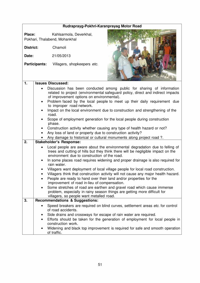
51
Rudraprayg-Pokhri-Karanprayag Motor Road
Place: Kahlsarmola, Deverkhal,
Pokhari, Thalabend, Mohankhal
District: Chamoli
Date: 21/05/2013
Participants: Villagers, shopkeepers etc.
1. Issues Discussed:
Discussion has been conducted among public for sharing of information related to project (environmental safeguard policy, direct and indirect impacts of improvement options on environmental).
Problem faced by the local people to meet up their daily requirement due to improper road network.
Impact on the local environment due to construction and strengthening of the road.
Scope of employment generation for the local people during construction phase.
Construction activity whether causing any type of health hazard or not?
Any loss of land or property due to construction activity?
Any damage to historical or cultural monuments along project road ?.
2. Stakeholder’s Response:
Local people are aware about the environmental degradation due to felling of trees and cutting of hills but they think there will be negligible impact on the environment due to construction of the road.
In some places road requires widening and proper drainage is also required for rain water.
Villagers want deployment of local village people for local road construction.
Villagers think that construction activity will not cause any major health hazard.
People are ready to hand over their land and/or properties for the improvement of road in-lieu of compensation.
Some stretches of road are earthen and gravel road which cause immense problem, especially in rainy season things are getting more difficult for villagers, so people want metalled road.
3. Recommendations & Suggestions:
Speed breakers are required on blind curves, settlement areas etc. for control of road accidents.
Side drains and crossways for escape of rain water are required.
Efforts should be taken for the generation of employment for local people in construction work.
Widening and black top improvement is required for safe and smooth operation of traffic.
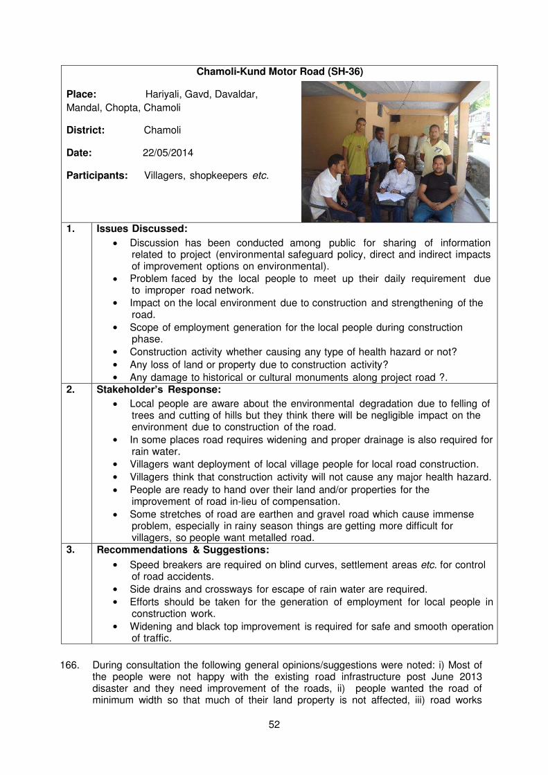
52
Chamoli-Kund Motor Road (SH-36)
Place: Hariyali, Gavd, Davaldar,
Mandal, Chopta, Chamoli
District: Chamoli
Date: 22/05/2014
Participants: Villagers, shopkeepers etc.
1. Issues Discussed:
Discussion has been conducted among public for sharing of information related to project (environmental safeguard policy, direct and indirect impacts of improvement options on environmental).
Problem faced by the local people to meet up their daily requirement due to improper road network.
Impact on the local environment due to construction and strengthening of the road.
Scope of employment generation for the local people during construction phase.
Construction activity whether causing any type of health hazard or not?
Any loss of land or property due to construction activity?
Any damage to historical or cultural monuments along project road ?.
2. Stakeholder’s Response:
Local people are aware about the environmental degradation due to felling of trees and cutting of hills but they think there will be negligible impact on the environment due to construction of the road.
In some places road requires widening and proper drainage is also required for rain water.
Villagers want deployment of local village people for local road construction.
Villagers think that construction activity will not cause any major health hazard.
People are ready to hand over their land and/or properties for the improvement of road in-lieu of compensation.
Some stretches of road are earthen and gravel road which cause immense problem, especially in rainy season things are getting more difficult for villagers, so people want metalled road.
3. Recommendations & Suggestions:
Speed breakers are required on blind curves, settlement areas etc. for control of road accidents.
Side drains and crossways for escape of rain water are required.
Efforts should be taken for the generation of employment for local people in construction work.
Widening and black top improvement is required for safe and smooth operation of traffic.
166. During consultation the following general opinions/suggestions were noted: i) Most of the people were not happy with the existing road infrastructure post June 2013 disaster and they need improvement of the roads, ii) people wanted the road of minimum width so that much of their land property is not affected, iii) road works
53
should be completed at the earliest and people should not face any further inconvenience, iv) after construction, proper maintenance of the road should be carried out, v) noise pollution control measures during construction shall be devised at village settlements, particularly at schools.
b. Future consultation and Disclosure 167. The public consultation and disclosure program will remain a continuous process
throughout the subproject implementation and shall include the following c. Consultation during Detailed Design
168. Focus-group discussions with affected persons and other stakeholders was performed to hear their views and concerns, so that these can be addressed in subproject design wherever necessary. Regular updates on the environmental component of the subproject will be kept available at the PIU/PMU of UEAP.
169. PIU/PMU will conduct information dissemination sessions at major intersections and solicit the help of the local community leaders/prominent citizens to encourage the participation of the people to discuss various environmental issues.
170. The PIU/PMU, with assistance of DSC will conduct information dissemination sessions in the subproject area. During EMP implementation PIU, DSC, and PMU shall organize public meetings and will apprise the communities about the progress on the implementation of EMP in the subproject works
d. Consultation during Construction
171. Public meetings with affected communities (if any) to discuss and plan work programs and allow issues to be raised and addressed once construction has started.
172. Smaller-scale meetings to discuss and plan construction work with local communities to reduce disturbance and other impacts, and provide a mechanism through which stakeholders can participate in subproject monitoring and evaluation.
e. Project Disclosure
173. A communications strategy is of vital importance in terms of accommodating traffic during road closure. Local communities will be continuously consulted regarding location of construction camps, access and hauling routes and other likely disturbances during construction. The road closure together with the proposed detours will be communicated via advertising, announcements, road signage, etc.
174. For the benefit of the community the IEE will be disclosed to the affected people and other stakeholders in a form and language(s) understandable to them at an accessible place in a timely manner and made available at: (i) PIU/PMU office; (ii) District Magistrate Office; and, (iii) DSC office. It will be ensured that the hard copies of IEE are kept at such places which are conveniently accessible to citizens as a means to disclose the document and at the same time creating wider public awareness. Electronic version of the IEE will be placed in the official website of the SDMA UEAP and the official website of ADB after approval of the IEE by ADB. The PIU will issue Notification on the locality-wise start date of implementation of the subproject. Copies of the IEE will be kept in the PMU/PIU office and will be distributed to any person willing to consult the IEE.
f. Public Disclosure
175. The IEE report will be disclosed in the English language at PMU, PWD division office and will also be available in the website of ADB. The full reports will also be available to interested parties upon request from PMU.

54
VII. ENVIRONMENTAL MANAGEMENT PLAN AND GRIEVANCE REDRESS MECHANISM
A. Environmental Management Plan
176. The EMP will guide the environmentally -sound construction of the subproject and ensure efficient lines of communication between the DSC (Engineer), contractors, and PIU/PMU. The EMP identifies the three phases of development as: (i) Site Establishment and Preliminary Activities; (ii) Construction Phase; and (iii) Post Construction/Operational Phase.
177. The purpose of the EMP is to ensure that the activities are undertaken in a responsible
non detrimental manner with the objectives of: (i) provide a pro-active, feasible and
practical working tool to enable the measurement and monitoring of environmental
performance on site; (ii) guide and control the implementation of findings and
recommendations of the environmental assessment conducted for the subproject; (iii)
detail specific actions deemed necessary to assist in mitigating the environmental
impact of the subproject; and (iv) ensure that safety recommendations are complied
with.
178. A copy of the EMP must be kept on site during the construction period at all times. The
EMP will be made binding on all contractors operating on the site and will be included
within the Contractual Clauses. Non -compliance with, or any deviation from, the
conditions set out in this document constitutes a failure in compliance. It shall be noted
that the Supreme Court of India mandates those responsible for environmental
damage must pay the repair costs both to the environment and human health and the
preventative measures to reduce or prevent further pollution and/or environmental
damage. (The polluter pays principle).
179. The Contractor is deemed not to have complied with the EMP if:
Within the boundaries of the site, site extensions and haul/ access roads there is
evidence of contravention of clauses.
If environmental damage ensues due to negligence.
The contractor fails to comply with corrective or other instructions issued by the
Engineer/PMU/PIU within a specified time.
The Contractor fails to respond adequately to complaints from the public
180. An environmental management plan (EMP) translates recommended mitigation and
monitoring measures into specific actions that will be carried out by the contractor and
proponent. Environmental Management Plan deals with the management measures
and implementation procedure of the guidelines along with enhancement measures
recommended to avoid, minimize and mitigate foreseen environmental impacts of the
project.
181. The succeeding Table presents a standardized EMP to guide the contractors in
mitigating environmental impacts.
B. Institutional Arrangement
182. The institutional arrangements specify the arrangements for the implementation of
environmental provisions of the proposed subproject. The Executing Agency (EA)
State Disaster Management Authority (SDMA) will work closely with the Implementing
Agency (IA) Uttarakhand Public Works Department (PWD) for effective implementation
55
of environmental safeguards related requirements of the sub projects. The institutional
arrangements and responsibilities are detailed below.
183. The subproject will be implemented and monitored by Uttarakhand Public works
Department as Implementing agency and implemented through its Field PIU’s supported by DSC (also working as Engineer) and overall management support shall
be provided by PMU, UEAP.
184. The Safeguard Staff of UEAP SDMA (EA) in PMU & IA will monitor the implementation
of environmental covenants with assistance of Engineer (DSC).
185. UEAP SDMA (EA) shall be responsible for ensuring compliance to environmental
requirements of the ADB as well as central/state governments and reporting the same
to ADB. A relevant portion of EMMP will be a part of contract with the civil works
contractors engaged for execution of the works. The primary responsibility of
implementation of EMMP is of the IA during pre-construction and operation and
maintenance phases; and of the civil works contractor during the construction phase
as defined in the EMMP. The responsibility of supervision of EMMP implementation is
of the DSC; and it would guide the IA and the civil works contractors in this regard. ,
DSC with IA and EA, UEAP will act as monitoring agency as delegated in EMMP. All
applicable statutory environmental clearances, consents, and/or permits (at national,
state and local levels) as required for the implementation of the subproject would be
obtained by the IA or by the civil works contractor in line with India’s national/state/local laws and regulations, and in accordance with ADB’s SPS 2009 requirements. Redressal of grievances shall be the responsibility of UEAP SDMA (EA).
Apart from the mechanism for the grievances receiving and redressal at the level of
EA, the provision shall be kept in the EMP of the subprojects wherein the contractor
will depute one Environmental Safeguard Officer who shall be responsible for
implementation of EMP, reporting and grievance redressal on day-to-day basis. The
grievances/complaints received at the level of contractor shall be recorded on the
Complaints Register and the same shall be forwarded to the DSC (Engineer of the
Contract) within 48 hours along with the details of action taken to redress the
grievance. The Team Leader of DSC shall immediately try to resolve the issues and
forward the details to the Field Program Implementation Unit FPIU / IA. If the action
taken by Contractor and DSC is found to be inadequate, then necessary instructions
shall be issued by the FPIU. IA for implementation of rectification measures.
(i) UEAP, SDMA (PMU)
Complies with all applicable legislation and is conversant with the requirements of the EMMP;
Assesses all activities requiring special attention as specified and/or requested by the Engineer (DSC) and/or Safeguards Staff of UEAP SDMA for the duration of the Contract;
May, on the recommendation of the EE DSC and/or Safeguards Staff of UEAP SDMA, through the DSC order the Contractor to suspend any or all works on site if the Contractor or his subcontractors/ suppliers fail to comply with the said contractual stipulations with respect to environment and EMMP.
Act as overall monitoring agency.
Addressing complaints and redressal of grievances.
56
(ii) UEAP, IA FPIU
Ensures along with Engineer (DSC) that EMMP and all necessary environmental stipulations are included in bidding documents and Contract documents with Contractor.
Complies with all applicable legislations and is conversant with the requirements of the EMMP;
Assesses all activities requiring special attention as specified and/or requested by the Engineer (DSC) and/or Safeguards Staff of UEAP PMU as Implementing agency for the duration of the Contract;
Ensures that the Contractor conducts all activities in a manner that minimizes disturbance to directly affected residents and the public in general, as advised by the Engineer and/or Safeguards Staff of UEAP PMU & IA.
May, on the recommendation of the EE DSC and/or Safeguards Staff of UEAP PMU & IA, through the DSC order the Contractor to suspend any or all works on site if the Contractor or his subcontractors/ suppliers fail to comply with the said contractual stipulations with respect to environment and EMMP.
Act as supervising & monitoring agency as delegated in EMMP.
Carries out public consultations, addresses complaints and responsible for redressal of grievances.
(iii) The Engineer (DSC)
Guides EA, IA, FPIU and Contractors with respect to environmental regulations and associated requirements, and facilitates ensuring compliance with those;
Arranges information meetings for and consults with interested and affected parties about the impending construction activities;
Maintains a register of complaints and queries by members of the public at the site office. This register is forwarded to the Project Manager of FPIU on weekly basis
Enforces and monitors compliance the requirements of the EMMP on site;
Assesses the Contractor’s environmental performance in consultation with Environmental Expert
Documents in conjunction with the Contractor, the state of the site prior to commencing construction activities.
Documents state of implementation of EMMP and clearly delineate if any item of EMMP is pending partially or fully before issue of completion certificate of the work.
(iv) Environmental Expert of Engineer (DSC)
Briefs the Contractor about the requirements of the Environmental Specification and/ or EMMP, as applicable;
Facilitates statutory compliance related activities for the IA and Contractors;
Advises the Engineer about the interpretation, implementation and enforcement of the Environmental Specification and other related environmental matters;
Monitors and report on the performance of the contractor/project in terms of environmental compliance with the EMMP to the Engineer and UEAP, SDMA-PMU;
Provides technical advice relating to environmental issues to the Engineer.
Organise and ensure public consultation and information disclosure are done as per the EMMP and ADB requirements. Monitor complaints and grievances are handled as per the Grievance Redressal Mechanism and report the same as per the environmental reporting.
(v)The Contractor
Appoints one full time suitably qualified and experienced Environmental Safeguard Officer for implementation and reporting of EMMP including Environment Health & Safety (EHS) measures, community liaisoning, reporting and grievance redressal on day to day basis.
57
Complies with all applicable legislations, is conversant with the requirements of the EMMP, and briefs staff about the requirements of same;
Ensures any sub-contractors/ suppliers who are utilized within the context of the contract comply with the environmental requirements of the EMMP. The Contractor will be held responsible for non-compliance on their behalf;
Supplies method statements for all activities requiring special attention as specified and/or requested by the Engineer or Environmental Expert (of Engineer) during the duration of the Contract;
Provides environmental awareness training to staff;
Bears the costs of any damages/ compensation resulting from non-adherence to the EMMP or written site instructions;
Conducts all activities in a manner that minimizes disturbance to directly affected residents and the public in general, and foreseeable impacts on the environment.
Ensures that the Engineer is timely informed of any foreseeable activities that will require input from the Environmental Expert (of Engineer)
Receives complaints/grievances from public, discuss with DSC, FPIU & IA and take steps for implementation of remedial measures in consultation with the Engineer (DSC), and reports to the Engineer (DSC) on the status in its each monthly report till satisfactory resolution.
186. The proposed sub-project will be implemented by the IA & FPIU, Uttarakhand Public
Works Department. The FPIU will be responsible for supervision and monitoring of day-to-day implementation of subprojects including EMMP.
187. For monitoring of environmental parameters as outlined in the EMMP, appropriate monitoring agencies would be engaged by the contractor (cost has been included in each contract based on subproject specific monitoring plans) or by the IAs for the monitoring works not included in the civil works contracts (cost included in the budget given in table.

58
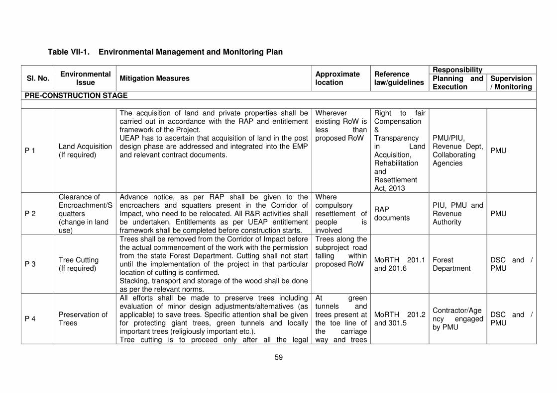
59
Table VII-1. Environmental Management and Monitoring Plan
Sl. No. Environmental
Issue Mitigation Measures
Approximate location
Reference law/guidelines
Responsibility Planning and Execution
Supervision/ Monitoring
PRE-CONSTRUCTION STAGE
P 1 Land Acquisition (If required)
The acquisition of land and private properties shall be carried out in accordance with the RAP and entitlement framework of the Project. UEAP has to ascertain that acquisition of land in the post design phase are addressed and integrated into the EMP and relevant contract documents.
Wherever existing RoW is less than proposed RoW
Right to fair Compensation & Transparency in Land Acquisition, Rehabilitation and Resettlement Act, 2013
PMU/PIU, Revenue Dept, Collaborating Agencies
PMU
P 2
Clearance of Encroachment/Squatters (change in land use)
Advance notice, as per RAP shall be given to the encroachers and squatters present in the Corridor of Impact, who need to be relocated. All R&R activities shall be undertaken. Entitlements as per UEAP entitlement framework shall be completed before construction starts.
Where compulsory resettlement of people is involved
RAP documents
PIU, PMU and Revenue Authority
PMU
P 3 Tree Cutting (If required)
Trees shall be removed from the Corridor of Impact before the actual commencement of the work with the permission from the state Forest Department. Cutting shall not start until the implementation of the project in that particular location of cutting is confirmed. Stacking, transport and storage of the wood shall be done as per the relevant norms.
Trees along the subproject road falling within proposed RoW
MoRTH 201.1 and 201.6
Forest Department
DSC and / PMU
P 4 Preservation of Trees
All efforts shall be made to preserve trees including evaluation of minor design adjustments/alternatives (as applicable) to save trees. Specific attention shall be given for protecting giant trees, green tunnels and locally important trees (religiously important etc.). Tree cutting is to proceed only after all the legal
At green tunnels and trees present at the toe line of the carriage way and trees
MoRTH 201.2 and 301.5
Contractor/Agency engaged by PMU
DSC and / PMU

60
Sl. No. Environmental
Issue Mitigation Measures
Approximate location
Reference law/guidelines
Responsibility Planning and Execution
Supervision/ Monitoring
requirements including attaining of In-principle and Formal Clearances form the Forest Dept./MoEF are completed and subsequently a written order is issued to the Contractor. Particular species declared as “protected” by the State Forest Dept. in the private land shall be felled only after due clearance from the Forest Dept. is obtained. In the event of design changes, additional assessments including the possibility to save trees shall be made. Systematic corridor level documentation for the trees cut and those saved shall be maintained by the UEAP
of valuable species having ecological value.
P 5
Relocation of Community Utilities and Common Property Resources
All community utilities and properties i.e., hand pumps, open wells, water supply lines, sewer lines, telephone cables, buildings and health centers shall not be relocated before construction of subproject road starts.
Throughout the corridor
RAP document PIU/PMU, other Agencies / Contractor
PMU
P 6
Relocation of affected Cultural and Religious Properties
All religious property resources such as shrines, temples and mosques within the project road shall be relocated. No such utilities will be relocated.. If there is any relocation of the religious structures may happen then it shall be identified in accordance with the choice of the community. UEAP in consultation with local people shall finalize those. The entire process (i.e. selection of relocation sites and design) shall be under supervision of Environmental Specialist of DSC, during the construction stage by the Contractor. The relocation shall be completed before the construction starts in these sites.
Throughout the stretch especially nearby settlements
MoRTH 110.7 PIU/ Contractor DSC/ PMU
Pre-construction activities by the Contractor/Environmental Specialist of DSC P 7 Field Verification and Modification of the Contract Documents P.7.1 Joint Field The Environmental Specialist of DSC and the Contractor Throughout the MoRTH 201.2 Contractor/ PMU
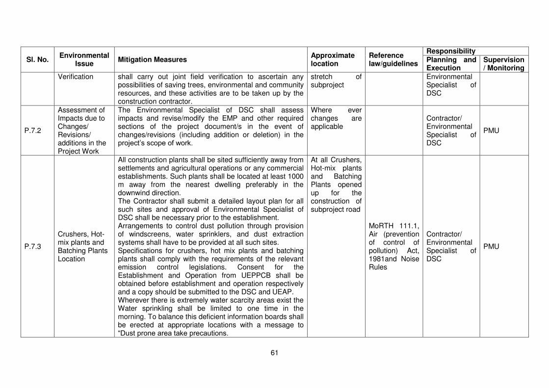
61
Sl. No. Environmental
Issue Mitigation Measures
Approximate location
Reference law/guidelines
Responsibility Planning and Execution
Supervision/ Monitoring
Verification shall carry out joint field verification to ascertain any possibilities of saving trees, environmental and community resources, and these activities are to be taken up by the construction contractor.
stretch of subproject
Environmental Specialist of DSC
P.7.2
Assessment of Impacts due to Changes/ Revisions/ additions in the Project Work
The Environmental Specialist of DSC shall assess impacts and revise/modify the EMP and other required sections of the project document/s in the event of changes/revisions (including addition or deletion) in the project’s scope of work.
Where ever changes are applicable
Contractor/ Environmental Specialist of DSC
PMU
P.7.3
Crushers, Hot-mix plants and Batching Plants Location
All construction plants shall be sited sufficiently away from settlements and agricultural operations or any commercial establishments. Such plants shall be located at least 1000 m away from the nearest dwelling preferably in the downwind direction. The Contractor shall submit a detailed layout plan for all such sites and approval of Environmental Specialist of DSC shall be necessary prior to the establishment. Arrangements to control dust pollution through provision of windscreens, water sprinklers, and dust extraction systems shall have to be provided at all such sites. Specifications for crushers, hot mix plants and batching plants shall comply with the requirements of the relevant emission control legislations. Consent for the Establishment and Operation from UEPPCB shall be obtained before establishment and operation respectively and a copy should be submitted to the DSC and UEAP. Wherever there is extremely water scarcity areas exist the Water sprinkling shall be limited to one time in the morning. To balance this deficient information boards shall be erected at appropriate locations with a message to “Dust prone area take precautions.
At all Crushers, Hot-mix plants and Batching Plants opened up for the construction of subproject road
MoRTH 111.1, Air (prevention of control of pollution) Act, 1981and Noise Rules
Contractor/ Environmental Specialist of DSC
PMU
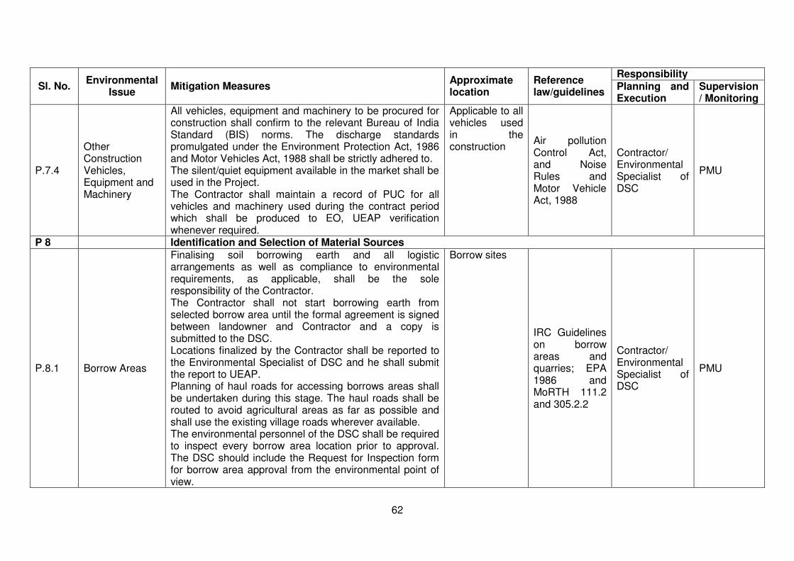
62
Sl. No. Environmental
Issue Mitigation Measures
Approximate location
Reference law/guidelines
Responsibility Planning and Execution
Supervision/ Monitoring
P.7.4
Other Construction Vehicles, Equipment and Machinery
All vehicles, equipment and machinery to be procured for construction shall confirm to the relevant Bureau of India Standard (BIS) norms. The discharge standards promulgated under the Environment Protection Act, 1986 and Motor Vehicles Act, 1988 shall be strictly adhered to. The silent/quiet equipment available in the market shall be used in the Project. The Contractor shall maintain a record of PUC for all vehicles and machinery used during the contract period which shall be produced to EO, UEAP verification whenever required.
Applicable to all vehicles used in the construction
Air pollution Control Act, and Noise Rules and Motor Vehicle Act, 1988
Contractor/ Environmental Specialist of DSC
PMU
P 8 Identification and Selection of Material Sources
P.8.1 Borrow Areas
Finalising soil borrowing earth and all logistic arrangements as well as compliance to environmental requirements, as applicable, shall be the sole responsibility of the Contractor. The Contractor shall not start borrowing earth from selected borrow area until the formal agreement is signed between landowner and Contractor and a copy is submitted to the DSC. Locations finalized by the Contractor shall be reported to the Environmental Specialist of DSC and he shall submit the report to UEAP. Planning of haul roads for accessing borrows areas shall be undertaken during this stage. The haul roads shall be routed to avoid agricultural areas as far as possible and shall use the existing village roads wherever available. The environmental personnel of the DSC shall be required to inspect every borrow area location prior to approval. The DSC should include the Request for Inspection form for borrow area approval from the environmental point of view.
Borrow sites
IRC Guidelines on borrow areas and quarries; EPA 1986 and MoRTH 111.2 and 305.2.2
Contractor/ Environmental Specialist of DSC
PMU

63
Sl. No. Environmental
Issue Mitigation Measures
Approximate location
Reference law/guidelines
Responsibility Planning and Execution
Supervision/ Monitoring
P.8.2 Quarry
Contractor shall finalize the quarry for procurement of construction materials after assessment of the availability of sufficient quantity of materials, quality and other logistic arrangements. In case the Contractor decides to use quarries other than recommended by DPR consultant, then the Contractor should give substantiation. Contractor shall also work out haul road network and report to Environmental Specialist of DSC and DSC shall inspect and in turn report to UEAP before approval.
Quarry sites
MoRTH 111.3
Contractor Environmental Specialist of DSC
P.8.3 Arrangement for Construction Water
In view of the special situation in Uttarakhand, Contractor shall prepare and implement the approved Water Management Plan in accordance with the Appendix-11, and BOQ Environment mitigation works The contractor shall use ground/surface water as a source of water for the construction and may set up own bore well facility for construction work. Contractor may take surface water from the Irrigation Canal with the written consent from the Irrigation Department. To avoid disruption/disturbance to other water users, the Contractor shall extract water from fixed locations and consult Environmental Specialist of DSC before finalizing the locations. The Contractor shall provide a list of locations and type of sources from where water for construction shall be extracted. The Contractor shall need to comply with the requirements of the State Ground Water Department for the extraction and seek their approval for doing so and submit copies of the permission to DSC and UEAP.
Throughout the subproject
As per the contract document and Clause No. 1010 EPA, 1986
Contractor Environmental Specialist of DSC
P 9 Sand The Sand shall be procured from identified statutorily Sand quarries As per the All riverbeds
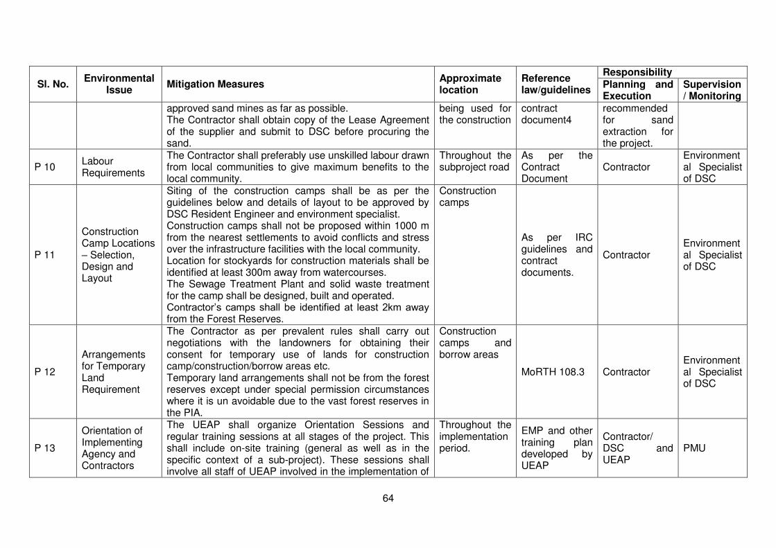
64
Sl. No. Environmental
Issue Mitigation Measures
Approximate location
Reference law/guidelines
Responsibility Planning and Execution
Supervision/ Monitoring
approved sand mines as far as possible. The Contractor shall obtain copy of the Lease Agreement of the supplier and submit to DSC before procuring the sand.
being used for the construction
contract document4
recommended for sand extraction for the project.
P 10 Labour Requirements
The Contractor shall preferably use unskilled labour drawn from local communities to give maximum benefits to the local community.
Throughout the subproject road
As per the Contract Document
Contractor Environmental Specialist of DSC
P 11
Construction Camp Locations – Selection, Design and Layout
Siting of the construction camps shall be as per the guidelines below and details of layout to be approved by DSC Resident Engineer and environment specialist. Construction camps shall not be proposed within 1000 m from the nearest settlements to avoid conflicts and stress over the infrastructure facilities with the local community. Location for stockyards for construction materials shall be identified at least 300m away from watercourses. The Sewage Treatment Plant and solid waste treatment for the camp shall be designed, built and operated. Contractor’s camps shall be identified at least 2km away from the Forest Reserves.
Construction camps
As per IRC guidelines and contract documents.
Contractor Environmental Specialist of DSC
P 12
Arrangements for Temporary Land Requirement
The Contractor as per prevalent rules shall carry out negotiations with the landowners for obtaining their consent for temporary use of lands for construction camp/construction/borrow areas etc. Temporary land arrangements shall not be from the forest reserves except under special permission circumstances where it is un avoidable due to the vast forest reserves in the PIA.
Construction camps and borrow areas
MoRTH 108.3 Contractor Environmental Specialist of DSC
P 13
Orientation of Implementing Agency and Contractors
The UEAP shall organize Orientation Sessions and regular training sessions at all stages of the project. This shall include on-site training (general as well as in the specific context of a sub-project). These sessions shall involve all staff of UEAP involved in the implementation of
Throughout the implementation period.
EMP and other training plan developed by UEAP
Contractor/ DSC and UEAP
PMU
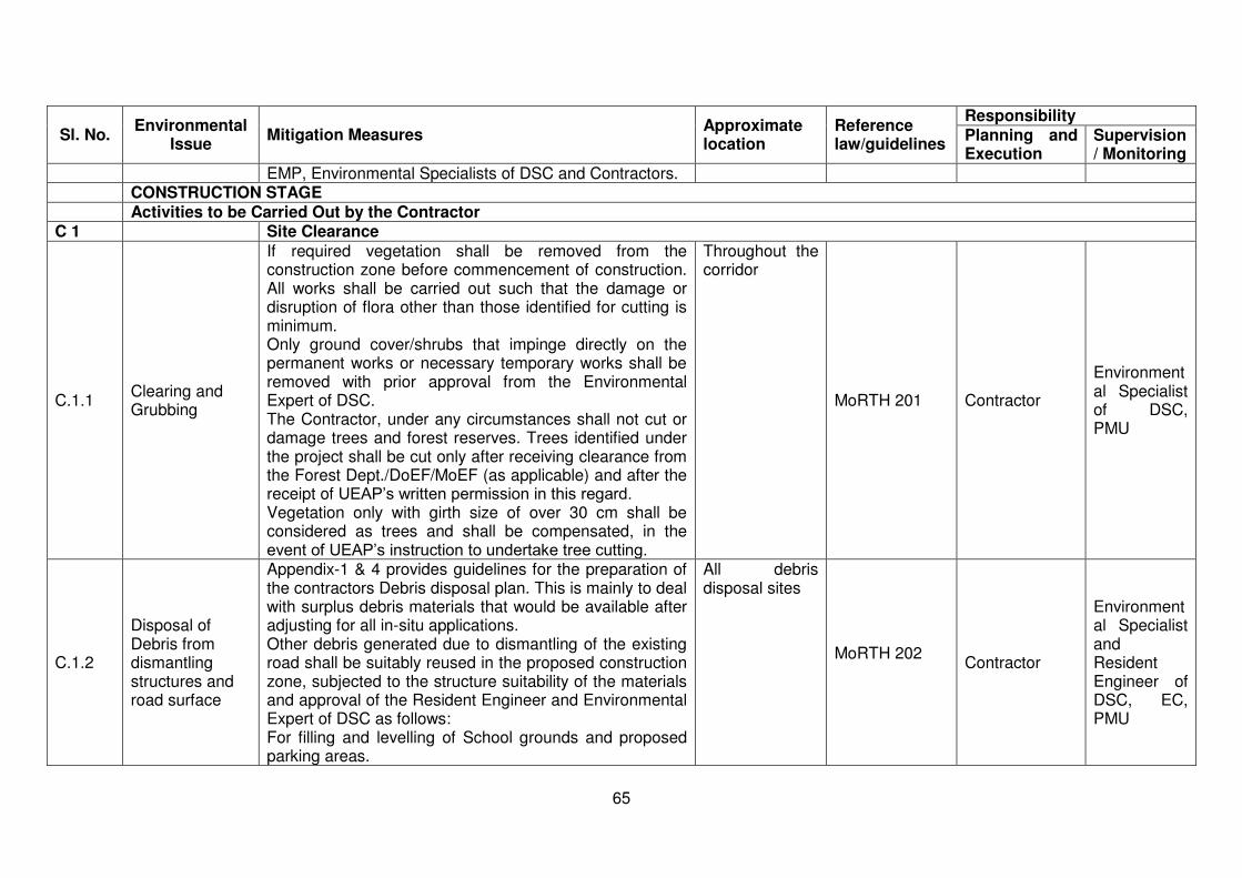
65
Sl. No. Environmental
Issue Mitigation Measures
Approximate location
Reference law/guidelines
Responsibility Planning and Execution
Supervision/ Monitoring
EMP, Environmental Specialists of DSC and Contractors. CONSTRUCTION STAGE Activities to be Carried Out by the Contractor C 1 Site Clearance
C.1.1 Clearing and Grubbing
If required vegetation shall be removed from the construction zone before commencement of construction. All works shall be carried out such that the damage or disruption of flora other than those identified for cutting is minimum. Only ground cover/shrubs that impinge directly on the permanent works or necessary temporary works shall be removed with prior approval from the Environmental Expert of DSC. The Contractor, under any circumstances shall not cut or damage trees and forest reserves. Trees identified under the project shall be cut only after receiving clearance from the Forest Dept./DoEF/MoEF (as applicable) and after the receipt of UEAP’s written permission in this regard. Vegetation only with girth size of over 30 cm shall be considered as trees and shall be compensated, in the event of UEAP’s instruction to undertake tree cutting.
Throughout the corridor
MoRTH 201 Contractor
Environmental Specialist of DSC, PMU
C.1.2
Disposal of Debris from dismantling structures and road surface
Appendix-1 & 4 provides guidelines for the preparation of the contractors Debris disposal plan. This is mainly to deal with surplus debris materials that would be available after adjusting for all in-situ applications. Other debris generated due to dismantling of the existing road shall be suitably reused in the proposed construction zone, subjected to the structure suitability of the materials and approval of the Resident Engineer and Environmental Expert of DSC as follows: For filling and levelling of School grounds and proposed parking areas.
All debris disposal sites
MoRTH 202
Contractor
Environmental Specialist and Resident Engineer of DSC, EC, PMU
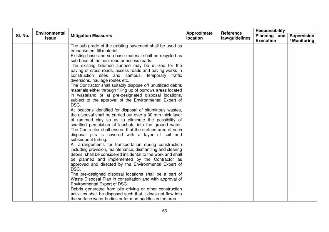
66
Sl. No. Environmental
Issue Mitigation Measures
Approximate location
Reference law/guidelines
Responsibility Planning and Execution
Supervision/ Monitoring
The sub grade of the existing pavement shall be used as embankment fill material. Existing base and sub-base material shall be recycled as sub-base of the haul road or access roads. The existing bitumen surface may be utilized for the paving of cross roads, access roads and paving works in construction sites and campus, temporary traffic diversions, haulage routes etc. The Contractor shall suitably dispose off unutilized debris materials either through filling up of borrows areas located in wasteland or at pre-designated disposal locations, subject to the approval of the Environmental Expert of DSC. At locations identified for disposal of bituminous wastes, the disposal shall be carried out over a 30 mm thick layer of rammed clay so as to eliminate the possibility of scarified percolation of leachate into the ground water. The Contractor shall ensure that the surface area of such disposal pits is covered with a layer of soil and subsequent turfing. All arrangements for transportation during construction including provision, maintenance, dismantling and clearing debris, shall be considered incidental to the work and shall be planned and implemented by the Contractor as approved and directed by the Environmental Expert of DSC. The pre-designed disposal locations shall be a part of Waste Disposal Plan in consultation and with approval of Environmental Expert of DSC. Debris generated from pile driving or other construction activities shall be disposed such that it does not flow into the surface water bodies or for mud puddles in the area.
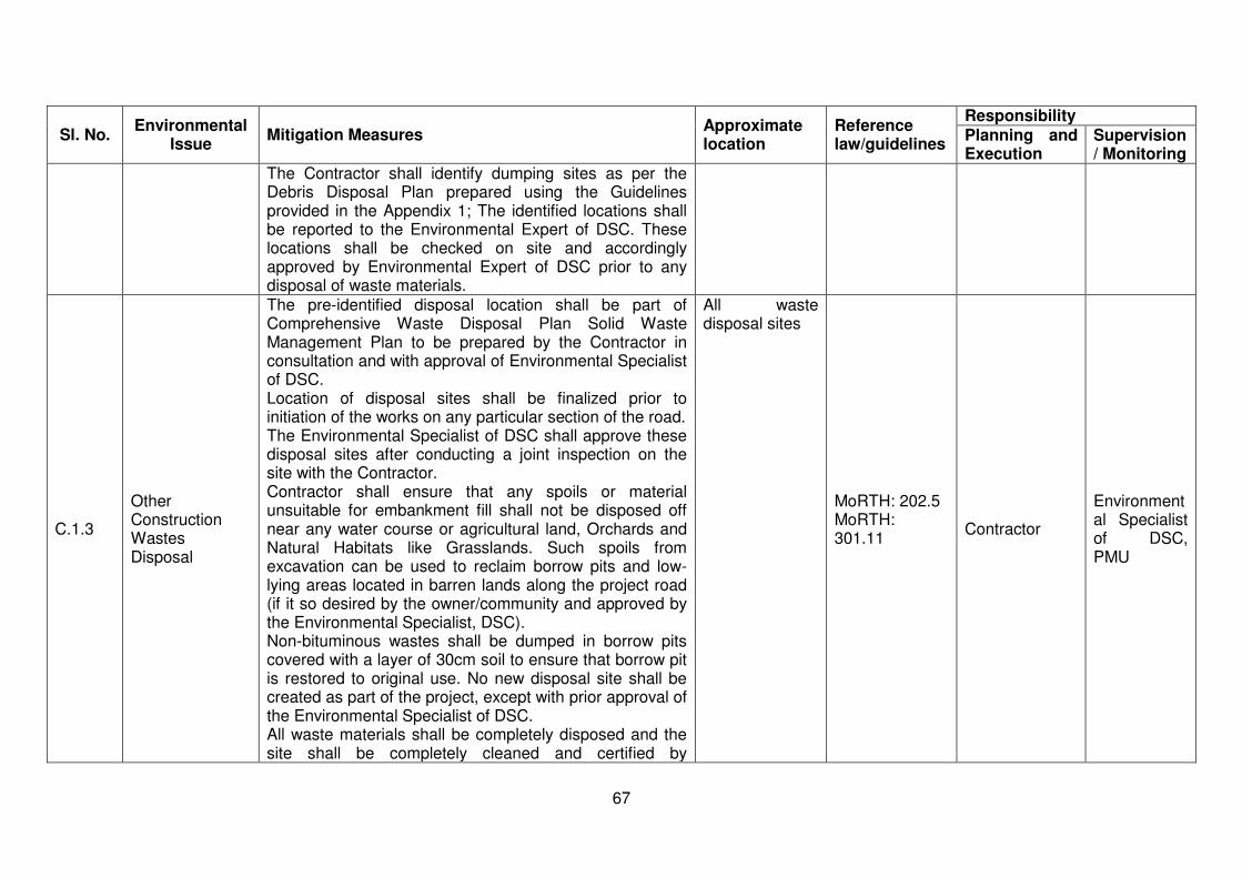
67
Sl. No. Environmental
Issue Mitigation Measures
Approximate location
Reference law/guidelines
Responsibility Planning and Execution
Supervision/ Monitoring
The Contractor shall identify dumping sites as per the Debris Disposal Plan prepared using the Guidelines provided in the Appendix 1; The identified locations shall be reported to the Environmental Expert of DSC. These locations shall be checked on site and accordingly approved by Environmental Expert of DSC prior to any disposal of waste materials.
C.1.3
Other Construction Wastes Disposal
The pre-identified disposal location shall be part of Comprehensive Waste Disposal Plan Solid Waste Management Plan to be prepared by the Contractor in consultation and with approval of Environmental Specialist of DSC. Location of disposal sites shall be finalized prior to initiation of the works on any particular section of the road. The Environmental Specialist of DSC shall approve these disposal sites after conducting a joint inspection on the site with the Contractor. Contractor shall ensure that any spoils or material unsuitable for embankment fill shall not be disposed off near any water course or agricultural land, Orchards and Natural Habitats like Grasslands. Such spoils from excavation can be used to reclaim borrow pits and low-lying areas located in barren lands along the project road (if it so desired by the owner/community and approved by the Environmental Specialist, DSC). Non-bituminous wastes shall be dumped in borrow pits covered with a layer of 30cm soil to ensure that borrow pit is restored to original use. No new disposal site shall be created as part of the project, except with prior approval of the Environmental Specialist of DSC. All waste materials shall be completely disposed and the site shall be completely cleaned and certified by
All waste disposal sites
MoRTH: 202.5 MoRTH: 301.11
Contractor
Environmental Specialist of DSC, PMU

68
Sl. No. Environmental
Issue Mitigation Measures
Approximate location
Reference law/guidelines
Responsibility Planning and Execution
Supervision/ Monitoring
Environmental Specialist of DSC before handing over. The Contractor at his cost shall resolve any claim, arising out of waste disposal or any non-compliance that may arise on account of lack of action on his part.
C.1.4
Stripping, stocking and preservation of top soil
The topsoil from all areas of cutting and all areas to be permanently covered shall be stripped off to a specified depth of 150 mm and stored in stockpiles. A portion of the temporarily acquired area and/or Right of Way shall be earmarked for storing topsoil. The locations for stock piling shall be pre-identified in consultation and with approval of Environmental Specialist of DSC. The following precautionary measures shall be taken to preserve them till they are used:
a) Stockpile shall be designed such that the slope does not exceed 1:2 (Vertical to horizontal), and height of the pile is restricted to 2 m. To retain soil and to allow percolation of water, silt fencing shall protect the edges of the pile.
b) Stockpiles shall not be surcharged or otherwise loaded and multiple handling shall be kept to a minimum to ensure that no compaction shall occur. The stockpiles shall be covered with gunny bags or vegetation.
c) It shall be ensured by the Contractor that the topsoil shall not be unnecessarily trafficked either before stripping or when in stockpiles. Such stockpiled topsoil shall be utilized for –
Covering all disturbed areas including borrow areas, only in case where they are to be rehabilitated.
Dressing of slopes of road embankment/agricultural fields of farmers acquired temporarily land.
At all construction material storage areas
MoRTH: 301.3.2 MoRTH: 301.7 MoRTH: 305.3.3 and MoRTH: 305.3.9
Contractor
Environmental Specialist of DSC, PMU
C.1.5 Accessibility The Contractor shall provide safe and convenient passage for vehicles, pedestrians and livestock to and from roadsides and property access connecting the project
Throughout the project corridor Contractor
Environmental Specialist of DSC,
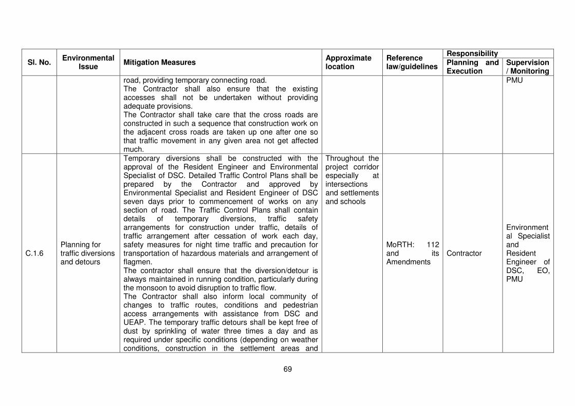
69
Sl. No. Environmental
Issue Mitigation Measures
Approximate location
Reference law/guidelines
Responsibility Planning and Execution
Supervision/ Monitoring
road, providing temporary connecting road. The Contractor shall also ensure that the existing accesses shall not be undertaken without providing adequate provisions. The Contractor shall take care that the cross roads are constructed in such a sequence that construction work on the adjacent cross roads are taken up one after one so that traffic movement in any given area not get affected much.
PMU
C.1.6 Planning for traffic diversions and detours
Temporary diversions shall be constructed with the approval of the Resident Engineer and Environmental Specialist of DSC. Detailed Traffic Control Plans shall be prepared by the Contractor and approved by Environmental Specialist and Resident Engineer of DSC seven days prior to commencement of works on any section of road. The Traffic Control Plans shall contain details of temporary diversions, traffic safety arrangements for construction under traffic, details of traffic arrangement after cessation of work each day, safety measures for night time traffic and precaution for transportation of hazardous materials and arrangement of flagmen. The contractor shall ensure that the diversion/detour is always maintained in running condition, particularly during the monsoon to avoid disruption to traffic flow. The Contractor shall also inform local community of changes to traffic routes, conditions and pedestrian access arrangements with assistance from DSC and UEAP. The temporary traffic detours shall be kept free of dust by sprinkling of water three times a day and as required under specific conditions (depending on weather conditions, construction in the settlement areas and
Throughout the project corridor especially at intersections and settlements and schools
MoRTH: 112 and its Amendments
Contractor
Environmental Specialist and Resident Engineer of DSC, EO, PMU

70
Sl. No. Environmental
Issue Mitigation Measures
Approximate location
Reference law/guidelines
Responsibility Planning and Execution
Supervision/ Monitoring
volume of traffic). C.2 Procurement of Construction Material
C.2.1 Earth from Borrow Areas for Construction
No borrow area shall be opened without permission of the Environmental Specialist of DSC. The location, shape and size of the designated borrow areas shall be as approved by the Environmental Specialist of DSC and in accordance to the IRC recommended practice for borrow pits for road embankments (IRC: 10: 1961). The borrowing operations shall be carried out as specified in the guidelines for siting and operation of borrow areas. The unpaved surfaces used for the haulage of borrow materials, if passing through the settlement areas or habitations; shall be maintained dust free by the Contractor. Sprinkling of water shall be carried out twice a day to control dust along such roads during their period of use. During dry seasons (winter and summer) frequency of water sprinkling shall be increased in the settlement areas and Environmental Specialist of DSC shall decide the sprinkling time depending on the local requirements. Contractor shall rehabilitate the borrow areas as soon as borrowing of soil is over from a particular borrow area in accordance with the approved Borrow Area Redevelopment Plan.
All borrow areas
MoRTH: 305.2 Contractor
Environmental Specialist of DSC, PMU
C.2.2 Quarry Operations Crushers
The Contractor shall obtain materials from quarries only after consent of the Department of Mines and Geology and District Administration. In view of special situation of excavation of the hill ward side, Contractor shall get an opportunity to use the same material for road construction. This shall require establishment of a number of crushers along the roadsides. The crushers and all related activities shall be under taken as per the Policy guidelines for
At quarries and Crushing units.
MoRTH: 111.3
Contractor
Environmental Specialist of DSC, PMU

71
Sl. No. Environmental
Issue Mitigation Measures
Approximate location
Reference law/guidelines
Responsibility Planning and Execution
Supervision/ Monitoring
installation of stone Crushers.
C.2.3 Blasting
Except as may be provided in the contract or ordered or authorized by the Engineer, the Contractor shall not use explosives. Where the use of explosives is so provided or ordered or authorized, the Contractor shall comply with the requirements of the following Sub-Clauses of MoRTH 302 besides the law of the land as applicable. The Contractor shall at all times take every possible precaution and shall comply with appropriate laws and regulations relating to the importation, handling, transportation, storage and use of explosives. The contractor shall at all times when engaged in blasting operations, post sufficient warning flagmen, to the full satisfaction of the Engineer. The Contractor shall at all times make full liaison with and inform well in advance and obtain such permission as is required from all Government Authorities, public bodies and private parties whomsoever concerned or affected or likely to be concerned or affected by blasting operations. Blasting shall be carried out only with permission of the Engineer. All the statutory laws, regulations, rules etc., pertaining to acquisition, transport, storage, handling and use of explosives shall be strictly followed. Blasting shall be carried out during fixed hours (preferably during mid-day) or as permitted by the Engineer. The timing should be made known to all the people within 1000m (200m for pre-splitting) from the blasting site in all directions.
Quarry sites
Sub-Clauses of MoRTH 302
MoRTH:302.4 301.9 (i) 304.5
C.2.4 Transporting Construction Materials and
Contractor shall maintain all roads (existing or built for the project), which are used for transporting construction materials, equipment and machineries as précised. All
All roads used for haulage of construction
As per IRC guidelines and contract
Contractor Environmental Specialist of DSC,

72
Sl. No. Environmental
Issue Mitigation Measures
Approximate location
Reference law/guidelines
Responsibility Planning and Execution
Supervision/ Monitoring
Haul Road Management
vehicles delivering fine materials to the site shall be covered to avoid spillage of materials. All existing roads used by vehicles of the Contractor or any of his subcontractor or suppliers of materials and similarly roads, which are part of the works, shall be kept clear of all dust/mud or other extraneous materials dropped by such vehicles. Contractor shall arrange for regular water sprinkling as necessary for dust suppression of all such roads and surfaces.
materials documents PMU
C.2.5 Construction Water
Contractor need to implement the finally approved contractors Construction Water Management Plan as per the guidelines provided in Appendix 11. This is linked to the contractor’s work plan. Contractor shall arrange adequate supply and storage of water for the whole construction period at his own cost. The contractor shall submit a list of source/s from where water shall be used for the project to DSC and UEAP. The Contractor shall source the requirement of water preferentially by conjunctive use of Surface water and groundwater but with prior permission from the Groundwater Authority. A copy of the permission shall be submitted to DSC and UEAP prior to initiation of construction. The Contractor shall take all precaution to minimize the wastage of water in the construction process/operation.
Throughout the project corridor
Environmental. Protection Act 1986 and MoRTH Spec. for Roads and Bridges
Contractor
Environmental Specialist of DSC, PMU
C.3 Construction Work
C.3.1
River training and disruption to other users of water
While working across or close to any perennial water bodies, Contractor shall not obstruct/prevent the flow of water. Construction over and close to the non-perennial streams shall be undertaken in the dry season. If construction work
Near major cross drainage structures (River crossings)
MoRTH:304.3.2
Contractor
Environmental Specialist of DSC, PMU
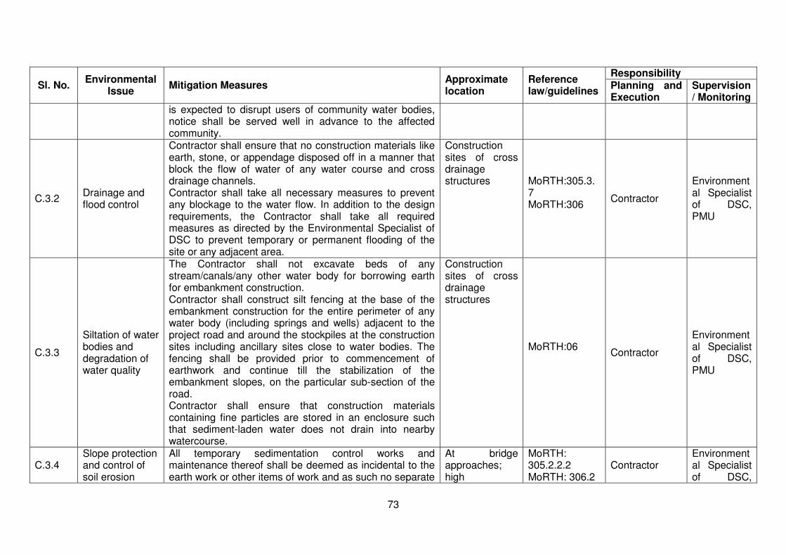
73
Sl. No. Environmental
Issue Mitigation Measures
Approximate location
Reference law/guidelines
Responsibility Planning and Execution
Supervision/ Monitoring
is expected to disrupt users of community water bodies, notice shall be served well in advance to the affected community.
C.3.2 Drainage and flood control
Contractor shall ensure that no construction materials like earth, stone, or appendage disposed off in a manner that block the flow of water of any water course and cross drainage channels. Contractor shall take all necessary measures to prevent any blockage to the water flow. In addition to the design requirements, the Contractor shall take all required measures as directed by the Environmental Specialist of DSC to prevent temporary or permanent flooding of the site or any adjacent area.
Construction sites of cross drainage structures MoRTH:305.3.
7 MoRTH:306
Contractor
Environmental Specialist of DSC, PMU
C.3.3
Siltation of water bodies and degradation of water quality
The Contractor shall not excavate beds of any stream/canals/any other water body for borrowing earth for embankment construction. Contractor shall construct silt fencing at the base of the embankment construction for the entire perimeter of any water body (including springs and wells) adjacent to the project road and around the stockpiles at the construction sites including ancillary sites close to water bodies. The fencing shall be provided prior to commencement of earthwork and continue till the stabilization of the embankment slopes, on the particular sub-section of the road. Contractor shall ensure that construction materials containing fine particles are stored in an enclosure such that sediment-laden water does not drain into nearby watercourse.
Construction sites of cross drainage structures
MoRTH:06
Contractor
Environmental Specialist of DSC, PMU
C.3.4 Slope protection and control of soil erosion
All temporary sedimentation control works and maintenance thereof shall be deemed as incidental to the earth work or other items of work and as such no separate
At bridge approaches; high
MoRTH: 305.2.2.2 MoRTH: 306.2
Contractor Environmental Specialist of DSC,
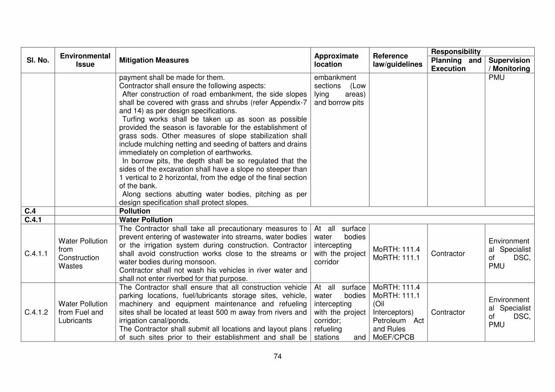
74
Sl. No. Environmental
Issue Mitigation Measures
Approximate location
Reference law/guidelines
Responsibility Planning and Execution
Supervision/ Monitoring
payment shall be made for them. Contractor shall ensure the following aspects:
After construction of road embankment, the side slopes shall be covered with grass and shrubs (refer Appendix-7 and 14) as per design specifications.
Turfing works shall be taken up as soon as possible provided the season is favorable for the establishment of grass sods. Other measures of slope stabilization shall include mulching netting and seeding of batters and drains immediately on completion of earthworks.
In borrow pits, the depth shall be so regulated that the sides of the excavation shall have a slope no steeper than 1 vertical to 2 horizontal, from the edge of the final section of the bank.
Along sections abutting water bodies, pitching as per design specification shall protect slopes.
embankment sections (Low lying areas) and borrow pits
PMU
C.4 Pollution C.4.1 Water Pollution
C.4.1.1
Water Pollution from Construction Wastes
The Contractor shall take all precautionary measures to prevent entering of wastewater into streams, water bodies or the irrigation system during construction. Contractor shall avoid construction works close to the streams or water bodies during monsoon. Contractor shall not wash his vehicles in river water and shall not enter riverbed for that purpose.
At all surface water bodies intercepting with the project corridor
MoRTH: 111.4 MoRTH: 111.1
Contractor
Environmental Specialist of DSC, PMU
C.4.1.2 Water Pollution from Fuel and Lubricants
The Contractor shall ensure that all construction vehicle parking locations, fuel/lubricants storage sites, vehicle, machinery and equipment maintenance and refueling sites shall be located at least 500 m away from rivers and irrigation canal/ponds. The Contractor shall submit all locations and layout plans of such sites prior to their establishment and shall be
At all surface water bodies intercepting with the project corridor; refueling stations and
MoRTH: 111.4 MoRTH: 111.1 (Oil Interceptors) Petroleum Act and Rules MoEF/CPCB
Contractor
Environmental Specialist of DSC, PMU
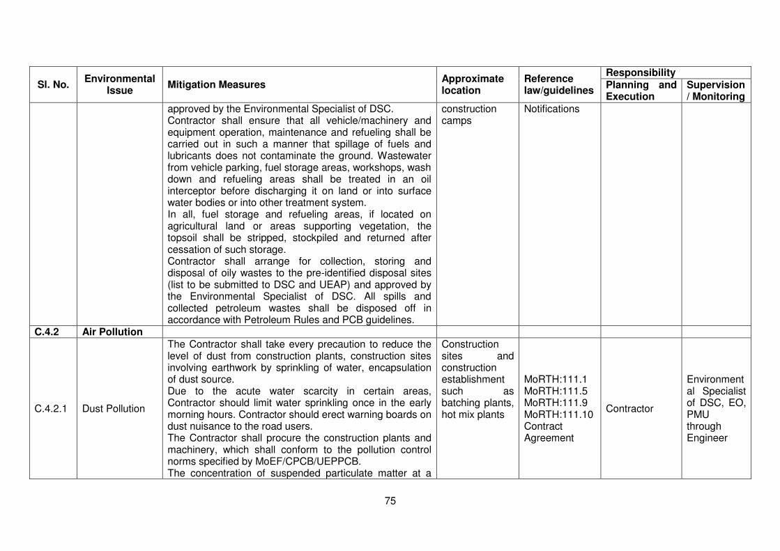
75
Sl. No. Environmental
Issue Mitigation Measures
Approximate location
Reference law/guidelines
Responsibility Planning and Execution
Supervision/ Monitoring
approved by the Environmental Specialist of DSC. Contractor shall ensure that all vehicle/machinery and equipment operation, maintenance and refueling shall be carried out in such a manner that spillage of fuels and lubricants does not contaminate the ground. Wastewater from vehicle parking, fuel storage areas, workshops, wash down and refueling areas shall be treated in an oil interceptor before discharging it on land or into surface water bodies or into other treatment system. In all, fuel storage and refueling areas, if located on agricultural land or areas supporting vegetation, the topsoil shall be stripped, stockpiled and returned after cessation of such storage. Contractor shall arrange for collection, storing and disposal of oily wastes to the pre-identified disposal sites (list to be submitted to DSC and UEAP) and approved by the Environmental Specialist of DSC. All spills and collected petroleum wastes shall be disposed off in accordance with Petroleum Rules and PCB guidelines.
construction camps
Notifications
C.4.2 Air Pollution
C.4.2.1 Dust Pollution
The Contractor shall take every precaution to reduce the level of dust from construction plants, construction sites involving earthwork by sprinkling of water, encapsulation of dust source. Due to the acute water scarcity in certain areas, Contractor should limit water sprinkling once in the early morning hours. Contractor should erect warning boards on dust nuisance to the road users. The Contractor shall procure the construction plants and machinery, which shall conform to the pollution control norms specified by MoEF/CPCB/UEPPCB. The concentration of suspended particulate matter at a
Construction sites and construction establishment such as batching plants, hot mix plants
MoRTH:111.1 MoRTH:111.5 MoRTH:111.9 MoRTH:111.10 Contract Agreement
Contractor
Environmental Specialist of DSC, EO, PMU through Engineer
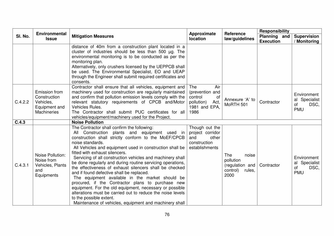
76
Sl. No. Environmental
Issue Mitigation Measures
Approximate location
Reference law/guidelines
Responsibility Planning and Execution
Supervision/ Monitoring
distance of 40m from a construction plant located in a cluster of industries should be less than 500 µg. The environmental monitoring is to be conducted as per the monitoring plan. Alternatively, only crushers licensed by the UEPPCB shall be used. The Environmental Specialist, EO and UEAP through the Engineer shall submit required certificates and consents.
C.4.2.2
Emission from Construction Vehicles, Equipment and Machineries
Contractor shall ensure that all vehicles, equipment and machinery used for construction are regularly maintained and confirm that pollution emission levels comply with the relevant statutory requirements of CPCB and/Motor Vehicles Rules. The Contractor shall submit PUC certificates for all vehicles/equipment/machinery used for the Project.
The Air (prevention and control of pollution) Act, 1981 and EPA, 1986
Annexure ‘A’ to MoRTH 501
Contractor
Environmental Specialist of DSC, PMU
C.4.3 Noise Pollution
C.4.3.1
Noise Pollution: Noise from Vehicles, Plants and Equipments
The Contractor shall confirm the following: All Construction plants and equipment used in
construction shall strictly conform to the MoEF/CPCB noise standards.
All Vehicles and equipment used in construction shall be fitted with exhaust silencers.
Servicing of all construction vehicles and machinery shall be done regularly and during routine servicing operations, the effectiveness of exhaust silencers shall be checked and if found defective shall be replaced.
The equipment available in the market should be procured, if the Contractor plans to purchase new equipment. For the old equipment, necessary or possible alterations must be carried out to reduce the noise levels to the possible extent.
Maintenance of vehicles, equipment and machinery shall
Though out the project corridor and other construction establishments
The noise pollution (regulation and control) rules, 2000
Contractor
Environmental Specialist of DSC, PMU
77
Sl. No. Environmental
Issue Mitigation Measures
Approximate location
Reference law/guidelines
Responsibility Planning and Execution
Supervision/ Monitoring
be regular and up to the satisfaction of the Environmental Specialist of DSC to keep noise levels at the minimum. At the construction sites within 150 m of the nearest habitation, noisy construction work such as crushing, operation of DG sets, use of high noise generation equipment shall be stopped during the night time between 10.00 pm to 6.00 am. Working hours of the construction activities shall be restricted around educational institutions/Health Centers (silent zones) up to a distance of 100 m from the sensitive receptors i.e., School, Health Centers and Hospitals etc. Contractor shall provide noise barriers to the suggested locations of select Schools. Noise monitoring shall be carried out at the locations specified in monitoring plan by the UEAP and the Engineer through the approved monitoring agency.
C.5 Safety
C.5.1
Personnel Safety Measures for Labour
Contractor shall provide: Protective footwear, protective goggles and nose masks
to the workers employed in asphalt works, concrete works, crusher etc.
Welder’s protective eye-shields to workers who are engaged in welding works
Earplugs to workers exposed to loud noise, and workers working in crushing or compaction
The Contractor shall comply with all regulations regarding safe scaffolding, ladders, working platforms, gangway, stairwells, excavations, trenches and safe means of entry and egress. The Contractor shall comply with all the precautions as required for ensuring the safety of the workmen as per the International Labour Organization (ILO) Convention No.
Throughout the project corridor and construction phase of the project
Building and other Construction Workers (regulation of Employment and Conditions of Services) Act, 1996;
Contractor
Environmental Specialist of DSC, PMU

78
Sl. No. Environmental
Issue Mitigation Measures
Approximate location
Reference law/guidelines
Responsibility Planning and Execution
Supervision/ Monitoring
62 as far as those are applicable to this contract. The Contractor shall make sure that during the construction work all relevant provisions of Building and other Construction Workers (regulation of Employment and Conditions of Services) Act, 1996 are adhered to. The Contractor shall not employ any person below the age of 14 years for any work and no woman shall be employed on the work of painting with products containing lead in any form The Contractor shall also ensure that paint containing lead or lead products is used except in the form of paste or readymade paint.
C.5.2 Traffic and Safety
The Contractor shall take all necessary measures for the safety of traffic during construction and provide erect and maintain such barricades, including signs, markings, flags, lights and flagmen as proposed in the Traffic Control Plan/Drawings and as required by the Environmental Expert of DSC for the information and protection on traffic approaching or passing through the section of any existing cross roads. The Contractor shall ensure that all signs, barricades, pavement markings are provided as per the MoRTH specifications. Before taking up of construction on any section of the existing lanes of the highway, a Traffic Control Plan shall be devised and implemented to the satisfaction of the Environmental Expert of DSC.
Throughout the project corridor especially at intersections and settlements
MoRTH: 112.4 MoRTH: 112.1 IRC: SP:55
Contractor
Environmental Specialist of DSC, PMU
C.5.3 Risk from electrical equipments
The Contractor shall take all required precautions to prevent danger from electrical equipment and ensure that:
No material shall be so stacked or placed as to cause danger or inconvenience to any person or the public.
All necessary fencing and lights shall be provided to protect the public in construction zones.
Construction sites and storage areas
The Building and Other Construction workers (Regulation of Employment
Contractor Environmental Expert of SC, PIU
79
Sl. No. Environmental
Issue Mitigation Measures
Approximate location
Reference law/guidelines
Responsibility Planning and Execution
Supervision/ Monitoring
All machines to be used in the construction shall conform to the relevant Indian Standards (IS) codes, shall be free from patent defect, shall be kept in good working order, shall be regularly inspected and properly maintained as per IS provision and to the satisfaction of the Environmental Expert of DSC.
and Conditions of Service) Act, 1996 and Factories Act, 1948
C.5.4 Risk force measure
Contractor shall take all reasonable precautions to prevent danger to the workers and public from fire, flood etc. resulting due to construction activities. Contractor shall make required arrangements so that in case of any mishap all necessary steps can be taken for prompt first aid treatment. Construction Safety Plan prepared by the Contractor shall identify necessary actions in the event of an emergency.
Throughout the construction phase
Contract Agreement and Annexure ‘A’ to MoRTH Clause 501
Contractor
Environmental Specialist of DSC, PMU
C.5.6 First Aid
The Contractor shall arrange for: A readily available first aid unit including an adequate supply of sterilized dressing materials and appliances as per the Factories Rules in every work zone. Availability of suitable transport at all times to take injured or sick person(s) to the nearest hospital. Equipment and trained nursing staff at construction camp.
Construction sites; labour camps and construction establishments
The Building and Other Construction workers (Regulation of Employment and Conditions of Service) Act, 1996
Contractor
Environmental Specialist of DSC, PMU
C.5.7 Informatory Signs and Hoardings
The Contractor shall provide, erect and maintain informatory/ safety signs, hoardings written in English and local language (Hindi), wherever required or as suggested by the Environmental Specialist of DSC.
Construction sites and construction establishments
MoRTH:801 MoRTH:802
Contractor
Environmental Specialist of DSC, PMU
C.6 Flora and Fauna: Plantation/Preservation/Conservation Measures
C.6.1 Road side Plantation Strategy
The Contractor shall do turfing on embankment slopes, plantation of shrubs as specified in the Contract. The compensatory plantation shall be carried out by the State Forest Department.
Throughout the length of project corridor
As per the contract document and MoRTH
Contractor
Environmental Specialist of DSC, PMU
80
Sl. No. Environmental
Issue Mitigation Measures
Approximate location
Reference law/guidelines
Responsibility Planning and Execution
Supervision/ Monitoring
Minimum 80 percent survival rate of the saplings shall be acceptable otherwise the Contractor/Forest Department shall replace dead plants at his own cost. The Environmental Specialist of DSC shall inspect regularly the survival rate of the trees planted by the Contractor in accordance with the plantation strategy suggested.
301.3.3
C.6.2 Flora and chance found Fauna
The Contractor shall take reasonable precaution to prevent his workmen or any other persons from removing and damaging any flora (plant/vegetation) and fauna (animal) including fishing in any water body and hunting of any animal. If any animal is found near the construction site at any point of time, the contractor shall immediately upon discovery thereof acquaint in the Environmental Specialist of DSC and carry out his instructions for dealing with the same. Environmental Specialist of DSC shall report to the nearby forest office (range office or divisional office) and shall take appropriate steps/measures, if required in consultation with the forest officials.
Throughout project corridor especially near forest stretches including surface water bodies Contractor
Environmental Specialist of DSC, PMU
C.6.3 Chance Found Archaeological Property
All fossils, coins, articles of value of antiquity, structures and other remains of archaeological interest discovered on the site shall be the property of the Government and shall be dealt with as per provisions of the relevant legislation. The Contractor shall take reasonable precautions to prevent his workmen or any other persons from removing and damaging any such article or thing. He shall, immediately upon discovery thereof and before removal acquaint the Environmental Specialist of DSC of such discovery and carry out the DSC’s instructions for dealing with the same, waiting which all work shall be stopped.
Throughout project corridor
The Ancient Monuments and Archaeological Sites and Remains Act, 1958
Contractor
Environmental Specialist of DSC, PMU

81
Sl. No. Environmental
Issue Mitigation Measures
Approximate location
Reference law/guidelines
Responsibility Planning and Execution
Supervision/ Monitoring
The DSC shall seek direction from the Archaeological Survey of India (ASI) before instructing the Contractor to recommence the work in the site. The Archaeological structures identified along the road sides should be protected/ preserved or enhanced as per the law.
C.7.1 Accommodation
Contractor shall follow all relevant provisions of the Building and the other Construction Workers (Regulations of Employment and Conditions of Service) Act, 1996 for construction and maintenance of labour camp. The location, layout and basic facility provision of each labour camp shall be submitted to DSC and UEAP prior to their construction. The Construction shall commence only upon the written approval of the Environmental Specialist of DSC. The Contractor shall maintain necessary living accommodation and ancillary facilities in functional and hygienic manner and as approved by the DSC.
Labour camps The Building and Other Construction workers (Regulation of Employment and Conditions of Service) Act, 1996
Contractor
Environmental Specialist of DSC, PMU
C.7.2 Potable Water
The Contractor shall construct and maintain all labour accommodation in such a fashion that uncontaminated water is available for drinking, cooking and washing. The Contractor shall also provide potable water facilities within the premises of every camp at an accessible place, as per standards set by the Building and other Construction Workers (Regulation of Employment and Conditions of Service) Act, 1996. The Contractor shall also guarantee the following:
a) Supply of sufficient quantity of Potable Water (as per IS) in every workplace/labour camp (Site at suitable and easily accessible places and regular maintenance of such facilities.
b) If any water storage tank is provided that shall be kept such that the bottom of the tank at least 1 m above the
Construction site, Labour camp
The Building and Other Construction workers (Regulation of Employment and Conditions of Service) Act, 1996
Contractor
Environmental Specialist of DSC, PMU
82
Sl. No. Environmental
Issue Mitigation Measures
Approximate location
Reference law/guidelines
Responsibility Planning and Execution
Supervision/ Monitoring
surrounding ground level. c) If water is drawn from any existing well, which is within 30
m proximity of any toilet, drain or other source of pollution, the well shall be disinfected before water is used for drinking.
d) All such wells shall be entirely covered and provided with a trap door, which shall be dust proof and water proof.
e) A reliable pump shall be fitted to each covered well. The trap door shall be kept locked and opened only for cleaning or inspection, which shall be done at least once in a month.
f) Analysis of water shall be done every month as per parameters prescribed in IS 10500-1991. Environmental Specialist of DSC shall be required to inspect the labour camp once in a week to ensure the compliance of the EMP
C.7.3 Sanitation and Sewage System
The Contractor shall ensure that – The Sewage system for the camp are designed, built and
operated in such a manner that no health hazards occurs and no pollution to the air, ground water or adjacent water courses take place
Separate toilets/bathrooms, wherever required, Screened from those form men (marked in vernacular) are to be provided for women
Adequate water supply is to be provided in all toilets and urinals
Night soil can be disposed of with the help of local municipal extractor or disposed of by putting layer of it at the bottom of a permanent tank prepared for the purpose and covered with 15 cm layer of waste or refuse and then covered with a layer of earth for fortnight.
Labour camps
The Building and Other Construction workers (Regulation of Employment and Conditions of Service) Act, 1996 MoRTH:114.14
Contractor
Environmental Specialist of DSC, PMU
C.7.4 Waste Disposal The Contractor shall provide garbage bins in the camps Labour camps Annexure 'A' to Contractor Environment
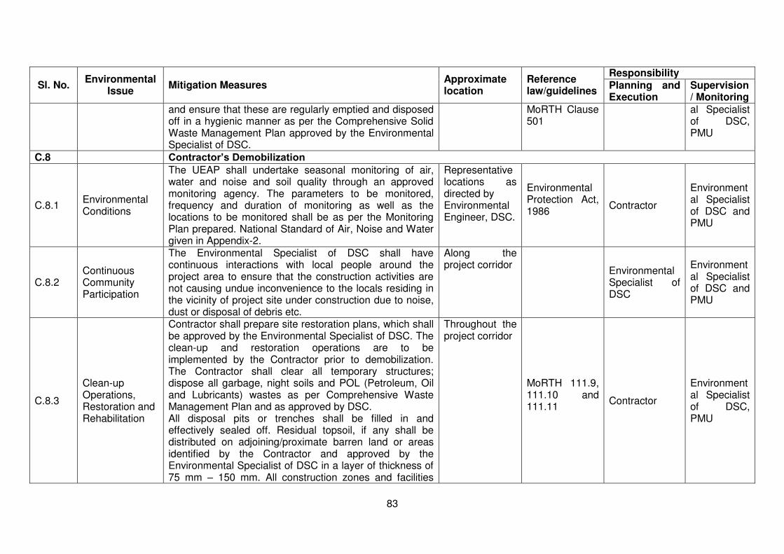
83
Sl. No. Environmental
Issue Mitigation Measures
Approximate location
Reference law/guidelines
Responsibility Planning and Execution
Supervision/ Monitoring
and ensure that these are regularly emptied and disposed off in a hygienic manner as per the Comprehensive Solid Waste Management Plan approved by the Environmental Specialist of DSC.
MoRTH Clause 501
al Specialist of DSC, PMU
C.8 Contractor’s Demobilization
C.8.1 Environmental Conditions
The UEAP shall undertake seasonal monitoring of air, water and noise and soil quality through an approved monitoring agency. The parameters to be monitored, frequency and duration of monitoring as well as the locations to be monitored shall be as per the Monitoring Plan prepared. National Standard of Air, Noise and Water given in Appendix-2.
Representative locations as directed by Environmental Engineer, DSC.
Environmental Protection Act, 1986
Contractor
Environmental Specialist of DSC and PMU
C.8.2 Continuous Community Participation
The Environmental Specialist of DSC shall have continuous interactions with local people around the project area to ensure that the construction activities are not causing undue inconvenience to the locals residing in the vicinity of project site under construction due to noise, dust or disposal of debris etc.
Along the project corridor
Environmental Specialist of DSC
Environmental Specialist of DSC and PMU
C.8.3
Clean-up Operations, Restoration and Rehabilitation
Contractor shall prepare site restoration plans, which shall be approved by the Environmental Specialist of DSC. The clean-up and restoration operations are to be implemented by the Contractor prior to demobilization. The Contractor shall clear all temporary structures; dispose all garbage, night soils and POL (Petroleum, Oil and Lubricants) wastes as per Comprehensive Waste Management Plan and as approved by DSC. All disposal pits or trenches shall be filled in and effectively sealed off. Residual topsoil, if any shall be distributed on adjoining/proximate barren land or areas identified by the Contractor and approved by the Environmental Specialist of DSC in a layer of thickness of 75 mm – 150 mm. All construction zones and facilities
Throughout the project corridor
MoRTH 111.9, 111.10 and 111.11
Contractor
Environmental Specialist of DSC, PMU
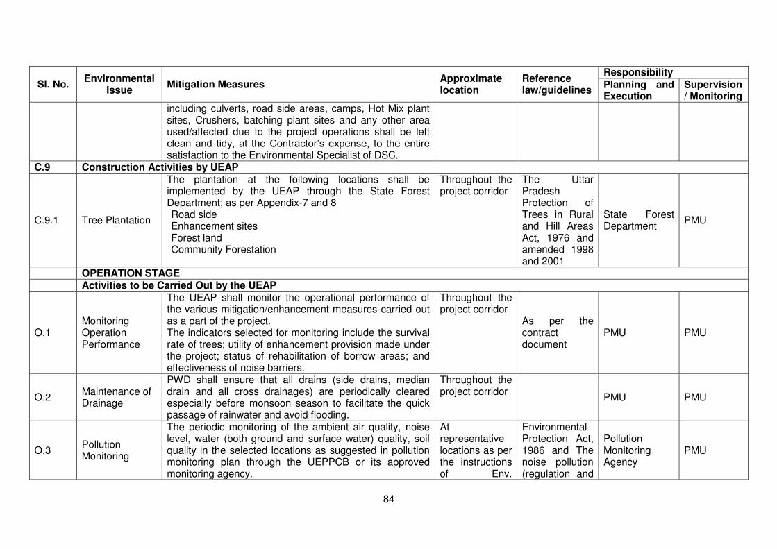
84
Sl. No. Environmental
Issue Mitigation Measures
Approximate location
Reference law/guidelines
Responsibility Planning and Execution
Supervision/ Monitoring
including culverts, road side areas, camps, Hot Mix plant sites, Crushers, batching plant sites and any other area used/affected due to the project operations shall be left clean and tidy, at the Contractor’s expense, to the entire satisfaction to the Environmental Specialist of DSC.
C.9 Construction Activities by UEAP
C.9.1 Tree Plantation
The plantation at the following locations shall be implemented by the UEAP through the State Forest Department; as per Appendix-7 and 8
1. Road side 2. Enhancement sites 3. Forest land 4. Community Forestation
Throughout the project corridor
The Uttar Pradesh Protection of Trees in Rural and Hill Areas Act, 1976 and amended 1998 and 2001
State Forest Department
PMU
OPERATION STAGE Activities to be Carried Out by the UEAP
O.1 Monitoring Operation Performance
The UEAP shall monitor the operational performance of the various mitigation/enhancement measures carried out as a part of the project. The indicators selected for monitoring include the survival rate of trees; utility of enhancement provision made under the project; status of rehabilitation of borrow areas; and effectiveness of noise barriers.
Throughout the project corridor
As per the contract document
PMU PMU
O.2 Maintenance of Drainage
PWD shall ensure that all drains (side drains, median drain and all cross drainages) are periodically cleared especially before monsoon season to facilitate the quick passage of rainwater and avoid flooding.
Throughout the project corridor
PMU PMU
O.3 Pollution Monitoring
The periodic monitoring of the ambient air quality, noise level, water (both ground and surface water) quality, soil quality in the selected locations as suggested in pollution monitoring plan through the UEPPCB or its approved monitoring agency.
At representative locations as per the instructions of Env.
Environmental Protection Act, 1986 and The noise pollution (regulation and
Pollution Monitoring Agency
PMU
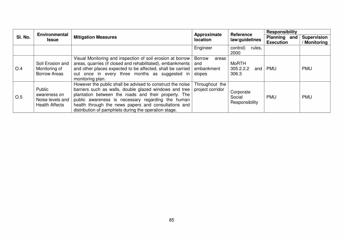
85
Sl. No. Environmental
Issue Mitigation Measures
Approximate location
Reference law/guidelines
Responsibility Planning and Execution
Supervision/ Monitoring
Engineer control) rules, 2000
O.4 Soil Erosion and Monitoring of Borrow Areas
Visual Monitoring and inspection of soil erosion at borrow areas, quarries (if closed and rehabilitated), embankments and other places expected to be affected, shall be carried out once in every three months as suggested in monitoring plan.
Borrow areas and embankment slopes
MoRTH 305.2.2.2 and 306.3
PMU PMU
O.5
Public awareness on Noise levels and Health Affects
However the public shall be advised to construct the noise barriers such as walls, double glazed windows and tree plantation between the roads and their property. The public awareness is necessary regarding the human health through the news papers and consultations and distribution of pamphlets during the operation stage.
Throughout the project corridor
Corporate Social Responsibility
PMU PMU
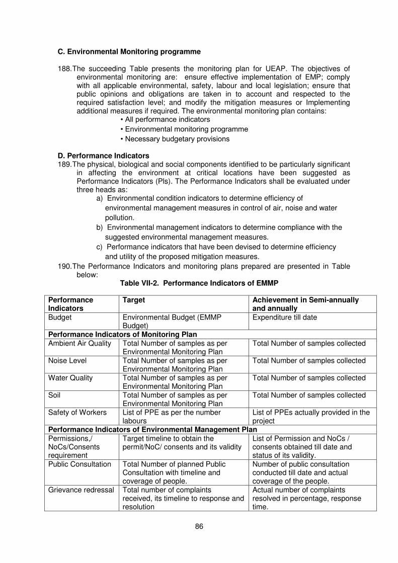
86
C. Environmental Monitoring programme
188. The succeeding Table presents the monitoring plan for UEAP. The objectives of environmental monitoring are: ensure effective implementation of EMP; comply with all applicable environmental, safety, labour and local legislation; ensure that public opinions and obligations are taken in to account and respected to the required satisfaction level; and modify the mitigation measures or Implementing additional measures if required. The environmental monitoring plan contains:
• All performance indicators
• Environmental monitoring programme
• Necessary budgetary provisions
D. Performance Indicators 189. The physical, biological and social components identified to be particularly significant
in affecting the environment at critical locations have been suggested as Performance Indicators (Pls). The Performance Indicators shall be evaluated under three heads as:
a) Environmental condition indicators to determine efficiency of
environmental management measures in control of air, noise and water
pollution.
b) Environmental management indicators to determine compliance with the
suggested environmental management measures.
c) Performance indicators that have been devised to determine efficiency
and utility of the proposed mitigation measures.
190. The Performance Indicators and monitoring plans prepared are presented in Table below:
Table VII-2. Performance Indicators of EMMP
Performance Indicators
Target Achievement in Semi-annually and annually
Budget Environmental Budget (EMMP Budget)
Expenditure till date
Performance Indicators of Monitoring Plan Ambient Air Quality Total Number of samples as per
Environmental Monitoring Plan Total Number of samples collected
Noise Level Total Number of samples as per Environmental Monitoring Plan
Total Number of samples collected
Water Quality Total Number of samples as per Environmental Monitoring Plan
Total Number of samples collected
Soil Total Number of samples as per Environmental Monitoring Plan
Total Number of samples collected
Safety of Workers List of PPE as per the number labours
List of PPEs actually provided in the project
Performance Indicators of Environmental Management Plan
Permissions,/ NoCs/Consents requirement
Target timeline to obtain the permit/NoC/ consents and its validity
List of Permission and NoCs / consents obtained till date and status of its validity.
Public Consultation Total Number of planned Public Consultation with timeline and coverage of people.
Number of public consultation conducted till date and actual coverage of the people.
Grievance redressal Total number of complaints received, its timeline to response and resolution
Actual number of complaints resolved in percentage, response time.

87
Issues raised in public consultation
Target to attend the issues raised in the Public Consultation
Status of compliance to the issues of Public consultation
Information disclosure
List of information and locations where information to be disclosed
Actual locations where information has been disclosed.
Education of site staff on Environmental training
Total Number of staffs to be trained No of staff actually
Capacity Building Total number of sessions to be covered Total Number of contractors, PIUs and DSCs to be covered
Number of Sessions completed and Number of contractors, PIUs and DSCs.
Implementation of EMP mitigation Measures
All items of Environmental Management Plan with timeline
Implementation status of EMP items till date
Reporting List and number of Report to be submitted
List and number of reports submitted
E. GRIEVANCE AND REDRESS MECHANISM
191. A joint social and environmental redress mechanism will be implemented under the project. Grievances and suggestions from local and affected people may come-up related to inappropriate implementation of the project and components of EMP. The expected range of grievances to be handled through this mechanism will encompass but not limited to the following: i) Nuisance from noise, dust, and temporary blocking of access; ii) Contamination of receiving water from runoff; iii) Emissions from increase vehicular traffic and stationary sources like hot mix plant; iv) Conflict between local residents and migrant workers; v) Ownership of vegetation for clearing; and vi) Damage compensation.
192. These issues will be addressed through acknowledgement, evaluation and corrective action and response approach. Grievances from public or stakeholders concerning the project and EMP implementation will be received by the concerned Executive Engineer of UEAP division.
193. The Executive Engineer shall refer the application to Construction Supervision Consultants (DSC) who then assess the grievances/suggestions and if they are found to be genuine and acceptable, will be resolved at division level itself within 15 to 30 days from the date of receipt. In case, the issue is unable to be resolved, the matter will be forwarded to the Social and Environmental cell, UEAP (Head quarter).
194. This mechanism is non-judicial in nature and does not preclude the affected people coursing their grievances to the courts. The corrective action will be started as per the action plan indicated to the stakeholder. The action taken and the outcome shall form a part of quarterly report to ADB.
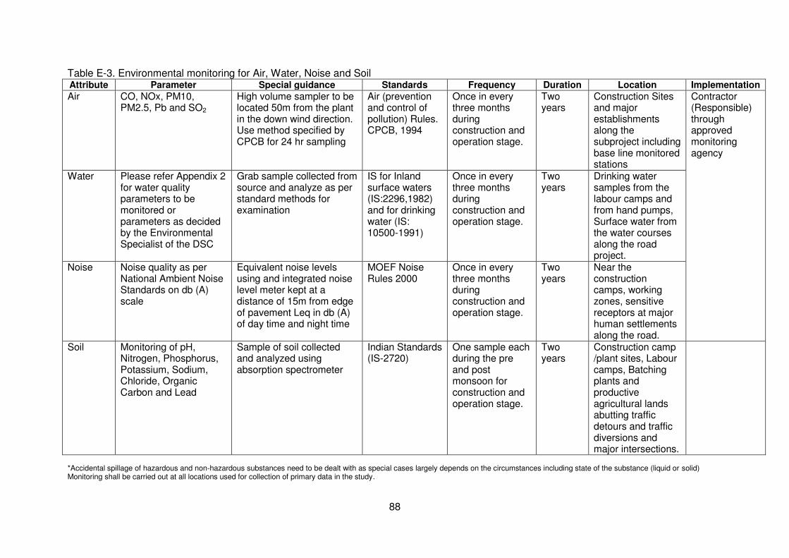
88
Table E-3. Environmental monitoring for Air, Water, Noise and Soil Attribute Parameter Special guidance Standards Frequency Duration Location Implementation
Air CO, NOx, PM10, PM2.5, Pb and SO2
High volume sampler to be located 50m from the plant in the down wind direction. Use method specified by CPCB for 24 hr sampling
Air (prevention and control of pollution) Rules. CPCB, 1994
Once in every three months during construction and operation stage.
Two years
Construction Sites and major establishments along the subproject including base line monitored stations
Contractor (Responsible) through approved monitoring agency
Water Please refer Appendix 2
for water quality parameters to be monitored or parameters as decided by the Environmental Specialist of the DSC
Grab sample collected from source and analyze as per standard methods for examination
IS for Inland surface waters (IS:2296,1982) and for drinking water (IS: 10500-1991)
Once in every three months during construction and operation stage.
Two years
Drinking water samples from the labour camps and from hand pumps, Surface water from the water courses along the road project.
Noise Noise quality as per National Ambient Noise Standards on db (A) scale
Equivalent noise levels using and integrated noise level meter kept at a distance of 15m from edge of pavement Leq in db (A) of day time and night time
MOEF Noise Rules 2000
Once in every three months during construction and operation stage.
Two years
Near the construction camps, working zones, sensitive receptors at major human settlements along the road.
Soil Monitoring of pH, Nitrogen, Phosphorus, Potassium, Sodium, Chloride, Organic Carbon and Lead
Sample of soil collected and analyzed using absorption spectrometer
Indian Standards (IS-2720)
One sample each during the pre and post monsoon for construction and operation stage.
Two years
Construction camp /plant sites, Labour camps, Batching plants and productive agricultural lands abutting traffic detours and traffic diversions and major intersections.
*Accidental spillage of hazardous and non-hazardous substances need to be dealt with as special cases largely depends on the circumstances including state of the substance (liquid or solid) Monitoring shall be carried out at all locations used for collection of primary data in the study.
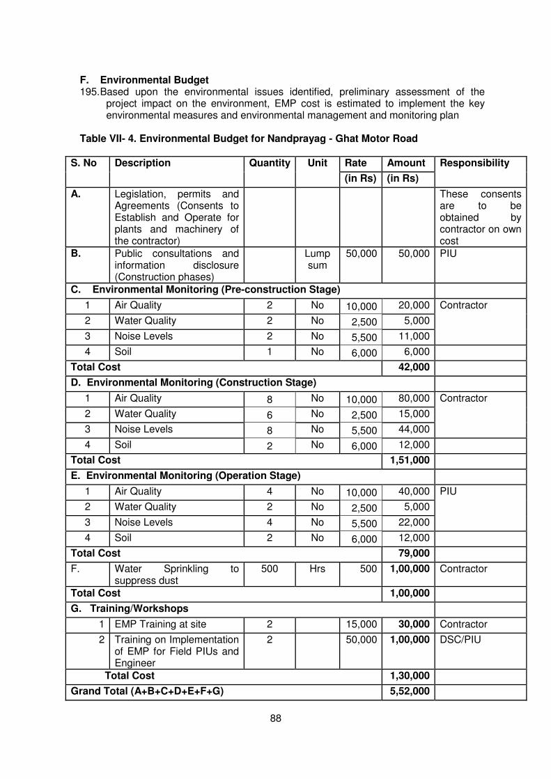
88
F. Environmental Budget 195. Based upon the environmental issues identified, preliminary assessment of the
project impact on the environment, EMP cost is estimated to implement the key environmental measures and environmental management and monitoring plan
Table VII- 4. Environmental Budget for Nandprayag - Ghat Motor Road
S. No Description Quantity Unit Rate Amount Responsibility
(in Rs) (in Rs)
A. Legislation, permits and Agreements (Consents to Establish and Operate for plants and machinery of the contractor)
These consents are to be obtained by contractor on own cost
B. Public consultations and information disclosure (Construction phases)
Lump sum
50,000 50,000 PIU
C. Environmental Monitoring (Pre-construction Stage)
1 Air Quality 2 No 10,000 20,000 Contractor
2 Water Quality 2 No 2,500 5,000
3 Noise Levels 2 No 5,500 11,000
4 Soil 1 No 6,000 6,000
Total Cost 42,000
D. Environmental Monitoring (Construction Stage)
1 Air Quality 8 No 10,000 80,000 Contractor
2 Water Quality 6 No 2,500 15,000
3 Noise Levels 8 No 5,500 44,000
4 Soil 2 No 6,000 12,000
Total Cost 1,51,000
E. Environmental Monitoring (Operation Stage)
1 Air Quality 4 No 10,000 40,000 PIU
2 Water Quality 2 No 2,500 5,000
3 Noise Levels 4 No 5,500 22,000
4 Soil 2 No 6,000 12,000
Total Cost 79,000
F. Water Sprinkling to suppress dust
500 Hrs 500 1,00,000 Contractor
Total Cost 1,00,000
G. Training/Workshops
1 EMP Training at site 2 15,000 30,000 Contractor
2 Training on Implementation of EMP for Field PIUs and Engineer
2 50,000 1,00,000 DSC/PIU
Total Cost 1,30,000
Grand Total (A+B+C+D+E+F+G) 5,52,000
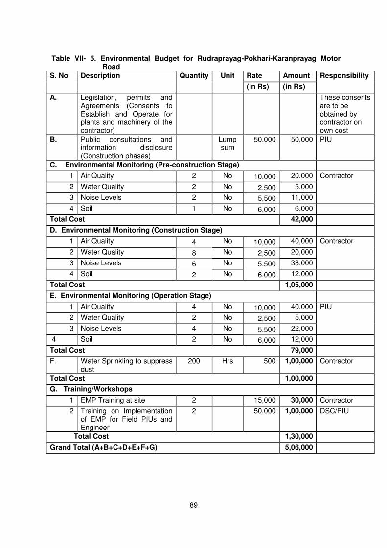
89
Table VII- 5. Environmental Budget for Rudraprayag-Pokhari-Karanprayag Motor
Road
S. No Description Quantity Unit Rate Amount Responsibility
(in Rs) (in Rs)
A. Legislation, permits and Agreements (Consents to Establish and Operate for plants and machinery of the contractor)
These consents are to be obtained by contractor on own cost
B. Public consultations and information disclosure (Construction phases)
Lump sum
50,000 50,000 PIU
C. Environmental Monitoring (Pre-construction Stage)
1 Air Quality 2 No 10,000 20,000 Contractor
2 Water Quality 2 No 2,500 5,000
3 Noise Levels 2 No 5,500 11,000
4 Soil 1 No 6,000 6,000
Total Cost 42,000
D. Environmental Monitoring (Construction Stage)
1 Air Quality 4 No 10,000 40,000 Contractor
2 Water Quality 8 No 2,500 20,000
3 Noise Levels 6 No 5,500 33,000
4 Soil 2 No 6,000 12,000
Total Cost 1,05,000
E. Environmental Monitoring (Operation Stage)
1 Air Quality 4 No 10,000 40,000 PIU
2 Water Quality 2 No 2,500 5,000
3 Noise Levels 4 No 5,500 22,000
4 Soil 2 No 6,000 12,000
Total Cost 79,000
F. Water Sprinkling to suppress dust
200 Hrs 500 1,00,000 Contractor
Total Cost 1,00,000
G. Training/Workshops
1 EMP Training at site 2 15,000 30,000 Contractor
2 Training on Implementation of EMP for Field PIUs and Engineer
2 50,000 1,00,000 DSC/PIU
Total Cost 1,30,000
Grand Total (A+B+C+D+E+F+G) 5,06,000
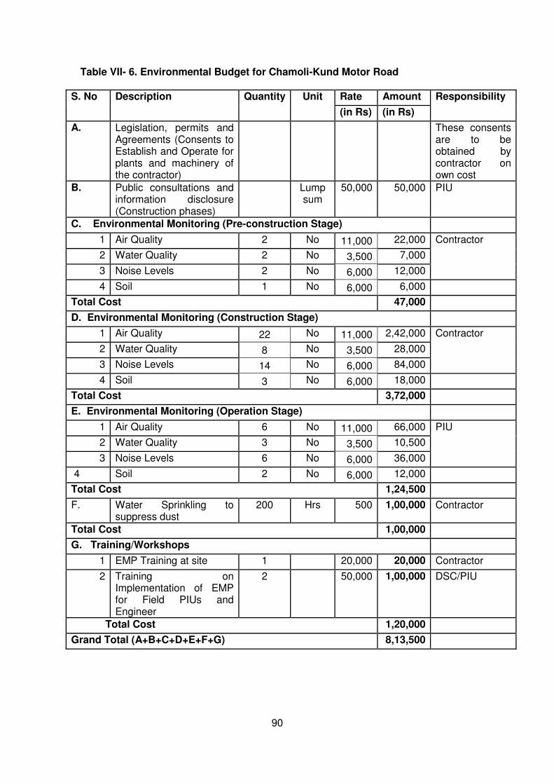
90
Table VII- 6. Environmental Budget for Chamoli-Kund Motor Road
S. No Description Quantity Unit Rate Amount Responsibility
(in Rs) (in Rs)
A. Legislation, permits and Agreements (Consents to Establish and Operate for plants and machinery of the contractor)
These consents are to be obtained by contractor on own cost
B. Public consultations and information disclosure (Construction phases)
Lump sum
50,000 50,000 PIU
C. Environmental Monitoring (Pre-construction Stage)
1 Air Quality 2 No 11,000 22,000 Contractor
2 Water Quality 2 No 3,500 7,000
3 Noise Levels 2 No 6,000 12,000
4 Soil 1 No 6,000 6,000
Total Cost 47,000
D. Environmental Monitoring (Construction Stage)
1 Air Quality 22 No 11,000 2,42,000 Contractor
2 Water Quality 8 No 3,500 28,000
3 Noise Levels 14 No 6,000 84,000
4 Soil 3 No 6,000 18,000
Total Cost 3,72,000
E. Environmental Monitoring (Operation Stage)
1 Air Quality 6 No 11,000 66,000 PIU
2 Water Quality 3 No 3,500 10,500
3 Noise Levels 6 No 6,000 36,000
4 Soil 2 No 6,000 12,000
Total Cost 1,24,500
F. Water Sprinkling to suppress dust
200 Hrs 500 1,00,000 Contractor
Total Cost 1,00,000
G. Training/Workshops
1 EMP Training at site 1 20,000 20,000 Contractor
2 Training on Implementation of EMP for Field PIUs and Engineer
2 50,000 1,00,000 DSC/PIU
Total Cost 1,20,000
Grand Total (A+B+C+D+E+F+G) 8,13,500
91
VIII. CONCLUSION AND RECOMMENDATION
196. The proposed Project has been categorized as Category ‘B’ based on environmental screening and assessment of likely impacts of both road sections. The initial environmental examination (IEE) ascertains that it is unlikely to cause any significant environmental impacts. Few impacts were identified attributable to the proposed sub-project, all of which are localized and temporary in nature and easy to mitigate.
197. All road sections proposed to be upgraded do not pass through or located nearby
any national park, wildlife sanctuary, reserved forests, or any other ecologically sensitive or protected areas. No archaeological/protected monument is located in the project vicinity.
198. Potential significant environmental impacts are related to encroachments or near to
historical and ecologically sensitive areas, road sections are prone to landslides, localized flooding, increase erosion, siltation, and hazardous driving conditions.
199. The beneficial impacts still outweighs the potential significant environmental impacts.
Beneficial impacts include reduction in travel time and lower vehicle operating costs; better internal and external access to and from Uttarakhand; and better access to agricultural production areas, markets, religious and tourist areas. The road design is also a mitigation measure to existing road safety and accessibility issues as it addresses erosion, landslides, poor drainage, and inadequate road safety. Improved roads will also contribute to the community climate change resiliency as it can better withstand more extreme weather events allowing continued accessibility and flow of materials under such conditions
200. In general, the sub-project received immense support from local people. Majority
welcomes several benefits related to better roads like facilitate transport, employment, and boost economic development. Concerns were expressed related to construction camps may put stress on local resources and the infrastructure in nearby communities.
201. The initial environmental examination ascertains that the sub-project is unlikely to
cause any significant environmental impacts. No additional studies or need of undertaking detailed EIA is envisaged at this stage. The Executing Agency shall ensure that EMMP is included in Bill of Quantity (BOQ) and forms part of bid document and civil works contract. The same shall be revised if necessary during project implementation or if there is any change in the project design and with approval of ADB.
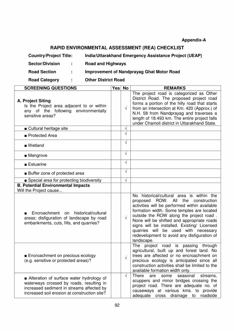
92
Appendix-A
RAPID ENVIRONMENTAL ASSESSMENT (REA) CHECKLIST
Country/Project Title: India/Uttarakhand Emergency Assistance Project (UEAP)
Sector/Division : Road and Highways
Road Section : Improvement of Nandprayag Ghat Motor Road
Road Category : Other District Road
SCREENING QUESTIONS Yes No REMARKS
A. Project Siting Is the Project area adjacent to or within any of the following environmentally sensitive areas?
√
The project road is categorized as Other District Road. The proposed project road forms a portion of the hilly road that starts from an intersection at Km. 420 (Approx.) of N.H. 58 from Nandprayag and traverses a length of 18.493 km. The entire project falls under Chamoli district in Uttarakhand State.
ミ Cultural heritage site √
ミ Protected Area √
ミ Wetland √
ミ Mangrove √
ミ Estuarine √
ミ Buffer zone of protected area √
ミ Special area for protecting biodiversity √ B. Potential Environmental Impacts Will the Project cause...
ミ Encroachment on historical/cultural areas; disfiguration of landscape by road embankments, cuts, fills, and quarries?
√
No historical/cultural area is within the proposed ROW. All the construction activities will be performed within available formation width. Some temples are located outside the ROW along the project road . None will be shifted and appropriate roads signs will be installed. Existing/ Licensed quarries will be used with necessary redevelopment to avoid any disfiguration of landscape.
ミ Encroachment on precious ecology (e.g. sensitive or protected areas)?
√
The project road is passing through agricultural, built up and forest land. No trees are affected or no encroachment on precious ecology is anticipated since all construction activities shall be limited to the available formation width only.
ミ Alteration of surface water hydrology of waterways crossed by roads, resulting in increased sediment in streams affected by increased soil erosion at construction site?
√ There are some seasonal streams, scuppers and minor bridges crossing the project road. There are adequate no. of causeways at various kms. to provide adequate cross drainage to roadside

93
SCREENING QUESTIONS Yes No REMARKS nallahs and to avoid soil erosion and accelerated deterioration of paved shoulders.
ミ Deterioration of surface water quality due to silt runoff and sanitary wastes from worker-based camps and chemicals used in construction?
√ No direct impact on surface water quality is envisaged. However, measures like locating camps away from water bodies and providing septic tanks and soak pits as sewage disposal facilities will be provided in the construction camps. The chemicals will be used for the project are kept at least 300 m away from the drainage channel, nallahs and other water resources.
ミ Increased local air pollution due to rock crushing, cutting, and filling works, and chemicals from asphalt processing?
√
Conformance to Emission standards and norms, use of locally available materials (licensed quarry), scheduling the activity preferably in wet months, avoiding the use of wood as fuel for heating bitumen, hot mix plant location to be preferably on waste lands, reuse of land filling of bituminous wastes, use of dust suppressants. Haul trucks will be covered and will strictly observe speed < 30 km / hr when traversing these locations. Contractor with concerned PIU will conduct consultation during construction phase to identify other measures to control dust.
ミ Risks and vulnerabilities related to occupational health and safety due to physical, chemical, biological, and radiological hazards during project construction and operation during project construction and operation?
√
Providing Personal Protection Equipments (PPE) to workers etc. Dismantling of existing structures and disposal by manual and mechanical means.
ミ Noise and vibration due to blasting and other civil works?
√
No blasting will be done. During construction, nuisance would be created due to the movement of heavy machineries like excavators, dumpers etc. No work will be permitted near the Schools and Colleges during the study hours. Proper mitigation measures will be in place like PPEs, noise enclosures, etc.
ミ Dislocation or involuntary resettlement of people?
√ Not involved
ミ Dislocation and compulsory resettlement of people living in right-of-way?
√ Not involved
ミ Disproportionate impacts on the poor, women and children, Indigenous Peoples or other vulnerable groups?
√ No. This hilly road will improve access of marginal upland dwellers to market centres and social services.
ミ Other social concerns relating to inconveniences in living conditions in the project areas that may trigger cases of upper respiratory problems and stress?
√
Hauling of fill materials and spoils over unpaved road at uncontrolled speeds will increase fugitive dust emissions resulting to episodes of elevated SPM concentration
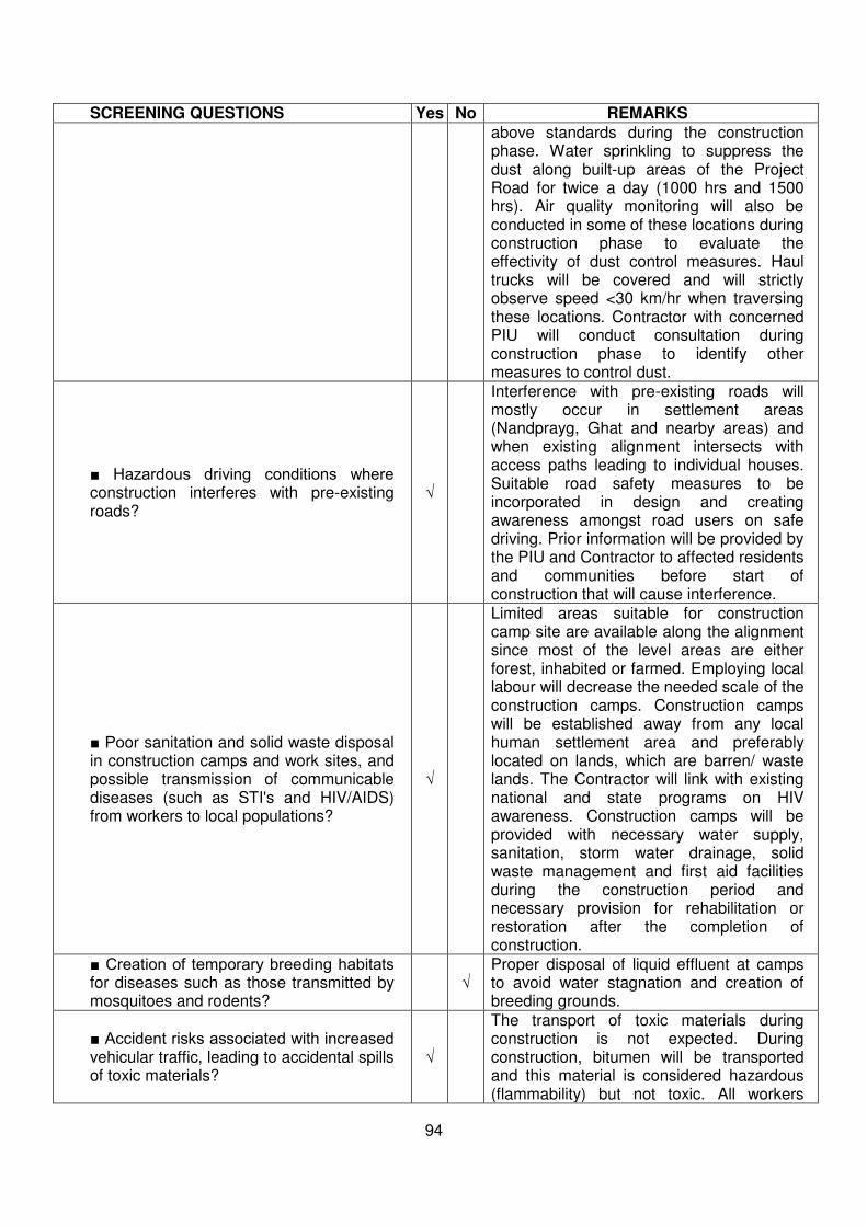
94
SCREENING QUESTIONS Yes No REMARKS above standards during the construction phase. Water sprinkling to suppress the dust along built-up areas of the Project Road for twice a day (1000 hrs and 1500 hrs). Air quality monitoring will also be conducted in some of these locations during construction phase to evaluate the effectivity of dust control measures. Haul trucks will be covered and will strictly observe speed <30 km/hr when traversing these locations. Contractor with concerned PIU will conduct consultation during construction phase to identify other measures to control dust.
ミ Hazardous driving conditions where construction interferes with pre-existing roads?
√
Interference with pre-existing roads will mostly occur in settlement areas (Nandprayg, Ghat and nearby areas) and when existing alignment intersects with access paths leading to individual houses. Suitable road safety measures to be incorporated in design and creating awareness amongst road users on safe driving. Prior information will be provided by the PIU and Contractor to affected residents and communities before start of construction that will cause interference.
ミ Poor sanitation and solid waste disposal in construction camps and work sites, and possible transmission of communicable diseases (such as STI's and HIV/AIDS) from workers to local populations?
√
Limited areas suitable for construction camp site are available along the alignment since most of the level areas are either forest, inhabited or farmed. Employing local labour will decrease the needed scale of the construction camps. Construction camps will be established away from any local human settlement area and preferably located on lands, which are barren/ waste lands. The Contractor will link with existing national and state programs on HIV awareness. Construction camps will be provided with necessary water supply, sanitation, storm water drainage, solid waste management and first aid facilities during the construction period and necessary provision for rehabilitation or restoration after the completion of construction.
ミ Creation of temporary breeding habitats for diseases such as those transmitted by mosquitoes and rodents?
√ Proper disposal of liquid effluent at camps to avoid water stagnation and creation of breeding grounds.
ミ Accident risks associated with increased vehicular traffic, leading to accidental spills of toxic materials?
√
The transport of toxic materials during construction is not expected. During construction, bitumen will be transported and this material is considered hazardous (flammability) but not toxic. All workers
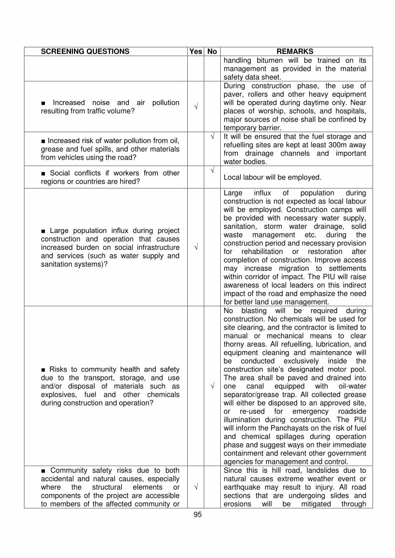
95
SCREENING QUESTIONS Yes No REMARKS handling bitumen will be trained on its management as provided in the material safety data sheet.
ミ Increased noise and air pollution resulting from traffic volume?
√
During construction phase, the use of paver, rollers and other heavy equipment will be operated during daytime only. Near places of worship, schools, and hospitals, major sources of noise shall be confined by temporary barrier.
ミ Increased risk of water pollution from oil, grease and fuel spills, and other materials from vehicles using the road?
√ It will be ensured that the fuel storage and refuelling sites are kept at least 300m away from drainage channels and important water bodies.
ミ Social conflicts if workers from other regions or countries are hired?
√
Local labour will be employed.
ミ Large population influx during project construction and operation that causes increased burden on social infrastructure and services (such as water supply and sanitation systems)?
√
Large influx of population during construction is not expected as local labour will be employed. Construction camps will be provided with necessary water supply, sanitation, storm water drainage, solid waste management etc. during the construction period and necessary provision for rehabilitation or restoration after completion of construction. Improve access may increase migration to settlements within corridor of impact. The PIU will raise awareness of local leaders on this indirect impact of the road and emphasize the need for better land use management.
ミ Risks to community health and safety due to the transport, storage, and use and/or disposal of materials such as explosives, fuel and other chemicals during construction and operation?
√
No blasting will be required during construction. No chemicals will be used for site clearing, and the contractor is limited to manual or mechanical means to clear thorny areas. All refuelling, lubrication, and equipment cleaning and maintenance will be conducted exclusively inside the construction site’s designated motor pool. The area shall be paved and drained into one canal equipped with oil-water separator/grease trap. All collected grease will either be disposed to an approved site, or re-used for emergency roadside illumination during construction. The PIU will inform the Panchayats on the risk of fuel and chemical spillages during operation phase and suggest ways on their immediate containment and relevant other government agencies for management and control.
ミ Community safety risks due to both accidental and natural causes, especially where the structural elements or components of the project are accessible to members of the affected community or
√
Since this is hill road, landslides due to natural causes extreme weather event or earthquake may result to injury. All road sections that are undergoing slides and erosions will be mitigated through
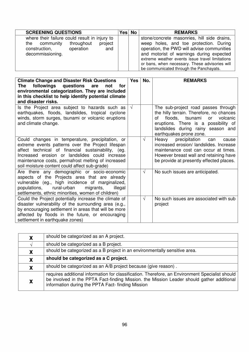
96
SCREENING QUESTIONS Yes No REMARKS where their failure could result in injury to the community throughout project construction, operation and decommissioning.
stone/concrete masonries, hill side drains, weep holes, and toe protection. During operation, the PWD will advise communities and motorist of warnings during expected extreme weather events issue travel limitations or bans, when necessary. These advisories will be communicated through the Panchayats.
Climate Change and Disaster Risk Questions The followings questions are not for environmental categorization. They are included in this checklist to help identify potential climate and disaster risks.
Yes No. REMARKS
Is the Project area subject to hazards such as earthquakes, floods, landslides, tropical cyclone winds, storm surges, tsunami or volcanic eruptions and climate change.
√ The sub-project road passes through the hilly terrain. Therefore, no chances of floods, tsunami or volcanic eruptions. There is a possibility of landslides during rainy season and earthquakes prone zone.
Could changes in temperature, precipitation, or extreme events patterns over the Project lifespan affect technical of financial sustainability, (eg. Increased erosion or landslides could increase maintenance costs, permafrost melting of increased soil moisture content could affect sub-grade)
√ Heavy precipitation can cause increased erosion/ landslides. Increase maintenance cost can occur at times. However breast wall and retaining have be provide at presently effected places.
Are there any demographic or socio-economic aspects of the Projects area that are already vulnerable (eg., high incidence of marginalized, populations, rural-urban migrants, illegal settlements, ethnic minorities, women of children)
√ No such issues are anticipated.
Could the Project potentially increase the climate of disaster vulnerability of the surrounding area (e.g., by encouraging settlement in areas that will be more affected by floods in the future, or encouraging settlement in earthquake zones)
√ No such issues are associated with sub project
x should be categorized as an A project.
√ should be categorized as a B project.
x should be categorized as a B project in an environmentally sensitive area.
x should be categorized as a C project.
x should be categorized as an A/B project because (give reason) .
x requires additional information for classification. Therefore, an Environment Specialist should be involved in the PPTA Fact-finding Mission. the Mission Leader should gather additional information during the PPTA Fact- finding Mission

97
RAPID ENVIRONMENTAL ASSESSMENT (REA) CHECKLIST
Country/Project Title: India/Uttarakhand Emergency Assistance Project (UEAP)
Sector/Division : Road and Highways
Road Section : Improvement of Rudraprayag Pokhari Karanprayag Motor
Road
Road Category : Other District Road
SCREENING QUESTIONS YES NO REMARKS
A. Project Siting Is the Project area adjacent to or within any of the following environmentally sensitive areas?
The project road is categorized as Other District Road. The proposed project road forms a portion of the hilly road that starts from Km 44.000 of Rudraprayag- Pokhari- Karnprayag Motor Road and traverses a length of 14.512 km. The entire project falls under Chamoli district in Uttarakhand State.
ミ Cultural heritage site
ミ Protected Area
ミ Wetland
ミ Mangrove
ミ Estuarine
ミ Buffer zone of protected area
ミ Special area for protecting biodiversity
B. Potential Environmental Impacts Will the Project cause…
ミ Encroachment on historical/cultural areas; disfiguration of landscape by road embankments, cuts, fills, and quarries?
No historical/cultural area is within the proposed ROW. All the construction activities will be performed within available formation width. Some temples are located outside the ROW along the project road. None will be shifted and appropriate roads signs will be installed. Existing/ Licensed quarries will be used with necessary redevelopment to avoid any disfiguration of landscape.
ミ Encroachment on precious ecology (e.g. sensitive or protected areas)?
The project road is passing through agricultural, built up and forest land. No trees are affected or no encroachment on precious ecology is anticipated since all construction activities shall be limited to the available formation width only.
ミ Alteration of surface water hydrology of waterways crossed by roads, resulting in increased sediment in streams affected by increased soil erosion at construction site?
There are some seasonal streams, scuppers and minor bridges crossing the project road. There are adequate no. of causeways at various kms. to provide adequate cross drainage to roadside nallahs and to avoid soil erosion and accelerated deterioration of paved shoulders.
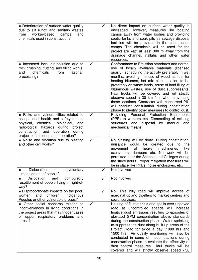
98
ミ Deterioration of surface water quality due to silt runoff and sanitary wastes from worker-based camps and chemicals used in construction?
No direct impact on surface water quality is envisaged. However, measures like locating camps away from water bodies and providing septic tanks and soak pits as sewage disposal facilities will be provided in the construction camps. The chemicals will be used for the project are kept at least 300 m away from the drainage channel, nallahs and other water resources.
ミ Increased local air pollution due to rock crushing, cutting, and filling works, and chemicals from asphalt processing?
Conformance to Emission standards and norms, use of locally available materials (licensed quarry), scheduling the activity preferably in wet months, avoiding the use of wood as fuel for heating bitumen, hot mix plant location to be preferably on waste lands, reuse of land filling of bituminous wastes, use of dust suppressants. Haul trucks will be covered and will strictly observe speed < 30 km / hr when traversing these locations. Contractor with concerned PIU will conduct consultation during construction phase to identify other measures to control dust.
ミ Risks and vulnerabilities related to occupational health and safety due to physical, chemical, biological, and radiological hazards during project construction and operation during project construction and operation?
Providing Personal Protection Equipments (PPE) to workers etc. Dismantling of existing structures and disposal by manual and mechanical means.
ミ Noise and vibration due to blasting and other civil works?
No blasting will be done. During construction, nuisance would be created due to the movement of heavy machineries like excavators, dumpers etc. No work will be permitted near the Schools and Colleges during the study hours. Proper mitigation measures will be in place like PPEs, noise enclosures, etc.
ミ Dislocation or involuntary resettlement of people?
Not involved
ミ Dislocation and compulsory resettlement of people living in right-of-way?
Not involved
ミ Disproportionate impacts on the poor, women and children, Indigenous Peoples or other vulnerable groups?
No. This hilly road will improve access of marginal upland dwellers to market centres and social services.
ミ Other social concerns relating to inconveniences in living conditions in the project areas that may trigger cases of upper respiratory problems and stress?
Hauling of fill materials and spoils over unpaved road at uncontrolled speeds will increase fugitive dust emissions resulting to episodes of elevated SPM concentration above standards during the construction phase. Water sprinkling to suppress the dust along built-up areas of the Project Road for twice a day (1000 hrs and 1500 hrs). Air quality monitoring will also be conducted in some of these locations during construction phase to evaluate the effectivity of dust control measures. Haul trucks will be covered and will strictly observe speed <30
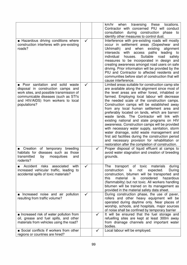
99
km/hr when traversing these locations. Contractor with concerned PIU will conduct consultation during construction phase to identify other measures to control dust.
ミ Hazardous driving conditions where construction interferes with pre-existing roads?
Interference with pre-existing roads will mostly occur in settlement areas (Gopeshwar and Ukhimath) and when existing alignment intersects with access paths leading to individual houses. Suitable road safety measures to be incorporated in design and creating awareness amongst road users on safe driving. Prior information will be provided by the PIU and Contractor to affected residents and communities before start of construction that will cause interference.
ミ Poor sanitation and solid waste disposal in construction camps and work sites, and possible transmission of communicable diseases (such as STI's and HIV/AIDS) from workers to local populations?
Limited areas suitable for construction camp site are available along the alignment since most of the level areas are either forest, inhabited or farmed. Employing local labour will decrease the needed scale of the construction camps. Construction camps will be established away from any local human settlement area and preferably located on lands, which are barren/ waste lands. The Contractor will link with existing national and state programs on HIV awareness. Construction camps will be provided with necessary water supply, sanitation, storm water drainage, solid waste management and first aid facilities during the construction period and necessary provision for rehabilitation or restoration after the completion of construction.
ミ Creation of temporary breeding habitats for diseases such as those transmitted by mosquitoes and rodents?
Proper disposal of liquid effluent at camps to avoid water stagnation and creation of breeding grounds.
ミ Accident risks associated with increased vehicular traffic, leading to accidental spills of toxic materials?
The transport of toxic materials during construction is not expected. During construction, bitumen will be transported and this material is considered hazardous (flammability) but not toxic. All workers handling bitumen will be trained on its management as provided in the material safety data sheet.
ミ Increased noise and air pollution resulting from traffic volume?
During construction phase, the use of paver, rollers and other heavy equipment will be operated during daytime only. Near places of worship, schools, and hospitals, major sources of noise shall be confined by temporary barrier
ミ Increased risk of water pollution from oil, grease and fuel spills, and other materials from vehicles using the road?
It will be ensured that the fuel storage and refuelling sites are kept at least 300m away from drainage channels and important water bodies.
ミ Social conflicts if workers from other regions or countries are hired?
Local labour will be employed.
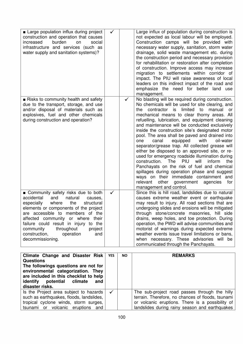
100
ミ Large population influx during project construction and operation that causes increased burden on social infrastructure and services (such as water supply and sanitation systems)?
Large influx of population during construction is not expected as local labour will be employed. Construction camps will be provided with necessary water supply, sanitation, storm water drainage, solid waste management etc. during the construction period and necessary provision for rehabilitation or restoration after completion of construction. Improve access may increase migration to settlements within corridor of impact. The PIU will raise awareness of local leaders on this indirect impact of the road and emphasize the need for better land use management.
ミ Risks to community health and safety due to the transport, storage, and use and/or disposal of materials such as explosives, fuel and other chemicals during construction and operation?
No blasting will be required during construction. No chemicals will be used for site clearing, and the contractor is limited to manual or mechanical means to clear thorny areas. All refuelling, lubrication, and equipment cleaning and maintenance will be conducted exclusively inside the construction site’s designated motor pool. The area shall be paved and drained into one canal equipped with oil-water separator/grease trap. All collected grease will either be disposed to an approved site, or re-used for emergency roadside illumination during construction. The PIU will inform the Panchayats on the risk of fuel and chemical spillages during operation phase and suggest ways on their immediate containment and relevant other government agencies for management and control.
ミ Community safety risks due to both accidental and natural causes, especially where the structural elements or components of the project are accessible to members of the affected community or where their failure could result in injury to the community throughout project construction, operation and decommissioning.
Since this is hill road, landslides due to natural causes extreme weather event or earthquake may result to injury. All road sections that are undergoing slides and erosions will be mitigated through stone/concrete masonries, hill side drains, weep holes, and toe protection. During operation, the PWD will advise communities and motorist of warnings during expected extreme weather events issue travel limitations or bans, when necessary. These advisories will be communicated through the Panchayats.
Climate Change and Disaster Risk Questions The followings questions are not for environmental categorization. They are included in this checklist to help identify potential climate and disaster risks.
YES NO REMARKS
Is the Project area subject to hazards such as earthquakes, floods, landslides, tropical cyclone winds, storm surges, tsunami or volcanic eruptions and
The sub-project road passes through the hilly terrain. Therefore, no chances of floods, tsunami or volcanic eruptions. There is a possibility of landslides during rainy season and earthquakes
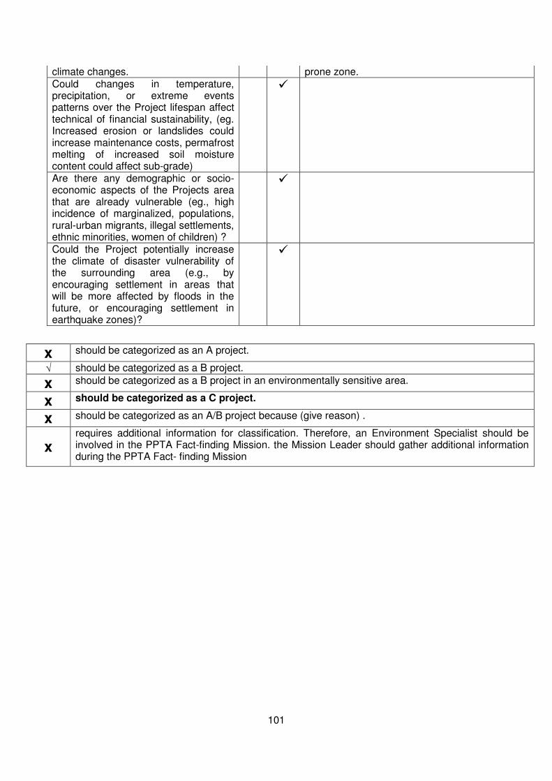
101
climate changes. prone zone. Could changes in temperature, precipitation, or extreme events patterns over the Project lifespan affect technical of financial sustainability, (eg. Increased erosion or landslides could increase maintenance costs, permafrost melting of increased soil moisture content could affect sub-grade)
Are there any demographic or socio-economic aspects of the Projects area that are already vulnerable (eg., high incidence of marginalized, populations, rural-urban migrants, illegal settlements, ethnic minorities, women of children) ?
Could the Project potentially increase the climate of disaster vulnerability of the surrounding area (e.g., by encouraging settlement in areas that will be more affected by floods in the future, or encouraging settlement in earthquake zones)?
x should be categorized as an A project.
√ should be categorized as a B project.
x should be categorized as a B project in an environmentally sensitive area.
x should be categorized as a C project.
x should be categorized as an A/B project because (give reason) .
x requires additional information for classification. Therefore, an Environment Specialist should be involved in the PPTA Fact-finding Mission. the Mission Leader should gather additional information during the PPTA Fact- finding Mission

102
RAPID ENVIRONMENTAL ASSESSMENT (REA) CHECKLIST
Country/Project Title: India/Uttarakhand Emergency Assistance Project (UEAP)
Sector/Division : Road and Highways
Road Section : Improvement of Chamoli Kund Motor Road
Road Category : State Highway
SCREENING QUESTIONS Yes No REMARKS
A. Project Siting
Is the Project area adjacent to or within any of
the following environmentally sensitive areas?
The project road is categorized as State
Highway (SH). The proposed project road
forms a portion of the hilly ring road that
starts from Chamoli and ends at Kund. The
sections of Chamoli Kund Motor Road to be
improved are Km 1 - 11, Km 15, Km 36.000
to 41.00 &, 70.000 to 85.200. The entire
project falls under Chamoli district in
Uttarakhand State.
ミ Cultural heritage site
ミ Protected Area
The Project road Chamoli Kund passes
through Kedarnath Muskdeer sanctuary from
km 44.000 to km 49.000. The sections of
Chamoli Kund Motor Road to be improved are
Km 1 - 11, Km 15, Km36.000 to 41.000,
70.000 to 85.200 and are far away from the
boundary of Sanctuary.
ミ Wetland
ミ Mangrove
ミ Estuarine
ミ Buffer zone of protected area
ミ Special area for protecting biodiversity
B. Potential Environmental Impacts
Will the Project cause...
ミ Encroachment on historical/cultural areas; disfiguration of landscape by road
embankments, cuts, fills, and quarries?
No historical/cultural area is within the
proposed ROW. All the construction activities
will be performed within available formation
width.
Existing/ Licensed quarries will be used with
necessary redevelopment to avoid any
disfiguration of landscape.
ミ Encroachment on precious ecology The project road is passing through

103
SCREENING QUESTIONS Yes No REMARKS
(e.g. sensitive or protected areas)? agricultural, built up and forest land. No trees
are affected or no encroachment on precious
ecology is anticipated since all construction
activities shall be limited to the available
formation width only.
ミ Alteration of surface water hydrology of waterways crossed by roads, resulting in
increased sediment in streams affected by
increased soil erosion at construction site?
The project road passes through Hilly terrain.
There are three bridges in project road at Km
79.000, Km 80.000 & Km 81.000. No other
water bodies such as lake, ponds exist within
proposed formation width. Project involves
rehabilitation / widening of some existing CD
structures which will not alter hydrology.
Mitigation measures will be adopted for
avoiding soil erosion /sedimentation during
construction.
ミ Deterioration of surface water quality due to silt runoff and sanitary wastes from worker-
based camps and chemicals used in
construction?
No direct impact on surface water quality is
envisaged. However, measures like locating
camps away from water bodies and providing
septic tanks and soak pits as sewage
disposal facilities will be provided in the
construction camps.
The chemicals will be used for the project are
kept at least 300 m away from the drainage
channel, nallahs and other water resources.
ミ Increased local air pollution due to rock crushing, cutting, and filling works, and
chemicals from asphalt processing?
Conformance to Emission standards and
norms, use of locally available materials
(licensed quarry), scheduling the activity
preferably in wet months, avoiding the use of
wood as fuel for heating bitumen, hot mix
plant location to be preferably on waste
lands, reuse of land filling of bituminous
wastes, use of dust suppressants.
Haul trucks will be covered and will strictly
observe speed < 30 km / hr when traversing
these locations.
Contractor, CSC with concerned PIU will
conduct consultation during construction
phase to identify other measures to control
dust.
ミ Risks and vulnerabilities related to occupational health and safety due to physical,
chemical, biological, and radiological hazards
during project construction and operation during
project construction and operation?
Providing Personal Protection Equipments
(PPE) to workers etc.
Dismantling of existing structures and
disposal by manual and mechanical means.
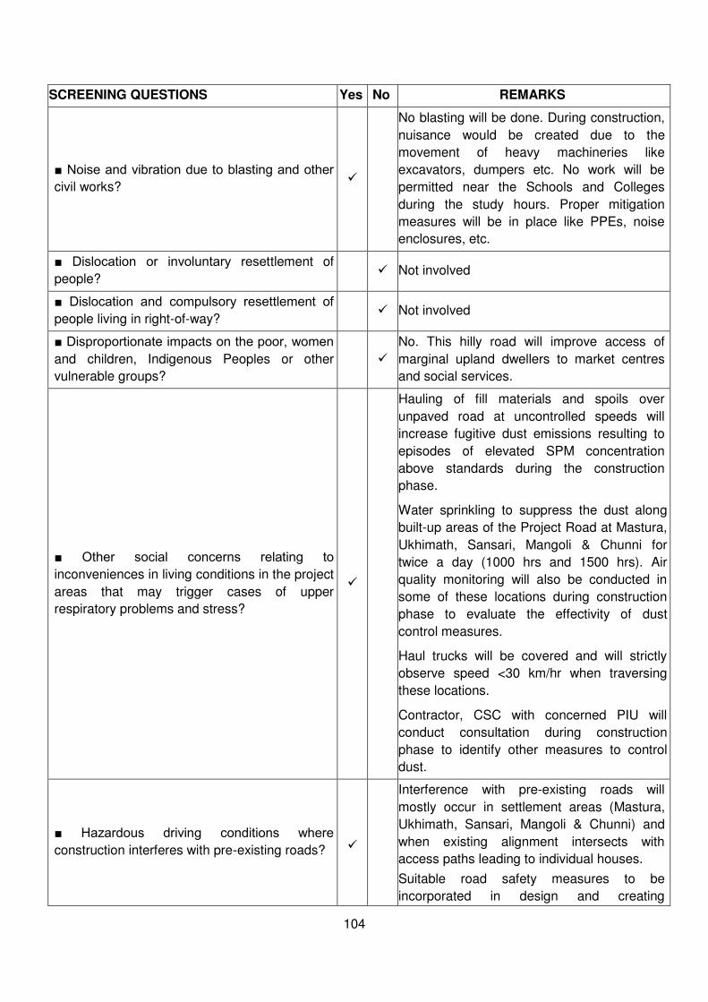
104
SCREENING QUESTIONS Yes No REMARKS
ミ Noise and vibration due to blasting and other civil works?
No blasting will be done. During construction,
nuisance would be created due to the
movement of heavy machineries like
excavators, dumpers etc. No work will be
permitted near the Schools and Colleges
during the study hours. Proper mitigation
measures will be in place like PPEs, noise
enclosures, etc.
ミ Dislocation or involuntary resettlement of
people? Not involved
ミ Dislocation and compulsory resettlement of people living in right-of-way?
Not involved
ミ Disproportionate impacts on the poor, women and children, Indigenous Peoples or other
vulnerable groups?
No. This hilly road will improve access of
marginal upland dwellers to market centres
and social services.
ミ Other social concerns relating to inconveniences in living conditions in the project
areas that may trigger cases of upper
respiratory problems and stress?
Hauling of fill materials and spoils over
unpaved road at uncontrolled speeds will
increase fugitive dust emissions resulting to
episodes of elevated SPM concentration
above standards during the construction
phase.
Water sprinkling to suppress the dust along
built-up areas of the Project Road at Mastura,
Ukhimath, Sansari, Mangoli & Chunni for
twice a day (1000 hrs and 1500 hrs). Air
quality monitoring will also be conducted in
some of these locations during construction
phase to evaluate the effectivity of dust
control measures.
Haul trucks will be covered and will strictly
observe speed <30 km/hr when traversing
these locations.
Contractor, CSC with concerned PIU will
conduct consultation during construction
phase to identify other measures to control
dust.
ミ Hazardous driving conditions where construction interferes with pre-existing roads?
Interference with pre-existing roads will
mostly occur in settlement areas (Mastura,
Ukhimath, Sansari, Mangoli & Chunni) and
when existing alignment intersects with
access paths leading to individual houses.
Suitable road safety measures to be
incorporated in design and creating
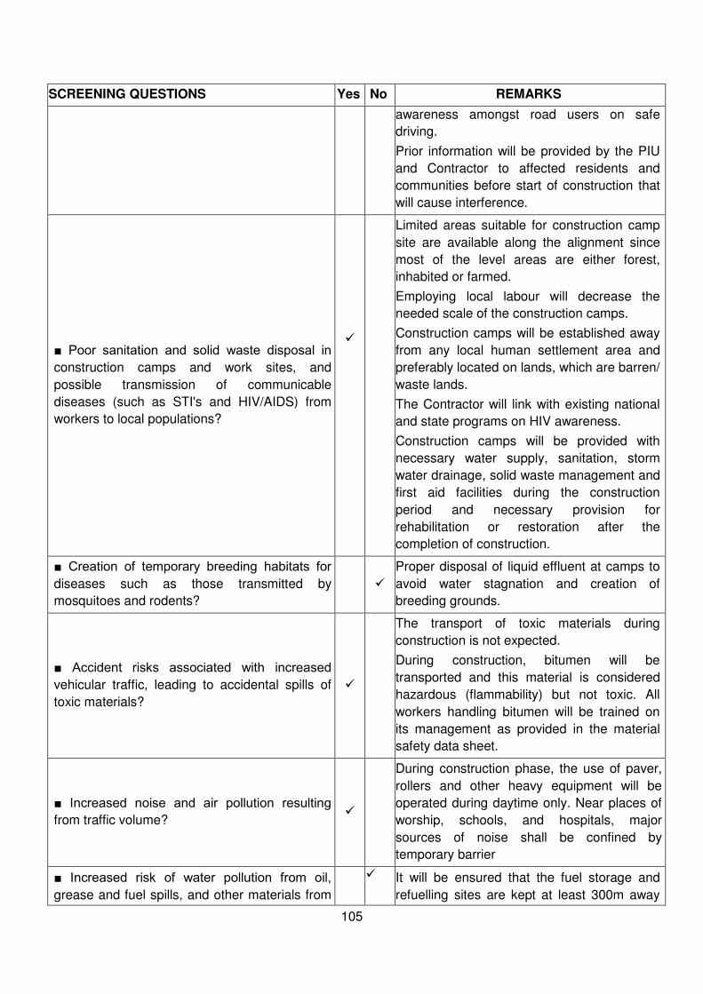
105
SCREENING QUESTIONS Yes No REMARKS
awareness amongst road users on safe
driving.
Prior information will be provided by the PIU
and Contractor to affected residents and
communities before start of construction that
will cause interference.
ミ Poor sanitation and solid waste disposal in construction camps and work sites, and
possible transmission of communicable
diseases (such as STI's and HIV/AIDS) from
workers to local populations?
Limited areas suitable for construction camp
site are available along the alignment since
most of the level areas are either forest,
inhabited or farmed.
Employing local labour will decrease the
needed scale of the construction camps.
Construction camps will be established away
from any local human settlement area and
preferably located on lands, which are barren/
waste lands.
The Contractor will link with existing national
and state programs on HIV awareness.
Construction camps will be provided with
necessary water supply, sanitation, storm
water drainage, solid waste management and
first aid facilities during the construction
period and necessary provision for
rehabilitation or restoration after the
completion of construction.
ミ Creation of temporary breeding habitats for diseases such as those transmitted by
mosquitoes and rodents?
Proper disposal of liquid effluent at camps to
avoid water stagnation and creation of
breeding grounds.
ミ Accident risks associated with increased vehicular traffic, leading to accidental spills of
toxic materials?
The transport of toxic materials during
construction is not expected.
During construction, bitumen will be
transported and this material is considered
hazardous (flammability) but not toxic. All
workers handling bitumen will be trained on
its management as provided in the material
safety data sheet.
ミ Increased noise and air pollution resulting from traffic volume?
During construction phase, the use of paver,
rollers and other heavy equipment will be
operated during daytime only. Near places of
worship, schools, and hospitals, major
sources of noise shall be confined by
temporary barrier
ミ Increased risk of water pollution from oil, grease and fuel spills, and other materials from
It will be ensured that the fuel storage and
refuelling sites are kept at least 300m away
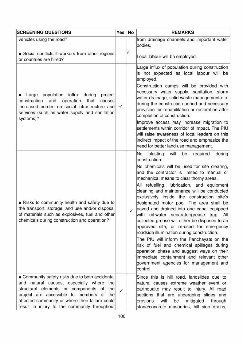
106
SCREENING QUESTIONS Yes No REMARKS
vehicles using the road? from drainage channels and important water
bodies.
ミ Social conflicts if workers from other regions or countries are hired?
Local labour will be employed.
ミ Large population influx during project construction and operation that causes
increased burden on social infrastructure and
services (such as water supply and sanitation
systems)?
Large influx of population during construction
is not expected as local labour will be
employed.
Construction camps will be provided with
necessary water supply, sanitation, storm
water drainage, solid waste management etc.
during the construction period and necessary
provision for rehabilitation or restoration after
completion of construction.
Improve access may increase migration to
settlements within corridor of impact. The PIU
will raise awareness of local leaders on this
indirect impact of the road and emphasize the
need for better land use management.
ミ Risks to community health and safety due to the transport, storage, and use and/or disposal
of materials such as explosives, fuel and other
chemicals during construction and operation?
No blasting will be required during
construction.
No chemicals will be used for site clearing,
and the contractor is limited to manual or
mechanical means to clear thorny areas.
All refuelling, lubrication, and equipment
cleaning and maintenance will be conducted
exclusively inside the construction site’s designated motor pool. The area shall be
paved and drained into one canal equipped
with oil-water separator/grease trap. All
collected grease will either be disposed to an
approved site, or re-used for emergency
roadside illumination during construction.
The PIU will inform the Panchayats on the
risk of fuel and chemical spillages during
operation phase and suggest ways on their
immediate containment and relevant other
government agencies for management and
control.
ミ Community safety risks due to both accidental
and natural causes, especially where the
structural elements or components of the
project are accessible to members of the
affected community or where their failure could
result in injury to the community throughout
Since this is hill road, landslides due to
natural causes extreme weather event or
earthquake may result to injury. All road
sections that are undergoing slides and
erosions will be mitigated through
stone/concrete masonries, hill side drains,

107
SCREENING QUESTIONS Yes No REMARKS
project construction, operation and
decommissioning.
weep holes, and toe protection. During
operation, the PWD will advise communities
and motorist of warnings during expected
extreme weather events issue travel
limitations or bans, when necessary. These
advisories will be communicated through the
Panchayats.
x should be categorized as an A project.
√ should be categorized as a B project.
x should be categorized as a B project in an environmentally sensitive area.
x should be categorized as a C project.
x should be categorized as an A/B project because (give reason) .
x requires additional information for classification. Therefore, an Environment Specialist should be involved in the PPTA Fact-finding Mission. the Mission Leader should gather additional information during the PPTA Fact- finding Mission
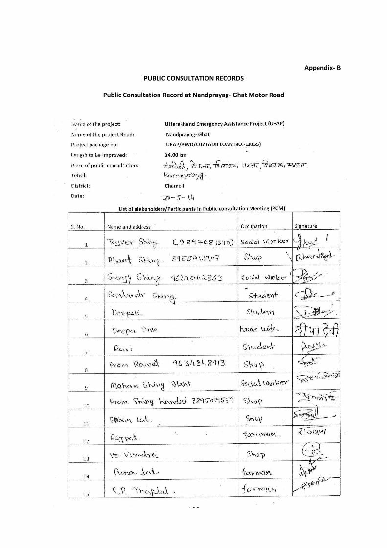
108
Appendix- B
PUBLIC CONSULTATION RECORDS
Public Consultation Record at Nandprayag- Ghat Motor Road
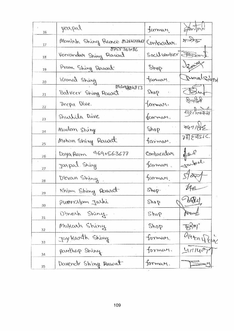
109

110
Public Consultation Record at Rudraprayag-Pokhari-Karanprayag
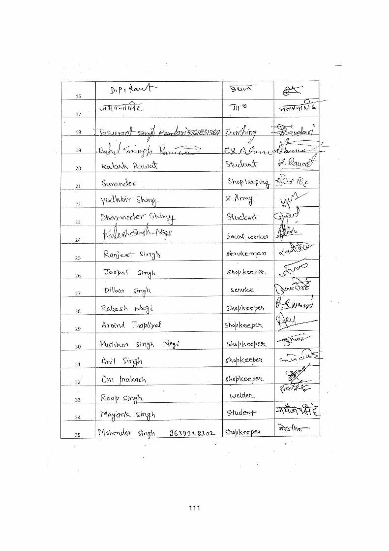
111

112
Public Consultation Record at Chamoli-Kund Road (SH-
36)

113
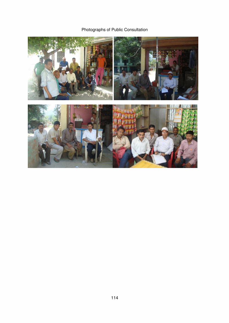
114
Photographs of Public Consultation

115
Appendix- C
Site Photographs
Nandprayag Ghat Motor Road

116
Rudraprayag-Pokhari-Karanpryag Motor Road

117
Chamoli-Kund Motor Road

118
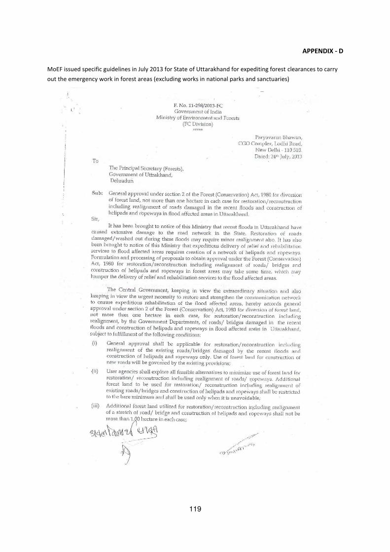
119
APPENDIX - D
MoEF issued specific guidelines in July 2013 for State of Uttarakhand for expediting forest clearances to carry
out the emergency work in forest areas (excluding works in national parks and sanctuaries)

120
121
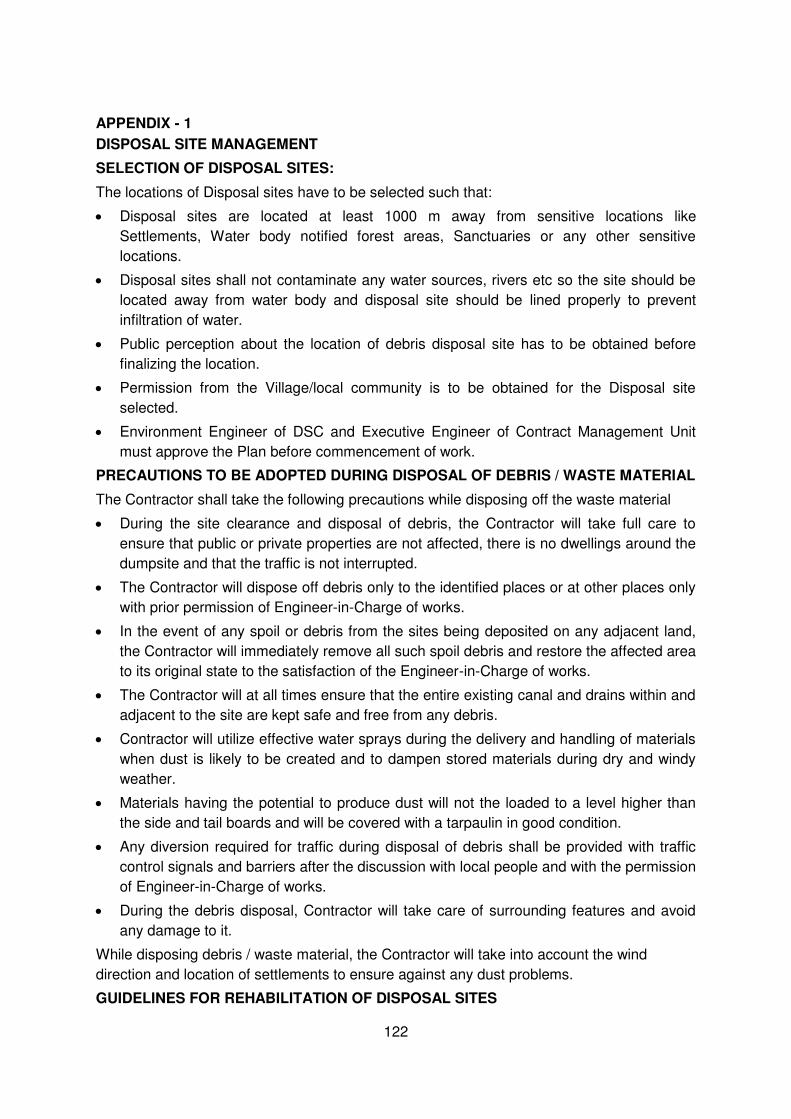
122
APPENDIX - 1
DISPOSAL SITE MANAGEMENT
SELECTION OF DISPOSAL SITES:
The locations of Disposal sites have to be selected such that:
Disposal sites are located at least 1000 m away from sensitive locations like
Settlements, Water body notified forest areas, Sanctuaries or any other sensitive
locations.
Disposal sites shall not contaminate any water sources, rivers etc so the site should be
located away from water body and disposal site should be lined properly to prevent
infiltration of water.
Public perception about the location of debris disposal site has to be obtained before
finalizing the location.
Permission from the Village/local community is to be obtained for the Disposal site
selected.
Environment Engineer of DSC and Executive Engineer of Contract Management Unit
must approve the Plan before commencement of work.
PRECAUTIONS TO BE ADOPTED DURING DISPOSAL OF DEBRIS / WASTE MATERIAL
The Contractor shall take the following precautions while disposing off the waste material
During the site clearance and disposal of debris, the Contractor will take full care to
ensure that public or private properties are not affected, there is no dwellings around the
dumpsite and that the traffic is not interrupted.
The Contractor will dispose off debris only to the identified places or at other places only
with prior permission of Engineer-in-Charge of works.
In the event of any spoil or debris from the sites being deposited on any adjacent land,
the Contractor will immediately remove all such spoil debris and restore the affected area
to its original state to the satisfaction of the Engineer-in-Charge of works.
The Contractor will at all times ensure that the entire existing canal and drains within and
adjacent to the site are kept safe and free from any debris.
Contractor will utilize effective water sprays during the delivery and handling of materials
when dust is likely to be created and to dampen stored materials during dry and windy
weather.
Materials having the potential to produce dust will not the loaded to a level higher than
the side and tail boards and will be covered with a tarpaulin in good condition.
Any diversion required for traffic during disposal of debris shall be provided with traffic
control signals and barriers after the discussion with local people and with the permission
of Engineer-in-Charge of works.
During the debris disposal, Contractor will take care of surrounding features and avoid
any damage to it.
While disposing debris / waste material, the Contractor will take into account the wind
direction and location of settlements to ensure against any dust problems.
GUIDELINES FOR REHABILITATION OF DISPOSAL SITES
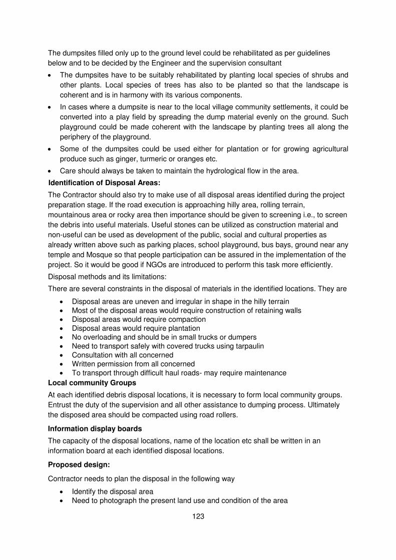
123
The dumpsites filled only up to the ground level could be rehabilitated as per guidelines
below and to be decided by the Engineer and the supervision consultant
The dumpsites have to be suitably rehabilitated by planting local species of shrubs and
other plants. Local species of trees has also to be planted so that the landscape is
coherent and is in harmony with its various components.
In cases where a dumpsite is near to the local village community settlements, it could be
converted into a play field by spreading the dump material evenly on the ground. Such
playground could be made coherent with the landscape by planting trees all along the
periphery of the playground.
Some of the dumpsites could be used either for plantation or for growing agricultural
produce such as ginger, turmeric or oranges etc.
Care should always be taken to maintain the hydrological flow in the area.
Identification of Disposal Areas:
The Contractor should also try to make use of all disposal areas identified during the project
preparation stage. If the road execution is approaching hilly area, rolling terrain,
mountainous area or rocky area then importance should be given to screening i.e., to screen
the debris into useful materials. Useful stones can be utilized as construction material and
non-useful can be used as development of the public, social and cultural properties as
already written above such as parking places, school playground, bus bays, ground near any
temple and Mosque so that people participation can be assured in the implementation of the
project. So it would be good if NGOs are introduced to perform this task more efficiently.
Disposal methods and its limitations:
There are several constraints in the disposal of materials in the identified locations. They are
Disposal areas are uneven and irregular in shape in the hilly terrain
Most of the disposal areas would require construction of retaining walls
Disposal areas would require compaction
Disposal areas would require plantation
No overloading and should be in small trucks or dumpers
Need to transport safely with covered trucks using tarpaulin
Consultation with all concerned
Written permission from all concerned
To transport through difficult haul roads- may require maintenance
Local community Groups
At each identified debris disposal locations, it is necessary to form local community groups.
Entrust the duty of the supervision and all other assistance to dumping process. Ultimately
the disposed area should be compacted using road rollers.
Information display boards
The capacity of the disposal locations, name of the location etc shall be written in an
information board at each identified disposal locations.
Proposed design:
Contractor needs to plan the disposal in the following way
Identify the disposal area
Need to photograph the present land use and condition of the area
124
Consult with all stakeholders
Get written agreement from all concerned
Prepare a suitable design for the safe disposal
Construct all required structures (e.g. retaining wall)
Planting of fast growing popular trees on the outer potion of the retaining wall in the form of a linear wall parallel to the retaining wall
Compact of the materials after disposal
Prepare a Contractors debris disposal plan with design drawings for each identified area
With regards to plan, there would be only one disposal plan with small changes for each location. Contractors need to get approvals for specific design for each identified disposal area.
Penalties:
Stringent action & penalties for dumping of materials in locations other than the pre-identified
locations is to be worked out to avoid clandestine disposal in the midnight hours. There are
several cases of dumping of material randomly in many locations.
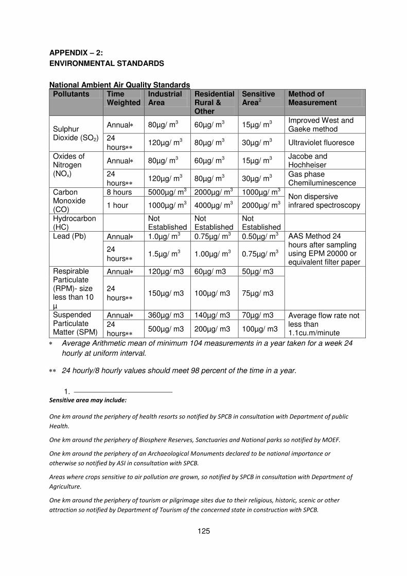
125
APPENDIX – 2:
ENVIRONMENTAL STANDARDS
National Ambient Air Quality Standards Pollutants Time
Weighted Industrial Area
Residential Rural & Other
Sensitive Area2
Method of Measurement
Sulphur Dioxide (SO2)
Annual 80µg/ m3 60µg/ m3 15µg/ m3 Improved West and Gaeke method
24
hours 120µg/ m3 80µg/ m3 30µg/ m3 Ultraviolet fluoresce
Oxides of Nitrogen (NOx)
Annual 80µg/ m3 60µg/ m3 15µg/ m3 Jacobe and Hochheiser
24
hours 120µg/ m3 80µg/ m3 30µg/ m3
Gas phase Chemiluminescence
Carbon Monoxide (CO)
8 hours 5000µg/ m3 2000µg/ m3 1000µg/ m3 Non dispersive infrared spectroscopy 1 hour 1000µg/ m3 4000µg/ m3 2000µg/ m3
Hydrocarbon (HC)
Not Established
Not Established
Not Established
Lead (Pb) Annual 1.0µg/ m3 0.75µg/ m3 0.50µg/ m3 AAS Method 24 hours after sampling using EPM 20000 or equivalent filter paper
24
hours 1.5µg/ m3 1.00µg/ m3 0.75µg/ m3
Respirable Particulate (RPM)- size less than 10 µ
Annual 120µg/ m3 60µg/ m3 50µg/ m3
24
hours 150µg/ m3 100µg/ m3 75µg/ m3
Suspended Particulate Matter (SPM)
Annual 360µg/ m3 140µg/ m3 70µg/ m3 Average flow rate not less than 1.1cu.m/minute
24
hours 500µg/ m3 200µg/ m3 100µg/ m3
Average Arithmetic mean of minimum 104 measurements in a year taken for a week 24
hourly at uniform interval.
24 hourly/8 hourly values should meet 98 percent of the time in a year.
1. Sensitive area may include:
One km around the periphery of health resorts so notified by SPCB in consultation with Department of public
Health.
One km around the periphery of Biosphere Reserves, Sanctuaries and National parks so notified by MOEF.
One km around the periphery of an Archaeological Monuments declared to be national importance or
otherwise so notified by ASI in consultation with SPCB.
Areas where crops sensitive to air pollution are grown, so notified by SPCB in consultation with Department of
Agriculture.
One km around the periphery of tourism or pilgrimage sites due to their religious, historic, scenic or other
attraction so notified by Department of Tourism of the concerned state in construction with SPCB.

126
Indian Standards of Drinking Water Specifications-IS 10500: 1991
S. No.
Substance or Characteristic
Requirement (Desirable Limit)
Undesirable Effect outside the Desirable Limit
Permissible Limit in the Absence of Alternate Source
Methods of Test (Ref. To IS)
Remarks
Essential Characteristics 1. Colour,
Hazen units, Max.
5 Above 5, consumer acceptance decreases
25 3025(Part 4) 1983
Extended to 25 only if toxic substances, in absence of alternate sources
2. Odour Unobjectionable
- - 3025 (Parts 5) 1984
a) Test cold and when heated b) Tests at several dilutions
3. Taste Agreeable - - 3025(Part 7 and 8) 1984
Test to be conducted only after safety has been established
4. Turbidity NTU, Max.
5 Above 5, consumer acceptance decreases
10 3025 (Part 10) 1984
-
5. pH Value 6.5 to 8.5 Beyond this range, the water will affect the mucous membrane and /or water supply system
No relaxation
3025 (Part 11) 1984
-
6. Total hardness (as CaCO3) mg/L. Max.
300 Encrustation in water supply structure and adverse effects on domestic use
600 3025 (Part 21) 1983
-
7. Iron (as Fe) 0.3 Beyond this limit 1 32 of -
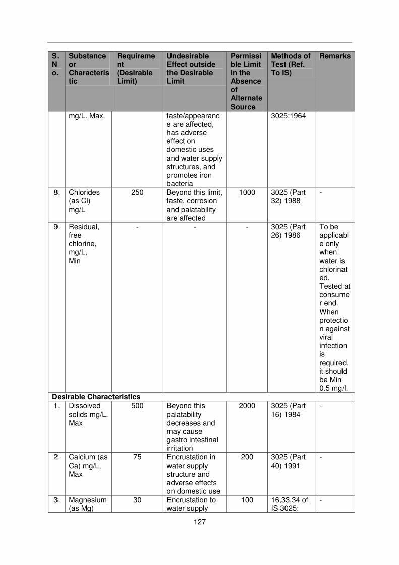
127
S. No.
Substance or Characteristic
Requirement (Desirable Limit)
Undesirable Effect outside the Desirable Limit
Permissible Limit in the Absence of Alternate Source
Methods of Test (Ref. To IS)
Remarks
mg/L. Max. taste/appearance are affected, has adverse effect on domestic uses and water supply structures, and promotes iron bacteria
3025:1964
8. Chlorides (as Cl) mg/L
250 Beyond this limit, taste, corrosion and palatability are affected
1000 3025 (Part 32) 1988
-
9. Residual, free chlorine, mg/L, Min
- - - 3025 (Part 26) 1986
To be applicable only when water is chlorinated. Tested at consumer end. When protection against viral infection is required, it should be Min 0.5 mg/l.
Desirable Characteristics 1. Dissolved
solids mg/L, Max
500 Beyond this palatability decreases and may cause gastro intestinal irritation
2000 3025 (Part 16) 1984
-
2. Calcium (as Ca) mg/L, Max
75 Encrustation in water supply structure and adverse effects on domestic use
200 3025 (Part 40) 1991
-
3. Magnesium (as Mg)
30 Encrustation to water supply
100 16,33,34 of IS 3025:
-
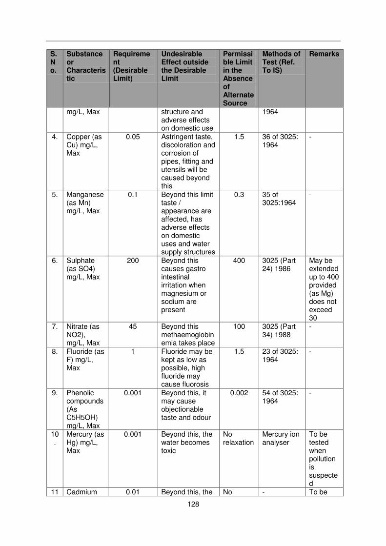
128
S. No.
Substance or Characteristic
Requirement (Desirable Limit)
Undesirable Effect outside the Desirable Limit
Permissible Limit in the Absence of Alternate Source
Methods of Test (Ref. To IS)
Remarks
mg/L, Max structure and adverse effects on domestic use
1964
4. Copper (as Cu) mg/L, Max
0.05 Astringent taste, discoloration and corrosion of pipes, fitting and utensils will be caused beyond this
1.5 36 of 3025: 1964
-
5. Manganese (as Mn) mg/L, Max
0.1 Beyond this limit taste / appearance are affected, has adverse effects on domestic uses and water supply structures
0.3 35 of 3025:1964
-
6. Sulphate (as SO4) mg/L, Max
200 Beyond this causes gastro intestinal irritation when magnesium or sodium are present
400 3025 (Part 24) 1986
May be extended up to 400 provided (as Mg) does not exceed 30
7. Nitrate (as NO2), mg/L, Max
45 Beyond this methaemoglobinemia takes place
100 3025 (Part 34) 1988
-
8. Fluoride (as F) mg/L, Max
1 Fluoride may be kept as low as possible, high fluoride may cause fluorosis
1.5 23 of 3025: 1964
-
9. Phenolic compounds (As C5H5OH) mg/L, Max
0.001 Beyond this, it may cause objectionable taste and odour
0.002 54 of 3025: 1964
-
10.
Mercury (as Hg) mg/L, Max
0.001 Beyond this, the water becomes toxic
No relaxation
Mercury ion analyser
To be tested when pollution is suspected
11 Cadmium 0.01 Beyond this, the No - To be
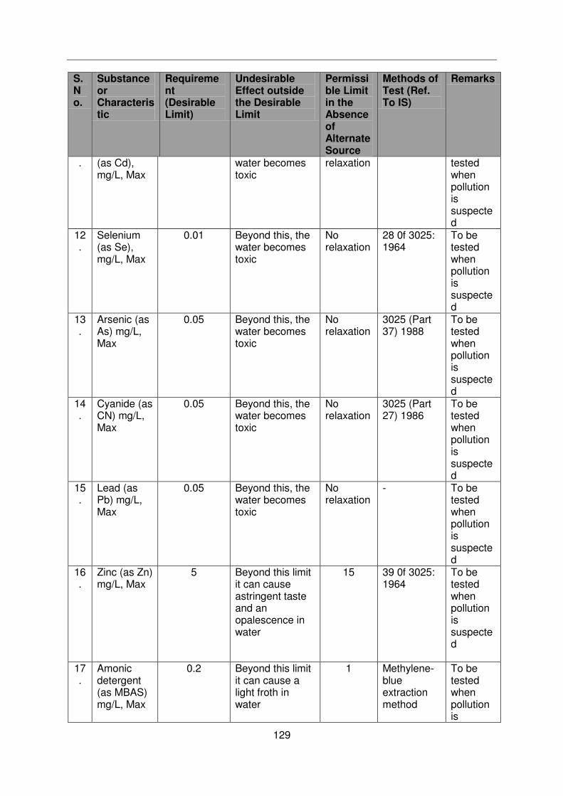
129
S. No.
Substance or Characteristic
Requirement (Desirable Limit)
Undesirable Effect outside the Desirable Limit
Permissible Limit in the Absence of Alternate Source
Methods of Test (Ref. To IS)
Remarks
. (as Cd), mg/L, Max
water becomes toxic
relaxation tested when pollution is suspected
12.
Selenium (as Se), mg/L, Max
0.01 Beyond this, the water becomes toxic
No relaxation
28 0f 3025: 1964
To be tested when pollution is suspected
13.
Arsenic (as As) mg/L, Max
0.05 Beyond this, the water becomes toxic
No relaxation
3025 (Part 37) 1988
To be tested when pollution is suspected
14.
Cyanide (as CN) mg/L, Max
0.05 Beyond this, the water becomes toxic
No relaxation
3025 (Part 27) 1986
To be tested when pollution is suspected
15.
Lead (as Pb) mg/L, Max
0.05 Beyond this, the water becomes toxic
No relaxation
- To be tested when pollution is suspected
16.
Zinc (as Zn) mg/L, Max
5 Beyond this limit it can cause astringent taste and an opalescence in water
15 39 0f 3025: 1964
To be tested when pollution is suspected
17.
Amonic detergent (as MBAS) mg/L, Max
0.2 Beyond this limit it can cause a light froth in water
1 Methylene-blue extraction method
To be tested when pollution is

130
S. No.
Substance or Characteristic
Requirement (Desirable Limit)
Undesirable Effect outside the Desirable Limit
Permissible Limit in the Absence of Alternate Source
Methods of Test (Ref. To IS)
Remarks
suspected
18.
Chromium (as Cr+) mg/L, Max
0.05 May be carcinogenic above this limit
- 38 of 3025: 1964
To be tested when pollution is suspected
19.
Poly nuclear aromatic hydrocarbon (as PAH) g/L, Max
- May be carcinogenic above this limit
- - -
20.
Mineral oil mg/L, Max
0.01 Beyond this limit undesirable taste and odour after chlorination take place
0.03 Gas Chromatograph
-
21.
Pesticides mg/L, Max
Absent Toxic 0.001 - -
22.
Radioactive Alpha emitters Bq/L, Max
- - 0.1 58 of 3025: 01964
-
23.
Radioactive Beta emitters pci/L, Max
- - 1 58 of 3025: 01964
-
24.
Aluminium (as Al), mg/L Max
200 Beyond this limit taste becomes unpleasant
600 13 of 3025: 1964
-
25.
Aluminium (as Al), mg/L Max
0.03 Cumulative effect is reported to cause dementia
0.2 31 of 3025: 1964
-
26.
Boron, mg/L, Max
1 - 5 29 of 3025: 1964
-
Source: Indian Standard Drinking water Specification- IS 10500: 1991

131
Noise Level Standards
Category Noise level for Day Time Leq dB (A) Noise level for Night Time dB (A)
Industrial area 75 70
Commercial area 65 55
Residential area 55 45
Silence Zone 50 40
Note:
Day Time- 6.00 am –10.00 pm (16 hours)
Night Time- 10.00 pm –6.00 am (8 hours)
Silence Zone: The silence zone includes a radius of 100 m around premises where loud
noise is prohibited (including hospitals and educational institutions)
Source: CPCB, 1989, GOI.
1. Standards for Suspended Particulate Matter for Stone Crushing Unit
The suspended particulate matter measured between 3 to 10 meters from any process
equipment of a stone crushing unit shall not exceed 600 µg/m3
(Source: EPA Notification [G.S.R. 742(E) dt. 30th Aug; 1990] & [S.O. 8(E) dt. Dec. 31, 1990)
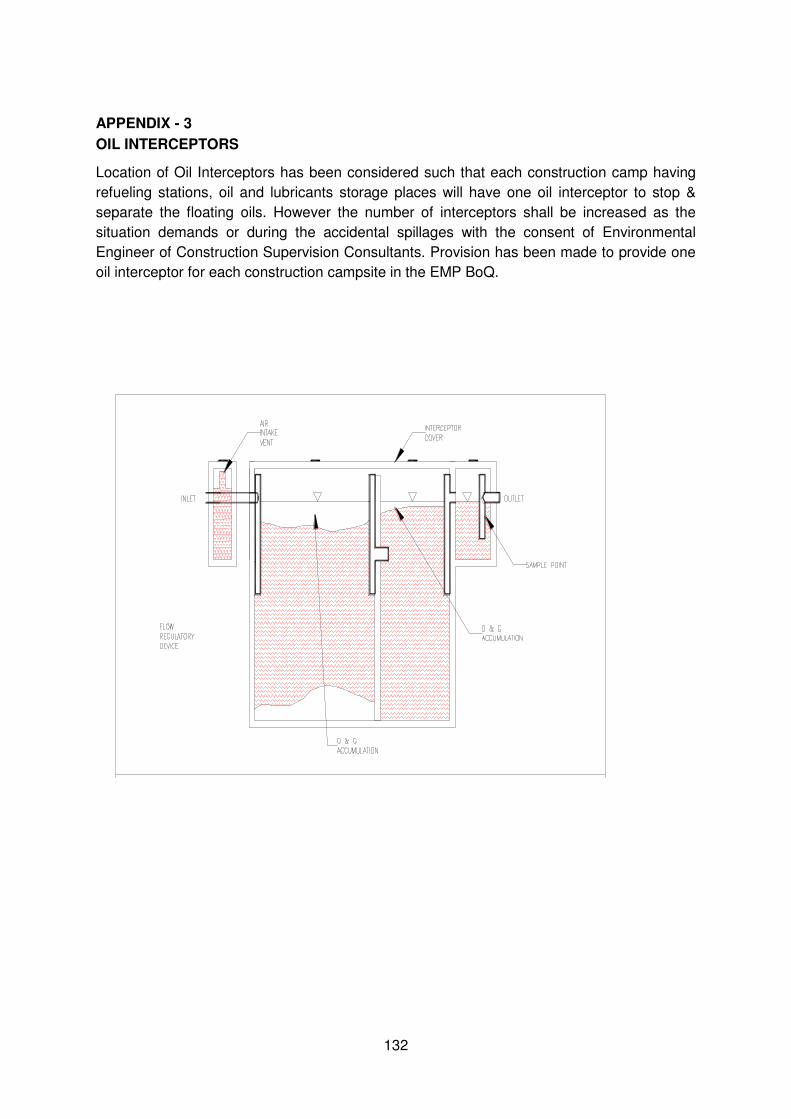
132
APPENDIX - 3
OIL INTERCEPTORS
Location of Oil Interceptors has been considered such that each construction camp having
refueling stations, oil and lubricants storage places will have one oil interceptor to stop &
separate the floating oils. However the number of interceptors shall be increased as the
situation demands or during the accidental spillages with the consent of Environmental
Engineer of Construction Supervision Consultants. Provision has been made to provide one
oil interceptor for each construction campsite in the EMP BoQ.
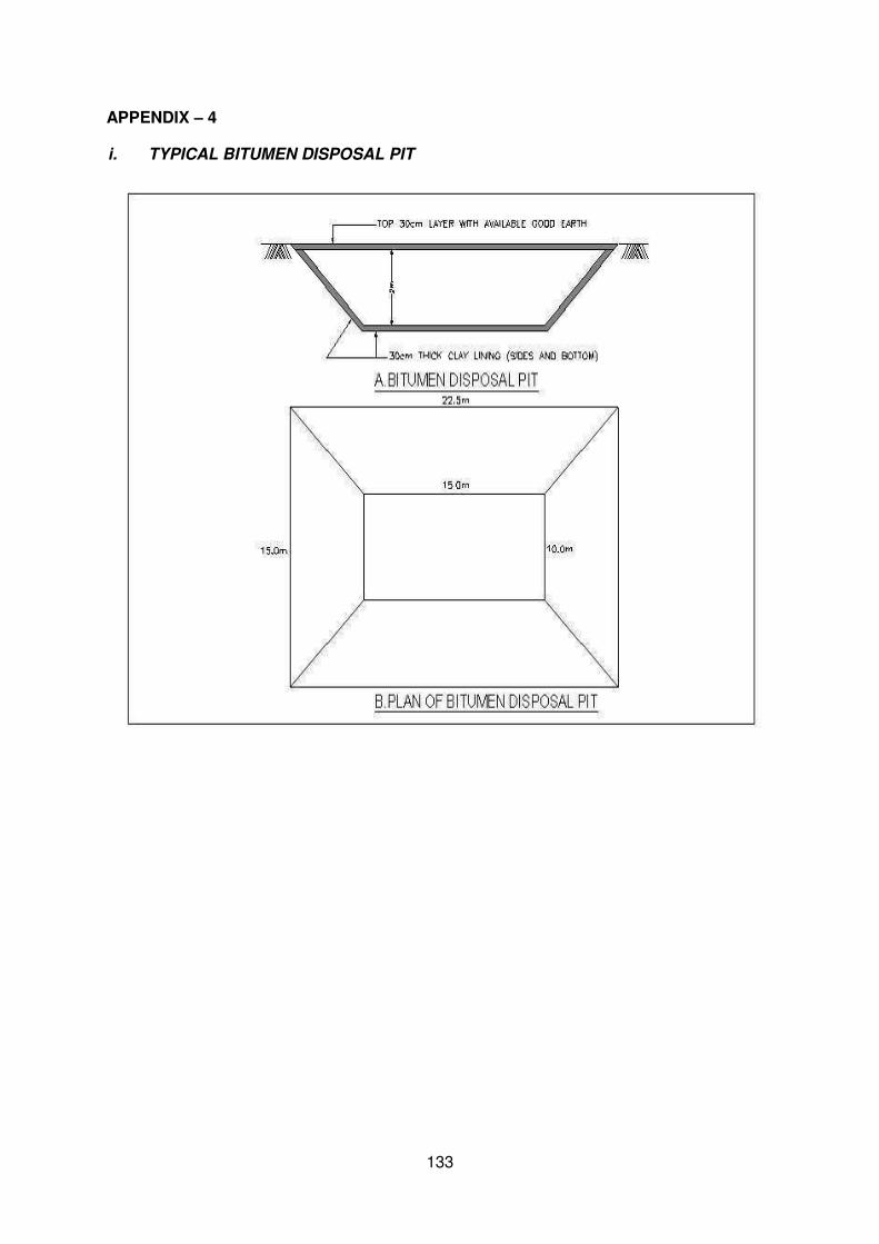
133
APPENDIX – 4
i. TYPICAL BITUMEN DISPOSAL PIT
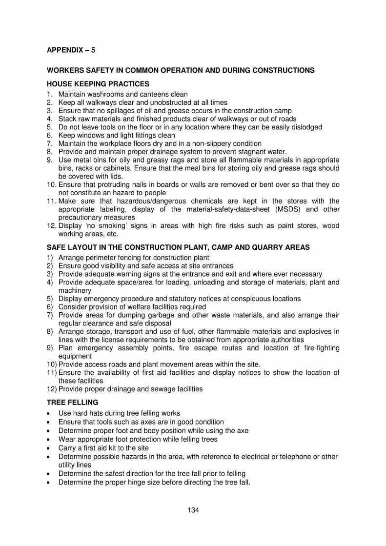
134
APPENDIX – 5
WORKERS SAFETY IN COMMON OPERATION AND DURING CONSTRUCTIONS
HOUSE KEEPING PRACTICES
1. Maintain washrooms and canteens clean 2. Keep all walkways clear and unobstructed at all times 3. Ensure that no spillages of oil and grease occurs in the construction camp 4. Stack raw materials and finished products clear of walkways or out of roads 5. Do not leave tools on the floor or in any location where they can be easily dislodged 6. Keep windows and light fittings clean 7. Maintain the workplace floors dry and in a non-slippery condition 8. Provide and maintain proper drainage system to prevent stagnant water. 9. Use metal bins for oily and greasy rags and store all flammable materials in appropriate
bins, racks or cabinets. Ensure that the meal bins for storing oily and grease rags should be covered with lids.
10. Ensure that protruding nails in boards or walls are removed or bent over so that they do not constitute an hazard to people
11. Make sure that hazardous/dangerous chemicals are kept in the stores with the appropriate labeling, display of the material-safety-data-sheet (MSDS) and other precautionary measures
12. Display ‘no smoking’ signs in areas with high fire risks such as paint stores, wood working areas, etc.
SAFE LAYOUT IN THE CONSTRUCTION PLANT, CAMP AND QUARRY AREAS
1) Arrange perimeter fencing for construction plant 2) Ensure good visibility and safe access at site entrances 3) Provide adequate warning signs at the entrance and exit and where ever necessary 4) Provide adequate space/area for loading, unloading and storage of materials, plant and
machinery 5) Display emergency procedure and statutory notices at conspicuous locations 6) Consider provision of welfare facilities required 7) Provide areas for dumping garbage and other waste materials, and also arrange their
regular clearance and safe disposal 8) Arrange storage, transport and use of fuel, other flammable materials and explosives in
lines with the license requirements to be obtained from appropriate authorities 9) Plan emergency assembly points, fire escape routes and location of fire-fighting
equipment 10) Provide access roads and plant movement areas within the site. 11) Ensure the availability of first aid facilities and display notices to show the location of
these facilities 12) Provide proper drainage and sewage facilities
TREE FELLING
Use hard hats during tree felling works
Ensure that tools such as axes are in good condition
Determine proper foot and body position while using the axe
Wear appropriate foot protection while felling trees
Carry a first aid kit to the site
Determine possible hazards in the area, with reference to electrical or telephone or other utility lines
Determine the safest direction for the tree fall prior to felling
Determine the proper hinge size before directing the tree fall.
135
NOISE HAZARDS AND ITS CONTROL
1) Observe the indications of noise levels 2) Use sound level meters to measure. If the sound level exceeds 85 dB(A), then
preventive and protective measures should be taken 3) Make personnel aware of noisy areas by using suitable warning signs and insisting that
ear protective devices should necessarily be worn. 4) Reduce noise at source by improved maintenance, replacing noisy machines, screening
with noise absorbing material, making changes to the process/equipment, controlling machine speeds, ensuring that two noise-generating machines are not running at the same time, using cutting oils and hydraulic breakers.
5) Appoint a competent person to carryout a detailed noise assessment in the site, designate ear protection zone, and give instructions on the necessary precautionary measures to be observed by site personnel, including the use of suitable type of ear protections.
6) Wear and maintain ear muffs and ear plugs as required 7) In construction or repair works, noise should be kept to a low-level bearing in mind the
disturbance to local residents.
ROAD WORKS
1) The use of signage is most important to caution the road users of possible unsafe conditions due to the road works.
2) Use appropriate signage devices as required by the site conditions/situation. The devices include regulatory signs, delineators, barricades, cones, pavement markings, lanterns and traffic control lights.
3) While using signs, make sure that they are (i) simple, easy-to-understand and convey only one message, (ii) luminescent and with reflective properties and (iii) prominent and of appropriate size.
4) While using barricades, make sure that you keep traffic away form work areas and you guide the drivers to keep along a safe and alternative path.
5) Ensure that proper personal protective equipment (PPE) is provided to all the workers. 6) Cover existing road signs and install new ones at appropriate locations taking into
account the distances that would be required and reaction times. 7) Plan layout and traffic management so that hazards do not occur. 8) Deploy flagmen to control traffic at the work areas. The flag should be 600mm x 600mm
fastened to a 1m length staff. 9) Flagmen should wear reflective safety vests along with hard hats. 10) If required, use wireless devices for flagmen to co-ordinate form either ends of the road,
where works are being carried out.
ELECTRICAL HAZARDS IN CONSTRUCTION AREAS
1) Treat all wires as live wires 2) Never touch dangling wires but report them to the manager 3) Unless you are a qualified electrician do not attempt electrical repairs 4) Never use electrical equipments if your hands are wet or you are standing in water 5) If electrical equipment is sparking or smoking, turn the power off and report the condition
to the supervisor 6) Never use electrical wires having physical damage 7) Never allow equipment or traffic to run over the electrical wires.
USE AND STORAGE OF GAS/LPG
1) Store filled gas/LPG cylinder in an open area or outside the building 2) Transport, store, use and secure cylinders in upright position 3) Ensure proper ventilation at the ground level where the gas/LPG is in use 4) Avoid physical damage to the cylinder 5) Never weld or cut on or near the cylinder
136
6) Store empty cylinders secured and in upright position. 7) Make sure that the cylinder is closed immediately after use. 8) Investigate immediately if there is thea smell of LPG or gas. 9) Never use destenched gas/LPG on site. 10) Make sure that there is no fire in the vicinity of the cylinder.
OPERATION OF EXCAVATORS
1) Ensure that excavators are operated by authorized persons who have adequately trained.
2) Prevent unauthorized movement or use of excavators 3) Check regularly and maintain the machine thoroughly 4) Ensure that all relevant information, including those related to instruction, training,
supervision and safe system of work are provided to the operators. 5) Ensure that the operation and maintenance manuals, manufacturer’s specifications,
inspection and maintenance log books are provided for the use of machines to service engineers or other safety personnel during periodic maintenance, inspection and examination.
6) During tipping or running along the trenches, excavators must be provided with stop blocks.
7) Excavators must be rested on firm ground during operation. 8) Avoid operating the machine too close to an overhand, deep ditch or slope. 9) Locate and identify underground utility services by checking with all utility companies
before the excavations. 10) Ensure that all excavations are supervised by experienced and competent persons. 11) When reversing or in case the operator’s view is restricted, adequate supervision and
signaling should be provided. 12) Ensure that the type and capacity of the excavator are properly chosen for the intended
purposes and site conditions. Never use a machine for any purposes other than it is designed for.
13) Check and report for excessive wear and any breakage of the bucket, blade, edge, tooth and other working tools of the excavator.
14) Check that all linkages/hinges are properly lubricated and ensure that the linkage pins are secured. Never use the improper linkage pins.
15) Never get down or climb a moving machine 16) Ensure adequate ventilation and lighting in the working place. 17) Ensure that the protective front screen of the driving cabin is fixed in position during
excavations to avoid eye injury to the operator. 18) Ensure to switch-off the unattended vehicle.
OPERATION OF TRUCKS AND DUMPERS
1) Ensure that only trained, authorized and licensed drivers operate the vehicles. 2) Provide the help of another worker before reversing the vehicle. 3) Switch-off the engine of an unattended vehicle. 4) Lower the tipping bodies when the machine is unattended, but if it is necessary to leave
them in the raised position they should be blocked to prevent their fall. 5) Wear safety boots or shoes to avoid injuries during loading and unloading. 6) Carryout periodic servicing to the manufacturer’s requirements. All records of
maintenance and repairs should be in writing and kept in the site. 7) Keep the vehicle tidy and its cabin free from tools and materials which might obstruct the
controls. 8) Do not exceed speed limits. 9) No passenger should be carried on a dumper except the driver 10) Never drive the vehicle across a slope 11) Provide stop blocks when the vehicle is tipping into or running towards excavations 12) Do not overload the vehicle.
137
13) Carry only well secured loads. 14) Park only on level ground, in neutral with the parking brake applied. 15) Never climb or get down from a moving vehicle.
GAS WELDING
1) Use the following personal protective equipment during welding
Face or hand shield fitted with filters,
Goggles, particularly while chipping slag,
Gloves long enough to protect wrists and forearms against heats, molten metal and radiation,
High-top boots to prevent sparks from burning foot. 2) Screen the work area with sturdy opaque or translucent materials as glare can cause
eye injury. 3) Key for opening the acetylene cylinder valve must be kept ready while the cylinder is in
use so that the cylinder valve may be immediately shut-off in an emergency. 4) Ventilate the workplace using air blowers and exhaust fans to remove poisonous fumes
and gases that are being used during welding 5) Take precautions against flying spark and hot slag where welding is being done near
flammable materials and check the area before leaving. 6) Do not weld the material degreased with solvents until it is completely dry. 7) Do not use gas cylinders for supporting work or as rollers. 8) Do not use oil/grease on oxygen cylinder fittings. 9) Do not use cylinders with damaged valves. 10) Do not use too much force if valves are stuck. 11) Replace valve caps after use 12) Search for leaks in equipment by using a solution of soap water. 13) Shut the cylinder valve if acetylene from a cylinder catches fire at the valve or regulator
due to leakage at a connection. 14) Treat all gas cylinders as “full” unless you are sure otherwise. 15) Never attempt to transfer acetylene from one cylinder to another or attempt to refill an
acetylene cylinder. 16) Keep portable fire extinguishers near the welding area 17) Secure all cylinders against accidental displacement. 18) Always lift gas cylinders. Do not slide them along the ground or drop them from trucks. 19) Keep gas cylinders in vertical position both in store and when it is in use. 20) Keep the work place dry, secure, free from combustible materials and obstruction. 21) Store the acetylene and oxygen cylinders separately and in a proper store. 22) Keep the gas cylinders away from source of heat, flammable materials, corrosive
chemicals and fumes.
MANUAL HANDLING AND LIFTING
1) Use mechanical equipment in place of manual handling as far as possible. 2) Assess the manpower required to handle or lift the load safely and arrange the
manpower accordingly. 3) While handling hazardous materials, the workers shall be informed of the hazards and
safety precautions. 4) All relevant persons shall be trained on proper methods of lifting and carrying. 5) Where team work is required, select the persons whose ages and physical builds are
compatible for teaming up. Coordinate the actions of the team members by giving necessary instructions.
6) Always lighten or suitably shape the load for manual handling. As far as possible keep a look for splinters, sharp edges, loose banding and nails.
7) Clear path or obstruction and tripping hazards.
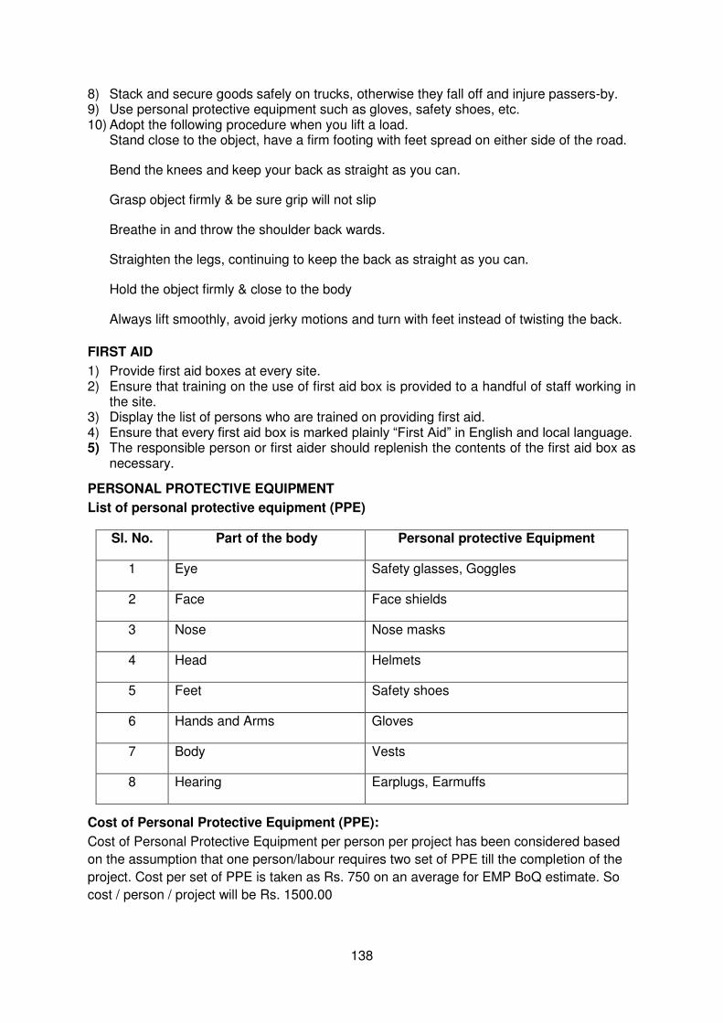
138
8) Stack and secure goods safely on trucks, otherwise they fall off and injure passers-by. 9) Use personal protective equipment such as gloves, safety shoes, etc. 10) Adopt the following procedure when you lift a load.
Stand close to the object, have a firm footing with feet spread on either side of the road.
Bend the knees and keep your back as straight as you can.
Grasp object firmly & be sure grip will not slip
Breathe in and throw the shoulder back wards.
Straighten the legs, continuing to keep the back as straight as you can.
Hold the object firmly & close to the body
Always lift smoothly, avoid jerky motions and turn with feet instead of twisting the back.
FIRST AID
1) Provide first aid boxes at every site. 2) Ensure that training on the use of first aid box is provided to a handful of staff working in
the site. 3) Display the list of persons who are trained on providing first aid. 4) Ensure that every first aid box is marked plainly “First Aid” in English and local language. 5) The responsible person or first aider should replenish the contents of the first aid box as
necessary.
PERSONAL PROTECTIVE EQUIPMENT
List of personal protective equipment (PPE)
Sl. No. Part of the body Personal protective Equipment
1 Eye Safety glasses, Goggles
2 Face Face shields
3 Nose Nose masks
4 Head Helmets
5 Feet Safety shoes
6 Hands and Arms Gloves
7 Body Vests
8 Hearing Earplugs, Earmuffs
Cost of Personal Protective Equipment (PPE):
Cost of Personal Protective Equipment per person per project has been considered based
on the assumption that one person/labour requires two set of PPE till the completion of the
project. Cost per set of PPE is taken as Rs. 750 on an average for EMP BoQ estimate. So
cost / person / project will be Rs. 1500.00
139
General:
1) Ensure that sufficient personal protective equipment are provided and that they are readily available for every person who may need to use them.
2) The management should ensure that all persons make full and proper use of the personal protective equipment provided.
3) Provide instruction and training on the proper use and care of protective equipment. 4) Do not willfully misuse, interfere with or ill-treat any protective clothing and equipment
provided. 5) Ensure that the personal protective equipments are in good condition. Report
immediately any damage to the management for replacement. Always keep the personal protective equipment as clean as possible.
Eye Protection
1) Issue eye protection equipment where there is a foreseeable risk of eye injury. 2) Ensure an adequate supply of goggles/shields is available. 3) Keep the goggles clean and make sure they fit well. 4) Do not watch welding operations unless your eyes are protected.
Head Protection
1) No person shall enter a construction site unless he is wearing a suitable safety helmet 2) Wear a safety helmet:
When there is the risk of being hit by falling objects
While on or near a construction site
During adverse weather conditions
When in any area designated as a “hard hat” area. 3) Provide identification labels to all helmets in some way to prevent random exchange
among wearers, with one helmet exclusive to each person. 4) Inspect helmets for cracks, sign of impact or rough treatment before each usage and
replace defective or damaged helmets.
Hearing Protection
1) Provide ear plugs or ear muffs as required. Use re-usable ear plugs when the reduction required (15-25 dB (A) is not excessive. Use ear muffs where a large attenuation of up to 40 dB (A) is demanded.
2) Do not use dry cotton wool for hearing protection because it cannot provide protection. 3) Provide disposable ear plugs for infrequent visitors and ensure that they are never re-
used. 4) Provide re-usable ear plugs for those who need to work continuously for a long period in
a high noise area. 5) Use ear muffs with replaceable ear cushions because they deteriorate with age or may
be damaged in use. 6) Avoid wearing spectacles with ear muffs. 7) Use soap and water or the recommended solvent for cleaning ear muffs. 8) Provide ear muffs for those who may need to get in and out of a high noise area
frequently.
RESPITATORY PROTECTIVE EQUIPMENT
1) Wear suitable respirable mask for protection against small particles entering the lungs, e.g. while emptying of cement bags.
2) Provide training to all persons using the respirators for their correct fitting, use, limitations and symptoms of exposure.
3) Clean and inspect all respirators before and after use. 4) Store respirators properly when it is not in use.
Safety Footwear
140
1) Wear suitable footwear while working.
2) Use safety footwear on site or in dangerous areas.
3) Wear suitable safety shoes or ankle boots when working where there is a high risk of foot
injuries from slippery or uneven ground, etc.
4) All Safety footwear including safety shoes, ankle boots and rubber boots should be fitted
with steel toecaps.
5) Avoid wearing flip flops, high heeled shoes, slippers, light sport shoes in situations where
there is a risk of foot injury.
6) Keep shoe lace knots tight.
Hand Protection
1) Wear suitable gloves for activities such as welding & cutting and manual handling of
materials & equipment.
2) Do not wear gloves where there is a risk of them becoming entangled in moving parts of
machinery.
3) Wash hands properly with disinfectant soap before eating & drinking. Wash hands
immediately after each operation on site & when the situation warrants.
FIRE PREVENTION, FIGHTING AND EQUIPMENT
Before fire breaks out
1) Store flammable material in proper areas having adequate fire protection systems.
2) Display sufficient warning signs.
3) Train selected personnel to use these fire extinguishers.
4) Inspect fire extinguishers regularly and replace as necessary.
5) Fire escape route should be kept clear at all times and clearly indicated.
6) Know the escape route and assembly point.
7) Display escape route maps prominently at prominent places.
8) Carryout fire drill regularly. Designate fire Officers.
9) Install fire alarm wherever required and test regularly.
10) Provide sufficient exit signs at prominent locations for directing people to the escape
route.
When fire breaks out
1) Alert all persons.
2) Put off the fire with appropriate fire extinguishers when you are sure that you are safe to
do so.
141
3) Escape if you are in danger through the fire escape route to assembly point.
4) Fire officers should carryout head count at the assembly point.
GUIDELINES FOR WORKERS SAFETY DURING CONSTRUCTION
Sl.
no. Stage and Nature of construction Hazard
Safety measures expected to be taken by the
contractors and site Engineers
1 Excavation in soft, loose & slushy soil above
2m depths sliding of earth or collapsing of
sides.
The Excavation beyond 1.5m to 2m to be done in
steps of minimum 500mm offsets and also planking
and strutting should be done.
2 Excavation in slippery area (water logged) -
the labour may fall or machinery on site may
slip.
Try to dewater the area and spread minimum 150mm
thick sand layer to avoid slipping
3 Excavation in rock where chiseling involved –
The fall of hammer may injure the hand,
small rock pieces may injure the eyes and
legs.
For hammer work, only experienced and skilled
labour should be employed. Chisel should not be
allowed to be held by hand, while hammering but
chisel holding clamp should be provided. The labour
should be provided with goggles and leg cover to
protect eyes and legs, from injuries due to small rock
pieces.
4 Excavation in Rock where blasting is involved
– careless handling may lead to injury to
worker or a passerby.
The work of blasting should be entrusted to only
experienced persons. Provide sufficient length of
fuse to give ample margin of time from the time of
lighting to the time of explosion. A danger zone at
least 180m diameter is to be flagged off 10 minutes
before actual firing. All workmen should be sent way
from danger zone except the firing man, who should
be provided with a whistle.
5 Excavation for drain across road or manhole
adjacent to a road – chances of a passer by
falling into the excavated portion.
The area should be well barricaded & a red lamp
provided at night. A watchman should be deputed to
prevent any movement of persons or vehicles.
6 Centring and scaffolding – formwork collapse
while concreting or just before concreting or
just before concreting especially when
wooden ballies are used.
Many a times ballies joined together give way due to
weak joint. Hence the use of joined ballies should be
restricted. Only 2 joined ballies out of 8 ballies should
be allowed. Incase of double staging for a slab at a
height, utmost care should be taken to see that the
top balli rests on the bottom balli. Particular care that
should be taken during each concreting, operating of
slabs and beams is that one carpenter and two
helpers with spare ballies, nails etc. should be
deputed below the slab/beam that is being concreted
to watch any disturbance in the supports of the form-
work below, during concreting and in case of any
142
Sl.
no. Stage and Nature of construction Hazard
Safety measures expected to be taken by the
contractors and site Engineers
doubt concreting should be stopped immediately and
the form work to be strengthened. Never allow bricks
below a balli to make up the required height. This is
most dangerous.
7 Form- work for beams and slabs – opening
the form – work accident due to fall of
materials during removing the forms.
In fact, this is a most dangerous work. One should be
very careful while formwork is removed. Only trained
carpenters should be deputed for the work. A safe
resting place outside the area of slab as a temporary
measure should be constructed from where the slab
can be removed safely. Removal of form-work during
night should not be permitted under any
circumstances.
8 Scaffolding – Fall of work–man, supervision
staff, standing on challis not tied properly or
toed only at one end. (Challis mainly made of
Bamboos)
This is a very common negligence on the part of
labour who do scaffolding work. The Challis on which
they work either span over its complete length or is
tied loosely and many a times at one end only.
Hence, care must be taken that the challis do not
span over the full length but some middle support
should be provided and also the same is tied
properly on both ends.
9 Ladders - Balli or bamboo ladders – The
horizontal member breaks and the person
falls. Some times the top face just rests on
wall and the whole ladder tilts causing an
accident.
The ladders should be strong enough to bear the
weight of a labour with materials on head. As for as
possible a hand rail should be provided at one end.
The horizontal member should be preferably fixed
with bolt & nuts or strong nails. When the ladder is
placed across a wall the top portion should be tied
firmly to a strong support so that the ladder does not
move laterally.
10 Dismantling – Dismantled materials may fall
on passer by or the person engaged in
dismantling work may fall due to slipping. The
dismantled materials may fall on persons
working below.
When work of demolition is to be taken up the area
should be closed for all outsiders. No one should be
allowed up to 50m from the place of demolition. The
workers engaged in demolition should be asked to
wear safety belts. Helmets must be worn by all the
workers engaged in dismantling work. The place
should be strictly guarded at night with red lights at
prominent places, and watchman should be posted.
11 Electrical connections/ cables etc., - HT / LT
electric wire passing near the slab structure –
while bending, lifting or tying reinforcements
the bar benders may sustain the electric
The work in such places should not be allowed to the
workers themselves, but in such position the work
must be executed under the strict supervision of a
responsible Foreman or a Supervisor.
143
Sl.
no. Stage and Nature of construction Hazard
Safety measures expected to be taken by the
contractors and site Engineers
shock, causing fatal injury.
12 Electric- connections/cables, etc., - cables
below ground may get punctured during
excavation & thus electrocute the labour
working. Similarly when connecting is in
progress the punctured cable may prone to
be fatal to the labour.
Before taking up the work all available drawings
should be studied, local enquiry to be made to know
the position of cables and work in such area should
be got executed under strict supervision of an
experienced Foreman or a supervisor.
13 Electric connections/cables etc.,- Temporary
Electric lines near damp walls, near joinery
stretched on a considerable length – There is
every chance that the wire may get cut due to
usage and may develop short
circuits/leakages etc., and may electrocute
the person touching the wire accidentally.
The Electric wires should be maintained by an
electrician who should regularly check up the
insulation of wires especially placed near steel items
& damp areas.
The temporary wiring should be supported properly.
As far as possible a good quality wire should be used
which may not get damaged easily.
14 Electric and gas welding work – Drilling,
polishing work – Done by temporary cables
used on a number of works – Due to the fact
that the wires are old & when they come in
contact with water even in the process of
curing the surrounding area may get affected
due to leakage in the electric current thus
causing damage to the workers & supervision
staff.
All wiring works to be inspected by experienced
electrician. All wires to be properly insulated and
fixed at height on temporary poles. No welding work
should be permitted near damp area. The welders to
be provided with welder’s goggles & gloves. As far
as possible machine in good condition should be
used.
15 Construction machinery – Concrete mixers –
Safety precautions. A mixer with hopper tried
to be operated by an helper could not release
brake in time thus causing injury to the
person near hopper – some times fatal one.
The Mixers with hopper should be operated by an
experienced mixer operator and such mixers should
not be allowed to be handled by a helper or a labour.
16 Water storage Tank for general use & curing
- chances of children of workers falling in the
tank with fatal accident.
The water tanks constructed on site should be
protected by at least 1.0m high walls on four sides,
so that the children do not fall.
17 Site cleaning – Cleaning top floors of
buildings – Upper portion of any structure –
throwing waste materials broken concrete
pieces, brick bats, sand etc., straightway fro
top to ground injuring person below or even a
passerby.
This dangerous practice should not be allowed at all.
The materials should be brought to the ground with
the help of lift or the use of rope over pulley with a
bucket, thus bringing down materials safely.
18 Bar bending work – Helpers of bar benders to This is a very bad practice. The helpers should bring
144
Sl.
no. Stage and Nature of construction Hazard
Safety measures expected to be taken by the
contractors and site Engineers
follow short cut method, throw surplus steel
pieces from top floors to ground and may
cause fatal injuries.
the rods to ground with help of lift or rope & pulley.
145
APPENDIX – 6
TREE PLANTATION STRATEGY
1. Introduction
This is the most common impact of any road-widening project. If the location of the project
road is in dry areas, the degree of impact is more than in a wet area where the trees can be
planted and grown easily. In the case of Uttarakhand thick vegetation exists in the Project
Implementation Area.
The scopes for tree planting along roads sides is good and also there are many isolated
patches of unutilized land along the project road. A typical plantation scheme proposed for
two lane road in plains with shoulders at the rate of 200 plants per km length.
Avenue Plantation:
It is proposed to plant 100 trees per kilometer on each side of the trees. The number of trees
proposed to be planted (Avenue plantation) along the road length on both sides of the road
is given as follows.
Median Plantation:
No median plantation is suggested as there is no proposed cross section having median.
2. Purpose of tree plantation
The objectives of planting trees and shrubs at selected enhancement sites against the felled
trees are as follows.
To reduce the impacts of air and dust pollution and act as a natural filter to traffic
emissions
To provide shade for the traffic as well as the pedestrians
To reduce the impact of vehicular noise caused by vehicles
To arrest soil erosion on slopes
Beautification of sites by planting selective ornamental shrubs, landscaping and
turfing with grasses.
Planting trees on the roadsides is to produce a softer greener landscape.
To act as a natural filter to the traffic emissions
3. Impacted Trees
3.1 Public owned trees
These are trees within the legal ROW of project road within the control of PWD.
All these trees with in the forest reserves are also termed as public trees. However the
procedure for cutting of these trees is different from the normal trees within the PWD ROW.
3.2 Private owned trees
The number of private owned trees to be acquired outside the right of way will be high
compared to the public trees within the right of way. The private trees that will be affected
during widening and improvement will be subjected to compensation at the appropriate
market rates. In addition to this the project will plant two trees for every tree removed as a
compensatory tree planting measure irrespective of the size, species etc.
4. Selection of trees species

146
The selection of the plants for greenery development is to be made as per the following
criteria;
Plants should be fast growing & have dense canopy cover
Preferably tropical to temperate species with large leaf area index
Indigenous species
Species resistant to air pollutants and
Should help to maintain the ecological and hydrological balance of the region
The plant species that are selected based on the climatic condition, soil characteristics and
conditions of the area. The row closest to the main carriage way will be of shade plants.
Similarly, subsequent rows will comprise of ornamental and flowering species. Mainly native
deciduous species, which retain their foliage longest, with high crown forms, resistant to
fungus and insects with rapid growth rate are selected for avenues. Lists of the species
recommended as shade plants and most recommended trees for planting along the
roadsides are provided in the following table.
Table: Trees recommended for planting
Sl. No. Main Species 1 Banyan 2 Pipal 3 Arjun 4 Mango 5 Jamun 6 Tamarind 7 Jakranda 8 Neem 9 Kheia 10 Peakcock tree 11 Gulmour 12 Jack Fruit
5. Compensatory Tree plantation programme
All trees are cut and removed will be accountable as per the Forest laws and efforts will be
maintained to plant minimum of two times the number of trees cut according to this tree
plantation strategy.
Indigenous species of trees recommended above are most suited for the tree plantations. In
order to make it tourist friendly and beautiful same types of trees would be planted in the
same location so that for every Kilometer the trees would change to new species.
6. Tree planting during construction
6.1 Tree planting along the roadsides
Tree plantation will be the responsibility of the Forest department. Necessary budget has
been allocated in the EMP.
6.2 Tree planting along Oxbow lands
147
In some areas, the improvement of roads will result in the formation of ‘oxbow lands’ all along the roads due to suitable curve improvements and realignments. The oxbow lands are
the existing roads where the road realignments are proposed. This is similar to the Oxbow
Lakes formed during the evolution of rivers hence the name for easier identification for
environmental management. The importance of the proper management of these oxbow
lands is there for an unavoidable outcome of the project. Tree planting all along these oxbow
lands could be very useful for the environmental enhancement of the region. This will help
positively for tourism industry. The oxbow lands along the corridors are available as
described in the Environmental management plan for individual corridors.
7 Protection Measures
The protection measures are as follows.
7.1 Barbed wire Fencing
Barbed wire fencing around the plantation area will be provided to protect the plants. Iron
Angles will be fixed at a spacing of 5m with 3-stand stretched barbed wire.
7.2 Precautionary Measures
Plantation will be made in the monsoon months (July-August)
The height of the plants should not be less than 30 cm and should be supplied in
polythene bags which are not to be removed until the moment of planting
All plants supplied must be planted within three days of removal from the nursery
Arrangements must be made to water in case of insufficient rains after planting
Provide compost/manure suggested quantity for each pit before plantation
7.2.1 Shrubs
Prior to planting it is suggested to remove all loose debris, fill up with good soil and level the
area. To ensure better growth and survival of grasses and shrubs, the surface should have
sufficient layer of good quality soil (up to 45 cm). Shrubs which are suggested for the
roadside and open area spaces where available should be selected from the following and
agreed with the Environmental Specialist of the construction supervision consultants.
Shrubs:
1 Bougainville 2 Nerium odorum ait 3 Carissa spinarum 4 Capparis decidua 5 Capparis zeylanica 6 Zizyphus nummularia 7 Artemisia species 8 Xanthium strumarium 9 Cassia tora 10 Capsicum fruitescens 11 Tabernaemontana coronaria 12 Achyranthes aspera
The contractor will be responsible for planting of shrubs at enhancement sites and along
bridge approaches during construction phase.

148
7.2.2 Turfing with grasses
The contractor will be responsible for turfing at enhancement sites and along bridge
approaches during construction phase.
The cost for the turfing along the bridge approaches and high embankments are part of the
civil construction contract.
Grass lines are used to provide a strong surface cover at the slope but it also needs a well –prepared surface. If grass is to be effective, then it must be allowed to establish property on
a slope, which is not subject to undue stress from erosion and mass movement in its stages.
To ensure this the following measures are suggested for the grass turfing.
A cover of 25 grams of grass seeds per Sq. m of surface will be prepared.
Bed will be prepared in June. The seed sowing must be carried out before the onset
of monsoon so that they yield desired results. Till the onset of the monsoon, watering
of the surface to be done by tankers with controlled flow sprinklers.
After sowing, mulch of prepared and dried out herbs will be laid over the whole
seeded area in a thin layer so that the direct sunlight and transpiration loss may not
affect the grasses
The grass species recommended for median are khabbal, Dhaula, Palwan, Sariala
and Kahi.
Contractor will ensure that the condition of the site is good enough for the successful
establishment of grasses and quality of grass seeds used.
8 Tree plantation costs
The plantation cost has been included in the bill of quantity (BOQ) under the non-civil
contracts and provided in section EMP BoQ
A tree- planting strategy is being developed which will meet all compensatory tree planting
that will be cut during the improvement of the roads including private trees. The cost
provisions have been included in the EMP BOQ.
9 Maintenance of trees planted
The trees planted once will be maintained at least for a period of six years.
A programme of compensatory afforestation has been proposed, not only to replace the
trees, which are cut to accommodate road widening and improvements in geometric design,
but also to upgrade the condition of adjacent areas. Trees will be replanted at a rate of two
for each one removed depending upon the location.
Tree felling in other sites such as borrow areas – shall be accommodated by the contractor
in the borrow area management plan.

149
APPENDIX – 7
ENHANCEMENT MEASURES
Enhance measures include
Plantation of trees along the length of the proposed roads wherever enough space available within RoW.
Enhancement by tree planting along the oxbow land and the other left over portions of the original PWD land.
Cultural property enhancement as a part of the cultural property rehabilitation plan.
Public amenities such as bus lay byes (new), rain shelters (in addition to the compensatory rain shelters for the impacted ones), comfort stations (toilets) and parking areas.
To improve the water table in this region recharge pits are constructed wherever feasible along the project road.
Median plantation in urban location.
Pond and catchment area improvements to protect ground water and harvest rain water
Information boards for the tourists, pilgrimage and other important structures of importance.
List of Enhancement sites:
a) Archaeological sites
None identified along this road.
b) Valley view location
None identified along this project road.
c) Proposed Bus bays & Parking areas
As the work is to
d) Pond enhancement
There are many streams and rivers along the project road. The typical pond/water body
enhancement drawing is given below
e) Oxbow land and other left over land
There are oxbow land spaces at realignment locations along the proposed road and where
ever width of CoI is less than width of the RoW, the space available along the sides of the
project road can be utilized for tree plantation..

139
TYPICAL DRAWING FOR POND ENHANCEMENT

140
APPENDIX –8
GUIDELINES FOR THE MANAGEMENT OF ROAD SECTION THROUGH FOREST AREAS
1. Introduction
A Management plan for the impacted or adjacent forest area is required for mitigation and
enhancement measures during construction and operational phases of the project road. This
will not allow any room for neglecting /avoiding of the implementable measures. This will
also define responsibilities of various institutions in this regard. This requirement is the basis
of the preparation of this document. The document addresses the issues relating to the
forest areas in the PIAs as well as immediately adjacent to the project road. The mitigation
measures are to be addressed during the design, construction and operational phases of the
project.
Incorporation of effective mitigation measures is therefore necessary and important. This will
be based on the recommendations of the biodiversity studies.
2. Status of the work relating to the up-gradation
The actual construction work cannot be started until all environmental clearances are
obtained. The environmental clearance also includes forest clearance basically for the
required land from forest reserves. Application for both clearances has to be routed through
two different agencies viz., PCB and State Forest Department.
3. Impact mitigation and Enhancement measures
This includes the legal requirement according to the (1) GoI Forest laws and (2) the
requirement according to the other laws.
4. Compensatory Afforestation Programme
Compensatory afforestation will be carried out against the loss of trees for road project.
According to the affforestation programme PWD shall plant thrice the number cut for the
project. Preferably this amount will be deposited with forest Department.
In addition, a number of impact mitigation and enhancement measures are required for the
Forest area that will be impacted. The Forest reserves adjacent to the project road do have
high faunal value.
1) Considering this aspect, the project will not provide demarcation of the forest boundary
with the Project road, as it will be a barrier for the wildlife movement.
2) PWD is committed to compensate plant trees according to the compensatory afforestation
programme required according to the Forest conservation Act 1980
3) Further, contractors have to set-up construction camps and plants (Hot mix, WMM plant
etc) at least 5 Km away from the forest boundary. In this regard;
Adequate training will be provided to contractors
The labour force will not allowed to enter forest reserves for the purpose of hunting, fuel wood collection, nuts and fruits collection etc.,]
The debris and waste materials shall not be dumped inside / immediately outside forest areas and other water sources.
Debris shall be disposed off according to the contractors debris disposal plan
141
The source of construction water shall not be from the forest areas or immediately adjacent (within 2 km) to the forest areas.
The construction work within the forest stretches should adhere to all international environmental standards as laid out by the environmental management plan under the GoI/GoU/ADB rules, regulation and policies.
During construction, the following measures will be taken in to consideration for effective
implementation
No construction camps or other polluting plants within 5 Km of the forest reserves.
No blasting shall be allowed during nighttime.
Blasting should be silent blasting along the forest reserves.
Blasting shall be confined to a particular time only. Best time would be 2-3 pm in daytime.
Hunting is strictly prohibited.
No cutting of trees from the forest reserves for any purpose relating to the construction work nor shall the people associated with the project construction should enter the forest reserves other than any legal requirements.
Contractor should erect appropriate signboards during construction.
After construction, the DSC/PWD should advice the locations for erecting the signboards including advance signboards notifying the forest reserves.
Immediately after construction fencing should be carried out parallel to the Forest reserves.
Any sign/indication of forest fire will be immediately notified to all considered agencies
Immediately after construction, the contractors shall erect signboards and information boards
close to the forest boundaries according to the Environmental Management plan (EMP)
prepared.
During operational period erection of sign/ information boards will be required. With regards
to institutional responsibilities the PWD and Forest Department need to coordinate the
various requirements.
PWD– Maintenance of the road furniture, signboards, information boards
State Forest Department – to coordinate with the PWD for various roadside arrangements change in the status of the forest
To facilitate Contractor do his job of construction
NGO Participation
Participation of NGO may be useful for the smooth implementation of the project.
142
APPENDIX – 9
ARRANGEMENT FOR TRAFFIC DURING CONSTRUCTION
The Contractor shall at all times carry out work on the road in manner creating least
interference to the flow of traffic with the satisfactory execution. For all works involving
improvements to the existing state highway, the Contractor shall, in accordance with the
directives of the DSC, provide and maintain, during execution of the work, a passage for
traffic either along a part of the existing carriageway under improvement, or along a
temporary diversion constructed close to the state highway. The Contractor shall take prior
approval of the DSC regarding traffic arrangements during construction.
1. TRAFFIC SAFETY AND CONTROL
(i) Where subject to the approval of the Engineer the execution of the works requires temporary closure of road traffic use, the Contractor shall provide and maintain temporary traffic diversions. The diversions shall generally consist of 200 mm thickness of gravel 4.5 meters wide laid directly upon natural ground and where any additional earthworks are required for this purpose that will be provided under the appropriate payment items.
(ii) Where the execution of the works requires single-lane operation on public road, the Contractor shall provide and maintain all necessary barriers, warning signs and traffic control signals to the approval of the Engineer.
(iii) With the exception of temporary traffic arrangements or diversions required within the first 4 weeks of the Contract, the Contractor shall submit details of his proposals to the Engineer for approval no less than 4 weeks prior to the temporary arrangement or diversion being required. Details of temporary arrangements or diversions for approval as soon possible after the date of the Letter of Acceptance.
(iv) The colour, configuration, size and location of all traffic signs shall be in accordance with the code of practice for road sign. In the absence of any detail or for any missing details, the signs shall be provided as directed by the Engineer (DSC).
(v) The Contractor shall take all necessary measures for the safety of traffic during construction and provide, erect and maintain such barricades, including signs, marking, flags, lights and flagmen as may be required by the Engineer for the formation and protection of traffic approaching or passing through the section of the road under improvement. Before taking up any construction, an agreed phased programme for the diversion of traffic or closer of traffic on the road shall be drawn up in consultation with the SE.
(vi) At the points where traffic is to deviate form its normal path (whether on temporary diversion or part width of the Carriageway) the lane width path for traffic shall be clearly marked with the aid of pavement markings, painted drums or a similar device to the directions of the SE. At night, the passage shall be delineated with lanterns or other suitable light source.
(vii) One-way traffic operation shall be established whenever the traffic is to be passed over part of the carriageway inadequate for two-lane traffic. This shall be done with the help of temporary traffic signals or flagmen kept positioned on opposite sides during all hours. For regulation of traffic, the flagmen shall be equipped with red and green flags and lanterns/lights.
(viii) On both sides, suitable regulatory / warnings signs as approved by the SE shall be installed for the guidance of road users. On each approach, at least two signs shall be put up, one close to the point where transition of carriageway begins and the other 120 m away. The signs shall be of design and of reflectory type, if so directed by SE.
(ix) Upon completion of the works for which the temporary traffic arrangements or diversions have been made, the Contractor shall remove all temporary installations and signs and reinstate all affected roads and other structures or installations to the conditions that existed before the work started, as directed by the Engineer.
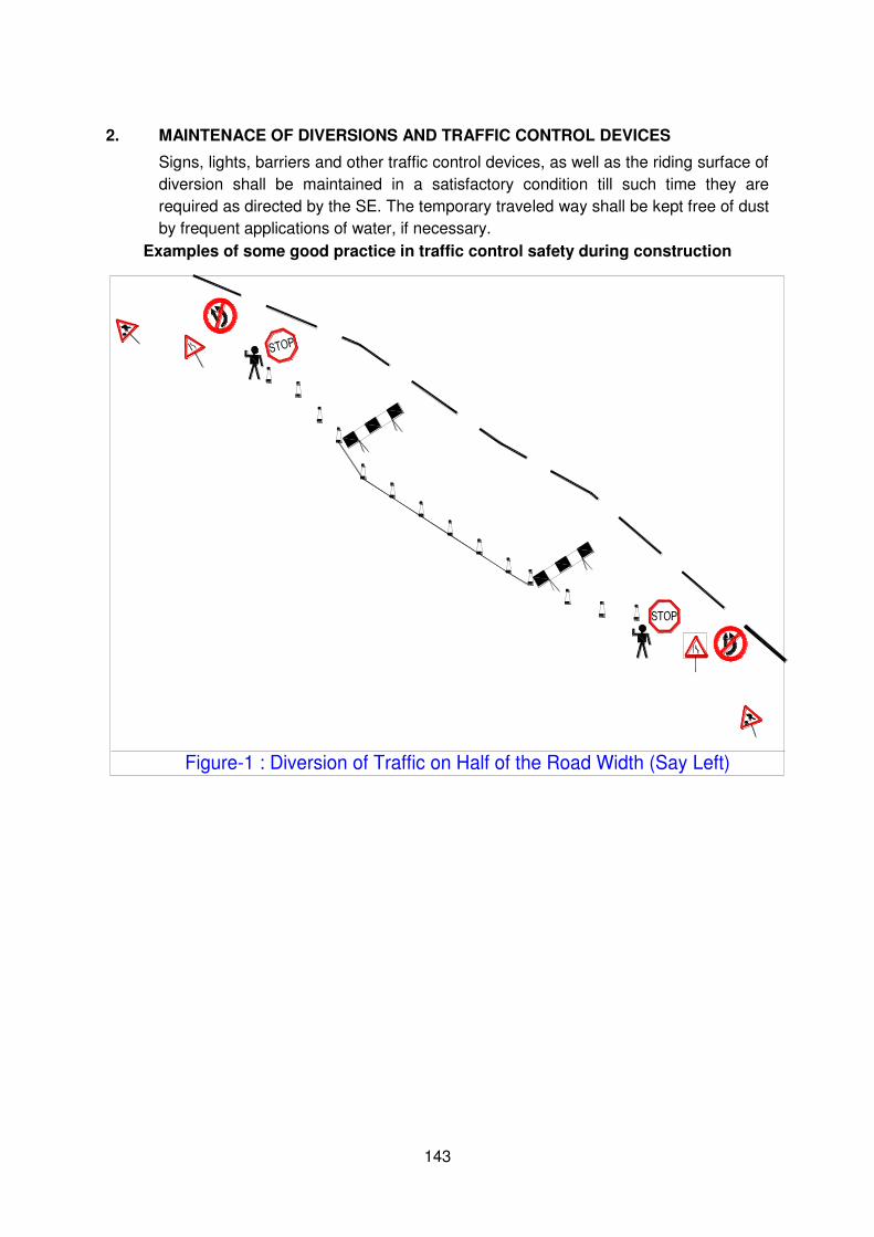
143
2. MAINTENACE OF DIVERSIONS AND TRAFFIC CONTROL DEVICES
Signs, lights, barriers and other traffic control devices, as well as the riding surface of
diversion shall be maintained in a satisfactory condition till such time they are
required as directed by the SE. The temporary traveled way shall be kept free of dust
by frequent applications of water, if necessary.
Examples of some good practice in traffic control safety during construction
Figure-1 : Diversion of Traffic on Half of the Road Width (Say Left)
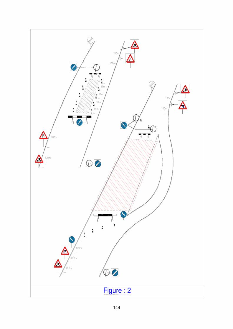
144
Figure : 2
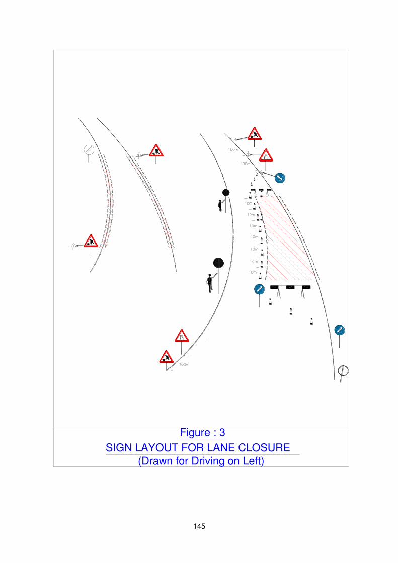
145
SIGN LAYOUT FOR LANE CLOSURE
(Drawn for Driving on Left)
Figure : 3

146
List of Traffic safety Signs/Equipment (Guideline)
Sl.
No. Signs
1 Barricading
2 Men at work
3 Keep Left
4 Go slow
5 Flag men
6 Narrow signs
7 Lantern(Amber Blinker)
8 Traffic control Lights
9 Cones
Note:
Safety jackets and helmets should be provided to all the workers/ Engineers working on the road.
Fixed mobile solid barricades must be placed between the workmen and traffic or pedestrian and traffic.
All the safety signs should be according to IRC: 67 and IRC: SP: 55: 2001
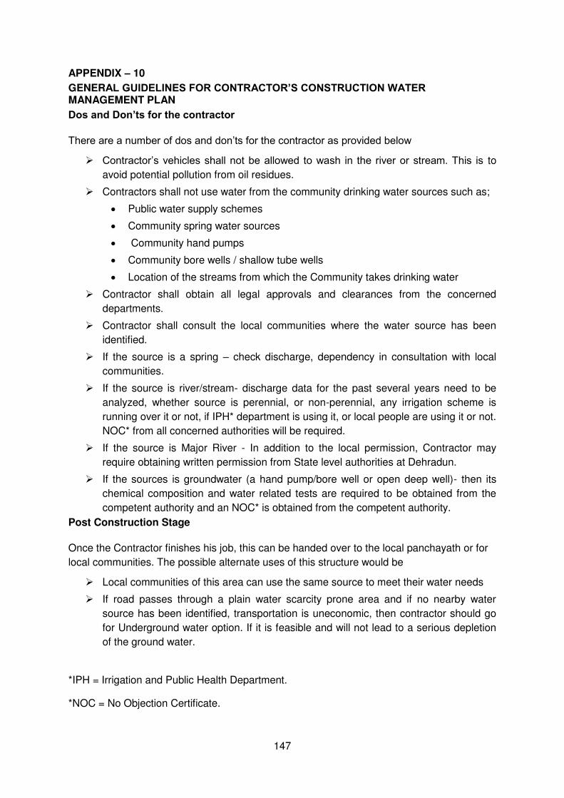
147
APPENDIX – 10
GENERAL GUIDELINES FOR CONTRACTOR’S CONSTRUCTION WATER MANAGEMENT PLAN
Dos and Don’ts for the contractor
There are a number of dos and don’ts for the contractor as provided below
Contractor’s vehicles shall not be allowed to wash in the river or stream. This is to
avoid potential pollution from oil residues.
Contractors shall not use water from the community drinking water sources such as;
Public water supply schemes
Community spring water sources
Community hand pumps
Community bore wells / shallow tube wells
Location of the streams from which the Community takes drinking water
Contractor shall obtain all legal approvals and clearances from the concerned
departments.
Contractor shall consult the local communities where the water source has been
identified.
If the source is a spring – check discharge, dependency in consultation with local
communities.
If the source is river/stream- discharge data for the past several years need to be
analyzed, whether source is perennial, or non-perennial, any irrigation scheme is
running over it or not, if IPH* department is using it, or local people are using it or not.
NOC* from all concerned authorities will be required.
If the source is Major River - In addition to the local permission, Contractor may
require obtaining written permission from State level authorities at Dehradun.
If the sources is groundwater (a hand pump/bore well or open deep well)- then its
chemical composition and water related tests are required to be obtained from the
competent authority and an NOC* is obtained from the competent authority.
Post Construction Stage
Once the Contractor finishes his job, this can be handed over to the local panchayath or for
local communities. The possible alternate uses of this structure would be
Local communities of this area can use the same source to meet their water needs
If road passes through a plain water scarcity prone area and if no nearby water
source has been identified, transportation is uneconomic, then contractor should go
for Underground water option. If it is feasible and will not lead to a serious depletion
of the ground water.
*IPH = Irrigation and Public Health Department.
*NOC = No Objection Certificate.
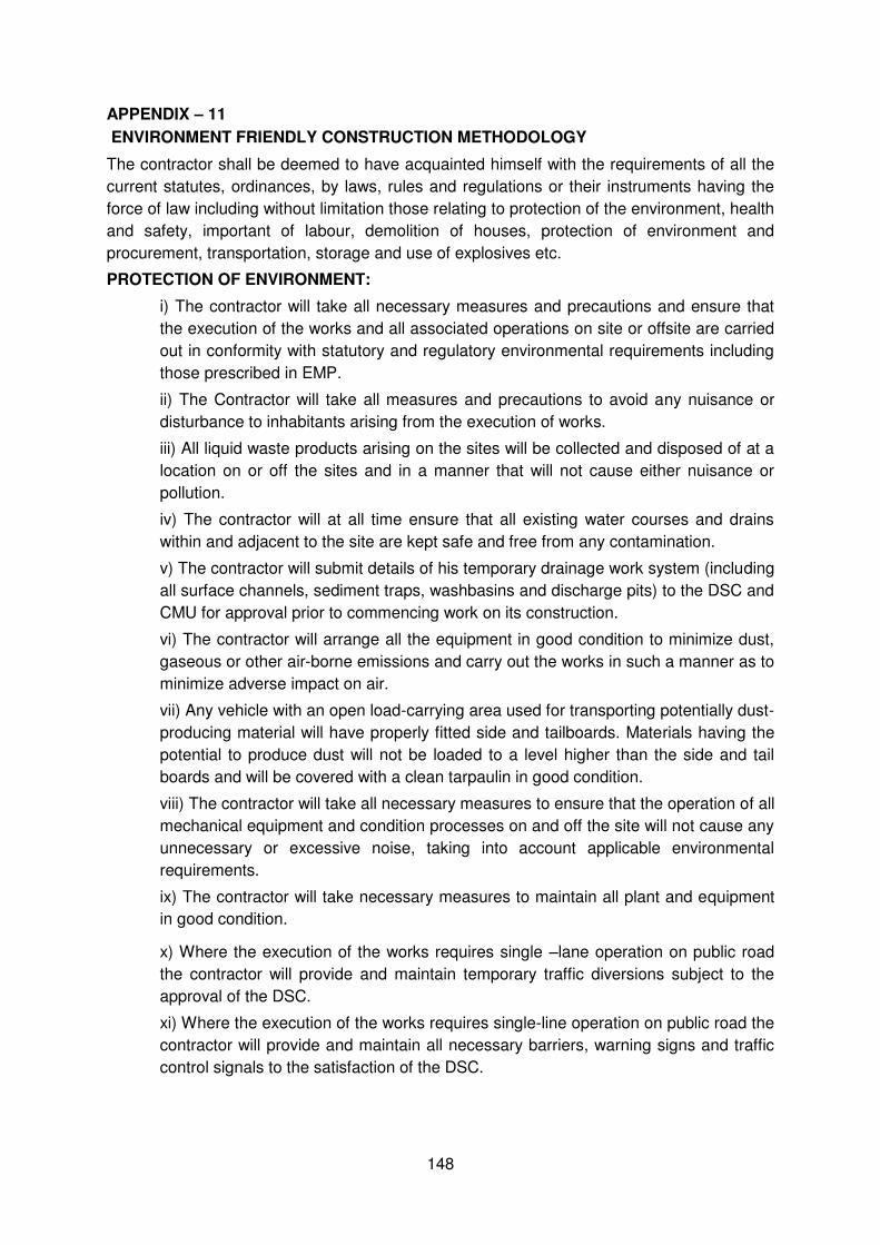
148
APPENDIX – 11
ENVIRONMENT FRIENDLY CONSTRUCTION METHODOLOGY
The contractor shall be deemed to have acquainted himself with the requirements of all the
current statutes, ordinances, by laws, rules and regulations or their instruments having the
force of law including without limitation those relating to protection of the environment, health
and safety, important of labour, demolition of houses, protection of environment and
procurement, transportation, storage and use of explosives etc.
PROTECTION OF ENVIRONMENT:
i) The contractor will take all necessary measures and precautions and ensure that
the execution of the works and all associated operations on site or offsite are carried
out in conformity with statutory and regulatory environmental requirements including
those prescribed in EMP.
ii) The Contractor will take all measures and precautions to avoid any nuisance or
disturbance to inhabitants arising from the execution of works.
iii) All liquid waste products arising on the sites will be collected and disposed of at a
location on or off the sites and in a manner that will not cause either nuisance or
pollution.
iv) The contractor will at all time ensure that all existing water courses and drains
within and adjacent to the site are kept safe and free from any contamination.
v) The contractor will submit details of his temporary drainage work system (including
all surface channels, sediment traps, washbasins and discharge pits) to the DSC and
CMU for approval prior to commencing work on its construction.
vi) The contractor will arrange all the equipment in good condition to minimize dust,
gaseous or other air-borne emissions and carry out the works in such a manner as to
minimize adverse impact on air.
vii) Any vehicle with an open load-carrying area used for transporting potentially dust-
producing material will have properly fitted side and tailboards. Materials having the
potential to produce dust will not be loaded to a level higher than the side and tail
boards and will be covered with a clean tarpaulin in good condition.
viii) The contractor will take all necessary measures to ensure that the operation of all
mechanical equipment and condition processes on and off the site will not cause any
unnecessary or excessive noise, taking into account applicable environmental
requirements.
ix) The contractor will take necessary measures to maintain all plant and equipment
in good condition.
x) Where the execution of the works requires single –lane operation on public road
the contractor will provide and maintain temporary traffic diversions subject to the
approval of the DSC.
xi) Where the execution of the works requires single-line operation on public road the
contractor will provide and maintain all necessary barriers, warning signs and traffic
control signals to the satisfaction of the DSC.
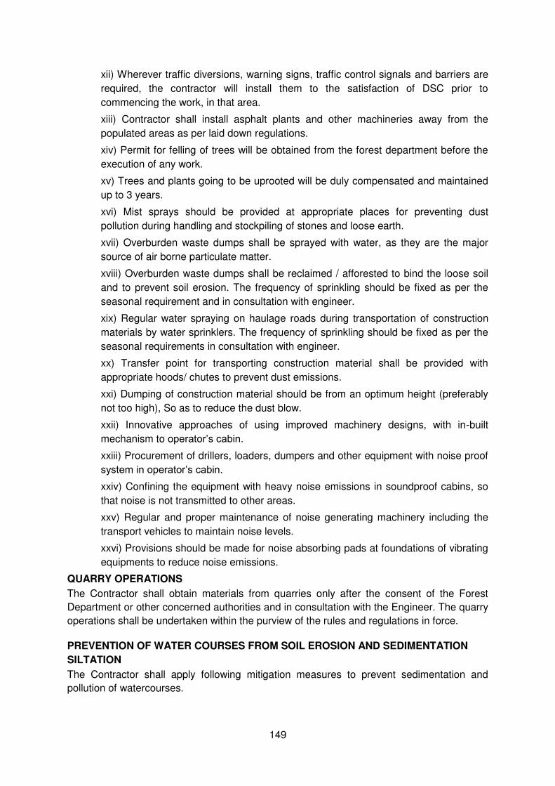
149
xii) Wherever traffic diversions, warning signs, traffic control signals and barriers are
required, the contractor will install them to the satisfaction of DSC prior to
commencing the work, in that area.
xiii) Contractor shall install asphalt plants and other machineries away from the
populated areas as per laid down regulations.
xiv) Permit for felling of trees will be obtained from the forest department before the
execution of any work.
xv) Trees and plants going to be uprooted will be duly compensated and maintained
up to 3 years.
xvi) Mist sprays should be provided at appropriate places for preventing dust
pollution during handling and stockpiling of stones and loose earth.
xvii) Overburden waste dumps shall be sprayed with water, as they are the major
source of air borne particulate matter.
xviii) Overburden waste dumps shall be reclaimed / afforested to bind the loose soil
and to prevent soil erosion. The frequency of sprinkling should be fixed as per the
seasonal requirement and in consultation with engineer.
xix) Regular water spraying on haulage roads during transportation of construction
materials by water sprinklers. The frequency of sprinkling should be fixed as per the
seasonal requirements in consultation with engineer.
xx) Transfer point for transporting construction material shall be provided with
appropriate hoods/ chutes to prevent dust emissions.
xxi) Dumping of construction material should be from an optimum height (preferably
not too high), So as to reduce the dust blow.
xxii) Innovative approaches of using improved machinery designs, with in-built
mechanism to operator’s cabin. xxiii) Procurement of drillers, loaders, dumpers and other equipment with noise proof
system in operator’s cabin. xxiv) Confining the equipment with heavy noise emissions in soundproof cabins, so
that noise is not transmitted to other areas.
xxv) Regular and proper maintenance of noise generating machinery including the
transport vehicles to maintain noise levels.
xxvi) Provisions should be made for noise absorbing pads at foundations of vibrating
equipments to reduce noise emissions.
QUARRY OPERATIONS
The Contractor shall obtain materials from quarries only after the consent of the Forest
Department or other concerned authorities and in consultation with the Engineer. The quarry
operations shall be undertaken within the purview of the rules and regulations in force.
PREVENTION OF WATER COURSES FROM SOIL EROSION AND SEDIMENTATION
SILTATION
The Contractor shall apply following mitigation measures to prevent sedimentation and
pollution of watercourses.
150
To prevent increased siltation, if need be existing bridges maybe widened downstream side of the water body;
Cement and coal ash should be stacked together, fenced by bricks or earth wall, and kept away from water, to prevent leachate formation and contamination of surface and ground water;
If need be, slope of the embankments leading to water bodies should be modified and re channelized to prevent entry of contaminations into the water body;
During construction silt fencing (consists of geo-textile with extremely small size supported by wire-mish mounted on a panel made up angle frame) could be used along the road at all canals and rivers to prevent sediments from the construction site to enter into the watercourses.
POLLUTION FROM HOT-MIX PLANTS AND BATCHING PLANTS
Plants and concrete batching plants shall be located sufficiently away from habitation,
agricultural operations. The Contractor shall take every precaution to reduce the levels of
noise, vibration, dust and emissions from his bituminous hot-mix plants and shall be fully
responsible for any claims for damages caused to the property, fields and residents in the
vicinity.
HEALTH AND SAFETY
The Contractor shall take all measures and precautions necessary to ensure the health,
safety and welfare of all persons entitled to be on the site. Such precautions shall include
those that, in the opinion of the Engineer, are reasonable to prevent unauthorized entry upon
the site and to protect members of the public from any activities under the control of the
Contractor. The Contractor’s responsibilities shall include but not be limited to:
The provision and maintenance of the Contractor’s Equipment in a safe working condition and the adoption of methods of work that are safe and without risks to the health of any person entitled to be on the site.
The execution of suitable arrangements for ensuring safety and absence of risks to health in connection with the use, handling, storage, transport and disposal of articles and substances,
The provision of lighting, including standby facilities in the event of failure that, in the opinion of the Engineer, is adequate to ensure the safe execution of any works that are to be carried out at right.
The provision of protective clothing and safety equipment, with such personnel and equipment and such information, instruction, training and supervision as the necessary to ensure the health and safety at work of all persons employed on or entering on the site in connection with the works, including the Engineer’s supervisory staff, all in accordance with the laws.
Near towns, villages and all frequented places, trenches and foundation pits shall be securely fenced provided with proper caution signs and marked with lights at night to avoid accidents. Contractor shall take adequate protective measures to see that the excavation operations do no affect or damage adjoining structures.
The Contractor shall not use or generate any materials in the works, which are hazardous to the health of persons, animals or vegetation. Where it is necessary to use some substances, which can cause injury to the health or workers, the Contractor shall provide protective clothing or appliances to his workers.
The Contractor will take all measures necessary to safeguard the health; safety and welfare of all persons entitled to be on site and will ensure that works are carried out in a safe and efficient manner. o The Contractor will provide, and ensure the utilization of appropriate safety equipment for all
workmen and staff employed directly or indirectly by the Contractor. Such safety equipment will include but not be limited to the safety harnesses, safety equipment for working over water, rescue equipment, fire extinguishers and first-aid equipment. The personnel working at vulnerable locations at site will wear safety helmets and strong footwear.

151
o The Contractor will provide an adequate number of latrines and other arrangements at areas of the site where work is in progress and ensure that they are regularly cleaned and maintained in a hygienic condition.
FIRST AID
The provision and maintenance of suitably equipped and staffed first aid stations throughout the extent of the works to the satisfaction of the Engineer. The Contractor shall allow in his prices and the responsible for the costs of all such site welfare arrangements and requirements.
Injuries might occur during the construction period. It is therefore pertinent to provide first aid facilities for all the construction workers. At construction camps and at all workplaces first aid equipment and nursing staff must be provided. Since many of the workplaces may be far away form regular hospitals, an indoor health unit having one bed facility every 250 workers needs to be provided.
Adequate transport facilities for moving the injured persons to the nearest hospital must also be provided in ready to move condition.
The first-aid units apart form an adequate supply of sterilized dressing material should contain other necessary appliances as per the factory rules.
MAINTENANCE
All buildings, rooms and equipment and the grounds surrounding them shall be maintained in a clean and operable condition and be protected form rubbish accumulation.
Each structure made available for occupancy shall be of sound construction, shall assure adequate protection against weather, and shall include essential facilities to permit maintenance in a clean and operable condition. Adequate heating, lighting, ventilation or insulation when necessary to reduce excessive heat shall provide for comfort and safety of occupants.
Each structure made available for occupancy shall comply with the requirements of the Uniform Building Code. This shall not apply to tent campus.
152
APPENDIX – 12
BORROW AREAS MANAGEMENT
Borrow areas will be finalized as identified by Contractor as agreed by the DSC and UEAP
as per the requirements of the contract. Agreement is not reached between the Contractor
and landowners for the identified borrow areas sites. In such cases arrangement for locating
the source of supply of material for embankment and sub-grade as well as compliance to
environment requirements in respect of excavation and borrow areas as stipulated from time
to time by the Ministry of Environment and Forests, Government of India, and local bodies,
as applicable shall be the sole responsibility of the Contractor.
The Contractor in addition to the established practices, rules and regulation will also
consider following criteria before finalizing the locations.
1) The borrow area should not be located in agriculture field unless unavoidable i.e. barren
land is not available.
2) The borrow pits should not be located along the roads.
3) The loss of productive and agricultural land should be minimum.
4) The loss of vegetation is almost nil or minimum.
5) Sufficient quality of soil is available.
6) The Contractor will ensure the availability of suitable earth.
The Contractor shall obtain representative samples form each of the identified borrow areas
and have these tested at the site laboratory following a testing programme as approved by
the concerned Engineer. It shall be ensured that the fill material compacted to the required
density
The Contractor shall submit the following information to the Engineer for approval at least 7
working days before commencement of compaction
The values of maximum dry density and optimum moisture content obtained in
accordance with IS: 2720 (Part 7) or (Part 8), as the case may be, appropriate for
each of the fill materials he intends to use.
A graph of density plotted against content from which, each of the values in (i) above
of maximum dry density and optimum moisture content are determined.
After identification of borrow areas based on guidelines. Contractor will fill reporting format
Annexure-III and submit the same for approval of the “Engineer”.
After receiving the approval Contractor will begin operations keeping in mind following;
1) Haulage of material to the areas of fill shall proceed only when sufficient spreading and
compaction plants is operating at the place of deposition.
2) No excavated acceptable material other than surplus to requirements of the Contract
shall be removed from the site. Contractor should be permitted to remove acceptable
material form the site to suit his operational procedure, then be shall make good any
consequent deficit of material arising there from.

153
3) Where the excavation reveals a combination of acceptable and un-acceptable materials,
the Contractor shall, unless otherwise agreed by the Engineer, carryout the excavation in
such a manner that the acceptable materials are excavated separately for use in the
permanent works without contamination by the un-acceptable materials. The acceptable
material shall be stockpiled separately.
4) The Contractor shall ensure that he does not adversely affect the stability of excavation
or fills by the methods of stockpiling materials, use of plants or siting of temporary
buildings or structures.
Borrow Areas located in Agricultural Lands
(i) The preservation of topsoil will be carried out in stockpile.
(ii) A 15 cm topsoil will be stripped off from the borrow pit and this will be stored in
stockpiles in a designated area for height not exceeding 2m and side slopes not
steeper than 1:2 (Vertical: Horizontal).
(iii) Borrowing of earth will be carried out up to a depth of 1.5m from the existing ground
level.
(iv) Borrowing of earth will not be done continuously through out the stretch.
(v) Ridges of not less than 8m widths will be left at intervals not exceeding 300m.
(vi) Small drains will be cut through the ridges, if necessary, to facilitate drainage.
(vii) The slope of the edges will be maintained not steeper then 1:4 (Vertical: Horizontal).
Borrow Areas located in Agriculture Land in un-avoidable Circumstances:
(i) The preservation of topsoil will be carried out in stockpile.
(ii) A 15 cm topsoil will be stripped off from the borrow pit and this will be stored in
stockpiles in a designated area for height not exceeding 2m and side slopes not
steeper than 1:2 (Vertical: Horizontal).
(iii) The depth of borrow pits will not be more than 30 cm after stripping the 15 cm topsoil
aside.
Borrow Areas located on Elevated Lands
(i) The preservation of topsoil will be carried out in stockpile
(ii) A 15 cm topsoil will be stripped off from the borrow pit and this will be stored in
stockpiles in a designated area for height not exceeding 2m and side slopes not
steeper than 1:2 (Vertical: Horizontal).
(iii) At location where private owners desire their fields to be leveled, the borrowing shall
be done to a depth of not more than 1.5m or up to the level of surrounding fields.
Borrow Areas near Riverside
(i) The preservation of topsoil will be carried out in stockpile

154
(ii) A 15 cm topsoil will be stripped off from the borrow pit and this will be stored in
stockpiles in a designated area for height not exceeding 2m and side slopes not
steeper than 1:2 (Vertical: Horizontal).
(iii) Borrow area near to any surface water body will be at least at a distance of 15m from
the toe of the bank or high flood level, whichever is maximum.
Borrow Areas near Settlements
(i) The preservation of topsoil will be carried out in stockpile
(ii) A 15 cm topsoil will be stripped off from the borrow pit and this will be stored in
stockpiles in a designated area for height not exceeding 2m and side slopes not
steeper than 1:2 (Vertical: Horizontal).
(iii) Borrow pit location will be located at least 0.75 km from villages and settlements. If
un-avoidable, the pit will not be dug for more then 30 cm and drains will be cut to
facilitate drainage.
(iv) Borrow pits located in such location will be re-developed immediately after borrowing
is completed. If spoils are dumped, that will be covered with a layers of stockpiled
topsoil in accordance with compliance requirements with respect MOEF/PPCB
guidelines.
Borrow Pits along the Road
(i) The preservation of topsoil will be carried out in stockpile
(ii) A 15 cm topsoil will be stripped off from the borrow pit and this will be stored in
stockpiles in a designated area for height not exceeding 2m and side slopes not
steeper than 1:2 (Vertical: Horizontal).
(iii) Borrow pits along the road shall be discouraged.
(iv) It permitted by the Engineer; these shall not be dug continuously.
(v) Ridges of not less than 8m widths should be left at intervals not exceeding 300m.
(vi) Small drains shall be cut through the ridges of facilitate drainage.
(vii) The depth of the pits shall be so regulated that there bottom does not cut an
imaginary line having a slope of 1 vertical to 4 horizontal projected from the edge of
the final section of bank, the maximum depth of any case being limited to 1.5m.
(viii) Also, no pit shall be dug within the offset width from the toe of the embankment
required as per the consideration of stability with a minimum width of 10m.
Re-development of Borrow Areas
The objective of the rehabilitation programme is to return the borrow pit sites to a safe and
secure area, which the general public should be able to safely enter and enjoy. Securing
borrow pits in a stable condition is fundamental requirement of the rehabilitation process.
This could be achieved by filling the borrow pit approximately to the road level.
Re-development plan will be prepared by the Contractor before the start of work inline with
the owner’s will and to the satisfaction of owner.
155
The Borrow Areas will be rehabilitated as follows;
Borrow pits will be backfilled with rejected construction wastes (unserviceable materials)
compacted and will be given a turfing or vegetative cover on the surface. If this is not
possible, then excavation slope should be smoothened and depression is filled in such a
way that it looks more or less like the original ground surface.
Borrow areas might be used for aquaculture in case landowner wants such development.
In that case, such borrow area will be photographed after their post-use restoration and
Environment Expert of Supervision Consultant will certify the post-use redevelopment.
The Contractor will keep record of photographs of various stages i.e. before using materials
form the location (pre-project), for the period borrowing activities (Construction Phase) and
after rehabilitation (post development), to ascertain the pre and post borrowing status of the
area.
156
APPENDIX - 13: SOIL EROSION AND SEDIMENTATION CONTROL
Prior to the start of the relevant construction, the Contractor shall submit to the Engineer for
approval, his schedules for carrying out temporary and permanent erosion/sedimentation
control works as are applicable for the items of clearing and grubbing, road way and
drainage excavation, embankment/sub-grade construction, bridges and other structures
across water courses, pavement courses and shoulders. He shall also submit for approval
his proposed method of erosion/sedimentation control on service road and borrow pits and
his plan for disposal of waste materials. Work shall not be started until the
erosion/sedimentation control schedules are prepared and the Engineer has approved
methods of operations for the applicable construction.
The surface area of erodible earth material exposed by clearing and grubbing, borrow and fill
operations shall be limited to the extent practicable. The Contractor may be directed to
provide immediate control measures to prevent soil erosion and sedimentation that will
adversely affect construction operations, damage adjacent properties, or cause
contamination of nearby streams or other watercourses. Such work may involve the
construction of temporary berms, dikes sediment basins, slope drains and use of temporary
mulches, fabrics, mats, seedling, or other control devices or methods as necessary to control
erosion and sedimentation.
The Contractor shall be required to incorporate all permanent erosion and sedimentation
control features into the project at the earliest practicable time as outlined in his accepted
schedule to minimize the need for temporary erosion and sedimentation control measures.
Temporary erosion/sedimentation and pollution control measures will be used to control the
phenomenon of erosion, sedimentation and pollution that may develop during normal
construction practices, but may neither be foreseen during design stage for associated with
permanent control features on the Project.
Where erosion or sedimentation is likely to be a problem, clearing and grubbing operations
should be so scheduled and performed that grading operations and permanent erosion or
sedimentation control features can follow immediately thereafter if the project conditions
permit; otherwise temporary erosion or sedimentation control measures may be required
between successive construction stages. Under no conditions shall a large surface area of
credible earth material be exposed at one time by clearing and grubbing or excavation
without prior approval of the Engineer.
The Engineer may limit the area of excavation, borrow and embankment operations in
progress, commensurate with the Contractor’s capability and progress in keeping the finish grading, mulching, seedling and other such permanent erosion, sedimentation and pollution
control measures, in accordance with the accepted schedule.
Temporary erosion is sometimes caused due to the Contractor’s negligence, carelessness or failure to install permanent controls. Sedimentation and pollution control measures then
become necessary as a part of the work as scheduled or ordered by the Engineer, and these
shall be carried out at the Contractor’s own expense. Temporary erosion, sedimentation and pollution control work required, which is not attributed to the Contractor’s negligence, carelessness or failure to install permanent controls, will be performed as ordered by the
Engineer.

157
Temporary erosion, sedimentation and pollution control may include construction work
outside the right of way where such work is necessary as a result of road construction such
as borrow pit operations, service roads and equipment storage sites.
The temporary erosion, sedimentation and pollution control features installed by the
Contractor shall be maintained by him till these are needed, unless otherwise agreed by the
Engineer.
158
APPENDIX – 14 LOCATING QUARRIES, REHABILITATING QUARRIES AND GUIDELINES FOR STONE CRUSHERS
Locating Quarries
The Contractor will finalize the locations in consultation with DSC and UEAP. The Contractor
shall establish a new quarry with the prior consent of the DSC only in cases when
i) Lead from existing quarries is uneconomical and
ii) Alternative material sources are not available.
The Contractor shall prepare a redevelopment plan for the quarry site and get approved by
the DSC.
The construction schedule and operation plans to be submitted to the DSC prior to
commencement of work shall contain a detailed work plan for procuring materials that
includes procurement, transportation and storage of quarry materials.
Operation & redevelopment plan (if a new quarry is opened)
Photograph of the quarry site prior to commencement
The quarry boundaries as well as location of the material deposits, working
equipments, stockpiling, access roads and final shape of the pit.
Drainage and erosion control measures at site.
Safety measures during quarry operation.
Design for redevelopment of exhaust site.
Option-A: Revegetating the quarry to merge with surrounding landscape: This is done
by conserving and reapplying the topsoil for the vegetative growth.
Option-B: Developing exhausted quarries as water bodies: The pit shall be reshaped
and developed into pond, for harvesting rainwater. This option shall only be considered
where the location of quarry is at the lowest point, i.e. surrounding areas/ natural drainage
slopes towards it.
Construction stage:
Development of site:
To minimize the adverse impact during excavation of material following measures are need
to be undertaken
i) Adequate drainage system shall be provided to prevent the flooding of the
excavated area
ii) At the stockpiling locations, the Contractor shall construct sediment barriers to
prevent the erosion of excavated material due to runoff
iii) Construction of offices, laboratory, workshop and rest places shall be done in the
up-wind of the plant to minimize the adverse impact due to dust and noise.
159
iv) The access road to the plant shall be constructed taking into consideration
location of units and also slope of the ground to regulate the vehicle movement
within the plant.
v) In case of storage of blasting materials, all precautions shall be taken as per The
Explosive Rules, 1983.
Quarry operations including safety:
i) Overburden shall be removed and disposed inline with Guidelines of Disposal
Management.
ii) During excavation, slopes shall be flatter than 20 degrees to prevent their sliding.
In cases where quarry strata are good and where chances of sliding are less this
restriction can be ignored.
iii) In case of blasting, procedure and safety measures shall be taken as per The
Explosive Rules, 1983.
iv) The Contractor shall ensure that all workers related safety measures shall be
done as per guidelines for workers and Safety attached as Annexure-8
v) The contractor shall ensure maintenance of crushers regularly as per
manufacture’s recommendation.
Topsoil will be excavated and preserved during transportation of the materials measures
shall be taken to minimize the generation of dust and prevent accidents.
The PIU and the DSC shall review the quarry site for the management measures during
quarry operation, including the compliance to pollution norms.
Post construction stage:
The Contractor shall restore all haul roads constructed for transporting the material from the
quarries to construction site to their original state.
The PIU and the DSC shall be entrusted the responsibility of reviewing the quarry site for the
progress of implementation of Redevelopment plan. These shall include the following two
cases;
Redevelopment of quarries opened by the contractor for the project
Redevelopment of existing quarries operated by other agencies
In the first case, the Contractor shall be responsible for the Redevelopment plan prior to
completion after five years, during the defect liability period. The DSC and PIU shall be
responsible for reviewing this case of redevelopment prior to the issuing the defect liability
certificate.
In the second case, the redevelopment of exhaust quarry shall be the responsibility of the
agency providing the permit to ensure the implementation of Redevelopment Plan.
Geological and Geomorphologic considerations:
i) No mining shall be allowed where the slope angles are more than 45 degree from
horizontal and in case of mid slope mining, the foot wall should be of hard strata.
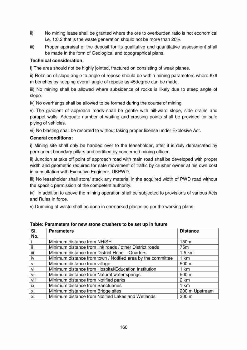
160
ii) No mining lease shall be granted where the ore to overburden ratio is not economical
i.e. 1:0.2 that is the waste generation should not be more than 20%
iii) Proper appraisal of the deposit for its qualitative and quantitative assessment shall
be made in the form of Geological and topographical plans.
Technical consideration:
i) The area should not be highly jointed, fractured on consisting of weak planes.
ii) Relation of slope angle to angle of repose should be within mining parameters where 6x6
m benches by keeping overall angle of repose as 45degree can be made.
iii) No mining shall be allowed where subsidence of rocks is likely due to steep angle of
slope.
iv) No overhangs shall be allowed to be formed during the course of mining.
v) The gradient of approach roads shall be gentle with hill-ward slope, side drains and
parapet walls. Adequate number of waiting and crossing points shall be provided for safe
plying of vehicles.
vi) No blasting shall be resorted to without taking proper license under Explosive Act.
General conditions:
i) Mining site shall only be handed over to the leaseholder, after it is duly demarcated by
permanent boundary pillars and certified by concerned mining officer.
ii) Junction at take off point of approach road with main road shall be developed with proper
width and geometric required for safe movement of traffic by crusher owner at his own cost
in consultation with Executive Engineer, UKPWD.
iii) No leaseholder shall store/ stack any material in the acquired width of PWD road without
the specific permission of the competent authority.
iv) In addition to above the mining operation shall be subjected to provisions of various Acts
and Rules in force.
v) Dumping of waste shall be done in earmarked places as per the working plans.
Table: Parameters for new stone crushers to be set up in future
Sl. No.
Parameters Distance
i Minimum distance from NH/SH 150m ii Minimum distance from link roads / other District roads 75m iii Minimum distance from District Head – Quarters 1.5 km iv Minimum distance from town / Notified area by the committee 1 km v Minimum distance from village 500 m vi Minimum distance from Hospital/Education Institution 1 km vii Minimum distance from Natural water springs 500 m viii Minimum distance from Notified parks 2 km ix Minimum distance from Sanctuaries 1 km x Minimum distance from Bridge sites 200 m Upstream xi Minimum distance from Notified Lakes and Wetlands 300 m
161
APPENDIX – 15
STORAGE, HANDLING, USE AND EMERGENCY RESPONSE FOR HAZARDOUS
CHEMICALS
A1. Refueling / Maintenance procedure
Truck or suitable containers will bring in all fuel and fluids. There will be no storage of
fuel, oil or fluids within 100M (or 50M) of the permanent water line.
Prior to re-fueling or maintenance, drip pans and containment pans will be placed
under the equipment. Absorbent blankets may also be required to be placed under
the equipment and hoses where there is a possibility of spillage to occur.
All used oils or fluids will be properly contained and transported to appropriately
licensed (authorized) disposal facilities;
Following re-fueling and maintenance, the absorbent blankets (if any) and spill pans
will be picked up and the fuel truck or container moved outside of the 100m (or 50m)
wide area.
Emergency spill procedure
Should a spill occur, trough spillage or equipment failure, the applicable emergency spill
procedure outlined in sections A-2 to A-4 must follow.
A2. Spill Procedure (inside the stream)
In the case of a spill, overflow or release of fluid into the stream waterway (whether water is
flowing during the spill or not), do what is practical and safely possible to control the
situation, then get help.
Stop the flow
o Stop the release into the stream waterway
o Shutdown equipment
o Close valves and pumps
o Plug hoses
Remove Ignition sources
Shut off vehicles and other engines
Do not allow tiger torches, vehicles, smoking or other sources of ignition near
the area. Keep a fire extinguisher on hand but keep it a safe distance away
from the potential ignition source (if a fire starts, the extinguisher must be
easily accessible)
Contact the environmental officer and initiate emergency response
o Notify the site supervisor and the Contractor’s Environmental Officer as soon as possible
o The Environmental Officer will review the situation and decide if Emergency
services like Fire Brigade are required
162
o Appropriate parties to be notified of the spill are
The contractor’s Project Manager
The Engineer through his designated Environmental Officer
The Client
Regulatory Agencies like Pollution Control Board, Municipal
Authorities, as applicable.
Site safety Officer
Cleanup and Disposal
Emergency Services will be engaged for the containment, cleanup and disposal of
contamination release into the environment.
Reporting
The Contractor’s Environmental Officer will document the event and submit repots to
the Engineer, the client and appropriate regulatory agencies like the Pollution Control
Board(s).
Procedure Review
The Engineer will review the report, determine if changes are required to procedures
and recommended implementation of all required changes …
A3. Spill procedure (on land)
In the case of a spill, overflow or release fluid onto land, do what is practical and safety
possible to control the situation and then get help.
Stop the flow
Stop the release into the water body
Shut down equipment
Close valves and pumps
Plug hoses
Remove Ignition sources
Shut off vehicles and other engines
Do not allow tiger torches, vehicles, smoking or other sources of ignition near the
area. Keep a fire extinguisher on hand but keep it a safe distance away from the
potential ignition sources (if a fire starts the extinguisher must be easily accessible).
Contain the Spill
Dike around the spill to contain the material
Spread absorbent or place a spill blanket on the spill
Enlist the help of personnel on site
163
Notify your supervisor as soon as possible
Notification
Appropriate parties to be notified of the spill are
The Contractor’s Project Manager
The Engineer through his designated Environmental officer
The Client
Regulatory Agencies like Pollution control Board, Municipal Authorities, as
applicable
Site Safety coordinator
Cleanup and Disposal
The Engineer’s Environmental officer will ensure that a proper cleanup and disposal method is determined. Absorbent pads will soak up the spilled material. The pads will
be contained and removed from site for disposal at a licensed (authorized) facility.
Reporting
The Contractor’s Environmental Officer will document the event and submit reports to the Engineer, the Client and appropriate regulatory agencies like the Pollution control
Board(s)
Procedure Review
The Engineer will review the report, determine if changes are required to procedures
and recommend implementation of all required changes.
164
APPENDIX – 16
SELECTION AND MANAGEMENT OF CONSTRUCTION CAMP
1. Selection and layout of construction camp
The construction camps for labour, accommodation, offices and construction plant sites shall
be identified based on the following guidelines. The construction site shall be located
At a minimum distance of 1km away from any major settlement or village.
At a minimum distance of 1000m of any major surface water course or body
If this is not possible the base camps should be located away from the settlements with the
following precautions
Base camp should be enclosed with boundary wall.
Movement of the workers should be registered during the nighttime.
There should not be any disturbance to the local community.
Operation of the plant and machinery should be restricted to 6 am to 10 am
Care should be taken while starting and moving the heavy vehicles, there is a
possibility that children of near settlement may be playing with machinery
parked outside the camps.
2. Facilities at workers camps
During the construction stage of the project, the construction contractor will construct and
maintain necessary (temporary) living accommodation and ancillary facilities for labour. It will
be ensured that all the temporary accommodation will be provided with uncontaminated
water for drinking, cooking and washing. Adequate washing and bathing places shall be
provided, and kept in clean and drained condition. Construction camps will be sited away
from vulnerable people and adequate health care will be provided for the work force.
General requirements include availability of:
Potable water supply in quantity and quality,
Requirement of power supply for heating as well as for cooking. Firewood shall
not be used for cooking and heating purposes. Contractor must provide LPG
gas / Kerosene for the construction camps.
Safe access road is required at camps
Waste (all kind of solid and liquid wastes) generated need to be disposed off
smoothly.
2.1 Sanitation Facilities:
Construction camps shall be provided with sanitary latrines and urinals. Closed drainage
systems and the proper treatment systems according to the local conditions should be
constructed for the proper flow and effective treatment. The sewage system built for the
camp will be operated properly to avoid health hazard, ground water and soil pollution.
Compost pits will be constructed for the disposal of the garbage and other biodegradable
wastes generated from the camps. Proper collection, transportation and disposal of the
wastes will be ensured.
165
3. Shelter at work place:
At such work places where the duration of the works will prevail for more than one month
some form of shelters will be provided for meals, resting, change of clothes and for keeping
the tools of the work and personal protective equipment. The height of shelter shall not less
than 3m from floor level to lowest part of the roof. Sheds shall be kept clean and the space
provided shall be on the basis of at least 1.0 Sq.m per head.
4. Canteen Facilities:
A cooked food canteen on a moderate scale shall be provided for the benefit of workers
wherever it is considered necessary. All the wastes generated from the canteen will be
treated / disposed of as detailed in the other sections of the waste disposal.
5. Health care Facilities:
Health problems of the workers should be taken care of by providing basic health care
facilities through a health centre set up at the construction camps. The health centre will
have at least a doctor (part time), nurses, duty staff, medicines and minimum medical
facilities to tackle first-aid requirements for minor accidental cases. Some arrangements will
be made with the nearest hospital to refer patients of major illnesses or critical cases.
The health centre will carry out quarterly awareness programme of HIV – AIDS with the help
of AIDS control society. Posters will be exhibited in the health care clinic.
6. Day crèche facilities
At construction sites where women with very young children are employed, provision of a
day crèche shall be provided. At construction sites where 20 or more women are ordinarily
employed, a hut for children under the age of 6 years shall be provided.
For ensuring the implementation of effective pollution control measures at the construction
base camps and construction plant sites, redevelopment/ closure plans for the closure of
these sites will be made part of the EMP of the construction contract.
7. Construction workers Camp
In all over India, road construction works are in peak stage. With several local / regional/
national and international contractors in place, the road construction work recently started
showing seriousness towards this issue. The contractor recently started providing required
legal and contractual facilities for the unskilled labour, hired from the local villages or are
brought to the place of work from outside the State.
Even now the Contractor camps and other facilities are set up in worst conditions even when
the contract documents are clearly specifying the required standards. The associated issues
are as follows.
Forest resources could be encroached up on in all possible ways by the labour force.
Unauthorized tree felling to get fuel-wood both for cooking as well as heating even when
alternative fuel is made available,
Poaching of edible animals and birds of the locality in spite of prohibition,

166
Poor sanitation arrangement and improper methods used for disposal of solid wastes and
effluent,
Indigenous people getting invaded by imported construction labour-force, due to lack of
discipline,
Transmission of communicable diseases to the local people by the construction workers due
to inappropriate health monitoring facilities, and
Creating hazardous traffic flow at construction site due to lack of concern about the local
needs and provision for pedestrian
No Contractor’s Establishments zones
Contractor shall not establish any construction camp, crushers, hot mix plant and WWM
plant in the identified locations (No Contractor’s Establishment Zone). These locations will be treated as eco-sensitive. No construction campsite areas also include settlement areas
provided below. These are the major settlements along the corridor. Campsites should be a
minimum of 500m away from settlements.