Embed Size (px)
Citation preview
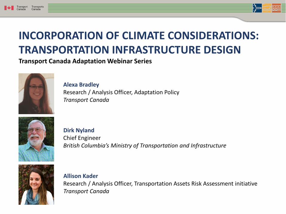
Alexa Bradley Research / Analysis Officer, Adaptation PolicyTransport Canada
Dirk NylandChief EngineerBritish Columbia’s Ministry of Transportation and Infrastructure
Allison Kader Research / Analysis Officer, Transportation Assets Risk Assessment initiativeTransport Canada
INCORPORATION OF CLIMATE CONSIDERATIONS: TRANSPORTATION INFRASTRUCTURE DESIGNTransport Canada Adaptation Webinar Series

Incorporation of Climate
Considerations:
Transportation Infrastructure
Design
Transport Canada Webinar
Dirk Nyland, P.Eng., IRP
Chief Engineer, BCMoTI
March 19, 2019

There has been a substantial increase in the intensity
of heavy-precipitation events over large parts of the
Northern Hemisphere due to greenhouse gases.
(Storms with over 100 millimetres of precipitation in 24 hours.)
Source: Zwiers, Nature,
2011
Holberg Road (Vancouver Island, Sept 2010) Hagensborg (Bella Coola, Sept 2010)
3

The unavoidable impacts associated with climate change and weather extremes have the potential to adversely affect infrastructure
Planned adaptation can result in lower costs and is often more effective than reactive adaptation. Proactive adaptation measures guide strategic resource allocation and help avoid costly future repairs or replacements
4

Adaptation in engineering design and
practices for resilient, reliable, efficient and
effective transportation infrastructure
Design Construction Maintenance
COST OF INFRASTRUCTURE
(resilience = lower maintenance)5

Design for higher temperature and precipitation over
lifecycle of components, i.e. bridges (50-100 years)
culverts (75 years), pavement (15-20 years)
6
Nazko 2018 Revelstoke Hwy 23N 2018

Design for Climate & Weather Extremes
• Extreme rainfall in one or more days (e.g. >76 mm/24 hrs)
• Atmospheric River-Pineapple Express (e.g. >150 mm/24 hrs)
• High Temperature (e.g. number of days over 30°C)
• Temperature variability (e.g. freeze-thaw)
• Sea level rise (e.g. 1m by 2100) Hwy 97 June 2016
7
Cariboo 2018

Adaptation Planning Process
8

Vulnerability or risk is a function of the character, magnitude, and rate of climate variation to which a system is exposed, its sensitivity, and its adaptive capacity
9

Data for Risk Assessment
• Infrastructure
Components
• Infrastructure Age
• Availability of
Infrastructure Data
• Geotechnical Indicators
• Variety of Terrain
• Traffic Volumes
• Strategic Importance
of Route
• Occurrence of Extreme
Environmental Events
• Historic Weather
Data Available
• Current Weather
Data Available
• Expected Climatic
Change – Temperature
• Expected Climatic
Change – Precipitation
• Climatic Regions
• Sea Level Rise
10

Infrastructure Components
11
• Surface asphalt
• Bridges
• Ditches
• Catch basins
• Culverts
• Third-party utilities
Criteria on design standards and limits for infrastructure components to assess risk to climate change and weather extremes
Kootenay Pass 2018 Salmon Arm 2018

Design Criteria - Bridges and Structures
Hydrotechnical Design – Scour
Current
Standards
Maximum instantaneous discharge (Q200)
Clearance between design water surface and bridge soffit
(i.e. 1.5 m)
Climatic
Variables
• Historic streamflow from hydrometric gauges
• Historic precipitation from weather stations
Risk Issues
• Changes in streamflow (Q200)
• Changes at watershed scale (land use & vegetation)
• Changes in channel scale (stability, sediment transport)
Design
Adaptation
• Estimate and use future streamflow (Q200)
• Structure clearance, size, clear span
• Construction quality (riprap)
• Debris control
• Maintenance for debris and sediment12

Design Criteria - Bridges and Structures
Thermal Movement
Current
StandardsCanadian Highway Bridge Design Code
Climatic
Variables
Temperature allowance in excess of max and min mean
daily temperature
Risk Issues
• Increase in temperature
• Temperature extremes
• (Note: for general bridge design – risk may be low.
Temperature changes may be small relative to
accuracy of bridge code values)
Design
Adaptation
NRC incorporate projected future temperature maps in
code
13

Design Criteria - Geotechnical
Slope Stability
Current
StandardsSafety factor 1.5
Climatic
VariablesCurrent conditions and moisture changes
Risk Issues
• Increased precipitation
• Groundwater changes
• Changes in land use and vegetation
• Higher flow volumes and velocities
Design
Adaptation
Compare recent conditions and future climate
projections
14

Design Criteria - Geotechnical
Pavement Grade - Asphalt Cement Mix
Current
StandardsStandard Specification 952
Climatic
Variables
Pavement Grade values based on historic
temperature and use
Risk Issues Increased temperatures
Design
Adaptation
Modify PG rating based on future temperature and
use
15
16
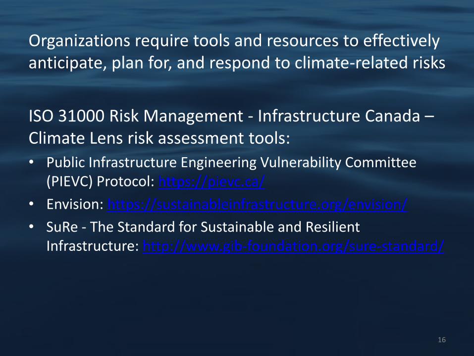
Organizations require tools and resources to effectively anticipate, plan for, and respond to climate-related risks
ISO 31000 Risk Management - Infrastructure Canada –Climate Lens risk assessment tools:
• Public Infrastructure Engineering Vulnerability Committee (PIEVC) Protocol: https://pievc.ca/
• Envision: https://sustainableinfrastructure.org/envision/
• SuRe - The Standard for Sustainable and Resilient Infrastructure: http://www.gib-foundation.org/sure-standard/

17
Climate Resilience Assessment
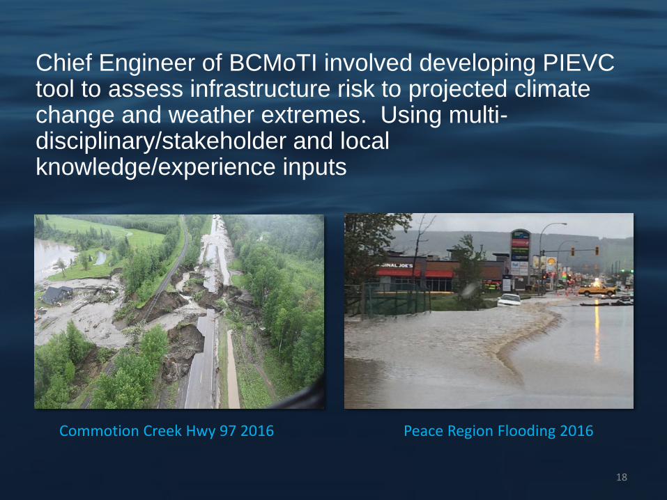
Chief Engineer of BCMoTI involved developing PIEVC tool to assess infrastructure risk to projected climate change and weather extremes. Using multi-disciplinary/stakeholder and local knowledge/experience inputs
18
Commotion Creek Hwy 97 2016 Peace Region Flooding 2016

19
PIEVC Steps

20
Risk Matrix

BC Highways are generally resilient to projected
climate change except for extreme precipitation events;
further research is required for events such as rain on
snow, fog and wind, avalanche, landslides, sea level
rise, etc.
21
Bitter Creek Bridge, Stewart, Sept 2011Yellowhead Hwy

• Develop awareness of climate
change/extreme weather and
implications (primarily water
related events)
• Include climate adaptation in
organizational practice
• Use multidisciplinary teams for
projects
• Use qualified professionals with
local knowledge (climate,
meteorological, hydrotechnical)
• Adaptation education for
professionals, consultants, staff
and students
22
Lessons Learned to Date
Batnuni Bridge 2018
Narcosli Bridge 2018

• Monitor data used in current codes
and standards and develop climate
resilience specific codes
• Use data and/or professional
judgement
• Apply sensitivity analysis
• Understand risks and uncertainties
• Review association guidance
23
Best Practices
Bella Coola, Sept
2010
• Use information from
ensemble of climate
models
• Determine best models
and data to use
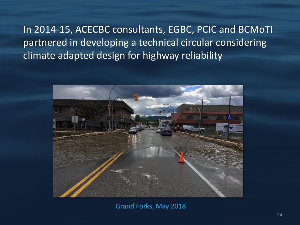
In 2014-15, ACECBC consultants, EGBC, PCIC and BCMoTIpartnered in developing a technical circular considering climate adapted design for highway reliability
Grand Forks, May 201824

Technical Circular Requirements
• Design for climate change and weather
extremes from model projections
• Vulnerability screening analysis for the design
life of structures and components include data
sources
• Development of practical and affordable
design criteria
• Design Criteria Sheet to summarize climate
parameter changes
25

Design SheetExample
2626

EGBC Practice Guidelines
27
Request for Proposal (2.2.1.1)
Define Highway Infrastructure project (3.2)
Conduct screening-level, climate change risk assessment (3.3)
Identify and incorporate climate adaptation options (3.4)
Documents (3.5)- Climate change risk assessment- Hwy resilient design report- Assurance statement- BCMoTI Design Criteria Sheet

Adapted Bridge Designs - Flow
Region Return periods from sheets vary
% ↑ Design Value for Climate Change
Climate Data
NR 100-200yr +9% to +30% -MoTI practices-EGBC recommendations*-PCIC regional reports-IDFCC-Consultant Reports
SIR 100-200yr +10% to +20% -MoTI practices-EGBC recommendations*-PCIC-Consultant Reports
SCR 200yr +11% to +15% -MoE coastal guidelines-EGBC recommendations*-Consultant Reports
28

Adapted Culvert Designs - Flow
29
Region
Return
periods from
sheets vary
% ↑ Design
Value for
Climate
Change Climate Data
NR 50-200yr +10% to +25% - IDFCC
- Consultant reports
SIR 25-200yr +10% - MoTI
- EGBC
recommendations*
- Consultant Reports
SCR 5-200yr +3.6% to
+25%
- EGBC
recommendations*
- PCIC
- IDFCC
- Consultant Reports
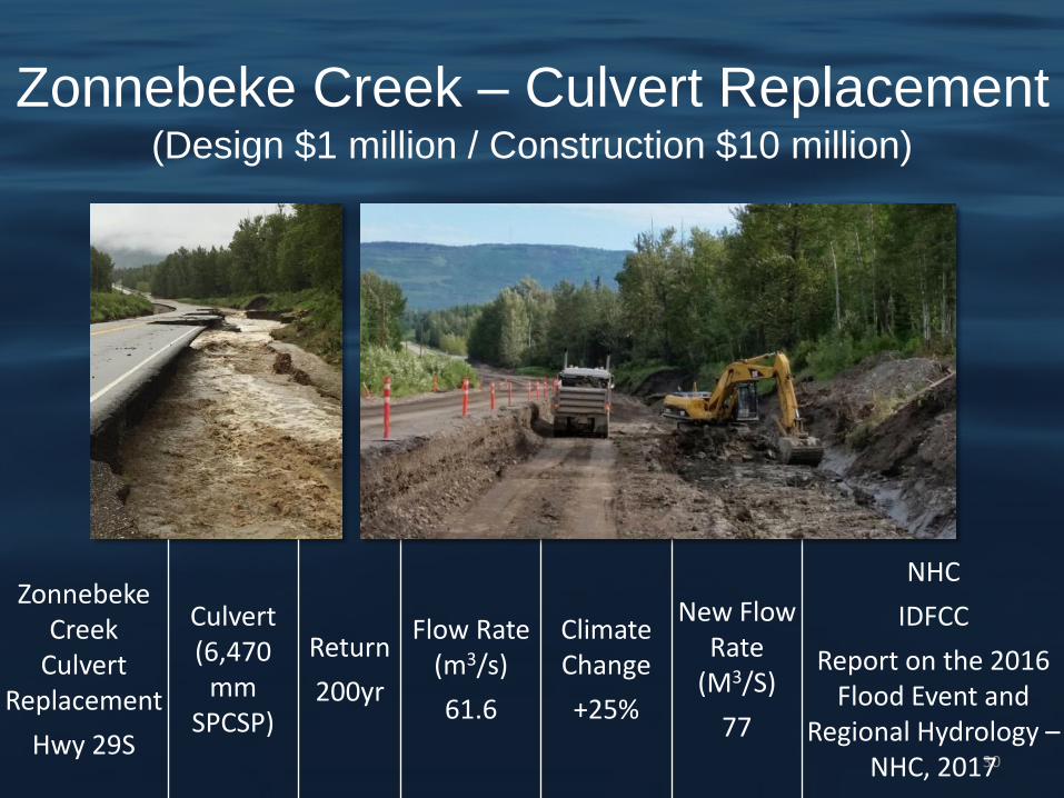
Zonnebeke Creek – Culvert Replacement(Design $1 million / Construction $10 million)
30
ZonnebekeCreek
Culvert Replacement
Hwy 29S
Culvert (6,470
mm SPCSP)
Return
200yr
Flow Rate (m3/s)
61.6
Climate Change
+25%
New Flow Rate
(M3/S)
77
NHC
IDFCC
Report on the 2016 Flood Event and
Regional Hydrology –NHC, 2017
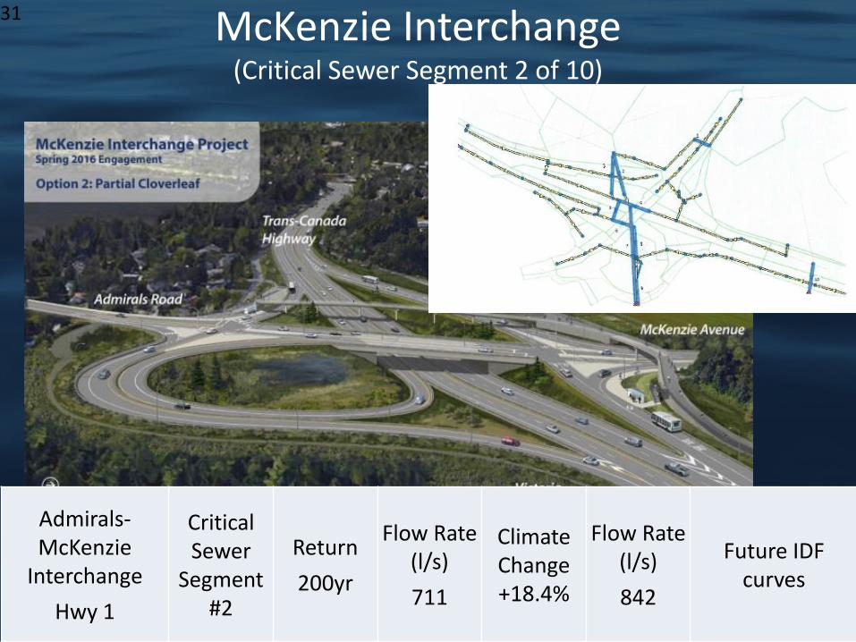
31 McKenzie Interchange(Critical Sewer Segment 2 of 10)
Admirals-McKenzie
Interchange
Hwy 1
Critical Sewer
Segment #2
Return
200yr
Flow Rate (l/s)
711
Climate Change +18.4%
Flow Rate (l/s)
842
Future IDF curves

32
Mountain Hwy Interchange
Hwy 1
Major Drainage systems
Keith Creek
Culverts
Return
100yr
(75yr DL)
Flow Rate (m3/s)
18.1
ClimateChange
+20%
Flow Rate (M3/S)
21.7
PCIC (Plan2Adapt 90th% 17.5%↑)
APEGBC (10%, 20%↑)
IDFCC (18-23%↑)
Mtn HwyInterchange

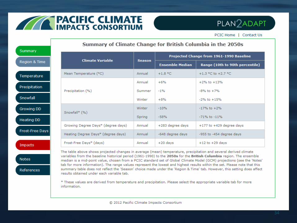
PCIC Climate Resources
• Plan2Adapt
• *New* Climate Explorer – climate projections
• Downscaled climate data - projections
• Hydrologic model output – projections
• Support from climate scientists
33
34

35
PCIC Climate Explorer(March release with instructional videos)

BCMoTI Adaptation Site
BCMoTI Adaptation site:
https://www2.gov.bc.ca/gov/content/transportation/transport
ation-environment/climate-action/adaptation
36
Old Kamloops Rd Hwy 5A 2018Sportsman Bowl Rd 2018

Adapt highway infrastructure for resilience to climate change and weather extremes using vulnerability assessment and climate projection tools
Recap
37

Thank you!
38
Grizzly Creek Culvert
Trash Rack – Flying V (2013)

Transport Canada’s Transportation Assets
Risk Assessment Initiative (TARA)
Recommended Practices and Lessons Learned
Presented by: Allison Kader, Research/Analysis Officer with Transport Canada’s TARA Team
March 19, 2019

Presentation Overview
• TARA Initiative
• Examples of Climate Risks
• Climate Risk Assessment
• PIEVC Review Results
• Recommended Practices and Lessons Learned
2

What is the TARA Initiative?
• The TARA initiative was announced following Budget 2017, receiving $16.35 million over five years
• Goal: Better understand climate risks to federally-owned transportation assets and potential adaptation solutions
• Eligible projects
1. Full climate risk assessment
2. Subcomponent(s) of a climate risk assessment
3. Research projects
• $3.7 million in funding approved since 2017
• Grants and Contributions Call for Proposals
• EN: http://www.tc.gc.ca/en/programs-policies/programs/transportation-assets-risk-assessment-program.html
• FR: http://www.tc.gc.ca/fr/programmes-politiques/programmes/programme-evaluation-risques-lies-ressources-transport.html
3

Examples of Climate Risks Affecting the Canadian Transportation System
How climate and weather can affect marine transportation. (Illustration created by www.soaringtortoise.ca) How climate and weather can affect air transportation (Illustration created
by www.soaringtortoise.ca)
How climate and weather can affect rail transportation (Illustration created by www.soaringtortoise.ca)
How climate and weather can affect road transportation (Illustration created by www.soaringtortoise.ca) 4

What is a Climate Risk Assessment?
• Consideration of the risk associated with the current and future climate impacts
• Follow ISO 31000 Risk Management Standard (i.e. PIEVC protocol)
• Three steps
1. Risk Identification
2. Risk Analysis
3. Risk Evaluation
• Key activities
• Climate data modelling and forecasting
• Infrastructure components and climate parameters definition
• Risk assessment workshop
• Engineering analysis
• Recommendations
5

Why is it Important to Assess Climate Risk?
• A resilient transportation system is critical
• Climate impacts already affecting the Canadian transportation system
• Climate impacts are expected to become more frequent and severe
6

Who should be involved?
Asset-Specific
• Operational/management
• Technical services
• Environmental services
Specialized Services
• Project Manager
• Climate Specialist
• Engineering Analyst
• Climate Risk Assessment Tool Lead
• Transportation Modal Expert
7

Asset Owner/Operator’s Role
• Provide access to the site and supporting documentation
• Receive deliverables and provide feedback
• Participate in climate risk assessment workshop
• Representatives from capital planning and operations
• Respond to recommendations
8
Examples of Approved Projects Assessing Climate Risk
• Climate risk assessment projects
• Five Transport Canada airports
• Four Parks Canada highways
• Confederation Bridge
• Six Atlantic ferry terminals
• Toronto Port Authority assets
• Climate risk assessment subcomponent projects
• Churchill Airport
• Winnipeg Richardson International Airport
• Research projects
• National Research Council’s development of storm surge and wave activity database and visualization tool for coastal BC
9

Review of PIEVC Climate Risk Assessments
• Use of publicly available PIEVC climate risk assessment reports
• Focus on the Canadian transportation system
• Establish an understanding of common recommendations
Type of
recommendation
Development/update
of policies and
previous evaluations
Studies and
instrumentation
MonitoringManagement
and
operational
changes
Engagement
to gather
additional
information
and/or
further apply
assessment
results
Engineering
solutions
Vulnerability
ranking and
criticality
parameters
Number of
recommendations 35 33 24 6 5 5 2
10

Recommended Practices and Lessons Learned
Climate Data and Parameters
• Cumulative impacts of climate parameters should be considered
• The lifecycle and management/maintenance plan of the observed asset should be considered when determining climate projection timescales
• There is a need to establish a method at the outset of the assessment to better identify which climate models and RCPs are most appropriate
• Climate data projections would benefit from an additional seasonal analysis as opposed to focusing on yearly projections
11

Recommended Practices and Lessons Learned
Climate Risk Assessment Tools and Processes
• Most climate risk assessment tools are not decision-making tools
• There is a need to understand what tools and methods exist or can be developed to assess climate risk as part of the normal design process
• Where possible, potential climate change opportunities should be considered along with negative impacts
• Climate risk assessment deliverables and results should be developed in a manner that is clear and easily understood
12
Thank you!
• For additional information on the TARA initiative, please
contact:
• Donavan Jacobsen, TARA initiative Manager, at
• Allison Kader, Research/Analysis Officer with the
TARA initiative, at [email protected]
• Questions on the grants and contributions application
process should be directed to: [email protected]
13

Q & A(Question and Answer Period)
Please pose your questions via the chatbox or by hitting *6 to unmute your line

Thank you for joining us today!
Stay tuned for upcoming webinars!
Alexa BradleyResearch / Analysis Officer, Adaptation Policy | Transport Canada