Embed Size (px)
Citation preview
Inclusive green growth in KenyaOpportunities in the dryland water and rangeland sectorsStudy in support of the Danish Green Growth and Employment Programme in Kenya 2015–2020
Caroline King-Okumu, IIED
Issue PaperJune 2015
Green economy
Keywords: Water, rangeland, green growth
About the authorCaroline King-Okumu, Senior Researcher, Dryland Ecosystems and Economic Assessment Email: [email protected]
Produced by IIED’s Climate Change GroupThe Climate Change Group works with partners to help secure fair and equitable solutions to climate change by combining appropriate support for adaptation by the poor in low- and middle-income countries, with ambitious and practical mitigation targets.
The work of the Climate Change Group focuses on achieving the following objectives:
• Supporting public planning processes in delivering climate resilient development outcomes for the poorest.
• Supporting climate change negotiators from poor and vulnerable countries for equitable, balanced and multilateral solutions to climate change.
• Building capacity to act on the implications of changing ecology and economics for equitable and climate resilient development in the drylands.
Acknowledgments Many individuals have helped with the development of this report. They include the key informants listed in Appendix 1, as well as colleagues at the Danish embassy, its partner institutions and IIED. The individuals interviewed bear no responsibility for the analysis and conclusions of this report, including any errors that may remain. Insightful comments on the first draft of the report were provided by Martin Enghoff (consultant to Danida), Ruth Nganga (WSTF), Jeff Worden (NRT), Tom Lalampaa (NRT), Anne Nyaboke Angwenyi (Danish Embassy in Nairobi), Roger White (MTAP), Celia Nyamweru, Oliver Greenfield (IIED) and Ced Hesse (IIED). Other IIED colleagues, including Morgan Williams, Teresa Sarroca, Lucy Southwood and Judith Fisher, also provided essential support in preparing this document.
Partner organisationSince the independence of Kenya in 1963, Denmark and Kenya have enjoyed strong bilateral relations. Through 50 years of development cooperation, Kenyans know Danida as a long-term development partner. Modalities and areas of cooperation have naturally changed during these 50 years, but the overall objectives have always been poverty alleviation and support to democracy and human rights. This cooperation is facilitated through the Danish embassy in Kenya which is an integral part of the Danish Ministry of Foreign Affairs (MFA). The embassy is accredited to represent Denmark in the areas of foreign policy and foreign economic and commercial relations as regards to the Republic of Kenya.
Published by IIED, June 2015.
Caroline King-Okumu. 2015. Inclusive green growth in Kenya: opportunities in the dryland water and rangeland sectors. Study in support of the Danish Green Growth and Employment Programme in Kenya 2015–2020. IIED Issue Paper. IIED, London.
Product code: 10137IIED
ISBN: 978-1-78431-213-8
Printed on recycled paper with vegetable-based inks.
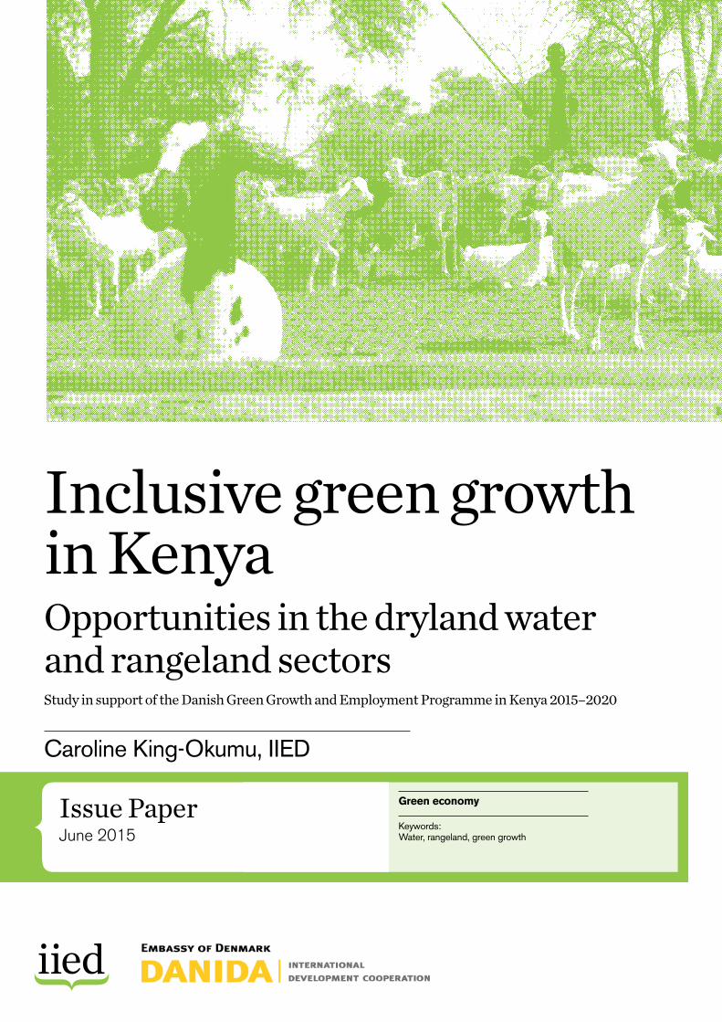
Photo caption: Pastoralist goat herder leads his flock to water in Kinna Ward, Isiolo, northern Kenya
Photo credit: Ben Fathers
International Institute for Environment and Development 80-86 Gray’s Inn Road, London WC1X 8NH, UK Tel: +44 (0)20 3463 7399 Fax: +44 (0)20 3514 9055 email: [email protected] www.iied.org
@iied www.facebook.com/theIIED
Download more publications at www.iied.org/pubs
Inclusive green growth requires enhanced resilience to perturbations that affect the Kenyan economy. These include climatic variability and changes and a range of other economic and socially driven changes in the drylands. This report explores the challenges and potential for Danida and its selected partners in the water, rangeland and livestock enterprise sectors. The concluding discussion highlights shared considerations across both sectors concerning the roles of the public sector, private sector and communities in providing services, tracking inclusive green growth and fostering green innovations (hard and soft). Recommendations target better national-level water accounting and more participatory scientific ecosystem management methods.
www.iied.org 3
ISSUE PAPER
ContentsList of acronyms 4
Executive summary 5
1 Introduction 6
Objectives and scope of work 7Danida’s intended intervention 8
2 Study approach 9
3 Green growth for the Kenyan ASALs and the drivers of change 11
4 The water services sector: potential contributions to inclusive green growth 16
4.1 Policy and institutional frameworks in the water sector and Danida support to WSTF 17
4.2 Available water service and sector data and facts relevant to green growth 18
4.3 Analysis of opportunities, challenges, risks and solutions that may be piloted through WSTF 20
5 Rangeland and livestock enterprise sectors: potential contributions to inclusive green growth 25
5.1 Policy and institutional frameworks in the rangeland sector and Danida support to NRT 26
5.2 Available livestock sector and rangeland service data and facts relevant to green growth 27
5.3 Analysis of opportunities, challenges, risks and solutions that may be piloted through NRT 29
6 Looking forward: addressing the drivers of change 35
6.1 Recommendations 366.2 Conclusion 37
References 38
Appendices 43
InclusIve green growth In Kenya | OppOrtunities in the dryland water and rangeland sectOrs
4 www.iied.org
List of acronymsASAL arid and semi-arid lands
CBC community-based conservancies
CIDPs County Integrated Development Plans
CSR corporate social responsibility
ENNCA Ewaso Ng’iro North Catchment
GESIP Green Economy Strategy and Implementation Plan
GoK government of Kenya
IIED International Institute for Environment and Development
KWS Kenya Wildlife Service
MCM million cubic metres
MDP Ministry of Devolution and Planning
MTAP Medium-Term Arid and Semi-Arid Programme
M&E monitoring and evaluation
NDMA National Drought Management Authority
NDVI normalised difference vegetation index
NGO non-governmental organisation
NRT Northern Rangelands Trust
PES Payments for Ecosystem Services
SCMP Sub-Catchment Management Plan
UNFCCC United Nations Framework Convention on Climate Change
VCI vegetation condition index
WRMA Water Resource Management Authority
WRUA water resources user association
WSTF Water Services Trust Fund
InclusIve green growth In Kenya | OppOrtunities in the dryland water and rangeland sectOrs iied issue paper
www.iied.org 5
Executive summaryGreen growth promises to provide the economic incentives that resource-dependent dryland communities need to achieve sustainable inclusive economic development. This will involve unravelling and overturning the intertwined negative drivers of climatic stress, environmental degradation, marginalisation and inequality that have held these communities back in the past. Kenya’s ongoing devolution process provides an opportunity for green economic planning in the arid and semi-arid lands (ASALs) to be informed by an inclusive consideration of needs, priorities, resource conditions and trends articulated from the level of the resource user. But building and aligning the necessary institutions and interventions to drive inclusive green growth still poses a challenge.
The main objective of this analytical study was to assess the drivers of change in Kenya’s ASAL areas, with an emphasis on the water, rangeland management and livestock enterprise development sectors, to inform the Danish embassy on appropriate strategic considerations or principles that may foster inclusive green growth through support to two selected partners: the Water Services Trust Fund and Northern Rangelands Trust. The purpose was not to collect new primary data, but to digest and frame what is currently available, and make recommendations on the considerations to take in designing Danida’s green growth and employment support through these partners in the areas of rangeland management and supply and access of water. The study took place over a rapid timeframe of one month and was based on a series of key informant interviews and a desk review of supporting literature. Inherent constraints on the depth of the analysis relating to the timeframe and timing, logistics, availability of information and partners’ participation are acknowledged.
This report introduces an understanding of the drivers of change in Kenya’s ASAL areas and provides a brief overview of policy and institutional frameworks for green growth in the rangeland and water sectors. The analysis explores strategic choices for promoting green growth through water and rangeland management sectors with Danida’s selected partners, based on available facts and data, and highlights relevant solutions and best practices. The concluding discussion focuses on considerations for the Danish embassy and additional potential entry opportunities for promoting inclusive
green growth in Kenya. This underlines the common challenges identified in relation to the roles of the public sector, private sector and communities in developing technology (hard and soft) and providing services to promote green growth in both the water and rangeland management sectors. Considerations focus on three key elements or principles that are central to the agenda for inclusive green growth in the ASALs:
• Inclusivity: including consideration of marginalised, displaced and transitory resource users.
• Accounting for the environment: balancing economic productivity with effects on resources under inherently variable and arid or semi-arid conditions.
• Institutional capacity: building devolved institutions for public resource management decision making.
The options we identified include green technologies of relevance to disadvantaged members of the ASAL communities, and including marginal groups in relevant decision making and technological development activities. While the draft national Green Economy Strategy and Implementation Plan (GESIP) focuses on information needs to monitor carbon emissions, this report considers the effects that ‘black’ economic growth has had on the distribution and conditions of other key resources in the ASALs, particularly water and land. We discuss options to improve monitoring of these resources, and we underline the opportunity to establish an effective resource accounting system to measure progress towards the achievement of economic growth with minimised environmental impacts. This would contribute significantly to filling a strategic gap in the present draft national GESIP, both for the ASALs and the national economy as a whole.
To unlock the political economy of poverty and inequality in the ASALs, building the capacities of devolved public institutions to take decisions and actions is critical. It is therefore important to ensure that donor support to communities through the water, rangeland and livestock enterprise sectors informs and strengthens these institutions’ capacities to envision, plan, enable and achieve inclusive green growth. To continue strengthening these essential institutions, there is an opportunity to review and build on the achievements of Danida’s Medium-Term Arid and Semi-Arid Programme.
InclusIve green growth In Kenya | OppOrtunities in the dryland water and rangeland sectOrs
6 www.iied.org
1
Introduction
InclusIve green growth In Kenya | OppOrtunities in the dryland water and rangeland sectOrs iied issue paper
www.iied.org 7
Kenya’s economic growth is largely dependent on natural resources that are under pressure from climate change, exploitation by a growing human population and changing lifestyle patterns (UNEP 2014). Unequal distribution of resources and factors of production, as well as a tension between black and green growth models, add to the challenge. These pressures are most susceptible to rapid acceleration in the arid and semi-arid lands (ASALs)(GoK 2012b). At present, water supply and livestock production in the ASALs are notably green sectors with relatively low carbon and water footprints that provide livelihoods and services to large sections of the population (McGahey et al. 2014). But the intended expansion of water service levels, the transition from informal to formal economic activities in the livestock production sector and the growth of competing demands for resources from other sectors could push the water and livestock sectors towards less green production patterns.
A recent critical appraisal of the scope for green growth in Kenya concluded that the country’s future choices on promoting economic and social development in the ASALs will be determined — and restricted — by the choices made today in relation to the pattern and quality of growth (Danida 2015b). In light of these recommendations, the Danish embassy has commissioned the International Institute for Environment and Development (IIED) to undertake an analytical study to assess green growth interventions in the ASALs that the embassy could support through partnerships established with the Water Services Trust Fund (WSTF) and Northern Rangelands Trust (NRT). The study is intended to provide the embassy with information on strategic/feasible considerations for its programme supporting green growth in selected ASAL counties through the water sector, rangeland management and livestock enterprise development.
This report first introduces an understanding of the drivers of change in Kenya’s ASAL areas and provides a brief overview of policy and institutional frameworks for green growth in the rangeland and water sectors. It then explores strategic choices and relevant best practices for promoting green growth through water and rangeland management sectors, focusing on Danida’s selected partners. The final section identifies considerations for the embassy and additional potential entry opportunities for promoting inclusive green growth in Kenya.
Objectives and scope of workThe main objective of this analytical study was to assess the drivers of change in Kenya’s ASAL areas, with an emphasis on water, rangeland management and livestock enterprise development, to inform the embassy on appropriate strategic considerations or principles that the proposed programme may support to foster inclusive green growth through these two areas of engagement. The purpose of the study was not to collect new, primary data, but to digest and frame what is currently available and make recommendations on the considerations to take when designing green growth and employment support in rangeland management, water supply and access to water.
The study’s objectives were to:
1) Describe policy and institutional frameworks for green growth in the rangeland and water sectors.
2) Suggest strategic choices in the design of support to the two proposed partners.
3) Assess data and facts on population, water, economic activities and so on, in counties of operation.
4) Recommend considerations and solutions that may be piloted, including monitoring and evaluation (M&E) for green growth.
5) Gather international best practices for the roles of public sector, private sector and communities in promoting green growth through rangeland management and water interventions.
We recommend strategic choices for Danida to consider when designing support for the two proposed partners. These options concern both pro-poor and green development and require consideration of inequality in access to resources and means of production. Such considerations should take a holistic, nature-based ecosystem approach and not focus on water interventions alone. They should also hold high potential for enterprise development, such as pastoralism or energy, while taking into account the needs and challenges that the identified institutions would face in implementing green growth.
InclusIve green growth In Kenya | OppOrtunities in the dryland water and rangeland sectOrs
8 www.iied.org
The following three key elements or principles are central to the agenda for inclusive green growth in the ASALs:
• Inclusivity: including consideration of marginalised, displaced and transitory resource users.
• Accounting for the environment: balancing economic productivity with effects on resources under inherently variable and arid or semi-arid conditions.
• Institutional capacity: building devolved institutions for public resource management decision making.
Danida’s intended intervention Since 2011, Danida has funded two phases of a Medium-Term Arid and Semi-Arid Programme (MTAP) supporting the Ministry for the Development of Northern Kenya through a programme support unit staffed by international and national advisers. MTAP’s objectives include:
• up-scaling the adoption of green technologies in ASALs, at both community and government level,
• updating natural resource management development plans at county level in line with the Kenyan Constitution and Vision 2030, 1 and
• mainstreaming ‘green growth’ in government policy for northern Kenya and other semi-arid lands.
Danida’s proposed programme on green growth and employment was designed in support of the Kenyan government’s Vision 2030, which aims to transform Kenya into a “newly industrialising, middle-income country providing a high-quality life to all its citizens by the year 2030.” Its overarching vision is a globally competitive and prosperous nation with a high-quality of life by 2030. The programme’s over-riding thematic objective is “to contribute to inclusive green growth and employment in Kenya” and support Kenya in pursuing economic growth, reducing inequality and poverty and creating sustainable, environmentally conscious development through increased earnings and jobs, with special attention on youth and women.
It is expected that the new Green Growth and Employment Programme will have a maximum of nine partners, including WSTF and NRT, supported with an indicative budget of 650 million Danish krone for 2015–2020. Identification and formulation of possible development engagements started in June 2014 and was appraised from 23 February to 9 March 2015, when the quality, design and documentation of the country programme was assessed according to Danida’s Aid Management Guidelines. The appraisal team drew attention to the need to ensure a well justified intervention logic, not only in relation to Kenyan and Danish policies, but also to the realities of Kenya’s political economy, road to democracy and decentralisation. The appraisal further observed a need to explain how the political economy of poverty and inequality is conditioned by an increasingly uneven distribution of forces of production and labour.
InclusIve green growth In Kenya | OppOrtunities in the dryland water and rangeland sectOrs iied issue paper
www.iied.org 9
2
Study approach
InclusIve green growth In Kenya | OppOrtunities in the dryland water and rangeland sectOrs
10 www.iied.org
This study was a rapid exercise, undertaken within the space of around one month, mostly during May 2015. The study team included a researcher, a reviewer and an administrative coordinator to handle logistics, budgeting and financial reporting to Danida. The study was based on a review of selected background literature and information collected through interviews with key informants (see Appendix 1). It took place in parallel to the reformulation of programme documents for Danida’s review. The accelerating timeframe and intensity of work needed for the practical purpose of programme design placed some pressure on the time of staff members at the two institutions concerned. It may also have influenced the nature of inputs provided.
Key informant interviews began with the management level of each institution, and then broadened participation to other staff members engaged in programme-relevant activities. The WSTF programme management also recommended we interview their colleagues at the Water Resource Management Authority (WRMA). The radiating scope of interviews continued until the deadline for submission of the first draft report, on 20 May. By this time, we had identified a number of key actors at county and community levels, but there was insufficient time to locate, liaise with and interview them. The study therefore could not draw on the perspectives of field staff or beneficiaries, but reflects discussions with management-level individuals at the institutions concerned.
We reviewed a number of background documents, which different bodies and organisations identified or provided. These included:
From the Danish embassy:
• the Draft Green Growth and Employment Programme document as of February 2015 (GoK 2015a)
• previous reports on green growth strategies for Kenya (BRC 2013, Stickler et al. 2011, UNEP 2014)
• the Kenya Country Programme appraisal as of 22 March 2015
• an excerpt from another appraisal report of the NRT’s development engagement document
• WSTF and NRT strategic plans (NRT 2012, WSTF 2014c).
From WSTF:
• annual reports (WSTF 2012, 2013b and 2014d)
• a list of completed projects, reports to Danida and other donors (WSTF 2013a, 2014a, 2014b and 2015)
• project publications (WMRA/WSTF 2011, WSTF undated)
• 14 subcatchment management plans (SCMPs).
From NRT:
• promotional NRT materials (NRT 2013, 2015b and 2015c)
• recent draft strategic documents (King et al. 2015, NRT 2015a and 2014)
• a draft socioeconomic study (Musengezi 2015)
• a completed report on monitoring of wildlife sightings (Golicha et al. 2013)
• several external reports (Glew 2012, Glew et al. 2010, Riginos et al. 2010, Ritchie 2015, Vågen and Winowiecki 2014).
We also identified other background materials (Alexovich et al. 2012, SBS 2012) from the NRT website. Only one completed conservancy plan was available (NRT 2015d); no written grazing plans but several maps of grazing areas were available (see Appendix 4). Roger White of MTAP also provided an additional SCMP (WRUA 2013), an internal report by NRTs Isiolo county coordinator on the needs of conservancies in Isiolo and a study on facilities for encouraging investment in Isiolo.
We identified other literature relating to data and facts on population, water supply and accessibility and economic activities through key informant interviews and a review of the County Integrated Development Plans (CIDPs) for Isiolo, Samburu, Wajir, Garissa, Mandera and Marsabit counties. We could not locate the CIDP for Turkana on the internet during the study period. The identification of the specific counties to be targeted through the Danida-funded programme has not yet been finalised, and may include another six or seven, depending on the design of the WSTF programme and the established reach of the NRT.
The study also drew on a rapid desk review of reports and publications addressing the development of the ASALs in particular, and the roles of the selected institutions in particular. Due to time constraints, this review was not exhaustive, but we were able to draw insights and references to be drawn from a range of well respected, objective sources.
The study team visited one ASAL county, Isiolo, during the study period. There was more information about this county than the other ASAL counties during the preparation of this report, for various reasons. Danida has previously supported compilation of data on water resource conditions that focused on Isiolo county and some surrounding areas (WRMA 2013a). The NRT headquarters are also located in Isiolo, and the one conservancy management and community development plan we identified was also from Isiolo county. The consultant also had access to more background materials on environment and development concerns in Isiolo, due to IIED’s ongoing work in this county through the ADA Consortium.2
InclusIve green growth In Kenya | OppOrtunities in the dryland water and rangeland sectOrs iied issue paper
www.iied.org 11
3
Green growth for the Kenyan ASALs and the drivers of change
InclusIve green growth In Kenya | OppOrtunities in the dryland water and rangeland sectOrs
12 www.iied.org
There is no consensus on a definition of green economy, but in the Kenyan context, it refers to a shift towards a development path that maximises resource efficiency, sustainable management of natural resources, social inclusion, resilience and sustainable infrastructure development (GoK 2015a). Due to its promise to address the economic challenges and environmental pressures that the world is facing in the form of climate change, natural resource depletion, loss of biodiversity and rising inequality, the potential of the green economy has received a great deal of attention and acceptance globally (3GF 2015, Adams 2009, Pearce 1989, Pearce et al. 1991). However, it is well recognised that debates, definitions, evidence and increasingly policies for green growth tend to be dominated by powerful countries and groups (Bass 2013a and 2013b). Informal economies – on which many marginalised groups depend (Benson et al. 2014) – are less often considered in discussions of green growth. Economic marginalisation and dependence on the informal economy are both relevant concerns in the case of the Kenyan ASALs.
Discussions of the potential for green growth in Kenya supported by Danida have highlighted pressures on water resources and ecosystems and scope for improving the efficiency with which private companies use energy and natural resources — especially water — and making green technologies more affordable to the general public (Stickler et al. 2011). Achievements already made by the Kenyan private sector — for example, in successfully leapfrogging to mobile phone technology — have inspired suggestions that Kenya’s private sector can play a catalytic role and create greener and cleaner sources of economic growth by investing in green technology and in the environment. Kenya’s draft national Green Economy Strategy and Implementation Plan (GESIP) (GoK 2015a) highlights the need to use technologies to alter the dynamics of drought and deepening poverty in the ASALs and identifies opportunities for using land management technologies such as water catchment and storage and drip irrigation.
The ASALs cover about 80 per cent of Kenya, and include 23 counties (NDMA 2014b). The Kenya Food Security Assessment Group have grouped these counties into five livelihood clusters:
• Pastoral Northwest: Turkana, Marsabit and Samburu
• Pastoral Northeast: Mandera, Garissa, Isiolo, Wajir and Tana River
• Agropastoral: Baringo, West Pokot, Laikipia, Narok, Kajiado and the Kieni part of Nyeri county
• Southeastern Marginal Agricultural: Tharaka part of Tharaka-Nithi county, Mbeere region of Embu county, Meru North part of Meru county, Makueni and Kitui
• Coastal Marginal Agricultural: Taita Taveta, Kilifi, Lamu and Kwale.
The Pastoral Northeast and Northwest clusters are considered to be particularly food insecure and in need of additional support from government and donors to achieve and sustain development goals (Figure 1).
The economy and current land uses of the arid areas are dominated by mobile pastoralism. In the semi-arid areas, pastoralism is mixed with rain-fed and irrigated agriculture, small-scale businesses based on dryland products and conservation or tourism-related activities (GoK 2012b). These areas support 70 per cent of the country’s livestock and 90 per cent of its wild game. Many economic activities in the pastoral livestock and other sectors, including various forms of trade and service provision, take place informally, without recognition or regulation by the local authorities. Service providers in the ASALs — of water, education, markets and financial services — cover large geographical areas, reach populations that are frequently mobile and operate under conditions of insecurity (Mwangi 2015).
Because the ASALs are characterised by scarce and variable rainfall, populations tend to rely on ground and surface water sources. The majority of the ASALs are located in the downstream portions of water catchments, including the Rift Valley (WRMA 2015a), Ewaso Ng’iro North (WRMA 2014a) and Tana River catchments (WRMA 2015b). Since the downstream ASAL portions of the water catchments are classified as low potential areas for agriculture and the upper (non-ASAL) portions of the watersheds are considered as high potential, the downstream areas receive a lesser and shrinking share of allocated rights to water extraction. This has been justified by the principle that water has an economic value and should be recognised as an economic good, taking into account affordability and equity criteria, as accepted in the Dublin Principles for Integrated Water Resource Management (WRMA 2014a).
The problem with this approach to water allocation is that the value of pastoral production has been widely underestimated due to informal trade and subsistence uses of livestock products (Davies 2007, Hesse and MacGregor 2006). It has also been difficult to assess the number and value of human lives saved and improved by water access in pastoral areas (Fitzgibbon 2012). At the same time, the value of upstream crop production is more easily overestimated due to the difficulties of quantifying the cost of externalities associated with land cover change, chemical use and post-harvest processes.
In addition to their value for livestock production, the ASALs are increasingly recognised as areas of great unexploited subsurface natural resource wealth (including precious minerals and water) and scenic

InclusIve green growth In Kenya | OppOrtunities in the dryland water and rangeland sectOrs iied issue paper
www.iied.org 13
beauty (GoK 2012b). The cultural heritage of the people who live in the ASALs combines deep knowledge and respect for the environment with an openness to innovation and a keen business sense for trade. New products and technologies can reach the ASALs through informal trade routes before they are available in the shops in Nairobi. The fact that economic growth has not followed a similar path to that observed in other, less arid, parts of the country offers investors the prospect of more growth potential in the ASALs (GoK 2012b) and more scope for following green production patterns rather than depending on the high-polluting activities that have been set up elsewhere.
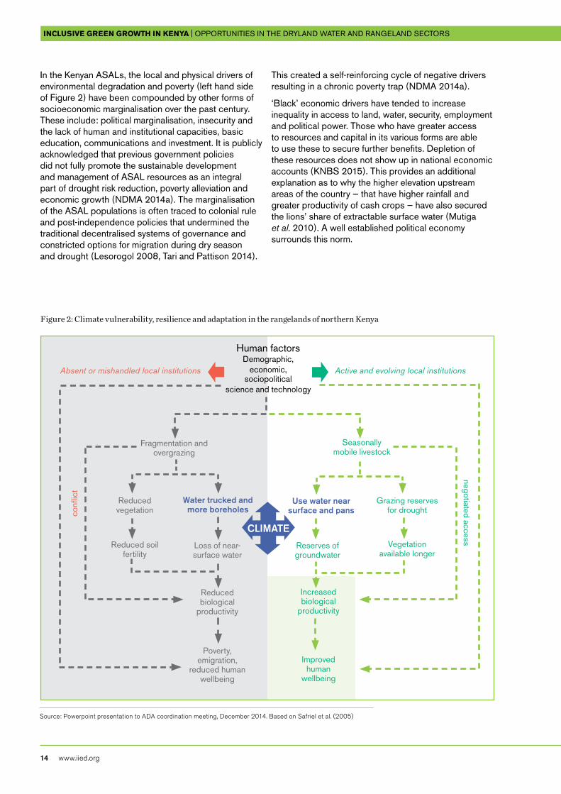
Over recent decades, climate variability has hit the ASALs’ rangeland and water sectors particularly hard. It has reduced the availability of forage during drought, increased the incidence of disease and lead to breakdowns in the marketing infrastructures, pushing many families into poverty (PDNA 2012). Where there is insufficient forage, overgrazing can contribute to reduced vegetative cover, loss of soil quality and land degradation (left hand side of Figure 2). Degradation can be compounded by the concentration of livestock around boreholes for long periods of time when no other water sources are available. Increasing constraints on
pastoralists’ mobility due to land fragmentation, lack of access to alternative grazing areas and fear of conflicts have driven and accelerated these problems in the ASALs over time.
However, many commentators on dryland development, in Kenya and elsewhere, have observed that communities can use their local knowledge and resource management skills to reverse the downward cycle of interacting drivers of negative change in the drylands (right hand side of Figure 2) (Safriel et al. 2005). Where pastoralists are able to practice traditional seasonal grazing strategies, they can ensure that their animals stay far from the permanent water sources during the wet seasons, using ephemeral water resources while they are available. This way, when the dry season comes, plenty of vegetation remains close to the riverbeds and boreholes (Chambers 1969, Herlocker 1993, Tari and Pattison 2014). Maintaining continual movement ensures that the herds do not ever graze too heavily in one place but consume just enough to stimulate regrowth. Human factors, social organisation, and cross-scale efforts driven from the community level play an important role in ensuring that these practices can be maintained (Venton et al. 2012).
Figure 1: Location and food status of the ASAL counties
Source: GoK (2015b)
InclusIve green growth In Kenya | OppOrtunities in the dryland water and rangeland sectOrs
14 www.iied.org
Figure 2: Climate vulnerability, resilience and adaptation in the rangelands of northern Kenya
In the Kenyan ASALs, the local and physical drivers of environmental degradation and poverty (left hand side of Figure 2) have been compounded by other forms of socioeconomic marginalisation over the past century. These include: political marginalisation, insecurity and the lack of human and institutional capacities, basic education, communications and investment. It is publicly acknowledged that previous government policies did not fully promote the sustainable development and management of ASAL resources as an integral part of drought risk reduction, poverty alleviation and economic growth (NDMA 2014a). The marginalisation of the ASAL populations is often traced to colonial rule and post-independence policies that undermined the traditional decentralised systems of governance and constricted options for migration during dry season and drought (Lesorogol 2008, Tari and Pattison 2014).
This created a self-reinforcing cycle of negative drivers resulting in a chronic poverty trap (NDMA 2014a).
‘Black’ economic drivers have tended to increase inequality in access to land, water, security, employment and political power. Those who have greater access to resources and capital in its various forms are able to use these to secure further benefits. Depletion of these resources does not show up in national economic accounts (KNBS 2015). This provides an additional explanation as to why the higher elevation upstream areas of the country — that have higher rainfall and greater productivity of cash crops — have also secured the lions’ share of extractable surface water (Mutiga et al. 2010). A well established political economy surrounds this norm.
Absent or mishandled local institutions Active and evolving local institutions
Seasonally mobile livestock
Grazing reserves for drought
Vegetation available longer
Reserves of groundwater
Improved human
wellbeing
Increased biological
productivity
Water trucked and more boreholes
Use water near surface and pans
Poverty, emigration,
reduced human wellbeing
Reduced biological
productivity
Loss of near-surface water
Fragmentation and overgrazing
Reduced vegetation
Reduced soil fertility
Human factorsDemographic,
economic, sociopolitical
science and technology
confl
ict
negotiated access
Source: Powerpoint presentation to ADA coordination meeting, December 2014. Based on Safriel et al. (2005)
CLIMATE
InclusIve green growth In Kenya | OppOrtunities in the dryland water and rangeland sectOrs iied issue paper
www.iied.org 15
Further compounding the problem of unequal resource access, dryland communities have, in some cases, been dissuaded from investing in resource stewardship measures for the scarce and variable resources that they have. It is discouraging for communities when outsiders can claim land, dig boreholes, burn trees, steal cattle or overgraze drought reserves without regard for locally established land management practices without reprise from the law, police and government officials. In the ASALs, these have been observed with the purchased assistance of individuals in positions of authority. Until devolution was introduced with the 2010 Constitution, local leaders without powers to ensure security, build prosperity or run viable institutions and businesses to employ and train the youth in the ASALs struggled to retain their confidence and respect. It takes time to shift attitudes, and it will take a concerted effort to overcome the residual effects of these institutionalised challenges, despite the encouraging policy changes.
After the introduction of the new constitution for Kenya in 2010, drivers of positive change in the ASALs have included growing political mobilisation of local leaders from the ASALs, public participation in democratic processes, the decentralisation of budgetary and administrative powers and new thinking about community resource management. Emerging policy and institutional arrangements at national and county levels have been designed to transform many of the relationships between the interconnecting drivers of change in the ASALs (NDMA 2014a).
ASAL communities now have a far stronger voice in local economic and environmental decision making, and in national government. CIDPs formulated for the ASAL county governments, outline strategies to integrate local economic development and environmental management. Some, such as the CIDP for Samburu, refer directly to objectives for achieving a green economy. The government has devolved budgetary control and funds to implement these plans to the county level. The CIDPs are publicly available via the internet, including those of Isiolo, Wajir, Garissa, Mandera, Samburu and Marsabit. Some of the county governments, such as Isiolo, are in the process of revising and improving their CIDPs.
Information and communication are critical drivers of change for the green economy, in the ASALs and elsewhere. In the past, if economic or other interests caused people or resources in a remote area to be misappropriated, stolen or damaged, this knowledge might never have reached the responsible authorities. In these cases, the only likely means of recourse would have been through local vigilantism or vendettas. It is now increasingly possible to monitor the environment and wellbeing of human populations at a relatively low cost. Societies can choose to do this to guard against the unacceptably higher costs of environmental and social degradation and insecurity. There is, therefore, less justification for damaging environmental and social externalities to accompany economic activities and wealth accumulation, even in the remote northern areas. But to ensure that pollution and other crimes will not pay, decisions still need to be taken, governance systems need to be informed and activated and people need to believe that they will function.
In theory, green economic planning in the ASALs can now be guided by an inclusive consideration of needs, priorities and resource conditions articulated from the community level in real time. But in practice, aligning the necessary economic incentives and community organisations to enable dryland resource stewards and users to drive the changes that they want to achieve still represents a challenge. Aspects of Kenya’s political economy that are emerging through the decentralisation process — such as political and economic stakeholder interests, power struggles between stakeholders and shared interest by economic and political elites — will inevitably continue to have implications for egalitarian reforms and the uneven balance and struggle between the black and green economies. Donors, including Danida, need to consider the need to build effective information and governance systems into green growth, in their intended engagement with partners from the public and private sector in the water and rangeland sectors.
InclusIve green growth In Kenya | OppOrtunities in the dryland water and rangeland sectOrs
16 www.iied.org
The water services sector: potential contributions to inclusive green growth
4
InclusIve green growth In Kenya | OppOrtunities in the dryland water and rangeland sectOrs iied issue paper
www.iied.org 17
4.1 Policy and institutional frameworks in the water sector and Danida support to WSTFSection 42 of the Constitution of Kenya (2010) accords every person the right to a clean and healthy environment. Section 43 (d) guarantees the right to clean and safe water in adequate quantities to every person.
The water sector is recognised as critical to the performance of other key sectors of the economy, including agriculture, livestock, energy, manufacturing and tourism. It includes the following subsectors: water resources, water services, land reclamation, water storage, flood control and regional development authorities (MEWNR 2015).
The National Water Master Plan (WRMA 2013b) provides a framework for water resource development and management consistent with the country’s social and economic development activities, as envisaged in Kenya Vision 2030. The constitution identifies county functions in water resource management, including environmental conservation, public works and services, firefighting and disaster management, health service provision and county planning and development. WRMA provides technical assistance and capacity building to the counties, and retains specific responsibilities for the provision of information on water resources and water bodies. It also regulates the development of water-related infrastructure, permits, environmental protection and disaster management.
The water service boards provide water services in Kenya. The Northern Water Services Board is a regional state corporation created under the Water Act 2002 to ensure availability of enough potable water and sanitation services for the people of the region through agents called water services providers.3 It covers seven arid and semiarid counties: Isiolo, Laikipia, Garissa, Mandera, Marsabit, Samburu and Wajir. They have a total area of approx 244,860km2, about 43 per cent of the whole country. In 2009, this area had a population of about 3.4 million people and over 4.5 million livestock. In 2014, the Northern Water Services Board was the only board not to register positive net increase in coverage. Its recorded –1.1 per cent net increase in coverage, despite increasing the extent of its service provision, is attributed to higher population growth (MEWNR 2015).
WRMA formally recognises less coverage of water resource user associations (WRUAs) in the ASAL portions of the catchments than in the less arid upper catchments (WRMA 2014b). For example, at the upper end of the Ewaso Ng’iro North catchment, where rainfall is relatively high, the Upper Ewaso Ngiro subregion covers an area of 4,167km2. This includes 21 subcatchments delineated by WRMA staff, 15 of which had WRUAs in place by 2014 (Njuguna et al. 2014). At the other extreme, in the lowest and most arid end of the catchment, the North Ewaso Laggas subregion contains 80 subcatchments delineated by WRMA staff across a total land area of 84,968km2 (WRMA 2014b). The digital elevation model used to develop the delineation in the middle and lower catchment areas had a lower resolution. This resulted in technical difficulties, and of the 80 identifiable subcatchments, only two (North Horr and Budha Hurri) had set up WRUAs.
The low level of WRUA coverage does not mean that there are no local institutions managing water supply in the ASALs. It means that the local institutions are not recognised and functioning within the WRMA and WSTF-supported system. For example, WRMA has identified only 16 WRUAs in the Middle Ewaso Ngiro subregion out of the 67 subcatchments in need of institutional structures, but there are well established customary institutions that manage both pasture and water in every rural neighbourhood in this area (Herlocker 1993, Tari and Pattison 2014).
Danida’s support for water interventions through the Ministry of Devolution and Planning (MDP) rather than through the Ministry of Environment and Natural Resources has provided an assurance that funds were dedicated to the ASALs and interventions were implemented by WSTF and WRMA in ways that were relevant for the ASALs. Ensuring further coverage of WSTF and the WRMA/WRUA models in the ASALs is a major step towards achieving more equal national development. Over the next five years, Danida’s support will be further complemented by additional support of €6 million from the EU, under delegated cooperation with Danida, for water and sanitation services for ASAL areas. Danida is contributing €2.137 million to this project, which will last four years. The project was expected to start during the Kenyan financial year 2014/15, but has been delayed.
InclusIve green growth In Kenya | OppOrtunities in the dryland water and rangeland sectOrs
18 www.iied.org
A proposed programme (G-GAP), anchored in the MDP’s Directorate of ASAL, was intended to focus on six counties. Proposed activities included Danida support to county government, WSTF and catchment-level planning to increase the economic uses of water to improve local livelihoods. Support to planning systems was to focus on inter-county planning and collaboration around shared resources and shared economic opportunities, including aquifers, grazing areas, areas that supply livestock markets and Lamu Port Southern Sudan-Ethiopia Transport Corridor project development opportunities. However, a Danida appraisal (Danida 2015a) advised to provide direct support to WSTF, with no coordination, leverage or inputs through the Directorate of ASAL.
WSTF was established under the Water Act 2002 as part of the reforms in the water sector (WSTF 2014c) to assist in financing the provision of water services to areas of Kenya that do not have adequate water services. WSTF is the Kenyan state corporation mandated to finance water and sanitation services for poor and underserved communities in rural and urban areas. The 2014 Water Bill proposed a revised legal framework, which is pending passage by the National Assembly. The Bill also proposed expanding the WSTF’s mandate to include provision of conditional and unconditional grants to counties. This is in addition to the ongoing mandate to assist in financing the development and management of water services in the marginalised areas or any areas which the Board of Trustees considers to be underserved.
Danida support to date through its MTAP programme has focused on encouraging WSTF to adapt its public/private service delivery methodologies to fit ASAL conditions (WSTF, undated). With Danida’s intended direct support, WSTF will now work with ASAL county governments, WRMA and subcatchment level WRUAs to support environmentally sound county planning, water investments and livelihood improvements. WSTF has been operating in six ASAL counties: Isiolo, Marsabit, Garissa, Wajir, Lamu, and Tana River. With enlarged support from Danida, it will be possible to add a further two counties: Turkana and Mandera.
Three programmes address water service needs in urban and rural contexts, and focus on water resource investments. The integration of the water resource assessment and service provision programmes is growing, and 15 subcatchment water resource management plans have already been produced. Under the intended green growth programme, water service infrastructure planning will be further integrated with resource assessment to ensure the ecological sustainability of water extractions. Catchment management plans are designed on the understanding that communities are most likely to maintain them where
they see the benefits of doing so in direct improvements to their livelihoods.
The proposed Green Growth and Employment Programme aims to support the WSTF in reaching out to underserved ASAL counties with community water and sanitation services provision and associated investments in water catchment area management. The programme will focus on community involvement and will provide capacity development in water planning and implementation to the counties and implementing agents. This support will impact positively on domestic and productive needs of ASAL communities, including the poorest segments. Water infrastructure will be climate-proofed and use green technologies when appropriate. Strategic water planning and provision will facilitate green growth opportunities specifically within the ASALs’ mobile livestock sector.
4.2 Available water service and sector data and facts relevant to green growth WRMA collects and houses information about water resource conditions and economic uses in the major ASAL catchments. The availability and use of this information is essential to ensure that planned development of water services does not threaten its long-term sustainability or reduce access for the poorest and most vulnerable water users in the ASALs. Annual water resource situation reports are availed to the county governments (MEWNR 2015). This information reporting also requires the counties to input, but the arid counties were unable to do so during the most recent reporting cycle. This may have been due to capacity challenges, institutional disconnects or some combination of both factors. WRMA also disseminates information — for example, on river basins and aquifers — through catchment forums, of which county governments that share common water bodies are members (MEWNR 2015). This enables harmonious resource management and a joint development approach in the CIDPs of counties that share resources.
Water supply in the ASALs involves the direct use of a variety of water sources, including:
• natural sources, such as rivers, streams and springs
• developed surface water, such as earth dams, sand/subsurface dams, tanks and pans
• developed groundwater, such as wells, shallow wells and boreholes
• water vendors, and
• emergency water supplied by the government using tankers.
InclusIve green growth In Kenya | OppOrtunities in the dryland water and rangeland sectOrs iied issue paper
www.iied.org 19
The numbers of households with piped water supplies vary among the counties (see Appendix Table A3:1). In some counties, such as Marsabit and Mandera, more than 50 per cent of the population do not have a household water supply, and rely on water vendors. While coverage of piped water supplies is often good in urban areas, rural households are usually less well served. Mobile people who cannot have a household water supply do not appear in household statistics (see Box 1). The population is growing rapidly in all the ASAL counties, presenting a challenge to improve water service levels (KNBS 2009).
For catchment planning purposes, WRMA has assessed water balance projections (GoK 2012a). In the Rift Valley and Tana catchments, the overall water balance is not yet considered to be critical (WRG 2015, WRMA 2015a and 2015b). In Rift Valley, annual renewable water resources were identified at 2,559 million cubic metres (MCM) in 2010, projected to increase to 4,171 MCM by 2030. Rift Valley’s estimated water demand for 2010 was 357 MCM. Overall demand is anticipated to increase five times by 2030, and groundwater abstraction is set to double by 2030 (WRMA 2013c). On top of this, mineral extraction is expected to contribute directly to future water demand and to increase population numbers in the Rift Valley
catchment beyond the linear growth estimates that have so far been used for water demand prediction. On the other hand, water availability estimates in the Rift Valley catchment do not yet include a recently completed groundwater survey in northern and central Turkana, (MEWNR 2015, RTI 2013). The new water sources will reduce the challenge of water scarcity, but the problem of infrastructure for water service provision remains.
The Ewaso Ng’iro North Catchment (ENNCA) is the most stressed of the three major ASAL catchments. The projected available water resources volume for ENNCA was estimated at 2,251 MCM a year, rising to 3,011 MCM by 2030 (WRMA 2014a). Demand in 2010 was 212 MCM, which is projected to increase to 2,857 MCM by 2030. This is driven partly by population increase, but mainly by the planned 20-fold increase in irrigated acreage. This irrigation is mostly in the less arid upper catchment; as it expands, it is expected to leave less water for downstream water demands in the ASAL areas.
In the more arid downstream areas of all of the ASAL catchments, little surface water is available during most of the year, and populations are more dependent on groundwater resources. In order to increase water service levels, it is likely that the degree of reliance on groundwater will increase further, since most available
Box 1: WATER SERvICES In ISIoLo CoUnTyForty two per cent of households in Isiolo county have access to potable water (GoK 2013c). However, only six per cent of these are connected to piped water supplies and sewerage lines; they are all in Isiolo Town. Seepage from pit latrines (used by 81 per cent of households) creates a serious environmental problem and inspection is needed to ensure people adhere to regulations for a safe distance between shallow wells and pit latrines. A range of different classification systems and definitions for access to water supplies may explain the apparent divergence between these figures and those available from www.majidata.go.ke (see Appendix Table A3:1).
In rural areas, water service coverage remains a challenge. WRMA estimates that about 93 per cent of the county lacks access to safe and clean water within 5km reach (WRMA 2013a). Over 175 villages (73 per cent) rely on water sources that are unsafe and more than 5km away. Some villages are 25km from the nearest safe water source. The maximum distance cattle can walk without stress is 10km, yet 74 per cent of pastoralists in the county walk more than 15km to the nearest water source for livestock
use (GoK 2013h). This includes 85 per cent of people in the former districts of Isiolo, Merti, Garbatulla and Samburu East, who are believed to rely on groundwater for their needs.
For rural populations, and particularly those who are mobile, compiling facts about water sources is a challenge. It is important to bear in mind that water sources in the rangelands are seasonal and their productive capacities vary depending on recent rainfall and local management conditions. Water pans will provide water for an indefinite time after the rains (perhaps two months or more) depending on their storage capacity, the volume of water collected, the rate of use and the degree to which water quality is conserved. A participatory mapping exercise with local resource users in 2013 recorded 249 seasonal and permanent water sources known to the local communities in the grazing areas of Cherab, Chari, Sericho, Garbatula and Kinna in Isiolo’s rural wards (GEODATA, forthcoming). This method identified twice as many water pans and sand dams than were recorded through field surveys by WRMA (2013a) (Appendix Table A3.2).
InclusIve green growth In Kenya | OppOrtunities in the dryland water and rangeland sectOrs
20 www.iied.org
surface water supplies are already in use. A study of the groundwater balance around Isiolo County identifies sizeable uncertainties regarding the available volumes of groundwater, the annual recharge rate and the safe yield for planning purposes (WRMA 2013a).
The same study assessed the present and future balance of water available in the Merti and Modogashe aquifer systems, but could not factor in any future increases in per capita demand for water for institutional or industrial uses (WRMA 2013a). See Appendix Table A3:4. This would be difficult to correct because, although the ASAL county governments intend to increase industrial activities and other businesses that would add to water demands, they have not generated estimates of future numbers of such water users. If these were available, water resource planners could multiply them by the standard estimates for volumetric demands, as have been developed for non-ASAL areas (WRMA 2009) or develop more precise estimates for volumes needed in the ASALs.
Future water demand projections used by WRMA and the World Bank are based on the socioeconomic frameworks set in Kenya’s Vision 2030 (WRG 2015). The estimates and projections assume that water users in arid areas will receive lower per capita water supply than the rest of the country (WRMA 2013c) and do not factor in an accelerated growth of industry and commercial water use in the ASALs (GoK/WRMA/JICA 2012). Even using the lower demand rates for projections for arid areas, the water deficit ratios in the Rift Valley, Ewaso Ng’iro North and Tana catchments are expected to increase faster than those in less arid areas (WRMA 2013c) (See Appendix Table A3:3). Nevertheless, current institutional efforts still prioritise the water management needs of the less arid catchments, or find these more straightforward to address (WRMA 2013b).
Although WSTF staff are aware of the need to assess economic water use in the ASALs, only one study has touched on this issue to date (WRG 2015). This brief synthesis of findings recommends further prioritisation of investments in water resource management in non-ASAL catchments. Generating improved estimations of the volumes and economic returns on different present and potential future water uses in the ASALs would require dedicated studies to be conducted in the ASALs and/or a comparison with water use patterns in arid regions of other countries.
Two reports have identified reduced household expenditures on water (enabling more spending on other items) and reduced distances to water (enabling more time for economic activities) as measures to capture the contributions of improved water services to the economy in general, and to the poor in particular (WSTF
2014b and 2015). Further information on household budgets in different parts of the country is available from the Kenya Integrated Household Budget Survey (KNBS 2006). The last survey was completed a decade ago, and a new survey is now underway (Otuki 2014, Khainga 2015). Once available, this information could enable further analysis of the effects on household spending patterns. It would also be possible to estimate economic losses caused by a lack of sanitation in terms of the costs of lost productivity due to disease and loss of life (Hutton 2015).
WSTF has systematically tracked and reported the number of people in the ASALs using water service infrastructure provided with Danida’s support, and the number of households moving from one service level to another (WSTF 2013b, 2014d and 2015). WSTF has previously identified the quantifiable impact of its projects on the local economy by counting the value of locally procured and used resources, such as cedar posts, cement, sand, gabion materials and local labour and contractors (WSTF 2014b).
WSTF also tracks the numbers of staff it employs directly in its annual reporting. It could therefore be possible to identify the number of staff employed in the ASALs by WSTF, WRMA and WRUAs, but counting the number of jobs created in private enterprises would be more challenging. WSTF has previously been able to report improved economic empowerment through the introduction of MTAP projects to communities where community-based organisations are able to generate income from selling water to users (WSTF 2015). This income covers maintenance costs and services provided by professional service providers.
4.3 Analysis of opportunities, challenges, risks and solutions that may be piloted through WSTFOpportunitiesWith support from Danida and other donors, WSTF has already developed an approach to water infrastructure planning based on SCMPs to conserve water and ecosystem conditions (see, for example, WRUA 2013, WSTF undated), and has created 15 plans in the ASAL counties with Danida support (See Appendix 2). Other donors have supported additional SCMPs in the ASALs (IUCN and FaIDA 2012). The SCMPs include, among other things, interventions to manage groundwater recharge processes and source protection areas. This creates a basis for management to ensure that water extraction for economic uses does not threaten resource
InclusIve green growth In Kenya | OppOrtunities in the dryland water and rangeland sectOrs iied issue paper
www.iied.org 21
sustainability and lead to environmental degradation. Water accounting at both catchment and subcatchment levels could enable effective management of scarce water resources in the ASALs, and possibly help identify areas where there could be a case for the more equitable distribution of surface water between upstream (non-ASAL) and downstream (ASAL) areas.
Due to the low level of water service provision in Kenya, the poor often have to pay for water services that are inadequate, unsafe and unsustainable (see Appendix Table A3:1). Providing and managing cheaper and/or better water services creates jobs and local business opportunities for water resource engineers, plumbers, hardware providers, transporters, energy providers and others. Some of these opportunities are accessible to the poor, while practical training and trade associations could make others more accessible. Providing practical training is already an important part of WSTF’s work. This could be further expanded and connected to more vocational opportunities. The availability of water itself also creates economic opportunities and removes obstacles — for example, without water, it is difficult to hygienically prepare milk containers and food, wash laundry, run some small businesses, and it makes it harder for girls to attend school. WSTF’s kiosks and fishponds create additional opportunities, and access to water offers up many other enterprise opportunities with relatively little capital outlay, such as barber’s shops, butcher’s shops, car washes or greenhouses.
WSTF has already identified a range of technological solutions that could be further adapted to contribute to green growth objectives in the context of the ASALs. For example, using mobile technologies could enable communities, including those in remote areas, to take on a greater role in the oversight and quality control of water service provision and resource monitoring. WSTF has also identified solar powered pumping technologies as an innovative green technology that can make water management less costly and more reliable for poor communities in remote arid areas, where access to diesel for water pumps is difficult. Water productivity in fodder and other crop production can often be more effectively enhanced by applying nutrients rather than increasing water use. WSTF has identified sanitation systems as a means to provide nutrients to achieve this purpose and has promoted this technology through WRMA and WRUAs. Promoting local technological innovation and entrepreneurship in the ASALs could either be a side-effect of further WSTF exploration of the potential of these technologies, or more explicitly targeted and monitored.
The draft GESIP seeks to improve the adoption of appropriate technologies in the purification, desalination, monitoring, distribution and use of water resources (GoK 2015a) and to promote technologies for water recycling. This will improve water use efficiency and reduce stress on natural surface and groundwater storage. The potential for reuse of domestic water or water from mosques for small-scale irrigation is relatively unexplored in the Kenyan ASALs because domestic water has usually been scarce. WSTF has not previously considered this option. Depending on design and innovation capacities, the installation of improved domestic water supplies could be accompanied by reuse for additional economic and/or environmental and aesthetic opportunities for greening. WMRA has highlighted groundwater recharge as an additional technological approach with the potential to reduce stress on water storage. WRMA staff are keen to explore deep injection techniques which are so far untried in Kenya. Other techniques for enhancing recharge, such as water spreading and conservation of vegetation, can involve communities and bring immediate greening and economic benefits.
Challenges/constraints (economic and technical)Engaging stakeholders (handled through WRMA and WRUAs): Providing basic water and sanitation-related services to vulnerable communities in the ASALs requires consultation and consideration of the needs of people in remote areas, including those without fixed dwellings. The quality and relevance of the WRUA plans can only be as good as the level of participation achieved in developing them. WSTF staff recognise that involving women in water resource planning decisions in the ASALs is a particular challenge. WRUA plans are currently available within WSTF, but are not publicly displayed on a website, where they could be viewed and critiqued by members of the public and/or scientific and technical communities.
Working with service providers (to be handled through county governments): There are many capacity-related challenges at community level for procuring, operating and maintaining water infrastructure. In a service provision trust fund with a large geographical scope and a small centralised staff, concerns relating to procurement, quality control and value for money are an inherent challenge. In the past, WSTF has worked through community organisations to provide services, but it now intends that the county governments should designate professional service-providing institutions
InclusIve green growth In Kenya | OppOrtunities in the dryland water and rangeland sectOrs
22 www.iied.org
that could more effectively provide the services the communities need. WSTF faces communication and coordination challenges at county level. MTAP has put staff in place in county governments to work with WSTF, an arrangement that will come to an end when MTAP closes in 2016. The EU SHARE project is expected to enable WSTF to have its own staff at county level in future.
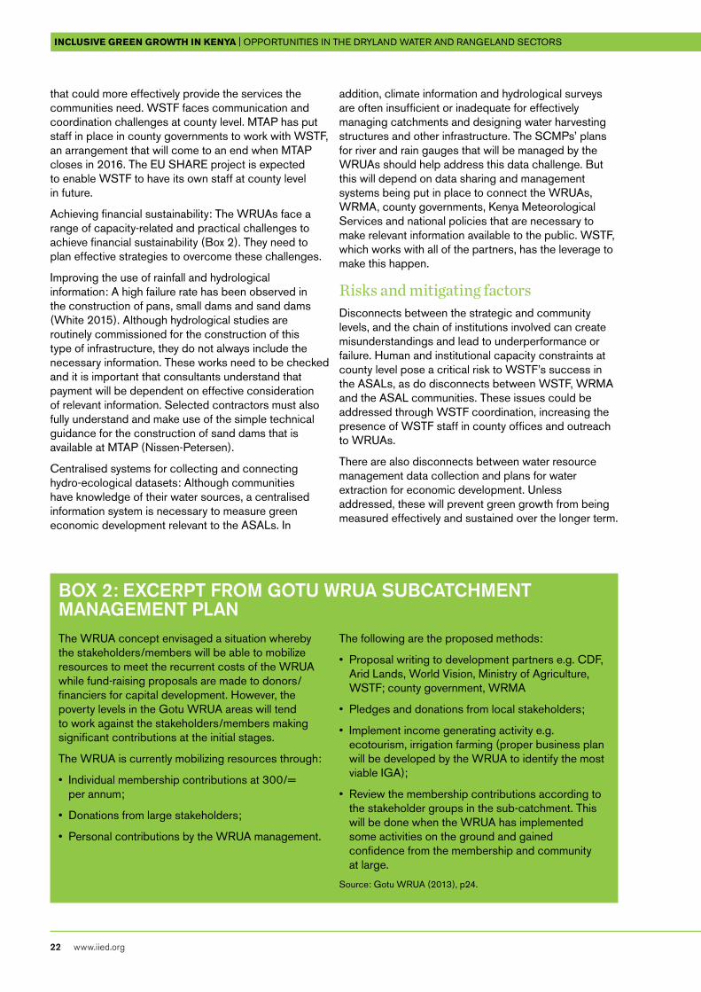
Achieving financial sustainability: The WRUAs face a range of capacity-related and practical challenges to achieve financial sustainability (Box 2). They need to plan effective strategies to overcome these challenges.
Improving the use of rainfall and hydrological information: A high failure rate has been observed in the construction of pans, small dams and sand dams (White 2015). Although hydrological studies are routinely commissioned for the construction of this type of infrastructure, they do not always include the necessary information. These works need to be checked and it is important that consultants understand that payment will be dependent on effective consideration of relevant information. Selected contractors must also fully understand and make use of the simple technical guidance for the construction of sand dams that is available at MTAP (Nissen-Petersen).
Centralised systems for collecting and connecting hydro-ecological datasets: Although communities have knowledge of their water sources, a centralised information system is necessary to measure green economic development relevant to the ASALs. In
addition, climate information and hydrological surveys are often insufficient or inadequate for effectively managing catchments and designing water harvesting structures and other infrastructure. The SCMPs’ plans for river and rain gauges that will be managed by the WRUAs should help address this data challenge. But this will depend on data sharing and management systems being put in place to connect the WRUAs, WRMA, county governments, Kenya Meteorological Services and national policies that are necessary to make relevant information available to the public. WSTF, which works with all of the partners, has the leverage to make this happen.
Risks and mitigating factorsDisconnects between the strategic and community levels, and the chain of institutions involved can create misunderstandings and lead to underperformance or failure. Human and institutional capacity constraints at county level pose a critical risk to WSTF’s success in the ASALs, as do disconnects between WSTF, WRMA and the ASAL communities. These issues could be addressed through WSTF coordination, increasing the presence of WSTF staff in county offices and outreach to WRUAs.
There are also disconnects between water resource management data collection and plans for water extraction for economic development. Unless addressed, these will prevent green growth from being measured effectively and sustained over the longer term.
Box 2: ExCERpT fRoM GoTU WRUA SUBCATChMEnT MAnAGEMEnT pLAn The WRUA concept envisaged a situation whereby the stakeholders/members will be able to mobilize resources to meet the recurrent costs of the WRUA while fund-raising proposals are made to donors/financiers for capital development. However, the poverty levels in the Gotu WRUA areas will tend to work against the stakeholders/members making significant contributions at the initial stages.
The WRUA is currently mobilizing resources through:
• Individual membership contributions at 300/= per annum;
• Donations from large stakeholders;
• Personal contributions by the WRUA management.
The following are the proposed methods:
• Proposal writing to development partners e.g. CDF, Arid Lands, World Vision, Ministry of Agriculture, WSTF; county government, WRMA
• Pledges and donations from local stakeholders;
• Implement income generating activity e.g. ecotourism, irrigation farming (proper business plan will be developed by the WRUA to identify the most viable IGA);
• Review the membership contributions according to the stakeholder groups in the sub-catchment. This will be done when the WRUA has implemented some activities on the ground and gained confidence from the membership and community at large.
Source: Gotu WRUA (2013), p24.
InclusIve green growth In Kenya | OppOrtunities in the dryland water and rangeland sectOrs iied issue paper
www.iied.org 23
Ecological risks include depletion of water resources, over-pumping of aquifers and degradation of water catchments and storage.
As economic activity increases across the ASALs, it brings new road infrastructure, petrol stations, waste disposal sites, mining and industrial activities. With all this development, new contamination threats will also emerge. WSTF could mitigate these risks by supporting improved systems for periodic data collection, compilation and reporting from the WRUAs and WRMA to the county governments and National Bureau of Statistics, either through existing channels (such as MEWNR 2015), or new ones.
Strategic choices, solutions and international best practices that may be piloted through WSTFWe have highlighted the role of the black economy in driving unequal surface water allocations, to the disadvantage of the ASAL communities. A greener economy could redress this balance, through the following solutions.
Measures of green economic growth should take water footprints into account. This would require effective use of water accounting (see examples of international best practice in: Molden and Sakthivadivel 1999, UN 2014). Water accounting, together with future demand and supply scenarios, is also critical to assess the capacity of available water resources to support new economic activities. WRMA and county authorities need to take strategic decisions about the generation of these data and scenarios and for a method for producing, storing and updating them, as well as incorporating them into county planning and budgets. WSTF could support WRMA and the counties in this, and allocate funds to ensure it gets done. The WRUA SCMPs provide a practical way to support and update water accounting, if appropriate coordination and data management systems can be ensured.
Where data needs simply require systematising the collection of available information, some of this could be built into the Danida-supported WSTF programme monitoring system. Information already routinely collected by WSTF could be supplemented with information to be generated in future by the WRUAs, WRMA and service providers on water availability and extractions, employment, procurement and service provision. Where strategic data gaps require the design of more extensive activities, these could not be included in the M&E plan unless the programme can support the necessary studies. For example, investigations of the economic impacts of water and sanitation services on household income generation would require participatory action research with water users.
In some cases, decisions will need to be made about how precise indicators of interest need to be for WSTF’s M&E purposes. For example, available estimates for groundwater storage and recharge volumes could enable approximated annual assessments of the water balance at subcatchment and catchment levels based on rainfall and available knowledge of surface and subsurface conditions. But further refinement of estimates and a detailed analysis of localised factors would always be desirable (WRMA 2013a). The level of precision required would determine the extent of dedicated activities to be designed to supplement routine monitoring. This would also determine the support needed for WRMA and WRUAs to undertake these activities.
Water accounting is important to offset economic growth and income generation. It can also be weighed against other environmental considerations of interest to the national GESIP (GoK 2015a) such as energy use, emissions and carbon sequestration. This more holistic consideration of water accounts is important because investments in water saving — for example, by installing drip irrigation and pump-dependent storage systems — tend to involve a tradeoff in which increased energy use enables a reduction in water losses (Hoff 2011, King and Jaafar 2015). Add to this the emphasis GESIP places on emissions accounting, and exploring the emissions WTSF incurs during infrastructure and service delivery becomes desirable. This would enable WSTF to quantify reductions that are due to an increased use of solar-powered technologies. The UN Framework Convention on Climate Change (UNFCCC) provides international best practices concerning emissions inventory. Kenya’s forthcoming 2nd national communication to the UNFCCC is expected provide further information on the national emissions inventory.
Stimulating pro-poor enterprise and innovation in the water sector are not among the WSTF’s current objectives, so the organisation does not systematically record the extent to which its operations do either. The design of the new programme could include a focus on what services are to be delivered to whom and by who. In other words, it could focus on how many jobs are created (with numbers disaggregated by age and gender) and how many small businesses are contracted. WSTF could work with and/or set up local trades associations and registers of water sector service professionals.4
Technical specifications and innovations could be disseminated to encourage independent local replication. Programmes that focus on stimulating technological development and innovation often fail to engage and create opportunities for women, but WSTF could overcome some of these gender barriers by focusing on domestic water and sanitation technologies that are used in and around the home.

InclusIve green growth In Kenya | OppOrtunities in the dryland water and rangeland sectOrs
24 www.iied.org
Another important area of technological development for the ASALs concerns the design of infrastructure for communal human and livestock use in rangeland areas, such as pans and sand dams. International best practice in the design and documentation of these systems is available (WOCAT 2013).
WSTF could commission studies to target key knowledge gaps for green water service provision, including studies of present and future water demands for commercial and industrial activities — such as abattoirs, hotels, mining operations, motor vehicle servicing — to be implemented with the ASAL county planning departments. It could also commission studies on technologies of interest such as waste water reuse5 and ground water recharge. WRMA could work with WRUA members and university students to refine the available understanding of current recharge areas, processes and volumes and analyse the economic feasibility and sustainability of increasing recharge rates through a range of different approaches. International best practices would include work by researchers at the Tunisian Institut des Regions Arides (Ouessar et al. 2009, WOCAT 2013).
WSTF supports capacity building activities for communities and WRUAs so they can operate and maintain their own water systems. A strategic decision could be taken to extend the scope of this training to include marketable professional skills in service provision, hardware and construction, developing
reference guides and encouraging trades associations. Hiring trainers who developed their skills and experience through successful interventions to could provide a means to reward management, and launch new vocations and businesses.
Ward adaptation planning committees (as described in NDMA 2014c) have been established in Isiolo and are under development in Wajir, Garissa, Kitui and Makueni. These provide local systems to prioritise community water needs, procurement and monitoring. WSTF could ensure that WRMA and the WRUAs engage the committees. These have set up (or are in the process of setting up) effective channels for procuring services such as pans and boreholes in rangeland areas. Where counties have prepared their own plans for their water needs and priorities, WSTF could fund them. WSTF could also encourage counties that do not yet have such plans to consult with the WRUAs and neighbouring counties within their subcatchments to prepare them.
Where county planners and non-governmental organisation (NGO) staff have been trained in the use of Open Street Map for participatory resource mapping (Hill et al. 2014), WSTF could encourage WRMA and the WRUAs to work with them to improve and maintain the inventory of water supply and sanitation infrastructure in the SCMPs and catchment management plans.6 Such trainings could also be offered to WRUA committee members or their selected nominees.
InclusIve green growth In Kenya | OppOrtunities in the dryland water and rangeland sectOrs iied issue paper
www.iied.org 25
Rangeland and livestock enterprise sectors: potential contributions to inclusive green growth
5
InclusIve green growth In Kenya | OppOrtunities in the dryland water and rangeland sectOrs
26 www.iied.org
5.1 Policy and institutional frameworks in the rangeland sector and Danida support to NRTMuch of the land in northern Kenya is under traditional community ownership (GoK 2012b). Land registration is considered to play an important role in enabling economic development and investment (IBRD/IFC 2012). For pastoralists, land gazettement and fragmentation causes problems because different areas of rangeland are important at certain times of the year; some are reserved for periods of drought stress (GoK 2012b). Since they are left empty at other times, to outsiders they may appear unused and ripe for alternative forms of production and investment. In fact, they are usually growing and conserving stocks of vegetation for use during drought periods.
The National Land Policy includes provisions that are relevant to securing pastoral community land rights (GoK 2007: Para 183, GoK 2009). This includes flexible cross-boundary access to protected areas, water, pastures and salt lick. These can be negotiated among different stakeholders for mutual benefit. The government has enacted three further pieces of legislation — the Land Act, the Land Registration Act and the National Land Commission Act. A draft Community Land Bill is also close to enactment; it will recognise communities’ customary land rights, but requires every community with an interest in community land to identify the extent of the land within two years of the date of start of the Act. It also requires communities to set up a committee to facilitate the registration of the community land and manage the land in accordance with the Act.
The draft Bill expands the definition of community land to include livestock passage routes and cattle dips, and makes provisions on how pastoral communities will manage grazing rights, including through temporal and spatial planning of access. It also describes provisions for converting community land into private land or for investments to be put up in areas of community land (GoK 2014a and 2014b).
The government drafted a strategy, policy and Bill on land reclamation in 2013, but this remains a draft (GoK 2013a, MEWNR 2015). A national land degradation assessment is reported to have identified degraded areas and trends (MEWNR 2015). This was accompanied by a capacity needs assessment in 18 ASAL counties and the reclamation of 1,227ha
in Turkana, Garissa, West Pokot, Taita Taveta and Keiyo Marakwet.
Conservation and natural resource management concerns have exercised a strong influence on successive generations of legislation around communal lands in Kenya. A 1989 amendment to the Wildlife Conservation and Management Act established modalities for community partnership and revenue-sharing arrangements. These provide direct payments and development funds to pastoralist communities living next to national parks and reserves to promote wildlife conservation on community-owned lands. This encouraged conservationists to search for ways in which wildlife could pay for itself so that benefits generated from wildlife use would increase community support for conservation (IIED 1994, Parkinson 2012). The Wildlife Conservation and Management Act 2013 legally recognised community conservancies and increased penalties for poachers.
Community conservancies need long-term logistical, financial and security support, exposure to government and donors and standards of governance and fiscal responsibility. The Lewa Wildlife Conservancy’s outreach programme helped neighbouring communities to develop community-based conservancies, including the Il Ng’wesi and Namunyak Wildlife Conservation Trust (NRT 2013). However, Lewa is a private game sanctuary. It became apparent that an independent trust would be better placed to mobilise donor support, provide technical assistance and meet the knowledge demands of the increasing number of communities (Glew et al. 2010, NRT 2013).
NRT was established in 2004 as a member-based umbrella organisation for community conservancies to take over the work begun by Lewa (NRT 2013). NRT is a trust and operates as a non-profit, with a for-profit arm. Its strength is its ability to work with community conservancies, helping them set up self-sustaining enterprises in the private sector. Its mission is to develop resilient community conservancies which transform people’s lives, secure peace and conserve natural resources (NRT 2012 and 2015a). The communities own and run the conservancies. NRT does not take away ownership and/or management from the communities: its role is to offer technical support, liaise with donors and transfer funds to the conservancies or spend them on their behalf to support staff salaries, equipment, community outreach, capacity building, and so on.
NRT has powerful connections within the private sector, certain parts of the government and international business community. It uses these to reshape environmental and social responsibility and
InclusIve green growth In Kenya | OppOrtunities in the dryland water and rangeland sectOrs iied issue paper
www.iied.org 27
create new economic opportunities for resource-dependent communities. Due to its large network of conservancies, NRT is well placed to facilitate improved understanding of rangeland health and productivity. Its comparative advantage as a development partner for ASAL communities lies in its national and international promotional and outreach capacities.
The 27 NRT conservancies that had been established by 2013 covered an area of nearly 32,000 km2,
employed over 1,000 people and served communities with a population of more than 200,000 people in seven counties: Samburu, Isiolo, Marsabit, Laikipia, Tana, Garissa and Baringo (NRT 2015c). Following the addition of a further six to be supported by Tullow Oil, NRT currently has 33 member conservancies, with more requesting to join (Harrison 2015). NRT has explored opportunities for Danida to support five NRT conservancies in the western parts of Isiolo, close to Samburu (MTAP unpublished, undated). In other parts of Isiolo, where customary institutions are stronger, the NRT conservancy model has not attracted local support due to concerns about the level of power and control likely to be exercised over the management of the land by NRT.
The Board of NRT is not elected. The NRT Council of Elders instead appoints Board members from political and community leaders, business professionals and conservation practitioners. The Council of Elders is comprised of up to 30 appointed members who are conservancy board chairpeople, representatives from county councils, Kenya Wildlife Service (KWS), the police, and local (private) conservation organisations including Lewa Conservancy, Laikipia Wildlife Forum, Ol Pageta and Borana. The council’s main role is to ensure that NRT use a management approach that equitably distributes the benefits from conservation initiatives. The organisation works in partnership with KWS, NGOs and community-based organisations to address the challenges facing landowners in the ASALs by optimising the value of their resources, including wildlife and livestock. Documentation of conservancy decision-making procedures and annual meetings is not publicly available.
The conservancies’ vision is to build resilient communities that are better able to cope with an uncertain future of drought, economic shock and political change. It does this by strengthening governance and social development, diversifying economies, improving water, rangeland and wildlife management, and building peace and security (NRT 2012).
Danida has previously supported NRT through the Fast Start Climate Change Programme, which helps pastoralist communities build resilience to climate change. NRT has approached this through holistic rangeland management (Savory 1983, 1991, 2011, Savory and Butterfield 1998). Conservancies have often set up ‘no-take’ or core areas for wildlife conservation but over time, and through discussion among local community members, strategies for grazing and land management at the different conservancies are evolving.
Early on, the conservancies were small, and involved designated core and buffer areas. But this model has evolved to include conservancies covering a larger spatial extent, including settlements as well as grazing areas. Within these areas, it is no longer possible to know how much land has been placed off limits to local communities or outside users. NRT has recently established a geographical information systems unit, but detailed maps of conservancy land management arrangements are not yet available.
Although there is a widely held perception that NRT was created primarily to ensure that the private conservancies had game animals, this is not the objective that is now stated in NRTs strategic plans (NRT 2012 and 2015a). In the early days, NRT was supported by the conservation community and international donors with an interest in wildlife conservation. But it is now increasingly supported by bilateral donors through funds intended for development assistance. This has introduced new and different priorities and staff capacities within the institution.
Danida’s Green Growth and Employment Programme supports the mission and vision of the NRT Strategic Plan (2012–2017) with the objective that “Resilience to climate change in pastoral communities in the arid lands of Northern Kenya is enhanced.” Danida has expressed interest in partnering with NRT on a more strategic, rather than project-oriented, basis for 2017–23.
5.2 Available livestock sector and rangeland service data and facts relevant to green growthA national assessment of scope for a green economy by the Kenyan Institute for Public Policy Analysis (KIPPRA) focused on policy simulations to illustrate what this could entail (UNEP 2014). The assessment explored how water and land use investments can mitigate the impact of climate change on productivity, promote soil cover, accumulate organic matter in the
InclusIve green growth In Kenya | OppOrtunities in the dryland water and rangeland sectOrs
28 www.iied.org
soil, ensure good-quality forage, reduce wood and fuel burning, and boost yields relative to the business-as-usual case, improving nutrition and food security as a result. But there is still a need for a solid evidence base on productivity in the pastoral rangelands to support greater recognition of the reality and potential of green growth (McGahey et al. 2014). This should encompass the livestock enterprise value chain from field to fork and inclusive benefits for the human population.
Although pastoralists make ongoing practical observations of rangeland conditions, documented data on rangeland health and productivity are difficult to obtain. The land degradation assessment described in the previous section (after MEWNR 2015) is not publicly available. It may have been developed by the Department of Resource Survey and Remote Sensing, which has an official mandate to collect geospatial data/information on most natural resources in Kenya to monitor changes over time. The only published assessment of land productivity and degradation levels described in the draft land degradation policy is almost a decade old (Bai and Dent 2006).
The only information on vegetation conditions in the conservancies the NRT has published is an assessment stating that 70 per cent of rangelands in its conservancies are highly degraded, over 50 per cent are heavily eroded and soil carbon stocks are critically low in 40 per cent of conservancies (NRT 2015c). These observations are based on NRT-commissioned studies of vegetation cover and soil depth written by external experts (Ritchie 2015, Vågen and Winowiecki 2014) rather than the rangeland users. Potential for comparison of vegetation conditions at some of NRTs conservancies to ‘unimproved’ areas has previously been explored (Glew et al. 2010).
The LEWS database, developed by researchers at the University of Texas 1999–2010 contained data from more than 350 forage monitoring sites that were established across East Africa. The database, which is no longer accessible, provided time-series information on biomass productivity generated from a simulation model called the phytomass growth model, based on satellite weather and normalised difference vegetation index (NDVI), ground information on soils, plants and grazing rules (Angerer et al. 2001, Bedunah and Angerer 2012).7 A number of these sites were located close to the NRT conservancies — for example, at Namunyak.
Generic conversion factors for the transformation of kilograms of biomass produced under each hectare of the various ASAL vegetation types into livestock products (meat and milk) are available (Herlocker 1993). Researchers from the University of Nairobi’s
Department of Land Resource Management and Agricultural Technology are carrying out participatory action research to refine understanding of the nutritional value of vegetation types in Isiolo.8 Similar research to explore the rates of conversion from biomass to meat and milk, and to increase their efficiency could be undertaken with the grazing committees at the conservancies. NRT has been working to set up a system for monitoring the rangelands, but no information is yet available. This system will be based on methods for monitoring rangeland health, as recommended by range scientists from the US (Riginos et al. 2010)
The National Drought Management Authority (NDMA) monitors a vegetation condition index (VCI) for all counties in northern Kenya on a monthly basis, but does not monitor vegetation conditions on the ground.9 The VCI is based on the relative change in the remotely sensed NDVI when compared to an archive including values for each week of previous years. The NDMA takes an average value across each county, compares it to previous three-monthly averages, and uses this to classify the severity of drought conditions. The VCI analysis is complemented by a standard precipitation index, based on satellite data due to the lack of meteorological stations on the ground. These datasets are compared to household survey data on livestock body condition, milk production, child nutrition, terms of trade and other socioeconomic conditions at a series of sentinel sites across the ASALs. This enables observation of the effects of changing vegetation conditions on livestock, milk production and household nutrition throughout the year and between years. Further information on child and adult nutrition and health across Kenya and localised surveys are available (such as KNBS 2014, IMC and ACF 2014, Nzioka and Awino 2013).
Livestock census data and market prices have previously been used to assess the economic benefits to society of live animal and milk production in the pastoral rangelands (Behnke and Muthami 2011). Livestock production and its local value chains generate jobs and income (formal and informal) in herding, fattening, feed supplement collection, veterinary care, collection, trading, transportation, security, butchering and hotel and restaurant sales (Alexovich et al. 2012, Hesse and MacGregor 2006). These are not yet fully documented and are often informal. Livestock production generates revenues for local authorities from marketing and slaughtering fees and various local and national government departments. Relevant information is available from the Kenya Livestock Marketing Council, District Livestock Marketing Council, various district offices (veterinary, livestock production and livestock
InclusIve green growth In Kenya | OppOrtunities in the dryland water and rangeland sectOrs iied issue paper
www.iied.org 29
marketing), County Revenue Offices and the County Licensing Offices (Chiara 2014).
NRT keeps internal records of the numbers and value of livestock purchased from each of the conservancies each year through its Program on Linking Livestock Markets to Wildlife Conservation. It can use these to calculate the funds it contributes to public revenues through cess, veterinary fees, movement permits, and so on (Ekodere 2015). But because alternative livestock value chains are poorly understood, it is hard to tell whether new routes to market through Ol Pegeta generate more or less benefit to society. During an independent investigation of influences on rangeland management practices (described in Tari et al. 2015), pastoralists volunteered anecdotal information stating that they welcomed sales through Ol Pegeta because these had kept prices higher during the dry season; in the past, prices had tended to fall or even collapse.
Beyond the livestock sector, NRT can track direct job creation in its conservancies: 33 conservancies employ over 1,000 staff including managers, accountants and rangers. Tourism businesses associated with the conservancies supported some 2,000–3,000 jobs, worth an estimated half million dollars last year (NRT 2015b, Harrison 2015) (see Appendix 5). NRT can track the falling proportion of its rangers that are armed, and the increasing use of communications and other equipment to increase security (NRT 2015c).
A 2013 assessment of job creation through NRT showed that permanent and casual jobs in the conservancies were increasing but tourism jobs were decreasing (Pellis et al. 2014). The overall income to the conservancy operations from commercial sources in 2013 was Ksh21,601,397 (around US$220,000), rising to Ksh23,388,799 (almost US$240,000) in 2014 (NRT 2015b). Total operating budgets were KSh134,856,719 (about US$1.4 million) for 2013 and KSh194,625,596 (almost US$2 million) for 2014, with the remainder coming from government and donors.
NRT’s ability to track the effects of economic activities on environmental sustainability has so far been limited to monitoring wildlife sightings (Golicha et al. 2013). But in 2013, NRT and the community conservancies started mapping settlements, infrastructure, water points, schools, wet and dry season grazing areas and other conservancy resources as part of a larger community-driven planning process, intended to strengthen NRTs socio-economic database and survey designs. In parallel, participatory resource mapping work is taking place in Isiolo, Wajir and Garissa (GEODATA, forthcoming; Hill et al. 2014). Groundwater recharge areas in rangeland areas of Marsabit, Isiolo and Wajir have been mapped with support from MTAP
(WRMA 2013a). A growing number of opportunities are emerging to connect this mapping work to other economic and resource mapping products that are relevant to inclusive green growth (Mwangi 2015, Njuguna et al. 2014).
The national census collects information on the household characteristics and economic activities of communities living in and around the conservancies every 10 years (KNBS 2009, Mwangi 2015). This enables analysis of the number of female-headed households, young, elderly and different ethnic groups, rates of service provision, and so on. The Hunger Safetynets programme maintains more detailed socioeconomic databases in Mandera, Wajir, Turkana and Marsabit, which can be accessed on request.10 NRT has generated its own information on perceptions of the conservancies’ socioeconomic benefits (Musengezi 2015) and can track the reinvestment of income generated by the conservancies into bursaries, health facilities and water services (Glew et al. 2010, Pellis et al. 2014). This ongoing survey work tends to focus on settled communities within the conservancies, rather than the wider community and mobile pastoralists who come and go on a seasonal basis.
5.3 Analysis of opportunities, challenges, risks and solutions that may be piloted through NRTOpportunitiesNRT has set up a programme facilitating livestock marketing linkages for remote rangeland areas (BRC 2013). Pastoralists used to trek long distances to market, spending cash on food and lodging and risking loss of animals to cattle raiders and bandits. NRT’s Linking Livestock Markets to Wildlife Conservation programme now comes to them, buys their cattle for a higher price, pays them immediately and treks the cattle to the Ol Pejeta Conservancy. This programme provides access to beef markets for community cattle (NRT 2013, Parkinson 2012). On the way to Ol Pegeta, the livestock are quarantined, rested and fattened at Lewa and on private ranches at rates negotiated by NRT.
The marketing programme was created to reward community members for maintaining the conservancies, including no-take areas where relevant. It was also intended to encourage a transition to saving in a bank, reduce grazing pressure and facilitate destocking, particularly during drought periods. Market access for herders is conditional on compliance with NRT-
InclusIve green growth In Kenya | OppOrtunities in the dryland water and rangeland sectOrs
30 www.iied.org
recommended grazing practices involving no-take core areas, and rotational grassland management in the areas outside them. It is also limited to three animals per household at any given time (Harrison 2015). This programme has recently been awarded a repayable loan by The Nature Conservancy to expand its win-win business model and improve facilities at Ol Pegeta.11 The programme is run by a competent and ambitious business manager, is generating profits and expects to repay the loan.
The marketing programme has uncovered opportunities for green growth through the development of livestock breeds, fattening practices and rangeland management to maximise palatable species growth and its transformation rate to kilogram of marketable meat (Ekodere 2015). Although pastoral communities have experience of these forms of technology development, they have not previously had knowledge of, or access to, such market incentives. Nor have they had access to communications tools and channels to influence and reshape market demand by educating discerning consumers to appreciate the particular tastes and qualities of livestock that have been raised in the northern pastoral systems. NRT is exceptionally well placed to do this through its promotional materials and access to international hotel operators.
Following the success of cattle meat marketing, Danida’s support could enable further opportunities for commercialising different livestock types and products from sustainably managed rangelands. This would be promoted through its potential benefits to all community members, including women. A draft report on socioeconomic survey work carried out for NRT recommends that: “For wider reaching benefits, inclusion of small stock such as shoats that have more widespread ownership will capture a larger proportion of conservancy households.” (Musengezi 2015).
Opportunities for creating green economic activities in the rangeland context will vary among the conservancies, according to location, resource availability, resource characteristics and livestock types. NRT has launched an approach that involves communities developing their own conservancy management and community development plans, with one plan completed to date (NRT 2015d) and 17 in progress. These include identifying other commercial opportunities, such as a market for grass seed collected from core conservancy areas (BRC 2013), tree nurseries and collecting gums and resins (NRT 2015d).
NRT has identified potential for carbon storage in soils and vegetation with planned grazing and rangeland management (Vågen and Winowiecki 2014). Watershed
services offer another potential forms of payment for ecosystem services in the northern rangelands, and could enable synergies with the work of WSTF and the WRUAs. NRT has worked with Ngare Ndare conservancy to generate payments from nearby flower farms in recognition of their role in the watershed, but this was more as a corporate social responsibility (CSR) investment than payment for delivery of a quantifiable environmental service. The impacts of flower farms on the hydrological systems are not understood in detail, and nor are those of the conservancy. NRT has identified another promising area of CSR engagement for companies intending to invest in mineral exploration and extraction, such as Tullow Oil in West Pokot.
NRT has also recently set up environmental monitoring systems in the conservancies. Although still in its early stage, this could be used to track the state of natural capital and the achievement of green growth in the rangelands.
Challenges/constraints (economic, legal and technical)Survival and generating enough income to cover overheads pose an important challenge for the conservancies. Ecotourism revenue is not particularly dependable, and international donors cannot be considered a reliable long-term source of funds. The conservancy model requires 60 per cent of revenues to go to the community, and only 40 per cent to be retained for conservancy operational costs. NRT also faces significant operational costs and logistical challenges to deliver services across an expanding geographical area characterised by remoteness, insecurity and poor roads and communications networks. NRT has experience of working in Samburu and Laikipia but is expanding into more arid areas further north, where environmental conditions are quite different. People and livestock are more mobile, and the conservancies’ practice of setting aside no-take areas in the greener parts of their prime grazing lands may be more problematic here.
The international scientific community has repeatedly aired concerns regarding externally driven priorities that may be imposed on participating local communities (for example, in Little 2014). There are also questions concerning powers and influence that the NRT management are likely to exercise over communities in the transfer of financial and technical support (Box 3). These commentaries do not only concern NRT, but represent a broader challenge to other international conservation organisations.
InclusIve green growth In Kenya | OppOrtunities in the dryland water and rangeland sectOrs iied issue paper
www.iied.org 31
Box 3: ThE ChALLEnGES of CoMMUnITy-BASEd ConSERvATIon “International conservation organizations, private wildlife advocates and development agencies have used the rhetoric of community empowerment, sustainability and participation to advocate private-sector partnerships between communities and investors that often end up marginalizing the communities they are supposed to assist.”
“Terms like community-driven, participatory and local empowerment were used to describe the new [community-based conservancy] CBC approach … but virtually all the initiatives were instigated by
outside parties rather than pastoralists themselves. How participatory could they be? Despite strong rhetoric about community improvement, KWS and most other conservation organizations primarily are concerned with environmental conservation, and secondarily with local social and economic development. For obvious reasons, some key pastoralist leaders opposed the new initiative since they saw it as further intrusion by conservationists onto their lands.”
Source: Little (2014)
Defining the term ‘community’ and exclusive claims to land is a particularly challenging question in the context of the ASALs. People here are historically mobile and there is considerable fluidity and crossover in the use of territories and resources by different ethnic groups. This is an inherent challenge in the definition of community lands and the proposed Community Land Bill (GoK 2014a and 2014b). The conservancies have played a role in asserting, demarcating and obtaining legal recognition for the claims of particular groups to territories, at the expense of others who had also previously been benefitting from them. This has attracted criticism of the conservation community in general, including NRT (Greiner 2012). Questions have also been raised concerning the role of local elites and the level of consultation within communities regarding the establishment of no-take areas or agreements with tour operators.
If public funds that could have been used to support community development through democratic institutions are instead being used to support the conservancies, the question of public answerability and participation in decision-making processes is pertinent. The conservancies are not answerable to the public except through the processes that they voluntarily chose to put in place for this purpose. No documentation of these processes is publicly available, and only selected individuals know what decisions are made, how and why. However, when considered in comparison to other conservation models — such as those in Amboseli or Masai Mara — rather than democratic institutions, NRT can be considered to be relatively more consultative and participatory (Lalampaa 2015).
On a practical level, the lack of documentation of participation and community decision-making processes in the conservancies does not mean a lack of sincerity in the design of these processes. It may be due instead to capacity-related challenges and relative inexperience in managing community decision-making processes. NRT staff have observed that the level of documentation is rapidly improving, as illustrated by the Conservancy Management and Community Development Plan (NRT 2015d). This is important because documentation can help to increase confidence in the decision-making processes, both externally and among the participating communities, even where there are some language constraints.
For NRT and its local stakeholders, objectively weighing the benefits and opportunity costs of the conservancy approach has proved challenging (Glew 2012, Glew et al. 2010, Musengezi 2015). This challenge is faced by many actors in the international conservation community, not only NRT (Franks 2014).
Academic and popular criticism (Godana et al. 2010, Greiner 2012, Little 2014) of NRT has taken issue with the conservancies’ use of armed and tacit force to exclude people and livestock from the core areas of its reserves, where they had previously found grazing resources during dry season and drought periods. Critics argue that this creates degradation in the areas surrounding the reserves and exacerbate conflicts between ethnic groups. On 8 June 2015, at least 10 pastoralists from Isiolo were reported killed after forcing their way into Il Ngwesi Conservancy in Laikipia County (Gitonga 2015). The report indicated that conservancy rangers claimed the dead pastoralists had fired the first
InclusIve green growth In Kenya | OppOrtunities in the dryland water and rangeland sectOrs
32 www.iied.org
shots. When asked about the incident, an NRT staff member questioned whether the individuals responsible were actually rangers or were individuals wearing green jerseys to impersonate rangers.
Risks and mitigating factorsSecurity remains an extremely important consideration in the ASALs. Conservancies are recognised to have developed from a fortress conservation approach, pioneered by Richard Leakey, who set up a taskforce of anti-poaching rangers, bringing in new managers, research teams, vehicles, equipment, armaments and aircrafts to mitigate these risks. NRT’s contributions to enhancing security are made through creating a better armed, better trained and paid security presence by employing rangers who are simultaneously police reservists. The critical question is how rapidly the armed presence could improve communications systems, the rule of law and respect for common property to a level where they can begin to disarm. There is a risk that this might never happen, perpetuating the use of armed guards. Mitigation can only be achieved by addressing the underlying causes of insecurity, building faith in public institutions, and ensuring that communities are willing, able and aware of the need to use non-violent means to maintain safety and security in their neighbourhoods.
By emphasising weaknesses in local government and security systems and its own potential to compensate for these, NRT’s narrative and fundraising strategy could unintentionally perpetuate the weaknesses of these democratic institutions, rather than contribute to building them. Partially filling gaps that exist in the emerging devolved public institutions will not help them develop if this is done by diverting funds from national government and donors wishing to improve security, governance, service provision and environmental protection in the ASALs. To mitigate this risk would require careful messaging by NRT concerning its ambitions to fulfil a community development role, and increased support for the development of democratic institutions beyond the conservancies.
Strategic choices, solutions and international best practices that may be piloted through NRTThe holistic management approach is considered controversial among rangeland scientists (Briske et al. 2013). Its major contribution is its recognition of natural synergies that can be fostered between the presence of wildlife, livestock and the ecosystem processes they are part of, and the rejection of land remediation approaches involving the removal of large herbivores
(Savory 1991). This is based on observations of the role of livestock in spreading seeds, accelerating nutrient cycling, breaking soil crusts, and so on, as they move across the landscape. Since many Western scientists and conservationists have previously blamed large ungulates for degrading the land, and therefore argued for their exclusion from degraded areas, the approach has been an eye-opener for them.
Although holistic management has much to offer — both as a concept and a focus for stimulating, scientific debate — it has been observed that “pastoralists have been implementing these ‘innovative’ herding strategies for centuries” (McGahey et al. 2014). Since younger generations of pastoralists need to learn from and deepen the knowledge of the previous generations, the suggestion that the approach is not new does not reduce its potential value as a management and learning framework. But the challenge to interpret and transfer this ‘modern’ technology does matter a great deal because the connection or disconnection that NRT’s technology transfer creates between the pastoral communities and their own heritage can play a role in either empowering or disempowering their resource management capacities. The mode of transfer can also either encourage or discourage young people in pastoral societies from accessing and using scientific investigation, review and debate as a means for to learn more and share their knowledge.
There is an interesting contradiction between the maintenance of core no-take areas at the centre of the NRT-designed conservancies and the emphasis that is placed on flexibility, coexistence and interpretation in the literature on holistic management. It appears that NRT may have moved away from more rigid early conservation patterns, but has not routinely documented these experiences and lessons. The conservancies’ wealth of experience in applying and observing the effects of different land management approaches is of considerable interest and value to their own members, and to other ASAL communities. Enabling and encouraging communities, including the youth, to make use of indigenous and scientific knowledge systems to document these observations would add value to ongoing efforts to achieve green growth both locally and externally.
Vegetation monitoring is essential to develop an understanding of rangeland productivity and dynamics. This should be central to NRTs M&E strategy for inclusive green growth. If NRT were able to publish vegetation monitoring, this would represent an important contribution to the broader discussion of land degradation in northern Kenya, its relationship to economic drivers and strategies for green growth through sustainable land management. Investing in
InclusIve green growth In Kenya | OppOrtunities in the dryland water and rangeland sectOrs iied issue paper
www.iied.org 33
monitoring and publishing information about the quality and productivity of rangelands should be a high priority for programme design. Even if NRT is struggling to develop a unified system that would generate meaningful information across all of the conservancies, publishing diverse, site-specific monitoring criteria and strategies in use among its grazing committees would make a valuable contribution to knowledge around rangeland productivity. Contributing to knowledge generation and collaborating with other institutions working to understand resilience in the rangelands could be a more effective strategy for NRT than attempting to generate all necessary data and analysis itself.
NRT’s intended vegetation monitoring system could also help to fill a gap between the use of remote sensing and ground-based surveys that currently characterises the early warning bulletins that County Steering Groups and Kenya Food Security Group use to determine food relief needs (GoK 2015b). If NRT were interested in developing this synergy, a possible entry point could be developed by building the capacities of its grazing committees to publish information on ground-level vegetation conditions. This could be considered by the County Steering Groups, which meet periodically to review the situation in the rangelands.
NRT needs to develop a strategy to identify the numbers of livestock and people, including marginalised groups, that benefit from sustainable conservancy management in the rangelands. Due to the mobility of the population, reliance on local household surveys will not be as effective for this purpose as direct observation and record-keeping by the conservancy staff and grazing committee members. Since such observations are likely already being made but not recorded, the major challenges concern documentation, database management and information sharing (all previously successfully overcome for the NRT wildlife monitoring and communications strategy). Information sharing is critical, both to publicise and market the green credentials of the conservancy products and enterprises, and to create synergies with other environmental and social monitoring programmes beyond those NRT manages directly. NRT has a website it could use for this purpose. Other channels for information sharing could also be available through local government institutions and the NDMA early warning system.
NRT has demonstrated a comparative advantage for work on market-based instruments in conservation. This is directly in line with the GESIP, which devotes attention to the opportunity for greater use of market-based instruments for water conservation and use (GoK 2015a). If properly designed, measures such
as Payments for Ecosystem Services (PES) are anticipated to offer essential support for catchment and subcatchment-level management, including instruments along the water value chain for waste water treatment. International best practice in relation to PES have been documented (Porras et al. 2013a, Porras et al. 2013b).
NRT could take a strategic decision whether — and if so, how — it might collaborate with partners in the water sector to explore the environmental services that the rangelands are already providing in support of the hydrological cycle and water storage, and how these can be maximised through good management practices. International best practice in rangeland ecosystem service assessment includes the use of hydrological modelling tools to quantify these services and rangeland management effects (Hadded et al. 2013, Myint 2014, Ouessar et al. 2009). NRT could collaborate with WSTF, WRMA and the WRUAs as they undertake hydrological surveys to explore these questions. NRT staff are occasionally contacted by international students undertaking hydrological modelling studies in northern Kenya. These interactions could be boosted, with NRT and the conservancies offering additional hosting arrangements to enable Kenyan students to pursue these studies.
NRT could monitor both the water and energy footprints of conservancies and tourist facilities and share this information with county governments and water resource planners. This would enable NRT to contribute directly to the national level monitoring of green growth (GoK 2015a). Although the emissions generated would be low, assessing and reporting them would demonstrate this point and provide an example of a simple workable approach to emissions inventory that other businesses operating in the ASALs could adopt. International best practice for environmental and water resource accounting is documented and available (UN 2014, WAVES 2015). Since livestock drinking water requirements are also available (WRMA 2013a), it would be possible to calculate the (likely quite low) water and energy footprint of livestock in the northern rangelands. This would allow carbon emissions inventories for the conservancy land and operations to be explored together with continuation of NRTs work on the assessment of the sequestration of carbon above and below ground in the conservancies (Ritchie 2015).
A strategic review of systems for certification of ‘green’ livestock products from pastoral and alternative livestock production systems could make a timely contribution to the development of this sector. There is intuitive recognition that livestock production in extensive systems tends to use less energy and water than intensive livestock production systems that depend on irrigated feed crops. But for the green economy to
InclusIve green growth In Kenya | OppOrtunities in the dryland water and rangeland sectOrs
34 www.iied.org
reward these benefits, there needs to be a documented evidence base (McGahey et al. 2014). Energy requirements for livestock and milk marketing include transportation and refrigeration, which are less easily calculated. International best practices are becoming available,12 which would enable comparisons between pastoral and other livestock production systems and could add to the competitive advantage of pastoral livestock products through marketing and labelling with NRT’s promotional support.
Scope to increase NRT’s engagement with public institutions should not be interpreted to mean that NRT should seek budgetary support from the county governments. If NRT were willing to advocate for donor support for communities to be delivered through publicly responsible institutions rather than through NRT, this could benefit all stakeholders in the ASALs, including NRT. Because the present flow of external support to the ASALs is constrained by low confidence in local institutions and perceptions of high risks, this strategy is more likely to help increase the overall flow of support to the ASALs than to cause any shift in its distribution away from NRT.
The growing area of NRT’s work that is focused on livestock marketing offers an opportunity for NRT to interface more directly with county governments in an area that they already recognise as highly strategic to their concerns.
The county governments could also benefit from NRT’s experience in working with the mining sector to manage and regulate inclusive green growth. NRT could work more closely with county governments in their efforts to provide a strategic forum for community development planning. It could host and contribute to preparatory discussions to accelerate the development of CIDPs for 2017, with a stronger emphasis on inclusive green growth.
The establishment of County Adaptation Funds, already in operation in Isiolo (NDMA 2014c) and under way in some of the other northern counties such as Wajir and Garissa, should offer a window for promising community-driven initiatives emerging through the conservancies to win funding and ‘graduate’ from dependence on NRT.
InclusIve green growth In Kenya | OppOrtunities in the dryland water and rangeland sectOrs iied issue paper
www.iied.org 35
6
Looking forward: addressing the drivers of change
InclusIve green growth In Kenya | OppOrtunities in the dryland water and rangeland sectOrs
36 www.iied.org
6.1 Recommendations The analysis pursued in this study has focused on the following three principles, which are considered critical for inclusive green growth in the ASALs:
• Inclusivity: including consideration of marginalised, displaced and transitory resource users.
• Accounting for the environment: balancing economic productivity with effects on resources.
• Institutional capacity: building devolved institutions for public resource management decision making.
The rapid timeframe and timing of the study (in parallel to the drafting of Danida programme documents) created a constraint on the study design. While this encouraged management-level engagement in the institutions concerned, it also imposed time constraints and distracted attention from the analytical undertaking.
The study has raised a number of considerations that require further attention through participatory action research with lower-level stakeholders in the communities and institutions concerned. We have identified common considerations relating to three different groups of actors — resource users, private sector and public institutions.
Resource users: WSTF and NRT both rely on, support and engage with community planning institutions and practices. One challenge to achieving inclusive green growth in the ASALs is ensuring the participation of the more marginalised members of mobile pastoral communities. Some groups or individuals — including refugees, women and children without a male guardian or strong extended family support in the neighbourhood — migrate across administrative and water catchment boundaries, and may not have a strong voice in established community planning forums. This is why maintaining the principle of non-exclusivity in community-level planning activities to be supported by Danida is essential. Understanding and quantifying the presence, economic activities and the constraints that transient and marginalised people face is difficult and household surveys will not necessarily help. For this purpose, other effective methods may include long-term observations collected through participatory action research involving the individuals concerned as well as local staff and long term stakeholders.
Recommendations for community engagement in technology development have identified a range of water service technologies — including boreholes, pans, dams, sanitation facilities and water reuse and
recharge — and rangeland technologies — such as vegetation assemblages, livestock breeds, grazing patterns, fattening practices, and dairy hygiene. Many of these can be accessible to the most marginalised including those considered to be transitory ‘influx’ to the communities. A reasonable proportion of incentives and capacity building activities could be intentionally targeted to encourage these and other vulnerable resource users to use green technologies and new economic opportunities.
Additional support for such activities could be offered through WRMA and NRT or other available research and training institutions, such as the Centre for Training and Integrated Research for ASAL Development or others. However, programmes focusing on practices for soil and water conservation, irrigation and supplementary fodder production that have been developed for other contexts should not be transferred without considering the specificities of the ASAL systems and the needs of their most disadvantaged inhabitants. Technology transfer needs to respect and encourage the use of indigenous and scientific knowledge. For its own work on capacity building in the rangelands, IIED often chooses to work with Resource Advocacy Program (RAP), which is a Kenyan NGO based in Garba Tula, Isiolo County.
Private sector: Our recommendations have focused on water sector technology and service providers, tourism facility operators and conservancy livestock marketing enterprises. Additional private sector actors of interest could include certification bodies for organic production enterprises. In the context of the ASALs, ‘greenness’ must be understood to include both emissions profiles and water footprints as well as productivity of vegetation for food, habitats and other uses. An adequate resource accounting system is an essential tool that is still lacking in efforts to assess private sector contributions to inclusive green growth.
While the draft national strategy for a green economy focuses on information needs to monitor carbon emissions, this report considers the effects that ‘black’ economic growth has had on the distribution and condition of other key resources in the ASALs, particularly water and land. We have identified options for improved monitoring of these resources, and priorities to set up an effective resource accounting system to measure progress towards the achievement of green growth have been identified. Some could be directly built into WSTF and NRT activities for the coming five years. Others would require further exploration through supplementary studies. Both would
InclusIve green growth In Kenya | OppOrtunities in the dryland water and rangeland sectOrs iied issue paper
www.iied.org 37
contribute to filling strategic gaps in the draft for the national GESIP, and are therefore relevant not only for the ASALs, but achieving inclusive green growth in Kenya as a whole.
Public institutions: Building the capacities of devolved public institutions to take decisions and actions is critical to the success of inclusive green growth. This will help unlock the political economy of poverty and inequality. It will also help distribute the forces of production and labour more evenly, and resolve the ongoing struggles among interest groups for access to land and water that will accompany the decentralisation process. It is therefore important to ensure that support to communities through WSTF and NRT informs and strengthens capacities in devolved public institutions. There is an immediate need to ensure effective connection between local planning processes and the WSTF and NRT programmes. But Danida’s support should enable county governments to convene inclusive and effective planning processes, rather than simply boosting WSTF and NRT engagement and precedence over other local community interests within the counties.
To date, Danida has supported county-level planning through its MTAP programme, and has placed staff in the county governments for this purpose. NRT and WRMA have also appointed county coordinators. There is therefore an opportunity for the embassy, through MTAP, to review these interactions and consider how best its programmes and personnel could support devolved participatory governance processes at community and county levels under the coming five-year programme. The embassy could then chose to seek additional potential entry points, beyond its intended support to WSTF and NRT in order to continue its contributions to strengthening these essential institutions and build on the achievements of its Medium-Term Arid and Semi-Arid Programme.
6.2 ConclusionAssessing the scope for contributions towards the achievement of an inclusive green growth in the ASALs through WSTF and NRT is similar to trying to take the temperatures of a charging herd of rhino or to assess the quality of water rushing from a recently drilled borehole. Both institutions are in a particularly dynamic phase of development and rapid transformation, thanks to support from Danida and other donors. Both are already key players in the rangeland and water sectors, which are critical to inclusive green growth in the ASALs. The emerging institutional strategies are hot off the press, and various new and evolving working methods are full of promise. New staff are in place, with more expected to come on board. All are full of potential and enthusiasm to take on the challenges ahead of them. Although neither of these institutions can substitute for genuine devolved democratic representation for the ASAL communities, they offer increased support to communities in their work towards this objective.
As described in the introduction to this report, the ASAL’s predominantly pastoral, transportation and trade-based economies can already be considered relatively green. But they have not been well integrated with the ‘black’ and water-intensive ‘blue’ growth patterns that have been established in the non-ASAL parts of the country. These not only fail to recognise the green productivity of the ASAL systems, but also effectively suck out the water from beneath them. As a result, when droughts periodically hit the country, the ASALs collapse, and the whole economy suffers the consequences in terms of slowed economic growth and rising insecurity. This report has identified interventions in the water, rangeland and livestock marketing sectors that can further pursue and reinforce inclusive green growth in the ASALs. These recommendations have a wider relevance beyond the ASALs, and should form part of an integrated national approach to inclusive green growth for the country as a whole, including the ASALs.
InclusIve green growth In Kenya | OppOrtunities in the dryland water and rangeland sectOrs
38 www.iied.org
References3GF (2015) Transformation of African cities opportunities for collaborative partnerships to advance green growth. Nairobi.
Adams, W M (2009) Green development: environment and sustainability in a developing world. Third Edition. Routledge, Taylor & Francis Group: London and New York.
Alexovich, A et al. (2012) Rethinking the shoat market - Report prepared for Northern Rangelands Trust and Kenya Markets Trust. Saïd Business School, University of Oxford: Oxford.
Angerer, J P et al. (2001) Use of satellite-derived data to improve biophysical model output: An example from Southern Kenya. Paper presented at Sustainable Agriculture and Natural Resource Management (SANREM) Research Synthesis Conference, Athens, Georgia, 28–30 November 2001.
Bai, Z G and Dent, D (2006) Global assessment of land degradation and improvement: pilot study in Kenya. ISRIC Report 2006/1. FAO.
Bass, S (2013a) Scoping a green economy — a brief guide to dialogues and diagnostics for developing countries drawing on results and lessons from 11 country processes to date. IIED: London.
Bass, S (2013b) What questions should you ask in-country to explore progress and potentials of a green economy? IIED: London.
Bedunah, D J and Angerer, J P (2012) Rangeland degradation, poverty, and conflict: How can rangeland scientists contribute to effective responses and solutions? Rangeland ecology and management 65(6): 606–612.
Behnke, R and Muthami, D (2011) The contribution of livestock to the Kenyan economy. IGAD LPI working paper 03–11. IGAD Livestock Policy Initiative: Addis Ababa.
Benson, E et al. (2014) Informal and green? The forgotten voice in the transition to a green economy. IIED: London.
BRC (2013) The 3rd annual forum Green growth in Kenya: a review of current activities. Background paper. Blue Ribbon Concepts, for Danida Natural Resource Management Program.
Briske, D D et al. (2013) The Savory method can not green deserts or reverse climate change: a response to the Allan Savory TED video. Rangelands 35(5): 72–74.
Chambers, R J (1969) Report of social and administrative aspects of range management development in the northeastern province of Kenya.
Chiara, B (2014) Economic contribution of pastoral meat trade to Isiolo Town in northern Kenya. University of Nairobi and IIED: Nairobi/London.
Danida (2015a) Kenya Country Programme 2015–2020. Appraisal report, Annexes 22 March 2015. Ministry of Foreign Affairs of Denmark.
Danida (2015b) Kenya Country Programme 2015–2020. Appraisal report, 22 March 2015. Ministry of Foreign Affairs of Denmark.
Davies, J (2007) The economics of mobile pastoralism: a global summary. Nomadic Peoples 11(1): 91 –116.
Ekodere, P. Personal communication. 25 June 2015.
Fitzgibbon, C (2012) Economics of resilience study — Kenya country report.
Franks, P (5 December 2015) Ensuring equitable management of protected areas: we’re still defining the issues. See www.iied.org/ensuring-equitable-management-protected-areas-were-still-defining-issues
GEODATA (forthcoming) Mainstreaming climate change adaptation atlas of community-based mapping of pastoralist resources, Isiolo County, Kenya.
Gitonga, M (2015) Ten killed after herders from Isiolo clash with residents of Il Ngwesi in Laikipia County. The Nation. Nairobi.
Glew, L (2012) Evaluating the effectiveness of community-based conservation in northern Kenya. University of Southampton, Faculty of Engineering and the Environment.
Glew, L et al. (2010) Evaluating the effectiveness of community-based conservation in northern Kenya: a report to the nature conservancy. University of Southampton, School of Engineering and Environment.
Godana, B et al. (2010) Biliqo Bulesa conservancy: local community risks losing trust land. Hormata Bultum. Merti, Merti Maarifa Centre.
GoK (2007) National Land Policy.
InclusIve green growth In Kenya | OppOrtunities in the dryland water and rangeland sectOrs iied issue paper
www.iied.org 39
GoK (2009) Sessional Paper No. 3 of 2009 on National Land Policy.
GoK (2012a) Master plan for conservation and sustainable management of water catchment areas in Kenya. Ministry of Environment and Natural Resources, Republic of Kenya.
GoK (2012b) Vision 2030 development strategy for northern Kenya and other arid lands final. Republic of Kenya.
GoK (2013a) Final draft, National Land Reclamation Policy. Ministry of Water and Irrigation. Republic of Kenya.
GoK (2013b) Garissa County Integrated Development Plan 2013–2017. Garissa County Government, Republic of Kenya.
GoK (2013c) Isiolo County Integrated Development Plan 2013–2017. Isiolo County Government, Republic of Kenya.
GoK (2013d) Mandera County Integrated Development Plan 2013–2017. Mandera County Government, Republic of Kenya.
GoK (2013e) Marsabit County Integrated Development Plan 2013–2017. Marsabit County Government, Republic of Kenya.
GoK (2013f) Samburu County Integrated Development Plan 2013–2017. Samburu County Government, Republic of Kenya.
GoK (2013g) Wajir County Integrated Development Plan 2013–2017. Wajir County Government, Republic of Kenya.
GoK (2013h) Water, sanitation, environment, natural resources & irrigation sector, strategic plan 2013–2018 (Draft). Isiolo County Government, Republic of Kenya.
GoK (2014a) The Community Land Bill. Draft, as revised by CIC AG KLRC.
GoK (2014b) The Community Land Bill 2014. Kenya Gazette, special issue. Supplement 147 (Senate Bills No. 38). Republic of Kenya: Nairobi.
GoK (2015a) Draft National Green Economy Strategy and Implementation Plan (GESIP) for Kenya. Nairobi.
GoK (2015b) The 2014 short rains season assessment report. Kenya Food Security Steering Group, NDMA, Government of Kenya.
GoK/WRMA/JICA (2012) The project on the development of the National Water Master Plan 2013. Final report. WRMA, Japan International Cooperation Agency.
Golicha, M et al. (2013) 2013 Wildlife comms report: key species trends and distributions. NRT.
Gotu WRUA (2013) Gotu WRUA sub-catchment management plan, Ewaso Ngiro North Catchment Area, middle Ewaso Ng’iro, Version 1: May 2013. Gotu WRUA, WRMA and MTAP: Isiolo.
Greiner, C (2012) Unexpected consequences: wildlife conservation and territorial conflict in northern Kenya. Human Ecology 40(3): 415–425.
Hadded, R et al. (2013) A decision support system to manage the groundwater of the Zeuss Koutine aquifer using the WEAP-MODFLOW framework. Water Resources Management 27(7): 1981–2000.
Harrison, M. Personal communication. 4–6 May 2015.
Herlocker, D J et al. (1993) Range management handbook of Kenya. Republic of Kenya, Ministry of Agriculture, Livestock Development and Marketing: Nairobi.
Hesse, C and MacGregor, J (2006) Pastoralism: drylands’ invisible asset? Developing a framework for assessing the value of pastoralism in East Africa. Dossier no 142. IIED: London.
Hoff, H (2011) Understanding the nexus. Background paper for the Bonn 2011 Conference: The water, energy and food security nexus. Stockholm Environment Institute: Stockholm.
Hutton, G (2015) Benefits and costs of the water sanitation and hygiene targets for the post-2015 development agenda: post-2015 consensus. Working paper as of 26 January 2015. Copenhagen Consensus Center: Copenhagen.
IBRD/IFC (2012) Doing business in Kenya 2012. World Bank, International Bank for Reconstruction and Development and International Finance Corporation: Washington DC.
IIED (1994) Whose Eden? An overview of wildlife management. IIED: London.
IMC and ACF (2014) Integrated survey, Isiolo County, Kenya, February 2014. ACF and IMC, funded by UNICEF.
IUCN and FaIDA (2012a) Habarow-Saka adapted sub-catchment management plan, Garissa County. Habarow-Saka WRUA, International Union for Conservation of Nature (IUCN), Fafi Integrated Development Association (FaIDA) and WRMA, with support from Austrian Development Corporation: Nairobi.
IUCN and FaIDA (2012b) Lagha Tula adapted sub-catchment management plan, Tana River County. Lagha Tula WRUA, IUCN, FaIDA and WRMA, with support from Austrian Development Corporation: Nairobi.
InclusIve green growth In Kenya | OppOrtunities in the dryland water and rangeland sectOrs
40 www.iied.org
King, C and Jaafar, H (2015) Rapid assessment of the water-energy-food-climate nexus in six selected basins of north Africa and west Asia undergoing transitions and scarcity threats. International Journal of Water Resources Development 31(3): 343–359.
King, J et al. (2015) A guide to establishing community conservancies — the NRT model. Version 1, January 2015. NRT: Isiolo, Kenya.
KNBS (2006) Kenya integrated household budget survey 2005/06 (revised edition). Basic report. Kenya National Bureau of Statistics (KNBS).
KNBS (2009) 2009 population census. KNBS: Nairobi.
KNBS (2014) Kenya demographic and health survey key indicators. KNBS: Nairobi.
KNBS (2015) Economic survey 2015. KNBS: Nairobi.
Lalampaa, T. Personal communication. 23 June 2015.
Lesorogol, C K (2008) Land privatization and pastoralist well-being in Kenya. Development and Change 39: 309–331.
Little, P D (2014) ‘’We now milk elephants’’ The community conservation business in rural Kenya. In Little, P D (ed.) (2014) Economic and political reform in Africa. Indiana University Press: Bloomington Indiana.
McGahey, D et al. (2014) Pastoralism and the green economy – a natural nexus? IUCN and UNEP.
MEWNR (2015) Annual water sector report 2013/2014 (zero draft). Ministry of Environment, Water and Natural Resources, Republic of Kenya; Nairobi.
Molden, D and Sakthivadivel, R (1999) Water accounting to assess use and productivity of water. International Journal of Water Resources Development 15(1–2): 55–71.
MTAP (unpublished, undated). Priorities and needs assessment report of the five conservancies in Isiolo County. Provided by Roger White, MTAP.
Musengezi, J (2015) Social conservancy monitoring system (Social CoMMS) 2014 household survey. Draft, March 2015. Prepared by The Nature Conservancy and NRT.
Mutiga, J K et al. (2010) Water allocation as a planning tool to minimise water use conflicts in the Upper Ewaso Ng’iro North Basin, Kenya. Water Resources Management 24(14): 3939–3959.
Mwangi, Z (2015) Highlights of the socio-economic atlas of Kenya. KNBS: Nairobi, Kenya.
Myint, M (2014) Biophysical analyses — final report for study the changes to ecosystem services following the implementation of sustainable land use practices submitted to Global Economics Programme of International Union of Conservation for Nature (IUCN) And Global Ecosystem Management Program — 17 July. Global Drylands Initiatives (IUCN): Gland, Switzerland.
NDMA (2014a) Ending drought emergencies: common program framework for sustainable livelihoods — final draft, August 2014. NDMA: Nairobi.
NDMA (2014b) Isiolo County 2013–14 short rains assessment report, 3–7 February 2014. NDMA: Nairobi.
NDMA (2014c) Isiolo County Adaptation Fund: activities, costs, impacts after the 1st investment round. NDMA: Nairobi/London.
Nissen-Petersen, E (undated) How to construct subsurface dams of soil. For more information, contact [email protected]
Njuguna, E et al. (2014) Sub catchment directory For Upper Ewaso Ngiro River Basin. Revised edition, July 2014. Centre for Training and Integrated Research in ASAL Development, with the funding from the Swiss Development Corporation through the Water and Land Resource Centre Project: Nanyuki, Kenya.
NRT (2012) Community conservation in northern Kenya: Northern Rangelands Trust Strategic Plan 2012–17. NRT: Isiolo.
NRT (2013) The story of the Northern Rangelands Trust. NRT: Isiolo.
NRT (2014) NRT sustainability plan (draft outline) — update, 24 September.
NRT (2015a) NRT operational plan. Approved by the NRT Board 5 Feb 2015; approved by the Council of Elders 6 Feb 2015.
NRT (2015b) State of conservances report 2014. NRT: Isiolo.
NRT (2015c) State of conservances report 2014, draft. NRT: Isiolo.
NRT (2015d) The Nakuprat-Gotu conservancy management and community development plan 2015–2019. NRT: Isiolo.
Nzioka, F and Awino, I (2013) Integrated survey Isiolo County, Kenya. May 2013. UNICEF.
Otuki, N (18 November 2014) KNBS to begin publishing quarterly employment data. Business Daily. See http://tinyurl.com/o7zv2sg
Ouessar, M et al. (2009). Modelling water-harvesting systems in the arid south of Tunisia using SWAT. Hydrology and Earth System Sciences 13(10): 2003–2021.
InclusIve green growth In Kenya | OppOrtunities in the dryland water and rangeland sectOrs iied issue paper
www.iied.org 41
Parkinson, C A (2012) The political ecology of community conservation in northern Kenya: A case study of the Meibae Community Wildlife Conservancy. A thesis submitted in conformity with the requirements for the degree of Masters of Arts in Geography. University of Toronto, Graduate Department of Geography and Planning.
PDNA (2012) Kenya post-disaster needs assessment (PDNA) for the 2008–2011 drought. Republic of Kenya, with technical support from the EU, UN and World Bank and financial support from the EU and the Grand Duchy of Luxembourg.
Pearce, D W (1989) Blueprint for a green economy: Earthscan: London.
Pearce, D W et al. (1991) Blueprint 2: greening the world economy. Earthscan: London.
Pellis, A et al. (2014) Tourism captured by the poor: evaluation of aid investments in the tourism sector of Kenya’s ASALs. Final report 9/30/2014. Commissioned by the embassy of the Kingdom of the Netherlands in Nairobi.
Porras, I et al. (2013a) Monitoring payments for watershed services schemes in developing countries. IIED: London.
Porras, I et al. (2013b) Learning from 20 years of Payments for Ecosystem Services in Costa Rica. IIED:London.
Riginos, C et al. (2010) Monitoring rangeland health — a guide for pastoralist communities and other land managers in eastern Africa, Version II. ELMT-USAID/East Africa: Nairobi.
Ritchie, M (2015) Remote-sensing based forage resource and livestock monitoring in the Northern Rangelands Trust Conservancies 2014. Soils for the Future report prepared for NRT.
RTI (2013) Advanced survey of groundwater resources of northern and central Turkana, Kenya. Final technical report. Radar Technologies International (RTI).
Safriel, U et al. (2005) Dryland systems. In Hassan, R et al. (eds). (2005) Ecosystems and human well-being: current state and trends. Island Press, Millennium Ecosystem Assessment.
Savory, A (1983) The Savory grazing method or holistic resource management. Rangelands 5(4): 155–159.
Savory, A (1991) Holistic resource management: a conceptual framework for ecologially sound economic modelling. Ecological Economics 3(3): 181–191.
Savory, A (2011) An overview of holistic management and holistic decision making. Savory Institute.
Savory, A and Butterfield, J (1998) Holistic management: a new framework for decision making. 2nd Edition. Island Press: New York.
SBS (2012) the value of conservation: case studies from the arid and semi-arid lands of Kenya — strategic consulting project — September 2012. Saïd Business School, University of Oxford, in partnership with Ol Pejeta Conservancy, Lewa Wildlife Conservancy and NRT.
Stickler, M et al. (2011) Green growth in Kenya: engaging the private sector. Conference summary and background paper for conference held at the Danish embassy in Nairobi on 31 January 2011, organised by Chihenyo Mvoyi-Kang’ara, Anne Angwenyi, Asger Hallberg Borg and Mogens Laumand Christensen. Embassy of Denmark in Nairobi and World Resources Institute: Nairobi.
Tari, D et al. (2015) A rapid assessment of returns on investments in strengthening local customary institutions: a case study from Isiolo County, Northern Kenya. ADA Consortium: Nairobi.
Tari, D and Pattison, J (2014) Evolving customary institutions in the drylands an opportunity for devolved natural resource governance in Kenya? Issue paper. IIED: London.
UN (2014) System of environmental-economic accounting 2012, central framework. UN, EU, FAO, IMF, OECD and WB.
UNEP (2014) Green economy assessment report – Kenya. UNEP: Nairobi.
Venton, C C et al. (2012) The economics of early response and disaster resilience: lessons from Kenya and Ethiopia. DFID.
Vågen, T G and Winowiecki, L A (2014) Baseline assessment of rangeland health — Kalama and Namunyak conservancies. NRT, based on research by World Agroforestry Centre (ICRAF) and International Center for Tropical Agriculture (CIAT).
WAVES (2015) Botswana country report, June 2015. Wealth Accounting and the Valuation of Ecosystem Services (WAVES).
White, R. Personal communication. 24 April 2015.
WMRA/WSTF (2011) Water Resource Users Association development cycle (WDC) — a proces of technical and financial support for community based water resources management. WRMA and WSTF: Nairobi.
WOCAT (2013) Water harvesting — guidelines to good practice. CDE: Berne.
InclusIve green growth In Kenya | OppOrtunities in the dryland water and rangeland sectOrs
42 www.iied.org
WRG (2015) Water resources in Kenya: closing the gap. Briefing note. 2030 Water Resources Group (WRG) in collaboration with various stakeholders and at the request of Kenya’s Ministry of Environment, Water and Natural Resources.
WRMA (2009) Water allocation guidelines.
WRMA (2013a) Final report — surface and groundwater assessment and planning in respect to the Isiolo County Mid-Term ASAL Program Study, Volume. 1 Main Report. Earth Water Ltd.
WRMA (2013b) The project on the development of the National Water Master Plan. Final report, volume I: executive summary. WRMA: Nairobi.
WRMA (2013c) The project on the development of the National Water Master Plan. Final report: volume II: main report. WRMA: Nairobi.
WRMA (2014a) Ewaso Ng’iro North Catchment Area (ENNCA) catchment management strategy 2015–2022. WRMA: Nairobi.
WRMA (2014b) Report on the delineation and rationalization of WRUAs in ENNCA. 26 December 2013 – 5 January 2014, Red Court Hotel, Nyeri.
WRMA (2015a) Rift Valley Catchment Area catchment management strategy 2015–2022. WRMA: Nairobi.
WRMA (2015b) Tana Catchment Area catchment management strategy 2015–2022. WRMA: Nairobi.
WSTF (undated) ASAL-focused Water Resource Users Association Development Cycle (WDC): a review manual for use with the WDC manual in ASAL regions. Adapted WDC manual for use by the WSTF for MTAP. A process of technical and financial support for community based water resource management. WSTF: Nairobi.
WSTF (2012) Water Services Trust Fund annual report for the rural window 2011/2012. WSTF: Nairobi.
WSTF (2013a) Support to poor communities in Kenya in addressing climate change through improved water resources management and water services provision through Water Services Trust Fund (WSTF), Kenya. January 2010 to June 2013 — program completion report. WSTF.
WSTF (2013b) Water Services Trust Fund annual report for the rural window 2012/2013. WSTF: Nairobi.
WSTF (2014a) Inventory and rapid assessment impact for non-CPC projects. Draft report. WSTF: Nairobi.
WSTF (2014b) Value for money study for WSTF-funded projects. Final report. August 2014. Lujo Consulting Engineers Ltd for WSTF: Nairobi.
WSTF (2014c) Water Sector Trust Fund strategic plan 2014–2019. WSTF: Nairobi.
WSTF (2014d) Water Services Trust Fund annual report for the rural window 2013/2014. WSTF: Nairobi.
WSTF (2015).Water Services Trust Fund Medium-Term ASAL Program. Final completion report, April 2015. WSTF.
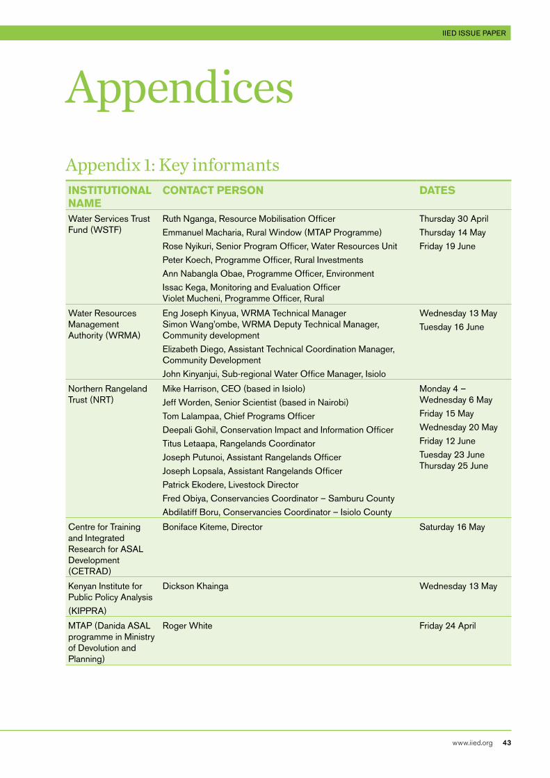
InclusIve green growth In Kenya | OppOrtunities in the dryland water and rangeland sectOrs iied issue paper
www.iied.org 43
AppendicesAppendix 1: Key informantsInstItutIonAl nAme
ContACt PeRson DAtes
Water Services Trust Fund (WSTF)
Ruth Nganga, Resource Mobilisation OfficerEmmanuel Macharia, Rural Window (MTAP Programme)Rose Nyikuri, Senior Program Officer, Water Resources UnitPeter Koech, Programme Officer, Rural InvestmentsAnn Nabangla Obae, Programme Officer, EnvironmentIssac Kega, Monitoring and Evaluation Officer Violet Mucheni, Programme Officer, Rural
Thursday 30 AprilThursday 14 May Friday 19 June
Water Resources Management Authority (WRMA)
Eng Joseph Kinyua, WRMA Technical Manager Simon Wang’ombe, WRMA Deputy Technical Manager, Community development Elizabeth Diego, Assistant Technical Coordination Manager, Community DevelopmentJohn Kinyanjui, Sub-regional Water Office Manager, Isiolo
Wednesday 13 MayTuesday 16 June
Northern Rangeland Trust (NRT)
Mike Harrison, CEO (based in Isiolo)Jeff Worden, Senior Scientist (based in Nairobi) Tom Lalampaa, Chief Programs OfficerDeepali Gohil, Conservation Impact and Information OfficerTitus Letaapa, Rangelands CoordinatorJoseph Putunoi, Assistant Rangelands OfficerJoseph Lopsala, Assistant Rangelands OfficerPatrick Ekodere, Livestock DirectorFred Obiya, Conservancies Coordinator – Samburu CountyAbdilatiff Boru, Conservancies Coordinator – Isiolo County
Monday 4 – Wednesday 6 MayFriday 15 MayWednesday 20 MayFriday 12 JuneTuesday 23 June Thursday 25 June
Centre for Training and Integrated Research for ASAL Development (CETRAD)
Boniface Kiteme, Director Saturday 16 May
Kenyan Institute for Public Policy Analysis (KIPPRA)
Dickson Khainga Wednesday 13 May
MTAP (Danida ASAL programme in Ministry of Devolution and Planning)
Roger White Friday 24 April
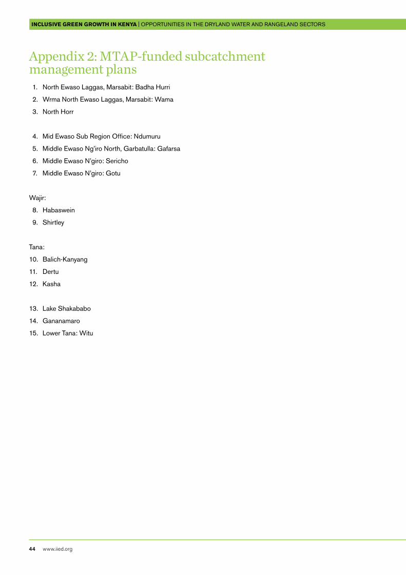
InclusIve green growth In Kenya | OppOrtunities in the dryland water and rangeland sectOrs
44 www.iied.org
Appendix 2: MTAP-funded subcatchment management plans 1. North Ewaso Laggas, Marsabit: Badha Hurri
2. Wrma North Ewaso Laggas, Marsabit: Wama
3. North Horr
4. Mid Ewaso Sub Region Office: Ndumuru
5. Middle Ewaso Ng’iro North, Garbatulla: Gafarsa
6. Middle Ewaso N’giro: Sericho
7. Middle Ewaso N’giro: Gotu
Wajir:
8. Habaswein
9. Shirtley
Tana:
10. Balich-Kanyang
11. Dertu
12. Kasha
13. Lake Shakababo
14. Gananamaro
15. Lower Tana: Witu
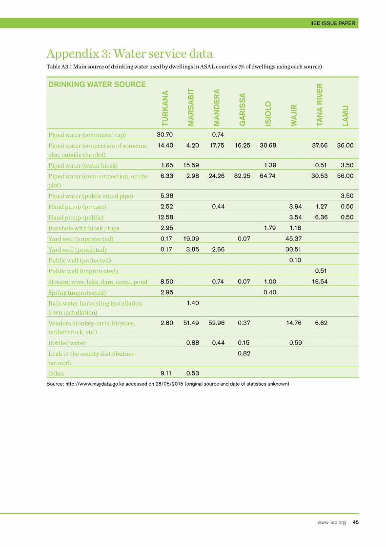
InclusIve green growth In Kenya | OppOrtunities in the dryland water and rangeland sectOrs iied issue paper
www.iied.org 45
Appendix 3: Water service dataTable A3:1 Main source of drinking water used by dwellings in ASAL counties (% of dwellings using each source)
dRInKInG WATER SoURCE
TUR
KA
nA
MA
RS
AB
IT
MA
nd
ER
A
GA
RIS
SA
ISIo
Lo
WA
jIR
TAn
A R
IvE
R
LAM
U
Piped water (communal tap) 30.70 0.74
Piped water (connection of someone else, outside the plot)
14.40 4.20 17.75 16.25 30.68 37.66 36.00
Piped water (water kiosk) 1.65 15.59 1.39 0.51 3.50
Piped water (own connection, on the plot)
6.33 2.98 24.26 82.25 64.74 30.53 56.00
Piped water (public stand pipe) 5.38 3.50
Hand pump (private) 2.52 0.44 3.94 1.27 0.50
Hand pump (public) 12.58 3.54 6.36 0.50
Borehole with kiosk / taps 2.95 1.79 1.18
Yard well (unprotected) 0.17 19.09 0.07 45.37
Yard well (protected) 0.17 3.85 2.66 30.51
Public well (protected) 0.10
Public well (unprotected) 0.51
Stream, river, lake, dam, canal, pond 8.50 0.74 0.07 1.00 16.54
Spring (unprotected) 2.95 0.40
Rain water harvesting installation (own installation)
1.40
Vendors (donkey carts, bicycles, tanker truck, etc.)
2.60 51.49 52.96 0.37 14.76 6.62
Bottled water 0.88 0.44 0.15 0.59
Leak in the county distribution network
0.82
Other 9.11 0.53
Source: http://www.majidata.go.ke accessed on 28/05/2015 (original source and date of statistics unknown)
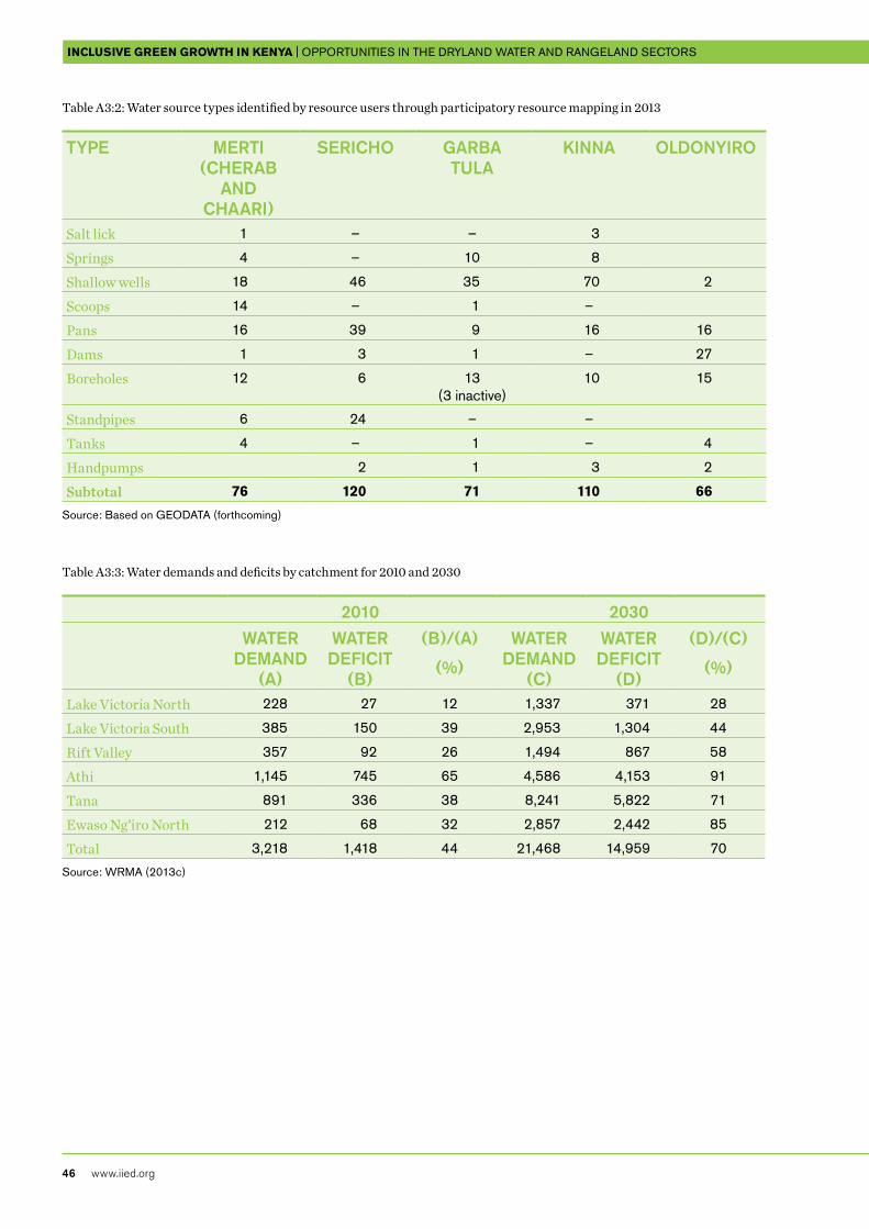
InclusIve green growth In Kenya | OppOrtunities in the dryland water and rangeland sectOrs
46 www.iied.org
Table A3:2: Water source types identified by resource users through participatory resource mapping in 2013
TypE MERTI (ChERAB
And ChAARI)
SERICho GARBA TULA
KInnA oLdonyIRo
Salt lick 1 – – 3
Springs 4 – 10 8
Shallow wells 18 46 35 70 2
Scoops 14 – 1 –
Pans 16 39 9 16 16
Dams 1 3 1 – 27
Boreholes 12 6 13 (3 inactive)
10 15
Standpipes 6 24 – –
Tanks 4 – 1 – 4
Handpumps 2 1 3 2
Subtotal 76 120 71 110 66
Source: Based on GEODATA (forthcoming)
Table A3:3: Water demands and deficits by catchment for 2010 and 2030
2010 2030WATER
dEMAnd (A)
WATER dEfICIT
(B)
(B)/(A)
(%)
WATER dEMAnd
(C)
WATER dEfICIT
(d)
(d)/(C)
(%)
Lake Victoria North 228 27 12 1,337 371 28
Lake Victoria South 385 150 39 2,953 1,304 44
Rift Valley 357 92 26 1,494 867 58
Athi 1,145 745 65 4,586 4,153 91
Tana 891 336 38 8,241 5,822 71
Ewaso Ng’iro North 212 68 32 2,857 2,442 85
Total 3,218 1,418 44 21,468 14,959 70
Source: WRMA (2013c)
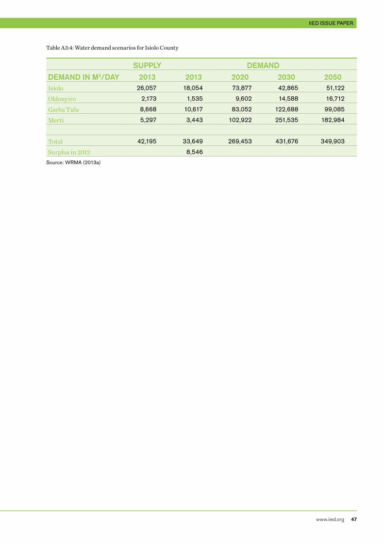
InclusIve green growth In Kenya | OppOrtunities in the dryland water and rangeland sectOrs iied issue paper
www.iied.org 47
Table A3:4: Water demand scenarios for Isiolo County
SUppLy dEMAnddEMAnd In M3/dAy 2013 2013 2020 2030 2050Isiolo 26,057 18,054 73,877 42,865 51,122
Oldonyiro 2,173 1,535 9,602 14,588 16,712
Garba Tula 8,668 10,617 83,052 122,688 99,085
Merti 5,297 3,443 102,922 251,535 182,984
Total 42,195 33,649 269,453 431,676 349,903
Surplus in 2013 8,546
Source: WRMA (2013a)
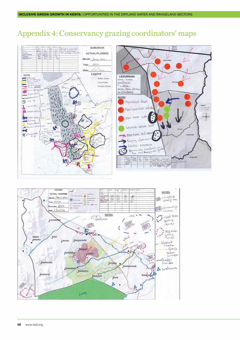
InclusIve green growth In Kenya | OppOrtunities in the dryland water and rangeland sectOrs
48 www.iied.org
Appendix 4: Conservancy grazing coordinators’ maps

InclusIve green growth In Kenya | OppOrtunities in the dryland water and rangeland sectOrs iied issue paper
www.iied.org 49
Appendix 5: Annual income to conservancies during 2014 (Ksh)
Tourism Livestock Levy
Beads* PES Total - Commercial
Total - operations
(Conservancy Income)
Total - livelihoods
(Community Income)
Il Ngwesi 2,180,000 124,000 2,304,000 921,600.0 1,382,400.0
Lekurruki 3,444,980 310,000 852,172 3,754,980 1,501,992.0 2,252,988.0
Naibunga – – – – –
Biliqo-Bulesa – 562,000 562,000 224,800.0 337,200.0
Mpus Kutuk 116,000 356,000 472,000 188,800.0 283,200.0
Leparua – 436,000 436,000 174,400.0 261,600.0
Nakuprat-Gotu 1,934,298 378,000 2,312,298 924,919.2 1,387,378.8
Nasuulu – 424,000 424,000 169,600.0 254,400.0
Ngare Ndare 4,600,000 – 6,105,983 10,705,983 4,282,393.2 6,423,589.8
Kalama 7,675,264 – 2,775,217 7,675,264 3,070,105.6 4,605,158.4
Ltungai – – – – –
Meibae – – – – –
Namunyak 16,961,339 1,084,000 18,045,339 7,218,135.6 10,827,203.4
Sera 2,208,162 590,000 2,904,203 2,798,162 1,119,264.8 1,678,897.2
West Gate 4,386,971 468,000 1,913,385 4,854,971 1,941,988.4 2,912,982.6
Melako 2,945,000 – 2,118,661 2,945,000 1,178,000.0 1,767,000.0
Shura – – – – –
Songa – – – – –
Jaldessa – – – – –
Ruko 782,000 – 782,000 312,800.0 469,200.0
Ndera – – – – –
Hanshak-Nyongoro
– – – – –
LowerTanaDelta – – – – –
Kiunga – – – – –
Pate – – – – –
Awer – – – – –
Ishaqbini 400,000 – 400,000 160,000.0 240,000.0
– – –
Totals 47,634,014 4,732,000 10,563,638 6,105,983 58,471,997 23,388,798.8 35,083,198.2
InclusIve green growth In Kenya | OppOrtunities in the dryland water and rangeland sectOrs
50 www.iied.org
Endnotes 1 See: www.vision2030.go.ke/cms/vds/Popular_
Version.pdf
2 See: www.adaconsortium.org
3 See: http://nwsb.go.ke/
4 Current listings of water resource professionals in Kenya are published at: http://tinyurl.com/nuzosfk
5 International best practices are available but may not be relevant to the Kenyan ASAL context. See http://tinyurl.com/qbjwc9h
6 For further information, contact Ibrahim Jarso and Daoud Tari at Resource Advocacy Program: [email protected]
7 Outputs from the model can be viewed at: http://glews.tamu.edu/EastAfrica
8 For more information on this research, contact Assistant Professor Oliver Wasonga: [email protected]
9 See www.ndma.go.ke
10 See: www.hsnp.or.ke
11 See: www.naturevesttnc.org/pdf/Project-Profile-Livestock-to-Markets-Kenya.pdf
12 See: www.fao.org/partnerships/leap/en/
InclusIve green growth In Kenya | OppOrtunities in the dryland water and rangeland sectOrs iied issue paper
www.iied.org 51
Knowledge Products
IIED is a policy and action research organisation working to promote sustainable development – development that improves livelihoods in ways that protect the environments on which these are built. Based in London and working on five continents, we specialise in linking local priorities to global challenges. In Africa, Asia, Latin America, the Middle East and the Pacific, we work with some of the world’s most vulnerable people to ensure they have a say in the decision-making arenas that most directly affect them – from village councils to international conventions.
International Institute for Environment and Development80-86 Gray’s Inn Road, London WC1X 8NH, UKTel: +44 (0)20 3463 7399Fax: +44 (0)20 3514 9055email: [email protected]
Inclusive green growth requires enhanced resilience to perturbations that affect the Kenyan economy. These include climatic variability and changes and a range of other economic and socially driven changes in the drylands. This report explores the challenges and potential for Danida and its selected partners in the water, rangeland and livestock enterprise sectors. The concluding discussion highlights shared considerations across both sectors concerning the roles of the public sector, private sector and communities in providing services, tracking inclusive green growth and fostering green innovations (hard and soft). Recommendations target better national-level water accounting and more participatory scientific ecosystem management methods.