Embed Size (px)
Citation preview

InCloud - Towards InfotainmentServices For VANETs
by
Haolin Guo
Thesis submitted to theFaculty of Graduate and Postdoctoral Studies
In partial fulfillment of the requirementsFor the M.A.Sc. degree in
Electrical and Computer Engineering
School of Electrical Engineering and Computer ScienceFaculty of EngineeringUniversity of Ottawa
c© Haolin Guo, Ottawa, Canada, 2014

Abstract
In order to realize effective infotainment systems for vehicles, we need to have context-aware applications that use the latest (live) information for an enhanced user experience.Such up-to-date information is now abundantly available on the Internet, due to the ex-plosive growth of the Web 2.0. In earlier times, it was difficult and expensive for vehiclesto connect to the Internet. Recent advances in vehicular ad-hoc networks (VANETs) haveenabled vehicles to connect to the Internet through road side infrastructures, with little tono additional cost. However, there are several problems with directly using Internet data ina vehicle, such as (1) Internet data sources have their own interfaces, which keep changingover time, needing frequent application updates, (2) information provided by multiple datasources needs to be preprocessed and fused before use, and (3) vehicles employ proprietyplatforms for infotainment systems, which makes an application update even more cumber-some. Furthermore, accessing multiple Internet sources may cause unnecessary overheadover the VANET bandwidth. In this thesis, we propose a cloud-based middleware frame-work for vehicular infotainment application development. The proposed framework followsservice oriented architecture in which data filtering and fusion functionalities are delegatedto the cloud. Data filtering and fusion reduce the data flow over VANET. Furthermore,because most the the processing is done on the cloud, the client becomes lightweight andloosely coupled with Internet resources and underlying platforms. We also propose a class-based fusion method to combine information from multiple sources. The efficacy of theproposed framework is validated by developing an enhanced navigation (eDirection) ap-plication for the vehicle, as well as three infotainment applications: context-aware music,news, and weather.
ii

Acknowledgements
To my family: Wenli Guo(My father), Jinjuan Geng(My mother). I will not beable to study in Canada without their supports”Special Thanks to:Prof. Dr. Abdulmotaleb El Saddik, my supervisor. I am very lucky to study in hislab. He gave constructive advises on crucial questions of my research.Dr.Mukesh Saini, my co-supervisor. He taught me a lot about my research. At the sametime, he is also a very kind, easygoing person and a good friend.Dr.Dewan Tanvir Ahmed, my co-supervisor. I learned many things from him throughour first paper.All MCR labs members, I am very happy to study with them. They are all very kindand generous people.
iii

Table of Contents
List of Tables vi
List of Figures vii
1 Introduction 1
1.1 Motivation . . . . . . . . . . . . . . . . . . . . . . . . . . . . . . . . . . . . 1
1.2 Research Issues . . . . . . . . . . . . . . . . . . . . . . . . . . . . . . . . . 2
1.3 Thesis Contributions . . . . . . . . . . . . . . . . . . . . . . . . . . . . . . 3
1.4 Thesis Overview . . . . . . . . . . . . . . . . . . . . . . . . . . . . . . . . . 4
2 Literature Review 5
2.1 VANETs . . . . . . . . . . . . . . . . . . . . . . . . . . . . . . . . . . . . . 5
2.2 Infotainment System History . . . . . . . . . . . . . . . . . . . . . . . . . . 6
2.3 Service-Oriented Architecture(SOA) . . . . . . . . . . . . . . . . . . . . . . 8
2.4 Mashup . . . . . . . . . . . . . . . . . . . . . . . . . . . . . . . . . . . . . 9
2.5 Related Work . . . . . . . . . . . . . . . . . . . . . . . . . . . . . . . . . . 10
2.6 Summary . . . . . . . . . . . . . . . . . . . . . . . . . . . . . . . . . . . . 15
3 Proposed Architecture 16
3.1 Design Principles . . . . . . . . . . . . . . . . . . . . . . . . . . . . . . . . 16
3.2 System Design . . . . . . . . . . . . . . . . . . . . . . . . . . . . . . . . . . 17
3.2.1 Resources Layer . . . . . . . . . . . . . . . . . . . . . . . . . . . . . 20
3.2.2 Cloud layer . . . . . . . . . . . . . . . . . . . . . . . . . . . . . . . 20
3.2.3 Application layer . . . . . . . . . . . . . . . . . . . . . . . . . . . . 27
iv

3.3 Data Fusion . . . . . . . . . . . . . . . . . . . . . . . . . . . . . . . . . . . 28
3.3.1 Fusion Input . . . . . . . . . . . . . . . . . . . . . . . . . . . . . . . 31
3.4 Summary . . . . . . . . . . . . . . . . . . . . . . . . . . . . . . . . . . . . 32
4 System Implementation 33
4.1 Context-Aware Routing Application . . . . . . . . . . . . . . . . . . . . . . 35
4.2 Context-Aware News Application . . . . . . . . . . . . . . . . . . . . . . . 41
4.3 Context-Aware Music Application . . . . . . . . . . . . . . . . . . . . . . . 43
4.4 Context-Aware Weather Application . . . . . . . . . . . . . . . . . . . . . 45
4.5 Summary . . . . . . . . . . . . . . . . . . . . . . . . . . . . . . . . . . . . 47
5 Experiments 49
5.1 Framework Experiment . . . . . . . . . . . . . . . . . . . . . . . . . . . . . 51
5.2 Data Fusion Experiment . . . . . . . . . . . . . . . . . . . . . . . . . . . . 56
5.3 Context aware Experiment . . . . . . . . . . . . . . . . . . . . . . . . . . . 60
5.4 Summary . . . . . . . . . . . . . . . . . . . . . . . . . . . . . . . . . . . . 63
6 Conclusion and Future work 64
References 66
v

List of Tables
2.1 Comparison of the proposed work with previous works on infotainment sys-tems. . . . . . . . . . . . . . . . . . . . . . . . . . . . . . . . . . . . . . . . 15
3.1 Few examples of information resources R. . . . . . . . . . . . . . . . . . . 19
3.2 Important functionalities for infotainment applications on VANET. . . . . 22
3.3 The implemented services and description . . . . . . . . . . . . . . . . . . 25
3.4 The implemented services and description . . . . . . . . . . . . . . . . . . 26
3.5 Resource types from fusion perspective. . . . . . . . . . . . . . . . . . . . . 29
5.1 Route distance result comparison . . . . . . . . . . . . . . . . . . . . . . . 60
5.2 User study of the personalized music recommendation application . . . . . 62
vi

List of Figures
2.1 Schematic diagram of VANETs. . . . . . . . . . . . . . . . . . . . . . . . . 7
2.2 The history of in-vehicle infotainment system. . . . . . . . . . . . . . . . . 8
2.3 Prototypical implementation of an in-car-infotainment system . . . . . . . 11
2.4 Implementation of the Android-based automotive infotainment system forsupporting drivers safety . . . . . . . . . . . . . . . . . . . . . . . . . . . . 12
2.5 Proposed embedded system architecture . . . . . . . . . . . . . . . . . . . 13
3.1 The block diagram of the proposed framework . . . . . . . . . . . . . . . . 18
3.2 A functional view of a typical service in the cloud. . . . . . . . . . . . . . . 20
3.3 The example of the KML file. . . . . . . . . . . . . . . . . . . . . . . . . . 24
3.4 The example of Ajax call pattern . . . . . . . . . . . . . . . . . . . . . . . 28
3.5 The fusion takes place in three steps depending on the type of resources. . 30
4.1 Class diagram of infotainment system. . . . . . . . . . . . . . . . . . . . . 34
4.2 Implementation of infotainment system. . . . . . . . . . . . . . . . . . . . 34
4.3 Screenshot of the map website from City of Ottawa. . . . . . . . . . . . . . 35
4.4 Flow chart of eDirection proposed algorithm. . . . . . . . . . . . . . . . . . 36
4.5 Example of step area. . . . . . . . . . . . . . . . . . . . . . . . . . . . . . . 36
4.6 Detail of the step calculation. . . . . . . . . . . . . . . . . . . . . . . . . . 37
4.7 Detail of the step calculation 2. . . . . . . . . . . . . . . . . . . . . . . . . 38
4.8 Interaction diagram of eDirection. . . . . . . . . . . . . . . . . . . . . . . . 38
4.9 Use case diagram of system . . . . . . . . . . . . . . . . . . . . . . . . . . 41
4.10 The schematic diagram for news service . . . . . . . . . . . . . . . . . . . . 42
4.11 The multimedia service flow chart . . . . . . . . . . . . . . . . . . . . . . . 43
vii

4.12 The interact diagram of recommendation music service . . . . . . . . . . . 44
4.13 The flowchart of the weather service . . . . . . . . . . . . . . . . . . . . . . 46
4.14 The interact diagram of the weather service. . . . . . . . . . . . . . . . . . 46
4.15 The example of the weather forecast . . . . . . . . . . . . . . . . . . . . . 48
4.16 The example of the zWeatherFeed . . . . . . . . . . . . . . . . . . . . . . . 48
5.1 Test page of the Web services . . . . . . . . . . . . . . . . . . . . . . . . . 50
5.2 Schematic diagram of news service . . . . . . . . . . . . . . . . . . . . . . 52
5.3 Schematic diagram of framework experiment I . . . . . . . . . . . . . . . . 53
5.4 Schematic diagram of framework experiment II . . . . . . . . . . . . . . . . 54
5.5 The comparison of data size. . . . . . . . . . . . . . . . . . . . . . . . . . 55
5.6 The comparison of time consume of data transmission. . . . . . . . . . . . 55
5.7 The result example of eDirection . . . . . . . . . . . . . . . . . . . . . . . 57
5.8 Route experiments part I . . . . . . . . . . . . . . . . . . . . . . . . . . . . 58
5.9 Route experiments part II . . . . . . . . . . . . . . . . . . . . . . . . . . . 59
5.10 eDirection application routing efficiency result. . . . . . . . . . . . . . . . . 61
5.11 The schematic diagram of service composition . . . . . . . . . . . . . . . . 62
viii

Chapter 1
Introduction
Since the advent of the first automobile, various advanced technologies have been devel-oped to improve the driving experience. Among these technologies, several increase drivingsafety such as Anti-lock Braking System (ABS), Traction Control System (TCS); some pro-vide better operability like cruise contro and all wheel drive; while others improve drivingconditions such as anti-lock brakes and climate control. The development of IntelligentTransport Systems (ITS) [15] has further improved driving efficiency. Recently, a numberof infotainment applications have been built for the comfort and convenience of the driversand passengers. These new technologies help passengers enjoy their journey instead of justtrying to pass the travel time.
The development of driving technologies is not confined to hardware, vehicular tech-nologies in software are also becoming increasingly important, for example multimedia,navigation, and health monitors. Some infotainment applications are being applied inmore and more vehicles for a robust operation and a higher degree of convenience. Sincecloud computing has been accepted by network resource providers, more systems are beingdeveloped based on this technology. In this new development paradigm, the core applica-tion parts are delegated to the cloud server on the Internet. The local clients only maintainthe user interface and display parts of the application. The emergence of Vehicular Ad-hocNetworks (VANETs) provides the possibility for the vehicles to access the Internet. Then,a great number of vehicles systems renew the model to adapt to Internet data. This thesisproposes a system model and implementation for an infotainment system. The model takesdata from the Internet for providing more efficient services for vehicles. Also, we proposedan approach to establish system with low-requirement and re-usability advantages.
1.1 Motivation
Nowadays, there is hardly a vehicle that doesn’t possess an infotainment system [12]. Butwhat if a navigation system shows a wrong pathway because the map is not updated
1

Research Issues 2
timely? Or what if the music becomes boring because the playlist is not intelligent enoughto adapt to current contexts and ratings? We need timely and accurate information todevelop effective infotainment applications, which is fortunately available in digital formatonline on the Internet. In fact, most of the ITS still rely on the analysis of local data,which is limited and generally out of date; such data surely influences the quality of theoutputs given by the system. Although the infotainment system is not critically necessaryfor primary driving tasks like the vehicle power system, its popularity still validates itsexistence. Since the information sources in the Internet are updated timely, we considerupdating the infotainment systems with information from the Internet. Passengers canwatch videos, listen to music, and even play games online, while, the driver can accesspersonal email, news, etc. These infotainment applications can greatly improve the drivingexperience. For example, one will get bored after he or she listens to local songs for a longtime. Generally, a song lasts three or four minutes, which means that even if a user chooses30 of his favorite songs, these can only be played repeatedly for two hours. According to theAir Resources Board(ARB) survey 2009 [49], the average time people spend driving is 18hours and 31 minutes a week. This includes about 2 hours 52 minutes a day on weekdays,and 2 hours 7 minutes a day on weekends. We can see that the audio resources are repeatedeven in one day’s average driving time. Also, most people generally do not have time tosearch and update new audio resources, therefore it’s very easy for the passengers anddriver to get bored with repeated multimedia resources. The situation would be differentif the vehicles could access the Internet; make use of user profile and context informationand search for appropriate titles. Users could listen to music directly from online sourceslike Last.fm or get personalized media resource like rock music.
1.2 Research Issues
Our first research issue is that how can we get vehicles access to the Internet. Cellphonehas gained the access to the Internet through MANET today. Due to the VANETs, vehi-cles can also use the Internet. Our system is built with the VANETs as communicationinfrastructure. We will talk about it in detail in next chapter. Therefore, vehicles couldoffer context-aware [8] cloud services to the driver and other on board passengers throughVANETs just as the cellphones in the mobile network. Then we need to develop a systemto process these data. To make our infotainment system more efficient and reliable, webring several features into the establishment of our model, like a simple interface, easyoperation and context-awareness. However, we still need to overcome a set of challengesto efficiently use Internet resources, as follows:
1. Most information resources have their own application programming interface (APIs)for accessing the data. The resource owners update these APIs over time, accordingto their own requirements. In order to make the infotainment applications robust to

Thesis Contributions 3
these changes, our system should be loose coupling, which means that each functionin our application is independent.
2. Since the connection of vehicles under the VANETs is wireless. The limitation ofbandwidth has restricted data transmission. Also, the stability of the network affectsthe efficiency of infotainment system. Abundant data will bring the transmissiondelay and the data loss to the vehicles which is deadly to time critical data.
3. Standard APIs return information with a lot of redundant data which is not usefulfor infotainment applications. The redundant data reduces the system’s efficiencyand complicates data format, which is not suitable for data fusion. Therefore, weneed to filter the data into a unified format.
4. Vehicle manufacturers build their own infotainment systems by cooperating withdifferent IT companies. For example, Apple supports BWM-iDrive and Microsoftsupports Ford MyFord [27]. These companies all have their own development plat-forms. There is no standards for developing a cross-platform infotainment system.Our goal is to develop a system that can execute in most of platforms.
5. There are a number of sources that provide similar information. For example, wecan obtain weather information or music ratings from the cloud resources. Theproblems are determining which resource we should trust more, and how to integrateinformation from multiple sources.
6. The limited interactive interface and driving environment restricts users’ operations.The operations can’t be complex and prolonged. For example, the driver can notinput complex commands like typing destination names into the system while driving.For this reason, we need to provide efficient services with a concise and clear interface.
In this thesis, we propose a solution to the above problems. We build a middleware cloudserver under the backbone of the VANETs. We take service oriented architecture (SOA)design approach for our implementation. The system in the server can filter the redundantdata from the Internet and occupy most of data processing work. In this way, it may reducethe consumption of network bandwidth and hardware requirement of the infotainmentclient in the vehicles. We will discuss this in greater detail in following chapters.
1.3 Thesis Contributions
The main contributions of this thesis are the following:
• Design data fusion and context-aware pre-filtering strategy for infotainment appli-cations, which can effectively combine information from multiple sources, thereforereducing the data flow on the RSU-OBU link.
Thesis Overview 4
• Design and implement an enhanced routing algorithm using data fusion strategy.The enhanced algorithm can offer optimized route which avoids the constructionsfrom third party resources.
• Design and implement a context aware search algorithm for music searching. Theproposed algorithm fuses the rating data from different music search resources withusers music preference. Therefore, we can provide users with more reasonable musicsearch results.
• Design and develop cloud services so that the applications are loosely coupled withthe data resources and underlying platforms, which is a desired feature for adaptiveand easily reconfigurable applications.
1.4 Thesis Overview
The organization of this thesis is as follows:
• Chapter 1 is introduction. In this chapter, we first talk about the research motivationand research issues. We also state the research contributions.
• Chapter 2 is literature review. It first introduces VANETs, Infotainment SystemHistory and Service-Oriented Architecture (SOA). Then, it shows the design conceptof mashup which is extend of SOA. Last, it reviews the architecture similar to ourwork and compare the differences between our work and some representative work.
• Chapter 3 is proposed work. We firstly give out the system architecture and designprinciples. Then we elaborate on the architecture in the following dissertation.
• Chapters 4 demonstrates the implementation of our proposed system. We explainfour applicatoins deisgn and fucntionalites. We also explain the details of the systemdesign and at the same time clarify how the prototypical system reflects the featuresof SOA.
• Chapter 5 provides details on the experiments that allowed us to verify the feasibilityand efficiency of our system.
• Chapter 6 finally concludes the thesis and suggests some future work and improve-ments.

Chapter 2
Literature Review
We live in a fast-paced society where the timely and accurate sharing of information amongpeople can make our life more convenient and comfortable. The Internet provides a dis-tributed platform for information exchange. The Web 2.0 [33] technology takes the in-formation spread to a new level. With the help of the Web 2.0 technology, many webservices are developed rapidly in order to satisfy users’ needs. More and more companiesand software firms tend to offer their services through the web. Instead of selling softwareto customers offline, these companies offer customers an updated service through web ser-vices. Users or developers can pick useful cloud services to form new applications, andsince plenty of sources provide different kinds of data and without any defined standardsto follow, it is a challenge to collect relevant data from different sources on the Internet andto process that information efficiently, according to user’s needs. In this thesis, we design amashup system [1] based on Service Oriented Architecture (SOA) for VANETs [39] whichprovides context-aware services in real-time. This design enables the system to retrievedata from the Internet with a certain amount of flexibility and process them accordingto defined logic. SOA is currently the most commonly used approach to realize a Cloudbased system, but the traditional SOA implementing method still has disadvantages. Inthis thesis, we propose to development an approach that can overcome these disadvantages.[44]. Our service model enhances the in-car infotainment system. In this chapter, we willintroduce VANETs and infotainment system; and provide a brief overview of the SOA andMashup design paradigms in order to build background knowledge for the thesis work.
2.1 VANETs
Wireless communication technologies emerged for more than 100 years ago, but haveevolved a great deal over the years. In 1879, David E. Hughes created a clockwork keyedtransmitter and now, the wireless technologies have become an indispensable part of the
5

Infotainment System History 6
communication approach. However, it still has drawbacks, such as a low and unstable band-width, limitations of data transmission range, etc. Recent advances in wireless networkshave introduced a new type of network called the Vehicular Ad-hoc Networks (VANETs),which enables Internet access in vehicles on the move. VANETs facilitate inter-vehiclecommunication between nearby vehicles and/or allows communication between vehiclesand roadside infrastructures [20].Vehicular Ad-Hoc Networks (VANETs) is one of the sys-tem’s many sub-classes. The others are Mobile Ad-Hoc Networks (MANETs), WirelessSensor Networks (WSNs) and Wireless Mesh Networks (WMNs) [19]. VANETs add anew dimension when accessing Internet services. The fast growing Internet offers plentyof services that are accessible anytime and anywhere. Our roadway travel could be moreinteresting and convenient if infotainment systems could make proper use of the resourcesavailable on the Internet in order to ensure infotainment applications are up-to-date andeffective.
A VANET, as shown in figure 2.1, is a collection of moving vehicles and road sideinfrastructures. The network disseminates information through these network nodes in amanner similar to cells mobile in the Mobile Ad-Hoc Networks (MANETs). Communi-cation components on the vehicles are called on-board units (OBU) [46] and consist ofwireless modules and sensors. The sensors are used to monitor and transmit the vehiclesinformation, and the Road Side Unit (RSU) [46] forwards information from one OBU tothe other. RSU not only provides the driving data such as location, speed, heading, etc.,but also supports Internet access for vehicles. Our system is created under the support ofInternet access from the VANETs.
Although VANETs enable Internet access in vehicles, we still need to overcome a setof challenges to properly collect information from multiple sources on the Internet. First,data from multiple sources may consume a large amount of bandwidth between the roadside unit (RSU) and the on-board unit (OBU) [20]. Since the link between the OBU andthe RSU is intermittent, we need to minimize data flow over this link [11]. Second, theapplications should be loosely coupled with the Internet source’s specific APIs and theunderlying hardware/software platform in the vehicle.
2.2 Infotainment System History
Infotainment is a combination of Information and Entertainment, which means informationand entertainment served together. In the context of vehicles, an infotainment system canprovide applications for navigation and music, in order to enhance the driver and/or pas-senger experience. Figure 2.2 shows the development history of the in-vehicle infotainmentsystem. The first infotainment system was introduced in vehicles by Motorola in the formof a radio in 1930 [5]. This is the basis for the infotainment system. In subsequent years,auto manufacturers around the world accepted this idea that driving should be enjoyable.Chrysler introduced a record player in their cars, and in 1965, Ford released the first tape

Infotainment System History 7
GPS
WiMAX/3G
Base Station
RSU
RSU
RSU
inter-vehicle
communication
vehicle-to-roadside
communication
inter-roadside
communication
Figure 2.1: Schematic diagram of VANETs.
player. These innovations are followed by the introduction of cassette-tape players, stereosystems, and in-dash CD players. With the development of Bluetooth and hardware stor-age, the in-car infotainment system has integrated satellite radio, mobile devices, and localstored multimedia together.
The navigation application shows that the infotainment system can bring us somethingmore than just entertainment. Before the invention of the navigation system, long roaddriving meant a bunch of fold-out maps. We also used to get route information from onlineservices such as Google map, or Yahoo map, print the out the results and use them as thetour guide. The navigation system changes this situation, as it gives convenience to theusers, allowings them to follow the route dynamically. The Global Positioning System(GPS) offers essential data for navigation. GPS was first used by the U.S. military in the1960s [35], and is only available to the public since the early 1980s, and then, the data wasnot very precise. By the end of 2000, GPS navigation with precise data began to open tothe public. There are currently 16 major original equipment manufacturers(OEMs) with 78major brands and approximately 600 models [10]. Almost all of these models are equippedwith infotainment systems. Future cars will certainly be able to communicate with eachother through VANETs. In this section we provide background knowledge essential to ourproposed system.

SOA 8
1930 1952
1953
1955 19631965
1969
1970 1977 1982
1985 present
Figure 2.2: The history of in-vehicle infotainment system.
2.3 Service-Oriented Architecture(SOA)
SOA is a software design pattern that provides each application to function as an indepen-dent service. It is the main pattern used to implement cloud based system. SOA is definedby the OASIS group [6] as a paradigm for organizing and utilizing distributed capabili-ties that may be under the control of different ownership domains. In this pattern, oneapplication is divided into N (N > 0) functional modules. Each module called service, isa self-contained unit that can hold one process to produce one individual functional task.For instance, the following are the services in the travel plan application: the service formapping, the service for booking tickets, the service for searching the places of interests,and the service to calculate the cost. Each service can provide the user with differentfunctions. These functions are associated and loosely coupled. Each service is responsiblefor one action or task, and the application organizes the services in the right processingorder.
The aim of inducing SOA is to design large-scale, tightly integrated applications thatare modular, inter-operable, and reusable. The services are encapsulated so that they canbe invoked across the application interfaces. We also want the services to serve as objects.These objects are available for multi-connects so that they can save more time and moneyby reducing duplicated code work. Current infotainment systems follow an ad-hoc softwaredevelopment approach (monolithic architecture), which does not meet these requirements[34] [2] [24]. In this work, we propose a cloud-based middleware following Service-orientedarchitecture for infotainment over VANETs, adhering to the above issues. SOA has thepotential of reducing both development costs and future application delivery time [47].At the same time, the flexible and agile organization gives the developer real-time access,which means the upgrades and maintenance of the system in SOA are much easier andfaster. The SOA has the following characteristics [3]: 1) Re-usability, 2)Loose coupling,3) Comparability, 4) Statelessness. Currently, the common approach to realize SOA is to
Mashup 9
implement it by web services. Services use WSDL to describe the service interface or anend point that operates the input and output parameters. Normally the result of webservice contains the name of the web service interface. For the data, web service generallyacquires XML or JSON data type. For the transmiting protocol, web service uses theXML-based protocol such as SOAP, WS-notification, and Representational State Transfer(REST) [48].
In this thesis, we propose a cloud-based middleware following SOA for infotainmentover VANETs adhering to the above issues. The cloud services run on the RSU or otherstandard clouds such as Amazon. The proposed middleware performs most of the compu-tation tasks in the cloud and presents only infotainment related content to the vehicularapplications. As a result, the application client can be easily adapted to multiple plat-forms, while new features can be incorporated efficiently in the cloud. To reduce the dataflow from RSU to OBU, we take following steps: (1) pre-process Internet data to removecontent not related to infotainment applications, (2) filter Internet data according to thecurrent context to further reduce its size, (3) fuse data from multiple Internet resources inthe cloud itself so that we utilize information from multiple resources, but the data flowfrom RSU to OBU would still be equivalent to one resource. To demonstrate the efficacyof the proposed middleware system, we have implemented the proposed architecture anddeveloped three lightweight applications (efficient up-to-date routing, context aware news,and music recommender).
2.4 Mashup
We also optimize the cloud based architecture by extending it with Mashup design. Amashup is a desgin that uses content from more than one source to create a single newservice displayed in a single graphical interface [14]. Mashup is firstly known as a musicalbum. A music bank mixed the Beatles’ White Album and Jay-Z’s black album togetheras a new album called Grey album. When brought to SOA field, it is a design that addsa middle ware between server and client. It is used in web development for combining andaggregating existing source data to generate more useful data. This part of design usuallymaintains the service composition and data integration. Theoretical SOA architecture hasvery low efficiency unless the web services are specifically designed for the applications.For example, if we directly use geographic data from Yahoo as keyword to do a routingsearch in Google Map API, it may return failed result. Because data format or data unitdoes not match. Then we need to unify these data in order to use them. Another, if wewant to process the API feedback further with the specified requirements, we have to addone step between API feedback and result. The middleware server plays this role in thearchitecture. It adds the local database that can store personal information like users’behaviors and user private data.

Existing infotainment systems 10
2.5 Related Work
Infotainment systems play a significant role in making our travel comfortable and enjoyable.Many research attempts have been made to improve infotainment systems from variousaspects. We review existing commercial infotainment systems and related research works.We particularly focus on in-vehicle infotainment systems. Currently, the main functions ofinfotainment systems are navigation and multimedia based entertainment. Most in-vehicleinfotainment systems by automobile manufacturers still rely on locally stored data for thesetwo functions. Although some tele-data is used, such as GPS data and radio data, there arestill limitations. For example, for most vehicles, the map data of the navigation system isstored locally. A lot of live traffic data or road conditions data can therefore not be used bythe system in a timely fashion. In addition, users do not want to pay for a whole new map,every time there are few small roads that are built. Besides, most vehicle manufacturestend to enlarge the resource scope of the system by adding a Bluetooth module. Since ourmobile phone can access the Internet, vehicles can also get the Internet data through theBluetooth connection. However, unstable bandwidth and limited speed can not satisfy therequirements of the next-generation of infotainment systems; there is still a great deal ofroom for improvement in the approach being used for data collection.
Another important problem is that there is no unified standard development environ-ment for manufactures to use to develop the infotainment systems. Presently, companiesmostly use proprietary platforms to develop their own infotainment systems. For devel-opers, this means a longer application development time, since they need to set-up thespecified environment and acquire its development tools. Although some automotive man-ufacturers and major IT companies have started to develop open source platforms forinfotainment systems like GENAVA InVehicle Infortainment (GENIVI), these platformsare hard to use because of the lack of related standards [26].
In this thesis, we mainly focus on the application layer. We wish to set up architecturethat implements the cloud based infotainment application. Although infotainment systemshave been around for decades, the topic of cloud based infotainment systems is still new andemerging. Only recently have a reasonable and feasible architectures been proposed [31].Among these proposed architectures, web services are the principal means of implementingthe Internet access. This is a method that supports machine communication over thenetwork. Generally, the communication is through Http or XMLHttp protocols. The datapackage is described using SOAP or REST, and exchanged through the interface that isdefined in a machine-processable format like WSDL.
We researched the infotainment systems that invoke Internet sources using web ser-vices. Currently, there are two ways for the systems to use the Internet sources. One isdirectly invoking web services from the Internet, as described in [16]. In their prototypicalimplementation, they directly display the route calculation results from BingMaps webservices. The other approach is to create a middleware server to customize services so thatthe server grabs the data from the Internet [29] [30]. Among these cases, most do not

Existing infotainment systems 11
Figure 2.3: Prototypical implementation of an in-car-infotainment system
use cloud, while others only provide theoretical models. We show several cases to make adetailed comparison:
A Prototypical Implementation by Daimler Center
Daimler Center for Automotive IT Innovations proposed a prototypical implementation ofan intelligent in-car-infotainment system [16]. Their work is a context-aware, intelligentinfotainment system. This system can adapt the service results based on the context-dependent daily routines of the user. They implemented the applications in ActionScriptthat can simulate the driving situation from the personal desktop. For the services, theyinvoked the BingMaps webs services for route calculation. for this system, Sandro proposeda contextual and personalized design for user interface, but they only implemented user’spattern recognition and context clustering the client side. There is no further talk of thecontext aware design for service feedback. Figure 2.3 is a screenshot of their system.
Implementation of the Android-Based Automotive InfortainmentSystem for Supporting Drivers Safe Driving
While some researches on automotive infotainment systems focus on the users’ convenience,some similar works focus on the driver safety. For example, Minyoung Kim and his teamproposed a design with additional functions such as black box and self-diagnosis, which theyadded to the automotive infotainment systems, based on the android platform embeddedhardware [26]. The highlight of their work is the set up of an architecture using an Android

Existing infotainment systems 12
Figure 2.4: Implementation of the Android-based automotive infotainment system forsupporting drivers safety
platform that is independent from current automotive development platforms like GENIVI.We can have a larger set of applications to choose from, since Android Market can providevarious applications. The open source platform allows the addition of adaptive third-partyapplications based in user preferences.
An In-Vehicle Infotainment Software Architecture Based on GoogleAndroid
Gianpaolo Macario also proposed an Android based architecture for in-vehicle infotain-ment [31]. Similar to Minyoung’s work, they proposed an architecture that can attachthird-party applications based on the Android platform. In this work, they proposed asafe mechanism for third-party applications to access vehicle data. For instance, theygranted permission to applications to gather the temperature and speed values; they alsoused Google Android features to handle inter-application communication. To verify thefeasibility, they implemented a prototype system using this architecture. Unfortunately,they did not provide related experiment results and their architecture doesn’t adopt thecloud technology.
Integrated Embedded System Architecture for In-vehicle Infotain-ment
National Chia-Yi University developed a system called Mayday, which provided location-based services for vehicles through Wifi and (General Packet Radio Service)GPRS [21].GPRS is a packet oriented mobile data service on the 2G and 3G cellular communicationsystem’s global system for mobile communications [7]. To meet the need for vehicle theInternet access from anywhere, a distributed service-based architecture was proposed basedon Jini middleware technology. They proposed an embedded system architecture, as shownin figure 2.5, which consists of the service and control station segment (SCS), and themobile segment (MS). This system took the location information from a GPS receiver. For

Existing infotainment systems 13
Figure 2.5: Proposed embedded system architecture
infotainment purposes, the system had an in-vehicle network that worked as a LAN serverto provide a connection to stream data with other devices such as PC, PDA, and tablet.However, this paper didn’t mention the middleware server and customized services model.The middleware server plays an important role in telematics.
Other In-vehicle Infotainment related works
Besides these principal related works, we also skimmed through other infotainment works.To make the point clear, we created a Table 2.1, which compares these previous worksto our proposed work.We mainly consider these related work from two aspects. One as-pect is efficiency and versatility of the infotainment system. Hackbarth [18] proposed amodular architecture for infotainment systems, mainly designed to meet the needs of var-ious hardware and configurations. Macario et al. [31] argue for am Android platform forinfotainment system development, to make it accessible to most users. Al-Ani [2] also pro-posed an android-based infotainment system. While Android provides a generic platformfor infotainment applications, car manufacturers still prefers their own platform becauseof specific requirements and features.
Another important aspect considered by researchers is the networking protocols ofVANETs. Festag et al. [13] proposed a geocast routing protocol customized for safety,efficiency, and infotainment messages, Huang et al. [22] also proposed a routing mecha-nism for infotainment messages, Cheng et al. [9] proposed a link layer optimization forinfotainment messages. Also, Salvo et al. [38] [36] provide forwarding rules so that info-tainment messages reach maximum nodes, and Amadeo et al. [4] propose an enhancementof IEEE 802.11p to better accommodate the traffic information that is generated throughthe infotainment application.

Existing infotainment systems 14
Researchers have proposed several techniques to improve the user interface of info-tainment systems. Sharma et al. [40] [41] proposed a component-based human-machineinterface framework that adapts the interface of infotainment systems according to vehic-ular context. Different ways of connecting external devices to car infotainment systemshave also been explored [42] [43]. Ohn-Bar et al. [32] proposed a vision-based control forinfotainment systems. where the driver and the passengers can interact with the systemwith gestures rather than with a tactile interface.
To cope with the processing needs of infotainment applications, Hsu et al. [21] andLattanzi et al. [28] proposed the use of high power embedded processors. We argue thatsuch a solution would not be scalable. Also, processing Internet data in the cloud wouldreduce the bandwidth requirements, as only the results would be sent to the infotainmentsystem over VANETs. Recently, Hussain et al. [23] [24] briefly discussed the idea of usingcloud over VANETs, but no framework is proposed. The authors merely discuss the ideathat the vehicle can use RSU as a gateway to the Internet cloud, but there needs to bea detailed investigation of the approach. Kim et al. [25] delegates a malware detectionprocess to the cloud in infotainment systems. Rangarajan et al. [34] discuss security oncloud-based infotainment.
A comparison of the proposed work with previous works is provided in Table 2.1, basedon the following aspects: Network or VANETs considered or not? Cloud used or not?Internet resources fused or not? If includes a data filtering step or not? And have theauthors identified cloud services for current infotainment systems or not? In this work, wepropose a cloud-based infotainment framework for VANETs and explore the design issuesof such a framework. We further validate our framework by building three infotainmentapplications based on the proposed framework where we consider resource informationadaptors, data unification, data fusion, and service identification.
With respect to the previous literature, our goals are to:
1. Use new approaches to collect Internet data.
2. Design a data fusion strategy.
3. Implement the proposed architecture and validate it through experiments.
We determined that it would be beneficial to our work to incorporate the features ofthe customized services model into our model. One advantage is that our system works foron-demand data integration which can reduce data size by dropping the redundant data.Another advantage is improved system efficiency; since we move the data processing partand services model to the server, it reduces the delay and reaction times. It reduces hard-ware requirement on the client side and is therefore for manufacturers to adopt. Moreover,we designed our system as an Internet resource accessible system.

Summary 15
Table 2.1: Comparison of the proposed work with previous works on infotainmentsystems.
Work VANETCloud-
basedFusion
Data Adaption
and Unification
Service
Identification
Hackbarth [18] No No No No NoHsu et al. [21] No No No No No
Sharma et al. [40] [41] Yes No No No NoFestag et al. [13] Yes No No No NoMacario et al. [31] No No No No NoLattanzi et al. [28] Yes No No No NoSharma et al. [42] Yes No No No NoSonnenberg [43] No No No No NoCheng et al. [9] Yes No No No NoHuang et al. [22] Yes No No No No
Salvo et al. [38] [36] Yes No No No No
Amadeo et al. [4] Yes No No No No
Kim et al. [25] Yes Yes No No No
Ohn-Bar et al. [32] No No No No No
Rangarajan et al. [34] Yes Yes No No No
Al-Ani [2] No No No No No
Hussain et al. [24] [23] Yes Yes No No No
Proposed Yes Yes Yes Yes Yes
2.6 Summary
In this chapter, We gave a brief introduction about background knowledge related tothis cloud based system. VANETs is our system environment, we make it clear that theInternet access support of network. We also stated some specific requirements for system ofVANETs. Then, we introduced the system architecture we used to implement cloud basedsystem. We brought the concept about mashup system which is used to extend the SOA.We discussed the current situation for infotainment systems. We mentioned that there iscurrently no unified platform for vehicle manufactures to develop infotainment applications.Also, most existing infotainment systems do not utilize Internet data. Furthermore, wealso discussed two issues that limits manufactures who still use local data. Next, wetalked about some related work and compared them to our work. For example, from theinfotainment systems of Daimler Center and National Chia-Yi, we learned that we couldimprove our system by adding a middle ware server in whole architecture. From GianpaoloMacario’s work, we noticed that our work should be created using cloud based architecture.At last, we provided a comparison to show the differences between our proposed work andexisting works.
Chapter 3
Proposed Architecture
3.1 Design Principles
The final goal of this thesis is to build an infotainment system that utilizes Internet resourcethrough VANETs to enhance user experience. To achieve this goal, we need to face severalchallenges. In this section, we formulated the se challenges in the form of design principles.In order to state the design principles precisely, let us assume that A is set of applications,R is set of all Internet resources relevant to Infotainment applications, and S is set ofservices running in the cloud. In cloud-based systems, one part of overall applicationfunction is implemented at the server (using services) and the other is at the client. In thisthesis, we name the client part as ”Applications”. With these definitions, we illustrate ourdesign principles as follows:
1. Data Fusion: In order to provide accurate and up-to-date results, every serviceneeds to fuse the information received from multiple Internet resources. If fi is thefunction that implements fusion strategy, we can define each service as
Si = fi(Ri) (3.1)
where Si ∈ S is service and Ri ⊆ R is set of resources required for service Si. Wewant to find structure of fi suitable for resources related to Infotainment applications.
2. Context-Aware: The client interface design and client functions should be context-aware so that the applications can bring the convenience for the passengers. If Ciis the contextual information required and Fi is the functionality implemented byapplication Ai, then, instead of having a separate application for each context, weintend to have context as a parameter of the application, i.e.,
Ai = Fi(Ci,Si) (3.2)
16

System Design 17
where Ci is set of contextual attributes affecting the application and Si ∈ S is theset of services used by application Ai. The context-aware filtering of the data shouldtake place at the cloud to reduce data flow between RSU and OBU.
3. Re-usability: For saving the money and time in developing new application, oursystem should be designed for reuse, which means the services should be useful formultiple applications. The re-usability of a service is defined by the number ofapplications that use the service, i.e.,
ρi =
|A|∑
j=1
|Si ∩ Sj| (3.3)
where ρi is the re-usability of service Si. A high re-usability would also mean thatthe middleware is generic enough to support future infotainment applications.
4. Loose Coupling: Since the system can be deployed in various vehicles, we needto reduce the hardware dependence of the system so that the system is available tomore vehicles. Furthermore, the system should be independent of Internet resourcesand their API’s. This is achieved by having a lighter client size by delegating mostcomputing tasks to the cloud. T () is a function that returns the processing time ofa functionality, the coupling degree κi is defined for ith application as follows:
κi =T (Fi)∑
∀j|Sj∈SiT (fj) + T (Fi)
. (3.4)
We want to design services such that the infotainment applications developed usingthese services have low coupling degree.
3.2 System Design
In order to meet above design principles, we propose cloud-based framework for developinginfotainment system. Since SOA is a software design pattern that reckons each applicationfunctionality as an independent service, in this design, one application is divided intoa particular number of functional modules which individually represent a service. Theapplication client delegates most of the services to the cloud which ensures a light weightclient.
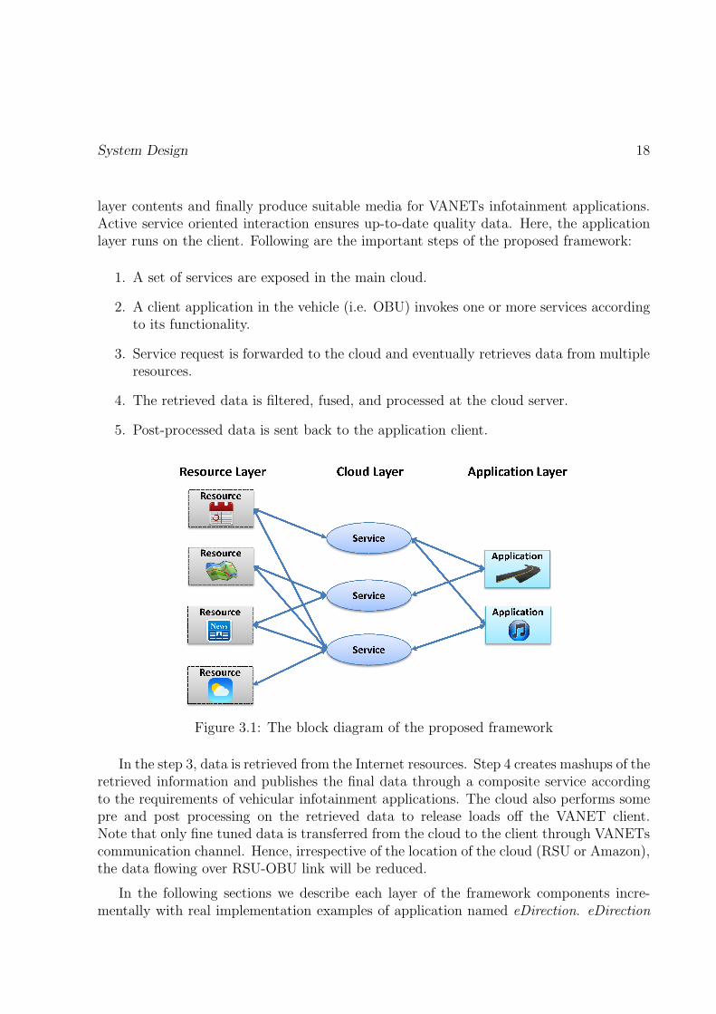
The block diagram of proposed framework is shown in figure 3.1. The proposed frame-work consists of three layers: (1) Resource Layer (set R), (2) Cloud Layer (set serviceson this layer as S), (3) and Application Layer (set A). Resource layer represents phys-ical sources from the Internet. Cloud layer implements services which consume resource
System Design 18
layer contents and finally produce suitable media for VANETs infotainment applications.Active service oriented interaction ensures up-to-date quality data. Here, the applicationlayer runs on the client. Following are the important steps of the proposed framework:
1. A set of services are exposed in the main cloud.
2. A client application in the vehicle (i.e. OBU) invokes one or more services accordingto its functionality.
3. Service request is forwarded to the cloud and eventually retrieves data from multipleresources.
4. The retrieved data is filtered, fused, and processed at the cloud server.
5. Post-processed data is sent back to the application client.
Figure 3.1: The block diagram of the proposed framework
In the step 3, data is retrieved from the Internet resources. Step 4 creates mashups of theretrieved information and publishes the final data through a composite service accordingto the requirements of vehicular infotainment applications. The cloud also performs somepre and post processing on the retrieved data to release loads off the VANET client.Note that only fine tuned data is transferred from the cloud to the client through VANETscommunication channel. Hence, irrespective of the location of the cloud (RSU or Amazon),the data flowing over RSU-OBU link will be reduced.
In the following sections we describe each layer of the framework components incre-mentally with real implementation examples of application named eDirection. eDirection

System Design 19
provides latest up-to-date map routing service for City of Ottawa in Canada by fusing in-formation from Google Map, MapQuest, Ontario Government Transport website and Cityof Ottawa website.
Example: Since navigation is the primary function service in current automobile, weshow the implementation of eDirection, an application following InCloud architecture. eDi-rection service provides the user more reasonable routing result based on the informationfrom multiple map information and routing data fusion. In the implementation, we takerouting resources from Google Map and MapQuest. We also take the local road construc-tion information from the Ontario Ministry of Transportation Website1. The outcome ofthis application provides better result after data fusion of multiple resources. We get theKML2 file of the map and analyze the file to get the data about road condition evaluationand road constructions coordinates.
Table 3.1: Few examples of information resources R.
Resources DescriptionWorld Weather Online3 Weather information
Yahoo Weather4 Weather informationGoogle Directions5 Direction information and route calculationGoogle Geocoding6 Address to location mapping information
Ontario ministry of transportation7 Road construction informationGoogle Calendar8 Event information
Youtube9 video, ratings, and reviewsFacebook10 community, pictures, and eventsTwitter11 news, updates
GasBuddy12 Gas station informationlastfm13 Music informationCBC14 News
1http://www.mto.gov.on.ca/english/traveller/trip/map.shtml2https://developers.google.com/kml/4http://www.worldweatheronline.com/free-weather.aspx5http://developer.yahoo.com/weather/6https://developers.google.com/maps/documentation/directions/7https://developers.google.com/maps/documentation/geocoding/8http://www.mto.gov.on.ca/english/traveller/trip/map.shtml9https://developers.google.com/google-apps/calendar/
10https://developers.google.com/youtube/getting started11https://developers.facebook.com/docs/reference/apis/12http://www.gasbuddy.com/13http://www.last.fm/api14http://www.cbc.ca/rss/

Resources Layer 20
3.2.1 Resources Layer
One of the design goals of the proposed framework is to reduce client side computationand increase the re-useability of the core implementation. That purpose is served byperforming calculation in the cloud and providing data only request service to the OBUclient. Resource layer refers to the Internet in figure 3.1. In this layer, we pick up thevaluable resources. Web 2.0 makes data interaction convenient between Internet resourcesand users. Nowadays, more and more organizations offer their data to clients throughREST, SOAP. Table 3.1 lists some of the popular information resources on the internet.Not only the clients, but also other servers can retrieve data through the web serviceprotocols. But as stated before, resources can be chosen from different API providersconsidering that one is main provider and the others are complementary.
3.2.2 Cloud layer
Figure 3.2: A functional view of a typical service in the cloud.
This is the core part of the proposed framework. The system removes the redundantdata and fuse the information as the application requirement in this layer.We use mashuparchitecture to build new combined services for the vehicle client applications. Figure 3.2illustrates internal components of the cloud layer. The services retrieve data from Internetresources and produce resulting data, which eventually flows over VANET communicationlink. To reduce the bandwidth requirements of infotainment content over VANET commu-nication link and distribute processing, we apply mashup architecture in the operationalcloud [50].
There are three important questions in the design of cloud middleware:
• What are the services provided by the cloud server?
• What are the main steps of a service?
Resources Layer 21
• What functionalities does each step provide?
A service is more useful if it can be used by multiple applications. We have identified alist (Table 3.2) of appealing web functionalities which are useful in VANET infotainmentapplications. To implement these functionalities, we have designed 15 services as listedin Table 3.2. Though detailed design would be different, but each service shares threecommon steps: Data Adaptor, Data Fusion, and Data Forwarding. Data Adaptor is thecomponent that interfaces Internet resources and Data Forwarding directs the generatedfinal result to the client applications.
Data Adaptor
Data adaptor performs pre-filtering operations on the data received from the Internetresources. Normally, this block receives the data in JavaScript Object Notation (JSON)or XML format. In the pre-filtering process, we mainly perform two tasks:
• Filtering: Internet resources design their APIs for general usage. There is a lot ofinformation which is not required in infotainment context. In this task we identifysuch information and drop it. Therefore, the data size is reduced, which is helpfulto improve the data processing speed and data transmission speed. In the caseof context-aware applications (i.e. time, location, or weather) irrelevant data aredropped. For example, we can filter the News updates based on current location (ifuser settings allowed) reducing the data flow over VANET link.
• Unification: After data adaptor, the information will be passed to the fusion block.Therefore, we convert information received from different Internet resources into aunified format for efficient fusion. The unified JSON file decouples Internet resourcesfrom fusion step. Algorithm 1 shows the detailed steps of the unification process ina cloud based service. In order to design any service we first identify the requiredparameters in that service (Select-Parameters). Then we expand each parameter tot more other words by using synonyms from WordNet15 and store them (Expand-Parameters). Multiple languages can be integrated in this part as well. For everyWordNet Synset or multi lingual words we identify a main word preferably in En-glish (Expand-Parameters). Next Internet based resource parameters are extracted(Extract-Resource-Paramters) and we match the stored parameters with the retrievedparameters and copy their value to the unification data structure using main words.
Example The getRoute service of eDirection is hosted in the middleware server. Ve-hicle client adds parameters such as origin coordinator and destination coordinator in therequest. Once given input, the application process starts. The server invokes Google map
15http://wordnet.princeton.edu/

Resources Layer 22
]
Table 3.2: Important functionalities for infotainment applications on VANET.
Functionality Input Output Infotainment Applications
ProfileUser
credentialsUser preferences Context-based Applications
NewsTextualkeywords
Latest news crawledfrom different newsresources on the
Internet
News Updates, Trip Planning, Eventsand Activities, Tourists Assistance
CalenderUser
credentials
Events compiled fromdifferent user
calenders such asyahoo, google,
Trip Planning, Alarms and Reminders
GeolocationTextualaddress
Location coordinatesTrip Planning, Traffic Information,Tourist Assistance, Context-based
Applications
Routing
Source anddestinationcoordi-nates
A linked list ofsegments representingthe optimal routefrom source todestination
Trip planning, Schedule, Timemanagement
RatingsMedia filename
Ratings of the mediafile (music or video)from different review
sites
Media playback, Media download,Media purchase, Playlist
Distance
Source anddestinationcoordina-
tion
distance betweensource anddestination
Trip planning, Time management
Weather Locationweather informationcrawled from different
resources
Trip Planning, Tourist Assistance,Context-based Applications

Resources Layer 23
Algorithm 1 Data unification algorithm for kth service
Require: R ⊆ IR such that IR = Internet ResourcesD = Internet Resource Data
Ensure:1: Hk ←− Select-Parameters(Sk);2: Hk ←− Expand-Parameters(Hk , t);3: Ik ←− Extract-Resource-Paramters(Rk);4: for all P ∈ Hk do5: for all Q ∈ Ik do6: if P == Q then7: main←− find-main-word(Q);8: append value of D < Q, J > to F < main, J > ;9: /*where J ∈ Rk */10: end if11: end for12: end for13: return Filtered Data, F
and MapQuest Map API, and gather direction results. It also collects the live data fromMapQuest at the same time. Next, local road construction information is collected fromOntario Ministry of Transportation Website and City of Ottawa website. Figure 3.3 illus-trates example data we get from Ontario Ministry of Transportation Website. Its formatis KML file which belongs to XML file [17]. We try to get the KML file of the map andanalysis the file to get the data like road condition evaluation and road constructions co-ordinates. We represent all the data in a common format which is part of unification andhelps in the fusion phase.
Data Fusion
Data fusion step is vital for the proposed cloud-based middleware. The aim of fusionstep is to combine different data sources and extract more comprehensive data for dataprocessing step. This step further enhances the quality of data which might reduce thedata size depending on the type of services. Table 3.3 shows the servers that we haveimplemented. For example, for ranking service the reduction ration will be 1/n for nresources. In case of route calculation we grab the road constructions data from OntarioGovernment Transport web site, while we also get the map data from Google. We fuseboth information to obtain a route that is shortest and without obstructions. More detailsabout the data fusion approach is covered in Section 3.3.
Example During the process of the data fusion, we take several pre-check steps toimprove the system process inefficiency. We firstly make normal route search options

Resources Layer 24
<?xml version="1.0" encoding="utf-8"?><kml xmlns="http://www.opengis.net/kml/2.2">
<Document xmlns="">
<name>Construction Information</name>
<description>Construction Information provided by the Ontario Ministry of Transportation</description>
<Style id="activeIcon"><IconStyle>
<scale>0.9</scale>
<Icon><href>http://www.mto.gov.on.ca/graphics/english/traveller/trip/icon-active_construction_contracts.png?5685685</href></Icon>
<hotSpot x="0.5" y="0.5" xunits="fraction" yunits="fraction" /></IconStyle></Style>
<Placemark>
<name>2011-2003</name>
<description>...</description>
<MultiGeometry>
<LineString><coordinates>
-79.610814,43.555320,131.28
-79.609329,43.557332,131.53 .
.
.-79.554116,43.609825,138.77
</coordinates></LineString>
</MultiGeometry>
<styleUrl>#active</styleUrl>
</Placemark>
<Placemark>
.
.
.</Placemark></Document></kml>
Figure 3.3: The example of the KML file.

Resources Layer 25
Table 3.3: The implemented services and description
Category Services Parameters Resources Comment
NewsgetNewsByKey
Wordkeywords:
value
YahooNews,GoogleNews,
CBC News
Return the top newsfrom yahoo news
,Google news and CBCnews based on the input
keywords
Music getRMusicartist: value,name: value
Musicovery,last fm
Return therecommended musicbased on the userspreference and mostplayed music style
Music getPMusic song: value xiami
Return the online medialink. The song containsthe songs name and
artist name
Music getPlayHistory userID : valueLocal
DatabaseReturn the user play list
history
Route getRouting
originLat:value, origin-Lon:value,destination-Lat : value,detination-Lon:value
GoogleMap,
MapQuest,Ontario
ministry oftrans-
portation
Return route result fromGoogle Map and
MapQuest, optimized byroad constructioninformation from
Ontario ministry oftransportation
Route geolocation place:valueGoogleMap
Return the formattedaddress using Google
Geolocaiton service. Theplace value can be
coordinators or placepolitical name.
Route getNaviSettings nullLocal
DatabaseReturn the setting for
the navigation
Route setNaviSettings nullLocal
DatabaseUpdate the setting for
the navigation

Resources Layer 26
Table 3.4: The implemented services and description
Category Services Parameters Resources Comment
Weather getWeatherInfoLat:value,Lon:value
Forecast,world-
weatheron-line,
wunder-ground
Return the weatherforecast result, pick upthe resources from
Forecast,worldweatheronline,
wunderground resourcesbased on the datatrusted calculation
Weather getYahooWeatherID latlon:valueYahoo,GoogleMap
Return the YahooWeather WOEID
Account loginCheck
username:value,
password:value
LocalDatabase
Return account checkresult and user ID if
account is valid
Account getAccountInfo userID:valueLocal
Database
Return the usersinformation based on
the user ID
Calendar getEventInfo userID:value
GoogleCalendar,Local
Database
Return Google Calendarevent items information
Calendar getEventPlace userID:value
GoogleCalendar,Local
Database,GoogleMap
Return Google Calendarevent place formatted
address

Resources Layer 27
based on the users preferences. Then we do an precise check if there is any constructionongoing in the current route bounds. If there is a construction ongoing, we change theroutes to see if we can avoid the road construction.
Data Forwarding
In the VANET infotainment application, the application request comes from the vehicleclient which is registered in the cloud. The vehicle client makes the request to the currentRSU along with its position, speed information. In our proposed framework we supporttwo types of cloud hosting. The straight forward approach is to have a central cloud fordata processing and result forwarding. Another approach is to host the clouds in the RSUin a more distributed manner. Detail description follows:
• In the former approach, RSU forwards the request to the cloud server which identifiesthe dynamic geolocation of the the requesting vehicle client and its approachingdirection in the connected RSU. Using this information, the cloud server determinesthe possible next handover RSU in the traveling path of the vehicle. Next, the cloudserver replicates the information in both current RSU and next RSU along withreusable cached information for independent RSU.
• In the later approach, every RSU works as an infotainment cloud. When a requestcomes to this RSU cloud, it determines the direction of the vehicle and forwards theprocessed data to the requesting vehicle. The processing RSU cloud also replicatessame information along with intelligent approximation and directs it to the probablynext RSU.
Example The route data is transferred to the RSU middleware server and from theresent back to the vehicle client. In our implementation we only considered one RSU. Inmultiple RSU scenario, we will have advanced forwarding which is part of our future work.
3.2.3 Application layer
In InCloud we intend to make application clients as lightweight as possible to achieveloose coupling with the underlying hardware of the vehicle. Application clients mainlyimplement modules related to user interface and information presentation. The client mayalso include processing steps such as video/image decoding which is not done at the serverbecause of large size of the decoded data. Recent attention16 of consumer electronics giantsApple, Google, and Microsoft in building operating system for car dashboard, which makes
16http://www.slashgear.com/google-projected-mode-android-tipped-to-take-on-apple-in-cars-02319097/

Resources Layer 28
Figure 3.4: The example of Ajax call pattern
our system more relevant since multiple platforms can consume our services to build theirinfotainment applications. Our light weight client approach ensures interoperability amongmultiple platforms as well.
The infotainment client is implemented on android platform. We host the client onGalaxy Tab 3 mobile device. The mobile device also has two network interfaces: 3G andwireless. However, at any given time only one interface is active. The client maintainsa WiFi Direct connection with the RSU server. The client implements the user interfaceand data processing, depending upon the application. The applications use AJAX withXMLHttpRequest protocol to interact with the IIS web server in RSU which is commonfor all web services. With the help of web browser and these technologies, users can easilyaddress rapid data interaction. We have chosen to use AJAX because it enables us toupdate a part of the webpage without refreshing the whole page. Hence, the reactionspeed is much faster than before.
In the server, we provide the web service interface by both REST and SOAP. For theservices’ result, we use JSONP. It is JSON with padding. The difference is that we add aheader or a pair of parenthesis around the JSON string to generate JSONP string. JSONPallows the client to load the JSON feedback as a script file. It is usually used for cross-siteAJAX with JSON data. In the implementation, our client use ajax from jquery library.JSONP makes it easier to invoke the web services. Based on the services tables, ourweb sevice URL pattern: ”Http://+ ServerIP + / infotainment.asmx/+ servicesName+?jsoncallback=?”. In the client, the ajax call pattern is shown in figure 3.4
3.3 Data Fusion
Data fusion strategy depends on the type of information being fused. We can broadlycategorize the information resources into three types: resources that provide opinions,resources that provide auxiliary information with respect to each other, and resources thatcompliment each other with additional information. Description of these resources andexamples are given in the Table 3.5.

Resources Layer 29
Table 3.5: Resource types from fusion perspective.
ResourceType
Description Examples
Opinions
These resourcesprovide opinionabout an event,
activity, or object.
Musicratings,movieratings
AuxiliaryInforma-
tion
These resourcesjust add more
quantity.
News,point ofinterest
ComplimentaryInforma-
tion
These resourcescompliment eachother towards acommon goal.
road map,traffic info,road con-struction
Each service may need to use different fusion strategy depending on the type of theinformation provided by the resources. It is also possible for one service to receive datafrom multiple types of resources. Therefore, a service may have all three types of fusionstrategies. The fusion model components are categorized as:
1. Automatic reputation models [45] or prior knowledge are given as Input to choosethe main resource.
2. Classify the remaining resources according to the type of information provided asgiven in Table 3.5.
3. Data Processing : first fuse opinions, then auxiliary information, and finally compli-mentary information.
Figure 3.5 shows overview of the fusion method employed by the services and Algorithm2 shows the higher level algorithmic steps. First we identify the main resources recom-mended for a service using primary knowledge and reputation model (Find-Main-Resource),next we identify opinion (Find-Opinion-Resource), auxiliary (Find-Aux-Resource), andcomplimentary services (Find-Comp-Resource). Later, based on the application type re-quirements, we identify the composition of opinion, auxiliary and complimentary informa-tion (Find-Mode). These additional information are later fused with the main extractedinformation in a specific order which is consumed by the vehicular client (Φo, Φa, andΦc). Every vehicle client is assigned an unique key which helps to log earlier interactionsin the internet cloud. These early records help in various fusion operations. Importantcomponents of the fusion methods are described below.

Resources Layer 30
CLASSIFICATION
Prior
Knowledge
Reputation
Model
Information Resources
Main
Re
sourc
e Complimentary
Information
Auxiliary
InformationOpinions
Fusion Result
F1 F2 F3
Figure 3.5: The fusion takes place in three steps depending on the type of resources.
Algorithm 2 Data fusion algorithm for for kth service
Require: R ⊆ IR such that IR = Internet Resources PK = Primary KnowledgeRM = Reputation Model
Ensure:1: Rm ←− Find-Main-Resource(Rk, PM,RM);2: Ro ←− Find-Opinion-Resource(Rk −Rm, PM,RM);3: Ra ←− Find-Aux-Resource(Rk − Ro −Rm, PM,RM) ;4: Rc ←− Find-Comp-Resource(Rk − Ro −Rm − Ra, PM,RM) ;5: Mode[o, a, c]←− Find-Mode (ApplicationType) ;6: F = Extract(Rm);7: if Mode[o] == True then8: F = Φo(F,R
o, PK);9: end if10: if Mode[a] == True then11: F = Φa(F,R
a, PK);12: end if13: if Mode[c] == True then14: F = Φo(F,R
o, PK);15: end if16: return Fused Data, F

Resources Layer 31
3.3.1 Fusion Input
We integrate various information in the data fusion, following is the detail of the inputinformation for data fusion.
Prior Knowledge
In our system, users incorporate their prior knowledge about the quality of the data pro-vided by different web resources. This information is stored in the Internet cloud againstthe vehicle client key which can be reused or updated over time. For instance, we canexperience that one news channel provides information of more interests than others. Sim-ilarly, during our earlier trips we might have experience that a particular website suggestsbetter places to visit than other websites. Prior knowledge is retrieved from the Internetcloud whenever necessary. It is also required to determine the type of any resource.
Reputation Model
The system also learns the reputation of each web resource by observing user returns overtime. For instance, the cloud may compare the places visited by a person and the placessuggested by websites over time. There are also scenarios where the system may determinethe correctness of partial information provided by the web resource and build reputation.For example, the vehicles generally have sensor to measure outside temperature accurately.This temperature value can be compared with the one provided by the weather resourceover time to identify which resource provides more accurate information. This can help inidentifying more trusted information resources.
3.3.2 Classification
This component classifies the resources according to the prior knowledge and reputationmodels. It selects one resource as the most trusted main resource and classifies the restwith respect to the main one. It enables and disables each fusion step according to theavailability of the resources. For example, opinion fusion step is only enabled when thereis a resource providing opinion information, otherwise the main resource data is forwardedto the next step. Same strategy is employed for each fusion step.
3.3.3 Data Processing
Opinions
This is the first step of the three steps fusion method. If there is any additional resourcethat provides opinion about the event, activity, or object under consideration, we need to

Summary 32
fuse that information to derive a single conclusion. For fusing opinions, we propose to useweighted some of individual opinions. The weights can be calculated based on the websitereputation model or prior trust value assigned based on past experience. If there is noresource providing opinion information, this step is disabled and the input data is copiedto the output data.
Auxiliary Information
As the web technology is growing rapidly, more content is now available online. For exam-ple, a large number of news websites report current events and happenings. As a result,many web resources accumulate to greater number of information which can provide theuser with more options. If auxiliary information is preferred by user settings then we canget more personalized content by applying user profile and preferences on the data. Forinstance, choosing news based on current location and interests of the user.
Complimentary Information
Different resources can provide different data/media which in turn completes the maintrusted information. For example, one resource provides road map, another traffic re-strictions, and third one provides ongoing road construction. All three types of informa-tion fused together provides the best up-to-date route information. For every category offunctionality, we need a separate fusion strategy. In the implemented system eDirection,getRoute service receives map and traffic data from Google Maps and road constructioninformation from Ministry of Transportation respectively.
3.4 Summary
We have described a cloud-based infotainment system in this chapter. The middlewareis developed according to the system design principles discussed earlier, such as cross-platform feature, system compatibility, and service re-usability. This framework is createdusing SOA extended with mashup methods. We divided this framework into three layersand listed all the related resources or methods in each layer. Second, we provided detailsof the fusion method used. Finally, we illustrated our prototype system. We showed theconnection method between resources layer and cloud layer and listed main services wecreated in the implementation.

Chapter 4
System Implementation
In our implementation we consider RSU as the middleware server which is a laptop withWindows 8 OS, Intel Core i7-3820QM processor, and 4 GB RAM. The laptop has twonetwork interfaces and simulates RSU in VANETs [37]. The wired Interface providesInternet connectivity while the wireless network is used by clients. Our web services arebuilt using Microsoft Web Platform and hosted in Internet Information Services (IIS) 8.5.The services are written in C# object oriented programming language using Visual StudioIDE.
The client can connect to the server and request any service through AJAX. The clientalso sends data with the request depending on the request. For example, to request func-tionality of getDistance web service, the client supplies source and destination location tothe server. After evaluating, the web server sends results back to the client through JSONfile.
To create service mashups, we write our own mashup code except news service. Fornews service we use Yahoo pipes. For all other services, we first fetch data from differentresources through API’s, RSS feeds, or by grabbing web data. The list of all services andtheir implementation details are provided in table 3.3. The source code of the server isavailable on Git public repository1 on www.bitbucket.org for download and testing. Herewe give the class diagram to illustrate the organization of the service as in figure 4.1.
We have implemented fifteen different services (Table 3.2) in different application do-mains among which eDirection is described inline with the framework and two other appli-cations (i.e. music player, and news service) are described in detail to validate the efficacyof the proposed infotainment middleware. Figure 4.2 represents the architecture of our im-plemented VANET infotainment system. Here Vehicle Client is a tablet and informationresources come from Internet. Any request goes from client to the RSU. Both RSU andServer can play the Middleware Server role. In our testbed, we have considered RSU onlyand hosted the middleware server in RSU. All the resources are consumed from Internet.
1https://bitbucket.org/mksaini/incloud-infotainment-middleware
33

System Implementation 34
Figure 4.1: Class diagram of infotainment system.
Figure 4.2: Implementation of infotainment system.

System Implementation 35
Figure 4.3: Screenshot of the map website from City of Ottawa.
4.1 Context-Aware Routing Application
The routing application is to provide users a new route which can avoid the additionalconstructions data. Fusion Input is user preferences such as faster service, toll free serviceetc. The system selects the main resource following this prior knowledge. Classification usesthe fusion input data and identify Google Map as main resource, MapQuest as auxiliaryinformation, and City of Ottawa as complimentary information. As shown in figure 4.3,we can observe that there are construction information added to Google Map. The wholeflow of the application is shown in figure 4.4:
a) At first, server retrieves the route bounds which is a pair of coordinates. The twopoints will generate a rectangle while they work as south-west and north-east corners.We can see from figure 4.5. The black rectangle is the route bounds. The server willcalculate whether the construction points fall in this area or not. Let north-east point be(XNE , YNE), south-west point (XSW , YSW ) and construction point (XC , YC). Then we getthe distance of two points like (XNE, YNE) to (XSW , YSW ) is D1 , (XNE, YNE) to (XC , YC)is D2, (XC , YC) to (XSW , YSW ) is D3. So if D2 < D1 and D3 < D1, the construction pointfalls in this area.
b) If there is no construction points in this area, system will send back the result.Otherwise, the system will divide the route into parts based on the turning and distance.Each part called step has its own start point coordinators and end point coordinators likethe red rectangle in figure 4.5. As shown in figure 4.5, the area covered by red rectangles is

System Implementation 36
Manually Add Way-Point
Result Segmentation
Directional Result
Construction?NO
YES
Invoke Direction API
YES
Construction?
Get Final Result
NO
Figure 4.4: Flow chart of eDirection proposed algorithm.
Figure 4.5: Example of step area.

System Implementation 37
Figure 4.6: Detail of the step calculation.
obviously smaller than black rectangle. We can reduce the construction check area in thisway to make more accurate construction check. Theoretically, if we red rectangles numberapproaches infinity, then the red rectangle area approaches the route.
c) Next, system will try to search which step locates the construction. Again, if thereis no construction points in these steps, system will send back the result. Once the con-struction locates the step, system will do further verification. The bending angle of theroute in each step is less than 90◦ since the step is divided based on turning. We assumethat the route in this block is near the diagonal of the step. So next we want to verify ifthe point falls in the shadow area like in figure 4.6. For each one construction point, we seta radial with it as starting point which is paralleling X axis. For each side of blue polygon,we calculate if there is intersection with the radial. If the sum of the intersections is odd,the it means the construction is in the polygon. If it is even, then the construction locatesout of the polygon. Algorithm 3 shows checking constructions points in each red area:
d) Last, we try to make new route to avoid the construction point. First, we generatenew route using MapQuest API, redo the upper steps to verify the route. Second, if newroute can’t get through the verification, we create route by adding new way point. Thefigure 4.7 shows that we assume construction is in red area, we add a new way point outof this area. We first add one new point in one side of the area, test if the new route canavoid the construction point, if not, we clear old way point and add new one in the otherside. Then again do the verification. If still does not work, we repeat upper steps untilthe new route can pass the verification. When all the step segments are clear, the systemsend back the final route result. Figure 4.8 displays the process of system. Following ispseudu-code for route optimization:

System Implementation 38
N
Figure 4.7: Detail of the step calculation 2.
eDirection:
Routing:GetResult :CheckConstruciton :OptimizeResult
1. getRoute()
2. GetConstruction()
3.boundsCheck()
4.StepsCheck()
valid result
valid result
5.HandleConstruction()
result
loop foreach construction point
valid result
if no constructionalt
Figure 4.8: Interaction diagram of eDirection.

System Implementation 39
Algorithm 3 Construction Point Check
Require: list of construction points’ coordinators ωc ωc = {(S1, S2, . . . , Sk}, Sk = (Xk, Yk)area start point coordinators (Xs, Ys) area end point coordinators (Xe, Ye) new waypoint coordinators (XN , YN) sides set of polygon β = {L1, L2, . . . , Ln} set tolerance t.
Ensure:1: SET J=0;2: for all Sk ∈ ωc do3: SET RADIAL Y = Xk;4: for all Ln ∈ β do5: if XN < 0 AND YN > 0 then6: KL = |YN − Ys|/|XN −Xs| or KL = |YN − Ye|/|XN −Xe|;7: Ln → Y = KLX + (YN + 2(1/2)t)−KL(XN − 2(1/2)t);8: CALCULATE IF RADIAL Y = Xk has intersection with Ln;9: intersection EXISTED10: J= J+1;11: end if12: if XN > 0ANDYN < 0 then13: KL = |YN − Ys|/|XN −Xs| or KL = |YN − Ye|/|XN −Xe|;14: Ln → Y = KLX + (YN − 2(1/2)t)−KL(XN + 2(1/2)t);15: CALCULATE IF RADIAL Y = Xk has intersection with Ln;16: intersection EXISTED;17: J=J+1;18: end if19: RS = J MOD 2;20: if RS !=0 then21: ωc = ωc − Ln;22: end if23: end for24: end for

System Implementation 40
Algorithm 4 Route Optimization
Require: area start point coordinators (Xs, Ys) area end point coordinators (Xe, Ye) setconstruction check result β = {S1, S2, . . . , Sk} set α = |Ys−Ye|/|Xs−Xe| set tolerancet
Ensure:1: SET J=0;2: GET THE MIDDLE POINT COORDINATORS Sm = ((Xs +Xe)/2, (Ys + Ye)/2);3: for all Sk ∈ β do4: while β /∈ φ do5: J=J+1;6: Sm = ((Xs +Xe)/2 + J ∗ t, (Ys + Ye)/2 + J ∗ t);7: FOR ((XS, YS), (Xm, Ym)) AND ((Xm, Ym), (Xe, Ye));8: CALL CONSTRUCTION METHOD 3;9: if β ∈ φ then10: β = β − Sk; Break;11: else12: Sm = ((Xs +Xe)/2− J ∗ t, (Ys + Ye)/2− J ∗ t);13: FOR ((XS, YS), (Xm, Ym)) AND ((Xm, Ym), (Xe, Ye));14: CALL CONSTRUCTION METHOD 3;15: if β ∈ φ then16: β = β − Sk; Break;17: end if18: end if19: Continue;20: end while21: end for

Contexts Aware News Application 41
With respect to cloud technology, infotainment system can gather massive data so thatit can offer user more accurate and high-quality context aware services. Besides the routingservice, we also implemented other services as shown in the services tables. Following figure4.9 is the use case diagram of our system.
User
Routing
News
Weather
getRouting
geolocation
Multimedia
recommendMusic
searchMusic
getliveweather
weatherforcast
getNewsby
keywords
User preference
Figure 4.9: Use case diagram of system
4.2 Context-Aware News Application
News service can provide the recent news based on users’ preferences and location. Supposethat a driver turns on the system, it will fetch the user’s information from server. Accordingto user’s operation history, system will generate the categories of News that user viewedmost. Also the system will catch the latest news based on user’s current location. Forverification of this service, we created a function which searches the news by keywords. Weuse Yahoo Pipe, an online mashup tool, to maintain the data fusion task.
With the development of the mashup system. More and more IT companies such asYahoo, Google, IBM, start to create their own mashup tool. Yahoo pipe is one of them.We choose this online mashup tool for the following reasons: 1) News service needs little

Contexts Aware News Application 42
Resource Layer Cloud Layer Application Layer
News Applicaiton
GPS
Google News
Yahoo News
BBC
getLastNews
getCityfrom
Coordinates
Figure 4.10: The schematic diagram for news service
data processing which means we do not need much calculation on the news data. Thisservice only needs to fuse and filter the news content. Yahoo pipe can improve the systemefficiency. 2) Using Yahoo pipe gives us convenience to access Yahoo search engine. Figure4.10 is schematic diagram for news services. It illustrates how the system fuses multipleresources using different services. The process is as follows:
1. In the first step, the client sends the request to the mashup server. The inputparameter represents the keyword. In the server, if no parameter is present, thesystem will take the top news as default value. The news service will firstly call”getCityfromCoordinates” method. This method invokes the Google Geocode APIthat can get the users’ current location coordinate.
2. Next, the service will call the method ”getLastNews” with the list of keywords. If thekeyword list is empty, we will look up in the users’ history to find highest frequencykeyword for news. Then recall the ”getLastNews” method. For the ”getLastNews”method, we gather the top news from three news search engine: Google News, YahooNews, BBC News. For the free resources purposes, we use different approaches tofetch the data. For instance, we use API for Google, RSS and Feed files for BBCand Yahoo News. For this step, resources firstly are gathered in Yahoo pipe. Andthe server gets the RSS file from Yahoo pipe.
3. After gathering the data, we unify the data. We set news object that includes : Title,Content, Link, Publisher, Publish Date five parameters. No matter what source ofnews we get, we just pick up these five related information elements and initialize

Context-Aware Music Application 43
the object. We can get latest 50 viewed news title and subtitle and analyze the newcategory and keyword.
4. Last, the system will check the duplicated news based on Link, Title, Publisher.After getting the result, it check the news link and remove duplicated ones. Thenserver send the result back to client. In client side, we try to minimize the operationof the passengers.
We can see the news services are context aware since the news search result not onlyrelies on the keyword but also relies on the users’ GPS data and preferences. The newsservices can provide users more useful news according to his location.
4.3 Context-Aware Music Application
Since the vehicles can access to the Internet, plenty of multimedia data will be availablethrough the Internet. Besides the music search service for expected music, it is very impor-tant to have a music recommendation system based on users’ preferences. Considering thesafety and convenience, it is better for passengers to have one-click application instead oftrying the search content on the screen. However, most music recommendation systems givethe music based on keyword search history or music type. Some audio database can providethe music rating service. Yet, the limitations of the region, languages, ages of the users,still hinds online music from providing convincing result. For instance, www.xiami.com isChinese on-line music website which is similar to the Lastfm. ”JuanZhuLian” is very pop-ular song and has very high rank in this website. While we can hardly find the informationfrom lastfm. On the other hand, the people who like 60s’ music have hardly used onlinewebsite like lastfm. Since there is not many play records of these tracks, the music theylike mostly does not have good rank. Due to these kinds of reasons, single on-line musicresource may not provide users a satisfied recommendation result.
Recommendation
requestHistory search Cloud search Rate data fusion Media fetch
Figure 4.11: The multimedia service flow chart
Multimedia is one important component of the infotainment system. To enhance QoS,we try to provide users with better music recommendation service. We design a musicrecommendation service to provide users new music that fits their desires. The on-linemusic service fetches the onine music by taking the advantages from the mashup system.Combining the user’s play history, recommendation service can provide passengers highrate musics which are similar to users’ favorite style. Figure 4.11 illustrates the flow ofwhole process. As depicted in figure 4.12, the music service process as following:

Context-Aware Music Application 44
Music
Recommendation::PlayReoord
Search:CloudSearch :Rating Music
1. recommendMusic()
2. getMostPlayMusic()
3.getSimilarMusic()
4.getTrackInfo()
5.getRating()
loop foreach track rating
valid result
:MediaPlay
5.playMusic()
valid result
Figure 4.12: The interact diagram of recommendation music service
1. Once the server receives the music recommendation request from the vehicle client,it searches user’s playback history from the database and finds the most played song.
2. The server searches for similar songs on Musicovery2, a music search engine. Thenthe server gathers each song’s popularity from Musicovery. The popularity valueranges from 0 to 100, where 0 means new or unpopular song and 100 means a hitsong. We denote the popularity value from Musicovery as S1
n, where n is the songindex number.
3. We also get the play counts from the Lastfm. Since the play count is incremental, weuse a function to limit the scope of the value between 0-100. If maximum play countis denoted as S2
m and current play count as S2c , then the popularity value from Lastfm
is calculated as: S2n = (S2
c/S2m) × 100. The final popularity rating Rn is calculated
as:
Rn =
r∑
j=1
wjSjn. (4.1)
where r is number of resources and w1 + w2.. + wr = 1 are weights assigned basedon prior knowledge. In our application, we take two resources and equal weights, soour rating is Rn = (S1
n + S2n)/2.
4. After calculating the final rating, the server sorts the songs based on the ratings andreturns the first ten results to the vehicle client. Each item contains the basic track
2www.musicovery.com

Context-Aware Weather Application 45
information, such as track name, artist name, album image etc. Once the user clicksany item on the playlist, the server requests for the online music service. This servicealso searches for online music streaming resource and gives the resource link back tothe client. In this implementation, the service finds the resource form xiami.com.
Due to the multimedia copyright issues and free resources issues, our system only canfind limited Internet resources. But this is enough to verify the concept of proposed service.If the system is established in commercial use or supported by more media web resources,the server can get more feedback and it will give more comprehensive music rate result.Also the on-line media search will have a larger scope.
4.4 Context-Aware Weather Application
For the weather service, accuracy of results is the key to QoE. More accurate data canalso influence the data fusion result that uses the weather data as parameters. We builda trusted system to choose more accurate weather resource to use. Our trusted systemmodel is to record the weather history data from different resources. It compares themwith vehicle sensors data, pick up the one resource most close to real outside vehicle data.
One important element of context aware application is location awareness which meansthe location information takes part in the data process of the application. Context-awarealso means synthesis of different service information. This can simplify the users’ operationsand improve users’ efficiency. We will present a scenario to give further explanation. Thereare two methods in this service: getWeatherInfo and getYahooWeatherID. getWeatherInfois a meant to return the user trusted weather forecast data. The figure 4.13 and figure 4.14illustrate the flow of the getWeatherInfo service:
1. The service will firstly invoke the geolocaiton method from the Route service using thevehicle’s GPS. The geolocatioin webservice from Route service returns the formattedaddress of the user’s current location.
2. Next, the server will search the local database for temperature record of the last 5days. This recorded data comes vehicle sensor. Every hour the server will receivethe record temperature data from the vehicle sensor, if this value is higher thanthe maximum value or lower than the minimum value in the database, the serverwill update the record. Therefore, the database can store maximum and minimumtemperature. We define these two value as MaxTempn and MinTempn, n meansthe day from history, usually n = 1, 2, 3, 4, 5 which means we take 5 days historyrecord from the database.

Context-Aware Weather Application 46
getWeatherInfo
worldweatheronline
getTrustedSource
Forecast
Result
Wunderground
Figure 4.13: The flowchart of the weather service
:GetWeatherInfo :HistorySearch :CloudSearch :GetTrustedSoure
1. getWeatherForecast()
2. getWeatherRecord()
3.getWeatherHistory() 4.getTrustSource()
5.compare()
loop foreach weather source
trusted sourcevalid result
weatherlocation
Figure 4.14: The interact diagram of the weather service.

Summary 47
3. After second step, we need to fetch the online resources history result. In the proof ofconcept, we consider weather information from 3 resources: Forecast3, Worldweath-eronline4, and Wunderground5. If we set the maximum temperature and minimumtemperature as MaxV (K)n and MinV (K)n, K means the number of the weatherresources, n means the day of the history. For example the maximum temperatureof yesterday, the first day back from today, from Forecast is MaxV (1)1, and thecriterion value is V (k). Then we have V (K) =
∑5n=1(|MaxV (K)n −MaxTempn|+
|MinV (K)n −MinTempn|).
4. After our calculation, we choose the minimum V (K) value as our trusted resource.And we then get weather forecast of user’s current location using the sources fromthe trusted resources. Figure 4.15 shows one week weather forecast result.
GetYahooWeatherID service aims to give the client an ID which can active the yahooweather widget. For the current weather information, there are already many matureweather widgets that provide users instant weather information. Since this data needsto be redirected from the Internet to the client by server, we just return the API keyinstead of whole package of the data to client to request the weather data. This mayreduce the consumption of the bandwidth because the client needs to keep continuous datacommunication with server for live weather data. If the client can request the data fromInternet resource directly based on the key the server returned, the network load will bemuch less. In our proof of concept, we choose Yahoo weather service as the resource. Yahooweather widget can be activated by setting the WOEID (Where On Earth Identifiers) whichis unique and non-repetitive 32-bit identifier that assigns to Yahoo geographic resource.We loaded the WOEID in our own system database first. Then, the server receive theclient request for current weather. It invokes the geolocation service to get the formattedaddress based on the user’s current location coordinates. Using the formatted address,server can get the right WOEID from the database and return to client.
In the client, we integrate the Yahoo weather widget to our client by using jquery-pluginnamed zWeatherFeed. Figure 4.16 shows the result of this plugin. It provides easy accessinterface, and can keep update weather information continuously.
4.5 Summary
This chapter discussed the multimedia services of our system. We showed several serviceswhich provide users audio, weather, and news information. We also illustrated how ourservices differ from current multimedia applications by using the Internet data.
3http://forecast.io/4http://www.worldweatheronline.com/5http://www.wunderground.com/

Summary 48
Figure 4.15: The example of the weather forecast
Figure 4.16: The example of the zWeatherFeed
Chapter 5
Experiments
In this chapter, we will verify our proposed system by three experiments. We will firstintroduce the methods of measurements of this system. Then we will illustrate the designfor each experiment. At last, we give the experiment result and conclusions.
We analyze the performance of the proposed work under two different perspectives: 1)The optimization of feedback data from the mashup server. 2) The consumption of networkfor transiting data. The first perspective is to evaluate the algorithms we implemented inthe mashup server. We need to verify whether the result from our server is better than theone from the Internet or not. In other words, we want to figure out the quality of the datathat processed by our algorithms. For second perspective, since the server is assumed to beestablished in the cloud under VANET, the communication approach is mostly wireless,we need to consider the network connection stability including bandwidth stability andpackage loss. Our infotainment system includes some applications that needs continuousconnection with VANET such as navigation and weather functions. Thus, we want toevaluate the enhancement of the data transition between the server and the client. We havetwo experiments to display the performance of our system. Since there is no existed VANETso far, we consider the network environment as in the Internet. We assume that the clientsare under good network connection which means the vehicles are in the urban area referringas service area. And the client is equipped with GPS device. We establish the mashupserver on PC. The PC information: Intel(R) Core(TM) [email protected], OS: Windows8.1 Pro, IDE : Visual Studio 2012. There are two wireless network interface cards, wiredNIC connects to the Internet while the wireless one is considered as the network interfacetowards the clients. For the client, we developed an Android application on a tablet. We useJuqery framework and phonegap framework to develop the Android application, MSSQLas the local database. Figure 5.1 shows the test page of the services in the PC. For theexperiments, we published the webservices to the Internet working as middleware server.The host address is http://uottawainfotainment.somee.com/infotainment.asmx.
49

Experiments 50
Figure 5.1: Test page of the Web services

Framework Experiment 51
5.1 Framework Experiment
One efficient approach to reduce the network data transmission load is to decrease thedata size from the server. To drop the abundant data can achieve this goal fairly. What ismore, reducing the data size also accelerates the speed of data process effectively.
In our implementation of the server, we have a data filter layer which maintains remov-ing the elements that our server does not need. For example, a weather complete feedbackcontains a lot of data such as windspeed, pressure, heat, etc. Since we just take the tem-perature into consideration in our weather service, these data is never involved in the dataprocessing layer. Abandoning these data will reduce the data size of the final feedbackwithout influencing the data processing. Besides, the data fusion can also reduce the datasize to a certain extent. For instance, the data fusion for news service will generate thelatest news that are related to users’ preferences and keywords. For the detail of the workflow of system, we demonstrate news service as an example. We have implemented oneweb service that searchD the news by keyword.
We use Yahoo pipe, an online data mashup tool, to integrate the news data fromGoogle News, Yahoo News and CBC news. As we explained before, we have no complexdata processing in the news service.
In the pipe, we first get the news by keyword from different resources. For Google Newsand Yahoo News, we receive news through the rss. The query for google news is http://news.google.com/news?hl =en&ned=us&q=keyword&ie= UTF-8&scoring=d&output=rss",and query for yahoo news is http://news.search.yahoo.com /news/ rss?p=keyword
&c=&ei=UTF-8& datesort=1&eo=UTF-8". Since there is search query or API for CBCnews, we just manually generate a rss news file consisting of the latest news in most fieldssuch as politics, business, health, arts, etc. Next step, we filter the news which containsthe keyword. Figure 5.2 is screenshot from the Yahoo pipe console. It is the schematicdiagram of news services.
Once the pipe feed is published, any device can get access to this resources from url:http://pipes.yahoo.com/pipes/pipe.run?_id=029120fb4913ab85dcfdb104759b698d&
_render=rss&textinput1=keywords. But there is still some abundant data in the feed-back. In the server, we filter the data furthermore based on our system requirements. Inthis case, we just need news title, news link, description and published time. So we createa news object that has these four parameters in the system model. Once we receive thedata from Yahoo pipe, we instantiate an object using this data. This way we just havethe needed data to enter the next layer in the system. We validate framework from twoaspects:
1. First, we validate framework by the data size. Since the data filter will drop theabundant data, there should be difference between original file and filtered file. Asshown in figure 5.3, we search the news with same keywords. We set the feedback

Framework Experiment 52
Figure 5.2: Schematic diagram of news service
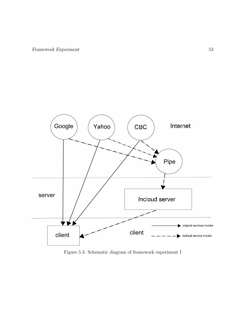
Framework Experiment 53
Pipe
ver
client
server
client
original services invoke
vice invoke
Figure 5.3: Schematic diagram of framework experiment I

Framework Experiment 54
Pipe
ver
original services invoke
vice invoke
client
Figure 5.4: Schematic diagram of framework experiment II
from Google, Yahoo, and CBC as f1, f2, and f3. They are directly invoked fromInternet resources. Then we make the same search from Incloud which invokes pipeto get result. We set the result as fi. Next, we put the feedback into a text file andget the file size on the disk. Finally, we compare f1 + f2 + f3 and fi.
2. Second, we validate framework by the transmission time. Considering bandwidthand stability, our connection between client and server is through LAN which isdifferent from VANET. And the framework is in the server as shown in figure 5.4,there is no meaning for us to measure this part time consumption. We make thesame search both from three resources and pipe. We can see from the figure 5.4, thetime consumption of original search To = To(1) + To(2) + To(3) + To(4). The timeconsumption of Incloud search Ti = Ti(1) + Ti(2) + Ti(3) + Ti(4) + Ti(5). The Ti(n)or To(n) is the sum of request time and response time. At last, we compare Ti andTo.

Framework Experiment 55
Figure 5.5: The comparison of data size.
Figure 5.6: The comparison of time consume of data transmission.

Data Fusion Experiment 56
Figure 5.5 shows the comparison of the data size between original news data size andthe size which is after the data fusion. Figure 5.6 shows the time consumption of datatransmission. We take 15 keywords in the experiments and collect the data of result’s sizedifference and transmission time. Among the 15 keywords, we also add a small test for theinfluence of multiple keywords. The Dashed line represents the file size and time consumedirectly from the Internet. The solid one represents the result which is after the serverdata fusion. We can see that the file size has obvious reduction comparing with the originalresult. And the time consumption appears to be less than 200 milliseconds than originalone. Concerning the difference of the search result and complexity of data fusion, the timeconsumption may be unsteady in some certain cases. This is because different popularitiesof keywords will lead to different amount of feedback.
5.2 Data Fusion Experiment
Of course, data fusion not only can resize the data package, but also can provide optimizedservice result based on the multiple resources. The routing service in this implementationreflects this point comprehensively.
In our implementation, the route calculation service is processed based on two mapresources: Google Map and MapQuest. For the route optimization, we add two more roadconstruction resources: Ontario Ministry of Transportation and City Of Ottawa. We ana-lyze the data file from these two website: http://traffic.ottawa.ca/map/construction_list and http://www.mto.gov.on.ca/kml/construction.kml. First, we invoke the ge-olocation service to get the coordinators of the destination and origin. This service providesthe formatted address that can identify unique geographic location on the earth. It alsosupports the conversion of formatted address like (75 Laurier Avenue East Ottawa, ONK1N 6N5) and geographic coordinates like (latitude: 45.421212 and longitude: -75.679797).We implement this service using the Google Geocoding service API. The request query is: http://maps.google.com/maps/api/geocode/json ?address="+address+"&sensor=
false and http://maps.google.com/maps/api/geocode/json?latlng= "+latitude+",
"+longitude+"&sensor=false. The service function may decide which query to use byanalyzing the request parameters. Second, the system will invoke the routing method afterreceiving the coordinators of the destination and origin. To get basic route result, we usedirection service API from Google Map and MapQuest. The Google Map request query ishttp://maps.google.com/maps/api/directions/json?origin="+origin_latitude+",
"+origin_longitude+"&destination="+destination_latitude+","+destination_lo
ngitude+"&sensor=false&alternatives=true. The MapQuest query is http://www.
mapquestapi.com/directions/v1/route?key=APIKey&callback=renderAdvancedNarr
ative&avoidTimedConditions=false&doReverseGeocode=false&outFormat=xml&rout
eType=fastest&timeType=1&enhancedNarrative=falseshapeFormat=raw&generalize
=0&unit=k&from="+startWayPoint.latitude+","+startWayPoint.longitude+"&to="

Data Fusion Experiment 57
Figure 5.7: The result example of eDirection
+endWayPoint.latitude+","+endWayPoint.longitude+"&drivingStyle=2&highwayEf
ficiency=21.0. We set Google Map result as the main route resource due to reputationrank in the implementation. Next, we optimize the route by recalculating the route toavoid the road construction from the road construction resources. In the client, we imple-ment an android application to simulate vehicle navigation system. We use Google Mapto display the route visually. We use JQuery and Google Map Javascript library to receivethe data and draw the polyline on the map as shown in figure 5.7.
We designed an experiment that compares our routing result with Google Map. Wedisplay both routes for the same origin, destination and distance. Since our route may notthe same as the Google Map result due to the road construction information, we also tryto calculate the detour road distance. We picked up 10 routes in Ottawa. Figures 5.8 and5.9 illustrate the result, the red route is the result from our server, and blue route is fromGoogle Map. The marker means the road construction point. We observe that see oursystem provides the user different routes in order to avoid constructions. From the figureswe can find the distance of our result is longer than Google Map. This is because we choosethe shortest way option for Google Map. But the driver need longer driving time to bypassthe construction to destination. Table 5.1 gives the distance data of these 10 routes. Wefigure out if we add detour distance,our result is a little shorter. Because most users won’tbe able to find reasonable detour road due to lacking knowledge of Ottawa Road Map.This optimization is more obvious if the user is a new comer to Ottawa.
Webservices are designed mainly to share heterogeneous data. Our system keeps thesame principle to provide users with more valuable data through less interfaces. In thisexperiment, we measure the efficiency of our map routing application. Our map routingapplication follows the system data fusion method and we compare the resulting distancewith the map routes generated by Google or MapQuest. We have empirically selected tendifferent source to destination routes as input to the routing application and Google orMapQuest. All the routes are from City of Ottawa, Canada where some road construc-tions are ongoing and there geolocations are reported in the Ontario Transport Ministryweb. Figure 5.10 analyzes the result from figures 5.8 and 5.9. It illustrates that our

Data Fusion Experiment 58
(a) (b)
(c) (d)
(e) (f)
(g) (h)
(i) (j)
Figure 5.8: Route experiments part I

Data Fusion Experiment 59
(a) (b)
(c) (d)
(e) (f)
(g) (h)
(i) (j)
Figure 5.9: Route experiments part II
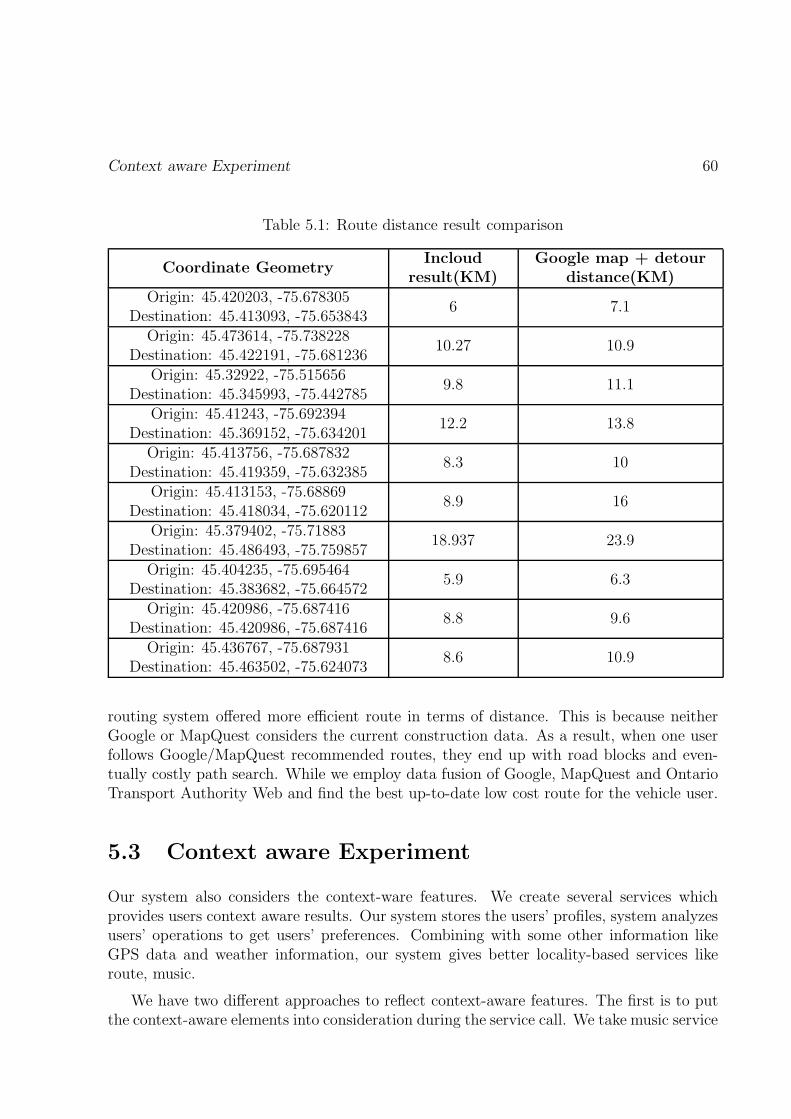
Context aware Experiment 60
Table 5.1: Route distance result comparison
Coordinate GeometryIncloud
result(KM)Google map + detour
distance(KM)Origin: 45.420203, -75.678305
Destination: 45.413093, -75.6538436 7.1
Origin: 45.473614, -75.738228Destination: 45.422191, -75.681236
10.27 10.9
Origin: 45.32922, -75.515656Destination: 45.345993, -75.442785
9.8 11.1
Origin: 45.41243, -75.692394Destination: 45.369152, -75.634201
12.2 13.8
Origin: 45.413756, -75.687832Destination: 45.419359, -75.632385
8.3 10
Origin: 45.413153, -75.68869Destination: 45.418034, -75.620112
8.9 16
Origin: 45.379402, -75.71883Destination: 45.486493, -75.759857
18.937 23.9
Origin: 45.404235, -75.695464Destination: 45.383682, -75.664572
5.9 6.3
Origin: 45.420986, -75.687416Destination: 45.420986, -75.687416
8.8 9.6
Origin: 45.436767, -75.687931Destination: 45.463502, -75.624073
8.6 10.9
routing system offered more efficient route in terms of distance. This is because neitherGoogle or MapQuest considers the current construction data. As a result, when one userfollows Google/MapQuest recommended routes, they end up with road blocks and even-tually costly path search. While we employ data fusion of Google, MapQuest and OntarioTransport Authority Web and find the best up-to-date low cost route for the vehicle user.
5.3 Context aware Experiment
Our system also considers the context-ware features. We create several services whichprovides users context aware results. Our system stores the users’ profiles, system analyzesusers’ operations to get users’ preferences. Combining with some other information likeGPS data and weather information, our system gives better locality-based services likeroute, music.
We have two different approaches to reflect context-aware features. The first is to putthe context-aware elements into consideration during the service call. We take music service

Context aware Experiment 61
Figure 5.10: eDirection application routing efficiency result.
as example. GetRMusic is one music service which provides the user with recommendedmusic based on the users’ play history and preferences. To test the user experience, wehave requested fifteen users (10 male, 5 female) to participate in the user study. For thetest, each user queries ten songs (song name, artist name) in the test user interface oneby one. The interface displays two sets of recommendations, one from the lastfm andthe other following our fusion method. Details of the application name and the publishername are hidden to avoid the user’s bias. Later we have provided questionnaires to theusers and asked them to rate both the recommendation result in 1-5 scale where 1-stronglydisagree, 2-disagree, 3-neutral, 4-agree, 5-strongly agree. Table 5.2 shows the average scoreof the five questions. From the result of the user experience survey, the users favored ourrecommendation over the lastfm solution. A probable reason is that our recommendationsystem aggregates results from multiple sources and finally provides a fused one.
The other one approach is that we make composition services to provide users complexservice. We will explain it using a scenario: Assuming a user is driving on the road. Oursystem may connect to user’s calendar through calendar service. It can search the comingevents in the calendar and get the event time and event place. Then it invokes the routeservice to get the route from current place to the destination. What is more, the systemcan estimate the travel time based on the route information and weather condition. Theweather condition can be gathered through weather service. At last, the system will givethe user a notice or an alert to inform of the user’s schedule. During this case, the userdoes not need to do any operation except login the system. The system will provide userreasonable notifications based on his or her calendar information, current position, weathercondition and road condition. It composes the service to generate a new complex servicein certain order as depicted in figure 5.11.

Context aware Experiment 62
Table 5.2: User study of the personalized music recommendation application
Question lastfm InCloud
I get effective recommendations fromthis system
3.3 4.2
I am more likely to listen to therecommended music
3.6 4.1
I am willing to use therecommendation system
3.3 3.9
I would prefer the musicrecommendations for my car
infotainment system3.9 4.3
Overall, I am satisfied with the system 3.4 4.0
loginCheck g���������t��� ��� � �� getUserPlace geoLocation getRoutinguser profile
GPS data geoLocation getWeatherInfo
������ettings
Figure 5.11: The schematic diagram of service composition
Summary 63
Services composition also reflects re-usability feature. Based on the example of servicecomposition, we can see that the more reusable services are created, the more operationswill be completed in the cloud, which inherently reduces the client workload.
5.4 Summary
For the experiments part, we designed three experiments to verify our system from dif-ferent perspectives. We have one news experiments for data size reduction and formationunification of our framework. We also have route experiment and multimedia experimentto reflect the data fusion feature of our system. From the result we can see, our systemhas significant improvements in these features.

Chapter 6
Conclusion and Future work
With the development of VANET, the vehicles are not just transportation tool any morebut also a place where users can enjoy multimedia information and social information.What is more, the access to VANET makes the vehicles available to the Internet. Thismay further enlarge the capabilities of the vehicles if the vehicles have proper applicationto use these data. Motivated by Cloud computing and mashup services, we have proposeda cloud based middleware framework for vehicular infotainment application development.The framework follows four design principles: data fusion, context-awareness, re-usability,and loose-coupling. In the framework, all the services are either hosted in the Road SideUnit or in the common cloud. Services consume the Internet resources and compile thesolution and send back as little operation intensive data as possible to the applicationclient. Application client only takes input from the user and try to display the resultwith as little operation as possible. In order to realize the effectiveness of the proposedframework, we have developed many services and used them to build three applications:eDirection map routing, personalized music recommender, and context-aware news. In theexperimental results, we employ the applications and both quantitatively and qualitativelymeasure their efficacy in fulfilling the design principles. The experimental results portraythat the proposed middleware framework is an effective and efficient method for developingvehicular infotainment applications.
For the future work, we expect to improve our system from following perspectives:
1. Enlarge scope of the resource : Currently, we just manually choose the Internetresource based on reputation credit. Next, we can extend a system module thatcan dynamically select the web resources. Since our system gets access to Inter-net through VANET, we need to consider several elements such as resource serverreaction time, server data transmission loss, and the resource value for choosing abetter resource. Because these elements may change when the vehicles moving in theVANET, we need to design a mechanism for dynamical resource choosing.
64

Conclusion and Future work 65
2. Enhance user communication with server : In the prototype, the client is justto display the data rarely update useful information to server. Next step, we hope wecan enhance it. For instance, we can design live traffic report mechanism. The userof our system not only can get the road condition online, but also they can reporttheir traffic information in their trips to the server. Thus, our server will have mostupdated information to other users.
3. Improve the interface of the client : The interface in our current client interfaceis designed based on Nuha’s work which has good icon design but lacks of menuorganization such as menu items design, user interface for data interaction.
We envision to develop more applications following the framework such as context-aware weather, need based hotel-restaurant recommender, price efficient gas station rec-ommender, etc. Also, we target to build a working VANET model which can be leveragedto build various other applications. Additionally, we want to improve the data forwardingcomponent in our implementations to support more than one RSU and application handover scenarios.

References
[1] Herrero Agustin, Jose Luis, Pablo Carmona, and Fabiola Lucio. A model-drivenapproach for service oriented web 2.0 mashup development. In ICIW 2013, The EighthInternational Conference on Internet and Web Applications and Services, pages 246–251, 2013.
[2] Tarik Al-Ani. Android In-Vehicle Infotainment System (AIVI). PhD thesis, Universityof Otago, 2012.
[3] Anwar Aldris, Ariadi Nugroho, Patricia Lago, and Joost Visser. Measuring the degreeof service orientation in proprietary soa systems. In SOSE, pages 233–244, 2013.
[4] Marica Amadeo, Claudia Campolo, and Antonella Molinaro. Enhancing ieee 802.11p/wave to provide infotainment applications in vanets. Ad Hoc Networks, 10(2):253–269, 2012.
[5] Justin Berkowitz. The history of car radios. http://www.caranddriver.com/
features/the-history-of-car-radios, 2010.
[6] Peter F Brown, Rebekah Metz, and Booz Allen Hamilton. Reference model for serviceoriented architecture 1.0. Technical report, Tech. rep., 2006. Retrieved December 16,2008 from http://docs. oasis-open. org/soa-rm/v1. 0/soa-rm. pdf, 2005.
[7] SIMON Buckingham. What is gprs. http://www.gsmworld.com/technology/gprs/intro.shtml, 2000.
[8] Guanling Chen, David Kotz, et al. A survey of context-aware mobile computingresearch. Technical report, Technical Report TR2000-381, Dept. of Computer Science,Dartmouth College, 2000.
[9] Ho Ting Cheng, Hangguan Shan, and Weihua Zhuang. Infotainment and road safetyservice support in vehicular networking: From a communication perspective. Mechan-ical Systems and Signal Processing, 25(6):2020–2038, 2011.
[10] Jan Dannenberg and Christian Kleinhans. The coming age of collaboration in theautomotive industry. Mercer Management Journal, 17:88–94, 2004.
66

Conclusion and Future work 67
[11] Yaser P Fallah, Ching-Ling Huang, Raja Sengupta, and Hariharan Krishnan. Anal-ysis of information dissemination in vehicular ad-hoc networks with application tocooperative vehicle safety systems. IEEE Transactions on, Vehicular Technology,60(1):233–247, 2011.
[12] Nuha Feraq. VANET’s Infotainment Services Portal Design. PhD thesis, Universityof Ottawa, 2012.
[13] Andreas Festag, Roberto Baldessari, Wenhui Zhang, Long Le, Amardeo Sarma, andMasatoshi Fukukawa. Car-2-x communication for safety and infotainment in europe.NEC Technical Journal, 3(1):21–26, 2008.
[14] Darlene Fichter. What is a mashup. ENGARD, N. Library Mashups Exploring newways to deliver library data. Information Today, 2010.
[15] Renato Filjar, Mico Dujak, Boris Drilo, and Dinko aric. Intelligent transport system.Coordinates, 5(6):8–10, 2009.
[16] Sandro Rodriguez Garzon. Intelligent in-car-infotainment system: A prototypicalimplementation. pages 371–374, June 2012.
[17] Maurizio Gibin, Alex Singleton, Richard Milton, Pablo Mateos, and Paul Longley. Anexploratory cartographic visualisation of london through the google maps api. AppliedSpatial Analysis and Policy, 1(2):85–97, 2008.
[18] Kai Hackbarth. Osgiservice-delivery-platform for car telematics and infotainmentsystems. In Advanced Microsystems for Automotive Applications 2003, pages 497–507. Springer, 2003.
[19] Sherin Abdel Hamid, Hossam S Hassanein, and Glen Takahara. Introduction to wire-less multi-hop networks. In Routing for Wireless Multi-Hop Networks, pages 1–9.Springer, 2013.
[20] Hannes Hartenstein and Kenneth P Laberteaux. A tutorial survey on vehicular adhoc networks. Communications Magazine, IEEE, 46(6):164–171, 2008.
[21] Roy Chaoming Hsu and Liang-Rui Chen. An integrated embedded system architecturefor in-vehicle telematics and infotainment system. volume 4, pages 1409–1414. IEEE,2005.
[22] Chenn-Jung Huang, Chin-Fa Lin, Ching-Yu Li, Che-Yu Lee, Heng-Ming Chen, Hung-Yen Shen, You-Jia Chen, and I-Fan Chen. Service-oriented routing and clusteringstrategies for vehicle infotainment dissemination. Int. J. Innov. Comput. Inf. Control,7(3):1467–1480, 2011.

Conclusion and Future work 68
[23] Rasheed Hussain, Fizza Abbas, Junggab Son, and Heekuck Oh. Tiaas: Secure cloud-assisted traffic information dissemination in vehicular ad hoc networks. In Cluster,Cloud and Grid Computing (CCGrid), 2013 13th IEEE/ACM International Sympo-sium on, pages 178–179. IEEE, 2013.
[24] Rasheed Hussain, Junggab Son, Hasoo Eun, Sangjin Kim, and Heekuck Oh. Rethink-ing vehicular communications: Merging vanet with cloud computing. pages 606–609.IEEE, 2012.
[25] Ho-Yeon Kim, Young-Hyun Choi, and Tai-Myoung Chung. Rees: Malicious softwaredetection framework for meego-in vehicle infotainment. pages 434–438. IEEE, 2012.
[26] Minyoung Kim, Jung-eun Lee, and Jong-wook Jang. Implementation of the android-based automotive infortainment system for supporting drivers safe driving. In Ubiq-uitous Information Technologies and Applications, pages 501–508. Springer, 2014.
[27] Robin Larsson and Maryam Zarrinjouei. Value creation from an in-vehicle infotain-ment perspective: A case study. null, 2011.
[28] A Lattanzi, F Bettarelli, R Toppi, and E Capucci. Implementing a car infotainmentsystem using nu-tech framework. pages 452–456. IEEE, 2009.
[29] Kunqiong Li, Yuan Fang, Huali Tang, Xiao Liu, and Jishen Liang. A customizedservices model based on web applications in cloud computing environment. In Infor-matics and Management Science IV, pages 433–438. Springer, 2013.
[30] Chen Liu, Jianwu Wang, and Yanbo Han. Mashroom+: An interactive data mashupapproach with uncertainty handling. Journal of Grid Computing, pages 1–24, 2013.
[31] Gianpaolo Macario, Marco Torchiano, and Massimo Violante. An in-vehicle infotain-ment software architecture based on google android. pages 257–260. IEEE, 2009.
[32] Eshed Ohn-Bar, Cuong Tran, and Mohan Trivedi. Hand gesture-based visual userinterface for infotainment. In Proceedings of the 4th International Conference onAutomotive User Interfaces and Interactive Vehicular Applications, pages 111–115.ACM, 2012.
[33] Tim o’Reilly. What is web 2.0. O’Reilly, 2009.
[34] Sathyanarayanan Rangarajan, Monica Verma, Anand Kannan, Ayush Sharma, andIngmar Schoen. V2c: a secure vehicle to cloud framework for virtualized and on-demand service provisioning. In Proceedings of the International Conference on Ad-vances in Computing, Communications and Informatics, pages 148–154. ACM, 2012.
[35] Rowdypat. History of car radio retrieved. http://rowdypat.wordpress.com/2012/06/22/history-of-car-radio/, 2012.

Conclusion and Future work 69
[36] Pierpaolo Salvo, Francesca Cuomo, and Andrea Baiocchi. Infotainment applicationssupport in vanet. DIET Department-University of Roma, Via Eudossiana, 18:00184,2012.
[37] Pierpaolo Salvo, Francesca Cuomo, Andrea Baiocchi, and Andrea Bragagnini. Roadside unit coverage extension for data dissemination in vanets. In Wireless On-demandNetwork Systems and Services (WONS), pages 47–50. IEEE, 2012.
[38] Pierpaolo Salvo, Mario De Felice, Francesca Cuomo, and Andrea Baiocchi. Info-tainment traffic flow dissemination in an urban vanet. In Global CommunicationsConference (GLOBECOM), pages 67–72. IEEE, 2012.
[39] Christoph Schroth and Till Janner. Web 2.0 and soa: Converging concepts enablingthe internet of services. IT professional, 9(3):36–41, 2007.
[40] Hemant Sharma, Roger Kuvedu-Libla, and A.K Ramani. Component oriented humanmachine interface for in-vehicle infotainment applications. In Proceedings of the WorldCongress on Engineering, volume 1. Citeseer, 2008.
[41] Hemant Sharma, Roger Kuvedu-Libla, and A.K Ramani. Confra: A context awarehuman machine interface framework for in-vehicle infotainment applications. In Pro-ceedings of the International MultiConference of Engineers and Computer Scientists,2008.
[42] Kamal Kumar Sharma, Hemant Sharma, and AK Ramani. mcar: software frame-work architecture for in-vehicle pervasive multimedia services. In Proceedings of theInternational MultiConference of Engineers and Computer Scientists, volume 1, 2009.
[43] Jan Sonnenberg. Service and user interface transfer from nomadic devices to carinfotainment systems. pages 162–165. ACM, 2010.
[44] Toby Velte, Anthony Velte, and Robert Elsenpeter. Cloud computing, a practicalapproach. McGraw-Hill, Inc., 2009.
[45] Yao Wang and Julita Vassileva. Trust and reputation model in peer-to-peer networks.In Peer-to-Peer Computing, 2003.(P2P 2003). Proceedings. Third International Con-ference on, pages 150–157. IEEE, 2003.
[46] Yu Wang and Fan Li. Vehicular ad hoc networks. In Guide to wireless ad hoc networks,pages 503–525. Springer, 2009.
[47] Richard Welke, Rudy Hirschheim, and Andrew Schwarz. Service-oriented architecturematurity. Computer, 44(2):61–67, 2011.
[48] Md Whaiduzzaman, Mehdi Sookhak, Abdullah Gani, and Rajkumar Buyya. A surveyon vehicular cloud computing. Journal of Network and Computer Applications, 2013.

Conclusion and Future work 70
[49] Diane Williams. The arbitron national in-car study, 2009.
[50] Jin Yu, Boualem Benatallah, Fabio Casati, and Florian Daniel. Understanding mashupdevelopment. Internet Computing, IEEE, 12(5):44–52, 2008.