Embed Size (px)
Citation preview
CCZO Page 1 of 199
IN THE BOARD OF COUNTY COMMISSIONERS
IN AND FOR CURRY COUNTY, OREGON
AN ORDINANCE ESTABLISHING ZONING REGULATIONS
FOR CURRY COUNTY, OREGON
The Board of Commissioners, Curry County, Oregon, ordains as follows:
ARTICLE I. INTRODUCTORY PROVISIONS
Section 1.010. Title.
This ordinance shall be known as the Curry County Zoning Ordinance of 1994.
Section 1.020. Purposes.
This ordinance is designed to provide and coordinate regulations in Curry County governing the
development and use of lands and to implement the Curry County Comprehensive Plan. To these
ends, it is the purpose of this ordinance to:
1. Insure that the development of property within the County is commensurate with the
character and physical limitations of the land, and, in general to promote and protect
the public health, safety, convenience and welfare;
2. Protect the economy of the County;
3. Conserve the limited supply of prime industrial lands to provide sufficient space for
existing industrial enterprises and future industrial growth;
4. Conserve farm and forest lands for the production of crops, livestock, and timber
products;
5. Encourage the provision of affordable housing in quantities sufficient to allow all
citizens some reasonable choice in the selection of a place to live;
6. Conserve all forms of energy through sound economical use of land and land uses
developed on the land;
7. Provide for the orderly and efficient transition from rural to urbanizable to urban land
uses;
8. Guarantee the ultimate development and arrangement of efficient public services and
facilities within the County;
9. Provide for and encourage a safe, convenient, and economic transportation system
within the County;
10. Protect the quality of the air and water resources of the County;
CCZO Page 2 of 199
11. Protect life and property in areas subject to floods, landslides, and other natural
disasters and hazards;
12. Provide for the recreational needs of residents of the County and visitors to the County;
13. Conserve open space and protect historic, cultural, natural and scenic resources; and
14. Protect, maintain, where appropriate develop, and where appropriate restore the
estuaries, coastal shorelands, coastal beach and dune area and the nearshore ocean and
continental shelf of the County.
Section 1.030. Definitions.
The following words and phrases, unless the context otherwise requires, shall mean:
1. Access. A way or means of approach to provide pedestrian, bicycle, or motor vehicular
entrance or exit to a property.
2. Access classification. A ranking system for roadways used to determine the appropriate
degree of access management. Factors considered include functional classification, the
appropriate local government=s adopted plan for the roadway, subdivision of abutting
properties, and existing level of access control.
3. Access connection. Any driveway, street, turnout or other means of providing for the
movement of vehicles to or from the public roadway system.
4. Access management. The process of providing and managing access to land
development while preserving the regional flow of traffic in terms of safety, capacity,
and speed.
5. Accessory structure or use. A use or structure incidental and subordinate to the main
use of the property and located on the same parcel, tract or lot as the main use.
6. Accessway. A walkway that provides pedestrian and bicycle passage either between
streets or from a street to a building or other destination such as a school, park, or
transit stop. Accessways generally include a walkway and additional land on either
side of the walkway, often in the form of an easement or right-of-way, to provide
clearance and separation between the walkway and adjacent uses. Accessways through
parking lots are generally physically separated from adjacent vehicle parking or
parallel vehicle traffic by curbs or similar devices and include landscaping, trees, and
lighting. Where accessways cross driveways, they are generally raised, paved, or
marked in a manner that provides convenient access for pedestrians.
7. Agricultural land. Lands suitable for agricultural use defined as follows:
a) Lands classified by the U.S. Soil Conservation Service (SCS) as
predominantly Class I-IV;
b) Land in other soil classes that is suitable for farm use as defined in ORS
215.203(2)(a), taking into consideration soil fertility; suitability for grazing;
climatic conditions; existing and future availability of water for farm irrigation
CCZO Page 3 of 199
purposes; existing land use patterns; technological and energy inputs required;
and accepted farming practices;
c) Land that is necessary to permit farm practices to be undertaken on adjacent or
nearby agricultural lands; and
d) Land in capability classes other than I-IV that is adjacent to or intermingled
with lands in capability classes I-IV within a farm unit, shall be considered as
agricultural lands even though this land may not be cropped or grazed.
8. Airport. Any area of land or water, within the county which is used, or intended for
use, for the landing and take-off of aircraft, and any appurtenant areas which are used,
or intended for use for airport buildings or other airport facilities or rights-of-way
together with all airport buildings and facilities located thereon.
9. Alley. A street which affords only a secondary means of access to property.
10. Applicant. For purposes of this ordinance the applicant shall be as defined in Section
2.040 of this ordinance.
11. Arterial. Roads that link cities or large traffic generators. Travel speeds will be
relatively high with minimum interference to through movement. An example is
Highway 101.
12. Assessment of Water Quality and Quantity. For purposes of this ordinance an
assessment of water for individual on-site water systems shall include the following:
a) the number of wells located within the quarter section of land in which the
subject property is located;
b) the quantity and flow rates of these wells (from Dept. Water Res. data or
personal investigation);
c) the flow rates of any springs or creeks proposed as source(s) of domestic
water;
d) the quality of water from any proposed source(s) by test for biological
contamination;
e) the disposition of any water rights for any source(s) of water proposed for
domestic use.
13. Average Slope. The average of percent slope between the highest and lowest points
where development activity is to occur on the property resulting from the division of
the increase in elevation in feet by the actual distance between the two points as
measured in feet in flat plane on a map.
14. Bicycle. A vehicle designed to operate on the ground on wheels, propelled solely by
human power, upon which any person or persons may ride, and with two tandem
wheels at least 14 inches in diameter. An adult tricycle is considered a bicycle.
15. Bicycle facilities. A general term denoting improvements and provisions made to
accommodate or encourage bicycling, including parking facilities and all bikeways.
CCZO Page 4 of 199
16. Bikeway. Any road, path, or way that is in some manner specifically open to bicycle
travel, regardless of whether such facilities are designed for the exclusive use of
bicycles or are shared with other transportation modes.
17. Board. Board of Curry County Commissioners.
18. Bridge Crossing(s). The portion of a bridge spanning a waterway but not including
supporting structures or fill located in the waterway or adjacent wetlands.
19. Bridge Crossing Support Structure(s). Piers, piling, and similar structures necessary to
support a bridge span but not including fill for causeways or approaches.
20. Building. A structure built for the support, shelter, or enclosure of persons, animals or
property of any kind.
21. Campground. An area in an undeveloped setting, which does not contain or provide
intensively developed recreational uses or facilities, that is devoted to overnight
temporary use for vacation or recreational purposes. It may be part of a larger park or
park area. Sites within a campground may be occupied by tents, travel trailers,
recreational vehicles, yurts or similar structures.
22. Commercial Activity in Conjunction with Farm Use. Retail or wholesale activities
conducted on the property to dispose of farm products produced on the property.
23. Commercial Agricultural Enterprise. A commercial use that consists of farm
operations that:
a) Contribute in a substantial way to the area's existing agricultural economy; and
b) Help maintain agricultural processors and established farm markets.
24. Commission. The Curry County Planning Commission.
25. Community Center. A building or small group of buildings which are established for
public service, educational, recreational or fraternal activities within a rural community
or rural exception area.
26. Community Water System. A public or private system of distribution pipes providing a
continuous supply of potable water from a central source in quantities sufficient to
meet needs for more than one but less than four (4) residential or other structures as
approved by the County Sanitarian. A system serving four (4) or more residences or
other structures shall be approved by the State Health Division.
27. Community Sanitary Sewer System. A public or private system of underground pipes
to carry sewage to treatment and disposal facilities, as approved by the Oregon
Department of Environmental Quality or its designated agent.
28. Condominium. The land, all buildings, improvements, rights and appurtenances
belonging thereto, which are submitted to the provisions of unit ownership.
CCZO Page 5 of 199
29. Corner clearance. The distance from a public or private road intersection to the nearest
access connection, measured from the closest edge of the pavement of the intersecting
road to the closest edge of pavement of the connection along the traveled way.
30. County. The County of Curry, State of Oregon.
31. Cross access. A service drive providing vehicular access between two or more
contiguous sites so the driver need not enter the public street system.
32. Date of creation and existence. When a lot, parcel or tract is reconfigured pursuant to
applicable law after November 4, 1993, the effect of which is to qualify a lot, parcel or
tract for the siting of a dwelling, the date of the reconfiguration is the date of creation
or existence. Reconfigured means any change in the boundary of the lot, parcel or tract.
33. Director. The Planning Director of Curry County or the Planning Director's
professional staff designee.
34. Development Activity. Any use or proposed use of land that requires disturbance of the
vegetation or soils or which requires action of the Planning Division or Building
Division to allow the construction or modification of structures or other improvements
or to allow the division of the land.
35. Development Permit. Means a permit to construct an on-site sewage disposal system
under state regulations, a building permit to construct a structure or a manufactured
dwelling siting permit under the building code, or other permit of similar nature.
36. Dwelling, Multiple-family. A building or portion thereof, designed for occupancy by
two or more families living independently of each other, including duplexes, and
apartment buildings.
37. Dwelling, Single-family. A detached building of conventional construction containing
one dwelling unit and designated for occupancy by only one family.
38. Easement. A grant of one or more property rights by a property owner to or for use by
the public, or another person or entity.
39. Engineer. A certified geotechnical engineer or a registered professional licensed by
the State of Oregon with knowledge and experience relating to geology and
geotechnical principles.
40. Estuary. A body of water semi-enclosed by land, connected with the open ocean, and
within which salt water is usually diluted by freshwater derived from the land. The
estuary includes: (a) estuarine water; (b) tidelands; (c) tidal marshes; and (d)
submerged lands. Estuaries extend upstream to the head of tidewater.
41. Estuarine Enhancement. An action which results in a long term improvement of the
existing estuarine functional characteristics and processes that is not the result of a
creation or restoration action.
CCZO Page 6 of 199
42. Exception Area. An area no longer subject to the requirements of Statewide Planning
Goals 3 or 4 because the area is the subject of a site specific exception acknowledged
pursuant to ORS 197.732 and OAR 660, Division 4.
43. Family. An individual or two or more persons related by blood, marriage, legal
adoption, or legal guardianship, living together as one housekeeping unit using one
kitchen, and providing meals or lodging to not more than five unrelated persons,
excluding servants; or group of not more than five unrelated persons living together as
one housekeeping unit using one kitchen.
44. Farm Animals. Includes livestock, poultry, furbearing animals, honeybees, and
worms.
45. Farm, Farm Land. Means any facility, including the land, buildings, watercourses and
appurtenances thereto, used in the commercial production of crops, nursery stock,
livestock, poultry, livestock products, poultry products or the propagation and raising
of nursery stock.
46. Farming Practice. Means a mode of operation on a farm that:
(a) is or may be used on a farm of a similar nature;
(b) is generally accepted, reasonable and prudent method for the operation of the
farm to obtain a profit in money;
(c) is or may become a generally accepted, reasonable and prudent method in
conjunction with farm use;
(d) complies with applicable laws; and
(e) is done in a reasonable and prudent manner.
47. Farming, Farm Use. Farm use is defined by ORS 215.203(2) on land zoned for farm
use. On lands not zoned for resource use, the definition applies to farm use practices
regardless of "profit" motivation.
48. Floor Area. The sum of the horizontal areas of the general floors of a building,
measured from the exterior faces of the exterior walls, exclusive of private garages,
carports, or courts.
49. Forest Land. Means land that is used for the growing and harvesting of forest tree
species and shall include lands which are suitable for commercial forest uses including
adjacent or nearby lands which are necessary to permit forest operations or practices
and other forested lands that maintain soil, air, water and fish and wildlife resources.
50. Forest Practice. Means a mode of operation on forest land that:
(a) is or may be used on forest land of a similar nature;
(b) is a generally accepted, reasonable and prudent method of complying with
ORS 527.610 to 527.770 and the rules adopted pursuant thereto;
(c) is or may become a generally accepted, reasonable and prudent method in
conjunction with forest land;
(d) complies with applicable laws;
(e) is done in a reasonable and prudent manner; and
(f) may include, but is not limited to, site preparation, timber harvest, slash
CCZO Page 7 of 199
disposal, road construction and maintenance, tree planting, precommercial
thinning, release, fertilization, animal damage control and insect and disease
control.
51. Frontage Road. A public or private drive which generally parallels a public street
between the right-of-way and the front building setback line. The frontage road
provides access to private properties while separating them from the arterial street.
52. Functional Area (intersection). That area beyond the physical intersection of two roads
that comprises decision and maneuver distance, plus any required vehicle storage
length.
53. Functional Classification. A system used to group public roadways into classes
according to their purpose in moving vehicles and providing access.
54. Garage, Private. A detached accessory building or a portion of a dwelling, for the
noncommercial parking, storage, or repair of equipment or vehicles belonging to the
occupants of the premises.
55. Garage, Public. A building or portion thereof, other than a private garage, used for the
parking, repair or storage of vehicles, where such vehicles are parked or stored for hire,
sale, or commercial activities.
56. Geologic Hazard Area. Geologic Hazard Areas in Curry County are areas shown on
the Natural Hazard Inventory maps adopted into the Goal 7 Element of the Curry
County Comprehensive Plan, including the Oregon Department of Geology and
Mineral Industries (DOGAMI) Bulletin 90 Land-Use Geology of Western Curry
County, Oregon, and the DOGAMI maps known variously as “Further Review Areas.”
Geologic Hazard Areas include, but are not limited to,
a) earthflow and slump topography with moderately sloping terrain and
irregularities of slope, drainage, or soil distribution;
b) areas of recent earth movement shown by tension cracks, bowed trees and
other indicators;
c) steep slope mass movement areas which are areas subject to localized debris
slide, debris flow, rockfall, or rock slide;
d) other areas as may be identified by in the preparation of assessments and
reports pursuant to the requirements of Section 3.252.
Geologic Hazard Areas specifically include those areas, which, because of their
relation to or location with respect to Geologic Hazard Areas, are in jeopardy of
rapidly moving landslides
57. Geologist. A certified engineering geologist licensed by the State of Oregon as
provided by ORS 672.505 to 672.705
58. Golf Course. An area of land with highly maintained natural turf laid out for the game
of golf with a series of 9 or more holes, each including a tee, a fairway, a putting green,
and often one or more natural or artificial hazards. A golf course on land zoned AFD or
EFU means a 9 or 18 hole regulation golf course consistent with the following:

CCZO Page 8 of 199
(a) A regulation 18 hole course is generally characterized by a site of about 120 to
150 acres of land, has a playable distance of 5,000 to 7,200 yards and a par of
64 to 73 strokes.
(b) A regulation 9 hole golf course is generally characterized by a site of about 65
to 90 acres of land, has a playable distance of 2,500 to 3,600 yards, and a par
of 32 to 36 strokes.
(c) Non-regulation golf courses are not allowed uses within the AFD and EFU
zones. Non-regulation golf course means a golf course or golf course-like
development that does not meet the definition of golf course given above,
including but not limited to executive golf courses, Par 3 golf courses, pitch
and put golf courses, miniature golf courses and driving ranges.
(d) Uses accessory to a golf course in the AFD and EFU zones shall be limited by
the following standards:
(A) An accessory use to a golf course is a facility or improvement that is
incidental to the operation of the golf course and is either necessary for
the operation and maintenance of the golf course or that provides
goods or services customarily provided to golfers at a golf course. An
accessory use or activity does not serve the needs of the non-golfing
public. Accessory uses to a golf course may include: parking;
maintenance buildings; cart storage or repair; practice range or driving
range; clubhouse; restrooms, lockers and showers; food and beverage
service; pro shop; a practice or beginners course as part of an 18 hole
or larger golf course. Accessory uses to a golf course do not include:
sporting facilities unrelated to golfing such as tennis courts, swimming
pools, and weight rooms; wholesale or retail operations oriented to the
non-golfing public or housing.
(B) Accessory uses shall be limited in size and orientation on the site to
serve the needs of the persons and their guests who patronize the golf
course to golf. An accessory use that provides commercial services
(e.g. food and beverage service, pro shop, etc.) shall be located in the
clubhouse rather than in separate buildings.
59. Grade. The average elevation of the finished surface of the ground, paving or
sidewalk within the area between the building and the property line or; when the
property line is more than five (5) feet from the building then the ground surface at a
point five (5) feet from the building. The ground slope within five (5) feet of the
building shall not exceed 2 (horz.) to 1 (vert.).
60. Guest House. A detached accessory structure containing a sleeping facility and
bathroom but without kitchen equipment or provisions for such which is used in
conjunction with an existing dwelling and does not exceed 500 square feet in size.
61. Hardship Dwelling. A manufactured dwelling or mobile home in conjunction with an
existing dwelling as a temporary use for the term of a medical hardship suffered by the
existing resident or a relative of the resident. The applicant shall provide verification
from a medical doctor of the need for the hardship dwelling. The county shall review
the permit authorizing such a dwelling every year and require an updated verification

CCZO Page 9 of 199
from a medical doctor. When the hardship ends, the county shall require removal of the
hardship dwelling.
62. Height of Building. The vertical distance from the grade to the highest point of the
coping of a flat roof or to the deck line of a mansard roof or to the height of the highest
gable of a pitch or hip roof.
63. Hillside Road or Street. A road traversing lands composed predominantly of slopes
greater than 25%. Predominantly means 50 percent or more of the total acreage of the
parcel.
64. Home, Nursing. Any home or institution maintained or operated for the nursing and
extended care of two or more nonrelated ill or infirm people not requiring hospital care
or hospital facilities.
65. Home Occupation. A secondary use of a dwelling, enclosure, or building accessory to
a dwelling (but not accessory to a resource use), which constitutes an occupation
carried on solely by a member or members of the family residing in the dwelling.
66. Hospital. A facility which provides medical, obstetrical, or surgical care to the general
public on a continuous basis and includes sleeping and eating facilities for persons
receiving such care.
67. Hotel. A building in which lodging for compensation is provided to guests and in
which no provisions are made for cooking in the lodging rooms although meals may be
provided.
68. Impervious Surface. Any material which reduces and prevents absorption of storm
water into previously undeveloped land.
69. Irrigated. Land watered by an artificial or controlled means, such as sprinklers,
furrows, ditches, or spreader dikes. An area or tract is irrigated if it is currently
watered, or has established rights to use water for irrigation, including such tracts that
receive water for irrigation from a water or irrigation district or other provider.
70. Joint Access (or shared access). A driveway connecting two or more contiguous sites
to the public street system.
71. Kennel. An open space or building in which four or more dogs, cats, rabbits, or similar
animals are kept for board, propagation or sale for other than agricultural purposes.
72. Local Road. A public road that is not a city street, state Highway or federal road. A
road connecting the local uses with the collector system. Property access is the main
priority ; through-traffic is not encouraged. All county roads not classified as arterials
or collectors are the county’s local roads.
73. Lot. A unit of land that is created by a subdivision of land whose boundaries have
been established by some legal instrument, which is recognized as a separate legal
entity for purposes of transfer of title, which typically has frontage upon a public or
private, street and complies with the dimensional standards of this ordinance unless
preexisting on the date the ordinance was adopted.
CCZO Page 10 of 199
74. Lot Area/Size. The total horizontal area within the lot lines of a lot exclusive of public
and private roads, and easements of access to other property. The lot size shall also be
considered to be the density to which dwellings may be constructed on a single parcel
of land.
75. Lot, Corner. A lot abutting on two or more intersecting streets neither of which is an
alley provided that the internal angle at the intersection of the two streets is less than
one hundred thirty-five (135) degrees.
76. Lot, Depth. The average horizontal distance from the midpoint of the front lot line to
the midpoint of the rear lot line.
77. Lot, flag. A lot not meeting minimum frontage requirements and where access to the
public road is by a narrow, private driveway right-of-way.
78. Lot, through (or double frontage lot). A lot that fronts upon two parallel streets or
fronts upon two streets that do not intersect at the boundaries of the lots.
79. Lot frontage. That portion of a lot extending along a road right-of-way.
80. Lot, interior. A lot other than a corner lot.
81. Lot Line. The property line bounding a lot.
82. Lot Line, front. In the case of an interior lot, the lines separating the lot from the street
other than an alley, and in the case of a corner lot, the shortest lot line along a street
other than an alley.
83. Lot Line, rear. A lot line which is opposite and most distant from the front lot line.
84. Lot Line, side. Any lot line not a front or rear lot line.
85 Lot Width. The average horizontal distance between the side lot lines.
86. Maintenance of Existing Structure or Facility. Includes all acts or functions necessary
to keep a structure or facility existing at the time of the adoption of this ordinance in a
continuous state of repair, but does not include expansion of the structure or facility to
a larger size or more intensive usage that may significantly increase visitation and that
may affect adjacent land use.
87. Major Collector. A road providing service to land uses that generate trips such as
consolidated schools, shipping points, parks, mining and agricultural areas. This type
of road links minor collectors with streets of higher classification. Examples of major
collectors are Elk River Road, Squaw Valley Road and Carpenterville Road (a state
facility).
88. Manufactured Home. A structure constructed for movement on the public highways
that has sleeping, cooking and plumbing facilities, that is intended for human
occupancy, that is to be used for residential purposes and that was constructed in
accordance with federal manufactured housing construction and safety standards and

CCZO Page 11 of 199
regulations in effect at the time of construction. The removal of wheels or placement
upon a foundation does not alter this definition.
89. Minor Collector. A road providing service to small communities. This type of road
links locally important land uses that generate trips with rural destinations. Examples
of minor collectors are Floras Lake Road, Nesika Road, North Bank Pistol River Road.
90. Minor Navigational Improvement(s). Alterations necessary to provide water access to
existing or permitted uses in conservation management units including dredging for
access channels and for maintaining existing navigation but excluding fill and in-water
navigational structures other than floating breakwaters or similar permeable wave
barriers.
91. Mitigation. The creation, restoration, or enhancement of an estuarine area to maintain
the functional characteristics and processes of the estuary, such as its natural biological
productivity, habitats, species diversity, unique features and water quality; and for
riparian vegetation shall mean taking one or more of the following actions listed in
order of priority:
a) Avoiding the impact altogether by not taking certain development
action or parts of that action;
b) Minimizing impacts by limiting the degree or magnitude of the
development action and its implementation;
c) Rectifying the impact by repairing, rehabilitating, or restoring the
affected environment;
d) Reducing or eliminating the impact over time by preservation and
maintenance operations during the life of the development action by
monitoring and taking appropriate corrective measures;
e) Compensating for the impact by placing or providing comparable
substitute resources or environments.
92. Mobile Home. A structure constructed for movement on the public highways that has
sleeping, cooking and plumbing facilities, that is intended for human occupancy, that is
being used for residential purposes and that was constructed between January 1, 1962,
and June 15, 1976, and met the construction requirements of Oregon mobile home law
in effect at the time of construction.
93. Mobile/Manufactured Home Park. A unit of land upon which four or more mobile or
manufactured homes less than 500 feet apart occupied for dwelling or sleeping
purposes are located, regardless of whether a charge is made for such accommodations.
94. Motel/Lodge. A building or group of buildings on the same unit of land containing
guest units with separate entrances directly to the exterior and consisting of individual
sleeping quarters, detached or in connected rows, for rental to travelers. Guest units
may include kitchen facilities or meals may be provided.
95. Neighborhood Activity Center. An attractor or destination for residents of surrounding
residential areas. Includes, but is not limited to existing or planned schools, parks,
shopping areas, transit stops, and employment areas.
CCZO Page 12 of 199
96. Net Loss. A permanent loss of habitat units or habitat value resulting from a
development action despite mitigation measures having been taken.
97. Nonconforming Access Features. Features of the property access that existed prior to
the date of ordinance adoption and do not conform with the requirements of this
ordinance.
98. Nonconforming Structure or Use. A lawful existing structure or use at the time this
ordinance or any amendment thereto becomes effective, which does not conform to the
requirements of the zone in which it is located.
99. Off-Street Parking. Parking spaces or a parking lot(s) provided in accordance with
Section 4.020 of this ordinance, but not located on any public street or road.
100. Parcel. A unit of land that is created:
a) by a partitioning of land as defined in ORS 92.010;
b) in compliance with all applicable planning, zoning and partitioning ordinances
and regulations; or
c) by deed or sales contract, if there were no applicable planning, zoning or
partitioning ordinances or regulations in effect at the time the parcel was
created.
d) whose boundaries have been established by some legal instrument, which is
recognized as a separate legal entity for purposes of transfer of title, which
typically has frontage upon a public or private, street and complies with the
dimensional standards of this ordinance unless preexisting on the date the
ordinance was adopted.
101. Parking Space. A rectangle not less than l8 feet long and 9 feet wide which is
available for the operable passenger vehicles of residents, customers, patrons, or
employees of the premises. At the decision makers discretion a percentage of the
required number of spaces may be of a lesser size to accommodate compact vehicles.
However, disabled person parking space shall also be provided in accordance with
ORS 447.233.
102. Pedestrian Facilities (also walkway). A general term denoting improvements and
provisions made to accommodate or encourage walking, including sidewalks,
accessways, crosswalks, ramps, paths, and trails.
103. Person. A natural person, firm, partnership, association or corporation.
104. Planned Unit Development. A single development in which a combination of uses
compatible with the comprehensive plan in terms of land use and density of
development is permissible subject to the procedural requirements of the zoning and
subdivision ordinances. Planned Unit Developments include condominiums, planned
communities, and any other development which includes common ownership of
structures or land.
105. Plat. An exact and detailed map of the partition or subdivision of land.
106. Private Driveway. A roadway which traverses and serves one lot.
CCZO Page 13 of 199
107. Private Road. A roadway owned by a private party(s) that provides the principal means
of access to an abutting property.
108. Property Owner. The owner of record for a property as established in the official
records of the Curry County Assessor's Office.
109. Public Road. A road over which the public has the right to use, that is a matter of
public record.
110. Reasonable Access. The minimum number of access connections, direct or indirect,
necessary to provide safe access to and from the roadway, as consistent with the
purpose and intent of this ordinance and any applicable plans and policies of the
county.
111. Reasonably Direct. A route that does not deviate unnecessarily from a straight line or
a route that does not involve a significant amount of out-of-direction travel for likely
users.
112. Recreation. Any experience voluntarily engaged in largely during leisure
(discretionary time) from which the individual derives satisfaction.
113. Recreation, High Intensity. Recreation which uses specially built facilities, or occurs in
such density or form that it requires or results in a modification of the area or resource;
i.e., campgrounds, golf course, and marinas.
114. Recreation, Low Intensity. Recreation which does not require developed facilities and
which can be accommodated without change to the area of resource; e.g., boating,
hunting, hiking, wildlife photography, and beach or shore activities.
115. Recreation Vehicle. See trailer.
116. Recreational Vehicle Park/Rural. A commercially developed area devoted to
overnight temporary use for vacation or recreational purposes and located outside of an
urban growth boundary but within an area for which a Goal 2 exception to Goals 3
and/or 4 has been approved. Sites within a recreation vehicle park/rural may be
occupied by tents, travel trailers or recreational vehicles.
117. Recreational Vehicle Park/Urban. A commercially developed area devoted to
overnight temporary use for vacation or recreational purposes and located within an
urban growth boundary. Sites within a recreational vehicle park/urban may be
occupied by tents, travel trailers, or recreational vehicles.
118. Restore. Revitalizing, returning, or replacing original attributes and amenities, such as
natural biological productivity, aesthetic and cultural resources, which have been
diminished or lost by past alterations, activities, or catastrophic events. For purposes of
Goal 16 estuarine restoration this term means to revitalize or reestablish functional
characteristics and processes of the estuary diminished or lost by past alterations,
activities, or catastrophic events. A restored area must be shallow subtidal or an
intertidal or tidal marsh area after alteration work is performed, and may not have been
a functioning part of the estuarine system when alteration work begins.
CCZO Page 14 of 199
119. Restoration, Active. Involves the use of specific positive remedial actions, such as
removing fills, installing water treatment facilities, or rebuilding deteriorated urban
waterfront areas.
120. Restoration, Passive. Is the use of natural processes, sequences, and timing which
occurs after the removal or reduction of adverse stresses without other specific positive
remedial action.
121. Right-of-Way. Land reserved, used, or to be used for a highway, street, alley, walkway,
drainage facility or other public purpose related to a transportation improvement.
122. Riparian Area. The area adjacent to a river, lake, or stream, consisting of the area of
transition from aquatic ecosystem to a terrestrial ecosystem.
123. Road. See Street.
124. Roadside Stand. A temporary structure designed for the purpose of retail sale of farm
commodities grown on the premises.
125. Rural Use. Uses which are outside of urban growth boundaries including non-urban
agriculture, forestry, or open space or sparse settlement, small farms or acreage
homesites with no or hardly any public services.
126. Safe and Convenient. Bicycle and pedestrian routes that are:
i) Reasonably free from hazards, and
ii) Provides a reasonably direct route of travel between destinations, considering
that the optimum travel distance is one-half mile for pedestrians and three
miles for bicycles.
127. Setback. The distance from the right of way or easement boundary of a public or
private road or other easement or from a lot line, to any point of a building.
128. Sign. A presentation or representation, other than a house number, by words, letters,
figures, designs, pictures, or colors publicly displayed so as to give notice relative to a
person, a business, an article or merchandise, a service, an assemblage, a solicitation or
a request for aid or other type of advertising. This includes the surface face upon
which the representation is displayed.
129. Significant Change in Trip Generation. A change in the use of property, including
land, structures or facilities, or an expansion of the size of structures or facilities
causing an increase in the trip generation of the property exceeding: (1) local facilities;
10 percent more trip generation (either peak or daily) and 100 vehicles per day more
than the existing use for all roads under local jurisdiction; or (2) State of Oregon
facilities; 25 percent more trip generation (either peak or daily) and 100 vehicles per
day more than the existing use for all roads under state jurisdiction.
130. Stable. A use of land where not more than one horse per one-half acre of total property
area is kept for commercial or noncommercial use which may include associated
structures.
CCZO Page 15 of 199
131. Stub-out (stub-street). A portion of a street or cross access drive used as an extension
to an abutting property that may be developed in the future.
132. Stream. A channel such as a river or creek that carries flowing surface water,
including perennial streams and intermittent streams with defined channels, and
excluding manmade irrigation and drainage channels.
133. Street. The entire width between the boundary lines of the driveable surface which
provides for public or private use for the purpose of vehicular and pedestrian traffic
and including, but not limited to, "roads", "highways", "lanes", "places", "avenues",
and "alleys".
134. Structure. That which is built or constructed. An edifice or building or any kind of
any piece or work artificially built up or composed of parts joined together in some
definite manner and which requires location on the ground or which is attached to
something having location on the ground and which is governed by the Uniform
Building Code.
135. Structural Alteration. Any change to the supporting members of a structure including
foundation, bearing walls, or partitions, columns, beams or girders, or any structural
change in the roof.
136. Substantial enlargements or improvements. An increase in the existing square footage
or increase in assessed valuation of the structure.
137. Tax Lot. A unit of land created by the County Assessor for taxation purposes.
138. Temporary Alteration. Dredging, filling, or another estuarine alteration occurring over
a specified short period of time which is needed to facilitate a use allowed by the
comprehensive plan. Temporary alterations may not be for more than three years and
the affected area must be restored to its previous condition. Temporary alterations
include (1) alterations necessary for federally authorized navigation projects (e.g.
access to dredged material disposal sites by barge or pipeline and staging areas or
dredging for jetty maintenance), (2) alterations to establish mitigation sites, alterations
for bridge construction or repair and for drilling or other exploratory operations, and
(3) minor structures necessary for research and educational observation.
139. Top of Bank. Shall have the same meaning as Bankfull stage@ defined in OAR 141-
085-0010 (2). Meaning the stage or elevation at which water overflows the natural
banks of streams or other waters of this state and begins to inundate the upland. In the
absence of physical evidence, the two year-recurrence interval flood elevation may be
used to approximate the bankfull stage.
140. Tourist Facility. Hotels, motels, lodges, trailer parks, restaurants, public parks, and
accessory uses.
141. Tract. One or more contiguous lots or parcels under the same ownership whose
boundaries have been established by some legal instrument, which is recognized as a
separate legal entity for purposes of transfer of title, which typically has frontage upon
a public or private, street and complies with the dimensional standards of this

CCZO Page 16 of 199
ordinance unless preexisting on the date the ordinance was adopted. A tract shall not be
considered to consist of less than the required acreage because it is crossed by a public
road or waterway.
142. Trailer, Camping or Recreational Vehicle. A vacation trailer or self-propelled vehicle
which is qualified to be licensed as a recreation vehicle by the State of Oregon. The
removal of wheels does not alter this definition.
143. Trailer or Camping Vehicle Park. A lot upon which two or more occupied trailer or
camping vehicles are sited or parked.
144. Urban Use. Uses which are high intensity residential, commercial or industrial uses
located inside urban growth boundaries, or outside urban growth boundaries where an
exception to Goal 14 has been justified.
145. Use. The purpose for which land or a structure is designed, arranged, or intended, or
for which it is occupied or maintained.
146. Utility. Any individual, firm, partnership, corporation, association, cooperative or
municipality which constructs, maintains, operates or manages a network of poles,
ducts, conduits, wires, cables, pipes, or mains connecting interrelated facilities and
equipment for the purpose of providing water, sewer, gas, electricity, steam, telephone,
cable television, data transfer, or other energy or communications service to the
general public within a general or designated service territory.
147. Utility Facility Necessary for Public Service. A facility or structure for the generation
and distribution of a public service including but not limited to electrical power,
communications, natural gas, water, sewage, fire and police protection, and road
maintenance which provides for a public need; this use does not include a facility or
structure for the generation of power for public sale.
148. Vision Clearance. A visually cleared, triangular area at a street or highway
intersection of a corner lot, or the alley-street intersection of a corner lot, the space
being defined by a line across the corner between the point on the street right of way
line or street-alley right of way line measured from the corner or in the case of rounded
corners, the triangular area between the tangents to the curve and a diagonal line
joining said point measured along the tangent. In all zones the distance along the street
right-of-way shall be twenty (20) feet for a street intersection.
149. Walkway. A hard-surfaced area intended and suitable for pedestrians,
including sidewalks and the surfaced portions of accessways.
150. Water Area. The area between the banks of a lake, pond, river, perennial or
intermittent stream, excluding man-made ponds.
151. Water-dependent. A use or activity which can be carried out only on, in, or adjacent to
water areas because the use requires access to the water body for water-borne
transportation, recreation, energy production, or source of water. It includes uses that
are in conjunction with and incidental to a water-dependent use. Examples of uses that
are in conjunction with and incidental to water-dependent uses include a restaurant on
the second floor of an existing seafood processing plant or a retail sales room as a part
CCZO Page 17 of 199
of a seafood processing plant. Generally, to be in conjunction with and incidental to a
water dependent use, a non water-dependent use may be constructed at the same time
or after the water-dependent use of the site is established and be carried out together
with the water dependent use. Incidental means that the size of the non water-
dependent use is small in relation to the water-dependent operation and that it does not
interfere with conduct of the water-dependent use.
152. Water-related. Uses which are not directly dependent upon access to a water body, but
which provide goods or services that are directly associated with water-dependent land
or waterway use, and which if not located adjacent to water, would result in a public
loss of quality in the goods or services offered. Except as necessary for water-
dependent or water-related uses of facilities, residences, parking lots, spoil and dump
sites, roads and highways, restaurants, businesses, factories, and trailer parks are not
generally considered dependent on or related to water location needs.
153. Yard. An open space on a lot which is unobstructed from the ground upward, except
as otherwise provided in this ordinance.
154. Yard, front. A yard between side lot lines and measured horizontally at right angles to
the front lot line to the nearest point of any building.
155. Yard, rear. A yard extending between side lot lines and measured horizontally at right
angles to the rear lot line, from the rear lot line to the nearest point of any
building.
156. Yard, side. An open space between the front and rear yards measured horizontally and
at right angles from the side lot line to the nearest point of any building.
Section 1.040. Compliance with Ordinance Provisions.
No structure or lot shall hereafter be used or occupied and no structure or part thereof shall be erected,
moved, reconstructed, extended, enlarged, or altered contrary to the provisions of this ordinance.
CCZO Page 18 of 199
ARTICLE I-A. PLANNING COMMISSION
Section 1.050. Purpose.
The purpose of this Article is to establish the membership, terms of members and powers of the
Commission.
Section 1.060. Statutory Authority.
The Commission is established as the only planning commission under the authority provided to the
governing body of Curry County under ORS 215.020.
Section 1.070. Membership of the Commission.
Membership of the Commission shall be established as follows.
1. The Commission shall consist nine (9) members.
2. Members of the Commission shall be appointed by the Board.
3. Members shall be appointed to the Commission for four (4) year terms except as
provided for below.
4. The Board shall adjust the term of any position on the Commission to maintain
staggered appointments at the time the term of a member sitting in that position expires
or the position becomes vacant.
5. Any vacancy on the Commission shall be filled by the Board for the unexpired term of
that position.
6. A commission member may be removed by the Board, after hearing, for misconduct or
nonperformance of duty. Nonperformance of duty includes, but is not limited to,
having two or more unexcused absences in a calendar year.
7. Membership of the Commission shall meet the following requirements:
a) The members of the Commission shall be residents of the County.
b) The majority of the members of the Commission shall reside in the
unincorporated area of the County.
c) The membership of the Commission shall be geographically distributed within
the County as follows:
(1) Three (3) members shall be appointed from the area extending from
the Coos County line south to an east-west line at the mouth of Mussel
Creek (Arizona Beach);
CCZO Page 19 of 199
(2) Three (3) members shall be appointed from the area extending from
the east-west line at the mouth of Mussel Creek (Arizona Beach) south
to an east-west line at Crook Point; and
(3) Three (3) members shall be appointed from the area extending from
the east-west line at Crook Point south to the California state line.
d) No more than two (2) voting members of the Commission shall be engaged in
the same kind of occupation, business, trade or profession.
e) No more than two (2) voting members shall be engaged principally in the
buying, selling or developing of real estate for profit, as individuals, or be
members of any partnership or officers or employees of any corporation that is
engaged principally in the buying, selling or developing of real estate for
profit.
8. The Board may designate one or more officers of the County to be nonvoting members
of the Commission.
9. The members of the Commission shall serve without compensation other than
reimbursement for duly authorized expenses which will be paid by the County subject
to budgetary authorization.
Section 1.080. Officers of the Commission.
1. The Commission shall elect a Chairperson and Vice-Chairperson at the first regular
meeting of each calendar year.
2. The Chairperson shall be the presiding officer of all meetings and shall be the
signatory of all official documents of the Commission.
3. The Vice-Chairperson shall perform the duties of the Chairperson in the absence of the
Chairperson.
4. In the absence of the Chairperson and Vice-Chairperson the Commission may elect a
Chairperson pro-tem to conduct business on a temporary basis.
5. If the position of a Commission officer becomes vacant during the term of the officer then
the Commission shall elect a replacement officer at its next regular meeting.
Section 1.090. Powers of the Commission.
1. The Commission shall have the power to make recommendations to the Board
regarding ordinances intended to implement part or all of the comprehensive plan,
including:

CCZO Page 20 of 199
a) Zoning;
b) Official maps showing the location and dimensions of, and the degree of
permitted access to, existing and proposed thoroughfares, easements and
property needed for public purposes;
c) Preservation of the integrity of the maps by controls over construction, by
making official maps parts of county deed records, and by other action not
violative of private property rights;
d) Conservation of the natural resources of the county;
e) Controlling subdivision and partitioning of land;
f) Renaming public thoroughfares;
g) Protecting and assuring access to incident solar energy;
h) Protecting and assuring access to wind for potential electrical generation or
mechanical application; and
i) Numbering property for addressing.
2. The Commission shall have those powers to hold hearings, review application
requests, make land use decisions and hear appeals as set forth in this ordinance and
the Curry County Land Division Ordinance.
3. The Commission shall advise and cooperate with other planning commissions within
the County, State of Oregon and State of California, and shall, upon request, or upon
its own initiative, furnish advice or reports to any city, county, officer or other
department on any problem related to county planning.
4. The Commission may enter upon land and make examinations and/or surveys in the
performance of its duties for any lands which are the subject of an application to the
county for a land use decision by the Commission.

CCZO Page 21 of 199
ARTICLE II. PROCEDURES FOR MAKING LAND USE DECISIONS
Section 2.010. Purpose.
The purpose of this Article is to establish the procedures for applications provided for by this
ordinance, appeals from aggrieved persons and parties, and review of any decision by a higher
authority.
Section 2.020. Review Process.
An application for development approval required by Curry County shall be processed by quasi-
judicial public hearing or Administrative Action, pursuant to applicable sections of this ordinance.
Quasi-judicial hearings shall be held on all applications for a permit or approval required by these
regulations, provided that hearings shall not be held in those matters the Director has authority to act
upon, unless an appeal be taken.
Section 2.030. Coordination of Application Review.
The review of all applications for development permits shall be a coordinated process between the
various county departments and other affected agencies.
1. The Director shall be responsible for the coordination of application review
procedures.
2. After an application has been submitted, no on-site sewage disposal permit, building
permit or license for the proposed use shall be issued until final action including the
resolution of all local appeals has been taken. Following final action on the application,
the issuance of permits or licenses shall be in conformance with the zoning regulations
of this ordinance, and any conditions of development approval.
Section 2.040. Who May Apply.
Applications for development approval may be initiated by one or more of the following:
a) The owner(s) of the property as listed in the records of the Curry County Assessor
which is the subject of the application; or
b) The purchaser of such property who submits a duly executed written contract or copy
thereof which has been recorded with the Curry County Clerk; or
c) The lessee in possession of such property who submits written consent of the owner to
make such application; or
d) A person or entity authorized by resolution of the Board or Commission; or
e) Any department of the Curry County government or a federal, state or local
government entity when dealing with land involving public works projects; or

CCZO Page 22 of 199
f) A public utility agency, when dealing with land involving the location of facilities
necessary for public service.
g) The agent of any of the foregoing who states on the application that he/she is the duly
authorized agent and who submits evidence of being duly authorized in writing by
his/her principal.
Section 2.050. Preapplication Conference.
An applicant shall request a preapplication conference prior to submitting a request for development
approval. The purpose of the conference shall be to acquaint the applicant with the substantive and
procedural requirements of the ordinance, provide for an exchange of information regarding applicable
elements of the comprehensive plan and development requirements, arrange such technical and design
assistance as will aid the applicant, and to identify policies and regulations that create opportunities or
pose significant constraints for the proposed development. When the proposed development will have
an impact on a transportation facility, the provider of the affected transportation facility shall be
included in the preapplication exchange of information.
Section 2.060. Application.
Application for development approval shall be made pursuant to applicable sections of this ordinance
on forms provided by the Director. An application shall be complete, contain the information required
by these regulations and address the appropriate criteria for review and approval of the request. All
applications shall be accompanied by the required fee which must be paid in U.S. currency, check or
money order at the time of filing. Failure to pay said fee at the time of filing is a jurisdictional defect
which will result in the application being rejected. Three (3) copies of all supporting material shall be
submitted with the application form. All material submitted shall be of page size (8 1/2" x 11") or
other size approved by the Director.
1. The Director shall have the authority to review, and approve or deny the following
applications which shall be Administrative Actions:
a) Development of property subject to the following overlay zoning districts
including:
(1) Riparian Corridor Buffer Overlay Zone. (Section 3.280)
(2) Geological hazards. (Section 3.252)
(3) Airport related areas. (Section 3.270)
b) Uses listed as "Conditional Uses Subject to Administrative Approval by the
Director" in each of the various zoning classifications of Article III within this
ordinance.
c) The determination of the existence and/or alteration of a nonconforming use
(Section 5.060-5.062).
d) Variance (Article VIII).
e) Waivers of minimum lot size (Section 5.040).
CCZO Page 23 of 199
f) Historical site provisions pursuant to Section 3.262.
2. The Planning Commission shall have the authority to review and approve or deny the
following:
a) Zone Change not involving a comprehensive plan amendment or Statewide
Planning Goal exception. Upon approval of a zone change by the Commission
(if not appealed) the order shall be forwarded to the Board which may
implement the approval of the ordinance without the necessity of additional
public notice under this ordinance.
b) Appeal of Director's decisions pursuant to Sections 2.060(l).
c) Referrals of Administrative Actions by the Director, and
d) Other land use actions not specified in (1) above and (3) below.
3. The Board shall have the authority to review and approve or deny the following:
a) Comprehensive Plan Amendments.
b) Exceptions to Statewide Planning Goals.
c) Appeals from Commission decisions.
Section 2.070. Notice.
1. At least twenty (20) days before the evidentiary hearing in a quasi judicial hearing
under Section 2.060(2) and (3) notice shall be sent to:
a) the applicant and all owners or contract purchasers of record of the property
which is the subject of the application;
b) any affected governmental agency which has entered into an agreement with
Curry County to coordinate planning efforts and to receive notices of such
hearings;
c) Oregon Department of Transportation to coordinate review of consistency with
the functions, capacities, and level of service of facilities identified in the
Transportation System Plan.
d) owners of property within 100 feet of the site where the site is wholly or
partially within an urban growth boundary, also further notice of only the time
and place of the hearing shall be extended to property owners from greater
than 100 feet to 250 of the site;
e) owners of property within 250 feet of the site where the site is outside an urban
growth boundary and not within a farm or forest zone; and
f) owners of property within 500 feet of the site where the site is within a farm or
forest zone.
CCZO Page 24 of 199
g) any neighborhood or community organization recognized by the governing
body and whose boundaries include the site.
2. At least twenty (20) days prior to an Administrative Decision under Section 2.060(1)
notice shall be given to:
a) those persons listed in 2.070(1)(a-e);
b) those persons who have indicated to the Director that they will be aggrieved by
the decision.
3. Written notice shall be provided to the Oregon Division of State Lands of applications
which involve lands that are wholly or partially within areas that are identified as
wetlands on the State-wide Wetlands Inventory as follows:
a) Within five (5) working days of the acceptance of a complete application for
the following:
i) Subdivisions;
ii) Building permits for new structures;
iii) Other development permits and approvals that allow physical
alteration of the land involving excavation and grading, including
permits for removal or fill, or both, or development permits in
floodplains and floodways;
iv) Conditional use permits and variances that involve physical alterations
to the land or construction of new structures; and
v) Planned unit development approvals.
b) If , after acceptance of an application, the county receives information that
there is a possible wetland on the subject property from a party responding to
the public notice for any of the above the county will also provide written
notice to the Oregon Division of State Lands.
c) Such notice is not required for any of the applications in (a) above if a permit
has been issued by the Division of State Lands for the activity.
d) If the Division of State Lands fails to respond to the notice from the county
within twenty (20) days of the postmark date of the notice, the county may
issue an approval for the proposed activity with written notice to the applicant
and owner of record that the proposed activity may require state or federal
permits.
e) The county may issue an approval for a comprehensive plan map or zoning
map amendment for parcels identified as or including wetlands on the State-
wide Wetlands Inventory upon providing to the applicant and the owner of
record of the affected parcel a written notice of the possible presence of
wetlands and the potential need for state and federal permits and providing the
Division of State Lands with a copy of the notification of comprehensive plan
map or zoning map amendments for specific properties.
CCZO Page 25 of 199
f) The county may issue approval for any activity listed in (a) above providing
that the approval includes one of the following statements:
i) Issuance of a permit under ORS 196.665 and 196.800 to 196.900 by
the Division of State Lands is required for the proposed project before
any physical alteration takes place within the wetlands;
ii) Notice from the Division of State Lands that no permit is required; or
iii) Notice from the Division of State Lands that no permit is required
until specific proposals to remove, fill or alter the wetlands are
submitted to the division.
g) Notice of activities authorized within an approved wetland conservation plan
shall be provided to the Division of State Lands within five days following
approval by the county.
h) Failure of the county to provide notice to the Division of State Lands as
required in this section will not invalidate county approval of the proposed
activity.
4. The records of the Curry County Assessor's Office shall be used for notice required by
this ordinance. Persons whose names and addresses are not on file at the time of the
filing of the application need not be notified of the action. The failure of a property
owner to receive notice shall not invalidate the action if a good-faith attempt was made
to notify all persons entitled to notice.
5. Notice for comprehensive plan amendments and exceptions to Statewide Planning
Goals shall also be made in accordance with relevant Oregon Statute and
Administrative Rules.
6. Any person who requests, in writing, and pays a fee established by the Director, shall
be entitled to receive copies of public notices for Administrative Actions and
Commission and Board Hearings.
Section 2.080. Contents of the Notice.
1. Notice of a public hearing before the Commission or Board shall include the following
information:
a) an explanation of the nature of the application and the proposed use or uses
which could be authorized;
b) a list of the applicable criteria from the ordinance and plan that apply to the
application at issue.
c) a description of the street address or easily understood geographical reference
to the subject property;
d) location of access points to the subject property;
CCZO Page 26 of 199
e) the date, time, and location of the hearing;
f) a statement that failure to raise an issue by the close of the record at or
following the final evidentiary hearing, in person or by letter, precludes appeal
to LUBA based upon that issue;
g) a statement that failure to provide sufficient specificity to afford the decision
maker an opportunity to respond to an issue that is raised precludes appeal to
LUBA based on that issue;
h) the name of a local government representative to contact and the telephone
number where additional information may be obtained;
i) a statement that a copy of the application, all documents and evidence relied
upon by the applicant and applicable criteria are available for inspection at no
cost and will be provided at reasonable cost;
j) a statement that a copy of the staff report will be available for inspection at no
cost at least 7 days prior to the hearing and will be provided at reasonable cost;
k) a general explanation of the requirements for submission of testimony and the
procedures for conduct of hearings.
2. Notice of an Administrative action shall include the following information:
a) that which is required in 2.080(1) (a)(b)(c)(d)(h) and (i); and
b) the deadline for filing comments on the request.
Section 2.090. Administrative Action Procedure of the Director.
1. After accepting a completed application for Administrative Action pursuant to Section
2.060(1) of this ordinance, the Director shall act on or cause a hearing to be held on the
application.
2. The Director shall:
a) Publish or otherwise give notice per Section 2.070(2).
b) Review the application and all comments that have been received regarding the
application.
c) Review the findings and evidence submitted to determine if the request
proposed in the application meets the relevant standards of the comprehensive
plan, zoning ordinance and other state or federal regulations.
d) Prepare a final order with supportive findings and conclusions of law.
3. If the Director determines that he/she has:
a) an actual conflict of interest;

CCZO Page 27 of 199
b) a potential conflict of interest;
c) a direct or substantial financial interest in the matter to be decided; or
d) an inability to render fair judgment because of prejudice or prejudgment;
he/she shall refer the matter to the Planning Commission.
Notice for such hearing shall be the same as that specified for the application under
Section 2.070.
Section 2.100. Administrative Action Decisions of the Director.
In making an Administrative Action decision, the Director:
1. Shall consider the following:
a) The burden of proof is placed upon the applicant. Such burden shall be to
prove:
(1) The proposed action fully complies with the applicable goals, policies
and elements of the Curry County Comprehensive Plan; and
(2) The proposed action is in accordance with the applicable criteria of
this ordinance, applicable Oregon Statutes and Oregon Administrative
Rules.
(3) The proposed action shall not impose an undue burden on the public
transportation system. For developments that are likely to generate
significant change in trip generation, the applicant shall provide
adequate information, such as a traffic impact study or traffic counts,
to demonstrate the level of impact to the surrounding road system. The
determination of impact or effects and the scope of the impact study
should be coordinated with the provider of the affected transportation
facility. A significant change in trip generation is defined as a change
in the use of property, including land, structures or facilities, or an
expansion of the size of structures or facilities causing an increase in
the trip generation of the property exceeding: (1) local facilities; 10
percent more trip generation (either peak or daily) and 100 vehicles
per day more than the existing use for all roads under local
jurisdiction; or (2) State of Oregon facilities; 25 percent more trip
generation (either peak or daily) and 100 vehicles per day more than
the existing use for all roads under state jurisdiction.
b) The possibility of the proposed action causing substantial change in the
neighborhood area or community area or other relevant geographic area.
c) Written comments from affected agencies or persons.
d) The results of any traffic study submitted by the applicant.
CCZO Page 28 of 199
2. Shall enter findings and conclusions to justify his or her decision.
3. May impose conditions in making a decision to approve an Administrative Action.
However, the following limitations shall be applicable to conditional approvals:
a) Conditions shall be fulfilled within any time limitations set forth in the
approval.
b) Such conditions shall be reasonably conceived to fulfill public needs
emanating from the proposed land use as set forth in the application in the
following respects:
(1) Protection of the public from the potentially deleterious effects of the
proposed use; or
(2) Maintain compatibility with the surrounding area and land uses.
(3) Protection of the function of existing and planned roadways. The
applicant shall be required to mitigate impacts attributable to the
proposed use. Mitigation measures may include, but are not limited to,
the following:
i) Dedication of land for roads, transit facilities, sidewalks,
bikeways, paths, or accessways shall be required where the
existing transportation system will be impacted by or is
inadequate to handle the additional burden caused by the
proposed use.
ii) Improvements such as paving, curbing, installation or
contribution to traffic signals, construction of sidewalks,
bikeways, accessways, paths, or roads that serve the proposed
use where the existing transportation system may be burdened
by the proposed use.
(4) Changes or alterations of conditions shall be processed as a new
Administrative Action.
(5) Failure to fulfill any conditions of approval within the time limitations
provided may be grounds for revocation by the Director or
Commission.
4. If an application is denied by the Director, and no higher authority reverses such denial
upon appeal, a new application for the same or substantially similar action shall be
filed in accordance with Section 2.200.
Section 2.110. Notice of Administrative Decisions by the Director.
1. Notice of an administrative decision shall be filed in the records of the Director and
also mailed to the applicant and all persons entitled to notice under 2.070(2).
2. Notice of an administrative decision shall contain:
CCZO Page 29 of 199
a) Identification of the application.
b) A summary of the findings of fact and conclusions of law of the Director.
c) Notice that any party may appeal the decision within fifteen days from the date
such notice was mailed (postmarked) by filing a timely application with the
Director.
3. The administrative decision of the Director shall be final upon the expiration of fifteen
days from the date of the mailing (postmarked date) of the notice under Section 2.110
unless an appeal from a person who qualifies under 2.120 is received by the Director
within such fifteen day period or unless the Commission or Board, on its own motion,
orders review within such fifteen day period after the date of approval or disapproval.
Section 2.120. Establishment of Party Status.
1. To be recognized as a party in an appeal of a land use decision under this ordinance the
person shall comply with a and b below; except that the applicant is always a party in
an appeal;
a) File a Notice of Appeal in accordance with Sections 2.l70, and
b) Appear before the local governing body regarding this matter of record either
orally or in writing.
2. The appeals body shall first determine whether a person is a party before deciding the
merits of the issue.
Section 2.130. Submission of Staff Report and Evidence.
1. Any staff report used at the hearing shall be available at least seven days prior to the
hearing.
2. All documents or evidence relied upon by the applicant shall be submitted to the
Planning Department and made available to the public at least 20 days prior to the
evidentiary hearing.
Notwithstanding the above, if additional documents, evidence, or written materials are
provided contrary to the above deadline, any party shall be entitled to a fourteen (14)
day continuance of the hearing. Such a continuance shall not be subject to the
limitations of ORS 215.428.
3. If additional documents or evidence is provided at the hearing in support of the
application, any party shall be entitled to a fourteen (14) day continuance of the
hearing. Such a continuance shall not be subject to the limitations of ORS 215.428.
Section 2.140. Hearing Procedure.
CCZO Page 30 of 199
1. In the conduct of a public hearing on a land use matter, the decision making body shall
have the authority to:
a) Determine who qualifies as a party.
b) Regulate the course, sequence and decorum of the hearing.
c) Dispose of procedural requirements or similar matters.
d) Rule on offers of proof and relevancy of evidence and testimony.
e) Set reasonable time limits for oral presentation, cross examination of witnesses
and rebuttal testimony.
f) Take such other action appropriate for conduct commensurate with the nature
of the hearing.
g) Grant, deny or, in appropriate cases, attach such conditions to the matter being
heard as may be necessary to carry out the Comprehensive Plan.
2. Order of Procedure:
Unless otherwise specified, the decision making body, in the conduct of a hearing,
shall:
a) Announce the following information:
(1) a statement of the nature and purpose of the hearing;
(2) a summary of the rules for conducting the hearing;
(3) a list of the applicable substantive criteria (this may be read into the
record through the staff report);
(4) a statement that testimony and evidence must be directed toward the
criteria described in a) (3) above or other criteria in the plan or land
use regulation which the person believes to apply to the decision; and
(5) a statement that failure to raise an issue with sufficient specificity to
afford the decision maker and the parties an opportunity to respond to
the issue precludes an appeal to LUBA based upon that issue;
(6) a statement that issues must be raised by the close of the record at or
following the final evidentiary hearing, in person or by letter, see ORS
197.763 (1);
(7) a statement that any party shall be entitled to a continuance hearing if
additional documents or evidence is provided in support of the
application, see ORS 197.763 (4) (b); and
CCZO Page 31 of 199
(8) a statement that if a participant at the hearing so requests before the
hearing concludes, the record shall be kept open for at least fourteen
(14) days, unless there is a continuance.
b) Permit members of the decision making body to announce:
(1) Actual conflict of interest; and
(2) Potential conflict of interest as defined by Oregon Revised Statute.
(3) A direct or substantial financial interest in the proceeding of the
member or those persons or businesses described in ORS 244.135.
(4) The inability of the member to render a fair judgment because of
prejudice or prejudgment (bias).No member shall serve on any
proceeding in which such member has bias or the member (including
those persons or businesses described in ORS 244.135) has direct or
substantial financial interest.
c) Allow any parties present to challenge members of the decision making body
regarding conflict of interest or personal bias in the matter to be decided.
d) Recognize parties.
e) Request the Director to present his staff report, explain any graphic or pictorial
displays which are a part of the report, and provide such other information as
may be requested by the decision making body.
f) Allow the applicant to be heard first, on his or her own behalf or by a
representative.
g) Allow parties or witnesses in favor of the applicant's proposal to be heard.
h) Allow other parties or witnesses to be heard next in the same manner as in the
case of the applicant.
i) Upon failure of any party to appear, the decision making body shall take into
consideration written material submitted by such party or staff.
j) Allow the parties to offer rebuttal evidence and testimony and to argue the
merits of their case regarding the issue to be decided. The scope and extent of
rebuttal shall be determined by the decision making body.
k) Allow the continuance of the hearing if authorized by these rules or if so
requested by the decision making body. Unless there is a continuance, the
decision making body shall allow the record to remain open for fourteen days
after the hearing if a participant so requests before the conclusion of the initial
evidentiary hearing. At the end of the fourteen day continuance the parties will
be allowed to argue based on evidence submitted during the continuance
period when the hearing is reconvened. If the record is reopened, it shall allow
CCZO Page 32 of 199
any person to raise new issues which relate to the new evidence, testimony or
criteria for decision making which apply to the matter at issue.
l) Conclude the hearing.
Questions may be asked at any time by the decision making body. Questions
by the parties or Director may be allowed by the decision making body, and
questions may be submitted directly to the witnesses or parties. The witnesses
or parties shall be given a reasonable amount of time to respond solely to the
questions.
m) Conclusion and findings.
At the conclusion of the hearing, the decision making body shall make its
decision with a motion, duly seconded, which shall pass with a majority vote
of the members present to constitute a quorum of the decision making body.
The decision making body may state findings which may incorporate findings
proposed by any party, or the Director, or may take the matter under
advisement. The decision making body may request proposed findings and
conclusions from any party to the hearing. The decision making body, before
finally adopting findings and conclusions, may circulate the same in proposed
form to the parties for written comment. All actions taken by the decision
making body pursuant to adopting findings and conclusions shall be made a
part of the record. The decision making body shall announce the time, date and
place that it will adopt its final written order regarding the matter being heard
at the conclusion of the hearing.
n) Decision.
The decision, findings and conclusions which support the decision shall not be
final until reduced to writing and approved by a vote of the majority of the
members present to constitute a quorum of the decision making body. The
written decision shall be signed by the Chair of the Commission or majority of
the Board whichever is applicable. The Director shall send a copy of the final
decision notice of the Commission or Board to all parties with standing in the
matter who have provided a proper mailing address and have indicated that
they want a copy of the notice and shall, at the same time, file a copy of the
final written order in the records of the county. A copy of the final written
order shall be provided to the applicant and appellant who have paid an
application or appeal fee. Others who request a copy of the order shall pay a
copy fee for the document.
3. General Conduct of Hearing:
The following rules apply to the general conduct of the hearing:
a) No person shall be disorderly, abusive, or disruptive of the orderly conduct of
the hearing.
CCZO Page 33 of 199
b) No person shall testify without first receiving recognition from the presiding
officer and stating his or her full name and address.
c) No person shall present irrelevant, immaterial, or unduly repetitious testimony
or evidence. Formal rules of evidence as used in courts of law shall not apply.
Evidence received at any hearing shall be of the quality that reasonable
persons rely upon in the conduct of their everyday affairs.
d) Audience demonstrations such as applause, cheering and display of signs, or
other conduct disruptive of the hearing shall not be permitted. Any such
conduct may result in the removal of the person(s) from the hearing.
4. If the Commission declines a case for any reason, such case shall be reset for review by
the Board. Upon withdrawal of the Commission from such case, the Board shall have
the final local authority in that case.
5. Miscellaneous Provisions
a) The burden of proof is upon the proponent. The more drastic the change or the
greater the impact of the proposal in an area, the greater is the burden on the
proponent.
b) Substantial, not technical compliance with these rules is required.
c) Any rule of procedure not required by law may be amended,
suspended, or repealed at any time by majority vote of those Board members
present and voting.
d) Failure to raise an issue by the close of the record or following the final
evidentiary hearing, in person, or by letter, precludes an appeal to LUBA based
upon that issue.
e) Failure to provide sufficient specificity to allow the decision maker an
opportunity to respond to an issue that is raised precludes appeal to LUBA
based on that issue.
Section 2.150. Official Notice.
1. The decision making body may take official notice of the following:
a) All facts which are judicially noticeable. Judicially noticed facts shall be stated
and made part of the record.
b) The Comprehensive Plan and other officially adopted plans, ordinances, rules
and regulations of Curry County.
2. Matters officially noticed need not be established by evidence and may be considered
by the decision making body in the determination of the application.

CCZO Page 34 of 199
Section 2.160. Record of Proceeding.
1. A record of the proceeding shall be made by stenographic or electronic tape recording
means. It shall not be necessary to transcribe testimony. In all cases the tape,
transcript of testimony or other evidence of the proceedings shall be part of the record.
2. All exhibits received shall be marked so as to provide identification upon review.
Section 2.170. Appeal of a Land Use Decision.
1. In the matter of all appeals, the decision making body shall take up the appeal as a de
novo issue and the final written order or conclusions of the lower decision making
body being appealed shall not be considered in the appellate review.
2. Administrative actions taken by the Director shall be subject to appellate review by the
Commission.
3. Decisions of the Commission shall be subject to appellate review by the Board.
4. Any person who qualifies under 2.120 may appeal a decision of the Director relative to
an Administrative Action. In the conduct of a hearing, the Commission shall establish
the appellant as a party who has timely appealed or the appeal shall not be heard and
the contested decision shall become final.
5. The Commission shall review the Administrative Action of the Director upon receipt
of a Notice of Appeal. For the purpose of this section, an appeal shall be filed with the
Director no later than fifteen (15) days following the date of the mailing notice
(postmarked date) under Section 2.110. Any decision of the Director may also be
reviewed by the Commission upon its own motion passed within fifteen (15) days of
the written decision sought to be reviewed if no appeal is filed.
6. Any party in a Commission decision may appeal a decision of the Commission to the
Board. For purpose of this section an appeal shall be filed with the Director no later
than fifteen (15) days following the date of the mailing of the notice of appeal
(postmarked date) of the decision by the Commission. A person who has been denied
party status by the Commission may appeal that decision by filing a Notice of Appeal
to the Board.
7. Every Notice of Appeal shall be on a form supplied by the Director and contain the
following information:
a) A reference to the application sought to be appealed;
b) The name of the appellant and statement describing his/her standing in the
matter being appealed; and
c) The date of the final decision on the action.
CCZO Page 35 of 199
8. The appeal shall be accompanied by the required fee paid in U.S. currency, check or
money order or other negotiable instrument.
9. Notice shall be given in accordance with Section 2.070.
10. Members of the decision making body shall neither:
a) Communicate, directly or indirectly, with any party or his/her representatives
in connection with any issue involved except upon notice and opportunity for
all parties to participate; nor
b) Take notice of any communication, reports, memoranda, or other materials
prepared in connection with the particular case unless the parties are afforded
an opportunity to contest the material so noticed.
11. During the course of the review, the Director shall present to the decision making body
any materials submitted by the applicant as part of his/her application, staff exhibits
used in making the decision, and an explanation of the request. The appellant then may
present his/her argument.
12. The review shall be accomplished in accordance with the Rules of Procedure contained
in Section 2.130. The decision making body may continue its hearing from time to
time to gather additional evidence or to consider the application fully. Unless otherwise
provided by the decision making body, no additional notice need be given of continued
hearings if the matter to be continued is given a date and a time certain.
13. Action upon the appeal shall be taken within 120 days of the filing of the original
application unless such time limitation be extended with consent of the applicant or as
otherwise provided by statute. Unless otherwise ordered by the decision making body,
the Director shall take such appeals in the order in which they are filed.
14. All evidence offered and not objected to may be received unless excluded by the
decision making body on its own motion. Evidence received at any hearing shall be of
the quality that reasonable persons rely upon in the conducting of their everyday
affairs. Evidence shall be received and notice may be taken of those facts in a manner
similar to that provided for in contested cases before state administrative agencies
pursuant to ORS l83.450 except as otherwise provided for herein.
15. The decision making body shall render a decision, may affirm, reverse or modify the
action of a lesser authority and may reasonably attach conditions necessary to carry out
the Comprehensive Plan.
a) For all cases the decision making body shall make a decision based on findings
and conclusions from the record before it as justification for its action.
b) The Director shall send a copy of the notice of the decision to all parties to the
appeal and shall, at the same time, file a copy of the final order in the records
of the County.
CCZO Page 36 of 199
Section 2.180. Review by the Commission.
1. The review of an administrative decision of the Director by the Commission shall be a
de novo review of the issue, which will include the following:
a) All materials, pleadings, memoranda, stipulations and motions submitted by
any party to the proceeding and recorded or considered as evidence;
b) All materials submitted by the Director with respect to the application;
c) The written findings, conclusions and decision.
2. The Commission may amend, reverse, affirm, or request the Board to review the
decision below. The Commission shall review the evidence presented and make
written findings and conclusions supporting its action if it affirms, amends, reverses or
requests review by the Board. Such findings and conclusion may incorporate findings
of the lesser authority. The Commission, before finally adopting findings and conclu-
sions, may circulate them in proposed form to the parties for written comment. All
actions taken by the Commission pursuant to adopting findings and conclusions shall
be made part of the record. The Commission shall amend, reverse, affirm, or request
review by the Board of the decision of the lesser authority.
3. Only those members of the Commission reviewing the entire record may act on a
decision of the Director. Upon failure of a majority of the members present which
constitute a quorum of the decision making body to agree on a decision, the decision of
the lessor authority shall stand.
4. If the Commission sustains, amends or reverses the decision of the lesser authority, any
party may request review by the Board by following the procedure prescribed in
Section 2.190.
Section 2.190. Review by the Board.
1. Review by the Board shall be a de novo review of the proceeding below, which will
include the following:
a) All materials, pleadings, memoranda, stipulations, and motions submitted by
any party to the proceeding and received or considered as evidence; and
b) All materials in the record submitted by the Director with respect to the
application;
2. The Board may affirm, reverse, or modify the decision and may approve or deny the
request, or grant approval with conditions necessary to carry out the Comprehensive
Plan.
a) For all cases, the Board shall make findings and conclusions, and make a
decision based on the record before it as justification for its action.
CCZO Page 37 of 199
b) The Board shall cause copies of the notice of the final decision to be sent to all
parties participating in the review before it.
3. Only those members of the Board reviewing the entire record may act on the matter
reviewed. The agreement of a least two members is necessary to amend, or reverse, the
decision. Upon failure of at least two members to agree, the decision of the lessor
authority shall stand.
Section 2.200. Limitation on Reapplication.
No application for any provision of this ordinance shall be considered by the Director, Commission, or
Board within a one year period immediately following a previous denial of such request, except the
decision maker may permit a new application if new evidence is discovered or if there is a change of
circumstances.
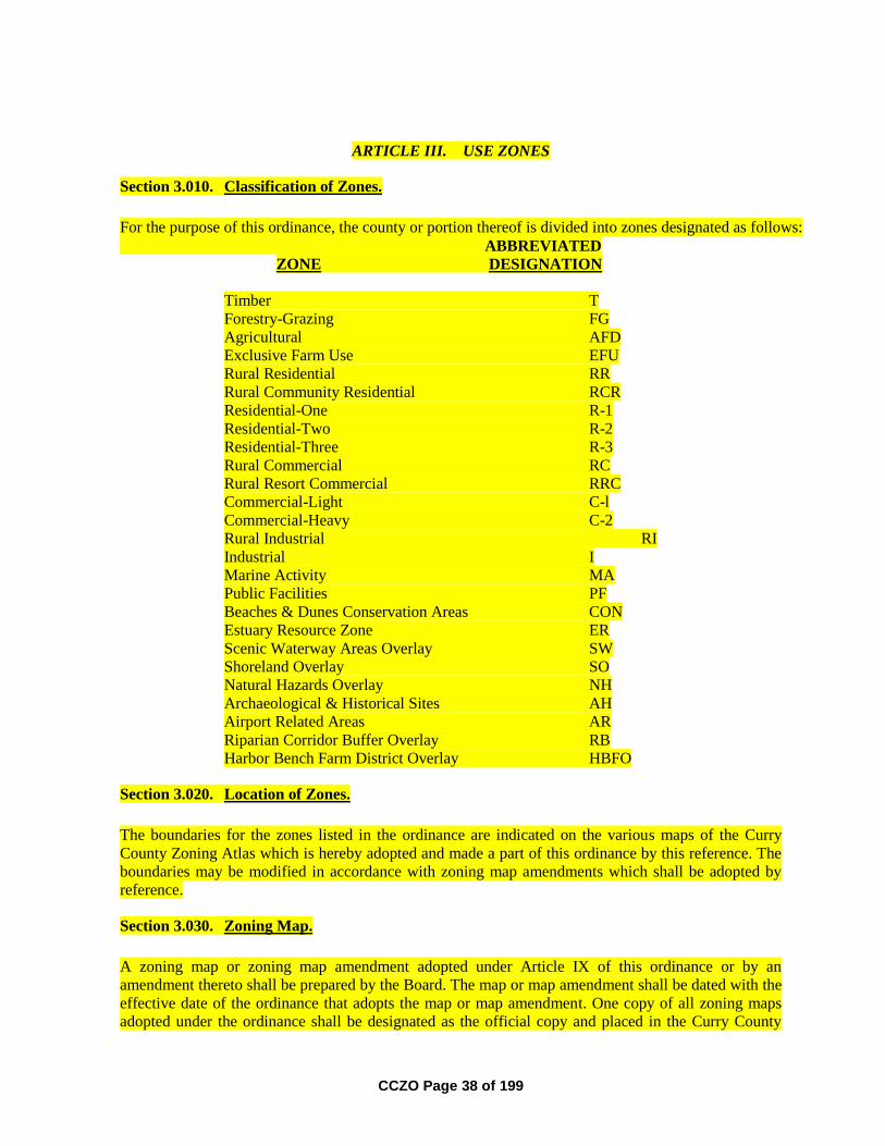
CCZO Page 38 of 199
ARTICLE III. USE ZONES
Section 3.010. Classification of Zones.
For the purpose of this ordinance, the county or portion thereof is divided into zones designated as follows:
ABBREVIATED
ZONE DESIGNATION
Timber T
Forestry-Grazing FG
Agricultural AFD
Exclusive Farm Use EFU
Rural Residential RR
Rural Community Residential RCR
Residential-One R-1
Residential-Two R-2
Residential-Three R-3
Rural Commercial RC
Rural Resort Commercial RRC
Commercial-Light C-l
Commercial-Heavy C-2
Rural Industrial RI
Industrial I
Marine Activity MA
Public Facilities PF
Beaches & Dunes Conservation Areas CON
Estuary Resource Zone ER
Scenic Waterway Areas Overlay SW
Shoreland Overlay SO
Natural Hazards Overlay NH
Archaeological & Historical Sites AH
Airport Related Areas AR
Riparian Corridor Buffer Overlay RB
Harbor Bench Farm District Overlay HBFO
Section 3.020. Location of Zones.
The boundaries for the zones listed in the ordinance are indicated on the various maps of the Curry
County Zoning Atlas which is hereby adopted and made a part of this ordinance by this reference. The
boundaries may be modified in accordance with zoning map amendments which shall be adopted by
reference.
Section 3.030. Zoning Map.
A zoning map or zoning map amendment adopted under Article IX of this ordinance or by an
amendment thereto shall be prepared by the Board. The map or map amendment shall be dated with the
effective date of the ordinance that adopts the map or map amendment. One copy of all zoning maps
adopted under the ordinance shall be designated as the official copy and placed in the Curry County
CCZO Page 39 of 199
Zoning Atlas which shall be retained by the records of the Planning Commission and maintained by the
Director.
Section 3.040. Timber Zone (T).
Purpose of Classification: The Timber Zone is applied to resource areas of the county where the
primary land use is commercial forestry. The purpose of the Timber Zone is:
(a) to implement the forest land policies of the Curry County Comprehensive Plan; and
(b) to implement Statewide Planning Goal 4 with respect to forest lands in the county.
Any rezoning of land from the Timber (T) zone to the Forestry-Grazing (FG) zone requires a
demonstration that the area being rezoned contains a mixture of agricultural and forest uses that neither
Goal 3 nor Goal 4 can be applied alone.
Section 3.041. Uses Permitted Outright.
The following uses and their accessory structures and uses are permitted outright.
1. Forest operations or forest practices including, but not limited to, reforestation of forest
land, harvesting of any forest tree species, road construction and maintenance,
application of chemicals and the disposal of slash.
2. Temporary portable facility for the primary processing of forest products.
3. Temporary forest labor camps.
4. Temporary on-site structures which are auxiliary (see NOTE below) to and used during
the term of a particular forest management operation.
5. Physical alterations to the land auxiliary (see NOTE below) to forest practices,
including but not limited to, those made for purposes of land-based exploration,
mining, commercial gravel extraction and processing, landfills, dams, reservoirs, road
construction or recreational facilities.
NOTE: "Auxiliary", for purposes of this zoning designation, means a use or alteration
of the land which provides help or is directly associated with the conduct of a
particular forest management operation or practice. An auxiliary structure is located on
site, temporary in nature, and is not designed to remain for the forest's entire growth
cycle from planting to harvesting. An auxiliary structure or use is removed when a
particular forest management operation or practice has been completed.
6. Uses to conserve soil, air and water quality on forest lands and to provide for wildlife
and fisheries resources.
7. Farm use as defined in ORS 215.203(2)(a).
CCZO Page 40 of 199
8. Additional local distribution lines within rights-of-way (e.g., electric, telephone,
natural gas, etc.) and accessory equipment (e.g., electrical distribution transformers,
meter cabinets, terminal boxes, pedestals), or which provide service hookups,
including water service hookups.
9. Land-based exploration for mineral and aggregate resources as defined in ORS Chapter
517.
10. Land-based exploration for and production of geothermal, gas, oil, and other associated
hydrocarbons, including the placement and operation of compressors, separators and
customary production equipment for an individual well adjacent to the well head.
11. Destination resorts reviewed and approved pursuant to ORS 197.435 to ORS 197.465
and Goal 8.
12. Private hunting and fishing operations without any lodging accommodations.
13. Fire stations and towers for forest fire protection.
14. Widening of roads within existing rights-of- way in conformance with the
transportation element of the comprehensive plan including public road and highway
projects as described below:
a. climbing and passing lanes within the right of way existing as of July 1, 1987;
b. reconstruction or modification of public roads and highways, not including the
addition of travel lanes, where no removal or displacement of buildings would
occur, or no new land parcels result;
c. temporary public road and highway detours that will be abandoned and
restored to original condition or use at such time as no longer needed; or
d. minor betterment of existing public roads and highway related facilities such
as maintenance yards, weigh stations and rest areas, within right of way
existing as of July 1, 1987, and contiguous public-owned property utilized to
support the operation and maintenance of public roads and highways.
15. Water intake facilities, canals and distribution lines for farm irrigation and ponds.
16. Alteration, restoration or replacement of a lawfully established dwelling that:
a. has intact exterior walls and roof structure;
b. has indoor plumbing consisting of a kitchen sink, toilet and bathing facilities
connected to a sanitary waste disposal system;
c. has interior wiring for interior lights;
d. has a heating system; and

CCZO Page 41 of 199
e. in the case of replacement, is removed, demolished or converted to an
allowable nonresidential use within three months of the completion of the
replacement dwelling.
17. Caretaker residences for public parks and fish hatcheries.
18. Uninhabitable structures accessory to fish and wildlife enhancement.
Section 3.042. Conditional Uses Subject to Administrative Approval by the Director.
The following uses may be allowed provided a land use application is submitted pursuant to Section
2.060 of the Curry County Zoning Ordinance and the Planning Director approves the proposed use
based upon relevant standards for review in this ordinance. Numbers in parenthesis following the uses
indicate the standards described in Section 7.040 that must be met to approve the use.
1. Permanent logging equipment repair and storage facilities. (1,16)
2. Log scaling and truck weigh stations. (1,16)
3. Television, microwave, and radio communication facilities and transmission antenna
towers. (1,5,16)
4. Fire stations for rural fire protection. (1,16)
5. Aids to navigation or aviation. (1,16)
6. Water intake facilities, water treatment facilities, pumping stations, and distribution
lines. (1,16)
7. Utility facilities for the purpose of generating power which do not preclude more than
10 acres from use as a commercial forest operation unless an exception is taken. (1,16)
8. Reservoirs and water impoundments. (1,16)
9. Cemeteries. (1,16)
10. Forest management research and experimentation facilities as referenced by ORS
526.215 or where accessory to forest operations. (1,16)
11. New distribution lines (e.g. electric, telephone, natural gas, etc.) with rights-of-way
fifty (50) feet or less in width.
12. Home occupations as defined in ORS 215.448. (1,7,16)
13. Private seasonal accommodations for fee hunting operations subject to compliance
with the Section 3.045 and Section 3.046 of this ordinance and the following
requirements:
a. accommodations are limited to no more than fifteen (15) guest rooms as that
term is defined in the Oregon Structural Specialty Code;
CCZO Page 42 of 199
b. only minor and incidental and accessory retail sales are permitted;
c. accommodations are occupied temporarily for the purpose of hunting during
game bird and big game hunting seasons authorized by the Oregon Fish and
Game Commission; and
d. the county may impose other appropriate conditions. (1,16)
14. Private accommodations for fishing occupied on a temporary basis subject to
compliance with Section 3.045 and Section 3.046 of this ordinance, and the following
requirements:
a. accommodations are limited to no more than fifteen (15) guest rooms as that
term is defined in the Oregon Structural Specialty Code;
b. only minor and incidental and accessory retail sales are permitted;
c. accommodations are occupied temporarily for the purpose of fishing during
fishing seasons authorized by the Oregon Fish and Game Commission;
d. accommodations must be located within one-fourth mile of fish bearing Class I
waters; and
e. the county may impose other appropriate conditions. (1,16)
15. Dwellings subject to Section 3.043. (1,16)
16. One manufactured dwelling or mobile home in conjunction with an existing dwelling
as a temporary use for the term of a hardship suffered by the existing resident or a
relative of the resident. (1,2,16,17)
17. Trailer, camping or recreational vehicle temporarily used as a residence during
construction of a permitted use or to temporarily provide watchman security for
material that cannot be reasonably stored in an established commercial storage facility.
18. Public road and highway projects as described below:
a. construction of additional passing and travel lanes requiring the acquisition of
right of way but not resulting in the creation of new land parcels;
b. reconstruction or modification of public roads and highways involving the
removal or displacement of buildings but not resulting in the creation of new
land parcels; or
c. improvement of public roads and highway related facilities, such as
maintenance yards, weigh stations and rest areas, where additional property or
right of way is required but not resulting in the creation of new land parcels.
(1,16)
CCZO Page 43 of 199
d. roads, highways and other transportation facilities and improvements not
allowed in a-c above may be established, subject to the approval of the
governing body or its designate subject to:
(i) adoption of an exception to the goal related to forest lands and to any
other goal with which the facility or improvement does not comply; or
(ii) ORS 215.296.
19. Permanent facility for the processing of forest products. (1,16)
20. Firearms training facility. (1,16)
21. Park and campground. For purposes of this rule, a campground is an area devoted to
the overnight temporary use for vacation, recreational or emergency purposes, but not
for residential purposes. A camping site may be occupied by a tent, travel trailer or
recreational vehicle. Campgrounds in this zone shall not include intensively developed
recreational uses such as swimming pools, tennis courts, retail stores, or gas stations.
(1,16)
22. Disposal site or transfer station for solid waste approved by Curry County for which
the Oregon Department of Environmental Quality has granted a permit under ORS
459.245, together with equipment, facilities or buildings necessary for its operation.
(1,16)
23. Land-based mining and processing of oil, gas, or other subsurface resources, as defined
in ORS Chapter 520 and not otherwise permitted in 3.041 (10), and the mining and
processing of aggregate and mineral resources as defined under ORS Chapter 517 but
not including support or processing facilities for offshore oil, gas or marine mineral
activities. (1,9,16)
24. Portable asphalt and concrete batch plants as a temporary use for a specific
highway/road construction or maintenance project. (1,10,16)
25. Expansion of an existing airport. (1,16)
Section 3.043. Standards for the Approval of Dwellings.
One single family dwelling may be approved on a forest land parcel if the dwelling meets any of the
tests set forth in (1), (2) or (3) below.
1. A lot of record single family dwelling may be sited on forest land after the Board or its
designate notifies the county assessor that the county intends to allow the dwelling and
if:
a) the lot or parcel on which the dwelling will be sited was lawfully created prior
to January 1, 1985; and
b) the lot or parcel was acquired by the present owner:
(i) prior to January 1, 1985; or
CCZO Page 44 of 199
(ii) by devise or by intestate succession from a person who acquired the
lot or parcel prior to January 1, 1985.
NOTE: For purposes of this subsection "owner" includes wife,
husband, mother, father, brother, brother-in-law, sister, sister-in-law,
mother-in-law, father-in-law, aunt, uncle, niece, nephew, stepparent,
stepchild, grandparent or grandchild of the owner or a business entity
owned by any one or a combination of these family members.
c) the tract on which the dwelling will be located does not include an existing
dwelling;
d) the proposed dwelling is not prohibited by and will comply with the
requirements of the comprehensive plan, zoning ordinance and other
provisions of law;
e) the lot or parcel on which the dwelling will be sited is composed of soils not
capable of producing 5,000 cubic feet per year of commercial tree species;
f) the lot or parcel is located within 1,500 feet of a public road as defined under
ORS 368.001 that is not a United States Forest Service or Bureau of Land
Management road; and the access road shall be maintained and either paved or
surfaced with rock.
g) when the lot or parcel on which the dwelling will be sited lies within an area
designated in an acknowledged comprehensive plan as habitat of big game, the
siting of the dwelling is consistent with the limitations on density upon which
the acknowledged comprehensive plan and land use regulations intended to
protect the habitat are based.
h) When the lot or parcel on which the dwelling will be sited is part of a tract, the
remaining portions of the tract are to be consolidated into a single lot or parcel
when the dwelling is allowed.
2. A single family dwelling may be sited on forest land if it complies with other
provisions of law and;
a) it will be located on a tract of land of at least 160 contiguous acres; or
NOTE: For purposes of this subsection a tract shall not be considered to
consist of less than 160 acres because it is crossed by a public road or
waterway.
b) the applicant is the owner of tracts that are not contiguous but are in the same
county or adjacent counties and the tracts are zoned for forest use and the
acreage of two or more tracts total 200 acres or more; under such
circumstances a dwelling may be placed on one of the tracts providing the
owner submits proof of a nonrevocable deed restriction that precludes all
future rights to construct a dwelling on the tracts or to use the tracts to total
acreage for other future dwellings unless the tract is no longer subject to
protection under goals for agricultural lands or forest lands. The covenants,

CCZO Page 45 of 199
conditions and restrictions shall be on a form provided by the county and has
been recorded with the county clerk of the county or counties where the
property subject to the covenants, conditions and restrictions is located. The
covenants, conditions and restrictions are subject to the following:
i) the covenants, conditions and restrictions are irrevocable, unless a
statement of release is signed by an authorized representative of the
county or counties where the property subject to the covenants,
conditions and restrictions is located;
ii) enforcement of the covenant, conditions and restrictions may be
undertaken by the Department of Land Conservation and Development
or by the county or counties where the property subject to the
covenants, conditions and restrictions is located;
iii) the failure to follow the requirements of this section shall not affect the
validity of the transfer of property or the legal remedies available to
the buyers of property which is subject to the covenants, conditions
and restrictions required by this section;
iv) the Director shall maintain a copy of the covenants, conditions and
restrictions filed in the county deed records pursuant to this section
and a map or other record depicting tracts which do not qualify for the
siting of a dwelling under covenants, conditions and restrictions filed
in the county deed records pursuant to this section. This map or other
record shall be readily available to the public at the county planning
office.
3. A single family dwelling may be sited on forest land if the lot or parcel is
predominantly composed of soils that are:
a) capable of producing 0 to 49 cubic feet per acre per year of wood fiber if:
(i) all or part of at least three other lots or parcels that existed on January
1, 1993 are within a 160 acre square centered on the center of the
subject tract; and
(ii) at least three dwellings existed on January 1, 1993 on the other lots or
parcels;
b) capable of producing 50 to 85 cubic feet per acre per year of wood fiber if:
(i) all or part of at least seven other lots or parcels that existed on January
1, 1993 are within a 160 acre square centered on the center of the
subject tract; and
(ii) at least three dwellings existed on January 1, 1993 on other lots or
parcels; or
c) capable of producing more than 85 cubic feet per acre per year of wood fiber
if:
CCZO Page 46 of 199
(i) all or part of at least 11 other lots or parcels that existed on January 1,
1993 are within a 160 acre square centered on the center of the subject
tract; and
(ii) at least three dwellings existed on January 1, 1993 on other lots or
parcels.
d) If the tract abuts a road that existed on January 1, 1993, the measurement may
be made by creating a 160 acre rectangle that is one mile long and one-fourth
mile wide centered on the center of the subject tract and to the maximum
extent possible, aligned with the road.
e) If the tract is 60 acres or larger, and abuts a road or perennial stream, the
measurement shall be made the same as in 3 d) above; however, one of the
three required dwellings shall be on the same side of the road or stream as the
subject tract, and;
(i) be located within a 160 acre rectangle that is one mile long and one-
fourth mile wide centered on the center of the subject tract and that is,
to the maximum extent possible aligned with the road or stream; or
(ii) be within one-fourth mile from the edge of the subject tract but not
outside the length of the 160 acre rectangle, and on the same side of
the road or stream as the tract.
g) If a road crosses the tract on which the dwelling will be located, at least one of
the three required dwellings shall be on the same side of the road as the
proposed dwelling.
4. The approval of a dwelling under subsections 1, 2, or 3 above shall be subject to the
following additional requirements.
a) Dwellings and structures shall be sited on the parcel so that:
i) they have the least impact on nearby or adjoining forest or agricultural
lands;
ii) the siting ensures that adverse impacts on forest operations and
accepted farming practices on the tract will be minimized;
iii) the amount of forest lands used to site access roads, service corridors,
the dwelling and structures is minimized; and
iv) the risks associated with wildfire are minimized.
b) The siting criteria to satisfy (a) above may include setbacks from adjoining
properties, clustering near or among existing structures, siting close to existing
roads and siting on that portion of the parcel least suited for growing trees.
CCZO Page 47 of 199
c) The applicant shall provide evidence that the domestic water supply is from a
source authorized by the Oregon Water Resources Department's administrative
rules for the appropriation of ground water or surface water and is not from a
Class II stream as defined in the Forest Practices Rules (OAR Chapter 629).
For purposes of this subsection, evidence of a domestic water supply means:
i) verification from a water purveyor that the use described in the
application will be served by the purveyor under the purveyor's rights
to appropriate water, or
ii) a water use permit issued by the Oregon Water Resources Department
for the use described in the application; or
iii) verification from the Oregon Water Resources Department that a water
use permit is not required for the use described in the application. If
the proposed water supply is from a well and is exempt from
permitting requirements under ORS 537.545, the applicant shall
submit the well constructor's report to the county upon completion of
the well.
d) As a condition of approval, if road access to the dwelling is by a road owned
and maintained by a private party or by the Oregon Department of Forestry,
the United States Bureau of Land Management, or the United States Forest
Service, then the applicant shall provide proof of a long-term road access
permit or agreement. The road use permit may require the applicant to agree to
accept responsibility for road maintenance.
e) Approval of a dwelling shall be subject to the following requirements:
i) the applicant shall plant a sufficient number of trees on the tract to
demonstrate that the tract is reasonably expected to meet Department
of Forestry stocking requirements at the time specified in Department
of Forestry administrative rules;
f) The Director shall notify the county Assessor of the above condition at the
time the dwelling is approved.
g) the property owner shall submit a stocking survey report to the Assessor and
the Assessor shall verify that the minimum stocking requirements have been
met by the time required by Department of Forestry rules;
h) the Assessor shall inform the Department of Forestry in cases where the
property owner has not submitted a stocking survey report or where the survey
report indicates that minimum stocking requirements have not been met;
i) upon notification by the Assessor the Department of Forestry shall determine
whether the tract meets the minimum stocking requirements of the Forest
Practices Act, if the Department of Forestry determines that the tract does not
meet those requirements then the Department shall notify the owner and the
Assessor that the land is not being managed as forest land, the Assessor shall
CCZO Page 48 of 199
then remove the forest land designation pursuant to ORS 321.359 and impose
the additional tax pursuant to ORS 321.372.
Section 3.044. Lot Size.
1. The minimum lot size within the Timber (T) zone is eighty (80) acres. Notwithstanding
the above minimum lot size; the placement of dwellings on parcels created in this
zoning designation is subject to the requirements of Section 3.043 of this ordinance.
2. New land divisions less than eighty (80) acres may be approved for the following uses:
a. uses listed in Section 3.041 (9) to (10) that have been approved pursuant to the
provisions of this ordinance; and
b. uses listed in Section 3.042 (1) to (9) and (21) to (25) that have been approved
pursuant to the provisions of this ordinance; and
c. such divisions shall create a parcel that is the minimum size necessary for the
use.
d. to allow the establishment of a parcel for a dwelling subject to the following
requirements:
i) the parcel established shall not be larger than five (5) acres, except as
necessary to recognize physical factors such as roads or streams, in
which case the parcel shall be no larger than ten (10) acres;
ii) the dwelling existed prior to June 1, 1995;
iii) the remaining parcel, not containing the dwelling, meets the minimum
lot size of the zone; or
the remaining parcel, not containing the dwelling, is consolidated with
another parcel, and together the parcels meet the minimum lot size of
the zone;
iv) the remaining parcel, not containing the dwelling, is not entitled to a
dwelling unless subsequently authorized by law or goal;
v) the property owner shall provide evidence that a restriction on the
remaining parcel, not containing the dwelling, stating that no new
dwellings shall be allowed on the parcel unless authorized by law or
goal while it is zoned for forest use has been recorded with the County
Clerk.
vi) the restriction imposed in (v) above shall be irrevocable unless a
statement of release is signed by the county Planning Director
indicating that the comprehensive plan or land use regulations
applicable to the property have been changed in such a manner that the
subject property is no longer subject to statewide planning goals
pertaining to agricultural or forest land.
CCZO Page 49 of 199
vii) the property owner shall provide evidence that a signed statement
declaring that the owner of the subject property will not in the future
complain about accepted farming or forest practices on nearby lands
devoted to farm or forest use has been recorded with the County Clerk.
e. to allow a division of forest land to facilitate a forest practice as defined in
ORS 527.620 that results in a parcel that does not meet the minimum lot size
requirements of Section (1) which meet the following requirements:
i) shall not be eligible for siting of a new dwelling;
ii) shall not serve as the justification for the siting of a future dwelling on
other lots or parcels;
iii) shall not, as a result of the land division, be used to justify
redesignation or rezoning of resource lands;
iv) shall not result in a parcel of less than 35 acres, except:
(a) where the purpose of the land division is to facilitate
an exchange of lands involving a governmental
agency; or
(b) where the purpose of the land division is to allow
transactions in which at least one participant is a
person with a cumulative ownership of at least 2,000
acres of forest land; and
v) if associated with the creation of a parcel where a dwelling is involved,
shall not result in a parcel less than the minimum lot size of this zone.
vi) the property owner shall provide evidence that a restriction on the
newly created parcel stating that no new dwellings shall be allowed on
the parcel unless authorized by law or goal while it is zoned for forest
use has been recorded with the county clerk.
vii) the restriction imposed in (vi) above shall be irrevocable unless a
statement of release is signed by the county Planning Director
indicating that the comprehensive plan or land use regulations
applicable to the property have been changed in such a manner that the
subject property is no longer subject to statewide planning goals
pertaining to agricultural or forest land.
viii) the property owner shall provide evidence that a signed statement
declaring that the owner of the subject property will not in the future
complain about accepted farming or forest practices on nearby lands
devoted to farm or forest use has been recorded with the County Clerk.
Section 3.045. Fire Fighting Standards for Dwellings and Structures.
The following fire siting standards shall apply to all new dwellings or permanent structures
constructed or placed on lands within the Timber (T) zoning designation.

CCZO Page 50 of 199
1. The dwelling shall be located on a parcel that is located within a structural fire
protection district or the owner has contracted with a structural fire protection district
for residential fire protection. If the dwelling is not within a fire protection district, the
applicant shall provide evidence that the applicant has asked to be included within the
nearest such district. If the Director determines that inclusion within a fire protection
district or contracting for residential fire protection is impracticable, the Director may
provide an alternative means for protecting the dwelling from fire hazards. The
alternative means for providing fire protection may include a fire sprinkling system,
onsite fire suppression equipment and water storage or other methods that are
reasonable, given the site conditions. If a water supply is required for fire protection, it
shall be a swimming pool, pond, lake, or similar body of water that at all times
contains at least 4,000 gallons or a stream that has a continuous year round flow of at
least one cubic foot per second. The applicant shall provide verification from the Water
Resources Department that any permits or registrations required for water diversion or
storage have been obtained or that permits or registrations are not required for the use.
Road access shall be provided to within 15 feet of the water's edge for fire fighting
pumping units. The road access shall accommodate the turnaround of fire fighting
equipment during the fire season. Permanent signs shall be posted along the access
route to indicate the location of the emergency water source.
2. Fire Safety Area.
Owners of new dwellings and structures shall comply with the following requirements.
a. A primary fire safety area of at least thirty (30) feet width shall be maintained
around all structures;
NOTE: For purposes of this ordinance a primary fire safety area shall be
defined as follows:
An area in which the vegetation shall be limited to mowed grasses, low shrubs
(less than two (2) feet high, and trees that are spaced with more than fifteen
(15) feet between the crowns and pruned to remove dead and low (less than
eight (8) feet from the ground) branches. Accumulated needles, limbs and
other dead vegetation should be removed from beneath the trees.
b. A secondary fire safety area of at least one hundred (100) feet width shall be
cleared and maintained around the primary fire safety area.
NOTE: For purposes of this ordinance a secondary fire safety area shall be
defined as follows:
An area in which the vegetation shall be limited to mowed grasses, low shrubs
(less than two (2) feet high, and trees that are spaced with more than fifteen
(15) feet between the crowns and pruned to remove dead and low (less than
eight (8) feet from the ground) branches.
c. Areas subject to the Scenic Waterway Area Overlay Zone may have
compliance with the primary and secondary fire safety area requirements of
this section modified to comply with specific siting standards contained in any
CCZO Page 51 of 199
state or federal approved Scenic Waterway Management Program when such
regulations conflict.
3. The dwelling shall have a fire retardant roof.
4. If the dwelling has a chimney or chimneys, each chimney shall have a spark arrester.
5. The dwelling shall not be sited on a slope greater than 40 percent.
6. The County may impose standards and conditions in addition to those specified above,
when it deems it necessary to protect the public health, safety and welfare.
7. Replacement or substantial improvement of legally sited existing dwellings requires
compliance with the Fire Safety Area requirements of subsection 2. above. Substantial
improvement constitutes an improvement which is in excess of 50% of the assessed
value of the existing dwelling.
8. Road Access to Dwellings
Road access to the dwelling shall meet the requirements set forth in Section 3.046.
Section 3.046. Fire Safety Standards for Roads.
The following special road standards shall apply within the Timber (T) zoning designation. These
special road standards shall not apply to private roads accessing only commercial forest uses that do not
include permanent dwellings or structures. The purpose of the rule is to provide adequate access for fire
fighting equipment.
1. Roads and driveways shall have a driveable surface width of sixteen (16) feet.
2. Roads and driveways shall have an all weather driveable surface of gravel or rock.
3. Roads and driveways shall have an unobstructed horizontal clearance of not less than
sixteen (16) feet and an unobstructed vertical clearance of not less than twelve (12)
feet.
4. Average grade for a road or driveway shall not exceed thirteen and one-half (13.5%)
percent for any one mile of road length; or exceed twenty (20%) percent for any four
hundred (400) consecutive feet of road length.
5. Roads and driveways shall have a driveable surfaced turnaround which has either a
thirty-five (35) foot radius cul-de-sac, or a sixty (60) foot "T-shaped" design for the
turning of fire fighting equipment.
6. Roads, driveways, bridges and culverts shall be designed and maintained to support a
minimum gross weight (GVW) of 50,000 pounds for the passage of fire fighting
vehicles or equipment.
7. Bridges or culverts which are part of the construction of the road or driveway to the
dwelling or structure shall have written verification from a Professional Engineer,
CCZO Page 52 of 199
licensed in the State of Oregon, that the structure can meet the 50,000 pound
construction standard.
8. All bridges shall be inspected and certified as to compliance with the 50,000 pound
construction standard at an interval not greater than once every two years from the date
of this ordinance. The inspection report shall be filed with the Curry County Road
Department.
9. Variations from these standards may be granted through the provisions of Article VIII
of this ordinance. The applicant shall provide a written statement from the governing
board of the fire protection district having responsibility for structural fire protection in
the area where the new dwelling or structure is to be located which states that their
fire-fighting vehicles and equipment can negotiate the proposed road and driveway.
Section 3.047. Set-Backs.
See Article IV.
Section 3.048. Height of Building.
See Article IV.
Section 3.049. Off-Street Parking and Loading.
See Article IV.
Section 3.050. Forestry Grazing Zone (FG).
Purpose of Classification: The Forestry Grazing Zone is applied to resource areas of the county where
the primary land use is commercial forestry with some intermixed agricultural uses for livestock uses.
The purpose of the Forestry Grazing Zone is:
(a) to implement the forest land policies of the Curry County Comprehensive Plan; and
(b) to implement Statewide Planning Goal 4 with respect to forest lands in the county.
(c) to implement the agricultural land policies of the Curry County Comprehensive Plan
with respect to livestock grazing and related farm uses which are intermixed with
forest land in some parts of the county; and
(d) to implement Statewide Planning Goal 3 with respect to intermixed farm and forest
land in the county.
If the subject tract was predominantly in agricultural (farm) use on January 1, 1993
then uses as specified under Sections 3.070 to 3.078 of this ordinance are applicable.
Section 3.051. Uses Permitted Outright.
The following uses and their accessory structures and uses are permitted outright.
CCZO Page 53 of 199
1. Forest operations or forest practices including, but not limited to, reforestation of forest
land, harvesting of any forest tree species, road construction and maintenance,
application of chemicals and the disposal of slash.
2. Temporary portable facility for the primary processing of forest products.
3. Temporary forest labor camps.
4. Temporary on-site structures which are auxiliary (see NOTE below) to and used during
the term of a particular forest management operation.
5. Physical alterations to the land auxiliary (see NOTE below) to forest practices,
including but not limited to, those made for purposes of land-based exploration,
mining, commercial gravel extraction and processing, landfills, dams, reservoirs, road
construction or recreational facilities.
NOTE: "Auxiliary", for purposes of this zoning designation, means a use or alteration
of the land which provides help or is directly associated with the conduct of a
particular forest management operation or practice. An auxiliary structure is located on
site, temporary in nature, and is not designed to remain for the forest's entire growth
cycle from planting to harvesting. An auxiliary structure or use is removed when a
particular forest management operation or practice has been completed.
6. Uses to conserve soil, air and water quality on forest lands and to provide for wildlife
and fisheries resources.
7. Farm use as defined in ORS 215.203(2)(a).
8. Additional local distribution lines within rights-of-way (e.g., electric, telephone,
natural gas, etc.) and accessory equipment (e.g., electrical distribution transformers,
meter cabinets, terminal boxes, pedestals), or which provide service hookups,
including water service hookups.
9. Land-based exploration for mineral and aggregate resources as defined in ORS Chapter
517.
10. Land-based exploration for and production of geothermal, gas, oil, and other associated
hydrocarbons, including the placement and operation of compressors, separators and
customary production equipment for an individual well adjacent to the well head.
11. Destination resorts reviewed and approved pursuant to ORS 197.435 to ORS 197.465
and Goal 8.
12. Private hunting and fishing operations without any lodging accommodations.
13. Fire stations and towers for forest fire protection.
14. Widening of roads within existing rights-of- way in conformance with the
transportation element of the comprehensive plan including public road and highway
projects as described below:

CCZO Page 54 of 199
a. climbing and passing lanes within the right of way existing as of July 1, 1987;
b. reconstruction or modification of public roads and highways, not including the
addition of travel lanes, where no removal or displacement of buildings would
occur, or no new land parcels result;
c. temporary public road and highway detours that will be abandoned and
restored to original condition or use at such time as no longer needed; or
d. minor betterment of existing public roads and highway related facilities such
as maintenance yards, weigh stations and rest areas, within right of way
existing as of July 1, 1987, and contiguous public-owned property utilized to
support the operation and maintenance of public roads and highways.
15. Water intake facilities, canals and distribution lines for farm irrigation and ponds.
16. Alteration, restoration or replacement of a lawfully established dwelling that:
a. has intact exterior walls and roof structure;
b. has indoor plumbing consisting of a kitchen sink, toilet and bathing facilities
connected to a sanitary waste disposal system;
c. has interior wiring for interior lights;
d. has a heating system; and
e. in the case of replacement, is removed, demolished or converted to an
allowable nonresidential use within three months of the completion of the
replacement dwelling.
17. Caretaker residences for public parks and fish hatcheries.
18. Uninhabitable structures accessory to fish and wildlife enhancement.
Section 3.052. Conditional Uses Subject to Administrative Approval by the Director.
The following uses may be allowed provided a land use application is submitted pursuant to Section
2.060 of the Curry County Zoning Ordinance and the Planning Director approves the proposed use
based upon relevant standards for review in this ordinance. Numbers in parenthesis following the uses
indicate the standards described in Section 7.040 that must be met to approve the use.
1. Permanent logging equipment repair and storage facilities. (1,16)
2. Log scaling and truck weigh stations. (1,16)
3. Television, microwave, and radio communication facilities and transmission antenna
towers. (1,5,16)
4. Fire stations for rural fire protection. (1,16)
CCZO Page 55 of 199
5. Aids to navigation or aviation. (1,16)
6. Water intake facilities, water treatment facilities, pumping stations, and distribution
lines. (1,16)
7. Utility facilities for the purpose of generating power which do not preclude more than
10 acres from use as a commercial forest operation unless an exception is taken. (1,16)
8. Reservoirs and water impoundments. (1,16)
9. Cemeteries. (1,16)
10. Forest management research and experimentation facilities as referenced by ORS
526.215 or where accessory to forest operations. (1,16)
11. New distribution lines (e.g. electric, telephone, natural gas, etc.) with rights-of-way
fifty (50) feet or less in width.
12. Home occupations as defined in ORS 215.448. (1,7,16)
13. Private seasonal accommodations for fee hunting operations subject to compliance
with the Section 3.055 and Section 3.056 of this ordinance and the following
requirements:
a. accommodations are limited to no more than fifteen (15) guest rooms as that
term is defined in the Oregon Structural Specialty Code;
b. only minor and incidental and accessory retail sales are permitted;
c. accommodations are occupied temporarily for the purpose of hunting during
game bird and big game hunting seasons authorized by the Oregon Fish and
Game Commission; and
d. the county may impose other appropriate conditions. (1,16)
14. Private accommodations for fishing occupied on a temporary basis subject to
compliance with Section 3.055 and Section 3.056 of this ordinance, and the following
requirements:
a. accommodations are limited to no more than fifteen (15) guest rooms
as that term is defined in the Oregon Structural Specialty Code;
b. only minor and incidental and accessory retail sales are permitted;
c. accommodations are occupied temporarily for the purpose of fishing
during fishing seasons authorized by the Oregon Fish and Game
Commission;
d. accommodations must be located within one-fourth mile of fish
bearing Class I waters; and

CCZO Page 56 of 199
e. the county may impose other appropriate conditions. (1,16)
15. Commercial activities associated with farm use where the subject property is
predominantly agricultural or grazing land and is currently in farm use as defined in
ORS 215.203(2)(a).
16. Dwellings subject to Section 3.053. (1,16)
17. One manufactured dwelling or mobile home in conjunction with an existing dwelling
as a temporary use for the term of a hardship suffered by the existing resident or a
relative of the resident. (1,2,16,17)
18. Trailer, camping or recreational vehicle temporarily used as a residence during
construction of a permitted use or to temporarily provide watchman security for
material that cannot be reasonably stored in an established commercial storage facility.
19. Public road and highway projects as described below:
a. construction of additional passing and travel lanes requiring the
acquisition of right of way but not resulting in the creation of new land
parcels;
b. reconstruction or modification of public roads and highways involving
the removal or displacement of buildings but not resulting in the
creation of new land parcels; or
c. improvement of public roads and highway related facilities, such as
maintenance yards, weigh stations and rest areas, where additional
property or right of way is required but not resulting in the creation of
new land parcels. (1,16)
d. roads, highways and other transportation facilities and improvements
not allowed in a-c above may be established, subject to the approval
of the governing body or its designate subject to:
(i) adoption of an exception to the goal related to forest lands and
to any other goal with which the facility or improvement does
not comply; or
(ii) ORS 215.296.
20. Permanent facility for the processing of forest products. (1,16)
21. Firearms training facility. (1,16)
22. Park and campground. For purposes of this rule, a campground is an area devoted to
the overnight temporary use for vacation, recreational or emergency purposes, but not
for residential purposes. A camping site may be occupied by a tent, travel trailer or
recreational vehicle. Campgrounds in this zone shall not include intensively developed
CCZO Page 57 of 199
recreational uses such as swimming pools, tennis courts, retail stores, or gas stations.
(1,16)
23. Disposal site or transfer station for solid waste approved by Curry County for which
the Oregon Department of Environmental Quality has granted a permit under ORS
459.245, together with equipment, facilities or buildings necessary for its operation.
(1,16)
24. Land-based mining and processing of oil, gas, or other subsurface resources, as defined
in ORS Chapter 520 and not otherwise permitted in 3.041 (10), and the mining and
processing of aggregate and mineral resources as defined under ORS Chapter 517 but
not including support or processing facilities for offshore oil, gas or marine mineral
activities. (1,9,16)
25. Portable asphalt and concrete batch plants as a temporary use for a specific
highway/road construction or maintenance project. (1,10,16)
26. Expansion of an existing airport. (1,16)
Section 3.053. Standards for the Approval of Dwellings.
One single family dwelling may be approved on a forest land parcel if the dwelling meets any of the
tests set forth in (1), (2) or (3) below.
1. A lot of record single family dwelling may be sited on forest land after the Board or its
designate notifies the county assessor that the county intends to allow the dwelling, and
if:
a) the lot or parcel on which the dwelling will be sited was lawfully created prior
to January 1, 1985; and
b) the lot or parcel was acquired by the present owner:
(i) prior to January 1, 1985; or
(ii) by devise or by intestate succession from a person who acquired the
lot or parcel prior to January 1, 1985.
NOTE: For purposes of this subsection "owner" includes wife, husband,
mother, father, brother, brother-in-law, sister, sister-in-law, mother-in-law,
father-in-law, aunt, uncle, niece, nephew, stepparent, stepchild, grandparent or
grandchild of the owner or a business entity owned by any one or a
combination of these family members.
c) the tract on which the dwelling will be located does not include an existing
dwelling;
d) the proposed dwelling is not prohibited by and will comply with the
requirements of the comprehensive plan, zoning ordinance and other
provisions of law;
CCZO Page 58 of 199
e) the lot or parcel on which the dwelling will be sited is composed of soils not
capable of producing 5,000 cubic feet per year of commercial tree species;
f) the lot or parcel is located within 1,500 feet of a public road as defined under
ORS 368.001 that is not a United States Forest Service or Bureau of Land
Management road; and the access road shall be maintained and either paved or
surfaced with rock.
g) when the lot or parcel on which the dwelling will be sited lies within an area
designated in an acknowledged comprehensive plan as habitat of big game, the
siting of the dwelling is consistent with the limitations on density upon which
the acknowledged comprehensive plan and land use regulations intended to
protect the habitat are based.
h) when the lot or parcel on which the dwelling will be sited is part of a tract, the
remaining portions of the tract are to be consolidated into a single lot or parcel
when the dwelling is allowed.
2. A single family dwelling may be sited on forest land if it complies with other
provisions of law and;
a) it will be located on a tract of land of at least 160 contiguous acres; or
NOTE: For purposes of this subsection a tract shall not be considered to
consist of less than 160 acres because it is crossed by a public road or
waterway.
b) the applicant is the owner of tracts that are not contiguous but are in the same
county or adjacent counties and the tracts are zoned for forest use and the
acreage of two or more tracts total 200 acres or more; under such
circumstances a dwelling may be placed on one of the tracts providing the
owner submits proof of a nonrevocable deed restriction that precludes all
future rights to construct a dwelling on the tracts or to use the tracts to total
acreage for other future dwellings unless the tract is no longer subject to
protection under goals for agricultural lands or forest lands. The covenants,
conditions and restrictions shall be on a form provided by the county and has
been recorded with the county clerk of the county or counties where the
property subject to the covenants, conditions and restrictions is located. The
covenants, conditions and restrictions are subject to the following:
i) the covenants, conditions and restrictions are irrevocable, unless a
statement of release is signed by an authorized representative of the
county or counties where the property subject to the covenants,
conditions and restrictions is located;
ii) enforcement of the covenant, conditions and restrictions may be
undertaken by the Department of Land Conservation and Development
or by the county or counties where the property subject to the
covenants, conditions and restrictions is located;
iii) the failure to follow the requirements of this section shall not affect the
validity of the transfer of property or the legal remedies available to
CCZO Page 59 of 199
the buyers of property which is subject to the covenants, conditions
and restrictions required by this section;
iv) the Director shall maintain a copy of the covenants, conditions and
restrictions filed in the county deed records pursuant to this section
and a map or other record depicting tracts which do not qualify for the
siting of a dwelling under covenants, conditions and restrictions filed
in the county deed records pursuant to this section. This map or other
record shall be readily available to the public at the county planning
office.
3. A single family dwelling may be sited on forest land if the lot or parcel is
predominantly composed of soils that are:
a) capable of producing 0 to 49 cubic feet per acre per year of wood fiber if:
(i) all or part of at least three other lots or parcels that existed on January
1, 1993 are within a 160 acre square centered on the center of the
subject tract; and
(ii) at least three dwellings existed on January 1, 1993 on the other lots or
parcels;
b) capable of producing 50 to 85 cubic feet per acre per year of wood fiber if:
(i) all or part of at least seven other lots or parcels that existed in January
1, 1993 are within a 160 acre square centered on the center of the
subject tract; and
(ii) at least three dwellings existed on January 1, 1993 on other lots or
parcels; or
c) capable of producing more than 85 cubic feet per acre per year of wood fiber
if:
(i) all or part of at least 11 other lots or parcels that existed on January 1,
1993 are within a 160 acre square centered on the center of the subject
tract; and
(ii) at least three dwellings existed on January 1, 1993 on other lots or
parcels.
d) If the tract abuts a road that existed on January 1, 1993, the measurement may
be made by creating a 160 acre rectangle that is one mile long and one-fourth
mile wide centered on the center of the subject tract and to the maximum
extent possible, aligned with the road.
e) If the tract is 60 acres or larger, and abuts a road or perennial stream, the
measurement shall be made the same as in 3 e) above; however, one of the
three required dwellings shall be on the same side of the road or stream as the
subject tract, and;

CCZO Page 60 of 199
(i) be located within a 160 acre rectangle that is one mile long and one-
fourth mile wide centered on the center of the subject tract and that is,
to the maximum extent possible aligned with the road or stream; or
(ii) be within one-fourth mile from the edge of the subject tract but not
outside the length of the 160 acre rectangle, and on the same side of
the road or stream as the tract.
g) If a road crosses the tract on which the dwelling will be located, at least one of
the three required dwellings shall be on the same side of the road as the
proposed dwelling.
4. The approval of a dwelling under subsections 1, 2, or 3 above shall be subject to the
following additional requirements.
a) Dwellings and structures shall be sited on the parcel so that:
i) they have the least impact on nearby or adjoining forest or agricultural
lands;
ii) the siting ensures that adverse impacts on forest operations and
accepted farming practices on the tract will be minimized;
iii) the amount of forest lands used to site access roads, service corridors,
the dwelling and structures is minimized; and
iv) the risks associated with wildfire are minimized.
b) The siting criteria to satisfy (a) above may include setbacks from adjoining
properties, clustering near or among existing structures, siting close to existing
roads and siting on that portion of the parcel least suited for growing trees.
c) The applicant shall provide evidence that the domestic water supply is from a
source authorized by the Oregon Water Resources Department's administrative
rules for the appropriation of ground water or surface water and is not from a
Class II stream as defined in the Forest Practices Rules (OAR Chapter 629).
For purposes of this subsection, evidence of a domestic water supply means:
i) verification from a water purveyor that the use described in the
application will be served by the purveyor under the purveyor's rights
to appropriate water, or
ii) a water use permit issued by the Oregon Water Resources Department
for the use described in the application; or
iii) verification from the Oregon Water Resources Department that a water
use permit is not required for the use described in the application. If
the proposed water supply is from a well and is exempt from
permitting requirements under ORS 537.545, the applicant shall
CCZO Page 61 of 199
submit the well constructor's report to the county upon completion of
the well.
d) As a condition of approval, if road access to the dwelling is by a road owned
and maintained by a private party or by the Oregon Department of Forestry,
the United States Bureau of Land Management, or the United States Forest
Service, then the applicant shall provide proof of a long-term road access
permit or agreement. The road use permit may require the applicant to agree to
accept responsibility for road maintenance.
e) Approval of a dwelling shall be subject to the following requirements:
i) the applicant shall plant a sufficient number of trees on the tract to
demonstrate that the tract is reasonably expected to meet Department
of Forestry stocking requirements at the time specified in Department
of Forestry administrative rules;
f) The Director shall notify the county Assessor of the above condition at the
time the dwelling is approved.
g) the property owner shall submit a stocking survey report to the Assessor and
the Assessor shall verify that the minimum stocking requirements have been
met by the time required by Department of Forestry rules;
h) the Assessor shall inform the Department of Forestry in cases where the
property owner has not submitted a stocking survey report or where the survey
report indicates that minimum stocking requirements have not been met;
i) upon notification by the Assessor the Department of Forestry shall determine
whether the tract meets the minimum stocking requirements of the Forest
Practices Act, if the Department of Forestry determines that the tract does not
meet those requirements then the Department shall notify the owner and the
Assessor that the land is not being managed as forest land, the Assessor shall
then remove the forest land designation pursuant to ORS 321.359 and impose
the additional tax pursuant to ORS 321.372.
Section 3.054. Lot Size.
1. The minimum lot size within the Forestry Grazing (FG) zone is eighty (80) acres.
Notwithstanding the above minimum lot size; the placement of dwellings on parcels
created in this zoning designation is subject to the requirements of Section 3.053 of
this ordinance.
2. New land divisions less than eighty (80) acres may be approved for the following uses:
a. uses listed in Section 3.051 (9) to (10) that have been approved pursuant to the
provisions of this ordinance; and
b. uses listed in Section 3.052 (1) to (9) and (21) to (25) that have been approved
pursuant to the provisions of this ordinance; and
CCZO Page 62 of 199
c. such divisions shall create a parcel that is the minimum size necessary for the
use.
d. to allow the establishment of a parcel for a dwelling subject to the following
requirements:
i) the parcel established shall not be larger than five (5) acres, except as
necessary to recognize physical factors such as roads or streams, in
which case the parcel shall be no larger than ten (10) acres;
ii) the dwelling existed prior to June 1, 1995;
iii) the remaining parcel, not containing the dwelling, meets the minimum
lot size of the zone; or
the remaining parcel, not containing the dwelling, is consolidated with
another parcel, and together the parcels meet the minimum lot size of
the zone;
iv) the remaining parcel, not containing the dwelling, is not entitled to a
dwelling unless subsequently authorized by law or goal;
v) the minimum size tract eligible for this type of land division is 40
acres;
vi) the tract shall be predominantly in forest use and that portion in forest
use be qualified for special assessment under a program under ORS
Chapter 321; and
vii) the remainder of the tract shall not qualify for any uses allowed under
ORS 215.283 that are not allowed on forest land.
viii) the property owner shall provide evidence that a restriction on the
remaining parcel, not containing the dwelling, stating that no new
dwellings shall be allowed on the parcel unless authorized by law or
goal while it is zoned for forest use has been recorded with the County
Clerk.
ix) the restriction imposed in (viii) above shall be irrevocable unless a
statement of release is signed by the county Planning Director
indicating that the comprehensive plan or land use regulations
applicable to the property have been changed in such a manner that the
subject property is no longer subject to statewide planning goals
pertaining to agricultural or forest land.
x) the property owner shall provide evidence that a signed statement
declaring that the owner of the subject property will not in the future
complain about accepted farming or forest practices on nearby lands
devoted to farm or forest use has been recorded with the County Clerk.
CCZO Page 63 of 199
e. to allow a division of forest land to facilitate a forest practice as defined in
ORS 527.620 that results in a parcel that does not meet the minimum lot size
requirements which meet the following requirements:
i) shall not be eligible for siting of a new dwelling;
ii) shall not serve as the justification for the siting of a future dwelling on
other lots or parcels;
iii) shall not, as a result of the land division, be used to justify
redesignation or rezoning of resource lands;
iv) shall not result in a parcel of less than 35 acres, except:
(a) where the purpose of the land division is to facilitate
an exchange of lands involving a governmental
agency; or
(b) where the purpose of the land division is to allow
transactions in which at least one participant is a
person with a cumulative ownership of at least 2,000
acres of forest land; and
v) if associated with the creation of a parcel where a dwelling is involved,
shall not result in a parcel less than the minimum lot size of this zone.
vi) the property owner shall provide evidence that a restriction on the
newly created parcel stating that no new dwellings shall be allowed on
the parcel unless authorized by law or goal while it is zoned for forest
use has been recorded with the county clerk.
vii) the restriction imposed in (vi) above shall be irrevocable unless a
statement of release is signed by the county Planning Director
indicating that the comprehensive plan or land use regulations
applicable to the property have been changed in such a manner that the
subject property is no longer subject to statewide planning goals
pertaining to agricultural or forest land.
viii) the property owner shall provide evidence that a signed statement
declaring that the owner of the subject property will not in the future
complain about accepted farming or forest practices on nearby lands
devoted to farm or forest use has been recorded with the County Clerk.
Section 3.055. Fire Fighting Standards for Dwellings and Structures.
The following fire siting standards shall apply to all new dwellings or permanent structures
constructed or placed on lands within the Forestry Grazing (FG) zoning designation.
1. The dwelling shall be located on a parcel that is located within a structural fire
protection district or the owner has contracted with a structural fire protection district
for residential fire protection. If the dwelling is not within a fire protection district, the
applicant shall provide evidence that the applicant has asked to be included within the
CCZO Page 64 of 199
nearest such district. If the Director determines that inclusion within a fire protection
district or contracting for residential fire protection is impracticable, the Director may
provide an alternative means for protecting the dwelling from fire hazards. The
alternative means for providing fire protection may include a fire sprinkling system,
onsite fire suppression equipment and water storage or other methods that are
reasonable, given the site conditions. If a water supply is required for fire protection, it
shall be a swimming pool, pond, lake, or similar body of water that at all times
contains at least 4,000 gallons or a stream that has a continuous year round flow of at
least one cubic foot per second. The applicant shall provide verification from the Water
Resources Department that any permits or registrations required for water diversion or
storage have been obtained or that permits or registrations are not required for the use.
Road access shall be provided to within 15 feet of the water's edge for fire fighting
pumping units. The road access shall accommodate the turnaround of fire fighting
equipment during the fire season. Permanent signs shall be posted along the access
route to indicate the location of the emergency water source.
2. Fire Safety Area.
Owners of new dwellings and structures shall comply with the following requirements.
a. A primary fire safety area of at least thirty (30) feet width shall be maintained
around all structures;
NOTE: For purposes of this ordinance a primary fire safety area shall be
defined as follows:
An area in which the vegetation shall be limited to mowed grasses, low shrubs
(less than two (2) feet high, and trees that are spaced with more than fifteen
(15) feet between the crowns and pruned to remove dead and low (less than
eight (8) feet from the ground) branches. Accumulated needles, limbs and
other dead vegetation should be removed from beneath the trees.
b. A secondary fire safety area of at least one hundred (100) feet width shall be
cleared and maintained around the primary fire safety area.
NOTE: For purposes of this ordinance a secondary fire safety area shall be
defined as follows:
An area in which the vegetation shall be limited to mowed grasses, low shrubs
(less than two (2) feet high, and trees that are spaced with more than fifteen
(15) feet between the crowns and pruned to remove dead and low (less than
eight (8) feet from the ground) branches.
c. Areas subject to the Scenic Waterway Area Overlay Zone may have
compliance with the primary and secondary fire safety area requirements of
this section modified to comply with specific siting standards contained in any
state or federal approved Scenic Waterway Management Program when such
regulations conflict.
3. The dwelling shall have a fire retardant roof.
CCZO Page 65 of 199
4. If the dwelling has a chimney or chimneys, each chimney shall have a spark arrester.
5. The dwelling shall not be sited on a slope greater than 40 percent.
6. The County may impose standards and conditions in addition to those specified above,
when it deems it necessary to protect the public health, safety and welfare.
7. Replacement or substantial improvement of legally sited existing dwellings requires
compliance with the Fire Safety Area requirements of subsection 2. above. Substantial
improvement constitutes an improvement which is in excess of 50% of the assessed
value of the existing dwelling.
8. Road Access to Dwellings
Road access to the dwelling shall meet the requirements set forth in Section 3.056.
Section 3.056. Fire Safety Standards for Roads.
The following special road standards shall apply within the Forestry Grazing (FG) zoning designation.
These special road standards shall not apply to private roads accessing only commercial forest uses that
do not include permanent dwellings or structures. The purpose of the rule is to provide adequate access
for fire fighting equipment.
1. Roads and driveways shall have a driveable surface width of sixteen (16) feet.
2. Roads and driveways shall have an all weather driveable surface of gravel or rock.
3. Roads and driveways shall have an unobstructed horizontal clearance of not less than
sixteen (16) feet and an unobstructed vertical clearance of not less than twelve (12)
feet.
4. Average grade for an road or driveway shall not exceed thirteen and one-half (13.5%)
percent for any one mile of road length; or exceed twenty (20%) percent for any four
hundred (400) consecutive feet of road length.
5. Roads and driveways shall have a driveable surfaced turnaround which has either a
thirty-five (35) foot radius cul-de-sac, or a sixty (60) foot "T-shaped" design for the
turning of fire fighting equipment.
6. Roads, driveways, bridges and culverts shall be designed and maintained to support a
minimum gross weight (GVW) of 50,000 pounds for the passage of fire fighting
vehicles or equipment.
7. Bridges or culverts which are part of the construction of the road or driveway to the
dwelling or structure shall have written verification from a Professional Engineer,
licensed in the State of Oregon, that the structure can meet the 50,000 pound
construction standard.
8. All bridges shall be inspected and certified as to compliance with the 50,000 pound
construction standard at an interval not greater than once every two years from the date

CCZO Page 66 of 199
of this ordinance. The inspection report shall be filed with the Curry County Road
Department.
9. Variations from these standards may be granted through the provisions of Article VIII
of this ordinance. The applicant shall provide a written statement from the governing
board of the fire protection district having responsibility for structural fire protection in
the area where the new dwelling or structure is to be located which states that their
fire-fighting vehicles and equipment can negotiate the proposed road and driveway.
Section 3.057. Set-Backs.
See Article IV.
Section 3.058. Height of Building.
See Article IV.
Section 3.059. Off-Street Parking and Loading.
See Article IV.
Section 3.060. Agricultural Zone (AFD).
Purpose of Classification: The AFD zone is applied to resource areas of the county in which
agriculture is intensive cultivation of specialty crops. The purpose of this zone is to protect the limited
agricultural lands of Curry County against encroachment of other uses that may be in conflict. The
intent of this zone is to implement the requirements of the Curry County Comprehensive Plan and
Statewide Planning Goal 3 with respect to agricultural lands in the county.
Section 3.061. Uses Permitted Outright.
The following uses and their accessory uses are permitted outright:
1. Farm use as defined in ORS 215.203.
2. Alteration, restoration or replacement of a lawfully established dwelling that:
a) has intact exterior walls and roof structure;
b) has indoor plumbing consisting of a kitchen sink, toilet and bathing facilities
connected to a sanitary waste disposal system;
c) has interior wiring for interior lights;
d) has a heating system and
e) in the case of replacement, is removed, demolished or converted to an
allowable nonresidential use within three months of the completion of the
replacement dwelling.
CCZO Page 67 of 199
3. The propagation and harvesting of a forest product.
4. Climbing and passing lanes within the right of way existing as of July 1, 1987.
5. Reconstruction or modification of public roads and highways, not including the
addition of travel lanes, where no removal or displacement of buildings would occur,
or no new land parcels result.
6. Temporary public road and highway detours that will be abandoned and restored to
original condition or use at such time as no longer needed.
7. Minor betterment of existing public road and highway related facilities such as
maintenance yards, weigh stations and rest areas within right of way existing as of July
1, 1987, and contiguous public-owned property utilized to support the operation and
maintenance of public roads and highways.
8. A winery as described in ORS 215.452.
9. Creation of, restoration of, or enhancement of wetlands.
10. Accessory buildings customarily provided in conjunction with farm use.
11. Operations for the exploration for and production of geothermal resources as defined
by ORS 522.005 and oil and gas as defined by ORS 520.005 but not including support
or processing facilities for offshore oil, gas or marine mineral activities.
12. Operations for the exploration for minerals as defined by ORS 517.750 but not
including support or processing facilities for offshore oil, gas or marine mineral
activities.
Section 3.062. Conditional Uses Subject to Administrative Approval by the Director.
The following uses may be allowed provided a land use application is submitted pursuant to Section
2.060 of the Curry County Zoning Ordinance and the Planning Director approves the proposed use
based upon relevant standards for review in this ordinance. Numbers in parenthesis following the uses
indicate the standards described in Section 7.040 that must be met to approve the use.
1. A dwelling subject to Section 3.064.
2. Accessory farm dwelling. (18)
3. A replacement dwelling to be used in conjunction with farm use if the existing
dwelling has been listed in a county inventory as historic property as defined in ORS
358.480 and be listed on the National Register of Historic Places.
4. Seasonal farm-worker housing as defined in ORS 197.675 and meeting the
requirements of ORS 197.685 which may be occupied no longer than 9 months (273
days) within any calendar year.

CCZO Page 68 of 199
5. One manufactured home in conjunction with an existing dwelling as a temporary use
for the term of a hardship suffered by the existing resident or a relative of the resident.
(17)
6. Trailer, camping or recreational vehicle temporarily used as a residence during
construction of a permitted use or to temporarily provide watchman security for
material that cannot be reasonably stored in an established commercial storage facility.
7. The employment of land for the primary purpose of obtaining a profit in money by
stabling or training equines.
8. Transmission towers over 200 feet in height. (16a,b)
9. Dog kennels except on high-value farm land. (16a,b)
10. Residential homes or facilities as defined in ORS 197.660 in existing dwellings.
(16a,b)
11. Propagation, cultivation, maintenance and harvesting of aquatic species. (16a,b)
12. Construction of additional passing and travel lanes requiring the acquisition of right of
way but not resulting in the creation of new land parcels. (16a,b)
13. Reconstruction or modification of public roads and highways involving the removal or
displacement of buildings but not resulting in the creation of new land parcels. (16a,b)
14. Improvement of public road and highway related facilities, such as maintenance yards,
weigh stations and rest areas, where additional property or right of way is required but
not resulting in the creation of new land parcels. (16a,b)
15. Utility facilities necessary for public service, (e.g. fire stations, utility substations, etc.)
except commercial facilities for the purposes of generating power for public use by
sale and transmission towers under 200 feet in height which must be situated in an
agricultural zone in order for the service to be provided. (16a,b)
16. Home occupations as provided in ORS 215.448. (7) (16a,b)
17. Commercial activities that are in conjunction with farm use. (16a,b)
18. Animal feed lot or hog farm. (11)
19. Public or private schools including all buildings essential to the operation of a school
except on high-value farm land and shall not be approved within three miles of an
urban growth boundary (UGB). (4)
20. Churches and cemeteries in conjunction churches except on high-value farm land and
shall not be approved within three miles of an urban growth boundary (UGB). (3)
21. Operations conducted for the mining and processing of geothermal resources as
defined by ORS 522.005 and oil and gas as defined by ORS 520.005 but not to

CCZO Page 69 of 199
include onshore support or processing facilities for offshore oil, gas or marine mineral
activities. (9) (16a,b)
22. Operations conducted for the mining, crushing or stockpiling of aggregate and other
mineral and other subsurface resources subject to ORS 215.298; including the
processing, as defined by ORS 517.750 of aggregate into asphalt or Portland cement
except that new uses shall not be allowed within two miles of a planted vineyard but
not to include onshore support or processing facilities for offshore oil, gas or marine
mineral activities. (16a,b)
23. Private parks, playgrounds, hunting and fishing preserves, and campgrounds except on
high-value farm land. (16a,b)
24. Parks, playgrounds or community centers owned and operated by a governmental
agency or a nonprofit organization, including fish and wildlife management uses.
(16a,b)
25. Golf Courses except on high-value farm land. (16a,b)
26. Commercial utility facilities for the purposes of generating power for public use by
sale.(5)(16a,b)
27. Personal-use airports for airplanes and helicopter pads, including associated hangar,
maintenance and service facilities. A personal-use airport as used in this section
means an airstrip restricted, except for aircraft emergencies, to use by the owner and on
an infrequent and occasional basis, by his invited guests, and by commercial aviation
activities in connection with agricultural operations. No aircraft may be based on a
personal-use airport other than those owned or controlled by the owner of the airstrip.
Exceptions to the activities permitted under this definition may be granted through
waiver action by the Aeronautics Division in specific instances. A personal-use airport
lawfully existing as of September l3, l975, shall continue to be permitted subject to any
applicable regulations of the Aeronautics Division. (16a,b)
28. A facility for the primary processing of forest products, provided that such facility is
found to not seriously interfere with accepted farming practices and is compatible with
farm uses described in subsection (2) of ORS 215.203. Such a facility may be
approved for a one year period which is renewable. These facilities are intended to be
only portable or temporary in nature. The primary processing of a forest product, as
used in this section, means the use of a portable chipper or stud mill or other similar
methods of initial treatment of a forest product in order to enable its shipment to
market. Forest products, as used in this section, means timber grown upon a parcel of
land or contiguous land where the primary processing facility is located.
29. A site for the disposal of solid waste approved by the county for which a permit has
been granted under ORS 459.245 by the Department of Environmental Quality
together with equipment, facilities or buildings necessary for its operation except on
high-value farm land. (16a,b)
30. A destination resort which is approved consistent with the requirements of any
statewide planning goal relating to the siting of a destination resort except on high-
value farm land. (16a,b)

CCZO Page 70 of 199
Section 3.063. High-Value Farm Land.
For purposes of limiting uses and the siting of dwellings; high value farm land is defined on the basis
of soil classification, irrigability and existing farm use as follows:
1. Agricultural land which includes;
a) prime and unique soils,
b) soils that are irrigated and classified prime, unique, SCS Class I or SCS Class
II,
c) soils that are not irrigated and classified prime, unique, SCS Class I or SCS
Class II,
d) land in a tract that has been used for growing specified perennials (perennials
grown for market or research purposes including, but not limited to nursery
stock, berries, fruits, nuts, Christmas trees or vineyards but not including seed
crops, hay, pasture or alfalfa) prior to November 4, 1993 as demonstrated by
the most recent aerial photography of the Agricultural Stabilization and
Conservation Service, USDA.
2. Other soils and agricultural land includes:
a) tracts used in conjunction with a dairy operation on January 1, 1993 composed
of the following SCS soil classes:
i) SCS Class IIIe - Knappa, Meda series,
ii) SCS Class IIIw - Chitwood series,
iii) SCS Class IVe - Meda, Nehalem series.
3. In addition to the lands described in 1. and 2. above high value farm land includes
tracts located west of U. S. Highway 101 composed predominantly of the following
soils in Class III or IV or composed predominantly of a combination of soils described
in 1 a through c above and the following soils:
a) Sub classification IIIw, specifically, Ettersburg silt loam and Croftland silty
clay loam;
b) Sub classification IIIe, specifically, Klooqueth silty clay loam and Winchuck
silt loam, and
c) Sub classification IVw, specifically, Huffling silty clay loam.
Section 3.064. Standards for the Approval of Dwellings.
1. A single family dwelling may be sited on a lot or parcel that is not high-value farm
land as defined in Section 3.063 if:
CCZO Page 71 of 199
a) It meets the following requirements:
i) the lot or parcel was lawfully created prior to January 1, 1985;
ii) the lot or parcel was acquired by the present owner:
(A) prior to January 1, 1985; or
(B) by devise or by intestate succession from a person who
acquired the lot or parcel prior to January 1, 1985,
NOTE: For purposes of Section 1 a), above; "owner" includes
the wife, husband, son, daughter, mother, father, brother,
brother-in-law, sister, sister-in-law, son-in-law, daughter-in-
law, mother-in-law, father-in-law, aunt uncle, niece, nephew,
stepparent, stepchild, grandparent, or grandchild of the owner
or a business entity owned by any one or combination of these
family members.
iii) the tract on which the dwelling will be located does not include an
existing dwelling,
iv) the proposed dwelling is not prohibited by, and will comply with, the
requirements of the comprehensive plan, zoning ordinance and other
provisions of law,
v) if the lot or parcel is located within a peripheral or significant big
game habitat area as designated in the comprehensive plan, then the
dwelling shall be sited in conformance with the dwelling density
specified by those designations;
vi) if the lot or parcel is part of a tract then the remaining portion of the
tract shall be consolidated into a single lot or parcel if the dwelling is
approved.
2. A single family dwelling may be sited on high-value farm land as defined in Section
3.063 if:
a) It meets the requirements of Section 3.064 (1) above;
b) The lot or parcel is protected as high-value farm land; and
c) A hearings officer of the State Department of Agriculture, under the provisions
of ORS 183.413 to 183.497 determines that:
i) the lot or parcel cannot practicably be managed for farm use, by itself
or in conjunction with other land, due to extraordinary circumstances
inherent in the land or its physical setting that do not apply generally
to other land in the vicinity,

CCZO Page 72 of 199
ii) the proposed dwelling will not force a significant change in accepted
farm or forest practices on surrounding lands devoted to farm or forest
use,
iii) the proposed dwelling will not significantly increase the cost of
accepted farm or forest practices on surrounding lands devoted to farm
or forest use, and
iv) the proposed dwelling will not materially alter the stability of the
overall land use pattern in the area.
3. A single family dwelling may be sited on high value farm land defined in Section
3.063 if:
a) It meets the following requirements:
i) the requirements in Section 3.064 (1) above;
ii) is located on a lot or parcel identified as high-value farm land in
Section 3.063 (2);
iii) is not located on a lot or parcel identified as high-value farm land in
Section 3.063 (1);
iv) is twenty-one (21) acres or less in size; and
v) the tract is bordered by:
(1) on at least 67% of its perimeter by tracts that are smaller than
twenty-one (21) acres and at least two such tracts had
dwellings on them on January 1, 1993; or
(2) on at least 25% of its perimeter by tracts that are smaller than
twenty-one (21) acres, and at least four (4) dwellings existed
on January 1, 1993 within one-quarter mile of the center of the
subject tract (up to two of the four dwellings may lie within an
urban growth boundary only if the subject property abuts the
urban growth boundary).
4. A single family dwelling customarily provided in conjunction with farm use may be
approved subject to meeting one of the following tests:
a) On land not identified as high-value farm land in Section 3.063 subject to the
following:
i) The parcel on which the dwelling will be located is at least; (1) 160
acres and not designated rangeland; or (2) 320 acres and designated
rangeland.
CCZO Page 73 of 199
ii) The subject tract is currently employed for farm use, as defined in
ORS 215.203.
iii) The dwelling will be occupied by a person or persons who will be
principally engaged in the farm use of the land, such as planting,
harvesting, marketing or caring for livestock at a commercial scale.
iv) Except for seasonal farm worker housing there is no other dwelling on
the subject tract.
b) On land not identified as high-value farm land in Section 3.063 subject to the
following:
i) The subject tract is at least as large as the median size of those
commercial farm or ranch tracts capable of producing at least $10,000
in annual gross sales that are located within a study area which
includes all tracts wholly or partially within one mile from the
perimeter of the subject tract; and
ii) The subject tract is capable of producing at least the median level of
annual gross sales of county indicator crops as the same commercial
farm or ranch tracts used to calculate the tract size in 3(b)(i) above;
and
iii) The subject tract is currently employed for a farm use, as defined in
ORS 215.203, at a level capable of producing the annual gross sales
required in 3(b)(ii) above and;
iv) The subject lot or parcel on which the dwelling is proposed is not less
than 10 acres; and
v) Except for seasonal farm worker housing, there is no other dwelling on
the subject tract; and
vi) If no farm use has been established at the time of application, land use
approval shall be subject to a condition that no building permit may be
issued prior to establishment of the farm use as required in 3(b)(iii)
above.
NOTE: The gross sales capability of each tract in the study area
including the subject tract must be determined using the gross sales
figures provided by LCDC on an annual basis. The gross sales
capability test shall be determined as follows:
(a) The study area shall be identified to include all the land in
tracts wholly or partially within one mile of the perimeter of
the subject tract;
(b) Determine for each tract in the study area the number of acres
in every land classification from the county assessor's data;

CCZO Page 74 of 199
(c) Determine the potential earning capability for each tract by
multiplying the number of acres in each land class by the gross
sales per acre for each class provided by LCDC and add these
to obtain the potential earning capability for each tract;
(d) Identify those tracts capable of grossing at least $10,000 based
on the data generated in (c) above;
(e) Determine the median size and median gross sales capability
for those tracts capable of generating at least $10,000 in
annual gross sales to use in b) i) and ii) above.
c) On land not identified as high-value farm land in Section 3.063 subject to the
following:
i) The subject tract is currently employed for farm use, as defined in
ORS 215.203 that produced in the last two years or three of the last
five years the lower of the following:
(A) At least $40,000 (1994 dollars) in gross annual income from
sales of farm products; or
(B) Gross annual income of at least the midpoint of the median
income range of gross annual sales for farms in the county
with gross sales of $10,000 or more according to the 1992
Census of Agriculture, Oregon; and
ii) Except for seasonal farm worker housing, there is no other dwelling on
the subject tract; and
iii) The dwelling will be occupied by a person or persons who produced
the commodities which grossed the income in 3(c)(i) above.
iv) In determining the gross income required by 3(c)(i) above, the cost of
purchased livestock shall be deducted from the gross income attributed
to the tract.
d) On land identified as high-value farm land in Section 3.063 subject to the
following:
i) The subject tract is currently employed for farm use, as defined in
ORS 215.203, that produced at least $80,000 (1994 dollars) in gross
annual income from the sale of farm products in the last two years or
three out of the last five years; and
ii) Except for seasonal farm worker housing there is no other dwelling on
the subject tract; and
iii) The dwelling will be occupied by a person or persons who produced
the commodities which created the income in 3(d)(i) above.
CCZO Page 75 of 199
iv) In determining the gross income required by 3(d)(i), the cost of
purchased livestock shall be deducted from the gross income attributed
to the tract.
5. A single family dwelling not provided in conjunction with farm use may be sited on
either high value or non-high value farm land subject to the approval of the governing
body or its designate upon a finding that:
a) The dwelling or activities associated with the dwelling will not force a
significant change in or significantly increase the cost of accepted farming or
forestry practices on nearby lands devoted to farm or forest use;
b) The dwelling is situated upon a lot or parcel or portion of a lot or parcel that is
generally unsuitable land for the production of farm crops and livestock or
merchantable tree species, considering terrain, adverse soil or land conditions,
drainage and flooding, vegetation, location and size of the tract. A lot or parcel
shall not be considered unsuitable solely because of size or location if it can be
reasonably be put to farm or forest use in conjunction with other land). If the
parcel is under forest assessment, the dwelling shall be situated upon generally
unsuitable land for the production of merchantable trees recognized by the
Forest Practices Rules, considering the terrain, adverse soil or land conditions,
drainage and flooding, vegetation, location and size of the parcel. A lot or
parcel is not "generally unsuitable" simply because it is too small to be farmed
by itself. If a lot or parcel can be sold, leased, rented or otherwise managed as
part of a commercial farm or ranch, it is not "generally unsuitable." A lot or
parcel is presumed to be suitable if it is composed predominantly of Class I-IV
soils. Just because a lot or parcel is unsuitable for one farm use does not mean
it is not suitable for another farm use. If the parcel is under forest assessment,
the area is not "generally unsuitable" simply because it is too small to be
managed for forest production profitably by itself. If a lot or parcel under
forest assessment can be sold, leased, rented or otherwise managed as part of a
forestry operation, it is not "generally unsuitable." If a lot or parcel is under
forest assessment it is presumed suitable if it is composed predominantly of
soils capable of producing 50 cubic feet of wood fiber per acre per year. If a lot
or parcel is under forest assessment, to be found compatible and not seriously
interfere with forest uses on surrounding land it must not force a significant
change in forest practices or significantly increase the cost of those practices
on the surrounding land.
c) the dwelling will not materially alter the stability of the overall land use pattern
of the area. In determining whether a proposed nonfarm dwelling will alter the
stability of the land use pattern in the area, the county shall consider the
cumulative impact of nonfarm dwellings on other lots or parcels in the area
similarly situated. If the application involves the creation of a new parcel for
the nonfarm dwelling, the county shall consider whether creation of the parcel
will lead to creation of other nonfarm parcels to the detriment of agriculture in
the area; and
d) the dwelling complies with such other conditions as the governing body or its
designate considers necessary.
CCZO Page 76 of 199
6. A single family dwelling may be sited on either high value or non-high value farm land
on a lot or parcel that is used for farm use upon a finding that:
a) the proposed dwelling is located on the same lot or parcel as the dwelling of
the farm operator; and
b) the proposed dwelling will be occupied by a relative, which means
grandparent, grandchild, parent, child, brother, or sister of the farm operator or
the farm operator's spouse, whose assistance in the management of the farm is
or will be required by the farm operator.
7. If a dwelling is sited on a lot or parcel under subsection 1, 2 or 3 above then no
additional dwellings may be sited on the same lot or parcel under subsection 5 above.
Section 3.065. Lot Size.
The AFD zone has been designated on lands identified as being in agricultural use for farming within
the Harbor Bench and Blacklock Cranberry Districts of the county.
1. The minimum lot size within the Agricultural Farm District (AFD) zone is eighty (80)
acres.
2. New land divisions less than eighty (80) acres may be approved for the following uses:
a. nonfarm uses allowed within this zoning designation such that the new parcel
shall be the minimum size necessary to accommodate the use in a manner
consistent with other provisions of law; and
b. dwellings not in conjunction with farm use that have been approved by the
county under the requirements of ORS 215.284(2) and Section 3.064(5) of this
ordinance.
Section 3.066. Set-Backs.
See Article IV.
Section 3.067. Height of Buildings.
See Article IV.
Section 3.068. Off-Street Parking and Loading.
See Article IV.
Section 3.070. Exclusive Farm Use Zone (EFU).
CCZO Page 77 of 199
Purpose of Classification: The purpose of the zone is to encourage the preservation of farm use lands
in the county where the land owner desires the protection of Exclusive Farm Use Zoning under the
provisions of ORS 215.203. The intent of this zone is to implement the requirements of the Curry
County Comprehensive Plan and Statewide Planning Goal 3 with respect to agricultural lands in the
county.
Section 3.071. Uses Permitted Outright.
The following uses and their accessory uses are permitted outright:
1. Farm use as defined in ORS 215.203.
2. Alteration, restoration or replacement of a lawfully established dwelling that:
a) has intact exterior walls and roof structure;
b) has indoor plumbing consisting of a kitchen sink, toilet and bathing facilities
connected to a sanitary waste disposal system;
c) has interior wiring for interior lights;
d) has a heating system and
e) in the case of replacement, is removed, demolished or converted to an
allowable nonresidential use within three months of the completion of the
replacement dwelling.
3. The propagation and harvesting of a forest product.
4. Climbing and passing lanes within the right of way existing as of July 1, 1987.
5. Reconstruction or modification of public roads and highways, not including the
addition of travel lanes, where no removal or displacement of buildings would occur,
or no new land parcels result.
6. Temporary public road and highway detours that will be abandoned and restored to
original condition or use at such time as no longer needed.
7. Minor betterment of existing public road and highway related facilities such as
maintenance yards, weigh stations and rest areas within right of way existing as of July
1, 1987, and contiguous public-owned property utilized to support the operation and
maintenance of public roads and highways.
8. A winery as described in ORS 215.452.
9. Creation of, restoration of, or enhancement of wetlands.
10. Accessory buildings customarily provided in conjunction with farm use.

CCZO Page 78 of 199
11. Operations for the exploration for and production of geothermal resources as defined
by ORS 522.005 and oil and gas as defined by ORS 520.005 but not including support
or processing facilities for offshore oil, gas or marine mineral activities.
12. Operations for the exploration for minerals as defined by ORS 517.750 but not
including support or processing facilities for offshore oil, gas or marine mineral
activities.
The following uses may be allowed provided a land use application is submitted pursuant to Section
2.060 of the Curry County Zoning Ordinance and the Planning Director approves the proposed use
based upon relevant standards for review in this ordinance. Numbers in parenthesis following the uses
indicate the standards described in Section 7.040 that must be met to approve the use.
1. A dwelling subject to Section 3.074.
2. Accessory farm dwelling. (18)
3. A replacement dwelling to be used in conjunction with farm use if the existing
dwelling has been listed in a county inventory as historic property as defined in ORS
358.480 and be listed on the National Register of Historic Places.
4. Seasonal farm-worker housing as defined in ORS 197.675 and meeting the
requirements of ORS 197.685 which may be occupied no longer than 9 months (273
days) within any calendar year.
5. One manufactured home in conjunction with an existing dwelling as a temporary use
for the term of a hardship suffered by the existing resident or a relative of the resident.
(17)
6. Trailer, camping or recreational vehicle temporarily used as a residence during
construction of a permitted use or to temporarily provide watchman security for
material that cannot be reasonably stored in an established commercial storage facility.
7. The employment of land for the primary purpose of obtaining a profit in money by
stabling or training equines.
8. Transmission towers over 200 feet in height. (16a,b)
9. Dog kennels except on high-value farm land. (16a,b)
10. Residential homes or facilities as defined in ORS 197.660 in existing dwellings.
(16a,b)
11. Propagation, cultivation, maintenance and harvesting of aquatic species. (16a,b)
12. Construction of additional passing and travel lanes requiring the acquisition of right of
way but not resulting in the creation of new land parcels. (16a,b)
CCZO Page 79 of 199
13. Reconstruction or modification of public roads and highways involving the removal or
displacement of buildings but not resulting in the creation of new land parcels. (16a,b)
14. Improvement of public road and highway related facilities, such as maintenance yards,
weigh stations and rest areas, where additional property or right of way is required but
not resulting in the creation of new land parcels. (16a,b)
15. Utility facilities necessary for public service, (e.g. fire stations, utility substations, etc.)
except commercial facilities for the purposes of generating power for public use by
sale and transmission towers under 200 feet in height which must be situated in an
agricultural zone in order for the service to be provided. (16a,b)
16. Home occupations as provided in ORS 215.448. (7) (16a,b)
17. Commercial activities that are in conjunction with farm use. (16a,b)
18. Animal feed lot or hog farm. (11)
19. Public or private schools including all buildings essential to the operation of a school
except on high-value farm land and shall not be approved within three miles of an
urban growth boundary (UGB). (4)
20. Churches and cemeteries in conjunction churches except on high-value farm land and
shall not be approved within three miles of an urban growth boundary (UGB). (3)
21. Operations conducted for the mining and processing of geothermal resources as
defined by ORS 522.005 and oil and gas as defined by ORS 520.005 but not to
include onshore support or processing facilities for offshore oil, gas or marine mineral
activities. (9) (16a,b)
22. Operations conducted for the mining, crushing or stockpiling of aggregate and other
mineral and other subsurface resources subject to ORS 215.298; including the
processing, as defined by ORS 517.750 of aggregate into asphalt or Portland cement
except that new uses shall not be allowed within two miles of a planted vineyard but
not to include onshore support or processing facilities for offshore oil, gas or marine
mineral activities. (16a,b)
23. Private parks, playgrounds, hunting and fishing preserves, and campgrounds except on
high-value farm land. (16a,b)
24. Parks, playgrounds or community centers owned and operated by a governmental
agency or a nonprofit organization, including fish and wildlife management uses.
(16a,b)
25. Golf Courses except on high-value farm land. (16a,b)
26. Commercial utility facilities for the purposes of generating power for public use by
sale.(5)(16a,b)
27. Personal-use airports for airplanes and helicopter pads, including associated hangar,
maintenance and service facilities. A personal-use airport as used in this section
CCZO Page 80 of 199
means an airstrip restricted, except for aircraft emergencies, to use by the owner and on
an infrequent and occasional basis, by his invited guests, and by commercial aviation
activities in connection with agricultural operations. No aircraft may be based on a
personal-use airport other than those owned or controlled by the owner of the airstrip.
Exceptions to the activities permitted under this definition may be granted through
waiver action by the Aeronautics Division in specific instances. A personal-use airport
lawfully existing as of September l3, l975, shall continue to be permitted subject to any
applicable regulations of the Aeronautics Division. (16a,b)
28. A facility for the primary processing of forest products, provided that such facility is
found to not seriously interfere with accepted farming practices and is compatible with
farm uses described in subsection (2) of ORS 215.203. Such a facility may be
approved for a one year period which is renewable. These facilities are intended to be
only portable or temporary in nature. The primary processing of a forest product, as
used in this section, means the use of a portable chipper or stud mill or other similar
methods of initial treatment of a forest product in order to enable its shipment to
market. Forest products, as used in this section, means timber grown upon a parcel of
land or contiguous land where the primary processing facility is located.
29. A site for the disposal of solid waste approved by the county for which a permit has
been granted under ORS 459.245 by the Department of Environmental Quality
together with equipment, facilities or buildings necessary for its operation except on
high-value farm land. (16a,b)
30. A destination resort which is approved consistent with the requirements of any
statewide planning goal relating to the siting of a destination resort except on high-
value farm land. (16a,b)
Section 3.073. High-Value Farm Land.
For purposes of limiting uses and the siting of dwellings; high value farm land is defined on the basis
of soil classification, irrigability and existing farm use as follows:
1. Agricultural land which includes;
a) prime and unique soils,
b) soils that are irrigated and classified prime, unique, SCS Class I or SCS Class
II,
c) soils that are not irrigated and classified prime, unique, SCS Class I or SCS
Class II,
d) land in a tract that has been used for growing specified perennials (perennials
grown for market or research purposes including, but not limited to nursery
stock, berries, fruits, nuts, Christmas trees or vineyards but not including seed
crops, hay, pasture or alfalfa) prior to November 4, 1993 as demonstrated by
the most recent aerial photography of the Agricultural Stabilization and
Conservation Service, USDA.

CCZO Page 81 of 199
2. Other soils and agricultural land includes:
a) tracts used in conjunction with a dairy operation on January 1, 1993 composed
of the following SCS soil classes:
i) SCS Class IIIe - Knappa, Meda series,
ii) SCS Class IIIw - Chitwood series,
iii) SCS Class IVe - Meda, Nehalem series.
3. In addition to the lands described in 1. and 2. above high value farm land includes
tracts located west of U. S. Highway 101 composed predominantly of the following
soils in Class III or IV or composed predominantly of a combination of soils described
in 1 a through c above and the following soils:
a) Sub classification IIIw, specifically, Ettersburg silt loam and Croftland silty
clay loam;
b) Sub classification IIIe, specifically, Klooqueth silty clay loam and Winchuck
silt loam, and
c) Sub classification IVw, specifically, Huffling silty clay loam.
Section 3.074. Standards for the Approval of Dwellings.
1. A single family dwelling may be sited on a lot or parcel that is not high-value farm
land as defined in Section 3.073 if:
a) It meets the following requirements:
i) the lot or parcel was lawfully created prior to January 1, 1985;
ii) the lot or parcel was acquired by the present owner:
(A) prior to January 1, 1985; or
(B) by devise or by intestate succession from a person who
acquired the lot or parcel prior to January 1, 1985,
NOTE: For purposes of Section 1 a), above; "owner" includes the
wife, husband, son, daughter, mother, father, brother, brother-in-law,
sister, sister-in-law, son-in-law, daughter-in-law, mother-in-law,
father-in-law, aunt uncle, niece, nephew, stepparent, stepchild,
grandparent, or grandchild of the owner or a business entity owned by
any one or combination of these family members.
iii) the tract on which the dwelling will be located does not include an
existing dwelling,
CCZO Page 82 of 199
iv) the proposed dwelling is not prohibited by, and will comply with, the
requirements of the comprehensive plan, zoning ordinance and other
provisions of law,
v) if the lot or parcel is located within a peripheral or significant big
game habitat area as designated in the comprehensive plan, then the
dwelling shall be sited in conformance with the dwelling density
specified by those designations;
vi) if the lot or parcel is part of a tract then the remaining portion of the
tract shall be consolidated into a single lot or parcel if the dwelling is
approved, and
2. A single family dwelling may be sited on high-value farm land as defined in Section
3.073 if:
a) It meets the requirements of Section 3.074 (1) above;
b) The lot or parcel is protected as high-value farm land; and
c) A hearings officer of the State Department of Agriculture, under the provisions
of ORS 183.413 to 183.497 determines that:
i) the lot or parcel cannot practicably be managed for farm use, by itself
or in conjunction with other land, due to extraordinary circumstances
inherent in the land or its physical setting that do not apply generally
to other land in the vicinity,
ii) the proposed dwelling will not force a significant change in accepted
farm or forest practices on surrounding lands devoted to farm or forest
use,
iii) the proposed dwelling will not significantly increase the cost of
accepted farm or forest practices on surrounding lands devoted to farm
or forest use, and
iv) the proposed dwelling will not materially alter the stability of the
overall land use pattern in the area.
3. A single family dwelling may be sited on high value farm land defined in Section
3.073 if:
a) It meets the following requirements:
i) the requirements in Section 3.074 (1) above;
ii) is located on a lot or parcel identified as high-value farm land in
Section 3.073 (2);

CCZO Page 83 of 199
iii) is not located on a lot or parcel identified as high-value farm land in
Section 3.073 (1);
iv) is twenty-one (21) acres or less in size; and
v) the tract is bordered by:
(1) on at least 67% of its perimeter by tracts that are smaller than
twenty-one (21) acres and at least two such tracts had
dwellings on them on January 1, 1993; or
(2) on at least 25% of its perimeter by tracts that are smaller than
twenty-one (21) acres, and at least four (4) dwellings existed
on January 1, 1993 within one-quarter mile of the center of the
subject tract (up to two of the four dwellings may lie within an
urban growth boundary only if the subject property abuts the
urban growth boundary).
4. A single family dwelling customarily provided in conjunction with farm use may be
approved subject to meeting one of the following tests:
a) On land not identified as high-value farm land in Section 3.073 subject to the
following:
i) The parcel on which the dwelling will be located is at least; (1) 160
acres and not designated rangeland; or (2) 320 acres and designated
rangeland.
ii) The subject tract is currently employed for farm use, as defined in
ORS 215.203.
iii) The dwelling will be occupied by a person or persons who will be
principally engaged in the farm use of the land, such as planting,
harvesting, marketing or caring for livestock at a commercial scale.
iv) Except for seasonal farm worker housing there is no other dwelling on
the subject tract.
b) On land not identified as high-value farm land in Section 3.073 subject to the
following:
i) The subject tract is at least as large as the median size of those
commercial farm or ranch tracts capable of producing at least $10,000
in annual gross sales that are located within a study area which
includes all tracts wholly or partially within one mile from the
perimeter of the subject tract; and
ii) The subject tract is capable of producing at least the median level of
annual gross sales of county indicator crops as the same commercial
farm or ranch tracts used to calculate the tract size in 3(b)(i) above;
and

CCZO Page 84 of 199
iii) The subject tract is currently employed for a farm use, as defined
in ORS 215.203, at a level capable of producing the annual gross
sales required in 3(b)(ii) above and;
iv) The subject lot or parcel on which the dwelling is proposed is not less
than 10 acres; and
v) Except for seasonal farm worker housing, there is no other dwelling on
the subject tract; and
vi) If no farm use has been established at the time of application, land use
approval shall be subject to a condition that no building permit may be
issued prior to establishment of the farm use as required in 3(b)(iii)
above.
NOTE: The gross sales capability of each tract in the study area
including the subject tract must be determined using the gross sales
figures provided by LCDC on an annual basis. The gross sales
capability test shall be determined as follows:
(a) The study area shall be identified to include all the land in
tracts wholly or partially within one mile of the perimeter of
the subject tract;
(b) Determine for each tract in the study area the number of acres
in every land classification from the county assessor's data;
(c) Determine the potential earning capability for each tract by
multiplying the number of acres in each land class by the gross
sales per acre for each class provided by LCDC and add these
to obtain the potential earning capability for each tract;
(d) Identify those tracts capable of grossing at least $10,000 based
on the data generated in (c) above;
(e) Determine the median size and median gross sales capability
for those tracts capable of generating at least $10,000 in
annual gross sales to use in b) i) and ii) above.
c) On land not identified as high-value farm land in Section 3.073 subject to the
following:
i) The subject tract is currently employed for farm use, as defined in
ORS 215.203 that produced in the last two years or three of the last
five years the lower of the following:
(A) At least $40,000 (1994 dollars) in gross annual income from
sales of farm products; or
CCZO Page 85 of 199
(B) Gross annual income of at least the midpoint of the median
income range of gross annual sales for farms in the county
with gross sales of $10,000 or more according to the 1992
Census of Agriculture, Oregon; and
ii) Except for seasonal farm worker housing, there is no other dwelling on
the subject tract; and
iii) The dwelling will be occupied by a person or persons who produced
the commodities which grossed the income in 3(c)(i) above.
iv) In determining the gross income required by 3(c)(i) above, the cost of
purchased livestock shall be deducted from the gross income attributed
to the tract.
d) On land identified as high-value farm land in Section 3.073 subject to the
following:
i) The subject tract is currently employed for farm use, as defined in
ORS 215.203, that produced at least $80,000 (1994 dollars) in gross
annual income from the sale of farm products in the last two years or
three out of the last five years; and
ii) Except for seasonal farm worker housing there is no other dwelling on
the subject tract; and
iii) The dwelling will be occupied by a person or persons who produced
the commodities which created the income in 3(d)(i) above.
iv) In determining the gross income required by 3(d)(i), the cost of
purchased livestock shall be deducted from the gross income attributed
to the tract.
5. A single family dwelling not provided in conjunction with farm use may be sited
on either high value or non-high value farm land subject to the approval of the
governing body or its designate upon a finding that:
a) The dwelling or activities associated with the dwelling will not force a
significant change in or significantly increase the cost of accepted farming or
forestry practices on nearby lands devoted to farm or forest use;
b) The dwelling is situated upon a lot or parcel or portion of a lot or parcel that is
generally unsuitable land for the production of farm crops and livestock or
merchantable tree species, considering terrain, adverse soil or land conditions,
drainage and flooding, vegetation, location and size of the tract. A lot or parcel
shall not be considered unsuitable solely because of size or location if it can be
reasonably be put to farm or forest use in conjunction with other land). If the
parcel is under forest assessment, the dwelling shall be situated upon generally
unsuitable land for the production of merchantable trees recognized by the
Forest Practices Rules, considering the terrain, adverse soil or land conditions,
drainage and flooding, vegetation, location and size of the parcel. A lot or
CCZO Page 86 of 199
parcel is not "generally unsuitable" simply because it is too small to be farmed
by itself. If a lot or parcel can be sold, leased, rented or otherwise managed as
part of a commercial farm or ranch, it is not "generally unsuitable." A lot or
parcel is presumed to be suitable if it is composed predominantly of Class I-IV
soils. Just because a lot or parcel is unsuitable for one farm use does not mean
it is not suitable for another farm use. If the parcel is under forest assessment,
the area is not "generally unsuitable" simply because it is too small to be
managed for forest production profitably by itself. If a lot or parcel under
forest assessment can be sold, leased, rented or otherwise managed as part of a
forestry operation, it is not "generally unsuitable." If a lot or parcel is under
forest assessment it is presumed suitable if it is composed predominantly of
soils capable of producing 50 cubic feet of wood fiber per acre per year. If a lot
or parcel is under forest assessment, to be found compatible and not seriously
interfere with forest uses on surrounding land it must not force a significant
change in forest practices or significantly increase the cost of those practices
on the surrounding land.
c) the dwelling will not materially alter the stability of the overall land use pattern
of the area. In determining whether a proposed nonfarm dwelling will alter the
stability of the land use pattern in the area, the county shall consider the
cumulative impact of nonfarm dwellings on other lots or parcels in the area
similarly situated. If the application involves the creation of a new parcel for
the nonfarm dwelling, the county shall consider whether creation of the parcel
will lead to creation of other nonfarm parcels to the detriment of agriculture in
the area; and
d) the dwelling complies with such other conditions as the governing body
or its designate considers necessary.
6. A single family dwelling may be sited on either high value or non-high value farm land
on a lot or parcel that is used for farm use upon a finding that:
a) the proposed dwelling is located on the same lot or parcel as the dwelling of
the farm operator; and
b) the proposed dwelling will be occupied by a relative, which means
grandparent, grandchild, parent, child, brother, or sister of the farm operator or
the farm operator's spouse, whose assistance in the management of the farm is
or will be required by the farm operator.
7. If a dwelling is sited on a lot or parcel under subsection 1, 2 or 3 above then no
additional dwellings may be sited on the same lot or parcel under subsection 5 above.
Section 3.075. Lot Size.
The EFU zone has been designated on lands identified as being in agricultural use for farming which
qualify for zoned farm land property tax deferral under ORS Chapter 215.
1. The minimum lot size within the Exclusive Farm Use (EFU) zone is eighty (80) acres.
2. New land divisions less than eighty (80) acres may be approved for the following uses:
CCZO Page 87 of 199
a. nonfarm uses allowed within this zoning designation such that the new parcel
shall be the minimum size necessary to accommodate the use in a manner
consistent with other provisions of law; and
b. dwellings not in conjunction with farm use that have been approved by the
county under the requirements of ORS 215.284(2) and Section 3.074(5) of this
ordinance.
Section 3.076. Set-Backs.
See Article IV.
Section 3.077. Height of Buildings.
See Article IV.
Section 3.078. Off-Street Parking and Loading.
See Article IV.
Section 3.080. Rural Residential Zone (RR).
Purpose of Classification. The Rural Residential Zone is designed to allow for low density residential
development outside urban growth boundaries and rural communities defined by the Comprehensive
Plan.
Section 3.081. Uses Permitted Outright.
The following uses and their accessory uses are permitted outright:
1. A single family dwelling or mobile home on each contiguous ownership or platted
subdivision lot approved prior to August l2, l986 or lot subsequently approved at the
minimum lot size specified by this zone subject to approval of on-site sewage disposal
and domestic water source by the agency regulating these facilities.
NOTE: Comprehensive Plan policy related to Floras Lake North (RLE-1) and Floras
Lake South (RLE-2) exception areas states that development in the Pacific City Town
Plats will not be allowed as one dwelling unit per lot but at one dwelling per
contiguous ownership subject to approval of on-site sewage disposal system and water
source by the agency regulating these facilities.
2. Farming or forestry use.
Section 3.082. Conditional Uses Subject to Administrative Approval by the Director.
The following uses may be allowed provided a land use application is submitted pursuant to Section
2.060 of the Curry County Zoning Ordinance and the Planning Director approves the proposed use
CCZO Page 88 of 199
based upon relevant standards for review in this ordinance. Numbers in parenthesis following the uses
indicate the standards described in Section 7.040 that must be met to approve the use.
1. Home occupation. (7)
2. Trailer, camping or recreational vehicle temporarily used as a residence during
construction of a permitted use or to temporarily provide watchman security for
material that cannot be reasonably stored in an established commercial storage facility.
3. One manufactured home in conjunction with an existing dwelling as a temporary use
for the term of a hardship suffered by the existing resident or a relative of the resident.
(17)
4. Television, microwave, and radio communication facilities and transmission antenna
towers.
5. Utility facilities necessary for public service, (e.g. fire stations, utility substations,
parks for public use, etc.) except commercial facilities for the purpose of generating
power for public use by sale. (5)
6. Animal hospital or kennel.
7. Church, school, or community building for public or non-profit organizational use.
(3,4)
8. The employment of land for the primary purpose of obtaining a profit in money by
stabling or training equines.
Section 3.083. Lot Size and Dwelling Density.
The RR zone has minimum lot sizes of 2, 5, and 10 acres which are applied according to policies in the
comprehensive plan. Changes in minimum lot size designation from 10 to 5 acres shall only be
approved by the Board when found to be in compliance with the policies related to the urbanization
element of the Curry County Comprehensive Plan and upon a determination that all proposed lots are
adequate for proper sewage disposal and have a suitable source of water for residential use.
Changes in minimum lot size in from 10 or 5 acres to 2 acres shall only be approved by the Board for
land within a Rural Residential zoning designation if the proposed development on the subject
property:
1. Was within a Rural Exceptions area as of February 13, 1989; and
2. Is not currently within an Urban Growth Boundary; and
3. Is found to be in compliance with the policies related to the urbanization element of the Curry
County Comprehensive Plan; and
4. Is not applied to areas presently zoned for rural use unless a Goal 14 an exception to Statewide
Goal 14 (Urbanization) is approved by the County; and
5. Demonstrates that:
CCZO Page 89 of 199
a. Rural uses, density, and public facilities and services are compatible with and will not
commit adjacent or nearby resource land to non-resource use; or
b. The plan and zoning designations limit the uses, density, public facilities and services,
and activities to only those that are justified in the exception; and
6. Has a conceptual development plan showing the number of lots or parcels; the location of lot or
parcel lines; and proposed road and access connections.
Prior to approval for division of land, the proposed development shall:
7. Demonstrate compliance with an approved conceptual plan; and
8. Have an approved septic site evaluation for each proposed lot or parcel and
9. Have suitable source of water for each proposed lot or parcel, accompanied by any required
water rights and meeting the following standards:
a. Water Source. Each proposed dwelling, parcel, lot, or place of public occupancy shall
be served by one of the following water sources:
i. A new or existing well or improved spring.
ii. An existing well or improved spring that currently serves one or two other
dwellings. The applicant shall secure an easement to supply water from the
owner of the land on which the water source is located and to permit the
maintenance of all physical improvements of the water system. Such easement
shall be reviewed and approved by the County Sanitarian.
iii. An existing public water system, if authorized by the water system's
representative.
iv. A new or expanded community water system, if approved pursuant to this
code, and determined to be in conformance with the standards and plan
specifications for water systems by the County Sanitarian and Contract County
Engineer. Expansion of any new community water systems shall provide
sufficient fire flows determined to be necessary by the district's fire chief in
accordance with the Uniform Fire Code, as adopted by the District and the
County.
v. Testing well pump test production shall be performed between July 15th and
October 15th.
b. Water Well Standards. If a well is proposed for single or group domestic water
system, the applicant shall submit the following evidence that the well yields a
minimum flow of 500 gallons per day of microbiologically safe water for each
dwelling, lot, or parcel:
i. A well log, if available, prepared by a licensed well driller and filed with the
State Watermaster indicating the well is a drilled, cased well.

CCZO Page 90 of 199
ii. A water quality test prepared by an approved testing laboratory showing that
the well meets the Environmental Protection Agency (EPA) standards for
coliform bacteria and nitrates.
iii. A current certified production report prepared in accordance with state statutes
and Oregon Administrative Rules (OAR 690-217).
iv. A pump test conducted in accordance with OAR 690-217.
c. Spring Standards. If a spring is proposed to be used as a water source, the applicant
shall design and construct improvements to protect the spring from contamination and
to collect the water for distribution. This shall be done as follows:
i. A professional engineer and/or hydrologist shall conduct a survey of the area
surrounding the spring and collect samples of the spring water.
ii. A water quality test prepared by an approved testing laboratory showing that
the well meets the Environmental Protection Agency (EPA) standards for
coliform bacteria and nitrates.
iii. The professional engineer and/or hydrologist shall advise the applicant what
measures are necessary to ensure water quality.
iv. The applicant shall implement the measures recommended in subsection iii.
d. Public Water System Standards. If a public water system is proposed, the applicable
standards of the Oregon State Statutes (ORS) and Oregon Administrative Rules shall
apply.
e. Nothing in this section is intended to conflict with ORS 537.505, et. seq., and the
provisions of state law shall apply and prevail as applicable to any actual or intended
groundwater use.
Section 3.084. Set-Backs.
See Article IV.
Section 3.085. Height of Buildings.
See Article IV.
Section 3.086. Off-Street Parking and Loading.
See Article IV.
CCZO Page 91 of 199
Section 3.090. Rural Community Residential (RCR).
Purpose of Classification: The RCR zone is applied to residential uses located within the county's four
rural communities of Agness, Langlois, Ophir and Nesika Beach. It authorizes higher residential
densities than in the RR zone in those portions of the rural communities where the density of residential
use is no longer clearly rural. This zone is not intended to be applied outside the boundaries of the four
rural communities defined by the Comprehensive Plan, and rezoning of lands within a rural community
to a minimum lot size smaller than five acres shall only be allowed upon approval of a Goal 2
exception to Goal 14.
Section 3.091. Uses Permitted Outright.
The following uses and their accessory uses are permitted outright:
1. A single family dwelling or mobile home on each contiguous ownership or platted
subdivision lot approved prior to August l2, l986 or lot subsequently approved at the
minimum lot size specified by this zone subject to approval of on-site sewage disposal
and domestic water source by the agency regulating those facilities.
2. Farming or forestry use.
Section 3.092. Conditional Uses Subject to Administrative Approval by the Director.
The following uses may be allowed provided a land use application is submitted pursuant to Section
2.060 of the Curry County Zoning Ordinance and the Planning Director approves the proposed use
based upon relevant standards for review in this ordinance. Numbers in parenthesis following the uses
indicate the standards described in Section 7.040 that must be met to approve the use.
1. Home occupation. (7)
2. Trailer, camping or recreational vehicle temporarily used as a residence during
construction of a permitted use or to temporarily provide watchman security for
material that cannot be reasonably stored in an established commercial storage facility.
3. One manufactured dwelling or mobile home in conjunction with an existing dwelling
as a temporary use for the term of a hardship suffered by the existing resident or a
relative of the resident. (17)
4. Television, microwave, and radio communication facilities and transmission antenna
towers.
5. Utility facilities necessary for public service, (e.g. fire stations, utility substations,
parks for public use, etc.) except commercial facilities for the purpose of generating
power for public use by sale. (5)
6. Church, school, or community building for public or non-profit organizational use.
(3,4)
7. Animal hospital or kennel.

CCZO Page 92 of 199
8. Planned unit development restricted to the uses and dwelling densities allowed in this
zone.
Section 3.093. Lot Size and Dwelling Density.
The RCR zone has minimum lot sizes of l.0, 2.5, 5.0 and 10.0 acres as specified by policies in
Comprehensive Plan and shown on the zoning maps. Changes in minimum lot size designation
within this zone to a smaller minimum lot size shall only be approved by the Commission
when found to be in compliance with the policies related to the urbanization element of the
Curry County Comprehensive Plan and upon a determination that all proposed lots are
adequate for proper sewage disposal and have a suitable source of water for residential use.
Section 3.094. Set-Backs.
See Article IV.
Section 3.095. Height of Buildings.
See Article IV.
Section 3.096. Off-Street Parking and Loading.
See Article IV.
Section 3.100. Residential-One Zone (R-l).
Purpose of Classification. The R-1 zone is designated to be applied to residential areas where housing
is typically single family dwellings and manufactured dwellings that are sited in a manner similar to
conventional dwellings. This is intended to be applied only within urban growth boundaries defined by
the Comprehensive Plan.
Section 3.101. Uses Permitted Outright.
The following uses and their accessory uses are permitted:
1. Single-family dwelling, including a manufactured dwelling in accordance with Section
4.070.
Section 3.102. Conditional Uses Subject to Administrative Approval by the Director.
The following uses may be allowed provided a land use application is submitted pursuant to Section
2.060 of the Curry County Zoning Ordinance and the Planning Director approves the proposed use
based upon relevant standards for review in this ordinance. Numbers in parenthesis following the uses
indicate the standards described in Section 7.040 that must be met to approve the use.
1. Home occupation. (7)

CCZO Page 93 of 199
2. Trailer, camping or recreational vehicle temporarily used as a residence during
construction of a permitted use or to temporarily provide watchman security for
material that cannot be reasonably stored in an established commercial storage facility.
3. One manufactured home or mobile home in conjunction with an existing dwelling as a
temporary use for the term of a hardship suffered by the existing resident or a relative
of the resident. (17)
4. Television, microwave, and radio communication facilities and transmission antenna
towers.
5. Utility facilities necessary for public service, (e.g. fire stations, utility substations,
parks for public use, etc.) except commercial facilities for the purpose of generating
power for public use by sale. (5)
6. Private horse stable where the lot or parcel is one acre or more in size but not including
the renting or boarding of horses for profit.
7. Keeping of farm animals for noncommercial use where the lot or parcel is one acre or
more in size.
8. Church, school, or community building for public or non-profit organizational use.
(3,4)
9. Planned Unit Development restricted to the uses and dwelling density allowed by the
zone and limited to single family dwellings that are separate discrete structures.
Section 3.103. Lot Size and Dwelling Density.
Except as provided in Sections 5.030 and 5.040 in an R-1 zone:
1. Minimum lot size must be at least one acre or larger for proper sewage disposal in
areas not served by a community water supply system or a community sewage system.
2. In areas served by community water supply system or by community sewage system
but not by both, lots may have a minimum area of 12,000 square feet.
3. In areas which are served by both community water supply system and community
sewage system, the minimum lot area may be 6,000 square feet.
4. The minimum lot width shall be sixty (60) feet.
Section 3.104. Set-Backs.
See Article IV.
Section 3.105. Height of Buildings.
See Article IV.
CCZO Page 94 of 199
Section 3.106. Off-Street Parking and Loading.
See Article IV.
Section 3.110. Residential-Two Zone (R-2).
Purpose of Classification: The R-2 zone is designated to be applied to residential areas where a variety
of types of single family dwellings are appropriate. This zone is intended to be applied only within
urban growth boundaries identified by the Comprehensive Plan.
Section 3.111. Uses Permitted Outright.
The following uses and their accessory uses shall be permitted outright:
1. Single-family dwelling.
2. Mobile Home or Manufactured Home.
Section 3.112. Conditional Uses Subject to Administrative Approval by the Director.
The following uses may be allowed provided a land use application is submitted pursuant to Section
2.060 of the Curry County Zoning Ordinance and the Planning Director approves the proposed use
based upon relevant standards for review in this ordinance. Numbers in parenthesis following the uses
indicate the standards described in Section 7.040 that must be met to approve the use.
1. Home occupation. (7)
2. Trailer, camping or recreational vehicle temporarily used as a residence during
construction of a permitted use or to temporarily provide watchman security for
material that cannot be reasonably stored in an established commercial storage facility.
3. One manufactured home or mobile home in conjunction with an existing dwelling as a
temporary use for the term of a hardship suffered by the existing resident or a relative
of the resident. (17)
4. Television, microwave, and radio communication facilities and transmission antenna
towers.
5. Utility facilities necessary for public service, (e.g. fire stations, utility substations,
parks for public use, etc.) except commercial facilities for the purpose of generating
power for public use by sale. (5)
6. Private horse stable where the lot or parcel is one acre or more in size but not including
the renting or boarding of horses for profit.
7. Keeping of farm animals for noncommercial use where the lot or parcel is one acre or
more in size.
CCZO Page 95 of 199
8. Mobile home park. (6)
9. Church, school, or community building for public or non-profit organizational use.
(3,4)
10. Planned unit development restricted to the uses and dwelling density allowed by this
zone and limited to single family dwellings that are separate discrete structures.
Section 3.113. Lot Size and Dwelling Density.
Except as provided in Sections 5.030 and 5.040 in an R-2 zone:
1. Minimum lot size must be at least one acre or larger for proper sewage disposal in
areas not served by a community water supply system or a community sewage system.
2. In areas served by community water supply system or by community sewage system
but not by both, lots may have a minimum area of 12,000 square feet.
3. In areas which are served by both community water supply system and community
sewage system, the minimum lot area may be 6,000 square feet.
4. For a mobile home park served by community water supply and community sewage
systems the minimum shall be 6,000 square feet or 3,000 square feet per mobile home
space, whichever is greater.
5. The minimum lot width shall be sixty (60) feet.
Section 3.114. Set-Backs.
See Article IV.
Section 3.115. Height of Buildings.
See Article IV.
Section 3.116. Off-Street Parking and Loading.
See Article IV.

CCZO Page 96 of 199
Section 3.120. Residential-Three Zone (R-3).
Purpose of Classification. The R-3 zone is designated to be applied to residential areas where housing
of a higher density is appropriate. This zone is intended to be applied only within urban growth
boundaries identified by the Comprehensive Plan.
Section 3.121. Uses Permitted Outright.
The following uses and their accessory uses are permitted outright:
1. Single-family dwelling.
2. Mobile Home or Manufactured Home.
3. Multiple-family dwelling.
Section 3.122. Conditional Uses Subject to Administrative Approval by the Director.
The following uses may be allowed provided a land use application is submitted pursuant to Section
2.060 of the Curry County Zoning Ordinance and the Planning Director approves the proposed use
based upon relevant standards for review in this ordinance. Numbers in parenthesis following the uses
indicate the standards described in Section 7.040 that must be met to approve the use.
1. Home occupation. (7)
2. Trailer, camping or recreational vehicle temporarily used as a residence during
construction of a permitted use or to temporarily provide watchman security for
material that cannot be reasonably stored in an established commercial storage facility.
3. One manufactured home in conjunction with an existing dwelling as a temporary use
for the term of a hardship suffered by the existing resident or a relative of the resident.
(17)
4. Television, microwave, and radio communication facilities and transmission antenna
towers.
5. Utility facilities necessary for public service, (e.g. fire stations, utility substations,
parks for public use, etc.) except commercial facilities for the purpose of generating
power for public use by sale. (5)
6. Mobile Home Park (6)
7. Church, school or community building for public or non-profit organizational use.
(3,4)
8. Planned unit development restricted to the uses and dwelling density allowed by the
zone.
9. Hospital, sanitarium, medical, or dental clinic. (3)
CCZO Page 97 of 199
Section 3.123. Lot Size and Dwelling Density.
Except as provided in Sections 5.030 and 5.040, in an R-3 zone:
1. Minimum lot size must be at least one acre or larger for proper sewage disposal in
areas not served by a community water supply system or a community sewage system.
2. In areas served by community water supply system or by community sewage system
but not by both, lots may have a minimum area of 12,000 square feet.
3. In areas which are served by both community water supply system and community
sewage system the minimum lot area may be 6,000 square feet.
4. For a mobile home park served by community water supply and community sewage
system the minimum shall be six thousand square feet or three thousand square feet per
mobile home space, whichever is greater.
5. For a multiple-family dwelling served by community water supply and community
sewer system, the minimum shall be 6,000 square feet or 2,000 square feet per
dwelling unit, whichever is greater.
6. The minimum lot width shall be sixty (60) feet.
Section 3.124. Set-Backs.
See Article IV.
Section 3.125. Height of Buildings.
See Article IV.
Section 3.126. Off-Street Parking and Loading.
See Article IV.
Section 3.130. Rural Commercial Zone (RC).
Purpose of Classification: The RC zoning classification is applied to all rural lands with existing
commercial uses in built and committed exceptions to the Statewide Planning Goals as of the date of
adoption of this ordinance. All future rezoning to this zoning designation shall require an exception to
Goals 3 and/or 4, 14 and other Goals which are applicable to the specific site. Land uses shall be
limited to commercial uses appropriate for the rural area in which it is located. Commercial uses in this
zoning designation must be compatible with any adjacent agricultural or forestry uses and are limited to
development which is suitable to individual water wells and septic systems or existing public utilities.
CCZO Page 98 of 199
Section 3.131. Uses Permitted Outright.
The following uses and their accessory uses are permitted outright:
1. Single family dwelling or mobile home on each contiguous ownership or platted
subdivision lot approved prior to August 12, 1986 or lot subsequently approved at the
minimum lot size specified by this zone.
2. Existing retail, professional or service establishments may be continued and expanded
including the expansion of existing structures to a total 2500 square feet.
Section 3.132. Conditional Uses Subject to Administrative Approval by the Director.
The following uses may be allowed provided a land use application is submitted pursuant to Section
2.060 of the Curry County Zoning Ordinance and the Planning Director approves the proposed use
based upon relevant standards for review in this ordinance. Numbers in parenthesis following the uses
indicate the standards described in Section 7.040 that must be met to approve the use.
1. New retail, professional, or service establishment, or expansion of an existing structure
to greater than 2500 square feet in area which is appropriate for and limited to serving
the requirements of the rural area in which it is located and which shall not have
adverse impacts on any farm or forest uses on adjacent lands. The following are
specific uses allowed:
a. grocery or food store;
b. general hardware, farm supply or feed store;
c. appliance, small engine, pump sales or repair shop;
d. art studio or gallery;
e. barber or beauty shop;
f. bakery;
g. book or stationary shop;
h. garden supply, greenhouse or nursery which includes retail sales;
i. restaurant, cafe or tavern;
j. professional office such as, real estate sales, legal office, accountant office,
etc.;
k.. handicraft or gift store including the manufacture of such goods on the
premises; and
l. other uses of a similar type and scale to those listed in a-m above.
2. Home occupation. (7)
CCZO Page 99 of 199
3. Trailer, camping or recreational vehicle temporarily used as a residence during
construction of a permitted use or to temporarily provide watchman security for
material that cannot be reasonably stored in an established commercial storage facility.
4. One manufactured home in conjunction with an existing dwelling as a temporary use
for the term of a hardship suffered by the existing resident or a relative of the resident.
(17)
5. Television, microwave, and radio communication facilities and transmission antenna
towers.
6. Utility facilities necessary for public service, (e.g. fire stations, utility substations,
parks for public use, etc.) except commercial facilities for the purpose of generating
power for public use by sale. (5)
7. Approval of a division of land under Section 3.133.
8. Church, school or community building for public or non-profit organizational use.
9. Repair garage provided their is no outside storage of vehicles or of equipment being
repaired.
10. Recreational vehicle park/rural or campground. (6)
11. Automobile service station.
12. Mini storage facility.
13. Medical, dental, or veterinary clinic.
Section 3.133. Lot Size and Dwelling Density.
This zoning designation is applied to all existing rural commercial uses and dwellings on the date of
adoption of this ordinance. These preexisting commercial uses are confined to no more than the
contiguous ownership in existence at the time of plan adoption. Rezoning of land to this designation or
division of land to create new parcels or to site additional uses as provided in this zone shall meet the
following criteria:
1. have the minimum impact on any adjacent resource lands;
2. be of the minimum size necessary to fulfill the need;
3. shall meet any lot size requirements determined for proper installation and operation of
water supply and sewage disposal systems; and
4. no division of land shall be allowed that will create a vacant parcel that is less than five
acres in size unless the county has approved a Goal 2 exception to Goal 14 and any
other applicable Goals.
CCZO Page 100 of 199
Section 3.134. Set-Backs.
See Article IV.
Section 3.135. Height of Buildings.
See Article IV.
Section 3.136. Off-Street Parking and Loading.
See Article IV.
Section 3.140. Rural Resort Commercial (RRC).
Purpose of Classification: The RRC zoning classification is applied to all rural lands with existing
resort commercial and related recreational facilities in built and committed exceptions to the Statewide
Planning Goals as of the date of adoption of this ordinance. All future rezoning to this zoning
designation shall require an exception to Goals 3 and/or 4, and other Goals which are applicable to the
specific site; and be for new resort developments in accordance with the comprehensive plan.
Section 3.141. Uses Permitted Outright.
The following uses and their accessory uses are permitted outright:
1. One single family dwelling or mobile or manufactured home accessory to the existing
resort commercial use.
2. Existing hotel, motel, or lodge may be continued and expanded but expansion is
limited such that the total structure including the structural enlargement cannot exceed
2500 square feet or 20 units.
3. Open space recreational uses.
Section 3.142. Conditional Uses Subject to Administrative Approval by the Director.
The following uses may be allowed provided a land use application is submitted pursuant to Section
2.060 of the Curry County Zoning Ordinance and the Planning Director approves the proposed use
based upon relevant standards for review in this ordinance. Numbers in parenthesis following the uses
indicate the standards described in Section 7.040 that must be met to approve the use.
1. In those areas for which a developed or committed exception to Goals 3 and 4 have
been approved upon existing residential or commercial developments, single family
dwelling(s) used as second or recreational dwelling(s) that do not exceed a density of
one per five acres based on the size of the parcel upon which the resort commercial use
is located.
2. Trailer, camping or recreational vehicle temporarily used as a residence during
construction of a permitted use or to temporarily provide watchman security for
CCZO Page 101 of 199
material that cannot be reasonably stored in an established commercial storage facility.
site.
3. One manufactured home in conjunction with an existing dwelling as a temporary use
for the term of a hardship suffered by the existing resident or a relative of the resident.
(17)
4. Television, microwave, and radio communication facilities and transmission antenna
towers.
5. Utility facilities necessary for public service, (e.g. fire stations, utility substations,
parks for public use, etc.) except commercial facilities for the purpose of generating
power for public use by sale. (5)
6. One single family dwelling or mobile home not in conjunction with the resort use.
7. New hotel, motel, lodge not to exceed forty (40) lodging units. The expansion of an
existing hotel, motel or lodge to greater than 20 lodging units but not greater than 40
lodging units and nonlodging structural enlargement not to exceed a total of 5000
square feet.
8. Recreational vehicle park/rural or campground. (6)
9. Retail or service establishments accessory to the resort and visitor-oriented
accommodations.
Section 3.143. Lot Size and Dwelling Density.
This zoning designation is applied to all existing Rural Resort Commercial uses on the date of adoption
of the ordinance and uses are confined to the contiguous ownership in existence at that time. Rezoning
of land to this designation, or division of land to create new parcels, or to site of additional uses as
provided within this zone, shall meet the following criteria:
1. have a minimum impact on any adjacent resource lands;
2. be of the minimum size necessary to fulfill the need;
3. shall meet any lot size or siting requirements determined for proper installation and
operation of water supply and sewage disposal systems;
4. shall in no case allow the rezoning of additional land to allow the siting of more than
three separate rural resort commercial uses in a single rural exception area excluding
rural communities; and
5. shall comply with the comprehensive plan policies related to the urbanization element
of the Curry County Comprehensive plan and have an approved Goal 2 exception to
Goals 3, 4, 14 and other Goals which are applicable to the specific site.
Section 3.144. Set-Backs.
See Article IV.
CCZO Page 102 of 199
Section 3.145. Height of Buildings.
See Article IV.
Section 3.146. Off-Street Parking and Loading.
See Article IV.
Section 3.150. Light Commercial Zone (C-l).
Purpose of Classification: The C-l zone is designated to be applied to areas such as community
shopping centers and business districts which cater to the needs of nearby residential areas. This zone
is intended to be applied, only within urban growth boundaries identified by the Comprehensive Plan.
Section 3.151. Uses Permitted Outright.
The following uses and their accessory uses are permitted outright:
1. Multiple-family dwelling.
2. Hotel or motel.
3. Dinner-entertainment club, lounge or tavern.
4. Hospital, sanitarium, medical or dental clinic.
5. Retail or service establishment of a light commercial character and conducted within a
building which will not be detrimental or obnoxious to the neighborhood in which it is
to be located.
6. Recreational vehicle trailer park/rural or urban, or campground.
7. Church, school or community building for public or non-profit organizational use.
Section 3.152. Conditional Uses Subject to Administrative Approval by the Director.
The following uses may be allowed provided a land use application is submitted pursuant to Section
2.060 of the Curry County Zoning Ordinance and the Planning Director approves the proposed use
based upon relevant standards for review in this ordinance. Numbers in parenthesis following the uses
indicate the standards described in Section 7.040 that must be met to approve the use.
1. Single family dwelling or manufactured home.
2. Trailer, camping or recreational vehicle temporarily used as a residence during
construction of a permitted use or to temporarily provide watchman security for
material that cannot be reasonably stored in an established commercial storage facility.

CCZO Page 103 of 199
3. One manufactured home in conjunction with an existing dwelling as a temporary use
for the term of a hardship suffered by the existing resident or a relative of the resident.
(17)
4. Television, microwave, and radio communication facilities and transmission antenna
towers.
5. Utility facilities necessary for public service, (e.g. fire stations, utility substations,
parks for public use, etc.) except commercial facilities for the purpose of generating
power for public use by sale. (5)
6. Planned Unit Development restricted to the uses and dwelling density allowed by the
zone.
7. Automobile service station.
8. Repair garage provided there is no outside storage of vehicles or equipment being re-
paired.
9. Marine or automotive sales, service, or storage.
Section 3.153. Lot Size and Dwelling Density.
Except as provided in Sections 5.030 and 5.040, in a C-l zone:
1. The minimum lot size and dwelling density shall be as large as necessary for proper
installation and operation of water supply and sewage disposal systems. If a
community water supply and /or a community sewage disposal system are available,
there shall be no minimum lot area, however, the maximum dwelling density shall be
as follows:
a) In areas served by community water supply system or by community sewage
system but not by both, the minimum lot area shall be 12,000 square feet and
the maximum dwelling density of one dwelling per 12,000 square feet of lot
area.
b) In areas which are served by both community water supply system and
community sewer system the minimum lot area shall be 6,000 square feet
and the maximum dwelling density of one dwelling per 6,000 square feet of lot
area.
c) For a mobile home park served by community water supply and community
sewer system the minimum lot area shall be six thousand square feet or three
thousand square feet per mobile home space, whichever is greater.
d) For a multiple-family dwelling served by community water supply and
community sewer system, the minimum lot area shall be 6,000 square feet or
1,000 square feet per dwelling unit, whichever is greater.
CCZO Page 104 of 199
Section 3.154. Set-Backs.
See Article IV.
Section 3.155. Height of Buildings.
See Article IV.
Section 3.156. Off-Street Parking and Loading.
See Article IV.
Section 3.160. Heavy Commercial Zone (C-2).
Purpose of Classification: The C-2 zone is designed to apply to areas where more intensive
commercial uses are necessary for community convenience. This zone is intended to be applied only
within urban growth boundaries identified by the Comprehensive Plan.
Section 3.161. Uses Permitted Outright.
The following uses and their accessory uses are permitted outright, provided that such use or operation
is compatible with the surrounding land uses.
1. Hotel or motel.
2. Dinner-entertainment club, lounge or tavern.
3. Hospital, sanitarium, medical or dental clinic.
4. Retail or service establishment including the outside storage of materials or equipment.
5. Automobile service station.
6. Machinery, farm equipment, marine, or automotive sales, service, storage, or repair.
7. Building material storage yard.
8. Plumbing, electrical, or paint contractor's storage, repair, or sales shop.
9. Tire retreading or vulcanizing shop.
10. Wholesale trucking and storage establishment.
11. Machine shop or cabinet shop.
12. Church, school or community building for public or non-profit organizational use. (3,
4)
CCZO Page 105 of 199
Section 3.162. Conditional Uses Subject to Administrative Approval by the Director.
The following uses may be allowed provided a land use application is submitted pursuant to Section
2.060 of the Curry County Zoning Ordinance and the Planning Director approves the proposed use
based upon relevant standards for review in this ordinance. Numbers in parenthesis following the uses
indicate the standards described in Section 7.040 that must be met to approve the use.
1. Single family dwelling or manufactured home.
2. Multiple-family dwelling.
3. Trailer, camping or recreational vehicle temporarily used as a residence during
construction of a permitted use or to temporarily provide watchman security for
material that cannot be reasonably stored in an established commercial storage facility.
4. One manufactured home in conjunction with an existing dwelling as a temporary
use for the term of a hardship suffered by the existing resident or a relative of the
resident. (17)
5. Television, microwave, and radio communication facilities and transmission antenna
towers.
6. Utility facilities necessary for public service, (e.g. fire stations, utility substations,
parks for public use, etc.) except commercial facilities for the purpose of generating
power for public use by sale. (5)
7. Park, playground, library or museum.
8. Recreational vehicle park/rural or urban, or campground. (6).
9. Airport or heliport.
10. Intensive commercial recreational uses such as automotive race tracks, or commercial
amusement establishment. (8)
11. Manufacturing, processing, assembling, or fabricating plants except those specifically
listed in Section 3.l73 and not including onshore manufacturing, processing,
assembling or fabricating plants, which support oil, gas or marine mineral activities.
12. Rock or gravel removal and screening, but not including further processing, except
portable crushers. (9)
Section 3.163. Lot Size and Dwelling Density.
Except as provided in Sections 5.030 and 5.040, in a C-2 zone:
1. The minimum lot size and dwelling density shall be as large as necessary for proper
installation and operation of water supply and sewage disposal systems. If a
community water supply and community sewage disposal system are available, there
shall be no minimum lot area; however, the maximum dwelling density shall be as
follows:
CCZO Page 106 of 199
a) In areas served by community water supply system or by community sewage
system but not be both, the minimum lot area shall be 12,000 square feet and
the maximum dwelling density of one dwelling per 12,000 square feet of lot
area.
b) In areas which are served by both community water supply system and
community sewer system the minimum lot area shall be 6,000 square feet and
the maximum dwelling density of one dwelling per 6,000 square feet of lot
area.
c) For a mobile home park served by community water supply and community
sewer system the minimum lot area shall be six thousand square feet or three
thousand square feet per mobile home space, whichever is greater.
d) For a multiple-family dwelling served by community water supply and
community sewer system, the minimum lot area shall be 6,000 square feet or
1,000 square feet per dwelling unit, whichever is greater.
Section 3.164. Set-Backs.
See Article IV.
Section 3.165. Height of Buildings.
See Article IV.
Section 3.166. Off-Street Parking and Loading.
See Article IV.
Section 3.170. Rural Industrial Zone (RI).
Purpose of Classification. The RI zoning classification is applied to all rural lands with existing
industrial uses in built and committed exceptions to the Statewide Planning Goals as of the date of
adoption of this ordinance. All future rezoning to this zoning designation shall require an exception to
Goals 3 and/or 4, 14 and other Goals which are applicable to the specific site, and shall be limited to
those expressly authorized by statute and the comprehensive plan.
Section 3.171. Uses Permitted Outright.
The following uses and their accessory uses established before the adoption of this ordinance are
permitted outright including:
1. A facility for the primary processing of forest products such as a sawmill or other
forest product plant such as a mill, chipper, etc.
CCZO Page 107 of 199
2. A facility for the primary processing of aggregate or other mineral resources such as
rock crushing, screening but not including processing facilities used for processing
offshore oil, gas, or marine mineral resources.
3. A facility for the primary processing of an agricultural product such as a washing, sort-
ing, grading, and repackaging facility for fruit or other horticultural product.
4. A facility for the handling, shipment, or processing of livestock or livestock products
such as feedlots, stock loading facilities, slaughterhouses, wool storage facilities, etc.
5. A farm or forest equipment service, storage or repair facility.
Section 3.172. Conditional Uses Subject to Administrative Approval by the Director.
The following uses may be allowed provided a land use application is submitted pursuant to Section
2.060 of the Curry County Zoning Ordinance and the Planning Director approves the proposed use
based upon relevant standards for review in this ordinance. Numbers in parenthesis following the uses
indicate the standards described in Section 7.040 that must be met to approve the use.
1. Single family dwelling or manufactured home which is subordinate and accessory to a
permitted use.
2. Trailer, camping or recreational vehicle temporarily used as a residence during
construction of a permitted use or to temporarily provide watchman security for
material that cannot be reasonably stored in an established commercial storage facility.
3. One manufactured home in conjunction with an existing dwelling as a temporary use
for the term of a hardship suffered by the existing resident or a relative of the resident.
(17)
4. Television, microwave, and radio communication facilities and transmission antenna
towers.
5. Utility facilities necessary for public service, (e.g. fire stations, utility substations,
parks for public use, etc.) except commercial facilities for the purpose of generating
power for public use by sale. (5)
6. A permanent facility for the secondary processing of forest products such as a plywood
mill.
7. A permanent facility for the secondary processing of aggregate or other mineral re-
sources such as an asphalt or concrete plant but not including facilities used for
processing offshore oil, gas or mineral resources.
8. A permanent facility for the secondary processing of an agricultural product such as a
cannery or packaging plant.
9. Automobile wrecking yard or solid waste disposal facility.
10. A trucking or storage establishment which is related to and accessory to nearby
resource land uses.
CCZO Page 108 of 199
Section 3.173. Lot Size.
The division of land to create new parcels shall meet the following criteria:
1. be large enough so that the new industrial use can be buffered to have the minimum
impact on any adjacent resource lands;
2. be of the minimum size necessary to fulfill the need;
3. shall meet any lot size requirements determined for proper installation and operation of
water supply and sewage disposal systems; and
Section 3.174. Set-Backs.
See Article IV.
Section 3.175. Height of Buildings.
See Article IV.
Section 3.176. Off-Street Parking and Loading.
See Article IV.
Section 3.180. Industrial Zone (I).
Purpose of Classification. The industrial zone is intended to provide for urban industrial uses. This
zone is intended to be applied only within urban growth boundaries identified by the Comprehensive
Plan.
Section 3.181. Uses Permitted Outright.
The following uses and their accessory uses are permitted outright:
1. Retail or service establishment including the outside storage of heavy equipment or
materials.
2. Automobile or truck service station.
3. Building material storage yard.
4. Plumbing, electrical, or paint contractor's storage, repair, or sales shop.
CCZO Page 109 of 199
5. Tire retreading or vulcanizing shop.
6. Wholesale trucking and storage establishment.
7. Machine shop.
8. Manufacturing, processing, assembling or fabricating plants, except those specifically
listed in Section 3.l83 but not including processing facilities for the processing of
offshore oil, gas, or marine resources.
Section 3.182. Conditional Uses Subject to Administrative Approval by the Director.
The following uses may be allowed provided a land use application is submitted pursuant to Section
2.060 of the Curry County Zoning Ordinance and the Planning Director approves the proposed use
based upon relevant standards for review in this ordinance. Numbers in parenthesis following the uses
indicate the standards described in Section 7.040 that must be met to approve the use.
1. Single family dwelling or manufactured home which is subordinate and accessory to a
permitted use.
2. Trailer, camping or recreational vehicle temporarily used as a residence during
construction of a permitted use or to temporarily provide watchman security for
material that cannot be reasonably stored in an established commercial storage facility.
3. One manufactured home in conjunction with an existing dwelling as a temporary use
for the term of a hardship suffered by the existing resident or a relative of the resident.
(17)
4. Television, microwave, and radio communication facilities and transmission antenna
towers.
5. Utility facilities necessary for public service, (e.g. fire stations, utility substations,
parks for public use, etc.) except commercial facilities for the purpose of generating
power for public use by sale. (5)
6. Junkyard, automobile wrecking yard, or scrap metal yard which must comply with all
relevant requirements of ORS Chapters 377 and 822.
7. Rendering plant or slaughterhouse.
8. Pulp or paper mill.
9. Quarry, gravel pit, subsurface or surface mining, including crushing, screening, or
washing of extracted materials. (9)
10. Commercial feed lot or stock yard. (11)
11. Cement or asphalt plant. (10)
12. Airport or heliport.

CCZO Page 110 of 199
Section 3.183. Lot Size and Dwelling Density.
Except as provided in Sections 5.030 and 5.040, in an I zone, the minimum lot size shall be as large as
necessary for appropriate conduct of the proposed use including, proper installation and operation of a
water supply and a sewage disposal system. If both a community water supply and community sewage
disposal system are available, there shall be no minimum lot area.
Section 3.184. Set-Backs.
See Article IV.
Section 3.185. Height of Buildings.
See Article IV.
Section 3.186. Off-Street Parking and Loading.
See Article IV.
CCZO Page 111 of 199
Section 3.190. Marine Activity Zone (MA).
Purpose of Classification. The MA Zone is applied to areas which are especially suited to water-
dependent uses.
Section 3.191. Uses Permitted Outright.
The following uses and their accessory uses are permitted outright:
1. Boat launching or moorage facilities, shoreline facilities related to marinas, boat
charter service.
2. Marine fuel storage and sale.
3. Seafood processing, storage, and sales including restaurants incidental to the water
dependent use.
4. Boat, marine equipment and marine products, sales, service, storage, rental, repair, or
manufacturing.
5. Fishing supply storage and sales.
6. Dredging and fill maintenance.
7. Offices which are related to marine activity.
8. Experimental laboratory for research of marine coastal production or resources but not
including experimental laboratories for research of offshore oil, gas or marine mineral
resources.
9. Aquaculture and accessory facilities.
10. Open recreation areas, including public waterfront access.
11. Aids to navigation.
12. Storage of products and materials transported by means of estuarine waters such as
logs or gravel not including storage facilities for offshore oil, gas or marine mineral
resources.
Section 3.192. Conditional Uses Subject to Administrative Approval by the Director.
The following uses may be allowed provided a land use application is submitted pursuant to Section
2.060 of the Curry County Zoning Ordinance and the Planning Director approves the proposed use
based upon relevant standards for review in this ordinance. Numbers in parenthesis following the uses
indicate the standards described in Section 7.040 that must be met to approve the use.
1. Single family dwelling or manufactured home which is subordinate and accessory to a
permitted use.
CCZO Page 112 of 199
2. Trailer, camping or recreational vehicle temporarily used as a residence during
construction of a permitted use or to temporarily provide watchman security for
material that cannot be reasonably stored in an established commercial storage facility.
3. One manufactured home in conjunction with an existing dwelling as a temporary use
for the term of a hardship suffered by the existing resident or a relative of the resident.
(17)
4. Television, microwave, and radio communication facilities and transmission antenna
towers. (5)
5. Government structure and use of land or public utilities which are accessory to or
necessary for a permitted use. (12c)
6. A temporary or modular office as allowed by the Uniform Building Code. (12c, 12e)
7. Nondependent uses which are temporary and do not preclude the timely use of the site
for water-dependent uses when a need arises; for example, parking and open storage.
(12e)
8. Flood and erosion prevention structures. (12c, l2f)
9. Transportation facilities essential to service water-dependent uses but not including
transportation facilities related to offshore oil, gas, or marine mineral activities. (12b,
l2c)
10. Uses not listed as permitted but shown to be water-dependent. (l2a, l2c)
Section 3.193. Lot Size and Dwelling Density.
Except as provided in Section 5.030 and 5.040 in an MA zone, the minimum lot size shall be as large
as necessary for the proper installation and operation of water supply and sewage disposal system. If
both a community water supply and a community sewage disposal system are available, there shall be
no minimum lot area.
Section 3.194. Set-Backs.
See Article IV.
Section 3.195. Height of Buildings.
See Article IV.
Section 3.196. Off-Street Parking and Loading.
See Article IV.
CCZO Page 113 of 199
Section 3.200. Public Facilities Zone (PF).
Purpose of Classification. The PF zone is applied to publicly and privately owned areas for the
development or maintenance of needed public facilities and services. All public highway, road and
street right-of-ways are included in this zoning designation.
Section 3.201. Uses Permitted Outright.
The following uses and their accessory uses are permitted outright:
1. Public schools, including nursery or day care center when located within an urban
growth boundary.
2. Public parks or recreational facilities.
3. Public utilities and/or service facilities.
4. Government structures, offices or uses.
5. Public parking lots or parking buildings when accessory to a permitted use.
6. Community centers.
7. Cemeteries.
8. Expansion of airport hangars and related buildings.
9. Disposal of dredge spoils on sites described in permits issued by Federal and/or State
governmental agencies.
10. Storage of equipment and construction materials necessary to maintain public roads
and highways for a period not to exceed six months in a calendar year, but not
including the operation of portable construction material processing plants. The time
limitation for storage of materials does not apply to the stock piling of sand, or rock.
11. Repair or modification of an existing use listed above which is located in a rural area
outside of an urban growth boundary.
12. Public transportation improvements including:
a) Normal operation, maintenance, repair, and preservation activities of existing
transportation facilities.
b) Installation of culverts, pathways, medians, fencing, guardrails, lighting, and
similar types of improvements within existing right-of-way.
c) Projects specifically identified in the Transportation System Plan as not
requiring further land use regulation.
d) Landscaping as part of a transportation facility.
CCZO Page 114 of 199
e) Emergency measures necessary for the safety and protection of property.
f) Acquisition of right-of-way for public roads, highways, and other
transportation designated in the Transportation System Plan except for those
that are located in exclusive farm use or forest zones.
g) Construction of a public street or road as part of an approved subdivision or
land partition approved as being consistent with the applicable land division
ordinance or code.
Section 3.202. Conditional Uses Subject to Administrative Approval by the Director.
The following uses may be allowed provided a land use application is submitted pursuant to Section
2.060 of the Curry County Zoning Ordinance and the Planning Director approves the proposed use
based upon relevant standards for review in this ordinance. Numbers in parenthesis following the uses
indicate the standards described in Section 7.040 that must be met to approve the use.
1. Single family dwelling or manufactured home which is subordinate and accessory to a
permitted use.
2. Trailer, camping or recreational vehicle temporarily used as a residence during
construction of a permitted use or to temporarily provide watchman security for
material that cannot be reasonably stored in an established commercial storage facility.
3. One manufactured home in conjunction with an existing dwelling as a temporary use
for the term of a hardship suffered by the existing resident or a relative of the resident.
(17)
4. Television, microwave, and radio communication facilities and transmission antenna
towers. (5)
5. A temporary or modular office as allowed by the Uniform Building Code.
6. A nongovernmental business or professional office conducted in a public building or
on land leased from the public.
7. The construction or establishment of any new public or private structure or facility
such as those listed as outright uses which would not create an urban use in a rural
area.
NOTE: The addition of structures or buildings that are located within the general
vicinity of the existing use or are an integral part of the existing use are deemed
not to be an urban use (i.e. additions to rural schools, park related buildings
within existing parks, etc.).
8. The construction or establishment of any new public or private structure or facility
related to or associated with any of the outright uses or structures described in Section
3.201 that would create an urban use in a rural area and does not adversely affect any
adjacent resource lands.
CCZO Page 115 of 199
9. Temporary use of portable construction material processing plants, i.e. rock crushers,
asphalt plants, etc. not to exceed one year. (l0)
10. Construction, reconstruction, or widening of highways, roads, or other transportation
projects that are: (1) not improvements designated in the Transportation System Plan;
or (2) not designed and constructed as part of a subdivision or planned or planned
development subject to conditional use review, shall comply with the Transportation
System Plan and applicable standards, and shall address the following criteria. For
State of Oregon projects that require and Environmental Impact Statement (EIS) or
Environmental Assessment (EA), the draft EIS or EA shall be reviewed and used as the
basis for findings to comply with the following criteria:
i) The project is designed to be compatible with existing land use and social
patterns, including noise generation, safety and zoning.
ii) The project is designed to minimize avoidable environmental impacts to
identified wetlands, wildlife habitat, air and water quality, cultural resources,
and scenic qualities.
iii) The project preserves or improves the safety and function of the facility
through access management, traffic calming, or other design features.
iv) The project includes provision for bicycle and pedestrian circulation as
consistent with the comprehensive plan and other requirements of this
ordinance.
11. Construction of rest areas, weigh stations, temporary storage yards and permanent
material processing sites.
NOTE: If review of a conditional use request under this Section indicates that the proposed use
or activity is inconsistent with the Transportation System Plan, the procedure for a plan
amendment shall be undertaken prior to or in conjunction with the conditional use permit
review.
Section 3.203. Lot Size and Dwelling Density.
Except as provided in Section 5.030 and 5.040 in a PF zone parcels created within this zone and
dwellings sited shall meet the following standards:
1. Provide the minimum impact on the surrounding agricultural or forest use;
2. Be of the minimum parcel size or number of dwellings necessary to fulfill the need;
and
3. The minimum lot size shall be as large as necessary for proper installation and opera-
tion of water supply and sewage disposal systems.
Section 3.204. Set-Backs.
See Article IV.

CCZO Page 116 of 199
Section 3.205. Height of Buildings.
See Article IV.
Section 3.206. Off-Street Parking and Loading.
See Article IV.
Section 3.207. Reversion of Zoning Upon Private Ownership.
Land designated in this comprehensive plan and zoning designation is intended for public facilities use
by public agencies and not for privately owned lands.
1. Land which is transferred to public ownership for purposes of public highway or
public road right-of-way or for other transportation projects shall automatically revert
to the Public Areas comprehensive plan designation and to Public Facilities (PF)
zoning designation.
2. Land designated for Public Facilities (PF) use which is transferred to private ownership
by a public agency shall automatically revert to the comprehensive plan and zoning
designation of the majority of the immediately adjacent lands upon transfer to private
ownership.
3. The county may consider an alternative comprehensive plan and zoning designation
other than the designation of the majority of the immediately adjacent lands based on
the following:
a. Existing development on the subject property,
b. Location of the subject property relative to the adjacent uses,
c. Natural features or natural hazards on the subject property,
d. Adequacy of existing public facilities to serve the subject property if it were
planned and zoned as alternatively proposed,
e. Adequacy of the existing road or street system to serve the subject property if
it were planned and zoned as alternatively proposed, or
f. Other relevant factors.
4. Consideration of an alternative comprehensive plan and zoning designation shall be by
the Board of Commissioners based upon factual evidence related to the items listed in
subsection 2 above.
5. The Board of Commissioners shall consider an alternative to the Public Facilities (PF)
plan and zoning designation in the same manner as a post-acknowledgment plan
amendment.
CCZO Page 117 of 199
Section 3.210. Beaches and Dunes Conservation Zone (CON).
Purpose of Classification. The purpose of the CON zone is to recognize and protect the unique natural
environment of beaches and coastal dunes and to allow uses that are consistent with these values and
the potential natural hazards associated with wave erosion and wind-blown sand.
Section 3.211. Uses Permitted Outright.
The following uses and their accessory uses are permitted outright:
1. Wildlife and aquatic sanctuaries.
2. Fishing and low intensity recreation not requiring developed facilities.
3. Aids to navigation.
4. Activities in support of the construction, rehabilitation, and maintenance of federally
authorized jetties and navigation channels on beaches and foredunes.
Section 3.212. Conditional Uses Subject to Administrative Approval by the Director.
The following uses may be allowed provided a land use application is submitted pursuant to Section
2.060 of the Curry County Zoning Ordinance and the Planning Director approves the proposed use
based upon relevant standards for review in this ordinance. Numbers in parenthesis following the uses
indicate the standards described in Section 7.040 that must be met to approve the use.
1. Single family dwelling or manufactured home except on beaches and active foredunes
or other foredunes which are conditionally stable and that are subject to ocean
undercutting or wave overtopping, and on interdune areas (deflation plains) that are
subject to ocean flooding. (13a)
2. Trailer, camping or recreational vehicle temporarily used as a residence during
construction of a permitted use or to temporarily provide watchman security for
material that cannot be reasonably stored in an established commercial storage facility.
3. One manufactured home in conjunction with an existing dwelling as a temporary use
for the term of a hardship suffered by the existing resident or a relative of the resident.
(17)(13a)
4. Television, microwave, and radio communication facilities and transmission antenna
towers. (5)(13a)
5. Farm and/or forest uses. (13a)
6. Structures for recreational activities (e.g. playground equipment, beach cabanas).
(13a)
7. Public or private waysides, day use parks, and school study areas. (13a)
CCZO Page 118 of 199
8. Aquaculture and accessory facilities. (l3a)
9. Recreational uses, including campgrounds. (13a)
10. Beach front protective structures. (l3b)
Section 3.213. Breaching of Foredunes.
Foredunes shall be breached only to replenish sand supply in interdune areas, or on a temporary basis
in an emergency (e.g. fire control, cleaning of oil spills, draining of farm lands, and, alleviating flood
hazards), and only if the breaching and restoration is consistent with sound principles of conservation.
Section 3.214. Beach and Foredune Development.
Developmental uses shall not be permitted on beaches or active foredunes except for the minimum
facilities necessary to support uses which are permitted outright.
Section 3.215. Lot Sizes and Dwelling Density.
Except as provided in Sections 5.030, in a CON zone, the minimum lot size shall be as large as
necessary for appropriate conduct of the proposed use including, proper installation and operation of a
water supply and a sewage disposal system. If both a community water supply and community sewage
disposal system are available, there shall be no minimum lot area. Within the Coastal Shorelands
Boundary, creation of new lots and parcels is subject to requirements of the Shoreland Overlay Zone
(SO).
Section 3.214. Set-Backs.
See Article IV.
Section 3.215. Height of Buildings.
See Article IV.
Section 3.216. Off-Street Parking and Loading.
See Article IV.
Section 3.220. Estuary Resource Zone (ER).
Purpose of Classification. The purpose of the ER zone is to recognize and protect the unique
environmental, economic, and social values of each estuary. For the purpose of this ordinance the
boundary of the ER zone shall be all estuarine area within the coastal shorelands boundary from the
head of tide to the mouth of the estuary, as defined in the Comprehensive Plan. It is further recognized

CCZO Page 119 of 199
that all uses permitted outright or conditionally are tied directly to the management unit designations
contained within the Curry County Comprehensive Plan.
Section 3.221. Uses Permitted Outright.
The following uses and activities are permitted outright:
1. Natural Management Designation (ER-l)
a) Undeveloped, low intensity, water-dependent recreation.
b) Research and educational observation.
c) Navigation aids, such as beacons and buoys.
d) Protection of habitat, nutrients, fish and wildlife and aesthetic resources.
e) Passive restoration measures.
f) Dredging necessary for on-site maintenance of existing functional tidegates
and associated drainage channels and bridge crossing support structures.
g) Riprap for protection of uses existing as of October 7, 1977, unique natural
resources, historical and archeological values; and public facilities.
h) Bridge crossings.
2. Conservation Management Designation (ER-2)
a) Uses allowed in l. above and uses allowed in Section 3.222 (1) (a) through (g).
b) Aquaculture which does not involve dredge or fill or other estuarine alteration
other than incidental dredging for harvest of benthic species or removable in-
water structures such as stakes or racks.
c) Communication facilities.
d) Active restoration of fish and wildlife habitat or water quality and estuarine
enhancement.
e) Boat ramps for public use where no dredging or fill for navigational access is
needed.
f) Pipelines, cables and utility crossings, including incidental dredging
necessary for their installation.
g) Installation of tidegates in existing functional dikes.
h) Bridge crossing support structures and dredging necessary for their
installation.

CCZO Page 120 of 199
3. Development Management Designation. (ER-3)
a) Water-dependent commercial uses.
b) Water-dependent industrial uses.
c) Marinas
d) Water transport channels where dredging may be necessary.
Section 3.222. Conditional Uses Subject to Administrative Approval by the Director.
The following uses may be allowed provided a land use application is submitted pursuant to Section
2.060 of the Curry County Zoning Ordinance and the Planning Director approves the proposed use
based upon relevant standards for review in this ordinance. Numbers in parenthesis following the uses
indicate the standards described in Section 7.040 that must be met to approve the use.
1. Natural Management Designation. (ER-l)
a) Aquaculture which does not involve dredge or fill or other estuarine alteration
other than incidental dredging for harvest of benthic species or removable in-
water structures such as stakes or racks. (l4a)
b) Communication facilities. (l4a)
c) Active restoration of fish and wildlife habitat or water quality and estuarine
enhancement. (14a, 14h)
d) Boat ramps for public use where no dredging or fill for navigational access is
needed. (14a)
e) Pipelines, cables and utility crossings, including incidental dredging necessary
for their installation. (14a)
f) Installation of tidegates in existing functional dikes. (14a)
g) Bridge crossing support structures and dredging necessary for their
installation, including low water bridges. (14a, 14d)
h) Temporary alterations of estuarine resource conditions for uses allowed in this
zoning designation. (14a, 14j)
2. Conservation Management Units. (ER-2)
a) High-intensity water-dependent recreation, including boat ramps, marinas, and
new dredging for boat ramps and marinas. (14a, 14b 14d)
b) Minor navigational improvements. (14a)
c) Mining and mineral extraction, including dredging necessary for mineral
extraction. (14a)

CCZO Page 121 of 199
d) Water-dependent uses requiring occupation of water surface area by means
other than filling. (l4a, l4g)
e) Aquiculture requiring dredge or fill or alteration of the estuary. (14a, 14b, 14d)
f) Active restoration for purposes other than the protection of habitat, nutrient,
fish, wildlife and aesthetic resources. (14a, 14b, 14h)
g) Temporary alterations of estuarine resource conditions for uses allowed in this
zoning designation. (14a, 14j)
3. Development Management Units (ER-3)
a) Water-related and nondependent, nonrelated uses not requiring fill. (l4g, l4i)
b) Mining and mineral extraction including dredging necessary for mineral
extraction. (14a)
c) Flow-lane disposal of dredged material monitored to assure that estuarine
sedimentation is consistent with the resource capabilities and purposes of
affected natural and conservation estuarine management units.
d) Dredge or fill as allowed elsewhere in this zoning designation.
e) Water storage areas where needed for products used in or resulting from
industry, commerce, and recreation.
Section 3.224. Development Standards-General.
All uses and activities shall be developed or carried out in conformance with applicable permit and rule
requirements of: l) port districts; 2) the Department of Environmental Quality; 3) the Division of State
Lands; 4) the U.S. Army Corps of Engineers, 5) FEMA and 6) all other agencies having interests
applicable to the proposed use.
Section 3.225. Dredged Material Disposal.
Dredged material disposal (DMD) is permitted only on sites designated in the Comprehensive Plan or
where such disposal is part of an approved fill project.
Section 3.230. Scenic Waterway Areas Zone (SW).
Purpose of Classification. The purpose of the SW zone is to recognize and protect the unique
environmental and social values of the designated scenic waterways in the county. For the purpose of
this ordinance the boundary of the SW zone shall be the boundaries of the federal and state scenic
waterway corridors defined along the designated wild and scenic rivers in the county and defined in the
Comprehensive Plan.
CCZO Page 122 of 199
Section 3.231. Uses Subject to Administrative Approval by the Director.
Uses adjacent to Scenic Waterways within the county shall not be approved unless they comply with
the following standards:
1. If the property proposed for use is located within the boundary of a federal or state
designated scenic river area, then no building permit shall be issued unless the
applicant has obtained a notice to proceed from the Scenic Rivers Program, Oregon
Parks and Recreation Department; or the time limit for State acquisition has expired.
2. If the property proposed for use is located within the legal boundaries of a National
Wild and Scenic River, as established by Act of Congress, then no building permit
shall be issued unless the applicant has obtained an authorization from the
administering agency for construction on property subject to a scenic easement.
3. The uses otherwise permitted by the Curry County Zoning Ordinance shall only be
allowed if they are consistent with those permitted by the National Wild Scenic Rivers
Act and the Oregon Scenic Waterways Act on those lands regulated by these laws.
4. Single-family residential densities in the scenic waterway areas shall be defined by the
densities allowed by the National Wild and Scenic River Act and the Oregon Scenic
Waterways Act.
5. No divisions of land for developmental purposes within the scenic waterways areas
shall be approved by the County until the residential density of the property is
established under the National Wild and Scenic River Act and/or the Oregon Scenic
Waterways Act.
6. Minimum lot sizes for divisions of land for the purpose of construction of a dwelling
within the scenic waterways area shall be determined by the area necessary to provide
an adequate water supply, sewage disposal, access, and setback requirements and not
the lot size specified for resource use of the land.
Section 3.240. Shoreland Overlay Zone (SO).
Purpose of Classification. The purpose of the SO zone is to protect shoreland resources identified in
the Comprehensive Plan and to apply development standards to all uses within the shoreland boundary
as applicable.
Section 3.241. Uses Permitted Outright.
The following uses are permitted outright if allowed in the underlying zone. If they are conditional
uses in the underlying zone, they shall be subject to the conditions referenced in Section 3.242.
CCZO Page 123 of 199
1. Farm uses as provided by Oregon Revised Statute Chapter 2l5.
2. Propagation and harvesting of forest products consistent with the Oregon Forest
Practices Act.
3. Water-dependent recreation developments.
4. Aquaculture.
5. Dredged material disposal (DMD), mitigation or restoration on sites designated in the
comprehensive plan.
Section 3.242. Conditional Uses Subject to Administrative Approval by the Director.
The following uses may be allowed provided a land use application is submitted pursuant to Section
2.060 of the Curry County Zoning Ordinance and the Planning Director approves the proposed use
based upon relevant standards for review in this ordinance. Numbers in parenthesis following the uses
indicate the standards described in Section 7.040 that must be met to approve the use.
1. Water-dependent commercial and industrial uses. (15a)
2. Water-related and other uses. (15a)
3. Temporary use of dredge material disposal (DMD), mitigation or restoration sites.
4. Uses permitted conditionally in the Agricultural and Exclusive Farm Use Zones. (15b)
5. Uses permitted conditionally and other uses allowed in the Timber and Forestry
Grazing zones. (15b)
6. Other uses not listed in Section 3.241 which are permitted in the underlying zone.
(15b)
7. Riprap, shoreline or erosion control structure. (13b)
Section 3.243. Additional Coastal Resources.
Except where findings are contained in the comprehensive plan, uses in areas identified as significant
wetlands, significant wildlife resources, coastal headlands, exceptional coastal landscapes or historic
and archeological sites, shall require affirmative findings that the above resources are protected. These
resources are identified on the coastal shorelands inventory maps, the wildlife resources maps, and in
Appendices 5-II and 5-III of the Natural Resources Inventory.
Section 3.244. Coastal Access.
Existing public ownerships, rights of way, and similar public easements in coastal shorelands which
provide access to or along coastal waters shall be retained or replaced if sold, exchanged or transferred.
Rights of way may be vacated to permit redevelopment of shoreland areas provided public access
across the affected site is retained.

CCZO Page 124 of 199
Section 3.245. Solutions to Erosion and Flooding Problems.
Nonstructural solutions to problems of erosion and flooding shall be preferred to structural solutions.
Where shown to be necessary and allowed, water and erosion control structures such as jetties,
bulkheads, seawalls, and similar protective structures and fill shall be designed to minimize adverse
impacts on water currents, erosion, and accretion patterns. Further, where listed as a permitted activity
within this zone riprap shall only be allowed upon findings that:
1. Land use management practices and nonstructural solutions are inadequate; and
2. Adverse impacts on water currents, erosion, and accretion patterns are minimized.
Section 3.250. Natural Hazard Overlay Zone (NH).
Purpose of Classification. The purpose of the NH zone is to provide for appropriate uses and protect
people, lands and development in areas that have been identified in the Comprehensive Plan as being
subject to various natural hazards and to apply review standards to all proposed development activity
within the areas subject to geologic hazards. For the purposes of these provisions, areas subject to
geologic hazards are known as “geologic hazard areas”. Geologic hazard areas are shown on the
Natural Hazard Inventory maps adopted into the Goal 7 Element of the Curry County Comprehensive
Plan. The maps include the Oregon Department of Geology and Mining Industries Bulletin 90 Land
Use Geology of Western Curry County, Oregon the DOGAMI maps known variously as the
“Provisional Maps of Rapidly Moving Landslides” and the “Further Review Areas” maps. Geologic
hazard areas may also be identified by site specific characteristics such as, but not limited to, earthflow
and slump topography with moderately sloping terrain and irregularities of slope, drainage or soil
distribution; steep slope mass movement areas subject to localized debris slides, debris flows, rock falls
or rock slides, and other areas that may be identified by an engineer or geologist conducting the
technical assessments required by the Curry County Zoning Ordinance.
Geologic Hazard Areas specifically include those areas, which, because of their relation to or location
with respect to Geologic Hazard Areas, are in jeopardy of rapidly moving landslides.
Section 3.251. Flood Plain.
Portions of zones may be subject to flooding. Restrictions, conditions and regulations for the
construction of buildings and uses of land lying in the flood plain zone are subject to the Flood Damage
Prevention ordinance of Curry County. The flood plain zones, as indicated on Flood Plain Maps, are
an official part of the County Zoning Maps. Flood Hazard Development Permits under the Flood
Damage Prevention Ordinance are subject to administrative approval by the Director.
Section 3.252. Development in Areas of Geologic Hazards.
Those areas identified as geologic hazard areas shall be subject to the following requirements at such
time as a development activity application is submitted to the Director.
1. The applicant shall present a geologic hazard assessment prepared by a geologist at the
applicant’s expense that identifies site specific geologic hazards, associated levels of
risk and the suitability of the site for the development activity in view of such hazards.
The geologic hazard assessment shall include an analysis of the risk of geologic
CCZO Page 125 of 199
hazards on the subject property, on contiguous and adjacent property and on upslope
and downslope properties that may be at risk from, or pose a risk to, the development
activity. The geologic hazard assessment shall also assess erosion and any increase in
storm water runoff and any diversion or alteration of natural storm water runoff
patterns resulting from the development activity. The geologic hazard assessment shall
include one of the following:
a) A certification that the development activity can be accomplished without
measures to mitigate or control the risk of geologic hazard to the subject
property or to adjacent properties resulting from the proposed development
activity.
b) A statement that there is an elevated risk posed to the subject property or to
adjacent properties by geologic hazards that requires mitigation measures in
order for the development activity to be undertaken safely and within the
purposes of Section 3.250.
2. If the assessment provides a certification pursuant to Section 3.252(1)(a), the
development activity may proceed without further requirements of this Section
3. If the assessment provides a statement pursuant to Section 3.252(1)(b), the applicant
must apply for and receive an Administrative Decision prior to any disturbance of the
soils or construction.
4. Applications, which require an Administrative Decision pursuant to Section 3.252(3),
shall provide the following information prior to the Planning Director’s determination
that the application is complete.
a) A geologic hazard mitigation report by a geologist prepared at the applicant’s
expense containing the following information:
i) Drawings at scales that allow for clear depiction of the following:
1. an index map showing the location of the development activity
within Curry County;
2. A topographic site plan that shall include
a. all adjacent, contiguous and related property identified
in the geologic hazard assessment as being at risk
from or posing a risk to the development activity;
b. the degree of slope on the subject and adjacent
properties;
c. all features on the subject and adjacent properties that
may cause or contribute to mass movement. Such
features shall specifically include any landslide, bluff
failure or shoreline erosion that could migrate upslope
into the subject or adjacent properties;
CCZO Page 126 of 199
d. the location of all identified geomorphic features and
micro-topographic features related to the identified
geologic hazards, and
e. all features or conditions, which gave, rise to the
statement pursuant to Section 3.252(1)(b) not
otherwise required to be included.
3. A map that depicts features and conditions associated with any
building site or construction site associated with the
development activity.
ii) A technical analysis and narrative describing the following:
1. The geologic features or conditions of the property as well as
those features or conditions which gave rise to the statement
pursuant to Section 3.252(1)(b);
2. All features related to earth movement or geologic instability
on, above and below the site;
a. The results of all geologic and/or engineering tests
performed on soils, material, and rock type subsurface
data from drill holes, or other data obtained from the
site investigation with data points clearly identified on
a map;
b. Whether the proposed development activity can be
safely sited on the subject property or at the site in
view of the geological hazards and risks that have
been identified in the geologic hazard assessment;
c. All features related to earth movement or geologic
instability on, adjacent to, upslope or downslope from
the subject property;
d. A clear statement of all requirements or conditions on
the development activity that the geologist has
determined are necessary to mitigate the geologic
hazards that require mitigation;
e. A qualitative assessment of the likelihood that the
proposed development activity will cause damage or
contribute to damage to adjacent properties resulting
from geologic hazards disclosed in the geologic
hazard assessment or during the course of the
preparation of the geologic hazard mitigation report.
f. A schedule of inspections to be completed by the
geologist or engineer to assure compliance with
recommendations
CCZO Page 127 of 199
b) In the event that the Director determines that the geologic hazard mitigation
report fails to include the required information, fails to analyze or take into
account documented hazards associated with the subject property or the
proposed development activity, fails to consider new information made
available to the Director or has other identified significant deficiencies, the
Director shall:
i) Notify the applicant in writing to identify the deficiencies. Thereafter
the applicant shall:
1. provide a revised geologic hazard mitigation report or, in the
applicant’s discretion, request the Director to submit the
geologic hazard mitigation report for peer professional review
at the applicant’s expense.
2. In the event of peer review, the Director shall provide the
applicant with a list of three qualified professionals from
which the applicant shall choose one to conduct the peer
review.
5. Upon the Director’s satisfaction with the geologic hazard mitigation report, the
Director shall approve it in writing and may thereafter proceed with the determination
of whether to grant the application.
6. If the geologic hazard mitigation report discloses that the entire subject property is
subject to geologic hazards that cannot be mitigated or that the subject property does
not contain sufficient area that can be mitigated to allow the development activity as
proposed, or that the development activity presents a significant risk of damage to or
destabilizing adjacent property that cannot be mitigated in the course of the
development activity itself, the development activity shall not be allowed, and the
application shall be denied.
7. Prior to approval of the development activity, the applicant shall provide a mitigation
plan prepared by an engineer or geologist specific to the development activity and
based on the approved geologic hazard mitigation report.
a. The mitigation plan must adequately address all issues identified in the
geologic hazard mitigation report and protect the subject property and
surrounding lands.
b. In the event that the development activity is a division of land, the mitigation
plan shall specify mitigation measures or improvements that must be
implemented on each parcel to assure the protection of the subject property
and of other properties from the hazards identified in the geologic hazard
mitigation report.
c. The mitigation plan shall specify which if any measures and improvements
must be installed or constructed under the direction of a supervising engineer.
d. The applicant shall, prior to the issuance of any development permits, record

CCZO Page 128 of 199
on the title to the subject property a notification that includes a description of
the measures or improvements and that also specifies the obligation of
subsequent land owners to refrain from interfering with such measures or
improvements and to maintain them.
e. A schedule of inspections to be completed by the geologist or engineer to
assure compliance with recommendations.
8. The Director shall provide notice as required for an Administrative Decision to all
affected parties regarding the proposed development in a natural hazard area. The
Director shall consider the applicant's reports, proposed mitigation plan and any
response from affected parties in making his decision. The Director’s review of
technical reports, plans and recommendations shall give greater consideration to the
comments of engineers or geologists qualified to assess the contents of such reports,
plans and recommendations.
9. Appeals of an Administrative Decision which challenge an assessment, report or plan
prepared or approved under Section 3.252(1), (4), (5) or (7), shall be accompanied by
an analysis of the challenged document. Such analysis must identify and analyze the
purported deficiencies with sufficient clarity to allow the Director to assess the
concerns. In the event that the Director does not have adequate technical ability to
make such an assessment, the Director may submit the matter for recommendation by
an engineer or geologist in which case the appellant and the applicant shall equally
share the cost of such peer review. Peer review shall be based on the entire record of
the proposed development activity.
10. If a possible new geological hazard that has not been mapped is brought to the
attention of county officials, the county shall then require that a geologist be hired by
the County to investigate the subject site and report on the nature of the hazard and its
possible impact to the proposed use and surrounding properties. The cost of this
geological hazard investigation is to be paid by the applicant.
11. The development activity, if approved, must be constructed as approved and must
implement the measures and improvements in the approved mitigation plan. The plans
submitted for development permits shall bear a statement from the engineer that they
include the mitigation measures contained in the approved mitigation plan. If required
by the mitigation plan, installation or construction of such measures and improvements
shall be undertaken under the supervision of an engineer.
12. Upon the completion of construction and prior to issuance of a certificate of
occupancy, the supervising engineer shall certify that the measures and improvements
in the approved mitigation plan have been properly installed. In the case of mitigation
plans that do not require a supervising engineer, such certification shall be made in the
form of a sworn affidavit by the applicant. No as-built changes to the requirements of
a mitigation plan will be accepted in the absence of certification of the changes by the
engineer or geologist who prepared the mitigation plan.
Section 3.253. Development in Stabilized Dune Areas.
CCZO Page 129 of 199
Uses proposed in those areas identified as being stabilized dunes on the "Coastal Shorelands" inventory
map of the Curry County Comprehensive Plan shall be approved as an administrative decision by the
Director subject to the following requirements:
1. A site investigation report shall be prepared at the applicant's expense, containing the
following information:
a) Location of the proposed use and the area affected.
b) Types of dune forms present.
c) Existing vegetation and vegetation to be removed.
d) A revegetation plan or other method of erosion control.
e) Proposed grading or fill.
f) Areas subject to wind erosion and sand accretion.
g) A determination that measures have been taken to protect the ground water
from draw-down which lead to loss of stabilizing vegetation, loss of water
quality or intrusion of salt water into water supplies.
h) A plan that adequately addresses the factors identified above and which
protects the proposed development and surrounding lands.
2. The Director will use the content of the developer's report to impose conditions as part of the
administrative decision which will control erosion, protect against dune erosion, sand
accretion, or other hazards, protect groundwater supply and quality and protect the
surrounding area from adverse effects of the proposed development.
Section 3.260. Archeological and Historical Sites Zone (AH).
Purpose of Classification. The purpose of the AH zone is to recognize and protect the unique historical
and social values of the various historic sites, historic structures and archeological sites identified in the
Comprehensive Plan.
Section 3.261. Archaeological Provisions.
Upon encountering archaeological artifacts on any property located within an archeological area
identified in the Curry County Comprehensive Plan, the following sequence of events shall occur:
1. All disturbances of the site shall immediately cease.
2. The property owner shall notify the Director of the discovery and shall notify the
appropriate agencies, including the State Archaeologist.
CCZO Page 130 of 199
3. The property owner shall provide the Director with written documentation that the
applicable requirements, if any, of ORS 358.905-358.955 have been complied with,
prior to resumption of the disturbance activities.
Section 3.262. Historical Site Provision.
Those historical sites and structures identified in the Comprehensive Plan shall be subject to the
provisions of this section. The Commission may authorize the alteration, moving, renovation, or
change the use of any site, structure, or object so identified to the provisions stated below.
Whenever application shall be made for the alteration, moving, renovation, demolition or change of use
of any historical site, and before any permit shall be issued, the following procedures shall be followed:
1. The applicant for a permit shall present to the Director information concerning the pro-
posed action, and the Director shall make findings and recommendations to the
Commission which shall include the following:
a) Whether the site, structure or object has maintained the required characteristics
for historical significance.
b) Whether it has deteriorated or changed so as to become hazardous to public
health, safety or welfare.
c) Whether historical significance will be substantially affected by the proposed
change.
d) Whether the financial or other hardship to the owner in preserving the
historic significance is outweighed by the public interest in preserving
historic values.
e) Whether there are alternative ways in which historic values may be preserved
if the proposed action is carried out.
f) Whether the proposed action or change will have any substantial economic,
social, environmental, or energy consequences and the effect of such conse-
quences on the public and private interests involved.
g) Whether there are sources of compensation or financial assistance available to
compensate the owner in the event that preservation of the property is
recommended by the commission.
2. After receiving a report from the Director the Commission shall hold a hearing after
notice has been provided consistent with Section 2.070 of this ordinance. The
Commission shall receive evidence concerning the issuance of the permit and it shall
make a determination of the matter, which may include determination that historic
significance no longer exists, that the interests of the owner outweigh the public
interest involved, that historic values can be preserved by issuing the permit either with
or without conditions, or that the historic values should be sustained without
compensation.

CCZO Page 131 of 199
Section 3.270. Airport Related Areas Overlay Zone (AR).
Purpose of Classification. In order to carry out the provisions of this overlay zone, there are hereby
established certain zones which include all of the land lying beneath the Airport Imaginary Surfaces as
they apply to the airports in the County. This overlay zone is intended to prevent the establishment of
airspace obstructions in airport approaches and surrounding areas through height restrictions and other
land use controls as deemed essential to protect the health, safety, and welfare of the people of the
County.
Section 3.271. Airport Related Areas.
Land uses in the vicinity of airports require certain limitations to avoid conflicts with the airport
airspace and runway protection zones needed for the operational safety of aircraft. The AR zones for
these airports are shown on the Airport Airspace and Runway Protection Zone diagrams for each type
of airport as included in Section 3.277 and in the current aviation facility plans for each airport. Further
these AR overlay zoning districts are intended to prevent the establishment of airspace obstructions in
airport approaches and surrounding areas through height restrictions and other land use controls as
deemed essential to protect the health, safety, and welfare of the people of the county.
Section 3.272. Special Definitions.
1. Aircraft. Means airplanes and helicopters, but not hot air balloons or ultralight
airplanes.
2. Airport. Means a strip of land used for taking off and landing aircraft, together with all
adjacent land used in connection with the aircraft landing or taking off from the strip of
land, including but not limited to land used for existing commercial and recreational
airport uses. Airports subject to the requirements of this section are described in OAR
660-013-0160 (3).
3. Airport Approach Safety Zone. The land that underlies the approach surface,
excluding the Runway Protection Zone (RPZ).
4. Airport Hazard. Any structure, tree, or use of land which exceeds height limits
established by the Airport Imaginary Surfaces.
5. Airport Imaginary Surfaces. Those imaginary surfaces in space which are defined by
the Approach Surface, Transitional Surface, Horizontal Surface, and Conical Surface
and in which any object extending above these imaginary surfaces is an obstruction
(see Section 3.277).
6. Approach Surface. A surface longitudinally centered on the extended runway
centerline and extending outward and upward from each end of the Primary Surface.
The inner edge of the approach surface is the same width as the Primary Surface and
extends to a width of:
CCZO Page 132 of 199
i) 1250 feet at the end of a utility runway having only visual approaches;
ii) 1500 feet at the end of a runway other than a utility runway having
only visual approaches;
iii) 2000 feet for a utility runway having a non-precision instrument
approach;
iv) 3,500 feet for a non-precision instrument runway other than utility,
having visibility minimums greater than three-fourths of a statute mile;
v) 4,000 feet for a non-precision instrument runway having visibility
minimums as low as three-fourths statute mile; and
vi) 16,000 feet for precision instrument runways.
The Approach Surface extends for a distance of 5,000 feet at a slope of 20 feet
outward to each foot upward (20:1) for all utility and visual runways; 10,000 feet at a
slope of 34 feet outward for each foot upward (24:1) for all non-precision instrument
runways other than utility; 10,000 feet at a slope of 34 feet outward for each foot
upward (34:1) for all non-precision instrument runways other than utility; and for all
precision instrument runways extends for a horizontal distance of 10,000 feet at a slope
of 50 feet outward for each foot upward (50:1); thence slopes upward 40 feet outward
for each foot upward (40:1) an additional distance of 40,000 feet.
7. Commercial and Recreational Airport Uses. Means those uses described in OAR 660-
013-0100.
8. Conical Surface. Extends 20 feet outward for each foot upward (20:1) for 4,000 feet
beginning at the edge of the horizontal surface (5,000 feet from the center of each end
of the Primary Surface of a visual and utility runway or 10,000 feet for all nonprecision
instrument runways other than utility at 150 feet above an airport elevation) and
upward extending to a height of 350 feet above the airport elevation.
9. Heliport Imaginary Surfaces. The following imaginary surfaces shall be established
around each heliport:
i) Approach surface - the approach surface begins at the end of the
heliport primary surface with the same width as the primary surface
and extends outward and upward for a distance of 4000 feet where its
width is 500 feet. The slope of the approach surface is 8 to 1 for
civilian heliports.
ii) Primary surface - the area of the primary surface coincides in size and
shape with the designated take-off and landing area of the heliport.
The surface is a horizontal plane at the elevation of the established
heliport.
iii) Transitional surfaces - these surfaces extend outward and upward from
the lateral boundaries of the heliport primary surface and from the
approach surfaces at a slope of 2 to 1 for a distance of 250 feet
CCZO Page 133 of 199
measured horizontally from the centerline of the primary and approach
surfaces.
10. Horizontal Surface. A horizontal plane 150 feet above the established airport elevation,
the perimeter of which is constructed by swinging arcs of 5000 feet from the center of
each end of the Primary Surface of each visual or utility runway and 10,000 feet from
the center of each end of the Primary Surface of all other runways and connecting the
adjacent arcs by lines of tangent to those arcs.
11. Noise Sensitive Area. Within 1,500 feet of an airport or within established noise
contour boundaries exceeding 55 Ldn.
12. Non-Towered Airport. Means an airport without an existing or approved control tower
on June 5, 1995.
13. Non-precision Instrument Runway. A runway having an existing instrument approach
procedure utilizing air navigation facilities with only horizontal guidance, or area type
navigation equipment, for which a straight-in non-precision instrument approach
procedure has been approved, or planned, or indicated on an FAA or state planning
document or military service airport planning document.
14. Place of Public Assembly. Structure or place which the public may enter for such
purposes as deliberation, education, worship, shopping, entertainment, amusement,
awaiting transportation, or similar activity.
15. Precision Instrument Runway. A runway having an existing instrument approach
procedure utilizing an Instrument Landing System (ILS), Microwave Landing System
(MILS), Global Positioning Satellite (GPS) or a Precision Approach Radar (PAR). It
also means a runway for which a precision approach system is planned and is not
indicated by an FAA approved airport layout plan; any other FAA or state planning
document, or military service airport planning document.
16. Primary Surface. A surface longitudinally centered on a runway. When the runway has
a specially prepared hard surface, the Primary Surface extends 200 feet beyond each
end of that runway. When the runway has no specially prepared hard surface or
planned hard surface, the Primary Surface ends at each end of that runway. The width
of the primary surface is 250 feet for utility runways having only visual approaches,
500 feet for utility runways having non-precision instrument approaches, 500 feet for
other than utility runways having only visual approaches or non-precision instrument
approaches with visibility minimums greater than three-fourths of a mile and 1,000 feet
for non-precision instrument runways with visibility minimums of three-fourths of a
mile or less and for precision instrument runways.
17. Public Assembly Uses. A structure or outdoor facility where concentrations of people
gather for purposes such as deliberation, education, worship, shopping, entertainment,
amusement, sporting events or similar activities, excluding airshows. Public Assembly
Uses do not include places where people congregate for short periods of time such as
parking lots and bus stops or uses approved by the FAA in an adopted airport master
plan.
CCZO Page 134 of 199
18. Runway Protection Zone (RPZ). An area off the runway end (formerly the clear zone)
used to enhance the protection of people and property on the ground. The RPZ is
trapezoidal in shape and centered about the extended runway centerline. It begins 200
feet beyond the end of the area usable for takeoff or landing. The RPZ dimensions are
functions of the type of aircraft and operations to be conducted on the runway.
19. Sponsor. Means the owner, manager or other person designated to represent the
interests of an airport.
20. Transitional Surface. Extends seven feet outward for each foot upward (7:1) beginning
on each side of the Primary Surface which point is the same elevation as the runway
surface, and form the sides of the approach surfaces thence extending upward to a
height of 150 feet above the airport elevation (Horizontal Surface).
21. Utility Runway. A runway that is constructed for and intended to be used by propeller
driven aircraft of 12,500 pounds maximum gross weight or less.
22. Visual Runway. A runway intended solely for the operation of aircraft using visual
approach procedures, where no instrument approach procedures have been approved,
or planned, or indicated on a FAA or state planning document or military service
airport planning document.
Section 3.273 Uses Permitted within the Runway Protection Zone (RPZ).
Only the following uses are allowed within the Runway Protection Zone (RPZ) provided they do not
include residential uses, do not include public assembly uses, do not attract wildlife, are below the
approach surface and do not interfere with navigational aids.
1. Agricultural operations (not including forest operations in conjunction with farming or
livestock farms).
2. Golf courses (not including club houses or spectator attended tournaments).
3. Automobile parking facilities.
4. Open space lands.
Section 3.274. Uses Permitted within the Airport Approach Safety Zone.
1. Farm use, excluding the raising and feeding of animals which would be adversely
affected by aircraft passing overhead.
2. Landscape nursery, cemetery, or recreation areas which do not include buildings or
structures.
3. Roadways, parking areas, and storage yards located in such a manner that vehicle
lights will not make it difficult for pilots to distinguish between landing lights and
vehicle lights or result in glare, or in any way impair visibility in the vicinity of the
landing approach. Approach surfaces must clear these uses by a minimum of 15 feet.
4. Pipeline.
CCZO Page 135 of 199
5. Underground utility wire.
Section 3.275. Conditional Uses Subject to Administrative Approval by the Director
within the Airport Approach Safety Zone.
1. A structure or building accessory to a permitted use in the underlying zone.
2. Single family dwellings, mobile homes, duplexes, and multifamily dwellings, when
authorized in the underlying zone, provided the use complies with the noise
compatibility requirements of this zoning designation.
3. Commercial and industrial uses, when authorized in the underlying zone, provided the
use does not result in:
a. Creating electrical interference with navigational signals or radio
communication between the airport and aircraft.
b. Making it difficult for pilots to distinguish between airport lights and lighting
from nearby land uses.
c. Impaired visibility due to emissions of smoke, dust or steam.
d. Creating bird strike hazards.
e. Endangering or interfering with the landing, taking off or maneuvering of
aircraft intending to use the airport.
f. Attracting a large number of people.
4. Buildings and uses of public works, public service, or public utility nature.
Section 3.276. Procedures.
1. The Director shall review all applications for building permits and other uses within
this overlay zone for compliance with the height and use restrictions of the zone. The
following information shall be included with each application submitted under Section
3.274:
a. Property boundary lines as they relate to the Airport Imaginary
Surfaces.
b. Location and height of all existing and proposed buildings, structures,
utility lines, and roads or streets.
2. Those applications which the Director finds would allow a structure greater than 35
feet in height or the proposed land use penetrates the imaginary approach surface of the
runway shall be reviewed as an administrative decision subject to the following:
a. The Director shall notify the owner of any private airport or the
sponsor of any public use airport of any land use permit or zone
change request within 5000 feet of the sides or ends of a runway of a
CCZO Page 136 of 199
visual airport and 10,000 feet of the sides or ends of a runway of an
instrument airport.
b. The Director shall give notice to the Administrator of the Oregon
Department of Aviation of any applications for land use actions which
would allow development as defined in a above.
c. The Director shall require the applicant to give notice to the
Administrator of the Oregon Department of Aviation in accordance
with applicable Oregon Administrative Rules of the proposed
development or land use change applied for in 2 above.
d. The Director shall not declare that the application is complete for
making a decision until the applicant has provided an acknowledgment
from the Oregon Department of Aviation which includes its
determination with regard to the development being a possible hazard
to air navigation.
e. The Director shall use the determination of the Oregon Department of
Aviation as a finding from an affected agency in making its decision
with respect to the proposed land use action.
f. The Director shall provide notice of the administrative decision to the
Administrator of the Oregon Department of Aviation and the owner of a
private use airport or sponsor of a public use airport as affected parties.
Section 3.276. Limitations.
1. In accordance with the standards established in FAA Regulations, Part 77 and OAR Chapter
738 Division 70, no structure shall penetrate into the Airport Imaginary Surfaces as defined
above under Section 3.272 (6).
2. No place of public assembly use shall be permitted in the Airport Approach Safety Zone or
Runway Protection Zone for any runway.
3. No structure or building shall be allowed within the Runway Protection Zone.
4. Whenever there is a conflict in height limitations prescribed by this overlay zone and an
underlying zoning district, the lowest height limitation fixed shall govern; provided, however
that the height limitations here imposed shall not apply to such structures customarily
employed for aeronautical purposes.
5. No glare producing materials shall be used on the exterior of any structure located within the
Airport Approach Safety Zone.
6. In noise sensitive areas (within 1,500 feet of an airport or within established noise
contour boundaries of 55 Ldn and above for identified airports) where noise levels are
a concern, a declaration of anticipated noise levels shall be attached to any building
permit, land division plat, deed and mortgage records. In areas where noise level is
anticipated to be 55 Ldn and above, prior to issuance of a building permit for
construction of noise sensitive land use (real property normally used for sleeping or

CCZO Page 137 of 199
normally used as schools, churches, hospitals, or public libraries) the permit applicant
shall be required to demonstrate that noise abatement strategy will be incorporated into
the building design which will achieve an indoor noise level less than 55 Ldn. The
planning and building will review building permits or noise sensitive developments.
7. Siting of new industrial uses and the expansion of existing industrial uses is prohibited
where either, as part of regular operations, would cause emissions of smoke, dust or
steam that would obscure visibility within airport approach corridors.
8. Outdoor lighting for new industrial, commercial or recreational uses or the expansion
of such uses is limited to prevent light from projecting directly onto an existing runway
or taxiway or into existing airport approach corridors except where necessary for safe
and convenient air travel.
9. The review of all radio, radiotelephone and television transmission facilities and
electrical transmission lines shall be coordinated with the Federal Aeronautics
Administration (FAA) and the Oregon Department of Aviation.
10. The establishment of new water impoundments larger than one-quarter acre in size
within the airport boundary and RPZ is prohibited. Wetland mitigation required for
projects located within the airport boundary or RPZ may be authorized within the
airport boundary where it is impractical to provide mitigation off-site. Seaplane
landing areas are exempt from this prohibition.
11. No development that attracts or sustains hazardous bird movements from feeding,
watering, or roosting across runways and/or approach and departure patterns of aircraft
including new water impoundments larger than one-fourth acre in size shall be
allowed. The Director shall notify the Oregon Department of Aviation of such
proposed development (e.g. solid waste disposal site, wetland or bird habitat
enhancement, etc.) within the airport overlay zone so as to provide the Oregon
Department of Aviation an opportunity to review and comment on the proposed site in
accordance with FAA AC 150/5200-33.
12. The establishment of new landfills near airports, consistent with Department of
Environmental Quality (DEQ) rules is prohibited.
13. Roadways, parking lots and storage yards shall be located in such a manner under an
Airport Approach Surface Zone that vehicle lights shall not make it difficult for pilots
to distinguish between vehicle lights and landing lights.
14. The county shall limit the establishment of new land uses or the modification of
existing land uses within an airport noise sensitive area that have been identified
pursuant to OAR 340, Division 35 and included in an airport facility plan for public
use airports. Land use limitations for airport noise sensitive areas are listed in the
Noise Compatibility Matrix shown in Section 3.277.
Section 3.278. Implementation Diagrams.
The following diagrams shall be used in the implementation of the provisions of the AR Overlay Zone.
1. Diagram showing imaginary surfaces for a public use airport (see attached).
CCZO Page 138 of 199
2. Diagram showing imaginary surfaces for a private use airport (see attached).
3. Diagram showing imaginary surfaces for a heliport (see attached).
4. Diagram showing the location of the runway protection zone (see attached).
5. Matrix listing land uses compatible with noise levels adjacent to airports (see attached).
*keys and notes for explanation 3.278 (5)
Section 3.280. Riparian Corridor Buffer Overlay Zone (RB).
Purpose of Classification: The purpose of the RB zone is to insure that riparian corridors identified in
the County's Goal 5 water resources inventory (Comprehensive Plan Figure 5.8.A, Table 5.8.A, Table
5.8.C and Table 5.8.D) are protected as habitat for fish, other aquatic life and wildlife, to control
erosion and limit sedimentation, and to reduce the effects of flooding. The provisions of this section
attempt to accomplish these goals by excluding structures from buffer areas around lakes, streams and
associated wetlands, and by prohibiting vegetation removal or other alteration to those buffers.
Section 3.281. Riparian Corridors.
The riparian area is the area adjacent to a river, lake or stream, consisting of the area of transition from
aquatic ecosystems to a terrestrial ecosystem. The riparian corridor to be protected by the provisions of
this section is defined as the area:
1. Along all streams within a river drainage basin in which the principal river or creek has
an average annual stream flow greater than 1,000 cubic feet per second (cfs), the
riparian corridor boundary shall be seventy-five (75) feet from the top of each bank
(Ref. Comp. Plan Figure 5.8.A).
2. Along all lakes, and streams within a river drainage basin in which the principal river
or creek has an average annual stream flow less than 1000 cubic feet per second (cfs),
the riparian corridor shall be fifty (50) feet from the top of each bank (Ref. Comp. Plan
Figure 5.8.A).
3. Where the riparian corridor includes all or portions of a significant wetland as
identified in the statewide wetland inventory (ref. ORS 196.674) and as adopted by the
comprehensive plan, the standard distance to the riparian boundary shall be measured
from, and include, the upland edge of the wetland.
4. Except as provided for in subsection 3. above, the measurement of distance to the
riparian corridor boundary shall be from the top of the bank. The measurement shall be
a slope distance. In areas where the top of each bank is not clearly defined, the riparian
corridor boundary shall be measured from the ordinary high water level, or the line of
non-aquatic vegetation, whichever is most landward. In areas where the predominant
terrain consists of steep cliffs, the distance to the corridor shall be measured as a
horizontal distance until the top of the cliff is reached, and as a slope distance on from
that point.
CCZO Page 139 of 199
Inventoried riparian corridors located on federal land are not subject to the provisions of this Section
unless the riparian corridor identified in this subsection extends onto non-federal land.
Section 3.282. Uses Permitted in Riparian Corridors.
The following uses are allowed on lands located within a riparian corridor area as defined in subsection
1, above:
1. Uses permitted in the underlying zone(s) are permitted or conditionally permitted in
the RB zone subject to the additional procedure and requirements of subsection 3.283,
below.
2. The requirements of the RB zone does not regulate forest practices subject to ORS
527.610 to 527.770, 527.990(1) and 527.992 and the rules adopted pursuant thereto or to farm
practices defined by ORS 30.930(2).
Section 3.283. Uses Prohibited or Limited within the Riparian Corridor.
The following uses are prohibited or limited within a riparian corridor area as defined in subsection 1,
above:
1. The permanent alteration of the riparian corridor by placement of structures, by
grading or the creation of impervious surfaces, except for the following uses provided
they are designed to minimize intrusion into the riparian area, and no other options or
locations are feasible:
a) Streets, roads, and paths which are aligned to the greatest extent possible in a
perpendicular direction relative to the bank of the body of water.
b) Drainage facilities, utilities, and irrigation pumps.
c) Water-related and water-dependent uses.
d) Replacement of existing structures with structures in the same location that do
not disturb additional riparian surface area.
e) Structures or other non-conforming alterations existing fully or partially within
the riparian area may be expanded provided the expansion does not occur
within the riparian area. Substantial improvement of a non-conforming
structure in the riparian area shall require compliance with the standards of this
zone.
f) Existing lawn within the riparian area may be maintained, but not expanded
within the riparian area. Development activities on the property shall not
justify replacement of riparian area with lawn.
g) Existing shoreline stabilization and flood control structures may be
maintained but not expanded to alter the riparian area.
2. Removal of vegetation in the riparian corridor area, except:

CCZO Page 140 of 199
a) As necessary for restoration activities, such as replacement of non-native
vegetation with native riparian species. The replacement vegetation shall
cover, at a minimum, the area from which vegetation was removed, and shall
maintain or exceed the density of the removed vegetation.
b) As necessary for the development of approved water-dependent or water-
related uses. Vegetation removal shall be kept to the minimum necessary to
allow the water-dependent or water-related use.
c) Trees in danger of falling and thereby posing a hazard to life or property may
be removed, following consultation and approval from the Oregon Department
of Fish & Wildlife. If no hazard will be created, the trees, once felled, may be
required to be left in place in the riparian area.
d) Activities as necessary for uses involving forest practices subject to ORS
527.610 to 527.770, 527.990(1) and 527.992 and involving farming practices
defined by ORS 30.930(2).
Section 3.284. Hardship Variances and Restoration Provisions.
1. Alteration Requiring Mitigation.
Permanent alteration of the riparian area by placement of structures or impervious
surfaces under Section 3.283 (1) is allowable under the following procedures, subject
to the mitigation requirements of 2. below.
a) A setback adjustment as allowed under subsection 3. below.
b) A variance to the riparian setback approved under subsection 4. below.
c) A setback reduction for streams described in Section 3.281 (1) as allowed
under subsection 5. below.
2. Mitigation Requirements.
Proposals for development activities within the riparian area allowed under
subsection 1 above, shall be reviewed by the Oregon Department of Fish &
Wildlife (ODFW), as per OAR 635-415 Fish and Wildlife Habitat Mitigation
Policy. A mitigation recommendation shall be obtained from ODFW. For
purposes of designing appropriate mitigation, sites should be considered at least
in Habitat Category 2" (OAR 635-415-0030), which strives for no net loss of
habitat values. Approval of the development proposal shall be as an
administrative conditional use permit requiring compliance with the mitigation
recommendations of ODFW.
3. Setback Adjustment.
a) Lots on which the riparian setback required by this zone exceeds any other
setback required in the underlying zone results in a building area depth of 25

CCZO Page 141 of 199
feet or less or a building footprint of 800 square feet or less will be qualified
for a riparian setback adjustment.
b) A riparian setback adjustment shall be the minimum necessary to create a
building footprint 25 feet deep or a building footprint of 800 square feet,
whichever requires a lesser reduction of riparian setback. The yard setback
opposite the riparian area may be reduced up to one-half of the standard
setback, except in the case of the setback from a road or street where a traffic
hazard would be created. If this does not create a sufficient building footprint
area, the riparian setback may be reduced to one-half the required setback.
Additional reductions of setbacks will require a variance. Removal of
vegetation within the original riparian setback shall be the minimum necessary
to allow development of the use, and shall otherwise conform with the relevant
standards of Section 3.282(2).
4. Variance to Riparian Setback.
a) In cases where the provision for a setback adjustment under subsection 3
above is not sufficient, a property owner may request a variance to the riparian
setback.
b) A variance to the riparian setback shall be applied for applied for and
processed in accordance with Sections 8.010 and 8.020 of this ordinance.
c) Granting of a variance to riparian setback requires findings that:
i) the proposed development requires deviation from the riparian
standards; and
ii) strict adherence to the riparian setback and other applicable
standards would effectively preclude a use of the parcel that
could be reasonably expected to occur in the underlying zone,
and that the property owner would be precluded a substantial
property right enjoyed by the majority of landowners in the
vicinity; and
iii) the allowed setback adjustment in subsection 3 above is insufficient to
remedy the hardship.
5. Large River Setback Reduction.
On streams described in Section 3.281 (1) which have a large average annual flow
structures and impervious surfaces may be placed within the riparian setback as
follows:
a) The removal of vegetation shall be limited to the minimum amount necessary
to accommodate the use. Any vegetation removed in excess of this standard
shall be non-native species, and the proposal shall specify replacement of that
vegetation with native species.
CCZO Page 142 of 199
b) The applicant shall provide sufficient information regarding the proposed
development and potential impacts to riparian resources to allow the Director,
in consultation with the Oregon Department of Fish & Wildlife (ODFW), to
determine whether the proposal will provide equal or better protection of
riparian resources. This information shall include, but is not necessarily limited
to:
i) a plot plan showing the top of the stream or waterbody bank;
ii) the extent of development within the riparian setback;
iii) uses that will occur within the riparian setback and potential impacts to
riparian resources (e.g. chemical runoff, fire hazard, etc.);
iv) the extent of vegetation removal proposed;
v) characteristics of the existing vegetation (e.g. types, density, etc.);
vi) any proposed alterations of topography or drainage patterns; and
vii) existing uses on the property and any potential impacts they could
have on riparian resources.
c) In no case shall such alterations occupy more than 50% of the width of the
riparian area measured from the upland edge of the corridor.
Section 3.290. Harbor Bench Farm District Overlay Zone (HBFO).
Purpose of Classification: The purpose of the HBFO zone is to reduce impact to the commercial
agricultural uses within the Harbor Bench Farm District as defined in the Curry County Comprehensive
Plan from nonfarm uses located within the farm district.
Section 3.291. Uses Permitted Outright.
The following uses are permitted in the Harbor Bench Farm District Overlay Zone. Uses requiring
development/building permits shall be subject to the standards referenced in Section 7.040 (19.)
1. Farm uses as provided by Oregon Revised Statute Chapter 215 if allowed in the
underlying zone.
2. Use permitted outright in the underlying zone.
Section 3.292. Conditional Uses Subject to Administrative Approval by the Director.
The following uses may be allowed provided a land use application is submitted pursuant to Section
2.060 of the Curry County Zoning Ordinance and the Planning Director approves the proposed use
based upon relevant standard for review in this ordinance. Number in parenthesis following the uses
indicated the standards described in Section 7.040 that must be met to approve the use.
CCZO Page 143 of 199
1. Uses permitted conditionally and other uses allowed in the underlying zone (19)
Section 3.293. Additional Notice Requirements.
Notice will be provided to the owners of lands zoned for agricultural use of pending land use decisions
for comprehensive plan/zone changes, conditional use permits, variances, partitions, subdivisions and
planned unit developments on lands zoned for non-agricultural use within the Harbor Bench Farm
District. This notice shall be provided in accordance with Section 2.070 of this ordinance. Owners of
lands zoned for agricultural use who respond to the notice under this section shall be given party status
to the matter being decided for purposed of appeal under Section 2.170 of this ordinance.
Section 3.300. Erosion Prevention and Sediment Control
Purpose: The purpose of this provision, consistent with Goal 5 of the Curry County Comprehensive
Plan, is 1) to preserve or enhance the health, safety, welfare and quality of life of the inhabitants of
Curry County by providing clean water, and by minimizing risk to inhabitants and property through
control of erosion and management of storm water and 2) to maintain or improve water quality within
Curry County consistent with the requirements of the State of Oregon and the United States
government.
This provision seeks to accomplish these goals by requiring measures to prevent erosion, control
sediment, and properly manage runoff from sites with disturbed soils and on structures and
improvements that are associated with development activities. It is within this purpose to require
measures that are both temporary and permanent in order to achieve these purposes for the long term.
Section 3.301. Areas of Applicability
This section is applicable to all lands within Curry County that are not within the limits of an
incorporated city, or under federal ownership at the date of an application for approval of development
activity, provided, however, that lands within areas that are subject to an approved comprehensive
storm water management plan which has been adopted by Curry County are excluded from the
provisions regulating the management of storm water drainage.
Section 3.310. Review by Director
1. The Director shall review all applications for development activity for conformance
with the standards and criteria of this section.
2. The Director may retain decision-making authority over matters subject to review or
may refer such matters to the Planning Commission consistent with the provisions of
Article II of the Curry County Zoning Ordinance.
3. The Director or the Planning Commission, as the case may be, may approve, approve
with conditions, require changes to or deny the application based upon the criteria or
standards listed in Section 3.322. The decisions in such matters may be appealed
consistent with the provisions of Article II of the Curry County Zoning Ordinance.
Section 3.320. Erosion Prevention and Sediment Control.
All development activity shall comply with the requirements for erosion prevention and sediment
control. The intent of these provisions is to minimize the amount of sediment and pollutants that exit
CCZO Page 144 of 199
the site of development activity and, thereby, minimize the amount of such material that reaches
waterways, wetlands, public improvements and the property of others. These provisions are intended
to require that temporary and permanent measures be taken for all development activity that require or
result in the disturbance of the surface of soil and/or vegetation.
Section 3.321. Development Affected
1. All development activity can result in altered or increased runoff, erosion and sediment
both during and following vegetation removal, grading, construction of improvements,
landscaping and other activities that disturb the surface of the soil. Measures must be
taken to manage site hazards such as water runoff, soil erosion and sediment
deposition. The requirements of this section must be met by all development activities
that:
a) Will result in the excavation of 800 square feet or more of soil surface or
b) Will result in the construction of either 2,000 square feet of impervious surface
on a site or will result in the coverage of 25% or more of the area of a site in
impervious surfaces, whichever is less.
2. The activities of home gardening that disturb less than one half an acre of land and
agricultural activities undertaken pursuant to ORS 215.203(2) are excluded from this
requirement.
3. Activities undertaking to control invasive bush species for fire control purposes or for
the preservation of pre-existing clearings or meadows are excluded from the
requirements of Section 3.322.
4. Activities undertaking exploration activity such as backhoe pits and bore holes not
requiring newly constructed road access are excluded from the requirements of Section
3.322.
Section 3.322. Erosion Prevention and Sediment Control Plan
1. Applications for authorization to undertake development and other activities described
in Section 3.321 must be accompanied by an Erosion Prevention and Sediment Control
Plan.
2. The provisions of an Erosion Prevention and Sediment Control Plan shall:
a) demonstrate that the subject property will not be disturbed, excavated, filled or
developed so as to cause movement of mud, soil, rock, vegetative material or
any products of erosion or other depositional material onto, deposited upon or
transported to the property of another;
b) include specific interim and permanent measures that will prevent erosion and
control sedimentation on the subject property and meet the requirements of
Section 3.322(2)(a);
c) include a strategy to minimize the removal of vegetation cover, particularly
tree cover, necessary for access, building placement or to establish views for

CCZO Page 145 of 199
proposed structures or improvements. Nothing in this requirement shall reduce
the applicant’s obligation to comply with the Fire Safety Areas required in
Section 3.055.
d) in cases of development activity that will result in the division of land, include
both interim and permanent measures and improvements that must be taken
and installed during the development of each lot or parcel created.
3. Preparation of Erosion Prevention and Sediment Control Plans
a) On a single lot or parcel on which the development activity will occur on
slopes of less than 15%, the plan may be prepared by the applicant utilizing
best management practices. Plans for development activities that will result in
the division of land may not be prepared pursuant to this subsection.
b) Development activities on properties that were created pursuant to an
application and for which an Erosion Prevention and Sediment Control Plan
was approved shall comply with the provisions of that plan and may submit
that plan in compliance with the requirements of Section 3.322(2).
c) On lands on which the development or other activity will occur on slopes of
15% or greater, the plan must be prepared by a geologist.
d) Plans prepared in Geologic Hazard Areas must also be prepared in consultation
with, and be signed by, a geologist.
e) Final recorded plats and subdivision maps shall indicate that all lots or parcels
must be developed consistent with the approved Erosion Prevention and
Sediment Control Plan and that the measures and improvements specified in
the plan must be maintained by the owner of each lot or parcel.
f) The applicant or owner of any lot or parcel on which an Erosion Prevention
and Sedimentation Control Plan has been approved shall record on the title to
the subject property a notification of the existence of the plan, of the fact that it
can be reviewed in the Planning Division files and that also specifies the
obligation of subsequent land owners to refrain from interfering with such
measures or improvements and to maintain them.
Section 3.323. Review and Approval of an Erosion Prevention and Sediment Control Plan
1. The Director shall review the proposed Erosion Prevention and Sedimentation Control
Plan for consistency with the requirements and purposes of these provisions and may
approve, approve with conditions, require changes to or deny the application based and
such review.
2. No activities may be conducted on the property that is the subject of such a plan prior
to the Director’s written approval thereof or prior to the installation of the approved
erosion prevention and sedimentation control measures.
3. If prior to applying for a permit or other authorization vegetation removal is required to
allow surveying and/ or site study, the applicant shall submit a plot plan to the Director
CCZO Page 146 of 199
describing the amount and location of vegetation removal. If the property has slopes
greater than 15%, vegetation can only be cut off at or above ground level. Stumps and
roots shall not be removed. The Director must approve this plan prior to any removal
of vegetation.
Section 3.324. Installation and Certification of Erosion Prevention and Sediment Control
Measures
1. The approved erosion prevention and sediment control measures shall be installed and
maintained as required by the approved plan.
2. The installation of measures required in a plan prepared under Section 3.322(3)(c) may
be certified by the applicant.
3. The installation of measures required in a plan prepared under Section 3.322(3)(d)
shall be inspected by Curry County or may be certified by the engineer or by a
geologist who prepared the plan.
Section 3.400. Storm and Surface Water Management Standards
Purpose: Detention of stormwater collected from impervious surfaces on a given property, or within
public rights-of-way, is essential to the management of stormwater in Curry County. This ordinance
includes standards for conveyance of surface water to streams, creeks, and channels. It also addresses
pollution reduction and flow control for stormwater generated from new and redevelopment. For the
purpose of this ordinance, "new" and "redevelopment" refers to any man-made change to improved or
unimproved real estate including, but not limited to the placement of buildings or other structures,
dredging, filling, grading, or paving. The ordinance provides standards for addressing infiltration,
treatment, and detention of stormwater separately as well as an option for a combined approach to
mitigating the water quality impacts of developments that fall below a certain size threshold.
Section 3.401. Applicability
No permit for construction of new development or tenant improvements that results in impervious
cover greater than 500 square feet for development activity on any land within Curry County that is not
within the limits of an incorporated city, or under federal ownership, at the date of an application shall
be issued until effects on stormwater management are evaluated. The level of review varies according
to the affected area:
1. 500-1,999 square feet. No stormwater management measures beyond any mitigation
measures for pollution reduction or flow control are required.
2. 2,000-4,999 square feet. Conceptual plans shall be submitted for approval.
3. 5,000+ square feet. A comprehensive stormwater management plan shall be
submitted for approval.
4. Areas smaller than 500 square feet may require review, and a greater level of review
for properties between 500 and 4,999 square feet may be necessary when the site is

CCZO Page 147 of 199
identified as having especially sensitive conditions, including but not limited to
wetlands, steep slopes, and fish bearing streams.
Separate applicability thresholds for Pollution Reduction and Flow Control Standards are listed in
Section 3.440 Pollution Reduction and Flow Control Standards. Development projects shall not be
phased or segmented in such a manner to avoid the requirement of these Rules and Regulations.
The Oregon Department of Transportation (ODOT) shall require stormwater and water
quality management plan coordination, design approval to state standards, and applicable
permits for all development impacting state transportation drainage facilities.
Section 3.410. Stormwater Management Plan Submittal
1. Site plans shall included the following analyses and descriptions:
a) A description of stormwater mitigation strategies to increase infiltration,
promote evapotranspiration (use of water by plants), and reduce the amount of
stormwater runoff generated from the site.
b) Calculations of the amount of impervious surface before development and the
amount of impervious surface after development. Impervious surface refers
only to strictly impervious surfaces including roofs of buildings, impervious
asphalt and concrete pavements, and other specifically impervious pavement
materials such as mortared masonry and gravel.
c) An analysis of vegetative and other treatment methods used to reduce
pollutants.
d) An analysis of flow reduction methods including infiltration, detention, and
retention techniques.
e) Statement of consistency with County stormwater management and, if
applicable, the watershed management plan for the basin and/or requirements
of a pollutant load reduction plan for a water quality limited stream which may
be affected by ground disturbance or increased or altered flow regime.
2. Post-construction plans shall include the following information:
a) As-built plans, stamped an engineer or geologist indicating all stormwater
mitigation and management strategies are installed per approved plans and
approved changes.
b) Maintenance plans for all stormwater treatment facilities installed to comply
with this ordinance. The maintenance program shall be subject to a recorded
agreement with the County that outlines the stormwater treatment facility
responsibilities of property owners and the County.
Section 3.420. General Requirements
1. Intent and Purpose. All development shall be planned, designed, constructed and
maintained to provide a system by which storm/surface water within the development

CCZO Page 148 of 199
will be managed without causing damage or harm to the natural environment, or to
property or persons and to protect property from flood hazards.
2. Criteria. Plans shall be submitted to the Curry County Public Services Department for
review. All plans and calculations for areas 5,000 square feet or larger must be
stamped and signed by a hydrologist, civil engineer, or other qualified person
recognized by the County. Plan approval will be based on the following criteria:
a) Design, construction and maintenance of proposed stormwater management
plan will result in limiting as much as possible the increase in post-
development off-site stormwater flow over pre-development off-site
stormwater flow.
b) All in-stream culvert installations must allow fish passage in accordance with
Division of State Lands (DSL) and the US Army Corps of Engineering (COE)
and any other authorized federal, state, or local agency.
c) Installation of culverts, spans, or stormwater outfalls along natural water
features shall be designed to emphasize preservation of natural flow conditions
and pursue stream enhancement opportunities.
d) Stormwater mitigation strategies, such as retention of existing trees, and use of
porous paving surfaces, as well as stormwater treatment and flow control
facilities used to meet the requirements of this code must be included in the
plans.
e) Stormwater management plan shall be consistent with the County’s most
current Stormwater engineering practice.
f) In areas of high pollutant load, stormwater infiltration shall incorporate, or be
preceded by treatment as necessary to prevent siltation of the infiltration
facility, protect ground water, and prevent toxic accumulations of pollutants in
the soil.
g) All storm conveyance pipes, vaults and stormwater infiltration, treatment and
detention facilities shall be built to specifications of the County.
h) The plan shall demonstrate compliance with the standards of CCZO Section
3.430 - Surface Water Conveyance Standards.
i) The plan shall demonstrate compliance standards of CCZO Section 3.440 -
Pollution Reduction and Flow Control Standards.
3. Infiltration Facilities. The County reserves the right to restrict the use of infiltration
facilities in high risk areas including those in Natural Hazard Areas with steep slopes,
unstable soils, high water tables, or sites known to be contaminated by hazardous
substances.
a) Infiltration facilities which fall under the jurisdiction of DEQ's Underground
Injection Control (UIC) Program must be registered with the state and meet the
requirements of the UIC Program.
CCZO Page 149 of 199
b) Security. Applicants shall provide cash or a letter of credit acceptable to the
County to assure successful installation and initial maintenance of surface
pollution reduction and flow control facilities.
c) Contingency for system failure. If the storm drainage system fails due to lack
of maintenance or breakage, and there are impacts to downstream water
quality or quantity as a result of the failure, the County may perform the
maintenance or repair and has the authority to charge the owner of the facility.
Section 3.430. Surface Water Conveyance Standards
1. The following measures are designed to efficiently convey stormwater.
a) Culverts in and spans of streams, creeks, gulches, and other natural drainage
channels shall maintain a single channel conveyance system.
b) Culverts and/or spans are to be sized for the 24-hour post-developed tributary
conditions of the 10-year storm on streams with an average flow less than 200
cfs.
c) Conveyance calculations shall use the following methods for analysis:
i) Projects smaller than 20 acres: The Rational Method, Santa Barbara
Urban Hydrograph, SCS TR-55, HEC-1, or SWMM.
ii) Projects 20 acres or larger: Any of the methods except the Rational
Method. Exceptions must be documented and approved by the County.
d) Credit will not be given for in-stream and in-line detention.
e) It shall be the responsibility of the owner that the new drainage system shall
not negatively impact any natural water conditions. The owner is responsible
for providing a drainage system for all surface water, springs, and groundwater
on site and for water entering the property as well as management of springs
and groundwater that surface during construction.
Section 3.440. Pollution Reduction and Flow Control Standards
1. Applicability. These standards shall apply to all subdivisions or site plan applications
creating greater than 500 square feet of impervious surface or redevelopment footprint
area, unless eligible for an exemption or granted a waiver by the County. Additionally,
these standards apply to land development activities that are smaller than the minimum
applicability criteria if such activities are part of a larger common plan of development
that meets the applicability criteria, even though multiple separate and distinct land
development activities may take place at different times and at different schedules.
2. Waivers. The County at its discretion can waive in whole or in part minimum
requirements for stormwater management, provided the applicant can prove with
submitted findings that at least one of the following conditions applies:
CCZO Page 150 of 199
a) It can be demonstrated that the proposed development is not likely to impair
attainment of the objectives or standards of this section, the County’s
Stormwater Plan, or the County’s Stormwater Management Program.
b) Alternative minimum requirements for on-site management of stormwater
discharges have been established in a stormwater management plan that has
been approved by the County.
c) Provisions are made to manage stormwater by an off-site facility. The off-site
facility is required to be in place, to be designed and adequately sized to
provide a level of stormwater control that is equal to or greater than that which
would be afforded by onsite practices and there is a legally obligated entity
responsible for long-term operation and maintenance of the stormwater
practice.
d) The County finds that meeting the minimum on-site management requirements
is not feasible due to the nature or existing physical characteristics of a site.
e) Non-structural practices will be used on the site that reduce: a) the generation
of stormwater from the site, b) the size and cost of stormwater storage and c)
the pollutants generated at the site. These non-structural practices are
explained in detail in the current design manual and the amount of credit
available for using such practices shall be determined by the County.
Section 3.443. Infiltration, Treatment, and Detention.
Proper management of stormwater includes a combination of infiltration, treatment, and detention. This
Section establishes the review standards for each method.
1. Infiltration
a) Infiltration systems are to infiltrate a minimum of one-half inch of rainfall in
24 hours.
b) Stormwater treatment, in accordance with Section 3.443(2), shall occur prior to
or concurrent with infiltration.
c) Infiltration systems shall be designed to overflow to conveyance systems.
d) Infiltration may be waived, or reduced, if it can be demonstrated by an
engineer or geologist that infiltration will destabilize the soil, cause structural
problems, or provide negative impacts to the environment, or because of site
constraints such as high groundwater or soil contamination. In such cases,
findings shall demonstrate that stormwater runoff will not adversely affect
adjacent properties or substantially change the flow characteristics of receiving
water ways, or if runoff is determined to occur, the developer shall be
responsible for in-lieu-of fees for regional treatment or off-site mitigation.
2. Treatment

CCZO Page 151 of 199
a) Water quality treatment facilities shall be designed to capture and treat runoff
for all flows up to the 80th percentile storm event.
b) The water quality system shall use vegetation for treatment. Alternative
systems may be used with approval of the of the Director after consulting an
engineer and shall be designed to provide equivalent treatment as is provided
with a vegetated system.
c) Systems treating stormwater from over 5,000 square feet of impervious area
and all systems must be designed by a registered engineer and be approved by
the County.
3. Detention. On-site storm quantity detention facilities shall be designed to capture and
detain runoff as follows:
a) 2-year, 24-hour, post-developed runoff rate to a 2-year, 24-hour pre-developed
discharge rate;
b) Sites with infiltration systems designed to handle storms in excess of that
specified by Section 3.443(3)(a) (above) of this Section will be permitted to
reduce on-site detention requirements by a volume equal to 100% of the
infiltration capacity.
4. Conveyance. Infiltration, treatment, and detention facilities shall be constructed to
convey excess stormwater. Conveyance systems shall be sized to meet the following
conditions:
a) Stormwater drainpipes draining less than 640 acres, 25-year 24-hour design
storm.
b) Stormwater drain pipes draining greater than 640 acres, 50-year 24-hour
design storm.
Section 3.450. Review Process
The requirements of this Chapter must be approved by the Public Services Director.
CCZO Page 152 of 199
ARTICLE IV. SUPPLEMENTARY PROVISIONS
Section 4.010. Set-Back Requirements.
The following set-back requirements are established for T, FG, EFU, AFD, R-1, R-2, R-3, RR, RCR,
RC and PF zones for development uses; except as provided in sections 5.030 and 5.040.
1. Required setback shall be minimum of ten (10) feet from lot lines bordering existing
roads other than an alley, provided that at least a thirty-five (35) foot set-back from the
center of existing road right-of-ways or easements is maintained.
2. Required setbacks shall be a minimum of five (5) feet from all other lot lines for a
structure not to exceed 15 feet in height. The setback shall increase 1/2 foot for every
foot the structure exceeds 15 feet in height.
3. Vision clearance shall be maintained on all corner lots or parcels.
4. Required dwelling setback for those parcels located within an Urban Growth Boundary
(UGB) and which have a common boundary with land zoned for agricultural purposes
(EFU or AFD) shall be thirty (30) feet from the boundary with the agricultural land. In
addition the boundary common with the agricultural land shall be fenced with a solid
fence at least six (6) feet high or a fence that is not solid but is screened with a hedge
of sufficient density to provide reasonable buffering for sound and dust.
5. These are the minimum set-back requirements and greater set-backs may be needed to
meet other requirements of this ordinance such as the fire break requirements of
forestry zones and mandated set backs for safety in areas subject to natural hazards.
Section 4.011. Riparian Vegetation Set-back.
SEE ALSO SECTION 3.280 RIPARIAN CORRIDOR BUFFER OVERLAY ZONE
The following set-backs shall be required from waterbodies for the protection of riparian vegetation:
1. Notwithstanding any yard or other setback requirement in any zone, all structural
development located along a stream, river, or lake shall maintain the requirements of
the Riparian Corridor Buffer Overlay (RB) zone, if applicable, or if not applicable then
a minimum fifty (50) foot setback from the top of the bank of that water body.
2. The county shall provide notice to the Oregon Division of State Lands (DSL) for all
development permits that are requested which affect wetlands identified on the
Statewide Wetlands Inventory (OAR 660-023-0100(7)).
Section 4.020. Off-street Parking.
At the time of construction of a new structure or at the time of enlargement or change in use of an
existing structure which would require additional parking spaces, off-street parking spaces shall be
provided in accordance with this section. If a parking space(s) has been provided in connection with an
existing use or is added to an existing use, the parking space shall not be eliminated if elimination
would result in less space than is required by this section. Where square feet are specified, the area
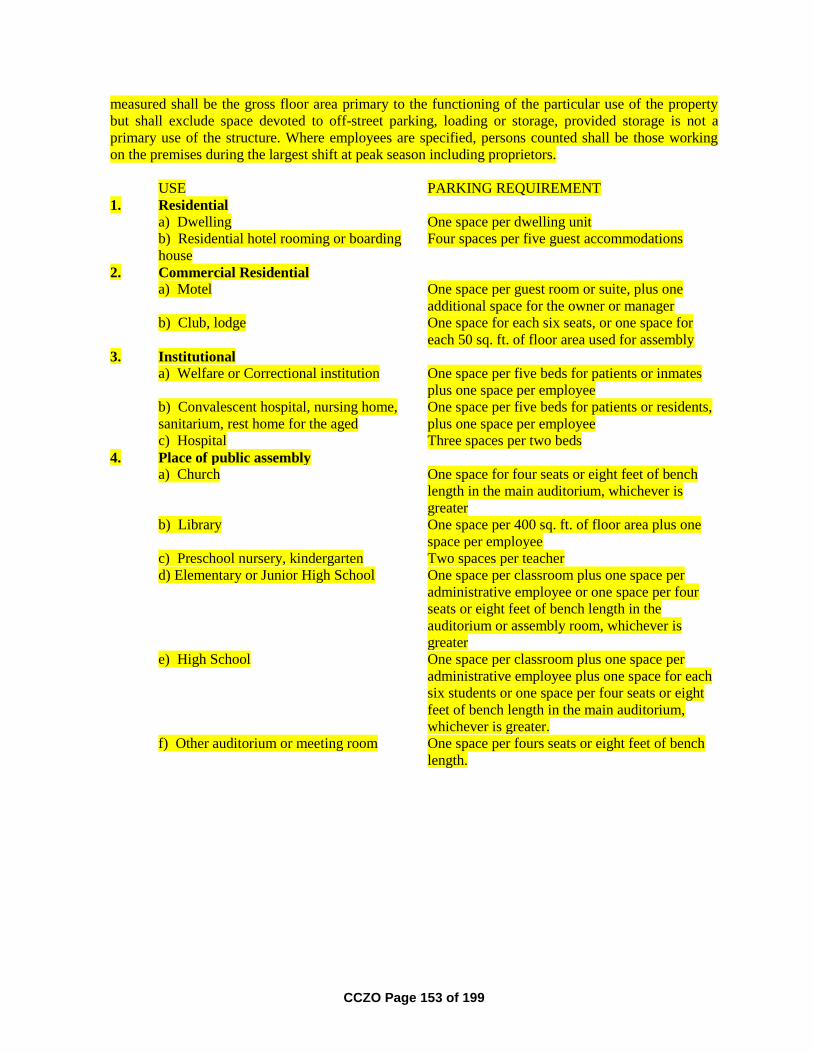
CCZO Page 153 of 199
measured shall be the gross floor area primary to the functioning of the particular use of the property
but shall exclude space devoted to off-street parking, loading or storage, provided storage is not a
primary use of the structure. Where employees are specified, persons counted shall be those working
on the premises during the largest shift at peak season including proprietors.
USE PARKING REQUIREMENT
1. Residential
a) Dwelling One space per dwelling unit
b) Residential hotel rooming or boarding
house
Four spaces per five guest accommodations
2. Commercial Residential
a) Motel One space per guest room or suite, plus one
additional space for the owner or manager
b) Club, lodge One space for each six seats, or one space for
each 50 sq. ft. of floor area used for assembly
3. Institutional
a) Welfare or Correctional institution One space per five beds for patients or inmates
plus one space per employee
b) Convalescent hospital, nursing home,
sanitarium, rest home for the aged
One space per five beds for patients or residents,
plus one space per employee
c) Hospital Three spaces per two beds
4. Place of public assembly
a) Church One space for four seats or eight feet of bench
length in the main auditorium, whichever is
greater
b) Library One space per 400 sq. ft. of floor area plus one
space per employee
c) Preschool nursery, kindergarten Two spaces per teacher
d) Elementary or Junior High School One space per classroom plus one space per
administrative employee or one space per four
seats or eight feet of bench length in the
auditorium or assembly room, whichever is
greater
e) High School One space per classroom plus one space per
administrative employee plus one space for each
six students or one space per four seats or eight
feet of bench length in the main auditorium,
whichever is greater.
f) Other auditorium or meeting room One space per fours seats or eight feet of bench
length.

CCZO Page 154 of 199
5. Commercial Amusement
a) Stadium, arena, theater One space per four seats or eight feet of bench
length or capacity as determined by the State Fire
Marshall if no seating is provided.
b) Bowling alley Five spaces per alley plus one space per two
employees
c) Dance hall, skating rink One space per l00 sq. ft. of floor area plus one
space per two employees
6. Commercial.
a) Retail store except as provided in
subsection b) of this section
One space per 200 sq. ft. of floor area, plus one
space per employee
b) Service or repair shop, retail store
handling exclusively bulky merchandise
such as automobiles or furniture
One space per 600 sq. ft. of floor area, plus one
space for each employee
c) Bank, Office (except medical and
dental)
One space per 600 sq. ft. of floor area, plus one
space for each employee
d) Medical and dental clinic One space per 300 sq. ft. of floor area, plus one
space for each employee
e) Eating or drinking establishment One space per 200 sq. ft. of floor space plus one
space for every four seats
f) Mortuaries One space per four seats or eight feet of bench
length in chapels, whichever is greater
7. Industrial
a) Storage warehouse, manufacturing
establishment, rail or trucking freight
terminal
One space per employee
b) Wholesale establishment One space per employee, plus one space per 700
sq. ft. of patron serving area
Section 4.021. Off-Street Loading.
1. Passengers. Driveways designed for continuous forward flow of passenger vehicles
for the purpose of loading and unloading children shall be located on the site of any
school having a capacity greater than 25 students.
2. Handicap Parking. At the time of construction of a new structure or at the time of
enlargement or change in use of an existing structure which would require additional
parking; handicap parking spaces shall be provided in the size, configuration and
number as required by ORS 447.233 and the Oregon Transportation Commission
standards for disabled person parking spaces.
3. Merchandise, materials or supplies. Buildings or structures to be built or substantially
altered which receive and distribute material or merchandise by truck shall provide and
maintain off-street loading berths in sufficient numbers and size to adequately handle
the needs of the particular use. If loading space has been provided in connection with
an existing use or is added to an existing use, the loading space shall not be eliminated
if elimination would result in less space than is required to adequately handle the needs
of the particular use. Off-street parking areas used to fulfill the requirements of this
CCZO Page 155 of 199
ordinance shall not be used for loading and unloading operations except during periods
of the day when not required to take care of parking needs.
Section 4.022. General Provisions - Off-Street Parking and Loading.
1. The provisions and maintenance of off-street parking and loading spaces are
continuing obligations of the property owner. No permit shall be issued until plans are
presented that show property that is and will remain available for exclusive use as off-
street parking and loading space. The subsequent use of property for which the permit
is issued shall be conditional upon the unqualified continuance and availability of the
amount of parking and loading space required by this ordinance. Use of property in
violation hereof shall be a violation of this ordinance. Should the owner or occupant of
a lot or building change the use to which the lot or building is put, thereby increasing
off-street parking or loading requirements, it shall be unlawful and a violation of this
ordinance to begin or maintain such altered use until the required increase in off-street
parking or loading is approved and constructed.
2. Offstreet parking and loading requirements for types of building and uses not
specifically listed herein shall be determined by the Commission, based upon the
requirements of comparable uses listed.
3. In the event several uses occupy a single structure or parcel of land, the total
requirements for off-street parking shall be the sum of the requirements of the several
uses computed separately.
4. Owners of two or more uses, structures or parcels of land may agree to utilize the same
parking and loading spaces when the hours of operation do not overlap, provided that
satisfactory legal evidence is presented to the Commission in the form of deeds, leases,
or contracts to establish the joint use.
5. Off-street parking spaces shall be located on the same or abutting lot with the building
or use they are intended to serve.
6. Required parking spaces shall be available for the parking of operable passenger
automobiles of residents, customers, patrons and employees only, and shall not be for
storage of vehicles or materials or for the parking of trucks used in conducting the
business or use.
7. Plans shall be submitted in sufficient detail so that they may be reviewed and approved
by the Director or Commission.
8. Design requirements for parking lots:
a) Areas used for standing and maneuvering of vehicles shall have durable and
dustless surfaces maintained adequately for all weather use.
b) Except for parking to serve residential uses, parking and loading areas adjacent to
or within residential zones or adjacent to residential uses shall be designed to
minimize disturbance of residents.
c) Access aisles shall be of sufficient width for all vehicle turning and
maneuvering.

CCZO Page 156 of 199
d) Groups of more than four parking spaces shall be served by a driveway so that
no backing movement or other maneuvering will be required within a street.
e) Lighting of the parking area shall be deflected from adjacent residential uses.
15. Completion time for parking lots. Required parking spaces shall be improved and
available for use by the time the use served by the parking is ready for occupancy.
Section 4.030. Maintenance of Minimum Ordinance Requirements.
No lot area, yard, or other open space, or required off-street parking or loading area existing on or after
the effective date of this ordinance shall be reduced in area, dimension, or size below the minimum
required by this ordinance, nor shall any lot area, yard or other open space or off-street parking or
loading area which is required by this ordinance for one use be used as the lot area, yard, or other open
space or off-street parking or loading area requirement for any other use.
Section 4.040. Zone Boundaries.
Unless otherwise specified, zone boundaries are property lines, the centerline of streets, and railroad
rights-of-way, or such lines extended. Where a zone boundary divides a land parcel under a single
ownership into two zones, the entire parcel shall be placed in the zone that accounts for the greater area
of the lot by the adjustment of the boundaries, provided the boundary adjustment is a distance of less
than 20 feet. If the adjustment involves a distance of more than 20 feet, the property shall be
considered as having two separate zones.
Section 4.050. Access Management.
1. Purpose.
The intent of this section of the ordinance is to manage access to land development in
order to preserve the county transportation in terms of safety, capacity, and function.
The provisions of this section shall apply to all property within Curry County. This
section of the ordinance is intended to implement the access management policies set
forth in the Curry County Transportation System Plan (TSP), and sets standards for the
review of land division proposals.
2. Frontage requirements.
All lots in the RR, R-1, R-2, R-3, RCR, RRC, RC, C-1, C-2, I, RI, MA, and PF
zones shall abut a county, public or private road as defined by the Curry County Code-
Article 3 - Roads for a distance of at least twenty-five (25) feet to provide adequate
access for a private driveway, except flaglots which shall have a 20 foot minimum
access.
Lots in the T, FG, AFD, EFU, CON, ER and SW zones shall have access to a county,
public or private roadway by driveway or easement for a distance of at least twenty-
five (25) feet or of a greater width if needed to provide adequate access for fire fighting
and other emergency equipment. This 25 foot access point may be shared by no more
than 3 proposed parcels, by benefit of an easement for a distance of no more than 80

CCZO Page 157 of 199
feet from the existing roadway. This access easement must be a minimum of 25 feet in
width. In instances when the existing roadway is paved, this access easement must
have a paved apron in the area adjacent to the existing roadway for a depth of 20 feet.
Such an access easement requires an access maintenance agreement to be described on
the partition plat. An access easement as described above may not be used in areas
where adjacent undeveloped land would be land-locked as a result.
3. Functional classification of roads and road standards.
Roadways within Curry County have been classified according to their function in
moving vehicles and providing access to property. The functional class of all major
public roads within the county is indicated in Table 12.2A of the Curry County
Comprehensive Plan and in Appendix B of the Curry County Transportation System
Plan.
4. The minimum right-of-way and roadway widths for roads of various functional classes
that are located within Curry County within the urban growth boundaries of the three
incorporated cities, shall be as follows:
A. URBAN STANDARDS FOR THE CITY OF BROOKINGS URBAN GROWTH AREA
Functional Class Minimum ROW Minimum Roadway
Paved Surface Width
(feet)
Sidewalk
Improvements *
Arterial Road/Hwy 80 70 6 foot/both sides
Major Collector 50 36 6 foot/both sides
Hillside Streets 50 24 4 foot paved shoulders
Local Road/Street
serving 21 or more
dwelling units
50 36 6 foot/both sides
Local Road/Street 45 30 6 foot/both sides
Commercial Industrial
Road
60 44 6 foot/both sides
Alley 20 20 None
Cul-de-sac 45R 36R 6 foot
* Different means of providing for pedestrian or bicycle transportation may be allowed if it is
consistent with existing conditions on adjacent properties/developments.
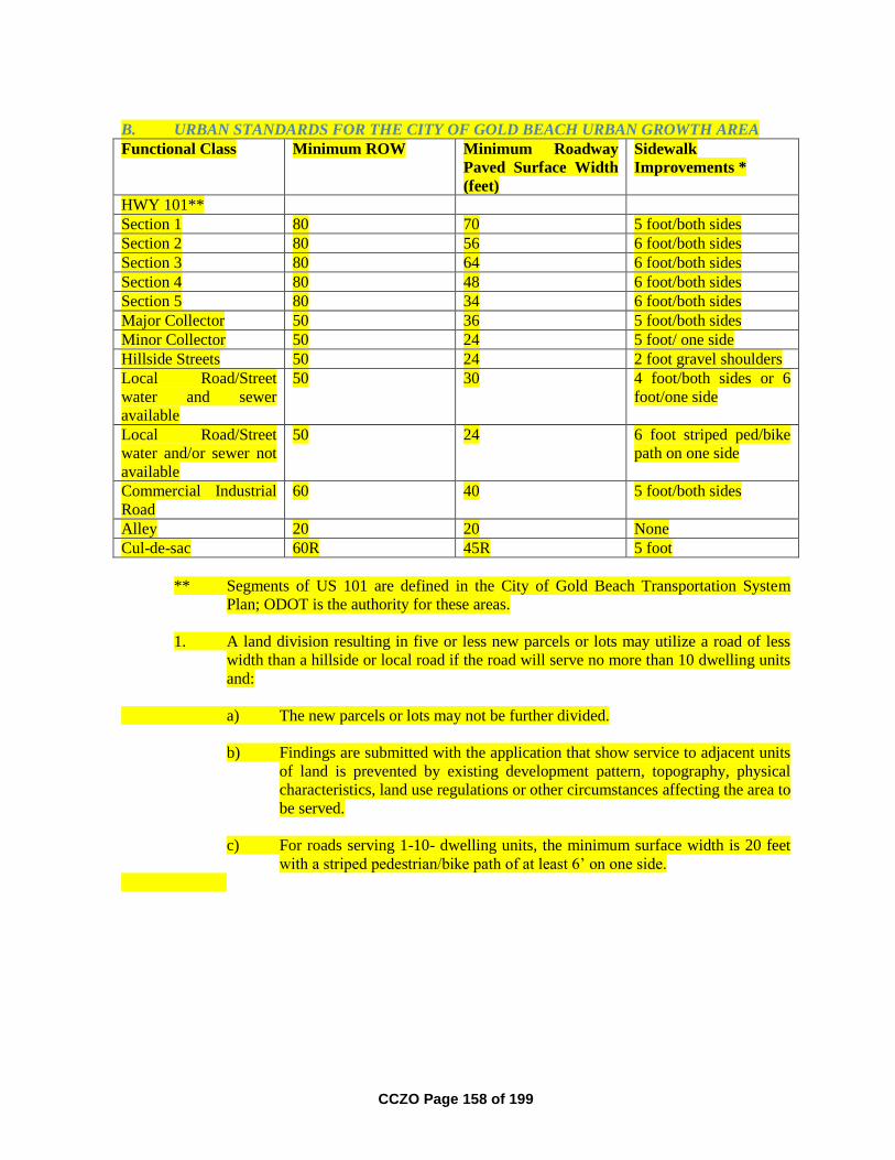
CCZO Page 158 of 199
B. URBAN STANDARDS FOR THE CITY OF GOLD BEACH URBAN GROWTH AREA
Functional Class Minimum ROW Minimum Roadway
Paved Surface Width
(feet)
Sidewalk
Improvements *
HWY 101**
Section 1 80 70 5 foot/both sides
Section 2 80 56 6 foot/both sides
Section 3 80 64 6 foot/both sides
Section 4 80 48 6 foot/both sides
Section 5 80 34 6 foot/both sides
Major Collector 50 36 5 foot/both sides
Minor Collector 50 24 5 foot/ one side
Hillside Streets 50 24 2 foot gravel shoulders
Local Road/Street
water and sewer
available
50 30 4 foot/both sides or 6
foot/one side
Local Road/Street
water and/or sewer not
available
50 24 6 foot striped ped/bike
path on one side
Commercial Industrial
Road
60 40 5 foot/both sides
Alley 20 20 None
Cul-de-sac 60R 45R 5 foot
** Segments of US 101 are defined in the City of Gold Beach Transportation System
Plan; ODOT is the authority for these areas.
1. A land division resulting in five or less new parcels or lots may utilize a road of less
width than a hillside or local road if the road will serve no more than 10 dwelling units
and:
a) The new parcels or lots may not be further divided.
b) Findings are submitted with the application that show service to adjacent units
of land is prevented by existing development pattern, topography, physical
characteristics, land use regulations or other circumstances affecting the area to
be served.
c) For roads serving 1-10- dwelling units, the minimum surface width is 20 feet
with a striped pedestrian/bike path of at least 6’ on one side.
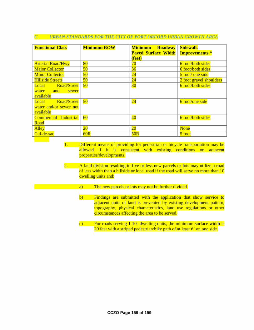
CCZO Page 159 of 199
C. URBAN STANDARDS FOR THE CITY OF PORT ORFORD URBAN GROWTH AREA
Functional Class Minimum ROW Minimum Roadway
Paved Surface Width
(feet)
Sidewalk
Improvements *
Arterial Road/Hwy 80 70 6 foot/both sides
Major Collector 50 36 6 foot/both sides
Minor Collector 50 24 5 foot/ one side
Hillside Streets 50 24 2 foot gravel shoulders
Local Road/Street
water and sewer
available
50 30 6 foot/both sides
Local Road/Street
water and/or sewer not
available
50 24 6 foot/one side
Commercial Industrial
Road
60 40 6 foot/both sides
Alley 20 20 None
Cul-de-sac 60R 50R 5 foot
1. Different means of providing for pedestrian or bicycle transportation may be
allowed if it is consistent with existing conditions on adjacent
properties/developments.
2. A land division resulting in five or less new parcels or lots may utilize a road
of less width than a hillside or local road if the road will serve no more than 10
dwelling units and:
a) The new parcels or lots may not be further divided.
b) Findings are submitted with the application that show service to
adjacent units of land is prevented by existing development pattern,
topography, physical characteristics, land use regulations or other
circumstances affecting the area to be served.
c) For roads serving 1-10- dwelling units, the minimum surface width is
20 feet with a striped pedestrian/bike path of at least 6’ on one side.
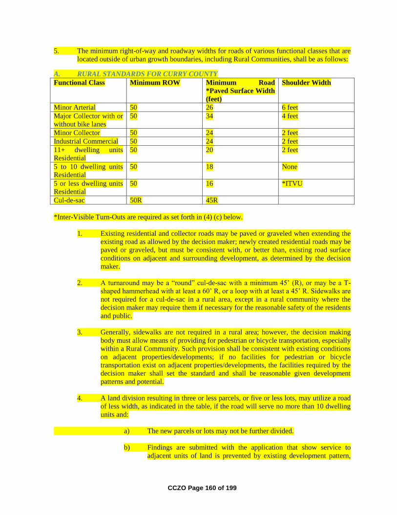
CCZO Page 160 of 199
5. The minimum right-of-way and roadway widths for roads of various functional classes that are
located outside of urban growth boundaries, including Rural Communities, shall be as follows:
A. RURAL STANDARDS FOR CURRY COUNTY
Functional Class Minimum ROW Minimum Road
*Paved Surface Width
(feet)
Shoulder Width
Minor Arterial 50 26 6 feet
Major Collector with or
without bike lanes
50 34 4 feet
Minor Collector 50 24 2 feet
Industrial Commercial 50 24 2 feet
11+ dwelling units
Residential
50 20 2 feet
5 to 10 dwelling units
Residential
50 18 None
5 or less dwelling units
Residential
50 16 *ITVU
Cul-de-sac 50R 45R
*Inter-Visible Turn-Outs are required as set forth in (4) (c) below.
1. Existing residential and collector roads may be paved or graveled when extending the
existing road as allowed by the decision maker; newly created residential roads may be
paved or graveled, but must be consistent with, or better than, existing road surface
conditions on adjacent and surrounding development, as determined by the decision
maker.
2. A turnaround may be a “round” cul-de-sac with a minimum 45’ (R), or may be a T-
shaped hammerhead with at least a 60’ R, or a loop with at least a 45’ R. Sidewalks are
not required for a cul-de-sac in a rural area, except in a rural community where the
decision maker may require them if necessary for the reasonable safety of the residents
and public.
3. Generally, sidewalks are not required in a rural area; however, the decision making
body must allow means of providing for pedestrian or bicycle transportation, especially
within a Rural Community. Such provision shall be consistent with existing conditions
on adjacent properties/developments; if no facilities for pedestrian or bicycle
transportation exist on adjacent properties/developments, the facilities required by the
decision maker shall set the standard and shall be reasonable given development
patterns and potential.
4. A land division resulting in three or less parcels, or five or less lots, may utilize a road
of less width, as indicated in the table, if the road will serve no more than 10 dwelling
units and:
a) The new parcels or lots may not be further divided.
b) Findings are submitted with the application that show service to
adjacent units of land is prevented by existing development pattern,
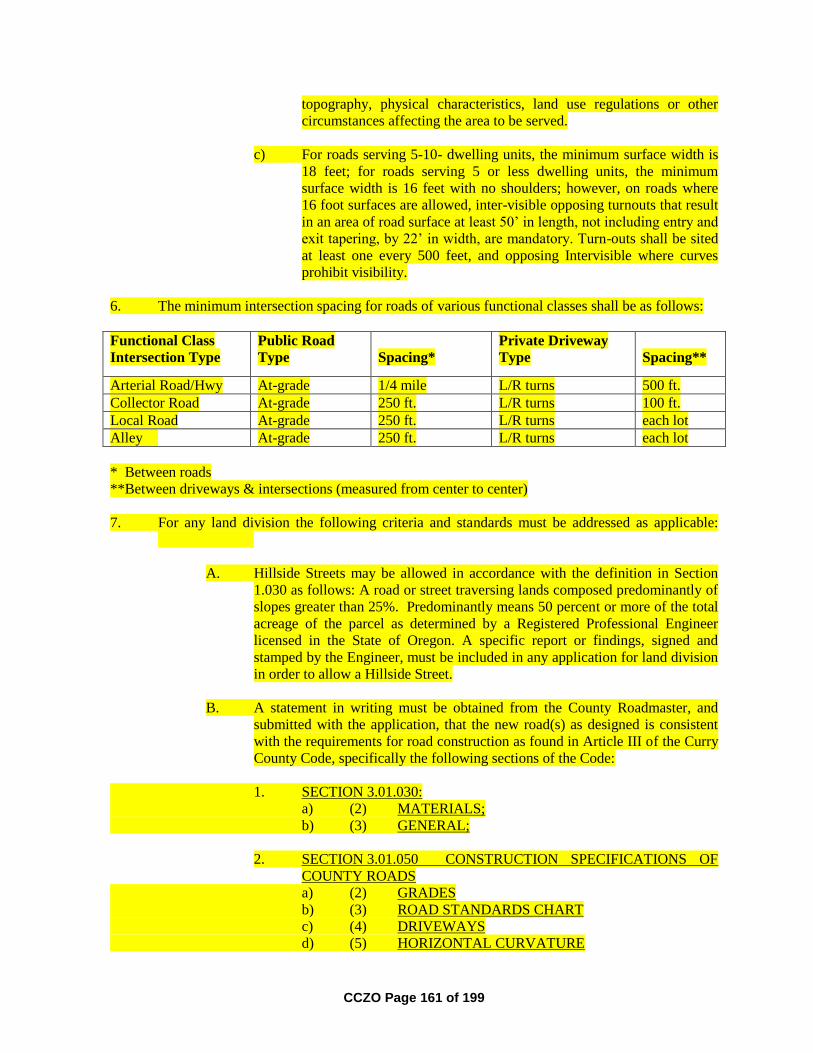
CCZO Page 161 of 199
topography, physical characteristics, land use regulations or other
circumstances affecting the area to be served.
c) For roads serving 5-10- dwelling units, the minimum surface width is
18 feet; for roads serving 5 or less dwelling units, the minimum
surface width is 16 feet with no shoulders; however, on roads where
16 foot surfaces are allowed, inter-visible opposing turnouts that result
in an area of road surface at least 50’ in length, not including entry and
exit tapering, by 22’ in width, are mandatory. Turn-outs shall be sited
at least one every 500 feet, and opposing Intervisible where curves
prohibit visibility.
6. The minimum intersection spacing for roads of various functional classes shall be as follows:
Functional Class
Intersection Type
Public Road
Type
Spacing*
Private Driveway
Type
Spacing**
Arterial Road/Hwy At-grade 1/4 mile L/R turns 500 ft.
Collector Road At-grade 250 ft. L/R turns 100 ft.
Local Road At-grade 250 ft. L/R turns each lot
Alley At-grade 250 ft. L/R turns each lot
* Between roads
**Between driveways & intersections (measured from center to center)
7. For any land division the following criteria and standards must be addressed as applicable:
A. Hillside Streets may be allowed in accordance with the definition in Section
1.030 as follows: A road or street traversing lands composed predominantly of
slopes greater than 25%. Predominantly means 50 percent or more of the total
acreage of the parcel as determined by a Registered Professional Engineer
licensed in the State of Oregon. A specific report or findings, signed and
stamped by the Engineer, must be included in any application for land division
in order to allow a Hillside Street.
B. A statement in writing must be obtained from the County Roadmaster, and
submitted with the application, that the new road(s) as designed is consistent
with the requirements for road construction as found in Article III of the Curry
County Code, specifically the following sections of the Code:
1. SECTION 3.01.030:
a) (2) MATERIALS;
b) (3) GENERAL;
2. SECTION 3.01.050 CONSTRUCTION SPECIFICATIONS OF
COUNTY ROADS
a) (2) GRADES
b) (3) ROAD STANDARDS CHART
c) (4) DRIVEWAYS
d) (5) HORIZONTAL CURVATURE

CCZO Page 162 of 199
e) (6) VERTICAL CURVATURE
3. SECTION 3.01.090 ROADWAY MATERIAL STANDARD
SPECIFICATIONS
4. SECTION 3.01.100 GRADUATION CHARTS
5. SECTION 3.01.140 PUBLIC ROAD STANDARDS
6. SECTION 3.01.200 PRIVATE ROAD, DRIVEWAY AND BRIDGE
STANDARDS
a) (3) GRADE
b) (4) PRIVATE BRIDGES
7. Exhibits A, B & C at the end of Article Three, Division One, of the
Curry County Code
The statement shall also include an assessment of whether or not the access route
proposed to the boundary of the subject property meets these requirements.
C. In any area outside of an Urban Growth Boundary, cul-de-sacs of at least 45’
radius; or a 60’ T-shaped “hammerhead”; or a loop with at least a 45’ radius,
are provided for emergency vehicle maneuvering at the end of any road over
150’ in length.
D. A statement in writing must be obtained from the Chief of the Rural Fire
Protection District of the area in which the road(s) is located, and submitted
with the application, that the District’s large fire-fighting equipment can safely
negotiate the road and serve all new parcels or lots. The statement shall also
include an assessment of whether or not the access route proposed to the
boundary of the subject property is adequate for the same service to the
boundary of the subject property.
E. Access to a property being divided must be deemed adequate, according to the
standards set forth below, by the decision maker. The access route is the
proposed route from an intersection with a County Road, or, State or Federal
Highway, to the boundary of the property proposed for division. Findings
addressing the adequacy of the access must take into account the total traffic
load on the access route, including that added from full build-out of the subject
property, and must address the entire access route.
1. A determination of “adequate” shall be made based on the following
factors:
a) If a Traffic Impact Study (TIS) is required for the proposed
development, and reveals that mitigation measures are
necessary, the mitigation measures proposed must be
approved by the county and constructed by the applicant prior
to final plat or plan approval.
b) The written statements from the Road Department and the
appropriate Rural Fire Protection District must indicate that
the access route is “adequate” according to the standards for
those entities as set forth in A through C above.
CCZO Page 163 of 199
c) If the land division is proposed within an Urban Growth Area,
the City must agree that the access route is “adequate”
according to A through C above. If A through C are deemed
not met by the City, but are deemed met by the decision
maker, Roadmaster and Fire Protection Authority, the City
may present other findings; however, those findings must be
overwhelming and compelling in order to negate the
determination of adequacy of the other authorities as set forth
in this section.
F. All roads utilized for access to new parcels or lots, whether existing or
proposed, shall be platted roads within the boundaries of the property being
divided; easements may not be used for access within the boundaries of the
property being divided.
G. Areas utilized for roads and easements shall be allowed to be included as part
of the total lot area; however, within the Brookings Urban Growth Growth
Area, the area of any lot or parcel outside road right-of-ways and access
easements shall not be reduced below 6000 square feet in size.
Article 4 Supplementary Provisions, and Section 3.250 Natural Hazard
Overlay Zone, of this ordinance, include required setbacks from property lines,
easements, roads and streets, etc., and limitations on buildable area due to
natural hazards, and are applicable. The lot size proposed must include
consideration of all applicable Article 4 and Section 3.250 standards for uses
requiring development permits (structures, septic systems) as defined by this
ordinance.
Any lot or parcel proposed must contain sufficient area to reasonably
accommodate uses allowed by the underlying zone that require development
permits, taking into account the requirements of Article 4, and of Section
3.250.
H. Roads platted as part of a land use approval shall not be part of the County
Road system unless accepted by the Board of Commissioners. Roads may be
accepted by the Board of Commissioners in accordance with the requirements
for such acceptance as set forth in Article 3, Division 1, Section 3.01.130
ACCEPTANCE BY COUNTY of the Curry County Code. Roads not accepted
into the County Road system shall not be constructed or maintained by the
County.
I. The disclosure statement for the land division must include a statement that the
County is not responsible for the construction or maintenance of any roads not
accepted into the County Road system.
J. A road maintenance agreement must be approved by the decision maker and
recorded in conjunction with the final plat for any roads not accepted into the
County Road system.
K. Prior to Final Plat approval, the applicant shall provide the County, in a format
specified by the County, “as-built” engineering/construction grade documents
CCZO Page 164 of 199
for all development, including but not limited to, grading, transportation
facilities and utilities.
L. Prior to Final Plat approval, the applicant shall obtain a statement from a
Registered Professional Engineer that the roads have been constructed as
preliminarily approved by the County.
8. Corner clearance.
A. Corner clearance for connections shall meet or exceed the minimum
connection spacing requirements for the functional class of the roadway
abutting the property.
B. New connections shall not be permitted within the functional area of an
intersection as defined by the connection spacing standards of this section,
unless no other reasonable access to the property is available.
C. Where no other alternatives exist, the County may allow construction of an
access connection along the property line farthest from the intersection. In
such cases, directional connections (i.e. right in/out, right in only, or right out
only) may be required.
9. Joint and cross access for commercial/ industrial development.
A. Adjacent commercial or office properties classified as major traffic generators
(i.e. shopping centers, office parks), shall provide a cross access drive and
pedestrian access to allow circulation between sites.
B. A system of joint use driveways and cross access easements shall be
established wherever feasible and shall incorporate the following:
1. A continuous service drive or cross access corridor extending the
entire length of each block served to provide for driveway separation
consistent with the access management classification system and
standards;
2. A design speed of 10 mph and maximum width of 20 feet to
accommodate two-way travel aisles designed to accommodate
automobiles, service vehicles, and loading vehicles;
3. Stub-outs and other design features to make it visually obvious that the
abutting properties may be tied in to provide cross-access via a service
drive;
4. A verified access and circulation system plan for coordinated or shared
parking areas is encouraged.
C. Shared parking areas shall be permitted a reduction in required parking spaces
if peak demands do not occur at the same time periods.
D. Pursuant to this section, the property owner shall:

CCZO Page 165 of 199
1. Record an easement with the deed allowing cross access to and from
other properties served by the joint use driveways and cross access of
service drive;
2. Record an agreement with the deed that remaining access rights along
the roadway will be dedicated to the County and pre-existing
driveways will be closed and eliminated after construction of the joint-
use driveway;
3. Record a joint maintenance agreement with the deed defining
maintenance responsibilities of property owners.
E. The County may reduce required separation distance of access points where
they prove impractical, provided all of the following requirements are met:
1. Joint access driveways and cross access easements are provided in
accordance with this section;
2. The site plan incorporates a unified access and circulation system in
accordance with this section;
3. The property owner enters into a written agreement with the County,
recorded with the deed, that pre-existing connections on the site will
be closed and eliminated after construction of each side of the joint use
driveway.
F. The County may modify or waive the requirements of this section where the
characteristics or layout of abutting properties would make the development of
a unified or shared access and circulation system impractical.
10. Access connection and driveway design for commercial/ industrial development.
A. Driveways shall meet the following standards:
1. If the driveway is a one-way in or one-way out drive, then the
driveway shall be a minimum width of 10 feet and a maximum width
of 15 feet and have appropriate signage designating the driveway as a
one way connection.
2. For two-way access, each lane shall have a minimum width of 10 feet
and maximum width of 12 feet.
B. Driveway approaches must be designed and located to provide an exiting
vehicle with an adequate sight distance in conformance with Curry County
Road Standards. Construction of driveways along acceleration or deceleration
lanes and tapers shall be avoided due to the potential for vehicle weaving
conflicts.
C. The length of driveways shall be designed in accordance with the anticipated
storage length for entering and exiting vehicles to prevent vehicles from
CCZO Page 166 of 199
backing into the flow of traffic on the public road or causing unsafe conflicts
with on-site traffic circulation.
11. Requirements for phased development plans.
A. In the interest of promoting unified access and circulation systems,
development sites under the same ownership or consolidated for the purposes
of development and comprised of more than one building site shall be
reviewed as single properties in relation to the access standards of this
ordinance. The number of access points permitted shall be the minimum
number necessary to provide reasonable access to these properties, not the
maximum available for that frontage. All necessary easements, agreements,
and stipulations shall be met. This shall also apply to phased development
plans. The owner and all lessees within the affected area are responsible for
compliance with the requirements of this ordinance and both shall be cited for
any violations.
B. All access must be internalized using the shared circulation system of the
principal development or retail center. Driveways shall be designed to avoid
queuing across surrounding parking and driving aisles.
12. Nonconforming access features.
A. Legal access connections in place as of the date of adoption of this ordinance
that do not conform with the standards herein are considered nonconforming
features and shall be brought into compliance with applicable standards under
the following conditions:
1. A new access connection permit is requested;
2. A change in use, enlargements or improvements that will increase trip
generation occurs.
13. Reverse frontage.
A. Lots that front on more than one road shall be required to locate vehicle
accesses on the road with the lower functional classification.
B. When a residential subdivision is proposed that would abut an arterial, it shall
be designed to provide through lots along the arterial with access from a
frontage road or interior local road. Access right of these lots to the arterial
shall be dedicated to the County and recorded with the deed. A berm or buffer
yard may be required at the rear of the through lots to buffer residences from
traffic on the arterial. The berm or buffer yard shall not be located within the
public right-of-way.
14. Flag lot standards.
A. Flag lot shall not be permitted when the result would be to increase the number
of properties requiring direct and individual access connections to the Oregon
State Highway System arterials, or collectors.
CCZO Page 167 of 199
B. Flag lots may be permitted for residential development when necessary to
achieve planning objectives, such as reducing direct access to roadways,
providing internal platted lots with access to a residential road, or preserving
natural or historic resources, under the following conditions:
1. Flag lot driveways shall be separated by at least twice the minimum
frontage requirement of the zoning designation of the property;
2. The flag driveway shall be 20 feet in width;
3. In no instance shall flag lots constitute more than 10 percent of the
total number of buildable lots in a recorded subdivision or buildable
parcels in a partition plat, or three lots, whichever is greater. This does
not apply when lots are served by a Local Road.
15. Lot/parcel width-to-depth ratios.
A. To provide for proper site design and to prevent the creation of irregularly
shaped parcels, the depth of any lot or parcel shall not exceed four (4) times its
width unless there is a topographical or environmental constraint or an existing
man-made feature.
16. Shared access.
A. Subdivisions with frontage on the state highway system shall be designed into
shared access points to and from the highway. Normally a maximum of two
accesses shall be allowed regardless of the number of lots served. If access off
a secondary road is possible, then access should not be allowed onto the state
highway. If access off of a secondary road becomes available, then conversion
to that access is encouraged and the access to the state highway will be closed.
17. Connectivity.
A. The road system of proposed subdivisions shall be designed to connect with
existing, proposed, and planned roads outside of the subdivision as provided in
this section of the ordinance.
B. Whenever a proposed development abuts unplatted land or a future
development phase of the same development, road stubs shall be provided for
access to abutting properties or to logically extend the road system into the
surrounding area. All road stubs shall be provided with a temporary turn
around unless specifically exempted from this requirement by the Planning
Director and Roadmaster. The extension of the road shall be the responsibility
of any future developer of the abutting land.
C. Minor collector and local residential access roads shall connect with
surrounding roads to permit the convenient movement of traffic between
residential neighborhoods or facilitate emergency access and evacuation.
Connections shall be designed to avoid or minimize through traffic on local
CCZO Page 168 of 199
roads. Appropriate design and traffic control such as four-way stops and traffic
calming measures are the preferred means of discouraging through traffic.
18. Variances to access management standards for driveways and intersections.
A. The granting of the variance shall meet the purpose and intent of these
regulations and shall not be considered until every feasible option for meeting
the access management standards has been explored.
B. Applicants for a variance from these standards must provide proof of unique or
special conditions that make strict application of the provisions impractical.
Applicants shall include proof that:
1. Indirect or restricted access cannot be obtained;
2. No engineering or construction solutions can be applied to
mitigate the condition; and
3. No alternate access is available from a road with a lower functional
classification than the primary roadway.
C. No variance shall be granted where such hardship is self-created.
Section 4.060. Height of Buildings.
Except as provided in Section 5.060 no building shall exceed in height the following standards:
Zone Height in Feet
Timber 35'
Forestry Grazing 35'
Agricultural 35'
Exclusive Farm Use 35'
Rural Residential 35'
Rural Community Residential 35'
Residential One (R-l) 35'
Residential Two (R-2) 35'
Residential Three (R-3) 45'
Rural Commercial (RC) 45'
Rural Resort Commercial 45'
Commercial Light (C-l) 45'
Commercial Heavy (C-2) 45'
Rural Industrial (R-I) 45'
Industrial (M-l) 45'
Marine Activity 35'
Public Facilities 45'
Conservation 35'
Estuary Resource Same as adjacent upland zone
CCZO Page 169 of 199
Scenic Waterways 35'
Section 4.070. Requirements for Manufactured Homes on Individual Lots or Parcels in
the Residential One (R-1) Zone.
1. These requirements shall apply to manufactured homes being sited in the R-1 zone to
ensure compatibility with other dwellings in this zone.
2. The manufactured home shall be multisectional and enclose a space of not less than
1,000 square feet.
3. The manufactured home shall be placed on an excavated and back-filled foundation
and enclosed by a perimeter wall of concrete, grouted concrete blocks or other
masonry material such that no more than 16 inches of the enclosing material is exposed
above grade. Where the building site has a sloped grade, no more than 16 inches of the
enclosing material shall be exposed on the uphill side of the home. If the manufactures
home is placed on a basement, the 16 inch limitation shall not apply. However, if these
requirements conflict with the Curry County Flood Damage Prevention Ordinance, the
requirements of the flood damage ordinance shall prevail.
4. The manufactured home shall have a pitched roof, except that it shall not have to be
greater than a nominal three (3) feet in height for each twelve (12) feet in width.
5. The manufactured home shall have exterior siding and roofing which in color, material
and appearance is similar to the exterior siding and roofing material commonly used on
residential dwellings in the community or which is comparable to the predominant
materials used on dwellings in the area in which it is to be sited.
6. The manufactured home shall be certified by the manufacturer to have an exterior
thermal envelope meeting performance standards which comply with the relevant State
of Oregon code. Evidence demonstrating that the manufactured home meets "Super
Good Cents" energy efficiency standards is deemed to satisfy the exterior thermal
envelope certification requirement. Additional manufacturers certification shall not be
required.
7. The manufactured home shall have a garage or carport constructed of materials similar
to the manufactured home.

CCZO Page 170 of 199
ARTICLE V. EXCEPTIONS
Section 5.010. Projections from Buildings.
Cornices, eaves, canopies, sunshades, gutters, chimneys, flues, belt courses, leaders, sills, pilasters,
steps, lintels, ornamental features, and other similar architectural features shall not project more than
two (2) feet into a required setback area.
Section 5.020. General Exception to Yard Requirements.
Roadside stands, fences, hedges, and signs may be located within a required setback area; but shall not
obstruct vision clearance on a corner lot or parcel.
Section 5.030. General Exception to Lot Size Requirements.
If, at the time of passage of this ordinance, a lot, or the aggregate of contiguous lots or land parcels held
in a single ownership has an area or dimension which does not meet the lot size requirements of the
zone in which the property is located, the lot or the aggregated holdings may be occupied by a use
permitted in the zone provided that an urban land use is not allowed within a "rural" or "resource" zone
without a Goal 2 exception to Goal 14.
Section 5.040. Waiver of Minimum Lot Size.
The minimum lot size of any zone except forest and agricultural zones may be waived in granting a
conditional use permit for a utility facility when in the opinion of the Director such a waiver meets the
following standards:
1. The proposed parcel is not larger than the minimum size necessary for the proposed
utility facility.
2. The proposed parcel is consistent with the purpose of the zone and the intent of this
ordinance.
Section 5.050. General Exception to Building Height Limitations.
The following types of structures or structural parts are not subject to the building height limitations of
this ordinance; chimney, tank, church spire, belfry, dome, monument, fire and hose towers,
observation tower, residential TV antenna, cooling tower, elevator shaft, transmission tower,
smokestack, flagpole, and other similar projections. Special height restrictions are applicable as
defined in Section 3.271 (Airport Related Height Restrictions) of this ordinance.
Section 5.060. Continuation and Alteration of Nonconforming Use or Structure.
1. Subject to the provisions of Sections 5.06l and 5.063 a nonconforming structure or use
may be continued and maintained in reasonable repair; however the alteration of a
nonconforming use shall be an administrative decision of the Director who may
impose such conditions as are necessary to carry out the intent of the particular zone
and this ordinance.
CCZO Page 171 of 199
2. Applications for the alteration of a nonconforming use shall be made in the same
manner as for a conditional use set forth in Sections 7.0l0 through 7.050.
3. Alteration of a nonconforming use may be permitted in the following situations:
a) the alteration is necessary to reasonably continue the use; or
b) the alteration is necessary to comply with any requirement to lawfully continue
the use.
4. A change in ownership of the nonconforming use shall not require approval of the
county.
Section 5.061. Nonconforming Structure.
Except for signs, a structure conforming as to use, but nonconforming as to height, setback, or coverage
may be altered providing alteration complies with the standards of this ordinance. A nonconforming
sign shall not be altered or extended except to make it comply with the requirements of this ordinance.
Section 5.062. Standards for the Alteration of a Nonconforming Use or Structure.
1. The proposed alteration in the use will be of no greater adverse impact to the
neighborhood or area in which it is located.
2. The proposed change in the structure or physical improvements will be of no greater
adverse impact to the neighborhood or area in which it is located.
Section 5.063. Discontinuance of a Nonconforming Use.
If a nonconforming use is discontinued from use for a period of one year, further use of the property
shall be limited to a conforming use.
Section 5.064. Authorization to Grant or Deny Reinstatement of a Discontinued
Nonconforming Use.
Subject to the following limitations the Director may authorize the reinstatement or resumption of a
discontinued nonconforming use is allowed under Oregon Statute.
1. If a nonconforming use is discontinued for a period greater than one year it shall not be
reinstated or resumed.
2. The nonconforming use may be reinstated if restoration or replacement has
commenced within one year. Commencement is defined as applying for development
permits to replace the nonconforming use.
3. If a nonconforming use is discontinued for a period of more than one year it shall be
changed only to a use conforming with the zoning regulations and once changed it
shall not be changed back again to the original nonconforming use.
4. If a nonconforming structure or a structure containing a nonconforming use is
destroyed or damaged by any cause to an extent requiring the discontinuance of the use
due to fire or other casualty or natural disaster, the replacement of the structure or use
CCZO Page 172 of 199
on the lot shall commence within one year and conform to the provisions of this
ordinance unless reinstatement or resumption of the original use or reconstruction of
the original structure is specifically approved by the Director.
Section 5.070. Completion of Structure.
Nothing contained in this ordinance shall require any change in the plans, construction alteration, or
designated use of a building for which physical construction with work with a valid building permit has
commenced prior to the adoption of this ordinance.
Section 5.080. Unoccupied Buildings.
If a building is unoccupied on the effective date of this ordinance then the last use of evidence shall be
considered to be its use of record and the one-year period of discontinuance allowed by Section 5.063
shall commence on the effective date of this ordinance.
CCZO Page 173 of 199
ARTICLE VI. PLANNED UNIT DEVELOPMENT
Section 6.010. Planned Unit Development Standards and Requirements.
The following standards and requirements shall govern the application of a Planned Unit Development
(PUD) in a zone in which it is permitted.
Section 6.020. Procedure for Planned Unit Development.
The following shall be observed when a planned unit development proposal is submitted for
consideration:
1. The applicant shall submit ten copies of a development plan to the Commission for
study at least thirty days prior to the commission meeting at which it is to be
considered. The preliminary plan shall include the following information:
a) Proposed land uses, building locations and housing unit densities.
b) Proposed traffic circulation pattern indicating the status of street ownership
and public street access points.
c) Proposed open space uses.
d) Proposed land grading and storm drainage plan.
e) Proposed method and routing of the water supply, sewage disposal, and all
other utility facilities.
f) A statement regarding compatibility of the proposed development to existing
land uses in the surrounding area and to the comprehensive plan for the area.
2. Prior to the Commission hearing, copies of the proposed plan shall be provided to the
appropriate state and local agencies and utility service providers with regard to streets
and utilities for study and comment.
3. In reviewing the proposed plan, the Commission must determine that:
a) Special physical conditions or objectives of development exist to warrant a
departure from standard zoning requirements.
b) Resulting development will not be inconsistent with the objectives of the
comprehensive plan or zoning provisions of the area including residential
density requirements.
c) The proposed development plan is substantially compatible with the land use
of the surrounding area.
d) The proposed development can be completed within a reasonable period of
time.
CCZO Page 174 of 199
e) The affected public or private streets are adequate to support the anticipated
traffic from the development.
f) The plan demonstrates that adequate water, sewage, utility, and drainage
facilities are available.
4. In addition to the requirements set forth in number 3 above, the Commission may
attach conditions it finds are necessary to carry out the purposes of this ordinance.
5. Before approving a planned unit development, the Commission shall determine that the
application is consistent with any relevant policies of the Comprehensive Plan.
6. Permits for the construction in a planned unit development shall be issued only on the basis
of the approved development plan. Any changes in the approved plan shall be submitted to
the Commission for processing as an amendment to this plan.
7. If the proposed planned unit development includes any division of ownership of the
property or structures, the applicant shall comply with all relevant provisions of the
Curry County Subdivision Ordinance.
CCZO Page 175 of 199
ARTICLE VII. CONDITIONAL USES
Section 7.010. Authorization to Grant or Deny Conditional Uses.
Uses designated in this ordinance as conditional uses may be permitted, enlarged or altered in
accordance with the requirements of Sections 7.020 through 7.050. In permitting a conditional use the
county may impose conditions in addition to the provisions set for uses within each zone in order to
protect the best interests of the surrounding property, the neighborhood, or the county as a whole. A
change in use, the size of the site area of use, or a structure that is classified as conditional and in
existence prior to the effective date of this ordinance shall conform to all provisions of this ordinance
pertaining to conditional uses.
Section 7.020. Application for Conditional Use.
A request for a conditional use, modification of an existing conditional use or a alteration of a
discontinued nonconforming use may be initiated by filing an application in accordance with Article II
of this ordinance. The application shall include plans of the proposed use, or modification of an
existing use, or reinstatement of a discontinued nonconforming use.
Section 7.030. Notification of Public Agencies.
For conditional uses within the MA, CON, ER, AH, SW, and SO Zones, the County shall notify the
following agencies by mail, not less than ten days prior to the date of the public hearing if the proposed
conditional use relates to that agency:
1. State Agencies:
a) Division of State Lands
b) Department of Fish and Wildlife
c) Department of Environmental Quality
d) Department of Forestry
2. Federal Agencies:
a) Army Corps of Engineers
b) National Marine Fisheries Service
c) U.S. Fish and Wildlife Service
3. Other Notification
a) State Water Resource Department (uses including appropriation of water only)
b) State Department of Geology and Mineral Industries (mining and mineral
extraction only)
CCZO Page 176 of 199
c) State Department of Energy (generating and other energy facilities only)
d) Department of Economic Development (docks, industrial, and port facilities,
and marinas only)
e) State Office of the Historical Preservation (historical structures and
archeological sites)
f) State and Federal Scenic Waterways agencies (for all developmental permits
within scenic river corridors).
Section 7.040. Standards Governing Conditional Uses.
In addition to the standards of the zone in which the conditional use is located and the other standards
in this ordinance, conditional uses must meet the following standards:
1. Conditional Uses Generally.
a) The County may require property line set-backs or building height restrictions other
than those specified in Article IV in order to render the proposed conditional use com-
patible with surrounding land use.
b) The County may require access to the property, off-street parking, additional lot area,
or buffering requirements other than those specified in Article IV in order to render the
proposed conditional use compatible with surrounding land uses.
c) The County may require that the development be constructed to standards more
restrictive than the Uniform Building Code or the general codes in order to comply
with the specific standards established and conditions imposed in granting the
conditional use permit for the proposed use.
d) If the proposed conditional use involves development that will use utility services; the
applicant shall provide statements from the affected utilities that they have reviewed
the applicants' proposed plans. These statements shall explicitly set forth the utilities'
requirements, terms and conditions for providing or expanding service to the proposed
development and shall be adopted by the Commission or Director as part of the
conditional use permit.
e) If the proposed conditional use involves the development or expansion of a community
or non-community public water system, the applicant shall submit a water right
permit(s) or documentation that a permit is not required from the Oregon Water
Resources Department which indicates that the applicant has the right to divert a
sufficient quantity of water from the proposed source to meet the projected need for
the proposed use for next twenty year planning period.
f) If the proposed conditional use involves the development or expansion of a community
or non-community public water system, the applicant shall install a raw water supply
flow monitoring device (flow meter) on the water system and shall record the quantity
of water used in the system on a monthly basis. The monthly record of water usage
shall be reported to the Curry County Department of Public Services-Planning
Division and Health Department Sanitarian on an annual basis.
CCZO Page 177 of 199
g) If the proposed conditional use included the development or expansion of a
community or non-community public water system and the use is located within the
service area of a city or special district water system the applicant shall utilize the city
or special district water system rather than developing an independent public water
system. An independent community or non-community public water system can be
developed for the use if the applicant can prove that it would be physically or
economically not feasible to connect to the city or special district water system. The
city or special district must concur in the conclusion that connection of the proposed
use is not feasible.
2. Dwelling not served by community water or sewer service.
a) A dwelling not served by community sewer may be authorized as a conditional
use only after the individual sewage disposal system site has been approved in
writing by the County Sanitarian or other agent authorized to regulate sewage
disposal systems in the county. If the Board, Commission or Director has been
informed as to a possible environmental hazard if the conditional use permit
were approved, or if records show past environmental violations on the part of
the applicant; the Board, Commission or Director shall request that this
conditional use be reviewed by the Department of Environmental Quality and
that a sewage disposal system plan shall be approved for this conditional use
before the permit is granted.
b) A dwelling not served by community water may be authorized as a conditional
use only after the description of the proposed method of supplying domestic
water to the proposed dwelling have been approved by the decision maker. If
the proposed method involves the creation of a community water system; the
plans, approved by a licensed engineer, and other related documents including
water rights, water quality test(s), water quantity test(s), and letters of approval
from the appropriate agency shall be provided to the decision maker. If the
proposed method involves the extension of an existing water supply system a
statement from the agency that controls the system indicating that it can and
will supply water to the proposed dwelling shall be provided to the decision
maker. If the proposed water source is an individual on-site source a
description of the water source and quantity of flow shall be provided to the
decision maker. If the water source is to be a proposed well the applicant shall
provide evidence that there is ground water available based on the well records
from existing wells within 1/4 mile of the proposed well site.
3. Church, hospital, nursing home, convalescent home, retirement home, community
building.
a) A church, hospital, nursing home, convalescent home, retirement home or
community building may be authorized as a conditional use after consideration
of the following factors as applicable to the proposed structure: sufficient area
provided for the building, required yards, and off-street parking (related
structures and uses such as a manse, parochial school, or parish house are
considered separate principal uses with additional lot area required); location
of the site relative to the service area of the church, hospital home or building;
projected growth and growth needs; site location relative to land uses in the

CCZO Page 178 of 199
vicinity, and adequacy of access from principal streets together with the
probable effect on traffic volumes of abutting and nearby streets. A church,
hospital, nursing home, convalescent home, retirement home, or related
building shall be at least thirty (30) feet from a side or rear lot line.
4. Schools.
a) Nursery schools shall provide and maintain at least one hundred square feet of
outdoor play area per child. A site enclosing fence at least four feet but nor
more than six feet high shall separate the play area from abutting lots.
b) Elementary schools shall provide a basic site area of five acres plus one
additional acre for each l00 pupils of predicted enrollment.
c) Secondary schools shall provide a basic site of ten acres plus one additional
acre for each l00 pupils or predicted enrollment.
d) Schools shall also meet all relevant standards of number 3 of this section.
5. Utility facilities necessary for public service.
a) In any residential zone, all equipment storage on the site shall be within an
enclosed building.
b) The use shall be fenced and provided with landscaping if there is to be outside
storage at the site.
c) The minimum lot size for a public utility facility may be waived on finding
that the waiver will not result in noise or other detrimental effect to adjacent
property.
d) As far as possible, transmission tower, poles, overhead wires, pumping
stations, and similar gear shall be so located, designed, and installed as to
minimize their conflict with adjacent uses.
e) A power generation facility shall not preclude more than 12 acres from use as
a commercial agricultural enterprise on high value farm land or 20 acres from
use as a commercial agricultural enterprise on other farm land unless an
exception to Statewide Planning Goal 3 is approved.
6. Mobile/Manufactured home parks, or recreational vehicle park or campground.
a) Mobile/Manufactured home park.
(1) The proposed use shall be compatible with the comprehensive plan
and surrounding land uses or shall be made so by imposing conditions
on the proposed use.
CCZO Page 179 of 199
(2) Parking space requirement. A parking space shall be provided for
each space on the site. In addition, guest parking spaces shall also be
provided in every park within two hundred feet of the spaces served
and at a rate of one parking space for each two mobile /manufactured
home spaces. Parking spaces shall have a durable and dustless surface
adequately maintained for all weather use and shall be properly
drained.
(3) Road access to the proposed use shall be adequate to serve the use
without creating unsafe traffic conditions within the park or on
adjacent public or private roads.
(4) Shall meet all requirements of the County Sanitarian or state agency
responsible for sewage disposal if community sewage disposal
facilities are not available.
(5) Shall meet all requirements of any other local or state agency relevant
to the proposed development.
b) Recreational vehicle park rural or urban.
(1) Campgrounds and recreational vehicle parks generally.
(a) The size and design of the park or campground at a minimum
shall conform to any limitations established by law on the
proposed public road access or driveway used for access to the
park or campground.
(2) Recreational vehicle park/urban.
(a) Accessory uses within a park shall be limited to those uses
which are allowed by the zoning designation in which the park
is located.
(b) One dwelling for a manager shall be allowed on the park site.
(3) Recreational vehicle park/rural.
(a) Utilities shall be limited to a size and scale appropriate for
rural uses. Drinking water facilities and sewage disposal
facilities shall be limited to those located wholly within the
property on which the park is located. Water, electric,
telephone, and other utilities may only be developed at a park
by extending existing distribution lines located along roads or
utility easements contiguous to the park.
(b) Accessory uses within the park shall be limited to a level
appropriate for rural uses and shall be limited to a store,
laundry facilities, outdoor recreation play area which are of a
size and design to serve only the patrons of the park.
CCZO Page 180 of 199
(c) One dwelling for a manager shall be allowed on the park site.
c) Campgrounds.
(1) Utilities shall be limited to a size and scale appropriate for rural uses.
Drinking water facilities and sewage disposal facilities shall be limited
to those located wholly within the property on which the campground
is located. Water, electric, telephone, and other utilities may only be
developed at a campground by extending existing distribution lines
along roads or utility easements contiguous to the campground.
(2) Accessory uses within a campground shall be limited to a size and
scale appropriate for rural uses and shall be limited to structures which
are of a size and design that is necessary and appropriate for efficient
management of the campground. Campgrounds shall not contain or
provide intensively developed recreational uses or facilities, including
but not limited to, swimming pools, tennis courts, retail stores, or gas
stations.
(3) One mobile home dwelling for a manager shall be allowed on the
campground but shall be removed if the campground use is
discontinued for a period of more than two years.
7. Home Occupation.
a) The home occupation must be a secondary use of a dwelling or building
accessory to a dwelling; except that a home occupation may not be authorized
in a structure accessory to a resource use in a forest or agricultural zone.
b) Such use shall occupy no more than 30 percent (30%) of the floor area within a
dwelling and no more than four hundred (400) square feet within an accessory
building.
c) No materials or mechanical equipment shall be used which will be detrimental
to the residential use of the property or adjoining residences because of
vibration, noise, dust, smoke, odor, interference with radio or television
reception, or waste products outside of the dwelling or enclosure.
d) No materials or commodities shall be delivered to or from the property which
are of such bulk or quantity as to require delivery by a commercial vehicle or a
trailer, or the parking of customer's vehicles in a manner or frequency as to
cause disturbance or inconvenience to nearby residents.
e) No advertising signs shall be allowed with the exception of one non-lighted
sign indicating only the name and trade of the property owner as specifically
approved by the County. This sign shall not exceed a size of (9) nine square
feet.
f) No structural alterations shall be allowed to accommodate the home
occupation except when otherwise required by law, and then only after the
CCZO Page 181 of 199
plans for such alterations have been reviewed and approved by the County.
Such structural alterations shall not detract from the outward appearance of the
building as an accessory structure to a residence.
g) A home occupation located on high value farm land may employ only
residents of the home.
8. Commercial amusement establishment. A commercial amusement or recreational establishment may be authorized after consideration
of the following factors:
a) The proposed use shall be compatible with the Comprehensive Plan and
surrounding land uses or shall be made so by imposing conditions on the
proposed use.
b) The proposed use shall have adequate access from public and private streets
serving the proposed use.
c) The proposed use shall have adequate off-street parking.
d) The proposed use shall not create a conflict with adjacent land uses due to
noise, dust, smoke, odor, glare from lights, or other aspects of the proposed
use.
9. Mining, quarrying, or other extractive activity.
a) Plans and specifications submitted to the Commission for approval must
contain sufficient information to allow the Commission to review and set siting
standards related to the following standards:
(1) Impact of the proposed use on surrounding land uses in terms of
Department of Environmental Quality standards for noise, dust, or
other environmental factors;
(2) The impact of the proposed use on water quality, water flow, or fish
habitat on affected rivers or streams;
(3) The impact of the proposed use on overall land stability, vegetation,
wildlife habitat and land or soil erosion;
(4) The adequacy of protection for people residing or working in the area
from the proposed mining activity through fencing of the site;
(5) The rehabilitation of the land upon termination of the mining activity.
The proposed rehabilitation must at least meet the requirements of
state surface mining or gravel removal permits.
b) If the proposed extractive activity involves the removal of rock, gravel, or
sediment from a river or stream, the proposal shall be reviewed by the Oregon
Department of Fish and Wildlife and it may provide a written statement to the
CCZO Page 182 of 199
county regarding the possible impact on fish habitat associated with the
affected river or stream.
c) The County will define an area around the specific removal site which includes
all lands within 250 feet of the site, based on the site map for a state mining or
gravel permit. The applicant shall provide findings which identify the existing
uses on those lands included within this area. The Commission shall evaluate
the applicant's findings with regard to the potentially conflicting uses identified
in the area based on the factors below:
1) If the mining activity can be sited on an alternate site; and
2) where conflicting uses are identified the economic, social
environmental and energy consequences of the conflicting uses shall
be determined and methods developed to resolve the conflict.
d) A rock crusher, washer or sorter shall not be located closer than 500 feet to any
residential or commercial use. Surface mining equipment and necessary
access roads shall be constructed, maintained, and operated in such a manner
as to eliminate, as far as is practicable, noise, vibration, or dust which are
injurious or substantially annoying to persons living in the vicinity.
e) No uses are permitted relating to offshore oil, gas or marine mineral
exploration or development.
10. Asphalt and cement plants
a) The proposed use shall be compatible with the Comprehensive Plan and
surrounding land uses or shall be made so by imposing conditions on the
proposed use.
b) Processing plants shall comply with all applicable state and federal regulations
for control of discharges from all equipment.
c) Required licenses for all equipment must be valid and current during
operation.
d) Surface mining equipment and necessary roads shall be constructed,
maintained, and operated in a manner as to eliminate noise, vibration, or dust
which are injurious or substantially annoying to persons living in the vicinity.
e) The applicant shall provide the Commission with an assessment of the
availability of water necessary for operation of the plant. In addition to the
above, the Commission may require that:
(1) The applicant construct a berm and install and maintain rapid growth
vegetative screening around the site.
(2) Operation be limited to daylight hours.
(3) No operations be allowed to occur on holidays or weekends.
CCZO Page 183 of 199
f) No plants are permitted that are related to offshore oil, gas or marine mineral
activities.
11. Animal feed lot, or other intensive animal farm or processing facility.
a) That the use be located no closer than 500 feet from a lot in a residential or
commercial use.
b) That the use be located not closer than l00 feet to a principal highway or major
county road as shown on the Comprehensive Plan.
c) In addition to the specific requirements as noted above, the Commission may
impose such other requirements as it deems necessary for the health, safety,
and welfare of the citizens of the county, including, but not limited to, plans
for management of surface water and run off, waste control, vector control,
location of the use with respect to prevailing winds and other existing or
potential development, and the limitation of the number of animals to be kept
on the premises.
12. Marine Activity.
The following criteria and standards are applied to specific uses and activities allowed
in the Marine Activity (MA) zone.
a) Uses not listed as permissible may be allowed upon a demonstration by the
applicant that the uses are in fact water-dependent consistent with the criteria
set forth in the definitions;
b) Storage of materials or products shall be permitted if found to be directly
associated with water transportation and an integral part of the operation of a
proposed or existing use or activity;
c) Any applicant for a use shall furnish evidence of compliance with, or intent to
comply with, all applicable permit and rule requirements of:
(1) any affected port district;
(2) the Department of Environmental Quality;
(3) the Division of State Lands;
(4) the U.S. Army Corps of Engineers; and
(5) all other agencies having an interest applicable to the proposed use. If
a statement to comply is submitted, the approving authority shall
condition approval upon such compliance.
d) Dwellings for caretakers and attached single family dwellings may be allowed
in urban water-dependent shorelands if such uses are an integral part of a
CCZO Page 184 of 199
water-dependent use and do not interfere with the location and operation of
other water-dependent uses.
e) For temporary uses, a date of permit expiration shall be established as a
condition of approval.
f) Flood and erosion control structures must be consistent with the provisions of
the adjacent estuarine management unit.
13. Beaches and Dunes.
The following criteria and conditions are applied to specific uses and activities in the
Beaches and Dunes Conservation (CON) Zone.
a) A site investigation report shall be prepared by a geologist or engineer
competent to evaluate beach and dune erosion which contains the following
information:
(1) Location of the proposed use and the area affected.
(2) Types of dune forms present.
(3) Existing vegetation and vegetation to be removed.
(4) A revegetation plan or other methods of erosion control.
(5) Proposed grading or fill.
(6) Areas subject to geologic hazards, wind erosion, undercutting, ocean
flooding, erosion by storm waves, or other natural hazards.
(7) Evidence that adequate measures have been taken to protect the
ground water from drawdown which would lead to loss of stabilization
vegetation, loss of water quality, or intrusion of salt water into water
supplies.
(8) Provide a plan that adequately addresses the factors identified above
and which protect the proposed development and surrounding lands.
The County will use the content of the developer's report to impose
conditions which will control erosion, protect against ocean flooding,
sand accretion, or other hazards, protect groundwater supply and
quality, and protect the surrounding area from adverse affects of
development.
The County will use the content of the developer's report and plan to
deny, approve or approve with conditions which will control erosion,
protect against ocean flooding, sand accretion, or other hazards;
protect groundwater supply and quality, and protect the surrounding
area from adverse affects of proposed development.
CCZO Page 185 of 199
b) Beach front protective structures shall be permitted only under the provisions
of ORS 390.635-390.655 for uses existing prior to January l, 1977. Protective
structures to protect "development" as defined by Statewide Planning Goal 18
existing prior to January 1, 1977 shall be required to receive a review by all
affected agencies and local review by the Planning Commission to determine
that they: (a) minimize visual impact, (b) do not impair beach access, (c) do
not create negative impact on adjacent property, and (d) do not create long
term or recurring costs to the public.
14. Estuarine Resources.
The following criteria and conditions are applied to specific uses and activities in the
Estuarine Resource (ER) zone.
a) Resource Capability Test. Certain uses in estuarine areas require findings of
consistency with the resource capabilities of the area.
(1) A determination of consistency with resource capability shall be based
on:
(a) Identification of all resources existing at the site and factors
relating to the resource capabilities of the area.
(b) Evaluation of impacts on those resources by the proposed use.
(c) Determination of whether any or all of the identified resources
can continue to achieve the purpose of the management unit if
the use is approved.
(2) In determining the consistency of a proposed use or activity with the
resource capabilities of the area, the county shall utilize information
from federal or state resource agencies regarding any regulated
activities in estuarine areas.
b) Dredge, fill, or other significant reductions or degradations. Uses and
activities which involve dredge, fill, or other reduction or degradation of
natural values shall be approved only if:
(1) The activity is required for navigation or other water-dependent use; or
in the case of fills for nonwater-dependent uses, is needed for a public
use and would satisfy a public need that outweighs harm to navigation,
fishing, and recreation, as per ORS 196.825(4), and an exception has
been taken in this plan to allow such fill;
(2) An estuarine location is required;
(3) A substantial public benefit is demonstrated;
(4) No alternative upland location exists;
(5) Adverse impacts are identified and minimized as much as feasible; and
CCZO Page 186 of 199
(6) The activity complies with the Curry County Flood Damage
Prevention Ordinance.
c) Impact Assessment. The information listed below is required to make findings
for paragraphs a) and b) above. An impact assessment should not be lengthy
or complex, but it should provide a clear understanding of the impacts to be
expected. It should include information on:
(1) The type and extent of alterations expected;
(2) The type of resource(s) affected;
(3) The expected extent of impacts of the proposed alteration on water
quality and other physical characteristics of the estuary, living
resources, recreation and aesthetic use, navigation, and other existing
and potential uses of the estuary; and
(4) The methods which could be employed to avoid or minimize adverse
impacts.
d) Fill in Conservation and Natural Estuarine Management Units. Fill activities
in conservation management units shall be allowed only if listed as an
"allowable" use within a respective segment, and then only as part of the
following use or activities:
(1) Maintenance and protection of man-made structures existing as of
October 7, l977.
(2) Active restoration if a public need is demonstrated.
(3) Low water bridges if:
(a) An estuarine location is required;
(b) Within the estuary, there are no alternative locations such as in
a development management unit;
(c) Adverse impacts are minimized as much as feasible.
(4) Bridge crossing support structures if:
(a) The findings of (3) above are made; and
(b) It is consistent with the resource capabilities of the area and
purposes of the management unit.
(5) Aquaculture, high-intensity, water-dependent recreation and minor
navigational improve-mints if:
(a) The findings of (4) above are made; and
CCZO Page 187 of 199
(b) No alternative upland locations exist for the portion of the use
requiring fill.
(6) Flood and erosion control structures if:
(a) Required to protect a water-dependent use as otherwise
allowed in (5) above; and
(b) Land use management practices and nonstructural solutions
are inadequate to protect the use.
Fill activities in natural management units shall be allowed only when
necessary for the maintenance and protection of man-made structures existing
as of October 7, l977.
e) Estuarine Mitigation Requirements. Mitigation shall be required when
estuarine dredge or fill activities are permitted in intertidal or tidal marsh areas
to mitigate the effects of dredging or fill by creation, restoration or
enhancement of another area to ensure that the integrity of the estuarine
ecosystem is maintained. However, mitigation shall not be required for
projects which the Division of State Lands has determined meet the criteria in
ORS 196.830(4).
f) Solutions to Erosion and Flooding Problems. Nonstructural solutions to
problems of erosion and flooding shall be preferred to structural solutions.
Where shown to be necessary and allowed, water and erosion control
structures such as jetties, bulkheads, seawalls, and similar protective structures
and fill shall be designed to minimize adverse impacts on water currents,
erosion, and accretion patterns.
Further, where listed as a permitted activity within the respective management
designations, riprap shall only be allowed upon findings that:
(1) Land use management practices and nonstructural solutions are
inadequate; and
(2) Adverse impacts on water currents, erosion, and accretion patterns are
minimized; and
(3) It is consistent with the development management unit requirements of
the Estuarine Resources Goal.
(4) Riprap is consistent with the resource capabilities of the area and the
purposes of maintaining conservation management units, or
Further, where listed as permitted activity within respective management
segments, riprap shall only be allowed in Natural Management Unit
designations upon findings that:
CCZO Page 188 of 199
(1) There is a need to protect from erosion: uses existing as of October 7,
l977, unique natural resources and historic archaeological values, or
public facilities;
(2) Land use management practices and nonstructural solutions are
inadequate;
(3) It is consistent with the natural management unit as set forth in this
plan and required by Estuarine Resources Goal; and
(4) Adverse impacts on water currents, erosion, and accretion patterns and
estuarine organisms and their habitat are minimized.
g. Proliferation of single-purpose docks and piers. The proliferation of individual
single-purpose docks and piers shall be restricted to those found to be
consistent with the respective management units identified by the Curry
County Comprehensive Plan.
This requirement shall be implemented:
(1) By the preparation of findings by the applicant and reviewed by local
government in response to a "request for comment" by the Division of
State Lands (which shall seek local government's determination
regarding the appropriateness of a permit to allow the proposed dock
or pier) which document that:
(a) The size and shape of the proposed dock or pier shall be
limited to that required for the intended use; and
(b) Alternatives to docks and piers, such as mooring buoys,
dryland storage, and launching ramps have been investigated
and considered; and
(2) By encouraging community facilities common to several uses and
interests by:
(a) Satisfying community needs for docks and moorage facilities
in this plan; and
(b) Encouraging easements to facilitate multi-ownership.
h. Limiting Dredge and Fill as Estuarine Restoration. Estuarine dredge or fill
actions shall be permitted as estuarine restoration (pursuant to Policy 5) and
only upon findings which demonstrate the following:
(1) A factual assessment of the nature and extent of the estuarine resource
believed to have existed at the proposed restoration site at some time
in the past; and
(2) A factual assessment of how the estuarine resource at the site was lost;
and
CCZO Page 189 of 199
(3) A comparison of the resource enhancement expected to result from the
proposed restoration project, together with a determination that the
proposed project will, in fact, probably restore all or some of the
resource value lost at the site.
i. Limiting to Water-dependent Uses. The proposed use must provide for
navigation and other identified needs for public, commercial, or industrial
water-dependent uses or must be accessory to and necessary to the proper
functioning of such a use.
j. Temporary Alterations. The proposed temporary alteration shall be in support
of a use permitted by Statewide Planning Goal 16 and the Estuarine Resources
(ER) zone. Application of the resources capabilities test (14a, above) shall
ensure:
a) That the short-term damage to resources is consistent with resource
capabilities of the area; and
b) That the area and affected resources can be restored to their original
condition.
15. Shoreland Overlay.
The following criteria and conditions are applied to specific uses and activities in the
Shoreland Overlay (SO) zone.
a) Except where findings are contained in the comprehensive plan, water-
dependent commercial, and industrial uses and water-related uses shall require
affirmative findings that the proposed use satisfies a need that cannot be
satisfied on uplands or in an urban or urbanizable area or in rural areas built
upon or irrevocably committed to non-resource use.
b) Except where findings are contained in the comprehensive plan, subdivisions,
partitions and other uses in rural shoreland areas shall require affirmative
findings that the proposed use satisfies a need which cannot be met in another
upland location, or an urbanizable area. Built and committed exceptions area
are specifically excluded from this requirement.
c) Dredged material disposal (DMD), Restoration (R) or Mitigation (M) sites.
These sites are protected for the use designated in the comprehensive plan.
Temporary uses within a designated (DMD), (R), or (M) site shall be permitted
only upon satisfying all of the following criteria:
(1) The proposed use must not entail substantial structural or capital
improvements, permanent buildings, or nontemporary water and sewer
connections;
CCZO Page 190 of 199
(2) The proposed use must not require any major alteration of the site that
would affect drainage or reduce the usable area or volume of the site,
such as extensive site grading/excavation or elevation by fill, and
(3) For restoration or mitigation sites the proposed use must not require
site changes that would prevent the expeditious conversion of the site
to estuarine habitat.
16. Uses on resource land.
a) The proposed use will not force a significant change in, or significantly
increase the cost of, accepted farming or forest practices on agricultural or
forest land.
b) The proposed use will not significantly increase fire suppression costs or
significantly increase the risks to fire suppression personnel.
c) A written statement be recorded with the deed or written contract with the
county or its equivalent shall be obtained from the land owner which
recognizes the rights of adjacent and nearby land owners to conduct forest
operations consistent with the Oregon Forest Practices Act and related Oregon
Administrative Rules for uses authorized in Section 3.042 (8), (12), (13), (14),
(15), (16), (21) and Section 3.052 (8), (12), (13), (14), (16), (17), (22).
17. Hardship Dwelling.
The following criteria and conditions shall be applied to the use of a hardship dwelling
on a lot or parcel where there is an existing dwelling:
a) the hardship dwelling shall be a manufactured or mobile home that can be
removed from the site once the hardship need has ended;
b) the hardship dwelling shall use the same on-site sewage disposal system as the
existing dwelling if public sewage disposal service is not available;
c) the need for the hardship dwelling shall be verified by a medical doctor by a
written certification explaining the reasons why the resident of the hardship
dwelling has to be located in close proximity to the existing dwelling;
d) the applicant shall agree to provide the county a new written certification from
a doctor as to the continuing need for the hardship dwelling every year after
the initial approval of the conditional use permit;
e) the county will provide notice as per Section 2.070 each time renewal of the
hardship is requested and public comment received will be considered in the
decision regarding the renewal of the permit; and
CCZO Page 191 of 199
f) the applicant shall sign an agreement to remove the hardship dwelling once the
resident of the hardship dwelling no longer has the need to reside in close
proximity to the existing dwelling.
18. Accessory Farm Dwelling.
An accessory farm dwelling may be considered customarily provided in conjunction with farm
use if it meets all the following requirements:
a) The accessory farm dwelling will be occupied by a person or persons who will be
principally engaged in the farm use of the land and whose assistance in the
management of the farm use will be required by the farm operator;
b) The accessory dwelling will be located on the same lot or parcel as the dwelling of the
farm operator (an accessory farm dwelling may be located on the same tract as the
principal farm dwelling if the lot or parcel on which the accessory dwelling will be
sited is consolidated with other lots or parcels in the tract into a single parcel when the
dwelling is approved);
c) There is no other dwelling on lands owned by the farm operator that is vacant or
currently occupied by persons not working on the subject farm or ranch and could
reasonably be used as an accessory farm dwelling; and
d) The principal farm dwelling to which the proposed dwelling would be accessory,
meets one of the following:
(1) On land not identified as high-value farm land, the principal farm dwelling is
located on a tract that is currently employed for farm use, as defined in ORS
215.203, that produced in the last two years or three of the last five years the
lower of the following:
(i) at least $40,000 (1994 dollars) in gross annual income from the sale
of farm products; or
(ii) gross annual income of at least the midpoint of the median income
range of gross annual sales for farms in the county with the gross
annual sales of $10,000 or more according to the 1992 Census of
Agriculture, Oregon.
NOTE: In determining the gross income described above, the cost of
purchased livestock shall be deducted from the total gross income
attributed to the tract.
(2) On land identified as high-value farm land, the principal farm dwelling is
located on a tract that is currently employed for farm use, as defined in ORS
215.203, that produced at least $80,000 (1992 dollars) in gross annual income
from the sale of farm products in the last two years or three of the last five
years.
e) The county shall not approve any proposed division of a lot or parcel to separate an
accessory farm dwelling from the parcel on which the principal farm dwelling is
located unless the accessory farm dwelling meets the standards for a "dwelling in
conjunction with farm use" and the accessory dwelling will be located on a parcel that
meets the minimum lot standard of the zone in which it is located.
CCZO Page 192 of 199
f) An accessory farm dwelling approved under these standards cannot be used to satisfy
the requirements for a dwelling not provided in conjunction with farm use (converted
to a non-farm dwelling).
19. Harbor Bench Farm District.
a) If the proposed use is located on a lot or parcel zoned for non-agricultural use
and is adjacent to land zoned for commercial agricultural use and is in
agricultural use then the proposed use shall not force a significant change in, or
significantly increase the cost of accepted and typical farming practices on the
agricultural land.
b) As a condition of approval a written easement shall be recorded with the deed
of the lot or parcel zoned for non-agricultural use by the land owner which
recognizes the rights of the owners of land zoned for commercial agricultural
use to conduct farming operations consistent with accepted and typical farming
practices used for commercial farming within the Harbor Bench Farm District.
c) If the proposed use located on a lot or parcel zoned for non-agricultural use
within the Harbor Bench Farm District includes the development of a structure
or the creation of an impervious ground surface, the person proposing the use
shall be required to direct all drainage from the structure or impervious surface
away from adjacent or nearby lands zoned for commercial farm use and into
the existing storm drainage system. The owner of the nonfarm use parcel may
divert surface water drainage onto farm land to receive water for a use
beneficial to agriculture. The written agreement shall contain a provision that
the owner of the nonfarm parcel will re-direct the surface water drainage into
the existing storm water drainage system at any time the farm land owner no
longer desire to receive such water.
d) All residential and commercial outdoor lighting shall be directed away from
adjacent farm land.
Section 7.050. Time Limit on a Permit for Conditional Uses.
1. Authorization of a conditional use, in general, shall become null and void after one
year unless substantial construction has taken place or an extension has been granted
under Section 7.050 (4). Substantial construction in this case means obtaining all
necessary permits required by governmental agencies to commence construction of any
structures or to commence the principal activity permitted by the conditional use
permit.
2. Once the construction of the structure or facility specified in the conditional use permit
is completed the conditional use permit is considered to be issued on a permanent
basis.
3. Authorization of a conditional use permit for transportation-related uses shall be null
and void after a period specified by the decision specified by the decision maker as
CCZO Page 193 of 199
being reasonable and necessary based on seasonal weather conditions, right-of-way
acquisition, and other pertinent factors. This period shall not exceed three years.
4. The Director or Commission may at its discretion issue conditional use permits which
must be periodically reviewed to ascertain that the conditions of the permit are being
complied with on a continuing basis. A discretionary decision approving development
on agricultural or forest outside an Urban Growth Boundary (UGB) is void two years
from the date of the final decision if the development is not initiated in that period.
5. The County may grant one extension period of up to 12 months if:
a) An applicant makes a written request for an extension of the development
approval period;
b) The request is submitted to the county prior to the expiration of the approval
period;
c) The applicant states reasons that prevented the applicant from beginning
development within the approval period; and
d) The county determines that the applicant was unable to begin development
during the approval period for reasons for which the applicant was not
responsible.
6. The one year limit and standards for granting extensions of conditional use permits in
subsection 4 above do not apply to those conditional use permits that do not involve
structural development.
7. Approval of an extension granted under this section is not a land use decision and is
not subject to appeal as a land use decision.
8. Additional extensions may be authorized under this section providing the applicable
criteria for the decision have not changed.
CCZO Page 194 of 199
ARTICLE VIII. VARIANCES
Section 8.010. Authorization to Grant or Deny a Variance.
The Director may grant variances from the provisions of this ordinance where it has been shown that
owing to unusual topographic conditions, unusual conditions such as the shape of property or the
location of a building on the property, or other conditions over which the applicant has had no control,
the literal interpretation of this ordinance would cause an undue or unnecessary hardship. No variance
shall be granted to allow the use of property for purposes not authorized within the zone in which the
proposed use would be located. In granting a variance, the Director may attach conditions which
he/she finds necessary to protect the best interests of the surrounding property or neighborhood and to
otherwise achieve the purposes of this ordinance or the comprehensive plan.
Section 8.020. Application for a Variance.
A request for a variance may be initiated by filing an application in accordance with Article II of this
Ordinance.
Section 8.030. Standards for Granting a Variance.
A variance may be granted only in the event that the applicant can show that all of the following
standards have been met:
1. Exceptional or extraordinary circumstances apply to the property which do not apply
generally to other properties in the same zone or vicinity, and result from lot size,
shape, topography, or other circumstances over which the owner of the property has no
control.
2. The variance is necessary for the preservation of a property right of the applicant
substantially the same as owners of other property in the same zone or vicinity possess.
3. The variance would not be materially detrimental to the purposes of this ordinance, or
to property in the same zone or vicinity in which the property is located, or otherwise
conflict with the objectives of the comprehensive plan or other county regulation.
4. The variance requested is the minimum variance which would alleviate the hardship.

CCZO Page 195 of 199
ARTICLE IX. AMENDMENTS TO THE ZONING ORDINANCE
Section 9.010. Authorization to Initiate Amendments.
An amendment to this ordinance in the text or the map may be initiated by the Board of County
Commissioners, the Planning Commission, Director or by application of a property owner or his
authorized agent.
Section 9.020. Application for a Zoning Change.
An application for an amendment by a property owner or his authorized agent shall be filed with the
Commission or Board in accordance with Article II of this ordinance.
Section 9.021. Standards for a Zone Change.
The Commission or Board shall determine that zone change requests meet the following standards:
1. Rezoning of the subject property will conform with the intent of all relevant policies of
the Comprehensive Plan;
2. Rezoning of the subject property will conform with the intent of the zoning designation
to which the subject property is proposed to be changed as defined in the purpose
statement of the proposed zone;
3. Rezoning of the subject property will not seriously interfere with the permitted
uses on other nearby parcels;
4. Rezoning of the subject property will not adversely impact the orderly provision of
public services (water, sewer, police, fire, schools, etc.) in the area in which the
property is located; and
5. Amendments to the comprehensive plan and zoning designations of the subject
property which significantly affect a transportation facility (see # 6, below) shall assure
that allowed land uses are consistent with the function, capacity and level of service of
the facility as identified in the Transportation System Plan. This shall be accomplished
by one of the following:
a) Limiting allowed land uses to be consistent with the planned function of the
transportation facility;
b) Amending the Transportation System Plan to ensure that existing, improved or
new transportation facilities are adequate to support the proposed land uses
consistent with the requirement of the Transportation Planning Rule; or,
c) Altering land use designations, densities, or design requirements to reduce
demand for automobile travel and meet travel needs through other modes.
6. A comprehensive plan or zoning designation amendment significantly affects a
transportation facility if it:
CCZO Page 196 of 199
a) Changes the functional classification of an existing or planned transportation
facility;
b) Changes standards implementing a functional classification system;
c) Allows types or levels of land use that would result in levels of travel or access
that are inconsistent with the functional classification of a transportation
facility; or
d) Would reduce the vehicle/capacity ratio and level of service of the facility
below the minimum acceptable level identified in the Transportation System
Plan.
Section 9.030. Application for a Comprehensive Plan Amendment.
An application for a zone change which requires an amendment to the comprehensive plan designations
shall be filed in accordance with Article II of this ordinance. Certain comprehensive plan amendments
will involve exceptions to the Statewide Planning Goals which shall be processed in accordance with
Statewide Planning Goal 2 and related Oregon Administrative Rules (OAR's). The applicant will be
required to submit any additional findings, or information related to the Goal 2 exception with the
application for a zone change. Comprehensive plan amendments to prove that land is not resource land
as defined by the Statewide Planning Goals shall meet the standards in Section 9.031. The Board will
consider the comprehensive plan amendment simultaneously with the zone change as a single
application.
Section 9.031. Standards for Comprehensive Plan Amendment for Nonresource Land.
The Board shall determine that requests for comprehensive plan amendments prove that land planned
and zoned for resource use is not resource land and meets the following standards:
1. The subject property does not meet the definition of Agricultural Land under Statewide
Planning Goal 3 and/or Forest Land under Statewide Planning Goal 4;
NOTE: If the subject property is predominantly Class I-IV soils or if it predominantly
consists of soils capable of producing 50 cubic feet of wood fiber per acre per year it is
not considered to be nonresource land.
2. The subject property does not contain any natural resources defined in Statewide
Planning Goal 5 which are identified in the Curry County Comprehensive Plan;
3. The subject property has been proven to be generally unsuitable for the production of
farm crops and livestock or merchantable tree species, considering terrain, adverse soil
conditions, drainage and flooding, vegetation, location and size of the tract. The
subject property shall not be considered nonresource land solely because of its size or
location if it can be reasonably be put to farm or forest use in conjunction with other
land.
4. The subject property is not considered to be nonresource land simply because it is too
small to be farmed or forest managed profitably by itself. If the subject property can be

CCZO Page 197 of 199
sold, leased, rented or otherwise managed as part of a commercial farm, ranch or other
forest land it is not considered to be nonresource land.
5. The subject property is not considered to be nonresource land if it has been given a
special tax assessment for zoned farm use, unzoned "greenbelt" farm use or as
designated forest land at any time in the past five years.
6. If the subject property is found to meet all of the standards above to be considered
nonresource land the county shall also determine that rezoning the property to a
nonresource zone will not materially alter the stability of the overall land use pattern of
the area and lead to the rezoning of other lands to nonresource use to the detriment of
the resource uses in the area.
7. The subject property shall be at least 20 acres in area unless it is contiguous to an area
that is zoned for nonresource use.
8. Rezoning of land that is found to be nonresource land shall be to a "rural" zone that is
appropriate for the type of land and its intended use (i.e. dune land that is found to be
nonfarm/nonforest land should be zoned for Conservation use).
CCZO Page 198 of 199
ARTICLE X. GENERAL PROVISIONS
Section 10.010. Enforcement.
The Commission or its agent shall have the power and duty to enforce the provisions of this
ordinance.
Section 10.020. Authorization of Similar Uses.
The Commission may permit in a particular zone a use not listed in this ordinance provided the
use is of the same general type as the uses permitted in that zone. However, this section does not
authorize the inclusion of a use in a zone where it is not specifically listed in another zone or
where it is similar to a use specifically listed in another zone.
Section 10.030. Application Fees.
The application fees for zoning amendments, conditional use permits, variances, and other land
use applications shall be determined by the Board of Commissioners.
Section 10.040. Interpretations.
Interpretation of the meaning of this ordinance may be rendered by the Director or Commission.
Such interpretations are subject to review by a higher authority under the provision of Article II.
The provisions of this ordinance shall be held to the minimum requirements fulfilling its
objectives. Where the conditions imposed by a provision of this ordinance are less restrictive than
comparable conditions imposed by any other provision of this ordinance or of any other
ordinance, resolution or regulation, the provisions which are more restrictive shall govern.
Section 10.050. Abatement and Penalty.
1. Violation of Zoning Regulations.
No person shall locate, construct, maintain, repair, alter, or use a building or
other structure or use, or transfer land in violation of any of the parts of this
ordinance or any decisions made by the County under this ordinance. Any person
may request an investigation of a violation by filing a signed request for
investigation of a zoning violation with the Director. Upon receipt of the request
for an investigation, the Director or his designate shall make an on-site
investigation of the reported violation. If a violation is verified by the on-site
investigation, the Director shall notify the property owner of record of the
violation and request that the violation be corrected within a specified period of
time. If the violation is not corrected within the specified time, the Director shall
seek remedy under the applicable law.
2. Remedy for Unlawful Structure or Land Use.
In case a building or other structure is located or is proposed to be located,
constructed, maintained, repaired, altered or used, or any land is or is proposed to
be used in violation of any of the parts of this ordinance the county shall, the
Board of Commissioners may, in addition to other remedies provided by law
CCZO Page 199 of 199
institute injunction, mandamus, abatement or other appropriate proceedings to
prevent, temporarily or permanently enjoin, abate or remove the unlawful
location, construction, maintenance, repair, alteration or use. When a temporary
restraining order is granted in a suit by the County, any affected person who is
not exempt from furnishing bonds or undertakings under ORS 22.0l0, shall
furnish an undertaking as provided in ORCP 82.
3. Civil Penalties.
Any individual, firm or corporation, whether as principal, agent, or employee
violating any provisions of this ordinance shall, upon conviction thereof, be
punished by a fine established for each offense as set forth in applicable law. For
purposes of this ordinance, a failure to comply with any provision of a county
ordinance from day to day shall be a separate offense for each day. In addition to
any fine, the court shall impose reasonable court costs, and other legal or
equitable relief as it seems appropriate.
Section 10.060. Severability.
The provisions of this ordinance are hereby declared to be severable. If any section, sentence,
clause or phrase of this ordinance is adjudged by a court of competent jurisdiction to be invalid,
such decision shall not affect the validity of the remaining portions of this ordinance.