Embed Size (px)
Citation preview

The business of sustainability
The business of sustainability
The business of sustainability
The business of sustainability
IMPROVING PLANNING RESPONSES FOR BUFFERS/SEPARATION
DISTANCES
Technical Report
ERM Reference: 0463345
Level 6, 99 King Street
Melbourne VIC 3000
Environment Resources Management
Australia Pty Ltd
AUSTRALIA
Telephone +61 3 9696 8011
Facsimile +61 3 9696 8022
www.erm.com
.
Version Author Reviewed By Approved By Date
Draft 1 A Burnett S Davis J Brock 8 August 2018
Draft 2 S Davis J Brock J Brock 27 August 2018
Final S Davis J Brock J Brock 17 September 2018

Table of Contents
Table of Contents ....................................................................................................................................................... 3
List of Abbreviations .................................................................................................................................................. 5
Executive Summary .................................................................................................................................................... 1
1 Introduction .......................................................................................................................................................... 1
1.1 Purpose of this Document .............................................................................................................................. 1 1.1.1 Major Hazard Facilities Advisory Committee .......................................................................................... 1 1.1.2 Other reports and policies relevant to this project .................................................................................. 1
1.2 Methodology ................................................................................................................................................... 2
1.3 Reviewing Clause 52.10................................................................................................................................. 2
1.4 Meanings of Words and Phases .................................................................................................................... 3
2 Overview of Separation Distance Tools and Guidance in Victoria ................................................................ 4
2.1 Clause 52.10 Uses with Adverse Amenity Potenial ....................................................................................... 4
2.2 EPA: Recommended Separation Distances for Industrial Residual Air Emissions Guideline (IRAE) ........... 5 2.2.1 Purpose and Intent of Recommended Separation Distances for IRAE .................................................. 6 2.2.2 Operation ................................................................................................................................................ 7 2.2.3 Principles to support a variation to a recommended separation distance .............................................. 7 Section 2.2 Key Findings – IRAE ....................................................................................................................... 9
2.3 Comparing Clause 52.10 and IRAE ............................................................................................................... 9
2.4 Planning and Environment Act 1987 (the Act) ............................................................................................. 11
2.5 Victoria Planning Provisions ......................................................................................................................... 11
2.6 Other relevant planning policies or guidance documents ............................................................................ 19 2.6.1 Plan Melbourne ..................................................................................................................................... 19 2.6.2 Potentially Contaminated Land – General Practice Note ..................................................................... 19
2.7 Environment Protection Act 1970 (the EP Act) ............................................................................................ 20
2.8 State Environment Protection Policies ......................................................................................................... 20
2.9 Environment Protection (Scheduled Premises) Regulations 2017 .............................................................. 22
2.10 Other guidance from EPA ............................................................................................................................ 23
3 Other Relevant Reviews and Documents ....................................................................................................... 23
3.1 Major Hazard Facility Ministerial Advisory Committee ................................................................................. 25 3.1.1 Discussion Paper .................................................................................................................................. 25 3.1.2 Submissions to MHFAC ........................................................................................................................ 26 3.1.3 Advisory Committee Final Report ......................................................................................................... 27 3.1.4 Government Response to the Major Hazard Facilities Advisory Committee (January 2018) .............. 29 Key Findings – MHFAC ..................................................................................................................................... 30
3.2 Better Managing Encroachment (Option Paper) .......................................................................................... 30 3.2.1 Purpose and intent of Better Managing Encroachment ........................................................................ 30 3.2.2 Clause 52.10, Issues and Options ........................................................................................................ 31 Key Findings – Better Managing Encroachment ........................................................................................... 33
3.3 Independent Inquiry into the EPA ................................................................................................................ 33 3.3.1 Independent Inquiry into the EPA ......................................................................................................... 33 3.3.2 The Government Response to the Independent Inquiry into the EPA .................................................. 35
3.4 Smart Planning ............................................................................................................................................. 37
3.4.1 Reforming the Victoria Planning Provisions (A Discussion Paper) ....................................................... 37
3.5 Local Buffer Support Program ...................................................................................................................... 38 3.5.1 Purpose and intent of the Local Government Buffer Support Program ................................................ 38 3.5.2 Buffer Protection Tools for Waste and Resource Recovery Facilities (AECOM) ................................. 38 3.5.3 Toolkits and Guidelines ......................................................................................................................... 39 3.5.4 Draft Planning Tools (Glossop Town Planning) .................................................................................... 40
4 Case Studies ...................................................................................................................................................... 42
4.1 Case Study 1: Airport West Structure Plan .................................................................................................. 43
4.2 Case Study 2: Brookland Greens Estate, Cranbourne South: Investigation into Methane Gas Leaks. ...... 45
4.3 Case Study 3: Strathbogie Shire, Nagambie Broilers: Cumulative Impact and Reverse Amenity. ............. 47
4.4 Case Study 4: Ravenhall Regional Landfill Expansion: Benefits and issues associated with Precinct
Structure Planning processes. ................................................................................................................................ 49
4.5 Case Study 5: Indigo Shire, Rutherglen-Wahgunyah Waste Water Treatment Plant: Encroachment
pressure from sensitive uses. ................................................................................................................................. 51
4.6 Case Study 6: National and International approches ................................................................................... 54 4.6.1 Ministry of the Environment Ontario Canada ........................................................................................ 54 4.6.2 Queensland – Brisbane City Council and State Planning Policy .......................................................... 57
5 Appendices ........................................................................................................................................................ 58
List of tables
Table 1: Meaning of words and phrases ...................................................................................................................... 3 Table 2: Agent of Change (IRAE) ................................................................................................................................. 8 Table 3: Criteria for site-specific variation (IRAE) ......................................................................................................... 8 Table 4: Comparing Clause 52.10 and IRAE ............................................................................................................... 9 Table 5: VPP reference to buffers and separation distances ..................................................................................... 11 Table 6: State Environment Protection Policies ......................................................................................................... 21 Table 7: Summary of MHFAC Submissions ............................................................................................................... 26 Table 8: MHFAC Comments on agreed principles ..................................................................................................... 28 Table 9: Better Managing Encroachment (Options Paper) Summary ........................................................................ 31 Table 10: The Government Response to the Independent Inquiry into the EPA Summary ....................................... 35 Table 11: Previously proposed planning system reforms ........................................................................................... 38 Table 12: EPA recommended buffer distances for the MRL ...................................................................................... 51 Table 13: Industrial Classifications ............................................................................................................................. 55 Table 14: Recommended minimum separation distances ......................................................................................... 56
List of Abbreviations
BPEM Best Practice Environmental Management Guidelines
C1Z Commercial 1 Zone
C2Z Commercial 2 Zone
CCZ Capital City Zone
CFA Country Fire Authority
DEDJTR Department of Economic Development, Jobs, Transport and Resources – Earth Resources Division
DELWP Department of Environment, Land, Water and Planning
DZ Docklands Zone
EP Act Environmental Protection Act 1970
EPA Environment Protection Authority
ESO Environmental Significance Overlay
FZ Farming Zone
IN1Z Industrial 1 Zone
IN2Z Industrial 2 Zone
IN3Z Industrial 3 Zone
IRAE Industrial Residual Air Emissions Guidelines, EPA 2013
LBSP Local Buffer Support Program
LDRZ Low Density Residential Zone
MHF Major Hazard Facility/Facilities
MUZ Mixed Use Zone
MWRRG Metropolitan Waste and Resource Recovery Group
NEPMs National Environmental Protection Measures
PAO Public Acquisition Overlay
PE Act Planning and Environment Act 1987
RCZ Rural Conservation Zone
RGZ Residential Growth Zone
RLZ Rural Living Zone
SEPPs State Environmental Protection Policies
SUZ Special Use Zone
TZ Township Zone
UGZ Urban Growth Zone
VPPs Victoria Planning Provisions

IPRBSD Technical Report
i
Executive Summary
The Department of Land, Water and Planning (DELWP) have engaged Environmental Resources
Management Australia Pty Ltd (ERM) to:
undertake a review of the existing threshold distances in Clause 52.10 of the Victoria Planning
Provisions (VPPs) and identify areas for alignment with the Environment Protection Agency’s (EPA)
Industrial Residual Air Emissions (IRAE) Guidelines.
commence a policy review into the role of buffers in strategic and statutory planning in Victoria, and the
mechanisms used to apply buffers, exploring how they can be better managed into the future.
This report forms the first step of undertaking this process and provides the technical background to the study
which identifies and compares the guidance that currently exists within the VPPs, IRAE and other relevant
guidance documentation regarding separation distances from industrial uses. It should be noted that this
report was prepared prior to the gazettal of VC148, as such it refers to the former clauses enclosed with the
Victoria Planning Provisions.
The catalyst for this project comes largely from the outcomes of the Major Hazard Facilities Advisory
Committee (MHFAC) which was appointed by the Minister for Planning to provide advice about improvements
to land use planning for areas surrounding Major Hazard Facilities (MHF).
The MHFAC made the following relevant recommendations in relation to Clause 52.10:
The Minister for Planning, in consultation with the Environment Protection Authority and stakeholders (industry, technical specialists and the planning and development profession) commission a comprehensive review of Clause 52.10 to:
o Review the head clause to clarify its application to risk (non Major Hazard Facility) and amenity.
o Review the head clause to clarify its application and use, including diagrams to assist with interpretation and expand its use to include ‘reverse amenity’ situations.
o Review the list of Type of Production, Use or Storage and the technical basis of threshold distances.
The Minister for Planning consult with the Environment Protection Authority to further consider the longer term development of a single instrument that combines Clause 52.10 and the IRAE Guidelines.
Develop a Ministerial Direction, based on Ministerial Direction 14, which require planning scheme amendments which would allow or intensify sensitive uses to explicitly consider the Types of Production, Use or Storage in Clause 52.10.
In the Major Hazard Facilities Government Response to the Major Hazard Facilities Advisory Committee
(January 2018), the MHFAC Recommendations relating to Clause 52.10 (identified above) was summarised
as “review threshold separation distances and operations”. This action was supported by Government. The
work undertaken as part of this project will assist DELWP undertake this review.
The issue of how planning should and shouldn’t articulate the need for separation distances has been an
ongoing and perplexing issue for many years with no shortage of complex, interconnected factors at play
hindering the ability of the planning system to apply clear and consistent approach to managing the impact
of conflicting land uses.
Some of the widely recognised issues with Clause 52.10 include (among others):
The basis and context of the threshold distances listed in the table to the clause;
The extent to which Clause 52.10 captures all impact causing land uses;
It does not allow consideration of reverse amenity via the application of the ‘agent of change’ principle;
Its inconsistency with other relevant guidelines and statutory instruments; and
The absence of application requirements and decision guidelines associated with the consideration of
threshold distances.
IPRBSD Technical Report
ii
ERM has undertaken a literature review relating to the application and history of Clause 52.10 as part of the
study. The review identified a number of common themes associated with the role and function of the
provision.
The following is a brief summary of the gaps and perceived shortcomings of Clause 52.10:
While Clause 52.10 in Title refers to ‘amenity’ and the Purpose refers to ‘unacceptable risk’; no
explanation of how these are intended to relate to the threshold distances can be found. Furthermore
the meaning of ‘amenity’ and ‘unacceptable risk’ in the context of the use and the non-compliance with
the threshold distance is not articulated in the VPPs.
The absence of application requirements and decision guidelines for planning applications triggered by
Clause 52.10 diminishes the effectiveness of the provision in terms of assess the appropriateness of a
proposal;
There is no mechanism within Clause 52.10 to allow consideration of encroachment by sensitive uses
on an established buffer to an existing industrial or warehouse uses;
Clause 52.10 does not represent an exhaustive list of uses with the potential to cause adverse amenity
impacts and does not provide means of considering the impact of uses not listed;
Some of the uses listed in Clause 52.10 are considered redundant in the context of the current industrial
landscape meaning that the clause adds little value to planners and users of the system in its current
format;
The threshold distances included in Clause 52.10 do not appear to be based on any empirical or
evidence based assessment of appropriate distances;
Clause 52.10 has an absence of guidance on what land uses may be permitted within the separation
distance;
Clause 52.10 has an absence of guidance on which performance standards industry needs to address
in the context of the purpose of separation distances. For example, do they relate to upset conditions or
normal operation? How do they relate to compliance issues associated with breaches of best practice
or poor performance?
Clause 52.10 is limited to amenity impacts associated with noise/vibration, dust, and odour and does
not trigger consideration of risk to health and safety related such as explosion caused by gas migration:
The connection to agencies with statutory responsibilities in relation to environmental and occupational
management such as the EPA and WorkSafe, is not strongly expressed in the planning framework and
in some circumstances those agencies are not identified as a referral agency for applications that could
benefit from the expert agency input;
Clause 52.10 has an absence of guidance in relation to the circumstances when it is appropriate to
reduce or vary a separation distance otherwise provided for in Clause 52.10; and
Uses and Threshold Distances within Clause 52.10 and IRAE are inconsistent (both industrial uses and
also ‘sensitive’ uses).
Recommended Separation Distances for Industrial Residual Air Emissions (IRAE)
The IRAE guideline, 2013 is published by EPA Victoria. This guideline provides recommended minimum
separation distances between industrial land uses that emit odour or dust and sensitive land sues. It is
important to note that other forms of impact such as noise, vibration, ambient and hazardous air pollutants
are not addressed in the scope of this guideline.
The IRAE replaces the Recommended Buffer Distances for Industrial Residual Air Emissions (Environmental
Protection Authority, 1990).
Critically, there is no reference to the IRAE in the Industrial or Commercial Zones and the VPPs continue to
refer to the outdated Recommended Buffer Distances for Industrial Residual Air Emissions, within Clause
13.04-2 Air Quality, Clause 17.02-1 Industrial land development and Clause 17.02-2 Design of industrial
development.
The key features of the IRAE are:
It provides guidance on separation distances between certain uses. It includes recommended separation
distance in metres, as well as providing guidance on how to consider a variation from the recommended
distance.
The purpose of the guideline relates only to odour or dust emitting industrial uses and sensitive land
uses. It does not consider noise and vibration impacts,

IPRBSD Technical Report
iii
Unless approval is required under the Environmental Protection Act 1970 (the EP Act) such as if the use
is a designated ‘Scheduled Premises’, Planning is the primary mechanism for enacting the IRAE. This
is particularly the case for small to medium enterprises which are less likely to trigger a need for approval
under the EP Act as the scale of their operations is smaller.
Despite the above references to utilising the IRAE in the planning system, the IRAE is not properly
referenced in the VPPs. The superseded version is referenced in two areas of the SPPF (Air Quality
and Industry), but does not appear in any zones.
When considering a variation to the recommended separation distances, the IRAE provides guidance
for planning processes which is limited to the extent it is encapsulated within the VPPs, and as such the
guidance may provide limited assistance to planners in some instances.
Table 3 in this report (refer below) provides a comparison of the operational differences between Clause
52.10 and the IRAE and highlights some critical differences such as Clause 52.10 not having the ability to
consider reverse amenity and the agent of change principles.
ERM have developed a comparison matrix which identifies range of land uses covered by both Clause 52.10
and the IRAE and highlight similarities, gaps and differences between the two. The matrix highlights that in
some instances there are major inconsistencies between the two in terms of the range of uses captured by
the documents and in situations where the same uses are listed, large variations in the specified distances
can occur. For example:
Land use Clause 52.10 EPA IRAE IRAE Difference
Works producing iron or steel products in
amounts
100 metres (up to
1,000,000 tonnes
p/a)
500 metres (up to
1,000,000 tonnes
p/a)
400m greater
Fibre glass production 200 metres 250 metres 50m greater
Rubber production using either organic
solvents or carbon black
300 metres (note 2) 250 metres 50m less
As a State wide reference document for all planning schemes, and the VPPs also reference a number of
documents that are incorporated documents, common to all planning schemes.
The Planning and Environment Act 1987 (the Act) and the VPPs have a number of triggers in place that
require consideration of the impacts of the application to the surrounding environment, whereby under the:
The Act:
Section 12 requires a planning authority to take account of any significant effects which it considers the
scheme or amendment might have on the environment;
Section 60 requires the responsible authority, prior to deciding on a planning permit application, to
consider any significant effects on the environment the responsible authority considers the use or
development may have.
The VPPs:
Planning Scheme Amendment VC148 was gazetted on 31 July 2018 which made structural changes to the
VPP. This Technical Report was substantially completed prior to VC148 and as such refers to pre
amendment clauses and provisions. However, the Draft Findings Summary Paper has been updated to
reflect the changes made under VC148.
Clause 13.04-2 requires, wherever possible, suitable separation between land uses that reduce amenity
and sensitive land uses to protect air quality;
Clause 17.02 provides various strategies related to ensuring appropriate threshold distances to sensitive
land uses and protecting industrial uses from encroachment of sensitive land uses which would
adversely affect the industry viability;
Clause 52.10 considers those uses which have the potential for adverse amenity potential, and specifies
the minimum threshold distance for various industry types between the proposed use and a sensitive
land use zone. The threshold distances contained in Clause 52.10 are based on impacts that may occur
during normal operation and are for impacts related to all releases from industry including, but not limited
to odour, dust, noise, vibration and health;

IPRBSD Technical Report
iv
Clause 66.02-7 requires referral of planning applications the EPA as a referral authority where the
planning application requires a Works Approval or Licence (i.e. a Scheduled Premises) or where the
land for the industry or warehouse for a purpose listed in Clause 52.10 with a Note 1 or where the
threshold distance is not met; and
Clause 66.05 requires referral of a planning application to the EPA as a referral authority where the
planning application is for a broiler farm.
The existing clauses therefore require a consideration of impact to the surrounding land use, and provide
referral to EPA where the industries are large (Scheduled Premises) or have sensitive uses within a defined
separation distance for specific industries. There is no general requirement, however, that the application
demonstrates compliance with the relevant State Environment Protection Policies and it is recommended
that this is made a requirement for the application in order that the planning authority can properly consider
their obligation under Section 12 and Section 60 of the PE Act.
While the provisions within the VPPs are sufficient to result in consideration of required separation distances,
the list of industries contained in Clause 52.10 is not exhaustive, does not capture smaller industries and the
basis of the separation distances is not clear.
It has become apparent throughout this project that the question of what is an appropriate
separation/threshold distance is in and of itself a problem for planning because it is not possible to know the
full range of variable impacts on sensitive uses associated with a given use. This is perhaps best
demonstrated by the fact that the basis for the existing figures listed in Clause 52.10 are generally unknown
and at best form a rule of thumb approach, essentially applying the precautionary principle.
Clause 52.10 states that the purpose is “To define those types of industries and warehouses which if not
appropriately designed and located may cause offence or unacceptable risk to the neighbourhood”, from this,
however, it is not certain whether the intent is that these separation distances are to prevent impact during
normal operations or upset conditions. Given that under the EP Act during normal operations industry must
be compliant with relevant SEPPs, it is considered that the threshold distances must apply to the risk of upset
conditions.

IPRBSD Technical Report
1
1 Introduction
1.1 Purpose of this Document The Department of Land, Water and Planning (DELWP) have engaged Environmental Resources
Management Australia Pty Ltd (ERM) to:
undertake a review of the existing threshold distances in Clause 52.10 of the Victoria Planning
Provisions (VPPs) and identify areas for alignment with the Environment Protection Agency’s (EPA)
Industrial Residual Air Emissions (IRAE) Guidelines.
commence a policy review into the role of buffers in strategic and statutory planning in Victoria, and the
mechanisms used to apply buffers, exploring how they can be better managed into the future.
This report forms the first step of undertaking this process. This report identifies and compares the guidance
that currently exists within the VPPs, IRAE and other relevant guidance documentation regarding separation
distances from industrial uses.
1.1.1 Major Hazard Facilities Advisory Committee
The catalyst for this project comes largely from the outcomes of the Major Hazard Facilities Advisory
Committee (MHFAC) which was appointed by the Minister for Planning to provide advice about improvements
to land use planning for areas surrounding Major Hazard Facilities (MHF). The final report was issued on 19
July 2016 by the Committee.
A number of submissions to the MHFAC commented on Clause 52.10. These submissions have been
considered as part of preparing this Literature Review.
The MHFAC made the following relevant recommendations in relation to Clause 52.10:
The Minister for Planning, in consultation with the Environment Protection Authority and stakeholders
(industry, technical specialists and the planning and development profession) commission a
comprehensive review of Clause 52.10 to:
o Review the head clause to clarify its application to risk (non Major Hazard Facility) and amenity.
o Review the head clause to clarify its application and use, including diagrams to assist with
interpretation and expand its use to include ‘reverse amenity’ situations.
o Review the list of Type of Production, Use or Storage and the technical basis of threshold distances.
The Minister for Planning consult with the Environment Protection Authority to further consider the longer
term development of a single instrument that combines Clause 52.10 and the IRAE Guidelines.
Develop a Ministerial Direction, based on Ministerial Direction 14, which require planning scheme
amendments which would allow or intensify sensitive uses to explicitly consider the Types of Production,
Use or Storage in Clause 52.10.
In the Major Hazard Facilities Government Response to the Major Hazard Facilities Advisory Committee
(January 2018), the MHFAC Recommendations relating to Clause 52.10 (identified above) was summarised
as “review threshold separation distances and operations”. This action was supported by Government. The
work undertaken as part of this project will assist DELWP undertake this review.
1.1.2 Other reports and policies relevant to this project
In addition to the MHFAC, a number of other reports, reviews, discussion papers and the like have made
reference to a need to consider how land use buffers, separation distances and threshold distances are
considered in Victoria. Refer to Section 3 for the literature review, which showcases the main documents
reviewed and considered as part of the development of this document.

IPRBSD Technical Report
2
1.2 Methodology In conducting this review, ERM have undertaken the following process:
Reviewed relevant planning provisions and available literature in order to understand the range and
depth of issues associated with the current approach to dealing with conflicting land uses.
Carried case study analysis of past and current planning situations in order to understand how the
implications of the current system have played out in a practical setting and to identify opportunities and
methods for improving the way in which planning responds to the need for buffers and separation
distances; and
Undertaken targeted stakeholder consultation via a facilitated workshop and other discussions which
helped to refine our understanding of the issues and test our assumptions in relation to the draft findings.
This paper details the literature and case study review which identifies and compares the guidance that
currently exists within the VPPs, IRAE and other relevant guidance documentation regarding separation
distances from industrial/warehouse/infrastructure uses.
1.3 Reviewing Clause 52.10 The issue of how planning should and shouldn’t articulate the need for buffers has been an ongoing and
perplexing issue for many years with no shortage of complex, interconnected factors at play hindering the
ability of the planning system to apply clear and consistent approach to managing the impact of conflicting
land uses.
The project aims to establish a clear and consistent evidence-based approach to the effective management
of conflicting land uses and the associated impacts. This project will:
Review the existing provisions of clause 52.10 of the Victoria Planning Provisions (VPPs) and identify
where change is required to ensure alignment with the Environment Protection Agency’s (EPA) Industrial
Residual Air Emissions (IRAE) Guidelines (EPA Publication 1518);
Review the range of relevant policies relating to the role of buffers in strategic and statutory planning in
Victoria, including the mechanisms used within both planning and environmental legislation to apply
buffers; and
Explore how planning can be more effective in managing conflicting land uses into the future.
Some of the widely recognised complaints associated with Clause 52.10 are (among others):
The basis and context of the threshold distances listed in the Table;
The extent to which Clause 52.10 captures impact causing land uses;
It does not allow for the consideration reverse amenity via the application of the ‘agent of change’
principle;
It inconsistent with other relevant guidelines and statutory instruments; and
The absence of application requirements and decision guidelines associated with the consideration of
threshold distances.
By virtue of the stated objectives of planning in Victoria, the planning system is required to play an important
role in managing and balancing the interests of all Victorians through the use and development of land. There
is now a recognised need to review threshold distances and how they operate in order to ensure that their
role in planning is clear, relevant and based in evidence to ensure that they align with other standards and
incorporate best practice.
Recent rapid rates of growth and change occurring across Melbourne and major regional centres throughout
Victoria is driving greater competition for space and increasing the potential for encroachment between
conflicting land uses. Buffers (or separation distances) one approach that planning in Victoria employs to
manage land use conflict between industries and sensitive use.
It is widely recognised that the impacts of some industrial/commercial uses should be managed to allow for
a diverse range of industries to remain a significant part of Victoria’s economy.
This project supports the delivery of:
Plan Melbourne 2017–2050, which identified the need to review and update separation distances in the
planning scheme in partnership with the EPA, the Victorian Planning Authority and councils;

IPRBSD Technical Report
3
The government’s response to the recent independent inquiry into the EPA, which also committed to
strengthening land use planning mechanisms to more clearly identify separation distances around
industries that pose health, safety and amenity risks; and
The government’s response to the Major Hazards Advisory Committee Final Report, that identified the
need to commence a priority review of threshold separation distances and their operation in the VPPs.
1.4 Meanings of Words and Phases As part of undertaking this Background Report it has become clear that some work meanings are not clear,
or are inconsistent between the “planning” world for those working primarily within the Planning and
Environment Act 1987, and the “environment” world for those working primarily within the EPA and related
legislation. For clarity, a discussion of some key words and phrases is included below:
Table 1: Meaning of words and phrases
Word/Phrase Meaning/Definition
Agent of Change Agent of Change says that the person or business responsible for
the change is responsible for managing the impact of the change.
Amenity (general meaning) Things considered to be necessary for one to live comfortably,
such as an absence of excessive noise, dust and odour impacting
on the enjoyment of ones surroundings.
Reverse Amenity A description of the impact of sensitive uses encroaching on an
emitting uses and limiting the ability of the emitting use to operate
unrestricted.
Sensitive Use Generally taken to mean land uses considered to be potentially
sensitive to emissions from industry and infrastructure including
residential developments, hospitals, hotels, motels, hostels,
caravan parks, schools, hospitals, nursing homes, child care
facilities, shopping centres, playgrounds, and some public
buildings.
Also used as a short-hand way of referring to uses which are
protected under a particular provision or guidance (such as
Clause 52.10), noting the actual scope of the ‘sensitive uses’ often
varies between provisions.
Buffer The physical parcels of land used to achieve separation distances
Separation Distance The distance that should be placed between
industrial/warehouse/infrastructure and sensitive land uses in
order to avoid/minimise impacts
Threshold Distance A reference point for the triggering of a planning assessment in
relation to determining a separation distance as appropriate.
Precautionary Principle The precept that an action should not be taken if the
consequences are uncertain and potentially dangerous
Normal Operation Conditions Operations and outputs occurring in accordance with the planned
operation of the site.
Upset Conditions A breakdown in normal operation which results in an increase in
emissions over and above what a site would be licenced to emit.
IPRBSD Technical Report
4
2 Overview of Separation Distance Tools and Guidance in
Victoria
This section of the report looks at the role and function of the key documents and instruments of planning
and environmental management associated with the application of separation distances and buffers.
Appendix 1 to this report provides an Assessment Matrix which outlines the range of differences between
52.10 and the IRAE highlighting that there are substantial areas of difference between the two documents in
terms of the range of applicable uses, the applicable distances and the application.
The Victoria Planning Provisions (VPPs) as a planning framework contemplates the need for separation
distances, buffers and the protection of amenity via a number of instruments within the planning toolkit. This
includes via State Planning Policies, Zone controls, Overlay Controls and Particular Provisions. The planning
framework also allows for local planning authorities to require land use and development to have regard to
certain matters via the local planning policy framework and while other mechanisms exist within planning,
the primary tool within the VPPs established to address adverse amenity impacts is Clause 52.10.
2.1 Clause 52.10 Uses with Adverse Amenity Potenial Clause 52.10 aims to guide the decision making on the appropriate separation distances for ‘uses with the
potential for adverse amenity potential’. It formed part of the original suite of controls included in the New
Format Planning Schemes which were introduced in the late 1990s, with only very minor changes occurring
to the content to reflect changes in land use terms or zoning names (Refer Planning Scheme Amendments
VC069, VC087 and VC100).
The stated purpose of Clause 52.10 is to:
“To define those types of industries and warehouses which if not appropriately
designed and located may cause offence or unacceptable risk to the neighbourhood”.
Clause 52.10 specifies:
“The threshold distance referred to in the table to this clause is the minimum distance from any
part of the land of the proposed use or buildings and works to land (not a road) in a residential
zone, Capital City Zone or Docklands Zone, land used for a hospital or an education centre or
land in a Public Acquisition Overlay to be acquired for a hospital or an education centre.”
Importantly, when read in isolation, Clause 52.10 does not trigger a planning permit or provide objectives or
decision guidelines. Rather, Clause 52.10 is referred to in a number of zones as a Condition within the Table
of Uses. In this regard, not complying with the threshold distances within Clause 52.10 can trigger a planning
permit for some uses which otherwise may not need a planning permit or prohibit a use from being allowed,
depending on the zone. In this regard the explanation of the threshold distance as articulated within Clause
52.10-1 is somewhat misleading.
Clause 52.10 also operates as a referral trigger. Non-compliance with the threshold distance within Clause
52.10 triggers a referral to the Environmental Protection Agency (EPA) as per Clause 66.02-7. Clause 66.02-
7 also requires referral to EPA if ‘Note 1’ is listed next to the use, and requires referral to the Victorian
WorkCover Authority if ‘Note 2’ is listed next to the use and:
A fire protection quantity is exceeded under the Dangerous Goods (Storage and Handling) Regulations
2012; or
if a notification is required under the Occupational Health and Safety Regulations 2000; or
a licence is required under the Dangerous Goods (Explosives) Regulations 2011;
a licence is required under Dangerous Goods (HCDG) Regulations 2016 and the use is not associated
with agriculture.
The rationale or origins behind the intent of the threshold distances is not articulated within Clause 52.10 or
explained anywhere within the planning framework, although it is understood the threshold distances were
originally based on air quality only. This is considered to be a significant issue in the current arrangements
as serves to highlight that there is neither consistency nor transparency in relation to the applied threshold
distances having regard to the various uses listed in the table to Clause 52.10.

IPRBSD Technical Report
5
The following is a summary of the gaps and perceived shortcomings of Clause 52.10 identified through the
literature review.
While Clause 52.10 in title refers to ‘amenity’ and the purpose refers to ‘unacceptable risk’; no
explanation of how these are intended to relate to the threshold distances can be found. Furthermore
the meaning of ‘amenity’ and ‘unacceptable risk’ in the context of the use and the non-compliance with
the threshold distance is not articulated in the VPPs.
Clause 52.10 provides little value to planners and users of the system in its current format. It provides
insufficient direction to application requirements and decision guidelines, making it problematic to gather
information and assess applications, and many of the uses specified are considered redundant in the
context of the current industrial landscape.
Clause 52.10 has an absence of guidance in relation to the circumstances when it is appropriate to
reduce or vary a separation distance otherwise provided for in Clause 52.10
There is no mechanism within Clause 52.10 to allow consideration of encroachment by sensitive uses
or ‘receptors’ on an established buffer to an existing industrial, warehouse or infrastructure use;
Clause 52.10 does not represent an exhaustive list of uses with the potential to cause adverse amenity
impacts and does not provide means for considering the impact of uses not listed;
The threshold distances included in Clause 52.10 do not appear to be based on any empirical or
evidence based assessment of appropriate distances;
Clause 52.10 has an absence of guidance on what land uses may be permitted within the separation
distance; and
Uses and Threshold Distances within Clause 52.10 and IRAE (and other EPA guidance) are often
inconsistent (both industrial uses and also ‘sensitive’ uses).
2.2 EPA: Recommended Separation Distances for Industrial Residual
Air Emissions Guideline (IRAE) ‘Recommended Separation Distances for Industrial Residual Air Emissions’ (IRAE) Guideline 2013 is
published by EPA Victoria. This guideline provides recommended minimum separation distances between
industrial land uses that emit odour or dust and sensitive land uses. This guideline provides recommended
minimum separation distances between industrial land uses that emit odour or dust and sensitive land sues.
Noise, vibration, ambient and hazardous air pollutants have not been considered in the scope of this
guideline. Critically, this document is under review, although the timeframes and direction of the review are
currently unknown.
The Environment Protection Act 1970 and the Planning and Environment Act 1987 provide the policy basis
for the regulation and management of separation distances. Because an EPA Works Authority and/or
Licence is typically only required when a given use exceeds a specified output or the use otherwise falls
within the definition of “Scheduled Premises”1, the VPPs play a significant role in triggering an assessment
against the requirements of the IRAE.
This is particularly the case for small to medium enterprises which are less likely to trigger a need for a Works
Authority and/or Licence due to the classifications of ‘Scheduled Premises’. In this regard, planning is a key
function for ‘proactively’ managing separation distances.
The IRAE replaces the Recommended Buffer Distances for Industrial Residual Air Emissions (Environmental
Protection Authority, 1990). Critically, it is noted that the VPPs continue to refer to the outdated
Recommended Buffer Distances for Industrial Residual Air Emissions, within State Planning Policy relating
air quality, industrial land development and the design of industrial development. There is no reference to the
IRAE in either the Industrial or Commercial 2 Zones.
Finally, the IRAE provides a useful outline of the EPA’s role in land use planning, as follows:
Environment Protection Authorities in land use planning
1 under the Environment Protection (Scheduled Premises and Exemptions) Regulations 2007

IPRBSD Technical Report
6
Land use planning is important in achieving the broader purpose of the EP Act of ecologically
sustainable development and pollution prevention. EPA also has statutory referral powers for some
land use planning proposals under the PE Act.
EPA also uses its environmental expertise to assist planning authorities and other responsible
authorities in understanding environmental risks associated with certain planning and development
decisions. In particular, EPA can improve the quality of a land use and development decision by:
Highlighting significant environmental impacts likely to occur from the proposed use of
development
Recommending or requiring solutions to address environmental risks
Providing information on best practice technique for environmental protection
Applying regulatory interventions where appropriate.
2.2.1 Purpose and Intent of Recommended Separation Distances for IRAE
The guideline provides advice on recommended separation distances with focus on ‘unintended’ industry-
generated emission of ‘odour and ‘dust’ only. Accordingly, the guideline aims to: (purpose)
provide clear direction on which land uses require separation
inform and support strategic land use planning decisions and the consideration of planning permit
applications
prevent new sensitive land uses from impacting on existing industrial land uses
prevent new or expanded industrial land uses from impacting on existing sensitive land uses
identify compatible land uses that can be established within a separation distance area.‘
The guidelines defines the term ‘separation distance’ as the space between industrial land uses and sensitive
land uses and relates to both urban and rural land use situations. The recommended separation distances
aim to minimise the off-site impacts on sensitive land uses arising from unintended, industry-generated dour
and dust emission. The fact that the IRAE refers to unintended emissions forms a major distinction between
this document and others relating to the establishment of buffers insofar as it seeks to plan for what are
referred to as “upset conditions” as opposed to normal operation conditions (i.e. Clause 52.10) on the basis
that all activities are required to comply with the relevant State Environment Protection Policies.
The term ‘sensitive use’ includes land uses which require a particular focus on protecting the beneficial uses
of the air environment relating to:
Human health and wellbeing;
Local amenity and;
Aesthetic enjoyment.
As an example, this can include:
Residential premises (regardless of zone);
Child care centres; and
Informal outdoor recreation sites.
Furthermore, the guideline has defined the term ‘activity boundary’ for measuring the separation distances.
The activity boundary of the industrial activity is taken to be the area (within a convex polygon) that includes
all current or proposed industrial activities (including the plants, buildings or other sources) from which IRAEs
may arise (including stockpiles, windrows, leachate ponds and odour-control equipment). In Urban Areas the
sensitive land use boundary is measured to the property boundary. In Rural Areas, the sensitive land use
boundary is measured to the activity boundary (not property boundary).
IPRBSD Technical Report
7
2.2.2 Operation
The guideline lists and defines the industries requiring a separation distance and recommends minimum
separation distances between the listed industries and sensitive land uses.
The recommended separation distances assume that the industry is operating in compliance with relevant
statutory rules and policies. However, the recommended separation distances are not based on any further
or particular assumptions about the industry, the likelihood of IRAEs or the environment surrounding the
industry. Rather, the recommended separation distances are the EPA’s default minimum in the absence of
a detailed, site-specific assessment for a proposed industrial or sensitive land use.
The Table 1 - Index of Industry Categories to the guideline includes:
Industry type
Industry activity/definition
Scale and industry description
Recommended separation distance: Where the Index specifies ‘case-by-case’, the separation
distance should be determined to the satisfaction of the EPA.
Further guidelines: Where the Index refers to other guidelines and codes relevant to particular
industries, this guideline recommends adopting the approach outlined in those other guidelines and
codes in respect to separation distances.
The following industry group are listed under the Index:
Agriculture
Basic metal products
Chemical, petroleum & coal products
Food, beverages & tobacco
Mining and extractive industry
Miscellaneous manufacturing
Non-metallic mineral products
Paper & paper products
Textiles
Storage and transport
Wood, wood products & furniture
Waste management
It should be noted that ‘Agriculture’ and ‘Mining and Extractive Industry’ are categories which are not included
in the Clause 52.10,with Extractive Industries being subject to Clause 52.09. Work currently underway by
the Department of Economic Development Jobs Training and Resources (DEDJTR) will provide clearer
guidance on separation distances required for animal industries (‘Planning for Sustainable Animal Industries’,
DEDJTR).
How to measure separation distances
The recommended separation distances are determined by measuring the distance from the boundary of the
industrial activity (‘activity boundary’) to the nearest location of a sensitive land use. The Guidelines provide
different methods for measuring separation distances for urban/township areas and rural areas. These
methods differ in the way the measurement point for the nearest sensitive land use is determined.
2.2.3 Principles to support a variation to a recommended separation distance
The document specifies that where a variation to a recommended separation distances is to be sought, this
should be resolved to the satisfaction of EPA prior to approval being granted under the planning provisions
or any other approval. This approach sets up a process whereby risks and site specific and operational
considerations are assessed.
Agent of change
The guideline specifies that the agent of change is responsible for the provision of evidence demonstrating
that a variation to the recommended separation distances is appropriate.

IPRBSD Technical Report
8
The following table is taken from the IRAE and outlines how the guidelines apply the Agent of Change
principle.
Table 2: Agent of Change (IRAE)
Proposal Agent of change
New or expanded industrial land use is proposed Industry
Sensitive land use is proposed Proponent of the proposed development
This review has found that this mechanism is not always effective as a planning permit and/or Works
Authority/Licence for the change may not be required in all situations.
Considerations for site-specific variation
The guideline provides guidance criteria that may be considered for assessment of a site-specific variation
to the recommended separation distances as follows:
Table 3: Criteria for site-specific variation (IRAE)
Criteria Explanation
Transitioning of the industry Existing industry has formally indicated that it will transition out of an
area and over a specified timeframe.
Plant equipment and operation The industrial plant and equipment have an exceptionally high
standard of emission control technology.
Environmental risk assessment An environmental risk assessment of IRAEs has been completed that
demonstrates a variation is justified.
Size of the plant The plant is significantly smaller or larger than comparable industries.
Further considerations
The IRAE provides the following additional guidance for considering separation distances:
Cumulative impacts: the guideline does not recommend specific separation distances for any
cumulative impacts resulting from the co-location of like industries.
Interface land uses: the guideline provides example of activities and their suitability as interface land
uses. However, it is not intended to be an exhaustive list of all activities.
Inter-industry separation distances: the guideline recommends to address inter-industry separation
distances on a case-by-case basis to ensure that appropriate planning solutions are reached. Planning
authorities need to ensure that their strategic land use plans, policies and controls are appropriately
framed for managing incompatible inter-industry uses. Designation of sub-precincts that are dedicated
to particular types of industrial activities, within a larger industrial precinct, is an effective means of
preventing and managing incompatible industries.
Critically, the considerations outlined above are given limited statutory weight within the VPPs. This is
considered further within Section 2.4 below.

IPRBSD Technical Report
9
2.3 Comparing Clause 52.10 and IRAE As the primary guidance on separation distances, a comparison of Clause 52.10 and IRAE has been
undertaken.
Table 4: Comparing Clause 52.10 and IRAE
Mechanism Clause 52.10 IRAE Guidelines Comments
Purpose To define those types of
industries and warehouses which
if not appropriately designed and
located may cause offence or
unacceptable risk to the
neighbourhood.
To minimise off-site impacts on
sensitive land uses arising from
unintended industry-generated
emission of odour and dust
Clause 52.10 states it relates to
risk and offence on the
neighbourhood if industries are
not appropriately design or
located.
IRAE relates to unintended
consequences (not
consequences of poor design
or location) and specifically to
odour and dust on sensitive
uses only.
Scope Despite “Purpose” considers only
specified uses and their potential
impact on dwellings within
certain zones, and land for
education or hospitals.
The scope of what constitutes
‘amenity’, ‘offence’ and
‘unacceptable risk’ is unclear.
Applies only to off-site residual
odour and dust emissions from
industries which have the
potential to impact on:
Human health and
wellbeing;
Local amenity and;
Aesthetic enjoyment.
Noise, vibration, ambient and
hazardous air pollutants are
not considered.
This has been seen as a major
impediment to reform
Tool Threshold Distance Separation Distance N/A
Threshold Distance
(definition)
The minimum distance from any
part of the land of the proposed
use or buildings and works to
land (not a road) in a residential
zone, Capital City Zone or
Docklands Zone, land used for a
hospital or an education centre
or land in a Public Acquisition
Overlay to be acquired for a
hospital or an education centre.
The space between industrial
land uses and sensitive land
uses.
A Separation Distance is the
distance between the industry
and the sensitive receptor. The
way the separation distances
are measured is dependent on
location (different for rural and
urban).
Section 2.2 Key Findings – IRAE
IRAE provides guidance on separation distances between certain uses. It includes
recommended separation distance in metres, as well as providing guidance on how to consider
a variation from the recommended distance.
The purpose of the guideline relates only to odour or dust emitting industrial uses and sensitive
land uses. It does not consider other impacts.
Unless approval is required under the EP Act 1970 (such as if the use is a designated
‘Scheduled Premises’), Planning is the primary mechanism for enacting the IRAE. This is
particularly the case for small to medium enterprises which are less likely to trigger a need for
approval under the EP Act 1970 as the scale of their operations is smaller.
Despite the above references to utilising the IRAE in the planning system, the IRAE is not
properly referenced in the VPPs. The superseded version is referenced in two areas of the
SPPF (Air Quality and Industry), but not in any zones.
When considering a variation to the recommended separation distances, the IRAE provides
guidance for planning processes which is limited to the extent it is encapsulated within the
VPPs, and as such the guidance may provide limited assistance to planners in some instances.

IPRBSD Technical Report
10
Mechanism Clause 52.10 IRAE Guidelines Comments
Sensitive land use
(definition)
Land in residential zone, Capital
City Zone or Docklands Zone,
land used for a hospital or an
education centre or land in a
Public Acquisition Overlay to be
acquired for a hospital or an
education centre. But otherwise
not defined in the planning
framework
Encompasses land uses which
require a particular focus on
protecting the beneficial uses
of the air environment relating
to human health and
wellbeing, local amenity and
aesthetic enjoyment.
This may include dwellings
regardless of zones and
outdoor recreation.
Sensitive uses are not defined
separately within Clause 52.10,
and can mean various things in
various contexts within
Planning.
MHFAC determined there was
not a need to define ‘sensitive
uses’ in planning. In the
context of Clause 52.10, it is
used in discussed as shorthand
way of saying those uses which
require consideration under
Clause 52.10.
Variation to
distances
Can be sought. Can be sought. Both the planning provision
and the EPA guidelines allow
for a variation to the
prescribed distance, although
each uses a different method
for determining the
appropriateness of a proposed
variation.
Criteria/Decision
Guideline for
assessment of
variation
Rely on decision guidelines within
Zones.
Application to vary the threshold
distances is referred to EPA
under Clause 66.
6 specific criteria are listed in
Table of the guidelines for site-
specific variation, and three
further considerations are also
provided.
The guidelines within Clause
52.10 are general and not
consistent with these in the
IRAE. Planning Application
Requirements (which sit in the
zone) may not support the
planners in obtaining suitable
information.
Agent of change Not covered This principle is articulated
within the IRAE and covers:
Industry for new or
expanded industrial land
use.
Development proponent for
sensitive land use.
Reverse amenity Not covered Can be considered Major difference
Cumulative impact Not covered No specific separation
distances recommended for
cumulative impact, however it
is a consideration within
“Further Considerations” when
a variation to the separation
distance is sought.
Interface land Not covered within Clause 52.10. Designation of sub-precincts by
planning is suggested to
manage inter-industry
separation.
Refer to the VPP consideration
below.
Inter-industry
Separation
Distances
Not covered within Clause 52.10.
It is a purpose of IN3Z to provide
a buffer between the IN1Z/IN2Z
land and local communities,
which allows for lighter industry
and commercial uses considered
to be more compatible with the
nearby community.
C2Z may also be used for this
purpose.
Table 5 of IRAE provides
examples of interface land uses
and their suitability.
By virtue of this approach, the
VPPs rely on Strategic Planning
to manage interface land uses.
This is not helpful where legacy
sites pose issues to be resolved
by use of statutory planning
tools.
IRAE provides a list of
suggested uses, which do not
fit well within the tools made
available by the VPPs.

IPRBSD Technical Report
11
2.4 Planning and Environment Act 1987 (the Act) In terms of the main legislative and regulatory framework for the consideration of land use impacts, the Act
establishes and the basis for the protection of land in the present and long term interests of all Victorians.
The relevant objective are:
to provide for the fair, orderly, economic and sustainable use, and development of land;
to provide for the protection of natural and man-made resources and the maintenance of ecological
processes and genetic diversity;
to secure a pleasant, efficient and safe working, living and recreational environment for all Victorians and
visitors to Victoria;
to protect public utilities and other assets and enable the orderly provision and co-ordination of public
utilities and other facilities for the benefit of the community;
The above objectives are reinforced via Section 6 of the Act where it states that a planning scheme can
regulate or prohibit any use or development in hazardous areas or in areas which are likely to become
hazardous areas.
The Act requires planning authorities to take into account any significant effects which it considers the
scheme or amendment might have on the environment or which it considers the environment might have on
any use or development envisaged in the scheme or amendment.
Section 60 of the Act requires a responsible authority to consider any significant effects which the responsible
authority considers the use or development may have on the environment or which the responsible authority
considers the environment may have on the use or development and also any relevant State environment
protection policy declared in any Order made by the Governor in Council under section 16 of the EP Act.
In this way the, Act seeks to ensure that planning schemes are equipped with appropriate tools and
mechanisms to achieve a balance between productivity/economic growth and safety, amenity and protection
of the environment.
2.5 Victoria Planning Provisions The VPPs provide the guidance on separation distances in a number clauses beyond those specified in
Clause 52.10. The following table sets out the relevant sections of the VPP referring to or requiring
consideration of a separation distance between uses with the ability to cause an impact or disturbance to
sensitive land uses.
Planning Scheme Amendment VC148 was gazetted on 31 July 2018 which made structural changes to the
VPP. This Technical Report was substantially completed prior to VC148 and as such refers to pre
amendment clauses and provisions. However, the Draft Findings Summary Paper has been updated to
reflect the changes made under VC148.
Table 5: VPP reference to buffers and separation distances
SPPF Relevant objectives Key words Notes/comments
Clause 10 Preliminary
Objectives of Planning in Victoria
Planning Schemes in Victoria must seek to achieve the objectives of planning in Victoria as set out in Section 4(1) of the Planning & Environment Act 1987. The relevant objectives are:
To provide for the fair, orderly, economic and sustainable use and development of land;
To provide for the protection of natural and man-made resources and the maintenance of ecological processes and genetic diversity;
To secure a pleasant, efficient and safe working, living and recreational environment for all Victorians and visitors to Victoria.
Fair, orderly, economic and sustainable land use and development
Pleasant, efficient and safe working living and recreational environment
This represents the “first principles” approach for planning to consider the need for the protection of amenity between active and sensitive uses.
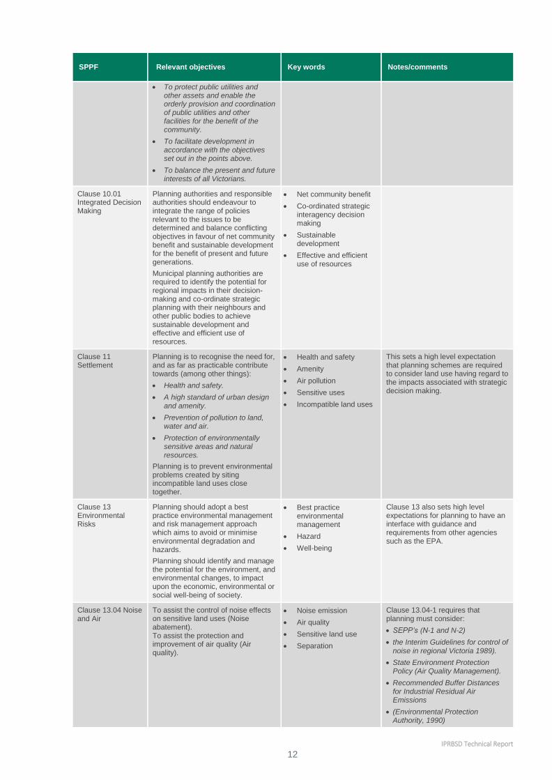
IPRBSD Technical Report
12
SPPF Relevant objectives Key words Notes/comments
To protect public utilities and other assets and enable the orderly provision and coordination of public utilities and other facilities for the benefit of the community.
To facilitate development in accordance with the objectives set out in the points above.
To balance the present and future interests of all Victorians.
Clause 10.01 Integrated Decision Making
Planning authorities and responsible authorities should endeavour to integrate the range of policies relevant to the issues to be determined and balance conflicting objectives in favour of net community benefit and sustainable development for the benefit of present and future generations.
Municipal planning authorities are required to identify the potential for regional impacts in their decision-making and co-ordinate strategic planning with their neighbours and other public bodies to achieve sustainable development and effective and efficient use of resources.
Net community benefit
Co-ordinated strategic interagency decision making
Sustainable development
Effective and efficient use of resources
Clause 11 Settlement
Planning is to recognise the need for, and as far as practicable contribute towards (among other things):
Health and safety.
A high standard of urban design and amenity.
Prevention of pollution to land, water and air.
Protection of environmentally sensitive areas and natural resources.
Planning is to prevent environmental problems created by siting incompatible land uses close together.
Health and safety
Amenity
Air pollution
Sensitive uses
Incompatible land uses
This sets a high level expectation that planning schemes are required to consider land use having regard to the impacts associated with strategic decision making.
Clause 13 Environmental Risks
Planning should adopt a best practice environmental management and risk management approach which aims to avoid or minimise environmental degradation and hazards.
Planning should identify and manage the potential for the environment, and environmental changes, to impact upon the economic, environmental or social well-being of society.
Best practice environmental management
Hazard
Well-being
Clause 13 also sets high level expectations for planning to have an interface with guidance and requirements from other agencies such as the EPA.
Clause 13.04 Noise and Air
To assist the control of noise effects on sensitive land uses (Noise abatement). To assist the protection and improvement of air quality (Air quality).
Noise emission
Air quality
Sensitive land use
Separation
Clause 13.04-1 requires that planning must consider:
SEPP’s (N-1 and N-2)
the Interim Guidelines for control of noise in regional Victoria 1989).
State Environment Protection Policy (Air Quality Management).
Recommended Buffer Distances for Industrial Residual Air Emissions
(Environmental Protection Authority, 1990)
IPRBSD Technical Report
13
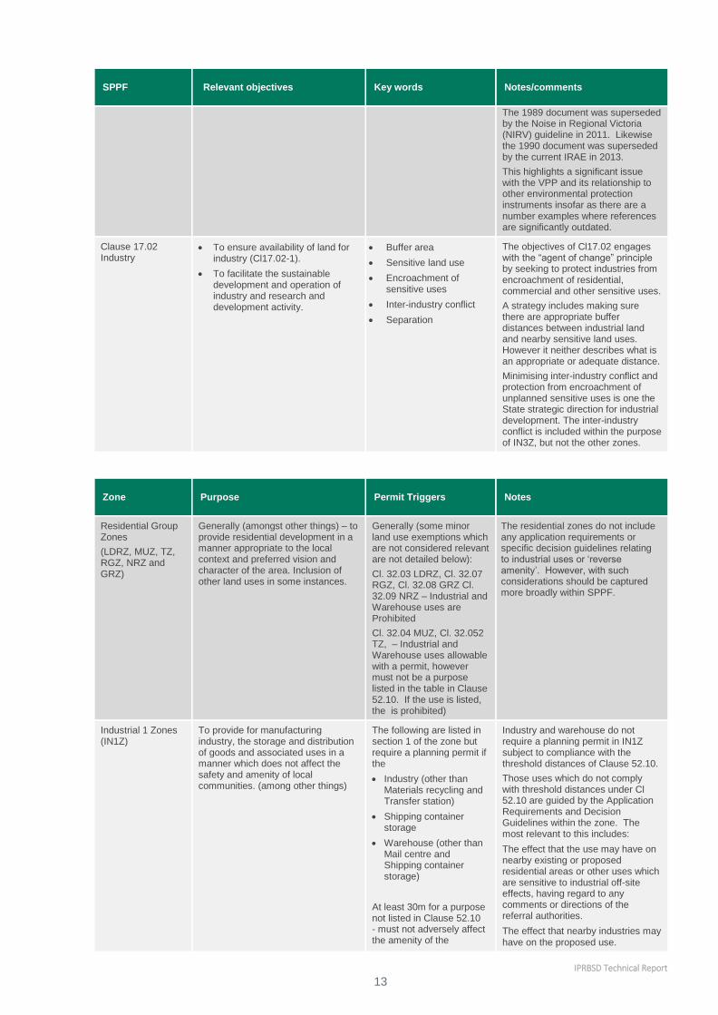
SPPF Relevant objectives Key words Notes/comments
The 1989 document was superseded by the Noise in Regional Victoria (NIRV) guideline in 2011. Likewise the 1990 document was superseded by the current IRAE in 2013.
This highlights a significant issue with the VPP and its relationship to other environmental protection instruments insofar as there are a number examples where references are significantly outdated.
Clause 17.02 Industry
To ensure availability of land for industry (Cl17.02-1).
To facilitate the sustainable development and operation of industry and research and development activity.
Buffer area
Sensitive land use
Encroachment of sensitive uses
Inter-industry conflict
Separation
The objectives of Cl17.02 engages with the “agent of change” principle by seeking to protect industries from encroachment of residential, commercial and other sensitive uses.
A strategy includes making sure there are appropriate buffer distances between industrial land and nearby sensitive land uses. However it neither describes what is an appropriate or adequate distance.
Minimising inter-industry conflict and protection from encroachment of unplanned sensitive uses is one the State strategic direction for industrial development. The inter-industry conflict is included within the purpose of IN3Z, but not the other zones.
Zone Purpose Permit Triggers Notes
Residential Group Zones
(LDRZ, MUZ, TZ, RGZ, NRZ and GRZ)
Generally (amongst other things) – to provide residential development in a manner appropriate to the local context and preferred vision and character of the area. Inclusion of other land uses in some instances.
Generally (some minor land use exemptions which are not considered relevant are not detailed below):
Cl. 32.03 LDRZ, Cl. 32.07 RGZ, Cl. 32.08 GRZ Cl. 32.09 NRZ – Industrial and Warehouse uses are Prohibited
Cl. 32.04 MUZ, Cl. 32.052 TZ, – Industrial and Warehouse uses allowable with a permit, however must not be a purpose listed in the table in Clause 52.10. If the use is listed, the is prohibited)
The residential zones do not include any application requirements or specific decision guidelines relating to industrial uses or ‘reverse amenity’. However, with such considerations should be captured more broadly within SPPF.
Industrial 1 Zones (IN1Z)
To provide for manufacturing industry, the storage and distribution of goods and associated uses in a manner which does not affect the safety and amenity of local communities. (among other things)
The following are listed in section 1 of the zone but require a planning permit if the
Industry (other than Materials recycling and Transfer station)
Shipping container storage
Warehouse (other than Mail centre and Shipping container storage)
At least 30m for a purpose not listed in Clause 52.10 - must not adversely affect the amenity of the
Industry and warehouse do not require a planning permit in IN1Z subject to compliance with the threshold distances of Clause 52.10.
Those uses which do not comply with threshold distances under Cl 52.10 are guided by the Application Requirements and Decision Guidelines within the zone. The most relevant to this includes:
The effect that the use may have on nearby existing or proposed residential areas or other uses which are sensitive to industrial off-site effects, having regard to any comments or directions of the referral authorities.
The effect that nearby industries may have on the proposed use.

IPRBSD Technical Report
14
Zone Purpose Permit Triggers Notes
neighbourhood through the emission of noise, artificial light, vibration, odour, fumes, smoke, vapour, steam, soot, ash, dust, waste water, waste products, grit or oil.
Industrial 2 Zone (IN2Z)
To provide for manufacturing industry, the storage and distribution of goods and associated facilities in a manner which does not affect the safety and amenity of local communities. To promote manufacturing industries and storage facilities that require a substantial threshold distance within the core of the zone. To keep the core of the zone free of uses which are suitable for location elsewhere so as to be available for manufacturing industries and storage facilities that require a substantial threshold distance as the need for these arises.
Industry and Warehouse are Section 2 uses.
A planning permit is triggered for most uses in this zone, meaning inter-industry uses would be able to be considered. However, while it is captured more broadly within Clause 17, this principle is not included specifically within the zone.
Application Guidelines and Decision Guidelines require specific information and assessments relating to Cl. 52.10, with a broad intent to encourage land uses which require large separation distances (1500m) to be located within the centre of the industrial precinct.
The decision guidelines seeks consideration of the effect that the use may have on nearby existing or proposed residential areas or other uses which are sensitive to industrial offsite effects.
Industrial 3 Zone (IN3Z)
To provide for industries and associated uses in specific areas where special consideration of the nature and impacts of industrial uses is required or to avoid inter-industry conflict. To provide a buffer between the Industrial 1 Zone or Industrial 2 Zone and local communities, which allows for industries and associated uses compatible with the nearby community.
To ensure that uses do not affect the safety and amenity of adjacent, more sensitive land uses.
Warehouse is Section 1 Use subject to the following conditions: Must not be a purpose shown with a Note 1 or Note 2 in the table to Clause 52.10.
Must meet the Clause 52.10 threshold distances
At least 30m for a purpose not listed in Clause 52.10
Must not adversely affect the amenity of the neighbourhood through the emission of noise, artificial light, vibration, odour, fumes, smoke, vapour, steam, soot, ash, dust, waste water, waste products, grit or oil.
Industry is Section 2 use.
The purpose of the Zone is to separate uses within IN1Z and IN2Z from more sensitive receptors. In this regard it is a key strategic planning tool to facilitate separation between heavy and sensitive uses.
Decision guidelines include considerations around what effect the use may have on residential areas or other uses which are sensitive to industrial off-site effects.
Commercial 1 Zone (CIZ)
To create vibrant mixed use commercial centres for retail, office, business, entertainment and community uses and residential uses at appropriate densities.
Industry and warehouse listed in the table to Clause 52.10 is prohibited.
Not listed as a sensitive zone although most of sensitive uses are 'as of right' uses.
Commercial 2 Zone (C2Z)
To encourage commercial areas for offices, appropriate manufacturing and industries, bulky goods retailing, other retail uses, and associated business and commercial services.
To ensure that uses do not affect the safety and amenity of adjacent, more sensitive uses.
Industry is Section 1 Use subject to the following conditions: Must not be a purpose shown with a Note 1 or Note 2 in the table to Clause 52.10.
Must meet the Clause 52.10 threshold distances
At least 30m for a purpose not listed in Clause 52.10.
Warehouse is a Section 2 use and must meet the threshold distances. Warehouse listed as
Industries are encouraged in C2Z. Industries listed within Clause 52.10 without Note 1 or Note 2 are 'as of right' uses subject to compliant with the threshold distances.
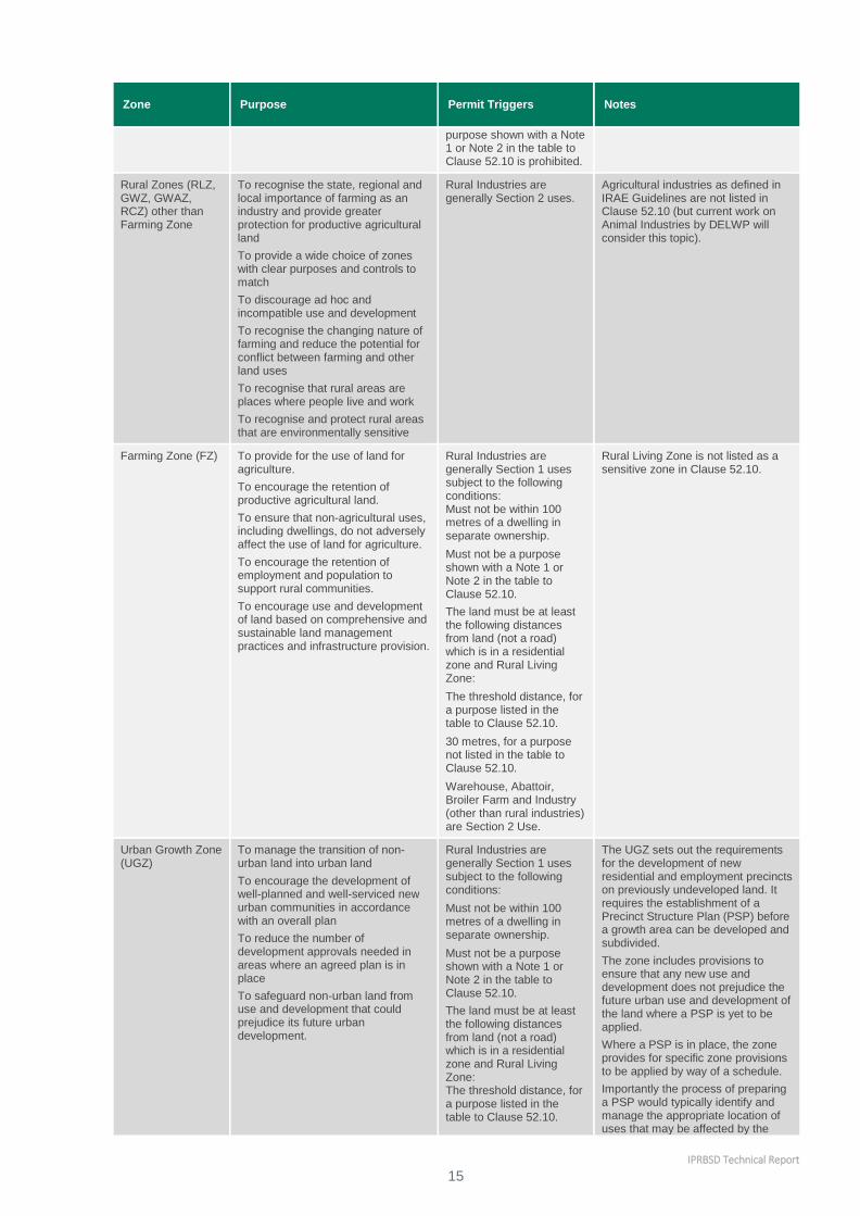
IPRBSD Technical Report
15
Zone Purpose Permit Triggers Notes
purpose shown with a Note 1 or Note 2 in the table to Clause 52.10 is prohibited.
Rural Zones (RLZ, GWZ, GWAZ, RCZ) other than Farming Zone
To recognise the state, regional and local importance of farming as an industry and provide greater protection for productive agricultural land
To provide a wide choice of zones with clear purposes and controls to match
To discourage ad hoc and incompatible use and development
To recognise the changing nature of farming and reduce the potential for conflict between farming and other land uses
To recognise that rural areas are places where people live and work
To recognise and protect rural areas that are environmentally sensitive
Rural Industries are generally Section 2 uses.
Agricultural industries as defined in IRAE Guidelines are not listed in Clause 52.10 (but current work on Animal Industries by DELWP will consider this topic).
Farming Zone (FZ) To provide for the use of land for agriculture.
To encourage the retention of productive agricultural land.
To ensure that non-agricultural uses, including dwellings, do not adversely affect the use of land for agriculture.
To encourage the retention of employment and population to support rural communities.
To encourage use and development of land based on comprehensive and sustainable land management practices and infrastructure provision.
Rural Industries are generally Section 1 uses subject to the following conditions: Must not be within 100 metres of a dwelling in separate ownership.
Must not be a purpose shown with a Note 1 or Note 2 in the table to Clause 52.10.
The land must be at least the following distances from land (not a road) which is in a residential zone and Rural Living Zone:
The threshold distance, for a purpose listed in the table to Clause 52.10.
30 metres, for a purpose not listed in the table to Clause 52.10.
Warehouse, Abattoir, Broiler Farm and Industry (other than rural industries) are Section 2 Use.
Rural Living Zone is not listed as a sensitive zone in Clause 52.10.
Urban Growth Zone (UGZ)
To manage the transition of non-urban land into urban land
To encourage the development of well-planned and well-serviced new urban communities in accordance with an overall plan
To reduce the number of development approvals needed in areas where an agreed plan is in place
To safeguard non-urban land from use and development that could prejudice its future urban development.
Rural Industries are generally Section 1 uses subject to the following conditions:
Must not be within 100 metres of a dwelling in separate ownership.
Must not be a purpose shown with a Note 1 or Note 2 in the table to Clause 52.10.
The land must be at least the following distances from land (not a road) which is in a residential zone and Rural Living Zone: The threshold distance, for a purpose listed in the table to Clause 52.10.
The UGZ sets out the requirements for the development of new residential and employment precincts on previously undeveloped land. It requires the establishment of a Precinct Structure Plan (PSP) before a growth area can be developed and subdivided.
The zone includes provisions to ensure that any new use and development does not prejudice the future urban use and development of the land where a PSP is yet to be applied.
Where a PSP is in place, the zone provides for specific zone provisions to be applied by way of a schedule.
Importantly the process of preparing a PSP would typically identify and manage the appropriate location of uses that may be affected by the
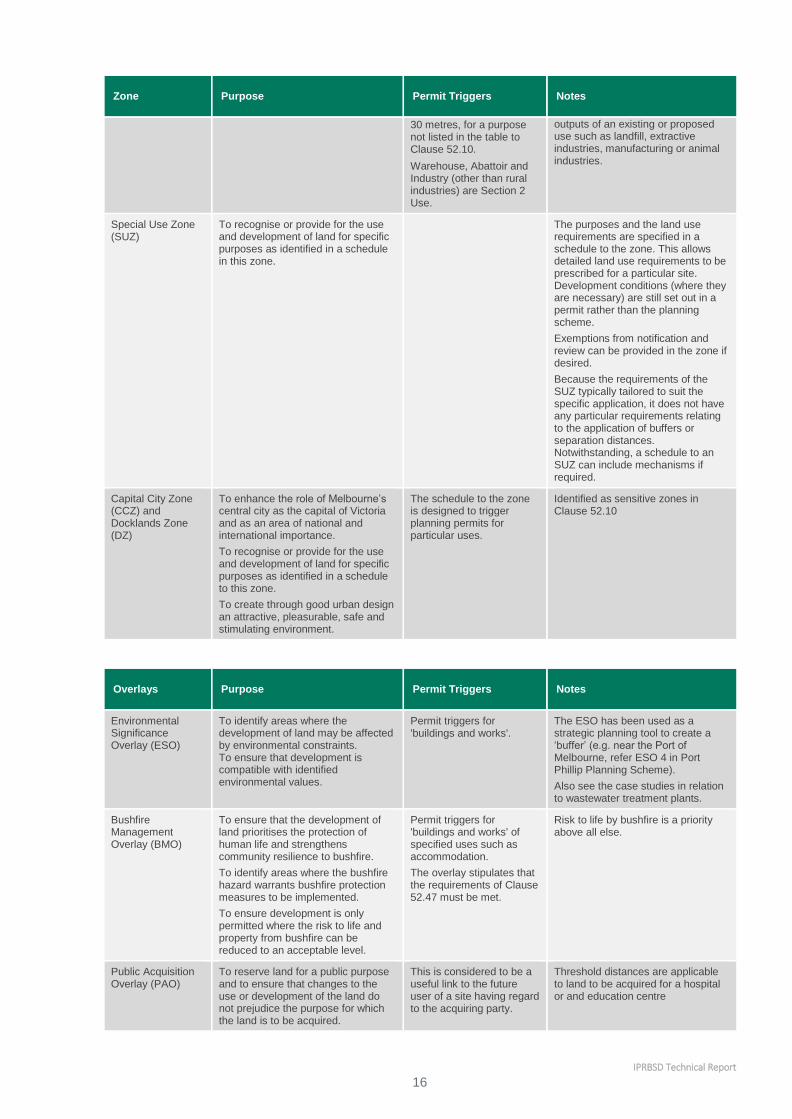
IPRBSD Technical Report
16
Zone Purpose Permit Triggers Notes
30 metres, for a purpose not listed in the table to Clause 52.10.
Warehouse, Abattoir and Industry (other than rural industries) are Section 2 Use.
outputs of an existing or proposed use such as landfill, extractive industries, manufacturing or animal industries.
Special Use Zone (SUZ)
To recognise or provide for the use and development of land for specific purposes as identified in a schedule in this zone.
The purposes and the land use requirements are specified in a schedule to the zone. This allows detailed land use requirements to be prescribed for a particular site. Development conditions (where they are necessary) are still set out in a permit rather than the planning scheme.
Exemptions from notification and review can be provided in the zone if desired.
Because the requirements of the SUZ typically tailored to suit the specific application, it does not have any particular requirements relating to the application of buffers or separation distances. Notwithstanding, a schedule to an SUZ can include mechanisms if required.
Capital City Zone (CCZ) and Docklands Zone (DZ)
To enhance the role of Melbourne’s central city as the capital of Victoria and as an area of national and international importance.
To recognise or provide for the use and development of land for specific purposes as identified in a schedule to this zone.
To create through good urban design an attractive, pleasurable, safe and stimulating environment.
The schedule to the zone is designed to trigger planning permits for particular uses.
Identified as sensitive zones in Clause 52.10
Overlays Purpose Permit Triggers Notes
Environmental Significance Overlay (ESO)
To identify areas where the development of land may be affected by environmental constraints. To ensure that development is compatible with identified environmental values.
Permit triggers for 'buildings and works'.
The ESO has been used as a strategic planning tool to create a ‘buffer’ (e.g. near the Port of Melbourne, refer ESO 4 in Port Phillip Planning Scheme).
Also see the case studies in relation to wastewater treatment plants.
Bushfire Management Overlay (BMO)
To ensure that the development of land prioritises the protection of human life and strengthens community resilience to bushfire.
To identify areas where the bushfire hazard warrants bushfire protection measures to be implemented.
To ensure development is only permitted where the risk to life and property from bushfire can be reduced to an acceptable level.
Permit triggers for 'buildings and works' of specified uses such as accommodation.
The overlay stipulates that the requirements of Clause 52.47 must be met.
Risk to life by bushfire is a priority above all else.
Public Acquisition Overlay (PAO)
To reserve land for a public purpose and to ensure that changes to the use or development of the land do not prejudice the purpose for which the land is to be acquired.
This is considered to be a useful link to the future user of a site having regard to the acquiring party.
Threshold distances are applicable to land to be acquired for a hospital or and education centre

IPRBSD Technical Report
17
Overlays Purpose Permit Triggers Notes
Airport Environs Overlay (AEO)
To identify areas which are or will be subject to high levels of aircraft noise, including areas where the use of land for uses sensitive to aircraft noise will need to be restricted.
To ensure that land use and development are compatible with the operation of airports in accordance with the appropriate airport strategy or master plan and with safe air navigation for aircraft approaching and departing the airfield.
To assist in shielding people from the impact of aircraft noise by requiring appropriate noise attenuation measures in new dwellings and other noise sensitive buildings.
To limit the number of people residing in the area or likely to be subject to significant levels of aircraft noise.
For use land, any requirement in a schedule to the overlay must be met.
New buildings must be constructed to comply with any noise attenuation measures required by Section 3 of Australian Standard AS 2021-2015, Acoustics – Aircraft Noise Intrusion - Building Siting and Construction, issued by Standards Australia Limited.
A permit is required to subdivide land.
This overlay is another example of strategic planning utilising an overlay to create a ‘buffer’. In this instance, a specific overlay was created for the airport.
The use of a similar provision for other uses with a known level of impact has been mentioned as one possible way of dealing with reverse amenity and agent of change issues. For example an overlay placed over parts of an urban renewal precinct within a certain distance of important industrial area or activity could made to trigger a planning permit for a sensitive use with application requirements to consider appropriate mitigation measures.
Particular Provisions
Purpose Application Notes
Clause 52.06 Live Music and Entertainment Noise
To recognise that live music is an important part of the State’s culture and economy.
To protect live music entertainment venues from the encroachment of noise sensitive residential uses.
To ensure that noise sensitive residential uses are satisfactorily protected from unreasonable levels of live music and entertainment noise.
To ensure that the primary responsibility for noise attenuation rests with the agent of
change.
This clause applies to an application required under any zone of this scheme to use land for, or to construct a building or construct or carry out works associated with:
a live music entertainment venue.
a noise sensitive residential use that is within 50 metres of a live music entertainment venue.
This clause does not apply to:
the extension of an existing dwelling.
a noise sensitive residential use that is in an area specified in clause 1.0 of the schedule to this clause
In addition to specifying noise abatement standards for new music and entertainment venues, this provision employs the agent of change principle to addressing reverse amenity impacts. Applications must be accompanied by the following information.
A site analysis, including plans detailing:
the existing and proposed layout of the use, buildings or works, including all external windows and doors
the location of any doors, windows and open space areas of existing properties in close proximity to the site.
If the application is associated with a noise sensitive residential use:
the location of any live music entertainment venues within 50 metres of the site
the days and hours of operation of identified venues.
If the application is associated with a live music entertainment venue:
the location of any noise sensitive residential uses within 50 metres of the
site the days and hours of operation of that venue
the times during which live music will be performed.
Details of existing and proposed acoustic attenuation measures.
The provision also allows for the responsible authority to exercise discretion by allowing the option of waiving or reducing the requirements.

IPRBSD Technical Report
18
Particular Provisions
Purpose Application Notes
Clause 52.08 Earth and Energy Resources Industry
To ensure that mineral extraction, geothermal energy extraction, greenhouse gas sequestration and petroleum extraction are not prohibited land uses.
To ensure that planning controls for the use and development of land for the exploration and extraction of earth and energy resources are consistent with other legislation governing these land uses.
No planning permit is required if the use and development comply with the relevant legislation governing these land uses as specified in the Table to Clause 52.08
Clause 52.09 Stone Extraction and Extractive Industry Interest Areas
To ensure that use and development of land for stone extraction does not adversely affect the environment or amenity of the area during or after extraction.
To ensure that excavated areas can be appropriately rehabilitated.
To ensure that sand and stone resources, which may be required by the community for future use, are protected from inappropriate development.
These provisions apply to planning applications for:
The use and development of land for stone extraction.
The use and development of land within an extractive industry interest area.
The use and development of land within 500 metres of stone extraction.
Decision guideline: The effect of vehicular traffic, noise, blasting, dust and vibration on the amenity of the surrounding area.
Pursuant to Clause 52.09-7, no alteration may be made to the natural condition or topography of the land within 20m of the boundary of the land.
A ‘reverse amenity’ trigger exists for use and development within 500m which requires a planning permit (however exempt activities would not be triggered solely by Clause 52.09).
Clause 52.32 Wind Energy Facility
To facilitate the establishment and expansion of wind energy facilities, in appropriate locations, with minimal impact on the amenity of the area.
Use and development of land for Wind energy facility is prohibited within 1km of and existing dwelling. This does not apply to a Wind energy facility that is located on land in a residential zone, an industrial zone, a commercial zone or a special purpose zone.
This is an example of a particular provision being implemented that deals with amenity impacts beyond the remit of Clause 52.10.
In this case the buffer has been established to reduce the impacts associated with turbine noise which can vary depending on the circumstances of the site.
General Provisions
Kind of application Referral authority Type of referral authority
Clause 66.02 Use and Development Referrals
To use land for an industry or warehouse for a purpose listed in the table to Clause 52.10 shown with a Note 1 or if the threshold distance is not to be met.
Environment Protection Authority
Determining referral authority
This represents one possible model for expanding the abilities of Clause 52.10 and to ensure that development has regard to the IRAE and of environmental statutory requirements.
To use land for an industry or warehouse for a purpose listed in the table to Clause 52.10 shown with a Note 2 or;
To construct a building or construct or carry out works on land used for an industry or warehouse for a purpose listed in the table to Clause 52.10 and shown with a Note 2 if the area of the buildings and works will increase by more than 25 per cent;
And if any of the following apply:
A fire protection quantity is exceeded under the Dangerous Goods (Storage and Handling) Regulations 2012.
The Victorian WorkCover Authority
Determining referral authority

IPRBSD Technical Report
19
General Provisions
Kind of application Referral authority Type of referral authority
A notification is required under the Occupational Health and Safety Regulations 2007.
A licence is required under the Dangerous Goods (Explosives) Regulations 2011.
A licence is required under the Dangerous Goods (HCDG) Regulations 2016 and the use is not associated with agriculture.
2.6 Other relevant planning policies or guidance documents 2.6.1 Plan Melbourne
Plan Melbourne broadly acknowledges a need for appropriate separation distances (also referred to as
buffers), as follows:
Policy 1.3.1 Plan for and facilitate the development of urban renewal precincts
Direction 1.4 Support the productive use of land and resources in Melbourne’s non-urban areas
Policy 3.4.3 Avoid negative impacts of freight movements on urban amenity
Desired planning outcomes for green wedges and peri-urban areas Protecting State-significant
infrastructure (including industrial areas and related odour and safety buffers for example Dandenong
South)
Policy 6.3.3 Protect water, drainage and sewerage assets
Policy 6.6.1 Reduce air pollution emissions and minimise exposure to air pollution and excessive noise
Policy 7.2.2 Strengthen transport links on national networks for the movement of commodities
2.6.2 Potentially Contaminated Land – General Practice Note
This General Practice Note provides guidance for the identification of potentially contaminated land and
determining the appropriate level of assessment of contamination associated with a proposed planning
scheme amendment or planning permit application.
Definition of ‘potentially contaminated land’
‘Potentially contaminated land’ is defined in Ministerial Direction No. 1 – Potentially Contaminated Land, as
land used or known to have been used for industry, mining or the storage of chemicals, gas, wastes or liquid
fuel (if not ancillary to another use of land).
Determination of appropriate level of assessment
The document list the types of land uses that may have potential for contaminating land and categorised
them into high potential, medium potential and low potential.
The appropriate level of assessment is dependent on the potential for contamination (high, medium or low)
and sensitivity of proposed land use (sensitive use or other uses). An assessment matrix is designed to
determine the level of assessment which can be:
A. Environment audit
B. Site assessment
C. General duty under Section 12(2)(b) and Section 60(1)(a)(iii) of the Planning and Environment Act 1987.
The sensitive uses are child care centre, pre-school or primary school, dwellings, residential buildings etc.
Environmental Audit
If the land is potentially contaminated and a sensitive use is proposed, a planning authority must satisfy itself
that the land is suitable through an environmental audit. The environmental audit aim to identify the
environmental quality of land and any detriment to beneficial uses of land which are linked to land use.

IPRBSD Technical Report
20
An environmental auditor undertakes an independent assessment of condition of a site and form an opinion
about suitability for the proposed use. An audit of the condition of a site may result in the issue of either:
a Certificate of Environmental Audit that indicates the auditor is of the opinion that the site is suitable for
any beneficial use and that there is no restriction on use of the site due to its environmental condition; or
a Statement of Environmental Audit that indicates that the auditor is of the opinion that there is, or may
be, some restriction on use of the site due to its environmental condition.
Section 53 ZE of the Environment Protection Act 1970 requires that an occupier provide to any person who
proposes to become an occupier a copy of any Statement of Environmental Audit that has been issued for
the site.
Environmental Audit Overlay
The Environmental Audit Overlay (EAO) is a mechanism provided in the Victoria Planning Provisions and
planning schemes to defer the requirements of Direction No. 1 for an environmental audit until the site is to
be developed for a sensitive use.
By applying the overlay, the planning authority has made an assessment that the land is potentially
contaminated land, and is unlikely to be suitable for a sensitive use without more detailed assessment and
remediation works or management.
2.7 Environment Protection Act 1970 (the EP Act) The EP Act2 establishes the powers, duties and functions of EPA. These include the administration of the
Act and any regulations and orders made pursuant to it, recommending State environment protection policies
(SEPPs) and industrial waste management policies (WMPs) to the Governor in Council, issuing works
approvals, licences, permits, pollution abatement notices and implementing National Environment Protection
Measures (NEPMs).
The EP Act contains a set of ten principles that guide environment protection in Victoria.
integration of economic, social and environmental considerations;
the precautionary principle;
intergenerational equity;
conservation of biological diversity and ecological integrity;
improved valuation, pricing and incentive mechanisms;
shared responsibility;
product stewardship;
wastes hierarchy;
integrated environmental management;
enforcement; and
accountability.
EPA also monitors industry in general to ensure compliance with the EP Act. There are specific penalties
through the EP Act for breaches of licenses and through EPA’s compliance and enforcement powers.
2.8 State Environment Protection Policies State Environment Protection Policies (SEPPs) provide detailed requirements and guidance for the
application of the EP Act. The SEPPs establish the legal basis for maintaining environmental quality and are
legally enforceable through the EP Act. The SEPPs express the needs, expectations and priorities of the
community with regard to environmental protection and maintenance, and improvement of environmental
quality objectives.
Importantly, SEPPs are considered to be a reactive mechanism in that they are typically only enforced if
non-compliance is detected. this implies that uses are presumed to be design and developed in a way that
would result in compliance with the applicable beneficial uses defined in the SEPPs.
2 It should be noted that the Environment Protection Act is currently under review and may be updated in the near future.

IPRBSD Technical Report
21
This potentially sets up a very important opportunity to provide a greater link between the planning and
development phase of a project and the requirements of a SEPP.
The following table outlines current suite of SEPPs:
Table 6: State Environment Protection Policies
Policy Area SEPP Title SEPP Summary
Air Policies Ambient Air Quality The 1999 State Environment Protection Policy (Ambient Air Quality) defines a range of air quality objectives and goals for the air environment, which are based on requirements set out in the National Environment Protection (Ambient Air Quality) Measure.
Schedule 1 of the Ambient Air Quality SEPP defines air quality objectives for environmental indicators.
Air Quality Management To achieve the environmental quality objectives outlined above, the 2001 State Environment Protection Policy (Air Quality Management) establishes framework for managing emissions into the air environment, addressing ambient air quality as well as management of sources (i.e. industry, motor vehicles, open burning) and local air quality impacts such as air toxics, odorous pollutants, greenhouse gases and ozone depleting substances. The Air Quality Management SEPP stipulates monitoring, research and modelling requirements for emission sources.
Management instruments outlined in the Air Quality Management SEPP include risk assessments, requirements for the Authority to provide a separation distance protocol, and Protocols for Environmental Management (PEMs) which comprise the following;
EPA Publication 824 (Greenhouse gas emissions and energy efficiency in industry);
EPA Publication 829 (Minimum control requirements for stationary sources);
EPA Publication 1191 (Mining and extractive industries).
Land and Groundwater Policies
Prevention and Management of Contaminated Land (854)
The 2002 State Environment Protection Policy (Prevention and Management of Contamination of Land) (Land SEPP), gazetted under the Environment Protection Act 1970, sets out the
regulatory framework for the prevention and management of contamination of land within Victoria.
The Land SEPP identifies land use categories and protected beneficial uses for each of these categories. Land (principally soil) is considered polluted when protected beneficial uses associated with the relevant land use categories are precluded. Beneficial uses of land are considered precluded when relevant land quality objectives set out in the Land SEPP have been exceeded.
The beneficial uses of land to be protected are dependent of the proposed land use rather than the current land, and are shown in Table 1.1 of the policy
Groundwaters of Victoria The 1997 State Environment Protection Policy (Groundwaters of Victoria) (Groundwater SEPP), gazetted under the Environment Protection Act 1970, defines a range of protected beneficial uses for specific segments of the groundwater environment, which are based on groundwater salinity. Groundwater is separated into segments based upon the salinity range, otherwise defined as Total Dissolved Solids (TDS).
As required by EPA Publication 759 (Guidelines for issue of certificates and statements of environmental audit) a beneficial use of groundwater may be considered ‘relevant’ when the
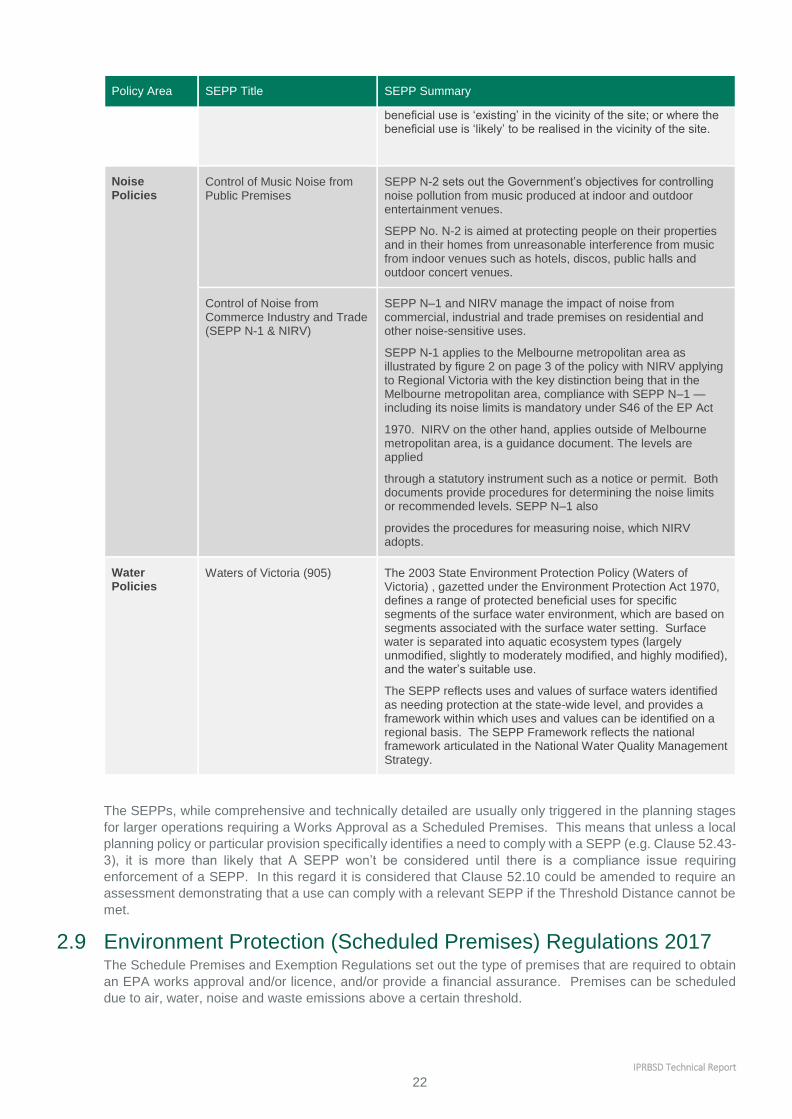
IPRBSD Technical Report
22
Policy Area SEPP Title SEPP Summary
beneficial use is ‘existing’ in the vicinity of the site; or where the beneficial use is ‘likely’ to be realised in the vicinity of the site.
Noise Policies
Control of Music Noise from Public Premises
SEPP N-2 sets out the Government’s objectives for controlling noise pollution from music produced at indoor and outdoor entertainment venues.
SEPP No. N-2 is aimed at protecting people on their properties and in their homes from unreasonable interference from music from indoor venues such as hotels, discos, public halls and outdoor concert venues.
Control of Noise from Commerce Industry and Trade (SEPP N-1 & NIRV)
SEPP N–1 and NIRV manage the impact of noise from commercial, industrial and trade premises on residential and other noise-sensitive uses.
SEPP N-1 applies to the Melbourne metropolitan area as illustrated by figure 2 on page 3 of the policy with NIRV applying to Regional Victoria with the key distinction being that in the Melbourne metropolitan area, compliance with SEPP N–1 — including its noise limits is mandatory under S46 of the EP Act
1970. NIRV on the other hand, applies outside of Melbourne metropolitan area, is a guidance document. The levels are applied
through a statutory instrument such as a notice or permit. Both documents provide procedures for determining the noise limits or recommended levels. SEPP N–1 also
provides the procedures for measuring noise, which NIRV adopts.
Water Policies
Waters of Victoria (905) The 2003 State Environment Protection Policy (Waters of Victoria) , gazetted under the Environment Protection Act 1970, defines a range of protected beneficial uses for specific segments of the surface water environment, which are based on segments associated with the surface water setting. Surface water is separated into aquatic ecosystem types (largely unmodified, slightly to moderately modified, and highly modified), and the water’s suitable use.
The SEPP reflects uses and values of surface waters identified as needing protection at the state-wide level, and provides a framework within which uses and values can be identified on a regional basis. The SEPP Framework reflects the national framework articulated in the National Water Quality Management Strategy.
The SEPPs, while comprehensive and technically detailed are usually only triggered in the planning stages
for larger operations requiring a Works Approval as a Scheduled Premises. This means that unless a local
planning policy or particular provision specifically identifies a need to comply with a SEPP (e.g. Clause 52.43-
3), it is more than likely that A SEPP won’t be considered until there is a compliance issue requiring
enforcement of a SEPP. In this regard it is considered that Clause 52.10 could be amended to require an
assessment demonstrating that a use can comply with a relevant SEPP if the Threshold Distance cannot be
met.
2.9 Environment Protection (Scheduled Premises) Regulations 2017 The Schedule Premises and Exemption Regulations set out the type of premises that are required to obtain
an EPA works approval and/or licence, and/or provide a financial assurance. Premises can be scheduled
due to air, water, noise and waste emissions above a certain threshold.

IPRBSD Technical Report
23
Typically, the regulations only apply to large industrial operations with large emissions, have high levels of
production output (i.e. tonnes per annum), or emit toxic substances such as Class 3 indicators in SEPP
(AQM).
Where a use designated as a scheduled premises, an EPA works approval and/or licence would be required,
likely in addition to a planning permit for buildings and works. Uses not designated as a scheduled premises
may only require planning approval. This typically is the case for small to medium enterprises which are too
small to meet the threshold of a Scheduled Premises, and as such rely on planning for decisions in relation
to appropriateness of location, design and potential impacts.
2.10 Other guidance from EPA In addition to the provisions outlined above, EPA provides additional guidance on environmental protection.
This additional guidance includes:
Best practice environmental management – Siting, design, operation and rehabilitation of landfill (Landfill
BPEM); and
Urban stormwater best practice environmental management guidelines (BPEMG)
3 Other Relevant Reviews and Documents
A review of the relevant literature relating to separation distances and buffers has been undertaken.
A large volume of information relating the subject matter has been reviewed as part of this project which has highlighted a number of common issues associated with the current Victorian planning system. For example it has illuminated the fact that Victoria’s approach to applying buffers is essentially ad hoc and
inconsistent approaches to determining the appropriateness of distances between land uses or how they’re dealt with at the planning scheme amendment stage and at the planning permit application stage of
development. It has also confirmed the fact that the issue of buffers and separation distances is indeed complicated by the fact that the planning system needs to provide flexibility and balance to allow for circumstances on a case by case basis.
The VPPs through the application of zones seek to create a form of separation of land use. For example the Industrial 1 Zone prohibits certain sensitive uses from establishing and concurrently a residential zone will prohibit industrial activity from establishing. An issue identified via this review highlights the fact that an
applied zone implies that the land is capable of being developed for a particular purpose intended by the zone regardless of it being located in an area affected by off-site amenity impacts from a neighbouring land
use. An example of this is an area of land located south of Diggers Rest which is zoned General Residential Zone despite it being impacted by the Melbourne Airport Environs Overlay, which prevents its further
subdivision. In this case the buffer created by the overlay is scientifically derived to protect the nationally significant airport activity from encroachment by sensitive uses and as such works well, it doesn’t change the fact that the underlying zone sets an expectation of development potential and thus a creating a source
of conflict.
The research conducted as part this project has identified a number of areas of the planning system which create tension in terms of dealing with issues associated with buffers and separation distances which
include:
The need to secure buffer distances to protect important land use activities close to the population centres, and the consequences of allowing sensitive uses in locations that are too close to the activity;
The inability to provide the whole of the necessary buffer distance on the land where the potential disturbance is generated and the need to separate sensitive uses which necessarily involves use of a
precious, finite resource; and
The consequences of effectively sterilising land which is owned by people who are not beneficial users of the land which precludes or in some way limits the viable development of their land;

IPRBSD Technical Report
24
In relation to the operation of buffer distances, the existing planning framework presents the following range
of issues:
The system imposes buffer distances on new uses only and does not deal well with encroachment;
The system lacks visibility in terms of mapping the location or extent of the buffer distances to the extent
that third parties may not know of the existence of an industry up to a kilometre or more away which
may be affected by their desire to build a house;
Nothing in the system imposes any express obligation upon the owners of nearby land to observe
buffers protecting existing industry, other than an obscure reference in the highest level planning policy
statement (i.e. at Clause 17.02 of the SPPF) which specifies that an "adequate" separation should be
achieved;
The current system does not offer any statutory protection of established buffers;
The stated buffer distances do not deal with all emitting industries or potential sources of hazard, nor
does clause 52.10 expressly contain a mechanism for establishing a default buffer distance for any land
use not contained in the table; and
It is unclear from the terms of Clause 52.10 and the SPPF which partly is responsible for maintaining
the buffer, and if so how?
In broad terms the literature reviewed as part of this project has highlighted a the following as common
issues.
1. There is an absence of certainty as to the aim of and technical basis for some buffers.
Buffers/separation distances are currently applied to prevent conflicts arising out of health and amenity concerns, without specifying which impact the buffer is aiming to address.
2. Encroachment by sensitive uses is inadequately covered by the VPP’s. Rezoning or development
proposals of sensitive uses into the environs of existing uses (e.g. industrial) is inconsistently regulated
in Victoria and does not feature in Clause 52.10. Currently the VPP’s only consider the impact of industrial activity on sensitive areas and does not provide a mechanism for planners to consider the reverse impact of encroachment or agent of change principles.
3. Safety Buffers in the context of risks to health and safety are inadequately addressed in planning
system insofar as the types of buffers currently specified in the planning scheme only address amenity issues not safety issues. In most cases, there is no planning guidance in the VPPs to guide decision makers as to how to determine safety buffers and to assess and manage the risks appropriately.
The precautionary principle
In terms of the precautionary principle is not defined in the Act but it is contained in the purposes provisions
of the EP Act.
The precautionary principle is the concept that if an action or policy has a suspected risk of causing harm to
the public or to the environment, in the absence of scientific consensus that the action or policy is harmful,
the burden of proof that it is not harmful is the responsibility of party undertaking the action.
The absence of the Precautionary Principle in the planning system and the need to consider its inclusion
represents a major challenge for planning and the Victorian system insofar as it a performance based system
deigned to allow consideration of development and uses that have not previously been contemplated to be
considered as appropriate.
To some extent ResCode (i.e. Clause 54, 55, 56 and 58 inclusive) provide a model for planning to in Victoria
for dealing with the agent of change and precautionary principles. A key tenor of the ResCode provisions is
the concept of ‘site analysis and design response’. In the most simplistic terms, the provisions require a
permit applicant for a new development to analyse the site and its surrounds in order to understand the things
upon which the new development will impact. As a matter of principle the provisions then require the
development proponent to develop a ‘design response’ which takes into consideration the things that will be
impacted and seeks to avoid, or at least minimise the impacts of the new development to an acceptable
standard.
The principles enshrined in the ResCode could be adapted to the consideration of reverse amenity and the
precautionary principle to proposal relating impact and on sensitive uses associated with the need for a
separation distance.

IPRBSD Technical Report
25
3.1 Major Hazard Facility Ministerial Advisory Committee On 4 October 2015 the Minister for Planning appointed an Ministerial Advisory Committee (MAC) to:
“…provide advice to the Minister for Planning about improvements to land use planning for areas
surrounding major hazard facilities (MHFs), in order to better manage the interface areas between
existing and new development and land used for MHFs.”
The process was completed on 10 July 2016 with the release of the AC Final Report.
While the Terms of Reference made it clear that the MHFAC focused on matters relating to Major Hazard
Facilities, item 5.b states that the MAC is to “make recommendations to the principles for applying land use
buffers more broadly to other uses with adverse amenity potential”.
A large number of submissions to the MHFAC identified issues associated with Clause 52.10, the recent
MHFAC provides a strong starting point for exploring the issues surrounding land use buffers and separation
distances within Victoria.
3.1.1 Discussion Paper
A Discussion Paper was released by the MAC to initiate the review of MHF. The Discussion Paper identifies
that (emphasis added);
“Clause 52.10 does not provide any guidance as to what tests should be applied in relation to the
proposed land use and potential conflicting use or how this conflict may be resolved in the event that
the relevant buffer distance is encroached upon. It is therefore of little assistance in determining what
is an acceptable separation distance between conflicting uses or in preventing encroachment of
sensitive uses onto existing impact generating land uses.
Because the Clause is linked to informing whether or not a use requires a permit, it is limited to
applying to new proposals that may cause an adverse amenity impact rather than to new proposals
that may be affected by an existing use. The lack of clear purposes and decision guidelines creates
difficulty with using the Clause to implement ‘reverse buffers’ to protect existing uses from
encroachment by sensitive uses”.
When considering the ‘Key Issues’ raised in the Discussion Paper, regarding the role and function of Clause
52.10 and the IRAE Guidelines, the following was noted in terms:
Any review of Clause 52.10 may benefit from considering the following matters:
Clarifying what risks it addresses, such as noise, odour, dust, vibration and public/human safety
The definition of ‘threshold distance’ and whether adequate protection is extended to sensitive
uses in zones that are not listed in the Clause
Clarifying its function, for instance that it does not set separation distances/buffer areas, but
rather triggers referrals and further assessment
Whether certain permit applications should be referred to the EPA and to WorkSafe
Clarifying its interaction with EPA and WorkSafe guidance notes, guidelines and information
sheets
The potential for identifying/listing permit application requirements to avoid/reduce delays with
requests for further information
Links with relevant policies in the State and local planning policy frameworks.
The EPA IRAE Guidelines were reviewed in 2013 and ... is a reference document in the SPPF. They
explicitly address both separation between existing industry and proposed sensitive use and vice
versa. The separation distances can be measured from activity to sensitive use boundary (urban
context) or activity to sensitive use (rural context).
This serves to highlight the applicative and functional differences between Clause 52.10 and the IRAE
Guidelines insofar as they neither reference one another or trigger assessment against one another,
essentially because they use a different set of metrics to determine the appropriateness.

IPRBSD Technical Report
26
3.1.2 Submissions to MHFAC
The MHFAC Discussion Paper received a number of submissions as part of the MHFAC process, which were
reviewed These have been reviewed, with some of the more pertinent points relevant to this project
referenced in the table below.
Table 7: Summary of MHFAC Submissions
Submitter Summary of points relevant to this project
CFA – 8 February 2016 The CFA sought for the MAC to consider not only MHF but also ‘high risk infrastructure’.
The CFA identified a desire to be included in strategic and statutory land use planning processes as a key stakeholder.
The CFA requested the adoption of a risk based methodology with which to identify sites with the potential for off-site impacts during emergencies.
They also sought for emergency management planning be extended to incorporate occupier responsibilities in regard to risk management for off-site impacts from credible worst-case incidents.
Brimbank City Council – 9 February 2016 ‘Reverse buffers” are recognised within EPA and WorkSafe, and applied in numerous decisions by Councils VCAT and Planning Panels. Brimbank sought for reverse buffers to be included within CL. 52.10.
Maribyrnong City Council – 9 February 2016 Cl. 52.10 and IRAE should be updated and include practical assessment criteria in the VPPs.
Hobsons Bay City Council – 9 February 2016 The concept of reverse buffer concept similar to that described in the EPA guidelines should be introduced into the VPPs. The submission recommended an amendment to clause 52.10 or drafting of a new particular provision that addresses the reverse buffer and Agent of Change principle.
Irrespective, the separation distances in the EPA guidelines should be informed by evidence based strategic justification and updated regularly in order for to be kept up with new and emerging industries and technologies.
Notwithstanding, clearer articulation in the planning system is required. Council’s submission does not support sterilising large portions of land for buffers given the long history of peaceful coexistence.
However, uses that have established buffers or new uses that require buffers (e.g. in a rural setting) should have their buffers supported and protected by the planning system. Principles around buffer management and protection can ensure this. Clause 52.10 may be amended to include the principles. Alternatively, a separate particular provision may be introduced into planning schemes. A repeat of the Brooklyn Green scenario must be avoided in future.
City of Melbourne – 9 February 2016 Buffers should reduce risk or amenity impacts to an “acceptable level. The acceptable level should be evidence based with a focus on human and environmental health; and health amenity. Excessive buffers may be an unnecessary economic impost.
There will always be a need to balance competing objectives and may be undesirable to be too prescriptive in planning. A risk based approach would be preferable.
Clearer guidance in the VPPs on the principles and needs for buffers would be useful. The principles would justify the size of the required buffer/separation distance.
DEDJTR – 13 February 2016 Support review of Cl. 52.10. It requires modernising to reflect modern manufacturing practices, to clarify its purpose and maintain consistency with EPA’s separation distance guideline.
Agent of change principle is supported, avoiding future land use conflict.

IPRBSD Technical Report
27
A combination of planning provision and guidance would assist in the understanding of the process and achieve a simplified process (rather than a more complex process).
Latrobe City – January 2016 Cl. 52.10 could take on a larger role and is complex.
The information required to unlikely to be known by the planner, and can be too technical.
The lack of a reverse buffer is problematic and introduction of agent of change principle is supported. Cl. 52.10 is out of date and needs to reflect current IRAE Guidelines.
Environment Protection Authority – February 2016
Cl. 52.10 is silent as to the types of risk that inform its threshold distances. EPA understands it is intended to address noise, odour and dust emissions, vibration and risks to public safety. This differs from the Separation Distance Guideline, which covers odour and dust emissions only.
Clause 52.10 was originally developed based on an EPA guideline that preceded the Separation Distance Guideline:
Recommended Buffer Distances for Industrial Residual Air Emissions (AQ 2/86, 1990).
EPA understands that since the 1990 guideline (like the Separation Distance Guideline) covered odour and dust emissions only, additional distance was added to some industries in clause 52.10 at the time of its creation to reflect its broader scope and account for noise and vibration impacts. The EPA review that led to the publication of the Separation Distance Guideline in 2013 resulted in further discrepancies with clause 52.10.
3.1.3 Advisory Committee Final Report
Final Recommendations
The MHFAC made the following relevant recommendations in relation to Clause 52.10:
The Minister for Planning, in consultation with the Environment Protection Authority and stakeholders
(industry, technical specialists and the planning and development profession) commission a
comprehensive review of Clause 52.10 to:
o Review the head clause to clarify its application to risk (non Major Hazard Facility) and amenity.
o Review the head clause to clarify its application and use, including diagrams to assist with
interpretation and expand its use to include ‘reverse amenity’ situations.
o Review the list of Type of Production, Use or Storage and the technical basis of threshold distances.
The Minister for Planning consult with the Environment Protection Authority to further consider the longer
term development of a single instrument that combines Clause 52.10 and the IRAE Guidelines.
Develop a Ministerial Direction, based on Ministerial Direction 14, which require planning scheme
amendments which would allow or intensify sensitive uses to explicitly consider the Types of Production,
Use or Storage in Clause 52.10.
The Final Report is careful to differentiate between impacts on amenity and risk to human safety and life from
industrial incidents, noting that these terms should not be confused in land use planning. It is noted that a
buffer can be used for both objectives, but that a buffer to protect the amenity of sensitive uses is often
considerably greater than a buffer separation distance for the purpose of managing risk to human safety.
Principles
The MHFAC report articulates the following principles.

IPRBSD Technical Report
28
Table 8: MHFAC Comments on agreed principles
Principle MHFAC Comment
Emission control is the
responsibility of the emitter.
As noted within the IRAE Guidelines “even with good pollution control technology
and practice, there may still be unintended emissions which must be anticipated
and allowed for.” There may be offences and remedies through the
Environmental Protection Act 1970 (pollution) or the Public Health and Wellbeing
Act 2008 (nuisance), but the responsibility for preventing emissions that
adversely impact others fundamentally rests with the emitter.
Even best practice source
emission control does not
guarantee there will never be
offsite adverse amenity
impacts.
Separation distances should be designed to ensure offsite amenity impacts are
reduced to an ‘acceptable’ level, not to the point where there will never be an
offsite impact, as this may be a very great distance.
Buffer or separation distances
must be evidence based and
adequate to reduce offsite
amenity impacts under upset
conditions to an acceptable
level.
The separation distance must be large enough to achieve its objectives without
unnecessarily restricting other land uses. The basis for the distance, whether a
standard or site specific calculated distance, must be transparent with all the
assumptions behind it clear.
Planning authorities should not
promote or approve land use
change to sensitive uses within
a buffer or separation distance
without a sound strategic
planning process and strong
State and local policy support.
There are many instances where transition to sensitive uses such as residential
occurs as old industrial areas are repurposed. However this should be done
strategically and logically and with the engagement of the relevant industry.
Land uses requiring a buffer or
separation distance should not
have the expectation that they
will receive planning support on
a new site, or expand on an
existing site, with inadequate
buffers or separation distances.
Just as sensitive uses should not encroach on existing industry, industry should
be required, as per Clause 52.10, to not establish or expand in areas where
adequate separation distances cannot be achieved.
Where possible, buffers or
separation distances should be
in the control or ownership of
the emitter.
With greenfield industrial development or in a regional locations this may be
relatively simple to achieve and gives the industry greater control if sensitive uses
are approaching. However in many instances a buffer or separation distance
extends well beyond the property owned by the emitting industry.
In these circumstances the balance again must be sought in net community
benefit terms as to whether land use planning should resolve the issues in favour
of protecting an industry or facilitating the growth in sensitive uses. Again the
policy framework becomes paramount.
Information in plain English
about potential amenity impacts
should be readily available to
the community, industry and
decision‐makers.
Whether through planning schemes or other mechanisms, the presence of
potential amenity impacts should be clearly identified to inform decision making at
the societal and individual level.
In addition, the following questions were articulated by the committee:
Are the provisions in the VPP adequate and suitable to effectively apply buffers to industry and other
land uses with off‐site impacts?
Does planning effectively consider amenity concerns from industry; and effectively consider the situation
where sensitive uses are encroaching on industry and other land uses?
Are the linkages between land use planning and environmental protection effective in protecting amenity?

IPRBSD Technical Report
29
Clause 52.10
In relation to the form and operation of Clause 52.10, the Committee considered that it is this part of the
clause that requires the most attention. It noted that:
“There was very strong agreement in submissions that Clause 52.10 requires revision. The Committee
observes that in our experience there has been a call to review this clause since the VPP commenced.”
A review should consider the following elements:
The ambiguity in Clause 52.10 as to whether it is addressing risk, amenity or both. In most instances,
the threshold distances will be for amenity and it is likely that the risk distance, at least in terms of the
area modelled for a MHF, will be lesser.
The type of amenity impacts Clause 52.10 is addressing. For example, is noise being considered or is
Clause 52.10 confined to the consideration of air emissions?
A review of the technical basis for distances in the clause to ensure that they are based on best available
understanding of emissions sources, management methods, allowance for topography, prevailing
weather conditions and plant size are therefore defensible as a permit trigger threshold.
Revising the clause to make it explicitly applicable to ‘reverse amenity’ situations as well; where a
sensitive use is encroaching on industry. This could be triggered through the use of a Ministerial Direction
which requires amendment proposals within the threshold distances to explicitly assess amenity
concerns.
The committee noted that a ‘one size fits all’ approach to buffers, while attractive at a superficial level does
not work well with a performance based planning system such as the VPPs. The Committee argued:
There must be room to test where the ‘net community benefit’ outcomes lie on a continuum, whilst
protecting the fundamentals of community safety and wellbeing (MHFAC Final Report Page 49).
Zones and Overlays
The Committee was satisfied that there was sufficient planning tools to manage amenity and buffers if required (in particular noting the use in some areas of a Special Use Zone or Environmental Significance Overlay, as well as the utilisation of Industrial 3 Zone, which is an explicit ‘buffer’ zone). The Committee did note that clear consideration was required as part of strategic planning, particularly where rezoning to allow sensitive uses. The committee noted that “rezoning to sensitive uses such as residential without due consideration of amenity impacts from industry is fraught with risk”.
Policy In relation to addressing the management of amenity impacts the Committee concluded that changes to the
SPPF, particularly the sections relating to amenity provisions, noise and air quality (i.e. 13.04‐1 and 13.04‐2), are not immediately required. Rather the Committee concluded that it would be more appropriate to update the references in the policies to relevant guidelines such as the IRAE Guidelines.
“Whilst improvements can always be made to policy, the Committee is not satisfied that in relation to amenity, the need for further articulation is required. Where there appears to be a greater need is how the policies are given effect in planning schemes through particular controls” (MHFAC Final Report Page 47).
This is considered to be an important point in terms of how planning responds to and seeks to protect the
community from amenity impacts. In the context of known concerns associated with Clause 52.10, the
problem is not that the planning system through policy provision does not have regard to amenity, it’s that
the policy does not appropriately link to instruments located outside the VPP which assist with guidance on
separation distances.
3.1.4 Government Response to the Major Hazard Facilities Advisory Committee (January 2018)
In the response, the Victorian Government agreed that threshold distances and their operation needed to be
reviewed to make them clearer, address their interaction with other standards and incorporate the best—
available evidence.
The Action articulated was as follows:

IPRBSD Technical Report
30
“DELWP will work with the EPA to review existing threshold distances for land uses with adverse
amenity potential and how clause 52.10 operates through the planning system. The review will start
by scoping priority areas for action.
This review will draw on the best-available science and best-practice approaches. It will also examine
threshold distances in the context of EPA’s Recommended Separation Distances for Industrial
Residual Air Emissions guidelines, to ensure the two mechanisms align.
The review will also consult with local governments, industry and other stakeholders.”
This document supports DELWP’s work on achieving this action.
3.2 Better Managing Encroachment (Option Paper) The Better Managing Encroachment (Options Paper), EPA December 2015, was prepared as part of an EPA
project to develop a more strategic and preventive approach to responding to situations where development
has the potential to encroach upon an established buffer.
3.2.1 Purpose and intent of Better Managing Encroachment
The purpose of Better Managing Encroachment is to identify and evaluate options for improving the
management of residential encroachment on industry through the planning system. This includes both
existing and potential new options.
The scope of Better Managing Encroachment is extended to include noise emission impact which is not
considered within of the scope of the Recommended Separation Distances for IRAEs.
Key Findings – MHFAC
The following Principles were articulated by the MHFAC to guide consideration of Separation
Distances:
1. Emission control is the responsibility of the emitter.
2. Even best practice source emission control does not guarantee there will never be offsite
adverse amenity impacts.
3. Buffer or separation distances must be evidence based and adequate to reduce offsite amenity
impacts under upset conditions to an acceptable level.
4. Planning authorities should not promote or approve land use change to sensitive uses within
a buffer or separation distance without a sound strategic planning process and strong State
and local policy support.
5. Land uses requiring a buffer or separation distance should not have the expectation that they
will receive planning support on a new site, or expand on an existing site, with inadequate
buffers or separation distances.
6. Where possible, buffers or separation distances should be in the control or ownership of the
emitter.
7. Information in plain English about potential amenity impacts should be readily available to the
community, industry and decision‐makers.
MHFAC determined there was a need to review:
o The ambiguity in Clause 52.10 as to whether it is addressing risk, amenity or both.
o The type of amenity impacts Clause 52.10 is addressing needs review. For example, is noise
being considered or is Clause 52.10 confined to the consideration of air emissions?
o A review of the technical basis for distances in the clause to ensure that they are based on
best available understanding of emissions sources, management methods, allowance for
topography, prevailing weather conditions and plant size are therefore defensible as a permit
trigger threshold.52
o Revising the clause to make it explicitly applicable to ‘reverse amenity’ situations as well; where
a sensitive use is encroaching on industry. This could be triggered through the use of a
Ministerial Direction which requires amendment proposals within the threshold distances to
explicitly assess amenity concerns.
The Government Response committed to a review of Clause 52.10 following on from the
recommendations of the MHFAC. This review supports that process.
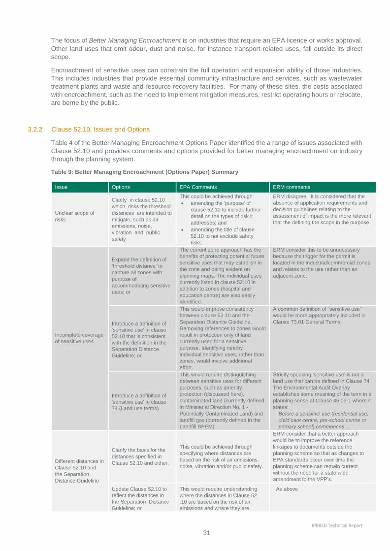
IPRBSD Technical Report
31
The focus of Better Managing Encroachment is on industries that require an EPA licence or works approval.
Other land uses that emit odour, dust and noise, for instance transport-related uses, fall outside its direct
scope.
Encroachment of sensitive uses can constrain the full operation and expansion ability of those industries.
This includes industries that provide essential community infrastructure and services, such as wastewater
treatment plants and waste and resource recovery facilities. For many of these sites, the costs associated
with encroachment, such as the need to implement mitigation measures, restrict operating hours or relocate,
are borne by the public.
3.2.2 Clause 52.10, Issues and Options
Table 4 of the Better Managing Encroachment Options Paper identified the a range of issues associated with
Clause 52.10 and provides comments and options provided for better managing encroachment on industry
through the planning system.
Table 9: Better Managing Encroachment (Options Paper) Summary
Issue Options EPA Comments ERM comments
Unclear scope of
risks
Clarify in clause 52.10
which risks the threshold
distances are intended to
mitigate, such as air
emissions, noise,
vibration and public
safety
This could be achieved through:
amending the 'purpose' of
clause 52.10 to include further
detail on the types of risk it
addresses; and
amending the title of clause
52.10 to not exclude safety
risks.
ERM disagree. It is considered that the
absence of application requirements and
decision guidelines relating to the
assessment of impact is the more relevant
that the defining the scope in the purpose.
Incomplete coverage
of sensitive uses
Expand the definition of
‘threshold distance’ to
capture all zones with
purpose of
accommodating sensitive
uses; or
The current zone approach has the
benefits of protecting potential future
sensitive uses that may establish in
the zone and being evident on
planning maps. The individual uses
currently listed in clause 52.10 in
addition to zones (hospital and
education centre) are also easily
identified.
ERM consider this to be unnecessary
because the trigger for the permit is
located in the industrial/commercial zones
and relates to the use rather than an
adjacent zone.
Introduce a definition of
'sensitive use' in clause
52.10 that is consistent
with the definition in the
Separation Distance
Guideline; or
This would improve consistency
between clause 52.10 and the
Separation Distance Guideline.
Removing references to zones would
result in protection only of land
currently used for a sensitive
purpose. Identifying nearby
individual sensitive uses, rather than
zones, would involve additional
effort.
A common definition of “sensitive use”
would be more appropriately included in
Clause 73.01 General Terms.
Introduce a definition of
'sensitive use' in clause
74 (Land use terms)
This would require distinguishing
between sensitive uses for different
purposes, such as amenity
protection (discussed here),
contaminated land (currently defined
in Ministerial Direction No. 1 -
Potentially Contaminated Land) and
landfill gas (currently defined in the
Landfill BPEM).
Strictly speaking ‘sensitive use’ is not a
land use that can be defined in Clause 74
The Environmental Audit Overlay
establishes some meaning of the term in a
planning sense at Clause 45.03-1 where it
states:
Before a sensitive use (residential use,
child care centre, pre-school centre or
primary school) commences…
Different distances in
Clause 52.10 and
the Separation
Distance Guideline
Clarify the basis for the
distances specified in
Clause 52.10 and either:
This could be achieved through
specifying where distances are
based on the risk of air emissions,
noise, vibration and/or public safety.
ERM consider that a better approach
would be to improve the reference
linkages to documents outside the
planning scheme so that as changes to
EPA standards occur over time the
planning scheme can remain current
without the need for a state wide
amendment to the VPP’s.
Update Clause 52.10 to
reflect the distances in
the Separation Distance
Guideline; or
This would require understanding
where the distances in Clause 52
.10 are based on the risk of air
emissions and where they are
As above

IPRBSD Technical Report
32
Issue Options EPA Comments ERM comments
based on other risks (noise,
vibration or public safety). The
discrepancies in the types of uses
listed in Clause 52.10 and the
Separation Distance Guideline
would also pose difficulties.
Review the technical
basis for the distances
specified in both Clause
52 .10 and the Separation
Distance Guideline
This would ensure a sound
technical basis for the distances
specified in both documents,
improve the consistency between
the two and clarify the reasons for
any appropriate discrepancies.
This could be part of a broader
review of the two documents to
clarify their individual roles and
how they interact.
This is something that should be
undertaken by the EPA and applied as
above.
Unclear
distinction
between
threshold
distance and
separation
distance
Clarify the meaning of
'threshold distance' in
Clause 52.10 l
This could be achieved through:
amending the 'purpose'
and/or 'definition' of Clause
52.10 to explain ·how the
threshold distances operate;
and
introducing a link within
Cause 52.10 to the clause 66
referral requirement (see
below).
This could be done by outlining what is
meant by a threshold distance in the
purpose of the clause.
Unclear link to
referral
requirements
Introduce a link within
Clause 52.10 to the
Clause 66 referral
requirement
This could be achieved by adding
a 'referral' provision within Clause
52.10, which explains what to do
when the threshold distance is not
met, with reference to Clause 66.
The referral requirement should be in
the applied zone with the permit trigger.
Insufficient
information for
referral
assessments
Introduce a
requirement in Clause
52 .10 for applications
to be accompanied by
certain information
A new 'application requirements'
section in Clause 52.10 could
outline the information EPA and
WorkSafe typically require in order
to properly assess the risk posed
by application. This would
streamline the referral process and
reduce delays associated with
further information requests.
As above
Limited referrals
for development
Expand the referral
trigger in clause 66 to
require certain
applications for
development for a
purpose listed in
Clause 52.10 to be
referred to EPA.
The Clause 66 referral trigger to
WorkSafe could be considered as
a basis. That covers applications
where the area of buildings and
works would increase by more
than 25 per cent.
As above
Lack of referral
trigger for sensitive
use applications
within clause 52.10
threshold distances
AmendCclause 66 to
make EPA and
WorkSafe
determining referral
authorities for certain
applications that fall
within Clause 52.10
threshold distances; or
This would ensure responsible
authority decisions are determined
by specialist technical advice. This
would significantly increase
resourcing requirements from EPA
and WorkSafe.
As above
Amend Clause 66 to
make EPA and
WorkSafe
recommending
referral authorities for
certain applications
that fall within clause
52.10 threshold
distances; or
This would ensure responsible
authority decisions are informed by
specialist technical advice, but
allow that advice to be balanced
against other planning scheme
requirements. This would also
significantly increase resourcing
requirements from EPA and
WorkSafe.
As above
Amend Clause 66 to
require notice to EPA
and WorkSafe of
certain applications
that fall within Clause
52.10 threshold
This would ensure EPA and
WorkSafe are aware of relevant
applications and have the
opportunity to respond. It would
also allow that advice to be
balanced against other planning
scheme requirements. This would
As above

IPRBSD Technical Report
33
Issue Options EPA Comments ERM comments
distances; or not as significantly increase
resourcing requirements from EPA
and WorkSafe, as responses
would be discretionary.
Use other planning
tools, such as
overlays, to specify
referral or notice
requirements
This option is currently available
and allows planning authorities to
set referral and notice triggers on
the basis of local requirements.
This would have resourcing
impacts due to increased
administrative burden.
As above
3.3 Independent Inquiry into the EPA
3.3.1 Independent Inquiry into the EPA
In May 2015 a Ministerial Advisory Committee was established to conduct an inquiry into the EPA, to consider
how it can protect public health and the Victorian environment, now and for future generations.
Of relevance to this review, the Inquiry provided some clear recommendations in terms of how the EPA can
play a more effective role in strategic land use planning process. The review succinctly summarised the
concerns with encroachment of sensitive uses into industrial areas, and identifies approaches to how the
EPA can manage and respond to these concerns.
The relevant recommendations of the Inquiry are as follows:
“Taking a strategic approach to land use planning
RECOMMENDATION 10.1
Create a statutory trigger, potentially via a Ministerial Direction under the Planning and Environment Act
1987, to require responsible authorities to seek early advice from the EPA on strategic planning
processes (such as, but not limited to, scheme amendments, rezoning and structure planning that
involve significant human health and environmental risks or development in close proximity to a licensed
facility.
RECOMMENDATION 10.2
Key Findings – Better Managing Encroachment
Clause 52.10 is silent as to the types of risk that inform its threshold distances. EPA understands it is
intended to address noise, odour and dust emissions, vibration and risks to public safety. This differs
from the IRAE, which covers odour and dust emissions only. EPA understands that since the 1990
guideline (like the Separation Distance Guideline) covered odour and dust emissions only, additional
distance was added to some industries in clause 52.10 at the time of its creation to reflect its broader
scope and account for noise and vibration impacts. The EPA review that led to the publication of the
IRAE in 2013 resulted in further discrepancies with Clause 52.10.
This review identified a number of issues with Clause 52.10, as follows:
o Unclear scope of risks
o Incomplete coverage of sensitive uses
o Different distances in clause 52.10 and the Separation Distance Guideline
o Unclear distinction between threshold distance and separation distance
o Unclear link to referral requirements
o Insufficient information for referral assessments
o Limited referrals for development
o Lack of referral trigger for sensitive use applications within clause 52.10 threshold distances
IPRBSD Technical Report
34
Require, as part of its establishment legislation, that the Victorian Planning Authority refer strategic
planning processes (such as, but not limited to, scheme amendments, rezoning and structure planning)
to the EPA including where such processes consider development in close proximity to a licensed
facility, including waste facilities.
RECOMMENDATION 10.3
Develop, as a priority, strengthened land use planning mechanisms that establish and maintain buffers
to separate conflicting land uses, avoid encroachment problems, help manage health, safety and
amenity impacts, and ensure integration with EPA regulatory requirements.
RECOMMENDATION 10.4
Together, the EPA and the Department of Environment, Land, Water and Planning simplify and better
integrate EPA regulatory standards and obligations that are to be applied through the planning system,
including through the creation of mandatory, measurable and enforceable planning controls that land
use planners can more readily understand and apply.
RECOMMENDATION 10.5
Amend the existing Policy and Planning Guidelines for Development of Wind Energy Facilities in Victoria
to require a statutory environmental audit of noise be undertaken for approval and compliance.”
As part of the review, it was noted that EPA were currently shifting to be more focussed on strategic planning
(rather than statutory planning) to reduce the likelihood of future conflicting land use problems. This can be
summarised as seeking to achieve a proactive approach rather than a reactive approach. This was outlined
as follows:
“The EPA must also be pragmatic about where it directs its attention and advisory capacity, to maximise
its influence as an expert advisor. We recognise EPA has shifted its focus from advising on statutory
planning matters to identifying fewer but more significant points of intervention and advice, including
mechanisms that rely less on referrals. This approach must be the key focus for the future. And this task
of influencing must be backed with skilled specialists and consistent authorisation from within the
organisation”.
Creating and maintaining land use buffers was also a key item within the review, as was making sure the
land uses and any buffer distances are easily identifiable for decision makers, community, industry and
operators and residents and correcting inconsistencies and gaps between the planning system and the
environmental system. The relevant excerpts of the Inquiry relating to this are included below:
“The most effective approach to managing encroachment issues is to provide for the formal separation
of conflicting activities through planning scheme requirements, such as threshold distances that provide
buffers. This issue is an important area for integrating land use planning and environmental protection.
In effect, licensing conditions establish the ‘acceptable levels’ of emissions assuming a given industrial
process and a given separation distance to avoid amenity impacts on sensitive uses. These separation
distances need to guide subsequent decisions made through the planning system regarding the
development and use of land that may be affected by the licensed activity.
In particular, the planning system must clearly and consistently identify activities with amenity impacts,
so that they can be addressed in all relevant planning decisions… Providing clear and accessible
information about land that is subject to a buffer – and about the expectations for potential amenity
impacts – is important for the planning system and environmental regulations to operate effectively.
Currently, there are inconsistencies between the planning and environmental systems and significant
gaps in coverage. In particular, the separation distance triggers in the planning system deal with the
risks posed by a new industrial development that will have an amenity impact. But they do not capture
applications for sensitive uses in areas with pre-existing buffers. This encroachment problem – housing
development occurring close to existing industrial facilities – was widely reported to us in our
consultations and in previous reviews.

IPRBSD Technical Report
35
Robust mechanisms for buffer establishment and protection and processes to effectively manage
encroachment onto buffers will allow the EPA to focus on critical priorities for the future. We consider
mechanisms should:
integrate planning and environment systems, using consistent terminology, based on sound
science (as determined by the EPA). Land use planners must be able to apply them, and they should provide clear guidance. The EPA and DELWP will need to work closely on amendments to the Victoria Planning Provisions (clause 52.10 – Uses with adverse amenity potential), to give effect to these outcomes.
address sensitive uses encroaching on existing industrial or waste facilities or buffers, to avoid
potential amenity, health and safety impacts. The Agent of Change principle may be appropriate in these situations – that is, if there is a conflict between existing and proposed land uses, the existing land use should have primacy. This principle would appropriately recognise the importance of waste and recycling infrastructure and protect these facilities from encroaching incompatible land uses.
provide appropriate triggers through planning and environmental regulation to address
encroachment on existing residential activity of industrial, agricultural and waste activities. This includes from expanding activities or changes of practice that create new impacts.
provide clear direction for planning decision makers, and so reduce reliance on referring statutory
planning matters to the EPA, except if there are potentially significant health impacts.
ensure buffers are ‘visible’ in the planning system. For example, establish a planning
mechanism(s), such as a zone or overlay, that applies appropriate controls to prevent encroachment on these buffers that may lead to conflicts between incompatible uses. This will ensure that buffers around waste facilities, landfills and scheduled premises are visible to planners and accounted for in rezoning or amendment decisions. Also, the community will be aware of the status of sites and likely suitability for various land uses.”
Finally, the Inquiry identifies that current EPA guidance is not written in a way which is easily understandable
for land use planners or Councils. The Inquiry identified that clearer standards and guidance which were
better integrated into the planning system would assist in interpretation and reduce problems associated with
a lack of local environment expertise. While the Inquiry noted that a number of submissions from Councils
identified that they did not have the resources or capability to apply the EPA Requirements, the Inquiry
identified that better articulated statutory planning controls relating to EPA standards and guidelines would
be effective in responding to the concerns identified:
“…we do not consider that it is feasible or appropriate to expand the EPA’s role in permit level statutory planning. Nor do we consider it practical for local governments to commission additional ‘peer review’ advice to help them interpret technical assessments and make decisions….We consider that EPA regulatory standards and obligations need to be simplified and better integrated into the planning system, with mandatory, measurable and enforceable land use planning mechanisms. Referral requirements also need to be clear, including in relation to the process for completion of referrals and the enforcement responsibilities of respective agencies. This should reduce problems of interpretation and lack of local environment expertise.”
3.3.2 The Government Response to the Independent Inquiry into the EPA
The Government Response broadly supported each of the Recommendations from the Inquiry, as articulated below: Table 10: The Government Response to the Independent Inquiry into the EPA Summary
No. Recommendation Response
10.1 Create a statutory trigger, potentially via a Ministerial Direction under the Planning and Environment Act 1987, to require responsible authorities to seek early advice from the EPA on strategic planning processes (such as, but not limited to, scheme amendments, rezoning and structure planning) that involve significant human health and environmental risks or
Support
The Victorian planning system currently provides the opportunity for strategic planning advice from the EPA. This will be strengthened by the creation of statutory mechanisms to ensure the EPA is involved early in strategic planning processes for a specific range of land uses, bringing Victoria in line with other Australian states. This approach will ensure the EPA’s input is sought early in the planning process when changes or improvements

IPRBSD Technical Report
36
development in close proximity to a licensed facility.
are most readily incorporated, providing greater certainty to government, community and developers. It will also lead to efficiencies ‘downstream’ in statutory planning, and support ongoing compliance with environmental standards. Government will commence work in 2017 to identify and implement the appropriate statutory mechanisms to give effect to this recommendation. Government will carefully consider the specific range of land uses to be covered, and alignment with existing referral processes and timelines where appropriate. Strengthening consideration of environment and human health in this way will help maximise benefit for Victoria.
10.2 Require, as part of its establishment legislation, that the Victorian Planning Authority refer strategic planning processes (such as, but not limited to, scheme amendments, rezoning and structure planning) to the EPA including where such processes consider development in close proximity to a licensed facility, including waste facilities.
Support in Principle
Early advice from the EPA will help improve how environment, human health protection and safety are considered in Victorian Planning Authority strategic planning processes. Government will commence a process in 2018 for the Minister for Planning to strengthen appropriate directions to give effect to this recommendation.
10.3 Develop, as a priority, strengthened land use planning mechanisms that establish and maintain buffers to separate conflicting land uses, avoid encroachment problems, help manage health, safety and amenity impacts, and ensure integration with EPA regulatory requirements.
Support
Strengthened land use planning mechanisms that establish and maintain buffers are critical to ensure sensitive land uses are well located, and that there are appropriate distances from industries and activities that pose health, safety and amenity risks. Government will support the provision of mechanisms to ensure buffer distances are more clearly specified and communicated through the Victorian planning framework. This will include appropriate forward-planning to identify and protect buffers for existing and future industries and activities. The definition and application of buffer distances must be evidence based, using guidance from the EPA and other expert sources where required. This work will be informed by the government responses to the recommendations of the Major Hazard Facilities Advisory Committee report to the Minister for Planning, and the Animal Industries Advisory Committee.
10.4 Together, the EPA and the Department of Environment, Land, Water and Planning simplify and better integrate EPA regulatory standards and obligations that are to be applied through the planning system, including through the creation of mandatory, measurable and enforceable planning controls that land use planners can more readily understand and apply.
Support
Government will commence working through changes in 2017, including the development of clear and updated standards and controls, to ensure that the EPA’s regulatory requirements can be readily understood and applied through the planning system. The EPA will also strengthen its education and advice role to provide better support to planning professionals.
10.5 Amend the existing Policy and Planning Guidelines for Development of Wind Energy Facilities in Victoria to require a statutory environmental audit of noise be undertaken for approval and compliance.
Support
Government is committed to strategic policy and process reform to improve outcomes for the Victorian community and the wind energy industry in delivering on Victoria’s renewable energy target and the thousands of jobs it can support. DELWP has commenced a review of its internal processes and will deliver the necessary reform to provide clarity and certainty to the industry and the community. The planning provisions for Wind Development and associated Guidelines will be strengthened to require an assessment of noise to be undertaken by the proponent at the time of application and after facility commissioning. This would require noise assessments and\ noise management plans to be reviewed and verified as suitable by environmental auditors appointed under the EPA’s statutory environmental audit system. This reform will ensure that the community and industry have the assurance that wind energy facilities will be designed and

IPRBSD Technical Report
37
operated to achieve compliance with the relevant noise standards.
3.4 Smart Planning The Victorian Government launched Smart Planning in July 2016. Smart Planning is a two-year program,
with an additional stage – known as ‘Transform’ – subject to funding. Transform would focus on long-term
solutions to meet the challenges of the next 30 years.
Key objectives of Smart Planning are:
simplified planning schemes that are easier to navigate and understand
the planning system will be more responsive to emerging issues in Victoria
greater consistency between state and local policy, leading to fewer errors and conflicting planning
decisions.
simple and automated planning applications and enquiries
better access to planning information and policy, that is easier to understand.
3.4.1 Reforming the Victoria Planning Provisions (A Discussion Paper)
The new principles of a modernised VPP are:
Digital first: The provisions should be optimised for more efficient access and processing of planning
information, including through better digital interfaces – e.g. utilising technology and the desired user
experience to reverse engineer the way planning provisions are written and applied – moving from
‘document’ to ‘database’ driven planning schemes.
User focused: The provisions should be end user focused and provide accessible, transparent and
understandable pathways to navigate the approval process – restructuring planning schemes so users
can freely, instantly and intuitively access relevant information, using spatial means wherever possible.
Consistent: The architecture of the provisions and how they are applied should be simple and consistent
regardless of the content, so that it is clearly understood and applied by planning authorities and
proponents – e.g. use technology and drafting rules to ensure that new provisions are created and
planning schemes amended in a way that both maintains the integrity of the system and delivers the
desired policy outcomes.
Proportional: The provisions should impose a level of regulatory burden that is proportionate to the
planning and environmental risks – e.g. implementing an assessment pathways approach, including
code assessment, where low risk or simple applications can be assessed against objective criteria
through faster processes.
Land use focused: The provisions should avoid conflict and overlap with other interlocking regulatory
regimes – e.g. building, environmental & earth resources legislation, in particular where better technical
expertise and resources reside elsewhere.
Policy and outcome focused: The provisions should ensure that controls have a clear policy basis and
are planning outcomes driven – e.g. utilise technology and information databases to achieve strategic
clarity and precision in the way controls are created and implemented.
Restructure and reform the particular provisions
It is proposed to restructure and reform the particular provisions into a more understandable and consistent
format, with an emphasis on providing clearer assessment pathways for specific uses and development. The
new structure would also more clearly recognise the functions of the different types of particular provision,
under the following categories:
General performance standards and requirements — where the provisions set objectives and
performance standards for classes of use and development
Specific use and development provisions — where the provisions set out permit exempt requirements
and classes of VicSmart application and can operate as a ‘one stop shop’ for certain simple proposals
(such as a small restaurant, or ‘popup’ use)
Interface Provisions — where the provisions set out requirements for planning decisions that may affect
other legislative processes and instruments
Specific sites, areas and exclusions.

IPRBSD Technical Report
38
Appendix 2 of ‘Reforming the Victoria Planning Provisions (A Discussion Paper)’ provides possible reforms
of specific provisions.
Table 11: Previously proposed planning system reforms
Modification Justification
Review Uses with Adverse Amenity Potential having regard to the following:
a) Review buffer distances taking into account the Environmental Protection Authority‘s Recommended Separation Distances for Industrial Residual Air Emissions – Guideline (2013)
b) Review and clarify the clause’s application in ‘reverse amenity’ matters.
The buffer distances currently referenced within Clause 52.10 are based on an outdated guideline. It is important to update them as industries and their impacts have changed over time, as have community expectations. This would ensure the VPP remains effective and that controls are proportional to the impact of new development. There is also an opportunity to review whether the clause should operate in reverse amenity matters, which is when a sensitive use is proposed near an existing use creating amenity impacts. This would clarify a point of confusion and may reduce land use conflicts between landowners and the community.
3.5 Local Buffer Support Program
3.5.1 Purpose and intent of the Local Government Buffer Support Program
The Metropolitan Waste Resource Recovery Group (MWRRG) is delivering the Local Government Buffer
Support Program (LBSP) over five years beginning 2014 in collaboration with local government and key
Victorian Government agencies.
The LBSP aims to develop tools to support metropolitan local government to respond to land use planning
challenges associated with Waste and Resource Recovery Facilities (WRRF) as identified in Plan Melbourne,
the Statewide Waste and Resource Recovery Infrastructure Plan and the Metropolitan Waste and Resource
Recovery Implementation Plan. The LBSP seeks to define, protect and maintain buffers to WRRF and help
protect communities from the potential adverse amenity impacts of WRRFs.
3.5.2 Buffer Protection Tools for Waste and Resource Recovery Facilities (AECOM)
This document assesses the existing regulatory framework, recommended tools to determine and manage
buffer areas, evaluated those tools and compiled a toolkit to provide stakeholders with a standardised
approach to identify and evaluate the recommended measures to identify appropriate buffers. The proposed
buffer tools address new land uses and works; they do not address existing incompatible uses and sites. The
responsibility of considering the relevant planning control to assess the impacts of the WRRF and the
receiving environment and lodge a planning application with Council falls on the agent of change.
Evaluation of Clause 52.10 as a tool to identify and manage buffers:
The research paper includes Clause 52.10 as a recommended buffer management tool for WRRFs and
identifies the issues and opportunities in utilising Clause 52.10 as follows:
Clause 52.10’s potential in improving alignment with EPA publications and providing better clarity to
industry, stakeholder and the community were identified as the Clause’s strengths;
Aligning the provisions in Clause 52.10 is identified as ‘potentially complex’ and therefore a weakness of
the Clause;
An identified risk in utilising Clause 52.10 is the likelihood of ongoing and lengthy appeals to VCAT as a
result of regulations and guidelines being interpreted differently;
Developing Clause 52.10 into an adequate tool would require specialist knowledge;
Clause 52.10 can be understood and applied with specialist planning knowledge;
The cost to amend Clause 52.10 would be low (less than $50,000) with unlikely financial implications for
WRRFs;
The lead parties would be DELWP and EPA;
It would have a medium term (1 to 3 years) implementation timeframe
Application of land use separation distances for WRRF:
IPRBSD Technical Report
39
Separation distances are established for odor, dust, contamination and landfill gas emissions and are
based on VPP and EPA guidelines. They do not include recommended land use separation distances for
noise or light emissions.
These buffers are applied by default to potentially conflicting land uses and do not take detailed technical
investigations into account. They can be varied depending on how an individual site is to operate and the
nature of the sensitive receptors in the area.
These buffers are also applied when a new industry is introduced and do not afford ongoing protection of
industry from the encroachment of sensitive land uses into the buffer. Where they are achieved, extensive
technical assessments to support the planning application are often no longer required.
A land use separation distance should be defined according to technical assessments undertaken by
qualified practitioners.
Land buffers are recommended for when an industry is likely to have amenity impacts on land beyond the facility’s site boundaries to ensure that new industry is setback from sensitive land uses. However, they do not afford protection from encroachment of such uses on sensitive land. It is recommended for an evidence based overlay to establish the buffer distance to be applied at the time of establishing a WRRF. This could be done via a planning permit application and a planning scheme amendment. Whether incorporated in the planning scheme or not, planning and regulatory authorities should have regard to the need for land use buffers when:
Undertaking strategic planning that would allow for new or intensified urban development in proximity to
a WRRF with potential amenity impacts;
Assessing planning permit applications for sensitive land uses in proximity to any WRRF and for
incompatible land uses in proximity to WRRF with adverse offsite amenity impacts.
Statutory Planning
When a WRRF is proposed then a referral is required to the EPA where:
Triggered by Clause 52.10;
A development requiring works approval, licences and amendments to the licences as required by the
EP Act 1970;
To use or develop land for stone extraction if the land is intended to be used for land fill at a future date.
There is no statutory obligation to forward other types of planning permit applications to the EPA. However,
where a sensitive or incompatible land use is proposed within the buffer of a WRRF or a landfill respectively,
then the applicant must submit an environmental assessment to council as part of the planning permit
application. Council should then consider whether it should notify the EPA, in accordance with Section 52(1)
(c) of the Planning and Environment Act 1987.
Where an evidence based buffer has been established in a planning scheme, Council could request the a
referral of a planning permit application to the EPA and could capture this in the planning scheme control
applied to the land and the referral requirements as set out in a Schedule to Clause 66.04 and 66.06 of the
VPP.
Further work required
Proposed buffer management tools that require further development before they could be applied to sites
are:
Preparation of new policy
Revision and/or introduction of planning scheme zones, such as the Special Use Zone or a Waste and
Resource Recovery Facility Zone, that allow for the use and development of WRRF
Preparation of a new Strategic Infrastructure Environs Overlay
3.5.3 Toolkits and Guidelines
LBSP is the process of drafting tools and guidelines for local authorities, industry operators and stakeholders
to have a standardised approach to identify and evaluate strategic statutory planning tools and other
measures to identify, implement and manage separation distances and buffer areas. The following is

IPRBSD Technical Report
40
recommended to manage buffers and avoid land use conflicts arising due to lack of knowledge amongst
stakeholders on buffer area requirements to maintain adequate amenity and lack of strategic planning to
separate incompatible uses:
1. An integrated buffer assessment that is reflective of the type of emissions from a site are required to be
undertaken by a suitable qualified consultant as required by Council at the statutory planning stage
(preferably to be discussed in pre-application meetings);
2. Monitoring plans and audits are required for WRRF to ensure compliance with EPA licences (where
required for the operation) and address long term risks. The monitoring program should set out actions
to identify and minimise potential risks to ensure long-term environmental impacts to the subject site and
neighbouring land are identified early and are continually monitored;
3. Recording community complaints which reflect whether buffer areas are effective and can trigger site
specific investigations;
4. When implementing the buffer management tools, it is recommended that MWRRG and Councils have
regard to who will be responsible for the implementation of a tool such as undertaking technical
investigations or preparing planning scheme amendments.
5. To select an appropriate buffer management tool the user should consider the type and source of
emissions on the subject site (odour, dust, noise, contamination, light and/or landfill gas). The adoption
of tools will be dependent on the planning process, for example, whether precinct structure planning is
being undertaken or a planning permit is being assessed.
The toolkit proposes other buffer management tools which can be applied by site operators depending on
the different off-site amenity impacts.
3.5.4 Draft Planning Tools (Glossop Town Planning)
Glossop Town Planning was commissioned to draft the land use planning scheme tool templates in
accordance with the outcomes of workshops with the Waste Portfolio Group3 and recommendations provided
by AECOM to MWRRG (and considered by the Local Buffer Support Program Action Group) on the use of
such tools for defining and managing the development of WRRFs.
Local Planning Policies and Overlay templates were drafted and presented at a workshop with the Waste
Portfolio Group. Overall feedback to be carried on to drafting other land use planning tools includes:
The overlay templates must clarify the right circumstances which trigger a permit, the application
requirements and what the decision-maker is to base their assessment on;
The tools should cover the required range of WRRF, their lifecycle stages and contexts;
The tools provide clear and understandable provisions and guidance which will minimise the likelihood
of inconsistent interpretation;
The provisions should not only protect the facilities but also the community’s health and amenity from
their impacts;
The Statewide Waste and Resource Recovery Infrastructure Plan (SWRRIP) and its concepts should be
better referenced; and
The language used in the provisions should be clear of technical jargon and be consistent with EPA
publications and the SWRRIP.
It is recognised that further complementary works are required to other sections of the planning scheme the
limitations of overlay schedules and their operation within the VPP in comparison to other controls and
provisions. The suggested recommendations in the draft report are as follows and do not include a revision
of Clause 52.10:
Review and update Clause 19.03-5 to reflect current strategic guidance on waste and resource recovery
facilities and their buffer areas.
A new definition for ‘sensitive land use’ be introduced at Clause 72 of the Victoria Planning Provisions.
3 The Waste Portfolio Group comprises MWRRG, Sustainability Victoria (SV), DELWP and EPA.

IPRBSD Technical Report
41
Review terminology associated with terms like “buffer areas” and “separation distance” and adopt a
consistent term.
Consider opportunities for notice and referral of applications.
Advocate for the introduction of a new overlay provision to allow land use to be controlled within buffer
areas.
Review Clause 52.45 ‘Resource Recovery’ of the Victoria Planning Provisions

IPRBSD Technical Report
42
4 Case Studies
The project has reviewed a number of case studies from Victoria, interstate and overseas. The case studies
represent examples of where planning has encountered the issue of conflicting land use and the need for
separation distances between emitting uses and sensitive uses. The case studies fit into 3 broad categories
being examples of:
Practice failure: where the applied decision resulted in an impact requiring mitigation actions
Best Practice: where the applied decision resulted successful levels of co-existence
Extra jurisdictional: examples of how interstate and international planning frameworks respond to the
issue:
It should be noted that while some of these examples apply to areas not strictly covered by Clause 52.10 and
may have additional codes that relate to the particular use to guide the siting and operation; relevant learnings
have been extracted in relation to how improvements can be made to the VPP’s response to buffers and
separation distances.
The case studies selected are:
Suboptimal outcomes:
Airport West: Residential/Industrial/Commercial Interface: Historical situation, but has strategic planning
responded to potential amenity impacts?
Brookland Greens Estate, Cranbourne South: Investigation into Methane Gas leaks
Strathbogie Shire, Nagambie Broilers: Cumulative Impact and Reverse Amenity
Ravenhall Regional Landfill Expansion: Benefits and issues associated with Precinct Structure Planning
processes
Best Practice:
Indigo Shire, Rutherglen-Wahgunyah Waste Water Treatment Plant: Encroachment pressure from
sensitive uses;
Extra Jurisdictional:
Protecting Health: Air Quality and Land Use Compatibility, Ontario Canada: An alternative approach to
managing conflicting land uses; and
Brisbane City Council Guide to Industrial Development.
In terms of the national and international examples, the case studies have revealed a number of matters
that should be considered:
Victoria’s system is the only one that:
o Only deals with amenity from odour and dust
o Only focusses on upset conditions with the IRAE
o Has two systems – one that applies within the Planning system and one through EPA
o Has separate industries and distances listed rather than classifications of industry and one set
of default distances with a requirement to do a site specific assessment if you want to vary them.
Clause 52.10 was not considered as a determining factor in most of the case studies. This raises the
question of its relevance in the scheme given its in ability to consider a broader range of issues
The case studies have highlighted a number of issues in how buffers are considered within the Planning
Provisions. There are mechanisms with the Planning Schemes that enable buffers to be adequately
addressed and locked out to avoid incompatible land uses as shown by the wastewater treatment plant
examples where the ESO has been used to protect the required buffers for these facilities.
In other cases the lack of guidance of how the buffers should be applied, what they should protect against
and where they should be applied has resulted in decision making that has led to impacts on sensitive uses.
The case of the Cranbourne Landfill where the focus of the buffers was on protecting sensitive uses from
potential odour impacts from the active landfill cells ignored the risk of landfill gas migration from the closed
landfill cells. This resulted in approval being given to build residential properties adjacent to waste cells that
were actively producing methane that migrated into residential buildings posing a potential explosion risk.

IPRBSD Technical Report
43
Consideration of the broader risks present at the site beyond odour and dust and the appropriate point of
application for the buffers to apply may have resulted in a better planning outcome.
The Airport West example highlights the difficulties in the redevelopment of an existing area that already has
potentially incompatible land uses. Retrofitting the requirements of Clause 52.10 in these situations is
problematic.
The Nagambie example highlights the need to consider industrial precincts as a whole and not as individual
industries as the cumulative impacts of a number of industries may require a larger buffer than each individual
industry to protect sensitive uses. The approach of the Strathbogie Shire in identifying land in the Planning
Scheme to be set aside to industrial development is sound but must consider the potential cumulative impacts
of these industries and the potential siting of the more highly impacting industries away from the interface
with the sensitive uses.
4.1 Case Study 1: Airport West Structure Plan Airport West, is located approximately 11 km northwest of the Melbourne CBD, was a Principal Activity Centre
as identified in Melbourne 2030. Melbourne 2030, released in 2002, is the State Government’s 30-year plan
for the management of urban growth and development across metropolitan Melbourne.
In 2008 the City of Moonee Valley adopted the Airport West Activity Centre Structure Plan to manage change
and development of Activity Centres focussing on the development of private land in conjunction with various
public initiatives to support such private investment.
In March 2014, the State Government announced that the Victorian Planning Authority would prepare a new
framework plan for Airport West and neighbouring Essendon Fields, to integrate both these suburbs into a
new aviation, employment and technology precinct. As part of this, the City of Moonee Valley commenced
a review of the Structure Plan (“Structure Plan Review”) to consider how the suburb of Airport West can
integrate with the broader precinct over a 20-year timeframe, including changes to land use, transport,
community services and open spaces.
The Airport West area comprises of a mix of retail, commercial, industrial and residential development dating
back to the 1960s. The Activity Centre is anchored by the Westfield Shopping Centre to the north of the
suburb, which forms the “retail core”. Along Matthews Avenue which is the eastern edge of the Activity
Centre, lies a spine of retail premises. A substantial pocket of industrial land is situated to the west of
Matthews Avenue. The southern and western portions of Airport West comprise suburban residential areas
with community facilities, schools and public open spaces.
Airport West, Victoria
Source: Google Earth, 2018

IPRBSD Technical Report
44
As part of the Structure Plan Review, Charter Keck Cramer was appointed by the City of Moonee Valley to
provide direction for the review of the Airport West Activity Centre Structure Plan with respect to the future
economic and market feasibility of various land uses (Charter Keck Cramer, 2014). The findings of the
business land use survey undertaken as part of this assessment, identified the relative importance of
automative-related activities (e.g. mechanics, panel beaters), which accounted for 18.5% of businesses
followed by warehouses (16.0%), building supplies, installation and construction activities (12.7%) and
manufacturing (12.0%). Manufacturing businesses are quite diverse in terms of the markets they service
and the sophistication of their processes. These range from cabinetmakers and metal fabricators to more
high-tech businesses providing specialised products and services to industry. The same survey also
identified a number of larger industrial sites that may provide future opportunities for more intensive industrial
development. The Structure Plan Review also indicated that the General Residential and McNamara Avenue
zone precincts will support opportunities for incremental change in housing diversity and density in the coming
decades.
The 2008 Structure Plan for Airport West (Hansen, 2008) acknowledged that there is a “significant buffer
lacking between the residential and industrial land uses which affect the residential amenity”, as part of the
planning and urban design key influences of the 2008 Structure Plan. The 2008 Structure Plan also further
identified, as one of the land use initiatives (Initiative L4), to maintain light industrial uses as the key Airport
West employment hub. The guidelines of implementing this initiative, include:
Discourage industrial uses with adverse amenity potential in close proximity to residential, civic or
parkland areas; and
Encourage “clean and green” industrial uses including warehousing, value adding, service businesses
which can service both the local and regional catchment.
The 2008 Structure Plan further provided actions in relation to the guidelines that are relevant to minimising
adverse impacts on sensitive receptors:
Use Clause 52.10 of the Moonee Valley Planning Scheme to determine uses with adverse amenity
potential; and
Council to prepare a Design and Development Guidelines for the Airport West Service Industrial Precinct.
The application of buffer distances, in particular Clause 52.10 is relevant in the case of the Airport West
industrial precinct. Certain automotive-related activities which are identified to be an important industry in this
location, like panel beaters and spray painting, require buffer distances to minimise adverse amenity potential
for sensitive receptors. Whilst this was acknowledged as a land use initiative under the 2008 Airport West
Structure Plan, how Clause 52.10 will be considered and applied has not been referred to in the Structure
Plan Review.
Observations/Commentary
This case study has not identified any specific instances of adverse amenity impacts associated with the
location of industrial activity in such close proximity to a residential area. Given that this situation is not unlike
many locations around Melbourne where this occurs, it could be reasonably assumed that the area has
evolved and adapted over time to achieve a balance between the relative level of amenity expectations
among the existing neighbouring residents and the existence of relatively low impact industrial activity in the
area. This could be in part due to the fine grain nature of the industrial development in the area facilitating
small businesses that typically do not operate outside of traditional business hours.
The strategic planning challenge going forward for the future development of the Airport West area is how
best to maintain this balance given the changing nature of land use dynamics in Melbourne. As new residents
move into the area expectations regarding the level of amenity could change leading to a growing concern
about the viability of the industrial area. In this regard, the case studies and known range of issues associated
with Clause 52.10 point to the fact that without explicit reference to reverse amenity and agent of change
principles the current planning provisions are ill-equipped to manage change in land use dynamic in
established areas.

IPRBSD Technical Report
45
4.2 Case Study 2: Brookland Greens Estate, Cranbourne South:
Investigation into Methane Gas Leaks.
In 1998, property developer Peet & Co Casey Land Syndicate Limited (Peet) purchased an L-shaped parcel
of land of approximately 135 hectares, known as 1070 Cranbourne/Frankston Road and 815/885 Ballarto
Road Cranbourne. This parcel of land later to become known as the Brookland Green estate (the estate).
At the time of the purchase, the land was zoned a combination of residential and rural under the City of
Casey’s Planning Scheme.
In 1999, Peet submitted a request to amend the Casey Planning Scheme to rezone a parcel of land (96.93
hectares) bounded by the Cranbourne-Frankston Road, Ballarto and Stevensons Roads (the land). The
amendment (referred to as Amendment C6 sought to rezone the land to Residential Zone 1 and included
land that was located within the buffer distance of the Stevenson landfill.
At the time of the amendment request, this buffer distance was set at 200 metres, in accordance with the
State Environment Protection Policy (SEPP) (Siting and Management of Landfills Receiving Municipal
Wastes) 1991 . SEPPs are subordinate legislated frameworks established under the Environment Protection
Act 1970 that give effect to the Environment Protection Act, guides the Environment Protection Authority
(EPA) and provide legal framework for the granting of works approvals and licences.
The goals of the SEPP (Siting and Management of Landfills Receiving Municipal Wastes) 1991 are to:
“protect existing and anticipated beneficial uses of segment of the air environment, surface waters and
groundwaters and protect residents and the environment from off-site effects arising from landfills
receiving municipal wastes and to promote waste minimisation and resource recovery”.
The Policy further defines these relevant terms:
“beneficial uses” means a use of the environment or any element or segment of the environment which:
a) is conducive to public benefit, welfare, safety, health or aesthetic enjoyment and which requires protection from the effects of waste discharges, emissions or deposits or of the emission of noise; or
b) is declared in State environment protection policy of be a beneficial use
“buffer distance” means the distance between the tipping area of a landfill site and a segment of the
environment to be protected
“tipping area” means a place within a landfill site in which municipal wastes are, have been or will be
deposited.
The Amendment C6 led to two Panel hearings, which both concluded that the appropriate buffer distance
should be 200 m, although neither report explicitly defined where the buffer distance should be measured
from.
Amendment C6 was adopted and applied a Development Plan Overlay to the land in question. The
Development Plan Overlay required the City of Casey to approve a Development Plan prior to the
commencement of development. In the case of the Brookland Green estate, the Development Plan
stipulated various buffer areas to be observed in order to protect the amenity of residential land use.
In relation to the landfill, the Development Plan stated that the buffer may be progressively reduced if the
responsible authority (City of Casey) and the EPA were satisfied that the activities affecting the buffer had
permanently ceased.
Additionally, an agreement under section 173 of the Planning and Environment Act was entered into between
Peet and the City of Casey. The purpose of the Agreement was to restrict the development of dwellings
within buffer areas from surrounding industries. The Agreement stipulated that the restriction would remain
in place until the activity requiring the buffer ceased or it was agreed by the responsible authority (City of
Casey) and the EPA that the buffer was no longer required. By 2002, the City of Casey received an application
(P210/02) from Peet, for a planning permit for the subdivision of Stage 10 of the estate which included land
within the 200 m buffer. In Peet’s application submitted that as a result of landfill activities undertaken in
recent years, the land proposed for redevelopment was no longer within the required 200 m buffer and
therefore residential development should be allowed to proceed.

IPRBSD Technical Report
46
City of Casey did not support this position relating to the proposed reduction of the buffer distance and
opposed the granting of a planning permit. The EPA also opposed reduction in the buffer distance. However,
neither the City of Casey nor the EPA referred to the actual risks associated with reducing the buffer which
included the potential for explosions in residential areas caused by laterally migrating methane gas from an
unlined landfill in sandy geological conditions.
The matter was referred to VCAT who determined that the required buffer distance from the landfill was 200
m, as outlined in the State Environment Protection Policy (Siting and Management of Landfills Receiving
Municipal Wastes) 1991. VCAT concluded that the 200 m buffer distance was measured from the “active
tipping area”, being the open batters and the tip face within the working area of the tip. It was unclear how
VCAT arrived at this position in light of the definition of “tipping area” in the State Environment Protection
Policy (Siting and Management of Landfills Receiving Municipal Wastes) 1991. It is noted that VCAT did not
support the 500 m buffer as outlined in the EPA’s Best Practice Environmental Management – Siting, Design,
Operation and Rehabilitation of Landfills 2001.
Brookland Green Residential Estate
Source: Google Earth, 2018
Observation/Commentary
One of the critical decisions allowing residential development to occur within the 200 m buffer, was the lack
of definition associated with where the buffer distance should be measured from within the landfill. In its
decision VCAT concluded that the buffer should apply from the active tipping face which only addressed the
potential odour and dust. However, it did not address the risk of active methane production occurring in the
closed cells and the migration of the landfill gas into the residential areas.
Had the tribunal adhered to the definition of “buffer distance” and “tipping area” as contained within State
Environment Protection Policy (Siting and Management of Landfills Receiving Municipal Wastes) 1991, it
would have been clear that Cells 1 and 2 would form part of the “tipping area”, and the buffer distance would
have to be measured from the edge of the Cells nearest to the proposed Stage 10 development.
Instead the Tribunal preferred to use the term “active tipping area”, which meant that a shifting buffer distance
was applied which moved northwards as the active tipping area moved, effectively allowing the Stage 10
development to be built very near to the edge of Cells 1 and 2. The end result was that landfill gas migrated
into the homes closest to the landfill leading to an unacceptable risk of explosion and causing homes to be
evacuated while the issue was resolved.
One of the key issues highlighted in this case study is the lack of clarity and consistency in where buffers
should be applied and what they are aimed at protecting. An approach that considers all the risks from a
site, in this case not just odour and dust but also potential explosion risk from landfill gas, may have led to

IPRBSD Technical Report
47
an outcome that required a larger buffer distance but would have reduced the risk to the residents in the
Brookland Green’s Estate from landfill gas.
While Clause 52.10 does not strictly apply in this situation it highlights the fact that the planning system can
in some cases be ill-equipped to consider the full range of environmental considerations. This is particularly
the case if the applicable application requirements restrict what may or may not be consider as relevant.
4.3 Case Study 3: Strathbogie Shire, Nagambie Broilers: Cumulative
Impact and Reverse Amenity.
Strathbogie Shire Council’s (“Council”) 1999 Municipal Strategic Statement (“1999 MSS”) , under Clause
21.05, identified a large tract of rural land east and north east of Nagambie (“Area”) which was in large private
holdings and had only a small number of residences. Council considered that due to the low density of
sensitive receptors, the Area had the potential for the addition of a number of agricultural enterprises which
require large separation distances and separation from residences.
As a result, Council’s planning strategy for this Area, zoned as a Rural Zone4, was to limit the further
residential development and to encourage uses requiring extensive separation distances. Council set the
minimum subdivision area in this Area to be 100 hectares to prevent fragmentation of land ownership and
minimise uses inconsistent with uses requiring buffers. Clause 35.01 also recognised this buffer area of 100
hectares as the minimum area for which no permit is required to use land for a dwelling.
Schedule 1 to the Environmental Significance Overlay (Clause 42.01) further recognised the environmental
significance of retaining areas for rural industrial activities, such as a large broiler farm (located on Nagambie-
Locksley Road, Nagambie) and mushroom production, by identifying the following environmental objectives
to be achieved:
To discourage the development of dwellings that may conflict with rural industrial activities; and
To encourage the development of rural industrial activities that require large buffer distances.
Part of the decision guidelines of Clause 42.01 recognises that any application to construct or extend a
dwelling must address compatibility with surrounding rural industrial activities, and relevant guidelines and
codes dealing with amenity and buffers.
The Council’s 1999 position regarding buffer distances reaffirmed in the 2006 Local Planning Policy
Framework (LPPF) and 2007 Strathbogie Planning Scheme. The Clause 22.12 of the 2006 LPPF showed
that the Council supported agricultural industries and developments requiring planning permits and buffer
distances in the Farm Zone. Similarly, this Clause referred to the east and north east of Nagambie as an area
particularly suited to enterprises requiring buffer distances. It was Council’s policy to provide for and
encourage the location of land uses requiring buffer distance in this preferred development area. Council
limited the use, subdivision and development of land in this area such that it would compromise the
opportunities available for siting land uses requiring buffers that may impact on local amenity.
The Council’s 2007 Municipal Strategic Statement (“2007 MSS”), Clause 21.03 further confirmed the
Council’s strategy of limiting further development in the Strathbogie Special Use Precinct (located between
Euroa and Nagambie) and to encourage uses requiring substantial buffers. The Shire of Strathbogie
Sustainable Land Use Strategy Parsons Brinkerhoff, 2010 similarly refers to this Special Use Precinct, which
the Council believes better supports the development of agricultural enterprises which require large buffer
distances and separation from residences, than the Farming Zone classification.
In April 2009, an initial application was made to the responsible authority, Strathbogie Shire Council, to
develop two broiler farms each housing 320,000 birds on two lots abutting four existing broiler farms. Each
existing broiler farm grew 320,000 chickens (or 1.28 million birds in total). At the time when this application
4 Later known as Farming Zone (which is considered a Rural Zone classification) in Amendment C35 of the Planning Scheme (04 May 2006)

IPRBSD Technical Report
48
was lodged, the 2001 Broiler Code was in force which required no Odour Environmental Risk Assessment
(“odour ERA”) to be undertaken for a 320,000 capacity chicken farm.
In 2009, Broiler Code was revised. Clause 52.31-2 of the VPP, requires planning permit applications to
establish a new broiler farm or to expand an existing broiler farm in Victoria to comply with the Code. The
Code classifies broiler farms into the following:
Class A broiler farm;
Class B broiler farm;
Special Class broiler farm; and
Farm Cluster.
The classification of the application depends on the number of birds housed, proximity to nearby sensitive
uses (such as houses, schools, hospitals and nursing homes) and to other broiler farms. The Code applies
different information and assessment requirements to each farm classification. For Class A and Class B
broiler farms, the Code provides a formula to calculate the minimum separation distance required between
the nearest external edge of a broiler farm shed and the nearest external edge of a sensitive use not
associated with the broiler farm. This determines the required buffer to address odour and dust issues. The
Special Class and Farm Cluster broiler farms require the completion of an Odour ERA in accordance with
Section 6 of the Code.
The initial application for the new broiler farm was subsequently amended for two broiler farms of 400,000
each, and an amendment in the shed setback measures as a result of the 2009 Code. The new Code required
the setback to be measured from the external edge of the shed, rather than the centre. The revised
application was considered to be a Farm Cluster under the Code as the minimum separation distance
requirement for the new farms overlapped with the minimum separation distance requirement of the existing
broiler farms and the combined farm capacity of the broiler farms with overlapping minimum separation
distances was greater than 400,000 birds. Odour modelling conducted at the time of the application indicated
that there was potential odour impact beyond the boundary of the site that exceeded the EPA odour criterion.
Complaints received by Council and EPA for offensive odour at residential properties supported the finding
of the odour modelling. As Council did not make a decision on the application within the Statutory timelines
the application was considered by VCAT.
The area in which the farms were proposed is within the area designated by Strathbogie Shire for these types
of industries. There were a number of existing industries present in the area including many odorous
industries:
A four-farm broiler farm complex located immediately to the west of the site.
A mushroom composting facility which uses chicken litter in its composting operations located to the
east of the site
Nagambie Gold mine and quarry located between the site and mushroom compost facility
A further composting operation at the corner of Ballantynes Road and McDonalds Road, which at the
time of the proceedings was not operating but holds a current EPA works approval and composting
permit
the Nagambie Waste Water Treatment Plant located to the south on McDonalds Road
the Nagambie Refuse Transfer Station that is adjacent to the wastewater treatment plant; and
A four-farm chicken breeder farm, which is located to the southwest of the site.
Separation distances for broiler farms is not covered by Clause 52.10. Rather, the 2009 Code, being an
incorporated document of the VPP, sets out a formula to be used for calculation of the required separation
distance between broiler sheds and sensitive use beyond the broiler farm boundary. The separation distance
is the distance from the new or existing broiler sheds within which no sensitive use is to be located. The
separation distance is required to minimise the risk of routine and abnormal odour and dust emissions from
the broiler sheds adversely impacting on nearby sensitive receptors. Potential health impacts are not
considered in the setting of the separation distance.
In the case a Special Class Farm or Farm Cluster or where the Separation Distance is not met an Odour
ERA needs to be conducted in accordance with the SEPP (AQM). For Cluster Farm applications, the OERA
must assess cumulative odour emissions from all the broiler farms within the cluster.

IPRBSD Technical Report
49
Observations/Commentary
In the case of the assessment of the Nagambie broiler farms, the evidence presented to VCAT considered
emissions from the existing broiler farms, but did not consider odorous emission from other surrounding
sources. The case was made, and accepted by all parties including EPA, that the other sources of odour
were of a different odour character and thus the impact was not cumulative in nature. VCAT concluded that
given the risks of the odour impacts in the broader planning context of the area, which includes the presence
of other odour emitting rural industries, that the cumulative impacts were unacceptable. This finding was in
contradiction to Council’s intent of placing odorous industries within an area of low residential density, and
indicates that multiple odorous industries have a cumulative impact which must be considered.
One of the key issues for this case was that each individual existing operation had the required buffer for that
individual industry, however these buffers were not adequate to minimise off-site impacts such that there was
no impact on sensitive uses. This means that in areas where Council has identified, and provided planning
provisions to accommodate, a cluster of industries that may impact on sensitive uses that the cumulative
impact of those industries need to be considered in determining the appropriate buffers for those areas. The
South Australian Buffer Guidelines do this by providing a Precinct buffer which applies to the external
boundary of all industries within the precinct.
4.4 Case Study 4: Ravenhall Regional Landfill Expansion: Benefits and
issues associated with Precinct Structure Planning processes.
The Metropolitan Regional Landfill (MRL) has been operating at Ravenhall in Melbourne’s western suburbs
since the late 1990s. The existing operation of the landfill has capacity to take waste for another 7 to 10
years. In addition to the landfill, the site accommodates an existing quarry and a green waste facility. The
quarry has been in operation since 1964 and extracts basalt for use in the construction industry.
In 2016, the landfill operator lodged a new planning permit application PA2016/5118 with Melton Council for
a permit to expand the MRL. Specifically, the permit application is to allow the use of the land for refuse
disposal, construct or carry out works and remove native vegetation on the land at 408-546 Hopkins Road
Truganina and 1154-1198 Christies Road Ravenhall. On the same day, the Applicant lodged works approval
application with the EPA Victoria for an expansion of the MRL.
The Minister for Planning called in the planning permit application from Melton City Council and a Panel was
appointed to consider the submissions to the application. The Panel Chair was also appointed to preside
over a works approval conference to assist the EPA in its consideration of the works approval application.
Landfill is a listed use under Clause 52.10 of the Melton Planning Scheme. There is no threshold distance
prescribed under Clause 52.10 for a landfill. Note 1 applies, which requires the threshold distance to be
assessed “…dependent on the processes to be used and the materials to be processed or stored”. Landfill
is a scheduled premises under the EP Act and therefore a works approval is required. The EPA guideline for
Recommended Separation Distances for IRAE does not stipulate any separation distance. It recommends
adopting the approach outlined in Best Practice Environmental Management Siting, Design, Operation and
Rehabilitation of Landfills August 2015 (the BPEM).
Applicants for a works approval or an EPA licence must meet the objectives and outcomes of the BPEM. The
EPA must not issue a works approval or licence that does not adopt the suggested measures in the BPEM
unless the applicant can demonstrate that alternative measures provide at least an equivalent environmental
outcome. The BPEM requires a default buffer of 500 metres between landfills that accept putrescible waste,
and any buildings and structures. The buffer is primarily required to manage landfill gas migration risks, but
also manages amenity impacts such as odour and dust. The default buffer distance can be reduced, provided
it can be demonstrated that the environment would be protected and amenity not adversely affected.
Land to the west of the MRL is affected by the recently approved5 Amendment C162 to the Melton Planning
scheme which incorporates the Mt Atkinson and Tarneit Plains Precinct Structure Plan. Plan 11 of the PSP
shows 200m blast buffer from the quarry and Schedule 9 to the UGZ identifies restrictions on use and
5 The Amendment C162 was exhibited on March 2017 and approved on 12/09/2017.

IPRBSD Technical Report
50
development within this area. Construction of a building is prohibited within the quarry blast buffer. A Planning
Panel considered the Planning Scheme Amendment and adopted the buffers recommended in the PSP. The
Panel Report for the Planning Scheme Amendment was finalised about 6 weeks prior to the Panel Report
for the MRL.
The quarry sensitive use buffer extends 500m from the approved quarry works authority. The Schedule 9 to
the UGZ prohibits the use of land for sensitive uses such as Accommodation, Child Care Centre, Education
Centre and Hotel within the Quarry Sensitive Use Buffer. The applied zones within the 500m buffer are
Commercial 2 Zone, Industrial 1 zone and Industrial 3 Zone.
While the PSP has considered and sought to manage the separation of quarry and the sensitive uses, it is
considered that it has not considered that the potential future MLR impacts on the development of the PSP.
The 500m buffer from residential uses to the landfill has been considered appropriate to respond to the
potential for adverse amenity impact from odour. The PSP also relies on a 500m distance containing no
putrescible fill within the landfill itself to ensure 1km is established between the landfill and residential uses.
The PSP has assumed that all gas migration will be retained within the landfill site and that any buffers to
mitigate landfill gas migration required by the Best Practice Environmental Management (BPEM) for Siting,
Design, Operation and Rehabilitation for Landfills are internalised on the landfill site. Therefore no additional
planning controls or referrals have been included in the PSP to mitigate landfill gas migration.
The policy and regulatory frameworks do not give definitive direction as to whether landfill buffers should be
external or internal. Determining whether buffers should be internal or external requires a balancing of
competing policy objectives. The Applicant submitted that in this case buffers could be external. It submitted
that the policy balance overwhelmingly favours protecting the landfill over facilitating the development of
surrounding industrial land.
Sustainability Victoria and the MWRRG supported external buffers to protect landfills from encroachment of
incompatible uses amongst other grounds. The EPA described itself as ‘agnostic’ on whether buffers should
be internal or external. Melton submitted that buffers should be internal, and urged the Panel to refuse the
Applications, to allow the Applicant to seek approval for an alternative proposal that is consistent with an
internal buffer.
The Panel has considered the net community benefit and recommended:
Landfill gas buffer to the west: The Panel finds that the state planning and waste frameworks support external buffers to the west of the site if required. An external landfill gas buffer set at the BPEM recommended 500 metres would affect approximately 60 hectares of industrial land in the PSP, some 20 hectares of which is already subject to significant development constraints. The Panel does not consider that deferring or (at worst) preventing development in this area would be contrary to the broader community’s interests, given there is a significant long term supply of industrial land in metropolitan Melbourne (including the PSP and the western industrial precinct).
Buffers to the south: Buffers to the south of the site are complex. There is an existing high pressure
gas pipeline along the southern side of Middle Road, approximately 100 metres from the southern edge of existing and proposed landfill cells. The Public Acquisition Overlay Schedule 3 (PAO3) for a future connection between the Outer Metropolitan Ring Road (OMR) and the Deer Park Bypass abuts the southern boundary of the Applications area. In addition to the PAO3, the land south of the site is designated in Plan Melbourne and the West Growth Corridor Plan as the state significant future Western Interstate Freight Terminal (WIFT).
The Panel therefore concluded that existing policy does not support internal buffers along the southern boundary of the site due to lack of clarity around siting or delivery of the WIFT and also no concerns raised in relation to the proximity of the existing and proposed landfill cells to the high pressure gas pipeline, or the future OMR or Deer Park Bypass.
The Panel supported the EPA’s approach to a buffer on the eastern and northern side of the landfill of 1.5
kilometres, and a buffer of 1 kilometre to proposed residential areas on the western side of the landfill.
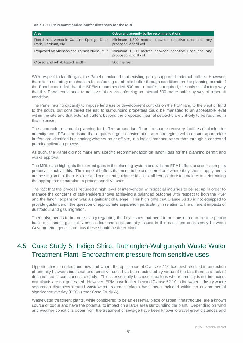
IPRBSD Technical Report
51
Table 12: EPA recommended buffer distances for the MRL
Area Odour and amenity buffer recommendations
Residential zones in Caroline Springs, Deer Park, Derrimut, etc
Minimum 1,500 metres between sensitive uses and any proposed landfill cell.
Proposed Mt Atkinson and Tarneit Plains PSP Minimum 1,000 metres between sensitive uses and any proposed landfill cell.
Closed and rehabilitated landfill 500 metres.
With respect to landfill gas, the Panel concluded that existing policy supported external buffers. However,
there is no statutory mechanism for enforcing an off-site buffer through conditions on the planning permit. If
the Panel concluded that the BPEM recommended 500 metre buffer is required, the only satisfactory way
that this Panel could seek to achieve this is via enforcing an internal 500 metre buffer by way of a permit
condition.
The Panel has no capacity to impose land use or development controls on the PSP land to the west or land
to the south, but considered the risk to surrounding properties could be managed to an acceptable level
within the site and that external buffers beyond the proposed internal setbacks are unlikely to be required in
this instance.
The approach to strategic planning for buffers around landfill and resource recovery facilities (including for
amenity and LFG) is an issue that requires urgent consideration at a strategic level to ensure appropriate
buffers are identified in planning; whether on or off site, in a logical manner, rather than through a contested
permit application process.
As such, the Panel did not make any specific recommendation on landfill gas for the planning permit and
works approval.
The MRL case highlights the current gaps in the planning system and with the EPA buffers to assess complex
proposals such as this. The range of buffers that need to be considered and where they should apply needs
addressing so that there is clear and consistent guidance to assist all level of decision makers in determining
the appropriate separation to protect sensitive uses.
The fact that the process required a high level of intervention with special inquiries to be set up in order to
manage the concerns of stakeholders shows achieving a balanced outcome with respect to both the PSP
and the landfill expansion was a significant challenge. This highlights that Clause 53.10 is not equipped to
provide guidance on the question of appropriate separation particularly in relation to the different impacts of
dust/odour and gas migration.
There also needs to be more clarity regarding the key issues that need to be considered on a site-specific
basis e.g. landfill gas risk versus odour and dust amenity issues in this case and consistency between
Government agencies on how these should be determined.
4.5 Case Study 5: Indigo Shire, Rutherglen-Wahgunyah Waste Water
Treatment Plant: Encroachment pressure from sensitive uses.
Opportunities to understand how and where the application of Clause 52.10 has best resulted in protection
of amenity between industrial and sensitive uses has been restricted by virtue of the fact there is a lack of
documented circumstances to study. This is essentially because situations where amenity is not impacted,
complaints are not generated. However, ERM have looked beyond Clause 52.10 to the water industry where
separation distances around wastewater treatment plants have been included within an environmental
significance overlay (ESO) (refer Case Study A).
Wastewater treatment plants, while considered to be an essential piece of urban infrastructure, are a known
source of odour and have the potential to impact on a large area surrounding the plant. Depending on wind
and weather conditions odour from the treatment of sewage have been known to travel great distances and

IPRBSD Technical Report
52
to linger for extended periods of time. In recent years water treatment practices have improved substantially
with advances in technology and processes resulting in reduced impact and disturbance.
While the water industry has improved practices the treatment of wastewater still requires a degree of
permanent separation from sensitive uses whereby the development of sensitive uses within a buffer is
prevented. The application of an ESO seeks to limit development associated with sensitive uses within the
required buffers sensitive uses.
In June 2001 the North East Regional Water Authority (NERWA) engaged Urban and Regional Planning to
undertake a review of implications of the existing planning schemes for the operation of NERWA’s wastewater
treatment facilities. One of the outcomes of the review was a recommendation to rezone the land surrounding
the waste water treatment plant from Farming Zone land to Public Use Zone and a request for Indigo Shire
Council to introduce an infrastructure policy into its planning scheme, which recognised the importance of
the plant and the need to protect a buffer surrounding the plant from the encroachment from sensitive uses.
An assessment undertaken into the emissions from the plant calculated that a separation distances of 330
metres for aerobic pond and 660 metres for facultative ponds was required in accordance with the EPA
Publication AQ 2/86 (‘Recommended Buffer Distances for Industrial Residual Air Emissions’ (July 1990))6.
The extent of the area covered by ESO-5 is illustrated below, noting that a number of other overlays apply to
the surrounding land.
Rutherglen-Wahgunyah Waste Water Treatment Plant
Schedule 5 to the ESO requires that a planning permit is not required to construct a building or construct a
building or carry out works unless the building or works are associated with Accommodation, Child care
centre, Education centre or Hospital on land which is within this schedule. Furthermore, Schedule 5 requires
that notice of applications to subdivide land or construct a building or construct or carry out works associated
with a sensitive use must be must be given under section 55 of the Planning and Environment Act 1987 to
North East Water as the referral authority.
These two features of the schedule to the overlay work together to ensure that applications for development
of land associated with sensitive uses within the area potentially affected by odour from the plant can be
considered on their merits and that long term strategic importance of the infrastructure is recognised and
preserved.
In addition to Schedule 5 of the ESO the importance of the wastewater treatment plant is recognised in the
Local Planning Policy Framework at Clause 22.04-3. The policy gives direction for the protection of the
6 EPA Publication AQ 2/86 was superseded by EPA Victoria Publication 1518, March 2013.

IPRBSD Technical Report
53
Rutherglen-Wahgunyah wastewater treatment plant within the municipality so that it can continue to serve
the present and future domestic and industrial treatment needs of the area. The objectives of the policy are:
To protect the operation of the wastewater treatment plant in a manner that is consistent with orderly
and proper planning and the protection of the environment.
To prevent the encroachment of sensitive land uses within the defined separation distance around the
wastewater treatment plant that may compromise the ability of the wastewater treatment plant to
service the needs of the community.
In this regard it is policy to:
Discourage the inappropriate encroachment of sensitive land uses in proximity to the wastewater
treatment plant that may compromise the ongoing operation of the plant.
Facilitate the ongoing operation of the wastewater treatment plant in a manner that is consistent with
the orderly and proper planning and the protection of the environment.
Determine any separation distance having regard to the EPA’s Recommended Buffer Distances for
Industrial Residual Air Emissions, Publication AQ2-86, (EPA 1990) or any environmental risk
assessment adopted by the relevant water authority, council and the EPA.
Identify the separation distance in an Environmental Significant Overlay (ESO) to provide a tool to
mitigate any detrimental non-routine odour impacts by ensuring there is suitable separation between
the wastewater treatment plant and sensitive land uses.
Review the extent of the separation distance that forms the basis of the ESO as part of the three year
planning scheme review in consultation with the EPA and the plant operators. The review is to have
regard to the future growth needs of the community or service district, adoption of best practice
technology, design and management, a revised risk assessment that may include air dispersion
modeling and any EPA Works Approvals and / or Licenses issued for the treatment plant, to ensure an
appropriate area is covered by the overlay.
The benefits of this approach highlight that the VPPs are equipped with appropriate mechanisms for
protecting strategically important industrial sites from encroachment by sensitive uses and reinforces the
agent of change principle by requiring a planning permit (rather than prohibiting) for uses that may be affected
by proximity to the site.
Triggering the need for a greater degree of consideration of the risks and potential impacts on encroaching
uses in combination with policy recognition has worked well in the context of the wastewater treatment plants.
It is considered that a similar approach could be applied to metropolitan areas identified as being strategically
important industrial or employment locations where substantial change and urban renewal is occurring in
surrounding areas.
The approach used by the NERWA has been applied to other regional wastewater treatment plants with a
number of examples of where this has occurred with amendments to the Moira Planning Scheme to introduce
an ESO for the Yarrawonga, Bundalong and Tungamah wastewater treatment plants providing encroachment
buffers of:
720 metres - Yarrawonga;
390 metres - Bundalong; and
220 Metres - Tungamah.
The extent of the buffer areas around the plants was calculated in accordance with the guidance by EPA
Publication 1518 (EPA Victoria 2013) based on projections for 2065 of peak population served by each
treatment plant and the type of installation within the plant.
These three examples show how existing tools within the Planning Schemes have been used to protect
buffers around critical industries and protect sensitive uses from potentially offensive odours. The
assessments on which the designated buffers were determined were based on the EPA Buffer Guidelines
and there is no clear consideration on 52.10 in the decision making process.

IPRBSD Technical Report
54
4.6 Case Study 6: National and International approches
A review has been undertaken of approaches taken in other jurisdictions to address the application of buffers
in planning decisions. Two jurisdictions have been reviewed below:
Ministry of the Environment Ontario Canada
Brisbane City Council and Queensland Planning Policy
There are some similarities in these systems that should be highlighted.
1. They are risk based and address issues beyond amenity impacts from odour and dust
2. They provide classifications of industry types rather than lists on individual industries. This enables
minimum separation distances to be set for an industry type rather than for each individual industry
which is done by a site-specific assessment
3. They provide zoning in the Planning Schemes for each industry classification with the lowest impact
industries closest to sensitive uses and high impact industries requiring a greater separation
The Canadian system also actively addresses encroachment of sensitive uses on existing industry or land
proposed for industrial use.
4.6.1 Ministry of the Environment Ontario Canada
The Ministry of the Environment in Ontario has developed a guide for land use planning authorities on how
to decide whether new development or land uses are appropriate to protect people and the environment.
This guideline identifies the direct interest of the Ministry in recommending separation distances and other
control measures for land use planning proposals to prevent or minimize adverse effects from the
encroachment of incompatible land uses where a facility currently exists or is proposed. The guideline sets
the context for all existing and new guidelines relating to land use compatibility. The approach used in the
guideline with respect to buffers is to identify a Class of industry (three classes of industries are defined) and
to establish three levels of buffers:
A minimum separation distance where no sensitive uses are allowed
An actual or potential influence zone where a site specific assessment is required to demonstrate that
there will be no adverse effects on any sensitive use
A distance beyond which no approvals are required
The approach used by the Ministry applies to both new industrial facilities as well as encroachment by a
sensitive use. The guideline is intended to apply only when a change in land use is proposed, however,
compatibility concerns should be recognized and addressed at the earliest possible stage of the land use
planning process for which each particular agency has jurisdiction. The intent is to achieve protection
from off-site adverse effects, supplementing legislated controls such as industrial licensing. The objective
of this guideline is to minimize or prevent, through the use of buffers, the exposure of any person,
property, plant or animal life to adverse effects associated with the operation of specified facilities.
Supporting documentation is provided that provides detailed guidance and definitions that are applicable
in the assessment and decision making process.
The guideline is applicable when:
a new sensitive land use is proposed within the influence area or potential influence area of an existing
facility; and/or
a new facility is proposed where an existing sensitive land use would be within the facility's influence
area or potential influence area.
The Guideline aims at protection of a sensitive use from adverse effects from a neighbouring industry. It
defines, consistent with the Ontario Environment Protection Act, adverse effects as one or more of:
a) impairment of the quality of the natural environment for any use that can be made of it,
b) injury or damage to property or to plant or animal life,
c) harm or material discomfort to any person,
d) an adverse effect on the health of any person,
e) impairment of the safety of any person,
f) rendering any property or plant or animal life unfit for use by man,
IPRBSD Technical Report
55
g) loss of enjoyment of normal use of property, and
h) interference with the normal conduct of business.
Sensitive land uses are defined as:
A building, 'amenity area' or outdoor space where routine or normal activities occurring at reasonably
expected times would experience one or more 'adverse effect(s)' from contaminant discharges generated by
a nearby 'facility'. The 'sensitive land use' may be a part of the natural or built environment. Depending upon
the particular 'facility' involved, a sensitive land use and associated activities may include one or a
combination of:
a) residences or facilities where people sleep (e.g. single and multi-unit dwellings, nursing homes,
hospitals, trailer parks, camping grounds, etc.). These uses are considered to be sensitive 24
hours/day.
b) a permanent structure for non-facility related use, particularly of an institutional nature (e.g. schools,
churches, community centres, day care centres).
c) certain outdoor recreational uses deemed by a municipality or other level of government to be sensitive
(e.g. trailer park, picnic area, etc.).
d) certain agricultural operations (e.g. cattle raising, mink farming, cash crops and orchards).
e) bird/wildlife habitats or sanctuaries.
The main responsibility for identifying and implementing the necessary steps to make a development
environmentally acceptable rests with the developer. As a result, the Ministry requests developers of land,
either industry or property developers, to provide information on potential or known constraints to
development and based on that information, identify necessary remedial measures. The types of studies and
remedial measures depend on the land in question and the use proposed for the land. Studies should be
prepared by qualified professionals to the satisfaction of the Ministry.
The Ministry expects planning authorities within the Province to identify, separate and/or otherwise protect
facilities and sensitive land uses through various means available to them. The guideline provides a
framework which municipalities and other approving authorities may use to make their own informed
decisions to reflect local conditions and the available planning mechanisms, including regulations, detailed
policies, guidelines and studies. Approving authorities should not allow development to proceed where there
are irreconcilable incompatibilities (i.e. significant impact(s) and no feasible remedial measures).
The guideline states that the separation distance should be sufficient to permit the functioning of the two
incompatible land uses without an 'adverse effect' occurring. Separation of incompatible land uses should
not result in freezing or denying usage of the intervening land. The distance is based on a facility's potential
influence area or actual influence area if it is known. When development is proposed beyond a facility's
potential influence area or actual influence area, the Ministry does not normally object to development on the
basis of land use compatibility.
Table 13: Industrial Classifications
Industrial
Facility
Operation Impact Potential
Class 1
A place of business for a small scale, self-
contained plant or building which
produces/stores a product which is contained
in a package and has low probability of fugitive
emissions. Outputs are infrequent, and could
be point source or fugitive emissions for any of
the following:
noise,
odour,
dust and/or vibration.
There are daytime operations only, with
infrequent movement of products and/or heavy
trucks and no outside storage.
Class 2
A place of business for medium scale
processing and manufacturing with outdoor
storage of wastes or materials (i.e. it has an
open process) and/or there are periodic
outputs of minor annoyance.
There are occasional outputs of either point
source or fugitive emissions noise, odour, dust
and/or vibration, and a low probability of
fugitive emissions.
Shift operations are permitted and there is
frequent movement of products and/or heavy
trucks during daytime hours.

IPRBSD Technical Report
56
Class 3 A place of business for large scale
manufacturing or processing, characterized by:
large physical size,
outside storage of raw and finished
products,
large production volumes, and
continuous movement of products and
employees during daily shift operations.
It has frequent outputs of point source and
fugitive emissions of significant impact and
there is high probability of fugitive emissions.
The guideline applies to all types of proposed, committed and/or existing industrial land uses which have the
potential to produce point source and/or fugitive air emissions such as noise, vibration, odour, dust and
others, either through normal operations, procedures, maintenance or storage activities, and/or from
associated traffic/transportation.
The guideline also establishes minimum separation distances and potential influence areas for industrial land
uses. Beyond the potential influence area, known as the acceptable range, development should not pose a
compatibility problem.
Table 14: Recommended minimum separation distances
Industrial
Facility
Operation Impact Potential Minimum
Separation
Distance
Potential
Influence
Area
Class 1
A place of business for a small scale,
self-contained plant or building which
produces/stores a product which is
contained in a package and has low
probability of fugitive emissions.
Outputs are infrequent, and could be
point source or fugitive emissions for
any of the following:
noise,
odour,
dust and/or vibration.
There are daytime
operations only, with
infrequent movement of
products and/or heavy
trucks and no outside
storage.
20 metres 70 metres
Class 2
A place of business for medium scale
processing and manufacturing with
outdoor storage of wastes or materials
(i.e. it has an open process) and/or
there are periodic outputs of minor
annoyance.
There are occasional
outputs of either point
source or fugitive emissions
noise, odour, dust and/or
vibration, and a low
probability of fugitive
emissions.
Shift operations are
permitted and there is
frequent movement of
products and/or heavy
trucks during daytime hours.
70 metres 300
metres
Class 3 A place of business for large scale
manufacturing or processing,
characterized by:
large physical size,
outside storage of raw and finished
products,
large production volumes, and
continuous movement of products
and employees during daily shift
operations.
It has frequent outputs of
point source and fugitive
emissions of significant
impact and there is high
probability of fugitive
emissions.
300 metres 1000
metres
These minimums are based on Ministry studies and historical complaint data. They also make allowance for
the fact that conventional zoning classifications usually permit a broad range of uses with varying potential
to create land use conflicts.

IPRBSD Technical Report
57
The actual influence area (overall range within which an adverse effect would be or is experienced) for a
particular facility is site-specific, and may be defined within, or in exceptional circumstances beyond, the
potential influence area either before, or where applicable, after buffers have been used to reduce, eliminate
or otherwise intercept adverse effects.
In the absence of specific substantiating information (normally obtained through technical studies) which
identifies an actual influence area, the potential influence areas set out in the guideline are used. Within the
potential influence area, adverse effects need to be identified, mitigation proposed and an assessment made
on the acceptability of the proposal.
Depending upon the situation, separation distances may be measured from different points:
1. General land use plans - separation distances should be applied from the designated industrial use
to the designated sensitive use
2. Site specific plans - Measurement should be from the closest existing, committed or proposed
property/lot line of the industrial land use to the property/lot line of the closest existing, committed or
proposed sensitive land use. This approach provides for the full use and enjoyment of both the
sensitive land use and the industrial properties.
3. Zoning/site plan control (industrial lands) – where a setback for any activity associated with the
industrial use that could create an adverse effect such as shipping and receiving or outside
storage/stockpiling of materials then the separation distance can be measured from the setback rather
than measuring from the industrial property line. It should be noted that this approach could restrict
future expansion of existing land uses.
4. Ancillary land uses (sensitive land use) - For sensitive land uses, where the established use of on-
site lands are not of a sensitive nature, such as a carpark, the land area comprising the carpark may be
included within the separation distance (i.e. measure from where the actual sensitive activities occur). It
should be noted that this approach could restrict future expansion of existing land uses.
The Ontario system provides a clear basis for decision making for new developments, either industrial or
residential development, that could be implemented in Victoria. The range of adverse effects considered and
the risk based approach to assessment with the influence zones is consistent with the broader role of the
EPA and is consistent with the current scope of Clause 52.10 that goes beyond just odour and dust. It also
puts the responsibility to determine the potential risk on the developer, either industry or the property
developer, to determine that there will be no adverse effects on sensitive uses.
The use of minimum separation distances to make clear decisions where development should not take place
makes the decision making process simple and the decision for developers to consider making a planning
application clear.
The Ontario guideline also recommends that when mitigation controls are to be installed on surrounding
properties, the local municipality or other approving authority should require an agreement between the
developer and the affected property owners, to ensure mitigation of adverse effects to the greatest degree
possible. The legal agreement between the developer and other affected parties to ensure adequate
mitigation should be reviewed and endorsed by Ministry staff and/or the delegated authority prior to
development approval. The Ministry also recommends that bonds be required by the approving authority to
ensure that mitigation will be carried out.
4.6.2 Queensland – Brisbane City Council and State Planning Policy
The Brisbane City Council has adopted a risk based approach for the siting of industrial facilities near
sensitive uses. It is similar to the Ontario approach. Industry is categorised into four classifications:
1. Low impact industry – can interface with sensitive uses
2. Medium impact industry – no direct interface with sensitive uses
3. High impact industry – no interface with sensitive uses or low impact industries
4. Noxious and hazardous industries – equivalent to major hazard facilities – no interface with sensitive
uses or low and medium impact industries
Industry zones within the Planning Scheme allows high impact industries to be zoned with medium and low
impact industries surrounding them to ensure that appropriate buffers are maintained between the relevant
IPRBSD Technical Report
58
industry types and the sensitive use. Transitioning areas in the Planning scheme are provided where one
type of industry transitions to the next classification. The local planning schemes provide the frameworks to
manage these transitions and to ensure that any interface between sensitive land uses and industrial uses
are managed to minimise impacts on human health, wellbeing, amenity and safety.
A development assessment code is included a part of the State Planning Policy 5/10: Air, Noise and
Hazardous Materials 2010 which establishes the criteria to assess acceptable outcomes for development
applications. The criteria include compliance with health based air quality standards, indoor noise quality
guidelines nuisance dust and odour criteria.
Similar to the Ontario system the State Planning Policy has trigger distances below which one of more
planning investigations must be conducted to demonstrate that the impacts from these industries have been
adequately considered in the local context. The trigger distances for each category of industry are shown
below:
1. Medium impact industry – 250m
2. High impact industry – 500m
3. Noxious or hazardous industry – 1500 m
Low impact industries can interface with sensitive uses.
The types of planning investigations required include community impact surveys, air, noise and odour
assessments, hazard and risk assessments and complaints analysis. Other investigations may be required
by the Department of Environment and Heritage Protection.
5 Appendices
Appendix 1: Clause 52.10 and IRAE comparison matrix

IPRBSD Technical Report
59
APPENDIX 1 CLAUSE 52.10 AND
IRAE COMPARISON MATRIX
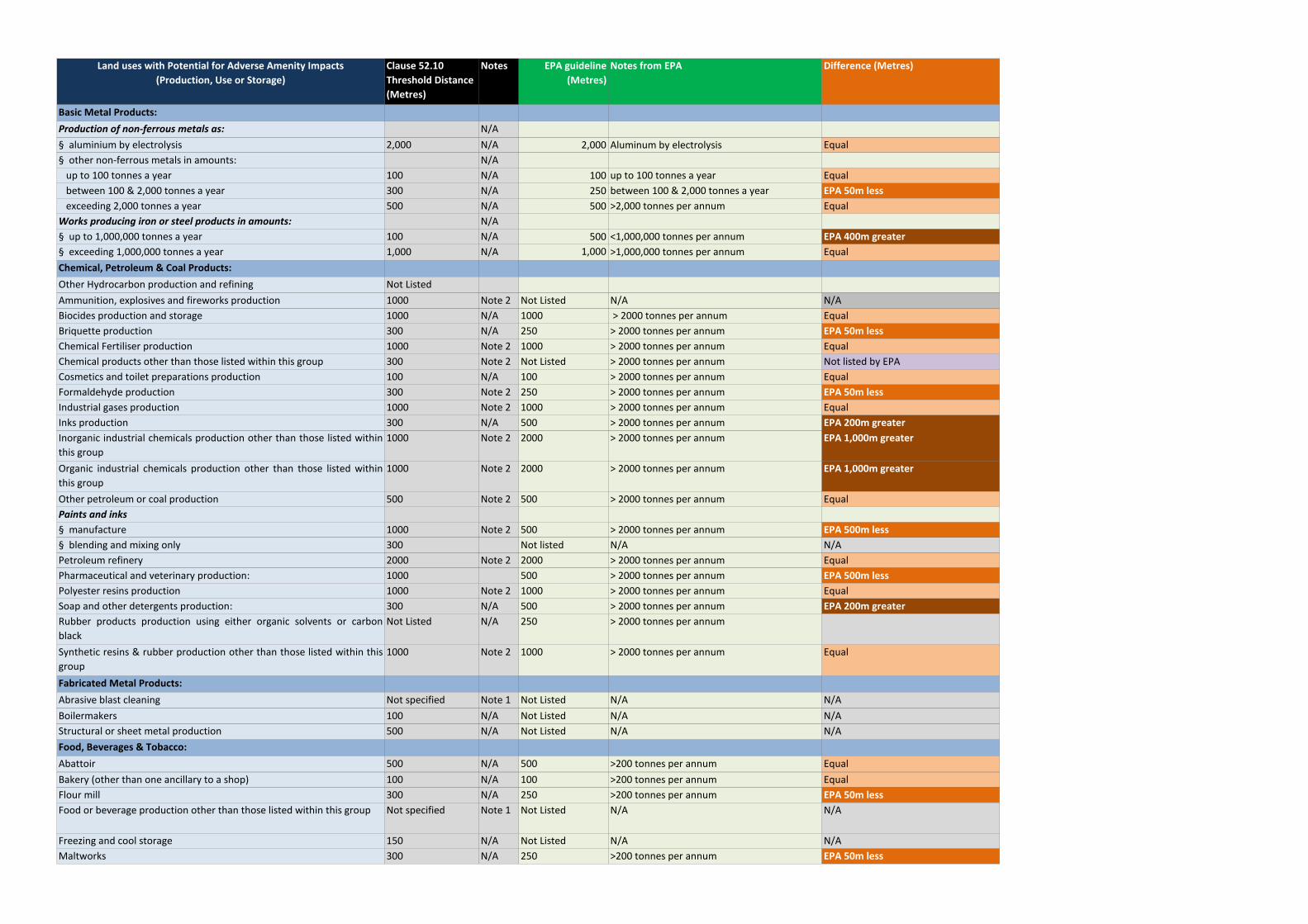
Land uses with Potential for Adverse Amenity Impacts
(Production, Use or Storage)
Clause 52.10
Threshold Distance
(Metres)
Notes EPA guideline
(Metres)
Notes from EPA Difference (Metres)
Basic Metal Products:
Production of non-ferrous metals as: N/A
§ aluminium by electrolysis 2,000 N/A 2,000 Aluminum by electrolysis Equal
§ other non-ferrous metals in amounts: N/A
up to 100 tonnes a year 100 N/A 100 up to 100 tonnes a year Equal
between 100 & 2,000 tonnes a year 300 N/A 250 between 100 & 2,000 tonnes a year EPA 50m less
exceeding 2,000 tonnes a year 500 N/A 500 >2,000 tonnes per annum Equal
Works producing iron or steel products in amounts: N/A
§ up to 1,000,000 tonnes a year 100 N/A 500 <1,000,000 tonnes per annum EPA 400m greater
§ exceeding 1,000,000 tonnes a year 1,000 N/A 1,000 >1,000,000 tonnes per annum Equal
Chemical, Petroleum & Coal Products:
Other Hydrocarbon production and refining Not Listed
Ammunition, explosives and fireworks production 1000 Note 2 Not Listed N/A N/A
Biocides production and storage 1000 N/A 1000 > 2000 tonnes per annum Equal
Briquette production 300 N/A 250 > 2000 tonnes per annum EPA 50m less
Chemical Fertiliser production 1000 Note 2 1000 > 2000 tonnes per annum Equal
Chemical products other than those listed within this group 300 Note 2 Not Listed > 2000 tonnes per annum Not listed by EPA
Cosmetics and toilet preparations production 100 N/A 100 > 2000 tonnes per annum Equal
Formaldehyde production 300 Note 2 250 > 2000 tonnes per annum EPA 50m less
Industrial gases production 1000 Note 2 1000 > 2000 tonnes per annum Equal
Inks production 300 N/A 500 > 2000 tonnes per annum EPA 200m greater
Inorganic industrial chemicals production other than those listed within
this group
1000 Note 2 2000 > 2000 tonnes per annum EPA 1,000m greater
Organic industrial chemicals production other than those listed within
this group
1000 Note 2 2000 > 2000 tonnes per annum EPA 1,000m greater
Other petroleum or coal production 500 Note 2 500 > 2000 tonnes per annum Equal
Paints and inks
§ manufacture 1000 Note 2 500 > 2000 tonnes per annum EPA 500m less
§ blending and mixing only 300 Not listed N/A N/A
Petroleum refinery 2000 Note 2 2000 > 2000 tonnes per annum Equal
Pharmaceutical and veterinary production: 1000 500 > 2000 tonnes per annum EPA 500m less
Polyester resins production 1000 Note 2 1000 > 2000 tonnes per annum Equal
Soap and other detergents production: 300 N/A 500 > 2000 tonnes per annum EPA 200m greater
Rubber products production using either organic solvents or carbon
black
Not Listed N/A 250 > 2000 tonnes per annum
Synthetic resins & rubber production other than those listed within this
group
1000 Note 2 1000 > 2000 tonnes per annum Equal
Fabricated Metal Products:
Abrasive blast cleaning Not specified Note 1 Not Listed N/A N/A
Boilermakers 100 N/A Not Listed N/A N/A
Structural or sheet metal production 500 N/A Not Listed N/A N/A
Food, Beverages & Tobacco:
Abattoir 500 N/A 500 >200 tonnes per annum Equal
Bakery (other than one ancillary to a shop) 100 N/A 100 >200 tonnes per annum Equal
Flour mill 300 N/A 250 >200 tonnes per annum EPA 50m less
Food or beverage production other than those listed within this group Not specified Note 1 Not Listed N/A N/A
Freezing and cool storage 150 N/A Not Listed N/A N/A
Maltworks 300 N/A 250 >200 tonnes per annum EPA 50m less

Manufacture of milk products: 300 N/A 250 if >200 tonnes per annum (see note* if <) EPA 50m less
Milk depot 100 N/A Not Listed N/A N/A
Poultry processing works 100 N/A 500 If no rendering EPA 400m greater
Production of vegetable oils and fats using solvents: 300 N/A 500 >200 tonnes per annum EPA 200m greater
Seafood processor 500 N/A 500 >200 tonnes per annum Equal
Smallgoods production 100 N/A 500 >200 tonnes per annum EPA 400m greater
Coffee roasting Not Listed 250 if >200 tonnes per annum (see note* if <) N/A
Pet food Not Listed 500 if >200 tonnes per annum (see note* if <) N/A
Vegetable oil and fat production using solvents Not Listed 500 if >200 tonnes per annum (see note* if <) N/A
Tobacco and cigarette production: 500 N/A Not Listed N/A
Miscellaneous Manufacturing:
Fibreglass production 200 N/A 250 >250 tonnes per annum EPA 50m greater
Leather and artificial leather goods production: 300 N/A 250 >250 tonnes per annum EPA 50m less
Leather tanning and dressing 300 N/A 250 >250 tonnes per annum EPA 50m less
Printing and coating works with heated curing ovens: 500 N/A 500 Emitting >100 kilograms per annum Equal
Rendering and casings works 1000 N/A 1000 >200 tonnes per annum Equal
Storage of wet-salted unprocessed hides Not Listed 250 N/A
Rubber production, using either organic solvents or carbon black 300 Note 2 250 >2,000 tonnes per annum EPA 50m less
Non-metallic Mineral Products:
Bitumen batching plant 500 N/A 500 >100 tonnes per week EPA 50m less
Cement production in amounts: N/A
<5,000 tonnes per annum 300 N/A 250 <5,000 tonnes per annum EPA 50m less
5,000 & 150,000 tonnes per annum 500 N/A 500 5,000 & 150,000 tonnes per annum Equal
>150,000 tonnes per annum 1000 N/A 1000 >150,000 tonnes per annum Equal
Clay bricks, tiles and pipe refractories, with a design production rate
exceeding 10,000 tonnes a year
200 N/A 250 >10,000 tonnes per annum EPA 50m greater
Concrete article or stone article production 100 N/A 100 >5000 tonnes per annum Equal
Concrete batching plant 300 N/A 100 >5000 tonnes per annum EPA 200m less
Cement clinker grinding: Not Listed N/A
<150,000 tonnes per annum 250 <150,000 tonnes per annum N/A
>150,000 tonnes per annum 500 >150,000 tonnes per annum N/A
Glass and glass production including glass wool 500 N/A 100 >5,000 tonnes per annum EPA 400m less
Plaster or plaster articles production 100 N/A 100 >5,000 tonnes per annum Equal
Rock wool manufacture 500 N/A 500 Equal
Other Premises:
Panel beating 100 N/A Not Listed N/A N/A
Rural industry handling, processing or packing agricultural produce 300 N/A Not Listed N/A N/A
Paper & Paper Products:
Paper or paper pulp production:
§ involving combustion of sulphur or sulphur containing materials 5000 Note 2 5000 involving combustion of sulphur or sulphur containing materialsEqual
§ from semi-processed materials 100 N/A 100 from semi-processed materials Equal
§ from prepared cellulose & rags 200 N/A 250 from prepared cellulose & rags EPA 50m greater§ by other methods than above None specified Note 1 Case by case by other methods than above Equal
Recreation, Personal & Other Services:
Dry cleaning for commercial and institutional customers, or in bulk
quantities
100 Note 2 Not Listed N/A N/A
Laundry for commercial and institutional customers, or in bulk
quantities
100 N/A Not Listed N/A N/A
Recycling and Resource Recovery:

Advanced resource recovery technology facility None specified Note 1 Case by case Equal
Combustion, treatment or bio-reaction of waste to produce energy None specified Note 1 Not Listed N/A N/A
Commercial and Industrial materials recycling None specified Note 1 Not Listed N/A N/A
Composting and other organic materials recycling. None specified Note 1 See further
guidelines
EPA refers to further guidelines
Construction and demolition materials recycling None specified Note 1 Not Listed N/A N/A
Other resource recovery or recycling operations None specified Note 1 Case by case Equal
Refuse and used material storage, sorting and recovery in a transfer
station:
(Waste
Management)
§ Accepting organic wastes None specified Note 1 See further
guidelines
BEPM EPA refers to further guidelines
§ Other 100 N/A See further
guidelines
BEPM EPA refers to further guidelines
Sanitary and garbage disposal in landfill None specified Note 1 See further
guidelines
BEPM EPA refers to further guidelines
Soil conditioning or blending None specified Note 1 Not Listed N/A
Used metals treatment or processing None specified Note 1 Not Listed N/A
Used paper and cardboard treatment or processing None specified Use
distanc
Not Listed N/A
Sewage Treatment Plant Not listed N/A N/A
Used plastics treatment or processing None specified Note 1 Not Listed N/A
Textiles:
Carpet backing with latex 300 N/A 250 EPA 50m less
Dyeing or finishing of cotton, linen and woollen yarns and textiles 300 N/A 250 EPA 50m less
Production of artificial fibres & textiles:
§ cellulose nitrate or viscose fibre, cellophane or artificial rubber 1000 Note 2 1000 Equal
§ other synthetic fibres and textiles 500 Note 2 500 Equal
Rope, cordage and twine production 100 N/A Not Listed Not listed by EPA
Treatment or production of textiles:
§ using carbon disulphide 500 Note 2 500 Equal
§ using other substances None specified Note 1 n/a Not listed by EPA
Wool scouring 200 N/A 250 EPA 50m greater
Transport and Storage:
Depot for refuse collection vehicles 100 N/A Not Listed N/A
Grain elevators 300 N/A Not Listed N/A
Storage of bulk volatile organic compounds in quantities greater than
1,000 tonnes
1000 Note 2 Not Listed N/A
Storage of petroleum products and crude oil in tanks exceeding 2,000
tonnes capacity:
300 N/A Not Listed N/A
§ with fixed roofs 100 Note 2 250 N/A
§ with floating roofs N/A 100 N/A
Storage of wet-salted or unprocessed hides 300 N/A 250 EPA 50m less
Temporary storage of industrial wastes 300 Note 2 Not Listed N/A
Treatment of aqueous waste 200 Note 2 Not Listed N/A
Waste incinerator for: N/A
§ Woodwaste 300 N/A Not Listed N/A
§ Plastic or rubber waste 500 Note 2 Not Listed N/A
§ Chemical, biomedical or organic waste Notes
1, 2
Not Listed N/A
Wood, Wood Products & Furniture:

Charcoal production
§ by the retort process 500 N/A Not Listed N/A
§ other than by the retort process 1000 N/A Not Listed N/A
Joinery 100 N/A Not Listed N/A
Sawmill 500 N/A 250 EPA 250m less
Wood preservation plant 100 N/A 100 Equal
Wood-fibre or wood-chip products 1500 N/A 250 Greater than 10,000 cubic metres of timber
per year
EPA 1,250m less
Agriculture:
Grain and stockfeed mill and handling facility Not Listed N/A 250 >20,000 tonnes per annum
mushroom farm Not Listed Case by case
piggery Not Listed Not specified refer National Environmental Guidelines for
Piggeries (APL, 2008)
Poultry (eggs, meat and bird production, incl quails, ducks turkeys,
geese and chickens)
Not Listed Not specified refer further guidance as listed below
for Meat Not Listed Not specified refer Vic. Code for Broiler Farms, DPI 2009
for free range meat Not Listed Not specified refer Planning Practice Note 63, 2012
for eggs (including free range) Not Listed Not specified refer Enviromental Guidelines for the Aust. Egg
Industry (AEC Ltd, 2008)
Stock feedlot Not Listed Not specified refer further guidance as listed below
Beef Not Listed Not specified refer Vic. Code for Cattle Feedlots, DPI 1995)
Dairy Not Listed 5000
Stock salesyard Not Listed 500 >500 head
Mining and extractive industry:
Open cut coal mine Not listed 1000
Gas and oil extraction Not listed 250
mine for other minerals Not listed 250
quarry Not listed
without blasting Not listed 250
with Blasting Not listed 500
with respirable crystalline silica Not listed 500
EPA Note* For food and beverage manufacturing producing less than 200 tonnes per annum, no separation distances are
specified. For these cases, EPA recommends there is no visible discharge of dust or emissions of odour offensive to
the senses of human beings, beyond the boundary of the premises.

ERM consulting services worldwide www.erm.com
ERM has over 160 offices across the following countries and territories worldwide
New Zealand Panama Peru PolandPortugalPuerto RicoRomania RussiaSingapore South Africa South Korea SpainSweden Taiwan Thailand United Arab Emirates UK US Vietnam
ArgentinaAustraliaBelgium BrazilCanadaChinaColombiaFranceGermanyHong Kong HungaryIndiaIndonesiaIreland Italy Japan KazakhstanMalaysiaMexicoThe Netherlands
ERM’s Melbourne Office
Level 6, 99 King Street, Melbourne, Victoria 3000 T: +61 0 9696 8011F: +61 3 9696 8022
www.erm.com