Embed Size (px)
Citation preview


Important Notice
The Report is qualified in its entirety by and should be considered in the light of AECOM’s Terms of Engagement
and the following:
1. The Report is provided solely for the purposes as outlined by Infrastructure Victoria for the purposes of high
level assessments of transport projects. Figures are produced for comparison purposes and should not be
relied upon for the purpose of budgeting or future project development. Nor should they be relied upon by
third parties or other bodies for any other purpose than those intended by Infrastructure Victoria.
2. AECOM has used its reasonable endeavours to ensure that the data contained in the Report reflects the
most accurate and timely information available to it in development of the project and is based on
information that was current as of the date of the Report.
3. The Report is based on estimates, assumptions and other information developed by AECOM from its
independent research effort, general knowledge of the industry and consultations with you, your employees
and your representatives. No warranty or representation is made by AECOM that any of the projected
values or results contained in the Report will actually be achieved. In addition, the Report is based upon
information that was obtained on or before the date in which the Report was prepared. Circumstances and
events may occur following the date on which such information was obtained that are beyond our control
and which may affect the findings or projections contained in the Report. We may not be held responsible
for such circumstances or events and specifically disclaim any responsibility therefore.
4. AECOM has relied on information provided by you and by third parties (Information Providers) to produce
the Report and arrive at its conclusions. AECOM has not verified information provided by Information
Providers (unless specifically noted otherwise) and we assume no responsibility and make no
representations with respect to the adequacy, accuracy or completeness of such information. No
responsibility is assumed for inaccuracies in reporting by Information Providers including, without limitation,
by your employees or your representatives or for inaccuracies in any other data source whether provided in
writing or orally used in preparing or presenting the Report.
5. In no event, regardless of whether AECOM’s consent has been provided, shall AECOM assume any liability
or responsibility to any third party to whom the Report is disclosed or otherwise made available.
6. The conclusions in the Report must be viewed in the context of the entire Report including, without
limitation, any assumptions made and disclaimers provided. The conclusions in this Report must not be
excised from the body of the Report under any circumstances.
7. Without the prior written consent of AECOM, the Report is not to be used in conjunction with any public or
private offering of securities or other similar purpose where it might be relied upon to any degree by any
person other than you.
8. All intellectual property rights (including, but not limited to copyright, database rights and trade marks rights)
in the Report including any forecasts, drawings, spreadsheets, plans or other materials provided are the
property of AECOM. You may use and copy such materials for your own internal use only.

Table of Contents
Executive Summary 2 1.0 Further exploration of major transport projects 4
1.1 Costing methodology overview 4 1.2 Contingency methodology 5
2.0 City Loop reconfiguration (CLR) – Preliminary costing 2 2.1 Scope 2 2.2 Capital costs 4
2.2.1 City Loop reconfiguration 4 2.2.2 City Loop reconfiguration works 5 2.2.3 Wallan extension 7 2.2.4 Rolling stock 10
2.3 Operational costs 10 2.4 Scope risk 10 2.5 Cost risk 10
3.0 Doncaster heavy rail line (DHR) – Preliminary costing 12 3.1 Scope 12 3.2 Capital costs 14
3.2.1 Land acquisition 15 3.2.2 Rolling stock 16 3.2.3 Comparison to previous study 16
3.3 Operational costs 16 3.4 Scope risk 16 3.5 Scope alternatives 16 3.6 Cost risk 16
4.0 Eastern Freeway to CityLink connection (EWE) – Preliminary costing 19 4.1 Scope 20
4.1.1 Plans 22 4.2 Operational costs 23 4.3 Scope risk 23 4.4 Scope alternative 23 4.5 Cost risk 24
5.0 Melbourne Airport heavy rail line – Preliminary costing 26 5.1 Scope 26 5.2 Capital costs 26
5.2.1 Land acquisition 29 5.2.2 Rolling stock 29
5.3 Operational costs 29 5.4 Scope risk 29 5.5 Scope Alternative 29 5.6 Cost risk 30
6.0 Melbourne Metro 2 – Preliminary costing 32 6.1 Scope 32
6.1.1 Alignments 32 6.1.2 Stations 33
6.2 Capital costs 34 6.2.1 Capital cost 34 6.2.2 MMS – Option 1 (Whole Project) 34 6.2.3 MMS – Option 2 (Newport to Parkville only) 37 6.2.4 Rolling stock 38
6.3 Operational costs 38 6.4 Scope risk 39 6.5 Scope alternatives 39 6.6 Cost risk 39
6.6.1 Geotechnical 39 6.6.2 Station structures and land acquisition 40
6.7 Staging 40 6.8 Cost benchmark 40
7.0 North-East link (NEL) – Preliminary costing 42 7.1 Scope 42 7.2 Capital costs 44

7.2.1 Land acquisition 47 7.3 Operational Costs 47 7.4 Scope risk 47 7.5 Scope alternatives 47 7.6 Cost risk 48
7.6.1 Geotechnical 48 7.6.2 Planning and environmental 48
8.0 Outer Metropolitan Ring Road – Preliminary costing 50 8.1 Scope 50 8.2 Capital costs 52 8.3 Operational costs 55 8.4 Scope risk 55 8.5 Scope alternative 55 8.6 Cost risk 55
8.6.1 OMR Geotechnical 55 8.6.2 E6 Geotechnical 55 8.6.3 Flora and Fauna 56
8.7 Staging options 56 9.0 Rowville heavy rail line (RHR) – Preliminary costing 58
9.1 Scope 58 9.2 Capital costs 58
9.2.1 Land acquisition 60 9.2.2 Rolling stock 61 9.2.3 Comparison to previous study 61
9.3 Operational Costs 61 9.4 Scope alternatives 61 9.5 Scope risk 61 9.6 Cost risk 61 Appendix A 1 Appendix B 1 Appendix C 1 Appendix D 1 Appendix E 1

List of Tables
Table 1 Direct option costs 2 Table 2 CLR – Lower bound costs 6 Table 3 CLR – Upper bound costs 7 Table 4 Wallan Electrification – Lower bound cost 8 Table 5 Wallan Electrification – Upper bound cost 9 Table 6 DHR – Lower bound costs 14 Table 7 DHR – Upper bound costs 15 Table 8 EWE (excl. Eastern Freeway widening) – Lower bound costs 21 Table 9 EWE (excl. Eastern Freeway widening) – Upper bound costs 21 Table 10 EWE (including widening) – Lower Bound costs 22 Table 11 EWE (including widening) – Upper Bound costs 22 Table 12 MAH – Lower bound costs 27 Table 13 MAH – Upper bound costs 28 Table 14 MMS (Option 1 – Whole Project) – Lower bound costs 35 Table 15 MMS (Option 1 – Whole Project) – Upper bound costs 36 Table 16 MMS (Option 2 – Newport to Parkville only) – Lower bound costs 37 Table 17 MMS (Option 2 – Newport to Parkville only) – Upper bound costs 38 Table 18 Widening costs – Lower bound 44 Table 19 Widening costs – Upper bound 44 Table 20 NEL with widening – Lower bound costs 45 Table 21 NEL with widening – Upper bound costs 46 Table 22 NEL excluding widening – Lower bound costs 46 Table 23 NEL excluding widening – Upper bound costs 47 Table 24 OMR – Lower bound costs 52 Table 25 OMR – Upper bound costs 53 Table 26 OMR Extension – Lower bound costs 54 Table 27 OMR Extension – Upper bound costs 54 Table 28 RHR – Lower bound cost 59 Table 29 RHR – Upper bound costs 60
List of Figures
Figure 1 CLR operational diagram 2 Figure 2 Network Development Plan – Stage 4 3 Figure 3 DHR illustrative alignment (excluding Burke Road station) 13 Figure 4 Alternative East-West link alignments 19 Figure 5 Preferred Eastern Freeway to CityLink connection alignment 20 Figure 6 Tunnelling profile 22 Figure 7 East West Link (east) ramps and intersections 23 Figure 8 Melbourne Metro 2 south-west section showing station opportunities 32 Figure 9 Melbourne Metro 2 north east section 33 Figure 10 Melbourne Metro projected capital costs 40 Figure 11 Illustrative NEL alignment 43 Figure 12 Outer metropolitan ring road indicative alignment 51 Figure 13 RHR illustrative alignment 58 Figure 14 CLR – 1:250,000 Surface Geology Map a Figure 15 MMS – Near-surface geology North East of Spencer Street Station a Figure 16 MMS – Near-surface geology from Southern Cross Station to Webb Dock b Figure 17 MMS – Near-surface geology west of the Yarra River d Figure 18 North-East link alternatives 1 a Figure 19 North-East link alternatives 2 b Figure 20 Generic Alignment of proposed North-East Link Tunnel a
List of Boxes
Box 1 Wallan rail electrification (WRE1) 4

Executive Summary
AECOM has undertaken preliminary costings for eight major projects for Infrastructure Victoria. The purpose of
these costings is to provide consistent inputs in the development of Benefit-Cost Ratios for each project.
Infrastructure Victoria will then measure the costs against modelled benefits in their development of an overall
infrastructure strategy.
The method of costing has been done based on publicly available information, as well as a VITM model produced
by ARUP in 2016.
Methodology was largely kept consistent across the projects and exceptions are noted in the body of the report
where this differs. The projects direct costs are summarised in the table below, which includes the capital, rolling
stock and whole-of-life PV operational costs. While some projects had previous more detailed costings available
from previous studies, in order to maintain consistency, projects which had not progressed to business case
stage were all considered using the same methodology. A summary of the various direct option costs is
presented in Table 1 below.
Table 1 Direct option costs
Option name
Direct option cost
($ real 2016)
City Loop reconfiguration CLR $4.5 billion – $6.5 billion
City Loop reconfiguration (without Wallan electrification) CLR $2.1 billion – $3.1 billion
Doncaster heavy rail line (to Doncaster Hill) DHR $3.3 billion – $4.4 billion
Eastern Freeway to CityLink connection EWE $6.7 billion – $8.6 billion
Eastern Freeway to CityLink connection (excluding Eastern
Freeway widening)
EWE $6.4 billion – $8.2 billion
Melbourne Airport heavy rail line MAH $3.0 billion – $3.9 billion
Melbourne Metro 2 MMS $15.4 billion – $22.9 billion
Melbourne Metro 2 (Newport to Parkville only) MMS $9.5 billion – $13.0 billion
North-East link (Bulleen alignment) NEL $4.9 billion – $7.2 billion
North-East link (excluding Eastern Freeway widening) NEL $4.7 billion – $6.9 billion
Outer metropolitan ring road (including Melbourne Airport connection) OMR $8.8 billion – $13.2 billion
Rowville heavy rail line RHR $5.7 billion – $8.5 billion
Source: AECOM
The City Loop reconfiguration (CLR) involves modifying the existing Melbourne Underground Rail Loop (MURL),
the Northern loop line and the Caulfield loop lines. This will allow increased capacity, particularly on the Upfield,
Craigieburn and rail lines to the south east. This will involve constructing new links via tunnelling, upgrading
signalling, constructing a new rail flyover and upgrades of rolling stock. Due to the complexity and unique nature
of the project the CLR has been costed without using the same risk profiles as the other costings.
The project will also enable the Wallan electrification, which involves electrification of the existing track between
Wallan and Craigieburn and the upgrade and construction of stations.
The Doncaster heavy rail (DHR) involves the construction of a new heavy rail link that will extend from Doncaster
Hill, along the Eastern Freeway; before connecting with the Clifton Hill heavy rail loop near Collingwood station.
This project is dependent on the Melbourne Metro 2 project as more capacity is currently required for the Clifton
Hill loop line.
The Eastern Freeway to CityLink connection (EWE) is the construction of a road link that will provide increased
connectivity from the east to west. There are a number of different alignments that are possible but for the
purposes of this report the road will consist of a six lane link from the Eastern Freeway to CityLink via the
previous East-West Link alignment. This project also includes widening works on the Eastern Freeway.
The Melbourne Airport heavy rail line (MAH) is a proposed twin track rail link between the Melbourne
(Tullamarine) Airport and Melbourne’s central city. The alignment which is investigated in this report will be via
the existing Albion East reservation which services would then run via the Melbourne Metro rail tunnel and
through to the south-east. The purpose of this rail line would be to provide direct connectivity to the airport, with
passengers able to easily access airport services.
The Melbourne Metro 2 (MMS) is a proposed new heavy rail connection that will run between Clifton Hill and the
CBD through to Fisherman's Bend and Newport by two new rail tunnels. This rail connection will allow separation
of the high growth South Morang – Southern Cross line from the Clifton Hill group. By constructing this additional
tunnel there will be additional capacity between Clifton Hill and Southern Cross, allowing for more services on the
Hurstbridge, Mernda and proposed Doncaster Rail line. It will also give the Werribee line improved capacity and
the Clifton Hill group will be able to undergo future improvements.
The North-East link (NEL) will create a road link between the Eastern Freeway and the M80 in Greensborough.
The alignment that has been costed is the Bulleen alignment in which the road is assumed to tunnel under the
Yarra River and to Bulleen where it connects with the Eastern Freeway. The purpose of this road project is to
improve the outer north-south links for road freight movement and travel time and reliability for road users.
The proposed Outer Metropolitan Ring Road (OMR) project will be the construction of a new road to improve
orbital and cross-Melbourne freight vehicle access and connections to the north and east from key freight
precincts in the west. This option will also improve access to employment in north and western metropolitan
Melbourne.
The Rowville heavy rail line (RHR) will be new rail line which will improve the connection between Rowville, the
Monash Employment Centre and the central city area, as well as decreasing road congestion. The alignment will
begin at Huntingdale Station and run east along the central median of North Road and Wellington Road to Stud
Road, then turning north to terminate at Stud Park using a mixture of tunnelled, at-grade and elevated rail
structures.

1.0 Further exploration of major transport projects
Through the option development process (Assessment 1, Assessment 2 and consultation), eight significant
transport projects have been identified by Infrastructure Victoria for a greater level of evaluation (including cost
benefit analysis) due to their scale, cost, and complexity. Preliminary evaluation of such options is consistent with
the approach taken for other major Victorian transport projects. In the case of policy and technology options,
there is also an opportunity to build an evidence base for the effectiveness of demand management, and better
utilising existing assets.
The preliminary evaluation of options directly supports the development of the Strategy, while fulfilling
Infrastructure Victoria’s other roles of providing advice to the Victorian Government, and publishing research on
infrastructure matters.
AECOM has undertaken evaluations of cost for Infrastructure Victoria for the purpose of preparing Benefit-Cost
Ratios for each of the following major projects:
- City Loop reconfiguration (CLR)
- Doncaster heavy rail line (DHR)
- Eastern Freeway to CityLink connection (EWE)
- Melbourne Airport heavy rail line (MAH)
- Melbourne Metro 2 (MMS)
- North-East link (NEL)
- Outer metropolitan ring road (OMR)
- Rowville heavy rail line (RHR).
To establish option benefits, Infrastructure Victoria has commissioned transport modelling using the State
Government’s Victorian Integrated Transport Model (VITM). This work will be used to determine the impact of the
eight significant transport projects on travel demand and behaviour, and ultimately, accessibility and level of
service in the network. It is understood that benefits are to be quantified using accepted DEDJTR Transport
modelling approaches, including guidance for incorporation of wider economic impacts for Victorian projects.
Option benefit and cost estimates will then be combined to produce a range of benefit cost ratios for the different
options. Benefit cost ratios will enable comparison of the relative impacts of the options, a key input to the
Strategy.
Please note that, as AECOM did not undertake the calculation of benefits, we cannot guarantee that the
assumptions costed in this report align completely with the estimated benefits however all reasonable efforts
have been made to do so.
1.1 Costing methodology overview
In order to assess the eight transport options, AECOM has collected the best available public information with
regard to previous planning related to the options. Public data, and data provided by Infrastructure Victoria, has
formed the basis of assumptions about option factors such as alignment, construction approach, technologies,
and land acquisition for the purposes of costing.
In forming assumptions about the options, AECOM relied on a VITM model provided by Arup (2016) which
outlines general alignments, interchanges and station locations to inform costings but may not have considered
station depths, rail operating speeds of chosen alignments or other operational variations. The general
alignments, interchanges and station locations are simply modelling assumptions and may not have been
subjected to assessment against alternatives.
Cost rates have been developed using AECOM’s experience, effort, independent research and general
knowledge of the industry as well as several industry consultations.
Quantities for those projects for which they have been calculated have been based on best available alignments
with limited knowledge of geotechnical conditions or ground conditions and services. While AECOM has
endeavoured to provide accurate and viable cost estimates, some projects involved preparing general alignments
which AECOM cannot confirm are viable without further investigation.

AECOM has cross referenced the costings provided in this report with other publically available information and
believe they are broadly consistent, but note that previous studies may have been undertaken using a different
set of assumptions. These previous studies and available information were also undertaken in isolation. For the
purposes of providing a fair comparison the costings in this report have all been provided at a high level suitable
for strategic assessment.
The same methodology was applied to the costings of the projects and exceptions have been noted were
appropriate. The following approaches were applied to all preliminary option costings:
- Price escalation has not been included for net present values of capital or operational costs and therefore
the nominal cost incurred for projects would need be escalated from the 2016-based prices presented in
these costings. As none of the projects are expected to commence in 2016, cost escalation should be
applied when considering use in further years.
- The design life of most elements such as formations and road structures has been assumed to be
100 years, while the operational life has been assumed to be 50 years as a conservative assumption
implying the likely need for upgrades in the 50 – 100 year period.
- Projects were costed predominantly on a per kilometre basis with the exception of the option CLR. This
option is an exception in that it contains a number of discrete projects which may vary in overall cost, rather
than on a per kilometre basis. Other projects have more homogenous costs per kilometre, and so the
number of kilometres required is the key driver of cost.
- Implementation schedules estimated involve design lead times as well as construction and commissioning
time. Schedules are presented starting from the equivalent of the award of a Design and Construct contract
to undertake the works, through to the opening of the project for public use. The schedules therefore does
not include the required time for related elements such as planning approvals (though planning approvals
have been commented on in relation to timing under some options), environmental approvals or preparation
of business cases or reference designs.
The following approaches were applied to specific preliminary option costings:
- For rail tunnels, the cost of construction includes the cost of the tunnel formation with rail related
infrastructure included as a separate line item. This affects options CLR, DHR, MMS and RHR.
- For road tunnels, the cost used was based on best available information which includes the cost of
associated infrastructure such as fire systems, signalling and communications, pavement and lighting. This
affects options EWE and NEL.
- Indirect costs have been included on a consistent basis across road and rail projects, though it is noted
that the indirect costs of road projects are lower than the indirect costs of rail projects due to higher costs
related to rail occupations and approvals.
1.2 Contingency methodology
The inclusion of contingency has been made with a consistent approach. In costing projects at this strategic level
it is important to be consistent so that projects can be ranked on a like for like basis.
As each of the projects is at a different stage of development and knowledge base we have adopted a
conservative estimate of contingency to allow for risk. This contingency method is consistent with the AustRoads
Research Report Improving Practice in Cost Estimation of Road Projects, (2011) and ‘Best Practice’ cost
estimation in land transport infrastructure projects (2010) produced by ARRB.
The first stage involves including the ‘inherent’ risk involved in any project to allow for known likely cost increases
such as service relocations, cost escalation, realignments and other associate works which are likely to be
discovered at later stages of project development. The cost including the inherent risk is included as a flat rate
across cost items as the ‘lower bound cost’ for each project.
A ‘contingent’ risk element has then been included to allow for larger unknowns for projects estimated at this
strategic stage. This may include major realignments or large additional costs which may result from unknown
items which may include, but is not limited to, ground contamination, unexpected geotechnical challenges, major
scope additions etc. The cost including this contingency factor is included as the ‘upper bound cost’ for each
project.
While for some projects such as Melbourne Metro 2 (MMS) these risks are far greater due to the very preliminary
level of existing information and for others such as the Outer metropolitan ring road (OMR), the risks may be
more well known, we have adopted a consistent approach, and rate, across all projects for which scope and
expected cost is easily defined so they can be considered on a like for like basis at this strategic level. To provide
varying contingency rates based on levels of evidence at this early stage of most projects would disadvantage
undeveloped projects against the other projects which are at a later stage of development.
This cost method has been adopted for all projects for which we have confidence in cost rates and the likely
quantities on a like-for-like basis. For the City Loop reconfiguration (CLR) there is significant uncertainty around
both quantity and likely cost due to the constrained inner-city environment and impacts on and by surrounding rail
services and infrastructure. For this project we have selected upper bound and lower bound likely costs for each
cost item. A contingency for risk has then been added to both the lower and upper bound costs to account for
both inherent and contingent risk in the project. While this may be inconsistent with the other project costings, the
nature of the CLR project is such that the risk to the lower bound cost is as likely as the upper bound cost.
For the Eastern Freeway to City Link connection (EWE) project due to the late stage of development and without
line item costs, contingency has been added at a lower rate (30 percent) and only applied to the upper bound
cost with the lower bound cost not including a contingency.
At the strategic level of assessment, the contingency method applied is aimed at providing the most accurate
costings without compromising the ability to compare projects.

City Loop reconfiguration
CLR
Supplement C – Major transport projects – preliminary costings Page 1
City Loop reconfiguration CLR
Infrastructure Victoria’s option description
Reconfigure the Melbourne Underground Rail Loop (MURL) Northern and Caulfield loop lines to increase
capacity particularly on the Upfield, Craigieburn and South East rail lines and to enable Wallan electrification. The
works will include new tunnelling links, signalling upgrades, a new rail flyover and rolling stock. This upgrade and
reconfiguration will enable additional services to be run through the core of the rail network, support extensions to
the network and allow for the creation of standalone end-to-end rail lines. Further operational details are outlined
in the PTV Network Development Plan – Metropolitan Rail, December 2012. This option will increase access to
the city centre and the overall resilience of the network.
Scope summary
Construction of additional rail tunnels between Parliament and Richmond and North Melbourne and Flagstaff
would allow trains for a through running operation and free up a track pair on the Flinders Street viaduct.
Sector
Transport
Certainty of evidence
Low
Evidence base
Network Development Plan – PTV 2012
Direct option cost (incl. rolling stock)
$2.1 billion – $3.1 billion
Including Wallan electrification:
$4.5 billion – $6.5 billion
Capital cost
$1.8 billion – $2.8 billion
Including Wallan electrification:
$3.1 billion – $4.9 billion
Annual recurrent costs
$2 million – $4 million
Whole-of-Life PV: $55 million
Including Wallan electrification
$51 million – $67 million
Whole-of-Life PV: $926 million
Construction period
4 years
Operational life (from opening)
50 years
Cost certainty
Certainty of evidence – Low
There is significant cost risk with unknown
geological and local ground conditions in particular
around the Dudley Street Bridge.
Actual cost will be higher as these figures do not include price escalation for future years.

City Loop reconfiguration
CLR
Supplement C – Major transport projects – preliminary costings Page 2
2.0 City Loop reconfiguration (CLR) – Preliminary costing
2.1 Scope
The scope considered for construction under this project includes the enabling works to convert City Loop
services to through-running metro-style train corridors. Construction projects required to enable these works
include:
- New tunnel link between Flagstaff (Caulfield Loop) and North Melbourne platform 2. This will enable trains
from Craigieburn to run into the Caulfield Loop to Flagstaff, then exit via the existing portal at Richmond
platform 5 and continue to Frankston via Parliament.
- New tunnel link between Parliament (Northern Loop) and Richmond platform 3. This will enable trains from
Frankston to run into the Northern Loop to Parliament, and then exit via the existing western portal at North
Melbourne on to Craigieburn via Flagstaff.
- Enabling works for new tunnel link from City Loop to Burnley line to facilitate through running from Clifton
Hill Loop Line to Ringwood Loop Line for the purposes of stabling and maintenance.
- New fly-over from the Upfield line to the through suburban lines at North Melbourne (over other Northern
Group tracks).
- Bi-directional signalling at North Melbourne platform 1 to enable operation of city-bound and outbound
Seymour services to Southern Cross.
- Additional platform and associated track and signalling at North Melbourne.
A map of the Network Development Plan – Stage 4 (with option CLR implemented) is displayed below in Figure 1
and Figure 2.
Figure 1 CLR operational diagram
Source: PTV (2012)
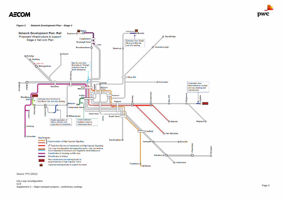
City Loop reconfiguration
CLR
Supplement C – Major transport projects – preliminary costings Page 3
Figure 2 Network Development Plan – Stage 4
Source: PTV (2012)

City Loop reconfiguration
CLR
Supplement C – Major transport projects – preliminary costings Page 4
2.2 Capital costs
Capital costs have been calculated for this project in a slightly different method to other projects in this document.
This project has a number of key components which could vary largely in size, such as connections to existing
tunnels and integration with existing rail yards. Connecting to older tunnels could result in significant re-
construction of the existing tunnels. Other assets will also be affected which may vary largely in cost depending
on the existing conditions and ability to avoid services or other obstacles.
The unique geotechnical and structural challenges as well as the limited level of detail of existing conditions
means there is greater uncertainty in these costings.
The cost ranges for the upper and lower bounds have been estimated based on available information, but there
is still a substantial risk for all cost areas, therefore a 50 percent contingency has been added to both the lower
and upper bound cost to provide a similar level of confidence as other projects which have costs that can be
more easily estimated from previous projects.
Capital costs are based on cut and cover tunnelling for the North Melbourne – Flagstaff tunnel. For the section
between Parliament and Richmond, the geotechnical investigation favoured a road header or drill and blast
construction through rock between Jolimont and Parliament. Cut and cover while reconstructing rail on top would
be used through the Jolimont rail yards to Richmond. Costs for either method are approximately the same but
have different implications on surrounding infrastructure.
There are significant operational disruptions resulting from the cut and cover tunnelling proposed through the
Jolimont Yard. The works will require cascading closures of tracks as the works progress through yard. There is a
high level of cost uncertainty associated with these disruptions as the duration and number of track closures will
not be known until further investigations are completed.
The Wallan extension has also been included in the capital costs and is described in Box 1.
Box 1 Wallan rail electrification (WRE1)
Infrastructure Victoria’s option description
Extend the electrified metropolitan rail network to Wallan. The scope includes the utilisation of the Upfield Line via
the reinstatement of tracks between Upfield to Somerton with duplication of the track between Gowrie and
Upfield, construction of a new track pair from Roxburgh Park to Craigieburn and electrification works between
Upfield and Wallan.
This extension to the electrified network will give greater access to the new growth areas in Melbourne’s north
through additional services to Seymour, Wallan, Upfield and Craigieburn. It will improve capacity and reliability
across all these lines and operations across the network.
Furthermore it will enable more efficient access to central Melbourne and support access to jobs and services.
Source: Infrastructure Victoria
The Wallan extension requires electrification of 20km of track from Craigieburn to Wallan as well as three grade
separations at Summerhill Road, Donnybrook Road, Beveridge Road and Wallan-Whittlesea Road. A new station
would also be constructed at Beveridge. A new connection between Roxburgh Park and Craigieburn involving
electrification of a new track pair is included in the costing.
2.2.1 City Loop reconfiguration
Costs involve two working areas:
- North Melbourne – Flagstaff
- Parliament – Richmond
The costs involved at the North Melbourne – Flagstaff section include re-aligning the existing portal area south of
North Melbourne station to create a new portal then continuing this tunnel under the Dudley Street Bridge, and
then passing over the existing Northern Loop tunnel before continuing under Latrobe Street where a connection
with the existing Caulfield Loop will need to be made.
As outlined in the geological assessment in Appendix A, a road header or cut and cover methods may be used to
construct the tunnel section.
The alignment in the vicinity of the Dudley Street Bridge runs generally along the interface between the
Tullamarine Basalt and Coode Island Silt. Underneath the Dudley Street Bridge, foundations are unknown;
therefore the costs of progressing through this section cannot be accurately estimated. We have assumed a cost
range from $20 million to $100 million. The low estimate would be if the tunnel could be constructed through

City Loop reconfiguration
CLR
Supplement C – Major transport projects – preliminary costings Page 5
basalt without impacting on bridge foundations, the high estimate represents what the costs might be to adjust
existing foundations or reconstruct part of the Dudley Street Bridge as part of the project.
The Parliament station section has two distinctly separate tunnelling sections. From Richmond to Wellington
Parade requires a new tunnel portal and a cut and cover tunnel through the existing rail yards. To cut and cover
the tunnel across the rail yards would require reconstructing tracks on structure above the new tunnel.
At Wellington Parade, the tunnel is expected to be a driven tunnel although it is not known where the
colluvium/newer volcanic and Melbourne Formation geologies begin and end along the alignment without more
detailed investigation. It is likely that a driven tunnel using a road header could be used in conjunction with drill
and blast tunnelling techniques.
Due to the uncertainty around quantities as well as costs for the various line items which are heavily dependent
on existing conditions of infrastructure and possible scope increases, costing for the CLR has been undertaken
using a low-high range for each cost item and then adding a contingency of 50 percent to the overall total.
Additional scope could include large ticket items such as tunnel reconstructions existing rail infrastructure
replacement and other large scale items.
2.2.2 City Loop reconfiguration works
The lower and upper bound costs for option CLR can be found in Table 2 and Table 3.

City Loop reconfiguration
CLR
Supplement C – Major transport projects – preliminary costings Page 6
Table 2 CLR – Lower bound costs
Item Quantity Unit cost
Cost per element
(millions)
North Melbourne – Flagstaff
Loop Tunnel modification - $25 million $25
Tunnel 1,000 metres $100,000 per m $100
Portal modifications 1 $30 million each $30
Dudley Street Bridge tunnelling - $20 million $20
North Melbourne flyover - $10 million $10
Parliament – Richmond
Northern Loop Tunnel modification - $20 million $20
Northern tunnel 350 metres $100,000 per m $35
Rail yard tunnel 950 metres $100,000 per m $95
Replacement rail on structure 2,700 metres $120,000 per m $324
Power and communications
Signalling and communications 5,002 metres $10,000 per m $50.02
Temporary works
Train disruption, re-routing and replacement - $50 million $50
Total direct $759.02
Indirect costs
Site works 25% of direct costs $189.75
Margin 8% of direct costs $60.72
Design work 15% of direct costs $133.85
Government costs 20% of direct costs $75.90
Total indirect $440.23
Lower bound sub-total $1,199.25
+ 50% contingency $1,798.88
Source: AECOM

City Loop reconfiguration
CLR
Supplement C – Major transport projects – preliminary costings Page 7
Table 3 CLR – Upper bound costs
Item Quantity Unit cost
Cost per element
(millions)
North Melbourne – Flagstaff
Loop Tunnel modification - $35 million $35
Tunnel 1,000 metres $150,000 per m $150
Portal Modifications 1 $75 million each $75
Dudley Street Bridge tunnelling - $100 million $100
North Melbourne flyover - $15 million $15
Parliament – Richmond
Northern Loop modification - $50 million $50
Northern tunnel 350 metres $150,000 per m $52
Rail yard tunnel 950 metres $150,000 per m $142.5
Replacement rail on structure 2,700 metres $150,000 per m $405
Power and communications
Signalling and communications 5,002 metres $14,000 per m $70.03
Temporary works
Train disruption, re-routing and replacement - $100 million $100
Total direct $1,195.03
Indirect costs
Site works 25% of direct costs $298.76
Margin 8% of direct costs $95.60
Design work 15% of direct costs $179.25
Government costs 20% of direct costs $119.50
Total indirect $693.11
Upper bound sub-total $1,888.14
+ 50% contingency $2,832.22
Source: AECOM
Signalling costs are higher under this project as it is possible that signalling and communications would need to
be reconfigured through large sections of the tunnel beyond the sections of the tunnel being changed. The higher
cost reflects the likely possibility of replacement signalling extending further than the study area. The shorter
distance also means some economies of scale are not realised as with other projects.
2.2.3 Wallan extension
The Wallan extension which has been costed includes electrification of the existing track pair between Wallan
and Craigieburn and rebuilding Donnybrook and Wallan stations, with new stations at Beveridge and Lockerbie.
The construction of the Upfield to Somerton link has been assumed to be a new track pair replacing the existing
track. This section also requires duplication of track between Gowrie and Upfield with two new tracks. New
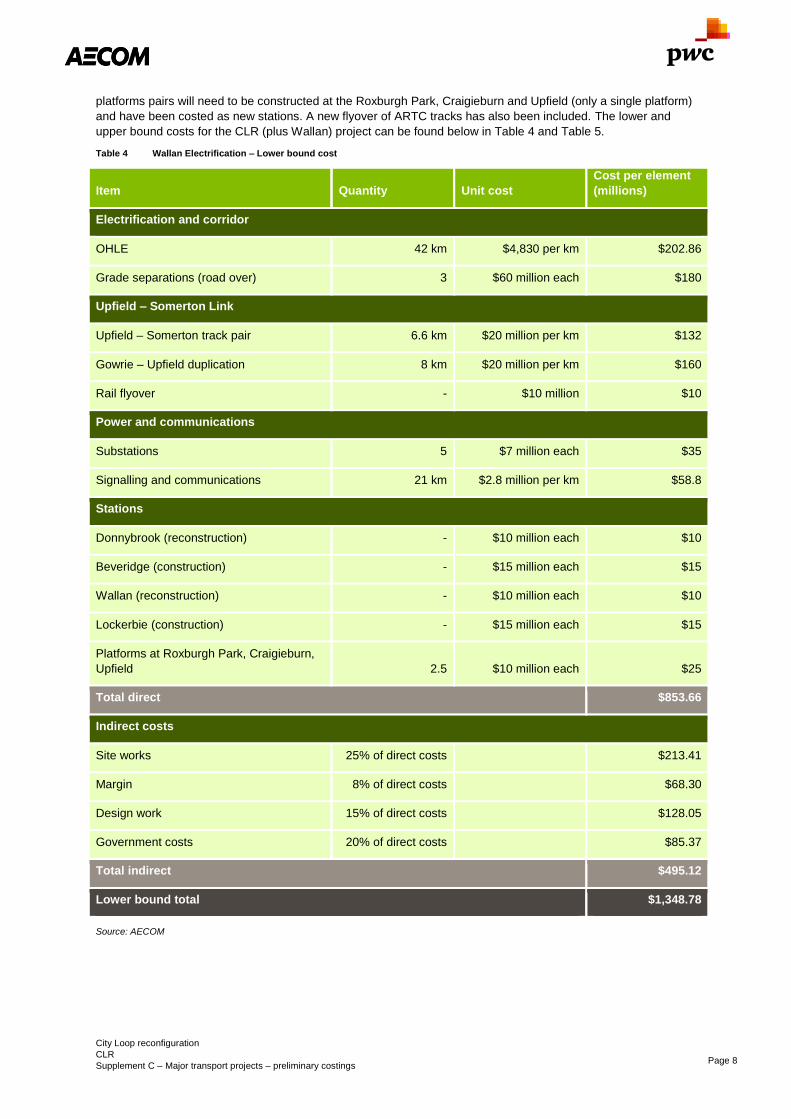
City Loop reconfiguration
CLR
Supplement C – Major transport projects – preliminary costings Page 8
platforms pairs will need to be constructed at the Roxburgh Park, Craigieburn and Upfield (only a single platform)
and have been costed as new stations. A new flyover of ARTC tracks has also been included. The lower and
upper bound costs for the CLR (plus Wallan) project can be found below in Table 4 and Table 5.
Table 4 Wallan Electrification – Lower bound cost
Item Quantity Unit cost
Cost per element
(millions)
Electrification and corridor
OHLE 42 km $4,830 per km $202.86
Grade separations (road over) 3 $60 million each $180
Upfield – Somerton Link
Upfield – Somerton track pair 6.6 km $20 million per km $132
Gowrie – Upfield duplication 8 km $20 million per km $160
Rail flyover - $10 million $10
Power and communications
Substations 5 $7 million each $35
Signalling and communications 21 km $2.8 million per km $58.8
Stations
Donnybrook (reconstruction) - $10 million each $10
Beveridge (construction) - $15 million each $15
Wallan (reconstruction) - $10 million each $10
Lockerbie (construction) - $15 million each $15
Platforms at Roxburgh Park, Craigieburn,
Upfield 2.5 $10 million each $25
Total direct $853.66
Indirect costs
Site works 25% of direct costs $213.41
Margin 8% of direct costs $68.30
Design work 15% of direct costs $128.05
Government costs 20% of direct costs $85.37
Total indirect $495.12
Lower bound total $1,348.78
Source: AECOM

City Loop reconfiguration
CLR
Supplement C – Major transport projects – preliminary costings Page 9
Table 5 Wallan Electrification – Upper bound cost
Item Quantity Unit cost
Cost per element
(millions)
Electrification and corridor
OHLE 42 km $7,245 per km $304.29
Grade separations (road over) 3 $100 million each $300
Upfield – Somerton link
Upfield – Somerton track pair 6.6 km $30 million per km $198
Gowrie – Upfield duplication 8 km $30 million per km $240
Rail flyover - $15 million $15
Power and communications
Substations 5 $10.5 million each $52.5
Signalling and communications 21 km $4.2 million per km $88.20
Stations
Donnybrook (reconstruction) - $15 million each $15
Beveridge (construction) - $25 million each $25
Wallan (reconstruction) - $15 million each $10
Lockerbie (construction) - $25 million each $25
Platforms at Roxburgh Park, Craigieburn,
Upfield
2.5 $15 million each $37.5
Total direct $1,315.49
Indirect costs
Site works 25% of direct costs $328.87
Margin 8% of direct costs $105.24
Design work 15% of direct costs $197.32
Government costs 20% of direct costs $131.55
Total indirect $762.98
Upper bound total $2,078.47
Source: AECOM
The CLR project without the Wallan extension is seen as above to cost a total of $1.8 billion – $2.8 billion
including a contingency for a large number of possible scope variations. The Wallan extension costing has been
done with the assumption that all existing level crossings to Craigieburn will have been completed before these
duplication and electrification works begin. The electrification costed independently and also including
contingency will be around $1.3 billion – $2.0 billion and thus the total when combined will be $3.1 billion – $4.9
billion.

City Loop reconfiguration
CLR
Supplement C – Major transport projects – preliminary costings Page 10
2.2.4 Rolling stock
Based on information provided by Infrastructure Victoria and assuming train costs of $22.5 million per seven-car
set, the cost of providing rolling stock for the City Loop reconfiguration with Wallan electrification is $383 million in
2031 rising to $698 million by 2046, requiring 17 additional trains initially but rising to 31 trains as services
increase.
2.3 Operational costs
The annual operational costs have been provided by Infrastructure Victoria and are based on unit cost estimates
used in previous rail projects.
Based on Infrastructure Victoria advice the total operating cost per annum for the services without the Wallan
extension is approximately $2 million and increasing to $4 million after 15 years. With the addition of the Wallan
extension the cost per annum is $51 million which increases to $67 million after 15 years. The operational cost
assumptions are that track maintenance is $264,498 per track/km/year, underground stations are $6 million each
and stations at-grade are $0.5 million each.
Using a discount rate of seven percent, the net present value of the operating costs is $926 million including
Wallan extension and $55.2 million without it for the 50 year life of the project. Escalation is excluded, thus the
future value would be higher than this estimate.
2.4 Scope risk
There is significant scope risk involved due to the nature of tying back into existing rail segments which are of
varying ages. Overhead infrastructure through the Jolimont area can be up to 100 years old, while excavated city
loop tunnels are of unknown condition. These items could lead to significant replacement being required to bring
adjoining infrastructure up to current standards to accommodate increased service numbers.
2.5 Cost risk
The risks of construction are related to operational impacts and constructability.
We have not included costs of re-routing trains or the cost of works which may be required to mitigate the
disruption of line closures during construction, though it is likely these will be a significant cost factor.
The connection between Parliament and Richmond Stations would require significant tunnelling through the
operational rail area carrying the Clifton Hill, Burnley, Dandenong, Frankston and Sandringham lines.
Construction of a new tunnel would require closures of multiple tracks between Richmond and Parliament
stations as a cut and cover tunnel is constructed under the Clifton Hill and Burnley Group lines before continuing
at surface level to Richmond station.
Under ongoing closures, significant replacement services would be required between Richmond and
Parliament/Flinders Street as well as closures required to construct the connections to the loop tunnels at
Flagstaff and Parliament.
Constructability of the tunnel between Parliament and Richmond would require a works site to drive a tunnel to
Parliament and to construct the cut and cover sections to Richmond.

Doncaster heavy rail
DHR
Supplement C – Major transport projects – preliminary costings Page 11
Doncaster heavy rail DHR
Infrastructure Victoria’s option description
Construction of a new heavy rail link that will extend from Doncaster Hill, along the Eastern Freeway; before
connecting with the Clifton Hill heavy rail trunk near Collingwood station. The new rail link would connect middle
suburbs through eastern Melbourne. The operation of the Doncaster Heavy Rail Service is dependent on the
reallocation of capacity in the Clifton Hill Loop Line through the construction of a new tunnel from Clifton Hill via
Parkville to Southern Cross Station for the South Morang – Southern Cross Line (MMS). This region is currently
serviced by the Doncaster Area Rapid Transit (DART) bus system. The construction of this rail extension would
provide the first rail line to the City of Manningham and linking to the city from the Doncaster area for people to
access jobs and services.
Scope summary
This project would involve the construction of a new 12.7km rail corridor from the Clifton Hill lines via Collingwood
station along the Eastern Freeway to the existing Doncaster Park and Ride before continuing in a tunnel to
Doncaster Hill.
Sector
Transport
Certainty of evidence
Medium
Evidence base
Doncaster Rail Study Engineering and
Environmental Investigation (Dec 2012)
Network Development Plan – PTV 2012
Direct option cost (incl. rolling stock)
$3.3 billion – $4.3 billion
Capital cost
$2.6 billion – $3.9 billion
Annual recurrent costs
$34 million
Whole-of-life PV: $472 million
Construction period
4 years
Operational life (from opening)
50 years
Cost certainty
Certainty of evidence – Medium
Doncaster Hill geology is a large unknown and cost
risk to the project for tunnelling costs. As is traffic
management for works within the Eastern Freeway
corridor.
Actual cost will be higher as these figures do not include price escalation for future years.

Doncaster heavy rail
DHR
Supplement C – Major transport projects – preliminary costings Page 12
3.0 Doncaster heavy rail line (DHR) – Preliminary costing
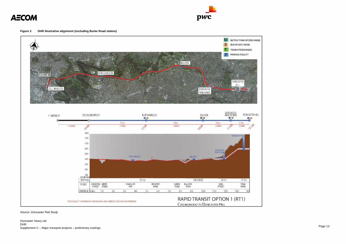
3.1 Scope
This project would involve the construction of a new rail corridor from the Clifton Hill lines via Collingwood Station
along the Eastern Freeway to the existing Doncaster park-and-ride before continuing in a tunnel to Doncaster
Hill. This option is related to the Doncaster Rail Study in 2012.
New stations would be constructed to be positioned at Kew (Chandler Highway), Burke Road, Bulleen, the
existing Doncaster park-and-ride and underground at Doncaster Hill.
These stations would also be provided with facilities including parking, access and forecourts.
Adjustment to Victoria Park Station will need to be made in order to also support additional Doncaster line tracks,
although this station will be decommissioned.
The illustrative alignment of this can be seen in Figure 3. Note the station at Burke Road was not included in
previous scoping projects and thus is not included in this figure.
Doncaster heavy rail
DHR
Supplement C – Major transport projects – preliminary costings Page 13
Figure 3 DHR illustrative alignment (excluding Burke Road station)
Source: Doncaster Rail Study

Doncaster heavy rail
DHR
Supplement C – Major transport projects – preliminary costings Page 14
3.2 Capital costs
Tunnelling costs are assumed to be a road header and/or cut and cover type tunnelling which both have a similar
cost per kilometre, however this would be dependent on the geology of the area and if some other tunnelling
method were required this could possibly double the cost of the project.
Indirect costs are assumed as a proportion of direct construction costs.
The lower range of the costing includes an inherent risk contingency of 40 percent while the upper bound limit
includes a contingent risk component of 50 percent.
The lower and upper bound costs for the DHR project can be found below in Table 6 and Table 7.
Table 6 DHR – Lower bound costs
Item Quantity Unit cost
Cost per element
(millions)
Track at grade
Track at grade (all infrastructure) 18 km $20.02 million per km $361.76
Elevated viaduct
Rail track 1,320 metres $4,830 per m $6.37
Viaduct structure 6,600 m2 $17,500 per m
2 $115.50
Cut and cover tunnel
Construction 3.165 km $105 million per km $322.32
Rail track 6.33 km $3.57 million per km $ 22.60
Power and communications
Substations 4 $7 million each $28
Signalling and communications 7.65 km $2.8 million per km $21.42
Stations
Elevated station 5 $56 million each $280
Underground station 2 $231 million each $462
Land acquisition 3,000 m2 $4,783 per m
2 $14.35
Total direct $1,644.33
Indirect costs
Site works 25% of direct costs $411.08
Margin 8% of direct costs $123.32
Design work 15% of direct costs $246.65
Government costs 10% of direct costs $164.43
Total indirect $945.49
Lower bound total $2,589.82
Source: AECOM

Doncaster heavy rail
DHR
Supplement C – Major transport projects – preliminary costings Page 15
Table 7 DHR – Upper bound costs
Item Quantity Unit cost
Cost per element
(millions)
Track at grade
Track at grade (all infrastructure) 18 km $30.03 million per km $542.64
Elevated viaduct
Rail track 1,320 metres $7,245 per m $9.56
Viaduct structure 6,600 m2 $26,250 per m
2 $173.25
Cut and cover tunnel
Construction 3.16 km $157.50 million per km $498.49
Rail track 6.33 km $5.35 million per km $ 33.90
Power and communications
Substations 4 $10.5 million each $42.00
Signalling and communications 7.65 km $4.2 million per km $32.13
Stations
Elevated station 5 $84 million each $420
Underground station 2 $346.5 million each $693.0
Land acquisition 3,000m2 $7,174 per m
2 $21.52
Total direct $2,466.50
Indirect costs
Site works 25% of direct costs $616.62
Margin 8% of direct costs $184.99
Design work 15% of direct costs $369.97
Government costs 10% of direct costs $246.65
Total indirect $1,418.23
Upper bound total $3,884.73
Source: AECOM
3.2.1 Land acquisition
For the land acquisition costs these have been based on RP data for house sales in the area and the State
Revenue Office (DA.048) advice that 45 percent of land value is made up of capital improvements while 55
percent is made up of land value. This gave a value per square metre of $3,416.60 (real 2016).
The total of land required which is not already within the road reservation is approximately 3,000m2.
Based on these figures the approximate value of the land required for acquisition is $14 million – $22 million
excluding indirect costs.
Doncaster heavy rail
DHR
Supplement C – Major transport projects – preliminary costings Page 16
3.2.2 Rolling stock
Based on information provided by Infrastructure Victoria and assuming train costs of $22.5 million per 7-car set,
the cost of providing rolling stock for the Doncaster Hill line is $225 million for 10, 7-car sets.
3.2.3 Comparison to previous study
A previous study into the Doncaster Heavy Rail line titled ‘Doncaster Rail Study’ was commissioned by the
Victorian Government and undertaken by AECOM, Aurecon, SKM and URS in 2012. For the Rapid Transit 1
(RT1) option the estimated cost of the project was projected to be $3 billion – $6 billion to Doncaster plus an
extra $800 million – $1 billion to Doncaster Hill, for a total cost of $3.8 billion – $7 billion. The Doncaster Rail
study cost has been released publically as $3 billion – $5 billion with an extra $1 billion to extend the line to
Doncaster Activity Centre in line with the PTV response to the Doncaster Rail Study.
In media the Doncaster Rail line has been represented as possibly costing only $840 million to build if it were part
of the Melbourne Metro rail tunnel proposal. This is much less than the calculated costings and we believe it to be
significantly less than the actual costs.
3.3 Operational costs
The annual operational costs have been provided by Infrastructure Victoria and are based on unit cost estimates
used in previous rail projects.
Based on Infrastructure Victoria advice the total operating cost per annum for these services is approximately
$34 million. The operational cost assumptions are that track maintenance is $264,498 per track/km/year,
underground stations are $6 million each and stations at-grade are $0.5 million each.
Using a discount rate of seven percent, the net present value of the operating costs is $469 million for the 50 year
life of the project with price escalation excluded.
3.4 Scope risk
The Melbourne Metro 2 (MMS) project would need to be completed prior to Doncaster Rail being constructed, to
ensure sufficient capacity, including redirecting the Mernda line via MMS allowing Doncaster and Hurstbridge
services to run via the existing Clifton Hill tracks.
3.5 Scope alternatives
There are other options that can be considered for the new Doncaster line:
- The Rapid Transit 2 (RT2) option has similarity to the RT1 option in that it will involve constructing the
Doncaster line underground as identical to the new South Morang line proposed in RT1. From there the
alignment will continue as identical to the RT1 Doncaster line and its proposed stations.
- The Rapid Transit 3 (RT3) option has the alignment beginning at a new station at Franklin Street which
would then continue to new stations at St Vincent’s and Smith Street, with the alignment then becoming
identical to the RT1 option.
- The Local Access Option 1 (LA1) alignment involves the proposal for an entirely separate underground rail
line as compared to the others that allow connection to other lines.
- The Local Access Option 2 (LA2) alignment will share the Glen Waverley line direct from Flinders Street to
Burnley Station, then following an underground junction the line would continue to a new station at
Glenferrie and continue as identical to LA1 to Doncaster Hill.
- The alternative Orbital Route (OR1) includes a bored tunnel between Box Hill and Doncaster Hill. This
option has not been costed, but may prove to be a more viable alternative in the short to medium term as it
has the inner-city capacity available on the Burnley Group to run.
In previous studies the RT1 alignment costed here has been the preferred alignment.
3.6 Cost risk
The cost figures presented do not include substantial traffic management and access costs which would be
incurred during construction due to limited access to sites within the freeway corridor.
There may be the possibility of Aboriginal heritage sites that will affect the alignment and stations, especially
within the vicinity of Merri Creek and the Yarra River. Other local heritage sites may also be impacted by works
and this must be avoided.
The impact of construction should avoid affecting threatened fauna and flora species in the area.

Doncaster heavy rail
DHR
Supplement C – Major transport projects – preliminary costings Page 17
Tunnelling and structure construction along the lines will cause significant impacts of the operation of the roads
and existing stations. This may include road closures and diversions which require planning and will incur costs.
There are certain points along the alignment of the route that will need extensive investigation in how to approach
the existing infrastructure in the area. This will likely involve the relocation of certain services and this will add a
significant cost to the project.

Eastern Freeway to CityLink connection
EWE
Supplement C – Major transport projects – preliminary costings Page 18
Eastern Freeway to CityLink connection EWE
Infrastructure Victoria’s option description
Improve road connectivity across the city from east to west. While there are a number of possible solutions
(alignment, length of tunnel, number of lanes, etc.), for the purpose of an initial assessment the option is
assumed to be a six lane (total) road link from the Eastern Freeway to CityLink, with a substantial amount of
tunnelling. It includes capacity expansion on the Eastern Freeway and localised works to improve inner north
public transport and amenity. This concept of the option draws in particular on the East West Link Needs
Assessment (Eddington Review, 2008). It also draws on the East West Link (Eastern Section) Project, but the
name has been generalised noting that the existing business case design could be revisited.
Scope summary
Construction of a 4.4km road tunnel from Alexandra Parade to Royal Park and a freeway-freeway interchange at
CityLink. Widening of the Eastern Freeway by one lane between Yarra Bend Road and Tram Road and managed
motorways between Hoddle Street and Springvale Road.
Sector
Transport
Certainty of evidence
Medium
Evidence base
East West Link Needs Assessment Overview
(2008)
East West Link Project Victorian Auditor-Generals
Report (December 2015)
Concept Estimate Report, East West Link (Aquenta,
2013)
East West Link Business Case Update (Sept 2013)
Direct option cost
$6.7 billion – $8.6 billion (2016)1
Excluding widening: $6.4 billion – $8.2 billion
Capital cost
$6.3 billion – $8.2 billion (2016)2
Excluding widening: $6.0 billion – $7.8 billion
Annual recurrent costs
$24 million
Whole-of-Life PV: $331 million (2016)3
Option lead time (design to opening)
5 years
Operational life (from opening)
50 years (based on building life) majority of
infrastructure had 100 year design life.4
Cost certainty
Certainty of evidence – Medium
Actual cost will be higher as these figures do
not include price escalation for future years.
1 East West Link Project Victorian Auditor-General’s
Report (December 2015) 2 East West Link Project Victorian Auditor-General’s
Report (December 2015) 3 East West Link Project Victorian Auditor-General’s
Report (December 2015) 4 East West Link Stage 1 Project Scope and
Requirements

Eastern Freeway to CityLink connection
EWE
Supplement C – Major transport projects – preliminary costings Page 19
4.0 Eastern Freeway to CityLink connection (EWE) – Preliminary
costing
The costing for EWE has been undertaken using elements of the proposed alignment and scope from the
previous East-West Link project (terminated June 2015). This involved a tunnel connecting the Eastern Freeway
to CityLink as well as widening of sections of the Eastern Freeway, Alexandra Parade Renewal and various
public transport upgrades. It does not include the cost of the port link between East West Link and Footscray
Road.
There are other alignments which have previously been considered in business case development and could be
considered in the future. Alignment with CityLink to Western Ring Road connection (EWW) would still remain an
option, currently planned for north of Western Distributor; however it is not clear if any further planning has been
carried out on the EWW alignment since the development of Western Distributor. Some of the alternative East-
West Link alignments proposed are displayed below in Figure 4.
Figure 4 Alternative East-West link alignments
Source: East West Link Business case (2013)
For the purposes of consistency, the cost scope from the East-West Link business case and the subsequent
agreement between the State and successful bidding consortium (East West Connect, EWC) have been used to
cost this project (presented in Figure 5). Some allowance has been made in the upper limit to allow for potential
scope alternatives.

Eastern Freeway to CityLink connection
EWE
Supplement C – Major transport projects – preliminary costings Page 20
Figure 5 Preferred Eastern Freeway to CityLink connection alignment
Source: Linking Melbourne Authority
4.1 Scope
Cost considerations for this option include construction of a 4.4km road tunnel from Alexandra Parade to Royal
Park and a freeway-freeway interchange at CityLink. They also include widening of the Eastern Freeway by one
lane between Yarra Bend Road and Tram Road and managed motorways between Hoddle Street and Springvale
Road (costed separately). DART improvement packages and tram upgrades included in the business case have
not been captured in this assessment.
The “Port Link” between the freeway interchange at CityLink and Footscray Road has not been included.
The alignment which has been costed is consistent with the previous project scope. This consists of widening of
the Eastern Freeway to the extent considered in the original project. Some further widening of freeways or arterial
roads may require additional works but these are not included in this costing.
Capital costs
Under the East West Link contract signed between East West Connect and the Victorian Government, the capital
cost of the project includes $400 million for complementary projects and $4.3 billion for capital costs of
construction of the tunnel and freeway interchange (nominal dollars). In addition, $559 million was allowed for
other design and construction period costs, $515 for land acquisition and $382 million for risk and contingency
held by the state (nominal dollars).5 In the case of land acquisition, we note that some land is currently in State
Government ownership but do not have full details of this. A simple assumption was made for the lower bound
cost estimate that half of the original land acquisition costs would be required, and that the full land acquisition
would be required for the upper bound cost (noting that design changes could require a different footprint).
The above costs were used for the basis of this estimate, however they needed to be translated from nominal
dollars (for a delivery program between 2013 and 2018) to a real 2016 dollar basis, which was done assuming an
overall price escalation rate of 2.5 percent per annum. The resulting figures were only slightly different to the
nominal figures.
In order to allow for adjustment of scope to realign the tunnel or create additional public transport projects or
interchanges, a 30 percent contingency has been allowed in the upper bound cost. The costing information is
displayed in Table 8 through Table 11.
5 Victorian Auditor Generals Office – East West Link, 2015

Eastern Freeway to CityLink connection
EWE
Supplement C – Major transport projects – preliminary costings Page 21
Table 8 EWE (excl. Eastern Freeway widening) – Lower bound costs
Item Quantity Unit cost
Cost per element
(millions)
Core works
Design and construction Eastern
Freeway to CityLink - $4,337 million $4,337
Associated works
Property Acquisition 0.5 $555 million $555
Pre-agreed modifications to D&C
package - $169 million $169
State costs
Business Case Update - $29 million $29
Other design and construction period
State costs - $559 million $559
Risk and contingency held by State - $382 million $382
Subtotal $6,031
Lower bound total $6,031
Source: AECOM
Table 9 EWE (excl. Eastern Freeway widening) – Upper bound costs
Item Quantity Unit cost
Cost per element
(millions)
Core works
Design and construction Eastern
Freeway to CityLink
- $4,337 million
$4,337
Associated works
Property Acquisition 0.5 $555 million $555
Pre-agreed modifications to D&C
package
- $169 million
$169
State costs
Business Case Update - $29 million $29
Other design and construction period
State costs
- $559 million
$559
Risk and contingency held by State - $382 million $382
Subtotal $6,031
Risk and contingency for alternative design (30%) $1,809
Upper bound total $7,840
Source: AECOM

Eastern Freeway to CityLink connection
EWE
Supplement C – Major transport projects – preliminary costings Page 22
Table 10 EWE (including widening) – Lower Bound costs
Item Quantity Unit cost
Cost per element
(millions)
Lower bound total excluding widening $6,031
Works on existing freeways
Eastern Freeway Widening 1 $306 million $306
Lower bound total $6,337
Source: AECOM
Table 11 EWE (including widening) – Upper Bound costs
Item Quantity Unit cost
Cost per element
(millions)
Upper bound total excluding widening $7,840
Works on existing freeways
Eastern Freeway Widening 1 $306 million $306
Upper bound total $8,238
4.1.1 Plans
A high level summary of the tunnelling and construction works is displayed in Figure 6 and Figure 7.
Figure 6 Tunnelling profile
Source: East West Link – Comprehensive Impact Statement Chapter 4

Eastern Freeway to CityLink connection
EWE
Supplement C – Major transport projects – preliminary costings Page 23
Figure 7 East West Link (east) ramps and intersections
Source: East West Link – Project Scope Requirements Volume 1
4.2 Operational costs
The cost to operate the East West Link have been derived from the VAGO report into the East West Link project
which indicated the operations and maintenance costs of the project were $3.3 billion assumed to be over 30
years (in nominal dollars). We believe this number accounts for activities beyond operations and maintenance of
the infrastructure and involves tolling, promotions and other activities possibly involving financing.
Operating costs for Eastlink for 2009 – 2011 were approximately $70 million per year, which adjusted to 2016
dollars would be $79 million per annum. The majority of this cost is involved in tolling and customer operations
and administrative expenses. The cost of roadside operations was $17.9 million per annum which is converted to
$20.2 million per annum in today’s currency.
Scaling up for the complexity and length of tunnel, the operating cost for EWE is estimated at $24 million per
annum.
Using a discount rate of seven percent, the net present value of the operating costs is $331 million with cost
escalation excluded.
4.3 Scope risk
The removal of public transport aspects from the project has been done to align with the benefits being modelled
in VITM. These projects may need to be re-introduced into the project to accommodate public transport routes
which are impacted by the EWE construction or to exploit opportunities created by the project.
Staging of the North-East link (NEL) and EWE will be important in determining the scope of each project. If the
NEL is constructed before EWE, this has likelihood to impact the works required for construction of the EWE
including regarding widening of the Eastern Freeway and works to adjacent arterial roads which were not
considered in the original East-West Link Business Case.
4.4 Scope alternative
A previous costing report included an alternative option which was an elevated road between EWE at CityLink
and a connection to the Port area also referred to as Port Link. This road was proposed along the western side of
CityLink. Construction of the Western Distributor may increase the benefits of this connection. A realignment of
the EWE tunnel itself could also be considered for direct connection to Western Distributor at CityLink.
The cost for Port Link in the previous report was $1.18 billion (P50) to $1.34 billion (P90). It is unlikely these costs
would still be accurate as they did not include consideration of Western Distributor which should be included in
further analysis and a cost update.
A change to the tunnel alignment could result in a new alignment from Royal Park under Gatehouse Street and
under residential areas of North Melbourne before surfacing in the vicinity of Arden Station (Melbourne Metro) to

Eastern Freeway to CityLink connection
EWE
Supplement C – Major transport projects – preliminary costings Page 24
create an above ground interchange with CityLink and Western Distributor. This tunnel alignment would be
slightly longer than the proposed alignment but would provide more direct connectivity to the Western Distributor
and avoid the need for the Port Link connection. An alignment directly to the Western Distributor through North
Melbourne would interact with the Melbourne Metro tunnels with the possible interchange in close proximity the
Arden station precinct.
There may also be additional public transport costs and other local road widening to accommodate any
realignment.
4.5 Cost risk
The cost risk for this project along the previous alignment is relatively low if the same design is adopted, with a
previously signed agreement indicating the project costs and with detailed geotechnical work already undertaken.
The link has faced previous opposition in the past by the community and was subject to court appeals to prevent
the project going through back in 2014.Thus this project may be at risk of similar action and this poses some cost
risk, particularly additional legal costs which could be substantial. This would likely apply to any similar road
alignment.
Other projects which have been undertaken since the cancellation of the proposed EWE such as the CityLink-
Tullamarine Freeway widening project may change costs to the EWE project with potentially different connections
and servicing requirements as well as different benefits.

Melbourne Airport heavy rail line
MAH
Supplement C – Major transport projects – preliminary costings Page 25
Melbourne Airport heavy rail line MAH
Infrastructure Victoria’s option description
Delivery of a rail link between Melbourne (Tullamarine) Airport and the central city, including the possibility of a
staged approach to full implementation of a service that is integrated with the Melbourne Metro (MM) project.
While the ultimate vision is to run 10-car trains via the MM tunnel through to the south east at 10-minute
frequencies, earlier completion of the branch along the Albion East reservation from Sunshine to Melbourne
Airport would allow the provision of a pre-MM airport train using existing 6-car trainsets into Southern Cross
Station or the City Loop (depending on the level of signalling upgrades to be undertaken). This service could
potentially run at frequencies of 20 minutes which would be comparable to most upper-tier airport rail services
from around the world. Compared with the existing SkyBus (which offers higher frequencies but widely varying
passenger loads and journey times) the proposed interim train service would offer a more reliable, comfortable
and predictable travel option particularly during the heavily-congested peak periods.
Scope summary
The scope considered for construction under this project includes the construction of a twin tracks from Albion
station to a new elevated platform at Melbourne Airport. The new alignment would follow the existing freight rail
lines from Albion before turning west and crossing the M80 and continuing along the median of Airport Drive to
the airport. At the airport, the alignment is assumed to run on a viaduct connecting to the departure terminal level
between terminal 4 and the new transport hub opposite terminal 4.
Sector
Transport
Certainty of evidence
Medium
Evidence base
Network Development Plan – PTV 2012
Melbourne Airport Rail Link Study – PTV 2013
Direct option cost (incl. rolling stock)
$3.0 billion – $3.9 billion (2016)
Capital cost
$2.1 billion – $3.1 billion
Annual recurrent costs
$54 million
Whole-of-life PV: $752 million
Construction period
5 years
Operational life (from opening)
50 yrs
Cost certainty
Certainty of evidence – Medium
Significant cost risks exist for services and planning
with numerous interfaces with existing
infrastructure.
Actual cost will be higher as these figures do not include price escalation for future years.

Melbourne Airport heavy rail line
MAH
Supplement C – Major transport projects – preliminary costings Page 26
5.0 Melbourne Airport heavy rail line – Preliminary costing
5.1 Scope
The scope considered for construction under this project includes the construction of a twin tracks from Albion
station to a new elevated platform at Melbourne Airport. The new alignment would follow the existing freight rail
lines from Albion before turning west and crossing the M80 and continuing along the median of Airport Drive to
the airport. At the airport, the alignment is assumed to run on a viaduct connecting to the departure terminal level
between terminal 4 and the new transport hub opposite terminal 4.
The alignment has been designed to provide access directly to and from the airport as an express service.
This scope does not include additional works to the network between Albion and the south east (via Melbourne
Metro) which may be required to accommodate the proposed number of services. Previous scoping had
assumed this enabling works would be undertaken as part of the Melbourne Metro project.
There are known to be significant services within the study area including, but not limited to, high voltage power
lines adjacent to the M80 and fuel pipelines which service the airport. Due to the lack of knowledge of the location
of these services, the relocation or mitigation to accommodate these services along the alignment has not been
included in this scope, but has been considered in determining the appropriate contingency. Normal service
relocations for communications, low-voltage power, gas and water have been allowed for as part of the rates.
This project does not include any new stations other than the Melbourne Airport station which is assumed to be a
single elevated station. This represents a high quality service for airport patrons. An alternative for consideration
could include new stations along the route to serve the employment areas around the airport and residential
areas around Airport West.
5.2 Capital costs
Table 12 and Table 13 outline the cost rates and quantities assumed in calculating the capital costs of the project
based on the attached plans.
Indirect costs are assumed as a proportion of direct construction costs.
The lower range of the costing includes an inherent risk contingency of 40 percent while the upper bound limit
includes a contingent risk component of 50 percent.
Government costs for this project are set at 20 percent to account for the need for federal approvals for changes
in the airport precinct.

Melbourne Airport heavy rail line
MAH
Supplement C – Major transport projects – preliminary costings Page 27
Table 12 MAH – Lower bound costs
Item Quantity Unit cost
Cost per element
(millions)
Track at grade
Track at grade (all infrastructure) 23.3 km $20.02 million per km $467.02
Elevated viaduct
Rail track 3,044 metres $4,830 per m $14.70
Structure 15,222 m2 $17,500 per m
2 $266.38
Bridge overpasses
Rail track 2,628 metres $4,830 per m $12.69
Structure 7,500 m2 $10,500 per m
2 $78.75
Bridge strengthening 3 $7 million per bridge $21
Maribyrnong bridge 6,640 m2 $10,500 per m
2 $69.72
Power and communications
Substations 4 $7 million each $28
Signalling and communications 2.63 km $2.8 million per km $7.36
Stations
Albion Station 1 $49 million per station $49
Airport Station 1 $231 million per
station
$231
Land acquisition 17,550 m2 $524.73 per m
2 $9.21
Total direct $1,254.83
Indirect costs
Site works 25% of direct costs $313.71
Margin 8% of direct costs $94.11
Design work 15% of direct costs $188.22
Government costs 20% of direct costs $250.97
Total indirect $847.01
Lower bound total $2,101.84
Source: AECOM
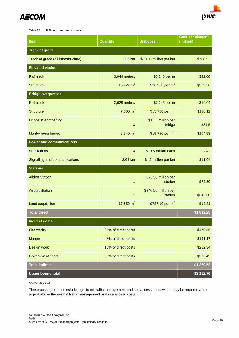
Melbourne Airport heavy rail line
MAH
Supplement C – Major transport projects – preliminary costings Page 28
Table 13 MAH – Upper bound costs
Item Quantity Unit cost
Cost per element
(million)
Track at grade
Track at grade (all infrastructure) 23.3 km $30.03 million per km $700.53
Elevated viaduct
Rail track 3,044 metres $7,245 per m $22.06
Structure 15,222 m2 $26,250 per m
2 $399.56
Bridge overpasses
Rail track 2,628 metres $7,245 per m $19.04
Structure 7,500 m2 $15,750 per m
2 $118.12
Bridge strengthening
3
$10.5 million per
bridge $31.5
Maribyrnong bridge 6,640 m2 $15,750 per m
2 $104.58
Power and communications
Substations 4 $10.5 million each $42
Signalling and communications 2.63 km $4.2 million per km $11.04
Stations
Albion Station
1
$73.50 million per
station $73.50
Airport Station
1
$346.50 million per
station $346.50
Land acquisition 17,550 m2 $787.10 per m
2 $13.81
Total direct $1,882.25
Indirect costs
Site works 25% of direct costs $470.56
Margin 8% of direct costs $141.17
Design work 15% of direct costs $282.34
Government costs 20% of direct costs $376.45
Total indirect $1,270.52
Upper bound total $3,152.76
Source: AECOM
These costings do not include significant traffic management and site access costs which may be incurred at the
airport above the normal traffic management and site access costs.

Melbourne Airport heavy rail line
MAH
Supplement C – Major transport projects – preliminary costings Page 29
5.2.1 Land acquisition
For the land acquisition costs these have been based on RP data for house sales in the area and the State
Revenue Office (DA.048) advice that 45 percent of land value is made up of capital improvements while 55
percent is made up of land value. This results in a value per square metre of $374.81 (real 2016).
The total of land required which is not already within the road reservation is approximately 17,550m2.
Based on these figures and applying additional scope and cost escalations the approximate value of the land
required for acquisition is $9.2 million – $13.81 million excluding processing, legal and management costs.
As detailed in the above tables, the estimated project capital costs are $2.1 billion – $3.1 billion.
5.2.2 Rolling stock
Based on information provided by Infrastructure Victoria and assuming train costs of $29.5 million per 10-car set,
the cost of providing rolling stock for the Melbourne Airport heavy rail line is $205 million for seven 10-car sets.
5.3 Operational costs
The annual operational costs have been provided by Infrastructure Victoria and are based on unit cost estimates
used in previous rail projects.
Based on Infrastructure Victoria advice the total operating cost per annum for these services is approximately
$54 million. The operational cost assumptions are that track maintenance is $264,498 per track/km/year,
underground stations are $6 million each and stations at-grade are $0.5 million each.
Using a discount rate of seven percent, the net present value of the operating costs is $752 million for the 50 year
life of the project excluding any price escalation.
5.4 Scope risk
There are significant risks to scope based on the operating constraints of the network between Albion and the
city. The project may need to provide greater capacity in this section which will be a significant increase in the
scope of the project. This could include additional tracks between Albion and the CBD, an alternate alignment
between the Airport and the CBD (connecting to another rail line or dedicated tracks for the full route) or an
alternate network configuration, for example taking advantage of the capacity created by Melbourne Metro 2
should that project proceed.
Until detailed planning is undertaken between the State Government, Federal Government and Airport
authorities, additional scope risk may be encountered within the Airport planning area. It is important to seek prior
approval from key stakeholders in further development of the project.
The addition of stations along the alignment may also add to the cost of the project with the possibility of
additional stations in the airport precinct or in the Airport West area. Station placements may add cost for not only
station construction but also rail alignments.
5.5 Scope Alternative
A study was undertaken in 2012 by PTV into the alternative alignments that were viable for the Melbourne Airport
rail link as detailed in PTV’s 2013 ‘Melbourne Airport Rail Link Study’. The alternatives included the Albion East
base case, a direct tunnel link, a Craigieburn link via the Craigieburn line with new track through Westmeadows
and a Flemington link via the Flemington line and then a rail tunnel. The alternatives were assessed next to a
number of criteria and the Albion base case was recognised as the best option. In summary this was due to:
- The direct tunnel and Flemington link being too costly in comparison to the Albion East base case and as
these alternatives utilise the City Loop and this would cause capacity restraints
- The Craigieburn link alternative would cause congestion in relation to the level crossings due to increased
services
- The Albion East option would have the best connectivity as the Melbourne Metro project would allow
patrons to travel from the airport to Dandenong

Melbourne Airport heavy rail line
MAH
Supplement C – Major transport projects – preliminary costings Page 30
5.6 Cost risk
Elevated structure construction along the line will cause significant impacts of the operation of the roads and
intersections. This may include road closures and diversions which will incur additional costs
There has not been intensive geotechnical investigation into the ground conditions for this project and this should
be undertaken. Depending on the outcomes the required foundations for elevated rail structures and associated
works will be affected and costs related to these.
Services through the airport area have not been investigated and are likely to include communications and fuel
as well as water, gas and sewerage.
The Maribyrnong River bridge has been costed at approximately $50 million, but the interface with existing
structures, environment and services has not been taken into account and any realignment through this area may
add significant cost to the project.
The bridge across the M80 will also present several challenges with long spans and high clearances required for
the crossing as well as the proximity of high voltage power lines which may need to be lifted to allow for
construction of the track.
No comparable previous costings have been publicly released for the project although the Melbourne Airport Rail
Link (MARL) was part of the previous Melbourne Rail Link project proposed by a previous State Government.
This project has now been superseded by the Melbourne Metro project.

Melbourne Metro 2
MMS
Supplement C – Major transport projects – preliminary costings Page 31
Melbourne Metro 2 MMS
Infrastructure Victoria’s option description
Construct a heavy rail connection between Clifton Hill and the CBD through to Fisherman's Bend and Newport
via two new rail tunnels. The works will separate the high growth South Morang – Southern Cross Line from the
Clifton Hill group. This will provide flow on capacity benefits to the Werribee line and will allow for future
extensions/additions to the Clifton Hill group (such as the Doncaster and Wollert rail extensions). This tunnel
forms the major component of the network upgrade during Stage 3 of the PTV Network Development Plan –
Metropolitan Rail, December 2012.
The new link could provide the opportunity for additional stations in the inner north and urban renewal precincts
such as Fisherman’s Bend. The construction of this link contributes to amenity and the attractiveness for
businesses and people to relocate to the redevelopment areas. Furthermore, it will add capacity for people to
access employment and social activities in the central city.
Scope summary
The scope of the Melbourne Metro 2 project is to create a new Metro-style train tunnel through the Melbourne
CBD connecting Clifton Hill with Newport via Parkville, Southern Cross Station and Fishermans Bend. The new
Metro service will provide additional capacity between Clifton Hill and Southern Cross, allowing for more services
on the Hurstbridge, Mernda and proposed Doncaster Rail line. New capacity will also be provided between
Newport and Southern Cross Station accommodating more direct Wyndham Vale (Werribee) line services. Nine
potential new underground stations have been identified, although only three of these would be in areas which
will not already have a station.
Sector
Transport
Certainty of evidence
Low
Evidence base
PTV Network Development Plan 2012
Melbourne Metro Business Case 2016
Project variations
Option 1: Clifton Hill to Newport (full project)
Option 2: Parkville to Newport (possible staging)
Direct option cost (incl. rolling stock)
Option 1 (full project):
$15.4 billion – $22.9 billion
Option 2 (possible staging):
$9.5 billion – $14.0 billion
Capital cost (excluding rolling stock)
Option 1 (full project):
$13.9 billion – $20.8 billion
Option 2 (possible staging):
$8.4 billion – $12.7 billion
Annual recurrent costs
Option 1 (full project):
$67 million – $89 million
Whole-of-Life PV: $1,232 million
Option 2 (possible staging):
$45 million – $63 million
Whole-of-Life PV: $869.5 million
Construction period
6 years
Operational life (from opening)
50 years
Cost certainty
Certainty of evidence – Low
Actual cost will be higher as these figures do not include price escalation for future years.
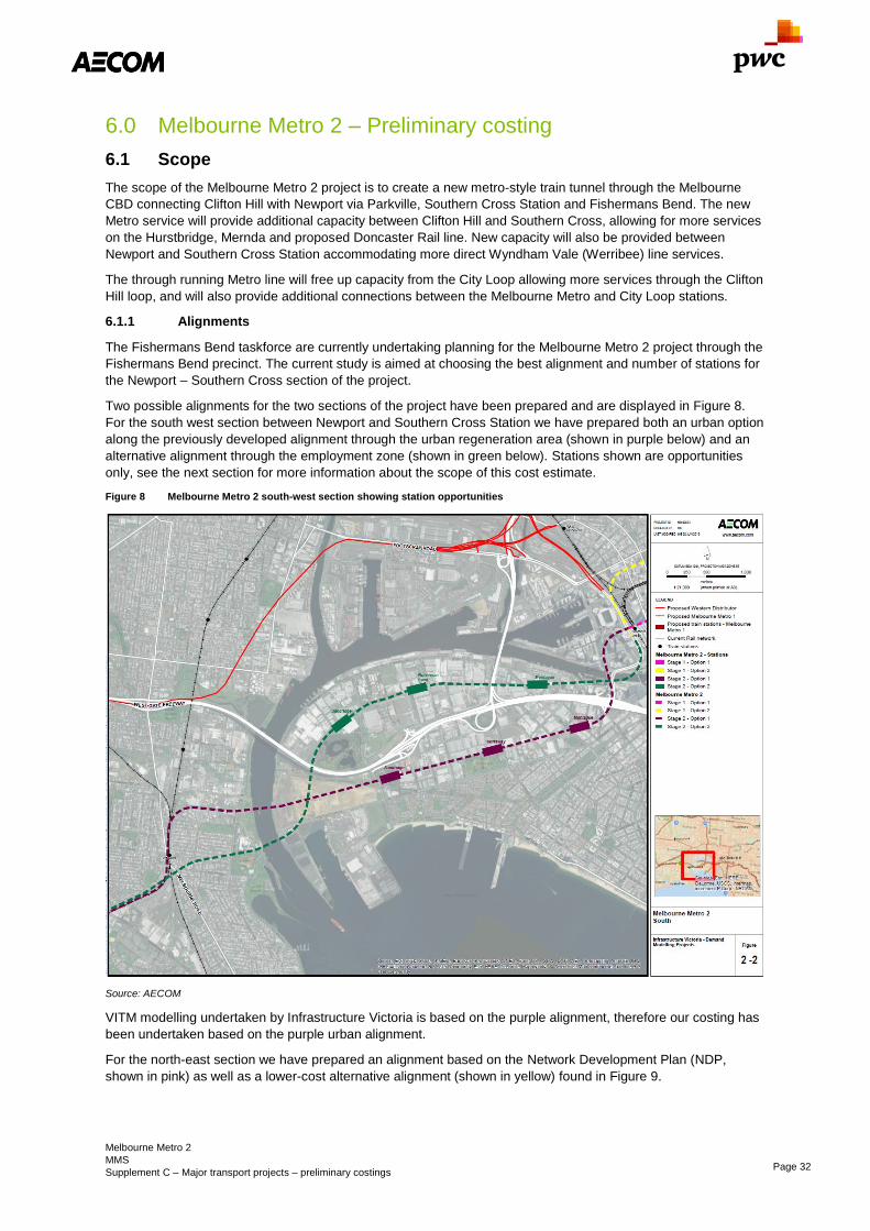
Melbourne Metro 2
MMS
Supplement C – Major transport projects – preliminary costings Page 32
6.0 Melbourne Metro 2 – Preliminary costing
6.1 Scope
The scope of the Melbourne Metro 2 project is to create a new metro-style train tunnel through the Melbourne
CBD connecting Clifton Hill with Newport via Parkville, Southern Cross Station and Fishermans Bend. The new
Metro service will provide additional capacity between Clifton Hill and Southern Cross, allowing for more services
on the Hurstbridge, Mernda and proposed Doncaster Rail line. New capacity will also be provided between
Newport and Southern Cross Station accommodating more direct Wyndham Vale (Werribee) line services.
The through running Metro line will free up capacity from the City Loop allowing more services through the Clifton
Hill loop, and will also provide additional connections between the Melbourne Metro and City Loop stations.
6.1.1 Alignments
The Fishermans Bend taskforce are currently undertaking planning for the Melbourne Metro 2 project through the
Fishermans Bend precinct. The current study is aimed at choosing the best alignment and number of stations for
the Newport – Southern Cross section of the project.
Two possible alignments for the two sections of the project have been prepared and are displayed in Figure 8.
For the south west section between Newport and Southern Cross Station we have prepared both an urban option
along the previously developed alignment through the urban regeneration area (shown in purple below) and an
alternative alignment through the employment zone (shown in green below). Stations shown are opportunities
only, see the next section for more information about the scope of this cost estimate.
Figure 8 Melbourne Metro 2 south-west section showing station opportunities
Source: AECOM
VITM modelling undertaken by Infrastructure Victoria is based on the purple alignment, therefore our costing has
been undertaken based on the purple urban alignment.
For the north-east section we have prepared an alignment based on the Network Development Plan (NDP,
shown in pink) as well as a lower-cost alternative alignment (shown in yellow) found in Figure 9.

Melbourne Metro 2
MMS
Supplement C – Major transport projects – preliminary costings Page 33
Figure 9 Melbourne Metro 2 north east section
Source: AECOM
The benefit of the yellow alignment would be the ability to construct the line above ground along the old inner
metropolitan ring corridor to Princes Park before going into a tunnel. The NDP alignment would be a fully
tunnelled option. For the purpose of this cost estimate, only the NDP alignment has been assessed.
No consideration has been given to alternative vertical alignment options at this early stage.
6.1.2 Stations
While indicative station locations have been shown on the above plans, the number and location of stations is
likely to change. For costing purposes we have adopted the number of stations based on VITM diagrams
provided by ARUP on behalf of IV. These plans indicate a single station between Clifton Hill and Parkville and
two stations in Fishermans Bend. The following station numbers and locations have been assumed:
- Merri Creek Station (new underground station required to achieve river crossing)
- Clifton Hill (new underground station for interchange with existing Clifton Hill Station)
- North Fitzroy (new underground station)
- Parkville (new underground station linked to Melbourne Metro Parkville Station)
- Flagstaff Station (new underground station linked to existing Flagstaff Station)
- Southern Cross Station (new underground station to the west of existing Southern Cross Station)
- Montague Station (new Fishermans Bend Station)
- Wirraway Station (new Fishermans Bend Station)
- Newport Station (new underground station at Newport has been assumed for interchange with existing at-
grade station
This total of seven new stations (plus one at either portal) for an alignment which is approximately 20.2km in
length results in a station every 2.8km. The Melbourne Metro 1 alignment contains one station every 1.8km.
However, unlike Melbourne Metro where three out of five stations are at locations which previously did not have a
heavy rail link (and no new station at either portal), this proposal would see just three out of a total of nine new
underground stations being in areas not previously served by a station. While this is an appropriately

Melbourne Metro 2
MMS
Supplement C – Major transport projects – preliminary costings Page 34
conservative assumption given the early stage of this project, it does add substantial cost and would require
further assessment in subsequent planning.
6.2 Capital costs
6.2.1 Capital cost
High level cost estimates have been developed for the fully tunnelled MMS project from Clifton Hill to Newport
(Option 1) in Section 6.2.2 and a shorter alignment linking Parkville to Newport (Option 2) in Section 6.2.3, which
is effectively a staged approach to Option1. Due to the reduced length of the tunnel, Option 2 does not link to the
Clifton Hill group of lines and will not allow for Mernda – Werribee service patterns.
This capital cost does not include costs beyond the train portals and into the broader train network such as
platform adjustments or signalling upgrades.
The lower range of the costing includes an inherent risk contingency of 40 percent while the upper bound limit
includes a contingent risk component of 50 percent.
Indirect Government costs of 20 percent have been assumed based on the complexity of the project and
interface with other major infrastructure.
6.2.2 MMS – Option 1 (Whole Project)
While the yellow alignment offers the potential for a lower cost solution, the “lower bound costs” set out in Table
14 was based on the fully tunnelled alignment (pink alignment), and no consideration has been given to
rationalising the number of underground stations. The upper bound costs can be found in Table 15 overleaf.

Melbourne Metro 2
MMS
Supplement C – Major transport projects – preliminary costings Page 35
Table 14 MMS (Option 1 – Whole Project) – Lower bound costs
Item Quantity Unit cost
Cost per element
(millions)
Rail track
TBM boring and construction 36.2 km $140 million per km $5,068
Rail Systems 36.2 km $14 million per km $506.80
Power and communications
Substations 4 $7 million each $28
Signalling and communications 36.2 km $2.8 million per km $101.36
Stations
Underground station 9 $280 million each $2,520
Land acquisition Fishermans Bend 24,000 m2 $2,372.7 per m
2 $56.94
Land acquisition Carlton 12,000 m2 $4,914.5 per m
2 $58.97
Total direct $8,281.10
Indirect costs
Site works 25% of direct costs $2,070.28
Margin 8% of direct costs $621.08
Design work 15% of direct costs $1,242.16
Government costs 20% of direct costs $1,656.22
Total indirect $5,589.74
Lower bound total $13,870.85
Source: AECOM

Melbourne Metro 2
MMS
Supplement C – Major transport projects – preliminary costings Page 36
Table 15 MMS (Option 1 – Whole Project) – Upper bound costs
Item Quantity Unit cost Cost per element
(million)
Rail track
TBM boring and construction 36.2 km $210 million per km $7,602
Rail Systems 36.2 km $21 million per km $760.20
Power and communications
Substations 4 $10.5 million each $3,780
Signalling and communications 36.2 km $4.2 million per km $152.04
Stations
Underground station 9 $420 million each $3,780
Land acquisition Fishermans Bend 24,000 m2 $3,559 per m
2 $85.42
Land acquisition Carlton 12,000 m2 $7,371 per m
2 $88.46
Total direct $12,421.66
Indirect costs
Site works 25% of direct costs $3,105.41
Margin 8% of direct costs $931.62
Design work 15% of direct costs $1,863.25
Government costs 20% of direct costs $2,484.33
Rail track $8,384.62
Upper bound total $20,806.28
Source: AECOM
This estimate indicates the overall capital cost of the MMS project would range from $13.9 billion to $20.8 billion.
The large cost variance reflects the uncertainty of tunnelling conditions and potential obstacles as well as
variation in possible station construction costs depending on depth of station which will be guided by geotechnical
information.

Melbourne Metro 2
MMS
Supplement C – Major transport projects – preliminary costings Page 37
6.2.3 MMS – Option 2 (Newport to Parkville only)
MMS Option 2 involves a shorter alignment linking Newport to Parkville via Southern Cross without continuing to
Clifton Hill and the costings for this are displayed in Table 16 and Table 17.
Table 16 MMS (Option 2 – Newport to Parkville only) – Lower bound costs
Item Quantity Unit cost
Cost per element
(millions)
Rail track
TBM boring and construction 21 km $140 million per km $2,940
Rail systems 21 km $14 million per km $294
Power and communications
Substations 2 $7 million each $14
Signalling and communications 21 km $2.8 million per km $58.8
Stations
Underground station 6 $280 million each $1,680
Land acquisition Fishermans Bend 24,000 m2 $2,372.7 per m
2 $56.94
Total direct $5,043.74
Indirect costs
Site works 25% of direct costs $1,260.94
Margin 8% of direct costs $378.28
Design work 15% of direct costs $756.56
Government costs 20% of direct costs $1,008.75
Total indirect $3,404.53
Lower bound total $8,448.27
Source: AECOM

Melbourne Metro 2
MMS
Supplement C – Major transport projects – preliminary costings Page 38
Table 17 MMS (Option 2 – Newport to Parkville only) – Upper bound costs
Item Quantity Unit cost
Cost per element
(millions)
Rail track
TBM boring and construction 21 km $210 million per km $4,410
Rail systems 21 km $21 million per km $441
Power and communications
Substations 2 $10.5 million each $21
Signalling and communications 21 km $4.2 million per km $88.2
Stations
Underground station 6 $420 million each $2,520
Land acquisition Fishermans Bend 24,000 m2 $3,559 per m
2 $85.42
Total direct $7,565.62
Indirect costs
Site works 25% of direct costs $1,891.40
Margin 8% of direct costs $567.42
Design work 15% of direct costs $1,134.84
Government costs 20% of direct costs $1,513.12
Total indirect $5,106.79
Upper bound total $12,672.41
Source: AECOM
The cost of this option ranges from $8.4 billion to $12.7 billion for the shorter alignment.
6.2.4 Rolling stock
Based on information provided by Infrastructure Victoria and assuming train costs of $29.5 million per 10-car set,
the cost of providing rolling stock for Option 1 is $878 million for full operations and will require 30 trains. For
Option 2 the cost of rolling stock for full operations is $644 million and requires 22 trains.
6.3 Operational costs
The annual operational costs have been provided by Infrastructure Victoria and are based on unit cost estimates
used in previous rail projects.
Based on Infrastructure Victoria advice the total operating cost per annum for these services for MMS Option 1 is
$66 million per annum initially and increases to $89 million after 15 years of operation. MMS Option 2 is $45
million increasing to $63 million after 15 years of operation. The operational cost assumptions are that track
maintenance is $264,498 per track/km/year, underground stations are $6 million each and stations at-grade are
$0.5 million each.
Using a discount rate of seven percent, the net present value of the operating costs is $1.23 billion for MMS
Option 1 and $869 million for MMS Option 2 for the 50 year life of the project excluding price escalation.
Melbourne Metro 2
MMS
Supplement C – Major transport projects – preliminary costings Page 39
6.4 Scope risk
Scope risks to the project are significant. Additional planning is required for determining station locations and
station numbers, and further geological investigation is required to determine tunnelling alignments based on
specific geography.
A proposed freight rail connection to Webb Dock in the Fishermans Bend area, which may also involve a tunnel
under the Yarra between Newport and Fishermans Bend may also pose a scope risk to the MMS project.
6.5 Scope alternatives
There are a number of possible alignments requiring further investigation. Development in the Fishermans Bend
area may dictate possible tunnel alignment options with modified catchments and attractors in the region.
Development around Clifton Hill and Merri Creek and between these locations and Parkville could lead to
selection of the alternative alignments outlined in this report. Once more detailed geotechnical information is
revealed, there will be greater certainty about preferred alignments.
6.6 Cost risk
6.6.1 Geotechnical
The risks of construction are predominantly related to the geotechnical unknowns and potential difficulties of the
alignments, such as below ground structures. Pending further transport modelling and detailing of the preferred
station locations and alignments, a detailed geotechnical investigation will be required to determine the potential
cost risks of geotechnical challenges.
A key element which has not been included in this estimate is the risk of encountering substantial foundations
between Flagstaff Station and Fishermans Bend. Particularly to the south west of Southern Cross Station, there
are numerous new developments with deep piled foundations, including deep piles for the West Gate Freeway
bridge structures.
There are alignments which could avoid foundations completely by tunnelling under the Yarra for greater
proportion but these would have significant impact on the benefits of the project due to station locations. The
early nature of the project as well as the lack of a firm alignment and the ongoing development of the Fishermans
Bend precinct means it is not possible to estimate the likelihood of encountering substantial building foundations.
Likewise, until the depth and alignment of the tunnel are known as well as the foundations likely to be
encountered the cost of mitigation is also unknown.
The cost estimate provided does not include the costs to avoid or to modify existing building foundations. The
assumption that a tunnel can be constructed through the area without modifying existing foundations or other
significant changes to alignments presents a significant cost risk to the project. The contingency built into the
project should be sufficient to realign the tunnel to avoid any significant foundations or to allow for compensation
in the event that the eventual alignment reservation impacts on previously approved developments.
Without detailed investigation of potential alignments (which is currently being undertaken by the Fishermans
Bend task force) it would not be reasonable to assume a range of costs or possible works as the scope and
impact assumptions would need to be very broad. When an alignment is selected, appropriate planning controls
are required to prevent new developments along the alignment creating foundations which would affect the
construction of the project.
A desktop analysis of the likely geotechnical challenges for other sections of the alignment has been undertaken
and is attached as Appendix B.
This analysis outlines the geology of three sections of the alignment.
- The north east section which travels through largely rock formations. Detailed investigations have previously
been undertaken of similar tunnelling projects through this area including East-West Link, Melbourne Metro
and even the City Loop.
- The south west section which involves tunnelling largely through Coode Island silt below the water table.
- The western Yarra River crossing which transitions from the Coode Island silt to newer volcanic basalt
flows.
A closed face TBM would likely be required for tunnelling through the south west section and for tunnelling under
the western Yarra section due to the transition from Coode Island Silt to newer volcanics.

Melbourne Metro 2
MMS
Supplement C – Major transport projects – preliminary costings Page 40
6.6.2 Station structures and land acquisition
The depth, composition and required footprint to cut and cover stations has not been confirmed as the location
for the stations and alignments has yet to be finalised. It has been assumed that the stations can be constructed
as cut and cover tunnels although there is a significant cost risk of stations being required at deep levels to avoid
foundations south west of Southern Cross Station and to construct a station and alignments under the proposed
Parkville and Flagstaff Stations. This may require significant land acquisition. The additional risk contingency in
the upper bound limit is expected to accommodate any such scope increases. Determination and reservation of
the tunnel alignment at an early stage will help to reduce any risks or potential for compensation.
6.7 Staging
The project could be staged to realise earlier benefits and reduce the overall cost of the project.
The northern Clifton Hill – Southern Cross section of the route could be accelerated if the Doncaster Heavy Rail
project is built, as there will not be sufficient capacity in the network to accommodate the additional Doncaster
trains if new tracks between Clifton Hill and Southern Cross have not yet been constructed.
The southern Newport – Southern Cross section (assessed as Option 2 in this report, linking as far as Parkville)
could be brought forward pending development of the Fishermans Bend precinct and growth on the Werribee
line. This section could be constructed to bring Werribee trains directly into the city and provide a heavy rail
service for the employment zone within the Fishermans Bend precinct.
6.8 Cost benchmark
The above capital cost estimates were also benchmarked against the Melbourne Metro 1 project, using capital
costs from the Melbourne Metro Business Case shown in Figure 10 below.
Figure 10 Melbourne Metro projected capital costs
Item
Real ($m) Nominal ($m)
P50 P90 P50 P90
Total project risk adjusted capital costs 8,887 9,480 10,154 10,837
Source: Melbourne Metro Business Case
This capital cost estimate excludes rolling stock but includes all other types of items assessed above, including
supporting infrastructure across the rail network. Melbourne Metro 1 involves two new 9km tunnels with five new
stations as well as associated tram, rail infrastructure and rail systems works. Without an accurate breakdown of
these costs (detail was redacted from the Melbourne Metro Business Case) we cannot include or exclude certain
elements from the costing.
Assuming the $8.9 billion – $9.5 billion capital works cost for a 9km rail tunnel, we have adopted a cost of $990
million – $1.05 billion per km (real 2016) including the cost of tunnelling, portals, track works, signals and station
construction. Applying this rate to a 20 kilometre alignment, as identified for Melbourne Metro 2 would produce an
estimate of $19.8 billion – $21.0 billion (real 2016), which is close to the upper bound cost estimate identified by
the cost estimate identified in this paper. While a range of conservative assumptions have been made about the
scope of the project (e.g. fully tunnelled, many new interchanging stations), this suggests the overall estimate is
not especially conservative.

North-East Link
NEL
Supplement C – Major transport projects – preliminary costings Page 41
North-East Link NEL
Infrastructure Victoria’s option description
Construction of the North-East motorway link between the eastern freeway and the M80 to improve outer north-
south links for road freight movement and improve travel time and reliability. Multiple possible corridors have
been identified, and tunnelling could be required.
Scope Summary
The North-East link (NEL) is a proposed connection between the end of the M80 at Greensborough and the
Eastern Freeway. Several alignments have been put forward during development of the project including a direct
connection from Greensborough south along the Greensborough Highway, across the Yarra River to Bulleen
where it connects with the Eastern Freeway. This is the alignment which has been modelled in VITM and has
been considered for detailed costing. Scope assumed to include widening of Eastern Freeway and Northern
Metropolitan Ring Road.
Sector
Transport
Certainty of evidence
Low
Evidence base
Report for East West Link Needs Assessment
Response Team Review – GHD for Department of
Premier and Cabinet (September 2008)
East West Link Business Case and contract
documents
Direct option cost
$4.9 billion – $7.2 billion
Excluding Widening: $4.7 billion – $6.9 billion
Capital cost
$4.6 billion – $6.9 billion
Excluding Widening: $4.4 billion – $6.6 billion
Annual recurrent costs
$26 million
Whole-of-life PV: $359 million
Option lead time (design to opening)
5 years
Operational life (from opening)
50 years
Cost certainty
Certainty of evidence – Medium
Actual cost will be higher as these figures do not include price escalation for future years.

North-East Link
NEL
Supplement C – Major transport projects – preliminary costings Page 42
7.0 North-East link (NEL) – Preliminary costing
7.1 Scope
The North-East link (NEL) is a proposed connection between the end of the M80 at Greensborough and the
Eastern Freeway. Several alignments have been put forward during development of the project including a direct
connection from Greensborough south along the Greensborough Highway, across the Yarra River to Bulleen
where it connects with the Eastern Freeway. This is the alignment which has been modelled in VITM and has
been considered for detailed costing. Further work is required to assess alternatives, including a more easterly
alignment option.
The general alignment has been interpreted from the GHD EWLNA review document which describes the NEL
alignment. Based on this outline and analysis we have prepared a proposed alignment and connections for the
NEL. More analysis of local conditions is required along with detailed planning work to determine optimum
alignment and intersection configurations.
From the end of the M80 to Lower Plenty Road, the alignment is assumed to be at or above ground, including
upgrading Greensborough Road to freeway standard with grade separated intersections with the Greensborough
Bypass, Grimshaw Street and Watsonia Road. The alignment is assumed to enter a tunnel portal north of Lower
Plenty Road.
The twin three lane tunnels are assumed to run from Lower Plenty Road under residential areas of Rosanna,
under the Yarra River and Banyule Flats to Bulleen Road. The length of the proposed tunnel is approximately
4.2km depending on alignments and geotechnical investigations. A southern tunnel portal is assumed to the
north of the Eastern Freeway, with the new link interchanging with the Eastern Freeway in place of the existing
Bulleen Road intersection displayed below in Figure 11.
For the widening of the Eastern Freeway the following has been assumed. For the segment between North East
Link to Doncaster Road the lanes will be increased by four lanes. Between Doncaster Road and Springvale Road
an extra lane will be added to each direction. From Chandler Highway to Bulleen Road the lanes will be
increased by four. This does not include any widening to Chandler Highway.
For the widening of M80, the road is to be widened from Plenty Road to Greensborough Highway which has been
assumed to be part of this project.
The alignment which has been costed is the previous alignment in line with the VITM modelling being
undertaken. Some arterial roads may require additional works but these are not included in this costing.

North-East Link
NEL
Supplement C – Major transport projects – preliminary costings Page 43
Figure 11 Illustrative NEL alignment6
Source: GHD – Potential staging opportunities for Northern Link (2008)
6 Potential staging opportunities were produced by earlier work and have not been reviewed or
proposed here.

North-East Link
NEL
Supplement C – Major transport projects – preliminary costings Page 44
7.2 Capital costs
Unit costs are based on the cost of constructing freeways in a brownfield environment, as well as the contract
costs of East West Link to estimate tunnelling costs.
Total capital construction costs for the East West Link tunnel and freeway interchange were $4.3 billion.
Assuming freeway interchange costs made up a small portion of the project costs (~$100 million based on bridge
deck costs and freeway interchange costs, and noting that the complex Elliot Avenue was removed from project
scope) we have assumed a conservative estimate of $4.3 billion for the 4.4km tunnel at a rate of $977 million per
km for road tunnel.
Intersection costs include costs of signalisation. Costs for the lanes that will be added to widen the Eastern
Freeway, M80 and other surrounding roads are also shown. These have been taken from the VITM model
although local widening around intersections and on feeder arterials have not been included.
The lower range of the costing includes an inherent risk contingency of 40 percent while the upper bound limit
includes a contingent risk component of 50 percent.
Table 18 through Table 23 present the itemised costings for the North-East link.
Table 18 Widening costs – Lower bound
Item Quantity Unit cost
Cost per element
(millions)
Widening works on existing roads
Eastern Freeway 42.8 km $2.91 million per km $124.64
M80 9.6 km $2.91 million per km $27.96
Total Direct Cost $152.60
Source: AECOM
Table 19 Widening costs – Upper bound
Item Quantity Unit cost
Cost per element
(millions)
Widening works on existing roads
Eastern Freeway 42.8 km $4.37 million per km $186.96
M80 9.6 km $4.37 million per km $41.94
Total Direct Cost $228.90
Source: AECOM
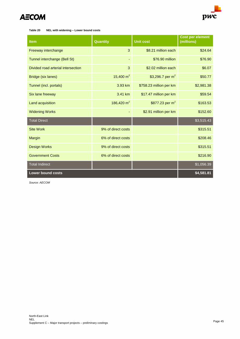
North-East Link
NEL
Supplement C – Major transport projects – preliminary costings Page 45
Table 20 NEL with widening – Lower bound costs
Item Quantity Unit cost
Cost per element
(millions)
Freeway interchange 3 $8.21 million each $24.64
Tunnel interchange (Bell St) - $76.90 million $76.90
Divided road arterial intersection 3 $2.02 million each $6.07
Bridge (six lanes) 15,400 m2 $3,296.7 per m
2 $50.77
Tunnel (incl. portals) 3.93 km $758.23 million per km $2,981.38
Six lane freeway 3.41 km $17.47 million per km $59.54
Land acquisition 186,420 m2 $877.23 per m
2 $163.53
Widening Works - $2.91 million per km $152.60
Total Direct $3,515.43
Site Work 9% of direct costs $315.51
Margin 6% of direct costs $208.46
Design Works 9% of direct costs $315.51
Government Costs 6% of direct costs $216.90
Total Indirect $1,056.39
Lower bound costs $4,581.81
Source: AECOM

North-East Link
NEL
Supplement C – Major transport projects – preliminary costings Page 46
Table 21 NEL with widening – Upper bound costs
Item Quantity Unit cost
Cost per element
(millions)
Freeway interchange 3 $12.32 million each $36.96
Tunnel interchange (Bell St) - $115.35 million $115.35
Divided road arterial intersection 3 $3.03 million each $9.10
Bridge (six lanes) 15,400 m2 $4,945 per m2 $76.15
Tunnel (incl. portals) 3.93 km $1,137.35 million per km $4,472.06
Six lane freeway 3.41 km $26.21 million per km $89.31
Land acquisition 186,420 m2 $1,315.84 per m2 $245.30
Widening Works - $4.37 million per km $228.90
Total Direct $5,273.14
Site Work 9% of direct costs $473.26
Margin 6% of direct costs $312.70
Design Works 9% of direct costs $473.26
Government Costs 6% of direct costs $325.35
Total Indirect $1,584.58
Upper bound costs $6,857.72
Source: AECOM
Table 22 NEL excluding widening – Lower bound costs
Item Quantity Unit cost
Cost per element
(millions)
Total Direct $3,362.83
Site Work 9% of direct costs $301.81
Margin 6% of direct costs $199.41
Design Works 9% of direct costs $301.81
Government Costs 6% of direct costs $207.49
Total Indirect $1,010.53
Lower bound costs $4,373.36
Source: AECOM

North-East Link
NEL
Supplement C – Major transport projects – preliminary costings Page 47
Table 23 NEL excluding widening – Upper bound costs
Item Quantity Unit cost
Cost per element
(millions)
Total Direct $5,044.24
Site Work 9% of direct costs $452.72
Margin 6% of direct costs $299.12
Design Works 9% of direct costs $452.72
Government Costs 6% of direct costs $311.23
Total Indirect $1,515.79
Upper bound costs $6,560.03
Source: AECOM
7.2.1 Land acquisition
Land acquisition costs have been based on RP data for house sales in the area and the State Revenue Office
(DA.048) advice that 45 percent of land value is made up of capital improvements while 55 percent is made up of
land value. This gave a value of $815 per square metre. Contingency was then applied and the cost was broken
down into indirect and direct as per the tables above.
The total of land required which is not already within the road reservation is approximately 186,400m2, based on
the alignment in the 2008 study.
Based on these figures the approximate value of the land required for acquisition is $152 million excluding
processing, legal and management costs.
7.3 Operational Costs
The operational costs could be broken into two sections, maintenance of the at-grade pavement and operations
and maintenance of the 4.2km road tunnel.
Operating costs for Eastlink for 2009 – 2011 were approximately $70 million per year, which inflated to 2016
costs would be $79 million per annum. The majority of this cost is involved in tolling and customer operations and
administrative expenses. The cost of roadside operations was $17.9 million per annum which is converted to
$20.2 million per annum in today’s currency.
Scaling up for the complexity and location of the tunnel under the Yarra River and sensitive environmental issues,
the operating cost for NEL has been estimated at $26 million per annum.
Using a discount rate of seven percent, the net present value of the operating costs is $358.8 million for the 50
year life of the project with escalation excluded.
7.4 Scope risk
There is significant risk involved in additional scope being added to the project due to the sensitive built-up areas
the project passes through. This may lead to additional requirements for bypasses or treatments on surrounding
arterial roads and public transport routes.
Without detailed modelling of impacts it is not clear what other mitigating works will be required on the network to
accommodate the new link and to achieve the best outcome.
7.5 Scope alternatives
While this scope has included the Bulleen alignment, there are two other viable alignments which could be
investigated as alternatives, including an alignment which connects via Ringwood to EastLink and an alignment
which runs further to the east as a more orbital route. The contingency costs do not allow for substantial changes
to alignment such as completely alternative routes, but does allow for minor changes to tunnel, road and
interchange alignments.
Due to topography and growth since early planning for the orbital completion in the late 1970’s, the more orbital
outer route is unlikely to be preferable to the Bulleen or Eastlink alignments.

North-East Link
NEL
Supplement C – Major transport projects – preliminary costings Page 48
Other lower cost alternatives are also possible, including elevated road structures in the place of tunnel through
the Banyule Flats. More detailed analysis of these scope alternatives would be required to settle on a preferred
alignment.
Some alternative alignments for the North-East Link can be found in Appendix C.
7.6 Cost risk
7.6.1 Geotechnical
Without detailed knowledge of the geology along the proposed alignment it is difficult to confirm the expected
geotechnical challenges. The creation of an interchange with Manningham Road immediately west of the Yarra
River bridge may be difficult to achieve while managing environmental impacts particularly with respect to
ground-water levels and the geology of the area.
A detailed analysis of the likely tunnelling methods and geotechnical challenges has been undertaken and is
included as Appendix D. The conclusion of this analysis is that a TBM would be the selected construction method
for the tunnel with access points north of Lower Plenty Road and at Bulleen Road south of the Yarra River.
7.6.2 Planning and environmental
The acquisition of land and the impacts on the surrounding environment, particularly in the tunnelled area and
where the proposed freeway will be close to adjoining properties, are a risk for the project. These may result in
additional land acquisition or additional mitigation works.
Further investigation into preferred alignments and the impacts of tunnelling on the environment would be
required prior to determining the level of risk involved.

Outer Metropolitan Ring Road
OMR
Supplement C – Major transport projects – preliminary costings Page 49
Outer Metropolitan Ring Road OMR
Infrastructure Victoria’s option description
Construction of the outer metropolitan ring road to improve cross-Melbourne freight vehicle access and
connections to the north and east from key freight precincts in the west. This option will also improve access to
employment in north and western metropolitan Melbourne.
Scope summary
The Outer metropolitan ring road (OMR) and E6 corridors are 70km and 23km long respectively. The OMR
alignment has been designed for a four lane carriageway in each direction while the E6 section is designed for
three lanes in each direction.
While the corridors could also support freight rail, this has not been included in this cost estimate.
Sector
Transport
Certainty of evidence
Medium
Evidence base
Geotechnical Assessment of Outer Metropolitan
Ring (OMR) Transport Corridor (May 2009)
Geotechnical Assessment of E6 Transport Corridor
VicRoads Outer Metropolitan Ring /E6 (OMR/E6)
Transport Corridor Planning Assessment Report
Direct option cost
$8.8 billion – $13.2 billion (2016)
Capital cost
$8.7 billion – $13.0 billion
Annual recurrent costs
$9.4 million
Whole-of-life PV: $129.7 million
Construction period
4 years
Operational life (from opening)
50 yrs
Cost certainty
Certainty of evidence – Medium
Actual cost will be higher as these figures do not include price escalation for future years.

Outer Metropolitan Ring Road
OMR
Supplement C – Major transport projects – preliminary costings Page 50
8.0 Outer Metropolitan Ring Road – Preliminary costing
8.1 Scope
The Outer metropolitan ring road (OMR) and E6 corridors are 70km and 23km long respectively. The OMR
alignment has been designed for a four lane carriageway in each direction while the E6 section is designed for
three lanes in each direction (however is costed below assuming two lanes in each direction).
The OMR has been designed to accommodate a 4-track rail corridor down the centre of the reservation to
connect freight lines from the west and north of Melbourne as well as providing an orbital public transport route.
The scope of this costing does not consider the cost of providing the rail or the additional structural costs likely to
be incurred due to the rail alignment.
Scoping has been undertaken based on the OMR/E6 corridor plans available from the VicRoads website
attached at Appendix E, with an overview of the future road displayed in Figure 12.
The Melbourne Airport Link is a road link connecting the Tullamarine Freeway to the Outer Metropolitan Ring
Road. It is expected that any construction of the OMR through this area would not occur without this connection
being made and therefore the cost of this extension has been included in the costing.

Outer Metropolitan Ring Road
OMR
Supplement C – Major transport projects – preliminary costings Page 51
Figure 12 Outer metropolitan ring road indicative alignment
Source: VicRoads

Outer Metropolitan Ring Road
OMR
Supplement C – Major transport projects – preliminary costings Page 52
8.2 Capital costs
Capital costs are based on rate costs for the various components of the project based on the design alignments
available on the VicRoads website. These costs include costs to construct interchanges with arterial roads and
freeway interchanges but do not include the cost of constructing joining roads such as the Bulla Bypass or
connection to the Deer Park Bypass.
The Melbourne Airport Link connection between the OMR and Tullamarine Freeway has been included as a
separate item and in the overall cost.
While allowance has been made for a six-lane freeway on the E6 and eight-lane on the OMR in the respective
road reservations, it is unlikely that the freeway would be initially constructed to this standard. Due to the likely
high number of trucks and anticipated speed of development, we have assumed construction of a freeway with
two lanes in each direction for the purposes of these costings for the entire length of the OMR and E6 corridors.
Further work is needed to identify appropriate staging, including which sections of the road might warrant delivery
ahead of others, or whether some sections should initially be delivered to an arterial road standard.
Unit costs are based on general alignments and estimated bridge and interchange costs. The cost breakdowns
including direct construction costs, indirect costs, margins and owner project costs are displayed Table 24
through Table 27.
Intersection costs include costs of signalisation.
The lower range of the costing includes an inherent risk contingency of 40 percent while the upper bound limit
includes a contingent risk component of 50 percent.
Table 24 OMR – Lower bound costs
Item Quantity Unit cost
Cost per element
(millions)
Four lane freeway 88.37 km $11.65 million per km $1,029.33
Freeway interchange 5 $8.21 million each $41.06
Arterial interchange 25 $2.02 million each $50.56
Bridge deck 269,045 m2 $3,295.93 per m
2 $886.75
Land acquisition
Werribee 5,440,000 m2 $341.41 per m
2 $1,857.26
Bulla 6,290,000 m2 $243.18 per m
2 $1,529.61
Epping 2,070,000 m2 $436.31 per m
2 $903.15
Total direct $6,297.73
Indirect costs
Site work 9% of direct costs $565.22
Margin 6% of direct costs $373.45
Design works 9% of direct costs $565.22
Government costs 6% of direct costs $388.57
Total indirect $1,892.47
Total lower bound $8,190.20
Source: AECOM

Outer Metropolitan Ring Road
OMR
Supplement C – Major transport projects – preliminary costings Page 53
Table 25 OMR – Upper bound costs
Item Quantity Unit cost
Cost per element
(millions)
Four lane freeway 88.37 km $17.47 million per km $1,544
Freeway interchange 5 $12.32 million each $61.60
Arterial intersection 25 $3.03 million each $75.84
Bridge deck 269,045 m2 $4,943.9 per m
2 $1,330.13
Land acquisition
Werribee 5,440,000 m2 $512.11 per m2 $2,785.89
Bulla 6,290,000 m2 $364.77 per m2 $2,294.41
Epping 2,070,000 m2 $654.46 per m2 $1,354.73
Total direct $9,446.60
Indirect costs
Site work 9% of direct costs $847.83
Margin 6% of direct costs $560.18
Design works 9% of direct costs $847.83
Government costs 6% of direct costs $582.85
Total indirect $2,838.7
Total upper bound $12,285.30
Source: AECOM
Land acquisition costs have been based on RP data for house sales in the area and the State Revenue Office
(DA.048) advice that 45 percent of land value is made up of capital improvements while 55 percent is made up of
land value. This gave a value per square metre of $317.12 for Werribee $225.88 for Bulla and $405.26 for
Epping. The alignment is segmented into three sections and costed for land acquisition based on these suburbs
for simplicity. The width of the road reserve was assumed to be 170m for the Werribee and Bulla, 90m for
Epping. Contingency was then applied and the cost was broken down into indirect and direct as per the tables
above.
The total of land required which is not already within the road reservation is approximately $13,800,000m2.
Based on these figures the approximate value of the land required for acquisition is $4.0 billion excluding
processing, legal and management costs. Any already incurred costs are considered to be relatively minor and
therefore have not been included for consideration.
Melbourne Airport Link is a 7km extension of the Tullamarine Freeway to the OMR with interchanges at
Somerton Road, Sunbury Road and a freeway interchange with the OMR.
The cost of this extension is outlined in Table 26 and Table 27.

Outer Metropolitan Ring Road
OMR
Supplement C – Major transport projects – preliminary costings Page 54
Table 26 OMR Extension – Lower bound costs
Item Quantity Unit cost
Cost per element
(millions)
Four lane freeway 7 km $11.65 million per km $81.53
Freeway interchange 1 $8.21 million each $8.21
Arterial interchange 2 $2.02 million each $4.04
Land acquisition
Bulla 1,190,000 m2 $243.18 per m
2 $289.38
Total direct $383.17
Indirect costs
Site work 9% of direct costs $34.39
Margin 6% of direct costs $22.72
Design works 9% of direct costs $34.39
Government costs 6% of direct costs $23.46
Total indirect $11.14
Total lower bound $498.32
Source: AECOM
Table 27 OMR Extension – Upper bound costs
Item Quantity Unit cost
Cost per element
(millions)
Four lane freeway 7 km $17.47 million per km $122.30
Freeway interchange 1 $12.32 million each $12.32
Arterial intersection 2 $3.03 million each $6.07
Land acquisition
Bulla 1,190,000 m2 $364.77 per m
2 $434.08
Direct total $574.76
Indirect costs
Site work 9% of direct costs $51.58
Margin 6% of direct costs $34.08
Design works 9% of direct costs $51.58
Government costs 6% of direct costs $35.46
Total indirect $172.72
Total upper bound $747.48

Outer Metropolitan Ring Road
OMR
Supplement C – Major transport projects – preliminary costings Page 55
Source: AECOM
Total capital cost including the Melbourne Airport Link (road) is $8.7 billion – $13.03 billion.
8.3 Operational costs
Based on maintenance costs being a portion of the existing road maintenance budget and taken from existing
road maintenance costs, the annual cost of maintaining the OMR would be $9.4 million.
Using a discount rate of seven percent, the net present value of the operating costs is $129.7 million for the 50
year life of the project excluding any future price escalation for improved freeway management or similar
operational projects.
8.4 Scope risk
Due to the dependence on development around the OMR corridor for timing and staging of the project there is
the possibility that development in the local area would require additional scope to the project. For example a
new rail or road connection through the corridor may add costs to the project.
Staging of the project will also likely add cost as some sections will be constructed before others. It is likely that
some connections will need to be constructed under partial traffic conditions.
Construction of part or all of the rail corridor during or prior to construction of the freeway would place additional
costs on the construction of the freeway. Lowering of the Bendigo – Melbourne Railway Line may also be
required.
Specifically, the proposed interchange with the Western Freeway may require relocation of the Western Freeway
alignment slightly to the north.
8.5 Scope alternative
Due to the detailed level of planning already undertaken it is unlikely that the scope will deviate substantially from
the alignment assessed. Changes may include local movements to accommodate unforeseen road or rail
projects which may develop in the interim. Such a change would be unlikely to have a material change to the cost
or scope identified in this report.
8.6 Cost risk
8.6.1 OMR Geotechnical
Major bridge structures are required at the Werribee River, Kororoit Creek, Jacksons Creek and Deep Creek
which are in incised valleys.
Many areas of the corridor contain ‘non-rippable’ basalt exposed at natural surface level where additional
investigation may be required to investigate re-processing and reusing excavated rock for pavement materials.
On the northern side of Bulla – Sunbury Road there is a substantial area of landfill which requires further
investigation to understand costs.
While these risks are known they have not been included in this costing. The nearby availability of existing
quarries and potential quarry sites may offset the costs encountered by these risks.
8.6.2 E6 Geotechnical
The Geotechnical Assessment of E6 Transport Corridor identified that there were no major impediments apart
from the common presence of near surface, high to very high strength basalt (including basalt boulders) and the
area between the Metropolitan Ring Road and McKimmmies Road which may be substantial landfill over 40m
deep at the site of an old quarry.
For at-grade structures it is likely that spread footings or large diameter bored piles would be used. For elevated
structures, pre-bored or driven piles are the preferred foundation.
Darebin Creek and Merri Creek may have softer weak soils than other areas and require further investigation.
While surface materials may be too weak for use as fill, there are several established quarries in the area which
could provide suitable fill material for no additional overall cost.
While these risks are known they have not been itemised in this costing, but have been considered in terms of
the overall risk allowance. The nearby availability of existing quarries and potential quarry sites may offset the
costs encountered by these risks.

Outer Metropolitan Ring Road
OMR
Supplement C – Major transport projects – preliminary costings Page 56
8.6.3 Flora and Fauna
Some sensitive flora and fauna are encountered at the southern end of the alignment around the Werribee River
including the Golden Sun Moth (threatened) and the Large-headed Fireweed (vulnerable). Mitigation or alteration
of the proposed route are a potential risk to the project. The implications of this on the overall project have not
been considered in this costing as they are assumed to be a small proportion of the overall project.
8.7 Staging options
Staging of the OMR and E6 would be largely dependent on development in the surrounding areas. Given the
existing traffic congestion on north-south arterials through Whittlesea, the E6 corridor is most likely to be
warranted earlier than other sections; however, pending traffic modelling, it may rely on the construction of NEL
as an enabling project as north-south routes across the Yarra south of Whittlesea are also heavily congested
during peak periods.
Another likely early stage would be at the Werribee end where congestion at the southern end of the M80 and
growth around the Werribee urban area may trigger the need for the OMR in this section.
The other possible lead stage could be a connection between the Hume corridor and the airport via the
Melbourne Airport Link. Growth in high value exports and airport growth in general could see the need for this
connection as an alternative to the M80.
There are upgrades of the M80 still being undertaken and therefore the staging of the OMR as an alternative will
be dependent on the impacts of the further expansions of the M80. There may also be consideration given to
further M80 widening as an alternative or supplementary project to the OMR.

Rowville heavy rail line
RHR
Supplement C – Major transport projects – preliminary costings Page 57
Rowville heavy rail line RHR
Infrastructure Victoria’s option description
A new heavy rail line to Rowville connected at Huntingdale Station running East along the central median of
North Road and Wellington Road to Stud Road, then turning north to terminate at Stud Park. The works include
the construction of four stations at Monash University, Mulgrave, Waverley Park and Rowville. This option has
the ability to reduce congestion on the road network in this corridor through passenger mode change. This option
provides a better service for people to access employment opportunities around the Monash Employment Cluster
and jobs and services in the central city. A rail extension to Rowville is identified in the PTV Network
Development Plan – Metropolitan Rail, December 2012 for delivery in Stage 3. A feasibility study has also been
completed which identified that prior to this project occurring there is a need to remove level crossings on the
Dandenong corridor (committed) and introduce extended trains (e.g. 10 car trains – option HCT2) operating via a
new Melbourne Metro tunnel (committed).
Scope summary
This project proposes to construct a heavy rail line from Huntingdale Station along North Road and Wellington
Road and then through an existing golf course reserve and park lane before terminating at Stud Park. The rail
line will consist of both underground and elevated rail sections along its length. Four stations are assumed to be
constructed including Monash University, Mulgrave, Waverley Park and Rowville.
Sector
Transport
Certainty of evidence
Medium
Evidence base
Rowville Rail Study Preliminary rail design report –
URS/AECOM 2012
Network Development Plan – PTV 2012
Rowville Rail Pre-Feasibility Study – Independent
Study 2004
Direct option cost (incl. rolling stock)
$5.7 billion – $8.5 billion (2016)
Capital cost
$4.8 billion – $7.8 billion
Annual recurrent costs
$52 million
Whole-of-Life PV: $713 million
Construction period
4 years
Operational life (from opening)
50 yrs
Cost certainty
Certainty of evidence – Medium
Significant risk due to number of interfaces with
existing infrastructure.
Actual cost will be higher as these figures do not include price escalation for future years.

Rowville heavy rail line
RHR
Supplement C – Major transport projects – preliminary costings Page 58
9.0 Rowville heavy rail line (RHR) – Preliminary costing
9.1 Scope
The scope considered for construction under this project includes the enabling works to develop the 31km dual
track heavy rail line and its components. Construction projects required to enable these works are as follows.
- three new underground rail stations placed at Monash University, Waverley Park and Rowville
- new underground platforms at Huntingdale Station
- a new above ground station at Mulgrave
This heavy rail line is to be constructed with the track at the end of the alignment elevated over the flood plain
running east – west to Eastlink before terminating at Stud Park shopping centre.
The track structure along the line will include both elevated viaduct structures and underground tunnelled sections
at different points. The illustrative alignment from the Rowville Rail Study Final Stage 1 Report can be seen in
Figure 13.
Figure 13 RHR illustrative alignment
Source: PTV
9.2 Capital costs
The capital costs of the Rowville Heavy Rail are based on length elements of the alignment including at-grade,
tunnel and viaducts.
Indirect costs are assumed as a proportion of direct construction costs.
The lower range of the costing includes an inherent risk contingency of 40 percent while the upper bound limit
includes a contingent risk component of 50 percent.
Table 28 and Table 29 display the itemised costs for option RHR.

Rowville heavy rail line
RHR
Supplement C – Major transport projects – preliminary costings Page 59
Table 28 RHR – Lower bound cost
Item Quantity Unit cost
Cost per element
(millions)
Track at grade
Track at grade (all infrastructure) 1.37 km $20.02 million per km $27.42
Elevated Viaduct
Rail track 13,414 m $4,830 per m $64.79
Viaduct structure 67,070 m2 $17,500 per m
2 $1,173.73
Cut and cover tunnel
Construction 6.14 km $105 million per km $644.56
Rail track 12.28 km $3.57 million per km $43.83
Power and communications
Substations 4 $7 million each $28
Signalling and communications 25.69 km $2.8 million per km $71.93
Stations
Elevated station 1 $56 million each $56
Underground station 4 $231 million each $924
Land acquisition 52,063 m2 $670.55 per m
2 $34.91
Total direct $3,069.18
Indirect costs
Site works 25% of direct costs $767.29
Margin 8% of direct costs $245.53
Design work 15% of direct costs $460.37
Government costs 10% of direct costs $306.92
Total indirect $1,780.12
Lower bound total $4,849.29
Source: AECOM
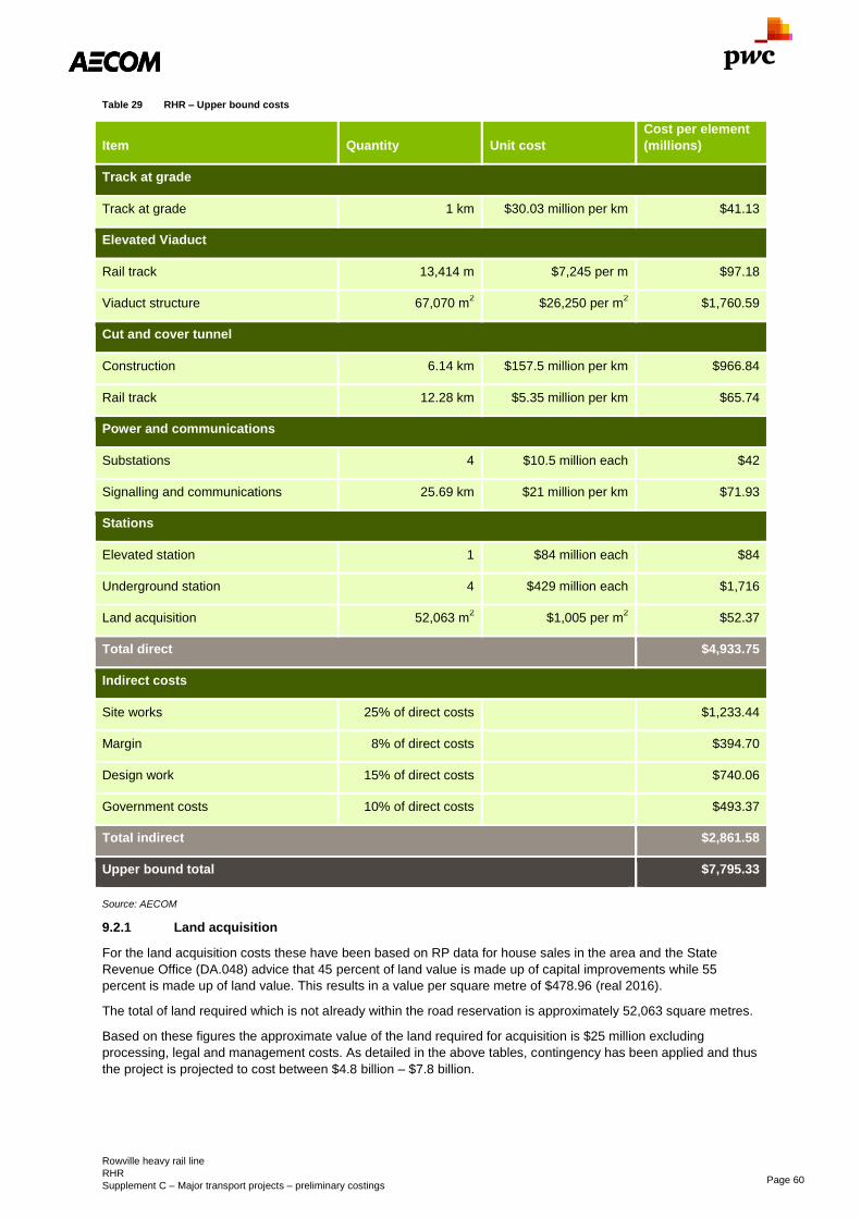
Rowville heavy rail line
RHR
Supplement C – Major transport projects – preliminary costings Page 60
Table 29 RHR – Upper bound costs
Item Quantity Unit cost
Cost per element
(millions)
Track at grade
Track at grade 1 km $30.03 million per km $41.13
Elevated Viaduct
Rail track 13,414 m $7,245 per m $97.18
Viaduct structure 67,070 m2 $26,250 per m
2 $1,760.59
Cut and cover tunnel
Construction 6.14 km $157.5 million per km $966.84
Rail track 12.28 km $5.35 million per km $65.74
Power and communications
Substations 4 $10.5 million each $42
Signalling and communications 25.69 km $21 million per km $71.93
Stations
Elevated station 1 $84 million each $84
Underground station 4 $429 million each $1,716
Land acquisition 52,063 m2 $1,005 per m
2 $52.37
Total direct $4,933.75
Indirect costs
Site works 25% of direct costs $1,233.44
Margin 8% of direct costs $394.70
Design work 15% of direct costs $740.06
Government costs 10% of direct costs $493.37
Total indirect $2,861.58
Upper bound total $7,795.33
Source: AECOM
9.2.1 Land acquisition
For the land acquisition costs these have been based on RP data for house sales in the area and the State
Revenue Office (DA.048) advice that 45 percent of land value is made up of capital improvements while 55
percent is made up of land value. This results in a value per square metre of $478.96 (real 2016).
The total of land required which is not already within the road reservation is approximately 52,063 square metres.
Based on these figures the approximate value of the land required for acquisition is $25 million excluding
processing, legal and management costs. As detailed in the above tables, contingency has been applied and thus
the project is projected to cost between $4.8 billion – $7.8 billion.
Rowville heavy rail line
RHR
Supplement C – Major transport projects – preliminary costings Page 61
9.2.2 Rolling stock
Based on information provided by Infrastructure Victoria and assuming train costs of $29.5 million per 10-car set,
the cost of providing rolling stock for the Rowville extension is $146 million given the assumption that five trains
will be required.
9.2.3 Comparison to previous study
Knox City Council had a study undertaken in 2004 which indicated the cost of the Rowville heavy rail project from
Huntingdale to Rowville would be around $480 million. The Rowville Rail Study Final Stage 1 Feasibility Report
indicated that this cost was likely to be too low.
9.3 Operational Costs
The annual operational costs have been provided by Infrastructure Victoria and are based on running additional
services to Rowville as well as re-directing some existing services from the Dandenong Group.
Based on Infrastructure Victoria advice the total operating cost per annum for these services is approximately
$51.7 million. The operational cost assumptions are that track maintenance is $264,498 per track/km/year,
underground stations are $6 million each and stations at-grade are $0.5 million each.
Using a discount rate of seven percent, the net present value of the operating costs is $713 million for the 50 year
life of the project. Escalation is excluded, thus the future value would be higher than this estimate.
9.4 Scope alternatives
There are a number of alternatives for various sections of the alignment for the construction type and other
factors; these have the potential to impact the scope and cost of this project. The options that are viable for the
current alignment are as follows:
- For Huntingdale Station the new underground platforms could be located to the east of the existing station to
lessen the impact on the existing mainline and station.
- There are several crossing points for local service roads along the North Road line that could be reduced
and this will impact the level of the rail alignment in this area. There is also an option to have open-cut
tunnelling with overbridges at the median crossing points.
- The major intersection with Princes Highway can be either cut and cover or a Sprayed Concrete Lining
(SCL) tunnelling method. This may depend on the location of the Monash University Station.
- The location of Monash University Station will be based on suitable horizontal alignment and the locations of
buildings.
- Cut and cover tunnelling could be replaced by tunnel-bored machines.
It should also be noted that for the project overall, there is an alternative of using TBM bored tunnels instead of
cut and cover or SCL tunnel. This may result in change in areas of the alignment and station locations.
9.5 Scope risk
- Preference for bored tunnels to reduce impacts on services and disruptions to traffic or environmental
impacts may result in additional costs for deeper stations and additional tunnelling costs.
- The foundations of structures may be impacted by tunnelling type, including those of the North Road Bridge,
North Road, Huntingdale Road and the Oakleigh Army Barracks. This could result in the need for
demolitions. Other interfaces with the existing Huntingdale Station infrastructure may also pose a scope risk.
- Demolition of properties may be required along the eastern end of the alignment towards Rowville Station
9.6 Cost risk
Tunnelling and elevated structure construction along the route will cause significant impacts on the operation of
the roads and intersections. This may include road closures and diversions which need to be planned for
accordingly. Temporary works for support of existing structures including North Road Bridge may also need to be
provided, adding further costs to the project.
There has not been intensive geotechnical investigation into the ground conditions for this project. Depending on
the outcomes of this type of investigation, the required foundations for elevated rail structures and the
construction of tunnelling may incur additional costs.
Environmental factors will have an impact on the final cost of this project.

Rowville heavy rail line
RHR
Supplement C – Major transport projects – preliminary costings Page 62
There are certain points along the alignment of the Rowville Rail line that will need extensive investigation into
how to approach the services that are currently in the area. This will likely involve the relocation of certain services
which will add cost to the project.

Appendix C: North-east Link – Alternative alignments
Supplement C – Major transport projects – preliminary costings Page C-1
Appendix A
City loop reconfiguration Geotechnical assessment
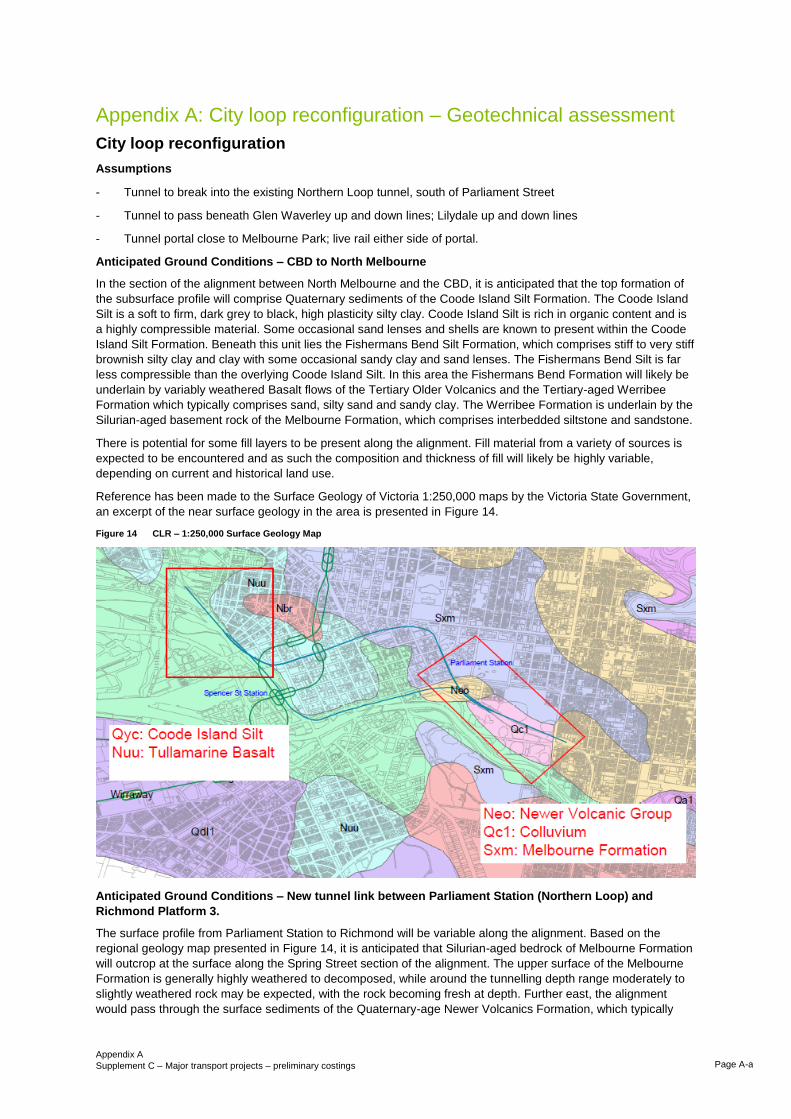
Appendix A
Supplement C – Major transport projects – preliminary costings Page A-a
Appendix A: City loop reconfiguration – Geotechnical assessment
City loop reconfiguration
Assumptions
- Tunnel to break into the existing Northern Loop tunnel, south of Parliament Street
- Tunnel to pass beneath Glen Waverley up and down lines; Lilydale up and down lines
- Tunnel portal close to Melbourne Park; live rail either side of portal.
Anticipated Ground Conditions – CBD to North Melbourne
In the section of the alignment between North Melbourne and the CBD, it is anticipated that the top formation of
the subsurface profile will comprise Quaternary sediments of the Coode Island Silt Formation. The Coode Island
Silt is a soft to firm, dark grey to black, high plasticity silty clay. Coode Island Silt is rich in organic content and is
a highly compressible material. Some occasional sand lenses and shells are known to present within the Coode
Island Silt Formation. Beneath this unit lies the Fishermans Bend Silt Formation, which comprises stiff to very stiff
brownish silty clay and clay with some occasional sandy clay and sand lenses. The Fishermans Bend Silt is far
less compressible than the overlying Coode Island Silt. In this area the Fishermans Bend Formation will likely be
underlain by variably weathered Basalt flows of the Tertiary Older Volcanics and the Tertiary-aged Werribee
Formation which typically comprises sand, silty sand and sandy clay. The Werribee Formation is underlain by the
Silurian-aged basement rock of the Melbourne Formation, which comprises interbedded siltstone and sandstone.
There is potential for some fill layers to be present along the alignment. Fill material from a variety of sources is
expected to be encountered and as such the composition and thickness of fill will likely be highly variable,
depending on current and historical land use.
Reference has been made to the Surface Geology of Victoria 1:250,000 maps by the Victoria State Government,
an excerpt of the near surface geology in the area is presented in Figure 14.
Figure 14 CLR – 1:250,000 Surface Geology Map
Anticipated Ground Conditions – New tunnel link between Parliament Station (Northern Loop) and
Richmond Platform 3.
The surface profile from Parliament Station to Richmond will be variable along the alignment. Based on the
regional geology map presented in Figure 14, it is anticipated that Silurian-aged bedrock of Melbourne Formation
will outcrop at the surface along the Spring Street section of the alignment. The upper surface of the Melbourne
Formation is generally highly weathered to decomposed, while around the tunnelling depth range moderately to
slightly weathered rock may be expected, with the rock becoming fresh at depth. Further east, the alignment
would pass through the surface sediments of the Quaternary-age Newer Volcanics Formation, which typically
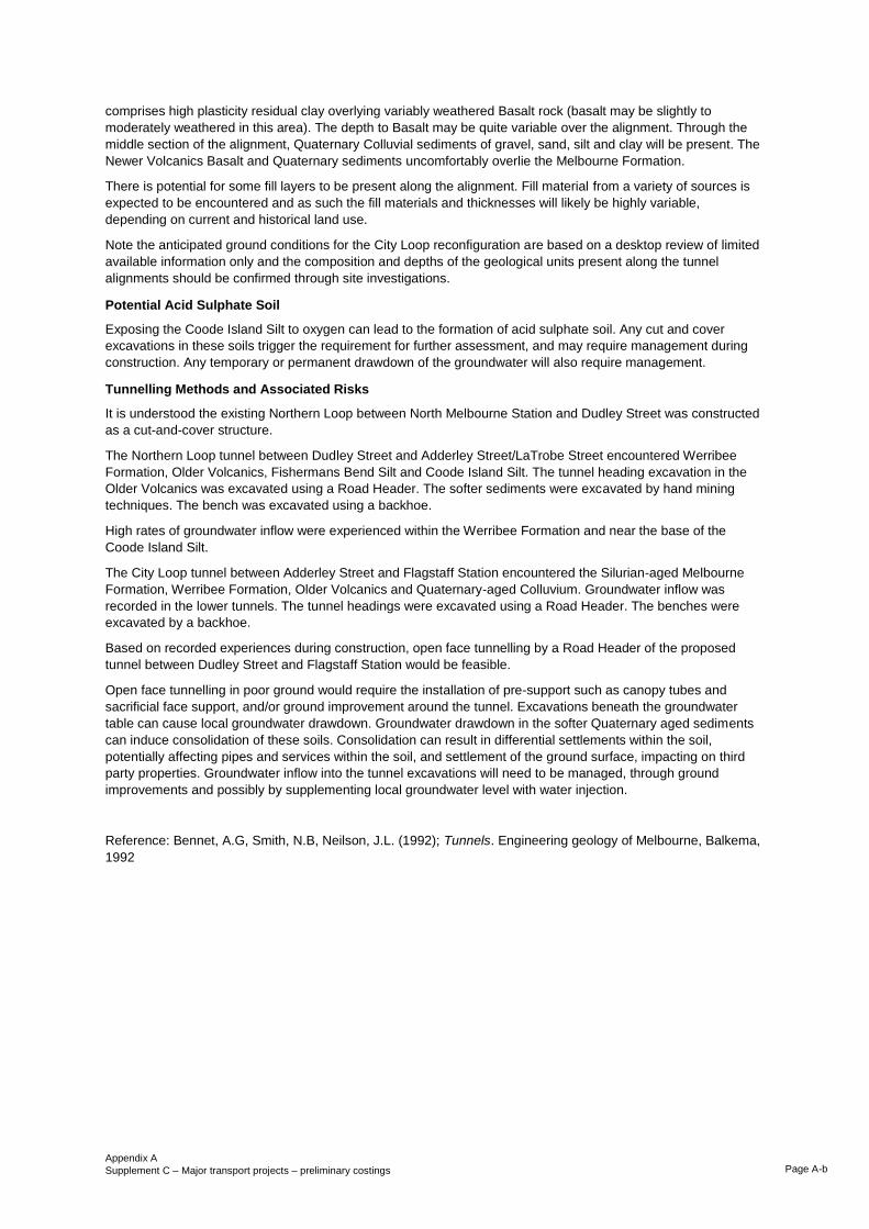
Appendix A
Supplement C – Major transport projects – preliminary costings Page A-b
comprises high plasticity residual clay overlying variably weathered Basalt rock (basalt may be slightly to
moderately weathered in this area). The depth to Basalt may be quite variable over the alignment. Through the
middle section of the alignment, Quaternary Colluvial sediments of gravel, sand, silt and clay will be present. The
Newer Volcanics Basalt and Quaternary sediments uncomfortably overlie the Melbourne Formation.
There is potential for some fill layers to be present along the alignment. Fill material from a variety of sources is
expected to be encountered and as such the fill materials and thicknesses will likely be highly variable,
depending on current and historical land use.
Note the anticipated ground conditions for the City Loop reconfiguration are based on a desktop review of limited
available information only and the composition and depths of the geological units present along the tunnel
alignments should be confirmed through site investigations.
Potential Acid Sulphate Soil
Exposing the Coode Island Silt to oxygen can lead to the formation of acid sulphate soil. Any cut and cover
excavations in these soils trigger the requirement for further assessment, and may require management during
construction. Any temporary or permanent drawdown of the groundwater will also require management.
Tunnelling Methods and Associated Risks
It is understood the existing Northern Loop between North Melbourne Station and Dudley Street was constructed
as a cut-and-cover structure.
The Northern Loop tunnel between Dudley Street and Adderley Street/LaTrobe Street encountered Werribee
Formation, Older Volcanics, Fishermans Bend Silt and Coode Island Silt. The tunnel heading excavation in the
Older Volcanics was excavated using a Road Header. The softer sediments were excavated by hand mining
techniques. The bench was excavated using a backhoe.
High rates of groundwater inflow were experienced within the Werribee Formation and near the base of the
Coode Island Silt.
The City Loop tunnel between Adderley Street and Flagstaff Station encountered the Silurian-aged Melbourne
Formation, Werribee Formation, Older Volcanics and Quaternary-aged Colluvium. Groundwater inflow was
recorded in the lower tunnels. The tunnel headings were excavated using a Road Header. The benches were
excavated by a backhoe.
Based on recorded experiences during construction, open face tunnelling by a Road Header of the proposed
tunnel between Dudley Street and Flagstaff Station would be feasible.
Open face tunnelling in poor ground would require the installation of pre-support such as canopy tubes and
sacrificial face support, and/or ground improvement around the tunnel. Excavations beneath the groundwater
table can cause local groundwater drawdown. Groundwater drawdown in the softer Quaternary aged sediments
can induce consolidation of these soils. Consolidation can result in differential settlements within the soil,
potentially affecting pipes and services within the soil, and settlement of the ground surface, impacting on third
party properties. Groundwater inflow into the tunnel excavations will need to be managed, through ground
improvements and possibly by supplementing local groundwater level with water injection.
Reference: Bennet, A.G, Smith, N.B, Neilson, J.L. (1992); Tunnels. Engineering geology of Melbourne, Balkema,
1992
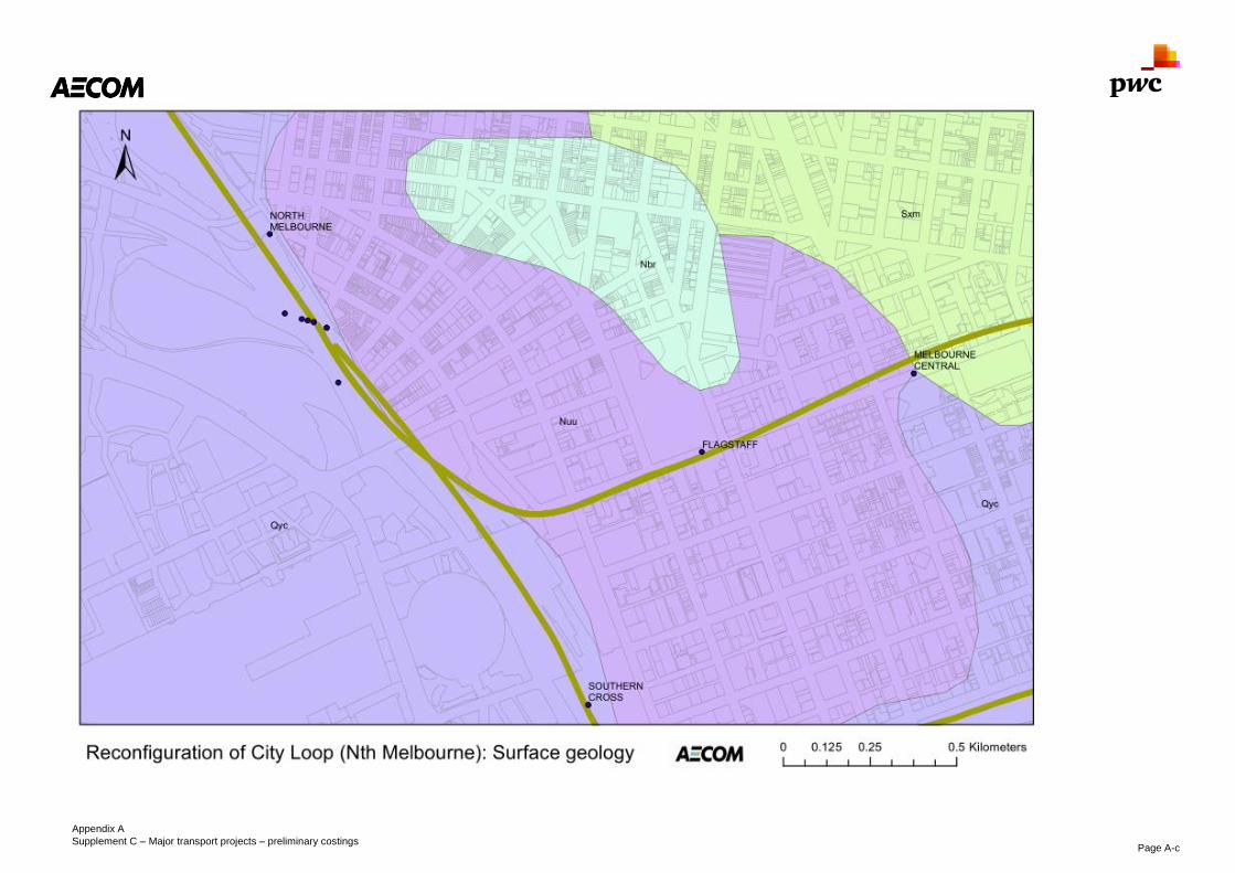
Appendix A
Supplement C – Major transport projects – preliminary costings Page A-c

Appendix A
Supplement C – Major transport projects – preliminary costings Page A-d

Appendix B
Supplement C – Major transport projects – preliminary costings Page B-1
Appendix B
Melbourne Metro 2 Geotechnical assessment

Appendix B
Supplement C – Major transport projects – preliminary costings Page B-a
Appendix B: Melbourne Metro 2 – Geotechnical assessment
North East of Southern Cross Station
Anticipated ground conditions
The surface geology along the proposed alignments between Spencer Street Station and Clifton Hill
predominantly consists of tertiary aged rock units including Red Bluff Sandstone of the Brighton Group which
comprises pale yellow and brown, fine to coarse grained sandstone, sands and gravel and Basalt flows of the
Newer Volcanic Group and Tullamarine Basalt. The Newer Volcanics typically comprise residual clays overlying
Basalt.
The Silurian-aged Melbourne Formation, comprising folded siltstone with interbedded sandstone bands, is also
expected to be present. The upper surface of the Silurian bedrock may be highly weathered, becoming fresh with
depth.
A thin layer of Quaternary aged sediments or fill materials may be present at the surface in some locations. The
near-surface geology along the alignment is presented in Figure 15 (Surface Geology of Victoria 1:250,000 maps
by the Victoria State Government)
Figure 15 MMS – Near-surface geology North East of Spencer Street Station
Tunnelling Methods and Associated Risks
A cut and cover tunnel typically requires access from ground surface for construction, therefore being more
disruptive to existing surface development than a driven tunnel.
Open face tunnelling techniques using road header or open beam Tunnel Boring Machine (TBM) are suitable in
the Melbourne Formation and other competent rock sections of the tunnel, and road header tunnels have been
typically adopted for road projects in the past.
Open face driven tunnels would typically be temporarily supported with combinations of steel sets and/or rock
bolts with mesh or sprayed concrete. Continuous monitoring of the ground surface above the tunnel within the
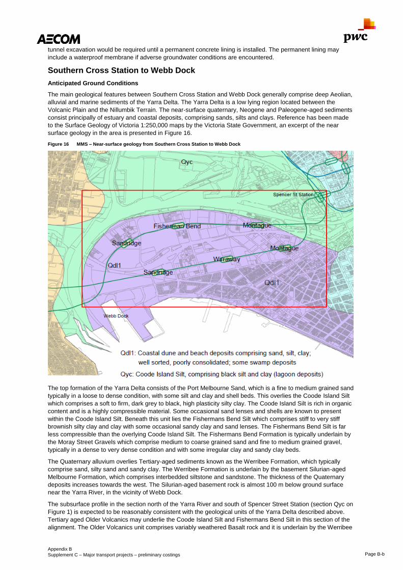
Appendix B
Supplement C – Major transport projects – preliminary costings Page B-b
tunnel excavation would be required until a permanent concrete lining is installed. The permanent lining may
include a waterproof membrane if adverse groundwater conditions are encountered.
Southern Cross Station to Webb Dock
Anticipated Ground Conditions
The main geological features between Southern Cross Station and Webb Dock generally comprise deep Aeolian,
alluvial and marine sediments of the Yarra Delta. The Yarra Delta is a low lying region located between the
Volcanic Plain and the Nillumbik Terrain. The near-surface quaternary, Neogene and Paleogene-aged sediments
consist principally of estuary and coastal deposits, comprising sands, silts and clays. Reference has been made
to the Surface Geology of Victoria 1:250,000 maps by the Victoria State Government, an excerpt of the near
surface geology in the area is presented in Figure 16.
Figure 16 MMS – Near-surface geology from Southern Cross Station to Webb Dock
The top formation of the Yarra Delta consists of the Port Melbourne Sand, which is a fine to medium grained sand
typically in a loose to dense condition, with some silt and clay and shell beds. This overlies the Coode Island Silt
which comprises a soft to firm, dark grey to black, high plasticity silty clay. The Coode Island Silt is rich in organic
content and is a highly compressible material. Some occasional sand lenses and shells are known to present
within the Coode Island Silt. Beneath this unit lies the Fishermans Bend Silt which comprises stiff to very stiff
brownish silty clay and clay with some occasional sandy clay and sand lenses. The Fishermans Bend Silt is far
less compressible than the overlying Coode Island Silt. The Fishermans Bend Formation is typically underlain by
the Moray Street Gravels which comprise medium to coarse grained sand and fine to medium grained gravel,
typically in a dense to very dense condition and with some irregular clay and sandy clay beds.
The Quaternary alluvium overlies Tertiary-aged sediments known as the Werribee Formation, which typically
comprise sand, silty sand and sandy clay. The Werribee Formation is underlain by the basement Silurian-aged
Melbourne Formation, which comprises interbedded siltstone and sandstone. The thickness of the Quaternary
deposits increases towards the west. The Silurian-aged basement rock is almost 100 m below ground surface
near the Yarra River, in the vicinity of Webb Dock.
The subsurface profile in the section north of the Yarra River and south of Spencer Street Station (section Qyc on
Figure 1) is expected to be reasonably consistent with the geological units of the Yarra Delta described above.
Tertiary aged Older Volcanics may underlie the Coode Island Silt and Fishermans Bend Silt in this section of the
alignment. The Older Volcanics unit comprises variably weathered Basalt rock and it is underlain by the Werribee

Appendix B
Supplement C – Major transport projects – preliminary costings Page B-c
Formation and Melbourne Formation. The Older Volcanics may be present nearer to the surface towards the east.
It is not anticipated that rock will be encountered within typical tunnelling depth ranges, however limited geological
information is available and therefore this assumption should be confirmed through targeted site investigations.
Based on a review of aerial photographs from 1945, significant land development has occurred over time
throughout the study area. As such, it is anticipated that a layer of fill will be present throughout much the
alignment. Fill material from a variety of sources is expected to be encountered and as such the composition and
thickness of fill will likely be highly variable, depending on current and historical land use. Any existing fill is
unlikely to have been placed as engineered fill, by using appropriate material types and compaction, and as such
may be subject to subsidence when loaded.
Hydrogeology
Given the proximity of the proposed tunnel to the coast, shallow groundwater is anticipated. Groundwater levels
are expected to be within a few metres of the surface and groundwater may be saline. The depth to groundwater
may become greater closer to the Melbourne CBD. Seasonal and tidal fluctuations in groundwater level should be
expected.
Perched groundwater tables may also be present locally within fill materials.
Acid Sulphate Soils
Acid sulphate soil may be present in near-surface Quaternary aged Yarra Delta sediments, particularly in the
Coode Island Silt. Any cut and cover excavations in these soils trigger the requirement for further assessment,
and may require management during construction. Any temporary or permanent drawdown of the groundwater
will also require management.
Tunnelling Methods and Associated Risks
Near surface stations would typically be excavated as cut-and-cover structures, while sections of the tunnels
close to the surface may also be constructed this way.
A cut and cover tunnel typically consists of excavating a relatively shallow trench, in which the tunnel structure is
constructed and covered with an overhead support system strong enough to carry the load of what is to be built
above the tunnel. It typically requires access from ground surface for construction, therefore being more disruptive
to existing surface development than a driven tunnel.
Cut and cover excavations below the groundwater table require groundwater retention. Secant pile or diaphragm
walls are common methods to achieve waterproofed structures beneath the water table.
Groundwater drawdown in the softer Quaternary aged sediments can induce consolidation of these soils.
Consolidation can result in differential settlements within the soil, potentially affecting pipes and services within
the soil, and settlement of the ground surface, impacting on third party properties. Temporary and permanent
groundwater inflow into cuttings and tunnel excavations will need to be managed, through ground improvements
and possibly by supplementing local groundwater level with water injection.
Closed face tunnelling techniques provide support to the excavated face, usually soft soil, while the face is being
excavated. Depending on ground conditions, either a closed face Earth Pressure Balance Machine or a Slurry
Shield TBM provides the face support during tunnel excavation. The permanent tunnel lining, typically in the form
of interlocking concrete segments, is installed progressively behind the TBM as the heading is advanced. TBM
tunnels are circular in section. Unlike an open face tunnel, there is generally no temporary groundwater drawdown
associated with closed faced tunnelling. A single shield TBM can operate in a closed face mode, installing the
permanent concrete liner as it excavates through the softer soil, and then as an open face machine in the
competent rock sections of the tunnel.
Western Yarra Crossing
Anticipated Ground Conditions
The main geological features underlying the Yarra River generally comprise deep Aeolian, alluvial and marine
sediments of the Yarra Delta. The geological units expected to be encountered include Coode Island Silt, which
comprises a soft to firm, dark grey to black, high plasticity silty clay with occasional sand lenses. The Coode
Island Silt is rich in organic content and is a highly compressible material. Beneath this unit lies the Fishermans
Bend Silt which comprises stiff to very stiff brownish silty clay and clay with some occasional sandy clay and sand
lenses. Moray Street Gravels are expected beneath the Fishermans Silt. The Moray Street Gravel Formation
comprises medium to coarse grained sand and fine to medium grained gravel, typically in a dense to very dense
condition and with some irregular clay and sandy clay beds. These Quaternary sediments overlie the basement
Silurian-aged Melbourne Formation, which comprised interbedded siltstone and sandstone. Silurian-aged
basement rock is present at almost 100 m below ground surface near the Yarra River.

Appendix B
Supplement C – Major transport projects – preliminary costings Page B-d
West of the Yarra River lies a geological boundary between the Quaternary sediments of the Yarra Delta and the
Tertiary aged Newer Volcanics basalt flows .The Newer Volcanics unit typically comprises fresh to slightly
weathered basalt, with basalt weathered to a high plasticity residual soil at the surface. Underlying the Newer
Volcanics is the Brighton Group, comprising fluvial and marine deposits of dense to very dense silty sand with
some coarse sand, fine gravel, silt and clay. Beneath this unit lies the Newport Formation which consists of
calcareous silty clay and silty sand, with some limestone and shells. The Newport Formation overlies the
Werribee Formation which comprises dense sands and silty sands with some hard clay and occasional lenses of
gravel.
Reference has been made to the Surface Geology of Victoria 1:250,000 maps by the Victoria State Government,
an excerpt of the near surface geology in the area is presented in Figure 17.
Figure 17 MMS – Near-surface geology west of the Yarra River
Hydrogeology
Immediately west of the Yarra River groundwater is expected at shallow depths, likely within a few metres of the
surface, reflecting the water level in the river. Groundwater may be saline given the proximity to the coast.
Seasonal and tidal fluctuations in groundwater level may be expected.
Groundwater may be present at greater depth towards the west, within the Newer Volcanics Basalt.
Acid Sulphate Soils
Acid sulphate soil may be present in near-surface Quaternary aged Yarra Delta sediments, particularly in the
Coode Island Silt. Any cut and cover excavations in these soils trigger the requirement for further assessment,
and may require management during construction. Any temporary or permanent drawdown of the groundwater
will also require management.
Tunnelling Methods and Associated Risks
A number of tunnel construction options exist for the western crossing of the Yarra River.
Immersed tube tunnels are constructed by linking together a series of separate tunnel segments typically across
the floor of a river, estuary or harbour. The segments are generally constructed off-line, floated to the tunnel site,
sunk into place and then linked together. The ends of an immersed tube crossing of the Yarra River will need to
interface with the tunnel from Southern Cross through the sediments of the Yarra Delta, and west towards
Newport through the Newer Volcanics and/or underlying sediments.
A cut and cover tunnel crossing of the Yarra River would require temporary coffer-dams to be set up across the
river, allowing access to the river bed for sequential excavation and construction of the tunnel segments. As with
the immersed tube option, the ends of a cut and cover crossing will need to interface with tunnels either side of
the river.

Appendix B
Supplement C – Major transport projects – preliminary costings Page B-e
Closed face tunnelling techniques provide support to the excavated face, usually soft soil and/or high groundwater
inflows and pressures, while the face is being excavated. Depending on ground conditions, either a closed face
Earth Pressure Balance Machine or a Slurry Shield Tunnel Boring Machine (TBM) provides the face support
during tunnel excavation. The permanent tunnel lining, typically in the form of interlocking concrete segments, is
installed progressively behind the TBM as the heading is advanced. TBM tunnels are circular in section. Unlike an
open face tunnel, there is generally no temporary groundwater drawdown associated with closed faced tunnelling.
A single shield TBM can operate in a closed face mode, installing the permanent concrete liner as it excavates
through the softer soil, and then as an open face machine in the competent rock sections of the tunnel.
A closed face TBM can pass continuously from a terrestrial tunnel beneath the Yarra River and beyond without
the need for the tie-ins that would be required for an immersed tube and possibly the cut and cover.
A closed face TBM could continue west from the Yarra River through the Newer Volcanics and underlying
Neogene/Paleogene sediments west of the Yarra River and onto Newport Station.
Open face tunnelling techniques using road header or an open beam TBM are also likely to be suitable in the
Newer Volcanics and underlying Neogene/Paleogene sediments west of the Yarra River and onto Newport
Station. An open faced tunnel would require a tie-in to the closed-face tunnel or cut-and-cover tunnel crossing of
the Yarra River. Open faced tunnelling would be suitable for Melbourne Formation basement rock, but depths of
near 100 metres below ground surface are unlikely to be practical for transit rail.

Appendix C: North-east Link – Alternative alignments
Supplement C – Major transport projects – preliminary costings Page C-1
Appendix C
North-East link Alternative alignments

Appendix C: North-east Link – Alternative alignments
Supplement C – Major transport projects – preliminary costings Page C-a
Appendix C: North-East link – Alternative alignments
North-East link
Five alternative routes for North-East link are displayed below in Figure 18 and Figure 19
Figure 18 North-East link alternatives 1

Appendix C: North-east Link – Alternative alignments
Supplement C – Major transport projects – preliminary costings Page C-b
Figure 19 North-East link alternatives 2

Appendix D
Supplement C – Major transport projects – preliminary costings Page D-1
Appendix D
North-East link Geotechnical assessment
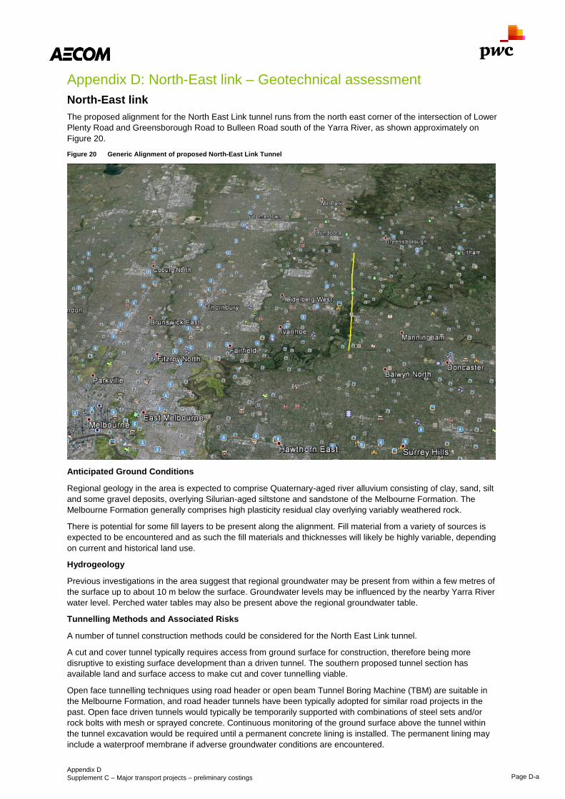
Appendix D
Supplement C – Major transport projects – preliminary costings Page D-a
Appendix D: North-East link – Geotechnical assessment
North-East link
The proposed alignment for the North East Link tunnel runs from the north east corner of the intersection of Lower
Plenty Road and Greensborough Road to Bulleen Road south of the Yarra River, as shown approximately on
Figure 20.
Figure 20 Generic Alignment of proposed North-East Link Tunnel
Anticipated Ground Conditions
Regional geology in the area is expected to comprise Quaternary-aged river alluvium consisting of clay, sand, silt
and some gravel deposits, overlying Silurian-aged siltstone and sandstone of the Melbourne Formation. The
Melbourne Formation generally comprises high plasticity residual clay overlying variably weathered rock.
There is potential for some fill layers to be present along the alignment. Fill material from a variety of sources is
expected to be encountered and as such the fill materials and thicknesses will likely be highly variable, depending
on current and historical land use.
Hydrogeology
Previous investigations in the area suggest that regional groundwater may be present from within a few metres of
the surface up to about 10 m below the surface. Groundwater levels may be influenced by the nearby Yarra River
water level. Perched water tables may also be present above the regional groundwater table.
Tunnelling Methods and Associated Risks
A number of tunnel construction methods could be considered for the North East Link tunnel.
A cut and cover tunnel typically requires access from ground surface for construction, therefore being more
disruptive to existing surface development than a driven tunnel. The southern proposed tunnel section has
available land and surface access to make cut and cover tunnelling viable.
Open face tunnelling techniques using road header or open beam Tunnel Boring Machine (TBM) are suitable in
the Melbourne Formation, and road header tunnels have been typically adopted for similar road projects in the
past. Open face driven tunnels would typically be temporarily supported with combinations of steel sets and/or
rock bolts with mesh or sprayed concrete. Continuous monitoring of the ground surface above the tunnel within
the tunnel excavation would be required until a permanent concrete lining is installed. The permanent lining may
include a waterproof membrane if adverse groundwater conditions are encountered.

Appendix D
Supplement C – Major transport projects – preliminary costings Page D-b
Open face tunnelling in poor ground would require the installation of pre-support such as canopy tubes and
sacrificial face support, and/or ground improvement around the tunnel. Excavations beneath the groundwater
table can cause local groundwater drawdown. Groundwater drawdown in the softer Quaternary aged sediments
can induce consolidation of these soils. Consolidation can result in differential settlements within the soil,
potentially affecting pipes and services within the soil, and settlement of the ground surface, impacting on third
party properties. Groundwater inflow into the tunnel excavations will need to be managed, through ground
improvements and possibly by supplementing local groundwater level with water injection.
Closed face tunnelling techniques provide support to the excavated face, usually soft soil, while the face is being
excavated. Depending on ground conditions, either a closed face Earth Pressure Balance Machine or a Slurry
Shield TBM provides the face support during tunnel excavation. The permanent tunnel lining, typically in the form
of interlocking concrete segments, is installed progressively behind the TBM as the heading is advanced. TBM
tunnels are circular in section. Unlike an open face tunnel, there is generally no temporary groundwater drawdown
associated with closed faced tunnelling. A single shield TBM can operate in a closed face mode, installing the
permanent concrete liner as it excavates through the softer soil, and then as an open face machine in the
competent rock sections of the tunnel.
Due to the crossing under the Yarra and the need to avoid groundwater drawdown, closed and open faced TBM
tunnelling based on local geology is likely to be the preferred tunnelling method.

Appendix D
Supplement C – Major transport projects – preliminary costings Page D-1
Appendix E
Outer metropolitan ring road Design drawings

Appendix E
Supplement C – Major transport projects – preliminary costings Page D-a
Appendix E: Outer metropolitan ring road – design drawings

Appendix E
Supplement C – Major transport projects – preliminary costings Page D-b

Appendix E
Supplement C – Major transport projects – preliminary costings Page D-c

Appendix E
Supplement C – Major transport projects – preliminary costings Page D-d

Appendix E
Supplement C – Major transport projects – preliminary costings Page D-e

Appendix E
Supplement C – Major transport projects – preliminary costings Page D-f

Appendix E
Supplement C – Major transport projects – preliminary costings Page D-g

Appendix E
Supplement C – Major transport projects – preliminary costings Page D-h

Appendix E
Supplement C – Major transport projects – preliminary costings Page D-i

Appendix E
Supplement C – Major transport projects – preliminary costings Page D-j

Appendix E
Supplement C – Major transport projects – preliminary costings Page D-k
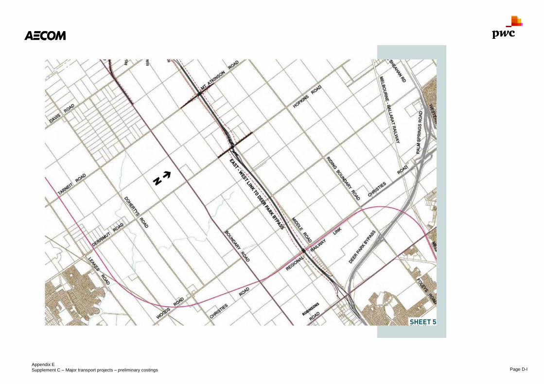
Appendix E
Supplement C – Major transport projects – preliminary costings Page D-l
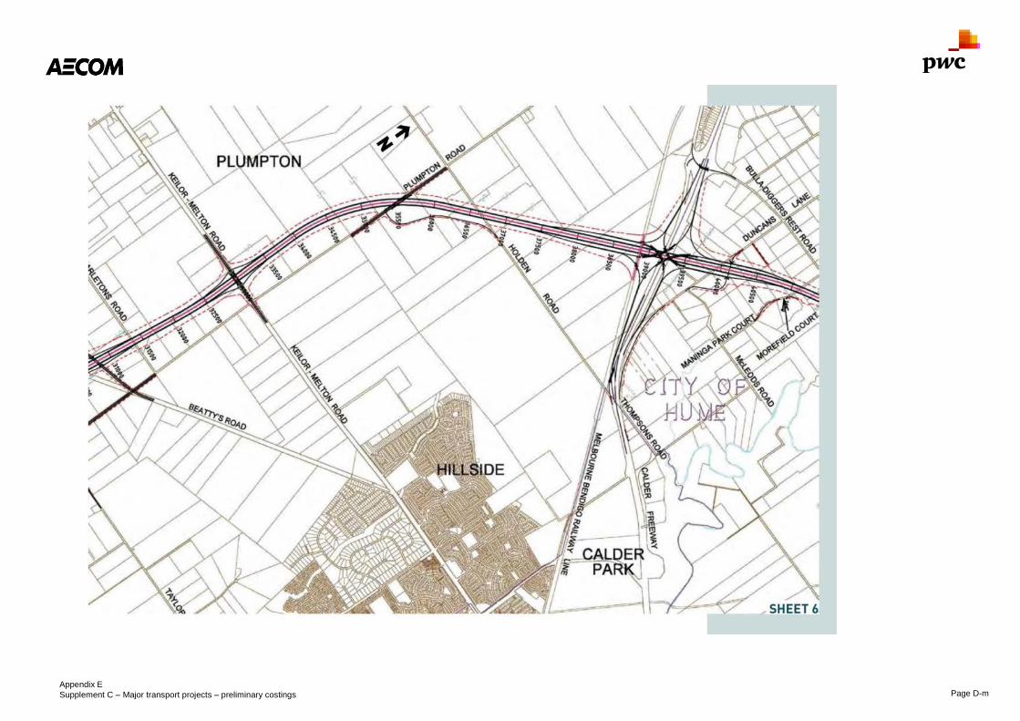
Appendix E
Supplement C – Major transport projects – preliminary costings Page D-m
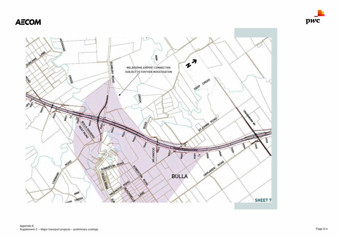
Appendix E
Supplement C – Major transport projects – preliminary costings Page D-n

Appendix E
Supplement C – Major transport projects – preliminary costings Page D-o
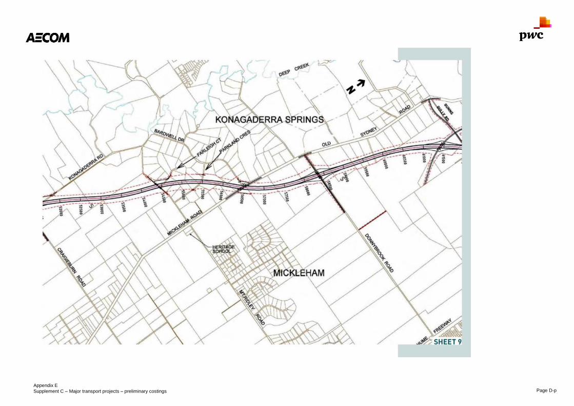
Appendix E
Supplement C – Major transport projects – preliminary costings Page D-p

Appendix E
Supplement C – Major transport projects – preliminary costings Page D-q

Appendix E
Supplement C – Major transport projects – preliminary costings Page D-r

Appendix E
Supplement C – Major transport projects – preliminary costings Page D-s

Appendix E
Supplement C – Major transport projects – preliminary costings Page D-t
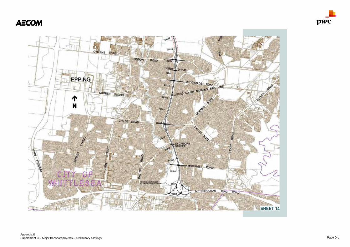
Appendix E
Supplement C – Major transport projects – preliminary costings Page D-u

Appendix E
Supplement C – Major transport projects – preliminary costings Page D-v
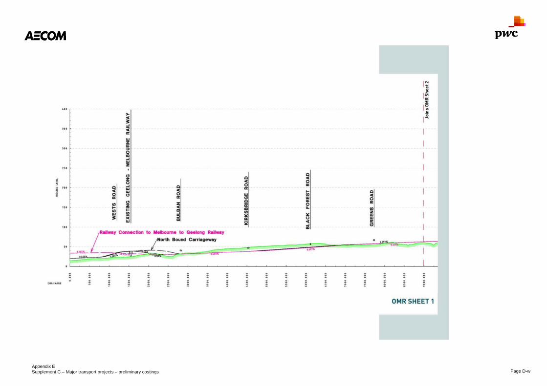
Appendix E
Supplement C – Major transport projects – preliminary costings Page D-w

Appendix E
Supplement C – Major transport projects – preliminary costings Page D-x

Appendix E
Supplement C – Major transport projects – preliminary costings Page D-y

Appendix E
Supplement C – Major transport projects – preliminary costings Page D-z

Appendix E
Supplement C – Major transport projects – preliminary costings Page D-aa

Appendix E
Supplement C – Major transport projects – preliminary costings Page D-bb

Appendix E
Supplement C – Major transport projects – preliminary costings Page D-cc

Appendix E
Supplement C – Major transport projects – preliminary costings Page D-dd

Appendix E
Supplement C – Major transport projects – preliminary costings Page D-ee

Appendix E
Supplement C – Major transport projects – preliminary costings Page D-ff

Appendix E
Supplement C – Major transport projects – preliminary costings Page D-gg