Embed Size (px)
Citation preview
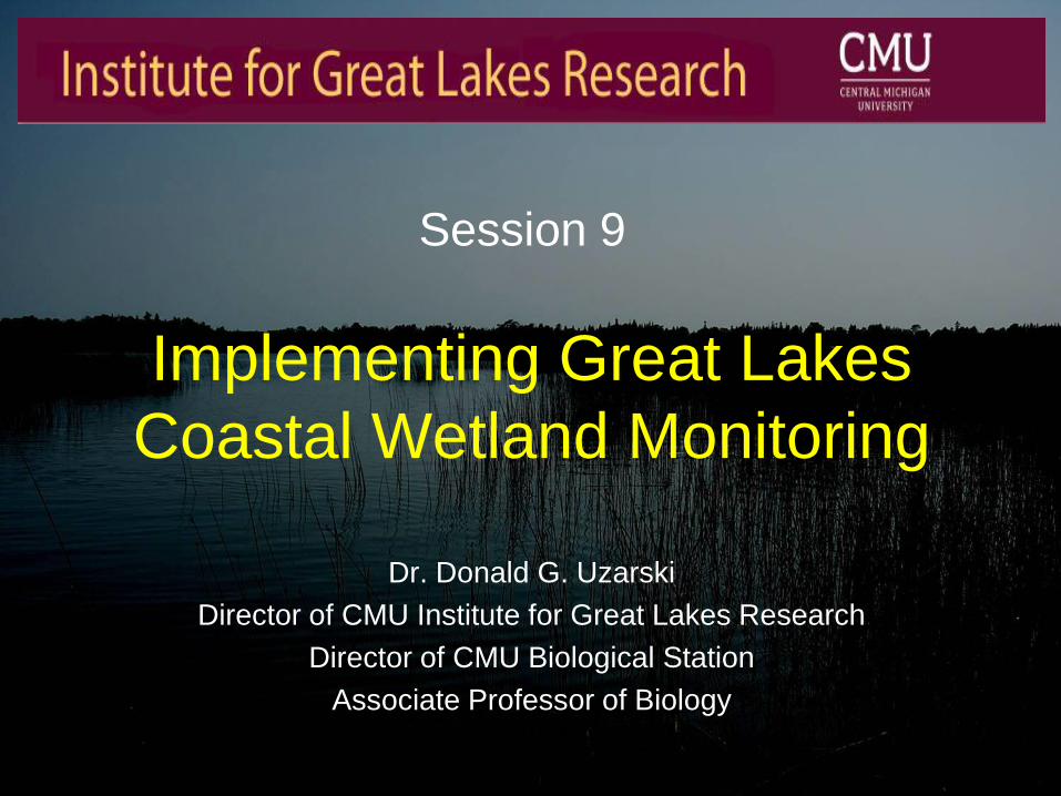
Implementing Great Lakes
Coastal Wetland Monitoring
Dr. Donald G. Uzarski
Director of CMU Institute for Great Lakes Research
Director of CMU Biological Station
Associate Professor of Biology
Session 9

Session Overview
• Session Includes Four Talks
– All Talks Part of the Same GLRI Funded Project
1:40 A Basin-Wide Great Lakes Coastal Wetland Monitoring Program • Donald Uzarski, Central Michigan University
2:00 Great Lakes Coastal Wetland Monitoring Program: Support of
Restoration Activities Across the Basin • Matthew Cooper, University of Notre Dame
2:20 Ecological Restoration Efforts in the St. Louis River Estuary:
Application of Great Lakes Monitoring Data • Valerie Brady, University of Minnesota, Duluth
2:40 Great Lakes Coastal Monitoring Provides Baseline Plant Data for
Sustainable Wetland Restoration Project • Dennis Albert, Oregon State University

Session Overview
• Introduce the Origin of our Project
– Formation of the Great Lakes Coastal
Wetlands Consortium (GLCWC)
– GLCWC Partners with Great Lakes
Environmental Indicators (GLEI)
– GLRI Request for Proposals

About the Great Lakes Coastal
Wetlands Consortium
• GLNPO RFP for $1.2 million (+600K
Supplemental) in 2000
– In response to SOLEC 96’ and 98’
• Indicators of ecosystem health
– Develop Bi-national Standardized Monitoring Program
Based on SOLEC Indicators
• Few, if any, SOLEC indicators were developed

The Great Lakes Coastal
Wetlands Consortium • 2000 Consortium was formed
• Joint facilitation GLC and GLNPO
– 150 + Participants • 50 organizations (Federal, State/Provincial,
Academic, NGOs)
• 2000 Consortium put out an RFP
– Develop and evaluate metrics and protocols for measuring ecosystem health
The Great Lakes Coastal
Wetlands Consortium • Development and Evaluation Process had to
Consider: – Cost
– Measurability
– Basin wide applicability
– Data availability
– Sensitivity to change
– Endpoint levels
– Statistical approach.
• Six proposals were selected by peer review.

The Great Lakes Coastal
Wetlands Consortium
• Six proposals
• Conducted Pilot Studies 2002 – Bain et al. (Ontario)
– de Szalay et al. (Erie)
– Ingram et al. (Ontario)
– Timmermans et al. (Erie)
– Uzarski et al. (Michigan & Huron)
– Wilcox et al. (Michigan)

The Great Lakes Coastal
Wetlands Consortium
• Six proposals
• Conducted Pilot Studies 2002 – Bain et al. (Ontario)
– de Szalay et al. (Erie)
– Ingram et al. (Ontario)
– Timmermans et al. (Erie)
– Uzarski et al. (Michigan & Huron)
– Wilcox et al. (Michigan)
Combined data
+ Uzarski et al. Superior data
The Great Lakes Coastal
Wetlands Consortium • During the Metric Development Phase
– Parallel project with different goals
• Great Lakes Environmental Indicators (GLEI)
group
• GLEI goal:
– To develop an integrated set of
environmental indicators that can be used
to assess the condition of the coastal
margins of all five Great Lakes.

The Great Lakes Coastal
Wetlands Consortium • 2007 Duluth, MN- Consortium and GLEI
– Ensure the best possible product
• Still considering – Cost
– Measurability
– Basin wide applicability
– Data availability
– Sensitivity to change
– Endpoint levels
– Statistical approach
– …and specific to wetlands
The Great Lakes Coastal
Wetlands Consortium
• Consortium Submitted Final Product to US
EPA March 2008.
• http://www.glc.org/wetlands/
• GLRI- GLNPO RFP for $10M to Monitor
Coastal Wetlands using GLCWC protocols
2009
• Awarded in 2010

A Basin-Wide Great Lakes Coastal
Wetland Monitoring Program
Dr. Donald G. Uzarski
Director of CMU Institute for Great Lakes Research
Director of CMU Biological Station
Associate Professor of Biology

Presentation Outline
• Briefly Discuss Some Results to Date
• Data Base and Users
• Supporting Restoration and Conservation Efforts
• Supporting Additional Research Projects
• Training and Jobs Created
• Interested Parties Including China
• Post 2015

Current Research
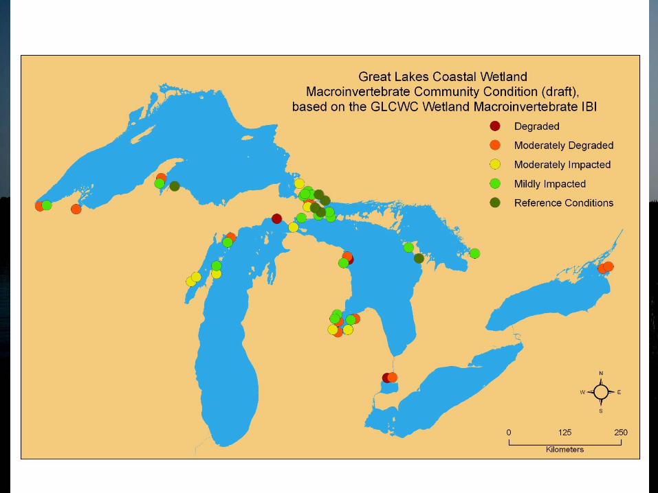
Measure Ecosystem Health ~1039 Coastal Wetlands
– Chemical/Physical Uzarski et al. 2008
– Invertebrates Uzarski et al. 2004
– Fish Uzarski et al. 2005
– Plants Albert 2008
– Birds Grabas et al. 2008
– Amphibians Timmermans et al. 2008
– Landscape Bourgeau-Chavez et al. 2008
Category Scores
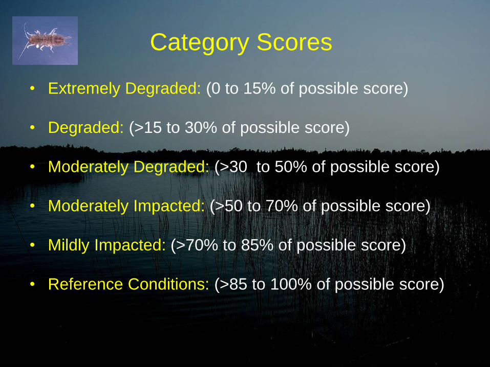
• Extremely Degraded: (0 to 15% of possible score)
• Degraded: (>15 to 30% of possible score)
• Moderately Degraded: (>30 to 50% of possible score)
• Moderately Impacted: (>50 to 70% of possible score)
• Mildly Impacted: (>70% to 85% of possible score)
• Reference Conditions: (>85 to 100% of possible score)

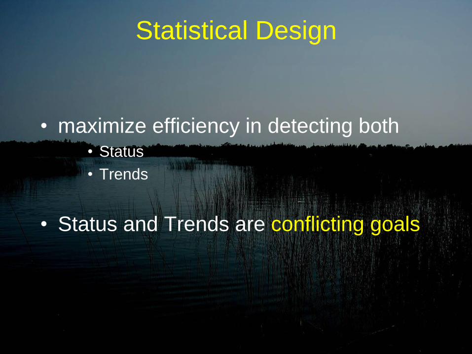
Statistical Design
• maximize efficiency in detecting both • Status
• Trends
• Status and Trends are conflicting goals

Statistical Design
• Status = Capture Spatial Variance
• What is the status or health of (all) GL wetlands?
Statistical Design
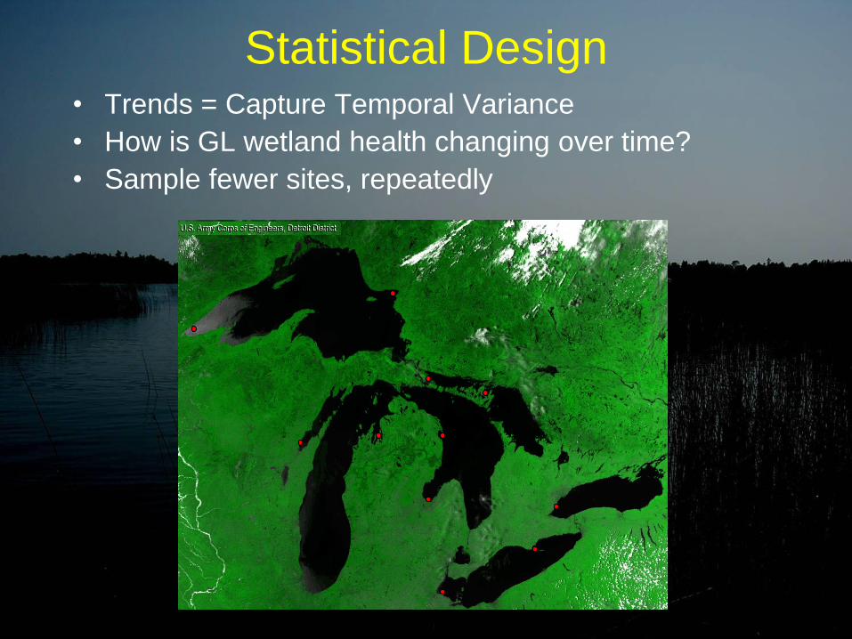
• Trends = Capture Temporal Variance
• How is GL wetland health changing over time?
• Sample fewer sites, repeatedly

XXXX XX XX XXX XXX XX X X XXX XX X X X XX
XXXX XX XX XXX XXX XXX XXX XX X X XXX
XXX XX X X XX XXX XX XXX XX XXX XXX XXX XXX
XX XXX XXXXX X X XX XXX XX XXX XX XXX XXX X
XX XXXXX X X XX XXX XX XXX XX XXX XXX XXX XXX
XX XXX XXX XX XXX XXXXX X X XXXXXXX XX X
X X XXXX XX X X XXXXXXX X XXX X X XXX
XX XXXXX XX XXX XXX XXXX XXX XXX XXX X X X
XXXXXXXXXX XXXXXXXXX X X X XXX
XXXXXXXXXX XX XXXXX XX XXXXX
XXXX XX XX XXX XXX XX X X XXX XX X X X XX
XXXX XX XX XXX XXX XXX XXX XX X X XXX
XXX XX X X XX XXX XX XXX XX XXX XXX XXX XXX
XX XXX XXXXX X X XX XXX XX XXX XX XXX XXX X
XX XXXXX X X XX XXX XX XXX XX XXX XXX XXX XXX
XX XXX XXX XX XXX XXXXX X X XXXXXXX XX X
X X XXXX XX X X XXXXXXX X XXX X X XXX

XXXX XX XX XXX XXX XX X X XXX XX X X X XX
XXXX XX XX XXX XXX XXX XXX XX X X XXX
XXX XX X X XX XXX XX XXX XX XXX XXX XXX XXX
XX XXX XXXXX X X XX XXX XX XXX XX XXX XXX X
XX XXXXX X X XX XXX XX XXX XX XXX XXX XXX XXX
XX XXX XXX XX XXX XXXXX X X XXXXXXX XX X
X X XXXX XX X X XXXXXXX X XXX X X XXX
XX XXXXX XX XXX XXX XXXX XXX XXX XXX X X X
XXXXXXXXXX XXXXXXXXX X X X XXX
XXXXXXXXXX XX XXXXX XX XXXXX
XXXX XX XX XXX XXX XX X X XXX XX X X X XX
XXXX XX XX XXX XXX XXX XXX XX X X XXX
XXX XX X X XX XXX XX XXX XX XXX XXX XXX XXX
XX XXX XXXXX X X XX XXX XX XXX XX XXX XXX X
XX XXXXX X X XX XXX XX XXX XX XXX XXX XXX XXX
XX XXX XXX XX XXX XXXXX X X XXXXXXX XX X
X X XXXX XX X X XXXXXXX X XXX X X XXX
200 Wetlands
Panel 2
200 Wetlands
Panel 1 200 Wetlands
Panel 3 200 Wetlands
Panel 4
200 Wetlands
Panel 5

XXXX XX XX XXX XXX XX X X XXX XX X X X XX
XXXX XX XX XXX XXX XXX XXX XX X X XXX
XXX XX X X XX XXX XX XXX XX XXX XXX XXX XXX
XX XXX XXXXX X X XX XXX XX XXX XX XXX XXX X
XX XXXXX X X XX XXX XX XXX XX XXX XXX XXX XXX
XX XXX XXX XX XXX XXXXX X X XXXXXXX XX X
X X XXXX XX X X XXXXXXX X XXX X X XXX
XX XXXXX XX XXX XXX XXXX XXX XXX XXX X X X
XXXXXXXXXX XXXXXXXXX X X X XXX
XXXXXXXXXX XX XXXXX XX XXXXX
XXXX XX XX XXX XXX XX X X XXX XX X X X XX
XXXX XX XX XXX XXX XXX XXX XX X X XXX
XXX XX X X XX XXX XX XXX XX XXX XXX XXX XXX
XX XXX XXXXX X X XX XXX XX XXX XX XXX XXX X
XX XXXXX X X XX XXX XX XXX XX XXX XXX XXX XXX
XX XXX XXX XX XXX XXXXX X X XXXXXXX XX X
X X XXXX XX X X XXXXXXX X XXX X X XXX
200 Wetlands
Panel 2
200 Wetlands
Panel 1 200 Wetlands
Panel 3 200 Wetlands
Panel 4
200 Wetlands
Panel 5
D=20
B=20
C=20
F=20 G=20
E=20
J=20
A=20
I=20
H=20
D=20
B=20
C=20
F=20 G=20
E=20
J=20
A=20
I=20
H=20
D=20
B=20
C=20
F=20 G=20
E=20
J=20
A=20
I=20
H=20
D=20
B=20
C=20
F=20 G=20
E=20
J=20
A=20
I=20
H=20
D=20
B=20
C=20
F=20 G=20
E=20
J=20
A=20
I=20
H=20

XXXX XX XX XXX XXX XX X X XXX XX X X X XX
XXXX XX XX XXX XXX XXX XXX XX X X XXX
XXX XX X X XX XXX XX XXX XX XXX XXX XXX XXX
XX XXX XXXXX X X XX XXX XX XXX XX XXX XXX X
XX XXXXX X X XX XXX XX XXX XX XXX XXX XXX XXX
XX XXX XXX XX XXX XXXXX X X XXXXXXX XX X
X X XXXX XX X X XXXXXXX X XXX X X XXX
XX XXXXX XX XXX XXX XXXX XXX XXX XXX X X X
XXXXXXXXXX XXXXXXXXX X X X XXX
XXXXXXXXXX XX XXXXX XX XXXXX
XXXX XX XX XXX XXX XX X X XXX XX X X X XX
XXXX XX XX XXX XXX XXX XXX XX X X XXX
XXX XX X X XX XXX XX XXX XX XXX XXX XXX XXX
XX XXX XXXXX X X XX XXX XX XXX XX XXX XXX X
XX XXXXX X X XX XXX XX XXX XX XXX XXX XXX XXX
XX XXX XXX XX XXX XXXXX X X XXXXXXX XX X
X X XXXX XX X X XXXXXXX X XXX X X XXX
200 Wetlands
Panel 2
200 Wetlands
Panel 1 200 Wetlands
Panel 3 200 Wetlands
Panel 4
200 Wetlands
Panel 5
D=20
B=20
C=20
F=20 G=20
E=20
J=20
A=20
I=20
H=20
D=20
B=20
C=20
F=20 G=20
E=20
J=20
A=20
I=20
H=20
D=20
B=20
C=20
F=20 G=20
E=20
J=20
A=20
I=20
H=20
D=20
B=20
C=20
F=20 G=20
E=20
J=20
A=20
I=20
H=20
D=20
B=20
C=20
F=20 G=20
E=20
J=20
A=20
I=20
H=20
Panel 1
Year 1
Panel 2
Year 2
Panel 3
Year 3 Panel 4
Year 4
Panel 5
Year 5

•Revisits
•Year 2 revisit sub-panel 1A
•Year 3 revisit sub-panel 2A
•Year 4 revisit sub-panel 3A
•etc.

Chosen Design • Randomly Selecting Wetlands to Sample
– Re-sample Subset Two Consecutive Years
• Stratify by Region by Lake
• Design Superior to Others
– Good Estimate of Variation in Wetland x Year Interaction.
– Eventually Sample Many Different Sites
– Less Impact on Wetland from Over Sampling • Sampling Year after Year = Disturbance


Currently Working on 5 Year $10 Million Research Project
CMU GLRI Lead
University of Minnesota-Duluth
University of Wisconsin
Grand Valley State University
University of Notre Dame
Lake Superior State University
Michigan DEQ
University of Windsor
Bird Studies Canada
Environment Canada
SUNY-Brockport
Oregon State University

Data Base
• Access to the Data Base
– USEPA and Project Researchers
• Full Access to Raw and Analyzed Data with Manipulation Capabilities
– State and Federal Wetland Managers
• Full Access to Raw and Analyzed Data
– NGOs Working on Restoration and Conservation
• Full Access to Analyzed Data (and Case by Case for Raw Data)
– General Public
• Access to Summarized Analyses

Supporting Restoration and Conservation Efforts
• Minnesota Land Trust
– Lower St. Louis River estuary – large-scale habitat restoration removing beneficial use
impairments
• Loyola University Chicago
– St. Marys & Galien River – evaluate restoration efforts of invasive species removal for biogas
• St. Marys River Binational Public Advisory Council
– St. Marys River & Little Rapids area – pre-restoration monitoring and habitat assessment of
Areas of Concern (AOCs)
• US Department of the Interior, Fish and Wildlife Service
– Rochester Embayment Area of Concern– habitat assessment to address beneficial use
impairment delisting criteria
• US Department of the Interior, National Parks Service
– Apostle Islands National Lakeshore, Isle Royale National Park, Pictured Rocks National
Lakeshore, Sleeping Bear Dunes National Lakeshore, and Indiana Dunes National
Lakeshore – assessing wetland condition and identifying restoration needs
• The Nature Conservancy
– Lakeview Wildlife Management Area, Sodus Bay – habitat monitoring for baseline
information to assist in evaluating conservation efforts
– Erie Marsh Preserve and North Maumee Bay – pre-restoration habitat monitoring and post-restoration habitat assessment of reconnecting the diked marsh to North Maumee Bay
Supporting Restoration and Conservation Efforts
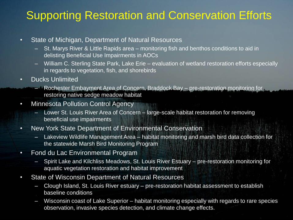
• State of Michigan, Department of Natural Resources
– St. Marys River & Little Rapids area – monitoring fish and benthos conditions to aid in
delisting Beneficial Use Impairments in AOCs
– William C. Sterling State Park, Lake Erie – evaluation of wetland restoration efforts especially
in regards to vegetation, fish, and shorebirds
• Ducks Unlimited
– Rochester Embayment Area of Concern, Braddock Bay – pre-restoration monitoring for
restoring native sedge meadow habitat
• Minnesota Pollution Control Agency
– Lower St. Louis River Area of Concern – large-scale habitat restoration for removing
beneficial use impairments
• New York State Department of Environmental Conservation
– Lakeview Wildlife Management Area – habitat monitoring and marsh bird data collection for
the statewide Marsh Bird Monitoring Program
• Fond du Lac Environmental Program
– Spirit Lake and Kilchliss Meadows, St. Louis River Estuary – pre-restoration monitoring for
aquatic vegetation restoration and habitat improvement
• State of Wisconsin Department of Natural Resources
– Clough Island, St. Louis River estuary – pre-restoration habitat assessment to establish
baseline conditions
– Wisconsin coast of Lake Superior – habitat monitoring especially with regards to rare species
observation, invasive species detection, and climate change effects.

Uzarski Lab Spin-Off Projects • North Maumee Bay chemical/physical characteristics and
community composition of Diked vs. Un-Diked Wetlands
• Importance of coastal wetlands to offshore fishes of the Great
Lakes: Dietary support and habitat utilization
• Spatial variation in macroinvertebrate communities within two
emergent plant zones in Great Lakes coastal wetlands
• Functional indicators of Great Lakes coastal wetland health
• Evaluating environmental DNA detection alongside standard fish
sampling in Great Lakes coastal wetland monitoring
• Impacts of drainage outlets on Great Lakes coastal wetlands
• Effects of anthropogenic disturbance affecting coastal wetland
vegetation

Uzarski Lab Spin-Off Projects • Great Lakes coastal wetland seed banks: what drives
compositional change?
• Spatial scale variation in patterns and mechanisms driving fish
diversity in Great Lakes coastal wetlands
• Building a model of macroinvertebrate functional feeding group
community through zone succession: Does the River Continuum
Concept apply to Great Lakes coastal wetlands?
• Scale dependence of dispersal limitation and environmental
species sorting in Great Lakes wetland invertebrate meta-
communities

Uzarski Lab Spin-Off Projects • Larval fish use and assemblage composition between different
wetland types
• Determining wetland health for selected Great Lakes Coastal
Wetlands and incorporating management recommendations
• Invertebrate co-occurrence trends in the wetlands of the Upper
Peninsula and Western Michigan and the role of habitat
disturbance levels
• Fish species co-occurrence in northern Michigan Wetlands

Spin-off Projects Encompass a Broad Range of
Ecological and Environmental Disciplines
• A biofuel research project partnered with Kettering
University and Swedish Biogas
• A broad scale project comparing Great Lakes coastal
wetlands with Pacific Northwest estuaries
• Comparing DNA detection with standardized monitoring
techniques
• Heavy metal and toxicant loads in turtles located within
coastal wetlands
• Sonar-derived estimates of plant presence and
abundance
• Invasive species tracking and detection

Jobs Created/Supported
Principle Investigators: 14
Post-doctoral researchers: 1
Graduate students: 30
Undergraduate students: 52
Technicians: 25
122 Paid Positions & 21 Volunteers

Threatened & Endangered Species • Birds
• Common terns (threatened in Wisconsin & Minnesota), Duluth-Superior Harbor; Allouez Bay, WI,
• Least Bittern (Threatened in New York), Hebblethwaite Drian wetland Lake Erie, Ontario
• Black Tern (Endangered in New York), northern Lake Michigan; Lake St. Clair wetlands
• Nesting pairs of bald eagles (special concern), St. Louis River estuary, Allouez Bay, WI
• Common loons (special concern), Madeline Island, WI and various wetland types within island complexes
• Sandhill cranes (special concern), Allouez Bay, WI;
• Sora rails (special concern), Fish Creek Wetland, WI; Hebblethwaite Drian wetland Lake Erie, Ontario
• Yellow rails (special concern), Munuscong River Delta, MI
• American white pelican (special concern)
• Wilson’s snipe (special concern)
• Wilson’s phalarope (special concern)
• Northern harrier (special concern)
• Forster’s tern (special concern)
• Vegetation
• Michigan monkey-flower (federally threatened), Epoufette Bay
• American lotus (rare plant), western Lake Erie marshes
• Montevidense’s arrowhead (rare plant), western Lake Erie Marshes
• Several orchid species considered rare but not federally or state listed were found within several coastal
wetlands: Loesel’s twayblade, rose pogonia, grass-pink, and hooded ladies’-tresses orchids
• Beck’s water marigold (species of conservation interest)
• Houghton’s goldenrod (species of special concern), Scott Point Wetland Complex
• Wild rice (special concern), Lake St. Clair wetlands; Long Point Lake Erie; White River northern Lake Michigan
• Fish
• Grass pickerel (rare), Presqu’ile Bay Marsh, Lake Ontario
• Reptiles
• Eastern fox snake (threatened), Point Au-Baril, Lake Erie
• Blanding’s turtle (at risk, Ontario), North Maumee Bay Lake Erie
• Eastern musk turtle (at risk, Ontario), Roberts Island and Tobie’s Bay, Honey Harbor, Ontario
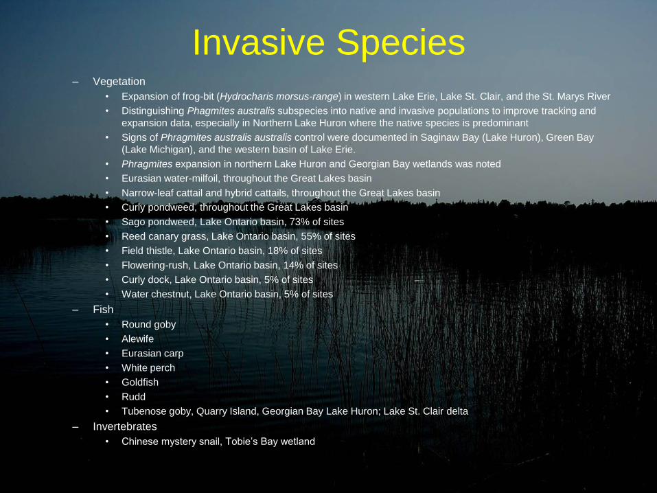
Invasive Species – Vegetation
• Expansion of frog-bit (Hydrocharis morsus-range) in western Lake Erie, Lake St. Clair, and the St. Marys River
• Distinguishing Phagmites australis subspecies into native and invasive populations to improve tracking and
expansion data, especially in Northern Lake Huron where the native species is predominant
• Signs of Phragmites australis australis control were documented in Saginaw Bay (Lake Huron), Green Bay
(Lake Michigan), and the western basin of Lake Erie.
• Phragmites expansion in northern Lake Huron and Georgian Bay wetlands was noted
• Eurasian water-milfoil, throughout the Great Lakes basin
• Narrow-leaf cattail and hybrid cattails, throughout the Great Lakes basin
• Curly pondweed, throughout the Great Lakes basin
• Sago pondweed, Lake Ontario basin, 73% of sites
• Reed canary grass, Lake Ontario basin, 55% of sites
• Field thistle, Lake Ontario basin, 18% of sites
• Flowering-rush, Lake Ontario basin, 14% of sites
• Curly dock, Lake Ontario basin, 5% of sites
• Water chestnut, Lake Ontario basin, 5% of sites
– Fish
• Round goby
• Alewife
• Eurasian carp
• White perch
• Goldfish
• Rudd
• Tubenose goby, Quarry Island, Georgian Bay Lake Huron; Lake St. Clair delta
– Invertebrates
• Chinese mystery snail, Tobie’s Bay wetland

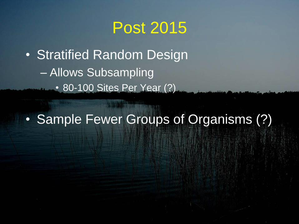
Post 2015
• Stratified Random Design
– Allows Subsampling
• 80-100 Sites Per Year (?)
• Sample Fewer Groups of Organisms (?)

Thank You!