Embed Size (px)
Citation preview

Implementing Ecological Site Structure & Strategy
Kendra Moseley UrbanikRegion 1/2 ES QA Specialist
February 5, 2015

Outline
• Part 631, Subpart A – Defining the Ecological Site Concept (ESC), Soil-Site Attributes
• Part 631, Subpart B, 630.80 – Differentiation and Development Exhibit
• Part 631, Subpart B, 631.11 – 631.13 – Differentiation and Development
• Take Home Messages
• NESH – what it does and does NOT do
• Part 630, Subpart B – Project Management
• Part 630, Subpart E – QC/QA
Part I - Structure
•Part 631, Subpart A –Ecological Site Definition
• Part 631, Subpart A – Defining the Ecological Site Concept (ESC)
Part II - Strategy

Part I - Structure
Objectives for Part I
Understand what the NESH does and does NOT do
Become familiar with the contents of the NESH
Recognize parallels between ES Project Planning Process vs. NSSH Project Planning Process
Become familiar with the QC/QA Roles for ES work

National Ecological Site Handbook (NESH)(first official release April 8, 2014)
What Version 1 does do:
• Establishes roles & responsibilities• Describes the project planning
process• Provides some basic QC/QA review
templates• Defines ecological sites and ESDs• Describes the ecological site
concept and description development process
• Outlines general relationships to other vegetation classifications
What Version 1 does NOT do:
• Provide a process for initial soil survey procedures
• Provide required data collection protocols
• Provide specific steps on how to perform soil-site correlation
• Provide an ecological site taxonomy
• Specific rules on site considerations
National directive finalized on April 8, 2014 – available at H_190_NESH http://directives.sc.egov.usda.gov/viewerFS.aspx?hid=35306

National Ecological Site Handbook (NESH)Version 1 (April 8, 2014)
Part 630 – Policy and ProceduresSubpart A - IntroductionSubpart B – Project ManagementSubpart C – Committees, Work Agreements, & Meetings - RESERVEDSubpart D – Working with Partners - RESERVEDSubpart E – ESD QC, QA, Correlation & CertificationSubpart F – Job Certification for Ecological Site Quality Control - RESERVEDSubpart G - Exhibits
Table Of Contents (TOC)
Part 631 – Ecological Site Concept & Description DevelopmentSubpart A – Ecological Site Characterization ConceptsSubpart B – Steps for Ecological Site Differentiation & Development of ESDsSubpart C – Sampling Methods - RESERVEDSubpart D – Ecological Site Naming ProtocolSubpart E – Ecological Site KeysSubpart F – Contents for an ESDSubpart G – Data Storage - RESERVEDSubpart H - Exhibits
Part 632 – Delineation & Mapping, Hierarchies, and Other Vegetation Classification & Stratification Schemes - RESERVEDSubpart A – Related Stratification SchemesSubpart B – Delineation & Mapping of Ecological SitesSubpart C – Benchmark Ecological SitesSubpart D – Ecological Site Relationships with Other Classification & Mapping Hierarchies
Part 633 – Glossary, References & Abbreviations - RESERVEDSubpart A – GlossarySubpart B – ReferencesSubpart C – Abbreviations

NESH Standards Content – Part 630 Subpart B - Project Management
• Purpose• Roles & Responsibilities – Specific to Project Planning
Board of Advisors – The BOA consists of the State Conservationist (STC) from each State served by the MLRA Soil Survey Regional Office (MO). Representatives of Federal, State, or other entities with affected lands are invited to serve as members as applicable. The SS Regional Director (SSRD) provides the necessary staff to plan work, conduct meetings, and present information.
Management Team – The management team consists of the SSRD, state soil scientists (SSSs), state resource conservationists (SRCs), and appropriate state technical leaders, as needed, for each State serviced by the MO. Representatives from Federal, Non-Governmental Organizations, State, University, and other NCSS partners are invited to serve as members, as applicable. NTSC and MO ES specialists may join or assist the team, as needed.
Technical Team – The team includes MLRA SSO staff (MLRA SSO leader, MLRA ES specialist, others), applicable field, area, state, or regional discipline specialists (e.g., soil range, forestry, agronomy, wildlife, etc.), and applicable partners. In cases where local assistance is limited or lacking, specialists from MO staffs and NTSC staffs may assist or join the team, as needed.
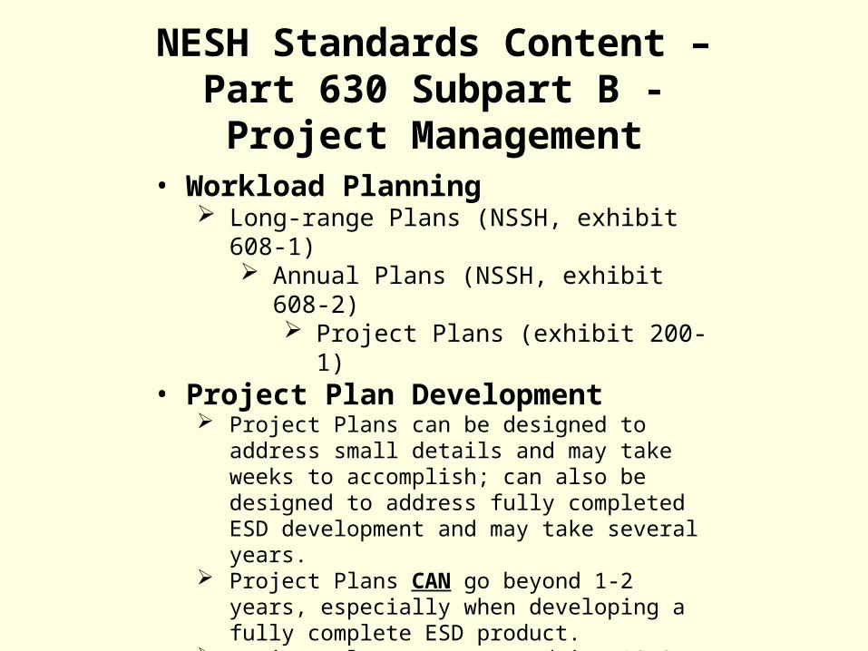
• Workload Planning Long-range Plans (NSSH, exhibit 608-1)
Annual Plans (NSSH, exhibit 608-2) Project Plans (exhibit 200-1)
• Project Plan Development Project Plans can be designed to address small details
and may take weeks to accomplish; can also be designed to address fully completed ESD development and may take several years.
Project Plans CAN go beyond 1-2 years, especially when developing a fully complete ESD product.
Project Plans are managed in NASIS
NESH Standards Content – Part 630 Subpart B - Project Management

• Prioritizing Project Plans Priorities are drafted by the Technical Team; reviewed and approved by the
Management Team; and BOA reviews and provides alternate recommendations as needed.
• Project Plan Approvals Project Plans, once prioritized by the Technical Team, are sent to MO by Soil Survey
Office (SSO) Leader SSRD ensures that the plans are reviewed by the Management Team
BOA receives plans approved by Management Team from the SSRD• ESD Revisions & Updates
Minor changes – REVISION. The state technical discipline specialist obtains approval of the Management Team by working with State Resource Conservationist to coordinate the edits and submit the revised ESD through the correlation process.
Significant changes – UPDATE. The state technical discipline specialist brings the information to the attention of the Technical Team. The Technical Team will then organize a project in accordance with the guidance contained in Part 630 of the ES Handbook.
NESH Standards Content – Part 630 Subpart B - Project Management

NESH Standards Content – Part 630 Subpart EQuality Control/Quality Assurance
• Definitions Quality control is the collective set of activities described in standards
and procedures for the purpose of achieving a high level of precision and accuracy (aspects of quality). Controlling quality involves providing:
Coordination of ES concept and ESD development activities to ensure that developed products meet the defined standards for content and accuracy;
direct review and inspection; and direction, consultation and feedback.
The quality of ES concepts and ESDs is controlled at the level at which each of the steps takes place, from fieldwork through publication. Quality control procedures are performed by qualified individuals.
NESH Standards Content – Part 630 Subpart EQuality Control/Quality Assurance
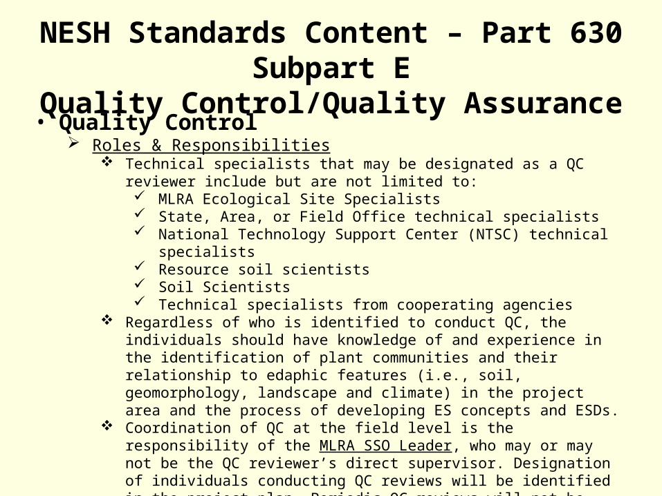
• Quality Control Roles & Responsibilities
Technical specialists that may be designated as a QC reviewer include but are not limited to: MLRA Ecological Site Specialists State, Area, or Field Office technical specialists National Technology Support Center (NTSC) technical specialists Resource soil scientists Soil Scientists Technical specialists from cooperating agencies
Regardless of who is identified to conduct QC, the individuals should have knowledge of and experience in the identification of plant communities and their relationship to edaphic features (i.e., soil, geomorphology, landscape and climate) in the project area and the process of developing ES concepts and ESDs.
Coordination of QC at the field level is the responsibility of the MLRA SSO Leader, who may or may not be the QC reviewer’s direct supervisor. Designation of individuals conducting QC reviews will be identified in the project plan. Periodic QC reviews will not be performed by an individual responsible for completing other tasks in the project plan, thus providing an independent peer review.

NESH Standards Content – Part 630 Subpart EQuality Control/Quality Assurance
• Quality Assurance Roles & Responsibilities
Responsibility for assuring the quality of ES concepts and ESDs rests with the RO The RO Ecological Site Specialists (RO ESSs) are responsible for this function, under
the overall leadership of the Soil Survey Regional Directors (SSRDs). RO ESSs have knowledge of and experience with the entire ESD development
process and related policies, from identification of ES concepts to the final editing, publication and correlation of ESDs.
Technical specialists from NTSCs, the National Grazing Lands Team, and the National Soil Quality and Ecosystems Branch are regularly consulted in the process to ensure that national ES standards are upheld and training and technical assistance needs are met, and to request their assistance, as needed.
Quality assurance is not performed by the same individual that completed QC activities.
The RO ESS, as QA reviewer, is also responsible for preparing and signing all QA review reports.
The SSRD signs the report and transmittal letters for these reports, which are then sent to the State Conservationist (STC), MLRA SSO Leader, the QC reviewer and others, as appropriate, for review and concurrence.

NESH Standards Content – Part 630 Subpart EQuality Control/Quality Assurance
• Quality Assurance, cont. Quality Assurance Reviews
Scheduled with regular frequency to ensure that technical standards are met, policy and procedures are being followed, and progress is consistent with timelines and milestones identified in the project plan.
Each initial ES project (where no ES information currently exists) requires: One initial QA Review At least one progress QA Review One final QA Review Progress reviews will be conducted at least annually on multi-year projects
For update ES projects, the number and type of QA reviews will be stated in the project plan. However, a final QA review is required for all ES projects.
Signature and Approval of QA Review Reports The QA reviewer is responsible for preparing and signing all QA review reports,
preparing the transmittal letter, and preparing and transmitting copies of the report. The Soil Survey Regional Director provides the final signature on ES quality assurance
reports, which thereby assuring that the ES project work meets the standards and specifications of the National ES Handbook.

• Certification of ESDs The final step is certification of the ESD by the
State and applicable partners before publishing in the FOTG and ESIS for public use. The States and partner agencies certify that
Correlated ESD meets needs for conservation planning, implementation, monitoring and assessment.
State conservationists (or designees) and applicable partners certify that ESDs meet needs for conservation planning, implementation, monitoring and assessment by signing the Correlated ESD Certification document (exhibit 300-8).
This signed Certification Sheet and all related documents are maintained at the MO as part of the ES project record file.
NESH Standards Content – Part 630 Subpart EQuality Control/Quality Assurance

• Currently Approved, Meeting Previous Standards Currently approved ESDs that meet the National Range and
Pasture Handbook (December 2003) or the National Forestry Manual (September 2010) guidance may remain as approved documents in ESIS database.
• De-Activating ESDs The RO places established ESDs on the deactivation list when
appropriate. De-activation is achieved by the RO checking the ‘unapprove’
button (in the current version of ESIS), after the 45-day waiting period and all efforts for mitigation of issues are exhausted. List deactivated ESDs in the ESD classification file.
NESH Standards Content – Part 630 Subpart EQuality Control/Quality Assurance

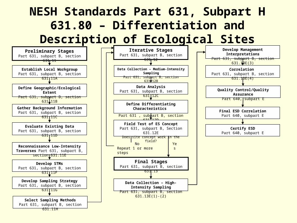
NESH Standards Part 631, Subpart H 631.80 – Differentiation and Description of Ecological Sites
Final StagesPart 631, subpart B, section 631.13
Preliminary StagesPart 631, subpart B, section 631.11
Gather Background InformationPart 631, subpart B, section 631.11C
Establish Local WorkgroupPart 631, subpart B, section 631.11A
Define Geographic/Ecological ExtentPart 631, subpart B, section 631.11B
Evaluate Existing DataPart 631, subpart B, section 631.11D
Reconnaissance Low-Intensity Traverses Part 631, subpart B, section 631.11E
Develop STMsPart 631, subpart B, section 631.11F
Develop Sampling StrategyPart 631, subpart B, section 631.11G
Select Sampling MethodsPart 631, subpart B, section 631.11H
Data Collection – Medium-Intensity SamplingPart 631, subpart B, section 631.12B
Iterative StagesPart 631, subpart B, section 631.12
Data AnalysisPart 631, subpart B, section 631.12C
Define Differentiating Characteristics
Part 631 , subpart B, section 631.12D
Field Test of ES ConceptPart 631, subpart B, Section 631.12E
Does site concept work in the field?
Develop Management InterpretationsPart 631, subpart B, section 631.13E(3)
Data Collection – High-Intensity SamplingPart 631, subpart B, section 631.13E(1)-(2)
Correlation Part 631, subpart B, section 631.13E(4)
Quality Control/Quality AssurancePart 640, subpart E
Final ESD CorrelationPart 640, subpart E
Certify ESDPart 640, subpart E
NoRepeat 1 or more steps
Yes
Part I: Take Home Messages
1. The NESH is NOT a cookbook; it provides general policy and guidelines for roles, responsibilities and process
2. The NESH was only released in 2014—there is still much to be determined, added, taken out, defined, refined and addressed. **Remember – the NSSH has had at least 30+ revisions/updates**
3. The ES Project Planning Process is very similar to the MLRA Project Planning Process, but differs in small ways that are outlined in the NESH
4. Support structure is available in the form of Ecological Site Quality Control and Quality Assurance Staff and Review Processes
Part II - Strategy
Objectives for Part II
Defining the ecological site concept (ESC)
Know the difference between the ESC, an Ecological Site, and an ESD
Review primary soil-site attributes that influence plant growth
Become familiar with iterative steps to the ecological site development process

NESH Standards, Subpart A, 631.1 – Ecological Site
Definition: “a distinctive kind of land based on recurring soil, landform, geological, and climate characteristics that differs from other kinds of land in its ability to produce distinctive kinds, amounts, and proportions of vegetation and in its ability to respond similarly to management actions and natural disturbances.”
And ecological site descriptions are a document that describes and defines the relationships between these ecological characteristics, in order to provide land managers and land users a baseline or guideline for management on the ecological sites they work with.
An ecological site is a conceptual grouping of characteristic soils, vegetation, and hydrology based on similar climate, landform and disturbance regimes.

The ecological site concept (ESC) is the foundational concept that the ecological site is built around and the ecological site description describes. It is based on the fundamental idea that differences in ecologically significant associations of plant species and their resilience are governed by important differences in:
• Local climate• Geomorphology• Soils, and • Natural disturbances
Determining for each ecological site what these unique combinations of attributes are, is what formulates the ecological site concept.
NESH Standards Subpart A, 631.2 – Defining the Ecological Site Concept (ESC)

Geomorphology, elevation, landform position, slope, aspect, and soil characteristics drive or strongly influence:
• Soil temperature• Soil moisture, and• Soil nutrient regimes
These in turn influence plant species responses, including:
• Distributions• Abundance, and • Productivity
NESH Standards Subpart A, 631.2 – Defining the Ecological Site Concept

Ecological Site Considerations
It is crucial to define early on in the site development process, what the site concept is for the ecological site being developed or modified and updated.
• An ecological site concept does not simply list the absolute minimums and maximums in the range of characteristics. Otherwise, everything would overlap.
• An ecological site IS a compilation of the range of data that best represents the general minimums and maximums of the ecological site concept, which has been determined based on the expert knowledge, literature review and science, and data collection that has been compiled to describe and develop the site.
NESH Standards Subpart A, 631.2 – Defining the Ecological Site Concept

• Restricted/specific• Primarily abiotic
controlling factors• Resulting reference
state• Ideal (every site
meeting the ESC is this site)
• Accepted variability• MUCs with similar
properties (controlling factors)
• Confirmed communities• Typical (every site
meeting the ESC + allowance for limited plasticity in controlling factors)
Ecological Site Concept Ecological Site Boundaries
NESH Standards Subpart A, 631.2 – Defining the Ecological Site Concept

Formulating the ESC
• Requires thinking about how plants use their environment to grow
• Considering soil and site attributes that influence plant growth
• Relationship with other associated sites on the landscape
NESH Standards Subpart A, 631.2 – Defining the Ecological Site Concept, Soil-Site Attributes
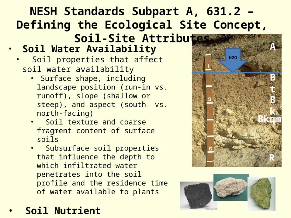
• Soil Water Availability• Soil properties that affect soil water
availability• Surface shape, including landscape position
(run-in vs. runoff), slope (shallow or steep), and aspect (south- vs. north-facing)
• Soil texture and coarse fragment content of surface soils
• Subsurface soil properties that influence the depth to which infiltrated water penetrates into the soil profile and the residence time of water available to plants
• Soil Nutrient Availability
• Soil properties that affect soil nutrient availability
• Differences in soil texture• And differences in mineralogy
H2O
A
Bt
Bk
Bkqm
R
NESH Standards Subpart A, 631.2 – Defining the Ecological Site Concept, Soil-Site Attributes

Local (MLRA and/or LRU) climate – is the composite or generally prevailing weather conditions of a region, as temperature, air pressure, humidity, precipitation, sunshine, cloudiness, and winds, throughout the year, averaged over a series of years.
Microclimate – is a fundamental aspect of environmental variation and can influence plant response. It is on a variation of scale from a few kilometers, meters, or even centimeters and is usually measured over short periods of time. These often have more influence over ecological site concepts than the local climate.
Microclimate is influenced by landscape features such as:
• Altitude• Aspect• Vegetation• Color of the ground• Presence of boulders• Etc.
Microclimate affects that can cause differences among ecological sites
NESH Standards Subpart A, 631.2 – Defining the Ecological Site Concept, Soil-Site Attributes

Altitude: general concept that temperatures will decrease as elevation increases.
• Atmospheric pressure decreases with elevation• Air rising up the side of a mountain expands• Less atmosphere exists to trap and radiate heat back to the ground as elevation increases.
High elevation - cold
High elevation - cool
Mid-elevation - warm
Low elevation - Warmest
General idea of cooling as altitude increases
NESH Standards Subpart A, 631.2 – Defining the Ecological Site Concept, Soil-Site Attributes
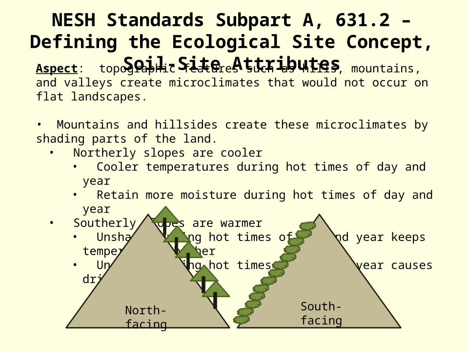
Aspect: topographic features such as hills, mountains, and valleys create microclimates that would not occur on flat landscapes.
• Mountains and hillsides create these microclimates by shading parts of the land.• Northerly slopes are cooler
• Cooler temperatures during hot times of day and year• Retain more moisture during hot times of day and year
• Southerly slopes are warmer• Unshaded during hot times of day and year keeps temperatures higher• Unshaded during hot times of day and year causes drier conditions
North-facing South-facing
NESH Standards Subpart A, 631.2 – Defining the Ecological Site Concept, Soil-Site Attributes
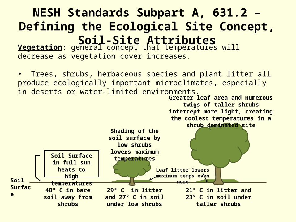
Vegetation: general concept that temperatures will decrease as vegetation cover increases.
• Trees, shrubs, herbaceous species and plant litter all produce ecologically important microclimates, especially in deserts or water-limited environments.
Soil Surface
Soil Surface in full sun heats to high
temperatures
48° C in bare soil away from shrubs
Shading of the soil surface by low shrubs
lowers maximum temperatures
Leaf litter lowers maximum temps even more
Greater leaf area and numerous twigs of taller shrubs intercept more light, creating
the coolest temperatures in a shrub dominated site
29° C in litter and 27° C in soil under low shrubs
21° C in litter and 23° C in soil under taller shrubs
NESH Standards Subpart A, 631.2 – Defining the Ecological Site Concept, Soil-Site Attributes

Color of the Ground: generally most noticeable in dry climates—semi arid and arid deserts for example. The general concept is that that temperatures will decrease as vegetation cover increases.
• White sands, barren of vegetation, are generally cooler• Black sands, barren of vegetation, can heat up fast to high temperatures because they absorb more light than white sands do.
NESH Standards Subpart A, 631.2 – Defining the Ecological Site Concept, Soil-Site Attributes

Presence of Large Rock Fragments: general concept is that presence of boulders on the soil surface can reduce temperatures around and beneath them.
• Larger the rock fragment the more shadow it casts, creating shade for the soil surface• Larger the rock fragment the cooler the soil beneath it will be.
Wider zone of influence from bigger rock fragments on the soil profile
Narrower zone of influence from smaller rock fragments on the
soil profile
Soil not influenced by rock fragment cover
will be drier and hotter
NESH Standards Subpart A, 631.2 – Defining the Ecological Site Concept, Soil-Site Attributes

Water potential of pure water 0
-1
-2
-3
-4
-100Dry air has the lowest water potential
Water potential at the top of the plant is lower
(more negative)
Water potential in the soil is higher (less negative)
-0.6
Plant water potentials
-0.9
-1.2
-2.2
-6
Water potentials can cause differences among ecological sites
NESH Standards Subpart A, 631.2 – Defining the Ecological Site Concept, Soil-Site Attributes

Root Growth in Response to Soil Water AvailabilityExtent of root development by plants often reflects differences in water availability. • Dry environments:
• Plant roots tend to grow deeper in the soil to exploit deeper water• Some tap roots in deserts can extend over 30 m down into the soil
• Plant roots in shallow soils grow extensive lateral root systems• Plant roots tend to constitute a greater proportion of the plant biomass
• Moist environments:• Plant roots are shallower to the surface of the soil• Plant roots tend to only constitute approximately 25% of plant biomass
Soil Depth
Dry Site Moist Site
NESH Standards Subpart A, 631.2 – Defining the Ecological Site Concept, Soil-Site Attributes
Shallow Soil

NESH Standards Part 631, Subpart B – Differentiation and Description of Ecological Sites
“It takes 10,000 hours of deliberate practice to become an expert in any
field” – Malcom Gladwell
Ecological Site
Geomorphology
Soils
Invasive Species
Climate
Rangelands
Forestry
Riparian
Wetlands
GIS
GeologyLandscape Ecology
Wildlife
Plant-Animal Interactions
Hydrology
Fire Ecology

“Building the ES is a TEAM concept”
NESH Standards Part 631, Subpart B – Differentiation and Description of Ecological Sites

The process and methods for differentiation and description of ecological sites (ESs) involve several steps (part 631, subpart H, 631.80). The steps are grouped as follows:
(1) Preliminary stages (2) Iterative stages
(3) Final stages
The preliminary and iterative stages focus on identification and differentiation of Ecological Sites. As abiotic and biotic factors are identified and tested, ES concepts are formulated and differentiated. Development and use of a landform-based ES key is an example.
The final stage focuses on the steps needed to complete an ecological site description (ESD). It includes the characterization of community phases, description of ecosystem dynamics associated with the site, and documentation of reference and alternative states.
NESH Standards Part 631, Subpart B – Differentiation and Description of Ecological Sites

• Strong interdisciplinary participation is critical to the ES development process.
• Ideally, this process is done concurrent
with active soil survey projects.
• Validation of existing ESs for areas in which soil survey activities have been completed and a soil survey manuscript has been published will be conducted concurrently with soil and vegetation specialists and others.
NESH Standards Part 631, Subpart B – Differentiation and Description of Ecological Sites
NESH Standards Part 631, Subpart H 631.80 – Differentiation and Description of Ecological Sites
Final StagesPart 631, subpart B, section 631.13
Preliminary StagesPart 631, subpart B, section 631.11
Gather Background InformationPart 631, subpart B, section 631.11C
Establish Local WorkgroupPart 631, subpart B, section 631.11A
Define Geographic/Ecological ExtentPart 631, subpart B, section 631.11B
Evaluate Existing DataPart 631, subpart B, section 631.11D
Reconnaissance Low-Intensity Traverses Part 631, subpart B, section 631.11E
Develop STMsPart 631, subpart B, section 631.11F
Develop Sampling StrategyPart 631, subpart B, section 631.11G
Select Sampling MethodsPart 631, subpart B, section 631.11H
Data Collection – Medium-Intensity SamplingPart 631, subpart B, section 631.12B
Iterative StagesPart 631, subpart B, section 631.12
Data AnalysisPart 631, subpart B, section 631.12C
Define Differentiating Characteristics
Part 631 , subpart B, section 631.12D
Field Test of ES ConceptPart 631, subpart B, Section 631.12E
Does site concept work in the field?
Develop Management InterpretationsPart 631, subpart B, section 631.13E(3)
Data Collection – High-Intensity SamplingPart 631, subpart B, section 631.13E(1)-(2)
Correlation Part 631, subpart B, section 631.13E(4)
Quality Control/Quality AssurancePart 640, subpart E
Final ESD CorrelationPart 640, subpart E
Certify ESDPart 640, subpart E
NoRepeat 1 or more steps
Yes

NESH Standards Part 631, Subpart B 631.11 – Differentiation and Description of Ecological Sites
Preliminary Stages
Establish Local Work Groups Define Geographical/Ecological Extent Gather Background Information Evaluate Existing Data Conduct Reconnaissance (Low-Intensity
Traverses) Develop STMs Develop Sampling Strategies Sampling Methods

Where does it fit?
MLRA LRU/CRA Ecological Site Concept As defined by: http://soils.usda.gov/survey/geography/mlra/mlra_definitions.html
Land resource units (LRUs) are the basic units from which major land resource areas (MLRAs) are determined. They are also the basic units for State land resource maps. They are typically coextensive with State general soil map units, but some general soil map units are subdivided into land resource units because of significant geographic differences in climate, water resources, or land use.
Common Resource Areas (CRAs) are created by subdividing MLRAs by resource concerns, soil groups, hydrologic units, resource use, topography, other landscape features, and human considerations affecting use and treatment needs.
NESH Standards Subpart B, 631.11 – Defining the Geographic and Ecologic Extent
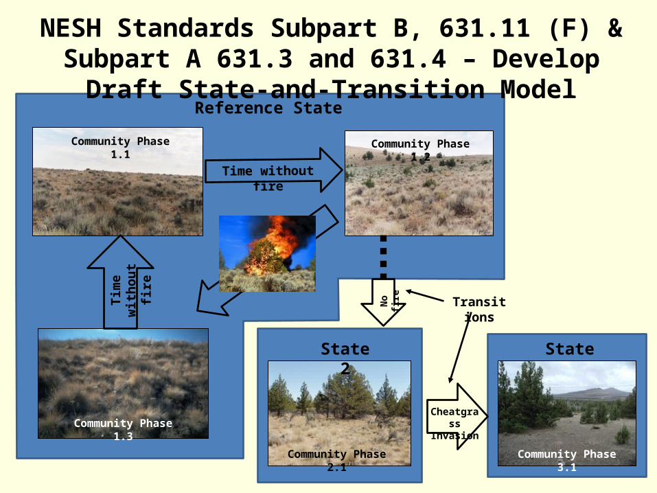
NESH Standards Subpart B, 631.11 (F) & Subpart A 631.3 and 631.4 – Develop Draft State-and-Transition Model
State 3
Community Phase 1.1 Community Phase 1.2
Community Phase 1.3
Reference State
Time without fire
Tim
e w
ithou
t fir
e
State 2
Transitions
Cheatgrass Invasion
Community Phase 2.1 Community Phase 3.1
No
fire
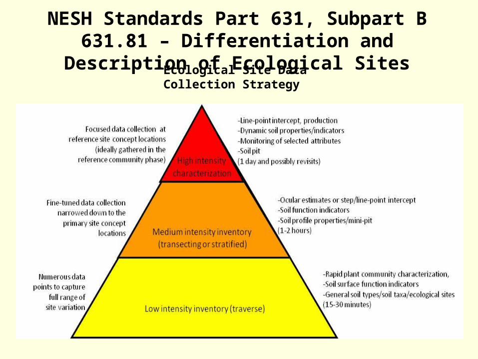
NESH Standards Part 631, Subpart B 631.81 – Differentiation and Description of Ecological Sites
Ecological Site Data Collection Strategy

Schematics or Block Diagrams
Tools to Visualize Ecological Site Concepts
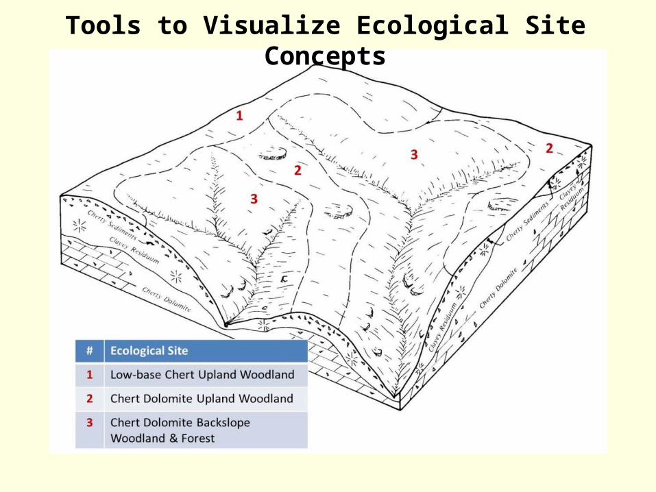
Tools to Visualize Ecological Site Concepts

Sand Hills
Sandy Bottoms
Gravelly Sand Hills
Sandy-skeletal, mixed, thermic Entic Haploxeroll
Sandy. mixed, thermic Entic Haploxeroll
Mixed, thermic Typic Xeropsamment
Actual Images from the LandscapeTools to Visualize Ecological Site Concepts

NESH Standards Part 631, Subpart B 631.12 – Differentiation and Description of Ecological Sites
Iterative Stages Data Collection (Medium-Intensity Sampling)
The following data are typically utilized to validate the ES concept: Full species list for each described community phase Canopy cover, by species, growth form, and vertical strata Production by species (e.g., dry-weight rank/comparative yield, site index/Culmination of
Mean Annual Increment (CMAI)) Overstory tree basal area by species Vegetation vertical structure Inherent soil properties Topography (i.e., landform, slope, aspect, elevation, slope shape)Ground surface cover (bare
ground , basal vegetation cover, litter, gravel, rock, biological soil crust, includes mosses and lichens and cyanobacteria)
Photographs that capture landscape setting as well as dominant vegetation components Canopy gaps Basal gaps Similar vegetative responses to the same management actions
Data Analysis Define Differentiating Characteristics of Ecological Sites Field Test the Ecological Site Concept

• Significant differences in the species that are in the characteristic community phase
• Significant differences in the relative proportion of species in the characteristic community phase
• Significant differences in the total annual production of the characteristic community phase
NESH Standards Part 631, Subpart B 631.12 – Differentiation and Description of Ecological Sites

NESH Standards Part 631, Subpart B 631.12 (4) – Differentiation and Description of Ecological Sites
Test the differentiating characteristics in the field to validate the ES concepts. This should include refining and testing the ecological site key that’s been developed.
• All ES key types are based on the ES concepts that have been tested, confirmed and at least preliminarily correlated to soils
Final soil-ES correlation and field review by soil scientists and vegetation specialists (ecologists or range management specialists) can occur during this step.
A. Technical ES Key Example 1 2
I. Flooded (bottom position, flooded from the valley-side or over-bank flow) 3
A. Soils with a seasonal or perennial high water-table (water table <3 ft from surface) 4
1. Soils sandy, gravelly, cobbly and with redox features …....Wet Sandy Bottom 5
2. Soils loamy to clayey with redox features ...………………..Wet Loamy-Clayey Bottoms 6
B. Soils without a seasonal or perennial high water table (water table >3 ft from surface) 7
1. Sandy textured soils ………………………………………….……..Sandy Bottom 8
2. Sandy loam to clay loam textured soils ……………………………Loamy Bottom 9
3. Soils clayey (vertic) …………………………………………………Clayey Bottom 10
II. Not Flooded (upland position, receives only precipitation) 11
A. Slopes less than 15% 12
1. Soils calcareous throughout 13
a. Shallow soils (less than 20 inches deep) 14
1. Soils with a lime cemented hardpan…….................Shallow Limy Hardpan 15 Upland 16 17
2. Soils underlain by limy schist, diorite or diabase…. Shallow Limy Upland 18
b. Soils moderately deep to deep (>30 inches) 19
1. Soils with an argillic horizon……………………………….Limy Claypan Upland 20
2. Soils without an argillic horizon…………………………....Limy Upland 21

What are the primary ecological drivers in this MLRA/LRU where the ecological site being proposed is found and does the site concept properly capture them?
Have the primary limiting factors for plant growth in this MLRA/LRU been
taken into consideration when developing the site concept? Have the way plants adapt to the ecological drivers and limiting factors been
addressed and properly identified in this ecological site concept? Have the key soils properties in the soils correlated to the proposed
ecological site been identified and discussed as to their relation to influencing plant growth?
What soils correlated appear as outliers? Have these been properly
explained as to why these soils result in similar vegetation response?
NESH Standards Part 631, Subpart B 631.12 (4) – Differentiation and Description of Ecological Sites
Some questions to ask while reviewing and refining your concepts

NESH Standards Part 631, Subpart B 631.13 – Differentiation and Description of Ecological Sites
Final Stages Data Collection (High-Intensity Sampling)
Soil and vegetation specialists should jointly conduct the detailed characterization
While the number of vegetation and soil characterizations that represent the concept of the reference state may vary, a minimum number of characterizations should be agreed upon in the local project plan.
Minimum sampling criteria for alternative states and community phase should also be defined in the work plan.
Type Location Data For each ES, there should be a minimum of three (3) reference type locations
described to the high-intensity sampling characterization level. This is an absolute minimum, but in many cases, this number should be increased in order to ensure the ES characteristics and range of variability has been captured.
Develop Management Interpretations Correlation/Certification

NESH Standards Part 631, Subpart B 631.13 – Differentiation and Description of Ecological Sites
High-intensity Samples
Low intensity inventory (traverse)
Medium intensity inventory (transecting or stratified)
High intensitycharacterization
-Rapid plant community characterization-Soil surface indicators-General soil types/soil taxa/ecological sites(15-30 minutes per point)
-Ocular estimates or step/line-point intercept -Soil surface indicators-Soil profile properties/mini-pit(1-2 hours per point)
-Line-point intercept, production-Dynamic soil properties/indicators-Monitoring of selected attributes-Soil pit (1 day per point and possibly revisits)
Numerous data points to capture
full range of site variation
Targeted data collection stratified using ecological site
concepts
Focused data collection at reference locations (ideally
gathered in the reference community phase)

NESH Standards Part 631, Subpart B 631.13 – Differentiation and Description of Ecological Sites
• Three replicates per state per site• Heavily consider monitoring temporal variations due to climate for several years
20m x 20m plot, one stratum, four soil subsamples
Soil subsample
Soil subsample, full pedon description
Soil stability sample
Baseline, 20 m long
Transect, 20m long
Herbaceous production subplot, 1m-sq
Woody production subplot, 100m-sq
Transect 1 2 3 4 5
0m 5m 10m 15m 20m
20 m
ONE Example of a High-Intensity Data Plot…there are MANY different types

Part II: Take Home Messages
The ESC is the blueprint to the entire ecological site process
Ecological site concepts should be built off soil and site attributes that influence plant growth.
The ESC is basically analogous to the Map Unit Concept
Ecological site concepts are what characterize the ecological site and the ecological site description (ESD) is the document that describes the ecological site.
Ecological site work is a TEAM effort! It requires time spent with the soil scientists, field office and area staffs, and any other specialists that can assist in the development of the site
There is too much complexity to ecological site work to become an expert at all of it, but the guidance and knowledge is out there, USE it!

Questions?