Embed Size (px)
Citation preview
Implementation Guidance
for
The Sustainable Growth and
Agricultural Preservation Act of 2012
Senate Bill 236
May 22, 2012
Version 1.0
SB236 Implementation Guidance, Version 1.0, May 22, 2012
Table of Contents
1. Executive Summary ........................................................................................................................................................... 1
1.1 Bill Highlights ................................................................................................................................................................ 2
1.2 Overview of the guidance document ................................................................................................................... 4
1.3 Overview of SB236 Process and Key Milestones ........................................................................................... 4
2. Develop and Adopt Tiers ................................................................................................................................................. 5
2.1 Wastewater Disposal and Subdivision Restrictions under SB236 ......................................................... 6
2.2 Developing the Growth Tiers ................................................................................................................................. 7
2.2.1 Information Needed to Develop the Growth Tiers ............................................................................... 7
2.2.2 Growth Tier Criteria .......................................................................................................................................... 8
Intent of Tiers I and II.............................................................................................................................................. 8
Intent of Tier III ......................................................................................................................................................... 9
Intent of Tier IV ........................................................................................................................................................ 10
Tier Mapping Decision Framework ................................................................................................................. 10
What is “Dominated by Agricultural or Forest Land”? ............................................................................ 11
Size and Location Criteria ............................................................................................................................... 11
Consideration of Zoning Districts ................................................................................................................ 12
Significance of Resource Values ................................................................................................................... 12
Data Supporting Determinations ................................................................................................................. 12
2.2.3 Resolving Conflicting Growth Tier Designations Among Local Jurisdictions .......................... 12
2.2.4 Adopting the Growth Tiers ........................................................................................................................... 13
2.2.5 After Adoption of the Growth Tiers, Submittal Requirements to the Maryland Department of Planning, and Turn Around Time for Comments....................................................................................... 13
2.2.6 Public Hearing Requirement to Consider Comments from the Maryland Department of Planning on Tier Mapping ........................................................................................................................................ 14
2.2.7 Tier IV Exemption Provision for Residential Major Subdivisions on Septic ............................ 14
3. Grandfathering Provisions: Tracking Residential Subdivisions to Determine Applicability of SB236 and Ensuring Applicable Wastewater Disposal Methods are Used .................................................... 15
4. Confirm or Adjust/Create Definitions of Major and Minor Subdivisions .................................................. 17
5. Controlling Authority Requirement for Shared Facilities or Community Sewerage Systems .......... 18
6. Implementing Restrictions Related to Resubdivision and Further Subdivision for New Residential Minor Subdivisions within Tier II, III and IV Areas ................................................................................................. 18
7. Planning Board Review and Recommendation for Approval of New Residential Major Subdivisions within Tier III Areas .................................................................................................................................. 19

SB236 Implementation Guidance, Version 1.0, May 22, 2012
8. Submittal of Documentation to MDE Designated Approving Authority for New Residential Major Subdivisions within Tier III and Exempted Tier IV Areas .................................................................................... 20
9. Make Changes to the Growth Tiers Over Time ..................................................................................................... 20
10. The Relationships between the PlanMaryland Planning Areas and the Growth Tiers ..................... 20
11. Option to Enact Provisions or Ordinances for Transfer of Development Rights to Subdivide Properties Used for Agricultural Activities ................................................................................................................. 23
12. Reporting to the General Assembly on SB236 Implementation ................................................................. 24
Appendix A. SB236: description and references to the guidance document ................................................ 25
Appendix B. Sustainable Growth and Agricultural Preservation Act FAQs ................................................... 29
General Questions ............................................................................................................................................................ 29
Administrative/Implementation ................................................................................................................................ 30
Appendix C. Applicable Sections of SB236 .................................................................................................................. 33

SB236 Implementation Guidance, Version 1.0, May 22, 2012 1
1. Executive Summary The purpose of this document is to provide guidance and technical assistance for implementing the Sustainable Growth and Agricultural Preservation Act (the Act) of 2012, or Senate Bill 236. The key intended audience is local government, but the document also will be useful to property owners, developers, citizens and others.
Senate Bill 236 was introduced by Governor O’Malley and passed by the Maryland General Assembly in its 2012 Session. The enrolled version of the bill is available online at http://mlis.state.md.us/2012rs/billfile/sb0236.htm. SB236 was the result of a two-year effort on the part of the O’Malley Administration, elected and appointed officials, homebuilders, environmentalists, farmers, planners, and others. The goal of the law is to limit the disproportionate impacts of large subdivisions on septic systems on our farm and forest land, streams, rivers and Chesapeake and Coastal Bays. The Act provides a moderate and reasonable approach for planned development on on-site sewage disposal systems.
Mapping the Tiers is intended to be a straight-forward exercise based on existing local government plans and goals for growth and land preservation. Therefore most of the Tier mapping will be a reflection of existing zoning, comprehensive plans and sewer service. Local jurisdictions should start considering how they will map their Tiers. In addition, they should decide how to adjust their development review process to implement the Act, including the tracking of subdivisions. The Maryland Department of Planning (MDP) is working with the Department of the Environment (MDE) on additional guidance on how to tweak the local development review process.

SB236 Implementation Guidance, Version 1.0, May 22, 2012 2
Figure 1. Overview of SB236 Process and Key Milestones
1.1 Bill Highlights SB236 applies to all counties and municipalities (local jurisdictions) in Maryland. The law applies only to residential subdivisions, not to commercial, industrial, or other non-residential subdivisions.
• Growth Tier Criteria (see page 10)
o Four Tiers of land use categories are created to identify where major and minor residential subdivisions may be located in a jurisdiction and what type of sewerage system will serve them.
SB236 Implementation Guidance, Version 1.0, May 22, 2012 3
Tier I areas are currently served by sewerage systems
Tier II areas are planned to be served by sewerage systems
Tier III areas are planned for future growth on septic systems
Tier IV areas are planned for preservation and conservation and prohibit residential major subdivisions on septic systems
o Local jurisdictions should map Tiers by December 31, 2012. Identification and mapping of the Tiers is voluntary; however, jurisdictions that do not map Tiers will not be able to approve major subdivisions outside of areas currently served by public sewerage systems.
o Municipalities and counties are strongly encouraged to work together to identify Tiers along boundary areas.
o MDP can provide assistance in the identification of Tiers.
o If two or more jurisdictions cannot agree on the designation of a Tier, MDP will recommend to MDE on the Tier designation.
• Wastewater Disposal and Subdivision Restrictions (see page 8)
o Major subdivisions on individual on-site septic systems are only permitted in a Tier III area
o In a Tier IV area, only minor subdivisions are permitted. Some counties may be able to permit major subdivisions in a Tier IV area if they can meet strong land protection requirements (see page 20).
• Definitions of Major and Minor Subdivisions (see page 23)
o The number of lots permitted in a major or minor subdivision is as defined by the local jurisdiction.
o If a local jurisdiction wants to modify its definition of major/minor subdivisions for the purposes of this Act, it can do so by December 31, 2012.
o If a local jurisdiction provides a new definition of a minor subdivision, the number of lots which constitutes a minor subdivision, for the purposes of this Act, may not exceed seven (7).
o If a local jurisdiction does not define a major or minor subdivision by December 31, 2012, then a major subdivision, for the purposes of this Act, will be considered five or more new lots.
• Grandfathering Provisions (see page 21)
o The Act includes fair and reasonable grandfathering provisions.
o Local jurisdictions are encouraged to maintain a record of all subdivisions going through the review/approval process to determine their applicability to this law.
• Adopting the Tiers (see page 18)
o Tiers may be initially adopted administratively but must be incorporated into the local comprehensive plan during the next 6-year review.
o Administrative adoption of the Tiers by December 31, 2012, can be by letter from the jurisdiction’s planning director, or chief appointed or elected official.

SB236 Implementation Guidance, Version 1.0, May 22, 2012 4
o If the Tiers are not incorporated into the comprehensive plan or an element of the plan when the local jurisdiction conducts the 6-year review of the plan, then the Tiers are not considered adopted (and major subdivisions will be restricted to public sewerage service areas only).
• Review of Major Subdivisions in Tier III Areas (see page 25)
o Major subdivisions in Tier III areas must be reviewed and recommended for approval by the local jurisdiction’s planning board.
o The planning board’s review of a major subdivision in a Tier III area shall include the cost of providing local government services to the subdivision and the potential environmental issues or natural resources affected by the subdivision. The planning board shall conduct at least one public hearing.
1.2 Overview of the guidance document This guidance document explains what SB236 requires of local jurisdictions, local environmental health directors (or other MDE designated approving authorities), the Maryland Department of Planning (MDP) and the Maryland Department of Environment (MDE). It explains how to complete required as well as optional provisions of SB236. It also provides additional suggestions for local jurisdictions and local MDE designated approving authorities to ensure the legislative intent of SB236 is achieved. SB236 applies to all local governments in Maryland.
1.3 Overview of SB236 Process and Key Milestones The following timeline provides an overview of the SB236 process and key dates to keep in mind for the implementation of SB236:
• Now o Local jurisdictions should already be working to identify and locate the Tier areas.
Criteria for the Tiers are described in Section 2 (see page 7). o Local jurisdictions (whether or not they adopt the Tiers) should begin tracking
residential subdivisions to identify those that will and will not be grandfathered under SB236. Key dates for grandfathering provisions are described in Section 3.
• July 1, 2012 o SB236 takes effect
• October 1, 2012 o Recommended date for adopting Tiers to ensure no disruption in land development.
Local adoption of Tiers by October 1, 2012 provides three months for MDP comments on Tiers, a local public hearing on MDP’s comments, and possible local changes to the Tiers before the development and sewerage restrictions begin on December 31, 2012.
• December 31, 2012 o Deadline for adopting Tiers. o If the Tiers are not adopted, no residential major subdivisions are allowed outside of
existing sewered areas. o If the Tiers are adopted: within Tier I, residential major and residential minor subdivisions will be served by
public sewerage systems. within Tier II, residential major subdivisions will be served by public sewerage
systems. On-site sewage disposal systems are allowed for residential minor

SB236 Implementation Guidance, Version 1.0, May 22, 2012 5
subdivisions but shall be viewed as interim systems until public sewerage systems are made available.
within Tier III, on-site sewage disposal systems are allowed for residential major subdivisions.
within Tier IV, no residential major subdivisions are allowed. o If desired, the deadline for creating/revising definitions or descriptions of “major
subdivision” and “minor subdivision” applicable solely to Section 9-206 of the Environment Article In addition, by this date, local jurisdictions must submit any definition or
description of a major or minor subdivision in the jurisdiction’s local ordinance or regulation to the Maryland Department of Planning
Following submission by the local jurisdictions, MDP must prepare a list of definitions and descriptions of major and minor subdivisions submitted by local jurisdictions for publication on the websites of the Department of Planning and the Department of the Environment
o Restrictions go into effect for new residential minor subdivisions within Tier II, III and IV areas with regard to resubdivision and further subdivision, as well as subdivision plat requirements related to this restriction
• February 1, 2013 o By this date, the Department of Planning, in consultation with the Department of the
Environment, shall report to the General Assembly, in accordance with § 2–1246 of the State Government Article, on: the adoption of the Tiers by each local jurisdiction, including mapped areas of the
Tiers; jurisdictions that have adopted or altered a local ordinance or regulation to
implement the provisions of SB236, including a description of the adopted or altered local ordinance or regulation
jurisdictions that the Department of Planning provided comments to on any of the Tiers or an area within one of the tiers
2. Develop and Adopt Tiers Local jurisdictions are encouraged to work with MDP and MDE as they implement the Act, including developing their Tiers. MDP would like to work with local jurisdictions in the process of developing the Tiers before adoption. Please contact the following staff for assistance:
• Jason Dubow – Director, MDP’s Environmental Planning Division – at (410) 767-4500 to request policy and/or technical assistance
• Jay Prager – Deputy Program Manager, MDE’s Wastewater Permits Program – at (410) 537-3780 to request assistance with MDE-related issues

SB236 Implementation Guidance, Version 1.0, May 22, 2012 6
2.1 Wastewater Disposal and Subdivision Restrictions under SB236 Table 1 provides a side-by-side comparison of the wastewater disposal and subdivision restrictions, under the Act, that apply to residential subdivisions. Table 1. If Growth Tiers* Are Not Adopted by December 31, 2012
If Growth Tiers Are Adopted by December 31, 2012
Tier I. Public sewerage for residential major subdivisions. Public sewerage for residential minor subdivisions.
Tier I. Public sewerage for residential major subdivisions. Public sewerage for residential minor subdivisions.
Tier II. Residential major subdivisions are not permitted. On-site sewage disposal systems are permitted for residential minor subdivisions.
Tier II. Public sewerage for residential major subdivisions. Public sewerage or on-site sewage disposal systems for residential minor subdivisions. On-site sewage disposal systems are permitted in Tier II but shall be viewed as interim systems until public sewerage systems are made available.
Tier III. Residential major subdivisions are not permitted. On-site sewage disposal systems are permitted for residential minor subdivisions.
Tier III. On-site sewage disposal systems are permitted for residential major subdivisions. Residential minor subdivisions can be served by individual on-site sewage disposal systems.
Tier IV. Residential major subdivisions are not permitted. On-site sewage disposal systems are permitted for residential minor subdivisions.
Tier IV. Residential major subdivisions are not permitted without an exemption (see page 20). Residential minor subdivisions can be served by individual on-site sewage disposal systems.
* Note: the Tiers are listed in the column “If Growth Tiers Are Not Adopted” to facilitate comparison. The definitions for each wastewater disposal method described in Table 1 are listed in Appendix C; however, they can be simplified as follows:
• Public sewerage is any type of sewerage system, except for an individual on-site sewage disposal system, that is owned and operated by a government entity, and discharges effluent above or below the soil surface or directly to surface waters.
• On-site sewage disposal systems include any type of on-site sewage disposal system, including individual systems, shared facilities and community sewerage systems. On-site sewage disposal systems only discharge effluent beneath the soil surface.
• An individual on-site sewage disposal system is an on-site sewage disposal system that discharges effluent beneath the soil surface and serves one user on one parcel.

SB236 Implementation Guidance, Version 1.0, May 22, 2012 7
2.2 Developing the Growth Tiers This section discusses the steps necessary for local jurisdictions to develop the growth tiers, including:
• Information Needed to Develop the Growth Tiers • Growth Tier Criteria • Resolving Conflicting Growth Tier Designations Among Local Jurisdictions • Submittal Requirements to the Maryland Department of Planning, After Adopting the
Growth Tiers • Public Hearing Requirement to Consider Comments from the Maryland Department of
Planning In addition, since extensive interaction with the Maryland Department of Planning will occur during the development of the Tiers, this section also discusses the Tier IV area exemption provision, which requires verification of the actual overall yield by the Maryland Department of Planning.
2.2.1 Information Needed to Develop the Growth Tiers There are several different geographic data layers that the local jurisdiction should gather and analyze (most of which is existing information) to develop the Tiers. Some of the data are available on Maryland’s Internet Map website at http://www.imap.maryland.gov/Portal. Examples are listed in Table 2.
Table 2. Information Needed to Develop Tiers
Information Description Sewerage Service Areas As designated in the county water and sewerage plan or as mapped by
the municipality but not yet included in the county water and sewerage plan. This includes areas with existing and planned service as well as those areas not designated to receive service (not planned)
Locally Designated Growth Areas
Areas that have been designated as future growth areas for counties (as mapped in the Land Use Element) or municipalities (as mapped in the Municipal Growth Element)
Existing and Proposed Land Use
County and municipal Land Use Element maps from the local comprehensive plan and associated information
Zoning Districts County and municipal zoning maps and associated information Municipal Boundaries Up-to-date boundaries including all annexations to date Priority Funding Areas, including Rural Village Boundaries
Rural Villages are as described in § 5-7B-03(F) of the State Finance and Procurement Article
Rural Legacy Area Boundaries
Areas that have been approved by the Rural Legacy Board. A map depicting these areas can be found here: http://www.dnr.state.md.us/land/rurallegacy/pdfs/State_RLAFY11.pdf
Priority Preservation Area (PPA) Boundaries
PPAs certified under the State Agricultural Certification Program by MDP and Maryland Agricultural Land Preservation Foundation (MALPF)

SB236 Implementation Guidance, Version 1.0, May 22, 2012 8
State and Local Protected Lands (Ownership and Easement)
Preserved parcels under easement or ownership by a state agency or local jurisdiction preservation program or initiative
Land Use/Land Cover MDP’s maps or alternative local maps
MDP or other State agencies maintain this information statewide and can provide technical assistance if requested for mapping the Tiers. MDP will use the above information when reviewing and commenting on local jurisdictions’ Tier maps. MDP will work with local jurisdictions to ensure the latest and best available data are used when assisting local jurisdictions in mapping the Tiers.
With the geographic data layers, the local jurisdiction should develop the Tiers using the criteria listed in SB236 for the Tiers. More information on the development of the Tiers is discussed below.
2.2.2 Growth Tier Criteria This section describes the intent of each Tier, the types of areas covered by each Tier, and suggested methods for developing the Tiers. Language in text boxes is from Article 66B, Section 1.05(H). (Note: after October 1, 2012, see Land Use Article, Title 1, Subtitle 5). The establishment of Tiers furthers the State’s growth policy as envisioned first in the 1992 Economic Growth, Resource Protection, and Planning Act and recently updated in the 2009 Smart, Green and Growing legislation. The State's growth policy focuses on concentrating development in suitable areas, protecting sensitive areas, and protecting our quality of life.
Intent of Tiers I and II Development within Tier I areas will be served by public sewerage systems, which is the best method for supporting long-term, planned development. Correspondingly, the intent in mapping
(1) TIER I AREAS ARE AREAS THAT ARE:
(I) SERVED BY PUBLIC SEWERAGE SYSTEMS AND MAPPED LOCALLY DESIGNATED GROWTH AREAS; OR
(II) A MUNICIPAL CORPORATION THAT IS A PRIORITY FUNDING AREA THAT IS SERVED BY PUBLIC SEWERAGE SYSTEMS;
(2) TIER II AREAS ARE AREAS THAT ARE:
(I) 1. PLANNED TO BE SERVED BY PUBLIC SEWERAGE SYSTEMS AND IN THE MUNICIPAL GROWTH ELEMENT; OR
2. MAPPED LOCALLY DESIGNATED GROWTH AREAS; AND
(II) NEEDED TO SATISFY DEMAND FOR DEVELOPMENT AT DENSITIES CONSISTENT WITH THE LONG–TERM DEVELOPMENT POLICY AFTER CONSIDERATION OF THE CAPACITY OF LAND AREAS AVAILABLE FOR DEVELOPMENT, INCLUDING IN–FILL AND REDEVELOPMENT, WITHIN THE LOCAL JURISDICTION;

SB236 Implementation Guidance, Version 1.0, May 22, 2012 9
Tier I areas is to identify areas for which public sewerage service is currently available. Also, public systems serving Tier I areas should be able to accommodate existing and planned future growth.
Within Tier II areas, community, shared and individual on-site sewage disposal systems are permitted for residential minor subdivisions. However, these systems shall be considered interim systems until public sewerage service is made available. Correspondingly, the intent in mapping Tier II areas is to identify growth areas that are planned for public sewerage service.
Intent of Tier III In Tier III, community, shared and individual on-site sewage disposal systems are permitted for residential major subdivisions. On-site sewage disposal systems are best suited for large lot development or for communities that are too small to financially support larger public sewerage systems. Correspondingly, the intent in mapping Tier III areas is to identify areas that are planned for large lot development, or are existing Rural Villages and towns without public sewerage systems. A local jurisdiction should strive to avoid creating a Tier III area that is bounded on all sides by land in a Tier IV area.
(3) TIER III AREAS ARE AREAS THAT ARE:
(I) NOT PLANNED FOR SEWERAGE SERVICE AND NOT DOMINATED BY AGRICULTURAL OR FOREST LAND;
(II) NOT PLANNED OR ZONED BY A LOCAL JURISDICTION FOR LAND, AGRICULTURAL, OR RESOURCE PROTECTION, PRESERVATION, OR CONSERVATION; AND
(III) ONE OF THE FOLLOWING:
1. MUNICIPAL CORPORATIONS NOT SERVED BY A PUBLIC SEWERAGE SYSTEM;
2. RURAL VILLAGES AS DESCRIBED IN § 5–7B–03(F) OF THE STATE FINANCE AND PROCUREMENT ARTICLE;
3. MAPPED LOCALLY DESIGNATED GROWTH AREAS; OR
4. AREAS PLANNED AND ZONED FOR LARGE LOT AND RURAL DEVELOPMENT
LOCAL JURISDICTION SHALL STRIVE TO AVOID CREATING A TIER III AREA THAT IS BOUNDED ON ALL SIDES BY LAND IN A TIER IV AREA
(4) TIER IV AREAS ARE AREAS THAT ARE NOT PLANNED FOR SEWERAGE SERVICE AND ARE:
(I) AREAS PLANNED OR ZONED BY A LOCAL JURISDICTION FOR LAND, AGRICULTURAL, OR RESOURCE PROTECTION, PRESERVATION, OR CONSERVATION;
(II) AREAS DOMINATED BY AGRICULTURAL LANDS, FOREST LANDS, OR OTHER NATURAL AREAS; OR
(III) RURAL LEGACY AREAS, PRIORITY PRESERVATION AREAS, OR AREAS SUBJECT TO COVENANTS, RESTRICTIONS, CONDITIONS, OR CONSERVATION EASEMENTS FOR THE BENEFIT OF, OR HELD BY A STATE AGENCY, AS DEFINED IN § 9–206 OF THE ENVIRONMENT ARTICLE, OR A LOCAL JURISDICTION FOR THE PURPOSE OF CONSERVING NATURAL RESOURCES OR AGRICULTURAL LAND.

SB236 Implementation Guidance, Version 1.0, May 22, 2012 10
Intent of Tier IV Within Tier IV, residential major subdivisions are prohibited. Correspondingly, the intent in mapping Tier IV areas is to identify areas where large lot development would conflict with the goals of the local jurisdiction for agricultural and natural resource land protection and with other areas of high rural resource value. Tier IV areas will likely consist of critical agricultural or other resource landscapes that meet one or more of the following criteria:
1) Have been targeted by state and local preservation/conservation programs, 2) Have a primary public intent articulated in local comprehensive plans and/or zoning
ordinances for protection, preservation, or conservation of agricultural, forestry, natural and/or cultural resources.
3) Are areas of significant contiguous agricultural and forest land 4) Have been preserved by state and/or local preservation programs
Tier Mapping Decision Framework The following “Tier Mapping Decision Framework” should be used to help the local jurisdiction identify the appropriate Tier for each area. Local jurisdictions also should keep the following issues in mind when mapping the Tiers:
• To protect the contiguity of Tier IV areas, jurisdictions should strive to avoid creating a Tier III area that is bounded on all sides by land in a Tier IV area (Article 66B, Section 1.05(G)).
• Local jurisdictions should review the methodology described in the MDP Models & Guidelines 25, Writing the Municipal Growth Element to the Comprehensive Plan, pages 7 through 11, to determine whether a potential Tier II area is “needed to satisfy demand for development at densities consistent with the long-term development policy after consideration of the capacity of the land areas available for development, including in-fill and redevelopment, within the local jurisdiction”.
1. Tier Mapping Decision Framework
a. Municipalities i. Existing development areas: Identify the portions of the municipal corporation
that are designated as PFA 1. For each area, is the area “served by public sewerage systems”?
a. If “yes”, then classify as Tier I b. If the area is planned for sewerage service, it should be classified as Tier II
and should be “needed to satisfy demand for development at densities consistent with the long-term development policy after consideration of the capacity of the land areas available for development, including in-fill and redevelopment, within the local jurisdiction”
ii. Growth areas: identify areas that are planned to be served by public sewerage systems and in the Municipal Growth Element 1. These areas should be classified as Tier II and should be “needed to satisfy
demand for development at densities consistent with the long-term development policy after consideration of the capacity of the land areas available for development, including in-fill and redevelopment, within the local jurisdiction”
b. Counties i. Identify “mapped locally designated growth areas”

SB236 Implementation Guidance, Version 1.0, May 22, 2012 11
1. These are areas that must be mapped and identified for growth in the County comprehensive plan a. For each area, is the area “served by public sewerage systems”?
i. If “yes”, then classify as Tier I ii. If the area is planned for sewerage service, it should be classified as Tier
II and should be “needed to satisfy demand for development at densities consistent with the long-term development policy after consideration of the capacity of the land areas available for development, including in-fill and redevelopment, within the local jurisdiction”
iii. If the area is not planned for sewerage service, then go to “Identify areas not planned for sewerage service” below
ii. Identify areas that are not “mapped locally designated growth areas” within the County comprehensive plan but are “served by public sewerage systems”, for example, areas previously with failing septic systems. 1. These might be in a variety of Tiers. Local jurisdictions should annotate these
areas to identify them separately. iii. Identify areas not planned for sewerage service
1. Is the area a “Rural Legacy area, Priority Preservation Area, or area subject to covenants, restrictions, conditions, or conservation easements for the benefit of, or held by a State agency, as defined in § 9-206 of the Environment Article, or a local jurisdiction for the purpose of conserving natural resources or agricultural land”? a. If “yes”, then classify as Tier IV b. If “no”, proceed to question 2
2. Is the area “dominated by agricultural or forest land”? a. See “What is Dominated by Agricultural or Forest Land?” section below b. If “yes”, classify as Tier IV c. If “no”, is the area “planned or zoned for land, agricultural, or resource
protection, preservation or conservation”? i. If “yes”, classify as Tier IV
ii. If “no”, is the area one of the following? 1. A “municipal corporation not served by a public sewerage system”? 2. A “Rural Village as described in § 5-7B-03(F) of the State Finance and
Procurement Article”? 3. A “mapped locally designated growth area”? 4. An “area planned and zoned for large lot and rural development”?
a. These areas are classified as Tier III What is “Dominated by Agricultural or Forest Land”? There are a number of reasonable approaches to delineating areas that should be included in Tier IV because they are dominated by agricultural and forest lands or other natural areas. MDP recommends the use of its 2010 Land Use/Land Cover layer and other spatial criteria to identify areas to consider for inclusion in Tier IV, followed by explicit evaluation of the resource values on the land so identified, as further explained below.
Size and Location Criteria For this approach, MDP recommends that areas initially be mapped to include:

SB236 Implementation Guidance, Version 1.0, May 22, 2012 12
• Agricultural and Forest lands that adjoin or are contiguous to other Tier IV areas. Other Tier IV areas include zoning districts planned and zoned for preservation/conservation, PPAs, and Rural Legacy Areas.
• Isolated areas 100 acres or larger of contiguous combined agricultural, forest, and other natural land covers.
• Isolated areas of contiguous combined agricultural, forest, and other natural land covers that are smaller than 100 acres in size that have stand-alone resource value identified by the State, local government or the private sector (often individual landowners). Such areas will generally be surrounded by non-agricultural, non-forest land uses such as residential subdivisions or other Tier I, II, or III lands.
Once these areas are mapped, their resource values for agriculture, forestry and natural resources can be further assessed to determine if they merit inclusion in Tier IV (see Consideration of Zoning Districts and Significance of Resource Values sections below).
Consideration of Zoning Districts Another approach is to determine if entire zoning districts that are not planned and zoned for preservation and/or conservation are dominated by agricultural, forest and other natural cover types with significant resource values.
Significance of Resource Values Considerations made to evaluate significance of resource values of land in these cover types should include presence of agricultural, forestry and natural resources, and the spatial configurations of these land areas, particularly how contiguous or fragmented they are, and how they conform to relevant features like stream networks and corridors, or green infrastructure hubs and corridors. DNR’s Expanded GreenPrint data, available on-line at http://greenprint.maryland.gov, will be particularly valuable for information on forestry and natural resources.
Data Supporting Determinations Jurisdictions are encouraged to use a variety of sources to determine land areas dominated by agricultural and forest lands including, but not limited to the following:
• MDP’s Land Use/Land Cover 2010 – http://planning.maryland.gov/ourwork/landuse.shtml • Aerial imagery • DNR’s Expanded GreenPrint data or better local data • A variety of relevant locally derived information/data
2.2.3 Resolving Conflicting Growth Tier Designations Among Local Jurisdictions The Act recognizes that in rare instances local jurisdictions might disagree on what Tier an area should be. One example is when a county and municipality disagree on the boundaries of a municipal growth area: the municipality may want the area to be designated as one Tier while the county might want the area to be designated as a different Tier. The State encourages local jurisdictions to coordinate with each other to identify such conflicts as early in the process as possible.
The Act provides for the following to resolve such conflicts:
• MDE and MDP confer with the local jurisdictions to seek resolution of the conflicting designations.

SB236 Implementation Guidance, Version 1.0, May 22, 2012 13
• If the conflict in Tier designations is not resolved, MDP recommends Tier designations to MDE based on the comprehensive plan, growth projections and development capacity, and availability of infrastructure.
• MDE may approve the preferred Tier designations as recommended by MDP. 2.2.4 Adopting the Growth Tiers The local jurisdiction should determine as soon as possible who within the local jurisdiction should adopt the Tiers administratively by December 31, 2012. Under SB236, an administrative officer within the jurisdiction can adopt the Tiers; however, many local jurisdictions might choose for their elected or appointed officials to adopt the Tiers. The decision will impact public hearing and public notice requirements, which in turn will impact the overall schedule the local jurisdiction must follow for adopting the Tiers by December 31, 2012. Administrative adoption of the Tiers can be by letter from the jurisdiction’s planning director or chief appointed or elected official.
Subsequent to adopting the Tiers by December 31, 2012, the Tiers are considered adopted, but when the next 6-year review of the comprehensive plan occurs under §§ 1.04(D) and 3.05(B) of Article 66B, local jurisdictions must incorporate the Tiers into the comprehensive plan or an element of the plan, otherwise the Tiers are no longer considered adopted. If not incorporated into the comprehensive plan at this stage, the wastewater disposal and subdivision restrictions associated with SB236 when the Tiers are not considered to be adopted are applied into the future until the Tiers are incorporated into the comprehensive plan or an element of the plan. MDP will send out a written reminder to local jurisdictions in advance of the next 6-year review.
2.2.5 After Adoption of the Growth Tiers, Submittal Requirements to the Maryland Department of Planning, and Turn Around Time for Comments After adoption of the Tiers, local jurisdictions are required to provide to MDP all information necessary to demonstrate the precise location of the Tiers, including, as appropriate, a map of the area showing planning and zoning characteristics of each Tier; and existing and planned water and sewerage services (Article 66B, Section 1.05(D)). Overall, local jurisdictions should submit their Tier maps along with documentation used to determine the location of the Tiers. This will allow for a comprehensive review by MDP.
MDP would prefer to receive GIS shapefiles or other geographic formats for the Tier map submittals (jurisdictions without GIS capabilities should contact MDP for technical assistance). In order to provide statewide consistency, local jurisdictions should provide the following metadata with the submittal:
• Geographic/map projection information • Data sources • Description of the database structure
MDP requests that the Tier shapefile contain a simple table structure that identifies each Tier through a “Tier” field as well as a simple descriptive field that depicts the reason that an area is located in a particular Tier, named “Description”. For example, if an area is designated as Tier I because it is designated as “S1”, or existing sewerage service area, the “Description” field could say “S1”. If an area is Tier IV because it is “dominated by agriculture and forest areas”, the description field could say “agforest”.
Along with the submittal of the Tier maps, MDP requests documentation and maps used to determine the location of the Tiers. This should include all of the data listed in Table 2 (see page 9)
SB236 Implementation Guidance, Version 1.0, May 22, 2012 14
and any other relevant information used to define the Tiers in the jurisdiction. Such documentation may be based on data and maps maintained at the local and/or State level.
As with the Tier map shapefiles, MDP would prefer to receive GIS shapefiles or other geographic formats for submittals of documentation and maps used to determine the location of the tiers. Please include the following metadata with the submittal:
• Geographic projection information • Data sources • Description of the database structure
MDP recognizes that many jurisdictions already work with MDP staff to ensure that the data layers that MDP uses in analysis activities are up-to-date. However, the information submitted by the local jurisdiction should be completely up-to-date for the formal MDP review that SB236 requires.
MDP has established an ftp site that can be used for data submittal. MDP will accept CDs and GIS data received by email but this is not preferable. MDP will be available for technical assistance throughout this process. After a complete package of information is submitted, MDP will complete its review in approximately 30 days.
To assist MDE in long-term planning, local jurisdictions should map their adopted Tiers over local water and sewerage plan maps and submit them to MDE.
2.2.6 Public Hearing Requirement to Consider Comments from the Maryland Department of Planning on Tier Mapping If the Maryland Department of Planning comments on any of the Tiers adopted by a local jurisdiction (provided for under Article 66B, Section 1.05(E)), or any area within an adopted Tier, the local legislative body or the planning board shall hold at least one public hearing on the comments.
A “planning board” means a planning board established under Article 66B or a planning commission or board established under Article 25A or Article 28 of the Code (Article 66B, Section 1.05(A)).
SB236 outlines the following steps with regard to public hearings to consider comments from the MDP on the adopted Tiers:
• The local legislative body or the planning board must: o hold at least one public hearing on comments received from MDP on the adopted Tiers. o review the adopted Tiers in light of MDP’s comments.
• After the public hearing and consideration of MDP’s comments, the planning board must recommend to the local jurisdiction that either the Tiers or an area within the Tiers be changed or that the adopted Tiers remain unchanged. o If the planning board recommends a change in the adopted Tiers, the planning board
must provide the recommended mapped Tier changes to the local jurisdiction. 2.2.7 Tier IV Exemption Provision for Residential Major Subdivisions on Septic As noted in Table 1 (see page 8), local jurisdictions that adopt the Tiers have the option to seek an exemption from the subdivision restrictions within Tier IV.
The Act sets a high standard for local jurisdictions to meet in order to obtain this exemption. Specifically, counties must have subdivision and zoning requirements in their Tier IV area that result in a protection level of not more than 1 dwelling unit per 20 acres. The purpose of the

SB236 Implementation Guidance, Version 1.0, May 22, 2012 15
exemption is to recognize that certain local jurisdictions have requirements in place within their Tier IV areas that greatly limit the amount of new residential subdivisions on septic systems.
The request for the Tier IV exemption must be made in writing to MDP. To verify the actual overall yield, MDP will begin by reviewing the jurisdiction’s zoning code and subdivision regulations. If the base allowable density in the zoning code applicable to the majority of the Tier IV land is one dwelling unit or fewer per 20 acres, MDP will complete a more detailed analysis of the potential for a jurisdiction’s Tier IV to be exempted from the minor subdivision limitation. The analysis will include consideration of relevant subdivision, development and environmental regulations or rules, to help determine the potential overall development yield. Overall, MDP will focus on the developable land and how zoning and other tools apply to it.
MDP also will consider subdivision and development activity within the Tier IV area, to compare empirically with potential yields indicated by the zoning code and development regulations. MDP will request that local jurisdictions provide data for this purpose, and also will use its own parcel data for this analysis.
Local governments are encouraged to submit materials to MDP that would assist in verifying the density yield for Tier IV lands. Such information includes:
• Excerpts from the zoning ordinance. • Excerpts from subdivision regulations or any other regulations that influence development
yields in the Tier IV area. • Databases (preferably in a GIS format) that provide an inventory of subdivision and parcel
development activity in the Tier IV area for the most recent 10-year period available. • Mapped data (preferably GIS) that indicate development constraints limiting or prohibiting
development activity in the Tier IV area (wetlands, steep slopes, stream buffer areas, etc.) according to local land use ordinance or regulation.
• Data that estimates development capacity (potential for new subdivision and additional parcel development) for the area.
• Protected lands data (preferably GIS) for lands within Tier IV. • Any other pertinent information that would assist MDP’s determination of actual overall
yield in Tier IV.
MDP will confer with the local government during the evaluation as often as necessary to acquire needed information, ensure understanding of information supplied, and corroborate interpretations and preliminary findings.
MDP is tasked with verifying that these areas achieve this yield in consultation with the Maryland Sustainable Growth Commission. MDP will present its initial determination to the Maryland Sustainable Growth Commission for review. The Commission meets every two months; this will be a standing agenda item on the Commission’s meetings through December 2012. After consultation with the Commission, MDP will communicate its final determination, in writing, to the local jurisdiction within 90 days of receipt of the initial verification request.
3. Grandfathering Provisions: Tracking Residential Subdivisions to Determine Applicability of SB236 and Ensuring Applicable Wastewater Disposal Methods are Used If subdivisions are not grandfathered then the SB236 wastewater disposal and subdivision restrictions apply (although the restrictions differ depending whether the Tiers are adopted) along with the other applicable provisions of SB236. As a result, all local jurisdictions—whether or not
SB236 Implementation Guidance, Version 1.0, May 22, 2012 16
the local jurisdiction adopts the Tiers—should track all residential subdivisions (minor and major) to identify which will or will not be grandfathered under SB236 and then should ensure the appropriate wastewater disposal methods and subdivision restrictions under SB236 for each residential subdivision are applied.
MDE and MDP recommend that local jurisdictions immediately adjust existing subdivision tracking systems (or create a separate tracking system) to ensure that a number of questions related to grandfathering provisions are answered, and the answers recorded, for every application for a soil percolation test approval and for every submission for preliminary plan approval. This is recommended to ensure that all of the grandfathering provisions required by SB236 are addressed.
As a first step, local jurisdictions should confirm whether a soil percolation test is required in their jurisdiction before a submittal can be made for preliminary approval and whether the local jurisdiction does not accept applications for soil percolation tests year round.
The local jurisdiction should record and track the following information for each application for a soil percolation test approval and every submission for preliminary plan approval. This applies to existing pipeline subdivisions and new subdivisions. For all questions listed, if the answer is “no” to any one of the listed questions, then the subdivision is not grandfathered.
1. If a soil percolation test is required in the local jurisdiction before submittal can be made for preliminary approval, and the local jurisdiction accepts applications for soil percolation tests year round: a. By July 1, 2012, has an application for a soil percolation test approval (for all lots that
will be included in the submission for preliminary approval) been made to the local health department?
b. What is the date of approval of the soil percolation tests for the lots that will be included in the submission for preliminary approval?
c. Within 18 months after approval of the soil percolation tests (for the lots that will be included in the submission for preliminary approval), has a submission for preliminary approval been made to the local jurisdiction that includes, at a minimum, the preliminary engineering, density, road network, lot layout, and existing features of the proposed site development?
d. Does the submission for preliminary approval include the same lots for which the approved soil percolation test was performed?
e. By October 1, 2016, has the local jurisdiction approved the preliminary plan? 2. If a soil percolation test is required in the local jurisdiction before submittal can be made for
preliminary approval, but the local jurisdiction does not accept applications for soil percolation tests year round:
a. By July 1, 2012, has documentation been provided that a Maryland professional
engineer or surveyor has prepared and certified under seal a site plan in anticipation of an application for soil percolation tests?
b. At the next available soil percolation test season after July 1, 2012, has an application for a soil percolation test approval (for all lots that will be included in the submission for preliminary approval) been made to the local health department?
c. Within 18 months after approval of the soil percolation tests (for the lots that will be included in the submission for preliminary approval), has a submission for preliminary approval been made to the local jurisdiction that includes, at a minimum, the preliminary engineering, density, road network, lot layout, and existing features of the proposed site development?
SB236 Implementation Guidance, Version 1.0, May 22, 2012 17
d. Does the submission for preliminary approval include the same lots for which the approved soil percolation test was performed?
e. By October 1, 2016, has the local jurisdiction approved the preliminary plan? 3. If a soil percolation test is not required in the local jurisdiction before submittal can be
made for preliminary approval: a. By October 1, 2012, has a submission for preliminary approval been made to the local
jurisdiction that includes, at a minimum, the preliminary engineering, density, road network, lot layout, and existing features of the proposed site development?
b. By October 1, 2016, has the local jurisdiction approved the preliminary plan? Using the data collected on each application for a soil percolation test approval and every submission for preliminary plan approval, the local jurisdiction will know which subdivisions are grandfathered under SB236. Once the subdivision reaches the stage where the choice of wastewater disposal must be made, if the subdivision is not grandfathered, the local jurisdiction should ensure the appropriate wastewater disposal methods allowed under SB236 are used. Table 1 (see page 8) explains the allowed wastewater disposal methods whether or not the Tiers are adopted.
Local jurisdictions should submit to MDP information on subdivisions in the development pipeline. Specifically, this should be a map of the location of and number of units in the subdivision process. This will be an indicator of how many subdivisions would be subject to grandfathering provisions. Note that this information also should be provided to MDE’s designated approving authority.
4. Confirm or Adjust/Create Definitions of Major and Minor Subdivisions A local jurisdiction should decide whether its existing definitions or descriptions of major subdivisions and minor subdivisions will help to implement the goals and visions of the local jurisdiction’s comprehensive plan, given the wastewater disposal and subdivision restrictions under SB236. As noted, these restrictions under SB236 vary depending on whether the Tiers are adopted, by growth Tier, and whether the residential subdivision is major or minor.
The following information describes the options available to local jurisdictions with regard to the definitions or descriptions of major subdivisions and minor subdivisions for the purposes of SB236 implementation:
• A major subdivision and minor subdivision is as defined or described in a local ordinance or regulation that is in effect on or before January 1, 2012.
• If a definition or description of a major subdivision and minor subdivision, that went into effect on or before January 1, 2012, does not exist in the local ordinance or a local regulation, the default definitions under SB236 are: o A major subdivision is five or more new lots, plats, building sites, or other divisions of
land o A minor subdivision is fewer than five new lots, plats, building sites, or other divisions
of land • If the local jurisdiction chooses to adopt a new definition or description of a major
subdivision and minor subdivision applicable for the purposes of SB236 implementation, it must do so on or before December 31, 2012 and SB236 requires that: o A minor subdivision defined or described in the adopted ordinance or regulation cannot
exceed seven new lots, plats, building sites, or other divisions of land

SB236 Implementation Guidance, Version 1.0, May 22, 2012 18
• If the local jurisdiction has multiple definitions or descriptions of a major subdivision and/or minor subdivision in the local ordinance or local regulation, the local jurisdiction must make an official determination of which existing definition or description of a major subdivision and/or minor subdivision will be used for the purposes of SB236 implementation. The local jurisdiction will need to decide who within the local jurisdiction will make the official determination.
Additional provisions related to definitions or descriptions of major and/or minor subdivisions include:
• SB236 does not grant any additional development rights in covenants, restrictions, conditions, or conservation easements for the purpose of conserving natural resources or agricultural land.
• SB236 does not diminish development rights transferred in transfer of development rights programs.
• SB236 does not prohibit a local jurisdiction from altering the definition or description of a major or minor subdivision in its local ordinance or regulation for local zoning or development purposes.
Also, SB236 requires local jurisdictions to submit the definitions or descriptions of major or minor subdivisions, to be used for the purposes of SB236 implementation, to MDP on or before December 31, 2012. As required by the Act, MDP must prepare a list of these definitions or descriptions for publication on the websites of MDP and MDE.
5. Controlling Authority Requirement for Shared Facilities or Community Sewerage Systems Under SB236, local environmental health directors (or other MDE designated approving authorities) can only approve new shared facilities or community sewerage systems if they are managed, operated and maintained by a controlling authority or a third party under contract with the controlling authority (Environment Article, Section 9-1110(C)). This applies to all proposed shared facilities even if no subdivision is proposed.
A controlling authority is defined as a “unit of government, a body public and corporate, or an intercounty agency authorized by the State, county, or a municipal corporation to provide for the management, operation, and maintenance of a community sewerage system, shared facility, or multiuse system” (Environment Article, Section 9-1110(A)). This effectively prohibits homeowner associations from being responsible for operating wastewater treatment plants.
The law does not require a local jurisdiction to be a controlling authority or force the local jurisdiction to authorize or allow the use of a shared facility or a community sewerage system within the local jurisdiction (Environment Article, Section 9-1110(B)).
6. Implementing Restrictions Related to Resubdivision and Further Subdivision for New Residential Minor Subdivisions within Tier II, III and IV Areas When a residential subdivision is approved by the local jurisdiction, SB236 requires local jurisdictions to place restrictions related to resubdivision or further subdivision of the tract or
SB236 Implementation Guidance, Version 1.0, May 22, 2012 19
parcel of land that was originally subdivided, and requires the local jurisdiction to add specific information to the subdivision plat to support these restrictions. This provides a mechanism at the local level for ensuring the provisions of SB236 can be enforced into perpetuity.
The following specific restrictions and subdivision plat requirements apply to residential minor subdivisions in a Tier II, Tier III or Tier IV area:
• On or after December 31, 2012, if a tract or parcel of land is subdivided leaving any remainder parcel or tract of land, the subdivision may not be resubdivided or further subdivided and the remainder parcel or tract of land may not be subdivided. In addition, the subdivision plat must state these restrictions and note that the plat is subject to State law and local ordinances and regulations. These restrictions and plat requirements do not apply if the subdivision or the remainder parcel or tract of land is within a Priority Funding Area and designated for public sewerage service within 10 years in the approved water and sewerage plan.
• A tract or parcel of land may be subdivided over time if each time a new lot or parcel is created, the subdivision plat states the number of new lots, plats, building sites, or other divisions of land remaining, and the total number allowed as a subdivision. Once the tract or parcel of land reaches the total number allowed, the subdivision plat shall state that the subdivision may not be resubdivided or further subdivided and the remainder parcel or tract of land may not be subdivided. The plat also must state that it is subject to State law and local ordinances and regulations. However, even after the tract or parcel of land reaches the total number of new lots, plats, building site, or other divisions of land allowed as a subdivision, the remainder parcel or tract of land may be subdivided for nonresidential agricultural purposes and the owner may apply for approval of an on-site sewage disposal system.
In addition, for the purposes of SB236 implementation, the local jurisdiction should indicate which lots within a particular subdivision can be further subdivided.
7. Planning Board Review and Recommendation for Approval of New Residential Major Subdivisions within Tier III Areas Under SB236, all proposed residential major subdivisions within Tier III areas may only be approved if the planning board has reviewed and recommended the approval of the subdivision. In addition, the planning board must hold at least one public hearing and must review specific information related to the subdivision prior to making its recommendation. As required by the Act, the planning board’s recommendation is then made by resolution.
In its review of the residential major subdivision within Tier III, the planning board must consider the cost of services to the major subdivision and the potential environmental issues or a natural resources inventory related to the proposed subdivision.
Charter and non-charter county planning boards, as well as municipal government planning boards must conduct the public hearing and make a recommendation. Since most charter county planning boards do not approve subdivisions, SB236 now requires them to conduct a public hearing and then make a recommendation to the administrative official within the local jurisdiction that approves subdivisions served by on-site sewage disposal systems. A non-charter county or municipal planning board can both make a recommendation for approval as well as approve residential major subdivisions within Tier III.

SB236 Implementation Guidance, Version 1.0, May 22, 2012 20
8. Submittal of Documentation to MDE Designated Approving Authority for New Residential Major Subdivisions within Tier III and Exempted Tier IV Areas In addition to planning board review and recommendation for approval of all proposed residential major subdivisions within Tier III areas, documentation must be submitted to the local environmental health director (or the MDE designated approving authority) indicating that the proposed residential major subdivision is within an adopted Tier III area (Environment Article, Section 9-206(J)). This documentation also must be submitted for proposed residential major subdivisions within exempted Tier IV Areas.
9. Make Changes to the Growth Tiers Over Time Over time, as rezonings or Water and Sewer Plan amendments or other changes (e.g., changes to Priority Preservation Areas) are made, locally adopted Tiers might become out-of-date. For example, if a downzoning occurs in a Tier III area, it is possible that it could become a Tier IV area. The following process must be followed to update Tiers over time:
• Until Tiers are included in the comprehensive plan, a local jurisdiction can change the Tiers administratively, but once the Tiers are included in a comprehensive plan, Tiers only can be changed through a local jurisdiction’s comprehensive planning process.
• Local jurisdictions will need to change their Tiers as rezonings, water and sewerage plan amendments, and other changes occur in any of the areas listed in Table 2 (see page 9).
10. The Relationships between the PlanMaryland Planning Areas and the Growth Tiers PlanMaryland, Maryland’s sustainable growth plan for the 21st century, is a framework for a collaborative process between the State and local governments, the development and environmental communities, the Maryland Sustainable Growth Commission and other stakeholders to address critical issues of environmental and fiscal sustainability. A fundamental component of PlanMaryland is the designation of Planning Areas.
Local jurisdictions are being asked to identify PlanMaryland Planning Areas at the same time as they are identifying Tiers. The identification of the Planning Areas should be of assistance to local jurisdictions when identifying their Tiers. The chart and table below show the general relationship between the Planning Areas and the Tiers. The chart indicates that Tier I and Tier II areas will be comprised mainly of Targeted Growth and Revitalization Areas, Established Communities, and Future Growth Areas. Tier III areas will be comprised mainly of Large Lot Development Areas, and Tier IV areas will consist mostly of Rural Resource Areas. Definitions for the Planning Areas are listed below.
As part of PlanMaryland, municipalities and counties identify their own Planning Areas and provide mapping of these areas to MDP for review; MDP then coordinates the review of local mapping and provide comments and feedback. Planning Areas are established through this local/state review and collaboration process. Existing State programs, policies and resources will be directed, and local efforts are encouraged to be directed as appropriate, to these Planning Areas to better achieve the goals for growth and preservation. Guidelines for developing the Planning Areas can be accessed through the PlanMaryland website at: http://plan.maryland.gov/implementPlan/implementPlan.shtml

SB236 Implementation Guidance, Version 1.0, May 22, 2012 21

SB236 Implementation Guidance, Version 1.0, May 22, 2012 22
The table below shows how each of the PlanMaryland Planning Areas fit into the Tiers.
Definitions of PlanMaryland Planning Areas:
• Targeted Growth & Revitalization. Broadly defined to emphasize mixed-use, higher density residential and business development, historic residential neighborhoods, and employment opportunities, and to better connect residential and business populations to retail, transportation (including public transit), educational, recreational and employment opportunities.
• Established Communities. Locations within a jurisdiction’s Priority Funding Area that already provide many Marylanders places to live, work, and play, but for the most part are not intended for substantial growth or revitalization.
• Future Growth. Typically undeveloped land that is not ready to be developed, but that the local government has recognized as a logical place for community expansion within an existing Priority Funding Area or as an addition to it.
• Large Lot Development. Low density, auto-dependent and single-use areas, with large lot single-family houses being the most prevalent land use. Typically, these areas are not served by public water and sewerage, but may require higher levels of public services than agricultural and other resource-based uses.
• Rural Resource Planning. Areas in a jurisdiction where land preservation and conservation efforts take place. Generally, these are not located in urban areas. They often have resource-based industries such as agriculture or forestry that need to be protected.

SB236 Implementation Guidance, Version 1.0, May 22, 2012 23
Other areas may have natural, historic, or cultural resources that may be endangered by development.
• Priority Preservation Areas for Agriculture. Areas identified by local zoning ordinances as intended for the conservation of agricultural and related rural resource lands. These (mostly) undeveloped lands lie outside Priority Funding Areas.
• Natural Resource Areas. These areas support terrestrial and aquatic living resources, habitats, and ecosystem functions of regional or statewide significance, as well as human uses of these areas. They include tidal fisheries, bay and coastal ecosystems; non-tidal fisheries, wetlands, rivers and streams; forests and other lands comprising major hubs and connecting corridors of green infrastructure; wildlife and endangered species habitats; and areas targeted for land conservation, public use and recreation.
• Water Resource Areas. Areas that are integral to safeguarding a sustainable water supply and consist of surface water supply watersheds, wellhead protection areas for public water systems using groundwater, sole source aquifers, water management strategy areas, outcroppings of confined aquifers used for public water supply, and groundwater recharge areas of other aquifers important as public or private water supply.
• Historic and Cultural Areas. Historic and Cultural Areas are more than the historic preservation efforts associated with a particular building. Historic preservation should be viewed as a broader approach to growth, redevelopment, investment and land-use decisions. Historic and Cultural Areas can be found in places identified for growth, revitalization, preservation or existing communities where no changes are expected.
• Climate Change Impact Areas. Lands likely to experience two feet of relative sea level rise by the middle of the century and as much as four feet or more by the end of the century, as determined by Maryland’s Commission on Climate Change. These also include lands made more vulnerable to storm surge damage or stormwater flooding from extreme weather events, as well as non-coastal areas sensitive to climate change impacts.
11. Option to Enact Provisions or Ordinances for Transfer of Development Rights to Subdivide Properties Used for Agricultural Activities Maryland counties have the authority to create Transfer of Development Rights (TDR) programs (Article 66 B, Section 11), and many have already created such programs. Under SB236, a local jurisdiction may enact a law or ordinance for the transfer of the right to subdivide, up to seven lots, by an owner of property used for agricultural activities to the owner of another property used for agricultural activities (Environment Article, Section 9-206(M)). A property used for agricultural activities, the owner of which receives rights to subdivide through this provision, is limited to a total of 15 lots and the lots must be clustered. The transfers take place within Tier IV; TDRs cannot be from Tier III to Tier IV.
The law does not specify the maximum percentage of the receiving parcel that can be built on and what percentage must remain open. The best practices to be found in Maryland limit cluster development to 20% of the receiving parcel (Calvert County), 15% (Queen Anne’s County), and 10% (Kent County).

SB236 Implementation Guidance, Version 1.0, May 22, 2012 24
12. Reporting to the General Assembly on SB236 Implementation To ensure that the legislative intent of SB236 is achieved, the law requires MDP, in consultation with MDE, to report to the General Assembly on the status of SB236 implementation no later than February 1, 2013. The report requires the following information to be reported (Uncodified Portion of SB236, Section 9):
• the adoption of the Tiers, by each local jurisdiction, including mapped areas of the Tiers; • each jurisdiction that has adopted or altered a local ordinance or regulation in
implementing the provisions of this Act, including a description of the adopted or altered local ordinance or regulation;
• each jurisdiction for which MDP has provided comments on any of the Tiers or an area within one of the Tiers.
SB236 Implementation Guidance, Version 1.0, May 22, 2012 25
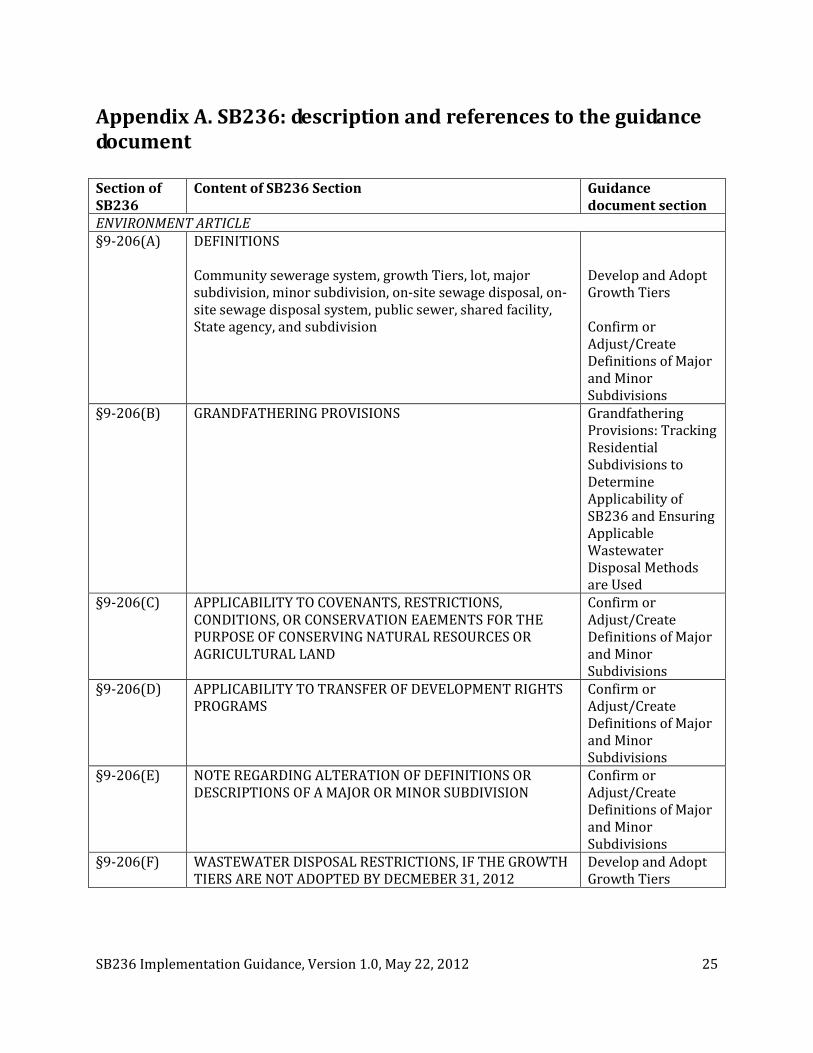
Appendix A. SB236: description and references to the guidance document Section of SB236
Content of SB236 Section Guidance document section
ENVIRONMENT ARTICLE §9-206(A) DEFINITIONS
Community sewerage system, growth Tiers, lot, major subdivision, minor subdivision, on-site sewage disposal, on-site sewage disposal system, public sewer, shared facility, State agency, and subdivision
Develop and Adopt Growth Tiers Confirm or Adjust/Create Definitions of Major and Minor Subdivisions
§9-206(B) GRANDFATHERING PROVISIONS Grandfathering Provisions: Tracking Residential Subdivisions to Determine Applicability of SB236 and Ensuring Applicable Wastewater Disposal Methods are Used
§9-206(C) APPLICABILITY TO COVENANTS, RESTRICTIONS, CONDITIONS, OR CONSERVATION EAEMENTS FOR THE PURPOSE OF CONSERVING NATURAL RESOURCES OR AGRICULTURAL LAND
Confirm or Adjust/Create Definitions of Major and Minor Subdivisions
§9-206(D) APPLICABILITY TO TRANSFER OF DEVELOPMENT RIGHTS PROGRAMS
Confirm or Adjust/Create Definitions of Major and Minor Subdivisions
§9-206(E) NOTE REGARDING ALTERATION OF DEFINITIONS OR DESCRIPTIONS OF A MAJOR OR MINOR SUBDIVISION
Confirm or Adjust/Create Definitions of Major and Minor Subdivisions
§9-206(F) WASTEWATER DISPOSAL RESTRICTIONS, IF THE GROWTH TIERS ARE NOT ADOPTED BY DECMEBER 31, 2012
Develop and Adopt Growth Tiers

SB236 Implementation Guidance, Version 1.0, May 22, 2012 26
Section of SB236
Content of SB236 Section Guidance document section
§9-206(G) WASTEWATER DISPOSAL RESTRICTIONS, IF THE GROWTH TIERS ARE ADOPTED BY DECMEBER 31, 2012; NOTE REGARDING DELAYS IN THE APPROVAL OF A RESIDENTIAL SUBDIVISION PLAT
Develop and Adopt Growth Tiers
§9-206(H) PROVISION TO ALLOW EXEMPTION FROM WASTEWATER DISPOSAL RESTRICTIONS WITHIN TIER IV
Develop and Adopt Growth Tiers
§9-206(I) RESOLVING CONFLICTING GROWTH TIER DESIGNATIONS AMONG LOCAL JURISDICTIONS
Develop and Adopt Growth Tiers
§9-206(J) DOCUMENTATION TO MDE (OR THE MDE DESIGNEE, USUALLY THE LOCAL ENVIRONMENTAL HEALTH DIRECTOR) REGARDING NEW RESIDENTIAL MAJOR SUBDIVISIONS
Submittal of Documentation to MDE Designated Approving Authority for New Residential Major Subdivisions within Tier III and Exempted Tier IV Areas
§9-206(K) RESPONSIBILITIES OF MDE (OR THE MDE DESIGNEE, USUALLY THE LOCAL ENVIRONMENTAL HEALTH DIRECTOR) IN RESPONSE TO DOCUMENTATION SUBMITTED REGARDING NEW RESIDENTIAL MAJOR SUBDIVISIONS
§9-206(L) RESTRICTIONS FOR NEW RESIDENTIAL MINOR SUBDIVISIONS WITHIN TIER II, III AND IV AREAS REGARDING RESUBDIVISION AND FURTHER SUBDIVISION, AND SUBDIVISION PLAT REQUIREMENTS RELATED TO THESE RESTRICTIONS
Implementing Restrictions Related to Resubdivision and Further Subdivision for New Residential Minor Subdivisions within Tier II, III and IV Areas
§9-206(M) OPTION FOR LOCAL LAW OR ORDINANCE FOR THE TRANSFER OF THE RIGHT TO SUBDIVIDE AMONG PROPERTIES USED FOR AGRICULTURAL ACTIVITIES
Option to Enact Provisions or Ordinances for Transfer of Development Rights to Subdivide Among Properties Used for Agricultural Activities
§9-1110 REQUIREMENT FOR CONTROLLING AUTHORITY FOR SHARED FACILITIES AND COMMUNITY SEWERAGE SYSTEMS
Controlling Authority Requirement for Shared Facilities or Community Sewerage Systems
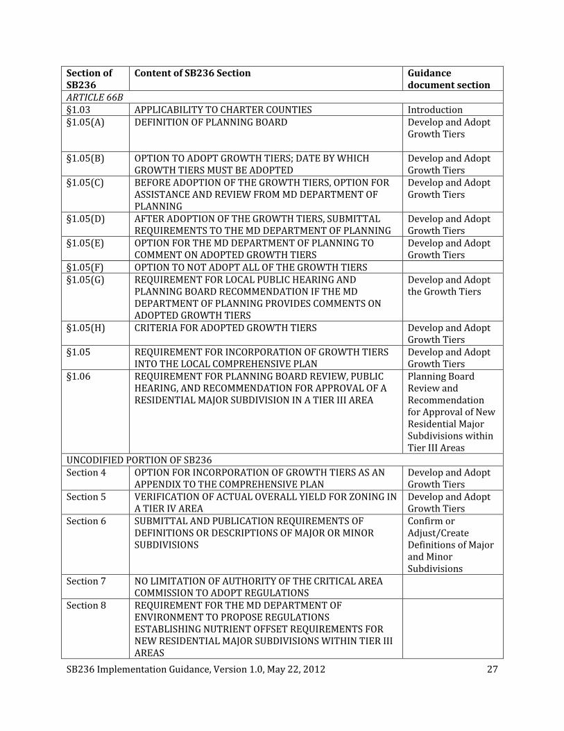
SB236 Implementation Guidance, Version 1.0, May 22, 2012 27
Section of SB236
Content of SB236 Section Guidance document section
ARTICLE 66B §1.03 APPLICABILITY TO CHARTER COUNTIES Introduction §1.05(A) DEFINITION OF PLANNING BOARD
Develop and Adopt Growth Tiers
§1.05(B) OPTION TO ADOPT GROWTH TIERS; DATE BY WHICH GROWTH TIERS MUST BE ADOPTED
Develop and Adopt Growth Tiers
§1.05(C) BEFORE ADOPTION OF THE GROWTH TIERS, OPTION FOR ASSISTANCE AND REVIEW FROM MD DEPARTMENT OF PLANNING
Develop and Adopt Growth Tiers
§1.05(D) AFTER ADOPTION OF THE GROWTH TIERS, SUBMITTAL REQUIREMENTS TO THE MD DEPARTMENT OF PLANNING
Develop and Adopt Growth Tiers
§1.05(E) OPTION FOR THE MD DEPARTMENT OF PLANNING TO COMMENT ON ADOPTED GROWTH TIERS
Develop and Adopt Growth Tiers
§1.05(F) OPTION TO NOT ADOPT ALL OF THE GROWTH TIERS §1.05(G) REQUIREMENT FOR LOCAL PUBLIC HEARING AND
PLANNING BOARD RECOMMENDATION IF THE MD DEPARTMENT OF PLANNING PROVIDES COMMENTS ON ADOPTED GROWTH TIERS
Develop and Adopt the Growth Tiers
§1.05(H) CRITERIA FOR ADOPTED GROWTH TIERS Develop and Adopt Growth Tiers
§1.05 REQUIREMENT FOR INCORPORATION OF GROWTH TIERS INTO THE LOCAL COMPREHENSIVE PLAN
Develop and Adopt Growth Tiers
§1.06 REQUIREMENT FOR PLANNING BOARD REVIEW, PUBLIC HEARING, AND RECOMMENDATION FOR APPROVAL OF A RESIDENTIAL MAJOR SUBDIVISION IN A TIER III AREA
Planning Board Review and Recommendation for Approval of New Residential Major Subdivisions within Tier III Areas
UNCODIFIED PORTION OF SB236 Section 4 OPTION FOR INCORPORATION OF GROWTH TIERS AS AN
APPENDIX TO THE COMPREHENSIVE PLAN Develop and Adopt Growth Tiers
Section 5 VERIFICATION OF ACTUAL OVERALL YIELD FOR ZONING IN A TIER IV AREA
Develop and Adopt Growth Tiers
Section 6 SUBMITTAL AND PUBLICATION REQUIREMENTS OF DEFINITIONS OR DESCRIPTIONS OF MAJOR OR MINOR SUBDIVISIONS
Confirm or Adjust/Create Definitions of Major and Minor Subdivisions
Section 7 NO LIMITATION OF AUTHORITY OF THE CRITICAL AREA COMMISSION TO ADOPT REGULATIONS
Section 8 REQUIREMENT FOR THE MD DEPARTMENT OF ENVIRONMENT TO PROPOSE REGULATIONS ESTABLISHING NUTRIENT OFFSET REQUIREMENTS FOR NEW RESIDENTIAL MAJOR SUBDIVISIONS WITHIN TIER III AREAS

SB236 Implementation Guidance, Version 1.0, May 22, 2012 28
Section of SB236
Content of SB236 Section Guidance document section
Section 9 REQUIREMENT FOR THE MD DEPARTMENT OF PLANNING TO REPORT ON SB236 IMPLEMENTATION TO THE GENERAL ASSEMBLY
Reporting Requirements of the Act
SB236 Implementation Guidance, Version 1.0, May 22, 2012 29
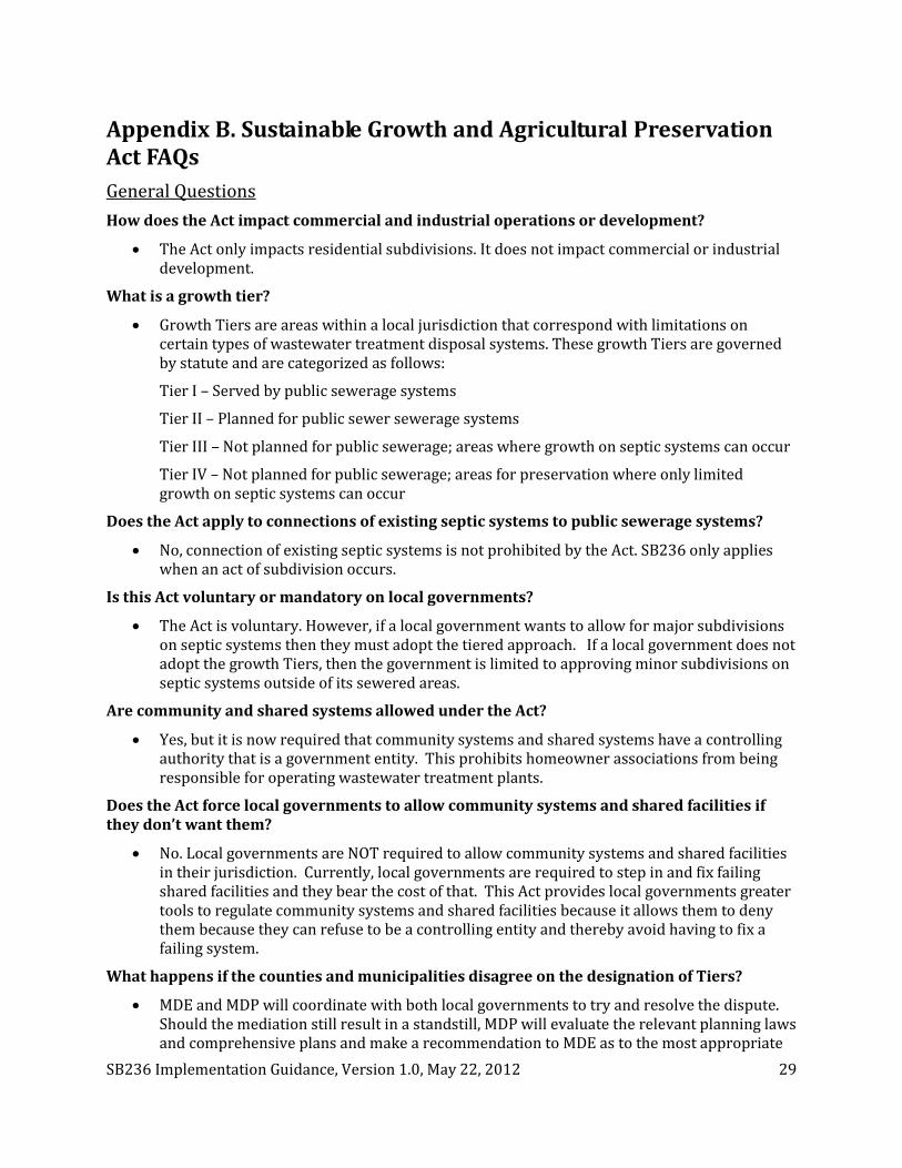
Appendix B. Sustainable Growth and Agricultural Preservation Act FAQs General Questions How does the Act impact commercial and industrial operations or development?
• The Act only impacts residential subdivisions. It does not impact commercial or industrial development.
What is a growth tier?
• Growth Tiers are areas within a local jurisdiction that correspond with limitations on certain types of wastewater treatment disposal systems. These growth Tiers are governed by statute and are categorized as follows:
Tier I – Served by public sewerage systems
Tier II – Planned for public sewer sewerage systems
Tier III – Not planned for public sewerage; areas where growth on septic systems can occur
Tier IV – Not planned for public sewerage; areas for preservation where only limited growth on septic systems can occur
Does the Act apply to connections of existing septic systems to public sewerage systems?
• No, connection of existing septic systems is not prohibited by the Act. SB236 only applies when an act of subdivision occurs.
Is this Act voluntary or mandatory on local governments?
• The Act is voluntary. However, if a local government wants to allow for major subdivisions on septic systems then they must adopt the tiered approach. If a local government does not adopt the growth Tiers, then the government is limited to approving minor subdivisions on septic systems outside of its sewered areas.
Are community and shared systems allowed under the Act?
• Yes, but it is now required that community systems and shared systems have a controlling authority that is a government entity. This prohibits homeowner associations from being responsible for operating wastewater treatment plants.
Does the Act force local governments to allow community systems and shared facilities if they don’t want them?
• No. Local governments are NOT required to allow community systems and shared facilities in their jurisdiction. Currently, local governments are required to step in and fix failing shared facilities and they bear the cost of that. This Act provides local governments greater tools to regulate community systems and shared facilities because it allows them to deny them because they can refuse to be a controlling entity and thereby avoid having to fix a failing system.
What happens if the counties and municipalities disagree on the designation of Tiers?
• MDE and MDP will coordinate with both local governments to try and resolve the dispute. Should the mediation still result in a standstill, MDP will evaluate the relevant planning laws and comprehensive plans and make a recommendation to MDE as to the most appropriate

SB236 Implementation Guidance, Version 1.0, May 22, 2012 30
Tier designation and MDE will render a decision. This is consistent with a directive issued by Governor Glendenning in 1995 to resolve disputes relating to water and sewerage plans which is in place today.
What happens if the local government and State disagree on the designation of the Tiers?
• The ultimate decision on the designation of the Tiers is left to the local jurisdiction. If the State and local jurisdiction disagree on the Tier designations MDP will comment on the local Tiers and the local jurisdiction must hold a public hearing to consider the MDP comments. The jurisdiction may then choose to amend their Tiers or choose for the Tiers to remain the same.
Administrative/Implementation How are the major/minor subdivision thresholds determined?
• The Act allows local governments to use their existing definitions for major/minor subdivisions. If the local jurisdiction wants to redefine the definitions of major/minor subdivision for the purposes of this Act, they may do so by December 31, 2012 as long as the definition of a minor subdivision does not exceed 7 lots.
If a jurisdiction has multiple definitions or descriptions of a minor subdivision, which definition will apply?
• A local jurisdiction shall decide which definition they choose for the purposes of the Act and inform MDE and MDP of the definition prior to December 31, 2012.
What if a local jurisdiction does not have or set a definition of a major/minor subdivision?
• If a local jurisdiction does not set a definition by December 31, 2012, a minor subdivision is defined as a division of fewer than five lots, building sites, plats, or other divisions of land.
Do jurisdictions have to adopt all the Tiers?
• Jurisdictions only need to adopt the Tiers that are relevant to the land uses within their counties. In some cases, jurisdictions might not need to adopt each of the four Tiers. For example, because Baltimore County and Howard County have no municipalities and are unlikely to create new growth areas, Tier II areas for future growth may not be needed.
• If a local jurisdiction does not adopt all the Tiers, the jurisdiction must document the reasons for their decision not to adopt a particular Tier.
What if a local jurisdiction ignores the language for Tier IV and designates land that should fall into Tier IV into Tier III?
• First, MDP will likely comment on that designation and the local jurisdiction is required to hold a public hearing on MDP’s comments. Second, new uncodified reporting language requires MDP to report back to the General Assembly before February 1, 2013 on the designations and MDP comments. The General Assembly will be able reevaluate the provisions of the law next session since local jurisdictions are required to adopt their Tiers by December 31, 2012.
Do jurisdictions have to include the Tiers in their comprehensive plans?
• To streamline the adoption process for the growth Tiers local governments can adopt the Tiers in an administrative fashion, similar to the existing PFA law. The local governments will then need to adopt the Tiers into their comprehensive plans as part of their normal 6-

SB236 Implementation Guidance, Version 1.0, May 22, 2012 31
year comprehensive plan update. This greatly reduces any administrative or financial burden for the local jurisdictions.
If a jurisdiction is currently updating its comprehensive plan or will begin doing so in 2012, must the jurisdiction adopt the Tiers into the current comprehensive plan update they are undertaking?
• If a comprehensive plan update is already in progress and due to be completed by the end of 2012, the jurisdiction does not have to adopt the Tiers in their current comprehensive plan update.
How do local jurisdictions change their Tiers over time (e.g., due to a downzoning in a Tier III area)?
• Until Tiers are included in the comprehensive plan, a local jurisdiction can change the Tiers administratively. Once the Tiers are included in a comprehensive plan, Tiers can be changed through a local jurisdiction’s comprehensive planning process.
Who is exempted from the Tier IV restriction of only minor subdivisions?
• For counties whose subdivision and zoning requirements in their Tier IV area result in a protection level of not more than 1 dwelling unit per 20 acres, they could be allowed to have major subdivisions in Tier IV. The local government can request a yield calculation from MDP to determine if they meet the exemption for the prohibition of major subdivisions in Tier IV.
• MDP will verify the actual overall yield after consultation with the Maryland Sustainable Growth Commission.
In Tier III and Tier IV, who determines what it means for an area to be dominated by agricultural lands, forests, or other natural areas?
• The local jurisdiction ultimately decides what is in each growth Tier and thus, the definition of “dominated” is up to the local jurisdiction. MDP provides guidance on approaches to use for defining this in the SB236 guidance document.
How does the Act impact existing and future easements?
• The Act does not apply to easements granted by the state or local jurisdictions for the purpose of conserving natural resources or agricultural land.
• The Act does not grant any additional easement rights. For example, if a state easement grants four (4) lot rights, the Act does not give the easement holder additional lot rights if the property is located in a jurisdiction and in a Tier that would give them more rights.
• The Act does apply to private or federal easements. However, since an easement is a contract between two entities, this Act does not grant the easement holder the right to violate that contract.
When considering MDP comments on the adopted Tiers, who can hold the public hearing and who does the Planning Board provide its recommendation to related to those comments?
• Regardless whether the planning director, planning board, or legislative body adopts the Tiers, either the Planning Board or Planning Commission or legislative body can hold the public hearing to consider the comments. The body that the Planning Board or Planning

SB236 Implementation Guidance, Version 1.0, May 22, 2012 32
Commission provides its recommendation to depends entirely on who within the local jurisdiction makes the decision with regard to adoption of the growth Tiers.
Does the Planning Board have to recommend a major subdivision on individual septic systems, shared facilities or community systems in a Tier III Growth area?
• Yes. The Act creates a new requirement for Planning Boards and Planning Commissions to have a public hearing on the proposed major subdivisions.
What does the Planning Board or Commission have to consider when they are holding the public hearing?
• The Board or Commission has to consider the cost of services to the major subdivision and the environmental issues or the natural resources inventory on the property.
How does the Planning Board or Commission recommend the major subdivision on individual septic systems, shared facilities or community systems?
• By resolution of the Board or Commission.
Does this Planning Board or Commission public hearing and recommendation requirement apply to charter counties?
• Yes. Since most charter county Planning Boards or Commission do not approve subdivisions this Act now requires them to recommend to that administrative official within the local jurisdiction that approves subdivisions a major subdivision on individual septic systems, a shared facility or a community system in Tier III.
What if the Planning Board in the charter county is advisory only? Is the Planning Advisory Board required to do the public hearing and the recommendation for a major subdivision on individual septic systems, a shared facility or a community system?
• Yes. The Act defines a Planning Board or Commission to include a Planning Board or Commission that is advisory only.
In a non-charter county or municipality, Planning Boards are required to approve subdivisions. How does this new public hearing and recommendation requirement for major subdivision on individual septic systems, a shared facility or a community system work with the existing requirement?
• A non-charter county or municipal Planning Board can combine the two functions as long as the Planning Board also meets the new requirements – a public hearing, consideration of the cost of services to the major subdivision and the environmental issues or the natural resources inventory on the property and a recommendation of approval by resolution.

SB236 Implementation Guidance, Version 1.0, May 22, 2012 33
Appendix C. Applicable Sections of SB236 2.1 Wastewater Disposal and Subdivision Restrictions under SB236
Environment Article, Section 9-206
(A) (2) “Community sewerage system” means a publicly or privately owned sewerage system that serves at least two lots.
(7) “On-site sewage disposal” means the disposal of sewage beneath the soil surface
(8) (I) “On-site sewage disposal system” means a sewage treatment unit, collection system, disposal area, and related appurtenances
(II) “On-site sewage disposal system” includes a shared facility or community sewerage system that disposes of sewage effluent beneath the soil surface.
(9) “Public sewer” means a community, shared, or multiuse sewerage system.
(10) “Shared facility” means a sewerage system that:
(I) Serves more than one:
1. Lot and is owned in common by the users;
2. Condominium unit and is owned in common by the users or by a condominium association;
3. User and is located on individual lots owned by the users; or
4. User on one lot and is owned in common by the users; or
(II) Is located wholly or partly on any of the common elements of a condominium
(III) Serves a housing or another multiple ownership cooperative
(F) On or after December 31, 2012, a local jurisdiction:
(1) May not authorize a residential major subdivision served by on-site sewage disposal systems, community sewerage systems, or shared systems until the local jurisdiction adopts the growth tiers in accordance with Article 66B, § 1.05 of the Code; or
(2) If the local jurisdiction has not adopted the growth tiers in accordance with Article 66B, § 1.05 of the Code, may authorize:=
1. A residential minor subdivision served by on-site sewage disposal systems if the residential subdivision otherwise meets the requirements of this title; or
2. A major or minor subdivision served by public sewer in a Tier I area.
(G) (1) Except as provided in subsection (F)(2) of this section and subject to subsection (I) of this section, a local jurisdiction may authorize a residential subdivision plat only if:
(I) All lots proposed in an area designated for Tier I growth will be served by public sewer;
(II) All lots proposed in an area designated for Tier II growth:
1. Will be served by public sewer; or
2. If the subdivision is a minor subdivision, may be served by on-site sewage disposal systems;

SB236 Implementation Guidance, Version 1.0, May 22, 2012 34
(III) Except as provided in subsection (H) of this section, the subdivision is a minor subdivision served by individual on-site sewage disposal systems in a Tier III or Tier IV area; or
(IV) The subdivision is a major subdivision served by on-site sewage disposal systems, a community system, or a shared facility located in a Tier III area and has been recommended by the local Planning Board in accordance with Article 66B, § 1.06 of the Code
2.2.4 Resolving Conflicting Growth Tier Designations Among Local Jurisdictions
Environment Article, Section 9-206
(I) (1) If two or more local jurisdictions adopt conflicting tier designations for the same area, the Department (i.e., MDE) and the Department of Planning shall confer with the local jurisdictions to seek resolution of the conflicting designations.
(2) If a conflict in growth tier designations is not resolved, the Department of Planning shall recommend to the Department (i.e., MDE) and the Department may approve the preferred local jurisdiction designations as recommended by the Department of Planning based on the following best planning practices or factors:
(I) The comprehensive plan, including the Municipal Growth Element, the Water Resources Element, the Land Use Element, and, if applicable, the Priority Preservation Element;
(II) Growth projections and development capacity; and
(III) Availability of infrastructure.
2.2.4 Adopting the Growth Tiers
Article 66B, Section 1.05
(B) On or before December 31, 2012, a local jurisdiction may adopt the mapped growth tiers in accordance with this section.
(H) (1) A local jurisdiction that adopts growth tiers shall incorporate the tiers into the local comprehensive plan or an element of the plan:
(I) When the local jurisdiction conducts the 6-year review of the plan under §§ 1.04(D) and 3.05(B) of this article; and
(II) In accordance with the requirements of this section.
(2) If a local jurisdiction does not incorporate all of the growth tiers authorized under this section into the local comprehensive plan or an element of the plan, the local jurisdiction shall state that a tier is not adopted.
(Note: after October 1, 2012, see Land Use Article, Title 1, Subtitle 5)
Uncodified Portion of SB236, Section 4
(a) (2) The tiers may be adopted as an amendment to the comprehensive plan under Article 66B, §1.05 of the Code or Title 1, Subtitle 5 of the Land Use Article and be included as an appendix that delineates the tiers and the comprehensive plan land use categories and zoning ordinance districts that are included in each tier.
2.2.6 Public Hearing Requirement to Consider Comments from the Maryland Department of Planning on Tier Mapping

SB236 Implementation Guidance, Version 1.0, May 22, 2012 35
Article 66B, Section 1.05
(G) (1) If the Department of Planning comments under subsection (E) of this section on any of the tiers or on an area within one of the tiers, the local legislative body or the planning board shall hold at least one public hearing on the comments by the Department of Planning.
(2) The local legislative body or the planning board shall review the mapped growth tiers adopted by the local jurisdiction in light of the comments by the Department of Planning.
(3) If the planning board holds the public hearing under paragraph (1) of this section, after the public hearing and the consideration of the comments by the Department of Planning, the Planning Board shall recommend to the local jurisdiction that either the tiers or an area within the tiers:
(I) Be changed; or
(II) That the adopted tiers remain unchanged.
(4) If the planning board recommends that the tiers or an area within the tiers be changed under paragraph (3) of this subsection, the planning board shall provide the recommended mapped growth tier changes to the local jurisdiction.
2.2.7 Tier IV Exemption Provision for Residential Major Subdivisions on Septic
Environment Article, Section 9-206
(H) (1) The limitation of minor subdivisions in subsection (G)(1)(III) of this section does not apply to a local jurisdiction, if the subdivision and zoning requirements in their cumulative Tier IV areas result in an actual overall yield of not more than one dwelling unit per 20 acres that has been verified by the Department of Planning.
(2) A local jurisdiction may request, in writing, a verification of the actual overall yield from the Department of Planning.
(3) The Department of Planning shall verify the actual overall yield after consultation with the Maryland Sustainable Growth Commission, established in § 5-702 of the State Finance and Procurement Article.
Uncodified Portion of SB236, Section 5
If requested by a local jurisdiction to verify the actual overall yield for zoning in a Tier IV area under 9-206(h) of the Environment Article, the Department of Planning shall:
(a) review the local zoning code, along with any relevant subdivision or development regulations or rules, to help determine the overall development yield;
(b) request, if appropriate, information from the local jurisdiction to help determine the overall yield of development in Tier IV;
(c) examine any additional information that the local jurisdiction provides supporting qualification of the jurisdiction’s zoning districts; and
(d) discuss any discrepancies or questions with the local jurisdiction before determining if the jurisdiction’s Tier IV area meets the overall actual yield of one dwelling unit per 20 acres within the Tier IV area.
3. Grandfather Provisions: Tracking Residential Subdivisions to Determine Applicability of SB236 and Ensuring Applicable Wastewater Disposal Methods are Used
Section 9-206, Environment Article

SB236 Implementation Guidance, Version 1.0, May 22, 2012 36
(B) (2) Subsections (F) through (K) do not apply to an application for approval of a residential subdivision under § 9-512(E) of this title if:
(I) 1. By October 1, 2012, a submission for preliminary plan approval is made to a local jurisdiction that includes, at a minimum, the preliminary engineering, density, road network, lot layout, and existing features of the proposed site development;
2. By July 1, 2012, in a local jurisdiction that requires a soil percolation test before a submission for preliminary approval:
A. An application for a soil percolation test approval for all lots that will be included in the submission for preliminary approval is made to the local health department; and
B. Within 18 months after approval of the soil percolation tests for the lots that will be included in the submission for preliminary approval, a submission for preliminary approval is made to a local jurisdiction that includes, at a minimum, the preliminary engineering, density, road network, lot layout, and existing features of the proposed site development; or
3. By July 1, 2012, in a local jurisdiction that requires a soil percolation test before a submission for preliminary approval and the local jurisdiction does not accept applications for soil percolation tests year round:
A. Documentation that a Maryland professional engineer or surveyor has prepared and certified under seal a site plan in anticipation of an application for soil percolation tests;
B. An application for a soil percolation test approval for all lots that will be included in the submission for preliminary approval is made to the local health department at the next available soil percolation test season; and
C. Within 18 months after approval of the soil percolation tests for the lots that will be included in the submission for preliminary approval, a submission for preliminary approval is made to a local jurisdiction that includes, at a minimum, the preliminary engineering, density, road network, lot layout, and existing features of the proposed site development; and
(II) By October 1, 2016, the preliminary plan is approved.
4. Confirm or Adjust/Create Definitions of Major and Minor Subdivisions
Section 9-206 of the Environment Article
(A) (5) “Major subdivision” means:
(I) The subdivision of land:
1. Into new lots, plats, building sites, or other divisions of land defined or described as a major subdivision in a local ordinance or regulation:
A. That is in effect on or before January 1, 2012; or
B. Adopted on or before December 31, 2012, if a local jurisdiction chooses to create a definition or description applicable solely to this section or if a local ordinance or regulation does not define or describe a major subdivision under item A of this item; or

SB236 Implementation Guidance, Version 1.0, May 22, 2012 37
2. If a local jurisdiction has not adopted a definition or description of a major subdivision on or before December 31, 2012, under item 1 of this item, into five or more new lots, plats, building sites, or other divisions of land; and
(II) If the local ordinance or regulation has multiple definitions or descriptions of a major subdivision under paragraph (I) of this subsection, the definition or description of a major subdivision that is determined by the local jurisdiction to apply for the purposes of this section.
(6) “Minor subdivision” means:
(I) The subdivision of land:
1. Into new lots, plats, building sites, or other divisions of land defined or described as a minor subdivision in a local ordinance or regulation:
A. That is in effect on or before January 1, 2012; or
B. Adopted on or before December 31, 2012, if a local jurisdiction chooses to create a definition or description applicable solely to this section or if a local ordinance does not define or describe a minor subdivision under item A of this item, provided that a minor subdivision defined or described in the adopted ordinance or regulation does not exceed seven new lots, plats, building sites, or other divisions of land; or
2. If a local jurisdiction has not adopted a definition or description of a minor subdivision on or before December 31, 2012, under item 1 of this item, into fewer than five new lots, plats, building sites, or other divisions of land; and
(II) If the local ordinance or regulation has multiple definitions or descriptions of a minor subdivision under item (I) of this paragraph, the definition or description of a minor subdivision that is determined by the local jurisdiction to apply for the purposes of this section.
(C) (1) Subsections (F) through (K) and subsection (N) of this section do not apply to covenants, restrictions, conditions, or conservation easements that were created or entered into at any time under § 2-118 of the Real Property Article for the benefit of, or held by, a State agency or a local jurisdiction for the purpose of conserving natural resources or agricultural land.
(2) Subsections (F) through (K) of this section may not be construed as granting any additional rights in covenants, restrictions, conditions, or conservation easements that were created or entered into at any time under § 2-118 of the Real Property Article for the benefit of, or held by, a State agency or a local jurisdiction for the purpose of conserving natural resources or agricultural land.
(D) Subsections (F) through (I) and subsection (L) of this section do not:
(1) Affect a local transfer of development rights program authorized under Article 25A, § 5(X), Article 28, § 8-101, or Article 66B, § 11.01 of the Code; or
(2) Diminish the local development rights transferred in these transfer of development rights programs.
(E) Subsections (F) through (I) and subsection (L) of this section may not be construed as prohibiting a local jurisdiction from altering the definition or description of a major or minor subdivision in a local ordinance or regulation for local zoning or development purposes.

SB236 Implementation Guidance, Version 1.0, May 22, 2012 38
Uncodified Portion of SB236, Section 6
(a) each local jurisdiction shall submit any definition or description of a major or minor subdivision in the jurisdiction’s local ordinance or regulation to the Department of Planning on or before December 31, 2012, in accordance with the provisions of § 9-206 of the Environment Article; and
(b) the Department of Planning shall prepare a list of definitions and descriptions of major and minor subdivisions submitted by local jurisdictions for publication on the Web sites of the Department of Planning and the Department of the Environment on or after December 31, 2012.
6. Implementing Restrictions Related to Resubdivision and Further Subdivision for New Residential Minor Subdivisions within Tier II, III and IV Areas
Environment Article, Section 9-206
(L) (1) This subsection applies to a residential minor subdivision in a Tier II, Tier III, or Tier IV area.
(2) Except as provided in paragraphs (4) and (5) of this subsection, on or after December 31, 2012, if a tract or parcel of land is subdivided into a residential minor subdivision leaving any remainder parcel or tract of land:
(I) The residential minor subdivision may not be resubdivided or further subdivided; and
(II) The remainder parcel or tract of land may not be subdivided.
(3) Except as provided in paragraphs (4) and (5) of this subsection, on or after December 31, 2012, the subdivision plat of the residential minor subdivision shall state that:
(I) The residential minor subdivision may not be resubdivided or further subdivided;
(II) The remainder parcel or tract of land may not be subdivided; and
(III)The subdivision plat is subject to State law and local ordinances and regulations.
(4) On or after December 31, 2012, if a tract or parcel of land is subdivided into a residential minor subdivision, the residential minor subdivision or the remainder parcel or tract of land may be resubdivided or further subdivided if the subdivision or the remainder parcel or tract of land is:
(I) Within a Priority Funding Area as defined in Title 5, Subtitle 7B of the State Finance and Procurement Article; and
(II) Designated for public sewerage service within 10 years in the approved water and sewer plan.
(5) (I) A tract or parcel of land may be subdivided into a residential minor subdivision in Tier II, Tier III, or Tier IV areas over time if each time a new lot or parcel is created, the subdivision plat states the number of new lots, plats, building sites, or other divisions of land that are left with the number of lots, plats, building sites, or other divisions of land allowed as a subdivision.
(II) Except as provided in paragraph (III) of this paragraph, when the tract or parcel of land that is subdivided over time reaches the total number of lots, plats, building sites, or other divisions of land that are allowed as a residential minor subdivision, the subdivision plat shall state that:
1. The residential minor subdivision may not be resubdivided or further subdivided;
2. The remainder parcel or tract of land may not be subdivided; and
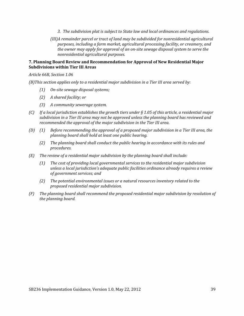
SB236 Implementation Guidance, Version 1.0, May 22, 2012 39
3. The subdivision plat is subject to State law and local ordinances and regulations.
(III)A remainder parcel or tract of land may be subdivided for nonresidential agricultural purposes, including a farm market, agricultural processing facility, or creamery, and the owner may apply for approval of an on-site sewage disposal system to serve the nonresidential agricultural purposes.
7. Planning Board Review and Recommendation for Approval of New Residential Major Subdivisions within Tier III Areas
Article 66B, Section 1.06
(B)This section applies only to a residential major subdivision in a Tier III area served by:
(1) On-site sewage disposal systems;
(2) A shared facility; or
(3) A community sewerage system.
(C) If a local jurisdiction establishes the growth tiers under § 1.05 of this article, a residential major subdivision in a Tier III area may not be approved unless the planning board has reviewed and recommended the approval of the major subdivision in the Tier III area.
(D) (1) Before recommending the approval of a proposed major subdivision in a Tier III area, the planning board shall hold at least one public hearing.
(2) The planning board shall conduct the public hearing in accordance with its rules and procedures.
(E) The review of a residential major subdivision by the planning board shall include:
(1) The cost of providing local governmental services to the residential major subdivision unless a local jurisdiction’s adequate public facilities ordinance already requires a review of government services; and
(2) The potential environmental issues or a natural resources inventory related to the proposed residential major subdivision.
(F) The planning board shall recommend the proposed residential major subdivision by resolution of the planning board.