Embed Size (px)
Citation preview

IMPACTS OF FLOW REGIMES ON ENVIRONMENTAL CONDITIONS IN THE MEKONG DELTA OF VIETNAM
ABTRACT Sound utilisation of water resources of the Mekong River basin is the strategic target of the agreement on Cooperation for the sustainable Development of the Mekong River Basin, signed by the four countries of the Lower Mekong River Basin in 1995 aiming at ensuring prosperous, equatable and sustainable development of communities living in the Mekong River Basin. It is neccesary that the development target of each country should be corresponding to the common regulation of Mekong River Committee on sharing water resources of the basin. The paper describes the general introduction of Mekong Rever Delta in Vietnam, its specific features and Vietnam Government’s policy of the development of Mekong Rever Delta, the flow distribution and flow regime, its impacts on socio-economic and environment and impacts of socio-economic activities on the ecosystem in the Mekong River Basin. The policy of Vietnam Government to develop the socio-economic in the Mekong River Basin to become key economic region of the whole country is the big challenge for sustainable development ensuring balance between economic development and environmental protection. The paper comments that development a research strategy for incorporating the environmental consequences of alternative river management strategies into existing bio-economic models of the Mekong is essential to provide decision maker and managers with a valuable and powerful source of information regarding the cost and benefits of river management options under consideration. This also addresses the Vietnam Government strategy on development of Mekong River Basin.
I. INTRODUCTION
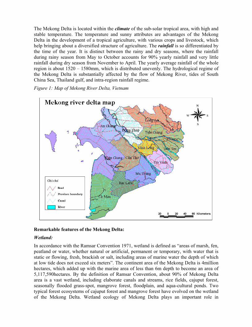
Mekong Delta is rested within the Vietnamese territory in the downstream of Mekong basin, which is bounded by Cambodia in the north, the East Sea (South China Sea) in the south and the west, Ho Chi Minh City and Tay Ninh province in the east. Mekong Delta consists of 12 provinces of Long An, Tien Giang, Ben Tre, Dong Thap, Vinh Long, Tra Vinh, An Giang, Can Tho, Soc Trang, Bac Lieu, Ca Mau, Kien Giang (figure 1)
The area of Mekong Delta is 3,971,232 hectares, with the population of 16.365million (average 2000), accounting for 12% and 22% of the national area and population, respectively. The population density is 412 persons per km2, as much as 1.75times of that of the nation (236persons per km2).
Except the autonomous mountain area in the north-west and ancient alluvium “net” in the east and north-east, the topography of the Mekong Delta is generally plain, with the sloping direction from the north down to the south, including two shallow areas of Dong Thap Muoi and the north-east of the Ca Mau peninsula. In addition to the natural rivers and streams, the Mekong Delta is partitioned by elaborate canals, which brings about a rather convenient waterway transport network, especially for the transport of agricultural products.
The Mekong Delta is located within the climate of the sub-solar tropical area, with high and stable temperature. The temperature and sunny attributes are advantages of the Mekong Delta in the development of a tropical agriculture, with various crops and livestock, which help bringing about a diversified structure of agriculture. The rainfall is so differentiated by the time of the year. It is distinct between the rainy and dry seasons, where the rainfall during rainy season from May to October accounts for 90% yearly rainfall and very little rainfall during dry season from November to April. The yearly average rainfall of the whole region is about 1520 – 1580mm, which is distributed unevenly. The hydrological regime of the Mekong Delta is substantially affected by the flow of Mekong River, tides of South China Sea, Thailand gulf, and intra-region rainfall regime.
Figure 1: Map of Mekong River Delta, Vietnam
Remarkable features of the Mekong Delta:
Wetland: In accordance with the Ramsar Convention 1971, wetland is defined as “areas of marsh, fen, peatland or water, whether natural or artificial, permanent or temporary, with water that is static or flowing, fresh, brackish or salt, including areas of marine water the depth of which at low tide does not exceed six meters”. The continent area of the Mekong Delta is 4million hectares, which added up with the marine area of less than 6m depth to become an area of 5,117,590hectares. By the definition of Ramsar Convention, about 90% of Mekong Delta area is a vast wetland, including elaborate canals and streams, rice fields, cajuput forest, seasonally flooded grass-spot, mangrove forest, floodplain, and aqua-cultural ponds. Two typical forest ecosystems of cajuput forest and mangrove forest have evolved on the wetland of the Mekong Delta. Wetland ecology of Mekong Delta plays an important role in

reservation of biodiversity, maintenance of ecological integrity and provision of products for the human society.
Acid Sulfate Soil: The acid sulfate soil covers 1,600,263ha, accounting for 41.10% of the total area. Of which, 1,050,000ha is slightly acid sulfate or neutral with deep acid sulfate strata, which are almost used for rice cultivation and other surface cultivations such as sugarcane, winged yam, cassava, etc. Highly acid sulfate soil with shallow acid sulfate strata and high acid sulfate content stretches over 550,263ha, which located largely in Dong Thap Muoi, Long Xuyen Quadrangle, and Ca Mau peninsula; most of these areas are already covered by forests and the minority is covered by rice field, leaving the remaining unused. The main disadvantage of this soil area is that the acidity and toxicity increase as pH decreases; however, this type of soil possibly provides for the high productivity once hushed by watering and proper fertilization. But anyway, the acid sulfate soils provide less productivity than others in the region. Due to the vast acid sulfate soils, the condition of acid water is spread out the Mekong Delta. At the beginning of rainy season, many areas of Mekong Delta water are acidified at 2.5 – 5pH. In the early 1980s, the total area of acid water is more than one million hectares during the period of 2-5months, which is varied from region to region. In recent year, thank to the irrigation infrastructures, the total area of acid water is shrunk substantially, and the period of acidity is also shortened. There remain some areas with acid water in the Mekong Delta; those are Ha Tien Quadrangle, north of Quan Lo Phung Channel, U Minh, central Dong Thap Muoi, Bac Dong – Bo Bo.
Salty Soil: Salty soil covers the area of 744,547ha, accounting for 19.10% of the total area. These are salt alluvium soil. Except for salt-marsh area, other salty areas can provide for the rice. The main disadvantage is that the saltiness increases in dry season, which harmfully affect the growth of cultivation. Generally, this soil can provide higher productivity and quality than others if washed by sufficient fresh water.
Salinity intrusion: The tidal intrusion brings about the salty intrusion into the Mekong Delta. During rainy season, the salty boundary is forced out to the near coast. However, the decreased fresh water discharge makes the saltiness intruded in to the inner-field. Formerly, the irrigation infrastructure is underdeveloped, and the salt-affected area is 2.1million ha. Recently, the irrigation is rather developed, which freshen many coastal areas and reduced the salt-affected areas down to 1.4million ha. However, the salty boundary in the main river is even forced in further.
Surface Water: The surface water in the Mekong Delta is rather abundant, which includes natural rivers and streams, as well as elaborate canals. These bring water stretching evenly across the plain, especially two main systems of the Mekong and the Vam Co rivers.
Underground Water: The underground water of the Mekong delta is assessed as of high reserve. Total potential reserve of the Mekong delta is more than 84million m3 per day. Based on existing geo-hydrologic data, the exploitation for safety can be utilized at 1million per day, which are mainly from upper layer of 5 aquifers of the Mekong Delta. The existing exploitation rate is

854,000m3 per day, of which the underground water accounts for 12% (106,000m3 per day). Based on preliminary statistics, there are more than 32,000 wells in the rural areas, with the exploitation rate of 220,000m3 per day.
Economic Development: Mekong Delta is the most important agricultural area of Vietnam, which contributes more than 50% foodstuff output, more than 55% aqua-cultural and fruit products; more than 61% of aqua product export of the country. The water resources contribute substantially to such achievements. The water sources in Mekong Delta is considered as a leading factor, which should be utilized carefully to sustain the environment, to ensure the high growth rate of agriculture and aquaculture, and to support for the development of other industries.
The average annual GDP growth rate of the Mekong Delta is 8.5% for the period of 1996 – 2000, which is higher than that of the country. The growth rate of primary sector (agriculture and aquaculture) is 5.19%, while that of the secondary sector (industry and construction) is 14.27% and the tertiary sector (services – trade – tourism) is 12.46%. The total GDP of the Mekong Delta accounts for about 20% of the country in 2000. However, the GDP per capita of this region remains at 6% lower than the average of the country.
Due to the higher growth rate of all three sectors than that of the country, and the growth rate of secondary and tertiary sectors is as much as twice of the primary sector, the economic structure is changing considerably, with the tends to decrease the weight of primary sector and increase the percentage of secondary and tertiary. However, the primary sector remains accounting for more than 50% of the regional GDP.
Development Policies of Vietnam: The Government of Vietnam has set out the policy of socio-economic development for the Mekong Delta to become a key economic region of the country (Decision No. 173/2001/QD-TTg dated 06th November 2001). As shown in such Decision, in order to develop the Mekong Delta, it is necessary to utilize the potentials and advantages on geography, land, water resources, forest, sea, and human resources, to promote the goods of rice, aqua-cultural and agricultural exports. The Mekong Delta started at a lower beginning than other regions of the country. In order to become a key economic region, the Mekong Delta should push up the production scale and total value of the regional economy to improve the social quality. The objective for the period 2001 – 2005 is that the average growth rate should be 9.8%; of which, the primary sector should grow by 6% annually; the secondary sector is 13.5%; and the tertiary is 10.0% annually. With such framework, the annual GRDP per capita is 550USD in the year 2005; poverty elimination is achieved; the percentage of the poor households is 10.0%; the weighting of malnourished children is about 22.0 – 25.0%; 80% of rural households will be provided with the electric power; 60% has access to the clean water, particularly 75 – 80% of municipal population has access to the clean water. Based on such framework, the GRDP structure for the year 2005 includes 45.5% of the primary sector, 22.5% of the secondary sector, and 31.5% of the tertiary sector. The total employments are 1.8 – 2.0 million. Such data are referred to the objectives of the Government for the 5-year development plan (2001 – 2005).
The latest study of Vietnam Mekong River Commission has suggested three development scenarios, which is distinguished on the view of reasonable utilization of water resources in the downstream basin of Mekong River. The first scenario assumes the unlimited utilization of water resources, so that the resulted focus of socio-economic development is the primary sector (agriculture, aquaculture, and forestry). The second scenario assumes the regulated

utilization of water resources, so that the socio-economic development relies on the agriculture, in coordination with rigorous development of industry. The third scenario assumes the safe utilization of water resources, so that the development is synchronous among agriculture – industry – services, as well as incorporated environment protection.
The development scenarios are the basis to establish the sub-regional development policies and plans for the 10V (Mekong Delta) by the year 2020. However, the purpose of this report is to identify the basic ideas, provided for the preparation of policies based on the water resources. It should take further time and sufficient conditions for the scenarios to be established.
II. FLOW REGIMES IN MEKONG RIVER DELTA
2.1 FLOW DISTRIBUTION
The Mekong River is the largest river of the South East Asia, with the total length of 4,800km and the basin area of 795,000km2. The river flows through 6 countries of China, Myanmar, Thailand, Laos, Cambodia and Vietnam to the South China Sea (East Sea). The Mekong Delta is the most downstream area of the Mekong Basin and rested in the territory of Vietnam, with the area of 39,000km2, accounting for 5% total basin area. The discharge distribution by basin among countries is not even (Table 1; Figure 2).
The annual discharge of the Mekong River is about 15,000m3/s, and 475 billion m3 per year. Of which 72% of the flow originated from four lower countries of Laos (35%), Thailand (18%), Cambodia (18%), and Vietnam (11%). The flow contributed by two upstream country accounts for only 18%; however, this is important contribution during the dry season.
The Mekong river stream is provided mainly from the intraregional rainfall and riverhead ice melting. The river flow is distinct by two seasons: high season and low season. In the upstream, the high season lasts from June to November, and the low season is from December to May.
The Great Lake (Tonle Sap) plays an important role in regulating the flow at the downstream of Phnom Penh. During high season, the Great Lake stores inflow water from the Mekong River, this will be reversed to the River during the low season. Due to this situation, the flow during high season can be reduced and the flow during low season can be increased from the downstream of Phnom Penh. The flow regulation by the Great Lake can help to decelerate the flood and lengthen the flood period, and also increase the flow during low season considerably.
Based on the statistics, the flow at the downstream of Phnom Penh during February – May decreases substantially, with the discharge of 2,000 – 5,000m3/s in April (lowest), and the average discharge is of 2,380m3/h, which is even as low as 2,000m3/s for the lowest ever year.
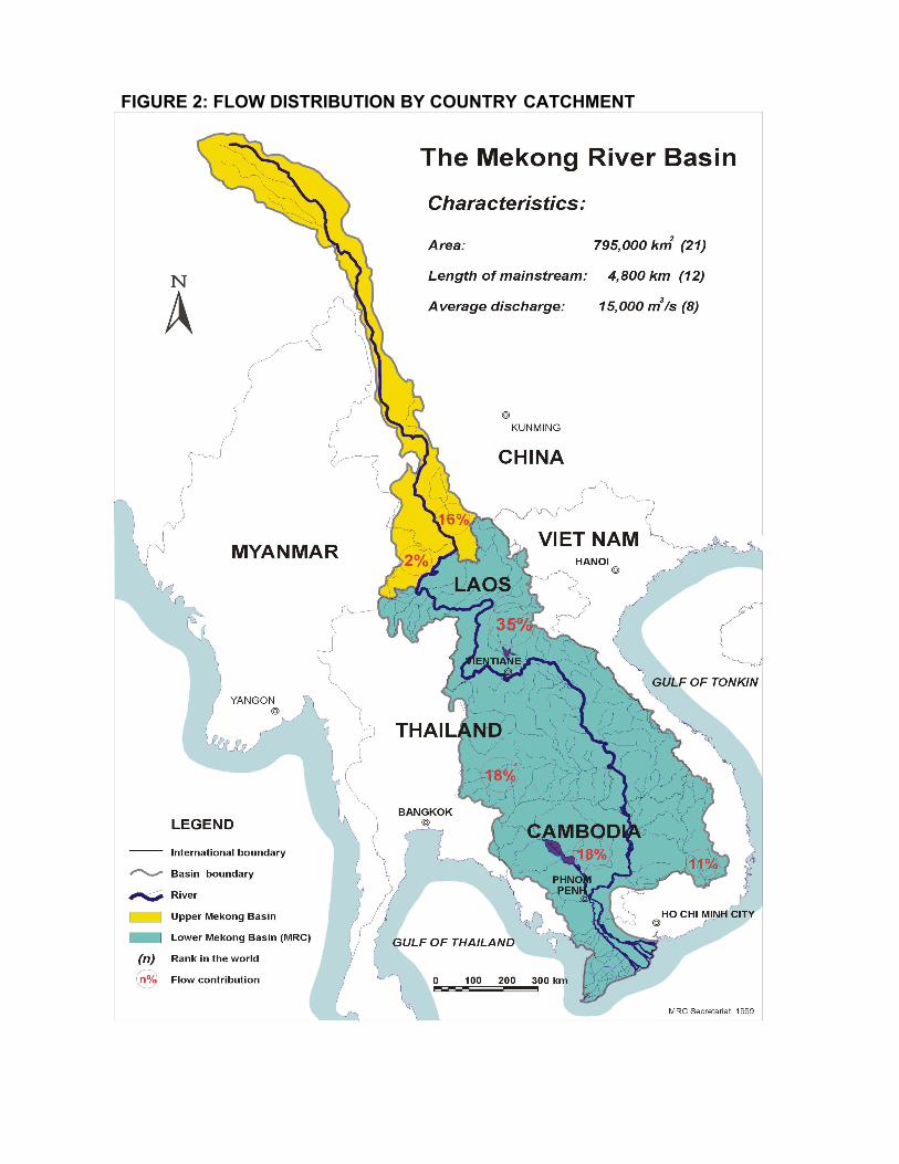
FIGURE 2: FLOW DISTRIBUTION BY COUNTRY CATCHMENT

Table 1: Area and flow contribution from riparian countries TT Name of Country % area by
country to river basin area
% area by country to total area of country
% flow contribution
1 2 3 4 5 6
China Myanma Lao Thailand Cambodia Vietnam
21 3 25 22 20 9
97 36 86 20
16 2 35 18 18 11
Total area 795.000 km2 Volume of discharge 475 km3 Sources: MRCS database.
The Mekong River flows into the Mekong Delta and drains to the sea through various streams, which bring about a complicated flow regime:
- Inflow: The major inflows are through the Tien and Hau Rivers, as well as overflowing the Long Xuyen Quadrangle into the midle of the Tien and Hau River (Dong Thap Muoi). Based on simulation, the direct inflow from Cambodia into Dong Thap Muoi is 2,850m3/s.
- Outflow: A part of the Hau River flow is diverted into the Long Xuyen Quadrangle, which added up with the direct inflow from Cambodia to flood across the region. A part of the flow is drained directly into Thailand Gulf through canals and the Cai Lon River, and the remaining will be diverted through the Hau River to the South China Sea (East Sea).
During the rainy season, high rainfall in the basin is the main reason for the flood in the main stream of the Mekong River and the Mekong Delta. The flow regime of the Mekong Delta is so affected by the flow of the Mekong River, tides of the South China Sea, the Western Sea (Thailand Gulf), and intra-field rainfall regime. The total annual water volume of the Mekong Delta is about 500billion m3 (about 422 billion m3 from the upstream, and 67billion from the intra-region rainfall). The water volume during the high season accounts for 80 – 83%, that of the low season accounts for 7 – 9%, and the figure for two transition months is 10 – 11%.
At the boundary of Vietnam, the flow of the Tien River is much higher than the Hau River, where the discharge at Tan Chau accounts for about 83%, and the discharge at Chau Doc is about 17%. During the flood season, the share at Tan Chau is about 80% and that of Chau Doc section is 20%. During the dry season, the flow at Tan Chau accounts for 85% and that of Chau Doc is 15%. However, due to the Vam Nao River, the distribution between the Tien River and the Hau River is rather balanced. The share at Can Tho and My Thuan is 50% for each distributary. The Vam Nao River plays an important role in re-distribute the flows of the two distributaries. The total average volume of the main stream as observed at Tan Chau and Chau Doc is about 387m3 annually. The flow is distributed unevenly among the time of year. The flow is very high during the flood season, particularly during September and October, the peak flood flow may reach 25,500m3/s and the total flow of these two months accounts for about 17% of the annual flow (Table 2). In the year 2000, the flood is so typical, that the average discharge of the highest month is 29,624m3/s; and the year 1998 is of the typical low flow, where the highest monthly flow is only 18,783m3/s. The lowest

monthly discharge occurs in April, with the average discharge of various years is 2,340m3/s, which is particularly as low as 1,820m3/s in 1998.
The Tien River is connected with the vast storage area of Dong Thap Muoi by the elaborate river and canal system. As the river tide fluctuated, the water level of Dong Thap Muoi will be changed accordingly. Therefore, the flow velocity at the downstream area of the Tien River Basin is very high, particularly during ebb tide. The flow velocity caused by the tide of the Tien River is much higher than the critical scouring velocity of the river-form soil. Therefore, the river bank at the downstream of the Tien River is much scoured.
Around the river-mouth of the Hau River, the flow velocity is also as high as 1.5m/s, even though the water exchanged between the river and the delta is not so high. With such high velocity maintained for a long period, the riverbank around the river-mouth is shaved constantly to result in individual deep rivulets.
The flow during the low season is rather low, with the discharge of Q < 5,000m3/s. The velocity of the inflow is rather low, and the main stream axis runs along the riverside.
Table 2: Average discharge at Tan Chau and Chau Doc (period 1977-1999)
Month Q Tan Chau (m3/s)
Q Chau Doc (m3/s)
Q Total (m3/s)
1 2 3 4 5 6 7 8 9 10 11 12
6220 3720 2600 2010 2640 7180 11270 16390 20140 20340 15260 10180
1360 700 420 330 460 1450 2390 3970 5290 5480 4700 2710
7580 4420 3020 2340 3100 8630 13660 20360 25430 25820 19960 12890
Trung bình 9830 2440 12270 Tổng lượng (tỷ m3)
310 77 387
% tổng l ượng 80% 20% 100% Sources: MRCS & KOICA, flood control planning for developing the Mekong Delta.
2.2 WATER LEVEL CHARACTERISTICS
The water level regime of the Mekong River depends on the inflow, the tides of the South China Sea (East Sea) and the West Sea (Thailand Gulf), of which the effect of the South China Sea is higher due to the profound amplitude (3.5 – 4m), while the tidal amplitude of the west sea is only about 1m (Figure 3 and 4) and the water exchange in the west is inconsiderable.

Figure 3: Variation of tide of South China Sea, Vung Tau Station
Figure 4: Variation of tide of Gilf of Thailand, Rach Gia Station
During the low season, the effect of the tide to the water level at Can Tho and My Thuan (90m from the coast) is about 1.5 – 2.0m. The effect decreases at the upstream and in the intra-field. The level fluctuation at Tan Chau and Chau Doc (190km away from the coast) is approximately 1m. During the low year, the effect on water level by the tide can be seen slightly in Phnom Penh (300km from the coast). During the flood season, due to the high flow, the effect by the tide decreases, with the level fluctuation at Tan Chau and Chau Doc is
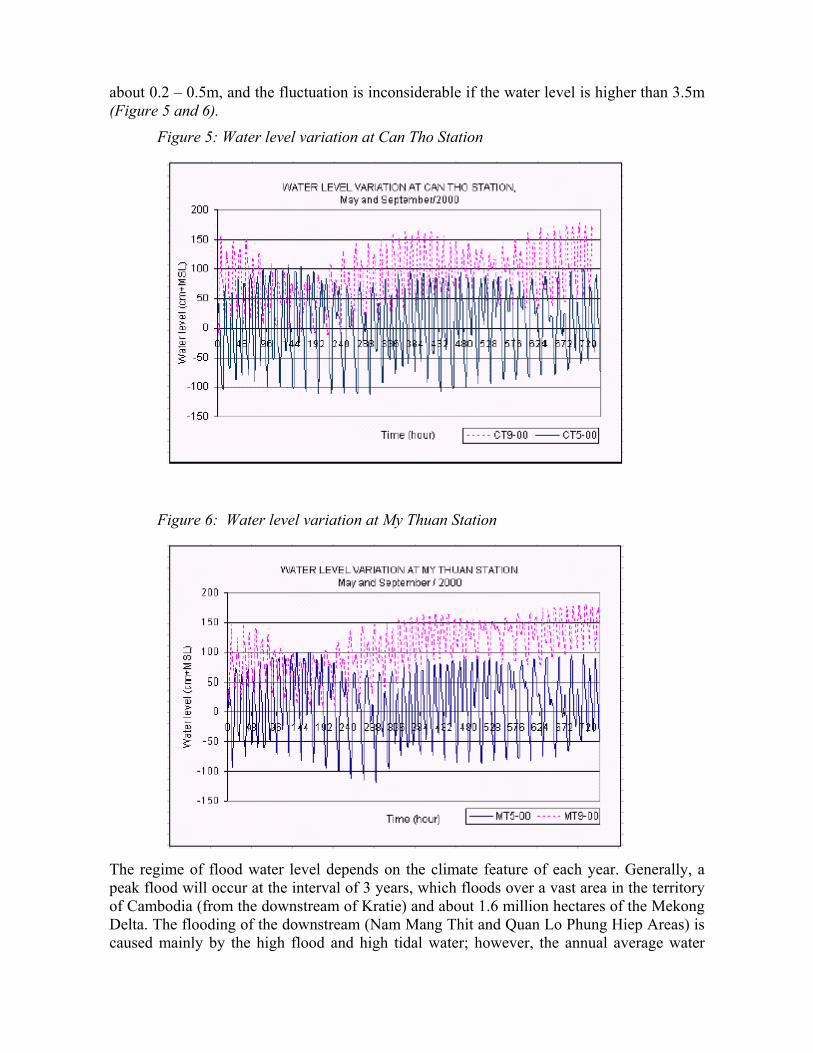
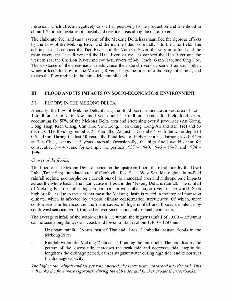
about 0.2 – 0.5m, and the fluctuation is inconsiderable if the water level is higher than 3.5m (Figure 5 and 6).
Figure 5: Water level variation at Can Tho Station
Figure 6: Water level variation at My Thuan Station
The regime of flood water level depends on the climate feature of each year. Generally, a peak flood will occur at the interval of 3 years, which floods over a vast area in the territory of Cambodia (from the downstream of Kratie) and about 1.6 million hectares of the Mekong Delta. The flooding of the downstream (Nam Mang Thit and Quan Lo Phung Hiep Areas) is caused mainly by the high flood and high tidal water; however, the annual average water

level is rather stable. While the flood water fluctuation at Chau Doc and Tan Chau is as high as 2.81 – 5.06m.
2.3 EFFECTS BY THE TIDAL REGIME
The tidal regime includes two tidal cycles for each day, with rather high amplitude. With the condition of wide and less gradient riverbed, the tidal effects penetrate into the very inland. During the low season, the tidal fluctuation can be seen at Phnom Penh, about 300km away from the coast. However, the reverse flow may exist up to Tan Chau and Chau Doc for a very short time during the low season.
As creeping upstream, the tidal effect on the Mekong River decreases. However, due to the interference between the inflow and the tidal flow, there are many whirlpools and regression in the in-stream of the river, which increases dynamic velocity and narrows the main stream.
During the flood season, the tidal effect is not as rigorous as during the low season. However, it affects substantially to delay the drain-out to the sea, particularly for days of high tide. For peak flood during the year, the flow is stagnant in the days of high tide, which increases the water level in the river and the intra-field (up to Tan Chau and Chau Doc). This stagnant situation cause instant sediments in some river reaches and increase the flow velocity upon ebb tides. Around the river-mouth, the high tides may cause regression to decrease considerably the flow velocity. Therefore, most of the sediment is found around the river-mouth.
Due to the high amplitude causing rigorous power, as well as the deep and less gradient riverbed, the tidal effects are transmitted into the very inland of the rivers. The tidal transmission into the rivers can be seen by two patterns: Current and wave. The current transmission into the river with high velocity of reverse flow (probably 1.5m/s). The tidal wave is transmitted into the river by the wave pattern. In comparison with the current transmission effects, the wave effect is much higher. Generally, the tidal effect area means the area affected by the tidal wave
Due to the high amplitude and deep / less gradient riverbed, it is easy for the salty water to intrude profoundly into the canals and rivers, particularly during the middle and late months of dry seasons. The salty intrusion occurred during the low season is magnified by the long dry season without rainfall, which brings difficulties for the agriculture and livelihood of the regional people. However, due to the discharge from upstream reservoirs is stable, so that the recent longest tidal intrusion during the low season is also kept stable. The figure of saltiness curve is similar to the figure of tidal level, though not so sharp, particularly for slightly salty areas.
The marine tides of the South China Sea (East Sea) is intruded profoundly into the plain through the Tien River, Hau River and the Vam Co River, which affects most of the Mekong delta areas, including the left of the Tien River, the area between the Tien River and Hau River, most of the Long Xuyen Quadrangle and Ca Mau Peninsula. In the coastal area, river-mouths and main stream, the tidal amplitude is frequently high. However the amplitude in the intra-field is much lower. In fact, the multi-directional transmission results in the weak flow, low amplitude, and less drainage capacity. The tidal intrusion brings about the salty
intrusion, which affects negatively as well as positively to the production and livelihood in about 1.7 million hectares of coastal and riverine areas along the major rivers.
The elaborate river and canal system of the Mekong Delta has magnified the rigorous effects by the flow of the Mekong River and the marine tides profoundly into the intra-field. The artificial canals connect the Tien River and the Vam Co River, the very intra-field and the main rivers, the Tien River and the Hau River, as well as connect the Hau River and the western sea, the Cai Lon River, and southern rivers of My Trach, Ganh Hao, and Ong Doc. The existence of the man-made canals cause the natural rivers dependent on each other, which affects the flow of the Mekong River, brings the tides into the very intra-field, and makes the flow regime in the intra-field complicated.
III. FLOOD AND ITS IMPACTS ON SOCIO-ECONOMIC & ENVIRONMENT
3.1 FLOODS IN THE MEKONG DELTA
Annually, the flow of Mekong Delta during the flood season inundates a vast area of 1.2 – 1.4million hectares for low flood years, and 1.9 million hectares for high flood years, accounting for 50% of the Mekong Delta area and stretching over 8 provinces (An Giang, Dong Thap, Kien Giang, Can Tho, Vinh Long, Tien Giang, Long An and Ben Tre) and 53 districts. The flooding period is 2 – 6months (August – December), with the water depth of 0.5 – 4.0m. During the last 50 years, the flood level of higher than 3rd alarming level (4.2m at Tan Chau) occurs at 2 years interval. Occasionally, the high flood would occur for consecutive 3 – 4 years, for example the periods 1937 – 1940, 1946 – 1949, and 1994 – 1996.
Causes of the floods:
The flood of the Mekong Delta depends on the upstream flood, the regulation by the Great Lake (Tonle Sap), inundated area of Cambodia, East Sea – West Sea tidal regime, intra-field rainfall regime, geomorphologic conditions of the inundated area and anthropologic impacts across the whole basin. The main cause of flood in the Mekong Delta is rainfall. The rainfall of Mekong Basin is rather high in comparison with other larger rivers in the world. Such high rainfall is due to the fact that most the Mekong Basin is rested in the tropical monsoon climate, which is affected by various climate conformation turbulences. Of which, three conformation turbulences are the main causes of high rainfall and floods: turbulence by south-west seasonal wind, tropical convergence band, and tropical depression.
The average rainfall of the whole delta is 1,700mm; the higher rainfall of 1,600 – 2,500mm can be seen along the western coast; and lower rainfall is about 1,400 – 1,500mm.
- Upstream rainfall (North-East of Thailand, Laos, Cambodia) causes floods in the Mekong River
- Rainfall within the Mekong Delta cause flooding the intra-field. The rain distorts the pattern of the lowest tide, increases the peak tide and decreases tidal amplitude, lengthens the drainage period, causes stagnant water during high tide, and to obstruct the drainage capacity.
The higher the rainfall and longer rainy period, the more water absorbed into the soil. This will make the flow more rigorously during the ebb tides and further erodes the riverbanks.

Flood Intensity:
Based on the results of studies at Tan Chau, which is typical site for the Mekong River, it is shown that: the highest instantaneous level usually occurs for the early floods, the flood intensity is not so high for the main seasonal floods, usually not higher than 10cm/day.
As higher flood from the upstream flowed in, the Tien River and the Hau River discharge 92.6% (about 30,000 – 32,000m3/s) to the sea (partly to the west sea of 4.6%, and 2.8% drained through the Vam Co River). Of which, about 82 – 86% drained by the Tien River and 14 – 18% by the Hau River, that results in the water level of 4.4m at Tan Chau and 3.88m at Chau Doc. The remaining 20% is overflowed the boundary floodplain into the Mekong Delta (about 8,000m3/s) and flowed into the intra-field at the discharge of 2,000m3/s.
Due to the regulation by the Great Lake and the overflow in the plain, the flood level at Tan
Chau and Chau Doc increases gradually. The average flood intensity is about ∆∆Ht
5 –
10cm/day, the highest may reach 30cm/day. The flood amplitude is about 3.5m – 4.0m in comparison with ∆H≈10m at Kratie. The flood transmission velocity is rather low 1.5 – 2.0km/h, which is even much lower during the high tide. This is an outstanding feature of the flood in the Mekong Delta.
The statistics of long-term floods of the Tien River at Tan Chau (1945 – 1996) can be summarized as follows:
+ Low flood ((H<4m); (Q≈20000m3/s): 7 years, accounting for 13.5%
+ Moderate flood (H = 4÷4,5m); (Q≈20000÷25000m3/s): 24 years, accounting for 46.1%
+ High flood (H>4,5m); (Q≈25000÷29000m3/s): 21 years, accounting for 40.4%
From 1911 up to now, generally one severe flood occurred by the 7-year return, where the longest interval is 12 years (1966 – 1978) and the shortest is 3 years (1991 – 1994). Recent severe floods occurred in 1961, 1966, 1978, 1984, 1991, and 1994. If the moderate floods are also considered, the years with high floods can be summed up as follows:
- Three – four consecutive years: 1937, 1938, 1939, 1940, 1946, 1947, 1948, 1949, 1970, 1971, 1972.
- Two consecutive years: 1929-1930, 1980-1981;
- At one or two years interval: 1940, 1942, 1943; 1964, 1966; 1978, 1980, 1981;
- Several consecutive years: 1937-1940, 1946-1949, 1994-1996
The Table 3 shows the time of peak flood and maintenance time of higher water level during severe floods in the Mekong Delta.
Generally, the flood level during flood season has three gradients:
- Higher at the upstream, and lower at the downstream
- Higher in the Tien River, and lower in the Hau River and the Vam Co Tay River
- Higher at the Hau River and lower at the coast of West Sea.
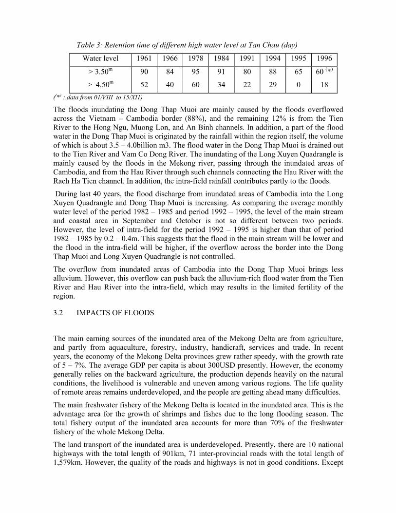
Table 3: Retention time of different high water level at Tan Chau (day)
Water level 1961 1966 1978 1984 1991 1994 1995 1996
> 3.50m 90 84 95 91 80 88 65 60 (*)
> 4.50m 52 40 60 34 22 29 0 18 ((*) : data from 01/VIII to 15/XI1)
The floods inundating the Dong Thap Muoi are mainly caused by the floods overflowed across the Vietnam – Cambodia border (88%), and the remaining 12% is from the Tien River to the Hong Ngu, Muong Lon, and An Binh channels. In addition, a part of the flood water in the Dong Thap Muoi is originated by the rainfall within the region itself, the volume of which is about 3.5 – 4.0billion m3. The flood water in the Dong Thap Muoi is drained out to the Tien River and Vam Co Dong River. The inundating of the Long Xuyen Quadrangle is mainly caused by the floods in the Mekong river, passing through the inundated areas of Cambodia, and from the Hau River through such channels connecting the Hau River with the Rach Ha Tien channel. In addition, the intra-field rainfall contributes partly to the floods.
During last 40 years, the flood discharge from inundated areas of Cambodia into the Long Xuyen Quadrangle and Dong Thap Muoi is increasing. As comparing the average monthly water level of the period 1982 – 1985 and period 1992 – 1995, the level of the main stream and coastal area in September and October is not so different between two periods. However, the level of intra-field for the period 1992 – 1995 is higher than that of period 1982 – 1985 by 0.2 – 0.4m. This suggests that the flood in the main stream will be lower and the flood in the intra-field will be higher, if the overflow across the border into the Dong Thap Muoi and Long Xuyen Quadrangle is not controlled.
The overflow from inundated areas of Cambodia into the Dong Thap Muoi brings less alluvium. However, this overflow can push back the alluvium-rich flood water from the Tien River and Hau River into the intra-field, which may results in the limited fertility of the region.
3.2 IMPACTS OF FLOODS
The main earning sources of the inundated area of the Mekong Delta are from agriculture, and partly from aquaculture, forestry, industry, handicraft, services and trade. In recent years, the economy of the Mekong Delta provinces grew rather speedy, with the growth rate of 5 – 7%. The average GDP per capita is about 300USD presently. However, the economy generally relies on the backward agriculture, the production depends heavily on the natural conditions, the livelihood is vulnerable and uneven among various regions. The life quality of remote areas remains underdeveloped, and the people are getting ahead many difficulties.
The main freshwater fishery of the Mekong Delta is located in the inundated area. This is the advantage area for the growth of shrimps and fishes due to the long flooding season. The total fishery output of the inundated area accounts for more than 70% of the freshwater fishery of the whole Mekong Delta.
The land transport of the inundated area is underdeveloped. Presently, there are 10 national highways with the total length of 901km, 71 inter-provincial roads with the total length of 1,579km. However, the quality of the roads and highways is not in good conditions. Except

for the important national highways, most of the roads are damaged and many sections are inundated during the flood season. The navigation is very important for the inundated area, with the 70% of transport volume is by the navigation.
The inundated area of the Mekong Delta includes 8 provinces, 60 district and 1,069 communes and auxiliary areas. The population of the region is 9,074,600 (1996), of which, the urban population accounts for 26.8% and the rural is 73.2%. Most of the people lives along the major canals and roads. The average population density of the region is 474persons per km2; however the population distribution is uneven, with major share is living in towns or townships (more than 2,000persons per km2) and districts along the Tien River and Hau River (about 500 – 1000 persons per km2). The population in the remote area is as low as less than 100 persons per km2.
The infrastructure in the inundated area of the Mekong Delta is less developed. About 15% of the population, who are of the literate ages, are still literate. The environment hygiene is poor, the clean water is short, community health care and treatment is limited, which harmfully affects the public health, waterborne deceases are spread, about more than 50% of the women suffers from gynecologic illness.
Negative impacts by the floods
The inundating is a major obstruction to the agricultural production and the livelihood of the people in the north of Mekong Delta. Due to the floods, such deeply flooded areas as Long Xuyen Quadrangle, North Vam Nao, and Dong Thap Muoi are not provided for the production from August – December. Hundreds thousand of the people in the inundated area have to pay for the annual migration to higher lands, which causes vulnerable and unstable livelihood. In addition, the floods cause substantial loss and damages to the human lives, assets, infrastructure, rice field, and other agricultural crops. The severe floods can cause hundreds of death and loss of thousands billion Vietnamese dongs.
The flood intensity of the Mekong Delta is not so high, but it is maintained for long time, which causes erosion of riverbanks and canal-banks, and serious damages to the infrastructure. The 1994 flood caused 407 deaths and the value loss of 2,284billion Vietnamese dongs; the 1995 flood caused 199 deaths and value loss of more than 700billion Vietnamese dongs; the 1996 flood caused 217 deaths and value loss of 2,182billion dongs. The inundating brings about difficulties for the permanent settlement and infrastructure development, as well as vulnerable and instable livelihood. The travel, school enrolment, and health care are much obstructed. The flooding is the most difficulty for the exploitation of the land resources and for the rural development and urbanization, as well as social development to the direction of industrialization, modernization, and civilization.
Positive impacts by the floods:
The floods of the Mekong Delta bring about many considerable benefits. The first is the huge volume of the alluvium soils from 95% of the upstream basin to deposit in the Mekong Delta. The deposition is ongoing to extend the Mekong Delta continuously to the East Sea, to improve the fertility of the field, to provide the plenty fishery and very favorable conditions for the aquaculture. The flood flow is also good for the improvement of water quality, particularly for the acid sulfate water, soil improvement, and field cleaning. In addition, this freshwater source is important for the agriculture, aquaculture, livelihood, and provided for a vast freshwater ecosystem for the plain.

IV. IMPACTS OF SOCIO-ECONOMIC ACTIVITIES ON ECOSYSTEM CONCLUSIONS
During the last decades, the socio-economic activities have caused profound changes in the formation, water regime, biota, and biodiversity. The migration of aqua marine species into the inland water of the Mekong Delta is the main feature of the ecosystem. In another way, the inland ecosystem of the Mekong Delta is an open system. However, during the last 20 years, the socio-economic activities have caused this system tends to be closed, and profoundly changes the inland ecosystem. Followings are such major activities.
Impacts of deforestation of mangrove forest for aquaculture of shrimp From early 1980s, the value of shrimp products increased in the global market. And the shrimp trading is bustling. The mass aquaculture of shrimp developed dramatically in the inland fresh water and the coastal salty water, which resulted in the deforestation from Ba Ria – Vung Tau to the Ca Mau cape.
The common features of the aquatic environment and ecosystem of the shrimp raising pond are the acid sulfate process, organic sediment, increase of H2S, Al3+, SO4
2- in the benthic mud. The aggregate N increases and DO decreases in the water results in the abundance of cyanophytes Oscillatoria, viscoalgae Enteromorpha and decrease the biodiversity. The results of the survey before and after the clearance of shrimp lagoons in Dat Mui floodplain (June 1992, October 1996 and September 1998) show that the clearance has proved positive changes to the floodplain conditions, and decreased the H2S and Al3+ in the mud. The benthos on the bed of removed shrimp ponds have been recovered, the distribution of aquatic biota is rather balanced.
However, the analysis results of the aquatic biota structure, the population increase of aquatic biota and preferred species, prove that the coastal area of Dat Mui tends to be enriched and contaminated by organic matters.
The mangrove forest in the cleared areas of Dat Mui has been recovered quickly for the enclosed dyke only, while the recovery of forest on the bed of the shrimp lagoon is extremely slow. Presently, after 5 years of clearance, the salt-mash planting is very little or not available. Probably, the black rotten mud accumulated in the pond bed during the shrimp breeding has restrained the growth of salt-mash forests.
Impacts of the “lagoon forest” embankment After the most severe fire of cajuput forest (1983), Ca Mau province excavated the canals and embanked enclosed dykes around the forestation and fishery farms U Minh I, U Minh II, Uminh III, Vo Doi to store water for the fire fighting during the dry season. The areas within the enclosed embankment are called as “lagoon forest”. The embankment of storage lagoon for the firefighting can also be seen in provinces An Giang, Kien Giang, Can Tho, and Dong Thap Muoi area, including the Tram Chim reservation area (Tam Nong district, Dong Thap province).
The embankment of enclosed lagoon results in the enrichment of organic sediment from planting parts such as leaves, algae, water hyacinth, water-lily, etc. in the intra-field canals. Such plants bloom and burnt to result in the benthic rotten mud and contaminate the aqua-system. It is also obvious that the routes for fish migration from canals to the intra-field are blocked, the resources of white fishes are no longer available, but only black fishes; the black rotten mud has eliminate the benthic zoology; there is much phytoplankton in the
aqua-system, the indicator zooplankton proves the low pH, high saltiness, and contamination of the environment.
The environment was changed drastically, which decreases the foods for birds and forces the birds to emigrate. This situation can be also seen in bird park Dam Doi (Ca Mau province).
The growth of cultivated cajuput is slow, and if the cajuput tree is lower than 5m, the long time inundation and the strong wind will blow down the mass of cajuputs.
The embankment of “lagoon forest” has many other impacts, such as the changes of biophysical and ecological features of the cajuput, the changes of fish and other biota due to the change of hydrological regime.
Impacts of the Freshening the Ca Mau Peninsula For more than haft of the century, a system of the man-made canals has been developed in the Mekong delta to extend the cultivation land, drain water, and provide for the navigation. Each localities have also built up local freshening area with the utilization of the rainfall, such as Cai Nuoc, Dam Doi, Tran Van Thoi, etc. The freshening activities have brought benefits of increasing the cultivation land and the number of crops. However, it also results in the environment and production problems in newly established ecological conditions. - Decreased saltiness in the intra-field aqua-systems; - Increase of the organic accumulation; - Introduction of many macro plants: Ceratophullum, Myriophyllum, Nympha sp.,
floating moss, water hyacinth, which will degrade the water quality and benthic mud once dead;
The population increase of the aqua biota shares the same characteristics for both freshened area and “lagoon forest”, that the abundance of zooplankton and indicator species for nutrient-enriched and contaminated environment. Benthic zoology is degraded drastically in most of the freshened area.
Impacts of the enclosed-dyke embankment for the “co-existence with floods” In recent years, the policy of co-existence with floods has been introduced. Many localities of the Mekong Delta have embanked enclosed-dyke to protect the residential areas, fruit tree garden, rice field against the floods, which results in closed ecosystems on such lands used to be improved by the water from the Mekong River. Some example consequences can be seen that hundreds hectares of mango by the Long Vu agricultural farm (Long An province) and some other fruit garden have been dead due to inundation; the habitat of migrated fishes and shrimp from rivers to the intra-fields has been shrunk. For the enclosed area of rice field, the water drainage is very slow, which negatively affect the cultivation crop.
Impacts of the transition from rice field into shrimp farm From the year 2000, in the transition ecosystem, which is fluctuated by the saltiness and other ecological conditions and which is being freshened (Tien Giang, Ben Tre, Tra Vinh, Soc Trang, Bac Lieu, Ca Mau, Kien Giang provinces), the tradeoff between the rice field and shrimp farm is fierce. In many localities, the authorities allow the people to change from rice production to shrimp farm, or rotation of one shrimp season and one rice crop.
The ecology of these inland aqua-systems, which are turning to a freshwater ecosystem, now is suddenly forced back to the blackish ecosystem. The freshwater ecology, which is being established, now be eliminated, the disintegration is going on, and the water quality is

degraded. The habitat is unstable. The tradeoff between shrimp and rice field can not be solved at once, but it will remain controversial for the Mekong Delta.
V. CONCLUSIONS
The environmentally sustainable development and management of water resources is a critical and complex issue for both rich and poor countries. It is technically challenging and often entails difficult trade-offs among social, economic, and political considerations. Typically, the environment is treated as a marginal issue when it is actually key to sustainable water management. The flow regime causes rather big effects on environment and ecosystem.
Mekong river is a water resource of determine meaning to the existance and development of people and society in the Mekong Delta. The development of socio-economic together with population increasing require the increasing of water demand. The effective water utilisation should be intergrated, economic and apropriated with development law of water resources development.
Vietnam Government has a policy to develop the socio-economic in the Mekong River Basin to become key economic region of the whole, so the development of research strategy for incorporating the environmental consequences of alternative river management strategies into existing bio-economic models of the Mekong is essential to provide decision maker and managers with a valuable and powerful source of information regarding the cost and benefits of river management options under consideration. This also addresses the Vietnam Government strategy on development of Mekong River Basin.
There is growing awareness that catchement and water resources development that alter pattern of water movement in aquatic ecosystems will cause the systems to change. These change do not have to be left to chance, but can be anticipated and limited to a level that society finds acceptable.
If respnsible environmental management, and the concept of sustainable use, are to succeed, scientific advisors, water managers, and decisionmakers culd benefit from a working realtionship based on a six-point strategy:
- Development of appropriate policy and legislation on resource protection (legitimizing sustanable use)
- Directed national programs of research on the links between ecosystems and flow (increasing the knowledge base)
- Use of best availabel knowledge from thsese programs, together with directed short-term research, to answer management questions (movieng ahead with limited knowledge)
- Use of structured, transparent processes for options assessment and decisiionmaking that equally address economic, ecological, social, and engineering concerns (assessing the full implications of all options and negotiating tradeoffs)
- Monitoring the outcome of the chosen option (learning by doing)

- Adjustment of management plans where indicated by monitoring results (employing strategic adaptive management)
To achieve this strategy, five factors for success are apparent in the case studies:
- Down-stream communities have an important role to play in the decisiionmaking process, which is likely to impact and alter there livelihoods
- The water authorities need to move from being providers of water to vecoming holistic managers of water resources
- Scientists and managers need to agree to work together in an envrionment of limited knowledge
- Emerging legislation on sustainable reosurce use, either from within the country or from outside, needs to be implemented to provide impetus for and legitimacy to the environmental flow assessment
- The move toward sustainable river use, though difficult, is typified by negotiation, transparent decision making, and attention to equity and conservation issues.
REFERENCES
1. Trinh Thi Long, 2003. Establishing the Methodologies to study the Environmental Flow of Mekong River for setting up the regulations to maintaince flow of in-stream, Project of Vietnam Mekong River Commission, 2003
2. To Quang Toan, November 2003. Partial review of salinity intrusion in the Mekong Delta, Vietnam. Mekong River Commission Phnom Penh, Cambodia
3. Richard Davis, Rafik Hirji, 2003. Water resources and environment, technical note C.1: environmental flows – concepts and methods. Series Editors, The World Bank - Washington, D.C.