Embed Size (px)
Citation preview

Impact of Earthquake and Tsunami on Physical
Infrastructure
Dr. K. Gopikrishna
Department of Civil Engineering
National Institute of Technology Warangal

Contents
● Brief Background● Earthquake characteristics● Disaster preparation● Tsunami & its characteristics● Casestudy● Performance of infrastructure ● Lessons learnt

[email protected] 4Courtesy : www. geology.com
Earth's crust ranges from 3 to 45 miles deep (5 to 70 kilometers). The crust is a thin, hard shell that floats on the denser, hotter rock of the mantle
The crust is divided into several pieces known as tectonic plates that are constantly in motion, grinding past one another at boundaries known as faults.
An Earthquake occurs when the pressure built up along a fault becomes stronger than the pressure holding the rocks together causing rocks on either side of the fault to suddenly rip apart releasing the pent-up pressure.
Energy from this separation radiates outward in all directions, including towards the surface, where it is felt as an earthquake.

✓ Ninety percent of all earthquakes occur along plate margins and by far the greater amount of energy released as seismic waves comes from subduction zones
✓ Every earthquake doesn't repeat exactly what happened before. Sometimes there is a big earthquakes, sometimes there are two or three together– No regularity.
✓A large earthquake is often followed by aftershocks, which are smaller quakes that result from the crust adjusting to the main shock. These aftershocks can help scientists target the origin of the main quake.✓ If the earthquake occurs in the ocean, it can push up powerful waves, known as tsunamis. ✓ The sudden upward or downward movement of the seafloor during an earthquake creates large tsunami waves, similar to a child splashing in the bathtub. ✓ Earthquakes can also trigger tsunamis by unleashing underwater landslides, which also displace huge amounts of seawater.
Earthquake characteristics

Measuring Earthquakes
❖ An earthquake's size, or magnitude, depends on how large its parent fault is and how much it has slipped.
❖ Measured using seismograms- using moment magnitude scale/ Richter scale.
❖ By using the readings from at least three seismographs, geologists can triangulate the origin of the earthquake. At the fault, that origin is called the hypocenter; on the surface, the epicenter.
✓ The Federal Emergency Management Agency (FEMA), recommends that all families everywhere should have an emergency kit in their home and car, and communicate with your loved ones a plan for any type of disaster

Preparing for Earthquake disaster● Living inside● If you live in known earthquake territory, make
sure you are firmly attached to the walls, with heavy objects on lower shelves.
● Keep heavy objects away from beds and sitting areas, and fasten fixtures such as large televisions to the walls.
● Locate a safe place in each room, under a sturdy desk or table, where you can seek refuge from falling objects.

Disaster Preparedness…● If you are outside, ◦ get into an open area, away from structures or bridges. ◦ According to FEMA, many deaths in the 1933 Long
Beach earthquake occurred when people ran outside, only to be crushed by falling debris from collapsing structures. ◦ Remember that the shaking ground rarely causes
injury or death; instead, it is the falling objects that result from the quake. ◦ If you are in a car, stop as soon as you are able, but
stay inside the car. If you are at or near the beach, move quickly inland to avoid potential waves from tsunamis.

Disaster preparedness..
● After an earthquake, proceed with caution. Remember that most earthquakes are generally followed by aftershocks.
● Keep an eye (and a nose) out for gas leaks. If you were inside during the quake, move outside.
● Listen for public service announcements; a battery-powered radio is ideal for your emergency kit.

Tsunami
❖ Although the impact of tsunamis is limited to coastal areas, their destructive power can be enormous and they can affect entire ocean basins; the 2004 Indian Ocean tsunami was among the deadliest natural disasters in human history with at least 230,000 people killed or missing in 14 countries bordering the Indian Ocean. [email protected] 10
❖ Tsunamis have a small amplitude (wave height) offshore, and a very long wavelength (often hundreds of kilometres long, whereas normal ocean waves have a wavelength of only 30 or 40 metres),which is why they generally pass unnoticed at sea, forming only a slight swell usually about 300 millimetres (12 in) above the normal sea surface. They grow in height when they reach shallower water surfaces.

Tsunami…
● For instance: On April 1, 1946, a magnitude-7.8 (Richter Scale) earthquake occurred near the Aleutian Islands, Alaska. It generated a tsunami which inundated Hilo on the island of Hawai'i with a 14-metre high (46 ft) surge.
● The earthquake occurred in Pacific Ocean floor is sub ducting (or being pushed downwards) under Alaska.

Characteristics of Tsunami
● Tsunamis cause damage by two mechanisms: ◦ the smashing force of a wall of water
travelling at high speed, and ◦ The destructive power of a large volume of
water draining off the land and carrying a large amount of debris with it.
● Tsunami in the deep ocean has a much larger wavelength of up to 200 kilometres (120 mi) & travels at well over 800 kilometres per hour (500 mph).

Characteristics of Tsunami…● Generally, owing to the enormous wavelength the wave
oscillation at any given point takes 20 or 30 minutes to complete a cycle and has an amplitude of only about 1 metre (3.3 ft). This makes tsunamis difficult to detect over deep water, where ships are unable to feel their passage.
● The velocity of a tsunami can be calculated by obtaining the square root of the depth of the water in metres multiplied by the acceleration due to gravity (approximated to 10 m sec2).
● For example, if the Pacific Ocean is considered to have a depth of 5000 metres, the velocity of a tsunami would be the square root of √5000 x 10 = √50000 = ~224 metres per second (735 feet per second), which equates to a speed of ~806 kilometres per hour or about 500 miles per hour.

Case Study – Background [6]
● A devastating earthquake and the resulting Tsunami hit coastal areas of Indian Ocean on December 26, 2004.
● A subduction earthquake, with a Richter magnitude of 9.3 occurred off the coast of the Indonesian island of Sumatra, at 7:59 a.m. local time.
● A devastating tsunami was generated with wave heights exceeding 20 m, inflicting widespread destruction in Indonesia, Malaysia, Myanmar, Thailand, Bangladesh, Sri Lanka, India and 12 other countries around the Indian Ocean.
● The effects of tsunami were felt as far away as Somalia, Tanzania and Kenya along the east coast of Africa.
● The casualties were in excess of 310,000millions leading to significant socio economic impact on the countries surrounding indian ocean.

Case Study... ● Canadian delegation from university of ottawa, ontario
canada has performed a reconnaisance survey in thailand & Indonesia to understand the damages caused and presented their observations
● Study mainly focussed on urban areas closest to epicenter -Rawai Beach, Kata Noi Beach, Kata Beach, Patong Beach, Nai Thon Beach and Kamala Beach on the Thai island of Phuket, Phi-Phi island, about 48 km south east of Phuket and the coastal town of Khao Lak about 100 km north of Phuket.
● City of Medan located north-east of the island of Sumatra and Banda Aceh, the capital of Indonesia’s Aceh Province at the northern tip of Sumatra.

● The Indian plate has been moving north-east at a rate of approximately 60 mm per year, subducting under the overriding Burma microplate.
● The epicenter of the quake was about 155 km west of Sumatra and about 255 km south-east of Banda Aceh, Indonesia (USGS3)
● The focal point was at a depth of 30 km. The ruptured fault length was estimated to be 1300km. Vertical uplift reportedly ranged between 7 to 10 m at the ocean floor, displacing a huge amount of water that led to tsunami.
Seismological information

Tsunami characteristics- Case study [6]
● The vertical offset of the ocean floor by 7 to 10 meters during the December 26, 2004 Sumatra earthquake displaced massive volumes of water, resulting in a destructive tsunami.
● Fault line was in North-south direction, the tsunami was the strongest in the east-west direction.
● The wave height in deep water (open ocean) measured through satellites reported to be approximately 60 cm, while traveling at a speed of 500 to 800 km/hr.
● The velocity decreased to only tens of kilometers per hour in shallow water near the shoreline, depending on the local bathymetry. Led to large and destructive waves with run-up heights of 20 to 30 meters in Banda Aceh.
● In coastal areas of Thailand and Sumatra the flood extended as far as 4 km inland

Travel time of Tsunami waves● The tsunami reached
Banda Aceh at the northern tip of the Indonesian island of Sumatra in about 15 minutes.
● It reached Sri Lanka and east coast of India after 2 hours approx. Although Phuket is much closer to the ruptured fault line than Sri Lanka, it took the waves about 90 minutes to reach Phuket because of the relatively shallow sea depth on the eastern side of the fault.
(Satake, 2005)
The tsunami waves reached east African coast after about 8 hours and southern Africa after 9 to 11 hours

Damage information
● The water height measured on buildings was found to vary between 6 m and 12 m from the sea level along the west coast of Phuket and Banda Aceh.
● water run-up was observed to be higher, causing structural damage at elevations higher than 12 m. The maximum run-up was measured to be 48.8 m in Rhitting, near Banda Aceh, as reported by Shibayama[5]

Kata & Patong beach● The measured water height was
approximately 4.0 m from the ground in Kata Beach, causing damage to low-rise buildings, including roof tiles. (Non-Engineered buildings)
● The most populated beach town along the west coast of Phuket was Patong Beach.
● Extensive damage to masonry infill walls was observed. Limited damage occurred in reinforced concrete structural elements, though significant damage was seen in timber structural elements.
● The entire shopping district of Patong Beach was destroyed within an area extending approximately two kilometers inland from the shore

Nai Thon Beach● Suffered extensive structural and
non-structural damage to reinforced concrete frame buildings.
● The water height, relative to ground, was in excess of 10 m, especially in areas between the shore and the nearby hilly terrains, which led to water run-ups
• An area that was entirely devastated by the tsunami is Khao Lak Beach, about 100 km north of Phuket. The water height was measured to be in excess of 10 m, causing extensive structural damage.

Khao Lak Beach
Failure of first-story masonry infill walls and structuralCollapse of low-rise reinforced concreteframe buildings.
However, certain multistory RC hotels survived the tsunami pressure, with damage limited to the first-story infill walls. Further, the harbor town and floating boats inland, was totally devastated.
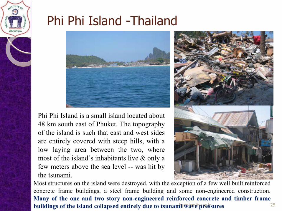
Phi Phi Island -Thailand
Phi Phi Island is a small island located about 48 km south east of Phuket. The topography of the island is such that east and west sides are entirely covered with steep hills, with a low laying area between the two, where most of the island’s inhabitants live & only a few meters above the sea level -- was hit by the tsunami.
Most structures on the island were destroyed, with the exception of a few well built reinforced concrete frame buildings, a steel frame building and some non-engineered construction. Many of the one and two story non-engineered reinforced concrete and timber frame buildings of the island collapsed entirely due to tsunami wave pressures

Banda Aceh, City in Indonesia● population of about 300,000
inhabitants before the tsunami.● subjected to damaging forces of
not only the tsunami but also the earthquake.
● Coastal areas were entirely swept away by tsunami waves, leaving piles of timber as the remains of building infrastructure.
● A large number of non-engineered RC buildings suffered structural damage, especially in their first floor columns.
● Multi-story engineered RC government buildings suffered seismic damage due to poor seismic design & detailing practices.

Effects of Tsunami● Tsunami waves imposed dynamic water pressures on coastal
structures as well as buildings and bridges near the coastline, inducing serious damage to the entire surrounding infrastructure located up to approximately 4 km inland.
● Impulsive pressures of breaking waves and hydro-dynamic pressures associated with water velocity, inflicted partial and full collapses of non-structural and structural components.
● There was some impact loading generated by the floating debris, though this was most pronounced in Banda Aceh, where large objects were observed to have impacted on structures.
Non-structural elements, like infill masonry walls, often collapse immediately after the application of tsunami wave pressure, and reduce the portion of the load transmitted to the structural elements--act like a fuse for the load carrying system, reducing the effective stiffness of the structure.

The below empirical equation was suggested by Hirori (1919) . is used for visualising the hydrodynamic pressure due to tsunami wave impact.
Hydrodynamic pressure of Tsunami wave

Timber structures
● Phi Phi Island, Thailand and Indonesia coastal town: had a large number of low-rise timber frame buildings made of timber columns and beams, supporting timber joist floor systems

Unreinforced masonry walls● Both hollow clay bricks
and concrete masonry blocks of the same thickness (50mm) were used as infilled walls in thailand and indonesia. They suffered punching shear failure due to tsunami wave pressure perpendicular to wall plane.◦ Large holes in walls or
completely detached .◦ Remaining walls did
not show any diagonal cracks, unless caused due to seismic excitations– banda aceh only. [email protected] 31

Non engineered RC buildings● The columns were of very
small cross-section (about 200 mmsquare), containing 4 smooth or deformed corner bars with 8 mm diameter, resulting in approximately 0.5% reinforcement ratio.

● The flexural capacity, based on 4 columns per frame providing resistance, was found to be significantly below the moments imposed by tsunami waves.
● Column failures occurred at mid-height, especially in Banda Aceh-- effects of debris impact, over and above the tsunami wave pressure. floating large objects like fishing boats and cars impacted on the columns, causing column failures near their mid-heights

● Low-medium rise RC buildings have survived tsunami pressures with out structural damage, non structural damage occured at first storey masonary wall.
● shopping centre in Patong Beach on Phuket Island, Thailand, where the Cellar was filled up with water, lifting and destroying the first floor slab panels.Similar failure was also abserved in concrete dock of the Kao Lak Harbor
Engineered RC buildings
Phi-Phi Island
the Kao Lak Harbor

Steel frame building
● Survived the disaster with out any structural damage
● There was extensive damage to bridges in the Aceh province of Indonesia caused by tsunami wave forces, causing many to collapse and jeopardizing relief efforts.
Bridge survived Bridge swept off
Eastern Banda Aceh a two-lane, multi-span RC bridge was swept off its piers

● The transportation system in Banda Aceh was completely paralyzed by the tsunami. Main arteries as well as small streets were all destroyed, -great hurdle for response & relief efforts.
● Foreign aid crews put in a substantial effort to clean and open streets that had been covered by the debris of collapsed buildings and destroyed trees.
● Access to urban areas was lost, in particular the 150 km coastal road to Meulaboh was washed away and bridges on the way lost their superstructure due to the tsunami wave pressure.
Lifeline systems

Lifeline systems
❖ Drainage system suffered extensive damage in Banda Aceh. The Cover slabs were broken and displaced and the channels were blocked by mud and debris, further contributing to flooding.❖ Water supply in Banda Aceh was disrupted due to the failure of water mains. ❖ A number of main pipelines were broken as they were attached to bridges to cross the rivers that pass through the city. ❖ These pipes were damaged either by the floating debris or collapsed bridge components

● The earthquake of December 26, 2004 was the second largest ever recorded by a strong motion seismograph (Northwestern University)
● The area was covered by soft soil, contributing to the amplification of seismic waves, focal point is 30km and strongest shaking was felt in Banda Aceh, causing significant damage but no seismic damage was reported in Thailand.
● The only strong motion seismograph in the area was in India, but it was not operational on the day of the quake as reported []
● Non-engineered and engineered reinforced concrete frame buildings formed the majority of building stock in Banda Aceh
● There was no new lesson learned from the earthquake, but many of the seismic deficiencies of buildings, known to cause poor structural performance, were clearly visible throughout the city
Earthquake Effects

● Strong Beams and Weak Columns cause Global failure.
● Strong and relatively deep beams were supported by smaller-size columns.
● Hinging of weak columns relative to beams also resulted in the pancaking of slabs (lack of joint reinforcement)
● Lack of transverse reinforcement: spacing and detailing of column ties, engineered building columns did not contain even sufficient transverse reinforcement .
Strong Beams and Weak Columns
Column failureSlab failure

● Soft storey failure● Many failures were attributed to lack
of transverse reinforcement in beam-column connections.
● lack of transverse reinforcement in column splice regions, coupled with inadequate splice lengths resulted in additional column failures.
Effect of Earthquakes...
Soft storey failure
Lack of shear reinforcement, aggravated by short column effects, resulted in column shear failures
column shear failures

Masonary wall
Brick and block walls were used as exterior and interior infill walls, as well as partition walls. they developed either sliding shear failures or diagonal tension cracks followed by the crushing of diagonal compression struts.
Inadequate reinforced concrete shear walls were used at the base of a concrete water tower in central Banda Aceh

❖ Non-engineered low-rise reinforced concrete frame buildings, with small size structural elements, are vulnerable to partial or full collapse due to lateral tsunami pressures. ❖ Columns of such buildings are further vulnerable to impact forces generated by floating debris caused by tsunami, often leading to flexural failures of columns within their mid-heights.
❖ Engineered reinforced concrete frames appear to have sufficient strength against tsunami forces. There was very little damage observed in structural components of engineered concrete buildings. ❖ Often, nonstructural elements failed before the effects of tsunami pressure reached a critical level for structural components of such buildings, relieving pressure on structural elements. ❖ There was one steel frame building shown by authors to have survived the tsunami pressure without any sign of distress.
❖ Bridge infrastructure was devastated by tsunami forces. Many bridges were swept away from their supports, disabling the transportation network.
Lessons learnt...

❖Storage tanks should be well anchored to their foundations to resist tsunami pressures. Many steel storage tanks, as well as other unanchored structures floated away long distances due to the uplift pressure generated by tsunami.
❖Light timber frame buildings are extremely vulnerable to tsunami wave pressures. Many residential districts with timber residential buildings in Banda Aceh were entirely wiped out by tsunami waves.
❖ Reinforced concrete frames, designed and built without seismic design and detailing practices, suffered significant damage due to ground shakings associated with the earthquake.
❖ Extensive use of unreinforced masonry, strong beams and weak columns, and lack of column and joint transverse reinforcement could be blamed for seismic damage.
❖ Furthermore, soft stories experienced widespread damage, often resulting in the collapse of first stories, sometimes leading to total building collapses
Lessons learnt...

References
1. CCBFC (1995). “National Building Code of Canada 1995”, Canadian Commission on Building and Fire Codes, National Research Council Canada, Ottawa, Canada.
2. Goda, Y. (1985). “Random Seas and Design of Maritime Structures”, University of Tokyo Press,Tokyo, Japan.
3. Hiroi, I. (1919). “A Formula for Evaluating Breaking Wave Pressure Intensity in the Case of Breaking Waves”, Journal of the College of Engineering, Tokyo Imperial University, Tokyo, Japan,pp. 11-21.
4. Satake, K. (2005). “Tsunamis in Indian Ocean from Sumatra Earthquake”, http://staff.aist.go.jp/kenji.satake/Sumatra-E.html.
5. Shibayama, T. (2005). “The December 26, 2004 Sumatra Earthquake Tsunami, Tsunami Field Survey in Banda Aceh of Indonesia”, http://www.drs.dpri.kyoto-u.ac.jp/sumatra/indonesiaynu/indonesia_survey_ynu_e.html.
6. Murat et al., (2005)“Effects of the December 26, 2004 Sumatra Earthquake and Tsunami on Physical Infrastructure”, ISET Journal of Earthquake Technology,paper 457,vol42(4),pp,79-94.