Embed Size (px)
Citation preview

Marine Pollution Bulletin 60 (2010) 79–90
Contents lists available at ScienceDirect
Marine Pollution Bulletin
journal homepage: www.elsevier .com/locate /marpolbul
Impact and recovery associated with the deposition of capital dredgingsat UK disposal sites: Lessons for future licensing and monitoring
Suzanne Ware *, Stefan G. Bolam, Hubert L. ReesThe Centre for Environment, Fisheries and Aquaculture Science, Lowestoft Laboratory, Pakefield Road, Lowestoft, Suffolk NR33 0HT, UK
a r t i c l e i n f o
Keywords:Capital dredgingsDisposalMacrofaunaImpactRecovery
0025-326X/$ - see front matter Crown Copyright � 2doi:10.1016/j.marpolbul.2009.08.031
* Corresponding author. Tel.: +44 01502 524348.E-mail address: [email protected] (S. War
a b s t r a c t
The majority of studies relating to impacts and recovery at dredgings disposal sites have concentrated onareas subject to regular and frequent disposals of maintenance dredgings over relatively long time peri-ods. In comparison less is known regarding the significance of impacts and the recovery processes asso-ciated with the disposal of capital dredgings that commonly involves the infrequent deposition ofheterogenous material over relatively restricted time periods. Impacts and recovery processes are likelyto be different to those associated with the disposal of maintenance dredgings. For example, findings sug-gest that capital dredgings deposited at both the Roughs Tower and Barrow-in-Furness result in theoccurrence of persistent changes to seafloor substrata within the license area and this subsequentlyeffects the composition of associated faunal communities present. Moreover, whilst the two disposal sitesare geographically distinct similar species are identified as being particularly sensitive to capital disposalactivities in both areas.
Crown Copyright � 2009 Published by Elsevier Ltd. All rights reserved.
1. Introduction
The disposal of dredged materials around the coast of Englandand Wales is regulated under part 2 of the Food and EnvironmentProtection Act 1985 (FEPA) that control all marine deposits belowmean high water springs. In licensing the disposal of dredgedmaterial at sea, numerous conditions associated with the relevantnational and international conventions and directives (e.g., theLondon Convention of 1972 (LC72), the OSPAR convention, theEnvironmental Impact Assessment Directive (97/11/EEC), the Hab-itats and Species Directive (92/43/EEC), the Wild Birds Directive(79/409/EEC) and the Strategic Environmental Assessment Direc-tive (85/337/EEC) must be considered to determine whether likelyimpacts arising from the disposal are acceptable (MEMG, 2003).Additionally, the recently adopted Water Framework Directive(WFD, 2000/60/EC)), which requires that good chemical and eco-logical status is achieved in inland and coastal waters by 2015,and the EU Marine Strategy Framework Directive (2008/56/EC),which requires that good environmental status is achieved in EUmarine waters by 2021, will influence future decisions surroundingthe licensing of dredged material disposal in UK waters. Criteriaconsidered under the various conventions and directives includethe presence and levels of contaminants in the materials to be dis-posed of, along with perceived impacts on any sites of conservationvalue in the vicinity of disposal. Additionally, any potential use of
009 Published by Elsevier Ltd. All
e).
the material must be considered prior to a disposal consent beingissued (MEMG, 2003).
Dredging activities can largely be categorised as either mainte-nance or capital dredging. Maintenance dredging typically involvesthe periodic removal of fine material deposited as a result of natu-ral processes (i.e. tidal currents, wave action, river flow etc.) in or-der to allow safe navigation into ports and harbours. Capitaldredging is typically associated with the initial deepening of achannel, harbour or berthing facility or is involved with a varietyof construction activities such as excavation of underwatertrenches for tunnels, cables or pipelines in addition to other civilengineering works (MEMG, 2003).
The majority of studies relating to impacts and recovery associ-ated with dredged material disposal have tended to focus on main-tenance disposal operations at either coastal sites (Birchenhoughet al., 2006; Bolam et al., 2006; Essink, 1999; Fredette and French,2004; OSPAR, 2008; Rees et al., 1992; Smith and Rule, 2001;Whomersley et al., 2008), or intertidal placement sites as part ofthe beneficial use of dredged material (Bolam and Whomersley,2003, 2005; Ray, 2000; Ray et al., 1994). Such studies have providedvaluable insights into the impacts on the seabed (i.e., nutrient in-puts, increased turbidity, enhanced sedimentation, etc.) and associ-ated faunal communities (i.e., smothering, abrasion etc.), alongwith recovery rates resulting from different disposal regimes in avariety of environmental conditions. The resulting improvementin our understanding of such processes has proved essential to in-form decisions relating to disposal, and in the formulation of licenceconditions that may be imposed to limit any adverse consequences.
rights reserved.
80 S. Ware et al. / Marine Pollution Bulletin 60 (2010) 79–90
In comparison, far less is known regarding the significance ofimpacts and the recovery processes associated with the marinedisposal of capital dredgings. Compared with maintenance dispos-als, such disposal operations are generally far larger (at any onetime), occur far less frequently and have low or zero levels of con-tamination associated with them. Therefore, in relation to the dis-posal of capital material, physical impacts are most likely to bedominant due to the physical nature of the material often beingfar less similar to that of the sediments in the receiving environ-ment. As such, it may be inappropriate to use the informationgained and conclusions reached from studies pertaining to mainte-nance deposition to those pertaining to capital disposal; the im-pacts and recovery processes are likely to be very different.Consequently, when faced with dealing with or advising on newapplications for capital licences, regulatory authorities are able todraw upon a far more limited literature body or scientific under-standing relative to maintenance applications. This situation is aparticular concern at present in view of the pressure on ports todeepen their approach channels and berthing areas to accommo-date increasing vessel draughts.
There is, therefore, an urgent need for more studies to be under-taken focusing explicitly on the impacts and recovery rates andmechanisms of capital disposal events, both within and outsidethe UK. In this study, we investigate the impacts associated with,and recovery of, two large and contrasting capital disposal opera-tions along the English coast, Roughs Tower and Barrow-in-Fur-ness. At both sites, we study the temporal changes inmacrofaunal communities and sediments associated with theirlargest capital disposal event, and, as neither site has since beensubject to deposits of comparable size, we study the consequentrecovery processes.
2. Methods
2.1. Site descriptions
2.1.1. Roughs TowerRoughs Tower disposal site is situated off the SE coast of Eng-
land, in the outer Thames Estuary, at a relatively shallow depth of10–20 m (Fig. 1). The site is characterised by moderately strong ti-dal currents and occasional exposure to the effects of wave action atthe seabed (Rees et al., 2002). The residual drift of sediments in thevicinity of the disposal site is locally complex and largely affectedby a combination of seafloor topography and the effects of wind en-ergy though a net southward residual drift has been observed in theouter Thames region (Rees et al., 2002; Talbot et al., 1982).
The complex of licensed areas that comprise the Roughs Towerdisposal site has historically received a mixture of materials arisingfrom regular maintenance dredging of neighbouring navigationalchannels along with sporadic capital dredgings (Rees et al., 2002)(Fig. 2a). Additionally, sewage sludge was disposed of at RoughsTower until 1996. Previous studies have shown that the site ishighly dispersive and suspended load disperses with the dominantSW/NE tidal directions and bedload appears to move in a predom-inantly northerly direction (HR Wallingford, 1997). Whilst finematerials arising from the disposal of maintenance dredging areshown to disperse relatively quickly from the site, coarser gravelymaterials and stiff clay arising from capital disposals were shownto persist for years following placement (HR Wallingford, 1997).
A comparatively large (i.e., 24 MT) disposal of capital materialcomprising mainly of stiff clay with smaller amounts of gravel,sand and mud was licensed for disposal during 1998–99 (Reeset al., 2002). Since it was predicted that such a large placementwould almost exceed the sites disposal capacity, it was effectivelyclosed from all further disposal operations in 2000.
A number of conditions were attached to the capital disposal li-cense, primarily to ensure containment of the material within thelicensed site boundaries following deposition. This involved theconstruction of a clay and rock bund along the northern and wes-tern boundaries of the licensed site followed by gradual infilling ofcentral regions with softer mixed sediments. Finally, a gravel layerwas deposited over the western area of the license in an attempt topromote colonisation by commercially important shellfish species(Rees et al., 2002).
2.1.2. Barrow-in-FurnessThe Barrow-in-Furness dredging disposal site is situated off
Morecambe Bay on the NW coast of England at an approximatedepth of 20 m (Fig. 1). Earlier studies have shown sediment path-ways in the area to be complex but offshore transport (i.e., wes-terly) was dominant. Barrow-in-Furness site was commissionedduring 1991 in response to the need to dispose of a large volume(8 MT in total) of mixed capital material originating from thelengthening and deepening of the access channel to Barrow docks.The material was largely comprised of silty material from thedocks and dock entrances along with sand, gravel and clay fromthe approach channel (IMO, 2007). During subsequent years, thissite has continued to receive small amounts of maintenancedredged material and occasional, small amounts of capital material(Fig. 2b).
2.2. Sample collection
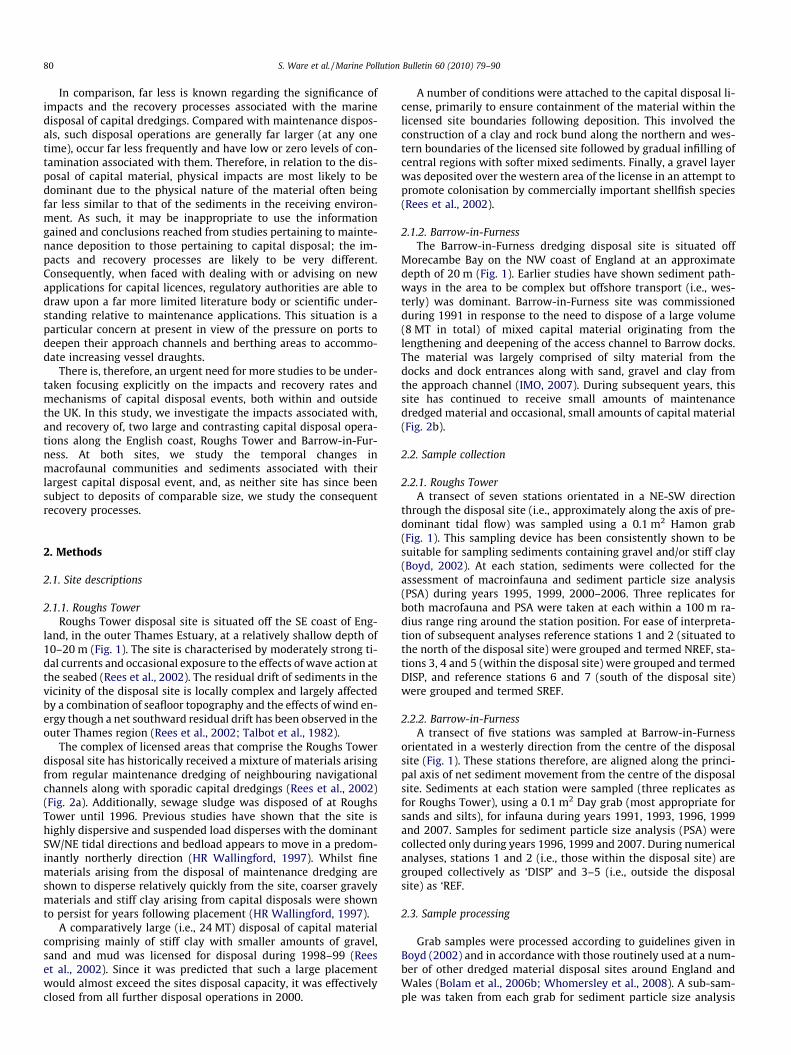
2.2.1. Roughs TowerA transect of seven stations orientated in a NE-SW direction
through the disposal site (i.e., approximately along the axis of pre-dominant tidal flow) was sampled using a 0.1 m2 Hamon grab(Fig. 1). This sampling device has been consistently shown to besuitable for sampling sediments containing gravel and/or stiff clay(Boyd, 2002). At each station, sediments were collected for theassessment of macroinfauna and sediment particle size analysis(PSA) during years 1995, 1999, 2000–2006. Three replicates forboth macrofauna and PSA were taken at each within a 100 m ra-dius range ring around the station position. For ease of interpreta-tion of subsequent analyses reference stations 1 and 2 (situated tothe north of the disposal site) were grouped and termed NREF, sta-tions 3, 4 and 5 (within the disposal site) were grouped and termedDISP, and reference stations 6 and 7 (south of the disposal site)were grouped and termed SREF.
2.2.2. Barrow-in-FurnessA transect of five stations was sampled at Barrow-in-Furness
orientated in a westerly direction from the centre of the disposalsite (Fig. 1). These stations therefore, are aligned along the princi-pal axis of net sediment movement from the centre of the disposalsite. Sediments at each station were sampled (three replicates asfor Roughs Tower), using a 0.1 m2 Day grab (most appropriate forsands and silts), for infauna during years 1991, 1993, 1996, 1999and 2007. Samples for sediment particle size analysis (PSA) werecollected only during years 1996, 1999 and 2007. During numericalanalyses, stations 1 and 2 (i.e., those within the disposal site) aregrouped collectively as ‘DISP’ and 3–5 (i.e., outside the disposalsite) as ‘REF.
2.3. Sample processing
Grab samples were processed according to guidelines given inBoyd (2002) and in accordance with those routinely used at a num-ber of other dredged material disposal sites around England andWales (Bolam et al., 2006b; Whomersley et al., 2008). A sub-sam-ple was taken from each grab for sediment particle size analysis
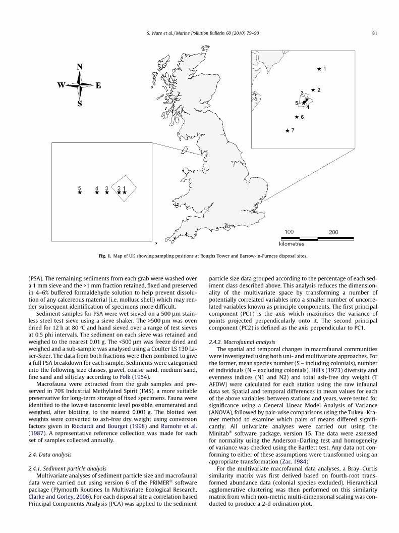
Fig. 1. Map of UK showing sampling positions at Roughs Tower and Barrow-in-Furness disposal sites.
S. Ware et al. / Marine Pollution Bulletin 60 (2010) 79–90 81
(PSA). The remaining sediments from each grab were washed overa 1 mm sieve and the >1 mm fraction retained, fixed and preservedin 4–6% buffered formaldehyde solution to help prevent dissolu-tion of any calcereous material (i.e. mollusc shell) which may ren-der subsequent identification of specimens more difficult.
Sediment samples for PSA were wet sieved on a 500 lm stain-less steel test sieve using a sieve shaker. The >500 lm was ovendried for 12 h at 80 �C and hand sieved over a range of test sievesat 0.5 phi intervals. The sediment on each sieve was retained andweighed to the nearest 0.01 g. The <500 lm was freeze dried andweighed and a sub-sample was analysed using a Coulter LS 130 La-ser-Sizer. The data from both fractions were then combined to givea full PSA breakdown for each sample. Sediments were categorisedinto the following size classes, gravel, coarse sand, medium sand,fine sand and silt/clay according to Folk (1954).
Macrofauna were extracted from the grab samples and pre-served in 70% Industrial Methylated Spirit (IMS), a more suitablepreservative for long-term storage of fixed specimens. Fauna wereidentified to the lowest taxonomic level possible, enumerated andweighed, after blotting, to the nearest 0.001 g. The blotted wetweights were converted to ash-free dry weight using conversionfactors given in Ricciardi and Bourget (1998) and Rumohr et al.(1987). A representative reference collection was made for eachset of samples collected annually.
2.4. Data analysis
2.4.1. Sediment particle analysisMultivariate analyses of sediment particle size and macrofaunal
data were carried out using version 6 of the PRIMER� softwarepackage (Plymouth Routines In Multivariate Ecological Research,Clarke and Gorley, 2006). For each disposal site a correlation basedPrincipal Components Analysis (PCA) was applied to the sediment
particle size data grouped according to the percentage of each sed-iment class described above. This analysis reduces the dimension-ality of the multivariate space by transforming a number ofpotentially correlated variables into a smaller number of uncorre-lated variables known as principle components. The first principalcomponent (PC1) is the axis which maximises the variance ofpoints projected perpendicularly onto it. The second principalcomponent (PC2) is defined as the axis perpendicular to PC1.
2.4.2. Macrofaunal analysisThe spatial and temporal changes in macrofaunal communities
were investigated using both uni- and multivariate approaches. Forthe former, mean species number (S – including colonials), numberof individuals (N – excluding colonials), Hill’s (1973) diversity andevenness indices (N1 and N2) and total ash-free dry weight (TAFDW) were calculated for each station using the raw infaunaldata set. Spatial and temporal differences in mean values for eachof the above variables, between stations and years, were tested forsignificance using a General Linear Model Analysis of Variance(ANOVA), followed by pair-wise comparisons using the Tukey–Kra-mer method to examine which pairs of means differed signifi-cantly. All univariate analyses were carried out using theMinitab� software package, version 15. The data were assessedfor normality using the Anderson–Darling test and homogeneityof variance was checked using the Bartlett test. Any data not con-forming to either of these assumptions were transformed using anappropriate transformation (Zar, 1984).
For the multivariate macrofaunal data analyses, a Bray–Curtissimilarity matrix was first derived based on fourth-root trans-formed abundance data (colonial species excluded). Hierarchicalagglomerative clustering was then performed on this similaritymatrix from which non-metric multi-dimensional scaling was con-ducted to produce a 2-d ordination plot.
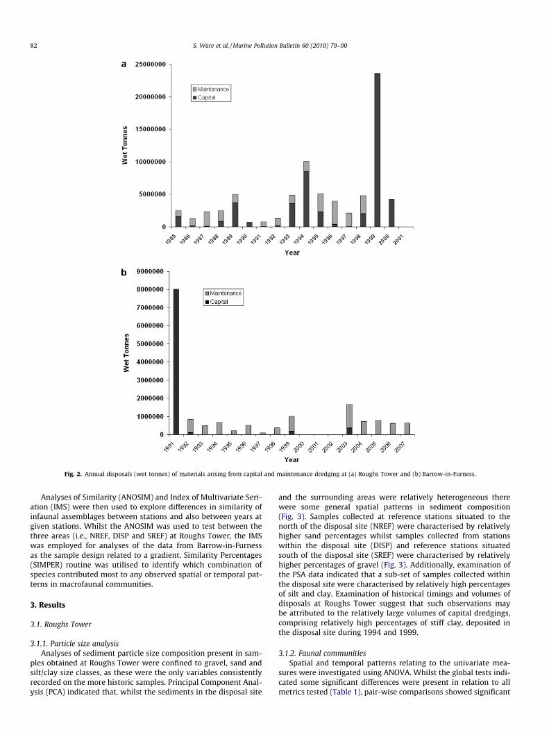
Fig. 2. Annual disposals (wet tonnes) of materials arising from capital and maintenance dredging at (a) Roughs Tower and (b) Barrow-in-Furness.
82 S. Ware et al. / Marine Pollution Bulletin 60 (2010) 79–90
Analyses of Similarity (ANOSIM) and Index of Multivariate Seri-ation (IMS) were then used to explore differences in similarity ofinfaunal assemblages between stations and also between years atgiven stations. Whilst the ANOSIM was used to test between thethree areas (i.e., NREF, DISP and SREF) at Roughs Tower, the IMSwas employed for analyses of the data from Barrow-in-Furnessas the sample design related to a gradient. Similarity Percentages(SIMPER) routine was utilised to identify which combination ofspecies contributed most to any observed spatial or temporal pat-terns in macrofaunal communities.
3. Results
3.1. Roughs Tower
3.1.1. Particle size analysisAnalyses of sediment particle size composition present in sam-
ples obtained at Roughs Tower were confined to gravel, sand andsilt/clay size classes, as these were the only variables consistentlyrecorded on the more historic samples. Principal Component Anal-ysis (PCA) indicated that, whilst the sediments in the disposal site
and the surrounding areas were relatively heterogeneous therewere some general spatial patterns in sediment composition(Fig. 3). Samples collected at reference stations situated to thenorth of the disposal site (NREF) were characterised by relativelyhigher sand percentages whilst samples collected from stationswithin the disposal site (DISP) and reference stations situatedsouth of the disposal site (SREF) were characterised by relativelyhigher percentages of gravel (Fig. 3). Additionally, examination ofthe PSA data indicated that a sub-set of samples collected withinthe disposal site were characterised by relatively high percentagesof silt and clay. Examination of historical timings and volumes ofdisposals at Roughs Tower suggest that such observations maybe attributed to the relatively large volumes of capital dredgings,comprising relatively high percentages of stiff clay, deposited inthe disposal site during 1994 and 1999.
3.1.2. Faunal communitiesSpatial and temporal patterns relating to the univariate mea-
sures were investigated using ANOVA. Whilst the global tests indi-cated some significant differences were present in relation to allmetrics tested (Table 1), pair-wise comparisons showed significant
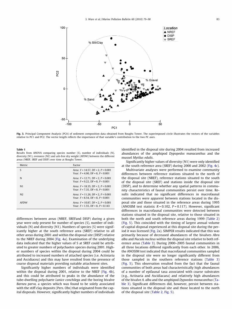
Fig. 3. Principal Component Analysis (PCA) of sediment composition data obtained from Roughs Tower. The superimposed circle illustrates the vectors of the variablesrelative to PC1 and PC2. The vector length reflects the importance of that variable’s contribution to the two PC axes.
Table 1Results from ANOVA comparing species number (S), number of individuals (N),diversity (N1), evenness (N2) and ash-free dry weight (AFDW) between the differentareas (NREF, SREF and DISP) over time at Roughs Tower.
Metric Factor
S Area: F = 14.57, DF = 2, P < 0.001Year: F = 4.90, DF = 8, P < 0.001
N Area: F = 12.71, DF = 2, P < 0.001Year: F = 9.22, DF = 8, P < 0.001
N1 Area: F = 18.35, DF = 2, P < 0.001Year: F = 7.35, DF = 8, P < 0.001
N2 Area: F = 11.26, DF = 2, P < 0.001Year: F = 8.54, DF = 8, P < 0.001
AFDW Area: F = 10.87, DF = 2, P < 0.001Year: F = 1.55, DF = 8, P = 0.143
S. Ware et al. / Marine Pollution Bulletin 60 (2010) 79–90 83
differences between areas (NREF, SREFand DISP) during a givenyear were only present for number of species (S), number of indi-viduals (N) and diversity (N1). Numbers of species (S) were signif-icantly higher at the south reference area (SREF) relative to allother areas during 2001 and within the disposal site (DISP) relativeto the NREF during 2004 (Fig. 4a). Examination of the underlyingdata indicated that the higher values of S at SREF could be attrib-uted to greater numbers of polychaetes species during 2001. High-er numbers of species within the disposal during 2004 could beattributed to increased numbers of attached species (i.e. Actiniariaand Ascidiacea) and this may have resulted from the presence ofcoarse disposal materials providing suitable attachment sites.
Significantly higher numbers of individuals were identifiedwithin the disposal during 2001, relative to the NREF (Fig. 4b),and this could be attributed to peaks in the abundance of thetube-dwelling polychaete Lanice conchilega and the boring bivalveBarnea parva, a species which was found to be solely associatedwith the stiff clay deposits (Pers. Obs) that originated from the cap-ital disposals. However, significantly higher numbers of individuals
identified in the disposal site during 2004 resulted from increasedabundances of the amphipod Dypopedos manacanthus and themussel Mytilus edulis.
Significantly higher values of diversity (N1) were only identifiedat the south reference area (SREF) during 2000 and 2002 (Fig. 4c).
Multivariate analyses were performed to examine communitydifferences between reference stations situated to the north ofthe disposal site (NREF), reference stations situated to the southof the disposal site (SREF) and stations inside the disposal site(DISP), and to determine whether any spatial patterns in commu-nity characteristics of faunal communities persist over time. Re-sults indicated that no significant differences in macrofaunalcommunities were apparent between stations located in the dis-posal site and those situated in the reference areas during 1995(ANOSIM test statistic R = 0.102, P = 0.117). However, significantdifferences in macrofaunal communities were detected betweenstations situated in the disposal site, relative to those situated inboth the north and south reference areas during 1999 (Table 2)(Fig. 5). This coincided with the timing of largest annual volumeof capital disposal experienced at this disposal site during the per-iod it was licensed (Fig. 2a). SIMPER results indicated that this wasprimarily because of decreased abundances of the bivalves Abraalba and Nucula nucleus within the disposal site relative to both ref-erence areas (Table 3). During 2000–2005 faunal communities inall three locations differed significantly from each other. In 2006,the ANOSIM test indicated that macrofaunal communities sampledin the disposal site were no longer significantly different fromthose sampled in the southern reference stations (Table 3)(Fig. 5). This observation resulted from the fact that the faunalcommunities of both areas had characteristically high abundancesof a number of epifaunal taxa associated with coarse substrates(e.g., Actinaria and Ascidiacaea) and relatively high abundancesof the bivalve A. alba and the amphipod Dypoedos monacanthus (Ta-ble 3). Significant differences did, however, persist between sta-tions situated in the disposal site and those located to the northof the disposal site (Table 2, Fig. 5).

Fig. 4. Mean numbers of species (a), numbers of individuals (b) and diversity (c), evenness (d) and ash-free dry weight (e) in samples collected within and outside the RoughsTower disposal site.
84 S. Ware et al. / Marine Pollution Bulletin 60 (2010) 79–90
The observed dissimilarity in patterns of change over time be-tween the disposal and the two reference locations (Fig. 5) furthersupports the likelihood that temporal shifts in community compo-sition within the disposal site are most probably in response to thedisposal activity as opposed to any natural variations in commu-nity composition.
3.2. Barrow-in-Furness
3.2.1. Particle size analysisAt Barrow-in-Furness, PSA data was only available for the final
three surveys, i.e., during 1996, 1999 and 2007. Sediment particlesize class data (i.e. % gravel, % coarse sand, % medium sand, % finesand and % silt/clay) indicated that spatial patterns were apparent
(Fig. 6). The majority (88.7%) of this variation could be explained byPC1 and PC2 (Fig. 6). The variability of the sediments collectedfrom stations within the disposal site were generally greater thanthose collected from the reference stations (Fig. 6). Samples col-lected from stations within the disposal site were characterisedby relatively high percentages of medium and coarse sand andgravel whilst those collected from reference sites were less heter-ogeneous and were largely comprised of fine sand.
3.2.2. Faunal communitiesPatterns relating to the univariate measures of macrofaunal
community structure were investigated using ANOVA. Signifi-cantly higher values of number of species (S) and number of indi-viduals (N) were consistently present at stations located in the
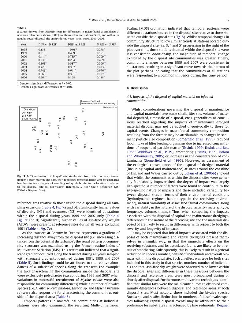
Table 2R values derived from ANOSIM tests for differences in macrofaunal assemblages atnorthern reference stations (NREF), southern reference stations (SREF) and within theRoughs Tower disposal site (DISP) during years 1995, 1999, 2000–2006.
Year DISP vs. N REF DISP vs. S REF N REF vs. S REF
1995 0.135 �0.017 0.278*
1999 0.318* 0.459** 0.1512000 0.414** 0.735** 0.709**
2001 0.336** 0.284* 0.469**
2002 0.363** 0.587** 0.506**
2003 0.723** 0.367* 0.433**
2004 0.749** 0.641* 0.676**
2005 0.863** 0.391** 0.757**
2006 0.564** 0.168 0.188*
* Denotes significant differences at P < 0.05.** Denotes significant differences at P < 0.01.
Fig. 5. MDS ordination of Bray–Curtis similarities from 4th root transformedRoughs Tower macrofauna data, with replicates averaged across year for each area.Numbers indicate the year of sampling and symbols refer to the location in relationto the disposal site (N REF = North Reference, S REF = South Reference, DIS-POSAL = Disposal Site).
S. Ware et al. / Marine Pollution Bulletin 60 (2010) 79–90 85
reference area relative to those inside the disposal during all sam-pling occasions (Table 4, Fig. 7a and b). Significantly higher valuesof diversity (N1) and evenness (N2) were identified at stationswithin the disposal during years 1999 and 2007 only (Table 4,Fig. 7c and d). Significantly higher values of ash-free dry weight(AFDW) were present at reference sites during all years excluding1991 (Table 4, Fig. 7e).
As the transect at Barrow-in-Furness represents a gradient ofincreasing distance away from the disposal site (i.e., increasing dis-tance from the potential disturbance), the serial pattern of commu-nity structure was examined using the Primer routine Index ofMultivariate Seriation (IMS). This test result indicated that a signif-icant gradient occurred along the transect during all years sampledwith strongest gradients identified during 1991, 1999 and 2007(Table 5). Such findings could be attributed to the relative abun-dances of a sub-set of species along the transect. For example,the taxa characterising the communities inside the disposal sitewere exclusively polychaetes (except during 1996 and 2007 whenvariations in successful recruitment of Mytilus edulus were alsoresponsible for community differences) while a number of bivalvespecies (i.e. A. alba, Nucula nitidosa, Thracia sp. and Mysella bidenta-ta) were also responsible for characterising the communities out-side of the disposal area (Table 6).
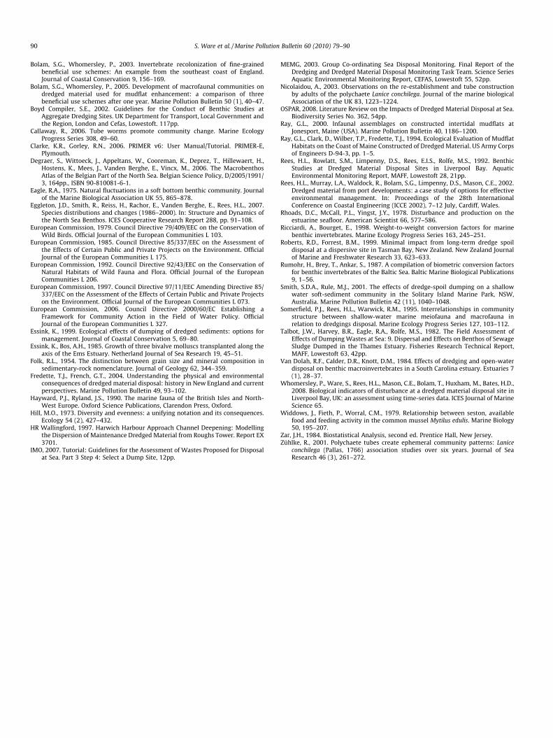
Temporal patterns in macrofaunal communities at individualstations were also examined; the resulting Multi-dimensional
Scaling (MDS) ordination indicated that temporal patterns weredifferent at stations located in the disposal site relative to those sit-uated outside the disposal site (Fig. 8). Whilst temporal changes incommunity structure follow similar trends at stations located out-side the disposal site (i.e. 3, 4 and 5) progressing to the right of theplot over time, those stations situated within the disposal site wereless consistent. Additionally, the magnitude of temporal changeexhibited by the disposal site communities was greater. Finally,community changes between 1999 and 2007 were consistent inall stations, resulting in a significant move towards the bottom ofthe plot perhaps indicating that the communities at all stationswere responding to a common influence during this time period.
4. Discussion
4.1. Impacts of the disposal of capital material on infaunalcommunities
Whilst considerations governing the disposal of maintenanceand capital materials have some similarities (i.e. volume of mate-rial deposited, timescale of disposal, etc.), generalities or conclu-sions reached regarding the impacts of maintenance dredgedmaterial disposal may not be applied unequivocally to those forcapital events. Changes in macrofaunal community compositionresulting from the former may be attributable to changes in sedi-ment particle size composition (Somerfield et al., 1995), reducedfood intake of filter feeding organisms due to increased concentra-tions of suspended particle matter (Essink, 1999; Essink and Bos,1985; Widdows et al., 1979), smothering (Essink, 1999; Bolamand Whomersley, 2005) or increases in the concentration of con-taminants (Somerfield et al., 1995). However, an assessment ofthe ecological consequences of the disposal of dredged material(including capital and maintenance) at sites around the coastlineof England and Wales carried out by Bolam et al. (2006b) showedthat whilst the communities within the disposal sites were gener-ally faunistically impoverished, the degree of impact was largelysite-specific. A number of factors were found to contribute to thesite-specific nature of impacts and these included variability be-tween disposal sites in terms of their environmental conditions(hydrodynamic regimes, habitat type in the receiving environ-ment), natural variability of associated faunal communities alongwith variability in the nature of the disposal activity (material type,frequency, volume, timing). Thus, when comparing the impactsassociated with the disposal of capital and maintenance dredgings,differences in the nature of the receiving site and the materials dis-posed of are likely to result in differences with respect to both theseverity and longevity of impacts.
It may be expected that initial impacts associated with the dis-posal of both maintenance and capital dredgings present them-selves in a similar way, in that the immediate effects on thereceiving substrate, and its associated fauna, are likely to be a re-sult of smothering. Subsequently, this is likely to result in a generalreduction in species number, density of individuals and overall bio-mass within the disposal site. Such an effect was true for both sitesincluded in this study in that species number, number of individu-als and total ash-free dry weight were observed to be lower withinthe disposal sites and differences in these measures between thedisposal and reference areas were most pronounced during orshortly after disposal. Furthermore, multivariate techniques identi-fied that similar taxa were the main contributors to observed com-munity differences between disposal and reference areas at bothdisposal sites. Most notably, these included the bivalve speciesNucula sp. and A. alba. Reductions in numbers of these bivalve spe-cies following capital disposal events may be attributed to theirpreference for substrates characterised by fine sediments (Degraer
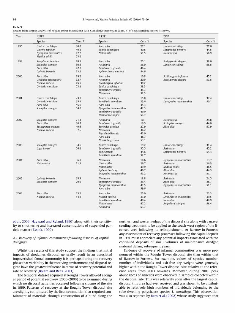
Table 3Results from SIMPER analysis of Roughs Tower macrofauna data. Cumulative percentage (Cum. %) of characterising species is shown.
Year N REF S REF DISP
Species Cum. % Species Cum. % Species Cum. %
1995 Lanice conchilegaGlycera lapidumNymphon brevirostrisMytilus edulis
30.640.247.253.4
Abra albaLanice conchilegaNotomastus
27.140.851.5
Lanice conchilegaSpiophanes bombyxNotomastus
27.644.856.9
1999 Spiophanes bombyxScoloplos armigerAbra albaOphelia borealis
18.930.642.253.2
Abra albaActiniariaLumbrineris gracilisAphelochaeta marioni
25.136.946.454.6
Bathyporeia elegansLanice conchilega
38.656.6
2000 Abra albaGoodallia triangularisNucula nucleusGoniada maculata
19.232.745.553.1
Abra albaActiniariaScalibragma inflatumLanice conchilegaLumbrineris gracilisNemertea
10.820.930.238.345.352.3
Scalibragma inflatumBathyporeia elegans
45.253.6
2001 Lanice conchilegaGoniada maculateAbra albaScoloplos armiger
23.735.945.654.0
Lanice conchilegaSabellaria spinulosaAbra albaDyopedos monacanthusLumbrineris gracilisHarmothoe impar
15.825.635.342.349.054.7
Lanice conchilegaDypopedos monacanthus
37.450.1
2002 Scoloplos armigerAbra albaBathyporeia elegansNucula nucleus
21.136.749.657.6
ActiniariaLumbrineris gracilisScoloplos armigerNemerteaMysella bidentataAbra albaNereis longissima
10.119.527.936.243.048.753.1
NotomastusScoloplos armigerAbra alba
24.844.057.9
2003 Scoloplos armigerLagis koreni
34.656.4
Lanice conchilgaLumbrineris gracilisLagis koreniSabellaria spinulosa
19.235.544.652.7
Lanice conchilegaActiniariaSpiophanes bombyx
31.445.254.4
2004 Abra albaNotomastus
36.851.3
NemerteaGlcera albaNotomastusAphelochaeta sp.Dyopedos monacanthus
18.629.739.946.753.2
Dyopedos monacanthusActiniariaMytilus edulisAbra albaNotomastus
13.726.536.544.351.1
2005 Ophelia borealisScoloplos armiger
38.970.6
NemerteaLumbrineris gracilisDyopedos manacanthusAbra alba
18.835.447.559.6
ActiniariaAbra albaDyopedos monacanthus
24.538.751.1
2006 Abra albaNucula nucleus
33.254.6
Abra albaNucula nucleusSabellaria spinulosaNotomastusActiniaria
25.033.040.447.253.7
ActiniariaDyopedos monacanthusNemerteaAmpelisca spinipes
23.339.548.958.4
86 S. Ware et al. / Marine Pollution Bulletin 60 (2010) 79–90
et al., 2006; Hayward and Ryland, 1990) along with their sensitiv-ity to smothering and increased concentrations of suspended par-ticle matter (Essink, 1999).
4.2. Recovery of infaunal communities following disposal of capitaldredgings
Whilst the results of this study support the findings that initialimpacts of dredgings disposal generally result in an associatedimpoverished faunal community it is perhaps during the recoveryphase that variability in the receiving environment and disposal re-gime have the greatest influence in terms of recovery potential andrate of recovery (Bolam and Rees, 2003).
The temporal dataset acquired at Roughs Tower allowed a long-er period of potential recovery (2000–2006) to be examined duringwhich no disposal activities occurred following closure of the sitein 1999. Patterns of recovery at the Roughs Tower disposal siteare slightly complicated by the licence condition that required con-tainment of materials through construction of a bund along the
northern and western edges of the disposal site along with a gravelseeding treatment to be applied to the south-west region of the li-censed area following its relinquishment. At Barrow-in-Furness,any assessment of recovery processes following the capital depositin 1991 must appreciate any potential impacts associated with thecontinued deposits of small volumes of maintenance dredgedmaterial during subsequent years.
Evidence of recovery of infaunal communities was more pro-nounced within the Roughs Tower disposal site than within thatof Barrow-in-Furness. For example, values of species number,number of individuals and ash-free dry weight were generallyhigher within the Roughs Tower disposal site, relative to the refer-ence areas, from 2003 onwards. Moreover, during 2001, peakabundances of annelids were observed in samples collected withinthe disposal site. This was relatively soon after the largest capitaldisposal this area had ever received and was shown to be attribut-able to relatively high numbers of individuals belonging to thetube-dwelling polychaete species L. conchilega. This observationwas also reported by Rees et al. (2002) whose study suggested that

Fig. 6. Principal Component Analysis (PCA) of sediment composition data ofsamples collected at Barrow-in-Furness. The superimposed circle illustrates thevectors of the variables relative to PC1 and PC2. The vector length reflects theimportance of that variable’s contribution to the two PC axes.
Table 4Results from ANOVA comparing species number (S), number of individuals (N),diversity (N1), evenness (N2) and ash-free dry weight (AFDW) between stationsinside and outside the Barrow-in-Furness disposal during different years.
Metric Factor
S Inside vs. outside: F = 188.49, DF = 1, P < 0.001Year: F = 4.46, DF = 4, P = 0.003
N Inside vs. outside: F = 222.84, DF = 1, P < 0.001Year: F = 0.52, DF = 4, P = 0.718
N1 Inside vs. outside: F = 39.93, DF = 1, P < 0.001Year: F = 3.94, DF = 4, P = 0.006
N2 Inside vs. outside: F = 10.93, DF = 1, P = 0.002Year: F = 6.20, DF = 4, P < 0.001
AFDW Inside vs. outside: F = 77.21, DF = 4, P = 0.009Year: F = 77.21, DF = 4, P = 0.009
S. Ware et al. / Marine Pollution Bulletin 60 (2010) 79–90 87
the establishment of adult populations of this species may aidrecovery within the disposal site through the encouragement ofcolonisation by other species resulting from its ability to stabilisesediments (Callaway, 2006; Eagle, 1975). It should also be notedthat relatively high numbers of L. conchilega were also reportedduring 2000 at a station situated in close proximity to RoughsTower sampled as part of the ICES Study Group on the North Seabenthos Project 2000 (Eggleton et al., 2007). Therefore, it may bethat natural population fluxes operating in the area over this timeperiod, along with the ability of this species to re-colonise areasrapidly following disturbance (Nicolaidou, 2003; Zühlke, 2001), re-sulted in the observed high settlement on sediment types favouredby this species (i.e. medium grained sand with relatively high mudcontent) that were present within the disposal site. Rees et al.(2002) suggested that this may be a good indication that the envi-ronment of the disposal site is sufficiently benign, following cessa-tion of disposal activities, to allow successful re-colonisation bycertain species.
Investigations of community patterns within the Roughs Towerdisposal site and surrounding reference areas indicated that infau-
nal communities within the relinquished disposal site becamemore similar to those present in the reference area to the southof the disposal site. This could be attributed to both areas beingcharacterised by relatively higher numbers of individuals belong-ing to the groups Actiniaria and Ascidiacea along with relativelyhigh numbers of the epibenthic amphipod species Dyopedos mon-acanthus. The increased similarity between faunal communitiesinhabiting the relinquished disposal site and the more gravelysouthern reference area is likely to have resulted from gravel seed-ing within the disposal site, along with enhanced retention of thecoarser disposal material by the bund, rendering sediments in thisarea much coarser and providing suitable attachment sites for cer-tain colonial epifauna.
Additionally, the presence of the boring bivalve B. parva wasonly recorded at stations situated within the Roughs Tower dis-posal site following the capital disposal event. This could be attrib-uted to the presence of stiff clays arising from capital disposalswith which this species is associated.
Impacts associated with the large capital disposal at Barrow-in-Furness resulted in a persistent reduction in numbers of speciesand individuals within the disposal area. This could be attributedto higher abundances of certain bivalves (i.e., N. nitidosa, A. albaand Spisula subtruncata) and polychaete species (i.e., Nephtys sp.,Spiophanes bombyx and Scalibregma inflatum), naturally abundantwithin this area, becoming restricted to stations outside the dis-posal site following capital disposal. These taxa are generally asso-ciated with fine sand which naturally characterise the sea bed inthis region (Degraer et al., 2006). The disposal of coarser sedimentswithin the disposal site, and the inability of bottom currents tosubsequently transport such sediments, rendered the disposal areaunsuitable for colonisation by the majority of surrounding taxa.However, in 2007 certain species, including the mussel M. edulis,were relatively more abundant within the disposal site, possiblydue to the presence of the coarser, deposited sediments providinga more favourable habitat for spat settlement. Furthermore, asmussels are generally sensitive to smothering following mainte-nance dredged material disposal, the prevalence of this specieswithin the disposal site perhaps suggests that negative effects aris-ing as a consequence of the ongoing maintenance dredgings dis-posal are minimal.
4.3. Implications for licensing of capital projects
This study highlights that whilst the activities of both mainte-nance and capital dredgings disposal have certain parallels, theyalso differ substantially in terms of disposal regime, associated im-pacts on both substrates and faunal communities and subsequentrecovery patterns. Informed decisions regarding disposal site loca-tion (i.e., using information regarding sediment characteristics, lo-cal hydrodynamics, dispersive capacity, etc.) have been proven tominimise long-term impacts on the seafloor and associated faunalcommunities resulting from disposal of maintenance dredgings(Bolam and Rees, 2003; Roberts and Forrest, 1999; Smith and Rule,2001; Van Dolah et al., 1984). However, results of this study sug-gest that the potential for dispersal (or erosion via sediment bed-load transport processes) of materials arising from capitaldredging operations is reduced due to the physical nature of thematerial (i.e. coarse gravel and stiff clay). This notion is supportedby our observations at both Roughs Tower and Barrow-in-Furnessby the persistently altered sediment characteristics present in thedisposal sites following capital disposal. Therefore, in the case ofcapital dredgings disposal, the dispersive capacity of the licensedsite may be less of a consideration than the potential consequencesof shoaling and the similarity between sediment characteristics ofthe receiving environment and the disposal material. Increasedsimilarity between the disposal material and the substrate present

Fig. 7. Mean numbers of species (a), numbers of individuals (b), diversity (c), evenness (d) and AFDW (e) in samples collected within and outside the Barrow-in-Furnessdisposal site.
Table 5Results of the Index of Multivariate Seriation (IMS) applied to macrofauna datacollected at Barrow-in-Furness.
Year Index of multivariate seriation
1991* 0.715 (0.1%)1993 0.492 (0.1%)1996 0.652 (0.1%)1999* 0.772 (0.1%)2007 0.788 (0.1%)
* Indicates years when disposal of capital dredgings occurred.
88 S. Ware et al. / Marine Pollution Bulletin 60 (2010) 79–90
in the selected licensed site (e.g., Roughs Tower) is likely to mini-mise alterations to the seafloor substrate and thus allow the re-
establishment of a faunal community more similar to that presentprior to any disposal activity.
Whilst no inferences were made from this study regarding theeffectiveness of the gravel treatment at Roughs Tower in enhancingthe local shellfish fishery, as was the intention of the original li-cence conditions, the gravel treatment does appear to have re-sulted in the re-establishment of a faunal community within thedisposal site that is very similar to that present in the un-impactedgravelly reference area to the south-west of the disposal site.Whilst we are unable to determine whether the re-established fau-nal community in the disposal site resembles that present beforeto disposal activities commenced (due to the absence of baselinesediment and faunal data) it may be surmised that disposal activ-ities at this site have not resulted in any permanent detrimental
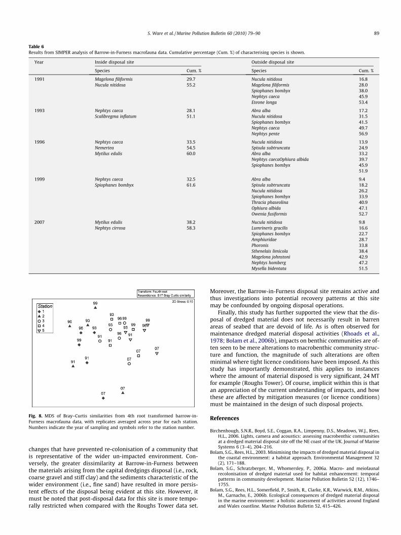
Table 6Results from SIMPER analysis of Barrow-in-Furness macrofauna data. Cumulative percentage (Cum. %) of characterising species is shown.
Year Inside disposal site Outside disposal site
Species Cum. % Species Cum. %
1991 Magelona filiformisNucula nitidosa
29.755.2
Nucula nitidosaMagelona filiformisSpiophanes bombyxNephtys caecaEteone longa
16.828.038.045.953.4
1993 Nephtys caecaScalibregma inflatum
28.151.1
Abra albaNucula nitidosaSpiophanes bombyxNephtys caecaNephtys pente
17.231.541.549.756.9
1996 Nephtys caecaNemerteaMytilus edulis
33.554.560.0
Nucula nitidosaSpisula subtruncataAbra albaNephtys caecaOphiura albidaSpiophanes bombyx
13.924.933.239.745.951.9
1999 Nephtys caecaSpiophanes bombyx
32.561.6
Abra albaSpisula subtruncataNucula nitidosaSpiophanes bombyxThracia phaseolinaOphiura albidaOwenia fusiformis
9.418.226.233.940.947.152.7
2007 Mytilus edulisNephtys cirrosa
38.258.3
Nucula nitidosaLumrineris gracilisSpiophanes bombyxAmphiuridaePhoronisSthenelais limicolaMagelona johnstoniNephtys hombergMysella bidentata
9.816.622.728.733.838.442.947.251.5
Fig. 8. MDS of Bray–Curtis similarities from 4th root transformed barrow-in-Furness macrofauna data, with replicates averaged across year for each station.Numbers indicate the year of sampling and symbols refer to the station number.
S. Ware et al. / Marine Pollution Bulletin 60 (2010) 79–90 89
changes that have prevented re-colonisation of a community thatis representative of the wider un-impacted environment. Con-versely, the greater dissimilarity at Barrow-in-Furness betweenthe materials arising from the capital dredgings disposal (i.e., rock,coarse gravel and stiff clay) and the sediments characteristic of thewider environment (i.e., fine sand) have resulted in more persis-tent effects of the disposal being evident at this site. However, itmust be noted that post-disposal data for this site is more tempo-rally restricted when compared with the Roughs Tower data set.
Moreover, the Barrow-in-Furness disposal site remains active andthus investigations into potential recovery patterns at this sitemay be confounded by ongoing disposal operations.
Finally, this study has further supported the view that the dis-posal of dredged material does not necessarily result in barrenareas of seabed that are devoid of life. As is often observed formaintenance dredged material disposal activities (Rhoads et al.,1978; Bolam et al., 2006b), impacts on benthic communities are of-ten seen to be mere alterations to macrobenthic community struc-ture and function, the magnitude of such alterations are oftenminimal where tight licence conditions have been imposed. As thisstudy has importantly demonstrated, this applies to instanceswhere the amount of material disposed is very significant, 24 MTfor example (Roughs Tower). Of course, implicit within this is thatan appreciation of the current understanding of impacts, and howthese are affected by mitigation measures (or licence conditions)must be maintained in the design of such disposal projects.
References
Birchenhough, S.N.R., Boyd, S.E., Coggan, R.A., Limpenny, D.S., Meadows, W.J., Rees,H.L., 2006. Lights, camera and acoustics: assessing macrobenthic communitiesat a dredged material disposal site off the NE coast of the UK. Journal of MarineSystems 6 (3–4), 204–216.
Bolam, S.G., Rees, H.L., 2003. Minimising the impacts of dredged material disposal inthe coastal environment: a habitat approach. Environmental Management 32(2), 171–188.
Bolam, S.G., Schratzberger, M., Whomersley, P., 2006a. Macro- and meiofaunalrecolonisation of dredged material used for habitat enhancement: temporalpatterns in community development. Marine Pollution Bulletin 52 (12), 1746–1755.
Bolam, S.G., Rees, H.L., Somerfield, P., Smith, R., Clarke, K.R., Warwick, R.M., Atkins,M., Garnacho, E., 2006b. Ecological consequences of dredged material disposalin the marine environment: a holistic assessment of activities around Englandand Wales coastline. Marine Pollution Bulletin 52, 415–426.
90 S. Ware et al. / Marine Pollution Bulletin 60 (2010) 79–90
Bolam, S.G., Whomersley, P., 2003. Invertebrate recolonization of fine-grainedbeneficial use schemes: An example from the southeast coast of England.Journal of Coastal Conservation 9, 156–169.
Bolam, S.G., Whomersley, P., 2005. Development of macrofaunal communities ondredged material used for mudflat enhancement: a comparison of threebeneficial use schemes after one year. Marine Pollution Bulletin 50 (1), 40–47.
Boyd Compiler, S.E., 2002. Guidelines for the Conduct of Benthic Studies atAggregate Dredging Sites. UK Department for Transport, Local Government andthe Region, London and Cefas, Lowestoft. 117pp.
Callaway, R., 2006. Tube worms promote community change. Marine EcologyProgress Series 308, 49–60.
Clarke, K.R., Gorley, R.N., 2006. PRIMER v6: User Manual/Tutorial. PRIMER-E,Plymouth.
Degraer, S., Wittoeck, J., Appeltans, W., Cooreman, K., Deprez, T., Hillewaert, H.,Hostens, K., Mees, J., Vanden Berghe, E., Vincx, M., 2006. The MacrobenthosAtlas of the Belgian Part of the North Sea. Belgian Science Policy, D/2005/1991/3, 164pp., ISBN 90-810081-6-1.
Eagle, R.A., 1975. Natural fluctuations in a soft bottom benthic community. Journalof the Marine Biological Association UK 55, 865–878.
Eggleton, J.D., Smith, R., Reiss, H., Rachor, E., Vanden Berghe, E., Rees, H.L., 2007.Species distributions and changes (1986–2000). In: Structure and Dynamics ofthe North Sea Benthos. ICES Cooperative Research Report 288, pp. 91–108.
European Commission, 1979. Council Directive 79/409/EEC on the Conservation ofWild Birds. Official Journal of the European Communities L 103.
European Commission, 1985. Council Directive 85/337/EEC on the Assessment ofthe Effects of Certain Public and Private Projects on the Environment. OfficialJournal of the European Communities L 175.
European Commission, 1992. Council Directive 92/43/EEC on the Conservation ofNatural Habitats of Wild Fauna and Flora. Official Journal of the EuropeanCommunities L 206.
European Commission, 1997. Council Directive 97/11/EEC Amending Directive 85/337/EEC on the Assessment of the Effects of Certain Public and Private Projectson the Environment. Official Journal of the European Communities L 073.
European Commission, 2006. Council Directive 2000/60/EC Establishing aFramework for Community Action in the Field of Water Policy. OfficialJournal of the European Communities L 327.
Essink, K., 1999. Ecological effects of dumping of dredged sediments: options formanagement. Journal of Coastal Conservation 5, 69–80.
Essink, K., Bos, A.H., 1985. Growth of three bivalve molluscs transplanted along theaxis of the Ems Estuary. Netherland Journal of Sea Research 19, 45–51.
Folk, R.L., 1954. The distinction between grain size and mineral composition insedimentary-rock nomenclature. Journal of Geology 62, 344–359.
Fredette, T.J., French, G.T., 2004. Understanding the physical and environmentalconsequences of dredged material disposal: history in New England and currentperspectives. Marine Pollution Bulletin 49, 93–102.
Hayward, P.J., Ryland, J.S., 1990. The marine fauna of the British Isles and North-West Europe. Oxford Science Publications, Clarendon Press, Oxford.
Hill, M.O., 1973. Diversity and evenness: a unifying notation and its consequences.Ecology 54 (2), 427–432.
HR Wallingford, 1997. Harwich Harbour Approach Channel Deepening: Modellingthe Dispersion of Maintenance Dredged Material from Roughs Tower. Report EX3701.
IMO, 2007. Tutorial: Guidelines for the Assessment of Wastes Proposed for Disposalat Sea. Part 3 Step 4: Select a Dump Site, 12pp.
MEMG, 2003. Group Co-ordinating Sea Disposal Monitoring. Final Report of theDredging and Dredged Material Disposal Monitoring Task Team. Science SeriesAquatic Environmental Monitoring Report, CEFAS, Lowestoft 55, 52pp.
Nicolaidou, A., 2003. Observations on the re-establishment and tube constructionby adults of the polychaete Lanice conchilega. Journal of the marine biologicalAssociation of the UK 83, 1223–1224.
OSPAR, 2008. Literature Review on the Impacts of Dredged Material Disposal at Sea.Biodiversity Series No. 362, 54pp.
Ray, G.L., 2000. Infaunal assemblages on constructed intertidal mudflats atJonesport, Maine (USA). Marine Pollution Bulletin 40, 1186–1200.
Ray, G.L., Clark, D., Wilber, T.P., Fredette, T.J., 1994. Ecological Evaluation of MudflatHabitats on the Coast of Maine Constructed of Dredged Material. US Army Corpsof Engineers D-94-3, pp. 1–5.
Rees, H.L., Rowlatt, S.M., Limpenny, D.S., Rees, E.I.S., Rolfe, M.S., 1992. BenthicStudies at Dredged Material Disposal Sites in Liverpool Bay. AquaticEnvironmental Monitoring Report, MAFF, Lowestoft 28, 21pp.
Rees, H.L., Murray, L.A., Waldock, R., Bolam, S.G., Limpenny, D.S., Mason, C.E., 2002.Dredged material from port developments: a case study of options for effectiveenvironmental management. In: Proceedings of the 28th InternationalConference on Coastal Engineering (ICCE 2002), 7–12 July, Cardiff, Wales.
Rhoads, D.C., McCall, P.L., Yingst, J.Y., 1978. Disturbance and production on theestuarine seafloor. American Scientist 66, 577–586.
Ricciardi, A., Bourget, E., 1998. Weight-to-weight conversion factors for marinebenthic invertebrates. Marine Ecology Progress Series 163, 245–251.
Roberts, R.D., Forrest, B.M., 1999. Minimal impact from long-term dredge spoildisposal at a dispersive site in Tasman Bay, New Zealand. New Zealand Journalof Marine and Freshwater Research 33, 623–633.
Rumohr, H., Brey, T., Ankar, S., 1987. A compilation of biometric conversion factorsfor benthic invertebrates of the Baltic Sea. Baltic Marine Biological Publications9, 1–56.
Smith, S.D.A., Rule, M.J., 2001. The effects of dredge-spoil dumping on a shallowwater soft-sediment community in the Solitary Island Marine Park, NSW,Australia. Marine Pollution Bulletin 42 (11), 1040–1048.
Somerfield, P.J., Rees, H.L., Warwick, R.M., 1995. Interrelationships in communitystructure between shallow-water marine meiofauna and macrofauna inrelation to dredgings disposal. Marine Ecology Progress Series 127, 103–112.
Talbot, J.W., Harvey, B.R., Eagle, R.A., Rolfe, M.S., 1982. The Field Assessment ofEffects of Dumping Wastes at Sea: 9. Dispersal and Effects on Benthos of SewageSludge Dumped in the Thames Estuary. Fisheries Research Technical Report,MAFF, Lowestoft 63, 42pp.
Van Dolah, R.F., Calder, D.R., Knott, D.M., 1984. Effects of dredging and open-waterdisposal on benthic macroinvertebrates in a South Carolina estuary. Estuaries 7(1), 28–37.
Whomersley, P., Ware, S., Rees, H.L., Mason, C.E., Bolam, T., Huxham, M., Bates, H.D.,2008. Biological indicators of disturbance at a dredged material disposal site inLiverpool Bay, UK: an assessment using time-series data. ICES Journal of MarineScience 65.
Widdows, J., Fieth, P., Worral, C.M., 1979. Relationship between seston, availablefood and feeding activity in the common mussel Mytilus edulis. Marine Biology50, 195–207.
Zar, J.H., 1984. Biostatistical Analysis, second ed. Prentice Hall, New Jersey.Zühlke, R., 2001. Polychaete tubes create ephemeral community patterns: Lanice
conchilega (Pallas, 1766) association studies over six years. Journal of SeaResearch 46 (3), 261–272.