Embed Size (px)
Citation preview

Unit 5: Plate Tectonics A . Alfred Wegner
1. Continental drift hypothesis a. single supercontinent called Pangaea b. 200 million years ago Pangaea (all land) began to break up and started drifting to their
present positions
2. Evidences
a. Matching fossils Mesosaurus fossils limited to South America and southern Africa b. Rock Types and Structures several mountain belts that end at one coastline, reappear on a
landmass across the ocean
3. Hypothesis rejected a. Wegener could not describe a mechanism that was capable of moving the continents across
the globe B. Theory of Plate Tectonics
1. The theory that proposes that Earth’s outer shell consists of individual plates that interact in various ways and thereby produce earthquakes, volcanoes, mountains, and the crust itself
2. Lithosphere – rigid outer layer of Earth, including the crust and upper mantle a. divided into segments called plates seven major plates b. largest = Pacific plate
3. Move about 5 cm/yr (about as fast as your fingernail)

Types of Plate Boundaries C. Divergent boundaries when two plates move
apart 1. results in upwelling of material from the
mantle to create new seafloor 2. Oceanic ridge – seafloor that is
elevated along well developed divergent boundaries
3. Rift valleys – deep faulted structures found along the axes of some segments
4. Seafloor spreading – The process in which the ocean floor is extended when two plates move apart, forming a crack where magma can rise to the surface, cooling and forming new crust. Ex: East African Rift valley
D. Convergent boundaries when two plates move together
1. results in a subduction zone when one oceanic plate is forced down into the mantle beneath a
second plate 2. creates an ocean trench
3. 3 types of convergent boundaries a. OceanicContinental Ocean plate (more dense) sinks down under continental plate
i. Can eventually cause volcanic eruptions ii. Ex. Andes
b. Oceanic Oceanic One descends beneath the other i. Can cause volcanoes to form
on ocean floor ii. Activity will eventually build a
chain of volcanic structures that become islands called volcanic island arc
iii. Ex. Aleutian Islands off the shore of Alaska

c. ContinentalContinental Plates collide i. Causes formation of complex mountains ii. Ex. Himalayas iii. Urbanizing mountainsides leads to erosion,
landslides, and water pollution E. Transform fault boundaries two plates grind past each other without the production or destruction of lithosphere
1. can cause earthquake activity 2. Ex. San Andreas fault zone
F. Evidence for Plate Tectonics
1. Paleomagnetism the study of the Earth’s magnetic field in the past – used as evidence for seafloor spreading
a. Normal Polarity – when rocks show the same magnetism as the present magnetic field
b. Reverse polarity – rocks that show the opposite
magnetism c. the discovery of strips of alternating polarity, while lie
as mirror images across the ocean ridges, is among the strongest evidence of seafloor spreading
2. Earthquake patterns 3. Ocean drilling 4. Hot spots a concentration of heat
in the mantle capable of producing magma, which rises to Earth’s surface
a. pacific plate moves over a hot spot, producing the Hawaiian Islands
b. supports the idea that the plates move over Earth’s surface

G. Mechanisms of Plate Motion 1. Convection – warm, less dense material rises and cooler,
denser material sinks 2. Convection Currents – transfer of thermal energy from warmer
regions of magma below the crust to cooler regions a. convection occurring in the mantle is the basic
driving force for plate movement
3. SlabPull occurs because old oceanic crust, sinks into the asthenosphere and pulls the trailing lithosphere along a. thought to be the primary downward arm of
convective flow in the mantle
4. RidgePush results from the elevated position of the oceanic ridge system a. causes oceanic lithosphere to slide down the sides f the oceanic ridge b. less important than slabpull
5. Mantle convection mantle plumes are masses of hotterthannormal mantle material that ascend toward the surface a. the unequal distribution of heat within Earth causes the thermal convection in the mantle that ultimately drives plate motion
Earthquakes H. Earthquakes
1. Earthquake – vibration of Earth produced by the rapid release of energy
2. Focus – The point within Earth where the earthquake starts
3. Epicenter – Location on the surface directly above the focus
I. Faults 1. Fractures in Earth where movement has occurred 2. Earthquakes are usually associated with faults in Earth’s crust and mantle
J. Causes of Earthquakes
1. Elastic Rebound Hypothesis a. when rocks are deformed, they first bend and then break, releasing stored energy b. most earthquakes are produced by the rapid release of elastic energy stored in rock that has
been subjected to great forces c. when the strength of the rock is exceeded, it suddenly breaks, causing vibrations
2. Aftershocks a. a small earthquake that follows the main earthquake usually much weaker
than the main earthquake b. can sometimes destroy structures weakened by the main EQ
3. Foreshocks – a. small earthquake that often comes before a major earthquake b. can happen days or years before the major quake
4. Transform fault boundaries a. produce smaller, shallowfocus earthquakes that occur 040 miles deep
5. Converging plate boundaries a. can produce deepfocus earthquakes that occur 180 miles or more below
the Earth’s surface K. Earthquake waves
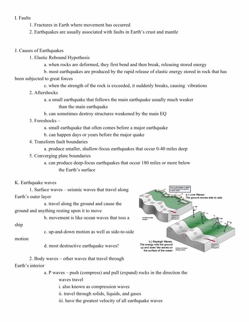
1. Surface waves – seismic waves that travel along Earth’s outer layer
a. travel along the ground and cause the ground and anything resting upon it to move
b. movement is like ocean waves that toss a ship
c. upanddown motion as well as sidetoside motion
d. most destructive earthquake waves!
2. Body waves – other waves that travel through Earth’s interior
a. P waves – push (compress) and pull (expand) rocks in the direction the waves travel i. also known as compression waves ii. travel through solids, liquids, and gases iii. have the greatest velocity of all earthquake waves
iv. move through the entire earthcrust, mantle, and core like a slinky b. S waves – shake particles at right angles to the direction that they travel
i. also known as transverse waves ii. travel only through solids iii. slower velocity than P waves iv. move through the ground (Earth’s outer layer) like a rope
3. A seismogram shows all three types of seismic waves a. first P wave, then first S wave, and then surface
waves hint: alphabetical order L. Locating an Earthquake
1. The greater the interval measured on a seismogram between the arrival of the first P wave and the first S wave, the greater the distance to the earthquake source
2. Earthquake direction
a. the precise location can be found when the distance is known from three or more different seismic stations
b. the point where the three circles intersect is the epicenter of the quake
3. Earthquake zones most earthquakes occur
around the outer edge of the Pacific Ocean

M. Measuring Earthquakes 1. Two different types of measurements to describe size of earthquake
a. intensity – a measure of the amount of earthquake shaking at a given location based on the amount of damage i. not quantitative measurement
b. magnitudes – a measure of the size of seismic waves or the amount of energy released at the source of the earthquake i. quantitative measurements – rely on calculations using seismograms
2. Richter Scale a. based on the amplitude of the largest seismic wave recorded on a
seismogram b. most EQ measurements you hear on news reports use Richter scale c. scientists no longer use it
3. Moment Magnitude a. most widely used measurement for earthquakes because it is the only
magnitude scale that estimates the energy released by earthquakes b. calculated factors
i. average amount of movement along the fault ii. area of the surface break iii. strength of the broken rock
N. Destruction from Earthquakes 1. Damage to building and other structures depends on these factors:
a. intensity and duration of the vibrations b. nature of the material on which the structure is built c. design of the structure
2. Landslides a. the greatest damage to structures is from landslides, or the sinking of the
ground triggered by the vibrations 3. Fire
a. start when gas and electrical lines were cut b. water lines may also break so that fires can’t be stopped
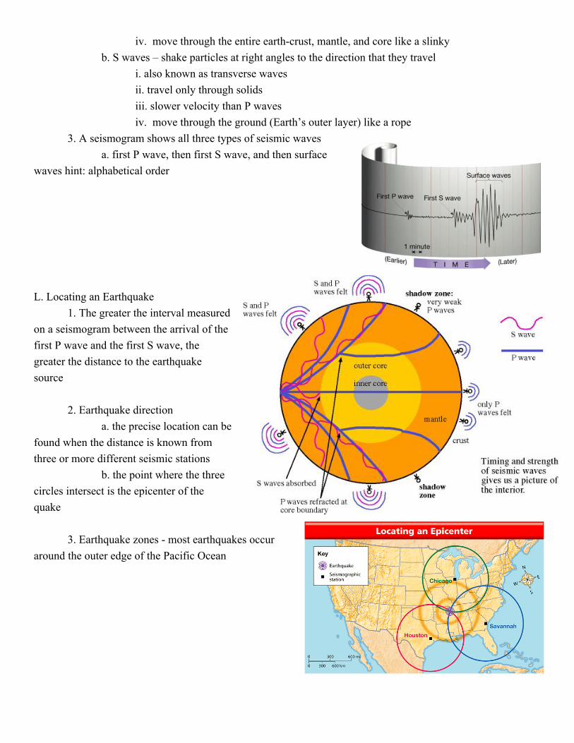
4. Tsunamis a. triggered by an earthquake b. occurs where a slab of the ocean floor is displaced vertically along a fault c. can also occur when the vibration of a quake sets an underwater landslide
into motion d. although tsunamis travel very rapidly, there is sufficient time to evacuate
all but the area closest to the epicenter
Tsunami Warning Center in Honolulu
Volcanoes O. Volcano – an opening in the earth’s crust through which molten lava, ash, and gases are ejected. P. Factors Affecting Eruptions
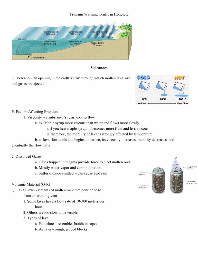
1. Viscosity – a substance’s resistance to flow a. ex. Maple syrup more viscous than water and flows more slowly
i. if you heat maple syrup, it becomes more fluid and less viscous ii. therefore, the mobility of lava is strongly affected by temperature
b. as lava flow cools and begins to harden, its viscosity increases, mobility decreases, and eventually the flow halts
2. Dissolved Gases
a. Gases trapped in magma provide force to eject molten rock b. Mostly water vapor and carbon dioxide c. Sulfur dioxide emitted = can cause acid rain
Volcanic Material (QR) Q. Lava Flows streams of molten rock that pour or ooze
from an erupting vent 1. Some lavas have a flow rate of 10300 meters per
hour 2. Others are too slow to be visible 3. Types of lava
a. Pahoehoe – resembles braids in ropes b. Aa lava – rough, jagged blocks
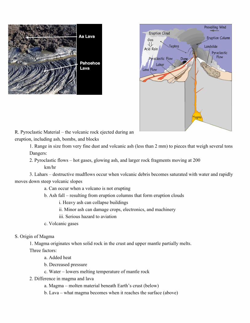
R. Pyroclastic Material – the volcanic rock ejected during an eruption, including ash, bombs, and blocks
1. Range in size from very fine dust and volcanic ash (less than 2 mm) to pieces that weigh several tons Dangers: 2. Pyroclastic flows – hot gases, glowing ash, and larger rock fragments moving at 200
km/hr 3. Lahars – destructive mudflows occur when volcanic debris becomes saturated with water and rapidly
moves down steep volcanic slopes a. Can occur when a volcano is not erupting b. Ash fall – resulting from eruption columns that form eruption clouds
i. Heavy ash can collapse buildings ii. Minor ash can damage crops, electronics, and machinery iii. Serious hazard to aviation
c. Volcanic gases S. Origin of Magma
1. Magma originates when solid rock in the crust and upper mantle partially melts. Three factors:
a. Added heat b. Decreased pressure c. Water – lowers melting temperature of mantle rock
2. Difference in magma and lava a. Magma – molten material beneath Earth’s crust (below) b. Lava – what magma becomes when it reaches the surface (above)
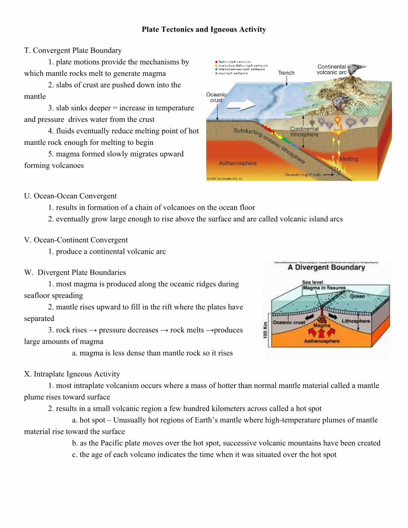
Plate Tectonics and Igneous Activity T. Convergent Plate Boundary
1. plate motions provide the mechanisms by which mantle rocks melt to generate magma
2. slabs of crust are pushed down into the mantle
3. slab sinks deeper = increase in temperature and pressure drives water from the crust
4. fluids eventually reduce melting point of hot mantle rock enough for melting to begin
5. magma formed slowly migrates upward forming volcanoes U. OceanOcean Convergent
1. results in formation of a chain of volcanoes on the ocean floor 2. eventually grow large enough to rise above the surface and are called volcanic island arcs
V. OceanContinent Convergent
1. produce a continental volcanic arc W. Divergent Plate Boundaries
1. most magma is produced along the oceanic ridges during seafloor spreading
2. mantle rises upward to fill in the rift where the plates have separated
3. rock rises → pressure decreases → rock melts →produces large amounts of magma
a. magma is less dense than mantle rock so it rises X. Intraplate Igneous Activity
1. most intraplate volcanism occurs where a mass of hotter than normal mantle material called a mantle plume rises toward surface
2. results in a small volcanic region a few hundred kilometers across called a hot spot a. hot spot – Unusually hot regions of Earth’s mantle where hightemperature plumes of mantle
material rise toward the surface b. as the Pacific plate moves over the hot spot, successive volcanic mountains have been created c. the age of each volcano indicates the time when it was situated over the hot spot