Embed Size (px)
Citation preview


The Integrated Global Observing Strategy (IGOSI is a partnership of international organizations that are
concerned with global environmental change issues. It links research, long-term monitoring and operational
programmes, bringing together the producers of global observations and the users that require them, to identify
products needed, gaps in observations and mechanisms to respond to needs in the science and policy communities.
Its principal objectives are to integrate satellite, airborne and in-situ observation systems.
The IGOS partners are comprised of the Global Observing Systems, the International Organizations which
sponsor the Global Observing Systems, the Committee on Earth Observation Satellites (CEOSl, and International
Global Change Science and Research programmes.
The IGOS Partners recognise that a comprehensive global earth observing system is best achieved through a
step-wise process focused on practical results. The IGOS Themes allow for the definition and development of a
global strategy for the observation of selected environmental issues that are of common interest to the IGOS Partners
and to user groups. The current IGOS Themes include the Oceans, the Carbon cycle, Geohazards, the Water cycle,
and a Coral reef sub-theme.
The IGOS Geohazards theme was initiated in 2001 by the National Oceanic and Atmospheric Administration
(NCAA), the United Nations Educational, Scientific and Cultural Organisation [UNESCO), CEOS and the International
Council for Science Union (ICSU) in Paris. An ad-hoc Working Group was formed, chaired initially by the International
Institute for Geo-lnformation Science and Earth-Observation (ITC) and then by the British Geological Survey (BGS),
and co-chaired by the European Space Agency (ESA) and UNESCO,
The proposal to develop the theme was approved by the IGOS Partners at their 9th Plenary in June 2002 and a
Theme Team was set up. With the support of a community of more than 200 people worldwide who expressed
interest in this initiative, a draft report was submitted to the 10th IGOS Plenary in June 2003. Following an
international peer review during summer 2003, the present Theme report was approved for implementation by the
IGOS Partnership in November 2003.
The IGOS Geohazards Theme was developed under the IGOS Chairmainships of Jose Achache, of ESA, Greg
Withee, of NOAA and Walter Erdelen, of UNESCO.
M Further information on IGOS can be obtained from: http;//www.igospartners.org
M The GeoHazards theme report is available from: http://dup.esrin.esa.it/iqos-geohazards/
M Inquiries about the IGOS Geohazards theme can be sent to: igosOesa.int
Dietrich E. LeihnerIGOS Co-chair
Director, Research, Extension & Training DivisionFood & Agriculture Organization of the UN
viale delle Terme di CaracallaRomeGOlOO Italy
Xu GuanhuaIGOS Co-chair
Minister for Science & Technology
Fuxing road, 15bBeijing 1ÜÜ862 People's Republic of China
H IGOS Geohazards Theme Report 200^

the impact of geological and related geophysical hazards on society is enormous. Every year volcanoes, earth¬
quakes, landslides and subsidence claim thousands of lives, injure thousands more, devastate homes and destroy
livelihoods. Damaged infrastructure and insurance premiums increase these costs. Developed countries are
affected, but the impact is highest in the developing world. As population increases, more people live in hazardous
areas and so the impact grows. The World Summit on Sustainable Development recognised that systematic, jointinternational observations under initiatives like the Integrated Global Observing Strategy form the basis for all nations
to improve their preparations for, and mitigation against, these hazards. In the same context, the IGOS Partners have
developed this geohazards theme. Its goal over the next decade is to integrate disparate, multidisciplinary, and
applied geohazards research into global, operational observation systems by filling gaps in organisation, observation
and knowledge. It has four strategic objectives; building global capacity to mitigate geohazards; improving mapping,
monitoring and forecasting, based on satellite and ground-based observations; increasing preparedness, using inte¬
grated geohazards information products and improved geohazards models; and promoting global take-up of localbest practice in geohazards management.
Citizens need to know a hazard's location, timing, extent, likely behaviour, and duration. It is not yet possible to
give firm answers to most of these questions. This makes crisis response initiatives like the International Charter on
Space and Major Disasters and the United Nations Action Team on Disaster Management harden Gaps remainbetween what is known and the knowledge required to answer these questions, what is observed and what must be
observed to provide the necessary information and current data integration and the integration needed to make trulyuseful information products. The IGOS Geohazards will reduce these gaps and so make the responsible agencies bet¬
ter prepared for managing geohazards. It targets monitoring and advisory agencies, by aiming to improve the hazard
inventories, maps and monitoring tools with which they supply the responsible agencies with information. It also tar¬
gets the research scientists, aiming to help them refine the models that are used to understand geohazard behav¬
iour By building on previous work undertaken by individual IGOS Partners, this approach will ultimately deliver bet¬
ter answers to citizens.
Geohazards driven directly by geological processes all involve ground deformation. Their common observationalrequirements are for global, baseline topographic and geoscience mapping, against which surface deformation and
seismic activity can be monitored. Systems that can meet these requirements include stereo optical and radar inter-ferometry satellites, plus ground-based GPS and seismic networks. Beyond this, specific hazards like volcanoes
require additional observations like temperature. All these observations must be stored in well-managed and acces¬
sible databases. Tools to produce information products through integration, modelling and assimilation must be
developed and documented. Networking, education, training and skills transfer must be undertaken, in order to build
the capacity to use these tools. Critical gaps exist in: the provision of detailed, global topographic data, hazard inven¬
tories and geoscience maps; continuity of the C- and especially L-Band radar interferometry that are needed to
observe surface deformation under varying vegetation cover; density and coverage of local GPS and seismic net¬
works; accessibility of relevant databases; adequacy of models and data integration; and the integration of the geo¬
hazards community.An action plan is proposed that is designed to close these gaps over the next decade. The first step is to create
an implementation mechanism based on UNESCO-International Union of Geological Sciences GeologicalApplications of Remote Sensing (GARS) Programme. The existing geological representation will be blended withspace agency participation and more scientific disciplines from all regions. A bureau funded by the European Space
Agency will support implementation through working groups on capacity building, observations and key systems,
integration and modelling, databases and infrastructure and the underpinning science. Links will be developed withrelevant sub-groups under the new Group for Earth Observation, linked to the Earth Observation Summit process.
Priority actions are to: begin networking within the geohazards community; improve topographic data provision using
existing observations; secure continuity of C- and L-Band radar interferometry with the space agencies; assess the
potential for existing data to be integrated into geohazard products and services; evaluate ways to improve databas¬
es with the agencies that manage them; and promote research that increases geohazards knowledge. The progressagainst this plan will be assessed by a Steering Committee and reported to the IGOS Partners and the sponsoringagencies annually. The strategy will be reviewed and updated every three years.
IGOS Geohazards Theme Report 2004

TABLE OF CONTENT
1. CONTEXT, SCOPE AND STRATEGIC OBJECTIVES
2. BENEFICIAIRES, STAKEHOLDERS AND USER NEEDS12
3. REQUIRED OBSERVATIONS AND KEY SYSTEMS20
U. INTEGRATION ISSUES30
5. FILLING THE GAPS34
6.IMPLEMENTATI0N PLAN AND COMMITMENTS TO ACT42
REFERENCES48
GLOSSARY OF TERMS50
TECHNICAL ACRONYMS AND ABBREVIATIONS51
ORGANIZATIONS, NETWORKS AND PROGRAMMES52
Chapter 1 examines the impact of
geohazards on society, describesthe main operational and politicalresponses, sets out the scope of
the IGOS Geohazards and definesits strategic objectives
Chapter 2 explains who will bene¬
fit from the strategy, introducesthree groups of targeted users,
states their needs for geohazardsinformation and acknowledgesthe roles of other stakeholders
Chapters lists the main observa¬
tions required in order to meetusers' information needs and
identifies the main existing and
planned ¡n-situ, airborne and
satellite observing systems need¬
ed to make them
Chapter 4 addresses data man¬
agement, integration, modelingand assimilation issues and con¬
siders how to build capacity in thegeohazards community by educa¬
tion, training and skills transfer
Chapter 5 analyses the criticalgaps in capacity building, obser¬
vations and key systems, integra¬
tion and modeling, databases and
infrastructure and underpinningscience that must be filled
Chapter 6 defines an implemen¬tation mechanism, presents an
action plan to fill the gaps over the
coming decade, demonstratescommitments to act and proposesan assessment and review cycle
IGOS Geohazards Theme Report 2004
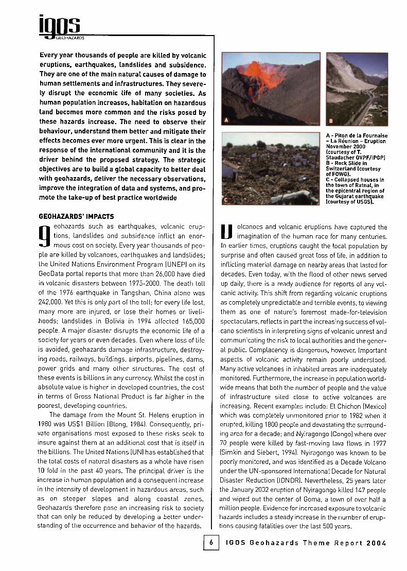
GEOHAZARDS
Every year thousands of people are killed by volcaniceruptions, earthquakes, landslides and subsidence.They are one of the main natural causes of damage tohuman settlements and infrastructures. They severe¬ly disrupt the economic life of many societies. As
human population Increases, habitation on hazardousland becomes more common and the risks posed by
these hazards increase. The need to observe theirbehaviour, understand them better and mitigate theireffects becomes ever more urgent. This is clear in theresponse of the international community and it is thedriver behind the proposed strategy. The strategicobjectives are to build a global capacity to better dealwith geohazards, deliver the necessary observations,improve the integration of data and systems, and pro¬
mote the take-up of best practice worldwide
GEOHAZARDS' IMPACTS
geohazards such as earthquakes, volcanic erup¬
tions, landslides and subsidence inflict an enor¬
mous cost on society. Every year thousands of peo¬
ple are killed by volcanoes, earthquakes and landslides;the United Nations Environment Program (UNEP) on its
GeoData portal reports that more than 26,000 have died
in volcanic disasters between 1975-2000. The death tollof the 1976 earthquake in Tangshan, China alone was
242,000. Yet this is only part of the toll; for every life lost,
many more are injured, or lose their homes or liveli¬
hoods; landslides in Bolivia in 1994 affected 165,000
people. A major disaster disrupts the economic life of a
society for years or even decades. Even where loss of life
is avoided, geohazards damage infrastructure, destroy¬
ing roads, railways, buildings, airports, pipelines, dams,
power grids and many other structures. The cost of
these events is billions in any currency. Whilst the cost in
absolute value is higher in developed countries, the cost
in terms of Gross National Product is far higher in thepoorest, developing countries.
The damage from the Mount St. Helens eruption in
1980 was US$1 Billion (Blong, 1984). Consequently, pri¬
vate organisations most exposed to these risks seek to
insure against them at an additional cost that is itself in
the billions. The United Nations (UN) has established thatthe total costs of natural disasters as a whole have risen
10 fold in the past 40 years. The principal driver is theincrease in human population and a consequent increase
in the intensity of development in hazardous areas, such
as on steeper slopes and along coastal zones.Geohazards therefore pose an increasing risk to societythat can only be reduced by developing a better under¬standing of the occurrence and behavior of the hazards.
A - Piton de la Fournaise- La Réunion - EruptionNovember 2000(courtesy of T.Staudacher OVPF/IPGP)B - Roclc Slide inSwitzerland (courtesyof FOWG).C - Collapsed houses intfie town of Ratnal, inthe epicentral region ofthe Gujarat earthquake(courtesy of USGS).
Uolcanoes and volcanic eruptions have captured the
imagination of the human race for many centuries.
In earlier times, eruptions caught the local population by
surprise and often caused great loss of life, in addition to
inflicting material damage on nearby areas that lasted fordecades. Even today, with the flood of other news served
up daily, there is a ready audience for reports of any vol¬
canic activity This shift from regarding volcanic eruptions
as completely unpredictable and terrible events, to viewing
them as one of nature's foremost made-for-television
spectaculars, reflects in part the increasing success of vol¬
cano scientists in interpreting signs of volcanic unrest and
communicating the risk to local authorities and the gener¬
al public. Complacency is dangerous, however. Important
aspects of volcanic activity remain pooriy understood.
Many active volcanoes in inhabited areas are inadequately
monitored. Furthermore, the increase in population world¬
wide means that both the number of people and the value
of infrastructure sited close to active volcanoes are
increasing. Recent examples include: El Chichón [Mexico)
which was completely unmonitored prior to 1982 when it
erupted, killing 1800 people and devastating the surround¬
ing area for a decade; and Nyiragongo (Congo) where over
70 people were killed by fast-moving lava flows in 1977
(Simkin and Siebert, 1994). Nyiragongo was known to be
poorly monitored, and was identified as a Decade Volcano
under the UN-sponsored International Decade for Natural
Disaster Reduction (IDNDR). Nevertheless, 25 years laterthe January 2002 eruption of Nyiragongo killed 147 people
and wiped out the center of Goma, a town of over half a
million people. Evidence for increased exposure to volcanichazards includes a steady increase in the number of erup¬
tions causing fatalities over the last 500 years.
IGOS Geohazards Theme Report 2004
200
ISO
100
50
O
-Fatal Eruptio
by centuryns
14th 15th 161h 17lh leth 19th 20lh
300,000-
250.000 -
200,000 -
150,000 -
100,000-
50,000-
0-
Cumulative Fatalities(since 0 AD)
Unzen 1792
Lakl1783ÍK6lut15B6 JT
i^ -^--"-^ 1 ' ' ' ' 1
Truíz 1985
J Pelee 1902
1 Krakatau 1883
Tambora 1815
1
O 1600 1700 1800
Year1900 2000
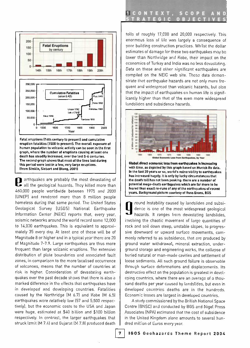
Fatal eruptions (Uth century to present) and cumulativeeruption fatalities (1500 to present). The overall exposure ofhuman population to volcanic activity can be seen in the firstgraph, where the number of eruptions causing at least onedeath has steadily increased, over the last 5-6 centuries.The second graph shows that most of the lives lost duringthis period were lost in a few, very large eruptions,(from Simkin, Siebert and Blong. 2001)
earthquakes are probably the most devastating of
all the geological hazards. They killed more than
460,000 people worldwide between 1975 and 2000
(UNEP) and rendered more than 8 million people
homeless during that same period. The United States
Geological Survey (USGS) National EarthquakeInformation Center (NEIC) reports that, every year,
seismic networks around the world record some 12,000
to 14,000 earthquakes. This is equivalent to approxi¬
mately 35 every day. At least one of these will be of
Magnitude 8 or higher and in a typical year there are 20
of Magnitude 7-7.9. Large earthquakes are thus morefrequent than large volcanic eruptions. The extensive
distribution of plate boundaries and associated faultzones, in comparison to the more localised occurrenceof volcanoes, means that the number of countries at
risk is highen Consideration of devastating earth¬quakes over the past decade shows that there is also a
marked difference in the effects that earthquakes have
in developed and developing countries. Fatalitiescaused by the Northridge (M 6.7) and Kobe (M 6.5)
earthquakes were relatively low (57 and 5,500 respec¬
tively), but the economic costs to the USA and Japan
were huge, estimated at $40 billion and $100 billionrespectively. In contrast, the larger earthquakes thatstruck Izmit (M 7.4) and Gujarat (M 7.8) produced death
tolls of roughly 17,000 and 20,000 respectively. This
enormous loss of life was largely a consequence of
poor building construction practices. Whilst the dollarestimates of damage for these two earthquakes may be
lower than Northridge and Kobe, their impact on the
economies of Turkey and India was no less devastating.
Data on these and other significant earthquakes are
compiled on the NEIC web site. These data demon¬
strate that earthquake hazards are not only more fre¬
quent and widespread than volcanic hazards, but also
that the impact of earthquakes on human life is signif¬
icantly higher than that of the even more widespreadlandslides and subsidence hazards.
Global direct economic loss from earthquakes Is Increasingwith time, as depicted by this graph based on Munich Re data.In the last 20 years or so. world's vulnerability to earthquakeshas increased hugely. It is only by lucky circumstances thatthe death toll has not been peaking: there are a number ofpotential mega-death earthquakes which are far more to befeared than exact re-runs of any of the earthquakes of recentyears. Background picture courtesy of Russ Evans. BGS
g
H
round Instability caused by landslides and subsi¬
dence is one of the most widespread geologicalhazards. It ranges from devastating landslides,
involving the chaotic movement of large quantities of
rock and soil down steep, unstable slopes, to progres¬
sive downward or upward surface movements, com¬
monly referred to as subsidence, that are produced by
ground water withdrawal, mineral extraction, under¬
ground storage and engineering works, the collapse of
buried natural or man-made cavities and settlement of
loose sediments. All such ground failure is observable
through surface deformations and displacements. Its
destructive effect on the population is greatest in devel¬
oping countries, where there are an average of a thou¬
sand deaths per year caused by landslides, but even in
developed countries deaths are in the hundreds.Economic losses are largest in developed countries.
A study commissioned by the British National Space
Centre (BNSC) and conducted by BGS and Nigel Press
Associates (NPA) estimated that the cost of subsidencein the United Kingdom alone amounts to several hun¬
dred million of Euros every yean
IGOS Geohazards Theme Report 2004
GEOHAZARDS
12
i '
'II
I
10
LULL imilll I
1200 1300 1400 1900 ISOO 1700 MOÜ 1900 2000
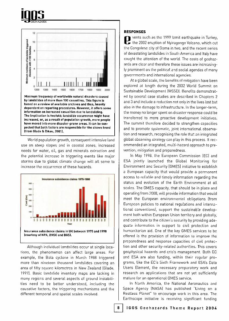
Mínimum frequency of worldwide natural disasters causedby landslides of more than 100 casualties. This figure isbased on a review of available archives and thus, heavilydependent on reporting procedures. However, it offers someinformation on increased casualties due to landsliding.The implication is twofold: landslide occurrence might haveincreased, or, as a result of population growth, more peoplehave moved into more disaster-prone areas. It can be sus¬pected that both factors are responsible for the shown trend(from Glade & Dikau. 2001).
World population growth, consequent intensive land
use on steep slopes and in coastal zones, increased
needs for water, oil, gas and minerals extraction and
the potential increase in triggering events like majorstorms due to global climate change will all serve to
increase the occurrence of these hazards.
Inturwict *ubtld*nc* cl«lmi ItTS-lOW
imî
l-^-MBB imiHi M n I > i ! I ! ! I ! ! I i ! I I f f Í !
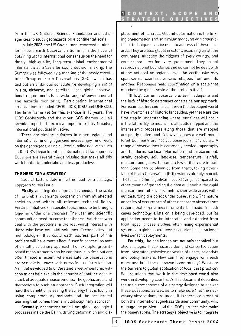
Insurance subsidence claims in UK between 1975 and 1998(courtesy of ^PA. BNSC and BGS).
Although individual landslides occur at single loca¬
tions, the phenomenon can affect large areas. For
example, the Bola cyclone in March 1988 triggeredmore than nineteen thousand landslides covering an
area of fifty square kilometres in New Zealand (Glade,
1997). Basic landslide inventory maps are lacking in
many regions and several aspects of ground instabili¬ties need to be better understood, including thecausative factors, the triggering mechanisms and thedifferent temporal and spatial scales involved.
RESPONSES
B vents such as the 1999 Izmit earthquake in Turkey,
the 2002 eruption of Nyiragongo Volcano, which cut
the Congolese city of Goma in two, and the recent series
of devastating landslides in South America and Italy have
caught the attention of the world. The costs of geohaz¬
ards are clear and therefore these issues are increasing¬
ly prominent on the political and social agendas of many
governments and international agencies.
At a global scale, the benefits of mitigation have been
explored at length during the 2002 World Summit on
Sustainable Development (WSSD). Benefits demonstrat¬
ed by several case studies are described in Chapters 2
and 3 and include a reduction not only in the lives lost but
also in the damage to infrastructure. In the longer-term,the money no longer spent on disaster response could be
transferred to more proactive development initiatives.
The summit therefore decided to strengthen capacities
and to promote systematic, joint international observa¬
tion and research, recognising the role that an integrated
global observing strategy can play in this process. It rec¬
ommended an integrated, multi-hazard approach to pre¬
vention, mitigation and preparedness.
In May 1998, the European Commission (EC) and
ESA jointly launched the Global Monitoring forEnvironment and Security (GMES) initiative to establisha European capacity that would provide a permanentaccess to reliable and timely information regarding the
status and evolution of the Earth Environment at allscales. The GMES capacity, that should be in place and
operating from 2008, will provide information that wouldmeet the European environmental obligations (from
European policies to national regulations and interna¬
tional conventions), support the sustainable develop¬
ment both within European Union territory and globally,
and contribute to the citizen's security by providing ade¬
quate information in support to civil protection and
humanitarian aid. One of the key GMES services to be
offered is the provision of information to improve the
preparedness and response capacities of civil protec¬
tion and other security-related authorities. This covers
geophysical hazards and crisis management. Both EC
and ESA are also funding, within their regular pro¬
grams, like the EC's Sixth Framework and ESA's Data
Users Element, the necessary preparatory work and
research on applications that are not yet sufficientlymature for an operational GMES service.
In North America, the National Aeronautics and
Space Agency (NASA) has published "Living on a
Restless Planet" to encourage work in this area. The
Earthscope initiative is receiving significant funding
IGOS Geohazards Theme Report 2004
from the US National Science Foundation and otheragencies to study geohazards on a continental scale.
In July 2003, the US Government convened a minis¬
terial-level Earth Observation Summit in the hope of
obtaining broad international consensus on the need fortimely, high-quality, long-term global environmentalinformation as a basis for sound decision making. The
Summit was followed by a meeting of the newly consti¬
tuted Group on Earth Observations (GEO), which has
laid out an ambitious schedule for developing a set of
in-situ, airborne, and satellite-based global observa¬
tional requirements for a wide range of environmentaland hazards monitoring. Participating internationalorganizations included CEOS, IGOS, ICSU and UNESCO.
The time frame set for this exercise is 10 years. The
IGOS Geohazards and the other IGOS themes will allprovide important technical input into this broader,
international political initiative.There are similar initiatives in other regions and
international funding agencies increasingly fund workon the geohazards, as do nationalfunding agencies such
as the UK's Department for International Development,
But there are several things missing that make all thiswork harder to undertake and less productive.
THE NEED FOR A STRATEGY
Several factors determine the need for a strategicapproach to this issue.
Firstly, an integrated approach is needed. The scale
of the problem demands cooperation from all affected
societies and within all relevant technical fields.Existing initiatives on specific topics need to be broughttogether under one umbrella. The user and scientificcommunities need to come together so that those who
deal with the problems in the real world interact withthose who have potential solutions. Technologies and
methodologies that could each address part of the
problem will have more effect if used in concert, as partof a multidisciplinary approach. For example, ground-based measurements can be continuous in time but are
often limited in extent, whereas satellite observationsare periodic but cover wide areas in a uniform fashion.A model developed to understand a well-monitored vol¬
cano might help explain the behavior of another, despite
a lack of adequate measurements. The geohazards lend
themselves to such an approach. Such integration willhave the benefit of releasing the synergy that is found ¡n
using complementary methods and the acceleratedlearning that comes from a multidisciplinary approach.
Secondly, geohazards arise from global geologicalprocesses inside the Earth, driving deformation and dis-
1 CONTEXT, SCOPE AND^1ytB^ÍÍta^HÉab^&a¿ÍMÍíbJla^JÍ&
placement of its crust. Ground deformation is the link¬
ing phenomenon and so similar modeling and observa¬
tional techniques can be used to address all these haz¬
ards. They are also global in extent, occurring on all the
continents, affecting the citizens of every country, and
causing problems for every government. They do not
respect national boundaries and so cannot be dealt withat the national or regional level. An earthquake may
span several countries or send refugees from one into
another Responses need coordination on a scale thatmatches the global scale of the problem itself.
Thirdly, current observations are inadequate and
the lack of historic databases constrains our approach.
For example, few countries in even the developed worldhave inventories of historic landslides, yet these are the
first step in understanding where landslides will occurin the future. By no means are all faults mapped and the
interseismic processes along those that are mapped
are poorly understood. A few volcanoes are well moni¬
tored but many are not yet observed in any detail. A
range of observations is commonly needed: topographyand landform, surface deformation and displacement,strain, geology, soil, land-use, temperature, rainfall,moisture and gases, to name a few of the more impor¬
tant. Some can be observed from space, taking advan¬
tage of Earth Observation (EG) systems already in orbit.
These can offer significant cost-savings compared to
other means of gathering the data and enable the rapid
measurement of key parameters over wide areas with¬
out disturbing the object under observation. The nature
or scales of occurrence of other necessary observations
require that ¡n-situ measurements be made. In both
cases technology exists or is being developed, but its
application needs to be integrated and extended fromlocal, specific case studies, often using experimentalsystems, to global operational scenarios based on long-lived sensor deployments.
Fourthly, the challenges are not only technical but
also strategic. These hazards demand concerted actionfrom integrated, cohesive networks of users, scientistsand policy makers. How can they engage with each
other and build the geohazards community? What are
the barriers to global application of local best practice?
Will solutions that work in the developed world also
work in developing countries? This document describesthe main components of a strategy designed to answerthese questions, as well as to make sure that the nec¬
essary observations are made. It is therefore aimed at
both the international geohazards user community, who
manage the problem, and the IGOS partners, who makethe observations. The strategy's objective is to integrate
H IGOS Geohazards Theme Report 2004

GEOHAZARDS
dispersed, multidisciplinary and applied research into
future cohesive, operational systems by filling observa¬
tional, organizational and knowledge gaps over the next
decade. The benefits will include: maximising returnson investments made by international agencies,through optimised use of the resulting observations;linkage of established ¡n-situ monitoring systems withnew satellite-based techniques; coordination of activi¬
ties and observations; and the development of a coher¬
ent, well informed global geohazards community to
address the underlying issues.
These missing pieces of the jigsaw can best be pro¬
vided not through an isolated approach for the geohaz¬
ards, but rather through developing a place for geohaz¬
ards in the Integrated Global Observing Strategy. The
IGOS Partnership brings together the key internationalagencies that make and use global observations, eitherfrom space or on the ground. It provides a coordinationmechanism to support the integration of these observa¬
tions, as well as the communities that work with them.Its long-term aim is to put in place all the pieces nec¬
essary for the IGOS to become a reality. It is the ¡deal
framework within which to address the deficiencies in
current approaches to the geohazards issue, avoiding
overlap but ensuring that the key gaps are filled.
CONTEXT AND SCOPE
for the strategy to be capable of implementation, it is
necessary to set out clearly the scope of this IGOS
theme, defining its place alongside other initiatives.The UN's now completed IDNDR, culminated in the cur¬
rent International Strategy for Disaster Reduction(ISDR). The ISDR forms a framework for action, to whichthis proposal is intended to respond. The starting point
for the necessary technical development is the work of
the CEOS Disaster Management Support Group
(DMSG), on whose foundations this strategy builds and
whose members helped write it. That group has consid¬
ered a range of natural disasters and documentedappropriate responses to them, especially in terms of
EO data. This strategy takes forward a coherent subset
of CEOS DMSG recommendations covering the geohaz¬
ards specifically - volcanoes, earthquakes, landslidesand subsidence - leaving floods, fire, ice and oil spills to
other initiatives. This strategy's scope has been tightlydefined in this way in order to provide a unique, coher¬
ent IGOS theme on geological and geophysical hazards.Defining the scope so tightly leaves aside some impor¬tant hazards that are, in part, related to geology. These
will be addressed through cooperation with other IGOS
themes. The complex interaction of earthquakes, sub-
10
marine landslides and the ocean that producestsunamis is an area of potential cooperation with the
Ocean theme. Flooding is influenced by geology and is
an area for future collaboration with the Water Cycle
theme. Volcanic ash clouds can form the basis for dis¬
cussions with the Atmospheric Chemistry theme.
What provides the theme's cohesion? Each geohaz¬
ard is a response to a specific set of geological and envi¬
ronmental conditions, but there is a common Earth sys¬
tem process linking all such geological and geophysicalhazards: deformation and displacement of the Earth's
crust. This means that similar observational and mod¬
eling techniques can be used to address all three geo¬
hazards. The strategy aims to strike a balance between
the many common aspects of the geohazards that make
this a coherent theme and individual characteristicsthat are also important. This is achieved by consideringthe user needs for each geohazards separately in
Chapter 2 before drawing out the common observation¬
al requirements in Chapter 3. The strategy then places
most emphasis on the common needs, whilst allowingthe specific needs of a particular hazard to be
addressed wherever necessary.
The scope must also be limited in terms of the type
of response to these hazards. Disaster managementand damage assessment are already being addressed
by initiatives such as the UN Action Team on Disaster
Management and the International Charter on Space
and Major Disasters. The UN Action Team is tasked withimplementing, through international cooperation, an
integrated global system to manage natural disastermitigation, relief and prevention efforts through EO and
other space-related services, making maximum use of
existing capabilities and filling gaps to provide world¬
wide coverage. The International Charter aims to pro¬
vide a unified system of space data acquisition and
delivery for users affected by disasters, to promotecooperation between space agencies and space systemoperators and to allow their participation in the organi¬
zation of emergency assistance. When a disasteroccurs, a participating end-user activates the Charter.
Earth observation data are then provided by a partici¬
pating space agency, and often enhanced by a value
adding company, to produce a useful information prod¬
uct ready for disaster management activities. Both theCharter and the Action Team cover a wide range of dis¬
asters and, in practice, they emphasise the disasterresponse element. In contrast, the IGOS Geohazards is
restricted to geological hazards and emphasises thepreparedness element.
The strategy proposed here is to develop close links
IGOS Geohazards Theme Report 2004
with all these complementary initiatives through cross-
membership and only cover in detail those activitieswhere there is a unique gap that needs addressing. This
means that the focus of the geohazards theme is on dis¬
aster preparedness, rather than post-event response. It
includes work such as assessing the spatial and tempo¬
ral distribution of these hazards, expanding the means of
monitoring them, improving data management and
developing better models, so as to produce more com¬
prehensive management plans, information and reportsin support of improved mitigation. The aim of these
processes is to improve our capability to forecast the haz¬
ard's behavior and ultimately to predict their occurrence
reliably Within this scope, these developments will make
an underpinning contribution to crisis response through
the related initiatives, for example resulting in productsthat form a starting point for damage mapping. Similarly,
the strategy does not address risk directly. Risk is a
measure not just of the location, magnitude and frequen¬
cy of a hazard but also of the value and vulnerability of
elements, such as population or infrastructure, that are
exposed to it. Its assessment therefore requires a con¬
sideration not just of the hazard itself but also of the
value of economic activity and infrastructure, as well as
their vulnerability and society's perception of its ability to
cope with exposure to the hazard. To illustrate the point,
a volcano on Mars may be hazardous and yet pose no riskto someone on the Earth. Because of these needs for dif¬
ferent types of information, an entirely different commu¬
nity carries out this type of assessment. Nevertheless,
the information products arising from the IGOS
Geohazards will form an input to such risk assessment
procedures, by characterising the hazard that con¬
tributes to the creation of the risk.
GOAL AND STRATEGIC OBJECTIVES
despite much valuable work being done throughexisting initiatives, there is still a lack of integration,key observations are not widely available, approach¬
es are often local rather than global in scale and there is
no overarching framework to pull all these initiatives in
the same direction. This means that the geohazardscommunity, the observations made to manage geohaz¬
ards and the science needed to understand them are
still in a transitional state between research and opera¬
tions. The goal of the IGOS Geohazards is therefore to
integrate disparate, multidisciplinary, applied research
into global, operational systems by filling gaps in organ¬
ization, observation and knowledge over the next
decade. In order to achieve this, the IGOS GeohazardsTheme has the following four strategic objectives:
1 CONTEXT, SCOPE ANDS 1.AJÍ TEG''
> Building capacity: engage and build the global geo¬
hazards community, so as to achieve the best from
the human as well as the technological resources
available to address the geohazards, ensuring thatusers needs are fully explored, understood, docu¬
mented and acted on;
> Observations: put in place systems to deliver reli¬
able, cost-effective and sustainable satellite and
ground-based observations that make best use of
existing tools, help define and take advantage of
emerging technologies and meet the observational
needs of the geohazards user community globally;
> Integration: ensure that end users and scientistswork together to define information needs, extractthe maximum value from existing, planned and
future observations by using EO and ground-based
systems in concert, and develop GeographicInformation Systems (GIS) and modeling technolo¬
gies that integrate these data into geohazards infor¬
mation products that meet the stated needs; and
> Promotion: develop education, sharing of data and
information, knowledge and know-how, global data¬
bases and networks, and knowledge and skillstrensfer to the developing world, thereby increasing
the capacity of all countries to manage risk related
to geohazards.
The strategy's impact will be judged not only by
how many new satellites result but also by the degree
of technical integration achieved and by the extent to
which the more intangible human elements are put in
place. The benefits may be hard to predict but the
costs of not acting are clean It is salutary to examinethe benefits derived from over three decades of globalocean observations. In addition to all the obvious ben¬
efits related to navigation and other marine opera¬
tions, this investment has delivered major scientificadvances such as the measurement and understand¬ing of El-Nirio. These advances in knowledge have
transformed our understanding of how the oceans
work in such a way, and with such benefits, that couldnot have been foreseen during the initial phase of
investment. The IGOS Geohazards has hopes that theprovision of long-term continuity in geohazard obser¬
vations will have a similar impact, perhaps ultimatelyeven in terms of prediction. The impact must thereforebe sought in the statistics associated with the phe¬
nomenon. If the hazard has been mitigated and, betterstill, one day predicted reliably, the risk will have been
reduced, fewer lives will be lost and the money saved
will be flowing to aspects of global development
0 IGOS Geohazards Theme Report 2004
GEOHAZARDS
The starting point for this IGOS Geohazards is to iden¬
tify those who will benefit from the strategy, its mainusers, and other stakeholders with significant roles toplay. The ultimate beneficiaries are the citizensaffected by the hazards, who want to know what willhappen, where, when, how and for how long.Responsible authorities need information about geo¬
hazards in order to attempt to answer these ques¬
tions. Monitoring services and information providersneed basic observations to integrate into useful infor¬mation products that address these issues. Thisprocess is based on current understanding, butresearchers need the same data in order to increaseour knowledge about how these hazards behave. Allthese users therefore depend on the agencies makingthe critical observations and each have needs that thestrategy must address. The IGOS Geohazards aims todo this by meeting the common needs of the threespecified users in particular; for geohazard invento¬
ries, monitoring and rapid information supply, allbased on improved geohazard knowledge.
THE USER COMMUNITY
fhe populations affected by geohazards globally willbe the ultimate beneficiaries of this strategy. More
accessible, improved and where possible standard¬
ized geohazards information will improve both the citi¬
zen's preparedness for such hazards and the effective¬
ness of society as a whole in responding to major dis¬
asters. However, these ultimate beneficiaries will not
be instrumental in developing and delivering that infor¬
mation or in deciding how to act upon it. The criticalusers specifically targeted by this strategy are thosewho will do that as part of their professional duties, on
behalf of the public at large. These users of geohazardsinformation and observations fall into three distinctclasses, according to their different roles and conse¬
quent needs, as described below. They would all bene¬
fit from a successful IGOS Geohazards. Other stake¬
holders include those who provide observationsrequired by these users, as well as those concernedwith information dissemination.
The first group of end-users is the ResponsibleAuthorities. They are responding to the social needsset out in Chapter 1 and are the primary consumers of
geohazard information. The responsible authoritiesuse information to manage the geohazards on a day-to-day basis, to issue public alerts and to make ongo¬
ing assessments of evolving hazards. The groupincludes a wide range of government officials at the
12
national, regional or local level. It includes elected
officials and representatives, emergency managers,police and fire officials, civil defense or military per¬
sonnel, staff of Non Governmental Organizations and
land use planners. The role of this group is crucial to
the successful mitigation of loss of life and property.
They decide when, and where, to evacuate threatenedareas and provide shelter, food, and water for the dis¬
placed population. In addition, these bodies interactwith a range of other end-users that include insurancecompanies, engineering and construction companies,mining and exploration companies, and infrastructureoperators in the public and private sectors as appro¬
priate. All these users generally need derived informa¬
tion products rather than the raw data on which they
are based. They are interested in the long-term identi¬
fication of geohazards, to support their role in long-term hazard mitigation through their control of, influ¬
ence on or implementation of land-use planning deci¬
sions. But in the short term they need informationfrom high frequency observations, delivered in "nearreal time" whenever a hazard threatens to become a
disaster. Their needs have led to the development ofthose monitoring systems that exist today.
The second group of critical users consists of
Scientists in Monitoring and Advisory Agencies.These vital, intermediary users provide the primaryinformation products that support the decisionsmade by the responsible authorities. The groupincludes scientists who are directly responsible formonitoring specific geohazards in the long term, forsynthesising the available data into information and
for providing continuously updated assessments of
the phenomenon monitored and the hazards it poses,
so long as the activity continues. These scientists are
found in governmental agencies such as geologicalsurveys, running seismic networks and staffing vol¬
cano observatories. They have a mandate to monitora specific type of geohazard, often within a definedgeographic area, and are responsible for the mainte¬nance of monitoring devices making in-situ observa¬
tions. This group uses and integrates data daily and is
the contact point with the local civil authorities dur¬
ing a geohazards-related emergency. During emer¬gencies they provide interpretations and recommen¬dations directly to those authorities. They may alsowork with key specialists in the private sector whohave an expertise in the production of certain types ofvalue added products. At the same time, they maycarry out research, especially when the hazard they
IGOS Geohazards Theme Report 2004
monitor is less active, and pursue long-term mitiga¬
tion as well as short-term crisis response.
The third group of critical users comprisesResearch Scientists doing research that may improveour understanding of the geohazard, ability to mitigateits effects and capacity to forecast events. Research
into geohazards is usually pertormed in universitiesand large public laboratories, but some is conducted
by private sector organizations. There is often overlapwith the second group, who typically apply researchfindings as they emerge and provide feedback on theireffectiveness on the ground. The key difference is thatresearchers do not normally have a specific mandatefor studying, analysing or monitoring the geohazards.Their host institutions rarely run operational monitor¬
ing networks providing information on a daily basis.
Consequently, there is a real difference between the
basic research done by this group, and the continuousmonitoring and synthesis performed by their col¬
leagues in the monitoring and advisory agencies. Thisleads to somewhat different needs and perspectives,but the two groups are close enough that scientistsmay move between them several times over thecourse of their careers.
Beyond the immediate user community there are
other important stakeholders to consider The supplyof basic Earth Science data is critical to all users.
Agencies and commercial operators that collect and
distribute EO imagery of the earth's surface, or thatenable data collection from airborne and in-situ plat¬
forms, or that provide communications facilities allhave a role to play. Organizations that provide and
support facilities for operational monitoring and
research campaigns on geohazards are a vital part¬
ner International groups, especially the IGOS
Partners who will support and oversee the implemen¬tation of this strategy, play an important integratingrole. A priority for the IGOS Geohazards will be to sug¬
gest ways for the satellite agencies to facilitate moreeffective transfer and continuity of in-situ and space-borne data to the scientists monitoring and research¬
ing individual geohazards.
Finally, the media are an important player, having a
strong influence on successful responses to events.
They convey the messages, alerts and reports, but are
not truly users of the information. Their most criticalrole is to relay the decisions of the emergency man¬
agers and decision makers in responsible agencies to
the population at risk. The media also transmit infor¬
mation from monitoring and advisory agencies to the
public. The first two user groups must communicate
directly with each other, and coordinate their messages,
so that information released to the public through the
media is clear and consistent. The article on
"Professional conduct of scientists during volcaniccrises" (lAVCEl, 1999) provides an excellent overview of
this process and other communication issues that ariseduring volcanic crises. There are educational aspects to
geological hazards that also require the authorities, sci¬
entists in the monitoring agencies, and researchers to
speak to the public with one voice.
NEEDS FOR INFORMATION
(here is a common set of questions to which all ben¬
eficiaries, users and stakeholders need answers:
the most important are what will happen, where,
when, how and what will be the duration and the extent
of the affected area. The answers vary depending on
the user's category and on the type of geohazard and
may imply very different time-scales. Unfortunately, it
is not possible to give firm answers to most of these
questions. The gaps, between what is known and the
knowledge required to answer these questions, fromwhat is observed to what must be observed to provide
the information, in how well data are integrated com¬
pared to the degree of integration needed to make
appropriate information products, remain large. The
purpose of the IGOS Geohazards is to close that gap by
making the best possible use of all available informa¬
tion and by defining clearly the extra information that is
required. Users' needs within each of the three maip
categories of geohazard are analysed in the followingsections, but common needs fall into three main cate¬
gories: an inventory of the hazard to provide a baseline;
ongoing monitoring of change against that baseline;and rapid supply of information during a crisis.
13 IGOS Geohazards Theme Report 2004
GEOHAZARDS
VOLCANIC HAZARDS
m hat the various users need in detail is dictatedby the nature of volcanoes and volcanic erup¬
tions. Key features peculiar to volcanic unrest and
activity are that:1 Scientists know where the problematic volcanoes
are. Volcanoes usually give some warning of
impending eruptions, the signals of which are
detectable if appropriate monitoring is occurring.This contrasts with earthquakes and landslides,where detailed location and times of events can not
be predicted.
2 The basic technique for minimising loss of life and
property is to move out of the way, or to build out of
reach of the volcano. There are no foreseeable
advances in technology that will change this: it is
not possible to prevent a volcanic eruption from
happening and large eruptions are sufficiently rare
that it is difficult to anticipate their consequences.
3 Volcanic hazards vary from one volcano to anotherand from one eruption to the next. The big killersare pyroclastic flows, lahars, and tsunamis trig¬
gered by volcanic eruptions (Blong, 1984). The mostfrequent lethal events are tephra explosions (Simkin
and other, 2001). The longest-lasting damage is
usually inflicted by thick lava flows or major col¬
lapses of volcanic edifices, as at Mt. St. Helens in
1980.
4 Eruptions leave traces in the geologic record, allow¬
ing reconstruction of the eruptive history (frequency,
type of eruption, size of eruptions, ages of eruptions)of a volcano. This gives some indication of what the
next eruption at a given volcano will be like.
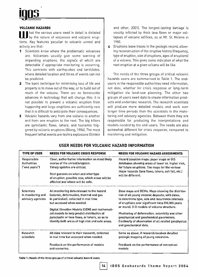
The needs of the three groups of critical volcanichazards users are summarised in Table 1. The end-users in the responsible authorities need information,not data, whether for crisis response or long-termmitigation via land-use planning. The other twogroups of users need data to create information prod¬
ucts and undertake research. The research scientistswill produce more detailed models and work over
longer time periods than the scientists in the moni¬
toring and advisory agencies. Between them they are
responsible for producing the interpretations and
models needed by the end-users. The needs are also
somewhat different for crisis response, compared to
monitoring and mitigation.
USER NEEDS FOR VOLCANIC HAZARD INFORMATION
TYPE OF USER
ResponsibleAuthorities("end users")
NEEDS FOR VOLCANIC CRISIS RESPONSE
Clear, authoritative information on most likelycourse of the unrest/eruption.Timely updates are critical.
Best guesses on when and what typeof eruption, possible size, which areas will be
affected and where will be safe.
Scientists All monitoring data relevant to the hazardin monitoring and (seismic, deformation, thermal and gasadvisory agencies in particular), collected in real time
but accessed when needed.
Digital Elevation Models (DEM) and mathemati¬cal models to help predict distribution ofpyroclastic or lava flows, or lahars, so as toidentify both areas of high risk and safe areas.
Researchscientists
All data relevant to their research, collectedin real time but accessed when needed.
Feedback on the performance of modelsand scenarios.
NEEDS FOR VOLCANIC HAZARD ASSESSMENTS
Hazard zonation maps: paper maps or GIS
databases showing areas of lower vs. higher risk,for future eruptions. The maps for the variousmajor hazards (lava flows, lahars, ash fall, etc.)will be different.
Base maps and DEMs. Maps showing the distribu¬tion of all young volcanic deposits, with dates,to determine type, size and recurrence intervalsof eruptions over significant time (10,000 yearsor more). 3-D models of volcano structure.
Monitoring of deformation, seismicity and othergeophysical and geochemical parameters.Continuity of observation of all related geophysicaland geochemical data.
Same as above, if research involves detailedgeologic mapping of young volcanoes.
Feedback on the performance of conceptualmodels
Table 1 : Needs of the three groups of critical volcanic hazard users
14 IGOS Geohazards Theme Report 2004
GEOHAZARDS
VOLCANIC HAZARDS
m hat the various users need in detail is dictatedby the nature of volcanoes and volcanic erup¬
tions. Key features peculiar to volcanic unrest and
activity are that:1 Scientists know where the problematic volcanoes
are. Volcanoes usually give some warning of
impending eruptions, the signals of which are
detectable if appropriate monitoring is occurring.This contrasts with earthquakes and landslides,where detailed location and times of events can not
be predicted.
2 The basic technique for minimising loss of life and
property is to move out of the way, or to build out of
reach of the volcano. There are no foreseeable
advances in technology that will change this: it is
not possible to prevent a volcanic eruption from
happening and large eruptions are sufficiently rare
that it is difficult to anticipate their consequences.
3 Volcanic hazards vary from one volcano to anotherand from one eruption to the next. The big killersare pyroclastic flows, lahars, and tsunamis trig¬
gered by volcanic eruptions (Blong, 1984). The mostfrequent lethal events are tephra explosions (Simkin
and other, 2001). The longest-lasting damage is
usually inflicted by thick lava flows or major col¬
lapses of volcanic edifices, as at Mt. St. Helens in
1980.
4 Eruptions leave traces in the geologic record, allow¬
ing reconstruction of the eruptive history (frequency,
type of eruption, size of eruptions, ages of eruptions)of a volcano. This gives some indication of what the
next eruption at a given volcano will be like.
The needs of the three groups of critical volcanichazards users are summarised in Table 1. The end-users in the responsible authorities need information,not data, whether for crisis response or long-termmitigation via land-use planning. The other twogroups of users need data to create information prod¬
ucts and undertake research. The research scientistswill produce more detailed models and work over
longer time periods than the scientists in the moni¬
toring and advisory agencies. Between them they are
responsible for producing the interpretations and
models needed by the end-users. The needs are also
somewhat different for crisis response, compared to
monitoring and mitigation.
USER NEEDS FOR VOLCANIC HAZARD INFORMATION
TYPE OF USER
ResponsibleAuthorities("end users")
NEEDS FOR VOLCANIC CRISIS RESPONSE
Clear, authoritative information on most likelycourse of the unrest/eruption.Timely updates are critical.
Best guesses on when and what typeof eruption, possible size, which areas will be
affected and where will be safe.
Scientists All monitoring data relevant to the hazardin monitoring and (seismic, deformation, thermal and gasadvisory agencies in particular), collected in real time
but accessed when needed.
Digital Elevation Models (DEM) and mathemati¬cal models to help predict distribution ofpyroclastic or lava flows, or lahars, so as toidentify both areas of high risk and safe areas.
Researchscientists
All data relevant to their research, collectedin real time but accessed when needed.
Feedback on the performance of modelsand scenarios.
NEEDS FOR VOLCANIC HAZARD ASSESSMENTS
Hazard zonation maps: paper maps or GIS
databases showing areas of lower vs. higher risk,for future eruptions. The maps for the variousmajor hazards (lava flows, lahars, ash fall, etc.)will be different.
Base maps and DEMs. Maps showing the distribu¬tion of all young volcanic deposits, with dates,to determine type, size and recurrence intervalsof eruptions over significant time (10,000 yearsor more). 3-D models of volcano structure.
Monitoring of deformation, seismicity and othergeophysical and geochemical parameters.Continuity of observation of all related geophysicaland geochemical data.
Same as above, if research involves detailedgeologic mapping of young volcanoes.
Feedback on the performance of conceptualmodels
Table 1 : Needs of the three groups of critical volcanic hazard users
14 IGOS Geohazards Theme Report 2004
2 BENEFICIARIES, STAKEHOLDERSAND USERS NEEDS
III hen volcanic unrest or an eruption occurs, the civil
ULI authorities need clear information and interpreta¬
tions of all aspects of the activity that are relevant to the
hazard and risk assessments being presented and can be
detected by the local populace. This includes reports of feltearthquakes, visible ground crocking, detectable changes
in emissions of S02, and so on. Even where there is no
immediate risk of an eruption, if people can see signs of
unrest for themselves, the local authorities need to under¬
stand the situation well enough to reassure the public. The
stream of information needs to be continuously updated, as
events unfold. The scientists responsible for assessing the
incoming data may provide scenarios on the likely course of
an eruption and how soon it might occur Based on the prior
history of the volcano, they will identify areas that are rela¬
tively safe, in the event that evacuations might be needed.
Both activities require up-to-date, relatively high-resolution
topography for the volcano, in addition to the data streams
mentioned above. Once an eruption begins, the flow of
information must speed up, as the responsible authorities
need to know what will happen next, which areas will be
affected, and how thick any volcanic deposits may be. Many
additional activities and methods come into play only afteran eruption has started. In addition to mapping the activity
in real time, observers must note changes in seismic
behavior or deformation patterns, especially any that sug¬
gest that the site of the eruption may change from the sum¬
mit to the flank of the volcano. Such changes need to be
recognised and conveyed to the authorities and the public
as quickly as possible.
Uolcanoes that have been dormant awaken gradually,
with the onset of unrest typically occurring weeks ormonths before an eruption (as happened at Mt. St. Helens
(1980), El Chichón (1982), Nevado del Ruiz (1985), and
Pinatubo (1991)). Volcanologists know to use this period to
raise the awareness of civil authorities and the generalpublic about possible impending events, based on the
observed unrest or activity. Their task is easiest where the
volcano in question erupts frequently, so that many are
familiar with the symptoms and the hazards involved.
However, there have been some notable successes even
for eruptions at long-dormant volcanoes (Mt. St. Helens,
1980; Pinatubo, 1991; see Newhall and Punongbayan,
1996). In these two cases, success depended on persuad¬
ing the responsible authorities that the probability of a
large eruption was high enough to justify ordering the
evacuation of large areas near the volcanoes. Evacuations
of people and moveable property resulted in saving thou¬
sands to tens of thousands of lives and millions of dollarsin property damage. Whilst immediate crises dominate
15
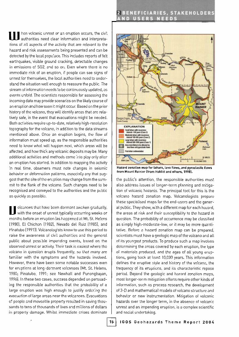
Hazard zonation map for lahars, lava flows, and pyroclastic flowsfrom Mount Rainier (from Hoblitt and others, 1998).
the public's attention, the responsible authorities mustalso address issues of longer-term planning and mitiga¬
tion of volcanic hazards. The principal tool for this is the
volcano hazard zonation map. Volcanologists prepare
these specialised maps for the end-users and the gener¬
al public. They show, with a different map for each hazard,
the areas at risk and their susceptibility to the hazard in
question. The probability of occurrence may be classified
as simply high-moderate-low, or it may be more quanti¬
tative. Before a hazard zonation map can be prepared,
scientists must have a geologic map of the volcano and allof its youngest products. To produce such a map involves
determining the areas covered by each eruption, the type
of materials produced, and the ages of all young erup¬
tions, going back at least 10,000 years. This informationdefines the eruptive style and history of the volcano, the
frequency of its eruptions, and its characteristic repose
period. Beyond the geologic and hazard zonation maps,
most longer-term mitigation efforts require other kinds of
information, such as process research, the development
of 3-D and mathematical models of volcano structure and
behavior or new instrumentation. Mitigation of volcanic
hazards over the longer term, in the absence of volcanic
unrest and an impending eruption, is a complex scientificand social undertaking.
IGOS Geohazards Theme Report 2004
GEOHAZARDS
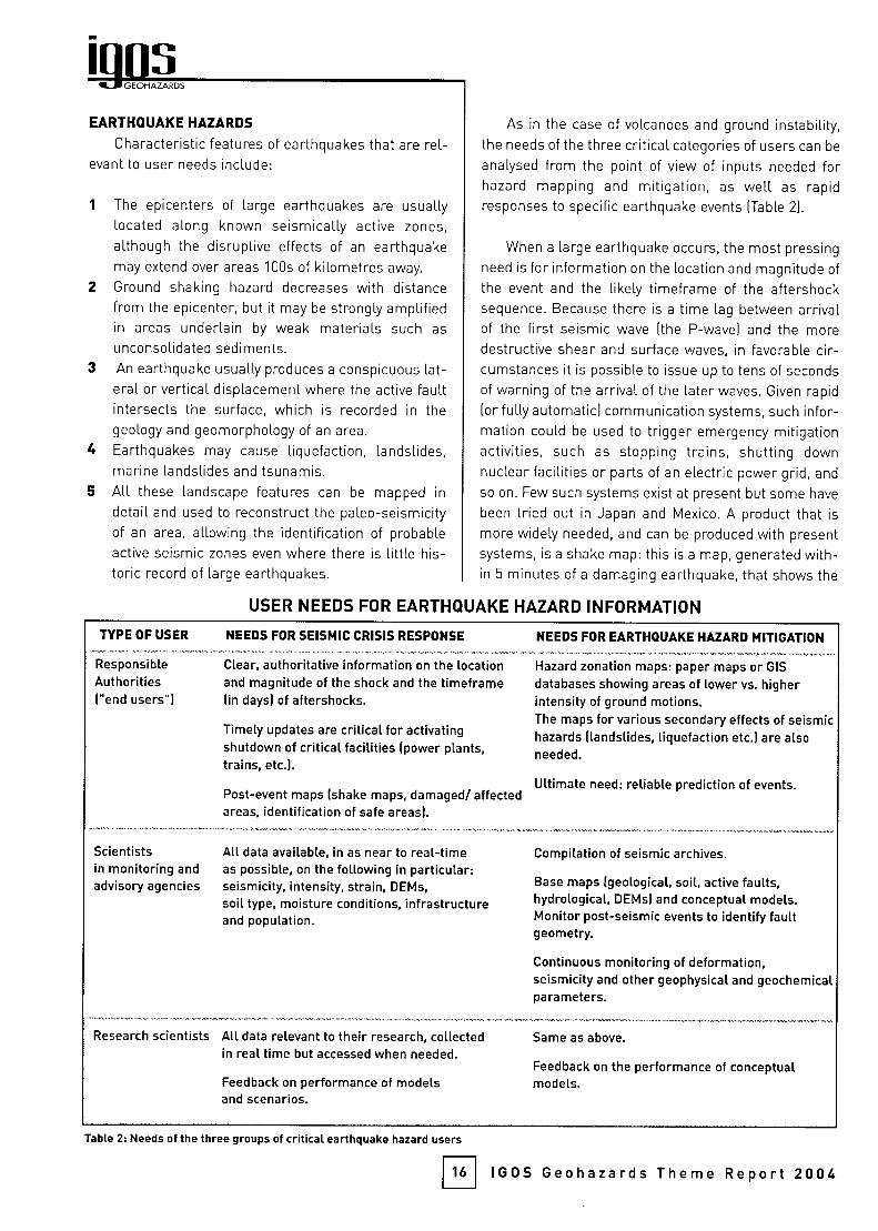
EARTHQUAKE HAZARDS
Characteristic features of earthquakes that are rel¬
evant to user needs include:
1 The epicenters of large earthquakes are usuallylocated along known seismically active zones,
although the disruptive effects of an earthquakemay extend over areas 100s of kilometres away.
Ground shaking hazard decreases with distance
from the epicenter, but it may be strongly amplifiedin areas underlain by weak materials such as
unconsolidated sediments.
An earthquake usually produces a conspicuous lat¬
eral or vertical displacement where the active faultintersects the surface, which is recorded in the
geology and geomorphology of an area.
Earthquakes may cause liquefaction, landslides,marine landslides and tsunamis.All these landscape features can be mapped in
detail and used to reconstruct the paleo-seismicityof an area, allowing the identification of probableactive seismic zones even where there is little his¬
toric record of large earthquakes.
As in the case of volcanoes and ground instability,the needs of the three critical categories of users can be
analysed from the point of view of inputs needed forhazard mapping and mitigation, as well as rapidresponses to specific earthquake events (Table 2).
When a large earthquake occurs, the most pressing
need is for information on the location and magnitude of
the event and the likely timeframe of the aftershocksequence. Because there is a time lag between arrivalof the first seismic wave (the P-wave) and the more
destructive shear and surface waves, in favorable cir¬
cumstances it is possible to issue up to tens of seconds
of warning of the arrival of the later waves. Given rapid
(or fully automatic) communication systems, such infor¬
mation could be used to trigger emergency mitigationactivities, such as stopping trains, shutting down
nuclear facilities or parts of an electric power grid, and
so on. Few such systems exist at present but some have
been tried out in Japan and Mexico. A product that is
more widely needed, and can be produced with presentsystems, is a shake map: this is a map, generated with¬
in 5 minutes of a damaging earthquake, that shows the
USER NEEDS FOR EARTHQUAKE HAZARD INFORMATION
TYPE OF USER
ResponsibleAuthorities["end users")
Scientistsin monitoring andadvisory agencies
NEEDS FOR SEISMIC CRISIS RESPONSE
Clear, authoritative information on the locationand magnitude of the shock and the timeframe(in days) of aftershocks.
Timely updates are critical for activatingshutdown of critical facilities (power plants,trains, etc.).
Post-event maps (shake maps, damaged/ affectedareas, identification of safe areas).
All data available, in as near to real-timeas possible, on the following in particular:seismicity, intensity, strain, DEMs,soil type, moisture conditions, infrastructureand population.
Research scientists All data relevant to their research, collectedin real time but accessed when needed.
Feedback on performance of modelsand scenarios.
NEEDS FOR EARTHQUAKE HAZARD MITIGATION
Hazard zonation maps: paper maps or GIS
databases showing areas of lower vs. higherintensity of ground motions.The maps for various secondary effects of seismichazards (landslides, liquefaction etc.) are alsoneeded.
Ultimate need: reliable prediction of events.
Compilation of seismic archives.
Base maps (geological, soil, active faults,hydrological, DEMs) and conceptual models.Monitor post-seismic events to identify faultgeometry.
Continuous monitoring of deformation,seismicity and other geophysical and geochemicalparameters.
Same as above.
Feedback on the performance of conceptualmodels.
Table 2: Needs of the three groups of critical earthquake hazard users
16 IGOS Geohazards Theme Report 2004
GEOHAZARDS
EARTHQUAKE HAZARDS
Characteristic features of earthquakes that are rel¬
evant to user needs include:
1 The epicenters of large earthquakes are usuallylocated along known seismically active zones,
although the disruptive effects of an earthquakemay extend over areas 100s of kilometres away.
Ground shaking hazard decreases with distance
from the epicenter, but it may be strongly amplifiedin areas underlain by weak materials such as
unconsolidated sediments.
An earthquake usually produces a conspicuous lat¬
eral or vertical displacement where the active faultintersects the surface, which is recorded in the
geology and geomorphology of an area.
Earthquakes may cause liquefaction, landslides,marine landslides and tsunamis.All these landscape features can be mapped in
detail and used to reconstruct the paleo-seismicityof an area, allowing the identification of probableactive seismic zones even where there is little his¬
toric record of large earthquakes.
As in the case of volcanoes and ground instability,the needs of the three critical categories of users can be
analysed from the point of view of inputs needed forhazard mapping and mitigation, as well as rapidresponses to specific earthquake events (Table 2).
When a large earthquake occurs, the most pressing
need is for information on the location and magnitude of
the event and the likely timeframe of the aftershocksequence. Because there is a time lag between arrivalof the first seismic wave (the P-wave) and the more
destructive shear and surface waves, in favorable cir¬
cumstances it is possible to issue up to tens of seconds
of warning of the arrival of the later waves. Given rapid
(or fully automatic) communication systems, such infor¬
mation could be used to trigger emergency mitigationactivities, such as stopping trains, shutting down
nuclear facilities or parts of an electric power grid, and
so on. Few such systems exist at present but some have
been tried out in Japan and Mexico. A product that is
more widely needed, and can be produced with presentsystems, is a shake map: this is a map, generated with¬
in 5 minutes of a damaging earthquake, that shows the
USER NEEDS FOR EARTHQUAKE HAZARD INFORMATION
TYPE OF USER
ResponsibleAuthorities["end users")
Scientistsin monitoring andadvisory agencies
NEEDS FOR SEISMIC CRISIS RESPONSE
Clear, authoritative information on the locationand magnitude of the shock and the timeframe(in days) of aftershocks.
Timely updates are critical for activatingshutdown of critical facilities (power plants,trains, etc.).
Post-event maps (shake maps, damaged/ affectedareas, identification of safe areas).
All data available, in as near to real-timeas possible, on the following in particular:seismicity, intensity, strain, DEMs,soil type, moisture conditions, infrastructureand population.
Research scientists All data relevant to their research, collectedin real time but accessed when needed.
Feedback on performance of modelsand scenarios.
NEEDS FOR EARTHQUAKE HAZARD MITIGATION
Hazard zonation maps: paper maps or GIS
databases showing areas of lower vs. higherintensity of ground motions.The maps for various secondary effects of seismichazards (landslides, liquefaction etc.) are alsoneeded.
Ultimate need: reliable prediction of events.
Compilation of seismic archives.
Base maps (geological, soil, active faults,hydrological, DEMs) and conceptual models.Monitor post-seismic events to identify faultgeometry.
Continuous monitoring of deformation,seismicity and other geophysical and geochemicalparameters.
Same as above.
Feedback on the performance of conceptualmodels.
Table 2: Needs of the three groups of critical earthquake hazard users
16 IGOS Geohazards Theme Report 2004
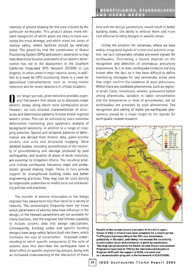
intensity of ground shaking for the area affected by the
particular earthquake. This product allows more effi¬
cient recognition of which areas are likely to have sus¬
tained the most damage, and which areas are zones of
relative safety, where facilities should be relativelyintact. The possibility that the combination of Global
Positioning System (GPS) and seismic observations may
help determine location and extent of co-seismic defor¬
mation has led to the deployment of the Southern
California Integrated GPS Network (SCION) in Los
Angeles. In urban areas in major seismic zones, in addi¬
tion to a need for GPS monitoring, there is a need forspecialised instrumentation such as strong-motiondetectors and for strain detectors in critical locations.
Over longer periods, plate tectonics provides a gen¬
eral framework that allows us to delineate majorseismic zones, along which most earthquakes occur.
However, we lack detailed characterization of struc¬
tures and deformation patterns in most known regional
seismic zones. This can be achieved by more extensive
deformation monitoring, plus systematic analysis of
background seismicity, in addition to a ronge of map¬
ping activities. Spatial and temporal patterns of defor¬
mation are derived from historic data, paleo-seismicstudies, and soils and structural mapping. More
detailed studies, including quantification of the intensi¬
ty of groundshaking and damage produced by past
earthquakes, and location of areas of weak materials,are essential to mitigation efforts. The resulting prod¬
ucts include earthquake frequency maps and proba¬
bilistic ground shaking maps. These in turn provide
support for strengthened building codes and betterengineering practices. They may also be used directlyby responsible authorities to modify land use and build¬
ing policies and practices.
The transfer of seismic information to the design
engineer has always been less than ideal for a variety of
reasons. The seismologist frequently does not knowwhich parameters of seismic data have influence in thedesign, or the relevant parameters are not available formany locations, and the engineer had limited capabilityto include seismic data into design calculations.Consequently, building codes and specific buildingdesigns have large safety factors built into them, whichincreases the cost of construction. Improved under¬
standing of which specific components of the suite of
seismic data that describes the earthquake have a
direct effect on specific engineering designs, along withan increased understanding of the interaction of these
2 BENEFICIARIES, STAKEHOLDERSAND USERS NEEDS
data with the design parameters, would result in betterbuilding codes, the ability to enforce them and more
cost effective building designs in seismic zones.
Unlike the situation for volcanoes, where we have
widely recognised signals of unrest and potential erup¬
tion, we lack comparably reliable pre-event signals forearthquakes. Forecasting a hazard depends on the
recognition and detection of anomalous precursoryphenomena. But, to date, earthquake locations are only
known after the fact, so it has been difficult to define
monitoring strategies for any seismically active zone
that might confirm the existence of such precursors.Whilst there are candidate phenomena, such as region¬
al strain fields, foreshocks, seismic quiescence before
strong aftershocks, variation in radon concentrationand the temperature or level of groundwater, not allearthquakes are preceded by such phenomena. The
recognition and vetting of viable pre-earthquake phe¬
nomena should be a major target on the agenda forearthquake-related research.
17
Results of the seismic hazard evaluation in the Adria region.Values of PGA in m/sec2 have been computed for a return periodT=475 years (corresponding to the 90% non-exceedanceprobability in 50 years), and taking into account the uncertaintyin attenuation. Scale and orientation is given by coordinates.This map was produced by the Global Seismic Hazard AssessmentProgramme launched in 1992 by the International LitosphereProgram (ILP) with the support of ICSU, and endorsedas a demonstration program in the framework of lUN/IDNDR).
IGOS Geohazards Theme Report 2004

GEOHAZARDS
GROUND INSTABILITY HAZARDS
ground instability, the two main sub-categories of
which are landslides and subsidence, is charac¬
terised by movements of solid rock, debris or soil
that are driven by gravitational forces acting at the sur¬
face and in the shallow sub-surface. It encompasses a
wide variety of surface deformations and displacements.
The triggers are either natural factors, such as extreme
rainstorms, prolonged wet periods, and earthquakes, orfactors related to human activity like mining, excavations
and blasting. There are preparatory factors, which pre¬
dispose a given area to failures, including natural and
induced changes in land cover and land use, presence of
soil and physical characteristics, hydrology, and geologi¬
cal conditions, including weathering status. The key
points of interest when analysing ground instabilityinclude the following:1 Landslides are one of the main processes by which
landscapes evolve and so the related hazards result in
a complex, changing landscape that must be mapped
and understood in detail in order to assess its future
behavior.
2 Landslides and subsidence both vary enormously in
their distribution in space and time, the amounts of
energy produced during the activity and especially in
size. This means that the resulting surface deforma¬
tion or displacement varies considerably from one
type of instability to another.
3 Individual landslides and subsidence failures are local
landscape phenomena. Data about site-specific con¬
ditions must be available in order to associate the
identified deformation or displacement patterns with
causative factors and hence model zones of different
degrees of susceptibility to the specific type of ground
instability.
4 Collectively, individual ground instabilities may have a
common trigger, such as an extreme rainfall event or
an earthquake, and therefore occur alongside many
equivalent occurrences over a large area. This means
that they can have a significant regional impact.
5 Ground instability analysis is interdisciplinary, involv¬
ing geotechnics, geomorphology, geophysics, hydrol¬
ogy, hydrogeology. solid and fluid mechanics and var¬
ious information sciences.
6 Ground instabilities, even when catastrophic, tend to
evolve to become progressive failures: once they start,
there is a high probability that they will develop fur¬
ther in space and time.
The three main categories of users and their corre¬
sponding needs are shown in Table 3. Determining where,
when and to which extent ground instabilities will take
place is a short-term requirement as far as the safety of
exposed people is concerned. These questions are easier
to answer for subsidence than they are for landslides. The
mechanics of subsidence are better understood and, once
the phenomenon has been triggered, its evolution can be
USER NEEDS FOR GROUND INSTABILITY HAZARD INFORMATION
TYPE OF USER
ResponsibleAuthorities("end users")
Scientistsin monitoring andadvisory agencies
NEEDS FOR CRISIS RESPONSE
Updated maps of affected areas and scenarios forongoing instability.
Early warning information.
Local rapid mapping of affected areas, magnitudeof instability, updated scenarios during ongoinginstability, impact analysis.
Near real-time observational tools.
As for mitigation, plus seismic data, weatherforecasts.
Research scientists As for mitigation.
Feedback on performance of scenariosand models.
NEEDS FOR HAZARD MITIGATION
Regularly updated inventory, susceptibility andhazard zonation maps: landslides, debris flows,rockfalls, subsidence (at scales as appropriate).Ground instability scenarios.Land use planning and enforcement information
Data on landslide inventory, DEM, deformation(to the ground and critical infrastructure),hydrology, geology, soils, geophysical, geotech-nical, climatic, seismic zonation maps, landcover, land use, historical archives, relevanthuman activities (at scales as appropriate).Regular and consistent observations.Methods and models for susceptibilityand hazard evaluation.Data from well-observed past events.
Continuity of observations, appropriate data asabove for understanding processes and fordevelopment of models and observational tools.Access to other scientific information.Data from well-observed past events.
Table 3: Needs of the three groups of critical ground instability hazard users
18 IGOS Geohazards Theme Report 2004
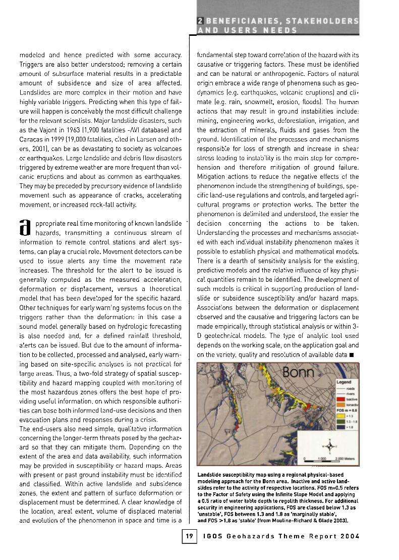
modeled and hence predicted with some accuracy.
Triggers are also better understood; removing a certain
amount of subsurface material results in a predictable
amount of subsidence and size of area affected.
Landslides are more complex in their motion and have
highly variable triggers. Predicting when this type of fail¬
ure will happen is conceivably the most difficult challenge
for the relevant scientists. Major landslide disasters, such
as the Vajont in 1963 (1,900 fatalities -AVI database) and
Caracas in 1999 (19,000 fatalities, cited in Larsen and oth¬
ers, 2001), can be as devastating to society as volcanoes
or earthquakes. Large landslide and debris flow disasters
triggered by extreme weather are more frequent than vol¬
canic eruptions and about as common as earthquakes.
They may be preceded by precursory evidence of landslide
movement such as appearance of cracks, accelerating
movement, or increased rock-fall activity.
appropriate real time monitoring of known landslidehazards, transmitting a continuous stream of
information to remote control stations and alert sys¬
tems, can play a crucial role. Movement detectors can be
used to issue alerts any time the movement rate
increases. The threshold for the alert to be issued is
generally computed as the measured acceleration,deformation or displacement, versus a theoreticalmodel that has been developed for the specific hazard.
Other techniques for early warning systems focus on the
triggers rather than the deformation: in this case a
sound model generally based on hydrologie forecasting
is also needed and, for a defined rainfall threshold,
alerts can be issued. But due to the amount of informa¬
tion to be collected, processed and analysed, early warn¬
ing based on site-specific analyses is not practical forlarge areas. Thus, a two-fold strategy of spatial suscep¬
tibility and hazard mapping coupled with monitoring of
the most hazardous zones offers the best hope of pro¬
viding useful information, on which responsible authori¬
ties can base both informed land-use decisions and then
evacuation plans and responses during a crisis.The end-users also need simple, qualitative informationconcerning the longer-term threats posed by the geohaz¬
ard so that they can mitigate them. Depending on the
extent of the area and data availability, such informationmay be provided in susceptibility or hazard maps. Areas
with present or past ground instability must be identified
and classified. Within active landslide and subsidence
zones, the extent and pattern of surface deformation or
displacement must be determined. A clear knowledge of
the location, areal extent, volume of displaced materialand evolution of the phenomenon in space and time is a
2 BENEFICIARIES, STAKEHOLDERSAND USERS NEEDS
fundamental step toward correlation of the hazard with its
causative or triggering factors. These must be identified
and can be natural or anthropogenic. Factors of naturalorigin embrace a wide range of phenomena such as geo-
dynamics (e.g. earthquakes, volcanic eruptions) and cli¬
mate (e.g. rain, snowmelt, erosion, floods). The human
actions that may result in ground instabilities include:
mining, engineering works, deforestation, irrigation, and
the extraction of minerals, fluids and gases from the
ground. Identification of the processes and mechanisms
responsible for loss of strength and increase in shear
stress leading to instability is the main step for compre¬
hension and therefore mitigation of ground failure.Mitigation actions to reduce the negative effects of the
phenomenon include the strengthening of buildings, spe¬
cific land-use regulations and controls, and targeted agri¬
cultural programs or protection works. The better the
phenomenon is delimited and understood, the easier the
decision concerning the actions to be taken.
Understanding the processes and mechanisms associat¬
ed with each individual instability phenomenon makes it
possible to establish physical and mathematical models.
There is a dearth of sensitivity analysis for the existing,
predictive models and the relative influence of key physi¬
cal quantities remain to be identified. The development of
such models is critical in supporting production of land¬
slide or subsidence susceptibility and/or hazard maps.
Associations between the deformation or displacement
observed and the causative and triggering factors can be
made empirically, through statistical analysis or within 3-
D geotechnical models. The type of analytic tool used
depends on the working scale, on the application goal and
on the variety, quality and resolution of available data
19
Landslide susceptibility map using a regional physical-basedmodeling approach for the Bonn area. Inactive and active land¬slides refer to the activity of respective locations. FOS m=0.5 refersto the Factor of Safety using the Infinite Slope Model and applyinga 0.5 ratio of water table depth to regoUth thickness. For additionalsecurity In engineering applications, FOS are classed below 1.3 as'unstable', FOS between 1.3 and 1.8 as 'marginally stable',and FOS >1.8 as 'stable' (from Mouline-Richard & Glade 2003).
IGOS Geohazards Theme Report 2004
GEOHAZARDS
This chapter describes the observations required by
the scientists in monitoring and advisory agencies and
the researchers undertaking related scientificresearch, in order to meet users' needs for informa¬tion. Commonalities in requirement between thethree main hazards are emphasised. These includethe observation of topography, deformation, seismicactivity and various geoscience parameters common¬
ly recorded on geology and soils maps. These commonrequirements form the basis for a common approachin the rest of the report.
. nformation products and advice required to support deci-
I sion-making by end users in responsible authorities are
based on a wide range of observations that are made
using many different optical, radar and other systems.
Some are satellite-based, some made by aircraft and many
are measured by critical, ground based systems. There is no
way that events like earthquakes or volcanic eruptions can
be prevented, so the emphasis is put on observations made
between events that permit better forecasting and mitiga¬
tion planning. Scientists in monitoring and advisory agen¬
cies take these observations, integrate and assimilate them
MOST REQUIRED VOLCANIC HAZARD OBSERVATIONS AND BEST AVAILABLE OBSERVATION SYSTEMS
REQUIRED OBSERVATIONS
Characterise seismicityof volcano or group of volcanoes[magnitude, 3-D location,and type of earthquake(s)].
Characterise deformationof volcanic edifice (horizontaland vertical); monitor changesin gravity; characterise topogra¬phy; determine locationof faults, landslides and groundfractures.
Characterise gas and ashemissions of volcanoesby species (S02, C02)and flux (tons per day)
Characterise and monitorthermal features of volcanoes[their nature, location,temperature,possibly heat flux).
Characterise eruptive style anderuptive history of volcanoes.
BACKGROUND MONITORING/ASSESSMENT
Individual volcanoes require at least 3-6 seis¬mometers, ideally with 3-directional sensors, todetect and locate earthquakes of Magnitude 0.5,
with digital data relayed/processed in real time.
Regional network good enough to detect andlocate earthquakes of Magnitude 2.5, datarelayed and processed in real time.
EDM and/or permanent GPS network of stations,either continuously transmitting or reoccupiedas necessary.
Leveling and tilt networks surveyed as needed.Borehole strainmeters (continuous recording).Gravity surveys (1-5 years).
SAR interferometry [frequency depending on thevolcano's historic activity).
Map existing geologic structures on volcanoesusing high spatial resolution satellite, aerial pho¬
tography, aerial surveys and geological and geo¬
physical ground surveys as needed.
COSPEC, LICOR surveys at regular intervals(weekly, monthly or annualLy).
Routine checks of appropriate satellite imagery.
Map and monitor hot springs, fumaroles, summitcraters, crater lakes, and fissure systems for tem¬perature variations using ground-based instru¬ments and high spatial resolution satellite data.
Systematic acquisition and analysis of imageryfrom airborne digital IR cameras, moderate reso¬lution to higher-resolution resolution satelliteimagery for thermal background and thermal flux.
Characterise, map and date all young eruptivedeposits of the volcano.
CRISIS RESPONSE
Repairs as needed and feasible.
Additional stations, deployed nearor on the volcano, to detect and locateearthquakes of Magnitude 0.5
Additional GPS stations as needed to cap¬
ture deformation; more frequent occupa¬tion (if data not continuously transmitted).
More frequent occupation (if notcontinuously recorded and transmitted).
Request more frequent tasking plussearch data archives for additional possible¡mage pairs.
Request repeat overflights to check fornew cracks; possibly install strainmetersacross selected cracks.
More frequent surveys, perhaps using smallaircraft if plume not accessible by road.
Additional requests tasking for higher-res¬olution data, check archives for useableImagery.
More frequent observations, includingvisible and IR photography and pyrometryas appropriate.
More frequent overflights with digital IR
camera; additional requests tasking forhigher resolution satellite data, checkarchives for time series of thermal data.
Observe eruption columns, plumes andsurface deposits (using overflights withvisible and IR photography, video).Monitor their motions (speed, direction,areas covered and threatened], character,and thickness. Update maps.
Table 4: Volcanic hazard observations most required and the best available observational systems
20 IGOS Geohazards Theme Report 2004

[
and use them in models of critical Earth system processes
to produce hazard maps, scenarios and forecasts that
answer questions such as: how do the relevant Earth sys¬
tem processes operate; what are the main hazards in each
case; which areas are exposed to those hazards; which are
safe; and what is the best estimate of the timing, duration
and extent of the hazardous activity?
The IGOS Geohazards has identified a wide range of
observations that are required to answer these questions
and mitigate each geohazard effectively This inventory
builds on previous works, in particular the reports on EO
requirements for earthquakes, volcanoes and landslidespresented in the CEOS DMSG final report. The observa¬
tions, documented on the Geohazards website will be
added to the IGOS obsen/ational requirements database,
maintained by the World Meteorological Organization
(WMO) on behalf of the IGOS Partners. This document
summarises the most important parameters to observe in
three tables below covering volcanoes, earthquakes and
ground instability A set of observational requirements
emerges, many of which are common to all three hazards,
and a suite of key observational systems is described thatsupport both monitoring and ultimately crisis response.
3REQUIRED OBSERVATIONSAND KEY SYSTEMS
> Volcanic HazardsVolcanic hazard mitigation requires a wide variety of
information. Essential volcano monitoring includesanalysis of data on the volcano's seismicity, surface
deformation, gas emissions and thermal features. In
addition, detailed topography and geologic mapping are
required for complete volcano hazards assessments.
> Earthquake HazardsEarthquake hazard mitigation also requires moni¬
toring of seismicity and deformation, albeit with a
slightly different focus and scale than for volcanoes.
Geological mapping for earthquake mitigation empha¬
sises the mapping of structures like faults. The possi¬
bility of using surface temperature or soil gas anom¬
alies should also be evaluated.
> Ground Instability Hazards
Ground instability hazard mitigation requires a
slightly wider range of observations, including geologi¬
cal and soils mapping, topography analysed as eleva¬
tion, slope and aspect, deformation, climatic and mete¬
orological parameters, ¡n-situ geotechnical observa¬
tions and se¡sm¡c¡ty In many cases the focus ¡s on sur¬
face geology and soils.
MOST REQUIRED EARTHQUAKE HAZARD OBSERVATIONS AND BEST AVAILABLE OBSERVATION SYSTEMS
REQUIRED OBSERVATIONS
Characterise seismicityof seismicalLy active region(magnitude, 3-D location,and type of earthquake[s)].
Characterise baseline topographyand ongoing deformat¡on of region(horizontal and vertical).
Characterise thermal signatureof region.
Determine location of faults,landslides and ground fractures.Characterise h¡stor¡c seismicityand paleo-seism¡c¡ty of reg¡on
BACKGROUND MONITORING/ASSESSMENT
Global monitoring network able to charac¬terise earthquakes of Magnitude 3.5 with datarelayed and processed in real time.
Regional network of strong-motion detectors,capable of surviving ground motions.
EDM and/or permanent GPS networkof stations, e¡ther cont¡nuously transm¡tt¡ngor reoccupied as necessary.
Borehole strainmeters (continuous recording).Strainmeters on critical structures such asdams, bridges, etc .
SAR interferometry (frequency dependingon the region's historic seismicity).
Obtain and process time series of low/medi¬um resolution IR imagery from polar and geo¬
stationary satellites for thermal backgroundcharacterisation.
Map exist¡ng structures ¡n the reg¡on us¡nghigh spatial resolution satellite and airborneimagery, aerial photography and geologicaland geophysical ground sun/eys.Study and date features that provide ev¡dencefor major prehistoric earthquakes.
CRISIS RESPONSE
Network is being putting in place,developed to verify the ComprehensiveTest Ban Treaty.
If none deployed, add stations afterwardsto capture aftershock sequence.
Additional GPS stations as needed tocapture post-earthquake deformation;more frequent occupat¡on (¡f data notcont¡nuously transm¡tted).
More frequent occupat¡on (if not continu¬ously recorded and transmitted); addition¬al strainmeters on critical structures tomonitor their structural integrity duringaftershock sequence.
Request more frequent satellite task¡ngplus search archives for additionalpossible ¡mage pa¡rs.
Evaluate time series for possible thermalanomalies before and afterthe earthquake.
Request over-fl¡ghts to check extentof ground breaking and offset,for new cracks, landslides, patternsof liquefact¡on and bu¡ld¡ng collapse, etc.
Table 5: Earthquake hazard observations most required and the best available observational systems
21 IGOS Geohazards Theme Report 2004
GEOHAZARDS
m t is clear from the tables 4-6 that observationalI requirements form a strong link between the three
main geohazards and can be considered together,emphasising the coherence of the geohazard theme.They are categorised into baseline observations, need¬
ed above all for the production of maps, and into time-series observations, which form the basis for hazard
monitoring. For each group of parameters, both currentand planned observational techniques and systems are
described, covering ground-based, airborne and satel¬
lite-based technologies. In general, ground-basedmethods provide the highest data accuracy and resolu
tion and the greatest continuity in time, but have limita¬
tions on areal coverage. Satellite-based systems have
variable and generally lower spatial and temporal reso¬
lution, but they have the advantage of providing synoptic
regional coverage and offer spatial continuity. The inter¬
mediate scale of airborne systems is used to combinethe advantage of spatial coverage offered by EO witheither higher resolution, and better control on acquisi¬
tion timing when sensing a specific event. To get the
most appropriate spatial, spectral and temporal resolu¬
tion, a global observing strategy for geohazards mustintegrate all these data streams.
MOST REQUIRED GROUND INSTABILITY HAZARD OBSERVATIONS AND BEST AVAILABLE OBSERVATION SYSTEMS
REQUIRED OBSERVATIONS
Characterise deformation withhigh accuracy and frequency (horizontal and vertical).
Map landslides, geomorphology,land-use, land cover, geology,structures, drainage network.
Topography/Elevation (incl. slopeangle, slope length, slope position).
Soil strength parametersand physical properties[incl. pore water pressures).
Climate Triggerprecipitation (rainfall, snow, magnitude, intensity, duration}, temperature.
Seismic triggerMagnitude, intensity, duration,peak acceleration.Decay of shaking level with sourcedistance [source, propagationshaking and site effects).
BACKGROUND MONITORING/ASSESSMENT
GPS network of stations continuously transmitting or reoccupied as necessary.
Satellite, airborne and ground-based SARinterferometry at various wavelengths.Frequency depending on the type of groundinstability [1 month to 1 year).
Other surveys e.g. leveling, laser scanning(terrestrial and airborne!, aerial photographyand high-resolution stereo satellite data,borehole inclinometers.Frequency depending on the type of groundinstability [1 month to 1 year).
Map existing landslides, depositional/ero-sional processes, geologic structures, land-use and land cover using high spatial reso¬lution satellite and airborne imagery, aerialphotography and geological and geophysicalground surveys.
High quality DEM from LiDAR. photogram-metry or high-resolution satellites.
Regular updated when necessary.Geotechnical field logging and sampling,¡n-situ and laboratory test to determinespecific site conditions and engineeringparameters .
Variation of pore water pressureis monitored by piezometers over time
Meteorological data field measurements.Meteorological satellites data.
Accelerometer network monitoring.(Frequency: continuous or reoccupied asnecessary) Models (Pseudo-static stability,Dynamic instability...).
CRISIS RESPONSE
Additional GPS stations as neededto capture deformation.More frequent occupation[if data not continuously transmitted).
Request more frequent satellite taskingplus search archives for additional possible image pairs.
More frequent occupationof all ground-based instrumentation(if data not continuously recordedand transmitted).
,^.,^,_.^_ ...... _,_..__,,.
Request over-flights to check extentand distribution of landslides.
Rapid local update neededof how the landscape has changed.
Request more frequent observations andif possible continuous recording of soilmoisture.
Continuous recording.
Continuous recording.
Table 6: Ground instability hazard observations most required and the best available observational systems
22 IGOS Geohazards Theme Report 2004

3REQUIRED OBSERVATIONSlA N D K EY SYSTEt4^S_
BASELINE OBSERVATIONS
> TopographyTopographie data are required to analyse all three
hazards. Such data are critical to the modeling of any
gravity-driven process, such as the emplacement of a
lava flow or the progress of a landslide. They also forma key requirement in the subsequent analysis of defor¬
mation, providing the baseline against which to meas¬
ure topographic change and so calculate the volume of
displaced material. The basic requirement is for a digi¬
tal terrain model, from which elevation, slope and
aspect can be calculated. Earthquakes need only low,
regional resolution. Volcanic hazards usually require
slightly higher resolution. Highest resolution is used forground instability, especially small landslides, whose
recognition relies largely on landform analysis often
done at around 1:10,000 scale, with a vertical resolution
of better than 1m.
Whilst ground-based methods like traditional sur¬
veying and GPS measurements are still used, topograph¬
ic surveying now has a long history of using EO and espe¬
cially airborne solutions. The most common approach is
photogrammetry, based on scanned analogue and
increasingly on digital aerial photography This willremain important, especially at the site-specific scale.
Radar altimeters, single-pass airborne radar interferom¬
eters and airborne Light Detection and Ranging (LiDAR)
are all used to improve available topographic maps and
Digital Elevation Models (DEMs). Satellite data sources
include high-resolution stereo optical satellite imagery,
radargrammetry, interferometry and altimetry. The clos¬
est that such data come to providing a global, high-reso¬
lution dataset is the Shuttle Radar Topography Mission
(SRTM). This was designed to provide coverage between
60N and 56S at 90 m resolution. Current and planned EO
systems that might be used for topographic observations
are listed at the end of the Chapter.
> MappingMapping, whether of bedrock geology, structure or
surficial deposits and soils, is essential in trying to
understand geohazards. All three hazards require vari¬
ous types of mapping based on satellite and airborneEO imagery, aerial photography and fieldwork. Terrain
analysis in three dimensions, both on the ground and
using remote sensing data, is used to map landform,geology, structure and soils, based on either a terrainmodel or stereography. For volcanoes, mapping focuss-es on eruptive deposits less than 10,000 years old and
related structures. For earthquakes, the most impor¬
tant features to map are faults, existing fractures and
23
Image of Nyiragongo Volcano, in Congo, shortly after the January2002 eruption. The image shows ASTER and Landsat 7 thermalimagery, draped over a DEM derived from SRTM data (courteseyofJPL).
other lineaments related to structure. For landslides,
soils and superficial deposits are critical and mapping
must also result in an inventory of current and historiclandslides in the region. Scales may vary from regionalmapping at 1:50,000-250,000 to local mapping at
1:5,000-10,000.
Field-based geological mapping not only provides
observations that are impossible to achieve any otherway, such as deformation fabrics that reveal the strainhistory in rocks, but it is also central to the developmentof knowledgeable and skilled geohazard scientists. It
results in scientists that understand the phenomena in
detail and who can successfully apply the other observa¬
tions to their mitigation. Fieldwork is supported by air¬
borne and satellite data. Aerial photography analysed in
stereo allows virtual fieldworks in the laboratory, favour¬
ing targeted field visits on key exposures. Ground insta¬
bility phenomena are best recognised this way. Airbornehyperspectral imagery from sensors like the
IGOS Geohazards Theme Report 2004
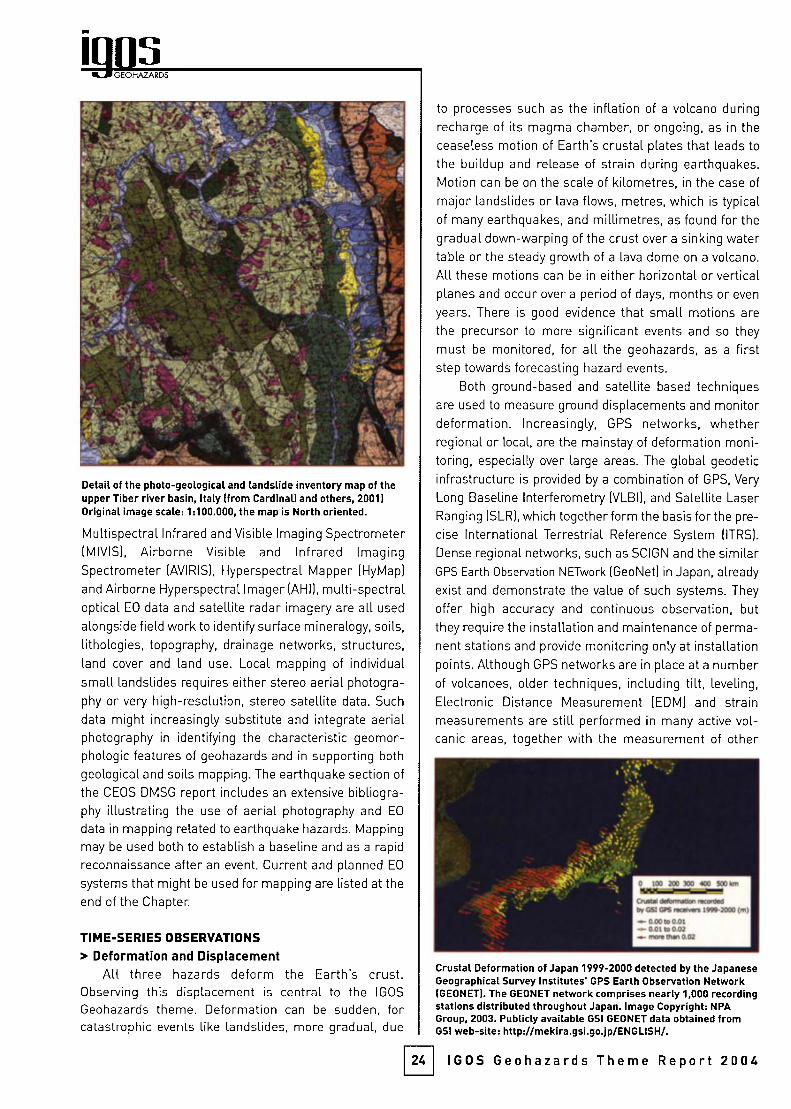
GEOHAZARDS
Detail of the photo-geological and landslide inventory map of theupper Tiber river basin, Italy (from Cardinali and others, 2001)Original ¡mage scale: 1:100.000, the map is North oriented.
Multispectral Infrared and Visible Imaging Spectrometer(MIVIS), Airborne Visible and Infrared ImagingSpectrometer (AVIRIS), Hyperspectral Mapper (HyMap)
and Airborne Hyperspectral Imager (AHI), multi-spectraloptical EO data and satellite radar imagery are all used
alongside field work to identify surface mineralogy, soils,
lithologies, topography, drainage networks, structures,land cover and land use. Local mapping of individual
small landslides requires either stereo aerial photogra¬
phy or very high-resolution, stereo satellite data. Such
data might increasingly substitute and integrate aerialphotography in identifying the characteristic géomor¬
phologie features of geohazards and in supporting both
geological and soils mapping. The earthquake section of
the CEOS DMSG report includes an extensive bibliogra¬
phy illustrating the use of aerial photography and EO
data in mapping related to earthquake hazards. Mapping
may be used both to establish a baseline and as a rapid
reconnaissance after an event. Current and planned EO
systems that might be used for mapping are listed at the
end of the Chapter.
TIME-SERIES OBSERVATIONS
> Deformation and DisplacementAll three hazards deform the Earth's crust.
Observing this displacement is central to the IGOS
Geohazards theme. Deformation can be sudden, forcatastrophic events like landslides, more gradual, due
to processes such as the inflation of a volcano during
recharge of its magma chamber, or ongoing, as in the
ceaseless motion of Earth's crustal plates that leads to
the buildup and release of strain during earthquakes.
Motion can be on the scale of kilometres, in the case of
major landslides or lava flows, metres, which is typical
of many earthquakes, and millimetres, as found for thegradual down-warping of the crust over a sinking watertable or the steady growth of a lava dome on a volcano.
All these motions can be in either horizontal or verticalplanes and occur over a period of days, months or even
years. There is good evidence that small motions are
the precursor to more significant events and so they
must be monitored, for all the geohazards, as a firststep towards forecasting hazard events.
Both ground-based and satellite based techniques
are used to measure ground displacements and monitordeformation. Increasingly, GPS networks, whetherregional or local, are the mainstay of deformation moni¬
toring, especially over large areas. The global geodetic
infrastructure is provided by a combination of GPS, Very
Long Baseline Interferometry (VLBI), and Satellite Laser
Ranging (SLR), which together form the basis for the pre¬
cise International Terrestrial Reference System (ITRS).
Dense regional networks, such as SCIGN and the similarGPS Earth Observation NETwork (GeoNet) in Japan, already
exist and demonstrate the value of such systems. They
offer high accuracy and continuous observation, but
they require the installation and maintenance of perma¬
nent stations and provide monitoring only at installationpoints. Although GPS networks are in place at a numberof volcanoes, older techniques, including tilt, leveling.
Electronic Distance Measurement (EDM) and strainmeasurements are still performed in many active vol¬
canic areas, together with the measurement of other
24
Crustal Deformation of Japan 1999-2000 detected by the JapaneseGeographical Survey Institutes' GPS Earth Observation Network(GEONET). The GEONET network comprises nearly 1,000 recordingstations distributed throughout Japan. Image Copyright: NPAGroup, 2003. Publicly available GSI GEONET data obtained fromGSI web-site: http://mekira.gsi.go.jp/ENGLISH/.
IGOS Geohazards Theme Report 2004

Average annual displacement map over London calculatedbetween 1992-2000: the deformation bar on the right enablesidentification of subsiding areas. (Image courtesy of NPA/TRE).
related parameters such as water levels in bore holes,
as summarised in Van der Laat (1996).
Airborne systems can sometimes detect surface
disp[acement, but a need for platform stability and reg¬
ular observations mean that satellite solutions are
increasingly important. The principal technique in use is
synthetic aperture radar differential interferometry(DInSAR), which enables detection of centimetricground displacements over wide areas. Existing satel¬
lite InSAR instruments are C-band (wavelength in the
order of 5.6 cm), offering high resolution, and typically
collect data every month, but they only provide informa¬
tion on non-vegetated surfaces. Data from the earlierJERS-1 satellite demonstrated that L-band satellites(wavelength in the order of 23.5 cm) can provide lowerresolution interferograms over a far greater range of
surface cover types. The next L-band SAR will be the
Japanese PALSAR sensor on the ALOS satellite, sched¬
uled for launch in 2004. This instrument is designed to
test several applications, including interferometry, so it
will provide some support for deformation analysis.
Monitoring crustal displacement is one of the main
design aims of the proposed L band TerraSar mission.Other limitations of current InSAR systems are the factthat measurement of displacement in the satellite'sline-of-sight is difficult to resolve into three dimensionsand the time gap between repeat observations.Approaches to overcome limited information over natu¬
ral surfaces have been documented in the CEOS DMSG
report and include: placing artificial corner reflectors oractive transponders in strategic locations; availability of
3REQUIRED OBSERVATIONSJLE
new InSAR techniques that can identify coherent targetsin time-series of radar images. Such approaches allowthe removal of atmospheric effects and the constructionof displacement histories for each identified point tar¬
get. Current and planned EO satellite systems thatmight be used for displacement quantification are listed
at the end of the Chapter.
> SeismicitySeismic activity is a feature of all three hazards. For
earthquakes, seismic monitoring is the most criticalobservation required, and for volcanoes it is the best-
established tool to evaluate the status of a volcano, both
between and during eruptions, Seismic monitoring is
needed to describe a earthquake's magnitude and its
location in three dimensions. It is also the best tool to
determine what is happening at depth, allowing the
plumbing inside a volcano and the position of subsur¬
face faults to be defined. It is important in ground insta¬
bility assessment, too, because seismicity is one of the
main triggers for landslides in some geological set¬
tings, especially mountainous terrain near active plate
boundaries. It is also associated with some subsidence
phenomena. The size of significant events varies withthe hazard: whilst most earthquakes smallerthan M 5.5
do little harm, earthquakes of M 0.5 or less may be
important for volcano monitoring purposes.
Seismic monitoring requires networks of ground-based instruments. The Global Seismic Network (GSN),
supported by the USGS, the US National Science
Foundation and the organization Incorporated Research
Institutions for Seismology (IRIS), is a global networkcapable of locating and characterising seismic events
>M3.5, in the northern hemisphere (Sykes, 2002). It has
been installed, in part, to monitor underground nuclearexplosions as part of the Comprehensive Test Ban Treaty
(CTBT). The existence of this and other networks means
25
Stations of the Global Seismic Network operated and maintainedby the US Geological Survey. (From the NEIC web site).
IGOS Geohazards Theme Report 2004

GEOHAZARDS
that locations and magnitudes for large earthquakes(>M5.5) occurring anywhere in the world are posted on
the web within minutes of their occurrence. One such
website is the National Earthquake Information Center
of the USGS. Strong-motion detectors are used to meas¬
ure the local effects of major earthquakes, while the
smaller tremors associated with volcanoes are moni¬
tored using more sensitive instruments, includingbroadband seismometers that detect the longer-periodevents characteristic of the movement of fluids withinthe Earth's crust. Critical requirements for all networksare sufficient coverage and station density and real timedata transmission capabilities.
OBSERVATIONS FOR SPECIFIC GEOHAZARDS
fhe climatic and meteorological observationsrequired for monitoring ground instability can be
met using normal weather observations. There are
also a number of promising new observations and
observing technologies that are not yet operational.These are described in Chapter 5 under the research
agenda. This leaves three other types of observationsthat are important for one or more specific hazards:
> Gas EmissionsFor volcanic hazards, S02 and C02 emissions are
critical indicators of volcanic activity and hence themonitoring of these gases plays an important role in
forecasts. In addition, these gases are hazards in theirown right, so they must be considered in any observa¬
tion system designed to address volcanic hazards. For
earthquakes, there is widespread interest in the possi¬
bility that certain gas species may be precursors to
earthquakes. Soil gas monitoring along active faultshas been attempted, but a key difficulty for this work is
to know where to put the sensor. These investigationsremain part of the research agenda for earthquakes.
Volcanic gas emission rates and plume composi¬
tion are commonly measured using correlation spec¬
trometers and infrared analysers (e.g. the CorrelationSpectrometer (COSPEC), LICOR) and, more rarely, the
new Open-Path Fourier Transform Infrared spectrome¬ters (OP-FTIR). These can be stationary or can be
mounted on trucks or small aircraft. The necessarymeasurements require repeated passes beneath theplume under sunny conditions, preferably at differentelevations. Such surveys are normally carried out on a
monthly or annual basis, unless the volcano is in a
state of heightened activity. Direct sampling using spe¬
cific geo-chemical sensors at critical sites is also used
to monitor gases, in particular C02 concentrations in
26
soils at volcanoes that are known C02 emitters.Airborne hyperspectral sensors can be used to
measure relative gas concentrations. S02, the most
characteristic volcanic gas, can be detected using mul¬
tispectral ultraviolet and infrared satellite sensors. The
use of infrared sensors on meteorological satellites formonitoring S02 plumes is reviewed in the CEOS DMSG
report. Coarse spatial resolution and low sensitivityhave limited satellite detection of S02 to volcanicplumes that reach the stratosphere. The Advanced
Spaceborne Thermal Emission and ReflectionRadiometer (ASTER) sensor's infrared bands and its
higher spatial resolution allow better monitoring of tro-pospheric and more dilute S02 plumes. ASTER data
(every 16 days] integrated with more frequent observa¬
tions from lower spatial resolution sensors such as the
Moderate-Resolution Imaging Spectroradiometer(MODIS) (every few hours) and the Scanning Enhanced
Visib(e and Infrared Imager (SEVIRI) (every 15 minutes),offers the best opportunity to map such plumes fromspace. Current and planned EO systems that might be
used to make gas (mainly S02) observations are listedat the end of the Chapter.
> TemperatureVolcanic activity is intrinsically a high-temperature
phenomenon, so in theory thermal monitoring oughtto be useful in forecasting eruptions. The range of
temperatures of interest is large, from 30-40 degrees
centigrade in hot springs to over 1200 degrees centi¬
grade for lava. Most of the heat sources are only
metres to tens of metres in dimension, so there is at
present little consistency in how temperature is moni¬
tored. Thermal flux, though almost certainly a precur¬
sor for eruptions, is rarely monitored. For earth¬
quakes, some studies suggest that local thermalanomalies may precede an earthquake. Specific cases
are few, but the possibility deserves rigorous evalua¬
tion. Temperature has only a marginal place in land¬
slide studies, although it can be used as an indirectindicator for the soil moisture variations that can affectthe strength of certain slopes and therefore their sus¬
ceptibility to landslide initiation. It has no obvious roleto play in subsidence observations.
Ground-based methods include thermocouples,pyrometers, and other kind of standard temperaturesensors. These approaches provide measurementsonly at point localities, but are the principal means ofevaluating thermal trends of lower-temperature sitessuch as hot springs, whether associated with volcanoesor with active faults. Fixed-position or airborne infrared
IGOS Geohazards Theme Report 2004

cameras that measure emissivity and temperature pro¬
vide detailed information on the structure of active lava
domes, flow fields, and tube systems.
Lava flow mapping and thermal surveys from hyper¬
spectral sensors are also possible. Satellite remote
sensing at various infrared wavelengths has been widely
used for thermal monitoring of active volcanic areas. Its
effective application depends on a good match between
the resolution of the sensor and the size of the target.Available sensors with higher resolution include Landsat
and ASTER, though they offer only low observational fre¬
quency For near real-time monitoring, high temporalresolution satellites in both polar and geostationary
orbits are widely used. Data from NCAA's Geostationary
Operational Environment Satellites (GOES) is routinely
used for volcanic hotspot analysis, and the results post¬
ed on the web (Harris and others, 2000). NCAA's opera¬
tional system of polar orbiting satellites provides obser¬
vations of the entire globe at least every 6 hours at spa¬
tial resolutions of 1-5 kilometres, but the sensors satu¬
rate far below magmatic temperatures. Efforts to docu¬
ment thermal anomalies as possible precursors to
earthquakes have drawn on the stream of Advanced Very
High Resolution Radiometer (AVHRR) and Along-Track
Scanning Radiometer (ATSR) data. New sensors like
MODIS and SEVIRI, which have a wider range of infrared
bands, should allow monitoring of a wider range of tem¬
peratures. In fact, the MODIS sensors are already used to
detect volcanic hotspots, with the results posted on the
web. Unlike the GOES site, the MODIS hotspot site has
global coverage. Current and planned EO systems thatmight be used for thermal observations are listed at the
end of the section.
3RE0U)RED OBSERVATIONSAND KEY SYSTEMS
> Physical PropertiesFor ground instability, understanding the behavior
of the hazard requires the collection of detailed geot¬
echnical information on the physical properties of soilsand superficial geological deposits. Measurements thatare necessary include moisture content, strain,strength, porosity and pore-water pressure. These data
are predominantly gathered on the ground, using a vari¬
ety of instrumentation deployed at specific hazard sites.
Field and laboratory measurements, includinggeotechnical and geophysical techniques, furnish infor¬
mation on strain-state, hydromechanical and hydrogeo-
logical properties and geological structure, especiallywithin active landslides. In some cases, they help detect
early-activated zones and so are usually included in
early warning systems. Geotechnical instruments used
include extensometers, inclinometers, crack metres,
rupture and contact detectors, water-level metres and
pore-water pressure sensors. Ground based geophysi¬
cal techniques such as electric, electromagnetic,ground penetrating radar, protonic resonance magnet¬
ics and active seismic reflection and refraction are allused to detect and characterise parameters relevant to
ground stability assessment. They permit noninvasive
investigation of subsurface conditions. These measure¬
ments are used to deduce permeability, water content,porosity, chemical constituents, stratigraphy, geologic
structure, and other properties. The detail needed fromsuch measurements is dictated by the size of the phe¬
nomenon and the purpose of the analysis. Soil moistureis measured from airborne thermal data and in favor¬
able conditions by satellite radar, but EO-based soilmoisture monitoring is not yet operational
STATUS 2002 2003 2004 2005 2006 2007 2008 2009 2010 2011 2012 2013
ERS-2/C-band SAR
RADARSAT 1,2/C-band SAR
ENVISAT/C-band SAR
ALOS/L-band SAR
Terra SAR-X/X-band SAR
Cosmo-SkyMed/X-band SAR
TerraSAR-L/L-band SAI
Rísat-1/C-band SAR
9 The key current and future satellite missions and sensors for ground displacements observationsand topographic mapping by InSAR techniques.
27 IGOS Geohazards Theme Report 2004
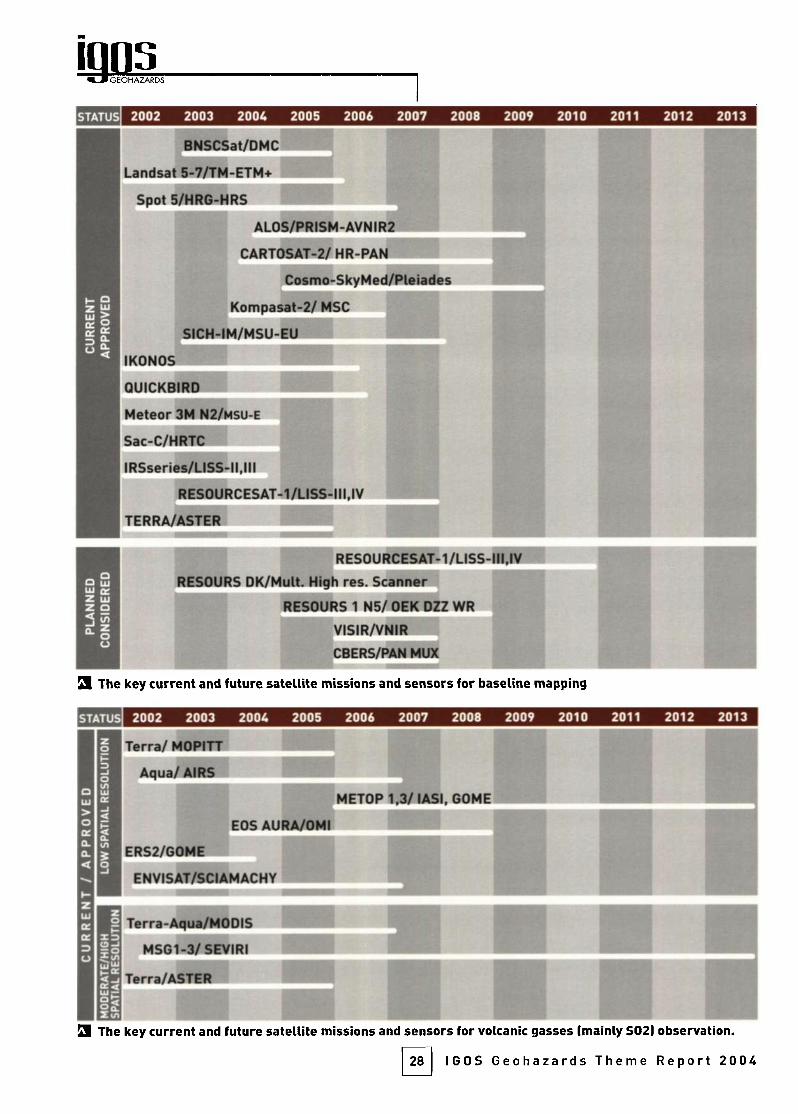
GEOHAZARDS
STATUS 2002 2003 2004 2005 2006 2007 2008 2009 2010 2011 2012 2013
BNSCSat/DMC^
I Landsat 5-7/TM-ETM+
Spot 5/HRG-HRS
AL0S/PRI5M-AVNIR2
CARTOSAT-2/HR-PAN
Cosmo-SkyMed/Pleiades
Kompasat-2/ MSC
SICH-IM/MSU-EU ^ I
IKONOS
QUICKBIRDi
Meteor 3M N2/msu-e
Sac-C/HRTC
)RSseries/USS-ll,l
RES0URCESAT-1/LISS-ni,IV
TERRA/ftSTER
i RES0URCESAT-1/LISS-III,IV
RESOURS DK/MuU. High res. Scanner
RESOURS 1 N5/ OEK DZZ WR
VISIR/VNIR
CBERS/PAN MUX
3 The key current and future satellite missions and sensors for baseline mapping
STATUS 2002 2003 2004 2005 2006 2007 2008 2009 2010 2011 2012 2013
iTerra/MOPITT
Aqua/ AIRS
METOP 1.3/ lASI, GOME
EOS AURA/OMI
^ERS2/G0ME
ENVISAI/SCIAMACHY
Terra-Aqua/MODIS
MS61-3/ SEVIRI
Terra/ASTE
S The key current and future satellite missions and sensors for volcanic gasses (mainly S02) observation.
28 IGOS Geohazards Theme Report 2004

lAND KEY SYSTEMS
STATUS 2002 2003 2004 2005 2006 2007 2008 2009 2010 2011 2012 2013
U
NOAA/Á\
TERRA/ MODIS
AQUA/ MODIS
ADEOS 2/ GLI
GOES 8-12, N-O/ IMAGER
IGMS, MTSAT-1R,2/VISSR,IMAGER
ImeTEOSAT, MSG-1,3/MVIRI, SEVIRI
FY-1D/MVISR
METOP-t'
INSAT-3A,METSAT/VHRRi
ENVI5AT/ AATSR
I ERS-2/ ATSR
60MS/MSU-GS
9 The key current and future satellite missions and sensors for thermal monitoring at moderate spatialresolution (from hundreds to thousands of metres! and high observational frequency (from tens of minutesto few days).
STATUS 2002 2003 2004 2005 2006 2007 2008 2009 2010 2011 2012 2013
Terra/Aster (Re. 15-90 ml SLandSat 5/TM iRes. 30-150 m)
UndSat 7/ETM (Res. 15-60 ml
9 The key current satellite missions and sensors for thermal monitoring at high spatial resolution (from tensto hundreds of metres).
STATUS 2002 2003 2004 2005 2006 2007 2008 2009 2010 201 1 2012 2013
DEMETER j^^Ê^Hesperi^^V
9 Future missions for ionosphere observations
29 IGOS Geohazards Theme Report 2004
GEOHAZARDS
Geohazard mitigation requires far more than simplymaking the correct observations. Satellite, airborneand ground-based observations need to be integrated,assimilated and used in models in order to generateuseful information products. The resulting data mustbe properly managed and made accessible to the geo¬
hazards community in a timely fashion. An infrastruc¬ture capable of supporting this has to be put in place.
Integration must also be extended to the user commu¬
nity, to ensure that the right products are created and
put in the hands of those who need them. The biggestlong-term challenge is to build on existing capacitywithin the geohazards community and promote theglobal application of local best practice, through pro¬
grams of education, training and technology transfer.
I- ntegration is needed on many levels, from the obser¬
vations systems, through the observations that they
make, to the communities making them. Systems
integration is needed in order to ensure that observa¬
tions made by different observing technologies are com¬
patible. The ¡ntegration of these separate observations
aims to release the synergy between them and so pro¬
duce a richer information product by, for example,
adding temporal continuity from ground-based observa¬
tions to spatial coverage from satellite observations.Integrating the geohazards community is perhaps the
most difficult challenge, because it involves building on
the capacity of disparate people and organizations to
help them perform their functions effectively, efficientlyand sustainably. The International Strategy for DisasterReduction affirms the need to increase international col¬
laboration, in order to reduce the impact of natural dis¬
asters. The World Summit on Sustainable Development
placed this issue at the heart of the sustainable develop¬
ment agenda. But it is the sheer complexity of develop¬
ing an integrated approach to geohazard mitigation thatdemands better international networks and partner¬ships. These will support the development of new tools,
provide wider access to knowledge, and enable sharingof experience and expertise.
DATA MANAGEMENT
The first set of integration issues concern the
establishment and maintenance of properly collectedand evaluated observational data for the geohazards.
The observations from the various observation systemsand the information products that are created fromthem need to be added to databases that ensure long-term preservation and curation. These archives or data¬
bases need to be complete in terms of global geograph-
30
ic coverage and the range of appropriate data types,
contain validated, consistent, geographically registered
data and be archived securely. Their very existence
encourages long-term continuity of observations, sup¬
porting ongoing monitoring and research whilst at the
same time ensuring that historic data exist when they
are required during a specific event. Both update and
access must be rapid and efficient, even when operatingin remote locations, and should be supported by appro¬
priate metadata. Pricing, intellectual property rightsand copyright apply to any data but policies should not
hinder access by those who need multiple repeat acqui¬
sitions of EO data in order to solve geohazard problems.
Data formats and database designs should foster data
sharing and interoperability.
Many essential databases and archives already exist
for selected geohazards data. The Smithsonian Global
Volcanism Project and its monthly bulletin are the
archive of record for volcanic activity, worldwide. The
USGS NEIC maintains on-line files of major earth¬
quakes, with some supporting descriptive material, but
it does not include full descriptions of all related data
and events, and there is nothing comparable for ground
instability hazards. Similar international initiatives fordeveloping a global landslide database for the collec¬
tion, storage and dissemination of landslide informationhave not yet been organised, although the InternationalConsortium on Landslides formed after the Kyoto sum¬
mit in 2002 may support this in the longer term.Examples of other relevant databases include IRIS, the
global archive for seismic records supported by the US
National Science Foundation, which makes data freely
available to participating institutions and investigators,and the International GPS Service (IGS), which has pro¬
vided valuable scientific data and products to users
since 1994. The University NAVSTAR Consortium(UNAVCO) also serves the GPS data user community.The EROS Data Center of the USGS archives all Landsatand ASTER data, as well as other airborne and EO data
streams, and similar archives exist at the various space
agencies for other relevant EO data such as ERS and
RadarSat.
DATA INTEGRATION AND MODELING
The existence of such databases facilitates the
development of software for ¡ntegration of the differentstreams of geohazard data. Integration aims to create a
richer data product that contains the strengths, but
overcomes the weaknesses, of each contributingdataset. Examples include the integration of 3-D pointobservations of topographic change from GPS, which are
IGOS Geohazards Theme Report 2004
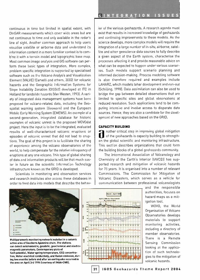
^integration ISSUES
continuous in time but limited in spatial extent, withDInSAR measurements which cover wide areas but are
not continuous in time and only available in the radar's
line of sight. Another common approach to help users
visualise satellite or airborne data and understand its
information content in a more familiar context is to com¬
bine it with a terrain model and topographic base map.
Most common image analysis and CIS software can per¬
form these basic types of integration. More complex,
problem specific integration is supported by specialised
software such as the Volcano Analysis and Visualization
Element (VALVE) (Cervelli and others, 2002) for volcanic
hazards and the Geographic Information Systems forSlope Instability Zonation (GISSIZ) developed at ITC in
Holland for landslide hazards (Van Westen, 1 993). A vari¬
ety of integrated data management systems have been
proposed for volcano-related data, including the Geo-
spatial warning system (Geowarn) and the European
Mobile Early Warning System (EMEWS). An example of a
second-generation, integrated database for historicexamples of volcanic unrest is the proposed WOVOdat
project. Here the input is to be the integrated, evaluated
results of well-characterised volcanic eruptions orepisodes of volcanic unrest that did not lead to erup¬
tions. The goal of this project is to facilitate the sharingof experience among the volcano observatories of the
world, to help compensate for the relative infrequency of
eruptions at any one volcano. This type of global sharing
of data and information products will be that much eas¬
ier in future as the scientific Information Technology
infrastructure known as the GRID is developed.
Scientists in monitoring and observation services
and research institutes also access these databases in
order to feed data into models that describe the behav-
Multiparameric monitoring networl< installed in a seismicactive area of Southern Apennine chain. The stationscan detect seismometric, geodetic, geochemical and electro¬magnetic parameters. Contemporary plots ofSelf-potential, Water spring temperature, C02 concentra¬tion. Water electrical conductivity, and Radon emission, dur¬ing two months before and after an earthqual^e occurred inthe area on April 3rd 1996 (courtesy of IMAA-CNRI.
ior of the various geohazards. A research agenda mustexist that results in increased knowledge of geohazards
and continuing improvements to these models. As the
science develops, more complex models will require the
integration of a large number of in-situ, airborne, satel¬
lite and other geoscience data sources to fully describe
a given aspect of the Earth system, characterise the
processes affecting it and provide reasonable advice on
what can be expected to happen under various scenar¬
ios. Such models support scenario planning and
informed decision-making. Process modeling software
is also therefore required and examples includeLAHARZ, which models lahar development and run-out(Schilling, 1998). Data assimilation can also be used to
bridge the gap between detailed observations that are
limited to specific sites and global observations at
reduced resolution. Such applications tend to be com¬
puting intensive and involve access to disparate data
sources. Hence, they are also a candidate for the devel¬
opment of new approaches based on the GRID.
CAPACITY BUILDING
another critical step in improving global mitigationof the geohazards is capacity building to strength¬
en the global scientific and monitoring infrastructure.This section describes organizations that could formthe building blocks of a global geohazards community.
The International Association of Volcanology and
Chemistry of the Earth's Interior (lAVCEl) has sup¬
ported research and mitigation of volcanic hazardsfor 75 years. It is organised into a number of relevantCommissions. The Commission for Mitigation of
Volcanic Disasters, which serves as a vehicle forcommunication between professional volcanologists
and the responsibleauthorities, focuses on
hazard maps as a mit¬
igation tool.wove, the World
Organisation of Volcano
Observatories develops
materials to supportmonitoring activities,including a directory of
member observatories.There is a Remote
Sensing Commissionlooking at the applica¬
tion of such technolo¬
gies to the mitigation of
volcanic hazards.
Euren .«pnmwl
31 IGOS Geohazards Theme Report 2004
GEOHAZARDS
Finally, the Cities and Volcanoes Commission has
set up the System for Technology Exchange for NaturalDisasters (STEND) as a conduit for exchange of infor¬
mation and ideas between cities affected by vo(canoes
and volcanologists and emergency planners who workin them. Good examples of other existing programs withcapacity building as their purpose include the Volcano
Disaster Assistance Program (VDAP) of the US
Geological Survey, formed in 1985 in response to the
disaster at Nevado del Ruiz. At the invitation of the host
country, VDAP personnel bring and install seismic,
deformation and gas monitoring equipment, train localpersonnel in its use and maintenance, and offer theirexperience in interpreting volcanic unrest to local scien¬
tists. A related program is the Center for the Study of
Active Volcanoes (CSAV), a cooperative project between
the University of Hawaii and the Vo(cano Hazards
Program of the USGS. Based in Hilo, this program pro¬
vides small groups of carefully selected scientists fromdeveloping countries a 6-week course of intense train¬
ing in volcano monitoring techniques, with Kilauea vol¬
cano as the laboratory. Over 70 scientists and techni¬
cians from developing countries have been trained at
CSAV since 1989.
The International Association of Seismology and
Physics of the Earth's Interior (IASPEI) promotesresearch on earthquakes and applied seismology thatdepends on co-operation between different countries.
Its Earthquakes and Megacities initiative has similarobjectives to STEND. lASPEI's European SeismologicalCommission (ESC) aims to extend and enhanceEuropean cooperation, minimising the divergencebetween countries and establishing European seismol¬
ogy so that it can fruitfully interact with the internation¬al community. ESC is now collaborating with countriesin North Africa and the Near East. Also on the European
level, UNESCO and the USGS run a Program on
Reducing Earthquake Risk in the EasternMediterranean Region. In cooperation with the Euro
Mediterranean Seismological Center and Observatoriesand Research Facilities for European Seismology, thishas been working for the past decade to promote seis¬
mic data exchange, joint data processing, instrumentcalibration, training and the reduction of seismic haz¬
ards through the development of seismic hazard maps.
As well as the US and Europe, almost 20 Mediterraneancountries are now involved. UNESCO has also support¬ed this type of initiative in other regions, such as theCentro Regional de Sismología para America del Sur,which is based in Peru and has 12 member states in
South America.
32
In the field of ground instability, such developments
are less advanced, probably because of the distributed and
localised expression of this global phenomenon. The main
initiative is the International Consortium on Landslides,
which was founded in 2002 after the Kyoto summit. It aims
to combine and coordinate international expertise on land¬
slide hazard mitigation and risk assessment. It plans
capacity building, communication and information activi¬
ties. These include: networking with other relevant initia¬
tives; the publication of the journal Landslide News, books
and guidelines; conference organization and sponsorship;
raising public awareness through the press and meetings;
training courses; and the supply of expert knowledge. The
IGOS geohazards theme is not aware of any similar initia¬
tives for subsidence.
fhe EO provider community concerned with geohaz¬
ards has organised itself under the leadership of the
Committee on Earth Observation Satellites, whichsponsored the DMSG Project. Many CEOS membershave strong programs in geohazards research and miti¬
gation. The CEOS DMSG report includes chapters withextensive discussion and recommendations for each of
the three geohazards and these recommendations formthe starting point for much of this IGOS theme's work.There is strong cross-membership between the DMSG
Working Groups and the IGOS Geohazards Theme Team
to facilitate this. The CEOS Strategic ImplementationTeam has recommended that CEOS be closely involved
in the implementation of the IGOS Geohazards in the
field of space-based observations. CEOS is therefore a
key component of any future capacity building activities.
One of the most effective steps that can be taken is
to spread best practice: for example, ways should be
found to apply new techniques developed at a few wellmonitored volcanoes to the majority of dangerous volca¬
noes around the world. For earthquakes, the USGS's
Shakemap is an example of an information product pro¬
duced locally that could be extended globally relativelyeasily. Similar steps can be taken for each hazard, using
strong case histories to facilitate this knowledge trans¬
fer process. Such case histories can form part of dedi¬
cated geohazards curricula and courses to grow the
community in the future.Education and training, especially of scientists from
the developing world, underpins capacity building by
delivering skilled, knowledgeable staff to work in geo¬
hazards institutes worldwide. Many organizations deliv¬
er such training, but the ITC has been particularly activein geohazards, collaborating with UNESCO and support¬ing the development of this IGOS theme. Providing sup-
IGOS Geohazards Theme Report 2004
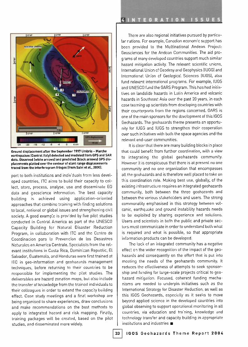
¡JÎ'JF
NOCFRA 1JFJRIÍ.'. ^D J
(à4 ^ 1
|ir!w ii'if
1^ / âJ
^^Mifll^'flï
K.
-^^^Bt^Î^(rn. ,.- V
\llA^ jii^ii il.-«
^^^^^Kn^KTT^^l v^ Ü-2« -za -1S -12 -« J cm ^^^^^^^^^H
Ground displacement after the September 1997 Umbria - Marcheearthquakes (Central Italy) detected and modeled from GPS and SARdata. Observed (white arrows) and predicted (black arrows) GPS dis¬placements plotted over the contour of slant range displacementstraced from the interferogram fringes (from Salvi et al., 2000).
port to both institutions and individuals from less devel¬
oped countries, ITC aims to build their capacity to col¬
lect, store, process, analyse, use and disseminate EO
data and geoscience information. The best capacity
building is achieved using application-orientedapproaches that combine training with finding solutions
to local, national or global issues and strengthening civilsociety. A good example is provided by five pilot studies
conducted in Central America as part of the UNESCO
Capacity Building for Natural Disaster Reduction
Program, in collaboration with ITC and the Centro de
Coordinación para la Prevención de los Desastres
Naturales en America Centrale. Specialists from the rel¬
evant institutions in Costa Rica, Dominican Republic, El
Salvador, Guatemala, and Honduras were first trained at
ITC in geo-information and geohazards managementtechniques, before returning to their countries to be
responsible for implementing the pilot studies. The
deliverables are hazard zonation maps, but also include
the transfer of knowledge from the trained individuals to
their colleagues in order to extend the capacity buildingeffect. Case study meetings and a final workshop are
being organised to share experiences, draw conclusionsand make recommendations on the best methods to
apply to integrated hazard and risk mapping. Finally,
training packages will be created, based on the pilotstudies, and disseminated more widely.
33
^INTE6RATIQN ISS U E S
There are also regional initiatives pursued by particu¬
lar nations. For example, Canadian economic support has
been provided to the Multinational Andean Project:
Geosciences for the Andean Communities. The aid pro¬
grams of many developed countries support much similarhazard mitigation activity The relevant scientific unions.
International Union of Geodesy and Geophysics (lUGG) and
International Union of Geological Sciences (lUGS), also
fund relevant international programs. For example, lUGS
and UNESCO fund the GARS Program. This has had initia¬
tives on landslide hazards in Latin America and volcanic
hazards in Southeast Asia over the past 20 years, in each
case teaming up scientists from developing countries with
their counterparts from the regions concerned. GARS is
one of the main sponsors for the development of this IGOS
Geohazards. The geohazards theme presents an opportu¬
nity for lUGG and lUGS to strengthen their cooperation
over such initiatives with both the space agencies and the
relevant end-user communities.
It is clear that there are many building blocks in place
that could benefit from further coordination, with a view
to integrating the global geohazards community.However it is conspicuous that there is at present no one
community and no one organization that encompasses
all the geohazards and is therefore well placed to take on
this coordination role. Making best use, globally, of the
existing infrastructure requires an integrated geohazards
community, both between the three geohazards and
between the various stakeholders and users. The strong
commonality emphasised in this strategy between vol¬
canic, earthquake and ground instability hazards needs
to be exploited by sharing experience and solutions.
Users and scientists in both the public and private sec¬
tors must communicate in order to understand both what
is required and what is possible, so that appropriateinformation products can be developed.
The lack of an integrated community has a negative
effect on the wider recognition of the impact of the geo¬
hazards and consequently on the effort that is put into
meeting the needs of the geohazards community. It
reduces the effectiveness of attempts to seek sponsor¬
ship and funding for large-scale projects critical to geo¬
hazard mitigation. Focused, coherent funding mecha¬
nisms are needed to underpin initiatives such as the
International Strategy for Disaster Reduction, as well as
this IGOS Geohazards, especially as it seeks to move
beyond applied science in the developed countries into
global observing to support operational monitoring in allcountries, via education and training, knowledge and
technology transfer and capacity building in appropriateinstitutions and industries
IGOS Geohazards Theme Report 2004
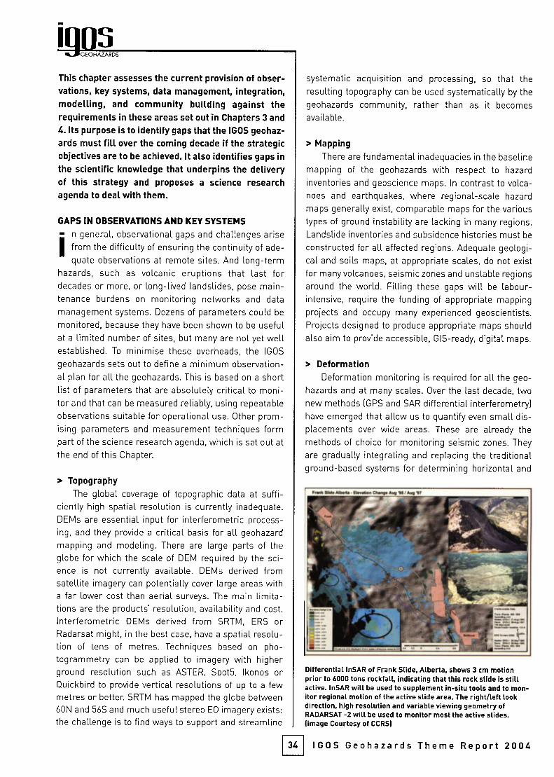
GEOHAZARDS
This chapter assesses the current provision of obser¬
vations, key systems, data management, integration,modelling, and community building against therequirements in these areas set out in Chapters 3 and
4. Its purpose is to identify gaps that the IGOS geohaz¬
ards must fill over the coming decade if the strategicobjectives are to be achieved. It also identifies gaps in
the scientific knowledge that underpins the deliveryof this strategy and proposes a science researchagenda to deal with them.
GAPS IN OBSERVATIONS AND KEY SYSTEMS
I" n general, observational gaps and challenges arisefrom the difficulty of ensuring the continuity of ade¬
quate observations at remote sites. And long-termhazards, such as volcanic eruptions that last fordecades or more, or long-lived landslides, pose main¬
tenance burdens on monitoring networks and data
management systems. Dozens of parameters could be
monitored, because they have been shown to be usefulat a limited number of sites, but many are not yet wellestablished. To minimise these overheads, the IGOS
geohazards sets out to define a minimum observation¬
al plan for all the geohazards. This is based on a shortlist of parameters that are absolutely critical to moni¬
tor and that can be measured reliably, using repeatableobservations suitable for operational use. Other prom¬
ising parameters and measurement techniques formpart of the science research agenda, which is set out at
the end of this Chapter.
> TopographyThe global coverage of topographic data at suffi¬
ciently high spatial resolution is currently inadequate.
DEMs are essential input for interferometric process¬
ing, and they provide a critical basis for all geohazard
mapping and modeling. There are large parts of the
globe for which the scale of DEM required by the sci¬
ence is not currently available. DEMs derived fromsatellite imagery can potentially cover large areas witha far lower cost than aerial surveys. The main limita¬
tions are the products' resolution, availability and cost.
Interferometric DEMs derived from SRTM, ERS orRadarsat might, in the best case, have a spatial resolu¬
tion of tens of metres. Techniques based on pho-togrammetry can be applied to imagery with higherground resolution such as ASTER, SpotS, Ikonos orQuickbird to provide vertical resolutions of up to a fewmetres or better SRTM has mapped the globe between60N and 56S and much useful stereo EO imagery exists:the challenge is to find ways to support and streamline
systematic acquisition and processing, so that theresulting topography can be used systematically by the
geohazards community, rather than as it becomes
available.
> Mapping
There are fundamental inadequacies in the baseline
mapping of the geohazards with respect to hazard
inventories and geoscience maps. In contrast to volca¬
noes and earthquakes, where regional-scale hazard
maps generally exist, comparable maps for the various
types of ground instability are lacking in many regions.
Landslide inventories and subsidence histories must be
constructed for all affected regions. Adequate geologi¬
cal and soils maps, at appropriate scales, do not exist
for many volcanoes, seismic zones and unstable regions
around the world. Filling these gaps will be labour-intensive, require the funding of appropriate mapping
projects and occupy many experienced geoscientists.Projects designed to produce appropriate maps should
also aim to provide accessible, GIS-ready, digital maps.
> DeformationDeformation monitoring is required for all the geo¬
hazards and at many scales. Over the last decade, two
new methods (GPS and SAR differential interferometry)have emerged that allow us to quantify even small dis¬
placements over wide areas. These are already the
methods of choice for monitoring seismic zones. They
are gradually integrating and replacing the traditionalground-based systems for determining horizontal and
34
Differential InSAR of Frank Slide, Alberta, shows 3 cm motionprior to 6000 tons rockfall, indicating that this rock slide is stillactive. InSAR will be used to supplement in-situ tools and to mon¬itor regional motion of the active slide area. The right/left lookdirection, high resolution and variable viewing geometry ofRADARSAT -2 will be used to monitor most the active slides,(image Courtesy of CCRS)
IGOS Geohazards Theme Report 2004

A: interferogram of Akutan Volcano in the Aleutians, made fromC-band ERS imagery (Lu and others, 2000) is only locally coherent(rainbow areas).B: interferogram made from L-band JERS data (Rykhus and others,20021 has fewer fringes, but achieves coherence over almost theentire surface of the island, allowing us to see the entire deforma¬tion pattern. To date, the JERS SAR mission has not been followedup with a new L-band instrument and so such observations are notcurrently possible, (image Courtesy of USGS)
vertical displacements and tilt that were developed formonitoring deformation at volcanoes. DInSAR is being
used in a pre-operational system to monitor subsidencein Europe. In the case of GPS. we can obtain precise,
long-term measurements of topographic change,whether in regions of high interest (southern California,with the SCIGN network) or globally (the IGS network).The main limitation is that the high-density networksneeded for hazards monitoring exist only locally. A
major challenge for the integration of local GPS data
globally, and the integration of GPS data with older, her¬
itage deformation data sets, is a lack of standard for¬
mats and established archives, plus limited accessibili¬
ty for the different kinds of deformation data.
Satellite radar differential interferometry providesthe capability to map past and ongoing crustal displace¬
ments, day or night, in all weather and over wide areas.The CEOS DMSG Report concluded that building up
long time series of radar images over sensitive loca¬
tions would enable more systematic exploitation of
multi-interferometric techniques. Their wider applica¬
tion to displacement monitoring is limited by: inade¬
quate temporal resolution; a lack of coherent data, due
to the radar frequency at which observations are cur¬
rently made; the difficulty of resolving Une-of-sightmeasurements into three dimensions; and insufficientmission continuity. The most frequent observation wasachieved during ERS's Tandem Mission, when it was
shown to be possible to monitor even certain types of
landslides using DInSAR. This was based on a 1-day
revisit interval, whereas SAR satellites typically have
revisit interval in the order of 1 month.Development has also been limited by the relative
inability of existing (C-band) systems to produce infor¬
mation over unconsolidated or vegetated natural sur¬
faces. L-band DInSAR has been shown to be applicableover a wider variety of natural land surfaces than C-
band during the now-completed JERS mission. This is
illustrated here by two interferograms, one of ERS data
and one of JERS data, showing the deformation fieldproduced in the 1 996 seismic crisis at Akutan Volcano in
the Aleutians. The recent report from the Solid Earth
Science Working Group (SESWG) "Living on a Restless
Planet" also emphasises the relevance of L-band SAR
for differential interferometry over natural surfaces.
Filling this gap in observations, perhaps using the forth¬
coming PALSAR or the proposed TERRASAR-L sys¬
tems, is critical to the success of the IGOS Geohazards.
At either wavelength, there is an urgent need forlong term continuity of observations. The phenomenato be observed are often slow but continuous, and theirsuccessful monitoring can only be achieved withdecades of satellite data. Other requirements are thatthe orbit and satellite design be optimised for thisapplication, be tasked specifically with interferometryin mind, in order to provide sufficient frequency of
observation and have sufficient look directions to
resolve motion in three dimensions. More generic mis¬
sions have been used to great effect in research modebut they involve compromises in spatial, spectral and
temporal resolution that limit the utility of these obser¬
vations for operational geohazard mitigation in generaland long-term monitoring in particular
> SeismicityAs noted earlier, earthquakes large enough to
cause damage (M > 5.5) can be detected worldwide and
are generally reported within minutes, although theglobal availability of the supporting seismic data could
be improved. But the principal gap here is that manyurban areas in high-risk seismic zones have inadequate
35 IGOS Geohazards Theme Report 2004

GEOHAZARDS
local monitoring, plus inadequate building and land-useplanning practices. For volcanoes the key issue is the
provision of adequate seismic networks at all hazardous
volcanoes sited in populated areas. Experience at well-monitored sites has shown that six seismometers pro¬
vide a minimally adequate network for one volcano, but
many hazardous volcanoes are inadequately monitoredor completely unmonitored.
> Thermal monitoringThermal data have obvious application to volcanic
eruptions and less well-established links to earth¬
quakes. Meteorological satellites have provided fre¬
quent but low-resolution thermal imagery for more
than twenty years. Such data have proven useful as
detectors of volcanic activity, and at dispelling erro¬
neous reports of eruptions at remote volcanoes. But the
spatial resolution is too low to be of much use to volcano
observatories. This low-resolution data has been sup¬
plemented by less frequent but more detailed data fromsensors such as Landsat TM/ETM and ASTER. There is
a need for data continuity, whether of a Landsat
TM/ETM or ASTER sensor, in order to let the potential of
this intermediate-resolution imagery develop. However
the most promising technique for detailed thermalmonitoring of volcanic activity is the use of portable dig¬
ital infrared cameras. This rapidly spreading techniquecan produce highly detailed thermal images of active
lava flow fields and domes, at whatever time intervalscientists require. The cost of supplying digital IR cam¬
eras to all of the volcano observatories in the worldwould be a small fraction of the cost of building even
one satellite that could achieve the same resolutionfrom space. A coordinated system would exploit the
Infrared video images showing details of the flow field and lava tubesystem at Kilauea Volcano, Hawaii. The view is upslope (to the west).The tube systems are about 10 km long, (from Kauahikaua and oth¬ers, 2003).
36
complementary attributes of all these existing systems,
allowing improved time series thermal data of haz¬
ardous areas at all resolutions.
GAPS IN DATA MANAGEMENT
the target here is to establish well-managed, visibleand accessible databases of the relevant observa¬
tions and to use these to create "strategic dataseis"for particular geohazards, backed up by well-docu¬mented case studies. The existence of such dataseiswill facilitate the production of ancillary data for hazard
mapping, guide ongoing systematic acquisitions over
hazard-prone areas and drive new, targeted acquisi¬
tions during a crisis. At a basic level databases exist formost types of Earth Observations, often as part of a pro¬
cessing and archive facility, and for many ground-basedmeasurements, as part of particular organisations' data
management strategies. The gaps that exist relate to
the visibility and fitness for purpose of these data
stores. The requirement is for much more than storagewithin a single organisation. Databases are needed witha high visibility within the geohazards community, which
facilitate the transfer of data, information and knowl¬
edge between different types of users in different coun¬
tries. Interoperability of databases is crucial, as geo¬
hazards require multidisciplinary research. The hetero¬
geneous nature of existing databases can be an obsta¬
cle to the progress of our understanding of failuremechanisms. This leads to the need forthe creation and
population of international geohazards databases.
A good example of what is required is provided by
the evolving World Organisation of Volcano
Observatories database. Similar initiatives are needed
for all the geohazards. Such databases should containboth baseline data and the outputs of monitoring activ¬
ities, including relevant ground-based data from geo¬
science organisations and also data from existing satel¬
lite archives. The data in them should be calibrated, val¬
idated, put into a standard format and quality assuredprior to databasing. This IGOS Geohazards shoulddevelop operational, and perhaps even automated,arrangements that will make the translation of data into
information contained in useable products happen moreefficiently. Mechanisms are needed to facilitate therapid and smooth transfer of data from the space agen¬
cies to the scientists monitoring geohazards and of
information from the scientists to the users. As soon as
an image is acquired over sensitive areas, the dataprovider should send an automatic notification to a listof subscribers interested in imagery over specific geo¬
graphic locations.
IGOS Geohazards Theme Report 2004

I ^ILLIN6 THE GAPS
Pricing strategies are not currently designed to
support cost-effective data access by developing coun¬
tries and they should be reconsidered. Some InSAR
studies of displacement require the purchase of many
images, over a ten-year period, as part of a strategicmonitoring programme with long-term continuity. Such
repeat data purchases for operational use should also
be made easier and more cost-effective to facilitatelong-term monitoring. In a more advanced phase, data
could be automatically processed at the scientist'spremises and, as soon as useful information on a haz¬
ard existed, the processed image products could be
sent to the local users. Technological developments like
extranet solutions and the emerging, advanced comput¬
ing GRID network should be used to manage, access,
exploit and distribute the large amounts of data and
information products required by geohazard mitigation.Provided that adequate models, appropriate softwaretools and sufficient observations exist, the end userscould even activate this process rather than the scien¬
tists, as happens in the International Charter on Space
and Major Disasters.
GAPS IN INTEGRATION AND MODELING
mproved databases, complemented by sharedI experience and improved analysis and modeling
tools like neural networks, fuzzy logic, statistical,stochastic and geostatistical methods, will open new
possibilities for developing data integration in supportof geohazards analysis. Integration of data acquired at
different resolutions, with different accuracies and
geometric characteristics and from different observa¬
tion systems, still needs a major effort from the scien¬
tific community. For example, the techniques needed
to monitor crustal deformation and surface displace¬
ment include both satellite-supported DInSAR and
ground-based monitoring, with GPS monitoring com¬
bining elements of both. The methods are comple¬
mentary: ground-based monitoring can provide a
record of deformation at a specific point on the groundthat is continuous in time, while DInSAR gives us peri¬
odic measurements of the areal distribution of dis¬
placement over wide areas. Both are needed in an
operational monitoring scenario and they can also be
used to cross-validate the observed deformation,increasing confidence in both individual results.Bawden and others (2001) provides an example of thevalue of combining the two approaches in a tectonical-ly complex area. But, in the main, the integrated use of
ground and satellite data is generally limited to inter-comparisons and data calibration.
37
Prediction of future events requires models and
numerical simulations based on well-understood Earth
system processes. There is a proliferation of different
models with widely differing assumptions, depending on
the scales of investigations. This is of major importancefor hazard mapping and monitoring of events ranging
from local to regional distributions. Models vary fromsimplified to complex. The former are approximate, but
they necessitate fewer input parameters and may be
applied to large zones. The latter are sometimes indis¬
pensable for evaluation of the stability of a specific, dan¬
gerous ground instability hazard but are data hungry. In
both cases, it is necessary to establish their capability,
accuracy, and sensitivity with respect to the needed
effort for gathering model inputs. Numerical simula¬
tions are still rare, especially for example in ground
instability studies, due to the difficulty of obtaining therequired input parameters and the heavy 3-D computa¬
tions involved. The development of reliable physical
models requires a better understanding of physical
processes, thresholds in physical properties and trigger¬
ing mechanisms. Field observations and laboratoryexperiments should be carried out to advance this.
This IGOS Geohazards can also contribute to the
development and documentation of standard data pro¬
cessing software and protocols and standard informationproducts. Some standard products exist but only in cer¬
tain countries and for certain hazards. The IGOS
Geohazards should extend this to all hazards and ensure
that such standard products become established in the
wider geohazards community Similarly, standard visual¬
isation tools are needed that can be used by scientists
and users alike to rapidly analyse new information prod¬
ucts as they a reproduced, whether working in the labo¬
ratory, at an observatory or in the field. Finally, workshould continue on the improvement of Earth system
process models via the research agenda proposed below.
BUILDING THE GEOHAZARDS COMMUNITY
Currently there is no global coordination mechanismto implement the IGOS Geohazards. One result of
this is relatively poor integration within the geohazardscommunity in comparison to, for example, theOceanography or Meteorology communities.Communication needs to be increased between all thekey players and across all the continents. This lack of
integration hinders many other desirable actions. Users
do not consistently define information products throughdialogue with monitoring and advisory agencies.Scientists do not consistently define the required obser¬
vations that the observing systems should make and do
IGOS Geohazards Theme Report 2004
GEOHAZARDS
not work in an integrated fashion across their disci¬
plines, technologies, or application areas often enough.
Appropriate technologies and methods for developing
global applications are lacking. The best students are
not attracted to study and consider careers in geohaz¬
ards, with most expertise developing during generalgeoscience careers and coming into the geohazards
field by serendipity in mid-career. Funding is also dis¬
persed and predominantly governed by the priorities of
individual organisations, regions or nations. An example
of this is that the International Strategy for DisasterReduction, the most visible international initiative in the
field of geohazards over the past decade, has no dedi¬
cated funding, unlike equivalent initiatives in other envi¬
ronmental application areas.
Geohazards sometimes have limited visibility in
wider decision making processes. For example, theimpact on hazard monitoring of the high price of band¬
width for satellite data links, caused by the telecommu¬nications market, is not being addressed, because the
geohazards community does not have a voice in thatdecision making process. The first step must be to cre¬
ate a coordinating mechanism. This should then be
used to encourage improved communication through¬
out the geohazards community, foster the transfer of
knowledge and information from the developed to the
developing world, and develop curricula to stimulatestudy courses dedicated to geohazards. The develop¬
ment of a more integrated geohazards community willalso have spin off benefits in crisis response, by
enabling the rapid gathering of expertise during a crisis.
And that geohazards community will be in a better posi¬
tion to present a coherent case to politicians and fund¬
ing agencies when this is necessary.
SCIENCE RESEARCH AGENDA
the social and economic issues created by the geo¬
hazards require an improved understanding of these
hazards. To do this, we need not only more extensiveobservations but also better models. Their purpose is to
produce refined hazard scenarios, and so increase ourability to mitigate hazards, with the ultimate goal of
being able to issue forecasts for individual geohazards.In order to offer forecasts, geoscientists must reach
consensus on identifying and validating precursory sig¬
nals. Useful precursory signals are those that allow us
to specify with reasonable confidence where an event
will occur, how big it will be, and something of its char¬
acter. This must be done with enough lead-time for theresponsible agencies, governments and citizens to
respond to the warning. Progress toward adequate fore-
38
casting is uneven across the geohazards, with volcanic
hazards being quite advanced in this respect and earth¬
quake forecasting perhaps offering the most difficultchallenge. The scientific agenda outlined below indi¬
cates both some promising areas of research, some of
the remaining challenges, and additional observationsand systems that should be investigated to see if they
can one day be used operationally.
> Volcanoes
At well-monitored volcanoes we can anticipate the
nature of the activity and give some early warning of
events, but we still lack the ability to forecast the size
and timing of eruptions. We need to refine our under¬
standing of volcano seismicity, deformation patterns,and degassing behaviour, and the relationship between
a volcano's geothermal and magmatic systems. Specificareas of interest include:
The recent development and deployment of broad¬
band seismometers, capable of recording long-periodearthquakes with individual events lasting 10-100
seconds. This has revealed a wide, previously unde¬
tected range of seismic signals, produced by the
movement of magma, hydrothermal fluids and gas
within volcanoes. Progress in their interpretation is
limited, in part by the complexity of the phenomena,and in part by the enormous computer processingcapacity required to take full advantage of the data. At
present, evaluation of these data is in the sphere of
research but it will improve our models of how volca¬
noes work significantly. If certain types of events are
shown to be reliable indicators of magma movement,and hence of an impending eruption, the geohazardscommunity will need to consider how best to supportwider installation of these instruments, as well as
how to support the large, shared computing facilitiesrequired to process the data.
Wider observations of gravity changes at volcanoeswould increase our understanding of volcanic process¬
es. Recent research using InSAR has shown that volca¬
noes can steadily inflate, presumably because new
magma is rising within them, even though there is not
yet any associated seismic activity during this steady
inflation phase (Wicks and others, 2002). To distinguishbetween inflation caused by magmatic intrusion and
inflation caused by pressurisation of a geothermal sys¬
tem, it is necessary to monitor changes in gravity at thesame location. At present, relatively few volcanoes aremonitored for gravity changes and so more extensive
IGOS Geohazards Theme Report 2004

gravity monitoring is needed, especially at deformingvolcanoes where there is inflation.
Other techniques that have been applied at volca¬
noes include the in-situ measurement of electric or
electromagnetic properties, which are affected by the
migration of fluids and gases in the subsurface. Such
migrations occur for all three hazards but the related
electro-magnetic effects are not yet well enough under¬
stood to demonstrate their value to operational moni¬
toring. For example, the signature of the geothermalsystem that exists under an active volcano dominates its
EM response and so the relationship to the magma sys¬
tem itself is uncertain. Further study of these parame¬
ters at active volcanoes may serve to reduce ambiguityin their interpretation.
Increased emission of steam, S02 and/or 002 fre¬
quently precedes volcanic eruptions, but quantitativelinkages are mostly still lacking. For S02, the principalscientific challenge has been the difficulty of mapping
low-altitude S02 and aerosol plumes over wider areas
with high resolution data. This could be done withASTER, if such imagery were available more frequentlyObstacles to the routine monitoring of volcanic C02
from space are the relatively high 002 content of the
atmosphere and the fact that most 002 emissions are
not associated with eruptions, but are non-explosive,diffuse, and occur at low temperature. Because C02 is
Electrical potential field (in volt) recorded at the Misti volcano(from Finizola et al., in press)
39
heavier than air. it flows along the ground, or seeps out
through the soil, making it difficult to detect by satellitetechniques. 002 plumes are deadly, however; the 1986
C02 emission at Lake Nyos, Cameroon, killed more
than 1,700 people and much livestock. Mitigation of this
hazard will require ground-based monitoring and warn¬
ing systems and these have yet to be developed.
Volcanoes emit other gas species, such as HCl and
HP among others. The newly available Open-Path
Fourier Transform Infra-Red spectrometer permits thedetection and characterization of all gas species pres¬
ent in active volcanic plumes, at temperature. Its use
will advance understanding of volcanic degassing, and
could lead to ground or even space-based monitoring of
the particular gas species that best predict volcanic
activity, once these have been firmly established.
> EarthquakesWe are further from being able to provide meaning¬
ful forecasts for earthquakes than we are for volcanic
eruptions. There are still major research issues sur¬
rounding the initiation of earthquakes, and documenta¬
tion and interpretation of the ground motions and defor¬
mation that constitute the earthquake itself. In addition,whilst a wide range of phenomena have been observed
at the same time as some large earthquakes, it is not
yet clear how closely and in which way these phenome¬
na are linked to earthquakes. There is as yet no con¬
sensus on any consistent precursory signal of an
impending earthquake. Promising research areas include:
The need for better understanding of pre-, co- and
post-seismic ground motions. Relative displacementsalong faults are typically measured after the earthquake.Wider deployment of permanent, continuously recording
GPS networks will provide a more complete picture of
pre- and post - event displacement. Wider use of
DInSAR across all the main active faults can help docu¬
ment continuous strain and identify locked segments of
major faults. These data, coupled with other geodetic,
hydrologie and geophysical data, will help scientists to
understand how the crust deforms in inter-seismic peri¬
ods. This will, in turn, form the basis for refined seismicprobability forecasts. Other questions concern the focal
mechanisms of the earthquakes and how rupturesevolve, both kinematically and dynamically.
New tomographic techniques for geophysical data
inversion [resistivity imaging, reflection and refractionseismology, self potential) can be applied to the mapping
IGOS Geohazards Theme Report 2004
GEOHAZARDS
of active faults, to define the geometry of complex tec¬
tonic structures and to characterise shallow geologicalenvironments that generate local seismic amplification.
Ancillary phenomena that may be associated withearthquakes include: surface thermal anomalies and
surface and near-surface temperature changes (report¬
ed for a number of earthquake events), sometimesaccompanied by changes in soil moisture, changes in
chemistry of pore waters and pore gases, and changes
in atmospheric composition (for components such as
CH4, C02, He, H2). Much of the work to date relies on
historic data and isolated reports, so no consensus has
yet emerged. A good summary of the very varied phe¬
nomena reported as occurring during earthquakes is
given in Singh (2003) for the recent Gujarat earthquake.More consistent monitoring of such events is required
to lead to an improved understanding of their relation¬
ship to earthquakes and enable a full assessment of
their utility as precursors.
Possible links between earthquakes and electro¬magnetic phenomena is an emerging area of research.
The next mission focused on electromagnetic signalsand their possible correlation with earthquakes is
DEMETER, to be launched in 2004. with an expected
lifetime of two years. Ground-based EM measure¬ments (including self-potential anomalies and UltraLow Frequency (ULF) emissions) will be an essentialcomponent of validating the connection betweenanomalies detected by satellites that are suggested to
be related to earthquakes and volcanoes and earthsystem processes.
Similarly, possible links between earthquakes and
changes in the Earth's gravitational field are being
researched actively at the present time. Satellite mis¬
sions to monitor changes in the Earth's gravitationalfield, such as GRACE. CHAMP and the planned GOCE
may elucidate the link between deeper tectonicprocesses and the geohazards. Once understood in
detail, these phenomena might offer promise as a
precursor.
> Ground instabilityFor the various types of ground stability, the need
for forecasting capability is a function of how fast theparticular type of ground failure or motion can occur.For landslides triggered by earthquakes, our ability to
forecast is limited by our current inability to forecastearthquakes. For ground failures triggered by severe
weather, we depend in part on weather forecasting.Areas of research that will lead to a better understand¬
ing of what controls ground instability include:
The processes that trigger the motion, which are of
critical importance whether natural or anthropogenicand include rainfall events, earthquakes and human
modification of land-cover and land-use. Soil moisturevariations are a natural triggering mechanism thatdeserves particular attention, because there are
emerging techniques that offer the potential to measurethe parameter remotely and in-situ monitoring is also
being improved. The Soil Moisture and Ocean Salinity(SMOS) satellite mission offers an opportunity for a
strong research project on this topic. Mining triggerssubsidence in a predictable fashion, but the linksbetween mine closures, rising water tables, mine gas
emission, seismicity and fault reactivation over a period
of decades need urgent investigation.
Delimiting the true extent of the subsidence prob¬
lem is difficult, because of the disparate causes and thelack of global observations until now. There is some evi¬
dence that it is more widespread than first thought, may
be accelerating in some areas and could be spreading
to new regions. Improved global observations will not
only help to monitor the known problem areas but they
will also provide a time-series dataset capable of
answering these wider questions.
Similarly, there is evidence for a link between cli¬
mate change and the frequency of landslide occur¬
rence. The role of landslides as a landscape evolutionprocess and their response under the future climatescenarios currently being evaluated presents an inter¬
esting area of interaction between geoscientists and cli¬
mate researchers. It could eventually support high-level, long-term, regional landslide forecasts.
Better understanding is needed of the patterns of
motion before, during and after events. The speed of
motion ranges from millimetres per year, which can be
effectively monitored rather than requiring a forecast, to
metres per second, which represents a catastrophicevent that does need forecasting. The speed of thesemotions changes with time and it is possible that suchchanges are precursors to the more significant events.
DInSAR may allow slow, small-scale motion to be
observed systematically for coherent targets. Fieldinstrumentation to monitor ongoing deformation is
essential, as well as the development of satellite based
40 IGOS Geohazards Theme Report 2004
monitoring that can be applied to targets that may
decorrelate over small time-intervals, like landslides.Ground-based interferometers may be a solution
for monitoring landslides, because of their high tempo¬
ral frequency. The main advantages are continuousmonitoring, optimal illumination geometry, flexibilityand the possibility to remotely monitor landslides up to
a distance of about a kilometre, the latter being espe¬
cially important when landslide sites are not easily
accessible with traditional instruments. These systemsalso offer two-dimensional images, and can provide
cost-effective solutions for specific sites, where the sys¬
tem can be properly installed and long-term monitoringproperly established.
TIME SCALE ISSUES
Dne of the most formidable obstacles to effectiveglobal monitoring of geohazards is that activity
occurs at an enormous range of time scales. Explosive
eruptions may be over in a few hours to a few days,
while pyroclastic flows and lahars can move at metresor tens of metres per second. Even the largest earth¬
quakes are over in minutes. Landslides may be rapid,catastrophic events on similar time scales to erup¬
tions. For rapid events, scientists are dependent on
monitoring networks already in place, or geostationarysatellites (which can take an image every 5-15 min¬
utes), or strategically placed time-lapse or video cam¬
eras, or observers in aircraft, to capture details ot the
events. One scientific challenge, then, is that effective
EG monitoring will require either a range of higher-resolution sensors on geostationary satellites, or larg¬
er constellations of low-Earth-orbiting (LEO) satellitesthan currently exist.
Other events are far slower: eruptions can last fordecades, like the current long-lived eruptions at
Montserrat (1995-present), Popocatepetl (1995-present),
Etna (1991-3 and 1995-present) and Kilauea (1983-pres-
ent). Regional subsidence can be a slow, relentlessprocess occurring over similar timescales. These long-lived events tax the patience of scientists, emergency
managers, and the general public alike. The need forcontinual monitoring becomes very expensive, whether it
is ground-based or uses satellite observations. Improved
monitoring and archiving of long-lived events will help
establish which parameters are most useful, in order to
make long-term monitoring as efficient as possible.
Then there is also the issue of the long repose timebetween large events. Taking volcanoes as an example.
about 60 of the world's 1 500 potentially active volcanoes
erupt in any given yean Most erupt only once a centuryor less frequently. Volcanoes with long repose times do
not make good neighbours, however; they generallyproduce much larger and more dangerous eruptionswhen they finally awake. El Chichón (1982. repose time600 years) and Pinatubo (1991. repose time 500 years)
are recent examples of such behaviour The populationnear those two volcanoes can take some comfort in thethought that it is unlikely that their volcano will eruptagain in their lifetimes. However there are many such
volcanoes around the world, and there is no easy way to
anticipate which will be the next Pinatubo. There is a
similar long repose time between extremely largeearthquakes at any one location.
It is difficult, for scientists and for society, to watchfor an event that may not occur for several centuries.For example, at Mt. Rainier, the USGS has installedacoustic flow detectors, to warn of life-threatening but
rare large lahars. and extensive efforts have been made
to ensure that the public understands the hazard and
the warning system, and will respond appropriately to
an alarm. But how often must the education process be
repeated, to keep the population informed? How many
times will the equipment need to be upgraded or com¬
pletely replaced, if centuries pass before a lahar rum¬
bles down from Mt. Rainier and justifies the whole
enterprise? A similar issue exists for how best to miti¬
gate for earthquakes that may occur once in a centuryor less. Perhaps the most difficult part of establishingan effective IGOS Geohazards will involve developing
systems to monitor and prepare for these highly dan¬
gerous, but relatively rare, catastrophic events
41 IGOS Geohazards Theme Report 2004

GEOHAZARDS
This chapter sets out the implementation mecha¬nism for the strategy, based on the UNESCO-IUGS
Geological Applications of Remote SensingProgram. It proposes an action plan to achieve itsfour strategic objectives over the coming decadeand the establishment of a working structure to fol¬low the plan. The roles of key players who are com¬
mitted to act are identified, including the BGS,
UNESCO, ICSU, CEOS and ESA. Three, six and nine-year reviews will assess implementation of short,medium and long-term actions. Feedback will be
provided to the IGOS Partners and the wider geo¬
science community.
IMPLEMENTATION MECHANISM
the IGOS Partnership prefers themes to be implement¬
ed using an existing mechanism and, wherever possi¬
ble, one of the Global Observing Systems (Global
Ocean Observing System-GOOS for the Oceans, Global
Terrestrial Observing System-GTOS for Terrestrial orGlobal Climate Observing System-GCOS for Climate). This
is designed to ensure integration, avoid duplication, reduce
the need for new structures and maximise the chances of
successful theme implementation. Some IGOS themes are
well suited to this implementation model, like the Ocean
Theme whose natural home is within GOOS. But the IGOS
Geohazards does not have an obvious home of this kind.
None of the existing global observing systems encompass
the active, ground-based geohazards community in geo¬
logical surveys, institutes, university departments, obser¬
vatories and related monitoring networks adequately.
Consequently, they have not been significant players in the
Theme's development and they do not have the appropri¬
ate vehicles to lead its implementation. An alternative
mechanism must be identified.
Two IGOS Partners, UNESCO and ICSU (throughlUGS), represent the active ground-based element of
the geohazards community within IGOS. They have
funded a joint initiative called the GeologicalApplications of Remote Sensing Programme (GARS)
since 1984. Its aim, on the scientific level, is to assess
the value and utility of remotely sensed data for geo¬
science applications. At the same time, it has been
building capacity by assisting institutes in developing
countries to acquire and apply modern technology.GARS has been chaired by the geological surveys of
France, Germany and, since September 2003, Britain, in
the person of the IGOS Geohazard Theme TeamChairman. The ground-based geoscience communityfrom other geological surveys, geoscience research
institutes and academia is well represented. Over 20
years, it has run projects in Africa on geological map¬
ping, in Latin America on landslide hazards and in Asia
on volcanic hazards. It is a main sponsor of the IGOS
Geohazard Theme's development.
Rather than invent a new mechanism to implementthe geohazards theme, the IGOS Geohazards Theme
Team proposes to transform GARS into a suitable vehi¬
cle for theme implementation. UNESCO and lUGS have
given the GARS Chairman a mandate to modify the pro¬
gram to achieve this end. The main steps will be to
secure formal involvement from the space segment and
seek the representation of a wide range of scientific and
applied disciplines worldwide. Space agencies with an
interest in or with active programs on geohazards
issues include BNSC, CNES, ESA. NASA and theJapanese Aerospace Exploration Agency (JAXA). The
representative body within IGOS for these agencies,CEOS, is committed to assisting the space element of
theme implementation through its StrategicImplementation Team. To support this, CEOS SIT has
agreed to become associated with GARS, which will be
expanded to include the interested space agencies. As a
co-Chair of the IGOS Geohazards, ESA will be invited to
participate in defining the shape of the new GARS
Program. GARS will also strengthen its links with otherrelevant ICSU member communities to draw on the
expertise of other scientific disciplines and will use its
networks to seek worldwide representation.
ACTION PLAN 2004 -2012aseries of short, medium and long-term actions are
proposed over the coming three, six and nine
years, tied into a review cycle proposed later in thischapter. Summarised in the accompanying text boxes,
they are described here in the order in which they
address the strategic objectives set out in Chapter 1:
building capacity; improving observations, increasingintegration and promoting take-up.
> Capacity building actionsNone of the strategic objectives can be fully
achieved without the participation of a coherent, inte¬
grated geohazards community. The development of a
global coordinating mechanism to implement thestrategy is the biggest challenge facing the IGOS
Geohazards. The immediate priority will therefore be
to establish GARS as a fit vehicle for theme imple¬mentation.
42 IGOS Geohazards Theme Report 2004

In the short term GARS will begin to fosterimproved international cooperation between the key
players, including the representative bodies withinICSU for all affected scientific disciplines, the associa¬
tions of all relevant professionals and organizationsworking on the geohazards in regions that have not yet
played an active role in the theme. Collaboration withother themes will be explored to assess its potentialfor dealing with hazards, such as tsunamis, ash cloudsand floods, which fall on the boundaries between the
geohazards, oceans, atmospheric chemistry and watercycle themes. As the lead body for theme implementa¬tion, GARS will have several important roles. The mostimportant will be to initiate actions, assess their out¬
comes and report the resulting progress on achieving
its strategic objectives to the IGOS Partnership,through its lead partners UNESCO and ICSU. But it is
hoped that GARS will also be in a position to help over¬
come the fragmentation of the geohazards communi¬
ty. For 20 years, GARS has worked via integratedregional initiatives on particular topics to achieve its
capacity building objective. This successful model willbe developed in order to support stronger participationin the IGOS Geohazards from Africa, Asia, South
America and Australasia than has been possible to
date. Contacts made during the IGOS Geohazards
workshop, via the IGOS Geohazards website and usergroup and through the international peer review of thisdocument will form the basis for this expansion. GARS
will seek ongoing participation in the relevant interna¬
tional conference sessions that are run by lUGS.
ISPRS, IGARSS, lAF, COSPAR and other internationalorganisations on the geohazards theme.
In the medium term GARS will support curriculumdevelopment within international educational pro¬
grammes run by UNESCO and organizations such as
ITC in the Netherlands. It will establish regional train¬
ing workshops, another successful feature of past
GARS activities. These will be used to build north-south networks and so increase capacity in developingcountries. In the longer term, technology transfer willfollow through these networks.
> Observations and key systems actionsSignificant improvements in geohazard mitiga¬
tion must be supported by enhanced global observa¬tions. Initially, better use should be made of existingobservations and the systems used to make them.Ultimately, operational observation will requiresome new satellite and ground-base observation
43
technologies to be put in place.
The short-term priority will be to build on existing
and planned systems. One way to do this is to seek the
release of data already collected but not yet widely
available. The most important examples where thisshould be achieved concern topographic data collect¬
ed by the Shuttle Radar Topographic Mapping Mission
and the ASTER data, which could be used to provide
global topographic data at a more adequate resolutionthan is currently available with minimal delay. NASA
and Japan's Ministry of Economy, Trade and Industry(METI) will be approached to explore how to achieve
this. In order to get the maximum return out of allexisting and planned observations, including C- and L-
band SAR, sensors described in this report will be the
subject of an early evaluation of their current orexpected utility for geohazards observation. In thisway, the theme's observational requirements will be
subjected to an early review, documented with refer¬
ence to published case studies and updated within theIGOS Partner's database. Discussions will be held withthose space agencies planning missions that could
provide whole or partial solutions to these require¬
ments. At the same time, arguments will be made
concerning the need for continuity of ASTER data to
provide thermal infrared observations. Continuity and
integration of GPS, CLONAS and GALILEO geodeticobservations, and especially of C band interferometrydata, will also be pursued. This is necessary in order to
facilitate exploitation of the systematic data archivesbuilt up over the past 15 years.
In the medium term, the IGOS Geohazards willseek support for the development of new instrumentsto provide any criticaL missing observations. The pri¬
mary new instrument required is an L-band SAR inter¬
ferometer designed for, and tasked with, the observa¬
tion of deformation in three dimensions. Research thathas been documented in order to demonstrate thisrequirement will be used in order to put forward a
strong case for a dedicated L-band interferometrymission. This case will be disseminated widely and it
will form the basis for discussions with CEOS, in orderto assess whether a dedicated mission can be
achieved. On the ground, the main effort should be
directed at increasing the coverage and density ofseismic networks and improving real time data trans¬mission capabilities and accessibility. Emerging tech¬
nologies such hyperspectral thermal sensors will be
kept under review. In the long term, the required sen¬
sors should be launched and commissioned.
IGOS Geohazards Theme Report 2004
GEOHAZARDS
> Integration and modeling actionsStudies will be encouraged that develop an integrat¬
ed approach to the geohazard issue, improve our mod¬
els of these hazard's behaviour and so add to the store
of knowledge underpinning geohazard mitigation.
In the short term, an evaluation will be made of the
useful information products that could be created by
integrating existing observations and how these can be
used more widely. Liaison will be established with, and
encouragement given to, projects that seek to do this.Discussions will be held with projects initiated underthe Global Monitoring for Environment and Security ini¬
tiative in Europe, such as TerraFirma, and as part of
Earthscope in North America. A dialogue will be estab¬
lished with the Global Earth Observation groups con¬
cerned with data integration and information productsthat emerge from the EO summit series. To look at the
full range of integration issues, an international project
will be established on InSAR-GPS integration as a cen¬
terpiece of the IGOS Geohazards. This will demonstratethe synergy to be achieved by integration in: satelliteand in-situ observations; periodic and continual meas¬
urement; areal coverage and point data; EarthObservation and geodesy; modeling and visualisationtools; and the scientific communities studying all three
of the geohazards.
In the medium term, services identified by the initialevaluation that are not yet established should be devel¬
oped by using existing international funding mecha¬
nisms to initiate bids from within the geohazards com¬
munity. Long-term efforts will aim at coordination of allthese services globally and their integration into a geo¬
hazard observation infrastructure for the monitoringand advisory agencies akin to those already developed
for Oceanography and Meteorology.
> Databases and infrastructure actionsPromotion of these better ways of working requires
improvements to the underlying infrastructure in orderto facilitate the transfer of data, information and knowl¬
edge between different types of users in different coun¬
tries. The IGOS Geohazards Theme will seek more effi¬
cient operational arrangements. Improvements in geo¬
hazards databases are a strategic goal that underpinsthe rest of this strategy.
Short-term action will focus on improving continuityof access to reliable remote sensing data. Actions willbe taken to make the most of existing databases,
44
addressing issues of visibility, completeness, interoper¬
ability and pricing with the agencies who maintain
them. For example, an easy improvement that could be
made to several EO databases would be the provision of
email-based alerts to key observatories when cloud-free data are acquired over specified targets. Such
improvements will be sought through discussion withthose organizations that manage these databases. In a
parallel action, support will be given to the design and
population of the WOVO database, as an example of a
dedicated geohazards database that could form the
design blue print for others in the future. A dialogue willbe opened with WOVO at an early stage in the IGOS
Geohazards implementation process.
In the medium term, strategic dataseis will be
developed on which to base validated and documentedcase histories for each of the geohazards. These shouldbe designed to accompany the database improvementsand developments by illustrating their utility and so
increasing take-up by the global geohazards communi¬
ty. They will be used to disseminate best practice to the
international geohazards community. Improved data¬
bases will also facilitate the production of ancillary data
for hazard mapping, guide systematic acquisitions over
hazard-prone areas and drive new, targeted observa¬
tions in times of crisis. In the longer term, the IGOS
Geohazards will seek to establish equivalent databases
for earthquakes, landslides and subsidence to that pro¬
posed by WOVO for volcanoes.
> Underpinning science actionsUnderpinning all of this will be an integrated global
geohazards science research agenda, developed and
coordinated through the above mechanism and involving
ICSU-IUGS, ISDR and other relevant internationalresearch organisations.
In the short term, the priority will be to establish thedetail of this agenda via international consultation and to
initiate flagship projects on the key elements. Emergingobservations linked to poorly understood processes are
one such area where significant progress can be expect¬
ed. A consensus will be sought on the most appropriateobservations to promote first. Candidates include gases
and gravity responses to magma movements in volca¬
noes, electromagnetic effects of volcanoes and earth¬
quakes and triggering mechanisms for landslides, espe¬
cially those related to climate change like moisture con¬
tent. A tool that requires further work to be operational,but which could be applied to the measurement of com-
IGOS Geohazards Theme Report 2004

plex deformation and motion in challenging, vegetated
terrains for all the geohazards, is the use of advanced
forms of interferometry. including three dimensionalmeasurements based on multiple look directions and
measurements where coherence is low using active
transponders. All these projects will have major signifi¬
cant involvement from the academic sector and are ideal
candidates for associated doctorate research topics in
participating universities and research institutes. But
they should also include the participation of monitoringand advisory agencies to assess how such measure¬
ments could be integrated with the established routinesthat are used to monitor geohazards today Ground
truthing should be the focus fora significant effort here.
In the medium term, these flagship projects will be
run and the results reported in peer-reviewed journalsand at appropriate international conferences. In the
longer term, issues requiring data continuity can be
addressed. Time series measurements are required to
assess the utility of several types of observation, sup¬
porting for example a thorough evaluation of the poten¬
tial relationship of thermal anomalies to earthquakes.
ORGANISATION, ASSESSMENT AND FEEDBACK
fhe action plan described above will be organised
under the modified GARS Program. Modification of
the GARS program to support the implementation of
the IGOS Geohazards can be achieved by changing its
working group and steering committee structure so thatthe IGOS Geohazards is the focus of activity in the com¬
ing years and has strong representation on the commit¬
tee. A series of IGOS Geohazards working groups willcover Capacity Building, Observations and Key Systems,
Integration and Modeling, Databases and Infrastructureand Underpinning Science. They will be represented on,
and report to, the GARS steering committee, alongside
its other, existing working groups. In this way, the IGOS
Geohazards can be managed as a standard, albeit dom¬
inant, activity within the GARS Program. At the same
time, GARS will retain the flexibility to pursue otheraspects of geological remote sensing if this is thought to
be necessary by the steering committee. This committeealready has representation from a mixture of geologicalsurveys and academic institutes in both developed and
developing countries. It has already run collaborativeprojects and workshops in the developing world includ¬
ing Latin America, Asia, and the Middle East. The addi¬
tion of space agencies and improved balance in scientif¬
ic and regional representation will be the two mainsgoals of the GARS re-organization.
45
The GARS program is required to report through
lUGS to ICSU annually. The GARS Steering Committeewill assess progress on the implementation of the IGOS
Geohazards annually, on a schedule designed to sup¬
port reporting to both ICSU, whose requirement willcontinue, and the IGOS Partnership. In addition, moreextensive reviews will be held at approximately three,six and nine years in order to assess progress toward
achieving the theme's four strategic goals. At thesestages, the programme proposes to publish a formalassessment of progress and future prospects, in the
form of an update to the theme report. It will also meet
any further reporting requirements thought to be nec¬
essary by the IGOS partners and ICSU.
In order to support and guide the development of the
Theme it is proposed to form a high level Advisory
Committee. This will have representatives from all of the
key users and stakeholders groups. It is expected to
include the senior management of a Space Agency, a
Geological Survey, a relevant Responsible Authority and a
senior member of the academic community, but it will be
broadened as necessary to ensure balanced representa¬
tion. It will meet annually as part of the review process,
providing an independent check on progress that can
also be fed to the IGOS Partners during their annual ple¬
nary, accompanying the Theme's annual report.
COMMITMENTS TO ACT IN 2004
during preparation of this theme a strong Theme
Team formed, whose activities covered all of the key
users and stakeholders groups. Active involvement
of end users in an international workshop held in March
2002, and attended by ninety people from sixteen coun¬
tries, was central to the Theme's definition. The key role
of scientists in monitoring and advisory agencies, as the
link between the science and its application, is recog¬
nised by their membership of the Theme Team; a large
group of such organizations is intimately involved in the
preparation of this proposal. Several of the longest-established geological surveys are active, alongsiderelated geoscience research institutes. The scientificuser community is also well represented by active
researchers in the full range of geohazards, providing
links with ICSU. Key stakeholders from the remote sens¬
ing industry are also well represented by space agencies,
institutes and industrial partners from the value-addingsector in several countries. The IGOS Partners are wellrepresented, with ESA, UNESCO and ICSU primary spon¬
sors of the Theme's development. Team members come
from Asia, Europe and North America. The regions that
IGOS Geohazards Theme Report 2004

¡gos«JGEOHAZARCGEOHAZARDS
were not so well represented in the formative stages of
the theme were included during the international peer
review of this document during 2003, including India,
Africa, South America and Australasia.
The development of the IGOS Geohazards Theme
has now been actively supported by the following organ¬
isations with staff effort and travel funds for two years:
> Geological Surveys:
British, French, German and United States
> Space Agencies:
European, British, Canadian and French
> International Bodies:
UNESCO, ICSU, lUGS and GARS
> Research Institutes:CNR/IMAA (Italy), CNR/IRPI (Italy), CNRS/IPG-P
(France), MRAC (Belgium), and RAS (Russia)
> Private Sector:DMT (Germany) and NPA (United Kingdom)
> Universities: ITC (Netherlands), Basilicata (Italy)
and Bonn (Germany)
All these organizations are committed to supportthe implementation of the theme. The milestones set
out in the original proposal have been met, demonstrat¬ing the track record of the Theme Team regarding deliv¬
ery. In the longer term, they all have active programmeson geohazards research and applications projects so
that they have a strong incentive to remain involved.
The co-chairs have already taken actions regarding
the development of an adequate structure for the imple¬
mentation of this theme beyond 2003, with the backingin place to re-shape the GARS program and to establishan ESA-funded bureau for the executive management of
the IGOS Geohazards. There is an infrastructure yet in
place that includes a website with the Theme documen¬
tation produced so far and an email contact mecha¬
nism, electronic file transfer facilities for the ThemeTeam members' work and an international contact listof interested parties ready for future dissemination and
capacity building activities. Implementation will call on
all these resources and commitments to ensure themaximum chance of success.
The following commitments are in place for themeimplementation in 2004:
> Publication of the theme report and website updateby ESA
> Establishment of an ESA-funded Bureau for theIGOS Geohazards
> Commitment of funding for its full-time staffingover the first 3 years
> International Workshop to launch the theme in thesecond quarter
> Modification of the GARS Program by UNESCO,
lUGSand BGS
> Establishment of Working Groups, Steering and
Advisory Committees
The workshop will be used to begin the integrationof the geohazards community, through as wide an inter¬
national participation as possible. It will guide the
establishment of the various implementation structuresand seek additional membership for them. In this way,
the action plan set out above will be given a firm foun¬
dation and implementation will begin in earnest
46 IGOS Geohazards Theme Report 2004

i na fivMi EMENTATION
Secretariat publish Report, update website
Establish IGOS Geohazards Bureau
Hold Theme Launch Workshop
Complete the modification of GARS ProgramEstablish Steering Committee and Working Group
2004-2006Capacity Building> Cement establishment of implementation mechanism> Regional outreach to interested parties and projects> Participate in relevant International Conferences
Observations and Key Systems> Seek release of SRTM/ASTER topography products
> Evaluate existing/planned sensors for geohazards> InSAR, positioning systems, ASTER, continuity> Update IGOS Observational Requirements database
Integration and Modeling> Assess existing data's potential for products/services> Establish IGOS InSAR -GPS integration project
Databases and Infrastructure> Assess options to improve data and databases> Liase with WOVO as a demonstrator project
Underpinning Science> Select and initiate flagship science projectjs)
2007-2012REVIEW AND UPDATE THEME REPORT IN 2007 & 2010
Capacity Building> Begin geohazards curriculum development
> Hold a series of Regional GARS workshops> N-S networks and technology transfer projects
Observations and Key Systems> Put forward case for dedicated L band InSAR
> Seek support for seismic network improvements> Review emerging technologies (thermal, hyper)
Integration and Modeling> Review existing services to identify gaps
> Assess requirements for service integrationDatabases and Infrastructure> Create strategic dataseis and case histories on them> Establish WOVO equivalents for other hazardsUnderpinning Science> Run science projects on key topics> Develop a project on long time series data
47 IGOS Geohazards Theme Report 2004
GEOHAZARDS
This is not intended to be a comprehensive list: only
selected references have been listed
Bawden, G.W., Thatcher, W., Stein, R. S., Hudnut, K.W,
and Peltzer, G. (2001) Tectonic contraction across Los
Angeles after removal of groundwater pumping effects.
Nature v. 412, pp. 812-815.
Blong, R.J. (1984) Volcanic Hazards: A Sourcebook on the
Effects of Eruptions. Academic Press, Sydney, Australia,424 pp.
Cardinali M., Antonini G., Reichenbach P., Guzzetti F.
"Photo-geological and landslide inventory map of the
upper Tiber river basin, Italy", GNDCI Publication 2116,
2001
Cervelli, D. P., Cervelli, P., Miklius, A., Krug, R., Lisowski,
M. (2002) VALVE: Volcano Analysis and Visualization
Environment, EOS Trans. AGU, 83 ( 47) Fall Meet. Suppl.,
Abstract U52A-07.
CEOS DMSG (2002) The Use of Earth Observing Satellites
for Hazard Support: Assessments and Scenarios. Final
Report of the CEOS Disaster Management SupportGroup. NOAA publication, 218 pp. Web site http-.//disas-
ter.ceos.org
Finizola A., Lénat J-F., Macedo 0., Ramos D., Thouret J-C, Sortino F., Fluid circulation and structural discontinu-ties inside Misti volcano (Peru) inferred from self-poten¬tial and audio-magnetotelluric measurements. Journalof Volcanology and Geothermal Research, In press
Glade, T. (1997). The temporal and spatial occurrence of
rainstorm-triggered landslide events in New Zealand.
School of Earth Science, Institute of Geography.
Wellington, Victoria University of Wellington: 380.
Glade, T. and R. Dikau (2001). GravitativeMassenbewegungen - vom Naturereignis zurNaturkatastrophe. Petermanns GeographischeMitteilungen 145(61:42-55.
Harris, A.J.L., Flynn, L P, Dean K., Pilger, E., Wooster,
M., Okubo, C. Mouginis-Mark, P, Garbeil, H., Thornber,C, De la Cruz-Reyna, S., Rothery, D. and Wright, R. (2000)
Real-time Satellite Monitoring of Volcanic Hot Spots. In
Mouginis-Mark, Crisp and Fink, eds., Remote Sensing of
Active Volcanism, AGU Monograph 116, pp. 139-159.
IAVCEI Subcommittee for Crisis Protocols (1999)
Professional conduct of scientists during volcanic crises.
Bulletin of Volcanology v. 60, pp. 323-334.
Kauahikaua, J. Sherrod, D. R., Cashman, K. V. Heliker, C.
Hon, K. Mattox, T.N., and Johnson, J.A. (2003) Hawaiian
Lava Flow Dynamics During the Pu'u O'o-Kupaianaha
Eruption: a Tale of Two Decades. In Heliker, C, Swanson,
D.A., and Takahashi, T. J., eds., The Pu'u O'o -
Kupaianaha Eruption of Kilauea Volcano, Hawaii: The
First 20 years: U.S. Geological Survey Professional Paper
1676. p. 63-87.
Larsen M.C., Wieczorek G. F., Scott Eaton L., Morgan B.A.
and Torres-Sierra H. (2001) Natural Hazards on AlluvialFans: The Venezuela Debris Flow and Flash Flood
Disaster, U.S. Geological Survey Fact Sheet FS-1 03-01
Lu, Z., Wicks, C, Jr., Power, J.A. and Dzurisin, D. (2000)
Ground deformation associated with the March 1996
earthquake swarm at Akutan volcano, Alaska, revealed
by satellite radar interferometry. Jour. Geophysical
Research, 105, pp. 21483-21495.
Mouline-Richard, V & Glade, T. (2003). "Regional slope
stability analysis for the Bonn region." EngineeringGeology, (submitted)
Newhall, C. G. and Punongbayan, R. (1996) The NarrowMargin of Successful Volcanic-Risk Mitigation. In Scarpa
and Tilling (editors) Monitoring and Mitigation of Volcano
Hazards, Springer-Verlag, pp. 807-838.
Rykhus, R., Lu. Z, Wicks, C, Power, J., Dzurisin, D. and
Masterlark, T (2002) Surface deformation over Akutan
Island, Alaska, during the 1996 seismic swarm, revealed
by both C-band ERS and L-band JERS radar interferom¬etry. Eos Trans. AGU, 83 (47) Fall meet. Suppl., AbstractT12A-1292.
S. Salvi, S. Stramondo, M. Coceo, E. Sansosti, I. Hunstad,
M. Anzidei, P. Briole, P. Baldi, M. Tesauro, E. Lanari, F.
Doumaz, A. Galvani, A. Pesci: MODELING COSEISMIC
DISPLACEMENT RESULTING FROM SAR INTERFEROM¬
ETRY AND GPS MEASUREMENTS DURING THE 1997
UMBRÍA - MARCHE SEISMIC SEQUENCE Journal of
Seismology,4, 479-499, 2000
Schilling, S. P. (1998) LAHARZ: GIS programs for auto¬
mated mapping of lahar-inundation hazard zones. U.S.
Geological Survey Open-File Report 98-638, 80 pp.
48 IGOS Geohazards Theme Report 2004

SESWG (2002) Living on a Restless Planet: Solid Earth
Science Working Group Report, NASA Report, 62 pages.
Web site http://solidearth.jpl.nasa.gov
Simkin, T., and Siebert, L (1994) Volcanoes of the World
(Second Edition). Geoscience Press, Inc. Tucson,
Arizona, USA, 349 pages.
Simkin, T., Siebert, L and Blong, R. (2001) Volcano
Fatalities Lessons from the Historical Record. Science,
voL291,p. 255.
Singh, R. P and Ouzounov, D. (2003) Two Years AfterGujarat Earthquake: Earth Processes are Reviewed fromSpace. EOS V 84, no. 26, p. 244
Sykes, L. (2002) Four Decades of Progress in Seismic
Identification Help Verify the CTBT. Eos Trans. AGU, 83
(44), p. 497,500.
Van der Laat (1996) Ground-Deformation Methods and
Results. In Scarpa and Tilling (editors) Monitoring and
Mitigation of Volcano Hazards, Springer-Verlag, pp. 807-
838.
Van Westen, C.J., Van Duren, I, Kruse, H. M. G. and Terlien,
M.T.J. (1993). GISSIZ: training package for Geographic
Information Systems in Slope Instability Zonation. ITC-
Publication Number 1 5, ITC, Enschede, The Netherlands.
Volume 1 : 245 pp. Volume 2: 359 pp.
Wicks, C. W., Jr. Dzurisin, D, Ingebritsen, S, Thatcher, W,
Lu, Z. and Iversen, J. (2002) Magmatic activity beneath
the quiescent Three Sisters volcanic center, centralOregon Cascade Range, USA. Geophysical Research
Letters V 29, no. 7, 10.1029/2001GL014205.
49 IGOS Geohazards Theme Report 2004

GEOHAZARDS
Aftershock A ground tremor caused by the repositioning of
rocks after an earthquake. It may continue to occur for as long
as a few years after the initial earthquake, their intensitydecreases over time
Decade Volcano initiative A lAVCEl contribution to IDNDR
aimed at better utilising science and emergency managementto reduce the severity of natural disasters.
Earthquake A series of shock waves generated at a point(focus) within the Earth's crust or mantle.
Earthquake Magnitude A measure of the strength or energyof an earthquake as determined from seismographic informa¬tion. It might be measured in the Richter scale.
Earthscope A US initiative to apply modern observational,analytical and telecommunications technologies to investigatethe structure and evolution of the North American continentand the physical processes controlling earthquakes and vol¬
canic eruptions.
GRID is a virtual supercomputer that can be harnessed to
power computational research and analysis projects on a
massive scale. This is achieved by combining millions of
online CPUs worldwide
Ground instability Term encompassing all sizes and shapesof different failures. Mobilised material include earth or soil,debris, rock, and reef. Whereas different classifications are
available in the scientific literature, with respect to the mainphysical mechanism, which determines ground instability, thefollowing categories may be considered: a) GravitationalForce; b) Forces caused by Phase Changes; c) Tectonic Forces
Ground subsidence Term used for a wide variety of a suddenor gradual downward-upward with no or very little horizontalground movements of earth. This motion might be caused by
ground water withdrawal, underground storage, collapse ofburied natural or man-made cavities and settlement of loosesediments. It could be considered as a gravitational motion if
the phenomena related to the fluid (liquid and gas] extractionwere excluded. They represent a major challenge morespecifically in industrial countries due to either the exploita¬tion of the underground resources [e.g. mines) or constructionof underground facilities [e.g. subways, sewage system, tun¬
nels) during the past two centuries.
Lahar debris flow or mudflow consisting largely of volcanicmaterial. Lahars can be triggered during an eruption by inter¬action of erupting lava with snow, ice, lakes, streams or heavy
rainfall, as occurred during the 1985 eruption of Nevado delRuiz. Secondary lahars, which have occurred at Pinatubo for a
decade following the 1991 eruption, can have as much impacton the surrounding area as the eruption itself. Lahars traveldownstream for distances of 20-300 km, at average speeds of10-30 km/hour. [Data from Blong, 19841.
Landslide A downward movement of masses of soil or rockmaterial
Lava magma extruded by a volcano
Licor Infrared carbon-dioxide analyser
Plate tectonics study of the major architectural features ofthe Earth's crust
Pyroclastic flow Avalanches of hot ash and lava fragments,volcanic gas and air, formed during explosive eruptions or by
collapse of growing lava domes. Their internal temperaturesare 200-1100EC and they move at speeds of 10-100 m/sec.[Data from Blong, 1984).
RegoUth Unconsolidated rock material resting on bedrock
Seismic Wave One of a series of progressive disturbances thatreverberate through the Earth to transmit the energy releasedfrom an earthquake. According to their characteristics theyare subdivided in: L, S and P waves
Shakemap A product of the USGS Earthquake HazardsProgram in conjunction with regional seismic network opera¬
tors. Shakemap Websites provide Near-Real-time maps of
ground motion and shaking intensity following significantearthquakes occurred over the US.
Tephra explosion Ejection of fragmental volcanic productsthrough the vent. Size of the products range from fine dust to
massive blocks
Tsunami A gravity wave that follows a short-duration, large-scale disturbance of the free sea surface
Volcano A vent or fissure in the Earth's crust through whichmolten magma, hot gases and other fluids escape to thesurface.
50 IGOS Geohazards Theme Report 2004
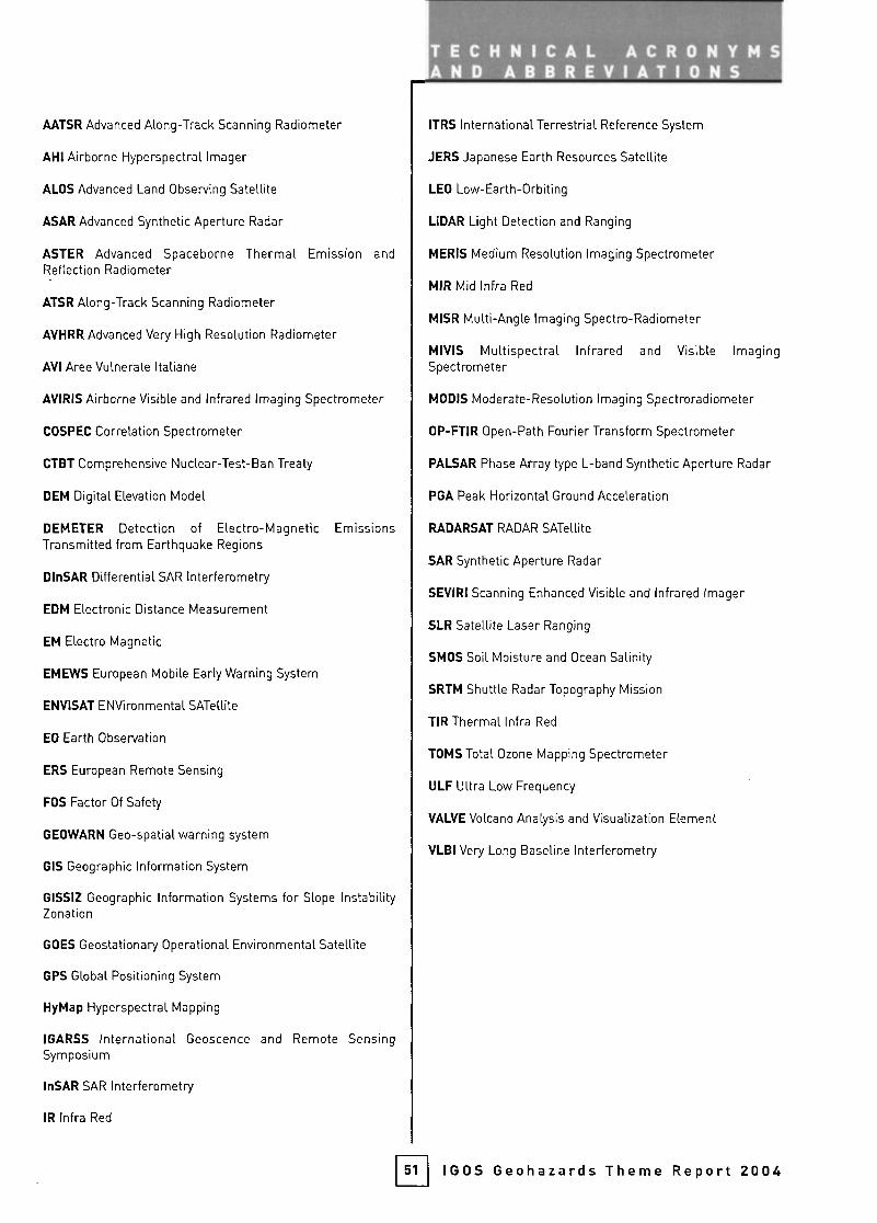
AATSR Advanced Along-Track Scanning Radiometer
AH! Airborne Hyperspectral Imager
ALOS Advanced Land Observing Satellite
ASAR Advanced Synthetic Aperture Radar
ASTER Advanced Spaceborne Thermal Emission andReflection Radiometer
ATSR Along-Track Scanning Radiometer
AVHRR Advanced Very High Resolution Radiometer
AVI Aree Vulnérate Italiane
AVIRIS Airborne Visible and Infrared Imaging Spectrometer
COSPEC Correlation Spectrometer
CTBT Comprehensive Nuclear-Test-Ban Treaty
DEM Digital Elevation Model
DEMETER Detection of Electro-Magnetic EmissionsTransmitted from Earthquake Regions
DInSAR Differential SAR Interferometry
EDM Electronic Distance Measurement
EM Electro Magnetic
EMEWS European Mobile Early Warning System
ENVISAT ENVironmental SATellite
EO Earth Observation
ERS European Remote Sensing
FOS Factor Of Safety
GEOWARN Geo-spatial warning system
GIS Geographic Information System
GISSIZ Geographic Information Systems for Slope InstabilityZonation
GOES Geostationary Operational Environmental Satellite
GPS Global Positioning System
HyMap Hyperspectral Mapping
IGARSS International Geoscence and Remote SensingSymposium
InSAR SAR Interferometry
IR Infra Red
ITRS International Terrestrial Reference System
JERS Japanese Earth Resources Satellite
LEO Low-Earth-Orbiting
LiDAR Light Detection and Ranging
MERIS Medium Resolution Imaging Spectrometer
MIR Mid Infra Red
MISR Multi-Angle Imaging Spectro-Radiometer
MIVIS Multispectral Infrared and Visible ImagingSpectrometer
MODIS Moderate-Resolution Imaging Spectroradiometer
OP-FTIR Open-Path Fourier Transform Spectrometer
PALSAR Phase Array type L-band Synthetic Aperture Radar
PGA Peak Horizontal Ground Acceleration
RADARSAT RADAR SATellite
SAR Synthetic Aperture Radar
SEVIRI Scanning Enhanced Visible and infrared Imager
SLR Satellite Laser Ranging
SMOS Soil Moisture and Ocean Salinity
SRTM Shuttle Radar Topography Mission
TIRThermallnfra Red
TOMS Total Ozone Mapping Spectrometer
ULF Ultra Low Frequency
VALVE Volcano Analysis and Visualization Element
VLBI Very Long Baseline Interferometry
51 IGOS Geohazards Theme Report 2004

GEOHAZARDS
BGS British Geological Survey
BNSC British National Space Centre
OCRS Canadian Center for Remote Sensing
CEOS Committee on Earth Observation Satellites
CEREGE Centre Européen de Rechercheet d'Enseignement des Géosciences
CNR Consiglio Nazionale délie Ricerche
COSPAR Commitee on Space Research
CSAV Center for the Study of Active Volcanoes
CSIRO Commonwealth Scientific& Industrial Research Organisation
DIFA Dipartimento di Ingegneria e Fisica dell'Ambiente
DINA6E Dirección Nacional de Geología
DMSG Disaster Management Support Group
DMT Deutsche Montan Technologie
DPC Dipartimento délia Protezione Civile
EC European Commission
ESA European Space Agency
ESC European Seismological Commission
FAO Food and Agriculture Organization of the United Nations
FOWG Federal Office for Water and Geology
GARS Geological Applications of Remote Sensing
GCOS Global Climate Observing System
GEO Group on Earth Observations
GEONET GPS Earth Observation NETwork
GMES Global Monitoring of Environment and Security
GOOS Global Ocean Observing System
GSI Geographic Survey Institute
GSN Global Seismic Network
GTOS Global Terrestrial Observing System
lAF International Astronautical Federation
lASPEI International Association of Seismology and Physicsof the Earth's Interior
IAVCEI International Association of Volcanologyand Chemistry of the Earth's Interior
ICSU International Council of Scientific Unions
IDNDR International Decade For Natural Disaster Reduction
IGOS Integrated Global Observing Strategy
IGS International GPS Service
ILP International Lithosphère Program
52
ORGANtZATIONS, NETWORKSAND PROGRAMMES
IMAA Istituto di Metodologie per I'Analisi Ambientale
INGV Istituto Nazionale di Geofísica e Vulcanologia
IPG-P Institut de Physique du Globe de Paris
IRIS Incorporated Research Institutions for Seismology
IRPI Istituto di Ricerca per la Protezione Idrogeologica
ISDR international Strategy for Disaster Reduction
ISPRS International Society for Photogrametryand Remote Sensing
ITC International Institute for Geo-lnformation Scienceand Earth Observation
lUGG International Union of Geodesy and Geophysics
lUGS International Union of Geological Sciences
JAXA Japanese Aerospace Exploration Agency
JPL Jet Propulsion Laboratory
METI Ministry of Economy Trade and Industry
MEXT Ministry of Education, Culture, Sports, Scienceand Technology
MRCA Royal Museum for Central Africa
NASA National Aeronautics And Space Administration
NEIC National Earthquake Information Center
NERC Natural Environment Research Council
NOAA National Oceanic and Atmospheric Administration
NPA Nigel Press Associates
OVPF Observatoire Volcanologique du Piton de la Fournaise
RAS Russian Academy of Sciences
SCIGN Southern California Integrated GPS Network
SESWG Solid Earth Science Working Group
STEND System for Technology Exchange for Natural Disasters
TRE Tele-Rilevamento Europa
UN United Nations
UNAVCO The University NAVSTAR Consortium
UNEP United Nations Environment Program
UNESCO United Nations Educational, Scientificand Cultural Organization
USGS United States Geological Survey
VDAP Volcano Disaster Assistance Program
WMO World Meteorological Organization
WOVO World Organisation of Volcano Observatories
WSSD World Summit on Sustainable Development
IGOS Geohazards Theme Report 2004
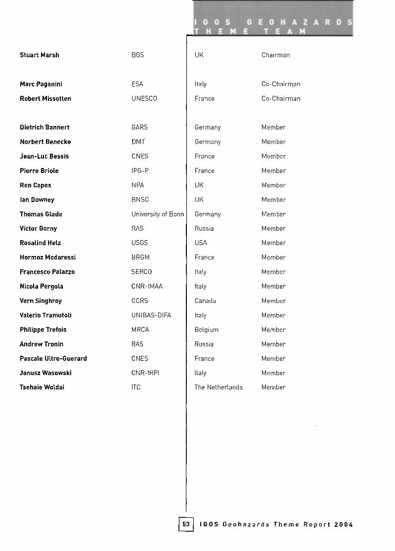
Stuart Marsh
Marc Paganini
Robert Missotten
BGS
ESA
UNESCO
Dietrich Bannert
Norbert Benecke
Jean-Luc Bessis
Pierre Briole
Ren Capes
lan Downey
Thomas Glade
Victor Gorny
Rosalind Heiz
Hormoz Modaressi
Francesco Palazzo
Nicola Pergola
Vern Singhroy
Valerio Tramutoli
Philippe Trefois
Andrew Tronin
Pascale Ultre-Guerard
Janusz Wasowski
Tsehaie Woldai
GARS
DMT
ONES
IPG-P
NPA
BNSC
University of Bonn
RAS
USGS
BRGM
SERCO
CNR-IMAA
OCRS
UNIBAS-DIFA
MRCA
RAS
ONES
CNR-IRPI
ITC
Germany
Germany
France
France
UK
UK
Germany
Russia
USA
France
Italy
Italy
Canada
Italy
Belgium
Russia
France
Italy
The Netherlands
Member
Member
Member
Member
Member
Member
Member
Member
Member
Member
Member
Member
Member
Member
Member
Member
Member
Member
Member
UK
Italy
France
Chairman
Co-Chairman
Co-Chairman
53 IGOS Geohazards Theme Report 2004
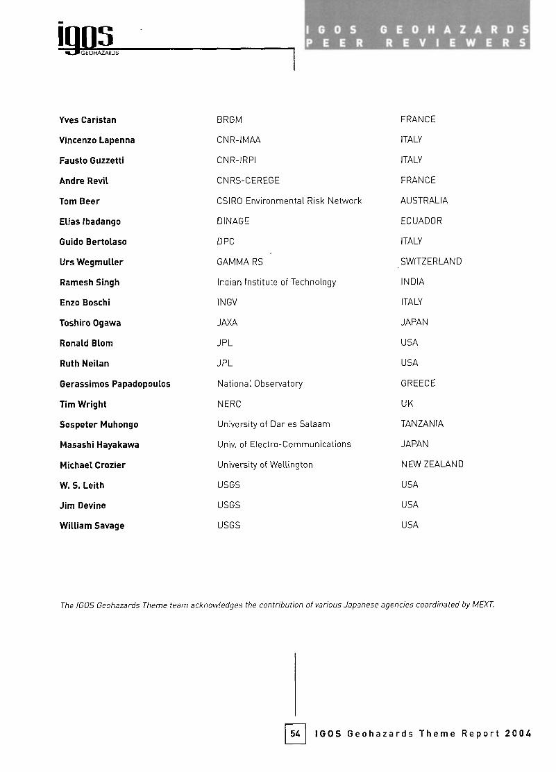
GEOHAZARDS
PEER REVIEWERS
Yves Caristan
Vincenzo Lapenna
Fausto Guzzetti
Andre Revil
Tom Beer
Elias Ibadango
Guido Bertolaso
Urs Wegmuller
Ramesh Singh
Enzo Boschi
Toshiro Ogawa
Ronald Blom
Ruth Neilan
Gerassimos Papadopoulos
Tim Wright
Sospeter Muhongo
Masashi Hayakawa
Michael Crozier
W. S. Leith
Jim Devine
William Savage
BRGM
CNR-IMAA
CNR-IRPI
CNR5-CEREGE
CSIRO Environmental R
DINAGE
DPC
GAMMA RS
Indian Institute
INGV
JAXA
JPL
JPL
sk Network
of Technology
National Observatory
NERC
University of Dar es Salaam
Univ of Electro- Commu
University of Wellington
USGS
USGS
USGS
nications
FRANCE
ITALY
ITALY
FRANCE
AUSTRALIA
ECUADOR
ITALY
SWITZERLAND
INDIA
ITALY
JAPAN
USA
USA
GREECE
UK
TANZANIA
JAPAN
NEW ZEALAND
USA
USA
USA
The IGOS Geohazards Theme team acknowledges the contribution of various Japanese agencies coordinated by MEXT.
54 IGOS Geohazards Theme Report 2004
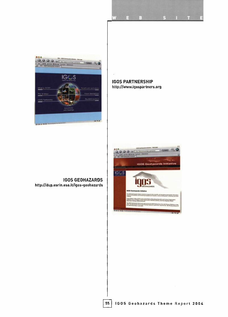
IGOS GEOHAZARDShttp://dup.esrin.esa.it/igos-geohazards
IGOS PARTNERSHIPhttp://www.igospartners.org
55 IGOS Geohazards Theme Report 2004

The IGOS Partners
CE#SCEOS
Committee on Earth Observation Satelliteshttp://www.ceos.org
FAO
Food and Agriculture Organization of the United Nationshttp://www.fao.org
GCOS
Global Climate Observing System
http://www.wmo.ch/web/gcos/gcoshome.html
GOOS
Global Ocean Observing System
http://ioc.unesco.org/goos/
GOS/GAW
Global Observing System/Global Atmosphere Watch of WMO
http://www.wmo.ch
GTOS
Global Terrestrial Observing System
http://www.fao.org/gtos/
IcsúInternational Council for Science
http://www.icsu.org
"¡GBP
International Geosphere-Biosphere Programmehttp://www.igbp.kva.se/
GOS/GAW
ICSU
GL BALCHANGE
IGFAIGFA
international Group of Funding Agencies
for Global Change Research
http://www.igfagcr.org
®IOC-UNESCO
Intergovernmental Océanographie
Commission of UNESCO
http://ioc.unesco.org/iocweb/
UNEP
UNEP
United Nations Environment Programmehttp://www.unep.org
UNESCO
United Nations Educational,Scientific and Cultural Organizationhttp://www.unesco.org
"WCRP
World Climate Research Programmehttp://www.wmo.ch/web/wcrp/wcrp-home.html
WMO
World Meteorological Organizationhttp://v(/ww.wmo.ch
CONTACT DETAILS
Stuart Marsh British Geológica
s.marshßbgs.ac.ukMarc Paganini European Space
marc.paganjnißesa.int
Robert Missotten UNESCO
r.missottenlBunesco.org