Embed Size (px)
Citation preview
^IE FELE COPY
tSl
•zO
I- u
UJ
UJ
Form 10-300 UNITED STATES DEPARTMENT OF THE INTERIOR (July 1969) NATIONAL PARK SERVICE
NATIONAL REGISTER OF HISTORIC PLACES INVENTORY - NOMINATION FORM
(Type all entries — complete applicable sections)
STATE:
MissouriCOUNTY:
PerryFOR NPS USE ONLY
ENTRY NUMBER DATE
hi N A' J^ E::£x i ;!;;f :: - xx- 1- ': ":':^. : :X :lxx;xx; x;. " K? : i; i ! i:' ' ?: W-; -^ :. :*!;; . ;i '•': i i; i: ! ' ;>x> :;xxx|:x! ?MS;x^*PI:^ i > > ^ :: : ? : •?' - ; ': ;'< 1 ^ . ' x :: > : , ;H':i f f Il|x •COMMON:
Tower Ror.kAND/ OR HISTORIC:
STREET AND NUMBER:
1 mile south of Wittenburg, east 1 mile on gravel road from County Hwy. ACITY OR TOWN:
Section 20 - Township 34N - Ranee 14ESTATE
Missouri[3. ' : C t-X S StF 1 C ATI ON v • x: : : :Hi- :x::l: : - : :x: i?X;: ?' : " ]:
CATEGORY (Check One)
G District [H Building B Pub
SI Site (J Structure D P r 'v
G Object D Botl
CODE COUNTY:
., , . 24 .„ ::•••••-• :'•'..--- •:.:'•••:'•:••.,•:'••'...•••':•.•"::;•' '. :'::-.": ; . : : '.- •"•:-• ••••,:•:..••;••". : : ::. -:' Vl ':'v:::.:••.:•. -• • :• •' •-: • :•: '•' •" :- - - •'•' " : '• •-•: '•:•: .- •: : .•: •/. :•" . x-: : ••:-.-. .•• :•••' .-•-.- •:...•; •
OWNERSHIP
tic Public Acquisition:
ate CD In Process
i [ | Being Considered
CODE
Perry 157;X |:X:;;: JSX S : :;;XX;xX:ii: ;j:.:..:; ••;:¥;; •:;!¥:.:.;:.:•: X ..;;:;'•:..;:. : ' .S; 'X i- 4M ̂ ^Xf
, TATIIt ACCESSIBLE STATUS TO THE PUBLIC
D Occupied Yes:KP M • j C3 Rsstricted OS] Unoccupied ' — 'r— i r. .0 Unrestricted | _ 1 Preservation work
in progress ' — 1 _
PRESENT USE (Check One or More as Appropriate)
[ | Agricultural \ 1 Government | 1 Park
j~l Commercial CH Industrial Q Private Residence
[~] Educational 1 1 Military
1 I Entertainment 1 1 Museum
1 I Transportation 1 1 Comments
Ivt Other (Soec-lMn Relioious Sito in Miss.n Scientific River b^d.
,......,. ....m OWNER OF PROPERTY ; '. x. xx, .. . , : , : ^
:'^::
OWNER'S NAME' ,, • . i ^ .. ' ^, <United States of America Department of the Interior
STREET AND NUMBER*
801 19th Street N.W.CITY OR TOWN:
......... . ...Washington, ..LOCAtlQN OF' LE GAL DE SCRiPT! ON ; :x. x:: x' ::- " . .:Vi^m&
STATE:
D r C. 20006
CODE
24
COURTHOUSE, REGISTRY OF DEEDS. ETC:
Office of Recorder of Deeds, Perrv County CourthouseSTREET AND NUMBER:
Cl TY OR TOWN:
Perrvville3 G i?R E^NTAt ION IN EX, ST)N G $u R VE YS :: : ; ; I: :x xX' : x ; j : •>; \-TITLE OF SURVEY:
Missouri Historic Sites SurveyDATE OF SURVEY: J Q ^3 Q Federol
STATE
Missouri 63775
CODE
24' :;; ' ; :X v ';-..s: : ::;:V : ; :X "•.• ::.xx:x :i v: : : ; X' •''. ; . : ? *:': /Xx; ^M:-!?:^ ̂ 3;;:??:|^SS
g] State G County Q LocaDEPOSITORY FOR SURVEY RECORDS:
S.tate Historical Society of MissouriSTREET AND NUMBER:
Corner, Hitt and Lowry StreetsCITY OR TOWN:
Columbia
STATE:
Missouri 65201
CODE
24
09 0
-t
*a
n
1ST ATE:
COUNTY:
ENTRY NUMBER
DATE
Tl O JOz
C (^ mOz r~

CONDITION
(Check One)
Excellent £3 Go °d Q Fair [3 Deteriorated Ruin Unexposed
(Check One)
Altered Q Unaltered
(Check One)
Moved (§3 Original Site
DESCRIBE THE PRESENT AND ORIGINAL (ft known) PHYSICAL APPEARANCE
Tower Rock is a large projection of limestone eroded by the Mississippi River to its current configuration.
The rock is located in the Mississippi River 150 feet from the Miss ouri bank.
It is formed of Bailey limestone deposited on the bottom of a shallow sea in the Devonian Age, 350 million years ago. (Dr. George Viele, Associate Professor of Structural Geology, University of Missouri, interviewed by Charla A. Piggott on Sept. 16, 1969.)
Tower Rock is approximately 80 feet high at the normal river level. Its sides are broken and jagged due to the river's erosional action, but the top supports a growth of grasses and shrubs.
Due to the uplift of the Ozark Dome which began in the Pleistocene Age, the river was able to cut a deeper trench in the resistant bed rock. As a result, a relatively narrow channel was created at this point and numerous rock pinnacles (including Tower Rock) remained as evidence of the river's vigorous cutting action. (Dr. George Viele, Associate Professor of Structural Geology, University of Miss ouri, interviewed by Charla A. Piggott on Sept. 16, 1969.)
The rock ledge all along the bank has been quarried, leaving only a small remnant of the original ledge opposite the rock. The three rock pinnacles which existed near Tower Rock have been destroyed be cause of their hazard to navigation.
m m
H
70
C
n
oz

'SIGNIFICANCE'ERIOD (Check One or More as Appropriate)
[3 Pre-Columbian! Q 16th Century
D 15th Century H 17th Century
D 18th Century
G 19th Century
G 20th Century
SPECIFIC DATE(S) (If Applicable and Known)
AREAS OF SIGNIFICANCE (Check One or More as 'Appropriate)
Abor iginal
[~1 Prehistoric
0 Historic
[~~1 Agriculture
[~1 Architecture
D Art
I 1 Commerce
[ ] Communications
( | Conservation
I I Education
I I Engineering
| | Industry
[ | Invention
j1 Landscape
Architecture
f~l Literature
G Military
G Music
G Political
n Religion/Phi-
losophy
| | Science
[| Sculpture
I 1 Social/Human
itarian
G Theater
| | Transportation
G Urban Planning
[3 Other (Specify)
rock is signifi cant as noted landmark on the river.______
z o
O
ID
LLI
UJ
STATEMENT OF SIGNIFICANCE
Tower Rock is primarily significant as the site where Father Jean Buisson de Saint Cosme planted a large wooden cross in 1699. The cross was erected as a symbol of Christianity and also to dispel the Indian belief that evil spirits inhabited the rock. The cross was clearly visible to all the river travelers. St. Cosme, Fran cois de Montigny, and Ambrose Davion voyaged down the Mississippi on a mission to the Indians of that area in 1698-99. From this incident, the perilous rock became known as La Roche de la Croix (Rock of the Cross) (Elisabeth Clark, Tower Rock, 1963, p. 16, and Louis Houck, A History of Missouri, 1908, p. 226.)
Tower Rock is also significant as a landmark on the Mississippi River noted by other early river travelers. Rising 80 feet above the water, it poses a serious navigational hazard and is considered to be the most dangerous spot on the river. The river is forced into a narrow channel between the rock and the bank, and the tur bulent waters create a treacherous whirlpool.
Father Jacques Marquette described this stretch of river in the journal of his voyage do\m the Mississippi in 1673. According to him, the Indians made sacrifices whenever they passed the rock because they believed a rnanitou (an evil demon) lived there waiting to devour travelers. (Louis Houck, A History of Missouri, 1908, p. 161.)
Early western travelers, Stephen H. Long, Maximilian-Prince of Wied, Edmund Flagg and Henry Schoolcraft also noted the hazardous rock in their journals. (State Historical Society of Missouri, Historic Sites Files: Perry County.)
Before the invention of steam power, the river boats could not as cend the river at this point because of the whirlpool and the danger of being crushed against the rocks. The boats had to be pulled around the cape on the Illinois side and this gave the Indians an excellent opportunity to attack the boatmen. (James Hall, Notes on
Wcstern_State_s, 1838, pp. 48-9.)

BIBLIOGRAPHICAL REFERENCES
1. Clark, Elisabeth. Tov?er Rock. Topeka, Kansas, 1963.
2. Hall, James. Notes on the Western States. Philadelphia: Harrison Hall, 1838, pp. 48-9.
3. Houck, Louis. A History of Missouri. Vol. III. Chicago: Donnelley and Sons, 1908, p« 161.
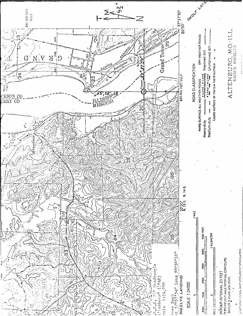
LATITUDE AND LONGITUDE COORDINATES
DEFINING A RECTANGLE LOCATING THE PROPERTY
NW
NE
SE
sw
LATITUDE
Degrees Minutes Seconds
LONGITUDE
Degrees Minutes Seconds o
O I m
O i
O I
LATITUDE AND LONGITUDE COORDINATES
DEFINING THE CENTER POINT OF A PROPERTYOF LESS THAN TFN ACRES
LATITUDE
Degrees Minutes Seconds
37 37 54
LONGI TUDE
Degrees Minutes Seconds
89 30 53
APPROXIMATE ACREAGE OF NOMINATED PROPERTY: T.PSSthan t PT1
ILIST ALL STATES AND COUNTIES FOR PROPERTIES OVERLAPPING STATE OR COUNTY BOUNDARIES
m m
STATE: CODE COUNTY
NAME AND Tl TLE:
Charla A. Pigp,ott, Research Historian
H
70
c n
ORGANI ZATION State Historical Survey and Planning Office Missouri State Park Board
DATE
Nov. 13. 1969STREET AND NUMBER:
P.O. Box 176. 1204 Jefferson BuildingCITY OR TOWN:
Jefferson City Missouri 65101 ?4iLlAtSQNiCJFFICER: CERTIF»CA1IQM : NATIONAL REGISTER VERIFICATION
As the designated State Liaison Officer for the Na
tional Historic Preservation Act of 1966 (Public Law
89-665), I hereby nominate this property for inclusion
in the National Register and certify that it has been
evaluated according to the criteria and procedures set
forth by the National Park Service. The recommended
level of significance of this nomination is:
National Q) State J{] Local Q
I hereby certify that this property is included in the
National Register.
Chief, Office of Archeology and Historic Preservation
Date
Name
Joseph Jaeger, Jr.ATTEST:
Title Director, Misr.ouri State Park Joard, and Missouri State Liaison
OfficerDate
Keeper of The National Register
Date
Form 10-300o (Dec. 1968)
UNITED STATES DEPARTMENT OF THE INTERIOR NATIONAL PARK SERVICE
NATIONAL REGISTER OF HISTORIC PLACES
INVENTORY - NOMINATION FORM
(Continuation Sheet)
STATE
MissouriCOUNTY
PerryFOR NPS USE ONLY
ENTRY NUMBER
(Number all entries)
6.
TOWER ROCK
Missouri State Historical Survey (state)
1969
Missouri State Park Board
P. 0. Box 176
1204 Jefferson Building
Jefferson City, Missouri 65101 Code: 24
Form 10-300a (July 1969)
UNITED STATES DEPARTMENT OF THE INTERIOR NATIONAL PARK SERVICE
NATIONAL REGISTER OF HISTORIC PLACES
INVENTORY - NOMiNATIOH FORM
(Continuation Sheet)
MissouriCOUNTY
PerryFOR NFS USE ONLY
ENTRY NUMBER
(Wumber all entries)
8.TOWER ROCK
On February 24, 1871, President Grant set aside Tower Rock for public purposes and it is now under the jurisdiction of the U.S e Department of the Interior. (Felix E. Snider and Jess E..Thi- lenius, Tower Rock, 1968, pp. 28-30.)
Tower Rock was such an integral part of life along the river that many legends and stories have been woven about its colorful history.

Form 10-300a (Dec. 1968)
UNITED STATES DEPARTMENT OF THE INTERIOR NATIONAL PARK SERVICE
NATIONAL REGISTER OF HISTORIC PL ACES
INVENTORY - NOMINATION FORM
(Continuation Sheet)
STATE
MissouriCOUNTY
PerryFOR NPS USE ONLY
ENTRY NUMBER
(Number all entries)
9.
TOWER ROCK
4. State Historical Society of Missouri, Columbia, Missouri, Historic Sites Files. Ref. Perry County.
5. Snider, Felix E. and Jess E. Thilenius. Tower Rock(la Roche de la Croix.) Cape Girardeau: RamfrePress, 1968, pp. 28-30.
6. Viele, Dr. George. Associate Professor of StructuralGeology, University of Missouri, Columbia, Missouri. Interviewed by Charla A, Piggott, September 16, 1969, filed at Missouri State Park Board, 1204 Jefferson Building, P.O. Box 176, Jefferson City, Missouri.
L.
u=> a:h-
IU
Ili
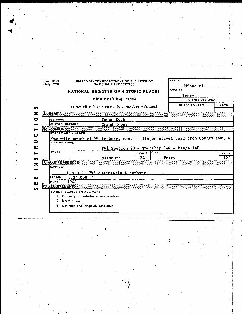
'Form 10-301 (July 1969)
UNITED STATES DEPARTMENT OF THE INTERIOR NATIONAL PARK SERVICE
NATIONAL REGISTER OF HISTORIC PLACES
PROPERTY MAP FORM
(Type all entries - attach to or i
STATE
Missouri
PerryFOR NPS USE ONLY
ENTRY NUMBER
STREET AND NUM BER:
One mile south of Wittenburg. east 1 mile on gravel road from County Hwy. ACITY OR TOWN:
SWi Section 20 - Township 34N - Range 14E
Missouri 24 PerryCODE
15?
SOURCE:
IT.S.G.S. 7% f uadranle AltenburSCAL.E: 1:24.000 '
1948
TO BE INCLUDED ON ALL. MAPS
1. Property broundaries where required.
2. North arrow.
3. Latitude and longitude reference.
?v?r
Roc':
-t
37
°3
7'5
4"
Lo
ng
S
9°30'5
3"
(NE
EL
YS
"LA
NO
ING
)~"~
SC
ALE
1:2
4000
32
'30
"
R.
13
E
. R
. 14
E.
69
00
00
F
EE
TU
LL
);8
9*3
0'
37
°37
'30
'
20
00
3
00
04
00
0
50
00
6
00
0
70
00
F
EE
T
DN
TO
UR
IN
TE
RV
AL 2
0 F
EE
T
Ei-R
EP
JfE
^E
f.'T
H
ALf-
iNT
ER
VA
L C
ON
TO
UR
S
DA
TU
M t
S f
/iA
N S
EA
LE
VE
L
•j V
/IT
H r.
'Al
lON
At
MA
P /
-CC
UR
AC
V S
TA
f,'O
Af>
DS
HA
RD
-SU
RF
AC
E A
LL W
EA
TH
ER
RO
AD
S
Heavy-d
uty
*
LA
NE
g
RO
AD
CL
AS
SIF
ICA
TIO
N
DR
Y W
EA
TH
ER
RO
AD
S
|mp
rove
cj
Medlu
m-d
uty
—
—
*
— W
£J-a
t«
£
Un
imp
rove
d d
irt
=
Lo
ose-s
urf
ace o
r n
arr
ow
hard
-surf
ace
-
AL
TE
NB
UR
G,
MO
.-IL
L.
N3737.5
--W
S930/7
.S

TOWER ROCK
COUNTY:
LOCATION:
OWNER:
ADDRESS:
DATE APPROVED BY A.C.:
DATE SENT TO JEFF. CITY:
DATE SENT TO D.C.:
DATE OF REC. IN D.C.:
DATE PLACED ON NATIONAL REGISTER:
DATE AWARDED CERTIFICATE
(AND PRESENTOR):
#83
Perry
1 mi S of Wittenburg, E 1 mi on gravel road
from County Hwy. A
Missouri Conservation Commission
2901 N. Ten Mile Drive, Jefferson City, Mo.
11-15-69
12-08-69
12-22-69
12-31-69
02-26-70
DATE FILE REVIEWED:

Tower Rock is primarily significant as the site where Father Jean Buisson de Saint Cosme planted a large wooden cross in 1699. The cross was erected as a symbol of Christianity and also to dispel the Indian belief that evil spirits
inhabited the rock. The cross was clearly visible to all the river travelers. St. Cosme, Francois de Montigny, and Ambrose Davion voyaged down the Mississippi on a mission to the Indians of that area in 1698-99. From this incident, the perilous rock became known as La Roche de la Croix (Rock of the Cross).