Embed Size (px)
Citation preview

1
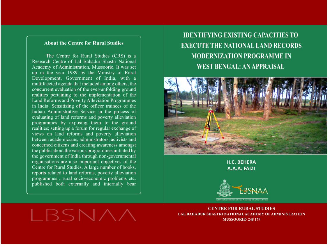
IDENTIFYING EXISTING CAPACITIES TO
EXECUTE THE NATIONAL LAND RECORDS
MODERNIZATION PROGRAMME IN WEST
BENGAL: AN APPRAISAL
H.C. BEHERA
A.A.A. FAIZI
CENTRE FOR RURAL STUDIES
LAL BAHADUR SHASTRI NATIONAL ACADEMY OF
ADMINISTRATION
MUSSOORIE- 248 179
2
Research Advisory
1. Shri Charanjit Singh, Director, DoLR
2. Dr. Prem Singh, Centre Director, CRS
Research Support
1. Shri Debraj Bharti
OC-Computer
Paschim Medinipur
Field visits and typing assistance
1. Shri Ramesh Kothari, DEO
Centre for Rural Studies, LBSNAA
2. Shri Dalip Bisht
Centre for Rural Studies, LBSNAA
3
CONTENTS
Page NO
Foreword i
Preface ii
Acknowledgement iv
Chapter-1: Introduction 1
i. Background
ii. Approaches in Land Administration
a. The Welfare Approach
b. Economic Growth and Development Approach
iii. National Land Records Modernization Programme
a. Components of NLRMP
b. Principles
c. Benefits of NLRMP
iv. Challenges Before Land Administration
v. Objectives of the Study
vi. Methodology
Chapter-2: An Appraisal of “Bhuchitra” Project in West Bengal 12
i) Brief History of Land Reforms and Land Administration in
West Bengal
a) Land administrative structure in West Bengal
b) Land policy in the state
c) Issues and Challenges in Land Administration
d) Specific Objectives of the Study
e) Methodology
ii. From Bhumi to Bhuchitra
Computerization of Land Records in West Bengal
Integration of RoR and Cadastral Maps
Generation of plot map

4
Chapter-3: Status of NLRMP in West Bengal 22
i. Component wise status
a. Computerization of Land Records-CLR
b. Computerization of Registration-CoR
c. Modern Survey and Resurvey
d. Training and Capacity Building
ii. Implementation Issues and Challenges
Chapter-4: Conclusion and Recommendations 59

5
FOREWORD
Focus on the welfare of citizens is key to the fundamental structure of a
federal and democratic nation like India. This is addressed by different
programs and schemes under various departments. Modernization of land
records has been crucial to give recognition to tenurial rights of farmers and
landholders. NLRMP is the most comprehensive tool so far towards
modernization of land records. It has emerged in 2008 with multiple
approaches in institutional and technological interventions in the areas of
creation, updating and maintenance of land records. Land issues are state
affairs. Therefore, implementation of the program is vested with state
governments. However, the Centre plays a significant role to coordinate with
the state governments and facilitates states with formulation of new policies
and schemes in the related field. The Department of Land Resources (DoLR)
has been the Nodal Agency in the country to coordinate and facilitate with the
states. It provides financial support to all the states in the country. Meanwhile,
it keeps a close watch for effective implementation of various programs
related to land resource in the country. NLRMP has been rolled out in all the
states but the degree of its implementation and also the quantum of its
progress varies widely across all the states in the country. The DoLR had
engaged the Centre for Rural Studies of NIAR, LBSNAA to assess the
physical and financial progress of NLRMP in several states of the country. I
am very glad that the CRS has brought out a report on “Identifying Existing
Capacities to Execute the National Land Records Modernization Program in
West Bengal: An Appraisal”. Hope, this will help immensely to understand
the ground realities with regard to implementation of NLRMP in the State.
Charanjit Singh
Director, DoLR
Government of India

6
PREFACE
The West Bengal state is an exemplary for its successful land reforms,
distribution of vested land to the poor and landless, and also to enforce
legal rights to the tenants. This is the only state which has a single
dedicated department for land and land reforms headed by a senior IAS
officer of the Commissioner Rank. With its long tradition of protection
of tenant farmers, the state has also better cadastral records with
periodic survey frequently taken place by the state government.
Therefore, the mauza maps are updated and accurate. Each mauza map
contains a large number of plots. Unlike in Maharashtra and in some
other states, there is no distinct plot sheet maintained by the
administration. However, with the systematic resurvey undertaken, the
dimension of plot maps is found to be accurate and mostly compatible
with the existing land records. With the implementation of the National
Land Record Modernization Program (NLRMP) in the State, the state
has modified the Bhumi software in its new name, ‘Bhuchitra’. As the
name indicates, the software is designed to accommodate both textual
and spatial land record information (RoR and mauza map in a single
software). The Mauza maps are scanned, digitized and made
management friendly as well as user friendly. The Plot maps showing
size and landholding details with additional information about the
adjacent plots are extracted from the mauza maps as and when required.
This facility is already extended across all the districts in the state.
However, the task is still unfinished. The scanning and digitization of
all the cadastral maps and their integration with RoRs are to be done for
all the revenue villages/mauzas. Wherever, there is need, modern
cadastral survey approach has to be adopted. The present effort does not
commensurate with the modern cadastral approach which advocates for
geo-referencing of plot maps. “Identifying existing capacities to execute
the NLRMP in West Bengal” is a sincere effort of the author to reflect

7
the realities about concurrent physical and financial progress with
regard to implementation and execution in the state. I hope, the report
will be very helpful for further extending the study in other states. The
inputs given in the report will also be helpful for the Nodal Agency to
further facilitate the state for better implementation of the ambitious
programme.
Dr. Prem Singh, IAS
Centre Director, CRS, LBSNAA
8
ACKNOWLEDGEMENT
We wish to express our sincere thanks and appreciation to Dr. Prem
Singh for his constant inspiration and encouragement in taking up this
study in West Bengal.
We are very grateful to Shri Padamvir Singh, IAS, Director, LBSNAA;
Shri Kush Verma, DG, NIAR; Shri Sanjeev Chopra, IAS, Joint
Director, LBSNAA and Shri Dushyant Nariala, IAS, Joint Director,
LBSNAA for their kind support and guidance in the study.
We express our sincere thanks to Shri Charanjit Singh, Director, DoLR,
Government of India; and Shri P.K. Pramanik, Sr. Technical Director
of NIC, West Bengal for extending their wholehearted support in the
study.
Nonetheless, the cooperation of all the faculty and staff of CRS,
particularly from Mr. Kothari, is well appreciated for his relentless
engagement in the field survey. We thank Mr. Snehasis Mishra for
providing additional field data for the analysis. We thank Mr. Deepak,
Mr. S.S. Kharola, Mr. Dalip, Mr. Adesh, and Mr. Samar for their
support in the study.
H.C.Behera
A.A.A. Faizi

9
Chapter-1
INTRODUCTION
Background
India has brought many significant policy and administrative reforms in
the recent past among which land administration is a vital area of
reform initiatives taken place in the form of NLRMP in 2008. Reform
in land administration has taken place in different states but in different
degrees with the conscious facilitation by the Centre. However, this has
taken place in such a manner to look beyond traditional institutional
reforms as introduced in the form of land reforms during an early
independence period. All major functions of land administration, such
as creation of land records, maintenance and updating of land records,
registration of land property, etc. are revisited with a fresh outlook.
Leveraging modern technology in addition to legal and institutional
support in land administration has been key strategies for revival in the
recent period. Three major departments that work under the ambit of
land administration, such as Revenue department, Survey and
Settlement Department and the Property Registration Department are
being facilitated with new policies, approaches and modern
technologies.
Management of urban land has gradually become more complex due to
partition of property with the increase in sale, purchase, inheritance and
other related transactions. The non-elastic resource land is basic for all
fundamental economic and development planning. The rising demand
for land by investors, farmers, landless poor, etc. has further pushed
interest to look into land record management more seriously than ever
before. Land is a state subject in India. Land administration, even today,

10
inherits more or less same practice since British regime. While majority
parts of India, including in West Bengal, undivided Bihar, Jharkhand,
parts of Odisha, and also some parts of Uttar Pradesh have features of
the zamindari system, the southern and some western parts in
Maharashtra and Gujarat have ryotwari system; mahalwari system
found in the northern states such as Punjab, Haryana, Himachal
Pradesh, and parts of Uttar Pradesh. Land record management in India
has developed in accordance with the survey and settlement system
practiced during the British administration. Therefore, both similarities
and differences exist in different regions and also in different states.
Textual and Graphical outputs of the survey are important to assess the
land revenue and land record management. Tippans or plot maps have
been created since pre-independence in ryotwari areas, mauza map or
village cadastral maps are found in the permanent settlement areas. The
types of land records largely vary among states in the country. In
addition to basic record of rights, the record of accounts, the record of
tenants, sharecroppers and bargadars, crop related information are also
maintained in some states. While Karnataka has the record of crop
grown; the record of share croppers and bargadar is the practice in West
Bengal.
Over the years with increasing demographic pressure, policy and
development intervention, the states are overburdened with additional
responsibilities. The pressure on revenue administration has been
proportionately increased. In addition to follow traditional land reform
measures such as the account of ceiling surplus land, vesting surplus
land, distribution of vested land, etc. approach towards modernization
of land records has been key to the whole revenue and land
administration because of increasing land and property value. While the
land revenue collection out of land and property holding has been
diminishing importance in rural areas, property registration in urban
11
areas has contributed significantly to the state revenue. Land and
property registration has been the second most important contributor to
land revenue in states like West Bengal, Maharashtra, Tamil Nadu,
Haryana, Karnataka, etc. except after excise and custom department.
Therefore, it can be easily imagined how significant it is to facilitate the
property and registration department for more efficient and effective
manner.
‘Land records management is an important sovereign function in both
rural and urban areas. In the rural areas, it has significant impact on the
livelihood of the people, who directly or indirectly depend on
agriculture and other allied sectors. Further, to ensure proper
development planning and decision making about agriculture or
industry, the accurate database on land is crucial. An accurate database
can only be ensured through proper land records management system’
(Vachhani & Behera, 2010). The welfare approach on one hand, and
growth and development approach on the other hand has induced
reforms in the land administration as a whole.
The welfare approach
Management of rights, restrictions, responsibilities and risks in relation
to property, land and natural resources are the functions of land
administration. These functions include the processes related to land
tenure (securing and transferring rights in land and natural resources);
land value (valuation and taxation of land and properties); land use
(planning and control of the use of land and natural resources) and more
importantly land development (Williamson, Enemark, Wallace, and A.
Rajabifard, 2010). In order to give justice to the poor, every inch of the
land has to be surveyed and mapped. All the land records have to be
documented and kept updated. Pramanik (2012) noted that each small
parcel of land is to be accurately measured & identified using precision
12
survey techniques. Therefore, land records should capture all relevant
information including land and landholding details, crop details,
irrigation details, to name a few. Land data should capture details about
land classification, size and location of land, etc. The land holdings
should depict details about land ownership with all legal heirs, tenants
or sharecroppers amongst others. The land use pattern should be
recorded and maintained properly. The market valuation of land should
be clearly established and kept up-to-date. The process of property
registration should be smoother and easier. Further, the land
administration should be efficient, effective, transparent and
accountable. By so doing, both state and its citizen will benefit and
progress. These are some of the visions of a good land administration.
Gone are those days when collection of land revenue and extraction of
rent was a sole motive of the revenue administration.
Changes in ownership, division or even amalgamation of plots and their
usages are a continuous phenomenon that ought to be accounted for in
real time so that land records mirrors the ground condition. Various
policy measures on land are taken to safeguard the interest of various
social groups, for the purpose of food security, the interest of the state
as a whole to meet the aspiration of the Government. Measure of land
holdings for an individual may have a limit; conversion for land usage
may be restricted so that there should not be a crunch of land resource
for the production of food. Many such restrictions are in vogue and a
quite a good number are legislated every year. Implementing the same
always was a challenge in itself (Pramanik, 2012)1.
1 Unpublished paper submitted to the National Workshop on Land Records Management in India: A Plea for Reforms, organized by the Centre for Rural Studies (NIAR), LBSNAA, Mussoorie on 23-24 January 2012

13
With states like Karnataka, Gujarat, Madhya Pradesh, Rajasthan,
Maharashtra, Haryana, Tamil Nadu, Odisha and West Bengal have
already made good progress in computerization of land records and
computerization of registration, modern cadastral survey is taken up in
some states with the application of ground survey methodology by
using total station and GPS or by hybrid approach such as aerial survey,
satellite imagery and use of ground survey methods.
Economic growth and development approach
Several World Bank studies have reported that the efficient land
administration has facilitated economic growth. For example, Thailand,
after successful land titling, there is a boost to economic growth. A
report on www.doingbusiness.org of the World Bank noted that India
holds 94th
position as far as efficiency or the time taken for property
registration is concerned. The time taken to the property registration in
the whole South Asia is longest in the world. It is the third most corrupt
sector in India and most corrupt sector in other South Asian countriesi.
Involvement of middlemen is large in this sector. Rent seeking behavior
is high. There is a lack of adequate transparency and accountability as
well. India loses 1.3 % potential growth rate due to poor governance in
land administration (McKinsey Global Institute Report on India, 2001).
Therefore, modernization of land record can facilitate the better growth
rate. The lack of survey and resurvey and also lack of updating of land
records has been a serious issue addressed by the Report of the
Committee on State Agrarian Relations and the Unfinished Task of
Land Reforms. The Report noted that the key elements of an effective
land policy are the following:
Modernization of management of land records
Reforms relating to land ceiling

14
Security of homestead rights
Reforms relating to tenancy laws
Protection of the rights in land of tribals
Access to agricultural services
National Land Records Modernization Program (NLRMP): A Brief
Outline
The National Land Records Modernization Program introduced towards
the end of the last decade is an impetus for growing synergy between
the Centre and the States in relation to land administration (Singh and
Behera, 2012). Some believe that the National Land Records
Modernization Program (NLRMP) is an outcome of a series of reforms
in land administration. The National e-Governance Plan (NeGP)
emphasizes its speedy implementation. Within a state itself, the
program has effect to bring coordination among departments such as
Survey and Settlement, Revenue Department, and Registration
Department to deliver service effectively and efficiently. The
Department of Land Records (DoLR), Ministry of Rural Development
has put tremendous effort to develop this new program and get it
approved by the Cabinet in 2008.
The main objective of the NLRMP is ‘to develop a modern,
comprehensive and transparent land records management system in the
country with the aim to implement the conclusive titling system with
title guaranteeii’. The components of the program are computerization
of land records that include the digitization of cadastral map and its
integration with textual data, survey/resurvey and updation of all survey
and settlement records, computerization of registration and its
integration with the land records maintenance system. The program
emphasizes on technology upgradation, infrastructure development by
establishment of modern record room, state and district level data
15
centre, training and capacity building, etc. It is believed that the
program has significant impacts on the revenue administration and on
the landholders that can enhance quality service delivery.
The old schemes such as the computerization of land records and the
strengthening revenue administration and updating of land records
(SRA &ULR) are merged with the new program. In addition, the
NLRMP emphasizes on the computerization of registration. The
important departments namely, the Revenue Department and the
Registration Department are now interconnected with the launch of
NLRMP. This will help registration to follow automatic mutation.
The program is based on four principles: mirror principle, curtain
principle, single agency and title insurance. Mirror principle, which
signifies that in any given moment the land records mirror the ground
realities. The curtain principle signifies that a record of right (RoR) is a
true depiction of the ownership status. Therefore, the mutation process
can be followed automatically after registration without further going
into details of the past records. The establishment of a single agency is
advocated under the NLRMP due to the fact that the existing process of
land records management by multiple Departments is cumbersome and
takes a lot of time to process the records management. Therefore, a
single agency can deal all the matters related to land records
management such as survey, resurvey and settlement, creation, updating
and maintenance of land records, land related transactions and
registration of documents, etc. Moreover, the provision of title
insurance is a great attempt under the NLRMP. The titleholders are
proposed to be insured for any loss arising out of inaccuracy.

16
Components under the NLRMP
Some of the important components of the NLRMP are:
1. Computerization of land records-this covers computerization of
textual data and digitization of cadastral map and their integration,
establishment of Data Centre at the State level and both at the
district and at the tehsil level.
2. Survey/resurvey and updating of land records by using pure ground
method using modern technology such as GPS and ETS, hybrid
method using aerial photography and ground truthing by ETS and
GPS and High Resolution Satellite imagery.
3. Computerization of registration- interconnectivity among SROs,
data entry of valuation details, data entry of legacy encumbrance
data, scanning and preservation of documents, etc.
4. Creation of modern record room or land records management
centres at tehsil/circle/block level.
5. Capacity building that includes organizing workshops/training,
development of infrastructure, strengthening of the survey and
revenue training institutes.
Benefits of NLRMP
Some benefits under Computerisation of Land Records (CLR) and
Computerization of Registration (CoR) are already being noticed in
several states. Both the CLR and CoR have reportedly improved
turnaround time. Efficiency has increased substantially wherever the
program is operational. Centre for Rural Studies (CRS), LBSNAA
evaluation studies have reported that under computerization of land

17
records there is an increase in efficiency with regard to delivery of RoR
and mutation process, but no overwhelming positive response to a
decreased corruption and reduction in land related disputes in the states.
IIM Ahmedabad study has reported that there is a reduction in the
number of trips by the landholders to access RoR after computerization.
The majority of states have reported increases in revenue collection
through user charges some portion of which is applied for the
maintenance cost of the system. CoR is very significant in reducing
transaction cost, expenditure in conveyance, helped in e-valuation or
standard calculations of stamp duty and registration fee, increased
transparency, efficiency and accountability in the system. NLRMP
provides support for resurvey activities so as to capture ground realities
and accommodate changes in the land related information. It facilitates
modern technology application for speedy and accurate survey/resurvey
to create or update land records.
FAO has noted number of benefits, which can be drawn from
computerization of land recordsiii
. Some of them are
1. Make significant reductions in the cost and space required for
storing and retrieving land records.
2. Prevent unnecessary duplication of records.
3. Accelerate the processing of data for the first registration of title.
4. Provide mechanisms for quality control
5. Facilitates monitoring and analysis of market and rental values of
land and property taxes
6. Improve efficiency and effectiveness in collecting land and property
taxes
Issues of storage and maintenance are pertinent in the land
administration system. Therefore to address this issue, the NLRMP has
the proposal for the modern record room which will have facilities of

18
modern instruments like compactor, computer storage facility and
others. There are many other benefits which can be accrued with
implementation of the NLRMP.
In view of above the Centre for Rural Studies has undertaken a study in
West Bengal under the direction of the Department of Land Resources,
Ministry of Rural Development, Government of India with the
following objectives.
1. Identifying existing capacities of the state based on the progress
achieved and time frame developed to execute all the components.
2. To assess infrastructure support/supporting wherewithal in the form
of record rooms, data centres at various levels, kiosks, etc. for
making available updated land records for general public and their
locations district wise in each state.
3. Identification of the technological interventions required not only to
achieve the objective of having correct and up-to-date land records
but also to give easy access to such records to the common man.
4. The steps taken or to be taken by the state to provide citizen
services under the NLRMP
Specific Objectives of the study
1. To understand features of Bhuchitra software and hardware
components and their implications in land record management
2. To appraise the progress made in land record computerization that
includes computerization of textual data, digitization of cadastral
maps (mauza map and plot maps), online mutation, etc.
3. To appraise the progress achieved in infrastructure development
such as Computer Centre, Kiosk setup, modern record room and
data centres, NLRMP Cell, etc.
4. To examine the status of service delivery such as Record of Rights,
mauza maps, plot map and online mutation in the state

19
5. To understand capacity building measures/initiatives in modern
cadastral survey
6. To identify the gaps and needs in technology intervention,
infrastructure development, capacity building and service delivery
under NLRMP
Methodology
The study is based on primary data collected from the nodal Offices
such as the Directorate Land Records and Surveys, and IG Registration,
NIC and other relevant Offices and institutes. Here, for the study in
West Bengal, the field study was undertaken in March 2013. Most of
the data collected was through questionnaire/formats designed by the
CRS followed by the author’s interaction with the revenue officials and
also field observation. Interaction and discussion with the Officials such
as the Director, Joint Director, and ASOs in the Directorate of Land
Records and Surveys, Senior Technical Director, NIC DLRO, BLRO
and other field offices concerned was much helpful in understanding the
program more minutely. Moreover, the field visit in the block levels
helped in further understanding the issue.

20
Chpater-2
AN APPRAISAL OF BHUCHITRA PROJECT IN
WEST BENGAL
I. Brief history Of Land Reforms and Land Administration In
West Bengal
West Bengal has a long history of land record management. It was the
place where the East India Company was first set up. The undivided
Bengal including Bihar and Parts of Odisha is known to be a permanent
settlement area where the original land records were created by the
colonial administration to extract maximum land revenue. Unlike in
other states, the lands of West Bengal are frequently surveyed or
resurveyed. Therefore information on land holding, ownership, tenancy,
and measurement are more accurate and precisely recorded in the state.
Land and Land reforms Department is one of the oldest departments in
the state established by the British administration. It is also an apex
level body for planning, monitoring and administrative affairs. The
principal tasks of the departments is implementation of Land Reforms
Acts, especially West Bengal Estates Acquisition Act 1953 and West
Bengal Land Reforms Act 1955. The Estates Acquisition Act is the
principal legal instrument to abolish estate rights and titles of
intermediaries or zamindars. This Act imposed ceiling limit of
landholdings. The land above the ceiling limit was vested with the
Government. Revised RoRs and cadastral maps were prepared under
this Act. According to many thinkers, the Estate Acquisition Act hasn’t
highlighted the issues of the bargadars or the sharecroppers. It didn’t
give them any land rights. The land rights of the bargadars or the

21
sharecroppers were addressed in the West Bengal Land Reforms Act.
“The Land Reforms Act 1955 was enacted to reform the law relating to
land tenure consequent on vesting of estates and of certain rights therein
and to consolidate the law relating to land reforms. The Act most
notably recognizes the rights of the bargadars or sharecroppers. They
are given a heritable but non transferable right of cultivation.iv
”
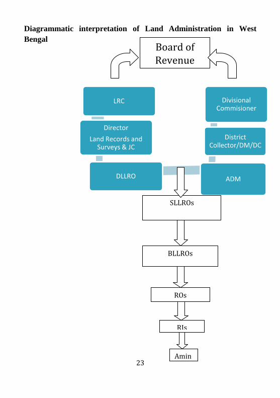
West Bengal and Land Reforms Manual 1991 delineate the function
and executive power of each Officer concerning to land administration.
The Board of Revenue is the highest body that decides matters
pertaining to land management, revenue management, etc. According
to the manual, ‘it has the power to supervise and guide the
implementation of the integrated set up of land reforms administration
and functions thereof and issues from time to time, such directions as
may be necessary for smooth performance of land and land reforms
functions’. “There is a separate land records directorate headed by the
Director, Land Records and Survey who is also the Joint Land Reforms
Commissioner. He is assisted by Joint Directors at the Directorate of
Land Records and Surveys (DLRS). DLRS is a major directorate under
the Land and Land Reforms department in West Bengal for
maintenance and develop land records and also mauza maps in the state.
It has large sets up comprising 341 Block level land and land reforms
offices, 3354 Revenue Inspector Offices.
The Record of Rights is called khatian, in West Bengal. It records
ownership details of land, the landholders, the area and size of
landholdings and nature classification of land, etc.
In a report submitted by Ahuja and Singh (2003), there is a detailed
description about preparation of RoR in the state,
Khatians are prepared in a number of stages which are known as
Khasra enquiry, Khanapuri, Bujharat, Attestation, Hearing of

22
Objection and final publication. To start with the particulars of a
plot such as standing crop, name of owner etc, are recorded on a
sheet of paper known as Khasra. Simultaneously, all the relevant
particulars are put on the khatian form and this process is known
as Khanapuri. The Khatians so prepared are again subjected to
further check in the field by examining the persons concerned.
The process is known as Bujharat. The records so prepared are
known as parcha in common parlance are then distributed to the
person concerned and these records are then processed through
attestation where the revenue officer designated as an attestation
officer puts his signature and stamp on the draft khatian. The
attested khatian is then put into draft publication inviting
objections. Objections in the form of petitions received are then
heard and the records are corrected again on the basis of orders
passed by the objection officers. After this the cohesion receives
the final shape, and is published and printed.
Chapter-III of the Land and Land Reforms Manual has described
preparation and revision of record of rights in land.
“Preparation and revision of record of rights in land under
chapter-VIIA of the West Bengal Land Reforms Cat, 1955 is normally
carried out in a district or in a part thereof if the government have
reason to believe that record of rights in land have become out of date
or there has been an intensive change in the topography.”
The preparation of mauza maps on the other hand is again more
complex, which requires thorough precision in measurement of land in
terms of size, boundary determination, elevation or projections if any,
and of course other dimensions along with determinations of plot maps
and their dimensions.
23
Diagrammatic interpretation of Land Administration in West
Bengal
LRC
Director
Land Records and Surveys & JC
DLLRO ADM
District Collector/DM/DC
Divisional Commisioner
Board of Revenue
SLLROs
BLLROs
RIs
ROs
Amin

24
Sharecropping and tenancy
‘The ultimate aim of land reforms in India is to confer the rights of
ownership to tenants to larger possible extent’v. Numerous state laws
(including Gujarat, Haryana, Himachal Pradesh, Jammu and Kashmir,
Madhya Pradesh, Maharashtra, Punjab, Rajasthan, UP and West
Bengal) call for including the names of tenants in land revenue records.
But, except West Bengal, no state has effectively implemented such a
provision (Hanstad, 2005). Chapter III of the West Bengal Land
Reforms Act 1955 dealing with the rights of the bargadar did not
provide for recording of their names. It only provided for updating the
village record-of-rights by specially empowered revenue officer. The
left front government amended Rule 21 and Schedule A of the WBLR
Act to correct the situation. The second provision of Schedule A was
amended to provide that the Settlement Officer could direct “that names
of bargadars shall be incorporated in the record of rights by the revenue
officer subordinate to him after holding such enquiry, and after giving
the persons claiming as bargadars and owners of the land concerned,
such opportunity of being heard as the Revenue Officer may deem fit”
(Datta, P.K. 1988). Parcha is the rights given to the bargadars on the
land identified by the state government where the bargadar has right to
cultivate. The parcha is given under Section 51. Since then West Bengal
is known for ‘Operation Barga’-a significant attempt for record of the
tenants.
District at a glance
Districts-18 and Kolkata
Blocks-341 blocks plus 5 additional blocks Hugli (Kholisani),
Burdawan (Asansol, Kulti), Howrah (Howrah town survey), South 24
Parganas (Additional Thakurpukur Mahestola)
25
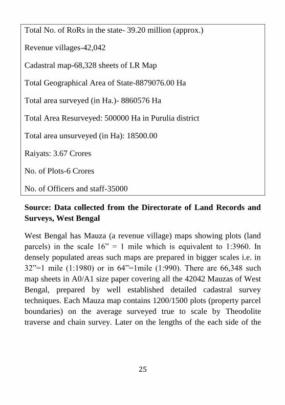
Total No. of RoRs in the state- 39.20 million (approx.)
Revenue villages-42,042
Cadastral map-68,328 sheets of LR Map
Total Geographical Area of State-8879076.00 Ha
Total area surveyed (in Ha.)- 8860576 Ha
Total Area Resurveyed: 500000 Ha in Purulia district
Total area unsurveyed (in Ha): 18500.00
Raiyats: 3.67 Crores
No. of Plots-6 Crores
No. of Officers and staff-35000
Source: Data collected from the Directorate of Land Records and
Surveys, West Bengal
West Bengal has Mauza (a revenue village) maps showing plots (land
parcels) in the scale 16” = 1 mile which is equivalent to 1:3960. In
densely populated areas such maps are prepared in bigger scales i.e. in
32”=1 mile (1:1980) or in 64”=1mile (1:990). There are 66,348 such
map sheets in A0/A1 size paper covering all the 42042 Mauzas of West
Bengal, prepared by well established detailed cadastral survey
techniques. Each Mauza map contains 1200/1500 plots (property parcel
boundaries) on the average surveyed true to scale by Theodolite
traverse and chain survey. Later on the lengths of the each side of the

26
plot and its area its extracts from the paper map itself using acre comb.
No field dimensions of the individual plots are noted on the map2.
II. FROM ‘BHUMI’ TO ‘BHUCHITRA’
Land Record Computerization in West Bengal
The first computerization of land records project in West Bengal is
called ‘Bhumi’ which emphasizes computerization of khatiyans. While
the project was initiated during 1990s, but the achievement till early
2000s remain uneven and not implemented effectively. An evaluation
study by Ahuja and Singh (2003) had observed that the state had not
fully achieved the required objectives of creating a clean, up-to-date
database by mid 2003. The system worked in offline mode and
standalone way. The Bhumi software was primarily operated through
DOS. The procedure to obtain RoR was hectic and cumbersome as it
was in the manual process (ibid.). However, almost after a decade of the
project was first evaluated by the Centre for Rural Studies, LBSNAA it
is expected that there might be improvement in the system of land
record management particularly in the backdrop of NLRMP that was
came into effect in 2008-09.
Bhuchitra is a major transformation of the simple Bhumi model that has
the facility for computerization of textual data or the RoR attributes to
combination of graphical and map related data (cadastral map) and
textual data. The major information and services provided by the
Bhuchitra are: RoR or khatian, plot information, plot index, mauza map,
extracted plot maps with dimensions and neighboring plots, mutation
and other record corrections. The record of rights in West Bengal is
called khatian which includes ownership details, tenant details,
2http://nlrmpportal.nic.in/secWorkshop.aspx# accessed on 4-12-2012

27
including address of the raiyats, plot information with boundary and
other dimensions, shared plots, classification of plot, etc. under recent
initiatives of computerization, details about property is available online
for the public or the citizens. Anyone can view the property online
anywhere in the country with access to khatian number of the respective
mauza.
The other mode of access to land records is by approaching the BLRO-
Block Land Reform Office. Every block office is provided with land
record computer centre that operated through service-client mode. The
computer centres are supervised by the BLRO and the officers below
the rank of BLRO such as the Revenue Officer or Circle Officer. No
private party members engaged in service delivery such as delivery land
record information. However, the mutation function varies. Mutation is
done online. But since many revenue offices are not connected
functionally to the SROs, complete online process is yet to be achieved.

28
Popular website:
Source: www.banglarbhumi.gov.in
‘Bhuchitra’ provides citizen centric services such as online access to
land record information or the property information. Both khatiyan and
plot related information can be accessed through the module on the
website “know your property”. An individual knowing about khatiyan
number or the plot number can access the related information. The
website is connected through WBSWAN-West Bengal State Wide Area
Network. Similarly, the mauza map and plot map can also be accessed
29
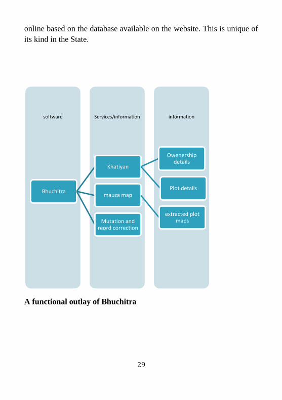
online based on the database available on the website. This is unique of
its kind in the State.
A functional outlay of Bhuchitra
information Services/information software
Bhuchitra
Khatiyan
Owenership details
Plot details mauza map
extracted plot maps Mutation and
reord correction

30
Chapter-3
STATUS OF NLRMP IN WEST BENGAL
I. Progress under Computerization
Computerized Records of Rights, which carry both maps (spatial) and (non-
spatial) attributes, are issued to the landholders upon request through Block
Level Computer Centre. The manual process has been completely banned by
law in the state and the computerized certified copies are considered legal in
the state. In the state, all the RoRs are computerized except in the areas where
there is ambigutity in possession, ownership rights and lack of clarity in land
records. Out of the eighteen districts for which data has been gathered, in 11
districts all the RoRs are computerized. Of the rest seven districts, Hugli,
Malda, West Medinipur and Nadia have above 92% computerization of land
records. Though we could not access exact figure about progress of CLR in
Jalapaiguri, East Medinipur and N-24 Parganas we are still assured about good
performance of these districts as well.
i. Computerization of Land Records
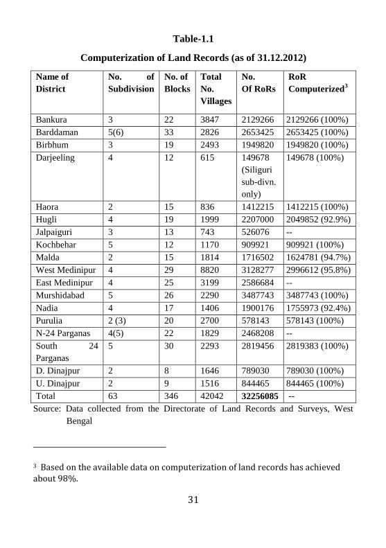
31
Table-1.1
Computerization of Land Records (as of 31.12.2012)
Name of
District
No. of
Subdivision
No. of
Blocks
Total
No.
Villages
No.
Of RoRs
RoR
Computerized3
Bankura 3 22 3847 2129266 2129266 (100%)
Barddaman 5(6) 33 2826 2653425 2653425 (100%)
Birbhum 3 19 2493 1949820 1949820 (100%)
Darjeeling 4 12 615 149678
(Siliguri
sub-divn.
only)
149678 (100%)
Haora 2 15 836 1412215 1412215 (100%)
Hugli 4 19 1999 2207000 2049852 (92.9%)
Jalpaiguri 3 13 743 526076 --
Kochbehar 5 12 1170 909921 909921 (100%)
Malda 2 15 1814 1716502 1624781 (94.7%)
West Medinipur 4 29 8820 3128277 2996612 (95.8%)
East Medinipur 4 25 3199 2586684 --
Murshidabad 5 26 2290 3487743 3487743 (100%)
Nadia 4 17 1406 1900176 1755973 (92.4%)
Purulia 2 (3) 20 2700 578143 578143 (100%)
N-24 Parganas 4(5) 22 1829 2468208 --
South 24
Parganas
5 30 2293 2819456 2819383 (100%)
D. Dinajpur 2 8 1646 789030 789030 (100%)
U. Dinajpur 2 9 1516 844465 844465 (100%)
Total 63 346 42042 32256085 --
Source: Data collected from the Directorate of Land Records and Surveys, West
Bengal
3 Based on the available data on computerization of land records has achieved about 98%.

32
Khatiyan or plot information
Certified copies of both khatiyan and plot information can be accessed
from the respective BLROs by submitting prescribed user fee at the
counter. However, one can view it online anywhere in the country. By
knowing the khatiyan number and the plot number one can access
detailed information both attributes and spatial information. The plot
map can also be viewed online. The below is an online view of plot and
khatiyan information accessed from the website
খতিযান ও দাগের িথয Khatian & Plot Information
Home Page
ম ৌজা পতরতিতি (Mouza
Identification): Must See
মজলা (District):
????? ????????
বলক
(Block):
????????-?
ম ৌজা (Mouza ):
???????
িযণ করন
(Options)
:
খতিযান
নং অনযাযী (Search
By
Khatian )
খতিযান নং (Khatian
No):
/
দাে
নং অনযাযী (Search

33
by Plot)
মজ.এল নং (J.L No.): 55 থানা (P.S.): বাাকডা (As on 11/02/2013)
খতিযান নং (Khatian No) : 10
রাযগির না (Owner Name) : অিীি আঠা
তপিা/সবা ী (Father/Husband): ভৱন আঠা
ঠিকানা (Address) : ৱডকডযা
জত র পতর াণ (Total Land) : 2.9778 (একর/Acre)
দাগের সংখযা (Total Plot) : 126
The detailed about plot information (plot number, plot classification
based on land use and soil quality), share, share area is available online.
While there is provision for integration of spatial and non-spatial data,
mauza map and plot maps are still not uploaded fully. Therefore
availing mauza map and plot map has not been possible yet.
Mutation disposal
Under the old scheme, computerization of land records, mutation
disposal through computer was an important objective. This was
emphasized even during the NLRMP. In West Bengal, online mutation
was successfully achieved after implementation of NLRMP. This is
undertaken in most of the Block Level Revenue Offices (BLROs). The
detailed status figure is mentioned below. The figures given in the table
below show that in a few cases the disposal of mutation through
computerization might overtake applied for mutation.

34
Table-1.2
Mutation disposal after computerization
Name of
District
Total No. of mutation
applied since
computerization
Disposed so far
through
computerization4
Mutation
Pending
(No.)
Bankura 124130 120388 13335
Barddaman 349374 305204 44170
Birbhum 150762 133335 29654
Darjeeling 33311 32564 2633
Haora 161239 136981 31579
Hugli 413015 429633 45088
Jalpaiguri 28790 33219 3856
Kochbehar 110550 112823 13593
Malda 186558 199485 32850
West Medinipur 325912 312235 98647
East Medinipur 579845 625600 90278
Murshidabad 384694 458068 25770
Nadia 389590 435273 81814
Purulia 8899 8065 860
N-24 Parganas 486569 520521 109377
South 24 Parganas 310150 284601 91569
D. Dinajpur 83199 82820 7344
U. Dinajpur 96385 73786 34322
Kolkata NA NA NA
Total 4222972 4362164 756739
Source: Data collected from the Directorate of Land Records and Surveys, West
Bengal in March, 2013
ii. Computerization of Registration
4 A few figures disposed through computerization are bigger than the mutation applied after computerization. This is because some mutations applied before computerization have also been included for computerization.

35
Registration and Stamp department is one of the oldest departments of
the state government. Further, Computerization of Registration is an
important initiative of the State Government. State Government started
computerization of registration in 2011. The computerization of
registration deals with scan and digitization of documents. Market value
assessment is done automatically from the existing database. The
Computerization of Registration is in full swing and all 240 SROs are
computerized. The inter-connectivity among the departments is
currently under process. Three SROs are undertaken on a trial basis to
implement the automatic mutation process in action. The
interconnectivity helps the Revenue Department to follow automatic
mutation procedure.
Vision, Mission and Objectives as described by the Government of
West Bengalvi
Vision: “The computerization of registration offices in West Bengal is
designed to eliminate the shortcoming of the conventional registration
system and to improve citizen services by making them quicker,
friendlier and transparent by reengineering Departments process as well
as to build capacity of the project team and infrastructure through the
use of e-governance tools”.
Mission: For improved and prompt citizen service delivery
Objectives:
1. To improve the quality of services to citizens.
2. To introduce transparency in the determination of market value
of the property through CORD.
3. Complete replacement of manual records.
4. Replacement of current manual system of indexing,
endorsement, according and reporting.

36
5. Introduce biometric, web camera and signature pad for capturing
thumb impression, photographs and signatures.
6. Seamless integration of all related systems
7. Post registration functionalities like searching of deeds and
printing of certified
Table-1.3
Status of Computerization of Registration
District No.
Of
SROs
No. of
SROs
Compu
terized
Internet
Con. to
SROs
(No.)
(Note 1)
e-Reg.
Facility
Avai. in
SROs
(No.)
(Note 2)
e-
Stamp.
Facility
in
SROs
e-
Valuat
ion
Fac.
SROs
Coochbehar 10 10 - - - 10
Jalpaiguri 8 8 - - - 8
Darjeeling 5 5 - - - 5
Uttar Dinajpur 8 8 - - - 8
Dakshin
Dinajpur
7 7 - - - 7
Malda 10 10 - - - 10
Murshidabad 20 20 - - - 20
Nadia 14 14 - - - 14
North 24 Parganas 20 20 3 3 - 20
South 24 Parganas 25 25 1 1 - 25
RA, Kolata 3 3 3 3 - 3
Howrah 10 10 2 1 - 10
Hoogly 16 16 2 2 - 16
West Medinipur 18 18 - - - 18
Bankura 11 11 - - - 11
Purulia 7 7 - - - 7
Burdawan 20 20 - - - 20
Birbhum 10 10 - - - 10
East Medinipur 18 18 - - - 18
240 240 11 10 - 240

37
Note-1: The Registration Offices and land offices will be connected
through MPLS (Multi Protocol Level Switching). The tender process
has been completed and work order has been issued. It is expected that
connectivity shall be established by next financial year.
Computerization of Registration Department (CORD)
By the time of fieldwork, all the 240 SROs were computerized. It is
expected that with the implementation of Computerization of
Registration Department, only 30 minutes taken for registration
processes, starting from the presentation of a document to the
registering officer to its final delivery to public (NIC, West Bengal).
However, this function under server-client mode again. Internet
connectivity to all the Sub-Registrar Offices is not complete as yet.
Only a few SROs located in the Howrah, Kolkata and other city offices
are connected with internet which is again not complete. Therefore, the
e-registration facility is not fully materialized.
Payment of stamp duty for a deed is processed through old stamp paper,
treasury challan, demand draft and SABR (Serialized Authenticated
Bank Receipt). However, as noticed this process is time consuming,
non-transparent, and encounters with delay and harassment. Therefore,
the demand for e-stamping by the government to ensure transparency,
hassle free, prompt, authenticated and secured way of paying stamp
duty and fees to government. Payees can be confirmed that payment is
made to its rightful recipient and for the desires (NIC, n.d). E-stamping
is successively introduced by NIC in 10 registration offices (A.R.A-I
Kolkata, A.R.A-II Kolkata, A.R.A-III Kolkata, A.D.S.R Alipore,
A.D.S.R Barasat, A.D.S.R. Barrackpore, A.D.S.R Chinsura, A.D.S.R
Howrah and A.D.S.R. Sreerampur). This shows that the e-stamping is
only introduced in and around Kolkata city where property value is very
high.

38
The steps of e-stamping and Registration fee as noted by NIC are as
follows.
Registrant public will feel an e-Requisition form containing the
property to be transacted and transferer and Transferee details of the
proposed transaction using the website of the Directorate of
Registration and Stamp Revenue, Government of West Bengal from
anywhere anytime. System will automatically generate e-assessment
slip informing required stamp duty and registration fee payable for
the registration of the deed.
Registrant public can also fill printed requisition form and submit at
Registration office and get assessment slip.
Registrant Public can also fill printed requisition form and submit it
at Registration office and get assessment slip
Registrant public will pay stamp duty and registration fee online
using Net banking facility using Government Receipt Portal System
(GRIPS) website https:wbfin.wb.nic.in/GRIPS/.
After payment of Stamp Duty (SD) and Registration fee, registrant
public shall present the deed for registration
Registered Deed shall be delivered to the party upon completion of
the entire registration process.
Impact on revenue collection after e-stamping
E-stamping is yet to roll out across the blocks, but based on the
successful implementation of e-stamping in as communicated expected
to have some positive impact on the increase in revenue collection.
Year wise target of revenue collection and achievement is mentioned
below in table 1.4. Over the year starting from 2004-05 to 2011-12
there is a continuous increase in net revenue collected from stamp duty
and registration. West Bengal has witnessed a 35 percent growth in
revenue collection to reach Rs. 14,176 crore during the first six months

39
(April-September 2012. According to Mr. Amit Mitra State Finance
Minister, “the implementation of electronic transaction systems in tax
collection aided the government in revenue collection. The Government
expects to maintain an average of 25 percent growth in revenue
collection.” (Business Line, The Hindu, November, 19, 2012).
Table-1.4
Revenue targets and achievements:
Year Revenue Collection
in Rupees
(In Crore)
Growth rate
(In %)
Achievement
(In %)
2004-2005 964.28 25.74 111.21
2005-2006 1087.02 12.73 103.03
2006-2007 1168.54 7.49 83.13
2007-2008 1352.21 15.72 90.14
2008-2009 1501.31 11.00 85.13
2009-2010 1916.27 27.64 95.57
2010-2011 2418.59 26.15 96.74
2011-2012 2905.00 20.11 90.78
Source: Directorate of Registration and Stamp Revenue’s own figures, not taken from
AG, West Bengal (Annual Administrative Report 2011-12), Government of
West Bengal
Revenue collection (an increasing trend) over the years
In concurrence with the above, the figure cited below show a steady increase
in the trend of revenue collection over a period of time starting from 2004-05
to 2011-12.

40
Fig-1 Showing increasing trend in revenue collection
0
500
1000
1500
2000
2500
3000
3500
Re
ven
ue
Co
llect
ion
(In
Rs)
Year
Revenue Collection (in Crore)

41
Table-1.5
District wise collection of revenue for the financial year 2010-11 and 2011-
12
Name of the
District
No. of deeds Total
Revenue
(Rs)
No. of deeds Total
Revenue (Rs.
In Crore)
2010-11 2010-11 2011-12 2011-12
Cooch Behar 43904 18.32 43278 21.91
Jalpaiguri 29721 57.49 32422 73.97
Darjeeling 12692 63.19 17156 79.84
Dinajpur (U) 40635 20.72 41965 25.07
Dinajpur (D) 33631 12.75 34115 15.60
Malda 82606 41.20 88839 50.65
Murshidabad 151380 63.58 161106 78.75
Nadia 105094 66.50 103815 78.20
North 24 Pgs 137210 336.60 165843 438.55
South 24 Pgs 161590 618.15 180940 742.44
Kolkata 38623 498.15 37001 557.14
Howrah 58992 139.51 60147 171.50
Hooghly 77056 112.30 81819 134.80
Mednipore (W) 78624 72.94 80400 92.09
Bankura 28823 36.40 27317 37.32
Purulia 21827 13.64 20178 15.52
Burdwan 101727 135.18 103459 143.41
Birbhum 66505 32.63 67770 37.41
Medinipore (E) 102947 79.34 114725 89.15
State Total 1373587 2418.59 1462295 2883.82
Source: Directorate of Registration and Stamp Revenue (Annual Administrative
Report 2011-12), Government of West Bengal
The above analysis shows that the net revenue collection through registration
and stamp is one of the prime revenue generating sources for the Government
of West Bengal. This is one of the largest revenue sources for the government.
Therefore, the vitality of the department and its modernization cannot be
simply ignored. The department has largest user interface, the approach of the
42
citizens to this department is the highest. In a city like Kolkata, every inch of
land is highly precious, so as in other cities. In order to bring accountability
and transparency in the system of registration has been increasingly taken up
after the NLRMP rolled out across the state.
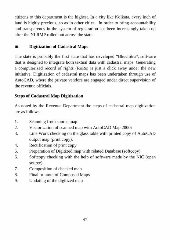
iii. Digitization of Cadastral Maps
The state is probably the first state that has developed “Bhuchitra”, software
that is designed to integrate both textual data with cadastral maps. Generating
a computerized record of rights (RoRs) is just a click away under the new
initiative. Digitization of cadastral maps has been undertaken through use of
AutoCAD, where the private vendors are engaged under direct supervision of
the revenue officials.
Steps of Cadastral Map Digitization
As noted by the Revenue Department the steps of cadastral map digitization
are as follows.
1. Scanning from source map
2. Vectorization of scanned map with AutoCAD Map 2000i
3. Line Work checking on the glass table with printed copy of AutoCAD
output map (print copy).
4. Rectification of print copy
5. Preparation of Digitized map with related Database (softcopy)
6. Softcopy checking with the help of software made by the NIC (open
source)
7. Composition of checked map
8. Final printout of Composed Maps
9. Updating of the digitized map
43
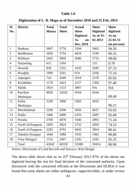
Table 1.6
Digitization of L. R. Maps as of December 2010 and 25 Feb, 2013
Sl.
No.
District Total
Mouza
Total
Sheet
Actual
Sheet
Digitized
As on
Dec, 2010
Sheet
Digitized
As of 25-
02-2013
Sheet
digitized
As on
25-02-13
(in percent)
1 Bankura 3847 5776 5184 5462 94.56
2 Bardhaman 2826 5754 4834 5199 90.35
3 Birbhum 2493 3809 3680 3733 98.00
4 Darjeeling 615 1504 132 8.78
5 Howrah 836 1552 1035 1045 67.33
6 Hooghly 1999 3241 674 2436 75.16
7 Jalpaiguri 743 2649 2019 2276 85.92
8 Kochbihar 1170 2423 2127 2360 97.40
9 Malda 1814 3133 3007 NA NA
10 Paschim
Medinipur
8820 10242 8764 9166
89.49
11 Purba
Medinipur
3199 3960 3383 3810
96.21
12 Murshidabad 2290 4298 3656 4037 93.93
13 Nadia 1406 2899 2476 2687 92.69
14 Purulia 2700 4078 1646 2905 71.24
15 North 24 Parganas 1829 3824 2732 2850 74.53
16 South 24 Parganas 2293 4793 4043 3854 80.41
17 Dakshin Dinajpur 1646 1986 1935 1982 99.80
18 Uttar Dinajpur 1516 2407 2185 2295 95.35
Total 42042 68328 53380 59416 86.96
Source: Directorate of Land Records and Surveys, West Bengal
The above table shows that as on 25th February 2013 87% of the sheets are
digitized leaving the rest for final decision of the concerned authority. Upon
discussion with the concerned officials at the Directorate and DLROs it was
found that some sheets are either ambiguous, vague/invisible, or under review
44
for final decision which are likely to be settled in the future. The figures
shown below represent how online views of the digitized maps showing plot,
adjacent plots, with dimension and ownership details. This process is different
from the other states, namely Maharashtra, Haryana and Gujarat. Here the
state governments have scanned, digitized and uploaded on software, but have
limited scope for geo-referencing without utilization of advanced satellite
imagery. Though this is one of the major objectives of the NLRMP to geo-
referencing the cadastral maps, but this present approach does not give space
for its utility.
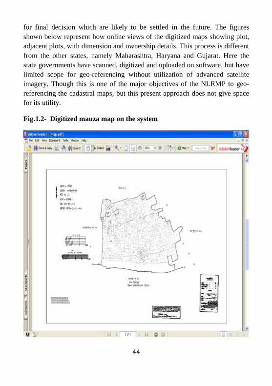
Fig.1.2- Digitized mauza map on the system

45
The above mauza map contain large number of plots with each plot map is
placed with the adjacent plot maps. Each khatiyan may contain number of
plots, so as a plot could be shared in number of khatiyans. The digitized map
enables editing which is required after trasanction of plots or partition of plots
due to sale, purchase, inheritance, etc.

46
Courtesy: NIC, Government of West Bengal
During our last visit in West Bengal during March 2013 we discussed with
various key officers about state preparedness to execute the NLRMP. During
this visit, we interacted with senior officials such as Director and Senior
Revenue Officers in the Directorate of Land Records and Survey, Senior
Technical Director, NIC, IG Registration and a few other officers in the
department of Revenue in Government of West Bengal.

47
During our interaction, the Revenue Officers briefed about the program and its
implementation in the state. The Director has shown all enthusiasm to execute
the program. The Revenue Officers are competent enough to know the nitty-
gritty’s of the program. The NIC Senior Technical Director, Mr. P.K.
Pramanik, who is the brain behind developing this software, has devoted
himself since last two decades to develop this software. A few from his vast
experience that he could share with within a short time gave some ideas to
know that how the software has successfully evolved. It was thought to be a
one man show. Mr. Pramanik has spent a longtime to understand the West
Bengal Revenue system and principles of land records management. His clear
understanding of the system is first step towards success of the programme. A
long time back he and his team had undertaken a feasibility study and had
produced detailed project report to execute the computerization of land
records programme. The state has been a historic success in implementing
land reforms. Most of the areas of the state, the Survey has been completed
and record of rights have been created. The cadastral maps have been
prepared. There is precision in survey and measurement. This is a fundamental
support to the revenue department to digitize cadastral maps. He has got all
cooperation with the state and the bureaucracy. The officials from the land
records have provided whole hearted support. Finance has never been a
constraint for the program. Both centre and state have adequate grants for the
project. The motivation from the higher officials has been instrumental to
develop this software. He has constantly engaged himself in developing and
further updating the software and never been diverted from his primary
interest to develop this user friendly software. The common interest among the
politicians, concerned administrators and the technical personnel is key to
success of the project. There has been mutual cooperation from both officials
of directorate of land records and the NIC officials. The NIC is too competent
to develop and design the software. But still then it is not the end of the
journey without having any sincere effort from the state government to
approach for Geo-referencing.
48
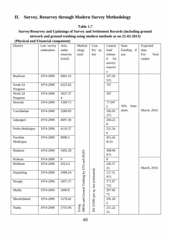
II. Survey, Resurvey through Modern Survey Methodology
Table 1.7
Survey/Resurvey and Updatings of Survey and Settlement Records (including ground
network and ground truthing using modern methods as on 25-02-2013)
(Physical and Financial component)
District Last survey
undertaken
Area
under
resurvey
(rural)
Method
ology
used
Cost
Per sq.
km
Central
fund
release
d for
survey/
resurve
y
State
Funding if
any
Expected
data
For final
output
Burdwan 1974-2000 6001.16 U
sing
HR
SIs
an
d G
rou
nd
Tru
thin
g b
y E
TS
and
DG
PS
RS
155
00/
per
sq
. k
m (
esti
mat
ed)
337.56
525
50% State
share
March, 2016
South 24
Parganas
1974-2000 6225.82 747
North 24
Parganas
1974-2000 3637.37
4
307
Howrah 1974-2000 1369.73 77.047
5
Coochbehar 1974-2000 3289.83 185.05
275
Jalpaiguri 1974-2000 4697.36 264.22
8
Purba Medinipur 1974-2000 4116.37 231.54
6
Paschim
Medinipur
1974-2000 8096.5 455.42
8125
Bankura 1974-2000
5492.28 308.94
075
Kolkata 1974-2000 0 0
March, 2016
Birbhum 1974-2000 4312.4 242.57
25
Darjeeling 1974-2000 2089.24 117.51
975
Hoogly 1974-2000 3057.37 171.97
725
Malda 1974-2000 3690.8 207.60
75
Murshidabad 1974-2000 5178.42 291.28
5
Nadia 1974-2000 3755.06 211.22
25

49
Purulia 1980- till
date
6075.27
Aerial
Photog
raphy
and
ground
truthin
g
Rs.
16500/
Per sq.
km
(estima
ted)
341.73
375
50% State
share
March, 2014
DakshinDinajpur 1974-2000 2187.78
Using
HRSIs
and
Ground
Truthin
g by
ETS
and
DGPS Rs.
15
500
/ p
er
sq
km
(est
imat
ed
123.06
3
March, 2016
Uttar Dinajpur 1974-2000 3118.97 175.44
225
Total
area
76391.7
34
4796.2
3188
4796.232
*No GCP set up under NLRMP
Source: Directorate of Land Records and Surveys, West Bengal

50
Table-1.8
Issuance of landholding, plot information and plot maps
District Landholding
certificate (RoR)
Plot information Plot maps
Howrah 7985 19323 0
Hugli 21780 32128 0
Nadia 376 906 0
Malda 7774 8228 0
Bankura 5595 10452 0
Bardwan 14715 27411 2
Birbhum 5521 7494 0
Jalpaiguri 1779 179 0
Coochbehar 8005 15917 39
Paschim Medinipur 19876 22057 0
Purba Medinipur 23390 20430 8
Murshidabad 12589 22695 23
Purulia 535 717 0
North 24 Parganas 18930 41280 4
South 24 Parganas 24633 27773 1
Dakshin Dinajpur 3069 5285 3
Uttar Dinajpur 4175 3508 0
Darjeeling 2586 2943 0
Total 183313 268726 80
Source: Directorate of Land Records and Surveys, West Bengal
Financial progress
The Government of West Bengal in the Land Reforms Department has
received a sum of Rs. 3626.79 lakh only as Grants-in-aid during 1989-90 to
2009-10 from Government of India as a Central share as per the details given
below.
51
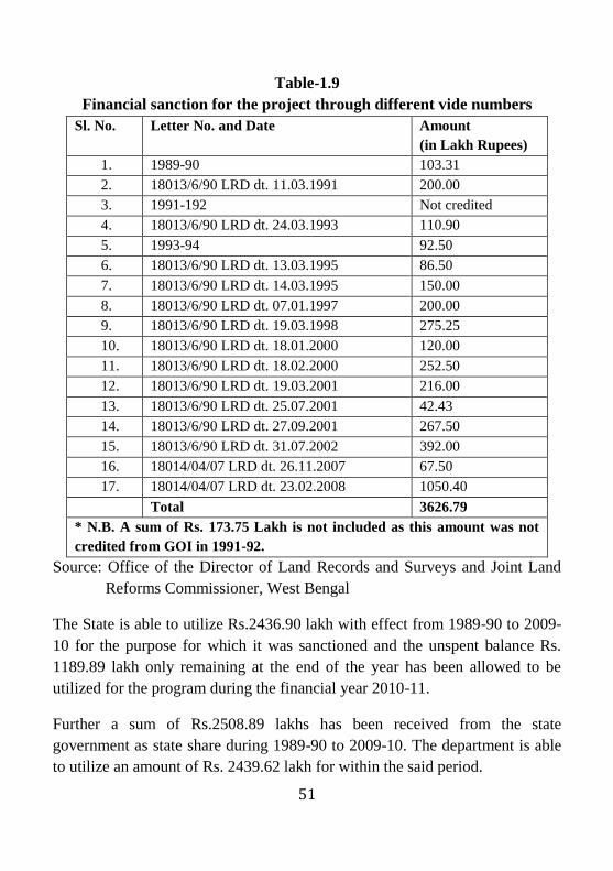
Table-1.9
Financial sanction for the project through different vide numbers
Sl. No. Letter No. and Date Amount
(in Lakh Rupees)
1. 1989-90 103.31
2. 18013/6/90 LRD dt. 11.03.1991 200.00
3. 1991-192 Not credited
4. 18013/6/90 LRD dt. 24.03.1993 110.90
5. 1993-94 92.50
6. 18013/6/90 LRD dt. 13.03.1995 86.50
7. 18013/6/90 LRD dt. 14.03.1995 150.00
8. 18013/6/90 LRD dt. 07.01.1997 200.00
9. 18013/6/90 LRD dt. 19.03.1998 275.25
10. 18013/6/90 LRD dt. 18.01.2000 120.00
11. 18013/6/90 LRD dt. 18.02.2000 252.50
12. 18013/6/90 LRD dt. 19.03.2001 216.00
13. 18013/6/90 LRD dt. 25.07.2001 42.43
14. 18013/6/90 LRD dt. 27.09.2001 267.50
15. 18013/6/90 LRD dt. 31.07.2002 392.00
16. 18014/04/07 LRD dt. 26.11.2007 67.50
17. 18014/04/07 LRD dt. 23.02.2008 1050.40
Total 3626.79
* N.B. A sum of Rs. 173.75 Lakh is not included as this amount was not
credited from GOI in 1991-92.
Source: Office of the Director of Land Records and Surveys and Joint Land
Reforms Commissioner, West Bengal
The State is able to utilize Rs.2436.90 lakh with effect from 1989-90 to 2009-
10 for the purpose for which it was sanctioned and the unspent balance Rs.
1189.89 lakh only remaining at the end of the year has been allowed to be
utilized for the program during the financial year 2010-11.
Further a sum of Rs.2508.89 lakhs has been received from the state
government as state share during 1989-90 to 2009-10. The department is able
to utilize an amount of Rs. 2439.62 lakh for within the said period.
52
III. Training and Capacity Building
At present Murshidabad and Salboni in Paschim Medinipur are the two places
where land record training is imparted to the revenue officials. We visited
Salobni area in West Medinipur district where the Officer Trainees of West
Bengal government were undergoing training on use of traditional survey
methodology such as plain table survey and chain survey. Moreover, on
enquiring further, we found that the program is designed for the OTs and the
Revenue Officers were very comprehensive and were also compatible to the
modern day requirement. The whole training module is covered within two
months comprehensive training period. Both theoretical and practical training
are delivered to the Officer Trainees and mid career officers. This shows that
the Government of West Bengal has planned well in advance foreseeing the
importance of training on modern survey equipment. A detailed training
module of the ATI, Salboni is cited below.
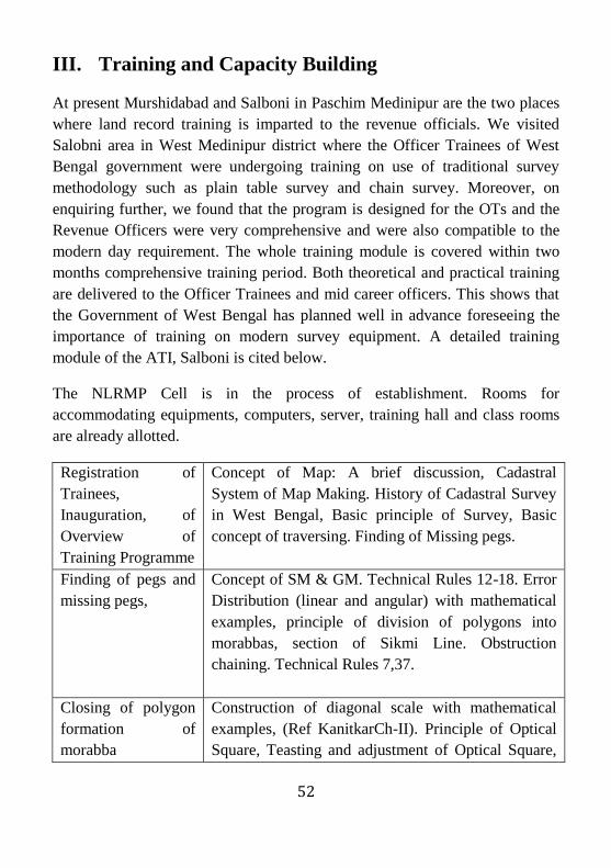
The NLRMP Cell is in the process of establishment. Rooms for
accommodating equipments, computers, server, training hall and class rooms
are already allotted.
Registration of
Trainees,
Inauguration, of
Overview of
Training Programme
Concept of Map: A brief discussion, Cadastral
System of Map Making. History of Cadastral Survey
in West Bengal, Basic principle of Survey, Basic
concept of traversing. Finding of Missing pegs.
Finding of pegs and
missing pegs,
Concept of SM & GM. Technical Rules 12-18. Error
Distribution (linear and angular) with mathematical
examples, principle of division of polygons into
morabbas, section of Sikmi Line. Obstruction
chaining. Technical Rules 7,37.
Closing of polygon
formation of
morabba
Construction of diagonal scale with mathematical
examples, (Ref KanitkarCh-II). Principle of Optical
Square, Teasting and adjustment of Optical Square,

53
(quadrilateral)
Formation of Sikmi
lines and Kistwar by
length of offsets, Instruments of measurement of
length & Area.
Kistwar by Chain
Survey-Distribution
of error
Error in length and area due to incorrect chaining,
mathematical formula and example. Partal in chain
survey
Kistwar by Chain
Survey
Detail survey – TR 38-41. Conception of plots.
Kistwar by Chain
Survey
Survey of village boundary, survey of Stream and
large rivers. TR-47-50,55
Kistwar by Chain
Survey-
Demonstration of
obstacle chaining
General maintenance of sheet. TR – 45-46, 51-54,
56, 145-150.
Chain triangulation. Prolongation, Horizontal
chaining. Technical Rules 21-22,26-27.
Kistwar of Chain
Survey –
Prolongation,
Triangulation
TR 57-72. Survey government land, Alluviated/
Dilluviated land. TR 115 Relay of LA plans- TR
117-121.
Kistwar in the
extended portion
Theory of Plane Table Survey- Testing and
adjustment, Setting up and orientation of Plane
Table, Advantages and Disadvantages of Plane Table
Survey.
Plane table survey –
Table set up, use of
sight vane.
Methods of Plane Table Survey - Plane Table
Traverse, Different methods resection: (1) two point
Problem (20 tree point problem.
Demo of radiation,
intersection
resection
Numbering of plots, numbering in multiple sheet,
Principle of Acre comb, Blue Inking of map TR -43-
46, final inking of map TR 135-144. numbering of
plots.
Practice of radiation, Concept Mouzathoka line & sheet thoka line.

54
intersection,
resection,
Boundary comparison, Boundary delineation from
sheet to ground. Principle of Acre Comb, Area
extraction,
Two point three
point problem.
Badar, and passing of village area, TR 122-134.
Mark map and list of register, incorporation of
changes in master copies of mouza map after final
publication, issuance of certified copies of map,
supervision & out turn TR 154-165.
Extension of
polygon by plane
Details discussion on work of Drawing section.
Maintenance of Registers
Kistwar on the
extended region by
plane table.
Numerical problems on diagonal scale, scale of map
Kistwar in the
extended region.
Boundary comparison, Demo of Boundary
comparison on P-70 sheet involving change of scale
(16” to 64”)
Boundary
comparison
Numbering of plots.
Practical demonstration of Preparation of Hal Sabek
list due to change of scale, renumbering of plot
Blue Inking Map Digitization-Roles and responsibilities.
Condition of LR maps in State Responsibilities of
TA.
Area extraction Sheet Junch: A complete Discussion
Preparation of R-O-
R Introdution to
A,B,C files
Prelimiary work at drawing section. TR chapter X-
TR 107-116 except 115.
Mid Term exam-
Practal test on Chain
survey and Plane
table survey
Mid Term Exam – Written test.

55
Introduction to the
instrument-
Theodolite (T2),
EDM, Station
setting
Basic of control survey using Theodolite- Concept of
Bearing and coordinate
Hands on –
Theodolite (T2),
EDM, Station
Setting, Taverse.
Numerical problem on Bearing and angle calculation
Theodolite Traverse Calculation of Astronomical Observation
Theodolite traverse Calculation of Set-up from, Distribution of error,
Calculation of U.T. Area
Astronomical
Observation
Calculation of UT area and preparation of P-70
Introduction to Total
Stations – Set up
and
Data download and processing and Drawing.
Map Digitization for Boundary comparison.
Total Station-
observation,
Introduction to GPS-
setting and
observation
Drawing conventional (manual method) on P-70
Traverse and detail.
Total Station-
observation,
Introduction to GPS-
setting and
observation
Lab Demo – Data download and processing
GPS observation –
Radial Method /
ETS Detail Survey
Establishing GCP, Concept of Datum, Coordinate,
Projection
GPS observation –
Trilataration /ETS
Detail
Mission planning with software. Introduction to the
instruments

56
GPS Observation –
Trilataration /ETS
Detail Survey
Downloading and processing of GPS data-
Demo+lab practice
GPS Observation –
ETS Detail Survey
Downloading and processing -Lab Demo
Traverse adjustment-Demo
ETS Details Survey Drawing in digital medium. – Lab Practice
Plane table survey –
64”=1 mile scale
Khanapuri Map corrections Ch V
Bujharat Map Correction Ch VI
Map correction in Atteslation, Post DP,TRCh VII,
VIII, Post FP corrections Ch – IX. Use of map
correction from with example in various stages.
Updation of Map after final publishing TR 108
Plane table Survey
64”=1 mile scale
Revisional Survey Ch XI
Revisional survey –
sheet to ground
relay. (update RS
maps)
TR CH –X (H)- Jurisdiction List, Creation of New
Mouza, Splitting and amalgation of mouza, & PS
Revisional survey –
sheet to ground
relay. (update RS
maps)
Visit to the District Drawing section record room of
PaschimMedinipore.
Practical Exam –
Theodolite/
ETS/DGPS
Groups discussion and presentation among and by
the trainees on the topics selected by the authority.
Source: ATI, Salboni, West Bengal

57
A Case Study of West Medinipur
Paschim Medinipur bifurcated from the old Medinipur district in the year 2002
and remained one of the biggest districts in the state. The district having long
archeological, cultural socio-economic and environmental significance lies 22
degree 15 minutes north and 87 degree 39 minutes east. A wide mixture of the
Hindu, the Muslim, the Christian, and the tribal communities, Paschim
Medinipur symbolizes great unity in diversity.
The total geographical area of the state is 9275.28 square kilometer covered
most part as rural area with 9076.43 square kilometer. Urban area covers
218.85 square kilometer. Forest cover constitutes 19% of the total area in the
district.
West Medinipur In Sq km In Ha
Total area of the district 9275.28 940817.82
Rural 9076.43 sq km 918667.00
Urban 218.85 22150.82
Forest 1747.6 174762 Ha
Further, land classification and land utilization statistics represent gradual
increasing of net sown area from a period starting 2002-03 to 2006-07. In the
contrary, barren and uncultivable land has increased in the district. Forest area
shows a sign of decrease.

58
Ta
ble
-1.1
1
Cla
ssif
ica
tio
n o
f la
nd
uti
liza
tio
n s
tati
stic
s
(Are
a in
tho
usa
nd h
ecta
re)
Yea
r
Rep
ort
ing
Are
a
Fo
rest
Are
a
Are
a u
nder
No
n-
agri
cult
ura
l
use
Bar
ren
&U
ncu
ltura
ble
land
Per
manent
pas
ture
s &
oth
er
gra
zing
land
Land
und
er
mis
c. t
ree
gro
ves
no
t in
clu
ded
in
Net
are
a so
wn
Cu
ltura
ble
was
te l
and
Fall
ow
land
oth
er
than
curr
ent
fall
ow
Curr
ent
fall
ow
Net
ar
ea
sow
n
(1 )
(2
) (3
) (4
) (5
) (6
) (7
) (8
)'
(9)
(10)
(11 )
2002-0
3
928.5
8
180.7
2
163.1
9
1.7
7
1.0
1
5.8
2
5.0
7
7.4
2
18.3
2
545.2
6
2003-0
4
928.5
8
169.6
9
146.0
7
2.4
4
0.6
5
6.4
6
4.1
9
3.8
2
29.9
8
565.2
8
2004-0
5
928.5
8
171.9
3
158.4
6
4.0
3
0.6
2
9.9
3
5.0
6
4.5
9
21.8
4
552.1
2
2005-0
6
928.5
8
171.9
3
154.3
2
4.9
3
1.7
0
11.7
0
6.4
9
6.3
7
19.4
2
551.7
2
2006-0
7
928.5
8
171.9
3
156.9
3
1.7
4
0.8
9
9.4
9
6.3
2
4.2
6
21.4
0
555.6
2
So
urc
e:
htt
ps:
//w
ww
.pa
sch
imm
ed
inip
ur.g
ov.i
n/d
istr
ict/
Sh
ow
.ph
p?
To
pic
=05

51
Computerization of Land Records
West Medinipur, a successful district with 100% computerization of RoRs
across all the sub-divisions namely, Sadar, Kharagpur, Jhargram and
Ghatal. Total 8820 villages in the district having 3900943 khatiyans are
all computerized. But mutation is too operational but the rate of success
varies across each sub-division. For example, in Sadar, the total number
of mutations applied for since computerization was 58675 but the
mutations disposed through computerization was 22173 (37.8%). In
Kharagpur the request for mutation was 60661 and disposal was 29601
(48.8%). The demand for mutation in Jhargram was 14021 with 10039
(71.6%) disposals, and in Ghatal the demand for mutation was 58682 and
the disposal was 22180 (37.8%).
Table-1.12
Computerization of Land Records Sl.
No
Name of
The
Subdivisio
n
No.
of
Blo
cks
Total
No.
of
Villag
ers
Khatiya
ns/RoRs
(No.)
RoRs
computeriz
ed
Total
no. of
mutati
ons
Applie
d for
Mutations
disposed
So far
Mutatio
ns
pending
(No.)
Online Total
1 Sadar 6 2389 650078 650078
58675 22173 22173 36502
2 Kharagpur 10 2719 1967485 1967485
60661 29601 29601 31060
3 Jhargram 8 3021 580967 580967 14021 10039 10039 3892
4 Ghatal 5 691 702413 702413 58682 22180 22180 36502
Computerization of registration
In Paschim Medinipur, all the 18 SROs are computerized. But the issue is
that there is no internet connectivity. The process is done on an offline
basis. There is no e-Registration facility available. Further, there is no e-
stamping or e-valuation done so far.
`
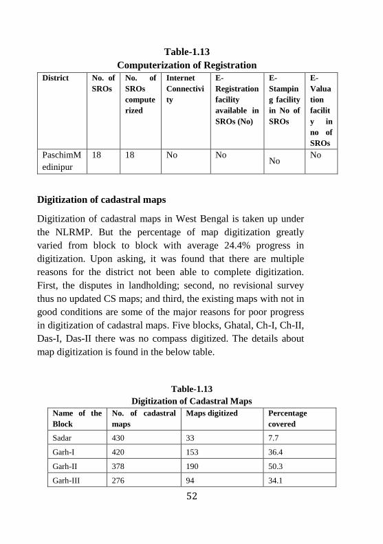
52
Table-1.13
Computerization of Registration
District No. of
SROs
No. of
SROs
compute
rized
Internet
Connectivi
ty
E-
Registration
facility
available in
SROs (No)
E-
Stampin
g facility
in No of
SROs
E-
Valua
tion
facilit
y in
no of
SROs
PaschimM
edinipur
18 18 No No No
No
Digitization of cadastral maps
Digitization of cadastral maps in West Bengal is taken up under
the NLRMP. But the percentage of map digitization greatly
varied from block to block with average 24.4% progress in
digitization. Upon asking, it was found that there are multiple
reasons for the district not been able to complete digitization.
First, the disputes in landholding; second, no revisional survey
thus no updated CS maps; and third, the existing maps with not in
good conditions are some of the major reasons for poor progress
in digitization of cadastral maps. Five blocks, Ghatal, Ch-I, Ch-II,
Das-I, Das-II there was no compass digitized. The details about
map digitization is found in the below table.
Table-1.13
Digitization of Cadastral Maps
Name of the
Block
No. of cadastral
maps
Maps digitized Percentage
covered
Sadar 430 33 7.7
Garh-I 420 153 36.4
Garh-II 378 190 50.3
Garh-III 276 94 34.1
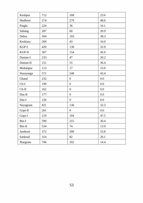
53
Keshpur 712 168 23.6
Shalboni 574 279 48.6
Pingla 224 36 16.1
Sabang 287 60 20.9
Debra 504 193 38.3
Keshiary 269 43 16.0
KGP-I 420 138 32.9
KGP-II 367 154 42.0
Dantan-I 233 47 20.2
Dantan-II 151 55 36.4
Mohanpur 113 17 15.0
Narayanga 571 248 43.4
Ghatal 232 0 0.0
Ch-I 199 0 0.0
Ch-II 162 0 0.0
Das-II 177 0 0.0
Das-I 126 0 0.0
Nayagram 421 136 32.3
Gopi-II 261 0 0.0
Gopi-I 219 104 47.5
Bin-I 590 215 36.4
Bin-II 534 74 13.9
Jamboni 372 200 53.8
Sankrail 314 82 26.1
Jhargram 706 102 14.4
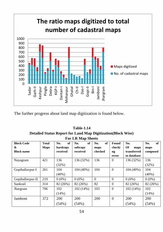
54
The further progress about land map digitization is found below.
Table-1.14
Detailed Status Report for Land Map Digitization(Block Wise)
For LR Map Sheets
Block Code
&
Block name
Total
Maps
No. of
hardcopy
received
No. of
softcopy
received
No. of
maps
checked
Found
checki
ng
error
No.
Of maps
transferred
to database
No. of
maps
composed
Nayagram 421 136
(32%)
136 (32%) 136 0 136 (32%) 136
(32%)
Gopiballavpur-I 261 104
(40%)
104 (40%) 104 0 104 (40%) 104
(40%)
Gopiballavpur-II 219 0 (0%) 0 (0%) 0 0 0 (0%) 0 (0%)
Sankrail 314 82 (26%) 82 (26%) 82 0 82 (26%) 82 (26%)
Jhargram 706 102
(14%)
102 (14%) 103 0 102 (14%) 102
(14%)
Jamboni 372 200
(54%)
200
(54%)
200 0 200
(54%)
200
(54%)
0 100 200 300 400 500 600 700 800 900
1000
Sad
ar
Gar
h-I
I
Kes
hp
ur
Pin
gla
Deb
ra
KG
P-I
Dan
tan
-I
Mo
han
pu
r
Gh
atal
Ch
-II
Das
-I
Go
pi-
II
Bin
-I
Jam
bo
ni
Jhar
gram
The ratio maps digitized to total number of cadastral maps
Maps digitized
No. of cadastral maps
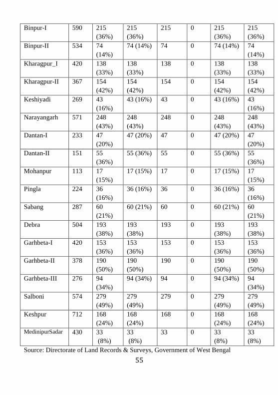
55
Binpur-I 590 215
(36%)
215
(36%)
215 0 215
(36%)
215
(36%)
Binpur-II 534 74
(14%)
74 (14%) 74 0 74 (14%) 74
(14%)
Kharagpur_I 420 138
(33%)
138
(33%)
138 0 138
(33%)
138
(33%)
Kharagpur-II 367 154
(42%)
154
(42%)
154 0 154
(42%)
154
(42%)
Keshiyadi 269 43
(16%)
43 (16%) 43 0 43 (16%) 43
(16%)
Narayangarh 571 248
(43%)
248
(43%)
248 0 248
(43%)
248
(43%)
Dantan-I 233 47
(20%)
47 (20%) 47 0 47 (20%) 47
(20%)
Dantan-II 151 55
(36%)
55 (36%) 55 0 55 (36%) 55
(36%)
Mohanpur 113 17
(15%)
17 (15%) 17 0 17 (15%) 17
(15%)
Pingla 224 36
(16%)
36 (16%) 36 0 36 (16%) 36
(16%)
Sabang 287 60
(21%)
60 (21%) 60 0 60 (21%) 60
(21%)
Debra 504 193
(38%)
193
(38%)
193 0 193
(38%)
193
(38%)
Garhbeta-I 420 153
(36%)
153
(36%)
153 0 153
(36%)
153
(36%)
Garhbeta-II 378 190
(50%)
190
(50%)
190 0 190
(50%)
190
(50%)
Garhbeta-III 276 94
(34%)
94 (34%) 94 0 94 (34%) 94
(34%)
Salboni 574 279
(49%)
279
(49%)
279 0 279
(49%)
279
(49%)
Keshpur 712 168
(24%)
168
(24%)
168 0 168
(24%)
168
(24%)
MedinipurSadar 430 33
(8%)
33
(8%)
33 0 33
(8%)
33
(8%)
Source: Directorate of Land Records & Surveys, Government of West Bengal
56
The last survey undertaken in the district was 1953 with the use of plain table
and chain. No revisional survey under modern methodology was undertaken at
the time of field survey. The major observation in the district was that the
region is backward with highly heterogeneous population and poor socio-
economic condition.
Field Visit Observation
Case-1
Block: Garhbeta-III
District: PaschimMedinipur
Month of visit: February 2013.
Basic Information:
Name of BLRO: Abdul Jamal
Total Number of ROs-One
Number of RIs-Eight
Number of mauzas under the Block-234
Observations
1. One man-one khatiyan system (one khatiyan may contain number of
plots).
2. Mauza wise maps. But only 43% mauza maps are digitized due to
number of factors such as legal discripancies, area and boundary
disputes, etc.
3. Digitization of maps has again limited scope for geo-referencing
without application of satellite imagery.

57
4. There is increasing demand for plot information and computerized
RoRs from the landholders. Plot information contains total area of the
plot, share possessed by the Raiyat and area possessed by the raiyat in
acre. RoR contains mauza number/JL number, khatiyan number, etc.
5. The computer centre-Server-Client mode-works in standalone not
interconnected with Blocks. Therefore, every month last date, the
monthly Progress report in CD sent to SDC through district authority.
6. Average application received for computerized RoRs and plot
information per day: 40
Case-2
Block: SadarMedinipur
District: PaschimMedinipur
Month of visit: February 2013.
Basic Information:
Name of BLRO: Sanjay Gupta
Total Number of ROs-One
Number of RIs-Eight
Number of mauzas under the Block-234
Observation
1. Weekly two days allocated for mutation disposal and one day
allocated for record correction and two day for RTI, reporting and
other matters.
58
2. Digitization of maps has again limited scope for geo-referencing
without application of satellite imagery.
3. Every day 200-500 applications received per week
4. There is shortage of Revenue Officers, particularly ROs
59
chapter-4
CONCLUSION AND RECOMMENDATIONS
Conclusion
The land records in West Bengal are quite updated and accurate due to
periodic surveys undertaken by the state. Over the years there is
increasing pressure on the land and revenue administration due to
demographic pressure, political compulsions and other socio-economic
factors. However, the dedicated single agency, the Land and Land
Reforms Department in the state has been instrumental in updating of
land records, by periodic surveys, complete computerization of RoRs,
good private outsourcing mechanism, dedicated NIC, etc. The
Directorate of Land Records and Surveys plays significant role in
implementing the ambitious NLRMP project in the state. About 90% of
the khatiyans are computerized but yet to achieve 100% result due to
litigations, court cases, lack of mutation on time, etc. The Bhuchitra
Software is compatible to accommodate digitized cadastral maps. At the
time of field survey, the digitization of cadastral maps was below 50%
successful. All the updated and digitized cadastral maps are not yet
uploaded on the software. Computerization of registration department
and capacity building initiatives are moderately successful. The modern
cadastral methods are rarely implemented in the states. The state seems
to be confused with the methodologies and approaches to adopt modern
cadastral survey in the state. Both online mutation and seam flow
automated registration are not fully materialized in the state.
The state has both strengths and weaknesses to execute the NLRMP.
The strength is its dedicated department with its dedicated employees,
sufficient manpower, and private outsourcing facilities amongst others.

60
The weaknesses on the other hand are political obligations and
compulsions. The state has been able to develop infrastructure facilities
adequately only in some BLROs. Modern record rooms are being built
up. The interconnectivity is in progress. Capacity building measures are
in full swing at its state level ATI in Salboni. The Bhuchitra software
and its implementation are unique of its nature in the country. Perhaps,
this is the first state to have uploaded cadastral maps online. But this is
not yet complete and well below half of the mark. Therefore, the
beneficiary landholders are very few who can have access to online
cadastral plot maps. Use of satellite imagery for further check of ground
reality seems to be a difficult task ahead. Therefore, geo-referencing has
not yet been done for the properties. However, it is expected that the
state will come up with new approaches to address these issues soon.
Recommendations for the state
1. User fee collection-some amount should be allocated for
maintenance cost at the Block level computer centres. The
BLRO will have the authority to grant for the maintenance from
this fund collected. Since this is found to be practiced in the
states like Gujarat and Odisha, this can be effectively reflected
in West Bengal.
2. Most of the states, particularly the southern states have initiated
kiosk for delivery of citizen friendly services at village level.
Installation of kiosk in the village level can minimize work
pressure of the officials working at the block level and save time
and money for the people travelling to Block head quarters for
accessing a computerized RoR. This can be done through state
wide Area network.

61
3. The computerization of BLRO Offices should now be connected
to the State Data centre through West Bengal State Wide Area
Network. So this will ensure effective management through
online.
4. Government should take further policy initiative for geo-
referencing of cadastral maps.
5. While the Government of West Bengal does have a well-
structured Ministry for the land reforms and land records
management, PMU should immediately set up within the
structure for special and specific attention on NLRMP.
6. The Registration department is working in silos with very
limited interaction with the LR department. Therefore, there
need to have framework followed under the NLRMP for more
consolidated and integrated department.
Recommendations for the Nodal Ministry
1. Rise in unit cost (per hectare) for cadastral survey. Rs. 17000/ha
as allocated is not sufficient for modern survey. The Unit cost
should be allocated based on Detailed Project Report prepared
by the state for modern survey, mapping and also digitization.
2. West Bengal is a typical case with high precision survey and
map creation for mauza wise. But plot wise survey does not
exist. Therefore, going for plot wise survey may incur huge cost
and time. In this regard, the Central government should support
through adequate fund for the state. Many Revenue Officers also
62
suggested for flexibility in expenditure from the allocated
budget under NLRMP grant. The expenditure should not be
based on component wise allocation.

63
Annexure-I
Financial Progress of National Land Records Modernization Programme
(in Lakh Rs.)
Financial
Year
District
covered (No.)
Data
Entry/Re
-
Entry/Da
te
Conversi
on
Digitiz
ation
of
Cadas
tral
Map
(CS1-
100%)
Intercon
nectivity
100%
State
Level
data
center
(CS-
100%)
Data
Centr
e (CS-
100)
Computerization
of Registration
(CS-
25%)
(SS2-
75%)
2 3 4 5 6 7 8 9 10
2008-09 9 plus Kolkata
for registration
45.00 Nil 474.00 50.00 Nil 260.815
2009-10 9 40.00 Nil 344.00 Nil Nil 158.815
2010-11 Nil Nil Nil Nil Nil Nil Nil Nil
2011-12 2 Cells at
ARTI, Salboni
and LMTC
Berhampore
for 18 districts
Total Upto
Dec., 2012
18 plus
Kolkata for
registration
85 0 818 50.00 0 419.63 0
Total
Amount
Utilized
Upto Dec.,
2012
89.91185 0 431.5971 0 0 0 0
Unspent
balance
-4.91185 0 386.4029 50 0 419.63 0
1 CS- Central Share

64
Contd…….
NLRMP
Center/
Cell
(CS 100%)
Survey/ Re-survey Modern Record Room Total Sanction amount
(CS-50%) SS2-
50%)
(CS-
50%)
SS2- 50%) Central
share CS)
State share
(SS)
Total
11 12 13 14 15 16 17 18
Nil 2479.745 0 2012.50 5322.0595
0 5322.0595
Nil 2509.898 0 1300.00 4352.713 0 4352.713
Nil Nil 1.66056 Nil Nil Nil 1.66056 1.66056
392.14 0.30645
392.14 0.30645 392.44645
392.14 4989.643 10.27890 3312.5
0 10066.91 10.27890 10077.1889
3.81352 10.27890
0 0 535.60137 10.27890 545.88027
388.3265 0 3312.5 0 9531.30863 0 9531.30863
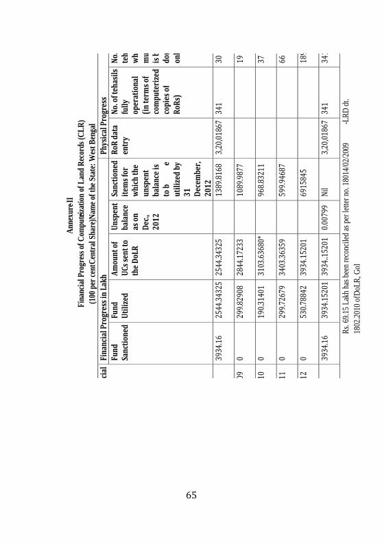
65
A
nne
xure
- II
Fin
anci
al P
rogr
ess
of C
omp
ute riz
atio
n of
Lan
d R
ecor
ds (
CL
R)
(100
per
cen
t Ce
ntra
l Sha
re) N
ame
of t
he S
tate
: W
est
Ben
gal
Fina
ncia
l Ye
ar
Fina
ncia
l Pro
gres
s in
Lak
h Ph
ysic
al P
rogr
ess
Fund
Sa
ncti
oned
Fu
nd
Uti
lize
d A
mou
nt o
f U
Cs s
ent t
o
the
DoL
R
Uns
pent
ba
lanc
e
as o
n
Dec
.,
2012
Sanc
tion
ed
item
s fo
r
whi
ch th
e
unsp
ent
bala
nce
is
to b
e
ut
iliz
ed b
y
31
Dec
embe
r,
2012
RoR
dat
a
entr
y N
o. o
f teh
asil
s
fully
op
erat
iona
l (i
n te
rms
of
com
pute
rize
d
copi
es o
f R
oRs)
No.
of
teha
sils
w
here
m
utat
ion
is
bei
ng
done
on
line
Upt
o
2008
39
34.1
6 25
44.3
4325
25
44.3
4325
1389
.816
8 3,
20,0
1867
34
1 30
2008
- 09
0 29
9.82
908
2844
.172
33
10
89.9
877
19
20
09 - 1
0 0
190.
3140
1 31
03.6
3680
*
968.
8321
1
37
2010
- 11
0 29
9.72
679
3403
.363
59
59
9.94
687
66
20
11 - 1
2 0
530.
7884
2 39
34.1
5201
6915
845
189
To
tal
3934
.16
3934
.152
01
3934
..152
01
0.00
799
Nil
3,20
,018
67
341
341
R
s. 6
9.15
Lak
h ha
s be
en r
econ
cile
d as
per
lette
r no
. 180
14/0
2/20
09
- LR
D d
t.
1802
.201
0 of
DoL
R, G
oI

66
Annexure-IV
Action Plan for Unspent Balance Name of Scheme – NLRMP
Sl. Unspent Sanctioned Action Plan to spent upto 31-03-2012
Annexure-III
Action Plan for U
nspent Balance
Physical and Financial Progress of NL
RM
P (Centre: State: : 50:50)
Year Fund
Sanctioned/
Released
towards
Central
share
Fund
Sanctione
d/
Released
towards
State
share
Total
available
funds
Fund
Utilized
(indicating central
share and State share
separately
as on 31-12-2012)
Amount
for
which
UCs
sent to
the DoLR
Unspent
balance as
on
31-12-2012
(indicated
Central and
State share
separately
Sanctioned item
s for
which
the unspent
balance is to be utilized
by
Upto 2008 5322.0595
0 5322.0595
0 0
5322.0595 1. Data entry & Data re-
entry;
2008-09 4352.713
0 9674.7725
0 0
9674.7725 2. Inter-connectivity,
2009-10 0
0 9674.7725
6.85354 6.85354
9667.91896 3. State level Data Centre,
2010-11 392.14
0 10060.0589
6
45.58842 52.44196
10014.47054 4.
Computerization
of
registration
2011-12 0
0.30645 10014.7769
9
473.24129 (CS)
525.9897 9541.22925
5. Survey/ re-survey
0.30645 (SS)
2012-13 (upto-
Dec.)
0 8.31189
9549.54114 11.57869 (CS)
0 9529.65056
6. Modern Record Room
8.31189 (SS)
Total 10066.9125
8.61834 10075.5308
4
537.26194
525.9897 9529.65056
`
8.61834
(SS)
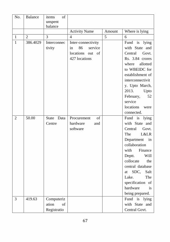
67
No. Balance items of
unspent
balance
Activity Name Amount Where is lying
1 2 3 4 5 6
1 386.4029 Interconnec
tivity
Inter-connectivity
in 86 service
locations out of
427 locations
Fund is lying
with State and
Central Govt.
Rs. 3.84 crores
where allotted
to WBEIDC for
establishment of
interconnectivit
y. Upto March,
2013. Upto
February, 52
service
locations were
connected.
2 50.00 State Data
Centre
Procurement of
hardware and
software
Fund is lying
with State and
Central Govt.
The L&LR
Department in
collaboration
with Finance
Deptt. Will
collocate the
central database
at SDC, Salt
Lake. The
specification of
hardware is
being prepared.
3 419.63 Computeriz
ation of
Registratio
Fund is lying
with State and
Central Govt.

68
n
4 3
8
8
.
3
2
6
5
NLRMP
Cell
ARTI Salboni
(1) Procurement
of 4 no. ETS and
1 pair GPS
(2) Procurement
of furniture for
library
(3) Procurement
computer
hardware
(4) Library books
(5) Organizing
training
46.415
0.86132
10.00
1.00
3.58
Central
Government
and ARTI,
Salboni. In
tender unit price
of ETS is
7.58000 lakh
and unit price
for 1 pair GPS
is 16.09500.
The approval
for procurement
and fund release
is pending
before Fin.
Department.
LMTC,
Berhampore
(1) Procurement
of 4 no. ETS and
1 pair GPS
(2) Procurement
of furniture for
library
(3) Procurement
computer
hardware
(4) Library books
(5) Organizing
training
46.415
0.86132
10.00
1.00
0.50
Central
Government
and LMTC,
Berhampore
Total 120.6326
5 4977.704 Surveys &
Resurveys
(1) Procurement
of High
Resolution
Satellite Image
1300.00 State and
Central Govt.
(2) Purchase of 272.88

69
ETS
(3) Purchase of 18
pairs of DGPS
289.71
(4) Establishment
of Secondary GC)
75.00
Total 1937.59
6. 3312.5 Modern
Record
Room
Fabricating
Modern Record
Rooms: 4
50.00 State and
Central Govt.

70
Annexure-V
Memo No. 5/1374/A/04 Dated, Alipore, the 4th
May, 2010
Government of West Bengal Directorate of Land Records and Surveys,
West Bengal
Scheme: Computerization of Land Record (CRL Scheme)
Utilization Certificate upto31st March, 2010
Sl. No. Letter No. and Date Amount (in lakh)
1. 1990-91 25.00
2. 1993-94 85.00
3. 1994-95 65.00
4. 1995-96 235.00
5. 1996-97 180.00
6. 1997-98 173.00
7. 1998-99
No. 180/4/31/98LRD dated 21/12/1998
266.20
34.58
8. 2000-2001 567.40
9. No. 18014/29/2000-LRD GOI
dated 27.09.2001
No. 180/4/31/98-LRD dated 21.04.2001
2001-2002
545.60
34.57
580.17
10. 2002-2003 Nil
11. 2003-2004 Nil
12. No. 05/2506-Budget/LL/CN/IB-195/2000(Sanction)
dated 09/08/2005
2004-2005
355.00
13. No. 18014/29/2000-LRD GOI
dated 07.12.2005
2005-2006
870.20
14. No. 18014/02/2007-LRD GOI
dated 30.03.2007
2006-2007
390.76
15. No. 18014/04/2007-LRD GOI
dated 26.12.2007
2007-2008
106.85
Total: 3934.16

71
Annexure-VI
Details about fund requested and approved for West Bengal
Sl.
No
State No.
Of
Districts
Funds
requested
Funds
approved
Sanction
year
Approved
date
Proposal
details
1 WB 10 5322.06 5322.06 2008-09 12/02/2009 19/14/2579
2 WB 9 4352.71 4352.71 2009-10 24/08/2009 19/14/2579
3 WB 1 196.07 196.07 2011-12 15/07/2011 19/17/2635
4 WB 1 0 0 2011-12 02/01/2012 19/17/2645
5 WB 1 196.07 196.07 2011-12 02/01/2012 19/17/2646
6 WB 1 196.07 196.07 2011-12 02/01/2012 19/17/2647
Source: http://nlrmp.nic.in/faces/rpt/rptApprovedClaim2.xhtml accessed on
26-12-2012

72
Annexure-VII
West Bengal Human Development Indices District Wise
Districts Health
Index
Income
Index
Education
Index
HDI HDI
Rank
Darjeeling 0.73 0.49 0.72 0.65 4
Jalpaiguri 0.61 0.38 0.6 0.53 10
Koch Behar 0.5 0.41 0.65 0.52 11
Dinajpur 0.62 0.39 0.53 0.51 13
Malda 0.49 0.36 0.48 0.44 17
Murshidabad 0.57 0.29 0.52 0.46 15
Birbhum 0.53 0.27 0.61 0.47 14
Bardhaman 0.74 0.47 0.71 0.64 5
Nadia 0.65 0.41 0.66 0.57 9
North 24 Parganas 0.72 0.49 0.76 0.66 3
Hugli 0.77 0.46 0.67 0.63 6
Bankura 0.67 0.26 0.62 0.52 11
Purulia 0.61 0.18 0.55 0.45 16
Medinipur 0.68 0.45 0.74 0.62 7
Haora 0.77 0.53 0.75 0.68 2
Kolkata 0.82 0.73 0.8 0.78 1
South 24 Parganas 0.71 0.4 0.68 0.6 8
West Bengal 0.7 0.43 0.69 0.61
Source: West Bengal Human Development Report
www.wbplan.gov.in/docs/Executive_Summary_WBHDR2004.doc

73
References
1. Williamson, Ian, S. Enemark, J. Wallace and A. Rajabifard
(2010). Land Administration for Sustainable Development, TS
3A-Land Governance for Sustainable Development, FIG
Congress 2010
2. Vachhani, A. and H.C. Behera (2010). Evaluation of
Computerization of Land Records in Gujarat, Centre for Rural
Studies, LBSNAA, Mussoorie.
3. Nikhil Nirmal, Village Study Report, submitted to LBSNAA,
Mussoorie
4. Ahuja, Manoj and A.P. Singh (2003). Evaluation of
Computerisation of West Bengal, Centre for Rural Studies,
LBSNAA, Mussoorie
iProne to corruption and litigation-3rd most corrupt sector (T.I. report, 2009) in India. The most corrupt sector in Nepal followed by Custom Department, police and judiciary (TI 2003). The most corrupt sector in Bangladesh as well (T.I. 2005 a)
ii Conclusive titling with title guarantee, the concept emerged in the developed nations to provide title guarantee to the landholders. Australia, Singapore, New Zealand and other countries have already having conclusive titling system where the state is responsible for loss of land, legal issues of landholders. In India the conclusive titling approach was already advocated in 1980s by the Wadha report submitted and an article was also submitted in the Economic and Political Weekly.
iiihttp://www.fao.org/docrep/006/V4860E/V4860E06.htm accessed on 10th April, 2011.

74
iv Quoted from Mr. Nikhil Nirmal’s Village Study Assignment submitted to CRS, NIAR.
vVenkatasubraminan, K. Land Reforms remains an unfinished business, http://planningcommission.nic.in/reports/articles/venka/index.php?repts=m-land.htm
vi Annual Administrative Report, 2010-2011, Finance Department, Government of West Bengal
About the Authors
Dr. A.A.A. Faizi, BAS, is a Professor at the Centre for Rural Studies at LBSNAA, Mussoorie.
Dr. Hari Charan Behera is presently a faculty member of SRU at the ISI, Giridih. Before joining the ISI at Giridih he was an Assistant Professor at the Centre for Rural Studies, LBSNAA, Mussoorie.

75


![Home | Welcome to West Bengal Judicial Academy Bengal Excise... · West Bengal Act of 2012 THE BENGAL EXCISE (AMENDMENT) ACT, 2012. [Passed by the West Bengal Legislature.] [Assent](https://img.dokumen.tips/doc/110x75/607fa9c0e387de78580b7626/home-welcome-to-west-bengal-judicial-bengal-excise-west-bengal-act-of-2012.jpg)