Embed Size (px)
Citation preview
Australian Journal of Basic and Applied Sciences, 8(6) April 2014, Pages: 96-105
AENSI Journals
Australian Journal of Basic and Applied Sciences
ISSN:1991-8178
Journal home page: www.ajbasweb.com
Corresponding Author: Norsidah Ujang, Universiti Putra Malaysia, Department of Landscape Architecture, Faculty of
Design and Architecture, 43400 Serdang Selangor Malaysia.
Ph: +60389464071. E-mail: [email protected]
Identification of Nodes as Legible Features in the Historical District of Kuala Lumpur,
Malaysia 1Norsidah Ujang and 2Tan Lai Kum 1Universiti Putra Malaysia, Department of Landscape Architecture, Faculty of Design and Architecture, 43400 Serdang, Selangor,
Malaysia. 2Universiti Putra Malaysia, Department of Landscape Architecture, Faculty of Design and Architecture, 43400 Serdang, Selangor, Malaysia.
A R T I C L E I N F O A B S T R A C T
Article history: Received 25 January 2014
Received in revised form
8 April 2014 Accepted 20 April 2014
Available online 10 May 2014
Keywords:
Nodes, Legibility, Historical District,
Kuala Lumpur
Background: In the developing cities, there is an increasing concern on the causal
factors of poor quality public spaces and places. Despite efforts to improve the physical
and experiential qualities, it is evident that historic cities are affected by the
development progress. One such a situation is the uncontrolled and unfit developments that continue to restructure the city pattern and the image of the historic district of
Kuala Lumpur. That makes the historical places incoherent, therefore, illegible to the
pedestrians. One of the elements that affect how people structure a city in their mental cognition is a node. Node as a space that encourages people to stop, inhabit and
participate with city life. They describe places in their physical structure, activity,
ambience and historical significance. This study aims to examine the legibility of nodes in the historic district of Kuala Lumpur, Malaysia. Direct observations of the historical
district were carried out to examine the characteristics of the historical district and the
constituting elements. Mental mapping and questionnaire survey were conducted to elicit the people’s identification of nodes considered to be legible and support their
experience of the district. The findings reveal that public buildings such as Masjid Jamek, transport node including Light Rail Transit (LRT) Station, the pedestrian mall
next to Central Market and public open space in front of Hong Kong and Shanghai
Bank (HSBC) headquarter as strategic nodes within the district. Respondents associated the nodes with paths and landmarks that directly link with the nodes. The scale and
facade treatment of historical buildings defining the nodes influence the respondent’s
recognition of the elements. The types of activities and the intensity of people within and around the nodes encourage engagement and association with the areas. The
findings suggest that the historical elements contribute to the legibility of places. In this
regards, planners and urban designer should consider the potential of these elements in making the city more attractive and identifiable to users.
© 2014 AENSI Publisher All rights reserved.
To Cite This Article: Norsidah Ujang, Tan Lai Kum.., Identification of Nodes as Legible Features in the Historical District of Kuala Lumpur,
Malaysia Aust. J. Basic & Appl. Sci., 8(6): 96-105, 2014
INTRODUCTION
Since the last decade, it is apparent that historic cities, particularly in the developing countries continue to
be affected by the development progress. One such example is the uncontrolled growth within the city centre of
Kuala Lumpur, which has restructured the design and the image of the historic part of the city. This can be seen
in the homogenized modern buildings as well as iconic structures. These elements are unfit to the overall pattern
and context of the city. Therefore, the image of the city is becoming less identifiable when experienced at
pedestrian level. So, “legibility or clarity” is the essential quality for cities because of its aesthetical value and
setting extent to volume, era and complication (Lynch, 1960, p.3).
Khairuddin et al (2004), Southworth (1985) and Bentley et al. (1985) agreed that old towns are usually
more legible, where important structures or buildings are highlighted, and public places are easily identified.
Recently, the need to secure the identity of Kuala Lumpur city center and the diminishing of place legibility has
been highlighted in Kuala Lumpur Structure Plan 2020 (Shuhana and Norsidah, 2008; DBKL, 2003. The city is
experiencing a gradual deterioration in the character of historic areas, which may lead to the loss of identity.
This is evident in a report by local papers, “The Star”, on the issues within the historical area of Kuala Lumpur
dated 22nd December 2006. The report urges the need to protect and preserve the historical value of the area. In
this case, the demolition of historical buildings which then replaced by high-rise buildings has changed the city
skyline, thus, affects its legibility. In addition, the emergence of mega shopping malls has resulted in the lack of
97 Norsidah Ujang and Tan Lai Kum, 2014
Australian Journal of Basic and Applied Sciences, 8(6) April 2014, Pages: 96-105
significance of traditional shopping streets that used to be the celebrated nodes in the city centre of Kuala
Lumpur in the past. (Norsidah, 2010).
Simultaneously, the attraction towards one stop commercial centre for shopping activities and leisure has
reduced the function of the streets and open spaces as means of communication as well as social interaction
(Khairuddin et al., 2004). Despite the continuing remarks on the need to preserve local identity, it is evident that
new developments within the traditional settings adversely transform constructed places and the local perception
of the places. This study examines the identification of nodes as legible elements within a historic district in the
city center of Kuala Lumpur. It advocates the need to preserve the city’s identity through enhancing urban
elements as place markers, especially nodes with historical features.
Methodology:
The legibility of the historic district in the Kuala Lumpur city centre is examined through users’
identifications of the urban features. Therefore, a single case study is selected to examine the legibility of the
identified study area. This is because of its capability to deal with the multiplicity of data, suitable method to
examine and reconfirm a well-formulated theory as agreed by Yin (1994). In addition, the case study is chosen
because of its uniqueness in giving information, in terms of personal and communal, for the research strategy in
psychology, sociology and planning fields.
Legibility is a study that is closely related to environmental studies. Related theories include environmental
image, environmental perception, environmental cognition, environmental psychology and environmental
behavior. In environmental perception research, Lynch’s (1960) imageability study identified distinctive
elements within the study areas. The mental mapping technique was originated from environmental cognition
study (McAndrew, 1993). In this study, the primary data were collected from field observations, mental
mapping exercise and survey questionnaire. The data gathered from the questionnaire survey and mental
mapping is analyzed using Statistical Product and Service Solutions (SPSS) Version 15.0 and the results are
validated by filed observation data.
Legibility and Urban Elements:
Lynch (1960) defines legibility as “the ease with which its parts can be recognized and can be organized
into a coherent pattern” (p.2-3). This refers to the identification of physical elements that indicates the citizens
or observers’ ability to structure the identified element into a comprehensive mental map.
Lynch (1960) introduces another terminology that is similar to legibility, which is called “imageability” or
“visibility”. It emphasizes on physical elements, which provides a vivid and distinctive image to user (p. 9). He
mentions that the quality of imageability is influenced by collective significance, purposes, history and the name
of the place. Southworth (1985) defines imageable city as composite from different physical objects which also
include landmarks, centers, districts and routes. He mentions that these physical objects allow mental maps,
which enable observers to orientate and travel within an environment without being disoriented and to be
configured. Therefore, the study assumes that imageability may be achieved if it works with the physical
elements. The theory is supported by Southworth (1985), who suggests that the development of an image should
begin with the modification of the physical structure of the city. This can be done by creating new or enhancing
existing distinctive features, such as constructing new focal points, restructuring paths, strengthening weak
edges and intensifying district character by changing land uses and forms (Bentley et al., 1985).
According to Lynch (1960), clarity or legibility is the property of the city which is able to be visually
understood and is only linked with other identifiable symbols into an overall picture. This is because the
environment is always supported by the presence of other arrangement with the indication of sizes, shape, hues,
lighting and senses, like aroma, noise and so on. He adds that an energetic and cohesive physical arrangement
contributes to a vivid image, which consists of various icons and recollection. On the other hand, a well-
organized environment becomes a reference, influences on the planning of activity and provides comprehensive
information. For that reason, the researcher believes that these vivid images allow observers to get their way and
also capable in building a secure environment. Later, with daily practice, observers are able to develop the
meaning with the given setting. Accordingly, this study realizes the importance of legibility in an environment
and efforts to investigate the existing distinctive objects that knit the historic district in the Kuala Lumpur city
centre.
Bentley et al. (1985) define legibility as “quality which makes a place graspable” (p.42). This because they
believe that people who are competent to read the layout of the environment are also able to get benefits offered
in the area. As an addition, they assume that the preferable quality of legibility should consider both physical
layout and patterns of use. Lynch (1960) and Bentley et al. (1985) agree that interpreting the layout of the
environment requires the skill to locate the correct image of the given environment in the form of mental map.
They mention that the physical layout is always represented by tangible features in different scales with a
combination of new and existing elements to remind observers of their location. As discussed earlier, physical

98 Norsidah Ujang and Tan Lai Kum, 2014
Australian Journal of Basic and Applied Sciences, 8(6) April 2014, Pages: 96-105
objects contribute to legibility of the city’s image and become essential components for observers in developing
mental maps. Lynch (1960) generalizes these physical objects by categorizing them into five types of elements,
namely “paths, edges, districts, nodes and landmarks” (p.46). In this study, the researcher intends to explore
nodes as place making features and their characteristics that influence legibility of an environment setting.
Nodes:
Nodes are strategic spots in a city, which enable an observer to penetrate and act as transmit spots for
movement from place to place (McAndrew, 2003; Yeung and Savage, 1996; Lynch, 1960). Nodes are small
spots, which include junctions, transportation spots, and a crossroads or conjunction of paths. They also transfer
points from one arrangement to another with some unique concentrations (Lynch, 1960). He also highlights that
nodes are interconnected with paths because they are derived from paths and are considered as small focal point
for those paths. Therefore, nodes may be a combination of intersections and focal point, such as, transportation
breaks in a convergence of paths. Other than that, nodes are essential elements to symbolize a district because
when observers are viewing inward, the environment, but observing from outside enable observers to bind the
environment with nearby districts. At the same time, many interrelated nodes may give a vivid characteristic to
the districts. In summary, nodes are an attention derived from paths, which consists of distinctive characters that
attract people’s attention.
Fig. 1: Nodes as Centre and Transfer Points for Movement (Source: Bentley et al., 1985).
Fig. 2: Nodes Configuration (Source: Bentley et al., 1985).
Fig. 3: Nodes as Concentration Places.
(Source: http://krypton.mnsu.edu/~tony/Pictures/Misc/Sketches0012.jpeg, 2012 and Bentley et al., 1985)
Observers pay attention at intersections to identify the uniqueness of the surrounding before they continue
travelling (Lynch, 1960). Therefore, nodes become important even though the features may be shapeless, for
example; observers will understand that they are away from the district when they pass through some elements.
In some circumstances, railway stations have become strategic meeting points and identifiable nodes in the city.
This indicates observers interpret nodes on functions rather than distinctive physical elements. In some situation
nodes can occupy a larger space than normal linear form of path elements like, squares.
99 Norsidah Ujang and Tan Lai Kum, 2014
Australian Journal of Basic and Applied Sciences, 8(6) April 2014, Pages: 96-105
Carmona and Tiesdell (2007) define nodes as a space that encourages people to stop, inhabit and participate
with city life. They describe places in their physical structure, activity, ambience and historical significance. The
physical structure consists of tangible elements involving a volume of space, architecture styles and independent
elements. On the other hand, activities are illustrated as lively or passive, dormant or crowded, vehicular-
pedestrian sharing space, moving-immobile pedestrian, local-tourist space uses and special themes, such as art
shows or regular activities, like people gossiping or children playing. In addition, actions will influence the
ambience within the place of its building such as in mosques, bazaars and shopping complexes. This increases
space qualities and people involvement. Stevens (2006) stated that places may heighten people’s awareness
through symbols of tangible appearance and senses. Lastly, historical significance with intangible appearance
works well in influencing people’s emotions through buildings, squares, trees or balconies involving individuals
or groups. The emotions from the historical significance can serve to present time, like a political site in a
government administration office and a marketplace or a gambling casino in a mega department store.
Therefore, a great historical place can manipulate significant city urbanizations by introducing richness and
morale of history to create enjoyment, worship, appreciation, sadness and admiration (Carmona and Tiesdell,
2007). In brief, design and planning may increase the characteristics of nodes through enhancing physical
features, creating activities, creating the sense and appreciating historic value. Therefore, the research seeks to
identify nodes that are potential to be rehabilitating in order to strengthen district character. This is relevant to
Kuala Lumpur, a city that continues to experience changes and transformations to its urban spaces.
The respondents:
The respondents who participated in the mental mapping and the survey are mixed in terms of status, place
of stay, gender, marital status, age, ethnicity and education.
Respondents were required to draw mental maps according to their own interpretation of the site. It is
recorded that the entire respondents (n=32, 100%) are Malaysian, 21 respondents (65.6%) are living within
Kuala Lumpur area while 11 respondents (34.4%) are living outside Kuala Lumpur.
There are 17 males (53.1%) and 15 females (46.9%) respondents. The sampling represents the current
population by gender in Malaysia. As documented in the Preliminary Count Report 2010 by the Department of
Statistics, Malaysia on 15 November 2010, the distribution of gender in the country is 51.2% male to 48.8%
female. Besides that, 19 respondents are single (59.4%), and 13 respondents are married (40.6%).
The age group are divided into 4 sub-categories which are from 18 to 29 years old (43.7%), 30 to 41 years
old (40.6%), 42 to 53 years old (6.3%) and more than 54 years old (9.4%). However, the group 42 to 53 years
old and 54 and older will be assigned as 42, and older (n=5, 15.7%) because very few respondents is not
significant to represent the groups itself. Majorities (84.3%) of respondents are from age group 18 to 41 years
considered as a young generation while, only minority (15.7%) of respondents are aged between 42, and older
represented old generation.
There were 16 Malays (50%), 11 Chinese (34.4%), 4 Indian (12.5%) and 1 others (3.1%). While, the
majority of respondents are from SPM (n=9, 28%), Certificate/Diploma/STPM (n=10, 31.3%) and Bachelor and
above (n=10, 31.3%) whereas, the least is not applicable (n=3, 9.4%). This shows that 90.6% (n=29) of the
respondents is educated at minimum SPM level.
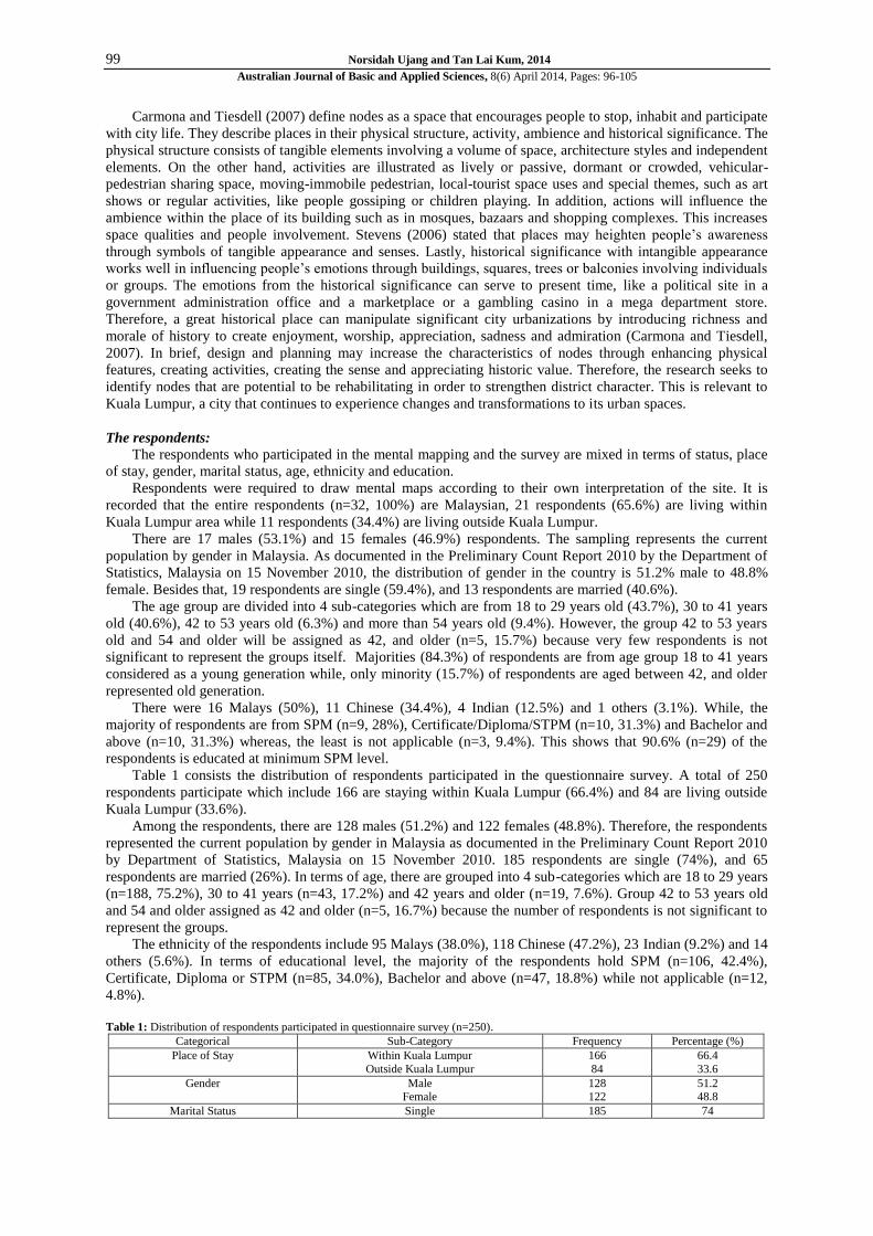
Table 1 consists the distribution of respondents participated in the questionnaire survey. A total of 250
respondents participate which include 166 are staying within Kuala Lumpur (66.4%) and 84 are living outside
Kuala Lumpur (33.6%).
Among the respondents, there are 128 males (51.2%) and 122 females (48.8%). Therefore, the respondents
represented the current population by gender in Malaysia as documented in the Preliminary Count Report 2010
by Department of Statistics, Malaysia on 15 November 2010. 185 respondents are single (74%), and 65
respondents are married (26%). In terms of age, there are grouped into 4 sub-categories which are 18 to 29 years
(n=188, 75.2%), 30 to 41 years (n=43, 17.2%) and 42 years and older (n=19, 7.6%). Group 42 to 53 years old
and 54 and older assigned as 42 and older (n=5, 16.7%) because the number of respondents is not significant to
represent the groups.
The ethnicity of the respondents include 95 Malays (38.0%), 118 Chinese (47.2%), 23 Indian (9.2%) and 14
others (5.6%). In terms of educational level, the majority of the respondents hold SPM (n=106, 42.4%),
Certificate, Diploma or STPM (n=85, 34.0%), Bachelor and above (n=47, 18.8%) while not applicable (n=12,
4.8%).
Table 1: Distribution of respondents participated in questionnaire survey (n=250).
Categorical Sub-Category Frequency Percentage (%)
Place of Stay Within Kuala Lumpur
Outside Kuala Lumpur
166
84
66.4
33.6
Gender Male Female
128 122
51.2 48.8
Marital Status Single 185 74

100 Norsidah Ujang and Tan Lai Kum, 2014
Australian Journal of Basic and Applied Sciences, 8(6) April 2014, Pages: 96-105
Married 65 26
Age 18-29
30-41 42-53
54 and older
188
43 15
4
75.2
17.2 6.0
1.6
Ethnicity Malay
Chinese Indian
Others
95
118 23
14
38.0
47.2 9.2
5.6
Education SPM Certificate/Diploma/STPM
Bachelor & above
Not applicable
106 85
47
12
42.4 34.0
18.8
4.8
Legible Nodes:
Nodes are strategic places which enable observers to experience the elements solely represented by open
spaces such as junctions or square as defined by Lynch (1960). However, studies of nodes should extend into
physical elements comprised of building features and independent elements as defined by Carmona and Tiesdell
(2007).
According to the Table 2, the results from mental mapping indicate that respondents identified 10 nodes
following their experience and knowledge about the study area. However, HSBC headquarter (f=18) is the only
recognizable nodes while, others identified an open space at the Medan Pasar, an area at the confluence of the
Klang and Gombak rivers, an open space in front the Cahaya Suria building, an open space in front of the the
Bangkok Bank, a bus stop in front of the Mydin building, an old building, a bus stop next to the Mydin building
and a car park next to the HSBC. They vary in frequencies (f=10 to 1).
Table 2: Legible nodes based on mental mapping (n=32).
Variables Ranks Frequency
Open space in front HSBC headquarter 1 18
Open space at Medan Pasar 2 10
Confluence River 3 9
Open space in front Cahaya Suria (Stamford College) 3 9
Open space in front Bangkok Bank 4 7
Bus stop in front Mydin 5 4
Old building 5 4
Bus stop next to Mydin 6 3
Toilet 7 1
Car park next to HSBC 7 1
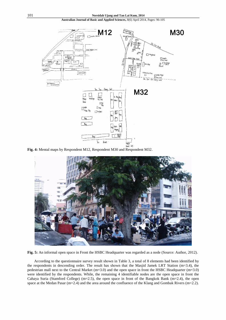
According to the mental mapping result, the open spaces located in front of the HSBC headquarter clearly
shown in mental maps drawn by Respondent M12, Respondent M30 and Respondent M32. This can be
influenced by the long established HSBC building offering banking services to support the economy of the
district. This enabled people to form their mental image of the area. It is also strategically located and near to the
transportation node (LRT Masjid Jamek Station) and situated close to Medan Pasar (which was formerly known
as Old Market Square). It attracts people to move from the centre of the square into the city edges under shaded
environment alongside some hawker stalls. This indicates that a strategic location, comfortable environment and
informal activities contribute to the identification of legible nodes. The result is consistent with Carmona and
Tiesdell (2007) who stated that places can be described in physical, activity, emotion and historical aspects.
It is interesting to note that it is less preferable for the respondents to utilize the Medan Pasar as square even
though it is the most recognizable nodes within the area. This may be because of the lack of environmental
comfort. These are evident by the problems of air and sound pollution produced by vehicles especially buses.
Hot and humid climate with inadequate shaded spaces and spaces surrounded by lots of car park also
contributed to the lack of preference.
In summary, the quantity of nodes identified through mental mapping is varied because the method
encourages respondents to spontaneously draw elements based on their experience and understanding compared
with prepared survey questionnaire which can limit the potential elements considered as legible nodes.
However, according to mental mapping results, respondent’s recognition of legible nodes are low because only
open spaces in front of HSBC headquarter are considered readable. However, the study found that attractive or
unique activities, comfortable environments and the availability of space for activities are also significant factors
that influence the respondent’s recognition of legible nodes.
101 Norsidah Ujang and Tan Lai Kum, 2014
Australian Journal of Basic and Applied Sciences, 8(6) April 2014, Pages: 96-105
Fig. 4: Mental maps by Respondent M12, Respondent M30 and Respondent M32.
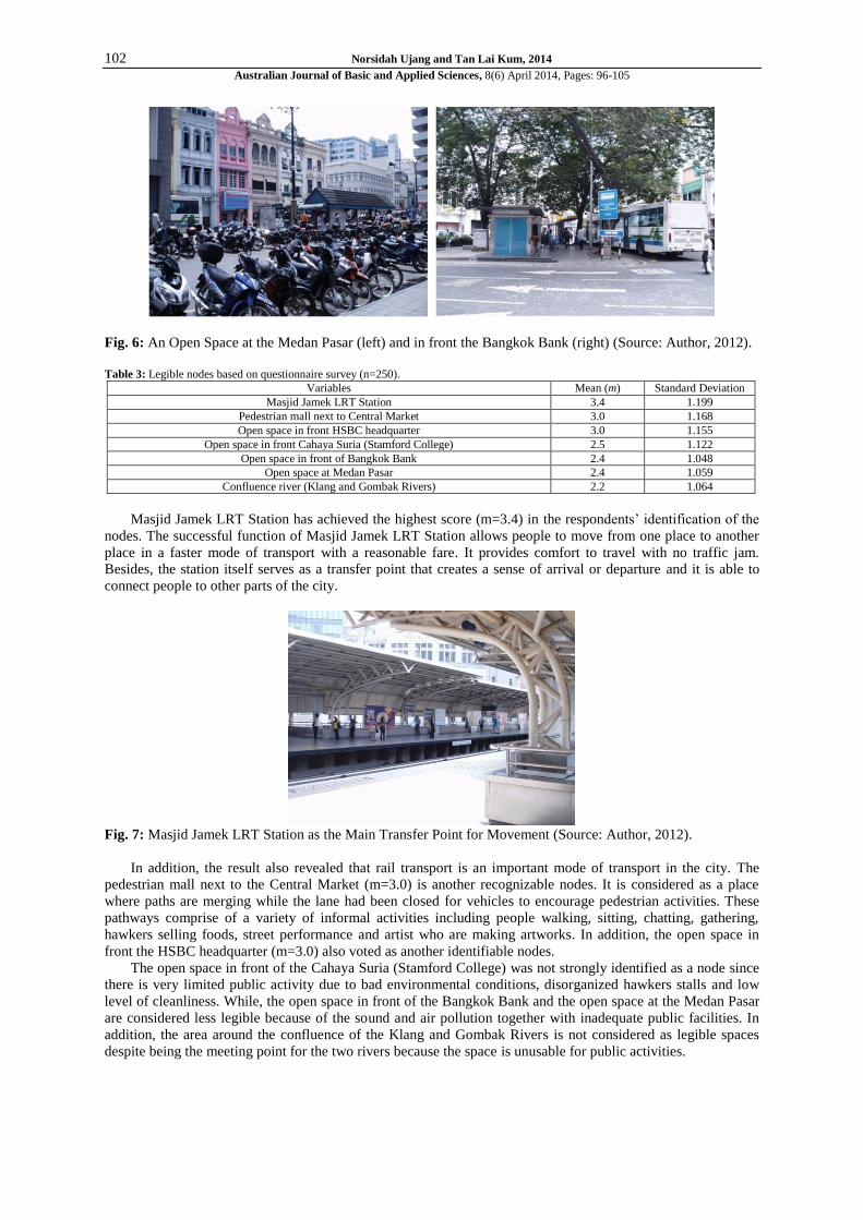
Fig. 5: An informal open space in Front the HSBC Headquarter was regarded as a node (Source: Author, 2012).
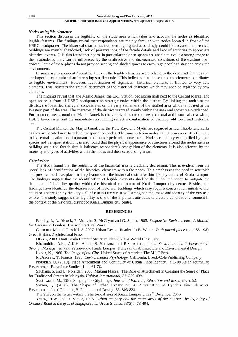
According to the questionnaire survey result shown in Table 3, a total of 8 elements had been identified by
the respondents in descending order. The result has shown that the Masjid Jamek LRT Station (m=3.4), the
pedestrian mall next to the Central Market (m=3.0) and the open space in front the HSBC Headquarter (m=3.0)
were identified by the respondents. While, the remaining 4 identifiable nodes are the open space in front the
Cahaya Suria (Stamford College) (m=2.5), the open space in front of the Bangkok Bank (m=2.4), the open
space at the Medan Pasar (m=2.4) and the area around the confluence of the Klang and Gombak Rivers (m=2.2).
102 Norsidah Ujang and Tan Lai Kum, 2014
Australian Journal of Basic and Applied Sciences, 8(6) April 2014, Pages: 96-105
Fig. 6: An Open Space at the Medan Pasar (left) and in front the Bangkok Bank (right) (Source: Author, 2012).
Table 3: Legible nodes based on questionnaire survey (n=250).
Variables Mean (m) Standard Deviation
Masjid Jamek LRT Station 3.4 1.199
Pedestrian mall next to Central Market 3.0 1.168
Open space in front HSBC headquarter 3.0 1.155
Open space in front Cahaya Suria (Stamford College) 2.5 1.122
Open space in front of Bangkok Bank 2.4 1.048
Open space at Medan Pasar 2.4 1.059
Confluence river (Klang and Gombak Rivers) 2.2 1.064
Masjid Jamek LRT Station has achieved the highest score (m=3.4) in the respondents’ identification of the
nodes. The successful function of Masjid Jamek LRT Station allows people to move from one place to another
place in a faster mode of transport with a reasonable fare. It provides comfort to travel with no traffic jam.
Besides, the station itself serves as a transfer point that creates a sense of arrival or departure and it is able to
connect people to other parts of the city.
Fig. 7: Masjid Jamek LRT Station as the Main Transfer Point for Movement (Source: Author, 2012).
In addition, the result also revealed that rail transport is an important mode of transport in the city. The
pedestrian mall next to the Central Market (m=3.0) is another recognizable nodes. It is considered as a place
where paths are merging while the lane had been closed for vehicles to encourage pedestrian activities. These
pathways comprise of a variety of informal activities including people walking, sitting, chatting, gathering,
hawkers selling foods, street performance and artist who are making artworks. In addition, the open space in
front the HSBC headquarter (m=3.0) also voted as another identifiable nodes.
The open space in front of the Cahaya Suria (Stamford College) was not strongly identified as a node since
there is very limited public activity due to bad environmental conditions, disorganized hawkers stalls and low
level of cleanliness. While, the open space in front of the Bangkok Bank and the open space at the Medan Pasar
are considered less legible because of the sound and air pollution together with inadequate public facilities. In
addition, the area around the confluence of the Klang and Gombak Rivers is not considered as legible spaces
despite being the meeting point for the two rivers because the space is unusable for public activities.

103 Norsidah Ujang and Tan Lai Kum, 2014
Australian Journal of Basic and Applied Sciences, 8(6) April 2014, Pages: 96-105
Fig. 8: Pedestrian Mall as Nodes supporting people’s Activities (Source: Author, 2012).
Fig. 9: Open Space in front of the Cahaya Suria Building (Source: Author, 2012).
Fig. 10: Legible Nodes based on the respondents’ identifications.
104 Norsidah Ujang and Tan Lai Kum, 2014
Australian Journal of Basic and Applied Sciences, 8(6) April 2014, Pages: 96-105
Nodes as legible elements:
This section discusses the legibility of the study area which takes into account the nodes as identified
legible features. The findings reveal that respondents are mainly familiar with nodes located in front of the
HSBC headquarter. The historical district has not been highlighted accordingly could be because the historical
buildings are mainly abandoned, lack of preservations of the facade details and lack of activities to appreciate
historical events. It is also found that nodes, in particular the open spaces are unable to evoke a strong image to
the respondents. This can be influenced by the unattractive and disorganized conditions of the existing open
spaces. Some of these places do not provide seating and shaded spaces to encourage people to stay and enjoy the
environment.
In summary, respondents’ identifications of the legible elements were related to the dominant features that
are larger in scale rather than interesting smaller nodes. This indicates that the scale of the elements contributes
to legible environment. However, identification of significant historical elements is limited to very few
elements. This indicates the gradual decrement of the historical character which may soon be replaced by new
elements.
The findings reveal that the Masjid Jamek, the LRT Station, pedestrian mall next to the Central Market and
open space in front of HSBC headquarter as strategic nodes within the district. By linking the nodes to the
district, the identified character concentrates on the early settlement of the studied area which is located at the
Western part of the area. The character of the district is spread evenly within the area and sometime overlapped.
For instance, area around the Masjid Jamek is characterized as the old town, cultural and historical area while,
HSBC headquarter and the immediate surrounding reflect a combination of banking, old town and historical
area.
The Central Market, the Masjid Jamek and the Kota Raya and Mydin are regarded as identifiable landmarks
as they are located next to public transportation nodes. The transportation nodes attract observers’ attention due
to its central location and important function for pedestrian movement. Nodes are mainly exemplified by open
spaces and transport station. It is also found that the physical appearance of structures around the nodes such as
building scale and facade details influence respondent’s recognition of the elements. It is also affected by the
intensity and types of activities within the nodes and their surrounding areas.
Conclusion:
The study found that the legibility of the historical area is gradually decreasing. This is evident from the
users’ lack of identification of the historical elements within the nodes. This emphasizes the need to refurbish
and preserve nodes as place making features for the historical district within the city centre of Kuala Lumpur.
The findings suggest that the identification of legible elements shall be the initial indication to mitigate the
decrement of legibility quality within the historical continuum of Kuala Lumpur city centre. Besides, the
findings have identified the deterioration of historical buildings which may require conservation initiative that
could be undertaken by the City Hall of Kuala Lumpur. It will strengthen the image and identity of the city as a
whole. The study suggests that legibility is one of the important attributes to create a coherent environment in
the context of the historical district of Kuala Lumpur city centre.
REFERENCES
Bentley, I., A. Alcock, P. Murrain, S. McGlynn and G. Smith, 1985. Responsive Environments: A Manual
for Designers. London: The Architectural Press.
Carmona, M. and Tiesdell, S. 2007. Urban Design Reader. In E. White . Path-portal-place (pp. 185-198).
Great Britain: Architectural Press.
DBKL, 2003. Draft Kuala Lumpur Structure Plan 2020: A World Class City.
Khairuddin, A.R., A.K.H. Abdul, S. Shuhana and B.S. Ahmad, 2004. Sustainable built Environment
through Management and Technology. Kuala Lumpur, Kuliyyah of Architecture and Environmental Design.
Lynch, K., 1960. The Image of the City. United States of America: The M.I.T Press.
McAndrew, T. Francis, 1993. Environmental Psychology. California: Brook/Cole Publishing Company.
Norsidah, U. (2010). Place Attachment and Continuity of Urban Place Identity. ajE-Bs Asian Journal of
Environment-Behaviour Studies. 1. pp.61-76.
Shuhana, S. and U. Norsidah, 2008. Making Places: The Role of Attachment in Creating the Sense of Place
for Traditional Streets in Malaysia. Habitat International, 32: 399-409.
Southworth, M., 1985. Shaping the City Image. Journal of Planning Education and Research, 5: 52.
Steven, Q. (2006). The Shape of Urban Experience: A Reevaluation of Lynch’s Five Elements.
Environmental and Planning B: Planning and Design. 33: 803-823.
The Star, on the issues within the historical area of Kuala Lumpur on 22nd
December 2006.
Yeung, H.W. and R. Victor, 1996. Urban imagery and the main street of the nation: The legibility of
Orchard Road in the eyes of Singaporeans. Urban Studies, 33(3): 473-494.

105 Norsidah Ujang and Tan Lai Kum, 2014
Australian Journal of Basic and Applied Sciences, 8(6) April 2014, Pages: 96-105
Yin, R.K., 1994. Case study research: Design and methods. Sage Pub.