Embed Size (px)
Citation preview

HyspIRI
DRAFT PRELIMINARY Level 1 Requirements
NASA Earth Science and Applications
Decadal Survey
Robert O. Green, Simon Hook, Betsy Middleton, Stephen Ungar, Bob Knox, Woody Turner, John
LaBrecque and the HyspIRI Team

Overview
Beginning in January 2007 a Mission Concept effort for HyspIRI has been under way with involvement of NASA HQ, JPL, GSFC, and a dedicated Science Study Group (SSG). Input from the broad community has been received through the Data Product Symposia and Science & Science Applications workshops. The HyspIRI Mission concept team has worked to develop a end-to-end concept for implementation of the HyspIRI Mission. Based on this effort and with input from SSG and the relevant communities a set of Level 1 Requirements and Success Criteria have been developed in accordance with the required NASA process. The Level 1 Requirements are a NASA Headquarters Document and provide an important basis for tracking the progress and judging the success of HyspIRI

Mike Abrams JPL [email protected] 818-354-0937 Rick Allen UID [email protected] 208-423-6601 Martha Anderson USDA [email protected] Greg Asner Stanford, CIW [email protected] 650-462-1047 Paul Bissett FERI [email protected] 813-866-3374 Alex Chekalyuk Lamont-Doh. [email protected] 845-365-8552 James Crowley USGS [email protected] 703-648-6356 Ivan Csiszar UMD [email protected] 301-405-8696 Heidi Dierssen U Conn. [email protected] 860-405-9239 Friedmann Freund Ames [email protected] 650 604-5183 John Gamon U A [email protected] 780-965-0345 Louis Giglio UMD [email protected] 301 867-2030 Greg Glass JHU [email protected] 410-955-3708 Robert Green JPL [email protected] 818 354-9136 Simon Hook JPL [email protected] 818-354-0974 James Irons GSFC [email protected] 301-614-6657 Bob Knox GSFC [email protected] 301-614-6656 John Mars USGS [email protected] 703-648-6302 David Meyer USGS EROS [email protected] 605-594-6046 Betsy Middleton GSFC [email protected] Peter Minnett U. Miami [email protected] 305-361-4104 Frank Muller Karger U. MA Dart. [email protected] 727-553-3335 Scott Ollinger UNH [email protected] 508 999 8193 Thomas Painter U. of Utah [email protected] 303.888.7119 Anupma Prakash UAF [email protected] 907-474-1897 Jeff Privette NOAA [email protected] 828-271-4331 Dale Quattrochi MSFC [email protected] 256-961-7887 Vince Realmuto JPL [email protected] Dar Roberts UCSB [email protected] 805-893-2276 Dave Siegel UCSB [email protected] 805-893-4547 Phil Townsend U of Wisc. [email protected] 608-262-1669 Kevin Turpie GSFC [email protected] 301-286-9996 Steve Ungar GSFC [email protected] 301-614-6674 Susan Ustin UC Davis [email protected] 530-752-0621 Rob Wright UHI [email protected] 808-956 9194 Michael Ramsey Upitt [email protected] 412-624-8772
HyspIRI Science Study Group (Selected by NASA Program Science Leadership)

HyspIRI Science Traceability Matrices

Level 1 Requirements Outline
1.0 Scope 2.0 Science Definition
2.1 Baseline Science Objectives 2.2 Science Instrument Summary Description
3.0 Project Definition 3.1 Project Organization and Management 3.2 Project Acquisition Strategy
4.0 Performance Requirements 4.1 Science Requirements 4.2 Mission and Spacecraft Performance 4.3 Launch Requirements 4.4 Ground System Requirements 4.5 Mission Data Requirements
5.0 NASA Mission Cost Requirement Program Requirement
5.1 Cost 5.2 Cost Management and Scope Reduction
6.0 Multi-Mission NASA Facilities 7.0 External Agreements 8.0 Public Outreach and Education 9.0 Special Independent Evaluation 10.0 Waivers 11.0 Approvals and Concurrences

Level 1 Requirements

Level 1 Requirements
• 2.2. Science Objectives
• The HyspIRI Project will implement an earth observation space mission designed to collect and deliver global surface spectral reflectance, remote sensing reflectance over shallow water, thermal emissivity and surface temperature imaging measurements that will enable science and applications users to advance the current understanding of the Earth’s ecology, biogeochemistry, biodiversity, coastal and inland water research, geology, natural hazards, hydrology, climate, climate change impact and adaptation, and studies of the carbon cycle[NRC DS].
Level 1 Requirements
4. Performance Requirements 4.1 Science Requirements The science objectives in Section 2.2 can be achieved by either the baseline or minimum science
mission requirements listed here, but the baseline mission provides substantially more value to NASA and the Earth Science Community.
• 4.1.1 Requirement: Baseline Science Mission • The scientific requirements that must be achieved in order to fully satisfy the baseline science
objectives.
• a) VSWIR
• b) TIR
• c) Combined

Level 1 Requirements
VSWIR • a) To address the Decadal Survey and community identified science and
application questions related to terrestrial and coastal ocean ecosystem composition, function, and change as well as surface composition (DS113-115), the baseline science mission shall provide global mapping measurements of the surface reflectance or remote sensing reflectance for shallow water regions across the solar reflected spectrum from 380 to 2500 nm at ≤10 nm sampling at the specified signal-to-noise ratio and accuracy with >95% spectral/spatial uniformity at ≤60 m nadir spatial sampling with <20 day revisit to provide >60% seasonal and >80% annual coverage of the terrestrial and shallow water regions of the Earth for at least three years with a subset of measurements available near-real-time for designated science and applications.

Level 1 Requirements (VSWIR)
Wavelength
Cross Track Sample Depiction -Grids are the detectors -Dots are the IFOV centers -Colors are the wavelengths Requirement Spectral Cross-Track >95% cross-track uniformity {<0.5 nm min-max over swath} Spectral-IFOV-Variation >95% spectral IFOV uniformity {<5% variation over spectral range}
Benchmark Radiances
Uniformity Requirement
Required SNR

VSWIR Cloud Cover Analysis
Mercury, M., R. Green, S. Hook, B. Oaida, W. Wu, A. Gunderson, M. Chodas, “Global cloud cover for assessment of optical satellite observation opportunities: A HyspIRI case study,” Remote Sensing of Environment, Volume 126, November 2012, Pages 62–71

Level 1 Requirements
TIR
b) To address the Decadal Survey and community-identified science and application questions related to volcanoes, wild fires, water usage, urbanization and surface composition (DS113-115), the baseline science mission shall provide global mapping measurements of the surface radiance, temperature and emissivity with 8 spectral bands from the 3-5 micron and 8-12 micron regions of the spectrum at the specified noise-equivalent-delta-temperature and accuracy at ≤60 m nadir spatial sampling with ≤5 day revisit to provide >60% Monthly, >70% seasonal and >85% annual coverage of the terrestrial and shallow water regions of the Earth for at least three years with a subset of measurements available near-real-time for designated science and applications.

Specified NEdT
Digitization @ min radiance
Digitization @ max radiance Digitization @ 300 K
(W/m^2/micron/sr) (W/m^2/micron/sr) (W/m^2/micron/sr)4.0e-2 (0.12 K) 4.0e-2 (0.01 K) 5.0e-2 (1.4 K)5.6e-3 (0.30 K) 5.6e-3 (0.009 K) 5.6e-3 (0.03 K)4.8e-3 (0.23 K) 4.8e-3 (0.009 K) 4.8e-3 (0.03 K)4.5e-3 (0.19 K) 4.5e-3 (0.009 K) 4.5e-3 (0.03 K)4.1e-3 (0.15 K) 4.1e-3 (0.010 K) 4.1e-3 (0.03 K)2.5e-3 (0.08 K) 2.5e-3 (0.008 K) 2.5e-3 (0.02 K)2.2e-3 (0.07 K) 2.2e-3 (0.010 K) 2.2e-3 (0.02 K)2.1e-3 (0.06 K) 2.1e-3 (0.012 K) 2.1e-3 (0.02 K)
NotesCenter wavelength is the average of the max and min wavelengths at the FWHMSpectral bandwidth is the FWHMMinimum nominal radiance is 200K except for 4 um band where it is 400KMaximum nominal radiance is 500K except for 4 um band where it is 1400K
Wavelength Spectral Bandwidth
Min Nominal Radiance and Temperature
Max Nominal Radiance and Temperature
NEdT at Min nominal Temperature
NEdT at Max Nominal Temperature NEdT at 300 K
(microns) (microns) (W/m^2/micron/sr) (W/m^2/micron/sr) Kelvin Kelvin KelvinBand 1 3.98 0.08 14 (400 K) 9600 (1400 K) 1 0.12 11.2Band 2 7.35 0.32 0.34 (200 K) 110 (500 K) 2.8 0.22 0.28Band 3 8.28 0.34 0.45 (200 K) 100 (500 K) 2 0.22 0.24Band 4 8.63 0.35 0.57 (200 K) 94 (560 K) 1.6 0.24 0.24Band 5 9.07 0.36 0.68 (200 K) 86 (500 K) 1.2 0.24 0.22Band 6 10.53 0.54 0.89 (200 K) 71 (500 K) 0.64 0.22 0.16Band 7 11.33 0.54 1.1 (200 K) 58 (500 K) 0.56 0.26 0.16Band 8 12.05 0.52 1.2 (200 K) 48 (500 K) 0.52 0.3 0.18

Performance
0.0
0.1
0.2
0.3
0.4
0.5
0.6
0.7
0.8
0.9
1.0
200 300 400 500
NET
D (K
)
Scene Temperature (K)
Noise-‐Equivalent Temperature Difference with TDI
4 microns8 microns12 microns

Number of daytime cloud-free views by TIR each month
Top Row: Jan, Feb, Mar Apr Middle Row: May, Jun, Jul, Aug Bottom Row: Sep, Oct, Nov, Dec

Level 1 Requirements
COMBINED c) To address Decadal Survey and community-identified science and application
questions (DS113-115), requiring combined reflectance, emissivity and temperature measurements, the baseline mission shall provide combined global mapping data sets.

Level 1 Requirements
Threshold Science Requirements
• Threshold (or minimum) scientific requirements (the “science floor”) that are required to scientifically justify performing the mission.

Level 1 Requirements
Threshold Science Requirements 4.1.2 Threshold Science Requirements a) [VSWIR] To address the Decadal Survey and community identified science and
application questions related to terrestrial and coastal ocean ecosystem composition, function, and change as well as surface composition (DS113-115), the baseline science mission shall provide global global mapping measurements of the surface reflectance or remote sensing reflectance for shallow water regions across the solar reflected spectrum from 380 to 2500 nm at ≤10 nm sampling at >80% of the specified signal-to-noise ratio and accuracy with > 90% spectral/spatial uniformity at ≤60 m nadir spatial sampling with <20 day revisit to provide > 50% seasonal and >70% annual coverage of the terrestrial and shallow water regions of the Earth for at least two years.

Level 1 Requirements
Threshold Science Requirements
b) [TIR]To address the Decadal Survey and community identified science and application questions related to volcanoes, wild fires, water usage, urbanization and surface composition (DS113-115), the baseline science mission shall provide global mapping measurements of the surface temperature as well as emissivity and surface radiance in 8 spectral bands from the 3-5 micron and 8-12 micron regions of the spectrum at >80% the specified noise-equivalent-delta-temperature and accuracy at ≤60 m nadir spatial sampling with ≤5 day revisit to provide > 40% Monthly, > 60% seasonal and >70% annual coverage of the terrestrial and shallow water regions of the Earth for at least two years.
c) [COMBINED] To address Decadal Survey and community identified science and
application questions requiring combined reflectance, emissivity and temperature measurements, the threshold mission shall provide combined global mapping data sets.
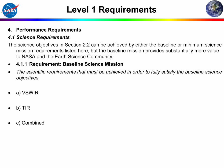
Baseline vs Minimum (Threshold)
Baseline Minimum (Threshold) 380 to 2500 nm at ≤10 nm sampling at the specified signal-to-noise ratio and accuracy with >95% spectral/spatial uniformity at ≤60 m nadir spatial sampling with <20 day revisit to provide
380 to 2500 nm at ≤10 nm sampling at >80% of the specified signal-to-noise ratio and accuracy with >90% spectral/spatial uniformity at ≤60 m nadir spatial sampling with <20 day revisit to provide
>60% seasonal and >80% annual coverage of the terrestrial and shallow water regions of the Earth
> 50% seasonal and >70% annual coverage of the terrestrial and shallow water regions of the Earth
three years with a subset of measurements available near-real-time for designated science and applications.
two years.
8 spectral bands from the 3-5 micron and 8-12 micron regions of the spectrum at the specified noise-equivalent-delta-temperature and accuracy at ≤60 m nadir spatial sampling
8 spectral bands from the 3-5 micron and 8-12 micron regions of the spectrum at >80% the specified noise-equivalent-delta-temperature and accuracy at ≤60 m nadir spatial sampling with ≤5 day revisit
>60% Monthly, >70% seasonal and >85% annual coverage of the terrestrial and shallow water regions of the Earth
> 40% Monthly, > 60% seasonal and >70% annual coverage of the terrestrial and shallow water regions of the Earth
Note: We will keep you informed of any changes such as the change in the saturation limit of the MIR band to 1200K © 2011 California Institute of Technology. Jet Propulsion Laboratory, California Institute of Technology. Government sponsorship acknowledged.
Summary and Conclusions
Program Level Requirements (or Level 1 Requirements) are a required gate product KDP-A: Draft KDP-B: Updated Draft Baseline KDP-C: Baseline Update In the pre Phase A period of the HyspIRI Mission concept input to the Level 1 Requirements are requested from the SSG and Community. The Level 1 Requirements are a NASA Headquarters Document and provide an important basis for tracking the progress and judging the success of HyspIRI HyspIRI has a viable set of draft preliminary Level 1 Requirements. Over the next year we will review these requirement in the context of different possible implementation options for HyspIRI.

Mission Concept Status: Preliminary Draft Program Level 1 Requirements: Stable Payload: Imaging Spectrometer, Thermal Infrared Imager, and IPM-Direct Broadcast subset Spacecraft: Small Payload: JPL/GSFC Launch Vehicle: ~1000 kg class Launch date: TBC (partner opportunities) Mission: Class C 3-5 years Trajectory or Orbit: LEO, Sun sync. S/C & Instrument Mass: 561 kg (30% margin) S/C & Instrument Power: 650W (66% margin) The HyspIRI mission concept is mature and stable with excellent heritage, low risk and modest cost.
Mission Urgency: The HyspIRI science and application objectives are important today and uniquely addressed by the combined imaging spectroscopy, thermal infrared measurements, and IPM direct broadcast.
0
0.1
0.2
0.3
0.4
0.5
0.6
0.7
0.8
0.9
1
3.00 4.00 5.00 6.00 7.00 8.00 9.00 10.00 11.00 12.00 13.00Wavelength (um)
Rel
ativ
e Sp
ectr
al R
espo
nse
H1 (m21)H2 (m28)H3 (a10)H4 (a11)H5 (a12)H6H7H8 (m32)
HyspIRI Decadal Survey Mission Key Science and Science Applications
Climate: Ecosystem biochemistry, condition & feedback; spectral albedo; carbon/dust on snow/Ice; biomass burning; evapotranspiration Ecosystems: Global plant functional-type, physiological condition, and biochemistry including agricultural lands. Fires: Fuel status, fire occurrence, severity, emissions, and patterns of recovery globally. Coral reef and coastal habitats: Global composition and status. Volcanoes: Eruptions, emissions, regional and global impact. Geology and resources: Global distributions of surface mineral resources and improved understanding of geology and related hazards. Measurement: Imaging Spectrometer (VSWIR) - 380 to 2500 nm in 10nm bands - 60 m spatial sampling - 19 days revisit - Global land and shallow water Thermal Infrared (TIR): - 8 bands between 4-12 µm - 60 m spatial sampling - 5 days revisit - Global land and shallow water IPM-Direct Broadcast
Ecosystems
Snow & ice
Fires Evapotranspiration
Volcanoes Coastal Habitats