Embed Size (px)
Citation preview

IEEE GEOSCIENCE AND REMOTE SENSING LETTERS, VOL. 16, NO. 11, NOVEMBER 2019 1751
Hyperspectral Image Classification Using RandomOcclusion Data Augmentation
Juan Mario Haut , Student Member, IEEE, Mercedes E. Paoletti , Student Member, IEEE,Javier Plaza , Senior Member, IEEE, Antonio Plaza , Fellow, IEEE,
and Jun Li , Senior Member, IEEE
Abstract— Convolutional neural networks (CNNs) havebecome a powerful tool for remotely sensed hyperspectral image(HSI) classification due to their great generalization ability andhigh accuracy. However, owing to the huge amount of parametersthat need to be learned and to the complex nature of HSI dataitself, these approaches must deal with the important problemof overfitting, which can lead to inadequate generalization andloss of accuracy. In order to mitigate this problem, in thisletter, we adopt random occlusion, a recently developed dataaugmentation (DA) method for training CNNs, in which thepixels of different rectangular spatial regions in the HSI arerandomly occluded, generating training images with variouslevels of occlusion and reducing the risk of overfitting. Our resultswith two well-known HSIs reveal that the proposed method helpsto achieve better classification accuracy with low computationalcost.
Index Terms— Convolutional neural networks (CNNs), hyper-spectral images (HSIs), random occlusion data augmenta-tion (DA).
I. INTRODUCTION
REMOTELY sensed hyperspectral images (HSIs) comprisehundreds of continuous and narrow spectral bands, where
each pixel (vector) characterizes uniquely the observed objects.HSIs have been widely used in many applications, includ-ing classification, segmentation, or target detection. Manydifferent machine learning techniques have been used forextracting information from HSIs, including support vectormachines (SVMs) [1], extreme learning machines (ELMs) [2],and single-hidden layer feedforward networks (SHLFN) [3].Recent advances in earth observation missions have allowedcapturing more complex HSI images, comprising a larger
Manuscript received August 30, 2018; revised October 15, 2018; acceptedMarch 20, 2019. Date of publication April 22, 2019; date of current versionOctober 30, 2019. This work was supported in part by Spanish Ministry underGrant FPU14/02012-FPU15/02090 and Grant ESP2016-79503-C2-2-P, in partby Junta de Extremadura under Grant GR18060, and in part by EuropeanUnion under Grant 734541-EXPOSURE. (Corresponding author: Jun Li.)
J. M. Haut, M. E. Paoletti, J. Plaza, and A. Plaza are with the HyperspectralComputing Laboratory, Department of Technology of Computers and Com-munications, Escuela Politécnica, University of Extremadura, 10003 Cáceres,Spain (e-mail: [email protected]; [email protected]; [email protected];[email protected]).
J. Li is with the Guangdong Provincial Key Laboratory of Urbanization andGeosimulation, Center of Integrated Geographic Information Analysis, Schoolof Geography and Planning, Sun Yat-sen University, Guangzhou 510275,China (e-mail: [email protected]).
Color versions of one or more of the figures in this letter are availableonline at http://ieeexplore.ieee.org.
Digital Object Identifier 10.1109/LGRS.2019.2909495
number of spectral bands and higher spectral and spatialresolution. This has imposed requirements in terms of runtimes and storage [4]. In this context, convolutional neuralnetworks (CNNs) have emerged as a powerful tool forHSI data interpretation [5], [6], consolidating deep learningCNN-based approaches as the current state of the art in HSIdata classification [3].
Most available CNN techniques for HSI data classificationsuffer from the problem of overfitting. Coupled with the greatspectral variability present in HSIs, this problem complicatesthe learning process. To the best of authors’ knowledge,traditional efforts to mitigate the overfitting problem [7] andimprove the generalization ability of CNNs are based onincreasing the amount of training data by including largespatial patches in the training process, possibly by meansof geometric transformations [6]. Other techniques focus onapplying regularization methods; for instance, Paoletti et al. [5]use dropout and maxpooling techniques. Other recent effortsare aimed at improving the model architecture, e.g., by addingmore connections between layers [8] or by developing residualarchitectures [9] to feed each layer with additional information.These methods have been further extended by other existingstrategies, such as pixel-pairs features (PPFs) [10], activelearning [11], or fully connected architectures [12]. However,these methods reduce overfitting at the expense of making anextensive use of the output (softmax) layer, which increasescomputational complexity. For instance, Li et al. [12] try toinsert new information in this layer using principal componentanalysis (PCA), while Haut et al. [11] improve the model’sgeneralization by incorporating the samples that have moreuncertainty. Similarly, the work by Li et al. [10] intends tosolve the problem of data occlusions by using PPFs in thepixel neighborhood information.
In fact, data occlusion is an important problem in remotesensing, which is related to those areas of the surface of theearth which are not visible from the remote sensor due toexternal factors, such as the interruption between the sensorand the target 2-D surface, or the presence of nearby 3-Dobjects. This problem is motivated by the presence of clouds,shadows, or other objects, which result in a loss of informationover the scene. Inspired by human reasoning, which is intrin-sically based on the interpretation of 3-D spaces [13], severaltechniques have been developed to address data occlusions.This concept can also be used to enhance the training ofmachine learning methods. In this letter, we adopt a recently
1545-598X © 2019 IEEE. Personal use is permitted, but republication/redistribution requires IEEE permission.See http://www.ieee.org/publications_standards/publications/rights/index.html for more information.
1752 IEEE GEOSCIENCE AND REMOTE SENSING LETTERS, VOL. 16, NO. 11, NOVEMBER 2019
developed technique for data augmentation (DA) [14] thatreduces the overfitting of CNN models by modifying randomly(in each learning batch and in each iteration) some of theinput data by replacing a part of them with an empty patchof random dimensions. This technique, known as randomocclusion, is computationally efficient, easy to implement, andcan be inserted into CNN-based HSI classification frameworksin a straightforward manner, without penalty at runtime.
The main innovative contributions of this letter can besummarized as follows.
1) We introduce a new deep CNN model for HSI classifica-tion that eliminates the need to use large spatial patchesin the training phase in order to reduce overfitting. Theuse of large spatial patches has been adopted in severalworks [12], [15], but this leads to high computationalcomplexity. Specifically, the aforementioned approachesuse patch sizes of 27 × 27 [15] and 48 × 48 [12] pixels,respectively. Our proposed method is able to achievesimilar results to those reported by the aforementionedmethods with smaller patch size (i.e., 23 × 23).
2) The proposed method offers a new way to increasethe amount of available training data in the sense thatby generating different samples with different occludedareas, the number of available samples increases, andthe associated spatial content varies considerably. As aresult, in addition to introducing variations in spatialfeatures (making the learning process more robust), theproposed method can be considered as an effectiveDA technique.
Furthermore, the adopted strategy is quite simple and easyto implement/integrate in HSI classification frameworks, andit does not significantly increase the computational load asopposed to some widely used DA methods, which are quitecomplex and require extra parameter learning and/or highmemory consumption. Also, it can be complemented byother traditional DA techniques based on crops or rotations.Section II describes the proposed method in detail. Theexperimentation over two HSIs (Section III) demonstratesthat the proposed method exhibits good results with veryfew training samples, improving the performance of a spatialCNN (2-DCNN)—an architecture that is traditionally ham-pered by overfitting—due to the variability of the informationcontributed by means of the adopted random occlusion DAmethod. Finally, Section IV concludes this letter with someremarks and hints at plausible future research lines.
II. METHODOLOGY
An HSI data set X is composed by n1 × n2 pixel vectors,where each pixel xi ∈ R
nbands collects the spectral infor-mation in nbands spectral bands, creating a huge data cube,X ∈ R
n1×n2×nbands .In order to process the HSI image X using a traditional
2-DCNN model, a preprocessing stage is often carriedout, consisting of two main steps [16]: 1) dimensionalityreduction, normally using PCA [17], which reduces the nbandsto one PC, reducing the spectral dimensionality and therequirements in terms of runtime and 2) grouping of the HSIpixels in regions in order to create, for each pixel vector xi ,a d × d spatial patch pi ∈ R
d×d that contains the spatial
neighborhood around the pixel. These patches are used toextract feature maps that will represent and characterize theoriginal input data. Although 2-DCNN models outperformpixel-based (1-DCNN) models by the inclusion of spatialinformation, they are quite sensitive to the quality of thespatial information contained in the patches, in the sense thatsmall variations produced by noise or occlusions, togetherwith overfitting, can lead the model to misclassifications andoversmoothing of small objects [18]. In order to address thisissue, a large number of training samples Dtrain = {pi , yi }L
i=1(being yi the corresponding label of pi ) or additional datavariations L + L+ (via DA) are often required.
Instead of obtaining L+ new training samples, our adoptedmethod increases randomly the variability of training samplesby performing random occlusions over the data, which is asimple and inexpensive form of DA. In this regard, the pool oftraining samples Dtrain is first shuffled, where each pi groupedinto different batches B j in each epoch of the network’s train-ing process. These batches are initially preprocessed beforebeing fed to the 2-DCNN model, assigning an initial randomprobability from a Gaussian distribution, p, to every patchpi ∈ B j . Those pi with higher values of p are modified byrandom occlusions, until a percentage of randomly occludedsamples per batch (denoted by n) is reached.
The occlusion strategy works as follows. For each pi ,we calculate a rectangular region p∗
i ∈ Rd∗
1 ×d∗2 allocated
inside the patch. In order to obtain both the spatial dimensiond∗
1 × d∗2 and the exact location of p∗
i in pi , the occlusionstrategy first obtains the area of the original input patch pi asai = d · d . From this value, the method calculates a smallerregion (whose size is between a minimum and maximumthreshold) over the original patch area, a∗
i = rand(tmax·ai , tmin·ai ). This a∗
i becomes the area of p∗i , which complies with the
expression a∗i = d∗
1 · d∗2 . The next step is to obtain d∗
1 and d∗2
as follows:
d∗1 =
√a∗
i · ri and d∗2 =
√a∗
i
ri(1)
where ri is a randomly selected value between a minimumand maximum threshold value: ri = rand(rmin, rmax), whosegoal is to avoid nondesirable shapes (such as horizontal andvertical lines). Finally, the process randomly allocates the p∗
iby making sure that it does not exceed the margins of theoriginal pi , and fills the area with a predetermined value, thatis, the occluded pixels have been set to 0.5 in our experiments.
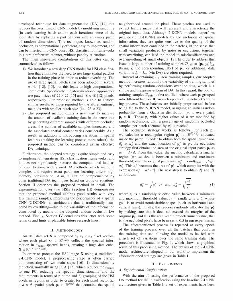
The aforementioned process is repeated at every epochof the training process, over all the batches that conformthe training data set, allowing the model to be fed witha rich set of variations over the same training data. Theprocedure is illustrated in Fig. 1, which shows a graphicalresult of this processing method. The details of the 2-DCNNmodel architecture adopted in our work to implement theaforementioned strategy are given in Table I.
III. EXPERIMENTS
A. Experimental Configuration
With the aim of testing the performance of the proposedDA method for HSI classification using the baseline 2-DCNNarchitecture given in Table I, a set of experiments have been

HAUT et al.: HSI CLASSIFICATION USING RANDOM OCCLUSION DA 1753
Fig. 1. Example of random occlusion DA in two different input patches.(Leftmost column) Original (not occluded) patches, while the other patchesexhibit occluded zones shown in green.
TABLE I
ARCHITECTURAL DETAILS OF THE PROPOSED 2-DCNNFOR HSI CLASSIFICATION
performed over a hardware environment composed by a sixthgeneration Intel Core i7-6700K processor with 8 M of Cacheand up to 4.20 GHz (4 cores/8 way multitask processing),40 GB of DDR4 RAM with a serial speed of 2400 MHz, aGPU NVIDIA GeForce GTX 1080 with 8-GB GDDR5X ofvideo memory and 10 Gb/s of memory frequency, a ToshibaDT01ACA HDD with 7200 RPM and 2 TB of storage capac-ity, and an ASUS Z170 pro-gaming motherboard. In orderto efficiently implement the proposed approach, it has beenparallelized over the GPU using Cuda language over Pytorchframework [19]. All the codes and examples presented in thisletter are available online.1
B. Hyperspectral Data Sets
Two well-known HSIs have been used to performexperiments. The first one is the 145 × 145 × 200 IndianPines (IP) data set, captured by the Airborne Visible/InfraredImaging Spectrometer (AVIRIS) sensor [20] in 1992 overseveral agricultural fields in Northwestern Indiana. The16 different classes are available in this scene. The seconddata set is the University of Pavia (UP) scene, acquired bythe Reflective Optics System Imaging Spectrometer (ROSIS)sensor [21] over a 610 × 340 × 113 urban area, comprisingnine different class labels.
C. Results and Discussion
1) Experiment 1: In this experiment, we compare theperformance of the 2-DCNN model (implemented using theproposed strategy) with seven standard HSI classifiers whichtraditionally suffer from the overfitting problem. Specifi-cally, six pixel-wise classifiers have been selected: SVM
1https://github.com/mhaut/ROhsi
Fig. 2. Evolution of the (Left) loss and (Right) OA as a function of thenumber of training epochs when using the 2-DCNN with and without theproposed random occlusion DA method (occluding 25% of the IP data ineach training batch).
implemented with radial basis function (SVM-RBF), ran-dom forest (RF), SHLFN, ELM, kernel ELM (KELM), anda spectral-based CNN (1-DCNN). In addition, the baselinespatial-based 2-DCNN without the proposed strategy has alsobeen included. The resulting values from RF, SVM-RBF,SHLFN, ELM, KELM, and 1-DCNN have been extractedfrom Ghamisi et al. [3], while the two 2-DCNN models (withand without DA) have been implemented in accordance withthe architectural details given in Table I. The reported resultscorrespond to the mean of five Monte Carlo runs, and we usefive different training percentages: 1%, 3%, 5%, 10%, and 15%of randomly selected labeled data from the two considered datasets. The rest of the data has been used for testing.
Table II reports the overall accuracies (OAs) obtainedafter the conducted experiments. On the leftmost part of thetable, we report the results obtained by traditional classifiers.On the rightmost side of the table, we report the resultsobtained by a 2-DCNN implemented with the proposed DAapproach (2-DCNN-n), with n set to 5%, 15%, 25%, and50% occlusion percentages.
Focusing on the results obtained for the IP data set andlooking at the leftmost part of the table, we can see howthe OA is increased as we add more training samples to theclassifiers, being the 2-DCNN the one with best OA values.This is mainly due to the efficient use of the spatial informationcontained in the input data, which improves the generalizationability. However, these OAs are lower than those achieved bythe 2-DCNN implemented with the proposed DA approach.In the rightmost part of Table II, we can see how the proposedmethod increases the accuracy by more than 3% points withonly occluding 5% of each batch, until reaching final solutionswith OAs that are 4% or 5% points superior to those achievedby the standard 2-DCNN model when occluding the 50%of the batch. This reveals that even with very little effort(i.e., by simply occluding 10%–15% of the data), the proposedmethod is able to significantly increase the OA. If we nowfocus on the UP data set, we can also observe that the OA val-ues of standard classification methods (at the leftmost part ofTable II) are increased when more training data are used, beingthe SVM-RBF the best classifier when few training samplesare available. These results are improved by those obtained bythe traditional 2-DCNN when 3% and higher training percent-ages are used. If we compare the baseline 2-DCNN with theproposed implementation in the rightmost part Table II, we cansee that by adding only 5% of occlusions into batches, theproposed method is able to outperform the OA in more than1% point, a difference that is increased as more occlusions is

1754 IEEE GEOSCIENCE AND REMOTE SENSING LETTERS, VOL. 16, NO. 11, NOVEMBER 2019
TABLE II
OAS OBTAINED BY DIFFERENT CLASSIFICATION METHODS FOR THE IP AND UP SCENES. THE LEFTMOST PART SHOWS THE RESULTS OBTAINEDBY TRADITIONAL CLASSIFIERS WITHOUT THE PROPOSAL. THE RIGHTMOST PART SHOWS THE RESULTS OBTAINED BY A 2-DCNN WITH THE
PROPOSED DA APPROACH (2-DCNN-n), WITH n SET TO 5%, 15%, 25%, AND 50% OCCLUSION PERCENTAGES
Fig. 3. Classification maps for the IP data set. (a) Simulated RGB composition of the scene. (b) Ground-truth classification map. (c)–(h) Classification mapscorresponding to Table III. Note that, the OA values are shown in brackets and the best result is highlighted in bold font. (a) RGB. (b) GT. (c) 2-DCNN(92.73%). (d) 2-DCNN-5% (96.00%). (e) 2-DCNN-15% (96.94%). (f) 2-DCNN-25% (96.94%). (g) 2-DCNN-50% (97.50%).
Fig. 4. Classification maps for the UP data set. (a) Simulated RGB composition of the scene. (b) Ground-truth classification map. (c)–(h) Classification mapscorresponding to Table IV. Note that, the OA values are shown in brackets and the best result is highlighted in bold font. (a) RGB. (b) GT. (c) 2-DCNN(98.33%). (d) 2-DCNN-5% (98.88%). (e) 2-DCNN-15% (99.12%). (f) 2-DCNN-25% (99.17%). (g) 2-DCNN-50% (99.09%).
added to the training data, until reaching the best OA (99.92%)with 15% of training data and 50% of occlusions.
2) Experiment 2: Our second experiment compares theproposed approach with traditional spatial-based CNN models.Specifically, we report the results obtained by the spatialmodel proposed by Chen et al. [15] (which is shallowerthan the proposed 2-DCNN and fed with bigger spatialpatches), the proposed baseline 2-DCNN architecture withoutthe proposal improvement, and the 2-DCNN framework withdifferent percentages of the proposed random occlusion DAstrategy. To facilitate the comparison, we have considered(for each of the two considered scenes) the number of pixelsper class indicated by Chen et al. [15].
Tables III and IV, respectively, provide the obtained resultsfor the IP and UP scenes, reporting the OA and also theaverage accuracy (AA), kappa statistic, and runtime in theconsidered computing environment (in seconds).
The results reported in Table III indicate that the base-line 2-DCNN provides better results than the method inChen et al. [15] in terms of accuracies and runtime. Theseresults are improved when incorporating the random occlusionDA strategy to the 2-DCNN, increasing the OA in about6%–8% points over the method in Chen et al. [15] andin about 3%–5% points over the standard 2-DCNN. Fig. 2graphically shows how the standard 2-DCNN tends to quicklyoverfit, reaching a very low loss value in the training stagebut being unable to reduce the loss in the test stage, whichultimately reduces the test accuracy. However, when the ran-dom occlusion DA strategy is adopted, several variations areintroduced that prevent the training from reaching the lowestloss value, and this allows the model to continue learning,which leads to low test errors and high test accuracies. On theother hand, it is important to emphasize that the runtime of the2-DCNN, with and without the random occlusion DA strategy,

HAUT et al.: HSI CLASSIFICATION USING RANDOM OCCLUSION DA 1755
TABLE III
OA, AA, KAPPA STATISTIC, AND RUNTIME OBTAINED BY DIFFERENTSPATIAL-BASED CLASSIFICATION METHODS FOR THE IP SCENE
TABLE IV
OA, AA, KAPPA STATISTIC, AND RUNTIME OBTAINED BY DIFFERENTSPATIAL-BASED CLASSIFICATION METHODS FOR THE UP SCENE
is very similar (less than one second difference), being in bothcases lower than that of the method in [15]. This makes theadopted strategy a very attractive one to easily increase theperformance of the network at very low computational cost.
The results obtained with the UP scene provide similarobservations (see Table IV), with improvements of over 5%points in OA when compared to the method in [15]. In ourexperiment, the proposed approach is faster than the 2-DCNNbaseline when occluding 5% of the data in each batch.
For illustrative purposes, Figs. 3 and 4, respectively, showsome of the obtained classification maps for the IP and UPdata sets, using the 2-DCNN baseline model and the proposedapproach (occluding 5%, 15%, 25%, and 50% of trainingsamples in each batch). Once again, the proposed method isable to improve the performance of the model at no cost.
IV. CONCLUSION
This letter evaluates a simple DA approach for HSI clas-sification which is based on randomly occluding areas of theinput data to reduce overfitting problems in CNN models. Theobtained results demonstrate that the adopted approach is quiteefficient, as it is able to improve the generalization ability ofCNNs without increasing the computational cost. Since theadopted approach is not restricted to spatial-based 2-DCNNs,in the future, we plan to incorporate it to spatial–spectral3-DCNN architectures.
REFERENCES
[1] B. Waske, S. van der Linden, J. Benediktsson, A. Rabe, and P. Hostert,“Sensitivity of support vector machines to random feature selection inclassification of hyperspectral data,” IEEE Trans. Geosci. Remote Sens.,vol. 48, no. 7, pp. 2880–2889, Jul. 2010.
[2] J. M. Haut, M. E. Paoletti, J. Plaza, and A. Plaza, “Fast dimensionalityreduction and classification of hyperspectral images with extreme learn-ing machines,” J. Real-Time Image Process., vol. 15, no. 3, pp. 439–462,Oct. 2018. doi: 10.1007/s11554-018-0793-9.
[3] P. Ghamisi, J. Plaza, Y. Chen, J. Li, and A. J. Plaza, “Advanced spectralclassifiers for hyperspectral images: A review,” IEEE Geosci. RemoteSens. Mag., vol. 5, no. 1, pp. 8–32, Mar. 2017.
[4] J. Haut, M. Paoletti, J. Plaza, and A. Plaza, “Cloud implementation of theK-means algorithm for hyperspectral image analysis,” J. Supercomput.,vol. 73, no. 1, pp. 514–529, Jan. 2017.
[5] M. E. Paoletti, J. M. Haut, J. Plaza, and A. Plaza, “A new deepconvolutional neural network for fast hyperspectral image classification,”ISPRS J. Photogram. Remote Sens., vol. 145, Part A, pp. 120–147.
[6] Y. Chen, Z. Lin, X. Zhao, G. Wang, and Y. Gu, “Deep learning-basedclassification of hyperspectral data,” IEEE J. Sel. Topics Appl. EarthObserv. Remote Sens., vol. 7, no. 6, pp. 2094–2107, Jun. 2014.
[7] J. A. Richards and X. Jia, “Using suitable neighbors to augment thetraining set in hyperspectral maximum likelihood classification,” IEEEGeosci. Remote Sens. Lett., vol. 5, no. 4, pp. 774–777, Oct. 2008.
[8] J. M. Haut, R. Fernandez-Beltran, M. E. Paoletti, J. Plaza, A. Plaza,and F. Pla, “A new deep generative network for unsupervised remotesensing single-image super-resolution,” IEEE Trans. Geosci. RemoteSens., vol. 56, no. 11, pp. 6792–6810, Nov. 2018.
[9] Z. Zhong, J. Li, Z. Luo, and M. Chapman, “Spectral-spatial residualnetwork for hyperspectral image classification: A 3-D deep learn-ing framework,” IEEE Trans. Geosci. Remote Sens., vol. 56, no. 2,pp. 847–858, Feb. 2018.
[10] W. Li, G. Wu, F. Zhang, and Q. Du, “Hyperspectral image classificationusing deep pixel-pair features,” IEEE Trans. Geosci. Remote Sens.,vol. 55, no. 2, pp. 844–853, Feb. 2017.
[11] J. M. Haut, M. E. Paoletti, J. Plaza, J. Li, and A. Plaza, “Active learningwith convolutional neural networks for hyperspectral image classificationusing a new bayesian approach,” IEEE Trans. Geosci. Remote Sens.,vol. 56, no. 11, pp. 6440–6461, Nov. 2018.
[12] J. Li, X. Zhao, Y. Li, Q. Du, B. Xi, and J. Hu, “Classification ofhyperspectral imagery using a new fully convolutional neural net-work,” IEEE Geosci. Remote Sens. Lett., vol. 15, no. 2, pp. 292–296,Feb. 2018.
[13] N. Silberman, D. Hoiem, P. Kohli, and R. Fergus, “Indoor segmentationand support inference from rgbd images,” in Proc. Eur. Conf. Comput.Vis. Berlin, Germany: Springer, 2012, pp. 746–760.
[14] Z. Zhong, L. Zheng, G. Kang, S. Li, and Y. Yang. (2017).“Random erasing data augmentation.” [Online]. Available:https://arxiv.org/abs/1708.04896
[15] Y. Chen, H. Jiang, C. Li, X. Jia, and P. Ghamisi, “Deep feature extrac-tion and classification of hyperspectral images based on convolutionalneural networks,” IEEE Trans. Geosci. Remote Sens., vol. 54, no. 10,pp. 6232–6251, Oct. 2016.
[16] L. Zhang, L. Zhang and B. Du, “Deep learning for remote sensingdata: A technical tutorial on the state of the art,” IEEE Geosci.Remote Sens. Mag., vol. 4, no. 2, pp. 22–40, Jun. 2016. doi:10.1109/MGRS.2016.2540798.
[17] Q. Sun, X. Liu, and M. Fu, “Classification of hyperspectral imagebased on principal component analysis and deep learning,” in 7th IEEEInt. Conf. Electron. Inf. Emergency Commun. (ICEIEC), Jul. 2017,pp. 356–359.
[18] K. Makantasis, K. Karantzalos, A. Doulamis, and N. Doulamis, “Deepsupervised learning for hyperspectral data classification through convo-lutional neural networks,” in Proc. IEEE Geosci. Remote Sens. Symp.,Jul. 2015, pp. 4959–4962.
[19] A. Paszke et al., “Automatic differentiation in pytorch,” Tech.Rep., 2017. [Online]. Available: https://github.com/pytorch/pytorch/issues/4126
[20] R. O. Green et al., “Imaging spectroscopy and the airborne vis-ible/infrared imaging spectrometer (AVIRIS),” Remote Sens. Envi-ron., vol. 65, no. 3, pp. 227–248, Sep. 1998. [Online]. Available:http://www.sciencedirect.com/science/article/pii/S0034425798000649
[21] B. Kunkel, F. Blechinger, R. Lutz, R. Doerffer, H. van der Piepen, andM. Schroder, “ROSIS (Reflective Optics System Imaging Spectrometer)-A candidate instrument for polar platform missions,” in OptoelectronicTechnologies for Remote Sensing from Space, vol. 868. InternationalSociety for Optics and Photonics, 1988, pp. 134–142.