Embed Size (px)
Citation preview

United States Department of Agriculture Forest Service 2013
Hydrology Report
Stafford Fire Salvage and Restoration Project
Shasta-Trinity National Forest Hayfork Ranger District Trinity County, California
Prepared by:
Zackary Mondry 8/23/13 Hydrologist South Fork and Trinity River Management Units Shasta-Trinity National Forest

The U.S. Department of Agriculture (USDA) prohibits discrimination in all its programs and activities on the basis of race, color, national origin, age, disability, and where applicable, sex, marital status, familial status, parental status, religion, sexual orientation, genetic information, political beliefs, reprisal, or because all or part of an individual’s income is derived from any public assistance program. (Not all prohibited bases apply to all programs.) Persons with disabilities who require alternative means for communication of program information (Braille, large print, audiotape, etc.) should contact USDA's TARGET Center at (202) 720-2600 (voice and TDD).
To file a complaint of discrimination, write to USDA, Director, Office of Civil Rights, 1400 Independence Avenue, S.W., Washington, D.C. 20250-9410, or call (800) 795-3272 (voice) or (202) 720-6382 (TDD). USDA is an equal opportunity provider and employer.

3
TABLE OF CONTENTS
EXECUTIVE SUMMARY .......................................................................................................................... 4
1. INTRODUCTION .................................................................................................................................... 6
Proposed Action ..................................................................................................................................... 6 Overview .............................................................................................................................................. 10
2. AFFECTED ENVIRONMENT .............................................................................................................. 14
Project Location and Area Description ................................................................................................ 14 Historic Condition ................................................................................................................................ 16 Existing Condition ................................................................................................................................ 17 Desired Condition ................................................................................................................................. 18
3. ENVIRONMENTAL CONSEQUENCES ............................................................................................. 20
Methodology ........................................................................................................................................ 20 No Action and Action Alternatives ...................................................................................................... 24 Direct and Indirect Effects.................................................................................................................... 27 Cumulative Effects ............................................................................................................................... 30
4. ADDITIONAL INFORMATION ........................................................................................................... 34
Resource Protection Measures ............................................................................................................. 34 Compliance with Forest Plan and Other Relevant Laws, Regulations, Policies and Plans .................. 34 Monitoring recommendations .............................................................................................................. 34
5. CONCLUSIONS ..................................................................................................................................... 35
Conclusions and/or determinations ...................................................................................................... 35
6. REFERENCES ....................................................................................................................................... 36

4
EXECUTIVE SUMMARY The Stafford Fire was a human-caused fire that started on September 5, 2012 along Wildwood Road on the South Fork Management Unit of the Shasta-Trinity National Forest (herein SHF) in Trinity County, California. The fire burned for two weeks and was finally contained at 4,462 acres. There are 4,171 acres of National Forest System (NFS) lands and 291 acres of private land within the fire perimeter. Within the fire perimeter, a small portion, approximately 596 acres of the fire occurred within the Wells Inventoried Roadless Area (IRA). The overall purpose of the Stafford Fire Salvage and Restoration Project is to reduce the risk to the public, forest workers, firefighters, and private property from hazard trees as well as reestablish forest vegetation, provide timber products, substantially reduce fuels hazard, and improve roads within burned areas of the Stafford Fire, which is immediately adjacent to the community of Hayfork, California. Based on the Upper Hayfork Creek and Middle Hayfork Creek/Salt Creek Watershed Analysis, the Land and Resource Management Plan for the SHF (herein Forest Plan, 1995) and post fire assessment, we have identified a need to:
• Create conditions that will support the long-term survival of new forest stands including removal of dead trees to limit the long-term accumulation of heavy fuels and the restoration of fire to its natural role in the ecosystem.
• Establish forest stands at densities appropriate to contribute to forest harvest in the future and to maintain wildlife habitat (Forest Plan, pg. 4-154).
• Retain open roads on the Forest transportation system that will be needed for future activities such as forest health projects, timber management, fire protection, recreation use and management, and wildlife management (Forest Plan, pg. 4-17).
• Manage the open road system for safety of users including removing danger/hazard trees (FSH 7709.59 Section 41.7) and managing the loading distribution and arrangement of natural and activity fuels for low flame lengths and low rate of spread adjacent to open roads.
• Reduce surplus activity fuels that remain after meeting wildlife, riparian, soil and other environmental needs (Forest Plan, pg. 4-17).
• Manage natural and activity fuel loading, distribution and arrangement within WUI for low flame lengths and rate of spread.
• Create conditions that will maintain or restore the sediment regimes under which aquatic ecosystems evolved (Forest Plan, pg. 4-53).
• Quickly recover the monetary value of wood through salvage and sale, where feasible and appropriate, to provide revenue and offset the costs to the public.
The Proposed Action would treat 1,775 acres within the Stafford Fire area through a combination of treatment methods to meet the Purpose and Need. Treatments would be excluded from the Wells IRA. Salvage treatments would be excluded from Riparian Reserves, but hazardous fuels reduction to protection infrastructure and planting would occur within Riparian Reserves. All treatments would retain all pines over 20 inches in diameter except for hazard trees.

5
The Stafford Fire had significant impacts to the hydrologic function of Negro Gulch and and unnamed tributary that drain the fire area. Analysis of fire effects indicate the potential for significantly increased peak flows in these two small (< 515 acres) watersheds. However, these increases would diminish significantly in the first few years post-fire. In addition, implementation of any project alternative is not expected to have a significant influence on this trend. Cumulative watershed effects (CWE) analyses that incorporated past, present, and reasonably foreseeable actions were performed for four project alternatives at the 5th and 7th-Field watershed scales. Effects of Stafford fire severity, fire line, and proposed tractor, cable, and helicopter salvage units were forecast for a five year period. All other past, present, and reasonably foreseeable actions outside of the Stafford Project area that can be accounted for (including private Timber Harvest Plans) were also modeled. Model results indicate that relative disturbance (measured by % Equivalent Roaded Area) of the project watersheds did not apparently exceed 10%. When compared with 5th-Field watershed Thresholds of Concern (TOC) of 16-17%, the modeled effects are considered modest. As such, it is expected that implementation of any project alternative will have insignificant CWE to hydrologic function in the project watersheds. Alternative 1: Proposed Action See 3. ENVIRONMENTAL CONSEQUENCES Section 3.2.1 for details. Alternative 2: No Action See 3. ENVIRONMENTAL CONSEQUENCES Section 3.2.2 for details. Alternative 3: Community Protection Alternative See 3. ENVIRONMENTAL CONSEQUENCES Section 3.2.3 for details. Alternative 4: Timber Salvage Alternative See 3. ENVIRONMENTAL CONSEQUENCES Section 3.2.3 for details.

6
1. INTRODUCTION PROPOSED ACTION The Proposed Action would treat 1,775 acres within the Stafford Fire area through a combination of treatments to meet the project Purpose and Need. Treatments would be excluded from the Wells Inventoried Road Area. Salvage treatments would be excluded from Riparian Reserves, but hazard trees would be felled where they threaten roads for public and infrastructure protection. Planting would also occur within Riparian Reserves. All treatments would retain all pine species over 20 inches in diameter, except for hazard trees.
An Emergency Situation Determination (ESD) was requested on April 8, 2013 for the implementation of the Proposed Action; due to the safety risk from hazard trees, risk to human health and safety related to fire hazard, and the substantial loss of economic value if implementation were delayed. Table 1 summarizes total acres within the treatment types for the Proposed Action.
Table 1: Proposed Action Treatments Treatment Type Acres Salvage and Fuels Reduction followed by Planting Treatments 780 Plantation Treatments 129 Restoration Treatments 711 Defensible Fuel Profile Management Zones 155
Treatments Total 1,775 Non-Treatment Areas Wells IRA 596
No/low burn severity 1,800 Riparian Reserves
Project Area Total 4,171 Salvage and Fuels Reduction followed by Planting Treatments The Proposed Action includes an estimated 780 acres of salvage removal of dead and dying trees. The definition of “dying” is the 70% mortality threshold using the Marking Guidelines for Fire-Injured Trees in California (Smith and Cluck 2011). The salvage treatments will be used to reduce fuels, provide economic return and employment opportunities, and to prepare sites for planting. Proposed salvage actions would be implemented by helicopter yarding on an estimated 167 acres, cable yarding on an estimated 464 acres, and mechanical skidding on an estimated 149 acres. These salvage activities would begin during the current year and possibly continue into 2014. As detailed in the Silviculture Report and seen on the associated map, the salvage treatments will utilize NFS roads 31N13, 31N17, 31N17A, 31N17B, 31N23, 31N25, 31N51, 31N51A, and 31N51B for implementation of identified units for each treatment type. NFS roads 31N13, 31N17, 31N19, 31N42, 31N51, and 31N51A will be utilized to haul timber and biomass outside of the project area. The primary haul route out of the project area will be NFS roads 31N51A and 31N51 to NFS road 31N42, NFS road 31N19, and then State Highway 3. The other haul routes out of the project area will be NFS road 31N17 to Morgan Hill Road and NFS road 31N13 to Wildwood Road. All roads will be maintained to meet their management objective with the exception of operational or resource protection needs.

7
Up to an estimated 12 temporary landings would be constructed, each measuring roughly 100 x 100 feet to 100 x 200 feet, and an additional 72 existing landings would be reused. Of these landings, three helicopter landings are proposed for the project area. Helicopter landings tend to be larger than landings utilized for ground-based or cable yarding systems. Landings are critical for handling and storing the substantial amount of woody material that would be produced by the removal of large numbers of relatively small diameter trees and dead fuel within project units. No green retention trees greater than 24 inches diameter at breast height (DBH) would be cut to create landings. The landings would be decompacted to facilitate water infiltration and natural revegetation following the proposed thinning and fuels reduction. New landings will not be constructed within Riparian Reserves. There would be no new system road construction, and no green retention trees over 24 inches DBH will be removed due to road-related project activities. An estimated 1.55 miles of temporary road (1.01 miles in areas where lands have been utilized for skid trails in the past and 0.54 miles with no previous activity is evident) would be constructed within project units to aid in tree removal, and decompacted and closed after completion of project activities (temporary roads would be built, used, and removed in the same dry season). Within areas identified for salvage (780 acres), the fuels would be reduced concurrently to meet the need of reducing potential fire behavior on the landscape by lop and scatter and jackpot burning treatments on an estimated 167 acres, and by yarding un-merchantable material (YUM), leaving tops attached (LTA), lopping and scattering, hand piling, burning piles, jackpot burning, and chipping on an estimated 613 acres. Dead and dying trees would be cut and removed throughout the area to create a mosaic of fuel loading that does not exceed 10 tons per acre. The desired condition for this area will be a stand with an open understory. Canopy base heights will be eight feet off the forest floor. All hazard trees exceeding resource needs will be felled. Coarse woody debris (CWD) will be reduced to 10 tons an acre. After salvage and fuel reduction actions, the estimated 780 acres would be planted with a mix of conifer seedlings to begin the restoration process. The mix of species planted will be representative of the stand that existed on the site prior to the Stafford Fire. Units will be planted with 60 to 100 clusters per acre. A cluster is a grouping of 3 to 4 trees planted closely together and spaced 21 to 27 feet from the adjacent cluster. The goal of cluster planting is to develop between 60 and 80 large trees or small groups of trees to the acre. The number of clusters will be dependent on the site class, with more clusters planted on the better sites. To help ensure stand establishment, conifer protection measures will be applied to minimize deer and rabbit browsing, and manual release will be implemented to help ensure acceptable levels of seedling survival and growth. No herbicides will be used on the project to help establish planted vegetation. These activities are anticipated to occur within 5 years following planting. Plantation Within existing plantations affected by the fire (and outside of salvage areas), reforestation with conifer species will occur to improve stocking (125 to 200 trees per acre) through site preparation, planting, protection and release on an estimated 129 acres. Site preparation includes the removal of dead

8
vegetation and resprouting shrubs within plantations. This material will be strategically cut, piled and burned to prepare the site for reforestation activities. Some dead vegetation may be left standing on harsh sites to create shade and improve survival of seedlings. Seedling protectors will be utilized to protect seedlings from browsing. Competing vegetation will be managed while trees are becoming established (1 to 3 years after planting). These activities would occur within the next 5 years. Restoration Within natural stands that burned with high and moderate severity (and not proposed for salvage harvest) 711 acres will be planted. No other site preparation will occur in these areas. Reforestation will occur in large deforested patches where the seed source has been limited by the fire. A mix of conifer species (i.e. Douglas-fir, sugar pine, ponderosa pine) will be planted in 60 to 100 clusters per acre. The number of clusters will be dependent on the site class, more clusters will be planted on the better sites. Seedling protectors will be utilized to protect planted trees from browsing. Competing vegetation will be managed while trees are becoming established (1 to 3 years after planting). Defensible Fuel Profile Management Zones In the Wildland Urban Interface defense zone, Defensible Fuel Profile Management Zones (DFPMZ) or fuelbreaks would be created within an estimated 600 feet of identified private lands and improvements on National Forest System lands, and within an estimated 300 feet (150 feet on each side) of Forest Service system roads 31N51 and 31N17. Activities in the DFPMZ include treatments already described in the Salvage and Fuels Reduction followed by Planting Treatments section above and fuels reduction treatments outside those treatments. Of those area identified for just fuels reduction treatments an estimated 67 acres are adjacent to private lands and improvements, an estimated 25 acres are along road 31N51, and an estimated 62 acres are along road 31N17; for a total estimate of 155 acres of hazardous fuels treatments. Proposed activities would include felling snags, hand piling fuels and burning piles, plus prescribed burning. To meet the need of reducing potential fire behavior, all dead or dying fuels exceeding 10 tons/acre within DFPMZ would be treated by one or a combination of the following treatments: scattering, piling, burning, or utilization (timber, firewood). Dead or dying hazard trees that pose a risk of falling onto or rolling into private property, within the 600 foot DFPMZ of private property will be felled. Reforestation will occur in large deforested patches where the seed source has been limited by the fire. A mix of conifer species (i.e. Douglas-fir, sugar pine, ponderosa pine) will be planted in 40 to 60 clusters per acre (27 to 33 feet between adjacent clusters). Seedling protectors will be utilized to protect planted trees from browsing. Competing vegetation will be managed while trees are becoming established (1 to 3 years after planting). Maintenance schedule and treatments The treatments will be maintained over time to retain the fuels reduction benefits, improve establishment of planted trees, and guide the development of the forest toward desired conditions. The maintenance

9
treatments will occur over the same areas where initial treatments are proposed. The initial treatments will be lumped into five areas for maintenance:
• A private boundary fuelbreak consisting of a 600 foot buffer bordering private property, • A fuelbreak 150 feet on either sides of NFS road 31N17, • A fuelbreak 150 feet on either side of NFS road 31N51, • Restoration, and • Plantations.
Table 2: Proposed Action Maintenance Treatments Maintenance Treatment Type Acres 600 foot Northern Private Boundary Shaded Fuelbreak 173 300 foot 31N17 Shaded Fuelbreak 74 300 foot 31N51 Fuelbreak 83 Restoration Treatments 1,316 Plantation Treatments 129
Maintenance Treatments Total 1,775 Non-Treatment Areas Wells IRA 596
No/low burn severity 1,800 Riparian Reserves
Project Area Total 4,171 The private boundary shaded fuelbreak is approximately 173 acres buffering the northern private property of the Stafford fire area. This area combines the DFPMZ established along the northern boundary and the salvage/fuels/planting treatments that occurred within the 600 foot buffer. Treatments will slow the potential spread of wildfire traveling onto private or public lands. The desired condition for this area will be a stand with an open understory. Canopy base heights will be eight feet off the forest floor. All hazard trees will be felled. Trees less than eight inches diameter breast height (DBH) will be thinned to a 20 foot spacing (110 trees per acre) and CWD will be reduced to 10 tons an acre. The NFS road 31N17 shaded fuelbreak is approximately 74 acres. Treatments will allow safe access to and from a fire by suppression resources. The desired condition for this area will be a stand with an open understory. Canopy base heights will be eight feet off the forest floor. All hazard trees will be felled. Trees less than eight inches DBH will be thinned to a 20 foot spacing (110 trees per acre) and CWD will be reduced to 10 tons an acre. Characteristics of shaded fuelbreaks are single story canopy with no ladder fuels to initiate crown fire and low fuel loading less than ten tons an acre to keep flame lengths lower than 4 feet and less than 100 BTU/Ft/second. Within these areas portions of the canopy are still green. The Stafford fire in these areas killed smaller trees and brush and occasionally killed pockets of larger trees. The initial treatment will remove the hazard trees and ground fuels to meet the fire behavior objectives stated above. These units will need to be maintained over time. It is recommended that these units be monitored every 10-15 years to determine if they still meet the fire behavior objectives. When the units begin to exceed the fire behavior objectives the following treatments will need to be implemented either alone or in combination:
10
prune canopy base height to 8 feet in all trees, reduce ladder fuels 8 inches DBH or less to 110-170 trees per acre, and hand pile and burn The NFS road 31N51 fuelbreak is approximately 83 acres and creates a strategic fuelbreak on a north south running ridge that runs parallel to wildwood road. Treatments will allow suppression resources an area to contain wildfires running from the east towards the community of Hayfork or wildfires running from the west towards the communities in Summit Creek and along Wildwood Road. The desired condition for this area will be a stand with an open understory and an overstory that cannot support crown fire. Canopy base heights will be eight feet off the forest floor. Canopy cover will be 50% or less. All hazard trees will be felled. Trees less than eight inches DBH will be thinned to a 20 foot spacing (110 trees per acre) and CWD will be reduced to 10 tons an acre. Fuelbreaks are characterized by open canopy, no ladder fuels and little to no surface fuels. The majority of this area has little to no forest vegetation as the majority of all vegetation was killed by the fire. This area will need to be maintained over time. It is recommended that this area be monitored every 3-7 years to determine if it still meets the fire behavior objectives. When the area begins to exceed the fire behavior objectives the following treatments will need to be implemented either alone or in combination: cut brush, reduce ladder fuels 8 inches DBH or less to 70-110 trees per acre, machine/hand pile, and burn. Within restoration and salvage/fuels/planting treatments, approximately 1,316 acres, the primary goal of maintenance will be the restoration of forest cover. The planted trees will be accessed for survival, competing vegetation, and overall density. A release for establishment may take place 1 to 3 years after planting and would control competing vegetation within a five-foot circle around planted trees. A release for growth would occur approximately 10 years after planting and would thin conifers if stand density was higher than expected (1 to 2 trees per cluster surviving, 40 to 100 clusters per acre) due to natural regeneration or high survival of planted trees within clusters. Within plantations, approximately 129 acres, the primary goal of maintenance will be the establishment and growth of planted trees. The planted trees will be accessed for survival, competing vegetation, and overall density. A release for establishment may take place 1 to 3 years after planting and would control competing vegetation within a five-foot circle around planted trees. A release for growth would occur approximately 10 years after planting and would thin conifers if stand density was higher than expected (125 to 200 trees to the acre) due to natural regeneration or high survival of planted trees. OVERVIEW The Stafford Fire was a human-caused fire that started on September 5, 2012 along Wildwood Road on the South Fork Management Unit of the SHF in Trinity County, California. The fire burned for two weeks and was finally contained at 4,462 acres. There are 4,171 acres of National Forest System (NFS) lands and 291 acres of private land within the fire perimeter. Within the fire perimeter, a small portion, approximately 596 acres of the fire occurred within the Wells Inventoried Roadless Area (IRA). The

11
Stafford Fire Salvage and Restoration Project area is the same as the fire boundary. However, this report will only analyze those areas where actions are proposed (Figure 1). Table 3: Stafford Fire Acres in 5th-Field Watersheds. HUC5 ID HUC5 Name Total Acres Stafford Fire Acres in HUC5 1801021203 Upper Hayfork Creek 105,766 3,834 1801021204 Lower Hayfork Creek 142,015 569 Table 4: Stafford Fire Acres in 7th-Field Watersheds.
HUC7 ID HUC7 Name Total Acres Stafford Fire Acres
in HUC71 18010212030402 Duncan Creek 4,603 77 18010212030403 Lower Carr Creek 4,443 352 18010212030302 Carrier Gulch-Hayfork Creek 4,917 2,181 18010212030502 Duncan Gulch-Hayfork Creek 9,830 1,168 18010212040301 Kingsbury Gulch-Kellogg Gulch 7,195 569 1-Acres sum to slightly less than the 4,402 stated previously in the executive summary and overview due to mapping limitations.

12
Figure 1: 5th-Field watershed map. Map scale approximately 1:300,000 showing location of the project area within the Stafford Fire perimeter (red outline) in the Upper and Lower Hayfork Creek 5th-Field watersheds. Riparian Reserves in and adjacent to the project area are shaded green.

13
Figure 2: 7th-Field watershed map. Map scale approximately 1:90,000 showing location of the project area within the Stafford Fire perimeter (red outline) in portions of five 7th-Field watersheds. Riparian Reserves in and adjacent to the project area are shaded green.

14
2. AFFECTED ENVIRONMENT PROJECT LOCATION AND AREA DESCRIPTION The analysis area is contained in the portion of the Stafford Fire perimeter along and west of Wildwood Road and is located east of the town of Hayfork, and south and east of State Highway 3 in Trinity County, CA. The project area includes portions or all of sections 8, 9, 10, 15, 16 (entire), 17, 18, 20, 21, 21 23, and 29 of Township 2N, Range 11W; Mount Diablo Meridian.
Figure 3: Analysis area topographic map. Map scale approximately 1:40,000, analysis area within the western portion of the Stafford Fire perimeter (red outline). Analysis area Riparian Reserves shaded in blue. Town of Hayfork, CA at west (left) edge of map. The project area is underlain by the Hayfork Creek Geologic Terrane which is composed of metavolcanic, metasedimentary, and granitic bedrock. The Hayfork Creek Terrane is generally stable with active and dormant landslides comprising less than 2% of the landscape (URS Greiner Woodward Clyde, 2000).

15
Figure 4: Field photograph. View south on 4/22/13 of a portion of the project area. Negro Gulch (shown in the photo) and the adjacent unnamed tributary to the south of Negro Gulch were burned the most severely in the Stafford Fire. Table 5: Permanently flowing nonfish-bearing streams in the project area. Drainage Area1 Stream Name (acres / square miles) Classification Hayfork Creek at Kingsbury Gulch 115,840 / 181 Fish-bearing
McCovey Creek at Hayfork Creek 576 / 0.9 Permanently flowing nonfish-bearing
Limestone Gulch at Hayfork Creek 256 / 0.4 Permanently flowing nonfish-bearing
Negro Gulch at Hayfork Creek 512 / 0.8 Permanently flowing nonfish-bearing
UT South of Negro Gulch at Hayfork Creek
384 / 0.6 Permanently flowing nonfish-bearing
Star Gulch at Middle Fork Kingsbury Gulch
384 / 0.6 Permanently flowing nonfish-bearing
1-Watershed areas estimated using the United States Geological Survey (USGS) StreamStats program (http://water.usgs.gov/osw/streamstats/california.html).

16
The Stafford Fire was characterized by a range of burn severities and thus diverse effects to existing resources. Within the fire area, Burned Area Reflectance Classification (BARC) mapping estimated the distribution of soil burn severity as follows: Table 6: Stafford Fire soil burn severity acres from BARC mapping.
Burn Severity Acres High 903
Moderate 1,146 Low 1,555
Unburned 858 Total 4,402
HISTORIC CONDITION Hayfork Creek Valley was settled by Anglo Americans beginning in 1852 with placer mining starting on tributaries in the Middle Hayfork Creek basin in the mid-1850’s (URS Greiner Woodward Clyde, 2000). Dragline and hard rock mining followed initial placer activity, and the lumber industry grew to support area ranching and mining operations. The lumber industry became economically significant nationally by the end of World War II (URS Greiner Woodward Clyde, 2000). Additionally, there is a history of water diversion from Hayfork Creek and its tributaries. These water diversions are recognized to be on the increase.
17
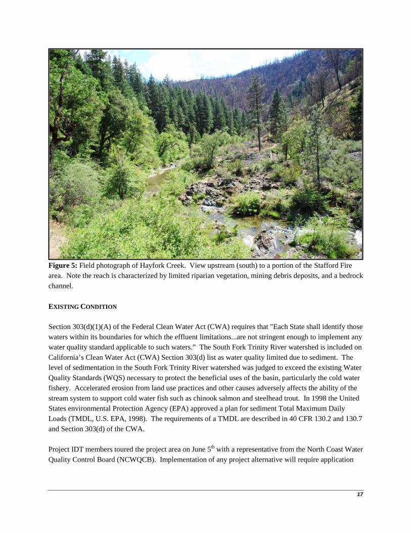
Figure 5: Field photograph of Hayfork Creek. View upstream (south) to a portion of the Stafford Fire area. Note the reach is characterized by limited riparian vegetation, mining debris deposits, and a bedrock channel. EXISTING CONDITION Section 303(d)(1)(A) of the Federal Clean Water Act (CWA) requires that "Each State shall identify those waters within its boundaries for which the effluent limitations...are not stringent enough to implement any water quality standard applicable to such waters.” The South Fork Trinity River watershed is included on California’s Clean Water Act (CWA) Section 303(d) list as water quality limited due to sediment. The level of sedimentation in the South Fork Trinity River watershed was judged to exceed the existing Water Quality Standards (WQS) necessary to protect the beneficial uses of the basin, particularly the cold water fishery. Accelerated erosion from land use practices and other causes adversely affects the ability of the stream system to support cold water fish such as chinook salmon and steelhead trout. In 1998 the United States environmental Protection Agency (EPA) approved a plan for sediment Total Maximum Daily Loads (TMDL, U.S. EPA, 1998). The requirements of a TMDL are described in 40 CFR 130.2 and 130.7 and Section 303(d) of the CWA. Project IDT members toured the project area on June 5th with a representative from the North Coast Water Quality Control Board (NCWQCB). Implementation of any project alternative will require application

18
under the new waiver agreement. The state representative was supportive and IDT members anticipate assistance from the board in meeting regulatory requirements for the project. Mining along stream channels has produced significant legacy disturbance to hydrologic function along some streams in the project area. Hayfork Creek adjacent to the project area is predominantly characterized by a bedrock stream channel lacking large wood with tall banks rising to terraces comprised of cobble and boulder mining debris (Figure 5). These terrace surfaces are rocky, lack significant fine material, are rarely flooded, and support limited riparian vegetation. Staff from the SHF established a 1,600 foot Stream Condition Inventory (USFS, 1995) survey reach in Hayfork Creek along Wildwood Road in May of 2013. Results of this survey indicate that the stream is not impaired by fine sediment (86% of 400 pebbles counted were gravels and cobbles, mean residual pool maximum depths > 4 feet), and the stream lacks functioning CWD with only 5 pieces counted in the reach. In addition, the channel is relatively powerful due to the large cross-sectional area (~ 80 ft2) and moderate slope (~ 0.5%) and displays significant bedrock outcrops. These characteristics taken together are interpreted to mean that this reach of Hayfork Creek is likely not sensitive to any potential increased peak flow and sediment delivery from tributaries draining the Stafford Fire. In addition, this reach would likely benefit from any CWD recruited from the Stafford Fire and deposited in the reach. Existing conditions differ from the future desired condition within the proposed project area. Standing dead trees (snags) have increased within the fire perimeter and have created a serious risk to forest workers and the public. Snags also pose a threat within one and a half tree lengths from all drivable roads and trails as these snags can fall at any time harming or damaging people, livestock, vehicles, or equipment. On steeper slopes these snags can fall and roll down the mountain damaging private property and potentially harming people. The roaded recreation prescription (Forest Plan, pg. 4-64) includes many dispersed recreation areas along Wildwood Road and Hayfork Creek that may be hazardous to recreational users if dead and dying trees are not treated. Other roads that are used by the public would also continue to pose a hazard to public and Forest Service personnel without treatment of dead and dying trees. Area closure is impractical because of existing mining permits, especially adjacent to the Wildwood Road. Wildwood Road, a Trinity County-controlled public road, is also a major travel route from Hayfork to Wildwood, California. Areas within the wildlife habitat management prescription (Forest Plan, pg. 4-66) would provide brushy habitat, but would not provide forested habitat for a long period of time into the future; however, prompt implementation would substantially reduce timeframes to re-establish and substantially improve the likelihood of timely development of suitable northern spotted owl critical habitat within the Stafford Fire-affected area. DESIRED CONDITION The Aquatic Conservation Strategy (ACS) that originated with the Northwest Forest Plan (NFP) and was incorporated in to the Forest Plan provides the main direction for watershed management on the Forest. The ACS was developed to restore and maintain the ecological health of watersheds and aquatic

19
ecosystems contained within them on public lands. This conservation strategy employs several tactics to approach the goal of maintaining the “natural” disturbance regime. Land use activities need to be limited or excluded in those parts of the watershed prone to instability. The distribution of land use activities, such as timber harvest or roads, must minimize increases in peak streamflows. Headwater riparian areas need to be protected, so that when debris slides and flows occur they contain CWD and boulders necessary for creating habitat farther downstream. Riparian areas along larger channels need protection to limit bank erosion, ensure an adequate and continuous supply of CWD to channels, and provide shade and microclimate protection. Watersheds currently containing the best habitat or those with the greatest potential for recovery should receive increased protection and receive highest priority for restoration programs.

20
3. ENVIRONMENTAL CONSEQUENCES METHODOLOGY Bounding Geographic Some minor differences in acreages and timber volumes may exist between sections of this document, other documents, appendix reports, or reference documents. These minor differences are the result of rounding and/or differences in the resource analysis and methodologies employed by specialists in assessing impacts to various resource areas. Such minor differences do not in any way invalidate the analysis or conclusions. The SHF analyzes CWE at multiple scales for past, present, and reasonably foreseeable ground-disturbing activities. These analyses are performed by estimating the equivalent roaded area (ERA) within the watershed (Haskins, D.M., 1986), and comparing results against watershed thresholds of concern (TOC). The watershed TOC is established for “planning watersheds” roughly at the 5th and 6th-field scale in the Shasta-Trinity National Forest Land and Resource Management Plan, and range from 14 to 18% ERA. CWE analysis for the Stafford Fire Salvage and Restoration Project was done primarily at the 5th and 7th-field watershed scales. It is important to note that a TOC established for a larger watershed is not valid for smaller watersheds (C. Mai, SHF, personal communication). However % ERA is still a useful variable to analyze at smaller watershed scales. In addition to CWE analysis, an assessment of potential increased stream peak flow resulting from fire effects was performed for the five permanently flowing nonfish-bearing streams within project area (Table 5). Pre-fire stream peak flows were estimated using USGS regression equations developed for Region 1 of California (Gotvald et al., 2012), and these values were adjusted using a weighted watershed area method derived from Omang (1992). Temporal The CWE analysis incorporates past ground-disturbing activites with Stafford Fire burn severity acres and fire supression line to establish a post-fire baseline condition. This baseline serves as the assessment of the No Action alternative. The CWE analysis then models diminishing watershed effects of past activities and fire while including present and reasonably forseeable projects (Proposed Action and project alternatives) for approximately five years. The assessment of increased stream peak flows estimates diminishing effects of hydrophobic soils over a period of five years.

21
Analysis The analysis of potential hydrologic effects of proposed activities began with field-validation of existing base hydrologic information. Beginning in February 2013 I conducted field reconnaissance to assess stream channels in the project area to determine the character of mapped streams in the terms defined in the Standards and Guidelines for management of Riparian Reserves in the NFP (1994) and the Forest Plan (1995). The plans specify fish-bearing, permanently flowing nonfish-bearing, and seasonally flowing or intermittent stream types. Hayfork Creek bounding the east and north side of the project area is a fish-bearing stream. Within the project area are portions of five permanently flowing nonfish-bearing streams (Table 5). The winter season is not suitable for validating the extent of permanent flow and as such I used the extent of (perennial streams in the National Hydrography Dataset (NHD). Inspection of the NHD in GIS indicated high drainage density in the project area with intermittent and ephemeral stream channels mapped to less than 500’ of ridge tops in places. Seasonally flowing or intermittent channels are defined in the NFP (pg. C-31) and Forest Plan (pg. 4-54) as those having a:
"definable channel and evidence of annual scour or deposition"
Field survey in the project area, particularly above the National Forest System (NFS) road 31N51A spur road, indicated that headwater swales typically did not contain definable channels that met the above-stated definition. Rather, the swales function like hill slopes without adequate drainage area to define and maintain channels. As such, intermittent and ephemeral channels mapped in the NHD in such areas were removed from the GIS data, and no riparian reserves were applied (Figure 6).

22
Figure 6: Project area streams. Stafford Fire perimeter is red outline, solid blue lines are permanently flowing reaches, dashed blue lines are seasonal channels, and brown lines are roads. Streams are not shown on the east side of the map as no project activities are planned there. Map scale approximately 1:24,000. Widths of Riparian Reserves are specified in the NFP and Forest Plan. For the Stafford Fire Salvage and Restoration Project the site-potential tree was determined to be 130’ tall. Table 7: Stream Types and Riparian Reserves.
Stream Type Standard Riparian
Reserve Width1 (feet)
Width from Site-Potential Tree Height1
(multiple)
Stafford Project Riparian Reserve
Width2 (feet) Fish-bearing 300 2X 300 Permanently flowing nonfish-bearing 150 1X 150 Seasonally flowing or intermittent 100 1X 130 1--Whichever results in the widest Riparian Reserve, measured as slope distance. 2--Measured from the “edges of the active stream channel” per the NFP.

23
Figure 7: Stafford Project Riparian Reserves, streams, and roads. The above-described stream and Riparian Reserve networks served as the framework for CWE analysis and an assessment of potential increases to stream peak flow. Incomplete and Unavailable Information Stream flow data is not available for the project area. However, peak flows of various return intervals were estimated using USGS regression equations and the StreamStats program. Table 8 displays estimates of the 2, 10, 25, 50 and 100-year discharges for the five permanently flowing nonfish-bearing streams within the project area.

24
Table 8: Two to 100-year return interval flows estimated for permanent nonfish-bearing streams draining the Stafford Fire Salvage and Restoration Project area. Values are estimated for pre-fire conditions. Estimated Pre-Fire Discharge1 (cfs)
Stream Name Drainage Area
(square miles / acres) Q2 Q10 Q25 Q50 Q100
McCovey Creek at Hayfork Creek 0.9 / 576 69 190 258 311 366 Limestone Gulch at Hayfork Creek 0.4 / 256 31 88 121 147 174 Negro Gulch at Hayfork Creek 0.8 / 512 61 168 229 276 326 Unnamed Tributary at Hayfork Creek 0.6 / 384 47 130 178 215 254 Star Gulch at Middle Fork Kingsbury Gulch 0.6 / 384 51 138 188 226 266 1-Flows estimated using USGS regression equations and the StreamStats program. Historic stream discharge data from the USGS for Hayfork Creek downstream of Carrier Gulch adjacent to the project area was summarized in the Middle Hayfork Creek-Salt Creek Watershed Analysis (URS Greiner Woodward Clyde, 2000). This summary characterizes the range of flows in Hayfork Creek from 1956 to 1965 (Table 9). Table 9: Summary of USGS Discharge Data for Hayfork Creek at Carrier Gulch.
Water Year Minimum Flow
(cfs) Maximum Flow
(cfs) 1957 7.0 1,920 1958 5.5 3,260 1959 2.0 1,490 1960 3.3 2,810 1961 2.5 1,180 1962 1.8 735 1963 4.0 1,910 1964 2.1 1,620 1965 2.4 5,430
NO ACTION AND ACTION ALTERNATIVES Four alternatives are being analyzed in detail: the Proposed Action, the No Action, a Community Protection alternative, and a Timber Salvage alternative. Two alternatives were considered but eliminated from detailed study. Direct, indirect and cumulative effects were analyzed for the no four alternatives. Direct effects are caused by the action and occur at the same time and place. Indirect effects are caused by the action but occur later in time and/or place. Cumulative effects result from the incremental impact of the action when added to other past, present, and reasonably foreseeable activities.

25
Alternative 1 – Proposed Action The Proposed Action would treat 1,775 acres within the Stafford Fire area through a combination of treatment methods to meet the Purpose and Need. Treatments would be excluded from the Wells Inventoried Road Area. Salvage treatments would be excluded from Riparian Reserves, but hazardous fuels reduction to protection infrastructure and planting would occur within Riparian Reserves. All treatments would retain all pines over 20 inches in diameter except for hazard trees.
Riparian Reserves Section 3.1.2 of this document describes methods employed in the determination of project Riparian Reserves. No salvage operations are proposed in Riparian Reserves and hazard trees will be felled, but not removed unless they threaten infrastructure. Replanting is planned for Riparian Reserves with the potential for some manual vegetation maintenance to benefit newly planted trees. This activity is scheduled to be done within 5 years after project approval. Timber Salvage and Hazard Tree Felling Please refer to the project Environmental Assessment for detailed information regarding timber salvage and hazard tree felling in the proposed action. Fuels Treatments Please refer to the project Environmental Assessment for detailed information regarding fuels treatments in the proposed action. Design Features The following Hydrologic design features apply to all Alternatives: • Project Riparian Reserves are established at 130 foot (height of 1 site-potential tree), 150 foot,
and 300 foot slope distance from the edge of seasonal, permanent non-fish-bearing, and fish-bearing streams, respectively, as specified in the Forest Plan (1994, pages 4-53 and 4-54). Riparian Reserves will be measured along the slope from the high watermark up the hillslope (BMP 1.4, pg. 51, BMP 1.8, pg. 55, and BMP 1.19 pg. 66).
• To limit slope disturbance, Inner Gorge terrane (> 65% slope) that extends beyond Riparian Reserves will be buffered by 50 foot slope distance from mechanical equipment activities. In areas where treatments may conflict a hydrologist will be consulted.
• To provide for water quality, springs identified outside of Riparian Reserves will be flagged and avoided from mechanical equipment activities.
• To minimize soil erosion, runoff from roads will be prevented from draining on to landings and skid trails by use of waterbars, mulching with weed free straw or fine slash, etc. (BMP 1.17, pg. 64).

26
• New landings will not be constructed within Riparian Reserves. Existing landings in Riparian Reserves can be reused, to the extent that the disturbed area will not increase (BMP 1.12, pg. 59).
• To aid soil and vegetative recovery, all reused landings in Riparian Reserves and constructed landings that are not needed for future projects will be restored after use. Restoration comprises ripping with a winged subsoiler to depth of 18”, mulching (weed free rice straw, wood chips, or onsite organic material) to 2 tons/acre, and planting of woody species appropriate for the site. When a landing is to be retained, mulch or use available organic material (rice straw or wood chips) to achieve 1 ton/acre of cover (2 to 4 inches) and seed an appropriate seed mix at a rate of 6 to 10 lbs/acre (BMP 1.16, pg. 63).
• To protect water quality by reducing erosion and sedimentation from skid trails, skid trail erosion control work will be kept current during implementation (BMP 1.17, pg. 64). Erosion control and drainage of skid trails will be complete prior to shutting down operations due to wet weather.
Alternative 2 – No Action To meet the intent of 40 CFR 1502.14(d) a No Action alternative was developed. Based on Forest Service policy direction, this is interpreted to mean that no new action will occur from this alternative. The No Action alternative considered potential direct, indirect, and cumulative effects to hydrologic function resulting from the Stafford Fire and fire suppression activities, as well as reasonably foreseeable activities at the 5th and 7th-field watershed scale. Alternative 3 – Community Protection Alternative The Community Protection Alternative is designed to strategically treat fuels in key areas of the Stafford fire area to afford suppression resources more options in suppressing a wildfire. A smaller percentage of the Stafford fire area is being treated in this alternative than the proposed action but the treatments will be more intensive. This treatment will meet Shasta-Trinity Land and Resource Management Plan standards and guides. Alternative 3 consists of three Defensible Fuel Profile Management Zones (DFPMZ) totaling 503 acres. This alternative has three benefits, ingress/egress route on NFS road 31N17, increase suppression tactics and safety, and creates a strategic fuelbreak. In all units all hazard trees will be felled. The desired condition is to lower flame lengths to less than 4 feet and heat per unit less than 100/BTU’s/second. This will allow firefighters to attack the head or flank of the fire with hand tools. Hand lines should contain the fire (RMRS-GTR-253). NFS roads 31N17, 31N51, and 31N51A will be utilized for implementation of this Alternative. Proposed Action Design Features will be used for this alternative.

27
Fuels Treatments and Hazard Tree Felling Please refer to the project Environmental Assessment for detailed information regarding fuels treatments and hazard tree felling in Alternative 3.
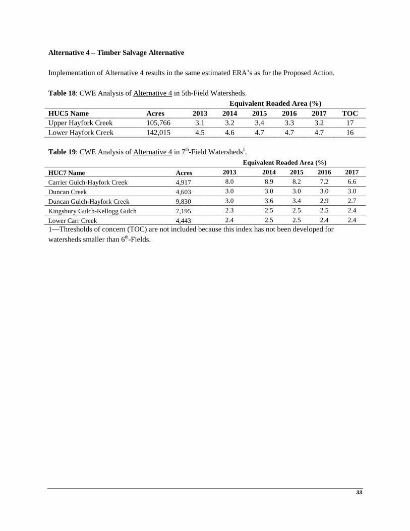
Alternative 4 – Timber Salvage Alternative The Timber Salvage Alternative would harvest approximately 613 acres of salvage removal of dead and dying trees. The definition of “dying” is the 70% mortality threshold using the Marking Guidelines for Fire-Injured Trees in California (Smith and Cluck 2011). The salvage treatments will be used to provide economic return and employment opportunities and reduce fuels. Salvage treatments would be implemented by cable yarding on an estimated 464 acres and mechanical skidding on an estimated 149 acres. These salvage activities would begin during the current year and possibly continue into 2014. Timber Salvage and Hazard Tree Felling Please refer to the project Environmental Assessment for detailed information regarding timber salvage and hazard tree felling in the proposed action. DIRECT AND INDIRECT EFFECTS Alternative 1 – Proposed Action Direct Effects Direct effects of timber salvage and fuels treatments on hydrologic function in burned areas are primarily due to ground compaction related to temporary road and landing construction, cable yarding, and mechanical skidding. Alternative 1 proposes construction of an estimated 1.55 miles of temporary road and 12 new landings. This modest amount of new ground-disturbance will be controlled by project design features to prevent significant direct effects on hydrologic function. The design features call for restoration of all temporary roads, and all landings that will not be needed for future projects. Indirect Effects The primary indirect effect on hydrologic function of Alternative 1 is potential increased peak stream flows from severely burned portions of the project area. These effects were assessed using USGS peak flow regression equations and a weighted watershed area method derived from Omang (1992). The use of regression equations to assess increased stream peak flow was the most common method cited in a survey of Burned Area Emergency Response (BAER) specialists by the USFS Rocky Mountain Research Station (http://forest.moscowfsl.wsu.edu/BAERTOOLS/ROADTRT/Peakflow/). Table 10 shows results of the peak flow assessment:

28
Table 10: Year-1 Post-Fire Peak Flows Estimated for Permanently Flowing Nonfish-bearing Streams Draining the Project Area for the 2, 10, and 25-Year events.
Estimated Year-1 Post-Fire
Discharge1,2 (cfs)
Stream Name Drainage Area
(square miles / acres) Q2 Q10 Q25 McCovey Creek at Hayfork Creek 0.9 / 576 75 205 279 Limestone Gulch at Hayfork Creek 0.4 / 256 45 128 176 Negro Gulch at Hayfork Creek 0.8 / 512 150 414 563 Unnamed Tributary at Hayfork Creek 0.6 / 384 146 408 556 Star Gulch at Middle Fork Kingsbury Gulch 0.6 / 384 52 142 192 1-Based on USGS regression equations and a weighted watershed area method. 2-Estimated increases solely from effects of hydrophobic soils within high-severity burn areas and do not consider proposed actions. The estimates of increased stream peak flows are significant in Year-1 in Negro Gulch and the unnamed tributary. Fire effects on peak flows for larger 50 and 100-year storms were not estimated with the method as such events would be characterized by saturated soils and thus hydrophobicity ceases to be significant (C. Mai, SHF, written communication). Proposed salvage and fuels treatments are not expected to impact post-fire peak flows because the activities do not change watershed canopy cover, and project design features control for road and landing runoff and provide for hillslope ground cover. The major stream crossing of the unnamed tributary was improved (Figure 8) as part of the Stafford Fire BAER response, and there are no vulnerable stream crossings along the main stem of Negro Gulch. In addition, the winter of 2012-13 did not produce any sediment mobilizing storms and it is expected that the extent of hydrophobic soils will diminish quickly after Year-1, perhaps by as much as 50% annually.

29
Figure 8: View downstream of improved crossing on the unnamed tributary in the project area. In addition to increased stream peak flows, landing construction and cable yarding and mechanical skidding of felled logs could produce indirect effects to hydrologic function if ground disturbance produces incipient rills and gullies. However, project design features will prevent significant indirect effects. Alternative 2 – No Action Direct Effects There are no direct effects on hydrologic function or water quality anticipated as a result of No Action. Indirect Effects Similar to the Proposed Action, indirect effects on hydrologic function of the No Action alternative result primarily from the potential for increased stream peak flows for relatively frequent events (2 through 25-Year storms) for 2-3 years post-fire from hydrophobic soils within high-severity burn areas (Table 10). In addition, increased loading of CWD to hillslopes and stream channels as burned trees decay and fall is expected. CWD loading to riparian zones and stream channels is widely regarded as beneficial in terms

30
of sediment retention, channel function, habitat complexity, cover, and nutrient cycling (see Keller and Swanson, 1979; Nakamura and Swanson, 1994; Grant and Swanson, 1995; Mondry, 2004, among others). Alternative 3 – Community Protection Alternative Direct Effects Direct effects on hydrologic function of Alternative 3 on hydrologic function would be much more subtle than those produced by the Proposed Action as just fuels treatments would be implemented, and these are manual activities. Indirect Effects Indirect effects on hydrologic function of Alternative 3 are expected to be the same as for the No Action alternative with the potential for increased stream peak flows for relatively frequent events (2 through 25-Year storms) for 2-3 years post-fire, and recruitment of CWD to hillslopes and stream channels. Alternative 4 – Timber Salvage Alternative Direct Effects Direct effects on hydrologic function of Alternative 4 are expected to be the same as for the Proposed Action. Indirect Effects Indirect effects on hydrologic function of Alternative 4 are expected to be the same as for the Proposed Action. CUMULATIVE EFFECTS Alternative 1 – Proposed Action CWE analysis of past, present, and reasonably forseeable activities (Table 11) and the proposed timber salvage and fuels treatments (Alternative 1) resulted in modest ERA values ranging from 3.1 to 4.7 % in 5th-Field watersheds and 2.3 to 8.9 % in 7th-Field watersheds (Tables 11 and 12). These values are low and thus no significant impacts to hydrologic function from CWE are expected from Alternative 1. Note that fuels treatment acres outside of salvage units are all to be implemented with manual piling and such effects are not included in the CWE model that was utilized. Effects of proposed temporary roads (estimated length of 1.55 miles) and newly constructed landings (12) were not modeled, but this was

31
accounted for by modelling of the entire Stafford Fire control line as 15 miles of newly constructed bull dozer line, when in fact a number of segments were existing roads and manually constructed line. Table 11: Ground disturbing activities incorporated in the CWE analysis, as acres. Acres of disturbance from timber harvest, fire, etc., are then modeled with “recovery curves”.
Roads Decommissioned Roads1 Timber/Salvage Harvest (tractor, cable, and helicopter acres) Forest Thinning (tractor, cable, helicopter, and manual acres) Fuels Treatments (tractor pile and mastication acres) High Severity Fire Moderate Severity Fire Fire Suppression Line (bulldozed and hand-constructed)
1-Road removal results in a reduction of the equivalent roaded area (ERA) affecting the watershed. Table 12: CWE Analysis of Alternative 1 in 5th-Field Watersheds. Equivalent Roaded Area (%) HUC5 Name Acres 2013 2014 2015 2016 2017 TOC Upper Hayfork Creek 105,766 3.1 3.2 3.4 3.3 3.2 17 Lower Hayfork Creek 142,015 4.5 4.6 4.7 4.7 4.7 16 Table 13: CWE Analysis of Alternative 1 in 7th-Field Watersheds1. Equivalent Roaded Area (%) HUC7 Name Acres 2013 2014 2015 2016 2017 Carrier Gulch-Hayfork Creek 4,917 8.0 8.9 8.2 7.2 6.6 Duncan Creek 4,603 3.0 3.0 3.0 3.0 3.0 Duncan Gulch-Hayfork Creek 9,830 3.0 3.6 3.4 2.9 2.7 Kingsbury Gulch-Kellogg Gulch 7,195 2.3 2.5 2.5 2.5 2.4 Lower Carr Creek 4,443 2.4 2.5 2.5 2.4 2.4 1—Thresholds of concern (TOC) are not included because this index has not been developed for watersheds smaller than 6th-Fields. Alternative 2 – No Action CWE analysis of past, present, and reasonably forseeable activities, assuming No Action implemented in the project area resulted in modest ERA values ranging from 3.0 to 4.6 % in 5th-Field watersheds and 2.1 to 8.0 % in 7th-Field watersheds. These values are low and thus no impacts to hydrologic function from CWE are expected from the No Action alternative.

32
Table 14: CWE Analysis of Alternative 2 in 5th-Field Watersheds. Equivalent Roaded Area (%) HUC5 Name Acres 2013 2014 2015 2016 2017 TOC Upper Hayfork Creek 105,766 3.1 3.0 3.1 3.0 3.0 17 Lower Hayfork Creek 142,015 4.5 4.6 4.6 4.6 4.6 16 Table 15: CWE Analysis of Alternative 2 in 7th-Field Watersheds1. Equivalent Roaded Area (%) HUC7 Name Acres 2013 2014 2015 2016 2017 Carrier Gulch-Hayfork Creek 4,917 8.0 6.8 6.0 5.5 5.1 Duncan Creek 4,603 3.0 3.0 3.0 3.0 3.0 Duncan Gulch-Hayfork Creek 9,830 3.0 2.6 2.3 2.2 2.1 Kingsbury Gulch-Kellogg Gulch 7,195 2.3 2.3 2.3 2.2 2.2 Lower Carr Creek 4,443 2.4 2.4 2.4 2.4 2.3 1—Thresholds of concern (TOC) are not included because this index has not been developed for watersheds smaller than 6th-Fields. Alternative 3 – Community Protection Alternative Implementation of Alternative 3 results in the same estimated ERA’s as for the No Action as fuels treatments are considered to be all manually implemented and thus do not factor in to the CWE model. Table 16: CWE Analysis of Alternative 3 in 5th-Field Watersheds. Equivalent Roaded Area (%) HUC5 Name Acres 2013 2014 2015 2016 2017 TOC Upper Hayfork Creek 105,766 3.1 3.0 3.1 3.0 3.0 17 Lower Hayfork Creek 142,015 4.5 4.6 4.6 4.6 4.6 16 Table 17: CWE Analysis of Alternative 3 in 7th-Field Watersheds1. Equivalent Roaded Area (%) HUC7 Name Acres 2013 2014 2015 2016 2017 Carrier Gulch-Hayfork Creek 4,917 8.0 6.8 6.0 5.5 5.1 Duncan Creek 4,603 3.0 3.0 3.0 3.0 3.0 Duncan Gulch-Hayfork Creek 9,830 3.0 2.6 2.3 2.2 2.1 Kingsbury Gulch-Kellogg Gulch 7,195 2.3 2.3 2.3 2.2 2.2 Lower Carr Creek 4,443 2.4 2.4 2.4 2.4 2.3 1—Thresholds of concern (TOC) are not included because this index has not been developed for watersheds smaller than 6th-Fields.
33
Alternative 4 – Timber Salvage Alternative Implementation of Alternative 4 results in the same estimated ERA’s as for the Proposed Action. Table 18: CWE Analysis of Alternative 4 in 5th-Field Watersheds. Equivalent Roaded Area (%) HUC5 Name Acres 2013 2014 2015 2016 2017 TOC Upper Hayfork Creek 105,766 3.1 3.2 3.4 3.3 3.2 17 Lower Hayfork Creek 142,015 4.5 4.6 4.7 4.7 4.7 16 Table 19: CWE Analysis of Alternative 4 in 7th-Field Watersheds1. Equivalent Roaded Area (%) HUC7 Name Acres 2013 2014 2015 2016 2017 Carrier Gulch-Hayfork Creek 4,917 8.0 8.9 8.2 7.2 6.6 Duncan Creek 4,603 3.0 3.0 3.0 3.0 3.0 Duncan Gulch-Hayfork Creek 9,830 3.0 3.6 3.4 2.9 2.7 Kingsbury Gulch-Kellogg Gulch 7,195 2.3 2.5 2.5 2.5 2.4 Lower Carr Creek 4,443 2.4 2.5 2.5 2.4 2.4 1—Thresholds of concern (TOC) are not included because this index has not been developed for watersheds smaller than 6th-Fields.

34
4. ADDITIONAL INFORMATION RESOURCE PROTECTION MEASURES Refer to detailed hydrologic design criteria described in the Proposed Action, section 3.2.1.4. COMPLIANCE WITH FOREST PLAN AND OTHER RELEVANT LAWS, REGULATIONS, POLICIES AND
PLANS The Proposed Action and all project alternatives comply with federal and state laws, and the Forest Plan. MONITORING RECOMMENDATIONS Project monitoring as required by the NCWQCB will be conducted during project implementation and in subsequent years following implementation. Results and determinations from this monitoring will be reported annually from the SHF to the NCWQCB.

35
5. CONCLUSIONS CONCLUSIONS AND/OR DETERMINATIONS High-severity areas of the Stafford Fire and associated hydrophobic soils have created the potential for increased stream peak flows for relatively frequent events (2 through 25-Year storms) for 2-3 years post-fire, and recruitment of CWD to hillslopes and stream channels, particularly in Negro Gulch and the unnamed tributary that drain the fire area. Analysis of fire effects indicate the potential for increased peak flows in these two small (< 515 acres) watersheds, but these potential increases will diminish significantly in the first few years post-fire. Implementation of any project alternative is not expected to have a significant influence on this trend. CWE anlyses that incorporated past, present, and reasonably foreseeable actions were performed for the Proposed Action, No Action, and Alternatives 3 and 4 at the 5th and 7th-Field watershed scales. Effects of existing roads, burned areas, constructed fire line, and proposed tractor, cable, and helicopter salvage units were forecast for a five year period. All other past, present, and reasonably foreseeable actions outside of the Stafford Project area that can be accounted for (including private Timber Harvest Plans) were also modelled. Model results were equal for the Proposed Action and Alternative 4, and also for No Action and Alternative 3. Results indicate that relative disturbance (measured by % Equivalent Roaded Area) of the project watersheds did not exceed 10% for any alternative. When compared with 5th-Field watershed Thresholds of Concern (TOC) of 16-17%, the modelled effects are considered modest. As such, it is expected that implementation of any alternative will have insignificant cumulative effects to hydrologic function in the project watersheds.

36
6. REFERENCES Gotvald, A.J., Barth, N.A., Veilleux, A.G., and Parrett, Charles. 2012. Methods for determining magnitude and frequency of floods in California, based on data through water year 2006: U.S. Geological Survey Scientific Investigations Report 2012–5113, 38 p., 1 pl., available online only at http://pubs.usgs.gov/sir/2012/5113/. Grant, G. E. and F.J. Swanson. 1995. Morphology and processes of valley floors in mountain streams, western Cascades, Oregon. Natural and Anthropogenic Influences in Fluvial Geomorphology. Geophysical Monograph 89. American Geophysical Union, Washington, DC, USA. Haskins, D.M. 1986. A Management Model for Evaluating Cumulative Watershed Effects. California Watershed Management Conference, November 18-20, West Sacramento, California. Keller, E. A., and F. J. Swanson. 1979. Effects of large organic material on channel form and fluvial processes. Earth Surface Processes and Landforms 4, 361 - 380. Mai, C. 2013. Shasta-Trinity National Forest Headquarters Mondry, Z. 2004. 1997 Flooding in Three Klamath Mountain Stream: Geomorphic Effectiveness and Sediment and Large Wood Budgets. M.S. Thesis, Humboldt State University, Arcata, California. 81p. Nakamura, F., and F.J. Swanson. 1994. Distribution of coarse woody debris in a mountian stream, western Cascade Range, Oregon. Canadian Journal of Forestry Research 24, 2395 – 2403. Omang R.J. 1992. Analysis of the Magnitude and Frequency of Floods and the Peak-Flow Gauging Network in Montana. U.S. Geological Survey Water-Resources Investigations Report 92-4048, 74 p. Smith S. L., and D. R. Cluck. 2011. Marking Guidelines for Fire-Injured Trees in California. USDA FS, Region 5, Forest Health Protection, Report # RO-11-01. US EPA. 1998. South Fork Trinity River and Hayfork Creek Sediment Total Maximum Daily Loads. 66 p. USDA FS and USDI BLM. 1994. Record of Decision for Amendments to Forest Service and Bureau of Land Management Planning Documents within the Range of the Northern Spotted Owl. USDA FS and USDI BLM. 2004. Record of Decision Amending Resource Management Plans for Seven Bureau of Land Management Districts and Land and Resource Management Plans for Nineteen National Forests within the Range of the Northern Spotted Owl. (Decision to clarify provisions relating to the Aquatic Conservation Strategy).

37
USDA FS Region 5. 2011. Soil and Water Conservation Handbook. Chapter 10 Water Quality Management Handbook. Vallejo, CA. 261 p. USDA FS Region 5. 2005. Stream Condition Inventory (SCI) Technical Guide. Version 5.0. 111 p. USDA FS Rocky Mountain Research Station Moscow Forest Sciences Laboratory website: http://forest.moscowfsl.wsu.edu/BAERTOOLS/ROADTRT/Peakflow/ USDI Geological Survey National Hydrography Dataset (NHD): http://nhd.usgs.gov/index.html USDI Geological Survey StreamStats Program: http://water.usgs.gov/osw/streamstats/california.html. URS Corporation Greiner Woodward Clyde. 2000. Middle Hayfork-Salt Creek Watershed Analysis. 118 p.