Embed Size (px)
Citation preview
Hydrologic Data for Urban Studies in the Austin, Texas Metropolitan Area, 1978
R.M. Slade, }r., M.E. Dorsey, }.D. Gordon, and R.N. Mitchell
U.S. GEOLOGICAL SURVEY Open-File Report 80-728
Prepared in cooperation with the City of Austin and the Texas Department of Water Resources
JULY 1980
UNITED STATES DEPARTMENT OF THE INTERIOR
CECIL D. ANDRUS, Secretary
GEOLOGICAL SURVEY
H. William Menard, Director
Reproduced by the Texas Department of Water Resources as part of the continuing program of cooperation in water-resources investigations between the Department and the u.s. Geological Survey.

CONTENTS
Page
Introduction------------------------------------------------------------- 7 Location and description of the area------------------------------------- 9 Data-collection methods-------------------------------------------------- 10
Precipitation data-------------------------------------------------- 10 Runoff data-~-~---------~-----~~---------~-~------------~----------- 14 Water-quality data-------------------------------------------------- 16 Ground-water data--------------------------------------------------- 16
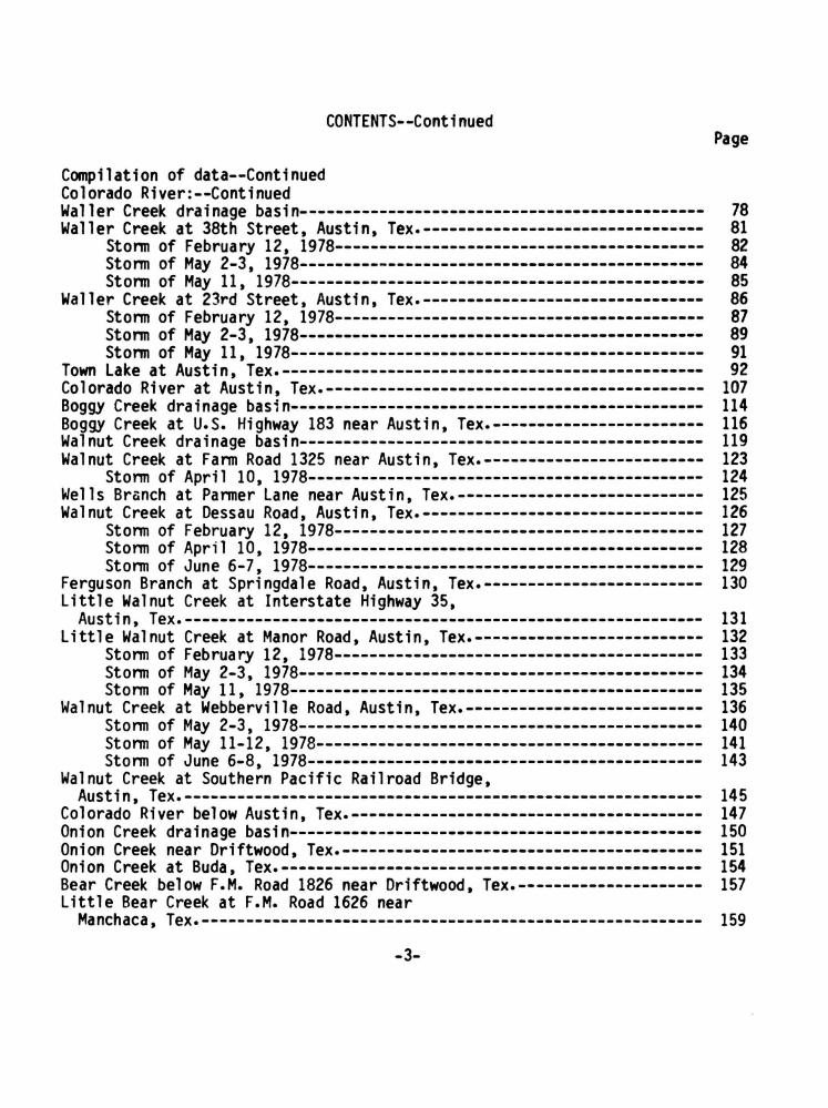
Selected references------------------------------------------------------ 22 Compilation of data------------------------------------------------------ 23 Colorado River: Colorado River below Mansfield Dam, Austin, Tex.------------------------- 24 Bull Creek drainage basin------------------------------------------------ 25 Bull Creek at loop 360 near Austin, Tex.--------------------------------- 27 West Bull Creek at loop 360 near Austin, Tex.---------------------------- 30 Bu11 Creek at Farm Road 2222 near Austin, Tex.--------------------------- 32 lake Austin at Austin, Tex----------------------------------------------- 34 Bee Creek drainage basin------------------------------------------------- 36 Bee Creek at West lake Drive near Austin, Tex.--------------------------- 38 Barton Creek drainage basin---------------------------------------------- 39 Barton Creek at State Highway 71 near Oak Hill, Tex.--------------------- 42
Storm of June 6-7, 1978--------------------------------------------- 45 Barton Creek at Loop 360, Austin, Tex,----------------------------------- 47 Barton Springs at Austin, Tex.------------------------------------------- 48 Barton Creek below Barton Springs at Austin, Tex.------------------------ 50 West Bouldin Creek drainage basin---------------------------------------- 53 West Bouldin Creek at Riverside Drive, Austin, Tex.---------------------- 55 Shoal Cr~ek drainage basin----------------------------------------------- 56 Shoal Creek at Steck Avenue, Austin, Tex.-------------------------------- 60
Storm of February 12, 1978------------------------------------------ 61 Storm of May 2-3, 1978---------------------------------------------- 62 Storm of May 11, 1978----------------------------------------------- 63
Shoal Creek at Northwest Park, Austin, Tex.------------------------------ 64 Storm of February 12, 1978------------------------------------------ 65 Storm of May 2-3, 1978---------------------------------------------- 67 Storm of May 11, 1978----------------------------------------------- 68
Shoal Creek at White Rock Drive, Austin, Tex.---------------------------- 69 Storm of February 12, 1978------------------------------------------ 70 Storm of May 2-3, 1978---------------------------------------------- 72 Storm of May 11, 1978----------------------------------------------- 73
Shoal Creek at 12th Street, Austin, Tex.--------------------------------- 74 Storm of May 2-3, 1978---------------------------------------------- 76 Stonm of May 11, 1978------------------------------------------------ 77
-2-
Compilation of data--Continued Colorado Rfver:--Continued
CONTENTS--Continued Page
Waller Creek drainage basin---------------------------------------------- 78 Waller Creek at 38th Street. Austin. Tex.-------------------------------- 81
Storm of February 12, 1978------------------------------------------ 82 Storm of May 2-3, 1978---------------------------------------------- 84 Storm of May 11, 1978----------------------------------------------- 85
Waller Creek at 23rd Street, Austin, Tex.-------------------------------- 86 Storm of February 12, 1978------------------------------------------ 87 Storm of May 2-3, 1978---------------------------------------------- 89 Storm of May 11, 1978----------------------------------------------- 91
Town lake at Austin, Tex.------------------------------------------------ 92 Colorado River at Austin. Tex.------------------------------------------- 107 Boggy Creek drainage basin----------------------------------------------- 114 Boggy Creek at u.s. Highway 183 near Austin, Tex.------------------------ 116 Walnut Creek drainage basin---------------------------------------------- 119 Walnut Creek at Farm Road 1325 near Austin, Tex.------------------------- 123
Storm of April 10, 1978--------------------------------------------- 124 Wells Branch at Parmer lane near Austin, Tex.---------------------------- 125 Walnut Creek at Dessau Road, Austin, Tex.-------------------------------- 126
Storm of February 12, 1978------------------------------------------ 127 Storm of April 10, 1978--------------------------------------------- 128 Storm of June 6-7, 1978--------------------------------------------- 129
Ferguson Branch at Springdale Road, Austin, Tex.------------------------- 130 little Walnut Creek at Interstate Highway 35,
Austin, Tex.----------------------------------------------------------- 131 little Walnut Creek at Manor Road, Austin, Tex.-------------------------- 132
Storm of February 12, 1978------------------------------------------ 133 Storm of May 2-3, 1978---------------------------------------------- 134 Storm of May 11, 1978----------------------------------------------- 135
Walnut Creek at Webberville Road, Austin, Tex.--------------------------- 136 Storm of May 2-3, 1978---------------------------------------------- 140 Storm of May 11-12, 1978-------------------------------------------- 141 Storm of June 6-8, 1978--------------------------------------------- 143
Walnut Creek at Southern Pacific Railroad Bridge, Austin. Tex.----------------------------------------------------------- 145
Colorado River below Austin, Tex.---------------------------------------- 147 Onion Creek drainage basin----------------------------------------------- 150 Onion Creek near Driftwood, Tex.----------------------------------------- 151 Onion Creek at Buda, Tex.------------------------------------------------ 154 Bear Creek below F.M. Road 1826 near Driftwood, Tex.--------------------- 157 little Bear Creek at F.M. Road 1626 near
Manchaca. Tex.--------------------------------------------------------- 159
-3-

Compilation of data--Continued Colorado River--Continued
CONTENTS--Continued
Page
Slaughter Creek drainage basin------------------------------------------- 160 Slaughter Creek at F.M. 1826 near Austin, Tex.--------------------------- 162 Slaughter Creek at F.M. 2304 near Austin, Tex.--------------------------- 163 Boggy Creek (south) drainage basin--------------------------------------- 164 Boggy Creek (south) at Circle S Road, Austin, Tex.----------------------- 167
Storm of February 12, 1978------------------------------------------ 168 Storm of May 2-3, 1978---------------------------------------------- 169
Williamson Creek drainage basin------------------------------------------ 170 Williamson Creek at Oak Hill, Tex.--------------------------------------- 173 Williamson Creek at Manchaca Road, Austin, Tex.-------------------------- 176
Storm of April 10, 1978--------------------------------------------- 177 Storm of May 2-3, 1978---------------------------------------------- 178 Storm of June 6-7, 1978--------------------------------------------- 179
Williamson Creek at Jirorny Clay Road, Austin, Tex.------------------------ 181 Storm of April 10, 1978--------------------------------------------- 185 Storm of May 2-3, 1978---------------------------------------------- 187 Storm of June 6-8, 1978--------------------------------------------- 188
Onion Creek at u.s. Highway 183, Austin, Tex.---------------------------- 190 Wilbarger Creek drainage basin------------------------------------------- 194 Wilbarger Creek near Pflugerville, Tex.---------------------------------- 195 Daily and monthly rainfall summary for gages west of
meridian 97°45'-------------------------------------------------------- 220 Daily and monthly rainfall summary for gages east of
meridian 97°45'-------------------------------------------------------- 225
-4-
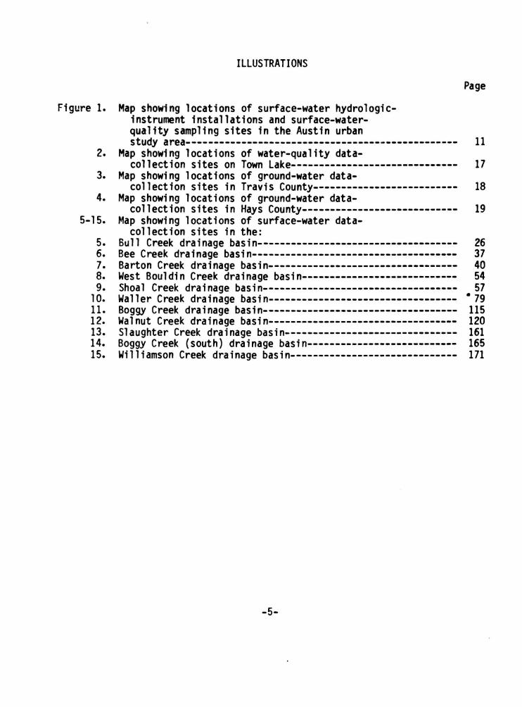
ILLUSTRATIONS
Figure 1. Map showing locations of surface-water hydrologicinstrument installations and surface-waterquality sampling sites in the Austin urban
Page
study area------------------------------------------------- 11 2. Map showing locations of water-quality data-
collection sites on Town Lake------------------------------ 17 3. Map showing locations of ground-water data-
collection sites in Travis County-------------------------- 18 4. Map showing locations of ground-water data-
collection sites in Hays County---------------------------- 19 5-15. Map showing locations of surface-water data-
collection sites in the: 5. Bull Creek drainage basin------------------------------------ 26 6. Bee Creek drainage basin------------------------------------- 37 7. Barton Creek drainage basin---------------------------------- 40 8. West Bouldin Creek drainage basin---------------------------- 54 9. Shoal Creek drainage basin----------------------------------- 57
10. Waller Creek drainage basin---------------------------------- • 79 11. Boggy Creek drainage basin----------------------------------- 115 12. Walnut Creek drainage basin---------------------------------- 120 13. Slaughter Creek drainage basin------------------------------- 161 14. Boggy Creek (south) drainage basin--------------------------- 165 15. Williamson Creek drainage basin------------------------------ 171
-5-

TABLES
Table 1. Weighted-mean precipitation factors for drainage basins above stations in the Austin metropolitan
Page
area---------------------~------------------------~------- 12 2. Rainfall and runoff data for selected continuous-record gaging stations in the Austin urban study area, 1978 water year------------------------------------------- 15
3. Peak discharges associated with water-quality samples collected during storms----------------------------------- 20
4-9. Storm rainfall-runoff data, 1978 water year,: 4. Barton Creek------------------------------------------------ 41 5. Shoal Creek------------------------------------------------- 58 6. Waller Creek------------------------------------------------ 80 7. Walnut Creek----------------------------------·------------- 121 8. Boggy Creek (South)----------------------------------------- 166 9. Williamson Creek------- ------------------------------------ 172
10. Records of wells, test holes, and springs in the Austin urban study area,
• Travis County---------------------------------------------- 196 Hays County--~~~~~~---------------------------------------- 205
11. Water-quality data from wells and springs in the Austin urban study area, Travis County---------------------------------------------- 210 Hays County------------------------------------------------ 216
-6-
HYDROLOGIC DATA FOR URBAN STUDIES IN THE
AUSTIN, TEXAS, METROPOLITAN AREA
1978
By
R. M. Slade, Jr., M. E. Dorsey, J. D. Gordon, and R. u.s. Geological Survey
INTRODUCTION
N. Mitchell
Hydrologic investigations of urban watersheds in Texas were begun by the u.s. Geological Survey in 1954. Studies are now in progress in Austin, Dallas, Dallas County, Fort Worth, Houston, and San Antonio.
The Geological Survey, in cooperation with the Texas Department of Water Resources, began hydrologic studies in the Austin urban area in 1954. In cooperat.ion with the city of Austin, the program was expanded in 1975 to include additional streamflow and rainfall gaging stations and the collection of waterquality data. In 1978, the program was expanded to include a ground-water resources study of the South Austin metropolitan area in the Balcones Fault Zone.
The objectives of the Austin urban-hydrology study are as follows:
1. To determine, on the basis of historical data and hydrologic analyses, the magnitude and frequency of flood peaks and flood volume.
2. To determine the effect of urban development on flood peaks and volume.
3. To determine the variations in water quality during different seasons in selected basins under various types of urban development.
4. To quantitatively appraise the ground-water resources along the Balcones Fault Zone, the effect of urbanization on the quality and quantity of recharge and discharge, and the extent of pollution in the Edwards aquifer.
-7-

This report presents the hydrologic data collected in the Austin urban area for the 1978 water year {Oct. 1, 1977 to Sept. 30, 1978). To facilitate the publication and distribution of this report at the earliest feasible time, certain material has been included that does not conform to the formal publication standards of the u.s. Geological Survey.
The inch-pound units of measurements used in this report may be converted to metric units by using the following conversion factors:
From Multiply To obtain Unit Abbrevia- by Unit
tion
inch 25.4 millimeter
foot 0.3048 meter
mile 1.609 kilometer
square mile mi2 2.590 square kilometer
cubic foot ft3/s 0.02832 cubic meter per second per second
foot per mi 1 e ft/mi 0.189 meter per kilometer
acre-foot 1233 cubic meter
0.001233 cubic hectometer
Abbrevia-tion
mm
m
km
km2
rrf3 /S
m/km
m3
hm3
Additional explanations of terms related to streamflow, water quality, and other hydrologic data used in this report are defined in the u.s. Geological Survey annual report Water Resourses Data for Texas, TX-78-3, 1978.
-8-
LOCATION AND DESCRIPTION OF THE AREA
The Austin study area is about 80 miles northeast of San Antonio and about 160 miles northwest of Houston. The study area extends from the Hill Country at the eastern edge of the Edwards Plateau across the Bal cones Escarpment to the Blackland Prairie of Texas. The land surface decreases in altitude from about 1,100 feet above NGVD (National Geodetic Vertical Datum of 1929) in the northwest to about 420 feet above NGVD level in the southeast.
Slopes genera 11 y range from 2 to 15 percent; s 1 opes greater than 5 percent occur a 1 ong the eastern edge of the Edwards Plateau, average about 5 percent within the Balcones Fault Zone, and are less than 5 percent east of the escarpment and along the flood plains and alluvial terraces of the Colorado River and its tributaries.
Soils overlying the hard limestone in the western half of the study area are in general poorly developed thin calcareous clays, clay loams, and stony clays. Bedrock is locally exposed. Soils on the soft limestones and shales of the Balcones Fault Zone are generally dark brown calcareous clays, clay loams, or silty clay loams 6 inches or more thick. Soils on the shaly formation in the eastern part of the area are dark gray to olive calcareous clays and clay loams, 12 inches or more thick. Soils on the flood plains and terraces of the Colorado River and its tributaries are dark gray to red-brown, ca 1 ca reo us, nc1rca 1 careous, sandy 1 oams, silty c 1 ay 1 oams, c 1 ay 1 oams, and gravelly sands 12 inches or more thick.
Detailed descriptions of the soils in the Austin urban study area can be found in Soil Survey of Travis County, u.s. Dept. of Agriculture, 1974. Additional geologic information in the Austin urban study area can be found in publications by the University of Texas Bureau of Economic Geol~gy.
The major streams in the study area are the Colorado River, Onion Creek, Barton Creek, Walnut Creek, Bull Creek, Boggy Creek, Shoal Creek, Williamson Creek, Slaughter Creek, and Waller Creek. Throughout the year, low flow for some of the smaller streams in the predominantly urban areas is partly sustained by return flow from commercial u~e; during the summer months, the low flaw is partly sustained by drainage from municipal and private swirm~ing pools and from residential use.
-9-
The climate of the Austin urban area is characterized by short mild winters, long moderately hot summers, moderately high humidity, and prevailing southerly winds. Records of the National Weather Service show that the mean annual temperature {based on the period 1941-70) is 70.6°F {21.5°C); the mean maximum temperature for July is 95°F {35.0°C); and the mean minimum temperature for January is . 41°F (5.0°C). The average gruwing season is about 270 days.
The average rainfall {based on the period 1941-70) is 32.49 inches and i s generally well distributed throughout the year; however, individual storms may cause flooding in any season. The major storms usually occur during the months of April-May and September-October.
DATA-COLLECTION METHODS
The drainage basins, locations of hydrologic-instrument installations, anu surface-water-quality sampling sites in the Austin urban study area are shown on figure 1. The 1 ocat ions of hydro 1 ogi c instruments and datacollection sites in the individual drainage basins are shown on figLres 5-15.
Precipitation Data
Precipitation data are based on 24 recording rain gages. The gages are distributed throughout t he drainage basins to measure total precipitation and to define rainfall intensities.
Preci pi tat ion at i ndi vudua 1 gages and weighted preci pi tat ion in each basin is given in the section 11 Compilation of data ... Weighted-mean precipitation factors are shown in table 1. Weighted-mean precipitation for a study area is determined by the Thiessen method described by Linsley, Kohler, and Paulhus (1949). For example, the weighted-mean precipitation for the drainage basin upstream from the stream-gaging station Bull Creek at Loop 360 is computed as follows: Multiply the recorded precipitation at rain-gage 1-BUL by 0.57 and to that value, add the recorded precipitation at rain-gage 2-BUL multiplied by 0.43.
Rainfall for the current water year was unevenly distributed over the area. Individual station totals ranged from 23.95 inches at gage 6-R in the Waller Creek basin to 32.31 inches at gage 1-WLN in the Walnut Creek basin. The mean water-year total of all the rain gages is 27.83 inches as compared with the 30-year average {1941-70) of 32.49 inches at the Austin Municipal Airport. Daily and monthly precipitation data at individual gages in the study area are given in the section 11 Compilation of data ...
Few storms of wide distribution produced rainfall totals of over 2 inches during the year. The most significant runoff-producing storm of the year occurred on May 2-3; rainfall totals for this storm ranged from 0.64 to 2. ~s inches. Widespread showers also fell on February 12 and May 11. These storms produced rai nfa 11 tot a 1 s ranging from o. 46 to 1. 92 inches, and o. 03 to 1.88 inches respectively.
-10-