Embed Size (px)
Citation preview

Hydrogeology Review of the Environmental Effects Statement Edithvale and Bonbeach Level Crossings Confidential Privileged Communication Prepared for: Russell Kennedy Pty Ltd, on behalf of Kingston City Council Level 12, 469 La Trobe Street Melbourne, VIC 3000 28 May 2018

Distribution
m16629_003_rpt_rev0 i
Distribution
Hydrogeology and Acid Sulfate Soils Review of the Environmental Effects Statement, Edithvale and Bonbeach Level Crossings
28 May 2018
Copies Recipient Copies Recipient
1 PDF Mr Andrew Sherman Principal Russell Kennedy Pty Ltd, on behalf of Kingston City Council Level 12, 469 La Trobe Street Melbourne, VIC 3000
1 PDF Senversa Project File
1 Reliance - This document has been prepared solely for the use of Russell Kennedy Pty Ltd, on behalf of Kingston City Council. No responsibility or liability is accepted for any damages arising out of the use of this document by any third party.
2 Copyright and Intellectual Property – No portion of this document may be removed, extracted, copied, electronically stored or disseminated in any form without the prior written permission of Senversa. Intellectual property in relation to the methodology undertaken during the creation of this document remains the property of Senversa.
3 Principles and Limitations of Investigation - This document is issued subject to the technical principles, limitations and assumptions provided in Section 2.0.
4 Confidentiality – This report was prepared for Russell Kennedy Pty Ltd, on behalf of Kingston City Council and may contain confidential information. If you receive this report in error, please contact Senversa and we will arrange collection of this document.
Senversa Pty Ltd ABN: 89 132 231 380 Level 6, 15 William Street, Melbourne, VIC 3000 tel: + 61 3 9606 0070; fax: + 61 3 9606 0074 www.senversa.com.au
Dr Andrei Woinarski Principal BE(Environmental), PhD
Contents
m16629_003_rpt_rev0 ii
Contents
List of Acronyms ...................................................................................................................................................................... iii
1.0 Name and Address ....................................................................................................................................................... 1
2.0 Qualifications and Experience ..................................................................................................................................... 1 2.1 Qualifications ................................................................................................................................................................ 1 2.2 Professional Affiliations ............................................................................................................................................... 1 2.3 Employment History ..................................................................................................................................................... 1 2.4 Experience and Expertise ............................................................................................................................................ 2 2.5 Assistance .................................................................................................................................................................... 2
3.0 Introduction................................................................................................................................................................... 3 3.1 Proposed Works ........................................................................................................................................................... 3
3.1.1 Edithvale ............................................................................................................................................................ 3 3.1.2 Bonbeach ........................................................................................................................................................... 3
3.2 Scope of this Assessment ........................................................................................................................................... 3
4.0 Limitations of the Report ............................................................................................................................................. 5
5.0 Site Hydrology, Hydrogeology & Geology .................................................................................................................. 6 5.1 Site Descriptions .......................................................................................................................................................... 6 5.2 Site Hydrology .............................................................................................................................................................. 6 5.3 Site Geology.................................................................................................................................................................. 7 5.4 Site Hydrogeology ........................................................................................................................................................ 8 5.5 Modelling ..................................................................................................................................................................... 11
6.0 Discussion .................................................................................................................................................................. 13 6.1 Hydrogeological Modelling and Implications ........................................................................................................... 13
6.1.1 Hydrogeological Conceptual Model .................................................................................................................. 13 6.1.2 Modelling Method ............................................................................................................................................. 14 6.1.3 Model Predictions ............................................................................................................................................. 15 6.1.4 Mitigations ........................................................................................................................................................ 17 6.1.5 Monitoring ........................................................................................................................................................ 17
6.2 Implications from Groundwater Elevation Changes ................................................................................................. 17 6.2.1 Groundwater Surface Expression ..................................................................................................................... 18 6.2.2 Interference to Local Groundwater Users ......................................................................................................... 18 6.2.3 Activation of Acid Sulfate Soils ......................................................................................................................... 18 6.2.4 Contaminant migration ..................................................................................................................................... 19
6.3 Implications for Salt Water Intrusion ......................................................................................................................... 19 6.4 Implications for Edithvale Wetland ............................................................................................................................ 20
7.0 Conclusions ................................................................................................................................................................ 21
8.0 Declaration .................................................................................................................................................................. 22
9.0 References .................................................................................................................................................................. 23
Appendix A: Curriculum Vitae

List of Acronyms
m16629_003_rpt_rev0 iii
List of Acronyms
Acronym Definition
AHD Australian Height Datum
ASS Acid Sulfate Soils
BG Brighton Group
CoPC Contaminant of potential concern
CQAP Construction quality assurance plan
CM Conceptual model
EES Environment Effects Statement
EPA Environment Protection Authority (Victoria)
m Metre
m3 Cubic metres
m AHD Metres Australian Height Datum
m bgl Metres below ground level
mg/L Milligrams per litre
MSL Mean sea level
QA Quaternary Aquifer
SWL Standing water level
UTAF Upper Tertiary Aquifer Formation (Brighton Group)

Name and Address, Qualifications and Experience
m16629_003_rpt_rev0 1
1.0 Name and Address
My name and address details are:
Andrei Zichy Woinarski,
Principal and Hydrogeology Practice Leader,
Senversa Pty Ltd,
The Grafton Bond Building, Level 5, 201 Kent Street,
Sydney NSW 2000
2.0 Qualifications and Experience
My qualifications, affiliations, accreditations and employment history are presented in the following sections. A copy of my Curriculum Vitae is presented in Appendix A.
2.1 Qualifications
My qualifications are:
• Bachelor of Engineering (Environmental), University of Wollongong, 1999.• Doctor of Philosophy, University of Melbourne, 2004.
2.2 Professional Affiliations
I am a member of:
• Australian Land and Groundwater Association (ALGA).• ALGA Groundwater Fate and Transport Special Interest Group (SIG) Committee.• International Association of Hydrogeologists.
2.3 Employment History
My employment history is:
Period Employer Role
2016 - current Senversa Pty Ltd Principal – Hydrogeology, Contaminated Land Assessment and Remediation – National.
2014 – 2016 JBS&G Australia Pty Ltd Principal – Hydrogeology, Contaminated Land Assessment and Remediation – NSW.
2010 – 2014 Golder Associates Pty Ltd Senior Engineer – Project Management, Contaminated Land Assessment and Remediation – National.
2004 – 2010 URS Australia Pty Ltd / URS Corporation
Project to Senior Engineer –Project Management, Contaminated Land Investigations – NSW.
2000 - 2002 Australian Antarctic Division / University of Melbourne
Research Scientist / Teaching – Contaminant Hydrogeology.

Qualifications and Experience
m16629_003_rpt_rev0 2
2.4 Experience and Expertise
I have approaching 20 years’ experience as an environmental engineer and hydrogeologist conducting environmental and contaminated land assessments and management throughout Australia and overseas.
I have conducted, managed or directed contamination, geological, geochemical, hydrological, hydrogeological and risk assessments, and water treatment and remediation projects, incorporating multi-disciplined teams. I have provided technical expert advice to support audits of sites under various State regulatory schemes nationally including in VIC, NSW, SA, QLD and WA.
I have specific expertise relating to hydrogeological and contamination assessments, and development of conceptual site models. My experience has included assessment, development of conceptual models (CM), and development and ongoing performance assessment of groundwater containment and management systems for the Botany Groundwater Clean-up project, which is set within Quaternary sediment aquifers.
I have developed numerous hydrogeological and contamination conceptual models (CM) for sites with a range of settings and complexity. Some of these include: a heavy industrial complex within Botany Aquifer; former chemicals manufacturing facility at Yarraville; operating chemicals manufacturing facility at Kooragang Island; operating chemicals manufacturing facility at Yarwun; former gasworks at Wollongong; copper refinery at Townsville; numerous smaller-scale brownfield sites in urban areas.
I have reviewed CMs, and 1D, 2D and 3D numerical modelling of groundwater flow, solute transport, flux assessments and water balances, typically to support audits or as the site hydrogeologist. These have included: groundwater modelling within Botany Aquifer; groundwater modelling and CM for RAAF Base Pearce; groundwater modelling and CM at various sites at Kwinana; groundwater modelling at Narngulu; groundwater and geochemical modelling at a smelter at Port Pirie.
I have provided expert witness support to a case in NSW Land and Environment Court. I have provided independent review of long-term contamination management costs for financial assurance purposes to the NSW Department of Planning.
I received a PhD from University of Melbourne focussed on cold climate hydrogeology and contaminated land remediation. I have published technical papers in relation to my research, and presented at numerous conferences on a range of topics. As a member of the ALGA Groundwater SIG, I am currently authoring an industry paper on fate and transport of per- and poly-fluorinated compounds.
2.5 Assistance
I have been assisted in the preparation of this report by Mr Patrick Clarke (Senior Principal) and John Piper (Senior Principal) at Senversa Pty Ltd.

Introduction
m16629_003_rpt_rev0 3
3.0 Introduction
Senversa Pty Ltd was engaged by Russell Kennedy Pty Ltd on behalf of the Kingston City Council (Council) on 10 May 2018 to provide an expert opinion on specific issues in relation to the proceedings in the Panel Victoria and Advisory Committee in relation to the matter, relating to the proposed Edithvale and Bonbeach level crossings removal projects.
3.1 Proposed Works
The two projects would involve the lowering of the Frankston railway line into two trenches, one at Edithvale Road, Edithvale and one at Station Street and Bondi Road, Bonbeach. For the purposes of this report, these are termed the ‘site’. For the purposes of this report, the area surrounding the site is defined as the ‘study area’.
3.1.1 Edithvale
The Edithvale project is located predominantly within the railway reserve owned by VicTrack and extends from Lincoln Parade Aspendale to Chelsea Road, Chelsea.
The trench would be constructed between Lochiel avenue and Berry avenue. It would be 1,300 m in length, 14 m wide at the narrowest point, widening to 24 m wide at the Edithvale Station. The rail track would be 8 m below ground level (bgl) at the lowest point at Edithvale Station and the maximum depth of excavation would be 15 m bgl to allow for the underground infrastructure below the rail track to collect and divert rainwater from the trench. Maximum pile depth would be 24 m bgl.
Decking above the rail trench would be provided for the new station building, car parking, and a sub-station. New pedestrian bridges would be constructed to provide access across the rail trench.
3.1.2 Bonbeach
The Bonbeach level crossing is also located predominantly within the existing rail reserve owned by VicTrack. The Bonbeach project extends from Chelsea Road, Chelsea to the Patterson River, Bonbeach.
The project involves the lowering of the rail track into a trench under Bondi Road while maintaining Bondi Road at the current road level. The trench would be constructed between Golden Avenue and The Glade. The trench would be 1,200 m long and 14 m wide at the narrowest point, and increase to 24 m wide at the new Bonbeach Railway station. Again, the rail track would be 8 m below the rail track surface at the lowest underground at Bonbeach Station and the maximum depth of excavation would be 15 m to allow for the infrastructure to collect and divert rainwater from the trench. Maximum pile depth would be 24 m bgl.
Decking would be provided at about ground level for the new railway station building and carparking. New pedestrian bridges would be constructed for pedestrian access across the trench.
3.2 Scope of this Assessment
The assessment is for the Council to satisfy itself that:
• the work undertaken is sound; and • the conclusions are reasonable and appropriate.
Of particular concern is:
• The predicted mounding and lowering of groundwater levels associated with the trenches, and related potential impacts including potential groundwater contamination movement.

Introduction
m16629_003_rpt_rev0 4
• The acknowledged upstream mounding that is likely to occur at the Edithvale site and the suggested construction fix to divert groundwater around the trenching structure and any opinion regarding the proposed fix, recognising that the detail is not finalised as to its methodology.
This report provides commentary on the issues of hydrogeology, including:
• Hydrogeological modelling and implications. • Implications from changes in groundwater elevations with respect to acid sulphate soils. • Implications for salt water intrusion. • Implications of changes in groundwater elevations on groundwater resources surrounding the
structures. • Implications for groundwater recharge of the Edithvale wetland.

Limitations of the Report
m16629_003_rpt_rev0 5
4.0 Limitations of the Report
In an associated separate expert report provided by Mr John Piper (Senversa, 2018), the following matters are discussed:
• The suitability and practicality of the horizontal drain and groundwater re-distribution around the proposed structures.
• Settlement issues as a result of construction. • Implications of the potential excavation of contaminated groundwater and soils. • Vapour intrusions risk. • Appropriateness of hydraulic conductivity testing.
This report does not address or comment these issues nor the following issues
• Impacts on ecology or biodiversity. • Surface water quality. • Land use and planning. • Noise and vibration. • Air quality. • Landscape and visual effect. • Effects on business or social issues. • Aboriginal cultural heritage. • Historic cultural heritage. • Impacts on stormwater runoff or disposal. • Traffic issues and carparking. • Structural engineering issues. • Spoil management. • Groundwater quality impacts on subsurface infrastructure.
The EES reports contain considerable information, and references to reports and assessments that provided the basis for their conclusions and have not been included in the information provided to me. Detailed information such as the geotechnical and hydrogeological investigations were not available for my review. As such, I was unable to fully assess the basis for modelling and conclusions reached in the EES. In any event, it is beyond the scope of our assessment to complete a comprehensive review.

Site Hydrology, Hydrogeology & Geology
m16629_003_rpt_rev0 6
5.0 Site Hydrology, Hydrogeology & Geology
Site investigations and development of the hydrogeological conceptual model (CM) that formed the basis for numerical modelling and impact assessment was presented in “Edithvale and Bonbeach Level Crossing Removal Projects, Environment Effects Statement, Technical Report A Groundwater Impact Assessment, LXRA-LX31-00-GE-EES-0001, Revision: 1, February 2018 (AECOM/GHD, 2018)”. An overview of the key aspects presented in the EES is provided following.
5.1 Site Descriptions
The proposed rail trenches are located on the Frankston railway line and run parallel to the coast.
The groundwater is recharged by the wetlands and rainwater and flows generally towards the coast although at Bonbeach the groundwater flow is more north to south towards the Patterson River as well.
The conceptual hydrogeological model is shown in Figure 1 below.
Figure 1: Conceptual Model of Groundwater Flow (after Chapter 5 of EES)
5.2 Site Hydrology
The study area exhibits flat topography, with elevations close to sea level. Coastal sand dunes parallel to the coast represent a local elevation high point, with surface drainage either westerly towards Port Phillip Bay or easterly towards the Centre Main Drain and Edithvale wetland. Numerous smaller drainage lines occur within the study area. The ultimate drainage outlet is Port Phillip Bay.
Edithvale wetland comprises a series of interconnected wetland cells, some of which have an elevation below sea level, with a total footprint of approximately 103 hectares, with 39 hectares of wetland habitat. Some of these wetland water bodies have been anthropogenically modified and drainage at the wetlands as a whole has been engineered. The wetland receives surface runoff and shallow groundwater discharge, and discharges to the Centre Main Drain, which is connected to Mordialloc Creek in the north and Patterson River in the south.

Site Hydrology, Hydrogeology & Geology
m16629_003_rpt_rev0 7
5.3 Site Geology
Based on the geological map of the area, the surface geology (See Figure No 3, Cranbourne 1:63,360) indicates Quaternary dunes of siliceous and calcareous sands overlying a Quaternary alluvium of peaty clay swamp deposits often quite soft. In figure No 2, Leonard (1979) geological survey report of the region also indicates that the shallow Quaternary deposits of aeolian sands overlying clay alluvium exist to a shallow depth. The Quaternary deposits are underlain by the Tertiary sands and clays known as the Brighton Group. The Brighton Group is then underlain by the Tertiary-aged Fyansford Formation which primarily consists of glauconitic silts and clays. The Fyansford Formation can contain Batesford Limestone but are considered unlikely to be present beneath the site on the basis that none of the borehole logs provided suggest that this formation was encountered at the site. However, we have not been provided with borehole logs for most of the bores drilled in this location, so we are unable to confirm that there is no Batesford Limestone present. In turn, the Fyansford Formation is underlain by the Tertiary-aged Older Volcanics, consisting of variably decomposed basalts and basaltic clays. The Older Volcanics are underlain at considerable depth by the Tertiary-aged Werribee Formation.

Site Hydrology, Hydrogeology & Geology
m16629_003_rpt_rev0 8
Figure 2: Geological Cross - Section (after Leonard, 1979)
Figure 3: Geological Map of the Area (Cranbourne, 1:63,360)
Acid Sulfate Soils (ASS) have been identified ranging from 4 m bgl to15 m bgl at the Edithvale site and 3.5 m bgl to14 m bgl at the Bonbeach site.
5.4 Site Hydrogeology
The hydrogeology is complex at the site consisting of, in some parts of the area, an unconfined, shallow water table in the Quaternary sediments and a number of confined and semi-confined aquifers in the Tertiary-aged formations that are discussed in the EES. Conceptual hydrogeological models are shown in Figure 4 below.

Site Hydrology, Hydrogeology & Geology
m16629_003_rpt_rev0 9
Figure 4: Conceptual Hydrogeological Cross-Section at the study area (after Chapter 5 of EES)
The local groundwater system is recharged by regional flow and rain infiltration, and flows locally towards the Edithvale wetlands (east), coast (west), and Patterson River south of the Bonbeach site, where groundwater discharges. A groundwater ‘divide’ appears to be present in the Quaternary Aquifer (QA) (aeolian sand dunes) and upper Tertiary aquifer formation (UTAF) (Brighton Group) parallel to the coast, which approximately correlates with the trench alignments (see Figure 5 and Figure 6 below). The trench intersects the QA and UTAF, and these are the principal hydrostratigraphic units of concern.

Site Hydrology, Hydrogeology & Geology
m16629_003_rpt_rev0 10
Figure 5: Water Table Elevation (after Technical Report A of EES)

Site Hydrology, Hydrogeology & Geology
m16629_003_rpt_rev0 11
Figure 6: Water Table Elevation – Edithvale Wetland (after Technical Report A of EES)
5.5 Modelling
Hydrological and hydrogeological modelling was conducted to support the impact assessment, including:
• A transient numerical groundwater flow model developed using MODFLOW for a domain incorporating the greater level crossing project (i.e. an area larger than the study area). The model is presented in “Appendix E – EES Technical Report A, Numerical Groundwater Modelling Report, LXRA-LX31-00-GE-EES-0002, Revision 0, February 2018”. The model was used to predict changes in groundwater elevations and flow due to the rail trenches, and assess impact mitigation measures.

Site Hydrology, Hydrogeology & Geology
m16629_003_rpt_rev0 12
• A two-dimensional (cross-section) density-driven flow model using FEFLOW developed to assess the potential effects from the project on saline intrusion (i.e. changes in the saltwater – groundwater interface). The model is presented in “Appendix F – EES Technical Report A, Saltwater Intrusion Modelling, LXRA-LX31-00-GE-EES-0003, Revision 0, February 2018”. The calibrated model was used to simulate current and future conditions using a quasi-steady-state approach (constant boundary conditions).
• A transient water balance model of Edithvale wetlands developed using ‘Source’ program to assess potential changes in water levels, water extent and quality caused by the project. The model is presented in “Appendix G – EES Technical Report A, Edithvale Wetland Water Balance, LXRA-LX31-00-GE-EES-0005, Revision 0, February 2018”. The water balance model used groundwater fluxes to the wetland simulated in the numerical flow model.
• The EES also presented construction dewatering and settlement modelling (not reviewed in this report).

Discussion
m16629_003_rpt_rev0 13
6.0 Discussion
From our review of the reports, the following issues have been identified for further comments and discussion:
• Hydrogeological modelling and implications. • Implications from changes in groundwater elevations with respect to acid sulphate soils. • Implications for salt water intrusion. • Implications of changes in groundwater elevations on groundwater resources surrounding the
structures. • Implications for groundwater recharge of the Edithvale wetland.
We have not been provided all of the background information that was used to formulate the conclusions and recommendations in the EES. Subject to further information, some of the issues may be or not be of concern but without this additional information we are unable to come to a final conclusion.
6.1 Hydrogeological Modelling and Implications
6.1.1 Hydrogeological Conceptual Model
A groundwater investigation program within the broader project area, including the study area, was conducted. A hydrogeological conceptual model (CM) was developed (summarised in Section 5 above). The CM was further refined during development of the numerical groundwater flow and wetland water balance modelling. There was background information relied upon to develop the CM that was not presented in AECOM/GHD (2013), and this has not been reviewed. The CM is considered to have assessed the most relevant hydrogeological and hydrological (wetland) aspects to the study area, and is considered adequate to form the basis for the numerical modelling.
Some aspects identified that have the potential to influence detailed mitigation design, but which can be addressed via monitoring and other pre-construction assessments or at the design stage include:
• Additional detail along the alignment of and immediately surrounding the proposed trenches. The investigation and CM had a regional focus – for example, AECOM/GHD (2013) reported 121 monitoring wells were installed. However, the number of monitoring wells within the study area was relatively few (circa 40) and oriented along the rail track alignment parallel to, and equidistant from, the foreshore, with few transverse locations. On this basis, the writer considers that there is a lower level of confidence in the accuracy of characterisation of local conditions (e.g. local variations in groundwater quality, flow directions and aquifer transmissivity that would be expected at the scale of the trench).
• The investigation and CM was largely based on information collected during a recent (2017) and relatively short period (weeks to a year, depending on the data type). However, consideration of available historical or longer-term temporal data (albeit it limited to head, rainfall and abstraction data at few locations within the broader region) and use of modelling to address these uncertainties is considered reasonable. The CM should be updated to incorporate new temporal information collected as part of monitoring and other pre-construction assessments.
• It is not clear whether reported groundwater elevations represent field or freshwater equivalent heads (i.e. adjusted for density differences) and logger data was subject to barometric compensation.
• Extractive groundwater use was considered. However, the EES did not present data for domestic or stock watering bores as it does not exist. The writer notes that, based on anecdotal information, there are likely to be other unlicensed domestic bores present within the study area that have the potential to influence the local shallow groundwater flow regime or be affected by dewatering associated with the project works.

Discussion
m16629_003_rpt_rev0 14
• The extent of Pleistocene clays at the base of the Quaternary sediments in the study area was not clearly shown (and its inferred thinning to the west and absence in the northern area of the wetlands was not clearly incorporated in the flow model). The extent and thickness of clay-rich sediments in the Quaternary sediments may significantly change the sensitivity of recharge of the Edithvale swamp associated with lowering of the water table associated with construction activities.
AECOM/GHD (2013) did not assess the Seaforth Wetland as it is south of Patterson River (an inferred hydraulic divide) – this is considered reasonable.
I note that I agree with Mr John Piper regarding the means of establishing hydraulic conductivity of formations potentially affected by dewatering associated with the proposed works. Changes in understanding of the permeability of key formations may affect sensitivity analysis of the groundwater models and conclusions drawn from the modelling.
6.1.2 Modelling Method
A transient numerical groundwater flow model developed using MODFLOW for a domain incorporating the greater level crossing project (i.e. an area much larger than the study area). Edithvale wetlands, Patterson River, Port Phillip Bay, extraction bores and drains were incorporated as boundary conditions within the study area. Wetlands south of Patterson River were not considered. Other modelling (not presented) was used to estimate recharge and evapotranspiration.
The model was calibrated using PEST to vary key parameters for each hydrostratigraphic unit within plausible ranges (based on field or literature values) to fit temporal groundwater heads (previous 20 years for few available regional bores; up to one year for new investigation bores) and measured hydraulic conductivities. Calibration statistics were appropriate (SRMS <5% for heads and water balance <1% difference). However, due to the regional coverage of hydrogeological information on which the model is based, it is difficult to assess calibration (and predictive uncertainty) specific to the study area.
Predicted heads at pilot points within the study area generally reflected the medium-term pattern of observed heads, but differences in absolute heads were different and not consistent between locations (i.e. some were higher, some were lower) (for example, see Figures 7 and 8). Plans of the modelled groundwater flow regimes and a more discretised water balance for the study area were not presented, which would aid in assessment of the model predictions.
Figure 7: Example of observed versus calibrated Heads – Edithvale (after Technical Report A of EES)
Discussion
m16629_003_rpt_rev0 15
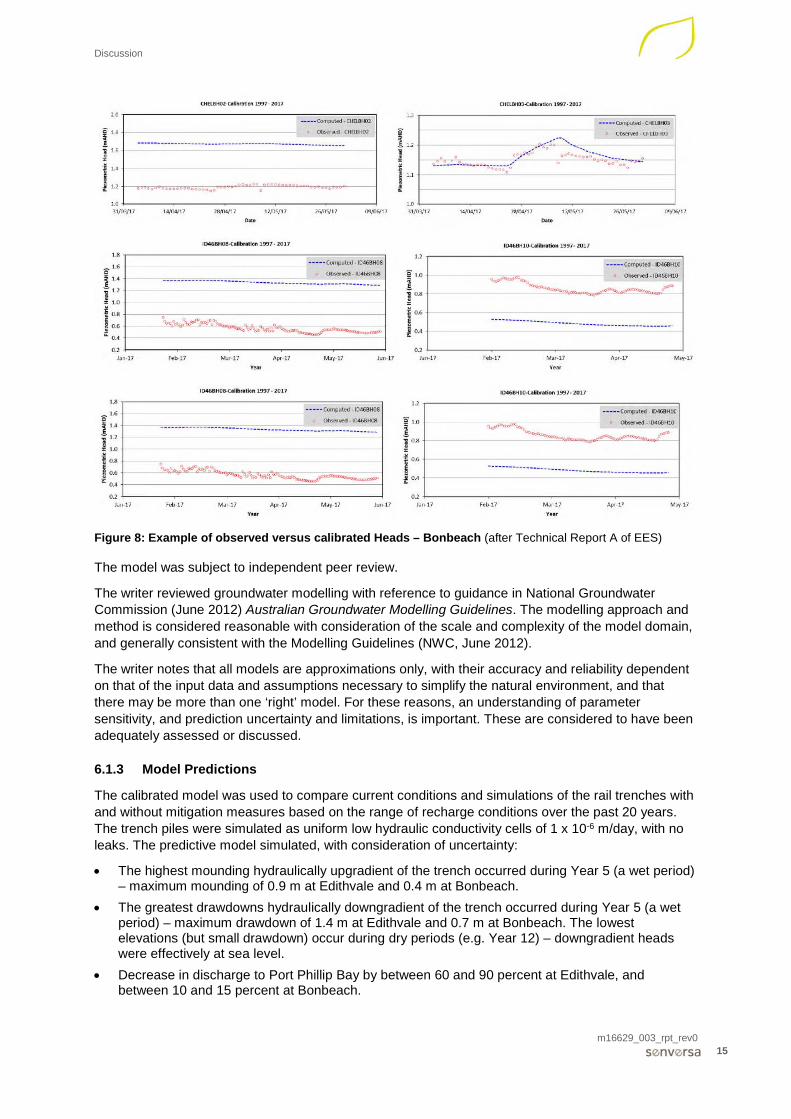
Figure 8: Example of observed versus calibrated Heads – Bonbeach (after Technical Report A of EES)
The model was subject to independent peer review.
The writer reviewed groundwater modelling with reference to guidance in National Groundwater Commission (June 2012) Australian Groundwater Modelling Guidelines. The modelling approach and method is considered reasonable with consideration of the scale and complexity of the model domain, and generally consistent with the Modelling Guidelines (NWC, June 2012).
The writer notes that all models are approximations only, with their accuracy and reliability dependent on that of the input data and assumptions necessary to simplify the natural environment, and that there may be more than one ‘right’ model. For these reasons, an understanding of parameter sensitivity, and prediction uncertainty and limitations, is important. These are considered to have been adequately assessed or discussed.
6.1.3 Model Predictions
The calibrated model was used to compare current conditions and simulations of the rail trenches with and without mitigation measures based on the range of recharge conditions over the past 20 years. The trench piles were simulated as uniform low hydraulic conductivity cells of 1 x 10⁻⁶ m/day, with no leaks. The predictive model simulated, with consideration of uncertainty:
• The highest mounding hydraulically upgradient of the trench occurred during Year 5 (a wet period) – maximum mounding of 0.9 m at Edithvale and 0.4 m at Bonbeach.
• The greatest drawdowns hydraulically downgradient of the trench occurred during Year 5 (a wet period) – maximum drawdown of 1.4 m at Edithvale and 0.7 m at Bonbeach. The lowest elevations (but small drawdown) occur during dry periods (e.g. Year 12) – downgradient heads were effectively at sea level.
• Decrease in discharge to Port Phillip Bay by between 60 and 90 percent at Edithvale, and between 10 and 15 percent at Bonbeach.

Discussion
m16629_003_rpt_rev0 16
• Head changes decrease with distance from the trench, with very minor changes to groundwater discharge to Edithvale wetland – less than 0.1 m head and 0.02 percent discharge increase was predicted at the wetland.
Stochastic predictions were used to assess uncertainty in drawdown and water balance, with ‘best’ (99th) and ‘worst’ (1st) case percentile predictions presented. The uncertainty analysis simulated a slightly larger range of drawdowns/mounding and extent, with a potential mounding of up to 1.5 m at Edithvale. Plans of simulated groundwater heads were not presented, which would have aided in assessment of model predictions.
The model predictions were based on recharge/discharge conditions over the past 20 years. To assess potential impacts of climate change, decreased recharge and increased sea levels were simulated. The simulations predicted decreased discharge, decreased drawdown/mounding at Edithvale and increased drawdown/mounding at Bonbeach due to the climate change assumptions. While the drawdown may decrease in magnitude at Edithvale, the absolute elevations will be lower.
Climate change modelling did not consider whether changes in rainfall intensity / seasonality or evapotranspiration are significant.
The smaller head changes predicted at Bonbeach due to the trench were hypothesised to be due to the orientation of the trench approximately along the groundwater divide in the northern portion, and southerly flow direction towards Patterson River in the southern portion.
Overall, the writer considers the model predictions inclusive of uncertainty are plausible. However, the writer recommends that model verification using additional hydrogeological data local to the sites should be included as part of pre-construction investigations and monitoring programs on the basis of the following:
• The model accuracy is of the same order of magnitude as the absolute drawdown elevations local to the site.
• The supporting hydrogeological investigations were of a regional nature and may not be of sufficient spatial or vertical density, or temporal duration, to have characterised conditions local to the trenches at a sensitivity appropriate for the predicted changes. For example, most monitoring wells are located along the rail alignment, with few transverse locations which mean it is difficult to interpolate the groundwater divide location.
• Review of observed versus predicted hydrographs that show the model reasonably predicts the pattern of changes in groundwater elevations due to stresses (e.g. changes in infiltration), but not the absolute level. This needs to be considered when comparing model predicted heads against elevations of features (e.g. PASS occurrence, abstraction bores, base of wetlands, refer to Section 6.2.3). Consideration should be given to more detailed investigations being completed in the vicinity of any surrounding structures considered sensitive to settlement (refer to Mr John Piper’s report).
• The writer considers that while the conclusions in relation to the hypotheses for the minimal impact predicted at Bonbeach are plausible, there is insufficient information presented (e.g. plans of groundwater heads and flow directions under different stress periods) and further site data (e.g. additional monitoring locations transverse to the trench) would be required, to verify this.
• Domestic and stock water bores were specifically excluded from the model due to an absence of firm data. Groundwater extraction from surrounding wells could influence local shallow groundwater flows, which may be critical to assessing potential impacts to wetlands, groundwater use and changes in contaminant plume behaviour. Consideration of the model sensitivity of shallow groundwater flow to these bores should be considered, and any implications considered in design of mitigation systems. Similarly, the impact of dewatering on surrounding groundwater extraction (i.e. reduction in available drawdown) and use should be considered (refer to Section 6.2.2).
• Leakage through trench piles may occur, which should be assessed via a sensitivity analysis, and any implications considered in design of mitigation systems.

Discussion
m16629_003_rpt_rev0 17
6.1.4 Mitigations
Predictive numerical flow modelling of the horizontal drain mitigation was presented in Appendix H of AECOM/GHD (2018). Model scenarios without the trench (baseline), and with the trench with and without mitigation, were compared.
The model predicted the horizontal drain mitigation system resulted in a reduced extent and magnitude of drawdowns/mounding at Edithvale (maximum of +0.2 / -0.3 m within 50 m of the trench), but an increase at Bonbeach. An uncertainty analysis was not presented.
The model included a conceptual system design as the system design, which has not been finalised. The model assumed an ‘ideal’ scenario - i.e. performance of the drain was not impacted by skin losses, clogging, or blockages within the drain, which could reasonably be expected to occur during drain operation over the long term. The drain may also act as a preferential migration pathway for contaminants in groundwater. Some, but not all, of these aspects were considered qualitatively.
The writer considers that while the concept of a head-equalisation mitigation measure is plausible, there is considerable uncertainty in model predictions of drain performance over the long term. While the EES discusses several aspects to consider in further work to address some of these, the writer suggests (from a modelling perspective):
• Conduct a sensitivity analysis of skin losses / clogging and blockages within the pipe, and hydraulic conductivity of the adjacent aquifer (e.g. potential influence on distribution of flow to the west), and assess uncertainty to confirm that the model conclusions do not detrimentally change.
• Assess the potential for the drain to cause detrimental preferential migration of contaminants in groundwater.
A revised design (if applicable) should be modelled to confirm that the impact assessment conclusions do not detrimentally change.
I note that Mr John Piper reviewed the design and implementation of the mitigation system separately (Senversa, 2018).
6.1.5 Monitoring
The EES requires various groundwater and wetland monitoring and mitigation plans to be prepared, reviewed and implemented. The EES also requires periodic hydrogeological review at 5 and 10 years of operation. The details of the monitoring and mitigation plans, and review, were not provided in the EES.
The writer endorses the VIC EPA submission1 in this regard, and considers that:
• A hydrogeological review be conducted following construction and commissioning of trench and mitigation systems. The review may be targeted and should include model verification.
• There be sufficient planning and preparation of contingency mitigation measures such that they can be implemented within a reasonable timeframe commensurate with that of the residual risk (e.g. impacts of saline intrusion may take a longer time period to propagate than oxidation of ASS due to excessive drawdown).
Additional comments are made in relation to groundwater monitoring and mitigation measures in Mr Piper’s report (Senversa, 2018).
6.2 Implications from Groundwater Elevation Changes
The following aspects include identified risks associated with changes in groundwater elevation caused by the project (i.e. drawdown downgradient of the trench or mounding upgradient of the trench).
1 EPA Victoria, Edithvale – Bonbeach Level Crossing Submission, letter dated 1 May 2018

Discussion
m16629_003_rpt_rev0 18
6.2.1 Groundwater Surface Expression
The model predicted an increase in the frequency, duration and extent of groundwater surface expression events (i.e. water logging) in low lying areas without mitigations. With mitigations at Edithvale, there is predicted to be reduced impacts, and the EES concluded a negligible risk of impact (defined as more than 10% change in drawdown at a well).
The writer considers the assessment approach was reasonable and the conclusions plausible. Due to uncertainty in the model predictions, particularly at the local scale required for water logging assessment, and reliance on performance of the horizontal drain mitigation at Edithvale, monitoring and contingency mitigations as proposed in the EES are considered necessary.
6.2.2 Interference to Local Groundwater Users
Potential long-term interference to local groundwater users was assessed via comparison of modelled groundwater elevations and known or assumed bore depths. The model predicted a decrease in groundwater availability at two stock water or domestic bores (if still present) local to the Edithvale site (with no mitigations), but negligible impact with mitigations.
The writer notes that there may be a significant number of unlicensed domestic and irrigation bores present within the study area. Anecdotal information suggests that there has been a wide-spread historical practice in the area of installation of unlicensed bores for garden irrigation and domestic use. Although unlicensed, impacts on groundwater resource potential of the works may be demonstrated by impacts on any existing groundwater bores. Further assessment of the existence of groundwater extraction wells in close proximity to the works is recommended.
The writer considers the assessment approach was reasonable and the conclusions plausible. Due to uncertainty and accuracy in the model predictions, particularly at the local scale required for assessment of bore interference, and reliance on performance of the horizontal drain mitigation at Edithvale, monitoring and contingency mitigations as proposed in the EES are considered necessary.
Interference during the construction phase was not considered by the writer.
6.2.3 Activation of Acid Sulfate Soils
Lowering of the water table downgradient of the trench could result in activation of potential acid sulfate soil (ASS) through exposure to oxygen. This could result in acidification of groundwater and mobilisation of metals, and impact the beneficial use of groundwater or receiving environment. The EES states there is a high probability of ASS at the study area.
An assessment of ASS was undertaken within the study area. The assessment included a desktop review and limited intrusive investigations. The investigation methodology and report was subject to independent peer review. The writer has not reviewed these investigations in detail.
At Edithvale, ASS was identified at elevations below sea level that would not be impacted by drawdown (which would not be below sea level), and at higher elevations at locations within the area located between Denman Avenue and Bank Road (300 m section). The assessment concluded that drawdown in this area would result in activation of ASS, but that the proposed mitigation (horizontal drain) will result in a negligible risk due to the decreased drawdown. The writer is unclear on whether this assessment assumed maximum predicted drawdown (at Year 5, a wet period) or minimum predicted groundwater elevations (Year 12, a dry period).
At Bonbeach, ASS was identified at elevations below sea level, and at higher elevations at locations within an area near Wimborne Avenue in the north (100 m section) and an area between Denman Avenue and Bank Road in the south (300 m section). The assessment concluded that drawdown in these areas will result in activation of ASS, but that the impacts would be localised, temporary and reversible. The writer is unclear on whether this assessment assumed maximum predicted drawdown (at Year 5, a wet period) or minimum predicted groundwater elevations (Year 12, a dry period), and has not seen information to support the conclusions of temporary and reversible impacts.

Discussion
m16629_003_rpt_rev0 19
Uneven recharge of the water table hydraulically downgradient of the trenches by the proposed horizontal drain structure identified by Mr Piper (Senversa, 2018) may also increase the risk of localised increased levels of water table drawdown.
The assessment of potential impact of drawdown on coastal ASS is considered reasonable and the conclusions plausible. Due to uncertainty in the drawdown predictions, particularly at the local scale required for assessment of ASS impacts, and reliance on performance of the horizontal drain mitigation at Edithvale, monitoring and development of contingency mitigations as proposed in the EES are considered necessary. Due to uncertainty in the drawdown predictions, particularly at the local scale required for assessment of ASS impacts, and identified risk of localised impacts at Bonbeach, monitoring and contingency mitigations as proposed in the EES are considered necessary.
6.2.4 Contaminant migration
Review of contamination issues is provided separately by Mr Piprer, (Senversa, 2018).
The writer endorses the EPA Victoria submission1 with regard to further assessment of contamination conditions. The writer also considers the following necessary:
• Further assessment of the potential change in contamination distribution and migration due to the horizontal drain mitigation measure at Edithvale.
• Further site data (e.g. additional monitoring locations transverse to the trench) and assessment to confirm that Bonbeach trench will have negligible impact on contaminant distribution and migration.
6.3 Implications for Salt Water Intrusion
Increased drawdown and lower groundwater elevations west of the trench may result in the inland migration of saline water (i.e. the salt water – groundwater interface) from Port Phillip Bay. This may affect beneficial use of groundwater resources in the Quaternary and Brighton Group Aquifers. Saline intrusion in the study area is likely to be complex, and spatially and temporally variable.
To assess this potential impact, a two-dimensional density driven flow model using FEFLOW was developed to assess the potential effects from the project on intrusion of saline water. The model simulated quasi steady-state conditions at a cross-sectional transect at each site (i.e. what may be representative of long-term conditions). There was limited site information to calibrate the model, and the model necessarily assumes some gross simplifications of the likely environment. The modelling did not consider temporal effects (e.g. variable recharge, changing heads) and did not assess sensitivity or predictive uncertainty. The calibrated model tended to under-predict current total dissolved solids (TDS) concentrations, though they were of the same order of magnitude.
The model predicted that without mitigation, the project would result in a slow (relative to changes in climate and sea levels) upward movement of the salt water – groundwater interface over decades, and a long-term increase in TDS of the QA downgradient of the trench by about 500 mg/L. The EES suggests that the predicted change due to the project is likely within that of the natural seasonal range, and although this is considered plausible, this has not been assessed. The model predicted increased saline intrusion under the climate change scenario.
The modelling predicted relative less impact on deeper aquifer units.
The model did not assess the trench with horizontal drain mitigation, but the EES qualitatively assessed the residual impact as negligible.
The model did not consider potential compounding affects associated with existing groundwater extraction practices associated with unlicensed wells occurring between the site and Port Phillip Bay. Existing groundwater extraction may significantly increase the potential for salt water intrusion into aquifers associated with the proposed structures. It is recommended that further assessment of existing groundwater extraction between the trenches and Port Phillip is undertaken.

Discussion
m16629_003_rpt_rev0 20
The writer considered the modelling has been conducted in an adequate manner, and is appropriate for semi-quantitative use in conjunction with the CM and numerical flow model. The impact assessment conclusion is considered plausible. Due to uncertainty and level of accuracy similar to predicted impacts, monitoring and contingency mitigations as proposed in the EES are considered necessary.
The writer acknowledges VIC EPA submission in relation to the impact on groundwater segments.
6.4 Implications for Edithvale Wetland
A transient water balance model of Edithvale wetlands developed using ‘Source’ program to assess potential changes in water levels, extent and quality caused by the project. Inflows to the wetland include surface runoff, rainfall and shallow groundwater discharge. Outflows include evapotranspiration, discharge to the drain, and discharge to shallow groundwater.
The water balance model used groundwater fluxes to the wetland simulated in the numerical flow model (Section 6.1). The model incorporated modelled surface elevation data (LIDAR and bathymetry), a hydraulic model (HEC-RAS) to simulate flow between wetland cells, assumed bed storage, regional rainfall and evaporation data, and hydrology model (SIMHYD) to simulate surface runoff – these were not presented and have not been reviewed.
The model was calibrated manually and then using PEST to vary key parameters within plausible ranges (based on field or literature values) to fit temporal wetland water levels at three gauges, water quality (TDS) and surface runoff (against that in the groundwater flow model). Calibration performance was also assessed by comparison of observed and modelled extents of wetted areas.
The calibrated model reasonably predicted the temporal pattern of wetting and drying cycles. Calibrated water elevations and wetted extents were similar to observations during wet and dry periods at the southern wetland cell (ES1). A poorer calibration was achieved for northern cells (EN2, EN3), with the model reasonably predicting the pattern of changing water levels, but tending to overpredict the absolute elevation and wetted extent. Calibrated surface runoff reasonably matched that of the groundwater flow model. A poorer calibration for water quality (TDS) was achieved, likely reflecting the complex temporal processes that could influence TDS concentrations.
A water balance was presented. There was insufficient detail presented in the groundwater model report to allow comparison.
Uncertainty in groundwater fluxes to the wetland was incorporated. However, uncertainty in other parameters was not assessed or presented.
Overall, the modelling approach and method is considered reasonable with consideration of the complexity of the wetland system. Model predictions of the temporal pattern of water levels and water extent are considered reasonable estimations and appropriate for use in conjunction with the CM and numerical flow model. Caution should be applied in use of the predictions for water quality.
The principal conceptual mechanism for the project to impact the wetlands is via the nature and magnitude of changes in groundwater elevations at, and discharge to, the wetland. On this basis, and since the groundwater flow model predicts negligible impact on groundwater elevations at (and discharge to) the wetland, the water balance model is considered less critical to assess the hydrogeological impacts of the project. If this changes then further assessment of model sensitivity and prediction uncertainty should be conducted.

Conclusions
m16629_003_rpt_rev0 21
7.0 Conclusions
None of the identified issues would prevent the construction of the level crossings at Edithvale or Bonbeach. It is considered essential that the uncertainty and limitations of the hydrogeological model and predictions be considered in monitoring and detailed design of mitigation measures. Further detailed investigation of hydrogeological conditions, existing groundwater use and effectiveness of mitigations measures (i.e. the horizontal drain) are recommended.
The writer agrees with the EPA and LXRA proposal on an independent reviewer and independent EPA Environmental auditor appointed under Section 53 of the EPA act be appointed to ensure that the further assessment, identified mitigation and design issues are carried through into the design and construction to ensure that the monitoring and any mitigation measures are appropriately implemented within a suitable time frame.

Declaration
m16629_003_rpt_rev0 22
8.0 Declaration
I, Andrei Woinarski, have made all inquiries I believe are desirable and appropriate based on the readily available information, and that no matters of significance that I regard as relevant have to my knowledge been withheld from this report.

References
m16629_003_rpt_rev0 23
9.0 References
Edithvale and Bonbeach Level Crossing Removal Projects, Environment Effects Statement, Technical Report A Groundwater Impact Assessment, LXRA-LX31-00-GE-EES-0001, Revision: 1, February 2018 (AECOM/GHD, 2018)
Geological Survey, Cranbourne Geological Map, 1:63,360
Leonard J.G., Preliminary Assessment of the Groundwater Resources in the Port Philip Region, Geological Survey report, No 66, 1979
National Groundwater Commission (June 2012) Australian Groundwater Modelling Guidelines.
Senversa (2018). Geotechnical, Contaminated Land and Soil Vapour Review of the Environmental Effects Statement - Edithvale and Bonbeach Level crossings. 25 May 2018

Appendix A: Curriculum Vitae
m16629_003_rpt_rev0
Appendix A: Curriculum Vitae

Andrei Woinarski_CV_May2018 May 2018 Page 1 of 8
Dr Andrei Woinarski Principal Qualifications & Certifications
Doctor of Philosophy, University of Melbourne, 2004 Bachelor of Engineering (Environmental; Hons 1), University of Wollongong, 1999
Career Profile
Andrei Woinarski is an environmental engineer / hydrogeologist approaching 20 years’ experience working in the contaminated land management / remediation
and research industry. Andrei has been largely based in Sydney through his consulting career, though has worked on projects throughout Australia, southeast Asia and California, USA
As a consultant, he has fulfilled the role of project manager, hydrogeologist, technical or project director on hundreds of small to large scale contaminated land assessment projects, with a particular focus on conceptual site model development and contaminant hydrogeology. These have included a range of natural site settings and media, and contaminants including: chlorinated hydrocarbons, petroleum hydrocarbons; heavy metals; nutrients; asbestos; and, recalcitrant compounds such as per- and poly-fluorinated alkyl substances.
Andrei has been involved as the hydrogeologist or managed remediation works including the large-scale hydraulic containment systems at Orica Botany, in situ geochemical fixation, containment walls/cells, soil excavation, in situ bioremediation, natural source zone depletion, natural attenuation, chemical oxidation and numerous small-scale pump-and-treat systems. With his scientific and engineering background, he has a diverse skillset and range of experience, often providing internal technical support to projects and external advice to clients across a range of environmental issues for pre-purchase and divestment due diligence purposes, including identification of liabilities and opportunities, provision of management strategies and probabilistic cost estimation.
Andrei has worked across most industry sectors including industrial, mining and minerals processing, defence, land development and petroleum sectors in Australia. Examples include assessment of contamination issues at a portfolio of properties for Suez, Orica Botany groundwater clean-up and mercury remediation, Orica Kooragang Island arsenic and nutrient assessment and remediation, Port Kembla Copper, Chatree Goldmine risk advice, and Glencore Townsville Copper Refinery assessment and closure planning.
More recently, Andrei has provided technical peer review or independent advice, including: supporting Audits of Nyrstar Port Pirie, various sites at Kwinana, WA and Veranus Island, WA; assessment of Pasminco Cockle Creek liabilities; expert witness support in Land and Environment Court NSW proceedings.
Expertise
Contamination land assessment
Contaminant hydrogeology
Contamination management/remediation
Technical auditing and peer review
Key Industry Sectors
Mining and Minerals Processing
Industrial / Manufacturing
Land Development
Petroleum
Government – local, State, Federal
Employment History
Jun 2016 (current): Senversa Pty Ltd
Jul 2014 to May 2016: JBS&G Australia Pty Ltd
Feb 2010 to Jun 2014: Golder Associates Pty Ltd
2008 to Jan 2010: URS Corporation (USA)
2004 to 2008: URS Australia Pty Ltd
2000 to 2002: Australian Antarctic Division and Queens University
Memberships
Australian Land and Groundwater Association (ALGA)
ALGA Special Interest Group – Groundwater Fate and Transport
International Association of Hydrogeologists (IAH)
Professional Training & Development
• HAZWOPER 24 Hour Health and Safety Training, 2004
• General construction OHS training, SafeWork NSW, 2004 (White Card)
• Peer reviewer for various publications, including Cold Regions Science and Technology

Dr Andrei Woinarski Senior Associate Environmental Engineer
Andrei Woinarski_CV_May2018 May 2018 Page 2 of 8
Project Experience
CONTAMINANT FATE AND TRANSPORT
Andrei has been responsible for and/or provided technical direction in developing conceptual site models and undertaking contaminant hydrogeology and geochemistry assessments at numerous sites to support risk assessment and management/remediation. These have considered contamination by heavy metals, arsenic, hexavalent chromium, recalcitrant organic compounds (including solvents), petroleum hydrocarbons and nutrients. Key projects include:
• Robertson Barracks, NT (2017-ongoing): Internal peer review of hydrogeological assessment plans and documentation of interpretations, and provision of technical support to field staff conducting works, for a large-scale PFAS assessment at the Defence site.
• RAAF Base East Sale, VIC (2016): Internal hydrogeological review and technical support to field staff in assessing and interpreting hydrogeology and geochemistry for a large-scale PFAS assessment at the Defence site.
• Technical peer review, various sites (2016- ongoing): Provided contaminant hydrogeology expert advice supporting Site Auditor / Technical Advisor reviews for multiple projects. This has included peer review of: groundwater modelling and conceptual site model (CSM) for RAAF Base Pearce; nutrient assessment and modelling and remediation planning/design at Bis Industries, Kwinana WA; CSM for Alcoa refinery, Kwinana WA; Iluka Narngulu fate and transport model (for B, NH4
+, TDS); LNAPL fate and transport at retail petroleum sites in Armadale WA, Caltex Brighton SA, BP Frankston South VIC; hydrogeology and LNAPL behaviour at Veranus Island and Barrow Island, WA; review of background soil and groundwater concentrations and application in assessing ecological risks at Barrow Island, WA.
• Nyrstar, Port Pirie, SA (2016-ongoing): Assisting the audit of contamination assessment and remediation program at the operating smelter by providing technical review of documents in relation to source characterisation, hydrogeology, hydrology, contaminant fate and transport, and water treatment/management. Contaminants included zinc, lead, cadmium and acidic groundwater, with key issues relating to groundwater migration, assimilative capacity of the aquifer and groundwater – surface water interactions.
• Former gasworks, Newcastle, NSW (2016): Contaminant hydrogeologist with responsibility to develop a CSM and conduct a Tier 1/2 environmental risk assessment associated with potential migration of contaminants in groundwater and discharge into a surface water system for the former gasworks to meet requirements of a VMP and support remediation planning.
• Chatree goldmine, Thailand (2014-2015): Conducted a technical review of environmental and community health monitoring data, site inspections and an audit of the monitoring program at an operating gold mine in Thailand. The objectives of the work were to assess whether arsenic in the local community/environment was related to mine activities, which had resulted in forced mine closure. Developed a program of works to assess community health, and worked with the client’s community consultation team to communicate actual risks. Involved leading technical aspects of collaborative work with the client, Thai universities and health experts, with particular consideration of Thai political and social frameworks, within a high-pressure work environment.
• Orica Kooragang Island, Newcastle, QLD (2010-2014): Former operations at the facility had resulted in arsenic and ammonium nitrate impacts to groundwater. Acted in various roles either acting as technical lead/peer review on behalf of the client or providing technical direction as a hydrogeologist and remediation engineer:
o Assessment of fate and transport mechanisms of arsenic in the subsurface at the ammonium nitrate manufacturing facility. This included: developing or reviewing site investigation and remediation feasibility assessment programs; conducting and reviewing monitoring programs; assessment of geochemistry, assimilative capacity, and groundwater – surface water interactions.
o Responsible for the assessment of fate and transport mechanisms of nutrients and acids in the subsurface at the facility.
o Reviewed numerical groundwater flow and solute transport models.
o Responsible for, and key author of, a CSM for arsenic and nutrient contamination at the site. The model has been used to support subsequent risk assessments, remediation works and ongoing management of contamination issues.
• Xstrata/Glencore copper refinery, Townsville, QLD (2012-2013): Project manager / principal investigator in work supporting closure planning of a copper refinery in North Queensland. Tasks and roles included:
o Characterisation and assessment of contamination sources, fate and transport of heavy metals, arsenic, ammonium and other contaminants as part of a program of site investigation and closure planning.
o Developing a CSM for metals, nutrients and other physicochemical vectors.

Dr Andrei Woinarski Senior Associate Environmental Engineer
Andrei Woinarski_CV_May2018 May 2018 Page 3 of 8
Project Experience
• Orica Botany, NSW (2006-ongoing): Long-term site hydrogeologist assisting the client to assess and manage various groundwater contamination issues associated with former operations at the Orica Botany chemical manufacturing facility. Roles and works in relation to fate and transport have included:
o Prepared a CSM focusing on hydrogeology, fate and transport of DNAPL, soil and dissolved phase chlorinated compounds and mercury to support risk assessments, investigations and remediation planning (most recent version in Sep 2017).
o Hydrogeological assessment of aquifer assimilation capacity for chlorinated compounds, including fate and transport mechanisms.
o Reviewed groundwater flow and solute (chlorinated solvents, mercury) transport models prepared by other consultants.
o Conducted contaminant mass and flux assessments.
• Former RailCorp site, Turrella, NSW (2015): Developed a CSM for a PCE/TCE contaminated site leased as a chemical distribution facility to assist RailCorp with their corporate risk management and meet regulator expectations.
• Orica Yarraville, VIC (2011): Hydrogeologist who was one of two key authors in preparing a CSM for a large chemical/industrial site with DNAPL, soil and dissolved phase pesticides, nitrogenated organics and chlorinated compounds. The model was used to support the CUTEP process.
• Modelling (various projects): Reviewed groundwater flow and solute transport models at various sites, and have undertaken basic fate and transport or geochemical models/tools (e.g. PHREEQC, BIOCHLOR, BIOPLUME, BIOSCREEN, SourceDK) and aquifer tests (Aqtesolve).
REMEDIATION
Andrei has been involved with numerous groundwater remediation projects typically as project manager, remediation engineer and/or hydrogeology lead, particularly at the front-end of projects (i.e. strategy, planning and design phases). In recent years, Andrei has also acted as project director. Key projects include:
• Former gasworks, Wollongong NSW (2018-ongoing): Technical direction for the project to carry out a HHERA and develop a RAP. Acted as key author of a SAQP for targeted site investigations and developed a CSM. The site is subject to a site audit.
• Former industrial waste disposal site, Lucas Heights, NSW (2017-ongoing): Provision of technical hydrogeological and remediation support via review of documents, participating in workshops to develop remedial and procurement strategies. Documents reviewed have included monitoring plans, responses to Auditor comments, and options assessments.
• Former industrial facility, Wickham NSW (2017-ongoing): Project manager of investigation and groundwater monitoring works in relation to remediation of metals and petroleum hydrocarbon impacts for redevelopment of the former warehousing and wool store site. The project is made more complex by the presence of LNAPL impacts associated with off-site sources, and additional work has included review of third-party reports and provision of technical advice in relation to project risks from the LNAPL.
• Lawrence Dry Cleaners, NSW (2016-ongoing): Project manager and remediation engineer for an enhanced in situ bioremediation system to remediate chlorinated solvent impacts associated with a former dry-cleaning facility. Responsible for all aspects of the project including: operation and maintenance of a pump and treat system; surface water, groundwater, soil vapour, ambient air and personnel monitoring; key author for all reports; stakeholder engagement including the client, client’s legal team,
tenant’s and regulators; targeted site investigations; in situ bioremediation works and remediation trials. The site is subject to regulation by the EPA.
• Port Kembla Copper, NSW (2017-ongoing): Remediation engineer supporting works assessing residual contamination in surface water, stormwater, sediments and shallow groundwater to support closure of the former smelter and associated slag landfills. This has included acting as project manager and developing, in conjunction with the project director: surface water, groundwater and soil assessment work plans and subsequent implementation; monitoring programs; data review; and assessment of remedial/management options. The site is subject to regulation by EPA.
• Technical peer review, various sites (2016- ongoing): Provided remediation expert advice supporting Site Auditor / Technical Advisor reviews for multiple projects. This has included peer review of: remediation planning/design at Bis Industries, Kwinana WA; review of RAP for former Akzo Nobel site at Camelia NSW; LNAPL pumping tests and analyses at Varanus Island, WA; review of LNAPL remediation system and costing at Wickham, NSW; groundwater remediation and management plans at Nyrstar Port Pirie, SA.
• Western Sydney Stadium, NSW (2017): Provided due diligence advice to Lend Lease in relation to contamination liabilities with the site and development for their bid. Reviewed the RAP and validation SAQP, and ongoing involvement in troubleshooting and auditor engagement. The site is subject to a site audit.
• Former fire-fighting training facility, VIC (2016-2017): Reviewed site information in relation to PFAS impacts at a large-scale former fire-fighting training facility. On the basis of this, conducted a desktop remedial options feasibility assessment following

Dr Andrei Woinarski Senior Associate Environmental Engineer
Andrei Woinarski_CV_May2018 May 2018 Page 4 of 8
Project Experience
USEPA CERCLA and State guidance to identify a preferred remedial/management approach – this approach has been applied by the client at other sites across Victoria. This has supported further remediation planning and design work for a containment type remediation approach. The site was subject to a site audit and EPA involvement.
• Carpet manufacturing site, VIC (2016 - ongoing): Strategic review of management/remediation approaches for a former carpet manufacturing site in Melbourne impacted with PCE in soil and groundwater, and subject to a site audit. Developed a remediation/management approach and conducted probabilistic cost estimation using Monte Carlo methods to assess likely costs.
• Australian Technology Park, NSW (2015-2016): Project director for project providing remediation planning and approvals due diligence advice at the client’s bid stage; and directed/reviewed subsequent contamination investigation, quantitative risk assessment and RAP for the redevelopment of the former industrial site. Developed an approach that saved significant remediation costs which enabled the client to win the development project tender. Remediation consists of on-site retention of impacted materials. The site was subject to a site audit.
• Former Orica site, Villawood NSW (2014-2015): Project director for remediation validation, asbestos clearance and monitoring services for a large-scale DDX, VOC, mercury and asbestos soil remediation (on-site thermal desorption) project at the former pesticide manufacturing facility. Key author for the draft remediation validation report.
• Former Email site, Pagewood NSW (2014): Project manager for the finalisation of a RAP, supporting contamination assessments and provision of ad-hoc advice in relation to remedial for a proposed redevelopment at a former PCE/TCE impacted industrial site.
• Barangaroo Central, Sydney NSW (2014): Assisted in providing advice to BDA for site contamination issues and assistance with remediation planning and tendering process for Barangaroo Central.
• Boral Nelsons Ridge, NSW (2014): Project manager and finalisation of remediation planning documents and supporting soil, groundwater and soil vapour assessments of VOC and TPH impacts for site redevelopment. Also responsible for auditor engagement.
• Former Akzo Nobel site, Sydney NSW (2012-2014): Project manager and remediation engineer for various projects managing issues associated with hexavalent chromium and chlorinated hydrocarbon contamination in soil, groundwater and stormwater at a former industrial facility. Tasks/roles included: review of site information and provision of technical advice to support long-term site management and property divestment strategies; managing and conducting operation and maintenance of a groundwater treatment plant; managing compliance monitoring of stormwater, groundwater and treatment plant discharge.
• Xstrata/Glencore copper refinery, Townsville QLD (2012-2013): Project manager / principal investigator in work supporting closure planning of a copper refinery in North Queensland. Remediation tasks and roles included:
o Assessing current remediation systems, which included a containment cell, and pump and treatment system.
o Developing cost forecasts for various remedial/management scenarios.
o Supported the client’s environment team in internally communicating the findings of this project and closure planning.
• Integral Energy depot, Fairfield NSW (2010): Project managed targeted site investigations of soil, soil vapour and groundwater and prepared a RAP for creosote soil contamination beneath residential properties associated with a former adjacent electrical substation depot.
• Orica Botany, NSW (2005-2016): o 2012-ongoing: Presenter and participant in various stakeholder workshops/seminars, and collaborative work with client and
their specialist consultants/contractors. Assisted client in developing long-term groundwater remediation.
o 2005-2016: Hydrogeologist/engineer managing collection and assessment of pumping data, treatment plant flow data, and data from loggers / pressure transducers and provision of hydrogeological advice to assist in optimisation of the pump-and-treat system and system troubleshooting.
o 2012-ongoing: Ongoing consulting advice and technical review in relation to works associated with development of long-term chlorinated solvent contamination remediation strategies and management for the Orica Botany site.
o 2010: Conducted a trial of groundwater injection and recovery system. Tasks include well rehabilitation, aquifer tests, monitoring, well fouling mitigation and injection trials.
o 2005-2008: Hydrogeologist for several large-scale chlorinated solvent DNAPL remediation projects in the conceptual design and field and/or laboratory feasibility trial phases, including: managing site investigations; collection of DNAPL, soil and groundwater samples for trial purposes; preparing DSI reports; providing site information to, and reviewing, third-party reports from remediation vendors. DNAPL remediation technologies assessed included direct recovery, in-situ chemical oxidation and thermal treatment technologies.

Dr Andrei Woinarski Senior Associate Environmental Engineer
Andrei Woinarski_CV_May2018 May 2018 Page 5 of 8
Project Experience
o 2004-2012: Oversight of construction and commissioning of a large (>120 extraction and monitoring wells) hydraulic containment barrier system (subsurface components). Ongoing role conducting well rehabilitation, including chemical, physical and biological assessment, at production bores with biological and physical fouling.
• Orica Kooragang Island, Newcastle NSW (2011-2014): o Seconded with the client to provide advice, strategy and planning input, technical review of deliverables from client’s other
consultants, and preparation of reports for issue to regulators in relation to various arsenic (in situ fixation, containment, PRBs, MNA, pump-and-treat) and nutrient contamination remediation projects at an ammonium nitrate manufacturing facility.
o Acted as a contaminant hydrogeologist and key report author for a treatability study and feasibility assessment of in situ geochemical fixation remediation for arsenic impacted groundwater.
o Concept design of a containment system for arsenic impacts.
o Directed site assessment, remediation planning, system design and implementation of a pump and treat system for a nitric acid plume.
• Former ChlorAlkali Plant, Botany NSW (2011-2013): Remediation engineer / hydrogeologist and key author for a feasibility assessment of soil and groundwater mercury remediation options, and preparation of RAP for a containment approach for the former ChlorAlkali Plant. The feasibility assessment and RAP were subject to peer review by an international expert and Site Auditor.
• Ammonium nitrate and cyanide production facility, Gladstone QLD (2011): Managed a remediation project for cyanide, ammonia and nitrate impacted groundwater and stormwater including: remedial options review, advice for the selection of a preferred approach and design of a hydraulic containment system. Also conducted a review of ex situ treatment and reuse options for cyanide impacted soil.
• Trans Bay Cable Project, CA USA (2009): Provided environmental oversight of construction and hazardous waste management for a construction project at a former gasworks site in San Francisco.
• Golden Eagle Refinery, CA USA (2008-2009): Field engineer assisting with management and troubleshooting for the operation and maintenance of a large-scale (>30 pumping wells and 1 km of piping) LNAPL recovery system. Role involved task management, subcontractor management, health and safety oversight, system inspections, remediation system design, LNAPL recovery tests.
• Antarctica, Sub-Antarctic and Arctic (2000-2004): PhD related work with University of Melbourne and Australian Antarctic Division included investigation and pilot trial of remediation strategies such as pump-and-treat, PRBs and in-situ chemical oxidation for management of several petroleum, heavy metal and PCB contaminated sites at Casey and Wilkes Stations in Antarctica, Macquarie Island and Resolution Island, Canada. This involved working with a diverse team of scientists, engineers and managers in all aspects of the project from design, planning, laboratory and field studies to implementation.
ENVIRONMENTAL SITE ASSESSMENTS
Andrei has conducted or been responsible for the delivery and project management of numerous Brownfields environmental site assessments in Australia. These have ranged from small (<$50k) to several large (>$500k) projects typically used to support contamination management, meet regulatory requirements, property transactions and land redevelopment. Andrei has also acted as lead contaminant hydrogeologist on a number of these projects. Key projects in addition to those mentioned above include:
• Multiple Dulux industrial facilities, NSW (2017-ongoing): Technical director for contamination assessment, and surface water and groundwater monitoring programs at Dulux’s NSW sites. Also prepared management plans and monitoring programs.
• PFAS assessment – large industrial facility, NSW (2016-2017): Project manager for a groundwater and soil seepage PFAS investigations at a large heavy industrial facility in NSW to support internal due diligence and legal advice in relation to PFAS liabilities.
• Portfolio of waste processing facilities, Australia (2016): Peer review of deliverables for a project providing due diligence services to a client to support the sale of a portfolio of industrial facilities across Australia. Deliverables included documentation of preliminary and limited detailed (soil, groundwater, surface water, soil vapour) assessments.
• Commercial/industrial site investigation, Marrickville NSW (2016): Project manager of a preliminary desktop and detailed site investigation (soil, soil vapour and groundwater) and reporting at a mixed use commercial and industrial site at Carrington Road, Marrickville. The investigations were conducted to inform remediation planning and master planning for development of the site.

Dr Andrei Woinarski Senior Associate Environmental Engineer
Andrei Woinarski_CV_May2018 May 2018 Page 6 of 8
Project Experience
• Former Koltex site, Leichhardt NSW (2015-2016): Project manager and hydrogeologist for a project to undertake site investigations (soil, soil vapour and groundwater), development a conceptual site model, preparation of remediation work plans, waste classifications and stakeholder liaison to support remediation and audit of the development site.
• Former Taubmans site, St Peters NSW (2015-2016): Project manager and directed provision of due diligence advice, site investigations (soil, soil vapour and groundwater), development an initial conceptual site model, engagement with EPA to support contamination aspects of the development planning. Issues were related to chlorinated solvents in groundwater, and other contamination issues common to urban industrial sites.
• Multiple former commercial/industrial brownfield sites, NSW (2004-ongoing): Acted variously as project director, project manager or oversight of field programs for environmental investigations (soil, soil vapour and groundwater) at other properties in Sydney, Newcastle and ACT - typically related to due diligence assessments, property transactions or contamination management at former industrial sites and retail petroleum sites. These include BlueScope Erskine Park NSW, RMS Matraville NSW, illegal filling at Kentlyn NSW, various Mobil sites in ACT and NSW.
• Orica Kooragang Island, NSW (2010-2014): Project manager for site investigations in relation to assessment of nutrients and nitric acid impacts. Also was the author for groundwater monitoring programs, an environment management plan and conducted groundwater monitoring in relation to arsenic groundwater impacts.
• Xstrata/Glencore copper refinery, Townsville QLD (2010-2013): Project manager and principal investigator for environmental contamination investigations at the site. This included a program of soil bores, groundwater wells, well repair/redevelopment, groundwater and surface water monitoring and reporting. The investigations supported development of a CSM and data gaps assessment for closure planning.
• Orica Botany, NSW (2004-2009): Acted as the project manager or lead field investigator for a series of DNAPL source area assessments and large-scale chemical and hydraulic monitoring programs (>100 monitoring locations) to characterise geology, hydrology, contaminant fate and transport, and inputs into assessment of risks to environment and human health from chlorinated hydrocarbons in the subsurface associated with a large chemical industrial site. Roles and responsibilities consisted of:
o Project management of monitoring programs.
o Key author for groundwater monitoring and assessment programs.
o Oversight of installation of a large network of bundled piezometers and monitoring wells.
o Conducted DNAPL source area field investigations.
o Hydraulic well and aquifer tests (slug, DNAPL recovery) and interpretation.
o Conducted intrusive and down-hole geophysical testing.
o Installation and maintenance of a hydraulic monitoring system of pressure transducers and loggers.
o Key author of reports, including hydrogeological and geochemical components and interpretations.
• Resolution Island / Queens University, Canada (2001): Provided scientific advice, field analytical services, remediation oversight and health and safety supervision for a large remediation project at a DEW-line site with sediments and groundwater contaminated with PCBs.
DUE DILIGENCE AND EXPERT OPINION / REVIEW
In addition to providing technical support and peer review to site audits, Andrei has provided due diligence advice to support property or company acquisitions or purchase of development rights of industrial and brownfield sites. These have typically involved review of third party information (and occasionally supporting site investigations). For advice relating to land development, consideration of development constraints and opportunities has been made. Andrei has also provided independent review of available information to support client’s internal risk management and help with community communications in the upstream oil and gas and mining sectors. Examples include:
• Pasminco Cockle Creek, NSW (2018): Lead author / reviewer for the assessment of long-term liabilities associated with the containment cell to support NSW Department of Environment and Planning project approvals.
• Expert support, Land and Environment Court (2017): Provided expert evidence to support proceedings involving illegal waste disposal at a site in western Sydney. The waste had principally impacted on Aboriginal heritage and environmental values.
• Various industrial brownfield Sites, NSW (2014-ongoing): Provided due diligence advice in relation to acquisition of industrial, commercial and brownfield properties for redevelopment. Clients have included major land developers, industrial companies and retail companies. The sites typically were potentially impacted with chlorinated solvents, petroleum hydrocarbons, asbestos and metals. Site have included various properties in Redfern, St Peters, Marrickville, Kings Park, Hurstville, Sydney Olympic Park. These have often led to further assessment, involvement in structure planning, remediation planning and remediation works.

Dr Andrei Woinarski Senior Associate Environmental Engineer
Andrei Woinarski_CV_May2018 May 2018 Page 7 of 8
Project Experience
• Confidential LNG Site, PNG (2015): Technical review / due diligence assessment of environmental and process information to assist client in assessing risks associated with a condensate release at a gas processing facility.
• Orica Kooragang Island, Newcastle NSW (2014-2015): Management and preparation of reports required for PRPs under an EPL for a public/regulatory audience. Involved working with client engineers and management to distil technical process/engineering information from a broad range of process plant cleaner-production projects into a document suitable for the targeted audience.
WATER TREATMENT & MANAGEMENT
Andrei has been involved in water treatment and management projects in conjunction with contaminated site assessments. These have included at the front end of projects assisting clients in developing strategies to manage wastewater at industrial sites, and being responsible for concept design, and operation and maintenance, of small to mid-sized groundwater treatment plants for organic contaminants, cyanide, chromium, low pH and nutrients. Key projects include: • PFAS water treatment option feasibility review, VIC (2017): Assisted in review of PFAS water treatment technologies and
initial feasibility assessment for a former fire training facility.
• Groundwater pump and treat systems, various sites NSW (2010-ongoing): Project manager or principal engineer for the operation, maintenance and monitoring of groundwater pump and treat systems – including: PCE impacted groundwater at Lawrence Dry Cleaners, NSW; chromium (VI) and chlorinated methanes at for AkzoNobel site, Camellia NSW; acidic groundwater at Orica Kooragang Island, NSW; metals and PCE impacted groundwater former Koltex site, NSW; TCE impacted groundwater at a metals manufacturing facility, Penrith NSW. Have also been responsible for overall concept design, procurement and commissioning for the plant at the former Koltex site.
• Orica Yarwun AN and Cyanide Production Facility, QLD (2010-2013): o 2013: Project Manager and engineering consultation to assess stormwater management and treatment options for cyanide
and nutrients (see below). This also included working with hydraulic engineers and modellers for stormwater capture and retention system design, assessment of runoff hydrographs and water quality, review and development of nutrient and cyanide treatment options, including trial of cyanide biological treatment.
o 2010-2012: Project Manager and engineer for an ongoing project to assist the client in managing industrial effluent issues at the facility, and potential integration with groundwater remediation systems. This involved developing management strategies, characterisation of effluent system and waste streams, identification of preferred treatment options, a feasibility assessment, treatability trials, costing and design. Constituents include ammonia, nitrate, cyanide, metals and phosphates. Also involved compliance monitoring and licensing.
• Selenium Water Treatment, Port Kembla Copper, NSW (2011): Review of performance of water runoff capture systems, a water treatment plant and desktop feasibility study of treatment alternatives for selenium at a former copper smelter being decommissioned.
• University of Melbourne, VIC (2000-2003): In PhD related work conducted research into using ion exchange resins and zeolites for treatment of heavy metals in waters.
Publications
REFEREED JOURNAL ARTICLES • Woinarski, A.Z. et al. A natural zeolite permeable reactive barrier to treat heavy-metal contaminated waters in Antarctica: Fixed-
bed ion exchange studies. Process Safety and Environmental Protection, 84(2) (2006), 109-116.
• Ferguson, S.H., A.Z. Woinarski et al. A Field Trial of In Situ Chemical Oxidation (ICO) to Remediate long-term Diesel Contaminated Antarctic Sediments. Cold Regions Science and Technology, 40 (2004), 47-60.
• Woinarski, A.Z. The effects of cold temperature on copper ion exchange by natural zeolite for use in a permeable reactive barrier in Antarctica. Cold Regions Science and Technology, 37(2) (2003), 159-168.
OTHER • Eleventh International Conference on Remediation of Chlorinated and Recalcitrant Compounds (‘Battelle’), April 8-12 2018 -
Insights on Risk-Reduction Mechanisms from 12 Years’ Operation of a Pump-and-Treat System at the Botany Chlorinated
Hydrocarbon ‘Mega-Site’. G. Dasey, A. Woinarski, and S. Corish

Dr Andrei Woinarski Senior Associate Environmental Engineer
Andrei Woinarski_CV_May2018 May 2018 Page 8 of 8
Project Experience
• Eleventh International Conference on Remediation of Chlorinated and Recalcitrant Compounds (‘Battelle’), April 8-12 2018 - Evolution of a Conceptual Site Model for the Botany Chlorinated Hydrocarbon ‘Mega-Site’ Clean-Up Project. A. Woinarski, G. Dasey, and J. Stening
• Stevens, G.W, A.Z Woinarski et al. Penguins, pollution and chemical engineering in Antarctica, The Chemical Engineer. 2004
• Woinarski, A.Z. 2004. Development of a natural zeolite permeable reactive barrier for the treatment of contaminated waters in
Antarctica. PhD Thesis, Department of Chemical and Biomolecular Engineering, University of Melbourne

tel: + 61 3 9606 0070 fax: + 61 3 9606 0074 [email protected] www.senversa.com.au Level 6, 15 William Street, Melbourne, VIC 3000 Senversa Pty Ltd ABN 89 132 231 380