Embed Size (px)
Citation preview

Karst Water Resources (Proceedings of the Ankara - Antalya Symposium, July 1985). lAHSPubl. no. 161
HYDROGEOLOGICAL AND ENGINEERING GEOLOGICAL PROBLEMS OF HYDROTECHNICAL CONSTRUCTIONS IN KARST
Petar Milanovic The Karst Water Research Institute,
Trebinje, Yugoslavia
Introduction
Besides its geological meaning, the term karst has become a synonym for a desert and waterless, mainly rocky region. While in nonkarst geological formations problems dealing with water for energy, water supply and irrigation had been solved by dam construction and water storage long ago, a karst region has been considered an unsuitable area for constructing hydrotechnical structures and water storage. Even ancient builders had noticed that in a terrain with the outflow reduced to a minimum, construction of the artificial reservoirs represents a considerable risk. The very fact that in karst there are a great number of closed natural depressions (sinkholes, dolines, poljes) and that permanent lakes are rare, although precipitation often exceeds 2000 mm annually, shows the difficulty of every attempt to store water at the surface.
Fear of karst as a medium for construction of dams and formation of the storage reservoirs has been increased by the initial construction failures. The need for energy potential gradually has changed the attitude toward karst. Early projects of large energy and meliorative systems within the storage reservoirs were located in region which are partially (Tennessee Valley — USA), or completely (a few energy systems in the Dinaric karst — Yugoslavia) in karst region. These and some other successful projects have changed the attitude toward karst as an environment for construction of complex objects and show the importance of knowing geological sites and all specificities of karst for water storage, excavations of underground halls and constructions of high dams.
In most cases, the project parameters of the hydrotechnical structures depend on the quality of the rock mass on which they are excavated. In relation to other geological formations, it is very difficult in karst to classify problems and to find suitable solutions because the nature of karst has a uniqueness in terms of the geology, hydrogeology and engineering geology for each locality and environment. So, a consequence of all these is the uniqueness of each separate problem.
According to locations in geological and hydrogeological space, it is possible to separate certain groups of problems as being specific for the surface zone of karstified rock mass, for the aeration zone and aquifer zone itself.
151
152 P. Miianovic
Geological Factors that influence hydrotechnical constructions in karst
The special and temporal relations of all factors influencing the evolution of the karst aquifer result in series, of specificities which depend on the suitability of the karstified rock mass, so that the surface or subsurface hydrotechnical structures or storage resorvoir can be constructed on it or in if. The basic parameters on which the development of the karst process depends are : lithological composition, tectonic structure and position of dominating erosion base level.
From relatively simple cases in which isolated cores of soluble rocks are subjected to karst processes, to the broad karst region in which deep and intensive karstification originates from long temporal periods and genetically complex orogen phase, there are limitless possibilities in the evolution of the karst aquifer. Surface storage conditions depend on the regional type of karst as well as of local geological structure, the storage space quality, and the microlocation of hydrotechnical constructions.
Morphological, hydrological,hydrogeological and engineering geological characteristics classify the géosynclinal type (Dinarides, Helenides, Taurides) into the most problematic environment for formation of surface reservoirs, dam construction and excavation of the underground halls. Every locality represents a complex hydrogeological - geotechnical case. Quantification of parameters and defining the engineering geological and hydrogeological laws with a purpose stereotype applications represent a great risk.
Numerous factors influence construction of hydrotechnical structures in karst. But here we will consider geological factors. Other factors, the subjects of studying different sciences, which are very often mutually related to geological factors, have an important influence on the decision about large constructions. For example these factors are : (1) hydrological — precipitations, outflow and some others, (2) ecological — interreaction of the constructions and storage reservoirs with the environment and water protection, (3) economic — submergence of raw minerals, agricultural areas, cultural — historic monuments and constructions, (4) sociologie - legal consequences — emigration of inhabitants, endangering or improving down stream springs, danger of dam collapse and so on.
The basis for geological classification can differ depending, to a great extent, on individual interpretation. In this paper the classification is done according to five groups of important geological factors : (1) regional - geological, (2) geomorphological, (3) hydro-geological, (4) engineering geological and (5) seismological.
Regional - geological factors define the activity and complexity of the karst process within broader geotectonic units. M. Herak (1977), has proposed a tecto - genetic approach to the long established différence between the karst of epicontinental and géosynclinal regions. He classifies four types of Epi - Orogenic (Epi - Continental) and four types of Oro genie (Geosynclynal) karst. The phase of emersion and imersion as well as regional neotectonic activity are among the most important regional -geological factors belonging to the spatial and temporal relations.
Geomorphological factors include surface and underground phenomena, among which the most important are : karrens, sinkholes, dry valleys, karst shafts, caves, karst poljes,

Hydrotechnical constructions in karstified rock 153
karst channels and karst plains. The choice of location for dam site depends on the way in which karst gorges have been modelled. The coverage of the karstified bedrock (thickness, lithological composition and damage of the sediments) also belongs to the important geomorphological factors.
Hydrogeological factors are most important to solve the problems dealing with water supply and choice of storage locations. They are also very important for successful realization of other hydrotechnical constructions, especially underground ones, it is an extremely complex problem to establish water shed zones as well as to make a water balance in karst. Quantification of the basic hydrogeological parameters of the karst aquifer demands above all, reconstruction of the very complex evolutionary process, and than numerous investigative work as in order to establish : porosity, filtration, depth of karstification,flow velocity through the underground channels of huge dimensions, fluctuations of water table, its depth and so on. Of special importance for the insurance of water tightness is the definition of special position of the the karst channels which are potential drains from the reservoirs. Establishing hydraulic characteristics of the aquifer also requires numerous investigative work. Water - tightness of the storage reservoir to great extent depends on the exact defining of the spacial relation of, the hydrogeologic barriers, storage space and influental erosion base level. The complexity of the problems dealing with sink zones is reflected in numerous unsuccessful and partially successful attempts to submerge them, while submergence of the spring zone is reflected in numerous problems of an engineering and political nature.
it becomes very important from the aspect of security and financial realization to predict zones with possible inflow during excavation of underground halls and tunnels, as well as danger from flooding.
Engineering geological factors dominate for the choice of dam site, excavation of underground halls and carrying out repair work around a swallow hole zone and at the abutments and the bottom of the reservoir. Rock slides at the flanks are relatively rare problems in karst. However, collapse at the abutments and especially at the bottom of the reservoirs are factors which can seriously endanger its functioning. Larger hydrotechnical constructions in karst depend on the quality of geotechnical work at the surface and underground. The success of these interventions is closely related to the engineering gelogical characteristics of the localities.
Detailed investigations and prognosis of engineering geological characteristics should preceed the construction of the underground halls. Cross sections are very important for the categorization of rock mass, selection of technology for excavation, determination of work dynamics, thickness of lining and so on.
Seismological factors, on which the stability of a construction and operating of a reservoir depend, occur in the form of natural and induced seismicity in karst. Induced seismic activity appears for different reasons. This can be a consequence of the abrupt change of the water table and a water hammer effect in the karst system under pressure. It also can be caused by the action of water pillar pressure in the storage reservoir which is through hydraulically well - connected systems of the karst channels, transmitted in the depth, initating seismic activity of the structures characterized by seismotectonic instablity.

154 P. Milanovic
The Role of Water in Forming Geotechnical Characteristics of Karst
Karstified rock mass has small porosity but it is a very permeable hydrogeological media. Total porosity is seldom greater than 2% and its common characteristics are : caverns, channels, cracks and intergranular porosity of cave sediments. Karst caverns can reach dimensions of hundreds of meters and a volume of thousands of cubic meters.
Karstified rock mass has all the characteristics of a "real" geological media which is discontinuous, heterogeneous, anisotropic, deformative and naturally stressed.
The basic circulation occur through karst channels and through, by solution widened, fissures. The flow can occur with a free surface or with characteristics of hydraulic system under pressure. The underground flow velocity usually ranges between 0.5 cm/s — 9.0 cm/s but can reach 50.0 cm/s. The water table fluctuations can have amplitudes, at their extreme, over 300 m, and an increase in the level of 90 m/24h has been registered. Reaction of the water table after heavy precipitations is very fast, often less than 10 h.
Elemental hydrogeological volume in karst does not exist. In order to define transport and storage characteristics, it is usually necessary to know the entire aquifer. Known engineering geological characteristics can not be applied or can be applied but conditionally. All these characteristics of the karst aquifer cause numerous problems during constructions of hydrotechnical structures.
It is very difficult to classify hydrogeological separately from engineering geological phenomena and processes which are important from the aspect of construction and operation of hydrotechnical structures. The influence of water is always present and dominating, whether in its indirect or direct effect.
Processes Which Disturb Monolity of Karstified Rock Mass
Corrosion
Corrosion is the process of chemical destruction of carbonate rock. In the karstificat-ion process corrosion has a crucial role and gives the basic characteristic to karst phenomena. This process requires a long period of time and the constant presence of a solvent (water), to disturb considerably the continuity of the rock mass. Lack of time retards or accelerates the processes which result from changes caused by the construction of hydrotechnical structures. But this retardation is irrelevant and cannot essentially disturb the natural geotechnical characteristics of rock mass. The fact that would show the eventual change of intensity of corrosion, that is karstification, at the dam site and at the bottom and abutments of deep man - made reservoirs, are unknown. This possibility should not be excluded, especially if conditions are created for filtration and the pressure of a high pillar of stored water.
Erosion
The process of erosioni plays an important role in degrading rock mass quality as well as in the process of karstification during construction of hydrotechnical objects. In the

Hydrotechnical constructions in karstified rock 155
process of karstification, erosion plays a secondary role in the degradation of rock mass which has already been undermined by tectonics and by the erosioni process. The basic conditions for the actions of this process are, turbulent flows and a great quantity of water. This conditions are often artificially made during the construction of hydrotechnical structures., Numerous investigative boreholes, shafts, tunnels, underground halls and adits enable the transport of a great quantity of water go into the zones where the karstified fissures and caverns are filled with clayey material, which is in certain cases well consolidated. This water is usually under pressure, so it destroys and caries away tons of this material. It is usually the clayey fraction which is transported by water in suspension form. The pieces of plastic clay, with weight of 0.5 — 1.0 kg, are rarely carried away. This process may be especially intensified during the long operation time because of great pressure in tunnels, in abutments of the storage reservoir and below the dam, and the destructive power of water is considerably increased.
Suffusion
The process of suffusion often preceeds the process of erosion. In karst process has special importance for the formation of alluvial swallowholes and caverns. Some authors call alluvia! ponors - suffusion ponors, stressing the process of their genesis. Alluvial coverage of karst poljes is subjected to frequent and simultaneous effects of the underground and surface water. This coverage of polje and other karst depressions is flooded in a high water table period, and values of the pressure and uplift often change. Because of that, their effect on the intensity of the suffusion process is variable. With formation of a man - made reservoir, the pressure is increased and its duration is prolonged. In that way the process of suffusion is intensified.
Besides washing the natural filling of fissures, the followings are subjected to a process of suffusion : the grouting mass suffusion and damage of grouting curtain and consolidated parts of rock mass.
Collapses, which are frequent phenomena in alluvial coverage of karst paleorelief, are also a result of the suffusion process. These collapses appear more and more because they are a result of numerous interventions which change the natural regime of the karst aquifer.
Water hammer effect
The condition of circulations, the fast filling and emptying of the aquifer and the unregular shape of karst channels and caverns result in frequent hydraulic water hammer effects. These water hammer are consequence of local and abrupt increases in pressure, and in certain cases they are caused by local sub - pressures. Micro tremors are reflected in the background of some intermittent karst springs and they are followed by very strong sound effects. Water hammers are often caused by artificial interventions in the karst aquifer and water storage at the surface. Cutting the karst channels with man - made structures may cause conditions for a strong water hammer effect which can destroy tunnel lining or artificial channel lining at the sections where it crosses the karst channels. These water hammers are reflected as local and specific seismic activity at the abutments of man - made reservoirs during their abrupt filling.

156 P. Milanovic
Air hammer effect
Similar to the water hammer, the air hammer is a result of specific characteristics of porosity and the karst aquifer regime. According to manifestations which are noticed as a result of these water hammers or which have been recorded as their seismic effect, it is very difficult to tell the difference between air and water hammers.
At numerous piezpmetric boreholes1 which cross a system of karst channels, an intensified air current has been recorded during the abrupt filling of the aquifer. At the exit of the piezometric tube this current reached a velocity of 15 m/s. Also it has been established that this airstream periodically has a pulsating character. Pulsating consists of blowing out and suctioning in of air. Air suction is a consequence of subpressure which occurs in the section of karst system during abrupt changes of the underground water levels.
The destructive actions of air pressure, have been registered during the formation of alluvial ponors. This happens during the abrupt rising of the water table when the air in fissures and cavities under and into the alluvial coverage comes under pressure and destroys this coverage.
Collapse of blocks
The shifting of blocks in karst caverns may be a result of different processes. These are natural conditions, usualy earthquakes, if they occur in caverns in the aeration zone, or turbulent flows, if they are in the aquifer zone. During construction of hydrotechnical structures, blasting work causes the collapse of a huge rock mass in surrounding caverns and in the caverns where this work is carried out. Collapsed masses represent a great danger for the underground construction in their vicinity.
The great quantity of water taken into caverns filled with cave deposits, causes the processes of suffusion and erosion, followed by the release and shifting of great blocks which are submerged in clayey - sand mass. These blocks endanger tunnel linings and other constructions situated in the karst underground.
The Most Frequent Defects Of Karstified Rock Mass
From the aspect of construction of the hydrotechnical structures, the natural defects of rock mass in karst can be classified according to their location in the geological profile.
These are : — defects of the surface zone, — defects of the aeration zone, and — defects in the aquifer zone.
In all three cases the basis of defect is a fissure or karst cavern.
At the surface of the ground these defects are manifested as pits, caves, ponors, subsidences, collapses, estavelles and rupture zones. All these defects can considerably

Hydrotechnical constructions in karstified rock 157
endanger the watertightness of a storage reservoir and in some cases> they can completely prevent the formation of a storage reservoir. These defects may be to such an extent that they can only be remedied by expensive and complicated interventions, making the whole project unprofitable. Besides all this, we cannot be sure whether the remedial interventions would be completely successful.
Surface karst forms at the dam sites are remedied in a relatively easier way because this is a question of a limited volume of rock mass. These forms are not as dangerous to the stability of structures as the rupture rocks which can considerably disturb the geotechnical characteristics of the dam site.
Impermeabilization of river beds is related to a series of problems which are the result of rock mass defects. These defects are manifested in the form of open fissure systems and channels which, under natural conditions, are usually camouflaged by gravel.
The most frequent defects in the aeration zone are filled or empty caverns. These caverns and channels have lost the function of water transport which they used to have in a former phase of the karst aquifer evolution. Very often these are caverns of great dimensions. individual parts of these systems of channels and caverns are partially or completely filled with a clayeysand deposits. The empty caverns are often filled with speleothems. The rock mass defect is often a real obstacle during the excavation of derivation tunnels, either by the clasical method or by rotation machine. The constructions of a surge tank are usually constructed in the region of the aeration zone so that during their excavation we face similar problems.
The narrow karst channels or fissure system do not represent any obstacle which would considerably disturb excavation of a tunnel but they can seriously endanger it during its exploration.
In a region of the aquifer zone, all the karst fissures and solution cavities are saturated with water so, if a mechanical defect of the rock mass is found, it is related to the break of water under pressure. Because this is a region in which intensive circulation occurs, the fissure system, channels and caverns are seldom filled. The magnitude of these caverns is usually smaller than those in the aeration zone. Usually these are sections of terrains in the region of absolute erosion base levels with basic underground flows. Water under pressure represents a greater danger and obstacle than the dimensions of the channels transporting water. Turbulent flows and extremely fast fluctuations of the water table add to this problem a specific dynamic component which aggravates the negative effect of the karst defect.
These are sections of terrains which are excavated for underground power houses, headrace tunnels, water intake galleries and similar constructions.
Examples for Solutions to Geological Defects of Karstified Rock Mass
The century old problem of the dewatering of karst poljes and other depressions has forced the inhabitants of karst regions to maintain ponors in constant swallowing conditions. At numerous sites, the remains of the construction whose purpose was to prevent material

158 P. Milanovic
from being brought in and natural filling of the entrance section of ponors are visible. In order to prevent erosion of agricultural soil, great attempts have been made to plug ponors and estavelles. The following materials have been used : stone, wood and clay (Fig. 1).
Fig. 1 — Ponor protection - old solutions 1. Karst channel, 2. Wooden construction with stone loading, 3. Alluvial deposit, 4. Soil material, 5. Walled - in ponor.
Usually all these attempts have been unsuccessful. The construction which plugged a ponor would usually be destroyed after only one rainy period. Maintenance of ponors proved to be more efficient than their plugging.
The swallowing water energy from some larger ponors has been used for driving mill - stones (Fig. 2). Wooden turbines would be put in the opening of ponor and the whole
Fig. 2 - Water mill above the ponor. 1. Cylindrical stone wall, 2. Water gate, 3. Mill - stone, 4. Wooden turbine, 5. Water inlet, 6. Karstified limestone, 7. Karst channel, 8.River bed, 9. River water level.
Hydrotechnical constructions in karstified rock 159
construction would be defended from the river's high water level, with a cylindric stone dam. The quantity of inflow to the.turbine was regulated by a special water gate. During a dry period, these mills did not operate because there was not water in the river bed. Estavelles have not been used for mill construction,
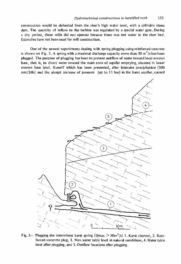
One of the newest experiments dealing with spring plugging using reinforced concrete is shown on Fig. 3. A spring with a maximal discharge capacity more than 50 m3/s has been plugged. The purpose of plugging has been to prevent outflow of water toward local erosion base, that is, to direct water toward the main zone of aquifer emptying, situated in lower erosion base level. Runoff which has been prevented, after intensive precipitation (100 mm/24h) and the abrupt increase of pressure (up to 11 bar) in the karst aquifer, caused
Fig. 3 - Plugging the intermitent karst spring (Qmax >50m3/s) 1. Karst channel, 2. Reinforced concrete plug, 3. Max.water table level in natural conditions, 4. Water table level after plugging, and 5. Outflow locations after plugging.

160 P. Milanovic
numerous problems at the slope above the spring, These problems were expressed as : local seismic activity, formation of a great number of new springs at an altitude of from 80 — 100 m above the spring, sliding of terrains, cracking of houses, destruction of road and so on. One hour after a plug had been lasted a discharge ceased from the highest spring, and after 3-6 hours, the discharge at lowest springs stopped. This shows a fast falling of the pressure at the aquifer, that means, limited retardation capacity and very developed drainage characteristics of this part of the karst aquifer.
One of the ways to solve problems dealing with estavelles in man - made storage reservoirs is a special valve construction (Fig. 4). These constructions are built in the opening of estavelles at the bottom of storage reservoirs and surrounding rocks are blanketed with concrete. Under the stored water pressure these valves prevent its loss from the storage reservoir. When estavelles function as a spring, valves are opened and water flows through them in the storage reservoir as long as the underground water pressure exceeds the water pressure in the storage reservoir. These constructions are not always successful because the new estavelles are opened at the edge of concrete blankets.
Large estavelles, at the rims of storage reservoirs may be isolated by cylindirical dam which enables water to runoff and prevent its loss (Fig. 5).
The broad spring zone at the edges of the storage reservoirs in some cases are isolated by the rock-filled or earth - filled dams whose length can reach hundreds of meters (Fig. 6). The ends of these dams lean on rocky abutments of the storage reservoir which are, or partially are, encompassed by the karstification process.
Fig. 4 — Protection of estavelles by the valves. 1. Reservoir water table, 2. Valve 3. Pipe of the valve, 4. Concrete protection, 5. The flow direction in the karst channel.

Hydrotechnical constructions in karstified rock 161
Fig. 5 — Cylindrical dam around estavelle 1. Reservoir water level, 2. Cylindric dam, 3. Piezometric line, 4. The flow direction in a karst channel.
If topographic conditions and ponor capacity are suitable then the ponor may have a role of natural over - flow. One solution, according to which a ponor with maximal swallowing capacity, 55 — 60 m3/s, has the same function as spillways on the dams, is shown Fig. 7. Surplus flood water that cannot be captured by downstream storage reservoir is diverted into the underground, preventing spillage over the dam and flooding in the agricultural areas.
During water withdrawal, under natural conditions the openings of some ponors are often closed with clayey material, in order to use these ponors for the evacuation of water surplus, different solutions have been applied. One of these is shown in (Fig. 8)
The ponor has been closed with a reinforced concerete plug. Flood water has been directed to the channel through a vertical shaft. After a few floods, the opening has been sedimented by clayey material of a thicknes of 10m. All this indicates what quantity of materials the river flow, of weak activity, transports into ground. The second very important function of this shaft is the evacuation, of air from the karst channels stretching below the adjacent compensation reservoir. During an abrupt increase of the underground water table the possibility for this air to come under pressure and to destroy alluvial coverage at the bottom of the storage reservoir is avoided.

162 P. Milanovic
Fig. 6 — Isolating the ponor zone at the abutment of a reservoir. (According to R. Nikolic). 1. Reservoir, 2. Karstified limestone, 3. Conglomerate, 4. Ponor zone, 5. Large single ponor, 6. Grouting curtain route, and 7. Earthfill dam.
Fig. 7 - Ponor - spillway. 1. Water gate construction, 2. A ponor with swallowing capacity Qmax > 5 0 m3/s. 3. Polje, 4. Karstified limestone, 5. River bed blanketed with shotcrete, and 6. Man -made channel.

Hydrotechnical constructions in karstified rock -j g3
If alluvial ponors are at the bottom of the storage reservoirs then their activity may be eliminated by interventions into alluvial deposit or in the bedrock, that is, in the zone of the karst channel which has caused the formation of alluvial ponors. One applicable solution is shown in Fig. 9. The ponor opening has been dug up to a bedrock, that is up to an opening of karst channel in the karstified limestone. An aeration pipe has been built in this opening and a cleaned part of the rock around the pipe has been cemented. Excavation around the pipe has been burried with constant compacting of clayey material.
Fig. 8 - Ponor with shaft. 1. Flood water level, 2. Shaft, 3. Concrete plug, 4. karstified limestone, 5. Level of mud before plugging, and 6. Level of mud after plugging.
The surface of terrain, that is the bottom of the storage reservoir around the pipe, has been covered with PVC foil. This treatment proved to be more efficient than building an aeration pipe through wells drilled down to the paleorelief.
In solving the problem of water tightness of the storage reservoirs whose bottom has been covered with alluvial sediments, a lot of cases have shown that great attention should be paid to the captured air in the karstified bedrock and fissures in alluvial coverage. This is shown in Fig. 10. In this case the problem of the alluvial ponor has been solved in the

164 P. Milanovic
Fig. 9 - Aeration tube. 1. Reservoir water level, 2. Aeration tube, 3. PVC foil, 4. Compacted layer, 5. Aliuviai sediments, 6. Karstified limestone, 7. Karst channel, 8. Concrete, 9. Water table, 10. Direction of air current in a falling water table period, and 11. Direction of air current during a water table rising period.
following way. The ponor opening and channel through the alluvial section have been filled in with crushed stone according to the principle of reverse filter. After that the surface has been covered with a layer of compacted clay and above this PVC foil at a thickness of 1.5 mm, has been put. During saturation, the underground water squizzes out air from fissures producting air bubbles. If the pressure reaches the limit of the plastic hardness the foil explodes.
In some cases the ponors open under the foil and then the foil tears in a shape of a star. There are indications that these damages occur because of subpressure which is a consequence of an abrupt fall of the water table (Fig. 11).

Hydrotechnical constructions in karstified rock 165
Fig. 10-Destruction of PVC foil. 1. PVC foil, 2. Rock filling, 3. Compacted layer,4. Karstified limestone, 5. Alluvial sediments, 6. Karst channel, 7. Water table, 8. PVC foil under pressure, and 9. Reservoir water level.
f®
Fig. 11—Destruction of PVC foil because of subpressure. 1. PVC foil, 2. Compacted layer, 3. Alluvium, 4. Suffusion cavities in alluvium, 5. A part of channel with collapsed in material, 6. Karstified limestones, 7. Empty part of channel, 8. Falling water table, 9. Stretched PVC foil, 10. Subpressure direction, 11. Loading of foil with a water pillar, 12. Reservoir water level.

166 P. Milanovic
Fig. 12—Grouting of the ponor in the bedrock. 1. Boreholes for grouting, 2. Alluvial ponors, 3. Grouted part of the bedrock, 4. Alluvium, 5. Karst channel filled with grouting mass.
Grouting of karstified paleorelief under alluvial coverage (Fig. 12) proved to be an efficient method of impermeabilization of the alluvial ponors. In that way, the cause of the alluvial ponor formation has been sealed. After grouting of bedrock, the channels in the alluvial section of ponors are filled in. Grouting mass is used for this filling with approximative characteristics of the surrounding material (a component of clay is increased to the detriment of cement).
In the region of the aeration zone, caverns are basic obstacles to the carrying out of underground work. If a cavern happens to be on a tunnel route, its dimensions may be a serious barrier to further progress of the work. In certain cases, the only good solution is the construction of a deviation tunnel, an example of which is shown in Fig. 13.
The stability of the tunnel construction may be endangered by caverns which are out of tunnel space or which are touched by the tunnel (Fig. 14). A small thickness between a cavern and a tunnel represents a great danger for the tunnel under pressure. Besides this,
the monolity of this part of rock mass has been disturbed by blasting. These zones require special reinforcement at the tunnel lining.

Hydrotechnical constructions in karstified rock 167
Fig. 13-Deviation of tunnel. 1. Cavern, 2. Karstified limestone, 3. Fault, 4. Concrete plug, and 5. Deviation of a tunnel.
If the section of a tunnel profile is solid rock mass and a part leans on the clay cave deposit, there is a possibility of losing support and of rotating the tunnel construction and its damage (Fig. 15). One of the possibilities for solving this problem is bridging the clay zone with reinforced concrete constructions and a sufficient number of supports which go through clay to solid rock.
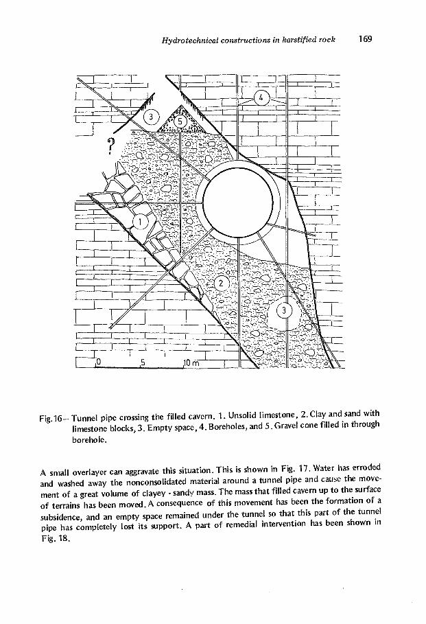
If tunnel with its whole profile goes through a cavern filled with clay, it is subjected to the danger of losing support because of the washing away of this material (Fig. 16).

] 68 P- Milanovic
Fig. 14 - Karst cavern in the abutment of a tunnel.
Fig.15-Tunnel profile encompassing a partially filled cavern. 1. Cavern, 2. Clay filling,
and 3. Support of tunnel lining.
Hydrotechnical constructions in karstified rock 169
N: i ^ T
i
"I
I i i
Xrn^ i X . ^ - J T K
1 ic
1
J/ ' 1 -,
( J
TTli
y\ & *°. 1
Fig 1 6 - Tunnel pipe crossing the filled cavern. 1. Unsolid limestone, 2. Clay and sand with limestone blocks, 3. Empty space, 4. Boreholes, and 5. Gravel cone filled in through borehole.
A small overlayer can aggravate this situation. This is shown in Fig. 17. Water has erroded and washed away the nonconsolidated material around a tunnel pipe and cause the movement of a great volume of clayey - sandy mass. The mass that filled cavern up to the surface of terrains has been moved. A consequence of this movement has been the formation of a subsidence, and an empty space remained under the tunnel so that this part of the tunnel pipe has completely lost its support. A part of remedial intervention has been shown m Fig. 18.

170 P. Milanovic
The case where tunnel driving has been carried out with rotation machines is a special problem to overcome in these caverns. Either these are caverns filled with clay or they are empty. Surmounting these obstacles is only possible by the help of classical technology of tunnel excavation.
Fig. 17-Moving of cave deposit around the tunnel pipe. 1. Tunnel pipe, 2. Empty (washed out) space under a tunnel, 3. Karstified limestone, 4. Sand and clay with blocks, 5. Fault, 6. Boreholes, 7. Subsidence at the surface, 8. Moving direction of a nonconsolidated mass.

Hydrotechnical constructions in karstified rock 171
Parts of the old karst system in aeration zones are very often activated in the storage reservoirs in karst. In addition to complex and detailed investigative work, these defects very often remain undiscovered, although their dimensions can be large. A cave at the left abutment of the dam site in Fig. 19, was not disovered until the grouting started. Water tighness of the" dam site was solved with the subsequent grouting curtain route according to the position of the cavern which has been investigated in detail by speleologists.
Fig. 18—Repairing a tunnel section which has lost a support. 1. Grouting mass, 2. Arch reinforced concrete construction, 3. Concrete, 4. Horizontal reinforced concrete plate, 5. Reversed filter, 6. Drainage, 7. Sand and clay with blocks, 8. Anchors, 9. Additionaly reinforced part of tunnel lining, 10. Opening at a tunnel pipe.
The activity of large ponorsj which are located in the storage space has been solved in certain cases by plugging their channels further in the underground. This intervention (Fig. 20) usually represents a part of the grouting curtain because if it is independently carried out, its function usually is not complete.
By cutting the karst channels which function as transport drains through the aeration zone, parts of the lining of the underground construction may come under unpredictable concentrated pressure. In order to prevent this, the crossed channel has been connected and in that way an undisturbed flow towards the aquifer zone has been provided (Fig. 21).
In the zone of syphonic circulation, that is, in the aquifer zone of static reserve, the all karst solution cavities and fissures are saturated with water. The basic problem during excavation in this part of aquifer, is the struggle with water under pressure. A smaller breakthrough of water, up to ten liters per second, is solved by simple capture. But stronger breakthroughs of water with a capacity exceeding more than hundreds of liters per second, require special treatment.

172 P- Miïanovic
Fig. 19—Caverns at the abutments of dam site. (According to S. Bozicevic). 1. Dam, 2. Reservoir, 3. Cavern, 4. Grouting curtain route, 5. River.
Fig. 20-The karst channel plugging. (According to S. Bozicevic). I.Channel of ponor, 2. Reinforced concrete plug, 3. Route of grouting curtain, 4. Deviation of grouting curtain route.

Hydrotechnical constructions in karstified rock -\ 73
Fig. 21-Cutting the karst channel. 1. Karst channel, 2. Tunnel pipe, 3 . Water level in the channel, 4. Part of lining under concentrated pressure, and 5. Drainage construction around the tunnel pipe.
Fig. 22-Solving the inflow in deep aquifer. 1. Limestone, 2. Karst channel filled with water under pressure, 3. Flow direction, 4. Metal "captage bell", 5. Provisional clayey watertight belt, 6. Anchor, 7. Concrete, and 8. Direction of grouting mass penetration.

174 P. Milanovic
An example has been given in Fig. 22. At the altitude of —34 m (below sea level) a karst channel has been cut, and water under pressure was gushing up at hundreds of liters per second. A metal "captage bell" was built in at the access and water was transported by pipes to a special shaft and pumped over at the surface. After that the entire bottom of the hall, including the "captage bell" was covered by concrete, at a thickness of 2.0 meters. Because of a strong uplift, the concrete plate was anchored to the foundation. Having closed the outflow pipe, circulation in the karst channel has been stopped. Under conditions when water did not flow, it was possible to groute the karst channels through accessory pipes and "captage bell". After that, the concrete plate was removed by blasting and excavation of the hall continued.
The following example shows a procedure for excavating sloping adit in the zone of statical water reserve. Carrying out the slope adit has stopped because water broke through at the altitude —32 m and flooded the slope adit up to the altitude 0.0 m. Divers did not succeed in filling up the discharge cavern. Above the place where water broke through, a gallery was excavated and from it, through boreholes, the slope adit and water cavern were buried with granulate. By grouting with granulate, the further inflow of water was stopped. In that way the pumping of water from the sloping adit was provided (Fig. 23). A further carrying out of the sloping adit has been provided by a successive grouting of the ahead rock mass through which excavation was done.
Fig. 23-Slope adit excavation through saturated karstified rock mass. 1. Auxilary gallery, 2. Borehole, 3. Granulate, 4. Karst channel, 5. Borehole for grouting, 6. Grouted zone, 7. Excavation in the grouted zone, and 8. Karstified limestone.

Hydrotechnical constructions in karstified rock 175
Changes is Aquifer Caused by Hydrotechnical Constructions
The basic purpose of hydrotechnical construction is to change, in regional or local scale, the surface water regime. In a lot of cases, these interventions have influences on the underground water regime. These are the most frequently unforseeable and unexpected influences with consequences that may have positive and negative effects on the regime of either underground or surface waters. These effects may be short and related to a period of excavation and construction, but they also may last as long as operating life of construction.
Long lasting monitoring of man - made reservoirs in karst, have shown that at abutments and the background important underground storage reservoirs have been formed.
Besides the zone of the aquifer dynamic reserve, this storage reservoir includes a part of the aeration zone. Under unsuitable hydrogeological conditions, these changes can cause a change of the location of the watershed zone whose consequence is a change in aquifer balance parameters, because a portion of water spills in to adjacent catchment areas.
Underground work and some investigative treatments can intensify the underground water circulation and they can locally change the natural direction of a flow. Increased circulation along tunnels, which are excavated in a zone of dynamic reserve of karst aquifer, is a consequence of blasting which forms a fissure aureole around the tunnel. Water circulates along these zones. The newly formed direction of circulation usually differs from the direction of the natural one. In that way, a disturbation of some portion of the water within the karst aquifer has been done, and the discharging of a certain aquifer zone has been increased as well as the formation of new spring zone.
Also adits and boreholes are the most important investigative work. But they undoubtly disturb the hydrogeological and geotechnical quality of the rock mass. An investigation of water permeability in boreholes with great pressure very often results in hydraulic destruction of rock mass and formation of new fissures, followed by washing out of the existing ones. A great number of the work in a smaller rock volume can locally change the hydrogeological and geotechnical characteristics of the rock mass. Excavation of the adit, especially if unsuitable blasting has been applied, disturbes the monolity of this part of the rock mass, causing defects that should be artificially remedied. While programming optimum investigative work, a great deal of attention should be paid.
So far, experiences have shown that man - made reservoirs and derivation tunnels in karst positively influence downstream springs. This influence is expressed in the increase of a minimal discharge of the permanent karst spring or in the transformation of an intermittent karst spring into a permanent one.
Because of construction of dams, storage reservoirs, tunnels and cementing of the river beds, recharging of the karst aquifer drastically decrease. More than 50% of the natural inflow has often been taken from it. It has been established that some aquifers in Dinaric karst are impoverished by 3000 million cubic meters of water, by these interventions.This disturbance of the relations of natural balance parameters considerably affects the aquifer

176 P. Milanovic
water table and at the same time hydrological, hydrogeological and ecological characteristics of the catchment area. A change in the water regime is especially drastic in karst poljes. Unavoidably, these effects have certain political repercussions. There are all changes of natural characteristics, such as; a change of the intermittent water flow into a permanent one; the intermittent spring into a permanent spring; increase of the maximal discharge of the spring by three, four or several times; storage of water in places where there used to be rocky desert; constant maintenance is required from those who have made these new conditions, no matter what the purpose of this creation was. Different energy interests on the one hand, and agriculture, water supply and tourism, on the other, very often become a political conflict. For example, the capacity of the spring zone captured for municipal water supply has been increased a few times because of leakage from the storage reservoir that had been formed at the higher altitude in a section of the catchment area belonging to another county. Every emptying of the reservoir in order to remedy losses, decreases the capacity of captage adapted to new the minimal discharge and the consequence of this is a reduction in water for citizens and industry.
The formation of large water surfaces increases air humidity which has positive influence on the surrounding vegetation, but at the same time, this so much changes the characteristics of the karst aquifer that it has a negative effect on the survival of numerous endemic species that are a great resource of the karst underground.
Induced seismicity, which is a follow up to most deep man - made reservoirs, is specific in karst. The genesis of some induced earthquakes is related to water and air hammers which are the results of the abrupt filling of the karst aquifer.
Here we have given some of the observed examples of the changed regime of the karst aquifer that are the consequence of the construction of hydrotechnical structures. These changes and their technical, ecological and political consequences are magnified by every new intervention in karst. A great number of negative consequences can be predicted by knowing well hydrogeological and engineering geological characteristics of karst. But, no matter how the investigative work has been done or how well we know the karstified rock mass, the possibilities of surprises should not be eliminated in advance.
REFERENCES
Bozicevic S., 1976. Losses of Grout in Caves. Working Papers of First Yugoslav Symposium for the Soil Consolidation, Zagreb.
Herak M, 1977. Tecto -genetic approach to classification of karst terraines. Carsus Jugos-laviae 9/4, Zagreb, Yugoslavia.
V.ilanovic, P., 1981. Karst Hydrogeology. Water Resources Publication, Littleton, Colorado U.S.A.
Milanovic P., 1984. Some Methods of Hydrogeological Exploration and Water Regulation in the Dinaric Karst. Chapter 10 in the book "Hydrogeology of Dinaric Karst" edited by B. F. Mijatovic. International Contributions to Hydrogeology, Hannover, Germany.

Hydrotechnical constructions in karstified rock 177
Nikolic R., 1972. Hydrogeological Relations in the Busko Blato Area (Dinaric Mountains) and Conditions for the Construction of a Storage Basin. Carsus Jugoslaviae, 8/4. Zagreb.
Stojic P., Fingerhut L., Simic T., 1976. La galerie decoulment a lusine hydroélectrique de Capljina la submersion at travaux de reprise par suite de lirruption deau. Working Papers of the First Yugoslav Symposium for Soil Consolidation. Zagreb, Yugoslavia.