Embed Size (px)
Citation preview
HW #2 Landscape 2016 Section:
Name: Date:
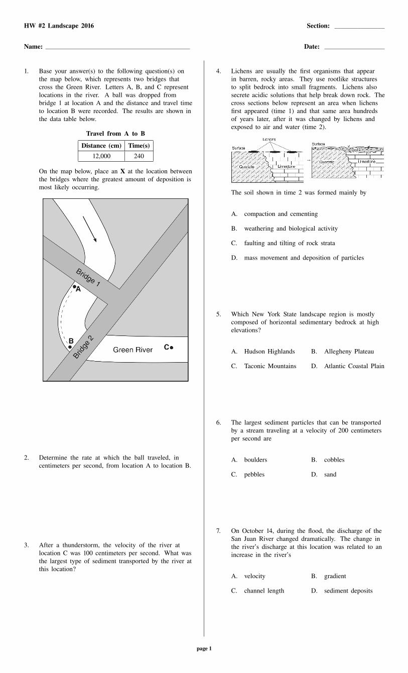
1. Base your answer(s) to the following question(s) onthe map below, which represents two bridges thatcross the Green River. Letters A, B, and C representlocations in the river. A ball was dropped frombridge 1 at location A and the distance and travel timeto location B were recorded. The results are shown inthe data table below.
Travel from A to B
Distance (cm) Time(s)
12,000 240
On the map below, place an X at the location betweenthe bridges where the greatest amount of deposition ismost likely occurring.
2. Determine the rate at which the ball traveled, incentimeters per second, from location A to location B.
3. After a thunderstorm, the velocity of the river atlocation C was 100 centimeters per second. What wasthe largest type of sediment transported by the river atthis location?
4. Lichens are usually the first organisms that appearin barren, rocky areas. They use rootlike structuresto split bedrock into small fragments. Lichens alsosecrete acidic solutions that help break down rock. Thecross sections below represent an area when lichensfirst appeared (time 1) and that same area hundredsof years later, after it was changed by lichens andexposed to air and water (time 2).
→
The soil shown in time 2 was formed mainly by
A. compaction and cementing
B. weathering and biological activity
C. faulting and tilting of rock strata
D. mass movement and deposition of particles
5. Which New York State landscape region is mostlycomposed of horizontal sedimentary bedrock at highelevations?
A. Hudson Highlands B. Allegheny Plateau
C. Taconic Mountains D. Atlantic Coastal Plain
6. The largest sediment particles that can be transportedby a stream traveling at a velocity of 200 centimetersper second are
A. boulders B. cobbles
C. pebbles D. sand
7. On October 14, during the flood, the discharge of theSan Juan River changed dramatically. The change inthe river’s discharge at this location was related to anincrease in the river’s
A. velocity B. gradient
C. channel length D. sediment deposits
page 1

8. Base your answer(s) to the following question(s) onthe diagram below and on your knowledge of Earthscience. The diagram represents a portion of a streamand its surrounding bedrock. The arrows represent themovement of water molecules by the processes ofthe water cycle. The water table is indicated by adashed line. Letter A represents a water cycle processoccurring at a specific location. Letter d represents thedistance between the water table and the land surface.
Explain why the distance, d, from the water table tothe land surface would decrease after several days ofheavy rainfall.
9. Slightly acidic groundwater has been seeping throughcracks and openings in the limestone bedrock ofthis area, producing caves. State whether the typeof weathering that produces these caves is mainlychemical or physical, and identify one characteristic oflimestone that allows this type of weathering to occur.
10. Which soil conditions normally result in the greatestamount of runoff?
A. low permeability and gentle slope
B. low permeability and steep slope
C. high permeability and gentle slope
D. high permeability and steep slope
11. Which change is most likely to occur in a landscape ifits climate changes from humid to arid?
A. Wind will become a more important agent oferosion.
B. Surface features will become more rounded.
C. Chemical weathering will increase.
D. Vegetation will increase.
12. The diagram below represents three identical beakersfilled to the same level with spherical beads.
Beads of0.15-cm diameter
Beads of0.45-cm diameter
Beads of0.70-cm diameter
A B C
If the packing of the beads within each beaker is thesame, which graph best represents the porosity withineach beaker? Beaker
A.
B.
C.
D.
13. Which soil characteristic allows greater amounts ofwater retention?
A. large-size particles B. small-size particles
C. high-density particles D. low-density particles
Section: page 2 HW #2 Landscape 2016
14. Trees growing on the edge of a river’s meander aremost likely to fall into the river due to
A. deposition on the inside of the meander
B. deposition on the outside of the meander
C. erosion on the inside of the meander
D. erosion on the outside of the meander
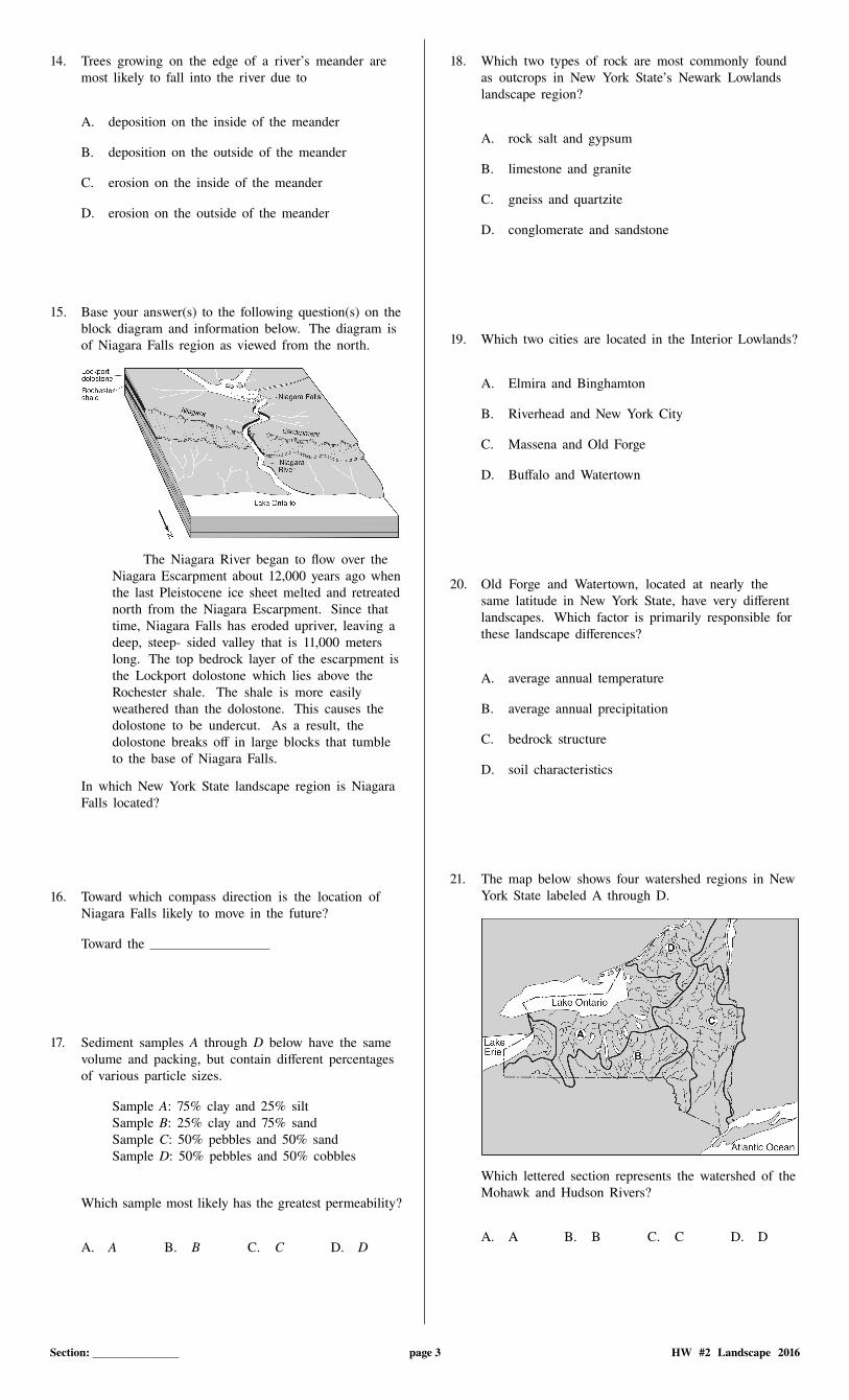
15. Base your answer(s) to the following question(s) on theblock diagram and information below. The diagram isof Niagara Falls region as viewed from the north.
The Niagara River began to flow over theNiagara Escarpment about 12,000 years ago whenthe last Pleistocene ice sheet melted and retreatednorth from the Niagara Escarpment. Since thattime, Niagara Falls has eroded upriver, leaving adeep, steep- sided valley that is 11,000 meterslong. The top bedrock layer of the escarpment isthe Lockport dolostone which lies above theRochester shale. The shale is more easilyweathered than the dolostone. This causes thedolostone to be undercut. As a result, thedolostone breaks off in large blocks that tumbleto the base of Niagara Falls.
In which New York State landscape region is NiagaraFalls located?
16. Toward which compass direction is the location ofNiagara Falls likely to move in the future?
Toward the
17. Sediment samples A through D below have the samevolume and packing, but contain different percentagesof various particle sizes.
Sample A: 75% clay and 25% siltSample B: 25% clay and 75% sandSample C: 50% pebbles and 50% sandSample D: 50% pebbles and 50% cobbles
Which sample most likely has the greatest permeability?
A. A B. B C. C D. D
18. Which two types of rock are most commonly foundas outcrops in New York State’s Newark Lowlandslandscape region?
A. rock salt and gypsum
B. limestone and granite
C. gneiss and quartzite
D. conglomerate and sandstone
19. Which two cities are located in the Interior Lowlands?
A. Elmira and Binghamton
B. Riverhead and New York City
C. Massena and Old Forge
D. Buffalo and Watertown
20. Old Forge and Watertown, located at nearly thesame latitude in New York State, have very differentlandscapes. Which factor is primarily responsible forthese landscape differences?
A. average annual temperature
B. average annual precipitation
C. bedrock structure
D. soil characteristics
21. The map below shows four watershed regions in NewYork State labeled A through D.
Which lettered section represents the watershed of theMohawk and Hudson Rivers?
A. A B. B C. C D. D
Section: page 3 HW #2 Landscape 2016

22. The block diagram below represents the drainagebasins of some river systems separated by highlanddivides, shown with dashed lines. The arrows showthe directions of surface-water flow.
The three areas separated by highland divides arecalled
A. meanders B. floodplains
C. watersheds D. tributaries
23. Base your answer(s) to the following question(s) onthe diagram below, which shows a model used toinvestigate the erosional-depositional system of astream. The model was tilted to create a gentle slope,and a hose supplied water to form the meanderingstream shown.
Which diagram best represents where erosion, E, anddeposition, D, are most likely occurring along thecurves of the meandering stream?
A.
B.
C.
D.
24. The block diagram below represents a portion of theGrand Canyon.
This region is best classified as a
A. plateau B. mountain
C. plain D. lowland
25. The photograph below shows farm buildings partiallyburied in silt.
Which erosional agent most likely piled the silt againstthese buildings?
A. glacial ice B. ocean waves
C. wind D. mass movement
26. A landslide is an example of
A. river deposition B. glacial scouring
C. mass movement D. chemical weathering
Section: page 4 HW #2 Landscape 2016

Problem-Attic format version 4.4.274c_ 2011–2016 EducAide Software
Licensed for use by Wanda VargasTerms of Use at www.problem-attic.com
Section: HW #2 Landscape 2016 09/13/2016
1.Answer:
2.Answer: 50 cm/s
3.Answer: Pebbles 2-cm to 3-cm-diameter particles
4.Answer: B
5.Answer: B
6.Answer: B
7.Answer: A
8.Answer: [answers vary] Ex: The water table
will rise, erosion of the land surface,Infiltration will occur
9.Answer: [answers vary] Ex: Acid dissolves
limestone
10.Answer: B
11.Answer: A
12.Answer: D
13.Answer: B
14.Answer: D
15.Answer: - Erie -Ontario Lowlands - Erie -Ontario
plains - interior lowlands
16.Answer: - S - south - SE - SW
17.Answer: D
18.Answer: D
19.Answer: D
20.Answer: C
21.Answer: C
22.Answer: C
23.Answer: A
24.Answer: A
25.Answer: C
26.Answer: C