Embed Size (px)
Citation preview

6 coastwatch | summer 2016 | www.ncseagrant.org
C o n t i n u e d
Looking Back at a Benchmark StormB y J a y B a r n e s
Jay Barnes is the author of four books on hurricanes, and often appears on media outlets such as The Weather Channel, NBC Nightly News and The Discovery Channel. He is director of development for the North Carolina Aquarium Society. For more, go to jaybarnesonhurricanes.com.
I remember listening to the droning roar of the wind, and the frequent crackle and snap of tree branches that made me worry about my roof.
It’s been 20 years but my memories of Hurricane Fran are distinct. It was a serious storm. Fran came ashore near Cape Fear on Sept. 5, 1996, less than four weeks after the arrival of Hurricane Bertha and just one year after the release of my first book, North Carolina’s Hurricane History, from UNC Press.
Though it tracked well to the west of my Carteret County home, I knew at the time Fran was a major hurricane — the first Category 3 to have a significant impact on the state since Donna in 1960. I remember sitting in the dark and listening to the wind, knowing the storm’s likely impact, and thinking about how our hurricane history was about to receive an important new chapter.
After the near record-breaking 1995 Atlantic hurricane season — with 19 named storms and 11 hurricanes — during which Hurricane Felix had just missed the Outer Banks, 1996 quickly established itself as a benchmark year for deadly weather in North Carolina. The state was paralyzed by winter storms that caused 12 fatalities, and a record 51 tornadoes touched down in April and June.
But by far, the biggest weather stories of 1996 arrived that summer — hurricanes Bertha and Fran. For the first time since the mid-1950s, two hurricanes struck the Tar Heel coast during the same season. Bertha, the first July hurricane to hit North Carolina since 1908, blasted the coast, felling trees and damaging nearly 2,000 structures. And then there was Fran, whose tear across the state set a new standard in hurricane destruction.
In this first of a two-part series looking back at Hurricane Fran, I’ve assembled stories and photos to help stir memories of this seminal weather event. Here, I’ve excerpted portions of North Carolina’s Hurricane History to help define the storm and its immediate impact.
My story in the Autumn issue will provide perspective two decades later. I will look back at lessons learned and important insights from meteorologists, emergency managers and others.
The goal? Understanding big storms like Fran could help us all one day — when the next major hurricane rolls through.
EDITOR’S NOTE: Hurricanes are strong low-pressure systems, with barometric values of 980 millibars or less. The Saffir-Simpson scale rates hurricane intensity from 1 to 5, with major storms considered Category 3 or above and having winds of 111 mph or greater.
From NORTH CAROLINA’S HURRICANE HISTORY, Fourth Edition by Jay Barnes. Copyright © 2013 by the University of North Carolina Press. Used by permission of the publisher. www.uncpress.unc.edu. Book is available at uncpress.unc.edu/books/12129.html.
HURRICANE FRAN REVISITED

coastwatch | summer 2016 | www.ncseagrant.org 7
Estimates for the total economic impact of Hurricane Fran in North Carolina vary, but the most significant cost was the loss
of 37 people directly or indirectly attributed to the storm.
John
Alth
ouse
/Jac
kson
ville
Dai
ly N
ews

8 coastwatch | summer 2016 | www.ncseagrant.org
C o n t i n u e d
… As the storm drew closer to the Carolinas, it gradually appeared that landfall would occur a little farther to the north than forecasters had earlier predicted—and it did. Fran came ashore near Bald Head Island around 8:30 P.M. Thanks to good early warnings and the storm’s lack of rapid acceleration before landfall, most residents who had wanted to leave the beaches had ample time to do so.
At the time Fran made landfall, it was still a minimal category 3 hurricane, with maximum sustained winds of 115 mph and an estimated minimum pressure of 953 mb. The strongest winds were believed to have run in streaks within deep convective areas of the circulation, north and northeast of the center. And Fran was no small storm. Before landfall, reconnaissance reports indicated that hurricane-force winds were measured up to 145 miles away from the eye. Before their televisions were darkened by the loss of power, most residents in the hurricane’s path were able to watch the ominous swirl of radar images as Fran advanced over them. By the time it moved inland, the storm appeared to have swallowed up much of the state.
Fran’s course over land seemed almost to follow the Cape Fear River, affecting a broad
region that extended upstate. Because the hurricane’s greatest power was concentrated on its eastern side, the beaches of New Hanover, Pender, Onslow, and Carteret Counties were hammered with the worst winds and tides. To a large degree, this was the same region that had suffered during Bertha just weeks before, but Fran was different. It was a larger, more intense storm, and its impact along most of this stretch of coast was far greater than that of the July storm.
Fran’s course carried it deep inland, up the Cape Fear, west of I-40, and into the heart of the Raleigh–Durham–Chapel Hill Triangle. Along the way, its howling winds battered every county in its path, felling millions of trees and knocking out power over a major portion of the state…
…Wind instruments all over eastern North Carolina were tested by the storm. … The National Weather Service was able to confirm wind reports that included gusts of 124 mph at Frying Pan Shoals Light, 122 mph at Figure Eight Island, 105 mph in Southport and New Bern, 100 mph in Greenville, 92 mph at the Duke University Marine Laboratory in Beaufort, 80 mph at Seymour-Johnson Air Force Base in Goldsboro, 79 mph at Raleigh-
Durham Airport, and 86 mph in Efland, west of Durham. …
… According to National Weather Service reports, the heavy storm surge that affected much of North Carolina’s southeast coast ranged from eight to twelve feet. Still-water marks measured inside buildings provided these elevations; exterior water levels were generally higher due to wave action. The highest surges were observed at Carolina Beach, Wrightsville Beach, Figure Eight Island, and Topsail Island. Some longtime residents at Wrightsville Beach compared the flood level during Fran with that of Hurricane Hazel in 1954 and found that Fran’s was several inches higher. Hazel was a much more intense storm, but it struck some forty miles farther down the coast. Preliminary reports from the Weather Service indicated that Fran’s surge was ten feet in Swansboro and New Bern, nine feet in Washington and Belhaven, and seven feet at Atlantic Beach. Still-water surge heights of five feet were measured in Southport and Beaufort. …
The destructive floods that hit many portions of the state did not just sweep in with the storm surge but also fell from the skies.
FRAN, SEPTEMBER 5/6, 1996
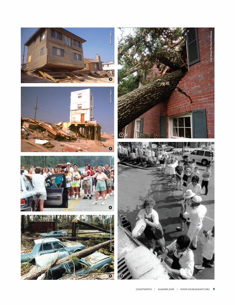
1. After riding out Hurricane Fran at Carolina Beach, Paula Cauble checks on the damage to her neighbor’s home. 2. Wayne Smith is rescued by Raleigh firemen at the intersection of Wilmington and Fayetteville streets. 3. The storm felled these houses along Kure Beach, dropping the buildings onto what used to be their parking areas under the houses. 4. This tower on Topsail Island, used to observe rocket development and testing during World War II, survived Fran. 5. Hurricane Fran was preceded by Hurricane Bertha, which included an evacuation of residents from North Topsail. 6. At Camp Lejeune, parked cars were hammered by fallen pines. 7. Trees fell throughout the Triangle area during Hurricane Fran, including this oak in Raleigh. 8. Following Hurricane Fran, the Cameron Village Harris Teeter gave out free ice to Raleigh residents.
1 2
Rob
ert W
illet
t/Th
e N
ews
& O
bser
ver
Kei
th G
reen
e/Th
e N
ews
& O
bser
ver
coastwatch | summer 2016 | www.ncseagrant.org 9
3
4
5
6 8
7
Spen
cer R
oger
sSp
ence
r Rog
ers
Don
Bry
an/J
acks
onvi
lle D
aily
New
sR
andy
Dav
ey/J
acks
onvi
lle D
aily
New
s
Scot
t Sha
rpe/
The
New
s &
Obs
erve
rSc
ott S
harp
e/Th
e N
ews
& O
bser
ver

10 coastwatch | summer 2016 | www.ncseagrant.org
2 4
3
John
Alth
ouse
/Jac
kson
ville
Dai
ly N
ews
Jay
Bar
nes
Cou
rtes
y N
OA
A O
ffice
for C
oast
al M
anag
emen
t
1 John
Alth
ouse
/Jac
kson
ville
Dai
ly N
ews

coastwatch | summer 2016 | www.ncseagrant.org 11
Drenching rains bore inland as Fran came ashore, with the heaviest bands of precipitation very closely following the storm track. To make matters worse, some portions of the state received monsoonlike rains even before Fran approached the coast. On September 3, two days before the hurricane’s landfall, Carteret and Onslow Counties were inundated with rains measured at up to 7.5 inches in some locations. These rains filled creeks and ditches and saturated soils near the coast. …
… As Fran tracked inland, its center of circulation held together longer than expected, partially due to its large size. Fran was as large as Hugo and larger than Andrew, even though it wasn’t as powerful as either of those storms. Its central core finally collapsed just southeast of Raleigh, almost directly over the city of Garner. These factors spelled disaster for the Raleigh area. … Though reports suggested that up to 9.5 inches fell at some Triangle locations, the Raleigh-Durham Airport officially recorded 8.80 inches, still enough to shatter the old twenty-four-hour record of 6.66 inches set back in September 1929. (Hazel brought only 4.93 inches to the Triangle.) Other records marked at the airport included the highest recorded wind gust (79 mph, which beat the previous record of 64 mph set during a thunderstorm in May 1996) and the lowest barometric pressure for September (977 mb). A slightly lower pressure
reading of 974 mb had been recorded at the airport during Hazel in October 1954. …
… Meteorologically, Fran was a major hurricane—a real category 3 with all the trimmings. But perhaps even more impressive than the record-breaking wind, storm surge, and rain were the scope and severity of destruction the storm laid across the land. Decades had passed since the Tar Heel State had felt this kind of blow, and its force painfully exposed our vulnerabilities. Not only did the storm shatter property wherever it went, but it also altered the lives and challenged the spirits of its victims. …
… At Oak Island, more than 200 homes received some damage, and 19 were rendered uninhabitable. Many were oceanfront cottages whose septic systems were undermined or damaged by the storm tide. … At Holden Beach, seven homes reportedly “fell into the ocean,” and several feet of dunes were washed away. At Ocean Isle, the septic systems of fourteen homes were damaged, and several cottages were flooded by overwash. Overall, though, these beaches, which were swept by Hazel’s awesome seventeen-foot surge, fared very well in Fran. Because they were on the weaker side of the eye, the storm surge was moderate, measuring only about six feet at Holden Beach. …
Around Cape Fear, it was a different story. The beaches of New Hanover County caught
the brunt of the hurricane and were left with a massive mess. Fort Fisher, Kure Beach, Carolina Beach, Wrightsville Beach, and Figure Eight Island all were exposed to Fran’s destructive core. As high winds peeled back roofs and snapped utility poles, the surging Atlantic sucked away dunes and poured into the streets. The tide filled some homes with water and sand and radically displaced others. In Carolina Beach, one house floated off its foundation and came to rest on Canal Drive, some 200 feet inland. The Wilmington Star-News reported that the town was under six feet of water at times. Other stories held that cars were floating about during the peak of the storm, bumping into telephone poles and buildings. As the flood worsened, rising water forced the town’s police department to move from its headquarters on Canal Drive to the town recreation center. … In all, Carolina Beach had over 930 damaged homes, 41 destroyed homes, 75 damaged businesses, and over $33 million in private property losses.
At nearby Kure Beach, the scene was similarly depressing. Dozens of oceanfront homes and condos, already compromised by Bertha a few weeks earlier, suffered major structural damage. Several feet of sand were carried inland by the surging waters and deposited in first-floor rooms of vacation resorts.
C o n t i n u e d
1. Sonja and Greg Wattier take a look at their home in Verona in Onslow County that was damaged by Hurricane Fran. 2. Roads started to flood as Hurricane Fran approached. 3. Hurricane Fran formed off the west coast of Africa on Aug. 22, 1996, and made landfall near Bald Head Island on Sept. 5, 1996. 4. Owners of O’Neals Drug Store in Belhaven have marked the height of flood waters for several storms, including Fran. 5. The storm was a Category 3, with winds reaching 115 miles per hour. 6. Fran caused considerable damage, including an estimated $50 million in losses to boats in North Carolina.
5 6
Cou
rtes
y N
OA
A N
WS
Ric
hard
Dav
is/N
.C. D
ivis
ion
of M
arin
e Fi
sher
ies

12 coastwatch | summer 2016 | www.ncseagrant.org
Porches, decks, and awnings disappeared, either swept away by wind and water or buried out of sight. Debris from damaged structures drifted in the flood, covering streets and lawns with a potpourri of lumber, appliances, household furnishings, and broken glass. A portion of Atlantic Avenue washed away, and other streets were barely recognizable. Water and sewer lines were ruptured, 68 businesses were damaged, and more than 260 houses were destroyed. Kure Beach was near ground zero during Fran, and few communities faced more significant destruction. …
… Up the coast at Wrightsville Beach, a storm surge of close to eleven feet tore down dunes and flooded expensive beach houses. Almost the entire town was underwater at one point. When residents at Harbor Island fi-nally returned to their homes, some found scum lines on their walls four feet above the floor. Up and down the beach, deep sand covered Lumina Avenue, mixed with debris from first-floor cot-tages and apartments. Beach chairs and wash-ing machines were not the only losses—some people lost personal keepsakes such as wedding albums, home videos, love letters, and music collections. Virtually anything left at ground level was either saturated by rising saltwater or washed into the streets. At the Bridge Tender restaurant near the bridge to Wrightsville, wit-nesses reported that high water “floated bottles off the bar.” … Like the other nearby beaches, Wrightsville suffered heavy damages: more than 560 homes damaged, 13 houses destroyed, and 50 businesses damaged. …
… Perhaps the most amazing destruction inflicted by Fran fell upon the hapless communities of Topsail Island along the Pender-Onslow coast. Topsail Beach, Surf City, and North Topsail Beach were all slammed hard by Hurricane Bertha in July, only to catch the worst of Fran mere weeks later. Bertha caused extensive property damages, but more
1. This beach house on Topsail Island, close to collapse after Fran, was later straightened — and still stands today. 2. When Crabtree Creek in Raleigh spilled its banks, the waters flooded the lower floors of Crabtree Valley Mall and a nearby Sheraton hotel. 3. North Carolina’s Hurricane History is available from UNC Press.
1
3
2
Jim B
ound
s/Th
e N
ews
& O
bser
ver
Spen
cer R
oger
s
Cou
rtes
y UN
C P
ress

coastwatch | summer 2016 | www.ncseagrant.org 13
important, it washed away the island’s protective dunes. Afterward, very little remained to slow the ten-foot storm surge that accompanied Hurricane Fran. …
… Riverfront communities not in the storm’s direct path were nonetheless soaked by flooding tides and heavy rains. Downtown New Bern was submerged by the rising waters of the Neuse, which also undercut the roadway on the U.S. 17 bridge, causing a six-foot section of pavement to collapse. … In Washington, about three-quarters of the downtown area was underwater at the height of the storm. Residents described the streets as “waist-deep rivers.” The combination of floodwaters from the Pamlico River and heavy rains draining from nearby creeks left several blocks of the city underwater more than a day after the hurricane’s passing. Even in Elizabeth City, Fran’s winds pushed water down the Pasquotank River, flooding the town’s harbor, wrecking docks and piers, and sinking a forty-two-foot sailboat. …
… In rural towns like Warsaw, Wallace, Burgaw, and Clinton, streets were littered with massive tree branches, loose shingles, and broken glass. Commercial signs were buckled and shattered, and misplaced power lines were draped over storefronts like Sillystring. Warped pieces of tin hung from trees across the countryside, having been stripped from the roofs of farmhouses and barns. Some yards were filled with the trunks of massive oaks and huge earthen cavities where the trees had once stood. …
… But Fran hit the Triangle hard. Not since Hazel’s visit in 1954 had the Raleigh area been subjected to the kind of flooding and wind damage it endured through Fran. Most residents in the region began the evening by watching multicolored radar and satellite images spin across their television screens, knowing that the storm’s path was undeniable—Fran was headed their way. As the hurricane’s collapsing eye approached the region, massive trees tumbled and power lines popped and sizzled. Inside their now-dark homes, almost a million Triangle residents could only sit and listen to the whirling winds outside, waiting fearfully for the next thunderous crash of pine or oak. A few managed to sleep through the ordeal, but most paced through the night with flashlight in hand, hoping for it all to end soon.
Winds in the Raleigh area were nearly hurricane strength, and countless trees gave way
to the blow. … Those who had seen Charlotte after Hurricane Hugo had instant flashbacks—the images of entire neighborhoods covered with toppled trees were eerily familiar. Raleigh—once dubbed the City of Oaks—now seemed to be the city of fallen oaks. …
… Unfortunately, Fran’s effects on the Triangle were not limited to punctured roofs, crushed cars, and streets blocked by leafy barricades. A record rainfall on the night of Fran’s visit saturated soils already presoaked by earlier rains, and the result was some of the worst flooding in the region’s history. … Raleigh’s Crabtree Creek spread far beyond its banks, inundating the area surrounding Crabtree Valley Mall and much of the heart of the city. The normally placid creek, a tributary of the Neuse River, rose more than sixteen feet in just fourteen hours, finally cresting at seven feet above flood stage. The result was a muddy sea that, by 4:25 A.M., filled the lower level of Crabtree Valley Mall with a foot of water and turned the nearby Sheraton Hotel into an island. Merchants in the mall later reported finding “water moccasins” among their merchandise. …
Surrounded by six-feet-deep floodwaters that completely buried rows of parked cars, guests at the Sheraton found themselves stranded on the morning of the storm. Included on the guest list were numerous evacuees who had fled the coast in search of safe refuge. One of those was actor James Woods, up from Wilmington, where he had been filming a forthcoming movie. Woods reportedly donned bedroom slippers and a bathrobe on the morning after the storm and helped make sandwiches for fellow victims in the hotel lobby. …
… In the hours and days following Fran’s trek across North Carolina, Tar Heel residents struggled to recover from the shock of the storm. Most quickly went to work salvaging what they could and beginning the arduous task of cleaning up the mess the hurricane had left behind. Curfews were established in most cities, as officials attempted to maintain order and prevent looting along darkened streets. As with any hurricane, perhaps the most basic necessity sucked away by Fran was available electric power. The Reuters News Service reported that 4.5 million people in the Carolinas and Virginia were without electricity on the day after the storm. …
… The difficult physical task of cutting up and removing downed trees kept many families
busy to the exclusion of almost all else. … For days and even weeks, a whining symphony of saws echoed through virtually every neighborhood in a forty-county stretch along the hurricane’s path. And as the trees, branches, and stumps were cut and stacked, mountains of storm debris quickly grew along city streets and country roads. Local officials scrambled to deal with the incredible volume of waste, which required caravans of trucks to haul and specially designated lots for mulching and burning. Virtually every city and county in the region managed its own “stump dump.” …
… Soon after Fran barreled through North Carolina, Governor Jim Hunt declared a state of emergency in all 100 counties, the first time such action had ever been taken. …
… Estimates for the total economic impact of Hurricane Fran vary, depending on which government agency you ask. …
According to the National Climatic Data Center, Fran caused at least $5 billion in damages to property, timber, and agriculture in North Carolina alone. The N.C. Division of Emergency Management places that total at $5.2 billion. In addition, early estimates from other states affected by the storm were as follows: South Carolina, $40 million; Virginia, $350 million; Maryland, $100 million; Pennsylvania, $80 million; West Virginia, $40 million; and Ohio, $40 million. Therefore, the sum total for Fran approached $6 billion, placing it among the most costly hurricanes in U.S. history.
But perhaps the most significant cost was the loss of thirty-seven people, directly or indirectly due to the storm. In North Carolina, twenty-four fatalities were reported, including three from drowning, twelve related to fallen trees, and nine due to other storm-related events. …
… Without doubt, Fran’s visit to the state established it as the new benchmark for hurricanes in North Carolina—at least for a while. It may not have been the strongest storm to hit the Tar Heel coast in the twentieth century, but its widespread effects and tremendous toll exceeded that of the previous hurricane to set the standard—Hurricane Hazel. It had such a significant impact on such a large number of people that a whole new generation of North Carolinians will forever be prepared to reminisce whenever the topic comes up. For decades to come, they’ll tell their children and their grandchildren: “I remember Fran!”