Embed Size (px)
Citation preview

HUON HILL MASTERPLAN SUPPORTING INFORMATION AND DETAILED STRATEGIES
2
These notes are intended to provide context and supporting or explanatory information for the Huon Hill Masterplan. They also include additional description and details for many of the 47 strategies proposed for Huon Hill than could be provided in the summary version of the Wodonga Hills Activation Strategy.
These supporting notes comprise:• A tabulated site assessment of Huon Hill,
summarising the advantages and limitations of the area for greater sustainable leisure, recreation and tourism use;
• A plan, and brief list, of the principal assets of Huon Hill that could be employed to support the area’s “activation”;
• A summary of the approach and key factors that determined the role and character of Huon Hill, and shaped the strategy’s and masterplan’s directions for the area; and,
• Descriptions and details of the 47 strategies proposed for Huon Hill as shown on the masterplan (and summarised in the activation strategy).

3 Draft Huon Hill Masterplan
SITE ASSESSMENT - ADVANTAGES AND LIMITATIONSHuon Hill presents the following advantages and limitations to activation of the area for greater sustainable leisure, recreation and tourism use.
ADVANTAGES LIMITATIONS
Location
Huon Hill is located approximately 2.7km from the town centre of Wodonga. It forms the eastern border to the Wodonga suburbs.
The other hill sites are further away:• 5km from Federation Hill• 6.5km from Baranduda Range• 6.5km from Mahers Hill• 8km from the Hunchback Hill complex
Easy links can be forged to Bears Hill 2.2km to the south-west through the existing pedestrian/road networks.
Huon Hill is in close proximity to the Murray River to the north and the Kiewa River to the east, separated by a narrow width of private farming land. An existing link to the Kiewa River is available from the north-east sector of Huon Hill via the Bundy Track.
Huon Hill is bounded by rural farming land save for an established pocket of residential subdivision to the south-west. Much of the rural farming land to the east, south and west is marked for future residential subdivision.
Land tenure
All but the ridgeline of Huon Hill is managed by the council including two outlying parcels to the north-west.
The ridgeline of Huon Hill is crown land managed by Parklands Albury Wodonga (PAW).
Split land management presents issues for coordination of the site as a whole.
Access (to the hill)
Vehicle access is available via a part sealed and part unsealed road from the eastern boundary to the picnic grounds at the summit, and to the trailheads of the Butt Butt, She-oak, Stringybark, and Mistletoe tracks.
The vehicle access road is via a circuitous route from Kenneth Watson Dve at the south-east corner and up one of the shallower sloping spurs on the eastern slope of Huon Hill. The entry to the hill is located on the side of the hill facing away from the Wodonga township.
An entry point for walkers and bike riders is located at the north-east end of a finger in the north-east sector of the park. This access point provides access for users of the shared path along the Kiewa River.
There are no other entry points available other than the access road, the north-east, south-east and south-west points.
An entry point is available for walkers and bike riders at the south-east corner to the Stringybark Track.
Lack of a perimeter road bordering the adjacent residential areas limits opportunities for users to park vehicles adjacent to the hill.
An entry point is available for walkers and bike riders at the south-west corner from the adjacent established residential area.
Pedestrian feeder networks within the adjacent residential areas are not sign posted with details of Huon Hill tracks and facilities.
Potential entry points to the site can be located from future residential areas to the north, south and west.
4
ADVANTAGES LIMITATIONS
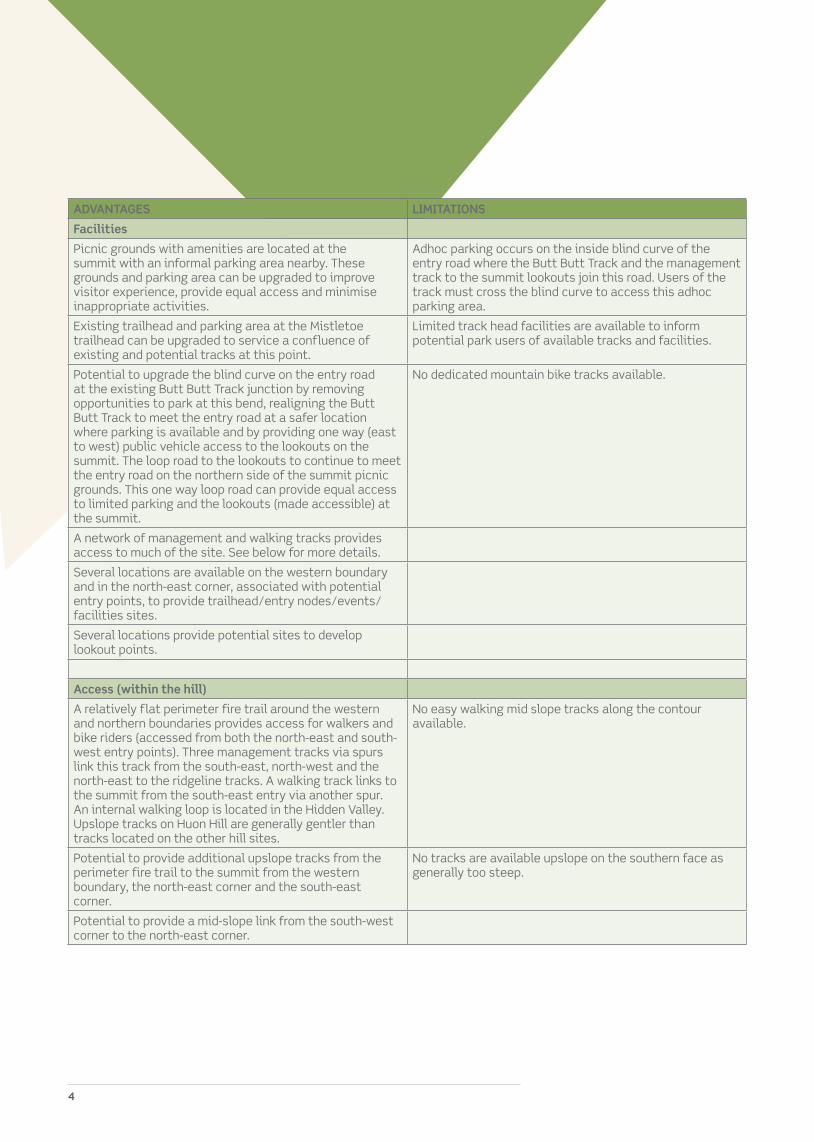
Facilities
Picnic grounds with amenities are located at the summit with an informal parking area nearby. These grounds and parking area can be upgraded to improve visitor experience, provide equal access and minimise inappropriate activities.
Adhoc parking occurs on the inside blind curve of the entry road where the Butt Butt Track and the management track to the summit lookouts join this road. Users of the track must cross the blind curve to access this adhoc parking area.
Existing trailhead and parking area at the Mistletoe trailhead can be upgraded to service a confluence of existing and potential tracks at this point.
Limited track head facilities are available to inform potential park users of available tracks and facilities.
Potential to upgrade the blind curve on the entry road at the existing Butt Butt Track junction by removing opportunities to park at this bend, realigning the Butt Butt Track to meet the entry road at a safer location where parking is available and by providing one way (east to west) public vehicle access to the lookouts on the summit. The loop road to the lookouts to continue to meet the entry road on the northern side of the summit picnic grounds. This one way loop road can provide equal access to limited parking and the lookouts (made accessible) at the summit.
No dedicated mountain bike tracks available.
A network of management and walking tracks provides access to much of the site. See below for more details.
Several locations are available on the western boundary and in the north-east corner, associated with potential entry points, to provide trailhead/entry nodes/events/facilities sites.
Several locations provide potential sites to develop lookout points.
Access (within the hill)
A relatively flat perimeter fire trail around the western and northern boundaries provides access for walkers and bike riders (accessed from both the north-east and south-west entry points). Three management tracks via spurs link this track from the south-east, north-west and the north-east to the ridgeline tracks. A walking track links to the summit from the south-east entry via another spur. An internal walking loop is located in the Hidden Valley. Upslope tracks on Huon Hill are generally gentler than tracks located on the other hill sites.
No easy walking mid slope tracks along the contour available.
Potential to provide additional upslope tracks from the perimeter fire trail to the summit from the western boundary, the north-east corner and the south-east corner.
No tracks are available upslope on the southern face as generally too steep.
Potential to provide a mid-slope link from the south-west corner to the north-east corner.

5 Draft Huon Hill Masterplan
ADVANTAGES LIMITATIONS
Setting
Modified farming landscape with mature trees in open grassed paddocks across the spine ridge and along the spurs.
Cattle on the property leave visible signs of use.
Densely vegetated southern slope, with pockets of vegetation along creek lines and in the Hidden Valley.
Mature trees tend to drop large limbs, a safety hazard to hill users. (Impacts on track alignment and maintenance practices in removing damaged limbs, not trees)
Stark variation between views to the urban areas to the south and west, and to rural areas to the north and east bounded by river corridors. When accessing the site from the south-east, the setting quickly changes from urban to rural as one enters the site.
Views
Several vantage points to view other hill sites, Wodonga, the Murray and Kiewa rivers up close, Lake Hume, farming lands and the ‘gateway’ to the plains to the north-west (north of the Hunchback Hill complex) are possible from many points on the ridge and perimeter tracks and from the upslope links.
270° views from the north-east to north-west via the south over Wodonga, Bandiana, the Defence base, farming lands and hills and ranges.
Broad views to the north and west from the north-west corner of the western communications tower site.
Prominent views of Huon Hill from the Murray Valley Hwy when travelling east.
Scenic views of Huon Hill available from the western and southern sides.
Terrain
Elevation provides opportunities for fabulous views over the wider region.
Some areas of flat curtilage are available on the western boundary for facilities or activity areas.
Several sites of slopes equal to or steeper than one to two occur on the western and northern slopes. A large site occurs on the southern slopes.
Several sites (x8) of gully erosion occur on the western, northern and eastern slopes. Two slump sites occur on the southern slopes.
Fauna/flora
Easily observed larger mobs of kangaroos and abundant birdlife (including resident wedge-tailed eagles).
Site contains Ecological Vegetation Communities (EVCs) listed as depleted across the southern slopes with EVCs listed as endangered over the remainder of the site.
Densely vegetated southern slopes. Observed feral deer (x1) during one visit. Anecdotal comments indicate more than one are present on the site.
Densely vegetated Hidden Valley including regeneration plantings.
Fingers of vegetated corridors reaching to the north-east and to the east.
Many scattered mature endemic trees over the remaining slopes.

6
ADVANTAGES LIMITATIONS
Cultural heritage
The Murray and Kiewa rivers fall within mapped areas of Aboriginal cultural heritage sensitivity, but these areas are outside of Huon Hill. Two small sites are located within the boundaries of the site.
Security
High level of surveillance of adjacent areas from the internal access road due to high level of road use.
Issues related to inappropriate activities occurring in areas accessible from the road as the site remains open overnight.

7 Draft Huon Hill Masterplan
ACTIVATION ASSETSThe figure on the following page shows the principal assets of Huon Hill that could be employed to activate the area for greater leisure, recreation and tourism use. These assets include:• The surrounding (developed) public road
network;• The existing public vehicle access road,
existing visitor facilities and developed lookouts;
• The hill’s existing walking track network;• Numerous existing and potential access/
entry points (pedestrian and bicycle);• Links to and from adjacent attractions
(notably the Murray and Kiewa river corridors);
• The hill’s current management track network;
• Vantage points, potential lookouts and major views to/from the area;
• Potential links or possible track/trail corridors;
• Areas of scenic vegetation and trees, and other features of interest; and,
• Locations potentially suitable for the provision of visitor facilities such as picnic or activity areas, entry nodes and facility sites, trailheads or vantage points.

8

9 Draft Huon Hill Masterplan
The strategy for Huon Hill is largely driven by the hill’s existing role as the most developed and accessible of the Wodonga hills. It is the only hill at present to offer public vehicle access to a high point, and the only hill containing established visitor (day-use) facilities. The strategy builds on Huon Hill’s existing profile as a tourism attraction and a popular destination among locals. However the strategy also aims to expand the activities and experiences on offer across the hill, and considerably increases walking opportunities, in an attempt to draw people away from the centralised facilities of the summit to experience more of Huon Hill. Planning for future leisure and recreational use of Huon Hill also takes a long-term view, recognising that the hill will, ultimately, be completely surrounded by residential areas and a large population of potential users.
The premier and most central attraction among the Wodonga hills, offering vehicle access to day-use facilities and stunning lookouts plus a variety of well-marked short and longer loop walks.
Visitors see Huon Hill as a single destination. They are blind to the “dual tenure” nature of the hill, where much of the higher areas, including part of the access road, eastern vantage point, and the upland track network, are under Parklands Albury Wodonga’s management while the remainder of the hill is under the council’s care. Effective co-operation between the council and Parklands Albury Wodonga will be critical to the successful expansion and management of leisure, recreation and tourism opportunities across Huon Hill. This is especially the case for the co-ordinated upgrading and better integration of the summit and its facilities as a whole, as well as the existing and
proposed tracks and trails that run to, from, or over the hill’s higher terrain. Presentation and interpretation of Huon Hill must also be unified and consistent.
The strategy capitalises on and reinforces the summit area as the hill’s premier destination and facility/activity node. Upgrading the existing summit facilities – the access road pattern, lookouts, picnic facilities (including amenity and screening landscape plantings), and car parking – and making the, at present, separate sites operate as an integrated whole are short term priorities for the strategy. This includes providing for visitors’ vehicles and all-abilities access to the eastern lookouts, and a proposed new all-abilities lookout developed on the summit’s western peak offering views over the Wodonga central business district (CBD) and urban area (views which are now not readily available from the summit). The strategy also reinforces the summit’s role as a major trailhead, from where visitors can radiate out on a number of existing and proposed tracks and trails (building on the solid foundation proved by the hill’s present track network) and including a short summit loop walk.
The strategy takes advantage of Huon Hill’s greater landform variety and interest, the hill’s gentler slopes (especially on the eastern side), and the appeal of the Hidden Valley area to identify a range of potential tracks or links and visitor facility or activity locations.
A secondary or supporting visitor facility node is proposed beside the access road on the eastern edge of Hidden Valley. This location will also become a major hub for several proposed walking tracks and shared paths. The gentler terrain of the hill’s east enables a proposed shared path to run up and along this side of
STRATEGY/MASTERPLAN RATIONALE
PLANNED ROLE AND CHARACTER FOR HUON HILL

10
Huon Hill – from the Riverside Estate in the south, to connect to the existing Kiewa River shared path in the north – offering an extended loop route (taking in “hills and rivers”), as well as connecting to Huon Hill’s wider track network at this supporting eastern facility node.
Walking opportunities are expanded across the hill’s steeper western side, including an extended walking track running mid-slope across the hill’s western and northern flanks, and possibly continuing south along the eastern slopes to link into Hidden Valley and the existing Mistletoe Walk. Another, longer term, significant walking track connection is proposed from the hill’s eastern boundary, up a scenic valley to a second major track hub above the western side of Hidden Valley.
Impressive views over the Murray River are a feature of Huon Hill, and one that distinguishes it from the other Wodonga hills. The strategy has identified two vantage points, one high and one lower on the hill’s northern slopes, where these views can be highlighted at lookout points developed as low-key destinations accessible to walkers and mountain bikers. Elsewhere several of the attractive groves of larger trees that dot Huon Hill’s slopes are proposed as low-key picnic or rest stops, or additional lookout points, helping to entice visitors to explore more of the hill while also spreading the visitor “load”.
Although not catered for as the primary activity or user group on Huon Hill, mountain biking can occur on the hill’s management tracks. A proposed mountain bike “touring” route has also been identified, from the south-east corner “up and over” Huon Hill to the north-west boundary (and linking to the proposed eastside shared path, or the existing Kiewa River shared path).
As Huon Hill is further developed for leisure, recreation and tourism use, the strategy proposes measures to improve its tourism profile and raise awareness of the hill and its attractions or experiences among potential users.
A very significant long-term consideration in planning for leisure and recreational use of Huon Hill is the prospect that the hill will, ultimately, be completely surrounded by housing. Residential development is at present progressing or planned on the hill’s south-west, south and south-east margins, with all other margins of the hill already zoned for residential development. It is therefore seen as important that the strategy plans for this future, when Huon Hill will be surrounded by a large population of potential users. Additional visitor facilities or opportunities across the hill; sufficient connections between the hill and the surrounding open space and pathway networks; and key locations for siting perimeter facilities, parking and trailheads have all been included as strategies for Huon Hill. However many of these will only be realised several decades into the future, depending on the pace of residential development.
In light of Huon Hill’s central location, popularity and profile, existing and proposed visitor facilities, and track/trail network, the strategy has also recognised the area’s potential for “events” and larger organised or community activities. Accordingly a major event space has been identified on the hill’s south-western curtilage.
Huon Hill contains large areas of grassy woodland remnants which, although highly modified by historic grazing practices, are important within the broader regional landscape. The hill itself is shaped to allow for ecological landscape connections, particularly to the Kiewa River corridor. These corridors also provide opportunities for pedestrian and cycle connections. Reinforcing these ecological and movement connections is an important component of the strategy for this site.
Huon Hill is visually striking; the hill’s western face is a very strong visual element in the view from the Wodonga CBD. The strategy responds to this landscape value and proposes several revegetation or regeneration measures on this western face, as well as elsewhere across
11 Draft Huon Hill Masterplan
the hill (to build on past revegetation efforts, increase habitat values and connectivity, or stabilise existing or potential erosion areas). There are also multiple vegetation offset areas within this site. Implementation of the relevant management plans for these areas will assist in achieving landscape and environmental outcomes across Huon Hill, and will also necessitate the sensitive implementation of activation strategies in some areas.
HUON HILL ACTIVATION STRATEGIES
A total of 47 strategies have been identified to “activate” Huon Hill, as shown on the masterplan and summarised in the Wodonga Hills Activation Strategy. (These directions are specific to Huon Hill, however the “general activation strategies”applicable to all the Wodonga hills – as described in Wodonga Hills Activation Strategy – will also apply.)
Strategies HH.1 and HH.2 apply to Huon Hill as a whole, while strategies HH.3 to HH.47 relate to specific sites, areas or corridors as shown on the masterplan.
Each of these strategies is described below, including the suggested timing for each (and in some cases additional prioritisation information), and the management objectives that each strategy will achieve or help realise (from the list of objectives in the table at the end of this section). For many strategies additional details of the underlying intention or rationale, or further planning and operational information to elaborate a strategy’s direction or details, are also provided.
Overall strategies
STRATEGY HH.1Continue to promote Huon Hill as a major destination in the various tourism information media, and the most accessible and “developed” of all the Wodonga hills. Tourism promotion should continue to focus on Huon Hill’s scenic viewing appeal, picnic opportunities and short stay activities, but expand over time to promote the hill as a walking destination as additional tracks are developed.
Timing: Ongoing
Relevant objectives: 3. Awareness, appreciation and understanding.
STRATEGY HH.2The coverage of tourism signage (standard “brown” tourism attraction signage) directing visitors to Huon Hill should be progressively widened within the Wodonga area.
Timing: Short term (and then progressively in line with management resources/capacity)
Relevant objectives: 3. Awareness, appreciation and understanding.
Short term site-specific strategies
STRATEGIES HH.3 and HH.4Close the existing unsafe parking area on the inside of the curve/crest on the main access road, downslope of the eastern lookouts (HH.3). Reconfigure the curve/intersection to a T-junction providing access to a sealed one-way (east to west traffic flow) single-lane loop road (approximately along on the line of the existing management track) (HH.4) to provide public vehicle access to the eastern lookouts, then downslope westward to rejoin the main access road at a second T-junction on the northern side of the boundary featuring bollards, to the existing picnic area. Provide lay-by or parallel parking bays on the road’s left (high) side at the eastern lookouts, including multiple equal access parking bays, to provide direct/easy

12
access to the viewing platforms (HH.5 below). Rehabilitate the former parking area on curve/crest. Establish a new sealed footpath from the picnic area upslope to the eastern lookouts and install bollard separation where this runs adjacent to the proposed loop road. Undertake screening plantings as required.
Timing: Short term (high cost item)
Relevant objectives: 1. Visitor activities and experiences; 4. Visitor or neighbour safety; 5. All-abilities access; 7. Sustainable use; 9 Landscape and scenic values.
STRATEGY HH.5Establish a short, sealed, all-abilities standard path from the lay-by or parallel parking bays, on the proposed single lane road to the eastern lookouts (HH.4), linking to the existing lookout platforms. Preferably developed as a loop path. Upgrading of these lookout platforms may be warranted to increase capacity, ensure wheelchair accessibility and accommodate interpretation.
Timing: Short term (concurrent with construction of single lane access road and layby parking, HH.4)
Relevant objectives: 1. Visitor activities and experiences; 5. All-abilities access.
STRATEGY HH.6Close and rehabilitate the southernmost section of the Bundy Track (this section of the Bundy Track is, at present, a walking track only) heading upslope to the trailhead at the curve/crest and informal parking area (HH.3, downslope of the eastern lookouts). Realign the Bundy (walking) Track to establish a new walking track link heading across slope to a new trailhead at the existing car park (HH.11), including upgrading the poorly defined section of the Bundy (walking) Track north to its junction with the Sheoak Walking Track, then north-east and north to the junction with the Hidden Valley Management Track (on the saddle proposed as a major track hub, HH.25).
Timing: Short term
Relevant objectives: 1. Visitor activities and experiences; 4. Visitor or neighbour safety; 7. Sustainable use.
STRATEGY HH.7Upgrade the Mistletoe Walk (loop track) with better definition/legibility (especially the less distinct sections located north of the drainage line), track surface improvements, upgraded wayfinding and signposting, and provision of interpretation. Resolve multiple tracks and route confusion at the loop’s north-eastern end, at the creek crossing above a small rocky gorge, and lack of a return connection to the access road or start point. Realign and clarify the track’s south-western section (around the small dam and west/north-west in Hidden Valley) to separate walking and management tracks, and to provide a clearly defined route for walkers. Signpost link to the major track junction on a rocky saddle to the west (HH.25), offering connections to the wider track/trail network. Avoid impacting existing trees for track upgrading/construction, and continue revegetation measures along the track and surrounds.
Timing: Short term
Relevant objectives: 1. Visitor activities and experiences; 4. Visitor or neighbour safety; 7. Sustainable use; 8. Biodiversity and habitat values.
13 Draft Huon Hill Masterplan
STRATEGY HH.8To better define, signpost and upgrade the Sheoak Walking Track, and provide seating at a vantage point midway across the slope with views north-east over Hidden Valley and east to Lake Hume. Upgraded from its southern junction with the Stringybark Walking Track to its north-western junction with the Bundy (walking) Track. Extend existing revegetation plantings to assist in screening, or “breaking up”, the track as viewed from the access road and Hidden Valley.
Timing: Short term
Relevant objectives: 1. Visitor activities and experiences; 4. Visitor or neighbour safety; 7. Sustainable use; 9. Landscape and scenic values.
STRATEGY HH.9Minor improvements and upgrades to the hill’s entry road, focused on problem locations chiefly on the unsealed section such as poor visibility/blind corners, heavy corrugations, problem maintenance sections or widening narrow sections/shoulders (especially to more safely accommodate cyclists). Progressively extend sealed sections of the access road as required (in addition to HH.10 and HH.14), notably as the adjacent Riverside Estate is developed and/or traffic volumes increase. Undertake additional roadside plantings to screen the more visible/intrusive sections of the access road or for amenity reasons (such as to highlight or frame views).
Timing: Short to medium term (or sooner if necessary, and ongoing as required. Further sealing would be a high cost item)
Relevant objectives: 1. Visitor activities and experiences; 2. Accessibility, connection and integration; 4. Visitor or neighbour safety; 9. Landscape and scenic values.
STRATEGY HH.10Seal the access road from the eastern curve/crest (HH.3) through the existing picnic area to the existing car park. Establish a short, sealed, all-abilities standard path to the existing accessible toilets. Provide additional shade and amenity plantings, but ensure that a sufficient fuel-free area is retained to function as an emergency fire refuge. Provide additional picnic tables (sheltered and open design) and furniture as demand dictates, but with sufficient separation to avoid any user perception of crowding. Reinstate working barbecues (preferably gas) to deter fireplace establishment. Provide trailhead shelter and orientation facilities for the Stringybark Walking Track, Bundy (walking) Track and path to the eastern lookouts, as well as promoting other track/trails across the hill.
Timing: Short to medium term (or sooner if warranted by increased usage levels) (potential high cost item)
Relevant objectives: 1. Visitor activities and experiences; 4. Visitor or neighbour safety; 5. All-abilities access; 7. Sustainable use; 9. Landscape and scenic values.
STRATEGY HH.11Contain/define and upgrade the existing car park opposite the existing picnic area, initially as a compacted gravel parking area (but possibly sealed as usage and maintenance demands require). Ensure this is suitable for all-abilities access/use. Define entry/exit points to the main access road. Establish a trailhead to the realigned Bundy (walking) Track (HH.6), with platform tables or seating and orientation under existing mature trees to the north-east. Improve shade and amenity plantings around the car park perimeter, but ensure that a sufficient fuel-free area is retained to allow the site to function as an emergency fire refuge.
Timing: Short to medium term (or sooner if warranted by increased usage levels)

14
Relevant objectives: 1. Visitor activities and experiences; 4. Visitor or neighbour safety; 5. All-abilities access; 7. Sustainable use; 9. Landscape and scenic values.
STRATEGY HH.12Redesign and upgrade the existing vehicle entrance to the hill to offer defined and safer vehicle parking/layby areas, a welcome and orientation shelter/information, and trailhead node (for the Stringybark Walking Track to the east, shared paths to the south (HH.13) and east to the Kiewa River shared path). A lockable entry gate should be installed here, or at another suitable point on the access road, with an opening and closing regime implemented to restrict vehicle access to daylight hours only (except for approved uses/events or times) in order to deter vandalism and anti-social behaviours on the Huon Hill summit and elsewhere.
Timing: Short to medium (a lockable gate, and ongoing opening/closing regime, should be installed as a priority or concurrent with major upgrading of facilities on the Huon Hill summit)
Relevant objectives: 1. Visitor activities and experiences; 2. Accessibility, connection and integration; 3. Awareness, appreciation and understanding.
STRATEGY HH.13Negotiate with the developer of the adjacent Riverside Estate to continue a shared path link, from the existing sealed path along the margin of the Kiewa wetlands (north-east of Riverside Boulevard), north to the existing hill entry and start of the Stringybark Walking Track (HH.12).
Timing: Short to medium term
Relevant objectives: 1. Visitor activities and experiences; 2. Accessibility, connection and integration.
STRATEGY HH.14Seal the access road from the existing car park upslope (west), to the north-east corner of the telecommunications inholding and provide a small car park, including one or more equal access parking bays. Establish a short, sealed, all-abilities standard path from the parking area east to a vantage point offering views west over the Wodonga urban area. Provide shade shelter and seating. Careful siting of developments is required to avoid intrusions on the skyline. Screen plantings may be necessary to ensure vehicles (and windscreen glare) are not obvious from the surrounding urban areas or other parts of the hill.
Timing: Short to medium term (potential high cost item)
Relevant objectives: 1. Visitor activities and experiences; 5. All-abilities access; 9. Landscape and scenic values.
STRATEGY HH.15Provide limited low-key picnic/rest facilities (platform tables or seating) among the attractive copse of trees on a knoll, beside the Butt Butt Management Track north of the telecommunications inholding, and offering filtered views to the north-east.
Timing: Short to medium term
Relevant objectives: 1. Visitor activities and experiences.
15 Draft Huon Hill Masterplan
STRATEGY HH.16Identification of a reasonably flat and readily accessible “event space(s)” to cater for fun run, mountain bike, triathlon, tree-planting, community days, fundraising/promotions or similar events on council and/or Parklands Albury Wodonga lands. To identify an area/areas with adequate “usable” or “set up” room for a variety of events/functions (including participant car parking), has good access to Huon Hill and its track/trail network, is accessible for larger vehicles, is close to other facilities (such as food outlets) and infrastructure, and will not cause excessive disturbance to nearby residential areas. The area has plantings from former efforts to establish a revegetation corridor, linking the North East Water land south to the western end of the Timberline Trail (sealed road section), as well as scattered mature trees. Development/use of this site for events should avoid the revegetation corridor and will require care to minimise impacts to existing trees, as well as incorporating supplementary amenity/screening plantings to reinforce this corridor and elsewhere if necessary. This space(s) could accommodate in the order of 500 parked cars (or equivalent uses) spread over four separate, but nearby, locations (with the largest being able to accommodate in the order of 300 parked cars). A lower gently-sloped and open grassed area to the west could accommodate in the order of 200 parked cars (or equivalent uses), but would have to be accessed off the North East Water service road and across part of this agency’s land, and require defined low-impact access to the track/trail network through the revegetation corridor.
Timing: Short to medium term (full potential cannot be realised until the proposed shared path link to the Butt Butt Management Track is established [HH.28])
Relevant objectives: 6. Events and organised uses; 9. Landscape and scenic values.
STRATEGY HH.17Upgrade the derelict picnic/rest stop under twin trees on a high knoll and major vantage point off the Bundy Management Track (known as “Watsons Lookout”). This “high” Murray River vantage point offers superb views; from the west to the Hunchback Hill complex and parts of the Wodonga CBD and urban area, north to the Murray River and Albury, and to the east to Lake Hume. Provide platform tables and/or seating and orientation/interpretive information, potentially sited to take advantage of the existing large shady trees (or provide shade shelter). Walker and mountain bike access only. Careful siting of developments is required, due to this site’s very prominent and visible location, to avoid intrusions on the skyline and adverse impacts on landscape/scenic values. Additional screen and amenity/shelter plantings may be necessary.
Timing: Short to medium term
Relevant objectives: 1. Visitor activities and experiences; 9. Landscape and scenic values.
STRATEGY HH.18Revegetation of the western end of the steeper south slope of Huon Hill, including a large section of unstable slope with existing land slips/slumps. Species selection to extend the extent of the depleted Dry Forest EVC on the upper slopes and the endangered Grassy Woodland EVC on the lower slopes.
Timing: Short to medium term (time lag for full effectiveness)
Relevant objectives: 8. Biodiversity and habitat values; 9. Landscape and scenic values.

16
Medium term site-specificstrategies
STRATEGY HH.19Establish a shared path (initially unsealed) from the proposed secondary activity node on the hill’s eastern mid-slope (HH.21) across slope, largely “along contour”, to join the Stringybark Walking Track mid-slope on the long spur descending to the hill’s existing entry point. This link includes upgrading the lower (eastern) end of the Stringybark Walking Track to a shared path standard, which will require the realignment of some steeper/switchback sections of the existing walking track (to be easily and safely passable for cyclists, with adequate safety for walkers), as well as drainage works. Undertake screen plantings.
Timing: Medium term (sooner if warranted by demand)
Relevant objectives: 1. Visitor activities and experiences; 4. Visitor or neighbour safety; 7. Sustainable use; 9. Landscape and scenic values.
STRATEGY HH.20Establish a new link track, as an unsealed shared path for both walkers and mountain bikers, linking the upper section of the Butt Butt Management Track (near the proposed picnic/rest stop and vantage point [HH.15]) to the proposed major track hub on the saddle above Hidden Valley (HH.25). The final northern section joins with the Bundy (walking) Track (HH.6) and will require upgrading of this walker-only track to a shared path standard.
Timing: Medium term
Relevant objectives: 1. Visitor activities and experiences; 7. Sustainable use.
STRATEGY HH.21Expand, formalise and contain/define the existing small informal parking on the west side of the access road to the east of Hidden Valley. Initially formalised as a compacted gravel parking area, but possibly sealed as usage and maintenance demands require. Define safe entry/exit points to the main access road. Provide facilities to develop this site as a secondary/supporting visitor use node, as well as to support a major track junction and trailhead. Facilities should include platform tables, seating, shelter and orientation/information (a toilet may ultimately be required depending on future use/demand levels). Provide shade and amenity plantings around the car park and trailhead facilities.
Timing: Medium term (or sooner if necessary, should be in place to support the proposed shared path link [HH.19 and HH.30])
Relevant objectives: 1. Visitor activities and experiences.
STRATEGY HH.22Establish a new link track, as an unsealed shared path for both walkers and mountain bikers, from the northern “end” of the Bundy Management Track down a rounded spur (moderate to steep gradient) to join the Timberline Management Track near the proposed “low” Murray River vantage point (HH.31). Alignment will require careful siting to allow safe use by both walkers and cyclists (travelling downhill) and for effective drainage. This northern face of Huon Hill is sparsely vegetated, and clumped plantings are warranted to screen and “break up” this new shared path alignment to reduce any potential adverse visual impacts.
Timing: Medium term
Relevant objectives: 1. Visitor activities and experiences; 4. Visitor or neighbour safety; 7. Sustainable use; 9. Landscape and scenic values.
17 Draft Huon Hill Masterplan
STRATEGY HH.23Establish a picnic/rest stop among a scenic copse of trees on the high point at the top of the Summit Management Track, with filtered views in all directions. Provide platform tables and/or seating and orientation information, sited to take advantage of existing large shady trees. Walker and mountain bike access only.
Timing: Medium term
Relevant objectives: 1. Visitor activities and experiences.
STRATEGY HH.24Establish a walking track connecting the Timberline Management Track (from south-east of the proposed “low” Murray River vantage point [HH.31] and junction with the proposed shared path linking upslope [HH.22] to Huon Hill’s higher tracks) south, largely “along contour”, to the north-eastern corner of the Mistletoe Walk (HH.7). This link would pass upslope (west) of a small scenic rocky gorge/cleft on “Bundy Creek”.
Timing: Medium term
Relevant objectives: 1. Visitor activities and experiences; 7. Sustainable use.
STRATEGY HH.25Establish and manage the saddle between the head of Hidden Valley to the east and the “Mid-west Valley” (the large scenic valley located approximately centrally on Huon Hill’s western slopes) to the west, as a major track hub. Provide orientation information for the tracks and trails radiating from this location (with trailhead wayfinding), as well as for the hill as a whole, and seating (possibly as placed rocks) suited to a low-key natural setting.
Timing: Medium term
Relevant objectives: 1. Visitor activities and experiences.
STRATEGY HH.26Establish an extended “mid-slope” walking track along the better timbered and more varied western face of Huon Hill, and continuing across the more open northern slopes, from the Butt Butt Track in the south-east to the Bundy and Timberline management tracks (via the proposed HH.22 link) in the north. Clumped screen plantings may be warranted to “break up” this track across the northern slopes.
Timing: Medium term for the Butt Butt to Summit management tracks section, medium to long term for the Summit to Bundy/Timberline management tracks section.
Relevant objectives: 1. Visitor activities and experiences; 7. Sustainable use; 9. Landscape and scenic values.
STRATEGY HH.27Targeted revegetation of areas within the large scenic valley located approximately centrally on Huon Hill’s western slopes, and especially the valley’s more open southern hillslope. Endangered Grassy Woodland EVC species should dominate these revegetation efforts. Control measures for Blackberry and other noxious or environmental weeds will also be required.
Timing: Medium term (time lag for full effectiveness).
Relevant objectives: 8. Biodiversity and habitat values; 9. Landscape and scenic values.

18
STRATEGY HH.28Establish a shared path (unsealed, for walkers and mountain bikers) from the proposed “event” area (HH.16) up a gently to moderately sloped grassy spur to join the Butt Butt Management Track (and proposed westside mid-slope walking track [HH.26]). The spur has only a few scattered trees, however additional plantings for path screening and amenity purposes – using endangered Grassy Woodland EVC species – are warranted.
Timing: Medium to long term
Relevant objectives: 1. Visitor activities and experiences; 6. Events and organised uses;7. Sustainable use; 9. Landscape and scenic values.
STRATEGY HH.29Better define and upgrade the indistinct track through the revegetation area along the lower reaches of “Bundy Creek”, and running out to Huon Hill’s north-eastern boundary. Upgrade this link to shared path standard (initially unsealed). The northern end of this track (now signposted as the “Bundy Track”) already connects north-east to the existing Kiewa River shared trail (linking across a power transmission easement). To the south it connects to the end of the Bundy Management Track (on council land) and the proposed shared path continuing along the creek to the south (HH.30). Some tree removal is likely to be necessary to upgrade and re-establish this link, and replacement plantings are warranted.
Timing: Medium to long term (sooner if warranted by demand)
Relevant objectives: 1. Visitor activities and experiences; 2. Accessibility, connection and integration; 7. Sustainable use; 9. Landscape and scenic values.
STRATEGY HH.30Establish a shared path (initially unsealed) along the eastern side and slope above “Bundy Creek”, from the end of the Bundy Management Track (on council land) in the north to the proposed secondary activity node on Huon Hill’s eastern mid-slope (HH.21) and then into the wider track and trail network in this area. This link would pass upslope (east) of a small scenic rocky gorge/cleft on “Bundy Creek”, and safe track alignment would be required across this slope.
Timing: Medium to long term (sooner if warranted by demand)
Relevant objectives: 1. Visitor activities and experiences; 4. Visitor or neighbour safety; 7. Sustainable use.
STRATEGY HH.31Establish a picnic/rest stop among a scenic copse of trees on a rocky knoll and vantage point, north of a small saddle on the Timberline Management Track. This “low” vantage point offers very good low level views of the Murray River (and is the closet vantage point to the river in all six Wodonga hills), and of the northern areas of Wodonga and Albury. Provide platform tables and/or seating and orientation information sited to take advantage of existing large shady trees. Walker and mountain bike access only. Careful siting of developments is required, due to this site’s very visible location, to avoid adverse impacts on landscape/scenic values. Additional screen and amenity/shelter plantings may be necessary.
Timing: Medium to long term
Relevant objectives: 1. Visitor activities and experiences; 7. Sustainable use; 9. Landscape and scenic values.
19 Draft Huon Hill Masterplan
STRATEGY HH.32Establish a new walking track along and up the larger scenic valley located approximately centrally on Huon Hill’s western slopes, providing walkers with access to the hill’s higher country and the wider track and trail network.
Timing: Medium to long term (co-ordinated with development of the Meridian Estate to generate a resident user catchment, but sooner if warranted to increase walking opportunities by linking the saddle track hub (HH.25) and the western Timberline Management Track)
Relevant objectives: 1. Visitor activities and experiences.
STRATEGY HH.33Establish a walking track connecting the Stringybark Walking Track, south down a moderate spur with scattered mature trees, to opposite the north end of a proposed drainage reserve and open space area in the Riverside Estate (north of Whytes Rd, as shown on the current approved Precinct Structure Plan). Additional plantings, using Grassy Dry Forest EVC species (considered depleted) on the upper slopes and Grassy Woodland EVC species (considered endangered) on the lower slopes, may be warranted.
Timing: Medium to long term (depending on development of the adjoining area of the Riverside Estate)
Relevant objectives: 1. Visitor activities and experiences; 2. Accessibility, connection and integration; 7. Sustainable use; 9. Landscape and scenic values.
STRATEGY HH.34Establish a shared path (unsealed, for walkers and mountain bikers) from opposite the northern end of a proposed drainage reserve and open space area in the Alpine Views Estate (in development), west/north-west up an open moderately sloped spur, to link with the proposed shared path (HH.28) between the proposed “event” area and the Butt Butt
Management Track. Undertake additional plantings for screening and amenity purposes using endangered Grassy Woodland EVC species.
Timing: Medium to long term (dependent on establishment of the proposed shared path between the proposed “event” area and the Butt Butt Management Track [HH.28])
Relevant objectives: 1. Visitor activities and experiences; 2. Accessibility, connection and integration; 7. Sustainable use; 9. Landscape and scenic values.
STRATEGY HH.35Establish a low-key walk-in overnight camping site, with limited facilities (platform tables and single toilet), located in a partly secluded area of Hidden Valley (with access off the Mistletoe Walk or management tracks). The site should have fuel stoves only to avoid environmental impacts and reduce fire risks. Access/use to be managed via a booking or permit system, with maximum group size limits. Potentially part of the proposed “Four Hills Walk”.
Timing: Medium to long term (or sooner if warranted by demand and/or management resources permit)
Relevant objectives: 1. Visitor activities and experiences; 4. Visitor or neighbour safety; 7. Sustainable use.
STRATEGY HH.36Negotiate with the developer of the adjacent Riverside Estate to ensure that the road hierarchy and layout in the Precent Structure Plan (and as constructed) provides for a legible, and reasonably direct, route through the new suburb to Huon Hill’s vehicle entry point (HH.41).
Timing: Medium to long term
Relevant objectives: 2. Accessibility, connection and integration.

20
STRATEGY HH.37Revegetation plantings, and erosion remediation/control works where required, along the deeply eroded creekline running east towards the Kiewa River on Huon Hill’s south-eastern side.
Timing: Medium to long term (time lag for full effectiveness)
Relevant objectives: 8. Biodiversity and habitat values; 9. Landscape and scenic values.
STRATEGY HH.38Targeted revegetation of the north-facing slope and spur, north of the lower section of Butt Butt Management Track, linking to the existing better timbered area to the north-east. Endangered Grassy Woodland EVC species should dominate these revegetation efforts.
Timing: Medium to long term (time lag for full effectiveness)
Relevant objectives: 8. Biodiversity and habitat values; 9. Landscape and scenic values.
STRATEGY HH.39Reinforce and extend the existing revegetation plantings along “Bundy Creek”, including infilling the central gap between past revegetation plots (linking to the Kiewa River wetlands) and extending southwards to better connect to Hidden Valley. Revegetate and stabilise an eroded section of the lower creekline.
Timing: Medium term (time lag for full effectiveness)
Relevant objectives: 8. Biodiversity and habitat values; 9. Landscape and scenic values.
STRATEGY HH.40Revegetation measures along a north-flowing creekline on Huon Hill’s northern side (towards the Murray River corridor), including the stabilisation and revegetation of an eroded upper section of creekline and tributaries at the base of the slopes.
Timing: Medium to long term (time lag for full effectiveness)
Relevant objectives: 8. Biodiversity and habitat values; 9. Landscape and scenic values.Long term site-specific strategies
STRATEGY HH.41Establish a new vehicle entrance to the hill, inside the council lands, as the adjacent Riverside Estate is developed and the existing entry road becomes a suburban “collector” road. This entrance should include Huon Hill identification and welcome signage (potentially the location for an entry “statement” or public art element), parking laybys, and an orientation/information shelter. A lockable entry gate should be included, and an opening and closing regime implemented, to restrict vehicle access to daylight hours only (except for approved uses/events) in order to deter vandalism and anti-social behaviours on the Huon Hill summit and elsewhere.
Timing: Long term (depending on development of the Riverside Estate between this location and the existing entry [HH.12])
Relevant objectives: 2. Accessibility, connection and integration; 3. Awareness, appreciation and understanding.

21 Draft Huon Hill Masterplan
STRATEGY HH.42Establish a minor entry node, with seating, shelter and orientation (and possible limited car parking), on the south-western boundary of Huon Hill (this site incorporates the unmade road reserve at this corner). Additional amenity and screening plantings, including endangered Grassy Woodland EVC species, would be warranted in developing this entry point.
Timing: Long term (co-ordinated with planning and development of the adjacent Meridian Estate)
Relevant objectives: 1. Visitor activities and experiences; 2. Accessibility, connection and integration; 9. Landscape and scenic values.
STRATEGY HH.43Establish a shared path (unsealed, for walkers and mountain bikers) from the proposed minor entry node (HH.42) up a gently/moderately sloped spur to the Butt Butt Management Track. This spur has only several scattered trees, but has been identified as a future revegetation area (HH.38) and such planting will also assist in screening this proposed shared path.
Timing: Long term (developed concurrently with the proposed minor entry node [HH.42])
Relevant objectives: 1. Visitor activities and experiences; 7. Sustainable use.
STRATEGY HH.44Establish a minor entry point, with seating and orientation, on the south-western boundary of Huon Hill, adjacent to the North East Water plant. Amenity plantings, including endangered Grassy Woodland EVC species, would be warranted in developing this entry point (and could be combined with screen plantings around the North East Water facility).
Timing: Long term (co-ordinated with planning and development of the adjacent Meridian Estate)
Relevant objectives: 1. Visitor activities and experiences; 2. Accessibility, connection and integration; 9. Landscape and scenic values.
STRATEGY HH.45Preferred site for a major entry/facility node and trailheads on the western edge of Huon Hill. Provide shelter(s), seating, picnic tables, barbecues, and toilets, including all-abilities accessible facilities. Provide orientation information for the hill as a whole, and detailed information for tracks/trails radiating from this location (Timberline Management Track and the proposed “Mid-west Valley” Walking Track [HH.32]). Negotiate with the developer of the adjacent Meridian Estate during preparation of the Precinct Structure Plan to link this site to the estate’s open space and urban pathway network to provide connections or “feeder” routes for walking and cycling access to the hill. Design of this site should include provisions for parking (potentially integrated with adjacent roadways or open space) to cater for leisure and recreation users driving to this access point from elsewhere in Albury-Wodonga. The site supports only a few mature trees and additional amenity plantings, including endangered Grassy Woodland EVC species, would be a central part of the site’s design. This site is visible from the Bandiana Link Rd, and more distant Hume Highway, and may also have potential as the site for a major public art installation.
Timing: Long term (co-ordinated with planning and development of the adjacent Meridian Estate)
Relevant objectives: 1. Visitor activities and experiences; 2. Accessibility, connection and integration; 3. Awareness, appreciation and understanding; 5. All-abilities access; 9. Landscape and scenic values.

22
STRATEGY HH.46Preferred site for a major entry/facility node and trailheads on the western edge of the hill on a low rounded grassy knoll/spur at the base of the Summit Management Track. Provide shelter(s), seating, picnic tables, and possibly toilets. Provide orientation information for the hill as a whole, and detailed information for tracks/trails radiating from this location (Timberline and Summit management tracks). Negotiate with the developer of the adjacent Meridian Estate during preparation of the Precinct Structure Plan to link this site to the estate’s open space and urban pathway network to provide connections or “feeder” routes for walking and cycling access to the hill. Design of this site should include provisions for parking (potentially integrated with adjacent roadways, open space or the transmission easement “non-usable open space”) to cater for leisure and recreation users driving to this access point from elsewhere in Albury-Wodonga. Existing trees should be protected in development of the site, and additional amenity plantings are warranted (including endangered Grassy Woodland EVC species) as part of this site’s design.
Timing: Long term (co-ordinated with planning and development of the adjacent Meridian Estate)
Relevant objectives: 1. Visitor activities and experiences; 2. Accessibility, connection and integration; 9. Landscape and scenic values.
STRATEGY HH.47Indicative site for a minor entry node and trailhead, with seating, shelter and orientation (and possible limited car parking, preferably integrated with future adjoining streets), on the north-eastern boundary of Huon Hill. Including provision of a short section of shared path (unsealed, for walkers and mountain bikers) linking upslope to the Bundy Management Track. Amenity plantings, including endangered Grassy Woodland EVC species, should be part of developing this entry point.
Timing: Long term (co-ordinated with planning and development of the adjacent residential estates)
Relevant objectives: 1. Visitor activities and experiences; 2. Accessibility, connection and integration; 9. Landscape and scenic values.

23 Draft Huon Hill Masterplan
MANAGEMENT OBJECTIVES
1 Visitor activities and experiences To expand and diversify the visitor activities and experiences offered across the Wodonga hills, as a whole and within each hill individually. To offer a range of quality nature-based or natural-setting visitor use opportunities which are in keeping with the underlying values of a site.
2 Accessibility, connection and integration
To increase the accessibility of the hills and their connection to the wider Wodonga area, as well as to better integrate the hills with existing and future surrounding open space and pathways networks.
3 Awareness, appreciation and understanding
To increase visitors’, and residents’, awareness, appreciation and understanding of the hills, the leisure and recreation opportunities they offer, and their values.
4 Visitor or neighbour safety To ensure that visitors can enjoy the hills with a reasonable degree of safety and security, and that management of the hills does not create significant bushfire or other risks to neighbours or adjacent assets.
5 All-abilities access To increase the locations and experiences across the hills that are accessible/suitable for disabled, less-mobile or elderly visitors.
6 Events and organised uses To accommodate community and special events, and appropriate organised or commercial activities, at suitable locations within the hills.
7 Sustainable use To ensure that leisure, recreation and tourism facilities and activities can be developed, managed and enjoyed without significant adverse impacts on the hills’ biodiversity, cultural heritage and scenic values or the experiences of other visitors.
8 Biodiversity and habitat values To maintain and enhance the hills’ natural vegetation, habitat and biodiversity values and wildlife corridor connections to surrounding environmental lands.
9 Landscape and scenic values To protect and enhance the hills’ landscape and scenic value as a backdrop to the Wodonga urban area and central element of the city’s character.

![Organised Phonology Data (Hote) filePage 1 Organised Phonology Data (Hote) Malê Language [HOT] Lae – Morobe Province Oceanic; North New Guinea Cluster; Huon Gulf Chain; South Huon](https://img.dokumen.tips/doc/110x75/5e1dd6e5ce99325aed7deb27/organised-phonology-data-hote-1-organised-phonology-data-hote-mal-language.jpg)