Embed Size (px)
DESCRIPTION
Huellas Aymaras
Citation preview

This material has been made under the CORFO-INNOVA Project: ENVIRONMEN-TAL IMPROVEMENT PROGRAM IN THE MUNICIPALITY OF PUTRE AS A TOOL FOR SUSTAINABLE TOURISM DEVELOPMENT (PMA - PUTRE), fi nanced by the Innova-tion Fund for Competitiveness of the Re-gion Arica and Parinacota and is the re-sult of the third stage of implementation.It was always a longing for the whole team – We are Sustainable and the University of Tarapacá - make a specifi c contribution to the community of Putre, to be materialized the enhancement of its great heritage Aymara, Aymara’s Tracks Guide is presented as an alter-native to know and live ancestral roads under the concept of sustainability. The guide describes places in a simple and clear way, so that any traveler can use it, is not required to be expert on the subject or understand a very technical language, it only takes a reader inter-ested in knowing the main routes that can start from the town square or Putre.We thus contribute to promoting the ex-perience of watching, walking, breath-ing and listening to what the beautiful surroundings of Putre, gives us and that we intend to live those who dare to do so with respect and care.
Este material se ha realizado bajo el marco del proyecto INNOVA- CORFO: PROGRAMA DE MEJORAMIENTO AM-BIENTAL EN LA COMUNA DE PUTRE COMO UNA HERRAMIENTA DE DESA-RROLLO DE TURISMO SUSTENTABLE (PMA - PUTRE), fi nanciado por el Fon-do de Innovación para la Competitivi-dad de la región de Arica y Parinacota y es el resultado de la tercera etapa de implementación.Siempre fue una anhelo del equipo completo - Somos Sustentable y la Universidad de Tarapacá - contribuir de manera concreta con la comunidad de Putre, para que fuera materializada la puesta en valor de su gran herencia Aymara. La Guía de Huellas Aymaras se presenta como una alternativa para conocer y vivir los caminos ancestra-les bajo el concepto de la sustenta-bilidad. La guía describe lugares de una manera simple y clara, para que cualquier caminante pueda usarla, no se requiere ser experto en el tema ni comprender un lenguaje muy técnico, sólo se requiere un lector con interés en conocer las principales rutas que se pueden comenzar desde el pueblo o la plaza de Putre.Queremos con ello contribuir a fomen-tar la experiencia de observar, caminar, respirar y escuchar lo que el hermoso entorno de Putre nos entrega y que pretendemos que quienes se atrevan a vivirla lo hagan con respeto y cuidado.
Presentación para la Guía “Huellas Aymaras”
Las Huellas Ancestralesde un Putre SustentableIntroduction to the Guide “ Aymaras Tracks”
Ancient Tracksof a Sustainable Putre
Claudia Monsalve PeraltaDirectora (A) del Proyecto / Proyect (A) DirectorPMA - Putre
1

This Aymaras Tracks Guide is off ered to nature lovers, from the Andean foothills of Putre and their original inhabitants. To those ones, that like and enjoy walk-ing through tracks drovers. Even better if they are ancient footprints, used by our original Aymara people, also by the Incas and afterwards during the Span-ish conquest.Ancient cultures of great walkers and great works with paths that allowed them to cross and arrive to various destinies, from the jungle, passing by the highlands over 4.000 m.a.s.l., going down to the Andes foothills and arriving up to the Pacifi c Coast.It is a complex net of routes, that have given to the walking man (chaskiq in quechua: “the one that receives and gives), a great knowledge acquired with the experience of the crossings, it is hard to imagine the great mental map of the Andean man to go through these end-less tracks and reach destiny.Therefore the track is not only a path that lead us from one place to the other, is transformed and power in an interac-tion of elements of the space and An-dean culture.The hikers of these ancients roads, used to count with route signposts, such as eaves with rock art , places where they perform their ceremonies, interacting with their deities, off ering burnings tributes. Another signpost route are the heaps “apachetas” (piles of stones) “getting rid of” the fatigue, leaving it on the stones, that were thrown forming a heap. The inns where to stay at night, eat and rest.
Se ofrece esta Guía de Huellas Aymaras a los amantes de la naturaleza, de la precordillera de Putre y de sus habi-tantes originarios. A los que gustan y gozan de caminar por sendas troperas. Que mejor si son huellas milenarias, usadas por nuestro pueblo originario Aymara, también por el Inca y pos-teriormente en la conquista por los españoles.Antiguas culturas de grandes caminan-tes y grandes obras con huellas que les permitían atravesar y llegar a diversos destinos, desde la selva, pasando por el altiplano sobre los 4.000 m.s.n.m., bajando a la precordillera y llegando hasta la costa marina del Pacífi co.Es una compleja red de rutas que han entregado al hombre caminante (chas-kiq en quechua: “el que recibe y da”), un inmenso conocimiento adquirido con la experiencia de las travesías, cuesta imaginar el gran mapa mental del hombre andino para transitar por esas huellas kilométricas y llegar al destino.Así, la huella no es sólo el sendero que nos lleva de un lugar a otro, se trans-forma y potencia en una interacción de elementos del espacio y tiempo andi-no, ayudando a formar su cosmovisión, su cultura Andina.Los caminantes de estos antiguos ca-minos contaban con señaladores de rutas, como aleros con arte rupestre, lugares donde realizan sus ceremonias andinas relacionándose con sus deida-des, ofreciendo quema de ofrendas. Otro señalador de rutas son las apa-chetas (cúmulos de piedras) donde
Prólogo para la Guía
“Huellas Aymaras”
Prologue to the Guide
“Aymaras Tracks”
Raúl Espinosa León, Caminante, arriero e Ing. Agrónomo / Hiker, muleteer & Agriculture EngineerS omosSustentable.cl
2
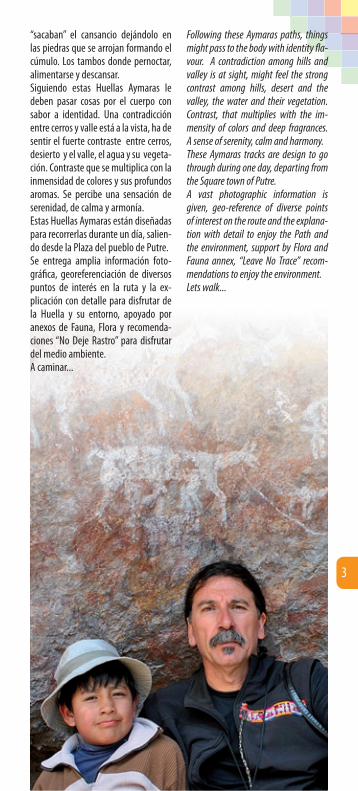
Following these Aymaras paths, things might pass to the body with identity fl a-vour. A contradiction among hills and valley is at sight, might feel the strong contrast among hills, desert and the valley, the water and their vegetation. Contrast, that multiplies with the im-mensity of colors and deep fragrances. A sense of serenity, calm and harmony. These Aymaras tracks are design to go through during one day, departing from the Square town of Putre.A vast photographic information is given, geo-reference of diverse points of interest on the route and the explana-tion with detail to enjoy the Path and the environment, support by Flora and Fauna annex, “Leave No Trace” recom-mendations to enjoy the environment.Lets walk...
“sacaban” el cansancio dejándolo en las piedras que se arrojan formando el cúmulo. Los tambos donde pernoctar, alimentarse y descansar.Siguiendo estas Huellas Aymaras le deben pasar cosas por el cuerpo con sabor a identidad. Una contradicción entre cerros y valle está a la vista, ha de sentir el fuerte contraste entre cerros, desierto y el valle, el agua y su vegeta-ción. Contraste que se multiplica con la inmensidad de colores y sus profundos aromas. Se percibe una sensación de serenidad, de calma y armonía.Estas Huellas Aymaras están diseñadas para recorrerlas durante un día, salien-do desde la Plaza del pueblo de Putre.Se entrega amplia información foto-gráfi ca, georeferenciación de diversos puntos de interés en la ruta y la ex-plicación con detalle para disfrutar de la Huella y su entorno, apoyado por anexos de Fauna, Flora y recomenda-ciones “No Deje Rastro” para disfrutar del medio ambiente.A caminar...
3

Algunos consejos para disfrutar las caminatas por la naturaleza, la Pacha-mama (Madre Tierra), muy cerca del cielo, respirando aire puro, gozando el canto y vuelo de las aves, observar animales salvajes en su ambiente na-tural, conocer la gente y la historia del pueblo Aymara.No son reglas ni leyes, ni tampoco to-can todos los temas, pero estos cinco tips te ayudarán a resolver problemas comunes que encontramos en una ca-minata por las Huellas Aymaras.Realizar actividades al aire libre con impacto mínimo, depende más de actitudes y conciencia que de leyes y reglamentos. Minimizar el impacto co-mienza con una planifi cación cuidado-sa antes de partir, tomando en cuenta todo efecto posible de su presencia en el lugar. Si se planifi ca con anticipación un viaje, se puede asegurar en princi-pio su seguridad y comodidad. Tenga en cuenta los siguientes puntos en sus
Few tips to enjoy the trekking, “Pa-chamama” (Mother Earth) nature, quite close to the sky, breathing pure air, enjoying the birds singing and fl iy-ing, watching the wild animals in their natural environment, encountering the Aymara people and their history.These are not rules or laws, neither go over all issues, but these fi ve tips, will help you to solve common problems that we might fi nd on a walk by the Aymaras Footprints.To perform outdoor activities with a minimun impact, depends more on at-titudes and awarness that laws or rules. Minimizing the impact starts with a careful plannifi cation before starting, taking into account all the possible ef-fects of your presence in the place. If you plan the trip ahead, you will be able to ensure your comfort and safety. Consider the following points on your
Consejos No Deje Rastro (NDR) para Huellas Aymaras
Tips for the Aymara Track“Leave No Trace” (LNT)
4

planes para evitar impactos negativos en la naturaleza. Usa esta guía y cuando no la ne-cesites, regalala a alguien que le pueda ser útil.
No Deje Rastro1. Camina y acampa sin dañar la
Pachamama• Usa caminos y huellas marcados
por el uso. Si la huella es angosta se debe transitar en fi la india.
• Si no hay huella marcada, escoge la superfi cie más resistente, piedra, grava, pastos secos y nieve, para no dañar las hierbas más débiles.
• Descansa en superfi cies resistentes, fuera de la huella o sendero.
• Evita lugares donde los impactos ambientales estén comenzando, como orillas de lagunas, y bofeda-les. Así ayudas a su recuperación.
2. Deja lo que encuentres• Preserva el pasado. Observa, pero
no toques ni rayes sitios de valor arqueológico, histórico o cultural.
• Deja rocas, plantas y otros elemen-tos naturales tal como los encon-trastes. No colectes “muestras” de ningun tipo.
• Evita el transporte o la introducción de especies no nativas.
• Recuerda : “llévate sólo las fotogra-fías, deja sólo las pisadas y mata sólo el tiempo”.
plannifi cation in order to avoid negative impacts on nature.Use this guide whenever you may need it, and give it away to some-one that it might be useful to.
Leave No Trace1. Walk and camp without damag-
ing the “Pachamama”• Walk on roads and tracks marked due
to the use of them. If the track is nar-row, you must walk on single queue.
• If there is no track marked, choose the most resistent surface, stone, gravel, dry grass or snow, in order not to damage the herbs grass weaker ones.
• Rest on surfaces out of the track or trail.
• Avoid places where environment impact has already started, such as lakes edges, wetlands, so you will be helping to their recovery.
2. Leave what you may fi nd• Preserve the past. Observe, but do
not touch or write on arqueological, storic or cultural places.
• Leave rocks, plants and other natural elements as you found them. Do not collect “samples” of any kind.
• Avoid to transport or introduce no native species.
• Remember: “take only the pictures, leave only the footprints and kill only the time” .
5

3. Respeta la vida silvestre• Observa los animales silvestres a
distancia.• Nunca alimentes animales silves-
tres, puede causar daño a su salud, altera su comportamiento natural y los expone a predadores.
• Protege los animales silvestres al-macenando tus alimentos y basura lejos de su alcance
• Si viajas con mascota, mantenla bajo control en todo momento.
• Evita el contacto con animales sil-vestres en sus temporadas de repro-ducción, anidación y crianza.
4. Respeta a los demás caminan-tes
• Se cordial con otras personas que como tú esperan disfrutar de la na-turaleza.
• Ubicate en la parte superior de la huella si te encuentras con otros ca-minantes o con ganado dómestico.
• Permite que los sonidos naturales prevalezcan, no generes ruidos mo-lestos.
5. Dispone adecuadamente tus residuos
• Todo lo que lleves y no consumas, además de tu basura, traélo de re-greso.
• Para hacer tus necesidades, cava un hoyo sobre 20 cm de profundidad y deposita la materia fecal en él. Preocupate de no estar a menos de 60 m de fuentes de aguas, de zona de camping o senderos. Cubre y di-simula el área cuando termines. El papel higiénico usado depositalo en una bolsa plástica y tráelo de regre-so.
Otros consejos • Estas Huellas Aymaras estan diseña-
das para realizarlas durante un dia, por lo tanto se deben iniciar por la mañana, ojalá antes de las 9:00 h.
• Protegete de la radiación solar, lo más importante es siempre la pre-vención.
• Considera que en ambientes de montaña el aire es menos denso,
3. Respect wildlife• Observe wild animals from a certain
distance.• Never feed the wild animals, you
could damage their health, alters their natural behaviour and exposes them to predators.
• Protect wild animals storing the food out of reach.
• If you travel with a pet, keep it under control at all times.
• Avoide contact with wild animals in their breeding, reproduction and nesting.
4. Respect other hikers• Be friendly with other people that as
you as well, expect to enjoy the na-ture.
• Place yourself on the higher part of the track if you fi nd yourself with other walkers or domestic cattle.
• Allow other natural sounds prevail, do not generate any annoying noise.
5. Dispose your garbage properly • All you take with you and do not eat,
besides garbage, take it back on your return.
• To relieve yourself, dig a hole of about 20 cm and put the fecal material in it. Ensure not to be within 60 mt from water sources of camping areas or tracks. Cover and disguise the area when fi nished. Put the toilet paper used, on a plastic bag and take it back with you.
Another tips• This Aymara tracks have been design
to be performed on a day, therefore must be started in the morning, hopefully before 9 am.
• Protect yourself from solar radiation the most important always is pre-vent.
• Consider that the mountain air is less dense than the sea level one, there-fore the solar radiation is far more dangerous.
• Use clothes that avoids to expose your body’s exposure to the sun. Use longe sleeves T-shirts and long trou-sers.
6

por lo cuál la radiación solar es mu-cho más péligrosa que a nivel del mar.
• Utiliza ropa que impida la exposi-ción de tu cuerpo al sol. Usa poleras manga larga y pantalones largos.
• Usa siempre lentes con protección UV.
• Usa un gorro de ala ancha. • Usa siempre protector solar de fac-
tor alto (sobre 30 SPF). • Si necesita un guía, prefi era los lo-
cales.• Compre su alimentación y agua en
establecimientos locales (Putre): Almacen Daria, calle O’Higgins 515 Cali, calle Baquedano 399 Supermercado la Paloma, calle
Baquedano 301 Tia Emilia (*), camino a Casibuñe s/n
Socoroma
(*) en este último establecimiento, se reco-
mienda reservar almuerzo antes de hacer el
Camino del Inka al 7-780.17.45, también
cuenta con alojamiento.
• Always use sun glasses with UV pro-tection.
• Use a wide-brimmed hat.• Always use a high factor sunscreen
protection (above 30 SPF).• If you need a guide prefer the local
ones.• Buy your food and water on stab-
lished stores (Putre): Almacen Daria Grosery, store
O’Higgins street 515 Cali, Baquedano street 399 La Paloma Supermarket, Baque-
dano street 301 Tia Emilia (*), towards Casibuñe
road no/nbr. Socoroma
(*) In this last place, lunch reservations are
recomended before doing the Del Inka trek-
king on the the phone nbr.; 7-780.17.45, it
also off ers accomodation.
7

Camino del Inka o Qhapaq Ñan que en quechua signifi ca “Camino Principal”
En el mapa la Huella está en color amarillo y lleva desde Putre al pueblo de Socoroma.Los puntos de referencia (UTM) descri-tos en la guía están en verde (CI).Casi en toda la huella hay señal de te-lefonía celular.
Distancia ida: 12.5 km
Tiempo aproximado: 6 h
Altura al inicio en Putre:3560 msnm
Altura llegada en Socoroma:3085 msnm
Se entregan 16 puntos (CI 1 al CI 16) sobre la huella, la distancia de marcha, coordenadas UTM, altura en msnm y fotografías del entorno como referencia. En el mapa puede en-contrar más detalles.
Inka or Qhapaq Ñan path, that in Quechua means “Main road”
The path in green, is the one between Putre and Socoroma.The (UTM) points of reference described in the guide are in green (CI).there is mobile sign in most of the track.
Forward Distance:12.5 km
Aproximate time: 6 h
Start height in Putre: 3.3560 masl (meters above sea level)
Height on arrival in Socorma: 3.085 masl
There are 16 points of the track, (CI 1 to CI 16), with the walking distance, with UTM coordinates, altitude in masl (me-ters above sea level ) and photographies of the environment. You can fi nd more details in the map.
Huella 1
del entorno cia. puede en-detalles.
You can fi nd more details in the map.
8

Salida desde la plaza de Putre en la esquina sures-
te, en la puerta del restaurant Canta-verdi y Banco Estado, seguir por calle A.P. Canto hasta el fi nal, doblar a la izquierda por Baquedano e inmedia-tamente a la derecha por la callecita del Hotel Kukuli, llegando hasta la Av. Circunvalación a orillas de la quebrada, siguiendo por ella a la derecha hasta unos corrales de pirca y un callejón que baja a la quebrada.
Distancia: 0.0 km
Coordenadas: 19K 440896 mE / 7987991 mS
Altura: 3560 msnm
Detalle de cada punto Detail for each point
En Avenida Circunvalación, está el callejón con los
corrales de pircas. Se debe bajar por el callejón hasta el fondo de la quebrada.
Distancia: 0.32 km
Coordenadas: 19K 440971 m E / 7987710 m S
Altura: 3550 msnm
Departure from Putre square in the southeast
corner, at Cantaverdi door’s restaurant and Banco Estado, continue through street A.P. Canto up to the end, turn left by Baquedano and immediately to the right through Hotel Kukuli’s little road, reaching Av.Circunvalación on the gully’s edge, continue through it on the right hand side up to a stone wall pens, Pirca (place to lock animals) and an al-ley that takes to the gully.
Distance: 0.0 km
Coordinates: 19K 440896 mE / 7987991 mS
Height: 3.560 masl
In Avenida Circunvalación, fi nd the alley that goes
down to the gully, between the stone wall pens. You must go down the alley to the end of the gully.
Distance: 0.32 km
Coordinates: 19K 440971 m E / 7987710 m S
Height: 3550 masl
CI 1
CI 2 CI 2
CI 1
CI 2
111111
222222 222222
111111
Yal
Phrygilus fruticeti
9

Bajando se llega al estero con agua, tomar a la dere-
cha sobre una pirca (muro de piedras) desmoronada, entrando al potrero o campo de cultivo. Continuar por la ori-lla del curso de agua hacia el poniente hacia la punta de las terrazas, se ve un árbol alto (eucaliptus).Desde ahí ya se ven y escuchan las aves cordilleranas, como el Yal (Phrygilus fruticetti), los Chirihues (Sicalis auri-ventris), el arrullo del agua del río, las terrazas de cultivo de alfalfa (Medicago sativa) con sus sistemas de riego siem-pre muy bien trabajados y cuidados.
Distancia: 0.43 km
Coordenadas: 19K 440987 m E / 7987637 m S
Altura: 3542 msnm
Going down it will be reached the estuary with
water, take your right over a pens (stone wall) crumbled, going into the paddock or breeding fi eld. Continue by the edge of the water course to the west towards the terraces edge, a tall tree (eucalyptus) can be seen.From there the birds from the Andes can be seen and heard, such as the Yal (Phrygilus fruticeti), the Chirihues (Si-calis auriventris), the sound of the river water, the cultivation of alfalfa (Medi-cago sativa) with their so well crafted and care irrigation systems.
Distance: 0.43 km
Coordinates: 19K 440987 m E / 7987637 m S
Height: 3542 masl
CI 3 CI 3
CI 4
333333 333333
10

Llegando por la derecha (Norte) de la punta de la
terraza, el árbol alto a la izquierda y con la quebrada a la derecha, la huella baja al fondo de la quebrada que tene-mos a la derecha. Una roca de tamaño mediano indica el acceso.
Distancia: 0.96 km
Coordenadas: 19K 440581 m E / 7987317 m S
Altura: 3483 msnm
Arriving by the right hand side (North) of the terrace
corner, the tall tree on the left and with the gully on the right, the path goes down to the bottom of the gully that we have to the right. A medium size rock shows the access.
Distance: 0.96 km
Coordinates: 19K 440581 m E / 7987317 m S
Height: 3483 masl
CI 4 CI 4444444 444444
Taruca (Taruka)
Hippocamelus antisensis
11

En el fondo de la quebra-da, continuar bajando al
poniente y doblando por la izquierda entrando a la segunda quebrada, esta vez seguir unos 50 m aguas arriba has-ta el lugar del vadeo (cruce del estero).
Distancia: 1.18 km
Coordenadas: 19K 440439 m E / 7987266 m S
Altura: 3464 msnm
At the gully’s bottom, con-tinue going down to the
west and turning to the left, going into the second gully, this time continue 50m upstream, up to the estuary crossing.
Distance: 1.18 km
Coordinates: 19K 440439 m E / 7987266 m S
Height: 3464 masl
CI 5 CI 5555555555555
12

CI 5
CI 5
Guanaco (Wanaku)
Lama guanicoe
13

Zona de cruce del estero, comienza el Camino del
Inka original bien marcado, seguir el ascenso en dirección a la mancha gris en el cerro. En este ascenso tendrá hermosas vistas al pueblo de Putre, sus nevados Táapaca, las terrazas de cul-tivo con los rebaños de llamas (Lama glama) y Alpacas (Vicugna pacos) pas-toreando. Con cierta facilidad podrá observar rebaños silvestres de Gua-nacos (Lama guanicoe) y si hay suerte algún grupo de Tarukas (Hippocamelus antisensis).
Distancia: 1.30 km
Coordenadas: 19K 440526 m E / 7987205 m S
Altura: 3468 msnm
Fin del ascenso, se llega a un par de apachetas
(cumulos de piedras) que enmarcan el pueblo con los nevados Táapaca al fondo.
Distancia: 2.68 km
Coordenadas: 19K 439673 m E / 7986683 m S
Altura: 3620 msnm
Estuary crossing zone, Camino del Inka the origi-
nal starts, well marked, continue the ascent in direction to the gray stain on the hill. In this ascent you will have beautiful sights of Putre town, its Taa-paca snow, the cultivation terraces with their llamas herds (Lama glama) and Alpacas (Vicugna pacos) grazing. With certain facility your will be able to see wild herds of Guanacos (Lama guani-coe) and if there is any luck some group of Traukas (Hippocamelus antisensis).
Distance: 1.30 km
Coordinates: 19K 440526 m E / 7987205 m S
Height: 3468 masl
At the end of the ascent, you will arrive to a pile of
stones “apachetas” that frame the town with the Taapaca snows at the back.
Distance: 2.68 km
Coordinates: 19K 439673 m E / 7986683 m S
Height: 3620 masl
CI 6
CI 7
CI 6
CI 7
Vista hacia el Norte, se ve el pueblo de Putre y el volcán
Táapaca, entre los apachetas.
Looking towards the North, the town of Putre and yhe Táapaca volcano can be seen, between the “apachetas”.
CI 7
666666666666
777777777777
14

Ya sobre terreno más pa-rejo, a la derecha hay una
formación rocosa donde se encuentra una hermosa Casa de Piedra y restos de corrales de pircas, donde el antiguo pastor encerraba sus animales por las noches.
Distancia: 3.35 km
Coordenadas: 19K 439277 m E / 7986240 m S
Altura: 3628 msnm
Se cruza una huella ancha, comienza el descenso, el ca-
mino se nota claramente a la distancia, entre arbustos como la Tola hedionda (Chersodoma jodopappa), la Yara (Du-nalia spinosa), la Chinchircoma (Mutisia acuminata), en las laderas más expues-tas al sol encontramos el Chastudo pelu-do (Oreocereus leucotrichus).Los árboles al fondo es el destino, Soco-roma.
Distancia: 3.62 km.
Coordenadas: 19K 439154 m E / 7986005 m S
Altura: 3631 msnm
Once on even land, to the right there is a rocky forma-
tion whith a beautiful stone house and some rests of paddocks and pens, where an old shepperd used to locked their ani-mals during the night.
Distance: 3.35 km
Coordinates: 19K 439277 m E / 7986240 m S
Height: 3628 masl
Cross a wide path, start the descent, the road is clearly
noted from the distance, between the bushes such as the Tola smelly (Cher-sodoma Jodopappa), the Yara (Dunalia spinosa), the Chinchircoma (Mutisia acuminata), on the slopes which are ex-posed to the sun we found the Chastudo peludo (Oreocereus leucotrichus) The trees at the end is the destiny, Socoroma.
Distance: 3.62 km
Coordinates: 19K 439154 m E / 7986005 m S
Height: 3631 masl
CI 8
CI 9
CI 8
CI 9
CI 8
CI 9
888888888888
999999 999999
15
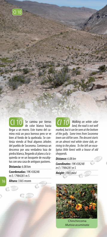
Se camina por tierras de color blanco hasta
llegar a un morro. Este tramo del ca-mino está un poco borroso pero se ve bien al fondo de la quebrada. Se con-tinúa viendo al fi nal algunos árboles del pueblo de Socoroma. Comienza un descenso por una verdadera loza de piedra blanca, llegando al plano a la iz-quierda se ve un bosquete de eucalip-tus con una casa de antiguos pastores.
Distancia: 6.08 km
Coordenadas: 19K 438248 m E / 7984281 m S
Altura: 3365 msnm
Walking on white color land, the road is not well
marked, but it can be seen at the bottom of the gully. Some trees from Socoroma town can still be seen. The descent starts on an almost real white stone slab, ar-riving to the plano. To the left an euca-lyptus little forest with a house of old shepperds.
Distance: 6.08 km
Coordinates: 19K 438248 m E / 7984281 m S
Height: 3365 masl
CI 10 CI 10
CI 10
000000000000
Chinchircoma
Mutisia acuminata
16

Llegada a la quebrada del Aroma, la bajada
está bien marcada, se debe cruzar el estero cuyo lecho se ve muy rojo. Una vez atravesado el estero comienza una subida encajonada.
Distancia: 7.14 km
Coordenadas: 19K 437839 m E / 7983461 m S
Altura: 3209 msnm
Arriving to the “Del Aroma” gully, the way
down is well marked, the stuary must be crossed, with its bed looking quite red. Once crossing the stuary it starts an enclosed way up.
Distance: 7.14 km
Coordinates: 19K 437839 m E / 7983461 m S
Height: 3209 masl
CI 11 CI 11
CI 11
111111111111
17

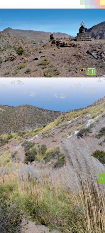
Hay un monolito con una cruz, con una
hermosa vista hacia el poniente en dirección a Socoroma, ya se divisan ca-minos más anchos de vehículos. Seguir subiendo por pequeña quebrada con arbustos como la Cola de Zorro (Cor-taderia atacamensis), hasta cruzar una acequia de riego.
Distancia: 8.5 km
Coordenadas: 19K 437476 m E / 7982924 m S
Altura: 3195 msnm
There is a monolith with a cross “Animita”, with
a beautiful view towards the west with direction to Socoroma, a wider road for vehicles, can be seen. Continue going up by the little gully with foxtail bushes (Cortaderia atacamensis), until crossing irrigation ditches.
Distance: 8.5 km
Coordinates: 19K 437476 m E / 7982924 m S
Height: 3195 masl
CI 12 CI 12
Subir por quebrada con vegetación arbustiva como las Cola de zorro
(Cortaderia atacamensis), que indican presencia de húmedad, por el canal que pasa más arriba y que se debe cruzar, para seguir subien-
do. Ya la huella está marcada.
Go up the gully with bushy vegetation like foxtails (Cortadería atacamensis), that tells about humidity in the area, by the canal that goes by a bit up and that has to be crossed, to continue going up, the path is already marked.
CI 12
222222222222
18
CI 12
19

Se llega a una extraña formación del cerro Ja-
machuma con grandes grietas naturales, escalonadas desde lo alto hasta la zona baja, dando forma a escalones o terra-zas naturales. Abajo pasa una tubería de agua de riego. Se puede ver y sentir la fl ora nativa en los bordes del camino, arbustos como el Cuetillo (Chuquiraga spinosa) y la Chinchircoma (Mutisia acu-minata), entre otras. Vuelan y trinan las aves de la zona precordillerana, banda-das de Chirihues (Sicalis auriventris), el potente canto en vuelo del Yal (Phrygilus fruticeti), hermosos Cometocinos (Phry-gilus atriceps) y varios más. (ver Anexos Flora y Fauna).
Distancia: 9.27 km
Coordenadas: 19K 437487 m E / 7982343 m S
Altura: 3230 msnm
Se cruza un tubo celeste del agua de
riego, el cuál se debe seguir hacia el poniente. Luego viene un cerco de alambre y una puerta que se debe mantener cerrada. El cerco es para intentar evitar que los guanacos (Lama guanicoe) ingresen a pastar a las zonas de cultivo.
Distancia: 9.90 km
Coordenadas: 19K 436982 m E / 7981422 m S
Altura: 3205 msnm
Arriving to a strange for-mation of the Jamachu-
ma hill, with big natural cracks, staggered from above to the down zone, giving form to steps or natural terraces. Below there is a water irrigation tube. You can see and feel the native fl ora on the edges of the road, bushes like el Cuetillo (Chuquiraga spinosa) and the Chinchircoma (Mutisia acuuminata) between others. The birds from the pre-Andes are fl ying and trilling, fl ocks of Chirihues (Sicalis auriventris), the potent Yal singing on fl ight (Phrygilus fru-ticeti), beautifull Cometocinos (Phrygilus atriceps) and many more (see annex Flora and Fauna).
Distance: 9.27 km
Coordinates: 19K 437487 m E / 7982343 m S
Height: 3230 masl
Cross a ligt blue pipe water irrigation, con-
tinuing towards the west. Then a wire fence and a door that should be kept shut. The fence is meant to avoid the lamas (Lama guanicoe) going into the crops area to graze.
Distance: 9.90 km
Coordinates: 19K 436982 m E / 7981422 m S
Height: 3205 masl
CI 13
CI 14
CI 13
CI 14
CI 13
333333333333
20

Ya sobre un camino ancho se llega a una
animita (monolito con cruz) y el tubo de agua cruza. Socoroma esta a la vista y se debe tomar la huella que baja a la izquierda del camino ancho vehicular. Se continúa bajando hasta el fondo de la quebrada por la huella peatonal con vista a las terrazas de cultivos.
Distancia: 10.5 km
Coordenadas: 19K 437266 m E / 7987374 m S
Altura: 3195 msnm
Already on a wide road, will reach a little “an-
imita” (monolite with a cross) and the water pipe that crosses. Socoroma is at sight and take the path that goes down to the left of the vehicles road. Continue going down to the bottom of the gully by the pedestrian trail with view to the cultivation terraces.
Distance: 10.5 km
Coordinates: 19K 437266 m E / 7987374 m S
Height: 3195 masl
CI 15 CI 15
CI 14
CI 15
555555555555
21
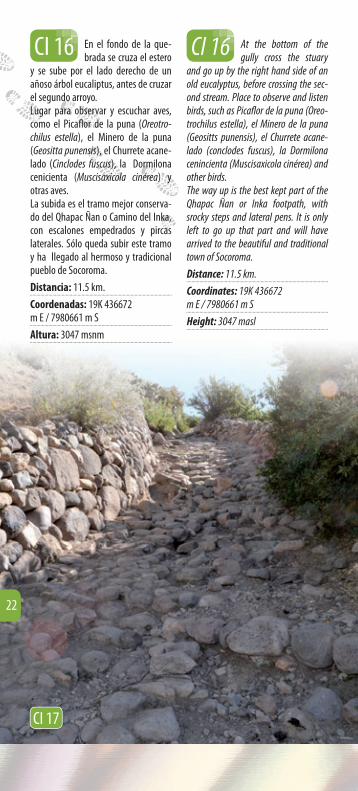
En el fondo de la que-brada se cruza el estero
y se sube por el lado derecho de un añoso árbol eucaliptus, antes de cruzar el segundo arroyo. Lugar para observar y escuchar aves, como el Picafl or de la puna (Oreotro-chilus estella), el Minero de la puna (Geositta punensis), el Churrete acane-lado (Cinclodes fuscus), la Dormilona cenicienta (Muscisaxicola cinérea) y otras aves.La subida es el tramo mejor conserva-do del Qhapac Ñan o Camino del Inka, con escalones empedrados y pircas laterales. Sólo queda subir este tramo y ha llegado al hermoso y tradicional pueblo de Socoroma.
Distancia: 11.5 km.
Coordenadas: 19K 436672 m E / 7980661 m S
Altura: 3047 msnm
At the bottom of the gully cross the stuary
and go up by the right hand side of an old eucalyptus, before crossing the sec-ond stream. Place to observe and listen birds, such as Picafl or de la puna (Oreo-trochilus estella), el Minero de la puna (Geositts punensis), el Churrete acane-lado (conclodes fuscus), la Dormilona cenincienta (Muscisaxicola cinérea) and other birds.The way up is the best kept part of the Qhapac Ñan or Inka footpath, with srocky steps and lateral pens. It is only left to go up that part and will have arrived to the beautiful and traditional town of Socoroma.
Distance: 11.5 km.
Coordinates: 19K 436672 m E / 7980661 m S
Height: 3047 masl
CI 16 CI 16
CI 17
666666666666
22

Huella Mark apata
Markapata Tracks
Huella 2
El bofedal de Guailloco se ubica hacia el noreste del Pueblo saliendo hacia Markapata o Putre Alto, en dirección a los Nevados Táapaca.
Distancia ida y regreso: 7.3 km
Tiempo aproximado: 5 h
Altura al inicio: 3544 msnm
Altura en bofedal: 3974 msnm
Se entregan 9 puntos (B1 al B9) sobre la huella, con la distancia de marcha, con coordenadas UTM, altura en msnm y fotografías del entorno como referencia. Se adjunta un mapa con el detalle.
Towards the northwest, in the high Putre area (Markapata) and towards the Táapaca up to the Guailloco bodefal (plain with more humidity and vegetation)
Round trip Distance: 7.3 km
Approximate time: 5 h
Height at start: 3544 masl
Bofedal Height: 3974 masl
9 Points are given (B1 to B9) on the track, with the walking distance and UTM coor-dinates, height in meters above sea level and photographs of the environment as a reference. A map is also enclosed with the detail. The bofedal is located in direction to the northwest of the town, under the refer-ence of Putre’s snows or Táapaca.
Inicio desde la plaza del pueblo, esquina sureste
donde se ubica el restaurant Cantaver-di, subir por calle A. Prat hasta el sen-dero peatonal en dirección a Markapa-ta o Putre Alto.
Distancia: 0.0 km
Coordenadas:m E / 7987992 m S
Altura: 3560 msnm
Starting from the town Square, south-
east where restaurant Cantaverdi is located, go up by street A.Prat till the walking path in direction to a Markapa-ta or High Putre.
Distance: 0.0 km
Coordinates:m E / 7987992 m S
Height:
B 1
B 1
1
111111
Detalle de cada punto Detail for each point
nicio desde la plaza del pueblo, esquina sureste bloca el restaurant Cantaver-elcalle A. Prat hasta el sen-lllle A.l en dirección a Markapa-n ddiro.
.0 km
as:2 m S
0 msnm
Starting froom m m m ththt e ffrromfown Squququuaarararareee,e, s sououththhhthth----ououththrestaaaaauurururuuraanant t Cantavverrerdidididid i s tavvere
upuppupp b bbbbbbyy yy ststreet A.Prat till ttttheheheheh t till iin direction to a Markapaa-rkakarkMarMark
tre.
00000 kkkk kk mmmm
:::2222 22 m SSSS
23

Subir por huella peatonal hasta camino ancho vehi-
cular y seguirlo al oriente. Se acerca a los sectores agrícolas y ganaderos.
Distancia: 0.18 km
Coordenadas: 19K 441025 mE/ 7988075 mS
Altura: 3583 msnm
Continúa camino ancho, comienzan las terrazas con
alfalfa y los sistemas de riego. Al fondo sobre un cerrillo la referencia es un ár-bol alto (eucaliptus), más al fondo los Nevados de Putre o Táapaca.
Distancia: 0.7 km
Coordenadas: 19K 441353 mE/ 7988504 mS
Altura: 3646 msnm
Go up by the walking path up to a vehicles wide road
and continue to the west. You are get-ting closed to agricultural and livestock area.
Distance: 0.18 km
Coordinates: 19K 441025 mE/ 7988075 mS
Height: 3583 masl
The wide road continues, the alfalfa terraces start to
appear (Medicago sativa) and the irri-gation Systems intricate and smoothly following the hills slopes curves. At the bottom over a small hill the reference is a tall tree (eucalyptus), and even further the Putre’s snows or Táapaca.
Distance: 0.7 km
Coordinates: 19K 441353 mE/ 7988504 mS
Height: 3646 masl
B 2
B 3
B 2
B 3333333
333333
B 2
B 3
Chirigue Dorado
Sicalis auriventris
24
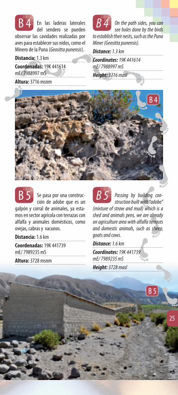
En las laderas laterales del sendero se pueden
observar las cavidades realizadas por aves para establecer sus nidos, como el Minero de la Puna (Geositta punensis).
Distancia: 1.3 km
Coordenadas: 19K 441614 mE/ 7988997 mS
Altura: 3716 msnm
On the path sides, you can see holes done by the birds
to establish their nests, such as the Puna Miner (Geositta punensis).
Distance: 1.3 km
Coordinates: 19K 441614 mE/ 7988997 mS
Height: 3716 masl
B 4 B 4444444 444444
Se pasa por una construc-ción de adobe que es un
galpón y corral de animales, ya esta-mos en sector agrícola con terrazas con alfalfa y animales domésticos, como ovejas, cabras y vacunos.
Distancia: 1.6 km
Coordenadas: 19K 441739 mE/ 7989235 mS
Altura: 3728 msnm
Passing by building con-struction built with “adobe”
(mixture of straw and mud) which is a shed and animals pens, we are already on agriculture area with alfalfa terraces and domestic animals, such as sheep, goats and cows.
Distance: 1.6 km
Coordinates: 19K 441739 mE/ 7989235 mS
Height: 3728 masl
B 5 B 5
B 4
B 5
25

Se encuentra por el lado izquierdo la acequia de
agua de riego del sector. Ya se extin-guen las terrazas de cultivos y encon-tramos terrenos naturales, con fl ora nativa como la Chinchircoma (Muti-sia acuminata), el Chastudo peludo (Oreocereus leucotrichus) y no faltarán los relinchos de alguna tropilla de Gua-nacos (Lama guanicoe) al divisarnos desde las laderas.
Distancia: 2.0 km
Coordenadas: 19K 441989 mE/ 7989636 mS
Altura: 3788 msnm
On the left hand side an irrigation water sector.
The crop terraces become to extinguish and we fi nd natural lands, with native fl ora such as the Chinchircoma (Mutisia acuminate), the Heary chastudo (Oreo-cereus leucotrichus) and not missing the neighing of some Guanacos (Lama guanicoe) herd when spotting us from the slopes.
Distance: 2.0 km
Coordinates: 19K 441989 mE/ 7989636 mS
Height: 3788 masl
B 6 B 6
Aparecen en los costados de la ruta pastos típicos de altura como es la Paja Bra-va (Festuca chrysophylla) , ya se ven y escuchan aves
de altura (ver Anexo Aves)
On the path sides appear typical grass height such as the Paja Brava (Festuca chrysophylla), and fl ocks of birds from the heights can be seen and heard, such as the Chirihües (Sicalis auriventri) Bandurrila of the puna (Upucerthia va-lidirostris). See birds annex for more info.
B 6
26

Se llega a la quebrada donde la huella se pierde,
se debe buscar por la ladera derecha, cruzando una gran pirca que atraviesa desde el cerro a la quebrada. El bofedal se divisa al frente en altura.
Distancia: 3.0 km
Coordenadas: 19K 442643 mE/ 7990316 mS
Altura: 3866 msnm
Arriving to the creek where the path is lost,
look by the right slope, crossing a great “pirca” (stone wall ) that goes across the hill to the creek. The bofedal can be seen at the other side in height.
Distance: 3.0 km
Coordinates: 19K 442643 mE/ 7990316 mS
Height: 3866 masl
B 7 B 7
B 6
B 7
Guacalla
Corryocactus brevistylus
Chastudo peludo
Oreocereus leucotrichus
27

Se llega a la intersección de dos quebradas, la de
la derecha lleva a un hermoso salto de agua que vale la pena visitar. Si se continúa por la quebrada de la izquier-da nos lleva al bofedal. Encontramos grandes Colas de Zorro en el lecho.
Distancia: 3.4 km
Coordenadas: 19K 442905 mE/ 7990603 mS
Altura: 3909 msnm
Arriving to the intersec-tion of two creeks, the one
at the right leads to a beautiful water fall worth visiting. If you continue by the creek on the left it takes us to the bofedal. Vegetation with great Fox Tails (Cortaderia atacamensis ) is found on the river bed.
Distance: 3.4 km
Coordinates: 19K 442905 mE/ 7990603 mS
Height: 3909 masl
B 8 B 8
B 8
B 8
28

Subiendo la ladera ya se lle-ga al bofedal, podrá sentir el
aire puro, el cielo más cercano, las bellas tonalidades de los cerros y sus piedras, caminar sobre la vegetación y suelo hú-medo, un momento muy especial para “alimentar el alma” con las bellezas escé-nicas del entorno que llaman a la calma a respirar profundo.Oportunidad de observar y fotografi ar las aves de precordillera que en este lugar son más abundantes (ver Anexo Aves).
Distancia: 3.6 km
Coordenadas: 19K 442979 mE/ 7990710 mS
Altura: 3938 msnm
Jacha mamanajtatanaj layrapachat jiwa-saru arusiri = Nuestros sabios abuelos nos hablan de tiempos antiguos.
Going up the slope it arrives to the bofedal, one can feel
the pure air, the sky closer, the beautiful shades on the hills and their stones, walk on vegetation and humid soil, a very spe-cial moment to “feed the soul” with the beautiful scenes surrounding that call to calm and deep breathing.Opportunity to observe and photograph birds from the Andean foothills, which are more abundant. (See birds annex).
Distance: 3.6 km
Coordinates: 19K 442979 mE/ 7990710 mS
Height: 3938 masl
Jacha mamanajtatanaj layrapachat ji-wasaru arusiri = Our wise grandparents talk to us about ancient times.
B 9
B 9
Con la altura y el frío se forman extrañas fi guras de hielo en las laderas más sombreadas y húmedas, que se entrelazan con pastos de altura.
With the altitude and the cold, strange ice fi gures on the shady moisty slopes can be seen, intertwined with tall grasses.
B 9
29

Huella a pictografías de Wilacabrani
Wilacabrani pedestrian track pictographs
Huella 3
En el mapa la huella en amarillo.Los puntos de referencia (UTM) descritos en la guia en azul (W).En esta huella se puede acceder en vehí-culo hasta el punto W10 y acortar en una hora el tiempo del circuito.Casi en todo la huella hay señal de tele-fonía celular.
Huella a WilacabraniEl nombre proviene de la lengua aymara que signifi ca:Wila: sangre, color rojo C”abrani : llamaEn alusión directa a los camélidos, lla-mas, que fi guran en la pintura rupestre de color rojo.
Distancia ida y regreso: 13 kmTiempo aproximado: 6 hAltura al inicio: 3556 msnmAltura en pictografías: 3143 msnm
Se entregan 20 puntos (W inicio al W19) sobre la huella, con la distancia de mar-cha, con coordenadas UTM, altura en
msnm y fotografías del entorno como
referencia. En el mapa puede
encontrar más de-talles.
The trail in yellow.The (UTM) points of reference, described in the blue guide (W).This track can be access in a vehicle until point W10 and shortened in one hour the circuit time.There is mobile sign in almost the whole track.
Wilacabrani TrackThe name comes from the Aymara Lan-guage which means: Wila; Blood, red colorC”abrani: LlamaIn direct allusion to the camels, llamas (Lama glama) which appear in the red color rock paintings.
Back and forward distance: 13 kmApproximate time: 6 hStarting Height: 3556 maslPictographs Height: 3143 masl
20 points are given (starting with W to W19) of the trail, with the walking dis-tance, with coordinates UTM, height in meters above sea level and environment photographs as a reference. You fi nd more details in the map.
30

Detalle de cada punto Detail for each point
Salida desde la plaza de Putre
en la esquina noroeste, en la puerta del restaurant Flor de Rosa, calles Latorre con Carrera. Caminar por calle Latorre hacia el poniente (bajando).
Distancia: 0.0 km
Coordenadas: 19K 440834 mE / 7988015 mS
Altura: 3556 msnm
Departure from Putre Square
in the northwest corner, at the restau-rant Flor de rosa door and Latorre with Carrera streets. Walk by Latorre street towards west (going down).
Distance: 0.0 km
Coordinates: 19K 440834 mE / 7988015 mS
Height: 3556 masl
W Inicio W Startt
Bajando por calle Latorre se llega a su fi n, junto al
muro de los terrenos de Regimiento de Caballería Blindada Granaderos. Do-blar al Norte (derecha) en una pequeña subida, hacia el Liceo C 3 Granaderos.
Distancia: 0.17 km
Coordenadas: 19K 440660 m E / 7987994 m S
Altura: 3546 msnm
Going down Latorre street you reach the end,
along the wall of the Armored Cavalry Regiment Granadero’s lands, turn to the North (right) on a little high up, towards School C3, Granaderos.
Distance: 0.17 km
Coordinates: 19K 440660 m E / 7987994 m S
Heigh: 3546 masl
W 1 W 1
Cometocino del norte
Phrygilus atriceps
31

En la esquina doblar a la izquierda, bajando al
poniente, a la derecha del camino está el Liceo C 3 y las instalaciones del Regi-miento Granaderos a la izquierda.Al fi nal del tramo ya se ve la quebrada del rio a la derecha y comienzan los campos de cultivo de alfalfa (Medicago sativa) y en verano chacras con maíz (Zea mays), habas (Vicia faba) y papas (Solanum tuberosum).Ya se ven y escuchan las aves, como el Chincol, Jilgueros, Mineros, etc. (más información en Anexo Fauna), el arrullo del agua del río, las terrazas de cultivo en la ladera del cerro al frente.
Distancia: 0.24 km
Coordenadas: 19K 440640 m E / 7988025 m S
Altura: 3544 msnm
Letrero del cruce al Hotel Qantati, se debe seguir
derecho por la bajada al río.Ya en zona rural, en las orillas del camino vehicular hay arbustos, Cuetillo (Chu-quiraga spinosa), Chinchircoma (Mutisia acuminata), etc. (Ver Anexo Flora) en épocas con muchas fl ores coloridas y con abundantes aves, como el Yal (Phrygilus fruticeti), Cometocino (Phrygilus atri-ceps), Churrete (Cinclodes fuscus), etc. (más información en Anexo Aves).
Distancia: 0.65 km
Coordenadas: 19K 440264 m E / 7987925 m S
Altura: 3510 msnm
In the corner turn to the Left going down towards
the west, to the right of the road, is School C3 and the Granaderos Regiment facilities towards the left.At the end of the section the river’s gully can be seen to the right and the alfalfa fi elds (Medicago sativa) begins and in summer the farms with maize (Zea mays) green beans (Vicia faba) and po-tatoes (Solanum tuberosum).The birds can be heard and seen, such as the Chincol, Goldfi nches, Miners, etc. (more info in fauna Annex) the water river murmur, the farming terraces in the hill side in front.
Distance: 0.24 km
Coordinates: 19K 440640 m E / 7988025 m S
Heigh: 3544 masl
Crossing sign at Qantati Hotel, continue straight
on down the river.Once at the rural zone, at the hedge of a vehicle road there are bushes, Cuetillo (Chuquiraga spinosa), Chinchircoma (Mutisia acuminata), etc. (See Flora Annex) on times with many color full fl owers and abundant birds, such as the Yal (Phrygilus fruticeti), Cometocino (Phrygilus atriceps), Churrete (Cinclodes fuscus), etc. (more info on Annex Birds).
Distance: 0.65 km
Coordinates: 19K 440264 m E / 7987925 m S
Heigh: 3510 masl
W 2
W 3
W 2
W 3
W2
32

Cruce de puente sobre río.
Atraídos por las aguas y la vegetación podrá observar abundantes aves y más de algún picafl or (Oreotrochilus estella) libando néctar de las fl ores en su típica pose de aleteo intenso, mantenién-dose estático frente a su alimento, el fuerte zumbido de su aleteo lo delatará para la observación.Se avanza entre terrazas de cultivo con alfalfa, eucaliptos y una casa a la derecha. La quebrada del río queda a la izquierda.
Distancia: 1.12 km
Coordenadas: 19K 439850 m E / 7988095 m S
Altura: 3464 msnm
Bridge crossing over the river.
Attracted by the water and vegetation will see abundant birds and more than one hummingbird (Oreotrochilus estella) sipping nectar of the fl owers in his typi-cal pose of severe fl utter, remaining static in front of his food, the strong hum of his fl uttering betray him for the observation.Go forward between alfalfa crops terraces, eucalyptus and a house to the right. The river gully is on the left side.
Distance: 1.12 km
Coordinates: 19K 439850 m E / 7988095 m S
Heigh: 3464 masl
W 4 W 4
W3
W4
Cuetillo
Chuquiraga spinosa
33

Por ladera del cerro, hay una hermosa roca tipo
monolito.Seguro podrá encontrar sobre la pared rocosa agujeros de aves que constru-yen sus nidos en el barranco, como el Minero de la Puna (Geositta punensis).
Distancia: 1.33 km
Coordenadas: 19K 439647.10 m E / 7988102.46 m S
Altura: 3467 msnm
On the hillside, there is a beautiful rock monolith
type.For sure it could be found over the rocky wall, holes of birds that build their nests on the gorge, like the Puna Miner (Geo-sitta punensis)
Distance: 1.33 km
Coordinates: 19K 439647.10 m E / 7988102.46 m S
Heigh: 3467 masl
W 5 W 5
W5
34

Se continúa con la ladera del cerro a la derecha,
hay una gran pared rocosa lisa con agujeros.
Distancia: 1.58 km
Coordenadas: 19K 439403 m E / 7988088 m S
Altura: 3464 msnm
Continue with hillside to the right, there is a great
smoothy rocky wall with holes.
Distance: 1.58 km
Coordinates: 19K 439403 m E / 7988088 m S
Heigh: 3464 masl
W 6 W 6
Capachito
Calceolaria inamoena
35

Nueva bifurcación del camino, continuar por la
izquierda.
Distancia: 2.12 km
Coordenadas: 19K 438912 m E / 7987928 m S
Altura: 3424 msnm
New fork on the road, continue on the left.
Distance: 2.12 km
Coordinates: 19K 438912 m E / 7987928 m S
Heigh: 3424 masl
W 8
W 8
W7
Bifurcación del camino, hay letreros, continuar
por letrero Puquios, por la izquierda.Comienza una gran planicie quedando a la derecha una derruida construcción.
Distancia: 1.84 km
Coordenadas: 19K 439159 m E / 7988036 m S
Altura: 3443 msnm
Fork in the road, there are signs, continue by the
Puquios sign, on the Leith.A great plain starts and to the right a ruined construction.
Distance: 1.84 km
Coordinates: 19K 439159 m E / 7988036 m S
Heigh: 3443 masl
W 7 W 7
Aguilucho de la puna
Buteo poecilochrous
36
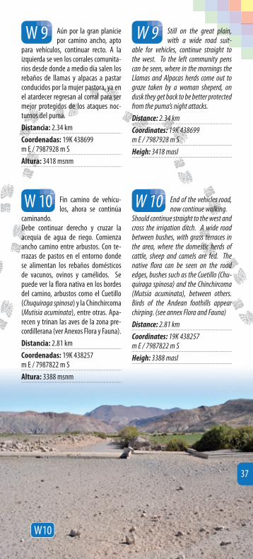
Aún por la gran planície por camino ancho, apto
para vehículos, continuar recto. A la izquierda se ven los corrales comunita-rios desde donde a medio día salen los rebaños de llamas y alpacas a pastar conducidos por la mujer pastora, ya en el atardecer regresan al corral para ser mejor protegidos de los ataques noc-turnos del puma.
Distancia: 2.34 km
Coordenadas: 19K 438699 m E / 7987928 m S
Altura: 3418 msnm
Still on the great plain, with a wide road suit-
able for vehicles, continue straight to the west. To the left community pens can be seen, where in the mornings the Llamas and Alpacas herds come out to graze taken by a woman sheperd, on dusk they get back to be better protected from the puma’s night attacks.
Distance: 2.34 km
Coordinates: 19K 438699 m E / 7987928 m S
Heigh: 3418 masl
W 9 W 9
Fin camino de vehícu-los, ahora se continúa
caminando.Debe continuar derecho y cruzar la acequia de agua de riego. Comienza ancho camino entre arbustos. Con te-rrazas de pastos en el entorno donde se alimentan los rebaños domésticos de vacunos, ovinos y camélidos. Se puede ver la fl ora nativa en los bordes del camino, arbustos como el Cuetillo (Chuquiraga spinosa) y la Chinchircoma (Mutisia acuminata), entre otras. Apa-recen y trinan las aves de la zona pre-cordillerana (ver Anexos Flora y Fauna).
Distancia: 2.81 km
Coordenadas: 19K 438257 m E / 7987822 m S
Altura: 3388 msnm
End of the vehicles road, now continue walking.
Should continue straight to the west and cross the irrigation ditch. A wide road between bushes, with grass terraces in the area, where the domestic herds of cattle, sheep and camels are fed. The native fl ora can be seen on the road edges, bushes such as the Cuetillo (Chu-quiraga spinosa) and the Chinchircoma (Mutsia acuminata), between others. Birds of the Andean foothills appear chirping. (see annex Flora and Fauna)
Distance: 2.81 km
Coordinates: 19K 438257 m E / 7987822 m S
Heigh: 3388 masl
W 10W 10
W10
37

Se ve a la derecha, al fondo en la quebrada
un gran árbol (eucaliptos), entre ar-bustos de diversas formas y aromas, más adelante zonas con riego y alfalfa.En el entorno de esta gran planicie agrícola tendrá hermosos cerros de diversos colores y tonalidades. Por esta misma huella transitan grandes reba-ños de camélidos domésticos que pue-de tener la suerte de cruzar, observar y conversar con su pastor.
Distancia: 3.8 km
Coordenadas: 19K 437343 m E / 7987461 m S
Altura: 3299 msnm
On the right, at the creek’s bottom, a great tree can
be seen (eucalyptus) among bushes of various forms and fragances, a bit ahead, zones with water irrigation and alfalfa. On this great agricultural plain surround-ings will have beautiful hills with diverse colors and shades. On the same trail great herds of domestic camels, might have the luck to see them crossing, observe and talk to their shepherd.
Distance: 3.8 km
Coordinates: 19K 437343 m E / 7987461 m S
Heigh: 3299 masl
W 11
W 11
W11
38

En la ladera de la que-brada se ve amplia zona
de antiguas terrazas de cultivo. Al fon-do de la quebrada una pequeña vega, zona más húmeda con pastos tiernos que prefi eren los animales herbívoros, a la orilla del río hermosas Colas de Zo-rro, también se ven restos de derruida casa del pastor y sus corrales.Al frente, abajo a la derecha, saliendo de la vega, se ve la Huella a Wilacau-rani.
Distancia: 3.92 km
Coordenadas: 19K 437266 m E / 7987374 m S
Altura: 3290 msnm
On the creek slopes a wide zone of ancient agricul-
tural terraces (andenes). At the bottom a small plain, which is a more humid zone with tender grass that animals prefer to feed themselves, a the banks of the wa-ter course beautiful foxtails (Cortaderia atacamensis), also a ruined shepherd house can be seen and stones corrals.Heading down to the west, coming out of the plain, the Wilacaurani Footprints can be seen.
Distance: 3.92 km
Coordinates: 19K 437266 m E / 7987374 m S
Heigh: 3290 masl
W 12W 12
W12
39

En este punto se debe bajar a la quebrada y
cruzar el estero, la huella se ve bien marcada al otro lado de la ladera y con-tinúa bajando por la quebrada.Ya se siente el aire desértico, frío y seco, que acaricia nuestro rostro. Ya está en las milenarias Huellas Aymaras, en el desierto profundo.
Distancia: 4.05 km
Coordenadas: 19K 437173 m E / 7987286 m S
Altura: 3277 msnm
At this point, go down the creek and cross the
estuary, the track looks well marked on the other side of the slope and continue descending down the creek. The desert air cold and dry, can be feel that caress-ing your our face. It is already on the ancient Aymaras footprints, in the deep desert.
Distance: 4.05 km
Coordinates: 19K 437173 m E / 7987286 m S
Heigh: 3277 masl
W 13W 13
W13
40

W13
Alpaca (Alpaga)
Vicugna pacos
Llama
Lama glama
41

Se escuchan los “mur-mullos del agua”, que
en voz aymara signifi ca el nombre del pueblo: Putre. El antiguo habitante ori-ginario que caminaba por esta huella, escuchaba los mismos murmullos.Fondo de la quebrada, hay agua (mejor no beberla). Cruzar estero y el sendero continúa por ladera norte de la que-brada. Lugar para observar y escuchar aves, como el Picafl or de la puna (Oreo-trochilus estella), el Minero de la puna (Geositta punensis), el Churrete acane-lado (Cinclodes fuscus), la Dormilona cenicienta (Muscisaxicola cinérea) y varios otros (ver Anexo Fauna).En la fotografía se muestra la salida desde la vega, con una pequeña subida y una huella bien marcada.
Distancia: 4.11 km
Coordenadas: 19K 437159 m E / 7987339 m S
Altura: 3272 msnm
The “murmurs of water” are heard, that in Ay-
mara voice, means the name of town: Putre. The old inhabitant that walked on this track, use to hear the same water sound.At the bottom of the creek, there is water (better not to drink it). Cross the estuary and the trail continues by the north side of the creek. Place to observe and listen to the birds, such as Hummingbird of the puna (Oreotrochilus estella) The Miner of the puna (Geositta punensis) the Cin-amon churrete (Cinclodes fuscus), the Sleeping beauty (Muscisaxicola cinérea) and various others (see Annex Fauna).In the photograph the way out from the plain is shown with a small way up and a well marked track to the west.
Distance: 4.11 km
Coordinates: 19K 437159 m E / 7987339 m S
Heigh: 3272 masl
W 14W 14
W14
42
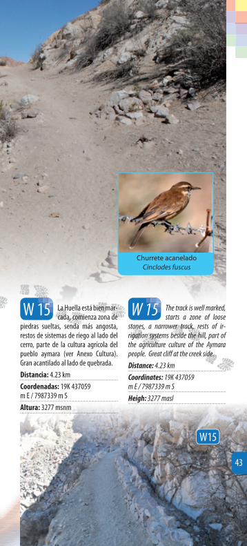
La Huella está bien mar-cada, comienza zona de
piedras sueltas, senda más angosta, restos de sistemas de riego al lado del cerro, parte de la cultura agrícola del pueblo aymara (ver Anexo Cultura). Gran acantilado al lado de quebrada.
Distancia: 4.23 km
Coordenadas: 19K 437059 m E / 7987339 m S
Altura: 3277 msnm
The track is well marked, starts a zone of loose
stones, a narrower track, rests of ir-rigation systems beside the hill, part of the agriculture culture of the Aymara people. Great cliff at the creek side.
Distance: 4.23 km
Coordinates: 19K 437059 m E / 7987339 m S
Heigh: 3277 masl
W 15W 15
W15
Churrete acanelado
Cinclodes fuscus
43
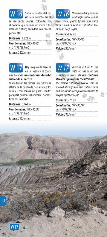
Hay un giro a la derecha en la Huella y se conti-
núa bajando, no continuar derecho subiendo el cerrito.Ya de divisan las terrazas de cultivo de alfalfa de la quebrada de Laitane y los corrales con muros de pircas usados para para guardar los animales domés-ticos por la noche.
Distancia: 5.16 km
Coordenadas: 19K 436247 m E / 7987218 m S
Altura: 3153 msnm
There is a turn to the right on the track and
it continues down, do not continue streight up towards the little hill.The alfalfa cultivation terraces can be spotted already from the Laitane creek and the corrals with pircas walls used to keep the pets at night.
Distance: 5.16 km
Coordinates: 19K 436247 m E / 7987218 m S
Heigh: 3153 masl
W 17W 17
Sobre el faldeo del ce-rro a la derecha arriba
se ven pircas (piedras colocadas por el hombre que forman un muro o te-rraza de cultivo) en ladera con mucha pendiente.
Distancia: 4.92 km
Coordenadas: 19K 436461 m E / 7987293 m S
Altura: 3202 msnm
Over the hill slopes stone walls right above can be
seen (Stones placed by the man which form a kind of wall or cultivation ter-race) on deep slopes.
Distance: 4.92 km
Coordinates: 19K 436461 m E / 7987293 m S
Heigh: 3202 masl
W 16W 16
W17
44

W18
La Huella pasa entre muros de piedras (pir-
cas), lo que denota que nos acercamos a otro lugar usado por los aymara en tiempos pasados, se ven los antiguos potreros y terrazas de cultivo.A la derecha gran farellón rocoso, al frente corrales de pircas.
Distancia: 5.51 km
Coordenadas: 19K 435926 m E / 7987272 m S
Altura: 3123 msnm
The Track goes over the stone walls (pircas),
which means that we are getting close to another place used by the Aymaras in past times, the old paddocks and culti-vation terraces of the area.To the right great rocky wall, to the front pens with stone walls (pircas).
Distance: 5.51 km
Coordinates: 19K 435926 m E / 7987272 m S
Heigh: 3123 masl
W 18
W 18
45
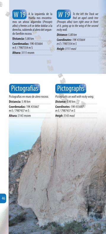
A la izquierda de la Huella nos encontra-
mos un añoso algarrobo (Prosopis alba) y frente a él se debe doblar a la derecha, subiendo al alero del segun-do farellón rocoso.
Distancia: 5.80 km
Coordenadas: 19K 435664 m E / 7987354 m S
Altura: 3111 msnm
To the left the Track we fi nd an aged carob tree
(Prosopis alba) turn right once in front of it, going up to the wing of the second rocky wall.
Distance: 5.80 km
Coordinates: 19K 435664 m E / 7987354 m S
Heigh: 3111 masl
W 19W 19
Pictografi as en muro de alero rocoso.
Distancia: 5.90 km
Coordenadas: 19K 435667 m E / 7987437 m S
Altura: 3143 msnm
Pictographs on wall with rocky wing.
Distance: 5.90 km
Coordinates: 19K 435667 m E / 7987437 m S
Heigh: 3143 masl
Pictografías Pictographs
46

Detalle de pintura rupestre de Wilacabrani, Putre.
Wilacabrani’s rock painting detail, Putre.
W19
47

Encontramos las crónicas sobre la piedra en este alero con pictografías.En general, el arte rupestre es una acti-vidad simbólica bastante frecuente en la prehistoria del desierto andino. No debe olvidarse que una de las características del ceremonialismo andino radica en la recurrente representación de deidades, y la diversidad de instancias de diálogo con ellas.El arte rupestre, dentro de la perspectiva de la movilidad del pueblo aymara, ha sido explorado como señalador de rutas, y también ha sido ligado a una ritualidad votiva relacionada con el éxito de la acti-vidad caravanera. Este pensamiento se ha sustentado en la asociación ya señalada de arte rupestre con distintas rutas en el desierto.Sobre esta pintura rupestre, en el alero vemos un gran panel expuesto con picto-grafías rupestres.Hay fi guras pintadas en la superfi cie para la representación de fi guras huma-nas, animales y geométricas. Se emplea para ello pigmentos de óxido de fi erro mezclados con sustancias aglutinantes. Representa escenas de camélidos en mo-vimiento de estilo naturalista bien logra-dos, acompañados de fi guras de felinos también naturalistas; las representaciones de diseños pintados sobre la roca desnuda han sido destruidos sistemáticamente. Hay huellas de hollín, raspados, inscrip-ciones recientes, etc. A pesar de todo, el panel no pierde su calidad de obra de arte prehistórica, cuyo signifi cado no ha sido develado hasta hoy día. Es el sitio más espectacular con arte rupestre de la zona.
We found the chronicles about the stone in this wing with pictographs.In general, the art on stone is a symbolic activity quite frequent in the prehistory of the Andean desert. Do not forget that one of the.Andean ceremonialism characteristics stays on the continue representation of deities and the instances of diverse dia-logue on them.Rock art, from the perspective of mo-bility of the Aymara people, has been explored as a sign of routes, and has also been linked to a votive rituals re-lated to the success of the caravan ac-tivity. This thought has been sustained on partnership and rock art marked with diff erent routes in the desert.On this rock painting in the wing panel we see a large cave with pictographs exposed.There are fi gures painted on the sur-face representation of human fi gures, animals and geometric. It is used for iron oxide pigments mixed with binding agents. Scenes of camels in naturalistic style movement well made, accompa-nied by fi gures of cats also naturalists representations designs painted on the bare rock, have been systemati-cally destroyed. There are traces of soot, scraped, recent inscriptions, and so on. Nevertheless, the panel does not lose its quality of work of prehistoric art, whose meaning has not been revealed until today. Is the most spectacular rock art in the area.
48